millfields conservation area appraisal and management · pdf file1 millfields conservation...
TRANSCRIPT
1 Millfields Conservation Area appraisal & management plan
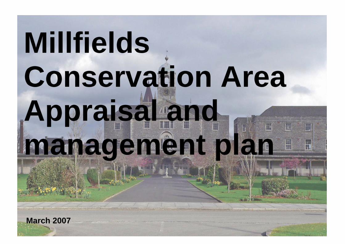
March 2007
Millfields Conservation Area Appraisal and management plan
2 Millfields Conservation Area appraisal & management plan

CONTENTS Appraisal Introduction 5 Conservation Area boundary 6 Location, geology and topography 7 Historic development 9 Characterisation 11 Summary of special interest 19 Issues 23 Management Plan 25 Management proposals 26 1 Statutory and other designations 26 2 Enforcement 26 3 Opportunities for enhancement 26 4 Monitoring and review 29 Illustrations Conservation Area boundary 6 Aerial photograph 8 Listed Buildings and buildings that make a positive contribution to the Conservation Area 11 Figure ground 13 Building age 14 Building heights 15 Land uses/Activity 16 Townscape analysis 17 Opportunities 28 Appendices 30
3 Millfields Conservation Area appraisal & management plan
4 Millfields Conservation Area appraisal & management plan
The Millfields (former Royal Naval Hospital) Conservation Area appraisal and management plan Introduction Conservation Areas were introduced in 1967. They are ‘areas of special architectural or historic interest the character or appearance of which it is desirable to preserve or enhance’ (Planning (Listed Buildings and Conservation Areas) Act 1990). Conservation Area designation has a number of implications. The principal effect is that special planning permission, known as Conservation Area Consent, is required for the complete or substantial demolition of any unlisted building or structure. In addition there are a number of other restrictions that do not apply outside Conservation Areas. The legislation also requires local planning authorities to periodically review their Conservation Areas and publish proposals for their preservation and enhancement. In response to this, Plymouth City Council is reviewing its existing Conservation Areas and considering the designation of new areas. Appraisals and management plans are also being prepared following extensive characterisation studies carried out in 2005/61. This work responds to the policy on the historic environment set out in the Core Strategy of the Local Development Framework (Policy CS03). This states that the Council ‘will safeguard and where possible enhance historic environment interests of acknowledged
importance, including in particular scheduled ancient monuments, listed buildings (both statutory and locally listed), conservation areas, and archaeological remains’. It also provides an evidence base and greater guidance for the policies set out in the Millbay and Stonehouse Area Action Plan, and will provide area specific detail to inform the Design Strategy Supplementary Planning Document. This programme will also meet the requirements of Best Value Performance Indicator 219, which is designed to monitor local authorities’ performance in relation to Sections 71 and 72 of the Planning (Listed Buildings and Conservation Areas) Act 1990.
(1) Stonehouse and Millbay Characterisation Study & Management Proposals, July 2006.
The primary purpose of this document is to:
• undertake a character appraisal of the Millfields
Conservation Area • consider what issues affect the Conservation Area, and how
they impact upon its character • identify management proposals to address these issues • identify opportunities for the preservation or enhancement
of the Conservation Area • assist Development Consents decisions and provide a
framework for specific projects and development briefs Conservation Area appraisal is by its nature a ‘broad brush’ process and it is therefore quite possible that some significant individual elements that are important in the Millfields Conservation Area have been overlooked. Omission of any particular building, feature or space should not therefore be taken as meaning that it is of no value.
5 Millfields Conservation Area appraisal & management plan
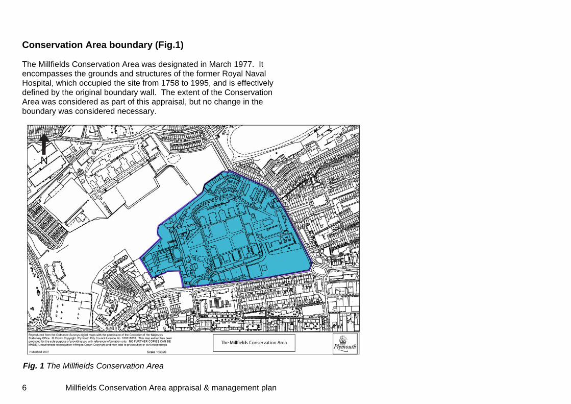
Conservation Area boundary (Fig.1) The Millfields Conservation Area was designated in March 1977. It encompasses the grounds and structures of the former Royal Naval Hospital, which occupied the site from 1758 to 1995, and is effectively defined by the original boundary wall. The extent of the Conservation Area was considered as part of this appraisal, but no change in the boundary was considered necessary.
Fig. 1 The Millfields Conservation Area
6 Millfields Conservation Area appraisal & management plan

Location, geology, and topography (Fig.2)
The Conservation Area lies about 500 metres to the west of Plymouth City Centre. The modern city of Plymouth is situated at the mouth of the river Tamar in the southwest of England overlooking Plymouth Sound, one of the world’s great natural harbours.
The gross geology of the city comprises a belt of hard grey limestone
which runs across its southern edge producing the cliffs overlooking the Sound, most prominently at Mount Wise, the Hoe and Mount Batten/Jennycliffe, as well as the limestone buildings which are so characteristic of many of the city’s historic areas. Inland of this limestone belt the geology is characterised mainly by mixed sedimentary shales producing the soft local ‘shillet’.
This has produced a topography that is characterised by a high
resilient hard stone ridge along the southern waterfront with the land behind gently rising towards Dartmoor to the north, though interspersed with several ridges and dips, all cut through by numerous rivers and lesser watercourses, most notably the estuaries of the Tamar and Plym.
The Millfields lies at the western end of one of these ridges,
between the low ground of the former ‘Sourpool’, an area of historic wet marshland to the south, and the historic Stonehouse Creek to the north. This produces a local low eminence on which the former hospital sits.
7 Millfields Conservation Area appraisal & management plan
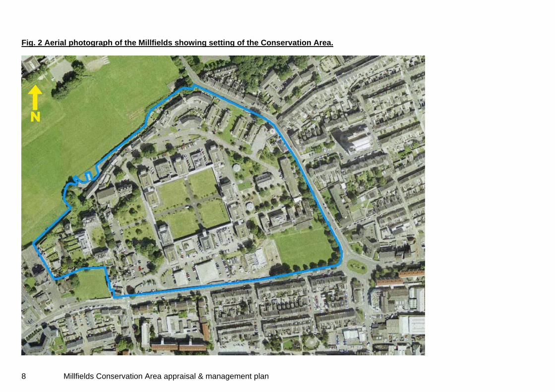
Fig. 2 Aerial photograph of the Millfields showing setting of the Conservation Area.
8 Millfields Conservation Area appraisal & management plan
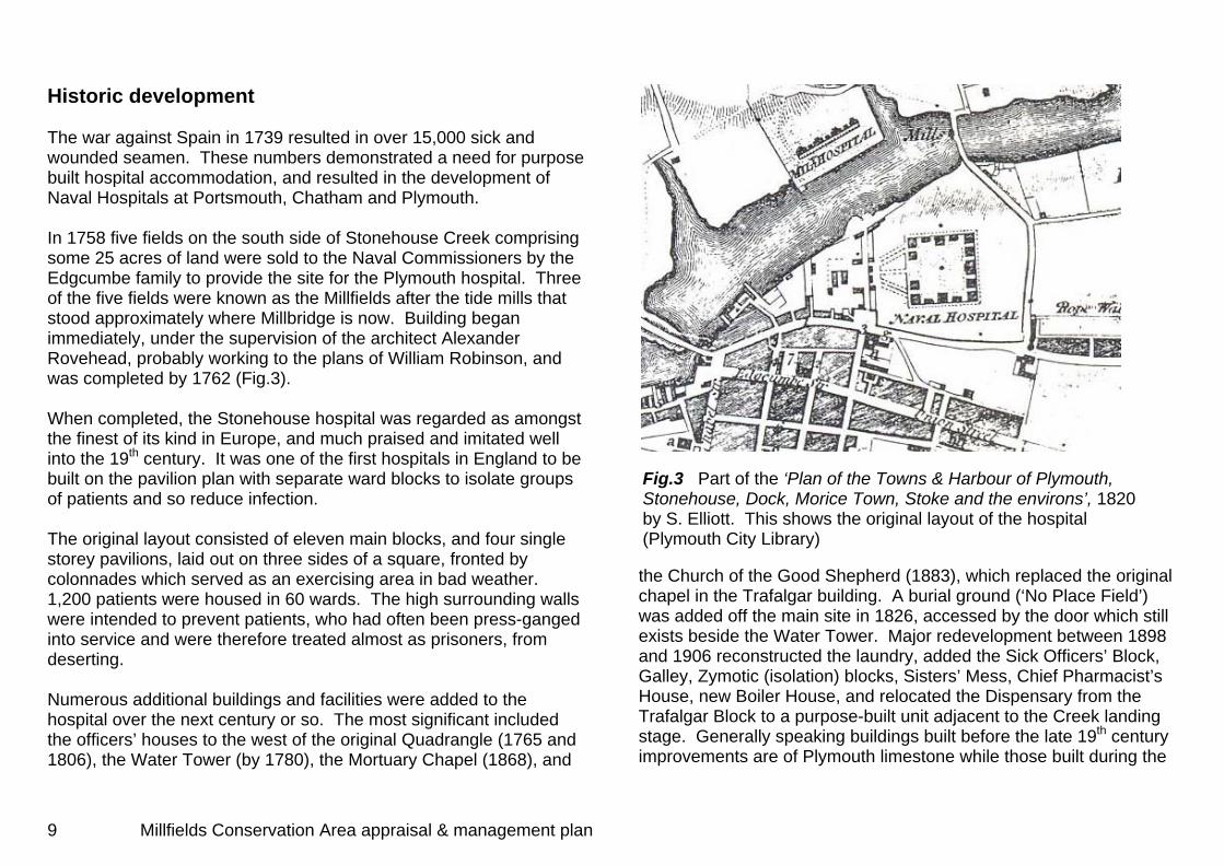
Historic development The war against Spain in 1739 resulted in over 15,000 sick and wounded seamen. These numbers demonstrated a need for purpose built hospital accommodation, and resulted in the development of Naval Hospitals at Portsmouth, Chatham and Plymouth. In 1758 five fields on the south side of Stonehouse Creek comprising some 25 acres of land were sold to the Naval Commissioners by the Edgcumbe family to provide the site for the Plymouth hospital. Three of the five fields were known as the Millfields after the tide mills that stood approximately where Millbridge is now. Building began immediately, under the supervision of the architect Alexander Rovehead, probably working to the plans of William Robinson, and was completed by 1762 (Fig.3). When completed, the Stonehouse hospital was regarded as amongst the finest of its kind in Europe, and much praised and imitated well into the 19th century. It was one of the first hospitals in England to be built on the pavilion plan with separate ward blocks to isolate groups of patients and so reduce infection. The original layout consisted of eleven main blocks, and four single storey pavilions, laid out on three sides of a square, fronted by colonnades which served as an exercising area in bad weather. 1,200 patients were housed in 60 wards. The high surrounding walls were intended to prevent patients, who had often been press-ganged into service and were therefore treated almost as prisoners, from deserting. Numerous additional buildings and facilities were added to the hospital over the next century or so. The most significant included the officers’ houses to the west of the original Quadrangle (1765 and 1806), the Water Tower (by 1780), the Mortuary Chapel (1868), and
Fig.3 Part of the ‘Plan of the Towns & Harbour of Plymouth, Stonehouse, Dock, Morice Town, Stoke and the environs’, 1820 by S. Elliott. This shows the original layout of the hospital (Plymouth City Library)
the Church of the Good Shepherd (1883), which replaced the original chapel in the Trafalgar building. A burial ground (‘No Place Field’) was added off the main site in 1826, accessed by the door which still exists beside the Water Tower. Major redevelopment between 1898 and 1906 reconstructed the laundry, added the Sick Officers’ Block, Galley, Zymotic (isolation) blocks, Sisters’ Mess, Chief Pharmacist’s House, new Boiler House, and relocated the Dispensary from the Trafalgar Block to a purpose-built unit adjacent to the Creek landing stage. Generally speaking buildings built before the late 19th century improvements are of Plymouth limestone while those built during the
9 Millfields Conservation Area appraisal & management plan

improvements are of yellow brick and this distinction is readily apparent within the site. The hospital originally had two entrances, one on the south at the landward entrance, and the other on the northern side, on the shore of Stonehouse Creek. Originally, most patients arrived at the hospital by boat from warships lying in the Sound, arriving at the hospital’s private jetty. This practice continued until shortly after the First World War, when the advent of reliable motor transport allowed patients to be conveyed by ambulance through the southern entrance. By then the upper creek had already been filled in and Victoria Park laid out, with Stonehouse Creek reduced to a stream (Fig.4). The hospital was significantly damaged in World War II. One ward block was totally destroyed and two were severely damaged. Two residences were also destroyed and both the Chaplain’s House and the Church of the Good Shepherd badly damaged. The Royal Naval Hospital closed on 31st March 1995, 235 years after admitting its first patients. Most of its buildings and historic boundary wall remain intact, though its use is now very mixed, including residential, office and commercial uses, and use as a school. The site is now known as the Millfields.
Fig. 4 Ordnance Survey map, 1906. (Plymouth City Council)
10 Millfields Conservation Area appraisal & management plan
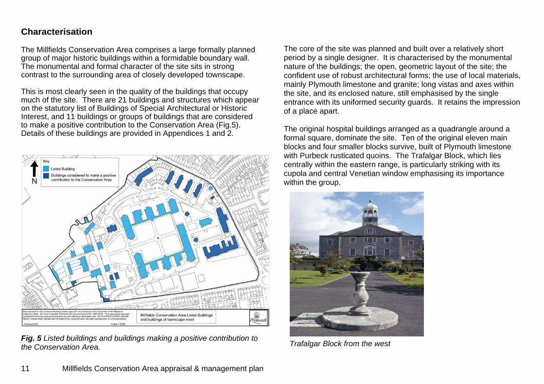
Characterisation The Millfields Conservation Area comprises a large formally planned group of major historic buildings within a formidable boundary wall. The monumental and formal character of the site sits in strong contrast to the surrounding area of closely developed townscape. This is most clearly seen in the quality of the buildings that occupy much of the site. There are 21 buildings and structures which appear on the statutory list of Buildings of Special Architectural or Historic Interest, and 11 buildings or groups of buildings that are considered to make a positive contribution to the Conservation Area (Fig.5). Details of these buildings are provided in Appendices 1 and 2. Fig. 5 Listed buildings and buildings making a positive contribution to the Conservation Area.
The core of the site was planned and built over a relatively short period by a single designer. It is characterised by the monumental nature of the buildings; the open, geometric layout of the site; the confident use of robust architectural forms; the use of local materials, mainly Plymouth limestone and granite; long vistas and axes within the site, and its enclosed nature, still emphasised by the single entrance with its uniformed security guards. It retains the impression of a place apart. The original hospital buildings arranged as a quadrangle around a formal square, dominate the site. Ten of the original eleven main blocks and four smaller blocks survive, built of Plymouth limestone with Purbeck rusticated quoins. The Trafalgar Block, which lies centrally within the eastern range, is particularly striking with its cupola and central Venetian window emphasising its importance within the group.
Trafalgar Block from the west
11 Millfields Conservation Area appraisal & management plan
New build within the site has included the construction of a block of office units against the southern boundary, and an area of new residential build between the Zymotic blocks and the Laundry. Though the office units have not significantly detracted from the overall character and appearance of the Conservation Area, residential conversion of some of the more sensitive historic structures, such as the former morgue, has had an adverse effect, not least through areas of car parking and the introduction of domestic features such as gardens and garages which jar with the character of the main buildings and overall site. The creation of the private gardens on the north side of the former Laundry wall has introduced a particularly jarring domestic character to this part of the Conservation Area, and compromised the historic boundary.
The houses to the west of the quadrangle, added in 1765 and 1806 and arranged around three sides of a formal square, form a well-defined stop to the main vista from the Trafalgar Block. Other significant buildings within the site include the Admiral's House of 1806, probably by Daniel Alexander (1768-1846). Restored after bomb damage, this is a large house of three-storeys plus attic and basement, distinguished by a grand semicircular front porch with Tuscan columns. The Chaplain's House c1806, also by Daniel Alexander, is a three-storey building of Plymouth limestone ashlar. The north (water) gateway into the hospital was designed for the Navy Board by Alexander Rovehead. It is a two-storey structure with an 8-window wide front of Plymouth limestone rubble originally fitted with both inner and outer gates. Part of the jetty for this gate still survives with a long rectangular plan projecting out into the former Stonehouse Creek (now infilled and used as a playing field). There is a fine view from this gate across the infilled creek to the colonnaded south aspect of the former military hospital of slightly later date built for army use.
Significant grant investment over the last ten years has included comprehensive restoration of the Creykes Court ward block (Single Regeneration Budget), and the re-roofing and repair of Norbury Court and Lyster Court through the Townscape Heritage Initiative (2006-7). English Heritage’s guidance makes clear that ‘defining character, or special interest, involves more than simply recording the appearance of an area, its individual buildings and other heritage assets, and documenting its historical development. It includes understanding the values and significance of the area, both in its parts and as a whole.’2 This process is clearly outlined in the Stonehouse and Millbay Characterisation Study & Management Proposals (see p.3) and that format is followed in the subsequent sections and maps, which attempt to define this ‘character’.
Other notable buildings include the three-storey octagonal water tower, built by 1780, and one of the earliest examples of a pressurised water supply system, and the Church of the Good Shepherd, a lively Gothic Revival building of 1883. The site was occupied by the Royal Naval Hospital for over 200 years. This use ceased in 1995, since then the site has undergone substantial redevelopment for a mix of uses including a school, residential use, and commercial office use. This has produced some unwanted results such as the loss of the principal circulatory route around the Quadrangle which has diminished the connectivity of the principal building groups, and the division of the colonnades within the Quadrangle by partitions.
2 Guidance on conservation area appraisals, English Heritage, 2006, p.8
12 Millfields Conservation Area appraisal & management plan
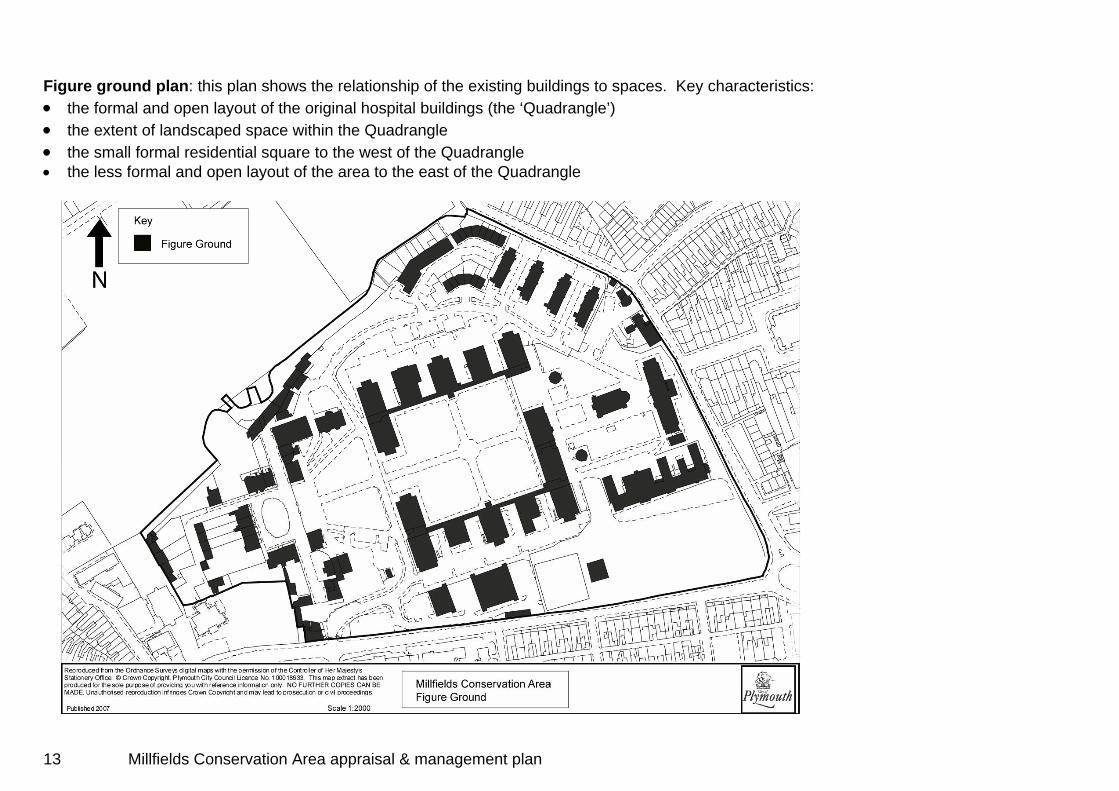
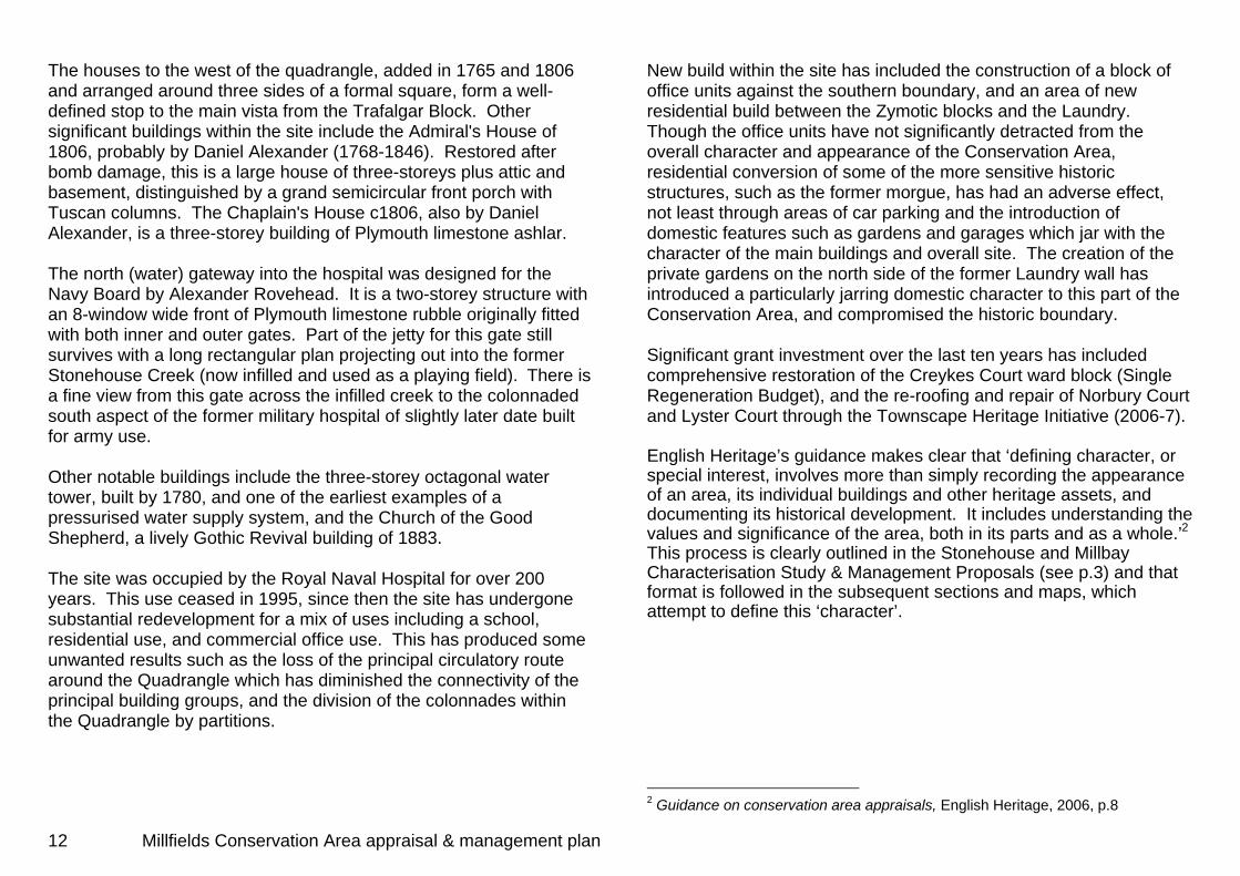
Figure ground plan: this plan shows the relationship of the existing buildings to spaces. Key characteristics: • the formal and open layout of the original hospital buildings (the ‘Quadrangle’) • the extent of landscaped space within the Quadrangle • the small formal residential square to the west of the Quadrangle • the less formal and open layout of the area to the east of the Quadrangle
13 Millfields Conservation Area appraisal & management plan

Building age plan: Key characteristics: • clear distinction between the 18th century original hospital buildings and the 19th and 20th century additions
14 Millfields Conservation Area appraisal & management plan

Building heights plan: Key characteristics: • the Quadrangle and Square are mainly enclosed by three or four storey buildings • peripheral buildings are mainly one or two storey
15 Millfields Conservation Area appraisal & management plan
Land uses/Activity plan: Key characteristics: • predominately commercial use of the Quadrangle • predominately residential use of the ‘periphery’ • school use of the south eastern corner of the Conservation Area. This has effectively segregated this part of the overall site • large central area of green open space
16 Millfields Conservation Area appraisal & management plan

Townscape analysis plan
17 Millfields Conservation Area appraisal & management plan
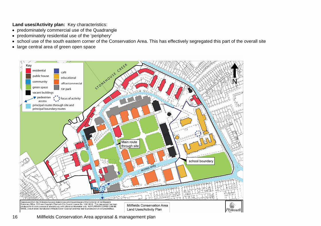
Photographs of the views shown on the Townscape analysis plan
1 View from High Street into Millfields
3 View to Trafalgar Block 2 View through archway to Devonport High School for Boys (former Royal Military Hospital)
4 View to water tower and ventilation chimney, Wyndham Lane
5 View to St Peter’s, Wyndham Square
6 View to Devonport High School for Boys from the east end of Millfields
7 View to Civic Centre and St Andrews from the edge of St Dunstans' school grounds
8 View to the Water Tower from North Road West
18 Millfields Conservation Area appraisal & management plan

Summary of special interest • The former Royal Naval Hospital retains most of its original layout
and buildings (though the main ward blocks retain little of their original interior details), and is a rare example of a naval hospital of the late 18th century.
• It was one of the first hospitals built to the pavilion plan with the
ward blocks kept small and separate to try to limit the spread of infection.
• Its building was supervised by a known architect, Alexander
Rovehead, and the layout provided an inspiration for French and other European hospital builders in the late 18th century.
• It includes a number of important or innovative later buildings,
notably the Water Tower. • The former Royal Naval Hospital is an iconic presence in this part
of Stonehouse by virtue of its age and physical presence. Its boundary walls dominate Clarence Place/High Street, Stoke Road/ Eldad Hill and the surrounding area, and the landmarks of the Water Tower and Trafalgar Block clock tower are visible from beyond its walls.
19 Millfields Conservation Area appraisal & management plan

General photographs taken within the Conservation Area
Official residences including the Admiral’s
House built in 1806, facing the square Inner gate pier, with ornate Victorian gate Originally built as the chaplain’s house,
later became the Medical Mess Annexe Looking north east across the Quadrangle Landing Jetty, originally used
to bring patients ashore via Stonehouse creek
The Church of the Good Shepherd 1883, restored after war damage 18th century octagonal water tower – an
early example of this type of stucture 20 Millfields Conservation Area appraisal & management plan
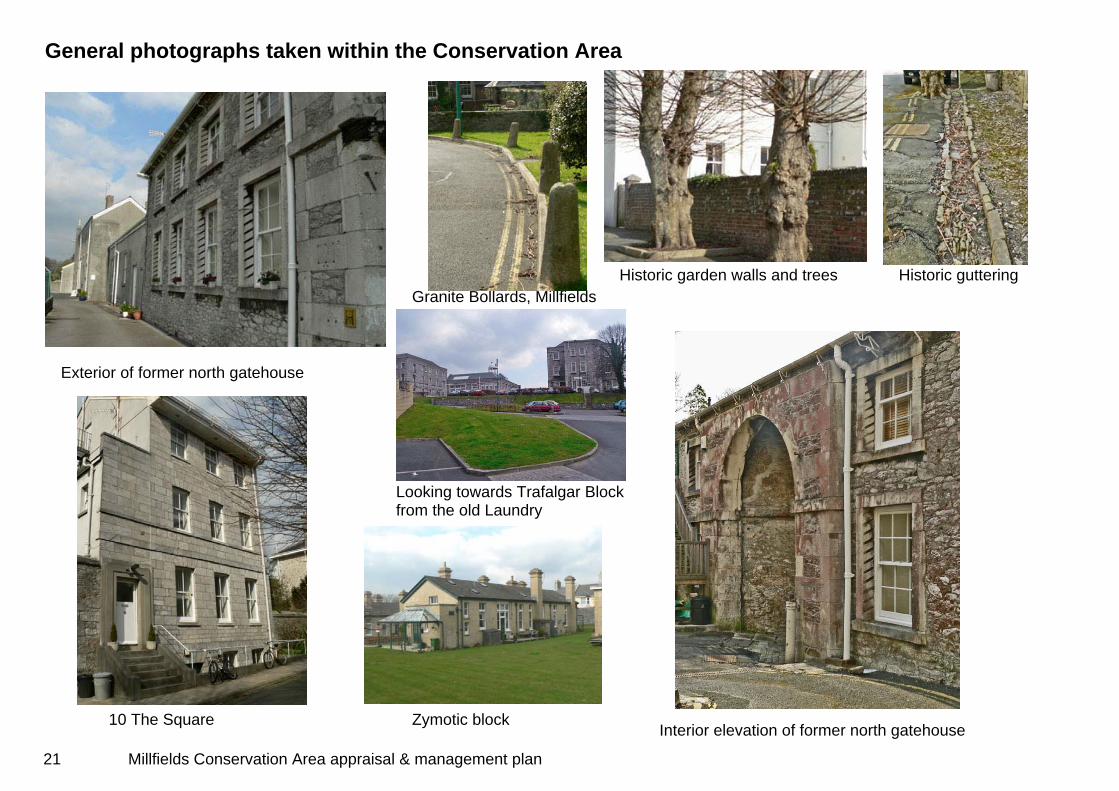
General photographs taken within the Conservation Area
10 The Square
Granite Bollards, Millfields Historic garden walls and trees Historic guttering
Exterior of former north gatehouse
Looking towards Trafalgar Block from the old Laundry
Zymotic block Interior elevation of former north gatehouse
21 Millfields Conservation Area appraisal & management plan
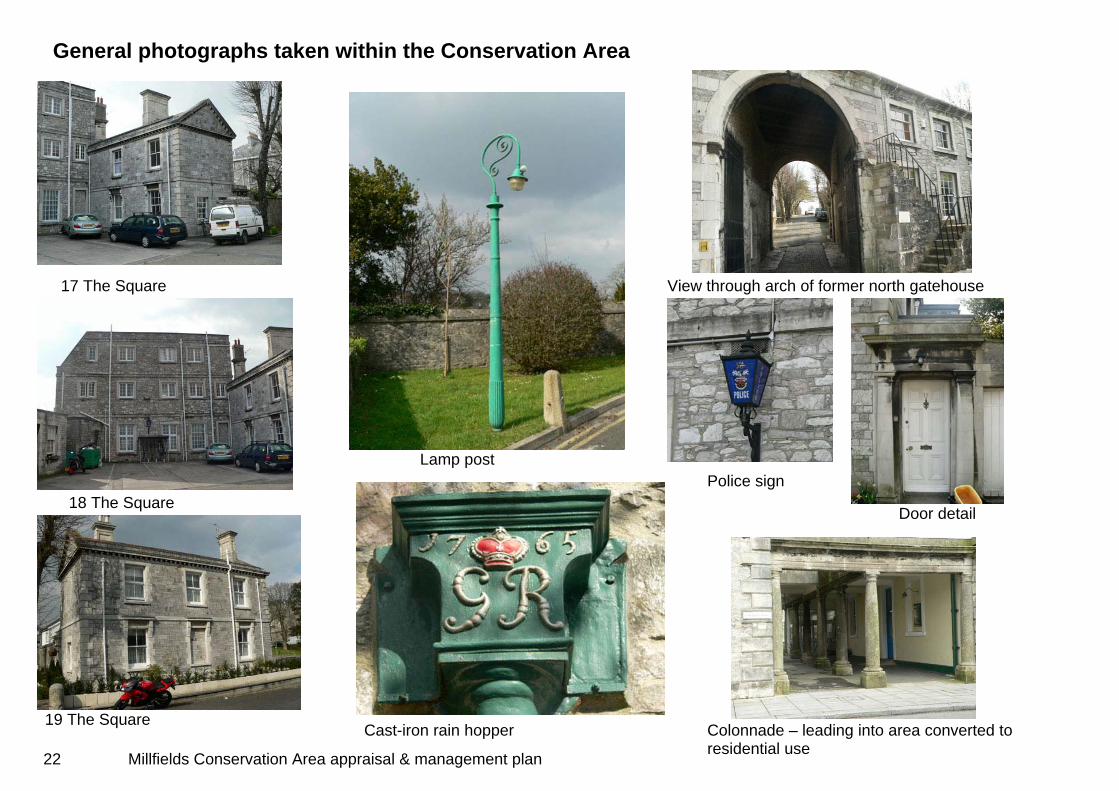
General photographs taken within the Conservation Area
19 The Square
Lamp post
17 The Square View through arch of former north gatehouse
Police sign 18 The Square
Door detail
Colonnade – leading into area converted to residential use
Cast-iron rain hopper
22 Millfields Conservation Area appraisal & management plan

Issues • Though the character and appearance of the Conservation Area
has generally stood up well to the challenges of reuse and redevelopment, there has been a degree of unsympathetic development and inappropriate changes, particularly relating to residential conversion and the accompanying ‘domestication’ of communal open space. This has included obscuring and disregarding part of the historic boundary to Stonehouse Creek. The future management of the Conservation Area must ensure that this sort of ‘piecemeal’ degeneration of its special character is very carefully managed and where necessary robustly addressed.
• Eight of the main ward blocks retain inappropriate and disfiguring
concrete tiled roofs, installed during the latter years of the MoD use of the site. Two of the blocks have also been extensively rebuilt to the extent that they no longer retain their original pitched roofs. Future management of these buildings must ensure that their character and appearance is robustly maintained. This is particularly important in view of the loss of much internal historic detail.
• The historic boundary wall is beginning to deteriorate in places,
due to a combination of the use of inappropriate hard cement pointing and vegetation growth.
• There was also an issue with the boundary to the school at the
time of the appraisal (2007) though it was expected that this would be resolved in a reasonable period.
23 Millfields Conservation Area appraisal & management plan

24 Millfields Conservation Area appraisal & management plan
Millfields Conservation Area management plan ‘It shall be the duty of the local planning authority from time to time to formulate and publish proposals for the preservation and enhancement of any parts of their area which are Conservation Areas’ (s.71(1) Planning (Listed Buildings and Conservation Areas) Act 1990). General principles In responding to the issues raised in the Conservation Area appraisal, and in exercising its powers within the Millfields Conservation Area, Plymouth City Council will follow the policies and objectives set out in the Core Strategy of the Local Development Framework. In particular the management plan will conform to Policies CS02 and CSO3, which relate to the delivery of a quality city, and Area Vision 2 –Millbay and Stonehouse - and its associated objectives. It also conforms to the Millbay and Stonehouse Area Action Plan (at Submission stage at March 2007), and the emerging Design Strategy Supplementary Planning Document. Guidance provided in Planning Policy Guidance Note 15, and English Heritage’s ‘Guidance on the management of Conservation Areas’ are also used as key references for the management plan. In order to interpret these policies and guidance for the Millfields Conservation Area the following principles will be adhered to in the consideration of any changes proposed in the Conservation Area. Principle 1 - Proposals to develop or redevelop sites and convert buildings to new uses will be required to preserve or enhance the character of the Conservation Area, and to contribute positively to the wider regeneration of Stonehouse.
Principle 2 - The position, scale, massing and materials of new development will be expected to respect the existing character of the Conservation Area. Principle 3 – Priority will always be given to the retention and enhancement of buildings of heritage value identified in the Conservation Area appraisal and management plans. Principle 4 - New development will be expected to be of the highest quality design that respects and enhances the character of the Conservation Area. High quality contemporary architectural design will be encouraged, though high quality restoration through replication will not necessarily be rejected. Principle 5 - New transport and parking provision will be expected to respect and where possible enhance the character of the Conservation Area. Prominent insensitive parking provision will therefore not normally be acceptable and opportunities will be taken wherever possible to reduce or remove any adverse impact of existing parking provision. Principle 6 - There should be early Historic Environment input into all proposals for significant public works within the Conservation Area. Principle 7 - Historic surfaces and street furniture will be retained, enhanced and restored wherever practicable. Principle 8 – The historic views and vistas identified in the appraisal will be retained, enhanced and restored. Principle 9 - Advertising and signage proposals will be expected to respect the character and appearance of the Conservation Area in terms of siting, size, number, materials, colours and illumination.
25 Millfields Conservation Area appraisal & management plan

Management proposals 1. Statutory and other designations The most significant buildings and other structures that are not currently statutorily protected will be considered for appropriate designation. Non-listed buildings that are considered to make a positive contribution to the Conservation Area (see Fig.5) may be considered for local listing if they meet criteria which will be laid out in the forthcoming Design Strategy Supplementary Planning Document. Proposed management plan action - The Old Laundry and ‘The Office’ public house will be assessed and proposed for statutory listing if warranted, within six months of the adoption of the completed appraisal and management plan. Possible candidates for any local list will be considered within 12 months of the adoption of the completed appraisal and management plan. 2. Enforcement The most effective means of preserving and enhancing the special interest of Conservation Areas is through efficient use of existing legislation and other powers, and Plymouth City Council will use the full range of powers available to it if necessary. This may include the use of Building Preservation Notices, Urgent Works Notices, Repairs Notices, Dangerous Structures Notices, Tree Preservation Orders and Section 215 Notices (used in cases where it is considered that the condition of land or buildings adversely affects the area). Informal contact, discussion and advice will also be used to encourage owners to undertake repairs and maintenance. Conversion of historic buildings to residential use and the associated creeping ‘domestication’ that this can produce has been identified as one of the main threats to the character of the Millfields Conservation Area. While Listed Building Consent is required for works of
alteration affecting the special character and/or appearance of Listed Buildings, unlisted buildings which are single dwelling houses enjoy the benefit of considerable permitted development rights, which allow, for example, minor extensions, demolitions and replacement doors and windows, without any requirement for planning permission. This means that some buildings have been altered to the detriment of their townscape quality, and important architectural features lost. Articles 4(1) and 4(2) of the General Permitted Development Order 1995 allow Local Planning Authorities to make directions withdrawing all or some of the permitted development rights given under the Order. These have been found to be an effective means of controlling the sort of piecemeal alterations that lead to the overall degeneration of buildings that contribute to the character or appearance of Conservation Areas. Proposed management plan action - A detailed schedule of buildings in the Millfields Conservation Area that would benefit from the imposition of Article 4 Directions will be drawn up and submitted for consultation and Council approval within twelve months of the adoption of the completed appraisal and management plan. 3. Opportunities for enhancement While the Millfields Conservation Area is generally well managed, the appraisal has identified a small number of specific sites and areas within the Conservation Area that currently have either a neutral or negative effect on its overall character. With sensitive development or improved management these sites could contribute positively to the ‘preservation or enhancement’ of the Conservation Area, and support the vision and objectives of the Millbay and Stonehouse Area Action Plan, especially those proposing ‘to capitalise on the historic assets of the area such as the historic townscape and important historic buildings’. These ‘opportunity’ sites are identified below along with possible delivery mechanisms. These will include the positive management of Council-owned land, partnership working, internally
26 Millfields Conservation Area appraisal & management plan

as well as externally, and positive use of the development consents process including the use of Section 106 agreements to deliver opportunities. a) There is a danger of the gradual domestication and loss of
communal landscape particularly around the former ‘Zymotic’ blocks and the former Water Tower.
Proposed management plan action: Consideration will be given to the application of an Article 4 Direction within the Conservation Area (see section 2 ‘Enforcement’ above) to control inappropriate development.
Delivery: Through the possible application of an Article 4 Direction, and through the positive use of the development consents process.
b) The northern boundary of the former Royal Naval Hospital
has been obscured by the creation of domestic gardens, (including breaches of the historic boundary wall) and by the erection of inappropriate chain link fencing.
Proposed management plan action: Consideration will be given to possible enforcement action if warranted, and/or to the restoration of the historic boundary.
Delivery: Through the possible use of enforcement powers, and through the positive use of the development consents process.
c) A number of the principal Quadrangle blocks were vacant at
the time of the appraisal (2006). The sensitive restoration, redevelopment and long-term survival of these blocks is of fundamental importance to maintaining the ‘special interest’ of the Conservation Area. Proposed management plan action: Proposals for re-use of the blocks should be considered particularly against the provisions of Principles 1, 3, 4 and 5 above.
Delivery: Through the positive use of the development consents process including the use of Section 106 agreements.
d) The historic boundary wall to the Millfields was seen to be
beginning to deteriorate in places at the time of the appraisal (2007)
Proposed management plan action: The condition of the boundary wall will be informally monitored over the life of the management plan.
27 Millfields Conservation Area appraisal & management plan
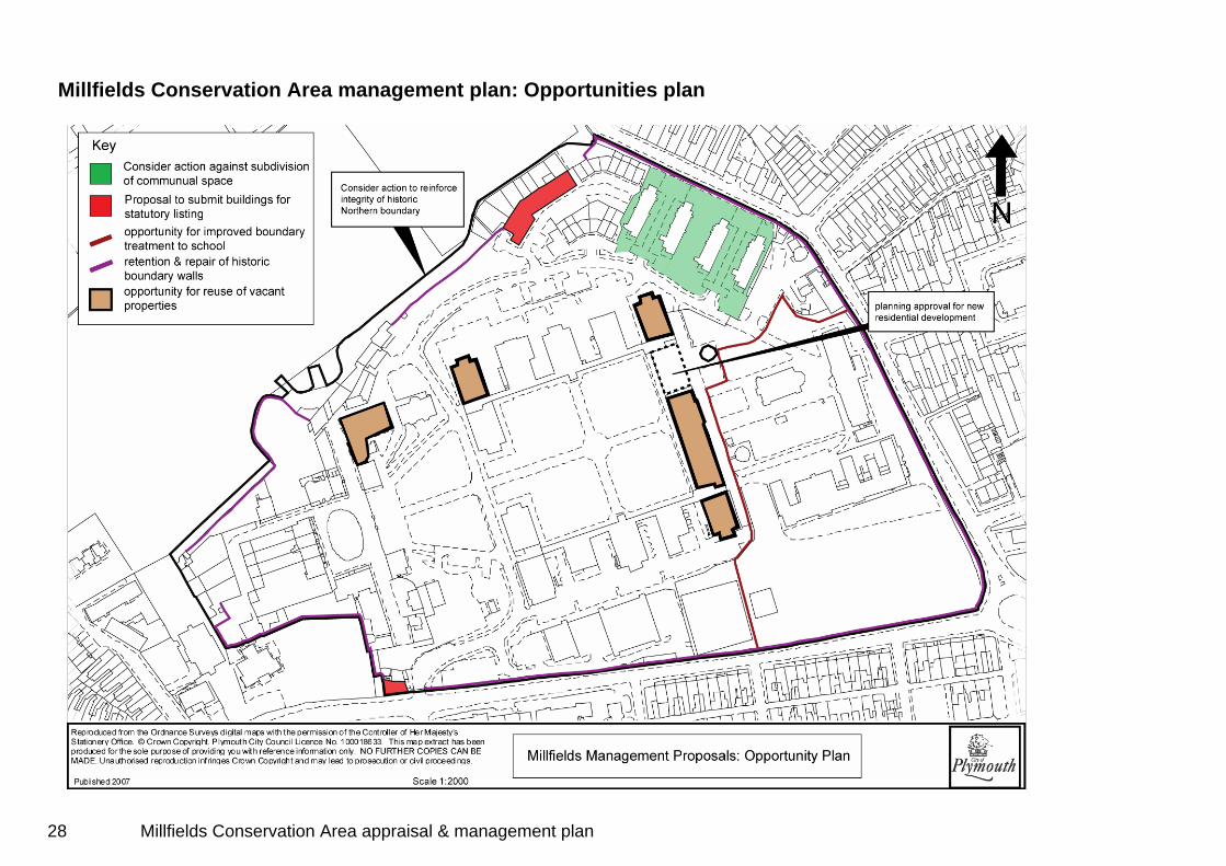
Millfields Conservation Area management plan: Opportunities plan
28 Millfields Conservation Area appraisal & management plan
4. Monitoring and review Monitoring An annual Conservation Areas Monitoring Report will be prepared. This will record progress on each of the main action areas and opportunities as identified in the management plan, including the effect of grant schemes such as the Townscape Heritage Initiative. This will be reported to the Historic Environment Champion, and will form part of Plymouth City Council’s Local Development Framework Annual Monitoring Report. It is envisaged that the first Conservation Areas Monitoring Report will be produced at the end of 2007. Review The Conservation Area character appraisal and management plan will be reviewed every 3-5 years. This may result in a revision or expansion of the existing appraisal and management plan, and will include: • recording changes. • re-assessing the definition of special interest that warrants
designation. • identifying any new issues affecting the Conservation Area,
and revising the management plan accordingly. Reviews will, wherever possible, link with the review of the Millbay and Stonehouse Area Action Plan so that development opportunities can be properly considered against the heritage interests of the Millfields Conservation Area.
The input of stakeholders including local conservation groups in this process, and in the wider management of the historic environment, such as monitoring buildings at risk, will be welcomed. Plymouth City Council’s Historic Environment Champion will take an active role in championing the importance of Plymouth’s historic environment. Officers will regularly meet the Historic Environment Champion and these meetings will be used to monitor and review the Conservation Area management plan.
29 Millfields Conservation Area appraisal & management plan
Appendix 1 Listed Buildings within the Millfields Conservation Area • Boundary wall to NW side, Former Royal Naval Hospital: Grade II • Church of the Good Shepherd, Former Royal Naval Hospital:
Grade II • Inner Gate including Piers and Gates, Former Royal Naval
Hospital: Grade II • Landing Jetty, Former Royal Naval Hospital: Grade II • Main Gateway and Gate Piers, Former Royal Naval Hospital:
Grade II • North Gateway and Store and attached walls, Former Royal Naval
Hospital: Grade II • Octagonal Posting Box immediately south of Pay Office, Former
Royal Naval Hospital: Grade II • Pavilion north of Inner Gates (Pay Office), Former Royal Naval
Hospital: Grade II • The Quadrangle (original ward blocks), Former Royal Naval
Hospital: Grade II* • No’s 1, 2, 3 The Square and area walls and railings, Former Royal
Naval Hospital: Grade II • No’s 4, 5, 6, 7 The Square and walls and railings, Former Royal
Naval Hospital: Grade II • No’s 8, 9 The Square and area walls and railings, Former Royal
Naval Hospital: Grade II • No 10 The Square, Former Royal Naval Hospital: Grade II • No’s 11, 12, 12A The Square and attached walls, Former Royal
Naval Hospital: Grade II • No 14 The Square (Middleton Lodge) and wall, Former Royal
Naval Hospital: Grade II • No 16 The Square and rear courtyard wall, Former Royal Naval
Hospital: Grade II • No 17 The Square, Former Royal Naval Hospital: Grade II • No 19 The Square, Former Royal Naval Hospital: Grade II
• Stables, Former Royal Naval Hospital: Grade II • Sundial in front and west of the Quadrangle, Former Royal Naval
Hospital: Grade II • Water Tower, Former Royal Naval Hospital: Grade II* Appendix 2 Buildings considered as making a positive contribution to the Millfields Conservation Area • Nos. 1-12 Constance Place • The Office Public House, High Street • Garden House, The Square • No. 15 The Square • No. 20 The Square • Chapel of Rest (Mortuary) • Nursing Sisters Accommodation • Two Octagonal Rest Rooms • The Old Laundry • St Dunstan’s Abbey School Buildings (former sick officers’ block) • St Dunstan’s Abbey School Buildings (former staff quarters)
30 Millfields Conservation Area appraisal & management plan