kevin rogan—architecture & design portfolio
DESCRIPTION
Collected professional and academic work.TRANSCRIPT

Kevin Rogan—architecture & design portfolio

Professional workCedar Terrace/Magnolia Homes
(master planning, residential
Broadview Hotel(institutional, rehabilitation)
People’s Health Centers(commercial)
Visualization(various projects and typologies)


various locations
various typologies
My professional work ranges from concept visualization to the production of final construction documents. I work on a wide variety of project typologies, including institutional & commercial buildings and 200+ unit multi-use housing developments.
Commercial building: St. Louis, MO
Professional work

Working primarily in the Housing Studio, I design and detail multi-use developments of varying sizes that adhere to U.S. HUD, LEED, and EGC guidelines and often support a mixed-income demographic.
Cedar Terrace/Magnolia HomesMixed-use development: San Antonio, TXPhases worked: SD, CD
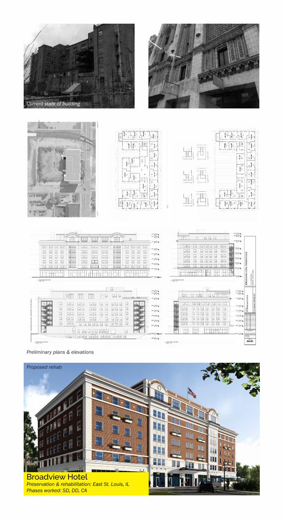
Broadview HotelPreservation & rehabilitation: East St. Louis, ILPhases worked: SD, DD, CA
Current state of building
Preliminary plans & elevations
Proposed rehab

Building section
People’s Health CenterInstitutional building: St. Louis, MOPhases worked: SD, DD, CD, CA
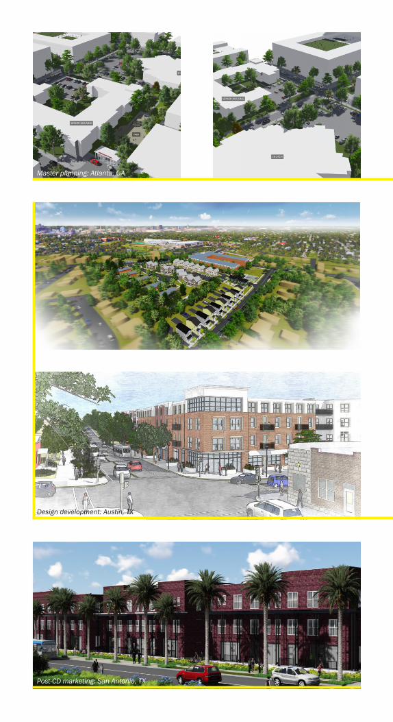
Master planning: Atlanta, GA
Design development: Austin, TX
Post-CD marketing: San Antonio, TX

(All images were created with a combination of SketchUp, Revit, Lumion, 3Ds Max, Vray, Kerkythea, KeyShot, and the Adobe Creative Suite.)
Interior design: St. Louis, MO.
Schematic design: Minneapolis, MN

Academic projects
Biopoetic urbanism: participatory infrastructure & the future city
New Ecologies:recuperating urban hydrology in Suzhou, CN
Performance of the boundary:campus theater
Urban Green Systems: master planning and park


Biopoetic urbanism:Participatory infrastructure & the future city
Semester X (thesis)
East Africa
urbanism & ekistics
This design project is the product of my
research thesis, Autonomy in the Future City.
EAST AFRICA 2080—How does a burgeoning population expand without destroying its surroundings? The Spine attempts to mediate growth and social/environmental stewardship.

The city as we know it is a destroyer of landscapes, resources & communities—but it does not need to be.
East Africa in 2080 is now home to 2 billion people. How can we ensure all these people will be able to live equitably?
The Spine in a pre-existing urban area
Maps of proposed regional conditions
A suspended transit platform

The Spine in an existing urban area
The Spinal city topology is raised to minimize spatial impact but maximum distributive effect.
Longitudinal section through urban zone
Technical section

The Spine is a conduit for the reception and distribution of resources, production, development, and people. A filigree urbanism grows from the Spine, responding to the morphogenic affiliation of a strong linearity, the amenities provided, and the connections offered.

There exists in East Africa an opportunity to propose a new urbanism that embraces the commons, the environment, and social equity in a new urban ecology.
Conditional longitudinal sections (typical)

Initial research map: Gini coefficient data Research map: transit networks
Research map: data infrastructure Research map: protected areas
Research map: population density Research map: power networks

New ecologies: recuperating urban hydrology in Suzhou, CN
Semester IX
Suzhou, CN
urban ecology
Suzhou’s centuries-old canals are masterpieces of pre-industrial equitable infrastructure, forming a critical component of the Lake Tai hydroregion—now in peril due to increasing urbanization.
The vertical canal offers the possibility of a new, recuperative hydrourbanism.

Suzhou context
The elevated streetscape over remediation beds
Urban expansion near Tai Lake
Algae blooms in Tai Lake
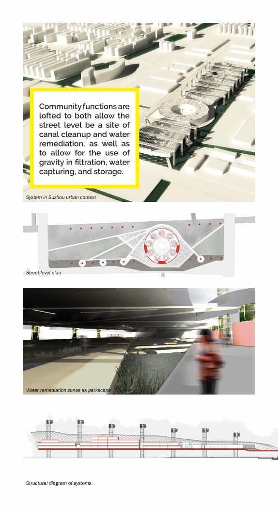
System in Suzhou urban context
Street-level plan
Water remediation zones as parkscape
Structural diagram of systems
Community functions are lofted to both allow the street level be a site of canal cleanup and water remediation, as well as to allow for the use of gravity in filtration, water capturing, and storage.

Egress/ingress diagram
Power distribution
Water cycleStages of implementation: rewriting the water cycle

Performance of the boundary:campus theater
Semester VIII
Springfield, MO
campus design
Drury University has a well-known theater program, but no theater building. In designing a suitable theater, practice space, shop, and classrooms, I began to interrogate the notion of performative spaces.

The boundary between stage & audience dissolves
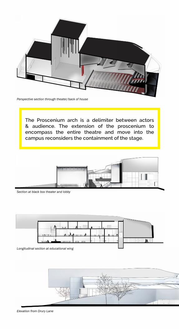
The Proscenium arch is a delimiter between actors & audience. The extension of the proscenium to encompass the entire theatre and move into the campus reconsiders the containment of the stage.
Elevation from Drury Lane
Section at black box theater and lobby
Longitudinal section at educational wing
Perspective section through theater/back of house

Site plan
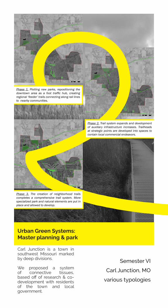
Urban Green Systems: Master planning & park
Semester VI
Carl Junction, MO
various typologies
Carl Junction is a town in southwest Missouri marked by deep divisions.
We proposed a system of connective tissues, based off of research & co-development with residents of the town and local government.
Phase 2. Trail system expands and development of auxiliary infrastructure increases. Trailheads at strategic points are developed into spaces to contain local commercial endeavors.
Phase 3. The creation of neighborhood trails completes a comprehensive trail system. More specialized park and natural elements are put in place and allowed to develop.
Phase 1. Plotting new parks, repositioning the downtown area as a foot traffic hub, creating regional ‘feeder’ trails connecting along rail lines to nearby communities.

We proposed economic programs supported by an underpinning green network—trails, nature centers, parks, recycling centers, and other attractions—to boost economic development, creating an “eco-eco” approach to growth.
The full report we delivered to the Carl Junction Visioning Committee is available online here.
Phase 4. The trail system is integrated into regional rail systems, making it possible to move throughout the town without use of a car. Natural systems and parks now work in tandem to produce new ecologies, and developmental guidelines, coupled with natural barriers, ensure new development will not be at the expense of natural systems.
Alternative transit Economic zones Ecological awareness

Memorial Park plan
Variance in the species, densities, and organizational schemes of plantings, coupled with a path and datum wall network, create an evocative, rolling experience.
Entrance to park from E Pennel St.

The memorial is the park. Instead of concentrating the memorial to a single ‘point’, the functions of the memorial are distributed into the park. Function & remembrance become one and the same.
Experiential sections
View from within memorial walk toward pavilion
