early warning system - sero.nmfs.noaa.gov · early warning system new england aquarium 2009 final...
TRANSCRIPT

EARLY WARNING SYSTEM
New England Aquarium 2009 FINAL REPORT
Aerial Surveys to Reduce Ship/Whale Collisions in the Calving Ground of the North Atlantic Right Whale
(Eubalaena glacialis)
Jessica K.D. Taylor, Monica A. Zani, Amy R. Knowlton, Kerry M. Lagueux, Philip Hamilton, and Scott D. Kraus.
Edgerton Research Laboratory New England Aquarium
Central Wharf Boston, MA 02110
August 25, 2009 to:
U.S. Department of Commerce NOAA Fisheries 2382 Sadler Road
Fernandina Beach, FL 32034
Contract Number: WC133F-06-CN-0022
New England Aquarium Early Warning System 2009 Final Report. Contract No. WC133F-06-CN-0022
TABLE OF CONTENTS INTRODUCTION ..................................................................................................................3 METHODS .............................................................................................................................6
Aerial Surveys.....................................................................................................................6 Notification of Sightings to Agencies.................................................................................8 Photographic Identification.................................................................................................9 Distribution .......................................................................................................................10 Sighting Distance ..............................................................................................................10 Demographics ...................................................................................................................11 Calving Intervals and Rates ..............................................................................................11 Associations and Behaviors ..............................................................................................11 Vessel Sightings................................................................................................................12 Automatic Identification System (AIS) ............................................................................13
EWS RESULTS....................................................................................................................14 Survey Effort.....................................................................................................................14 Sightings and Photo-identification....................................................................................14 Sighting Distances ............................................................................................................16 Demographics ...................................................................................................................16 Calving Intervals and Rates ..............................................................................................17 Associations ......................................................................................................................17 Vessel Sightings................................................................................................................18 Vessel/Whale Interactions ................................................................................................18 Mortalities and Injuries .....................................................................................................19 Entanglement ....................................................................................................................19 Injuries ..............................................................................................................................21 Additional Mortalities:......................................................................................................23
TABLES AND FIGURES ....................................................................................................24 Table 1. NEA Aerial Survey Effort (including contingency surveys) 24 Table 2. NEA Aerial Contingency Survey Effort 24 Table 3. NEA Aerial Survey Right Whale Sighting Frequency 25 Table 4. Calving Intervals for 2009 season M/C pairs 26 Table 5. NEA Aerial Survey Vessel/Whale Interactions 27 Table 6. Entanglement, Injury and Additional Mortality 33
Entanglements 33 Injury 34 Additional Mortalities 34
Figure 1. Central EWS Survey Area. 35 Figure 2. Central EWS Contingency Survey Areas. 36 Figure 3. Whale Alert Geographic Bins Map 37 Figure 4. NEA Aerial Survey Effort 38 Figure 5. NEA Aerial Survey Right Whale Sightings Events 39 Figure 6. NEA Aerial Survey Right Whale Sighting Events by Month 40 Figure 7. NEA Aerial Survey Effort in trackline nmi displayed in 5 day blocks. 41
1

New England Aquarium Early Warning System 2009 Final Report. Contract No. WC133F-06-CN-0022
2
Figure 8. Temporal Occurrence of Right Whales for NEA Aerial Surveys displayed in 5 day blocks. Total numbers include individuals, mothers, and calves. 41
Figure 9. Whales per nmi trackline of NEA Aerial Survey Effort displayed in 5 day blocks 42
Figure 10. Temporal Occurrence of Right Whales: Mom/calf pairs vs. individuals during NEA Surveys displayed in 5 day blocks. 42
Figure 11. NEA Aerial Survey Sighting Distances (n=299) 43 Figure 12. NEA Aerial Survey Sighting Distances with Beaufort Sea State
Considered (n=299) 43 Figure 13. Demographic Structure of the EWS Area for all Non-Calf Right
Whales 44 Figure 14. Association Types for all Right Whales Sighted by EWS Aerial
Survey Teams 45 Figure 15. AIS Data for Commercial Shipping Traffic Density (including tugs,
dredges and some pilot boats). 46 Figure 16. AIS Data for Commercial Tanker and Cargo Traffic Density 47 Figure 17. AIS Data for Average Traffic Speed (including tugs, dredges and some
pilot boats) 48 Figure 18. AIS Data for Average Traffic Speed of Commercial Tanker and Cargo
Vessels 49 Figure 19. Ship Traffic (not required to carry AIS) Recorded Visually during
NEA Aerial Surveys 50 Figure 20. Right Whale 2009 Calf of #2145 documented on 09 February 2009 by
NEA Aerial Survey Team 51 Figure 21. Right Whale 2009 Calf of #2660 documented on 12 February 2009 by
NEA Aerial Survey Team 51 DISCUSSION.......................................................................................................................52 ABBREVIATIONS ..............................................................................................................56 UNITS OF MEASURE.........................................................................................................57 DEFINITION OF TERMS ...................................................................................................58 REFERENCES CITED.........................................................................................................60 ACKNOWLEDGEMENTS..................................................................................................61 APPENDIX 1........................................................................................................................62 APPENDIX 2........................................................................................................................63

New England Aquarium Early Warning System 2009 Final Report. Contract No. WC133F-06-CN-0022
INTRODUCTION
Approximately 400-450 North Atlantic right whales (Eubalaena glacialis) 1
remain in the world, despite international protection since 1935 and federal protection since 1970. Failure of North Atlantic right whales to show signs of recovery can be attributed to several factors, including the effects of human activity on mortality rates. Vessel strikes account for the largest number of confirmed deaths. Of the 83 known right whale mortalities documented from 1970 through July 2009, at least 28 (34%) were due to collisions with vessels and 10 (12%) were due to entanglements (Knowlton and Kraus, 2001; NMFS Stock Assessment Report, 2008; New England Aquarium unpublished data). In addition, serious injuries caused by human activity in some cases can lead to the animal’s demise (Knowlton and Kraus, 2001). A recent analysis of the 25 year right whale database (1980-2004) indicates a median population growth rate of about 1% (Pace et al., 2007) which is likely due to an increase in calf numbers since 2001. Yet, the authors also note that the population has “almost no capacity to absorb additional mortality, and growth would benefit greatly if mortalities from ship strikes and entanglements were reduced.”
Waters adjacent to the coasts of Georgia (GA) and the east coast of Florida (FL) support the only known calving area for this small population and were designated a critical habitat in 1994 under the Endangered Species Act (59 FR 28793). The majority of calving events occur off of the coastal waters of northern FL, and southern GA, supported by initial sightings of new born calves in this region. However, calving may occur as far north as North Carolina (NC) based on a small number of mothers seen with very young calves at their first sighting of the season in that region. Pregnant female right whales typically arrive in the SEUS area beginning in December to give birth and depart the habitat by late February to mid March to head for the feeding grounds off the Northeast U.S. (NEUS). On rare occasions sightings of right whales have been documented in the calving area outside of this timeframe with one as early as September and another as late as July.
Vessel traffic within the SEUS calving ground is considerable. Three major shipping channels transect the right whale high density area between Brunswick, GA and St. Augustine, FL. These channels serve three commercial shipping ports and two military bases. The Brunswick channel, at the northern end of the critical habitat extends eight nautical miles (nmi) (14.6 kilometers (km)) offshore and serves the port of Brunswick, GA. The channel centered in the area at the GA/FL border is the St. Marys entrance channel, which runs 14 nmi (25.9 km) offshore and serves the Kings Bay Naval Submarine Base, as well as the port of Fernandina Beach, FL. The southern-most channel is the St. Johns River entrance channel, which runs four nmi (7.28 km) offshore and serves the port of Jacksonville, FL and Mayport Naval Base. This is by far the busiest channel in the area with all forms of large vessel traffic, including container ships, car carriers, tankers, bulk freighters, tug and tows and cruise ships as well as U.S. Coast 1 North Atlantic Right Whale Report Card. North Atlantic Right Whale Consortium. November 2008.
3

New England Aquarium Early Warning System 2009 Final Report. Contract No. WC133F-06-CN-0022
Guard (USCG) and U.S. Navy (USN) vessels. Commercial vessel traffic in this federally designated critical habitat has increased substantially since the 1950’s (Knowlton, 1997). Port expansions and diversions of military traffic to local bases closed elsewhere augment this trend. Based out of many small inlets and harbors along the coast, commercial fishing, charter and recreational vessels increase the traffic utilizing and transiting the area dramatically.
The Brunswick and St. Marys River Entrance channels are dredged almost annually while dredging of the St. Johns River Entrance channel is less frequent to maintain required depths. This occurs during the winter to avoid impacts to sea turtles that frequent the area in summer. Dredged material is usually removed from channels and carried to offshore disposal sites using ocean-going hopper dredges. These vessels work continuously, often making many transits between channels and disposal sites throughout a 24-hour period. Consequently, dredging activities substantially increase the vessel traffic in the vicinity of channels and within the calving area.
During the 1994 calving season (December 1993 through March 1994), the first comprehensive aerial surveys, referred to as the Early Warning System (EWS) surveys, were conducted to locate right whales and provide whale detection and reporting services to mariners in the calving ground, including the USN, U.S. Army Corps of Engineers (USACE) and USCG; port authorities and harbor pilots. These groups use the sighting information in their efforts to avoid collisions with right whales.
From 1994 to 2002, the New England Aquarium (NEA) EWS surveys covered the majority of the high-density area and provided daily coverage of the three shipping channels within it. Prior to the start of the 2003 calving season, surveys in the SEUS were redesigned to allow for more daily coverage of a larger area. Beginning in the 2003 season (December 2002), the NEA EWS surveys were extended from 15-20 nmi eastward to 30-35 nmi (54.8-63.9 km) from the coast and reduced in latitudinal range. The area includes the St. Marys River Entrance and the St. Johns River Entrance. This redesigned survey area flown by NEA is referred to as the Central EWS (CEWS) survey area. To the north, Wildlife Trust, GA (WTGA) conducts similar surveys that represent the Northern EWS surveys (NEWS). Florida Fish and Wildlife Conservation Commission’s Fish and Wildlife Research Institute (FWC) conduct surveys in the southern section of the calving area (Southern EWS, SEWS) (Figure 1). In addition, the Wildlife Trust, South Carolina (WTSC) performs aerial surveys off the coast of South Carolina (SC) and northern GA which is outside of the EWS parameters.
At the advent of the 2004 calving season, survey aircraft and crew for EWS surveys were held to newly imposed federal standards. Survey aircrafts were all certified under 14 CFR, Part 135 (airline, aircraft less than 10 seats). In addition, pilots and observers underwent intense pre-season training that included emergency-egress. Pilots also attended Federal Aviation Administration (FAA) Part 135 ground school and passed all associated check rides. A second pilot in command (SIC) was also added to each survey flight to ensure a higher safety margin during survey operations. The addition of a second pilot limited data recording during the surveys that were conducted in a Cessna
4

New England Aquarium Early Warning System 2009 Final Report. Contract No. WC133F-06-CN-0022
337 as the number of science crew was reduced from three to two persons due to weight and balance constraints. For this reason all surveys flown since 2004 have been conducted without a dedicated data recorder.
This report describes the results of right whale aerial survey effort data gathered by the NEA aerial survey team during the 2008-2009 EWS season (01 December 2008 – 31 March 2009), subsequently referred to as the EWS 2009 season. The area predominantly covered by the NEA aerial survey team was the CEWS survey area. In order to provide more accurate and comprehensive conclusions, this report also references right whale identification and sighting data collected throughout the region by other aerial survey teams, as well as by organizations involved in various events such as unusual sightings, entanglements, carcass retrieval or necropsies. For the purpose of this report, when referring to the “SEUS region”, this is inclusive of the WTSC and EWS survey areas, and does not include sightings from further north of the WTSC area or further south of the SEWS survey area. The EWS area describes the NEWS, CEWS and SEWS areas covered by WTGA, NEA and FWC respectively.
USACE, USCG and USN provide the funding for CEWS surveys with support from the National Oceanic and Atmospheric Administration’s National Marine Fisheries Service (NOAA Fisheries Service).
5

New England Aquarium Early Warning System 2009 Final Report. Contract No. WC133F-06-CN-0022
METHODS Aerial Surveys
CEWS surveys were flown daily from December 1, 2008 through March 31, 2009
during the 2009 calving season. The surveys were conducted in the area from the southern end of Cumberland Island, GA, approximately 6.5 nmi (12 km) north of the St. Marys River entrance (30° 50.0N), to Jacksonville, FL, approximately 6.5 nmi (12 km) south of the St. Johns River entrance (30° 17.0N), from the shoreline to 30-35 nmi (54.8-63.9 km) offshore. Twelve east/west transect lines were flown perpendicular to the coast at 3 nmi (5.5 km) intervals with a western limit of 0.5 nmi (0.9 km) off the shoreline (Figure 1). A total of 406 trackline nmi (761 km) were flown during each complete survey.
In addition to the CEWS survey area, when an aircraft of an adjacent EWS survey (NEWS or SEWS) was unable to fly for a period of time (due to maintenance or extended disentanglement efforts) a pre-approved contingency plan would be flown. Contingency plans were developed to ensure aerial survey coverage of port entrances in the absence of one (two-plane contingency) or two (one-plane contingency) of the EWS survey aircrafts (Figure 2). The two-plane contingency survey covers thirty transect lines shared between two aircrafts, covering an area extending from 31°26.0N, approximately 23 nmi (42.6 km) north of the Brunswick-Bar channel sea-buoy, south to 29°59.0N, approximately 25 nmi (46.3 km) south of St Johns sea-buoy. Redirected surveys for the NEA team during the two-plane contingency survey covered either the northern or southern section of this area, flying sixteen east/west transect lines perpendicular to the coast at three nmi (5.5 km) intervals from 0.5 nmi (0.9 km) off the shoreline out to 18- 29 nmi (33.3-53.7 km) from the shore. 377 trackline nmi (698 km) are covered per complete northern two-plane contingency survey, and 399 trackline nmi (739 km) are covered per complete southern two-plane contingency survey.
The one-plane contingency survey covers an area from 31°14.0N north, approximately 11 nmi (20.4 km) north of the Brunswick-Bar sea-buoy, south to 30°11.0N, approximately 13 nmi (24.1 km) south of St Johns sea-buoy. Redirected one-plane contingency surveys encompassed twenty-two east/west transect lines at three nmi (5.5 km) intervals from 0.5 nmi (0.9 km) off the shoreline out to between 14-24 nmi (25.9-44.4 km) offshore. Twenty-two tracklines cover 461 nmi (855 km) per complete one-plane contingency survey. Results provided in this report for survey effort are for NEA aerial surveys exclusively, including contingency surveys. However, when reporting on demographics, calving intervals, associations, mortality, entanglement and injury events, photographic data and event descriptions from other survey teams have been referenced in order to provide a more comprehensive assessment of the calving season.
6

New England Aquarium Early Warning System 2009 Final Report. Contract No. WC133F-06-CN-0022
Necessary conditions for all flights included a minimum cloud cover ceiling of 1000 feet (305 meters), visibility greater than three nmi (5.5 km) and winds 17 knots or less. Surveys were conducted in a 14 CFR Part 135 certified twin engine Cessna 337 Skymaster. The aircraft was equipped with Global Positioning System (GPS), Automated Identification System (AIS) receiver, Automatic Flight Following (AFF) transponder, full IFR (Instrument Flight Rules) instrumentation, aircraft mounted marine radio, life raft, medical kit, a waterproof handheld VHF marine radio, a registered removable 406MHz Emergency Position Indicating Radio Beacon (EPIRB), aircraft mounted 406MHz Emergency Locator Transmitter (ELT) and satellite phone.
The surveys were flown at an altitude of 1000 feet (305m) above sea level and an average air speed of approximately 100 Mph (160 km/hr). The survey team consisted of a pilot-in-command (PIC), SIC, and two observers positioned on each side of the aircraft in the rear seats. Each observer was individually equipped with, but not limited to, a Nomex ® flight suit, FAA approved survival vest, strobe light, rescue streamer, combo-edge knife and Personal Locator Beacon (PLB) with GPS. Observers scanned the water surface out to at least two nmi (3.7 km). In order to maintain standardized sighting effort, the PIC and SIC were instructed not to alert the observers to any sightings, but were allowed to report a sighting after it had been passed by the aircraft if missed by the observers.
A sighting event is defined in this report as an event at which the aircraft breaks from the trackline and a whale or group of whales are circled until they are positively identified as right whales. A single sighting event can be of a single whale or a group of whales. All right whale sightings were recorded into a digital voice recorder and entered into a computerized logging program, Logger 2000. Logger 2000 was created by International Fund for Animal Welfare (IFAW) and designed for compatibility with the Right Whale Consortium database, curated by the University of Rhode Island (URI). During surveys, Logger 2000 downloaded, at 10-second intervals; time, position (latitude and longitude), heading and aircraft speed directly from the aircraft’s GPS. All downloaded data is stored in a Microsoft Access database. In addition to the automatically downloaded data, the observers manually entered information on Beaufort sea state, visibility, cloud cover, and weather. Due to the change in configuration of aircraft personnel post 2003 season, with the addition of a PIC and loss of the data recorder position, no other marine species sightings were logged during flights except large whales (humpback, pilot whales etc.) manta rays, leatherback turtles and sharks. These species were opportunistically logged because of requests by researchers, but the aircraft did not break from the trackline to confirm species identification unless a sighting was suspected to be a right whale.
Positions were recorded for all commercial (excluding commercial fishing vessels) and military vessels, and for any other vessels that were visually estimated to be 100 ft (30.5 m) or greater in length. In addition, AIS-derived data on dynamic locations and static vessel information were collected for all vessels required to carry an AIS
7

New England Aquarium Early Warning System 2009 Final Report. Contract No. WC133F-06-CN-0022
transponder (Appendix 1). AIS-derived data were recorded into a separate computerized database.
When sightings of right whales occurred, the aircraft deviated from the trackline at a right angle to the sighting and flew directly over the whale(s) to obtain an exact GPS location of the whale(s). The aircraft then circled the whale(s), allowing observers to obtain photographic documentation of the individuals sighted. Data recorded per sighting included; date, time, behavior, image numbers, initial and final positions of whale(s), right whale letter for the day and photographer. The camera’s digital metadata time was synchronized to the GPS, computer-logging program (Logger 2000) and digital voice recorder at the start of each survey for accuracy. After completing photographic work of each sighting, the aircraft returned to the trackline at the point of departure. These methods conformed to research protocols followed by the North Atlantic Right Whale Consortium (NARWC) as approved by NOAA Fisheries Service.
All photographic data from EWS aerial survey teams has been submitted to NARWC and continues to be processed by NEA. Results provided in this report for demographics, and associations for whales in the calving grounds are preliminary overviews and figures will change slightly as data processing is ongoing. Notification of Sightings to Agencies
Prior to the 2009 season, the EWS survey area was subdivided into geographic
sighting “bins” (Figure 3). Email distribution lists were developed for each geographic bin to notify local, state, federal, non-profit and commercial marine interests of right whale sightings via sighting alerts. Sighting bins enabled users to receive only sighting alerts that pertained to their area of interest. Sighting alerts were brief, standardized messages that included date, time, latitude and longitude, group composition (i.e how many adults and calves), and direction of movement. In the subject line, the whale(s) position was indicated as a relative bearing and distance to the nearest sea-buoy, as requested by the harbor pilots in order to make corresponding navigational alterations more efficient and timely. Because alerts were brief, users were allowed the option of receiving messages via email, pager or cellular telephone texting service.
During the EWS season, all sightings of right whales were reported directly, via satellite phone, from the survey aircraft to a NEA ground contact. The ground contact immediately emails this near real-time data to the appropriate EWS distribution list. Upon receiving a sighting alert, the USCG transmits a Broadcast Notice to Mariners over VHF marine-band radio channel 16, switching to 22 alpha. Additionally, the survey team ground contact was responsible for entering the right whale sighting information into the Mandatory Ship Reporting System (MSRS) via an internet data entry portal which ensures that ships reporting into the MSRS will be aware of the most recent right whale sightings. Sighting information consists of date, time, latitude and longitude, and remains in the MSRS for a period of 48 hours. Sightings from alternative, reliable sources
8

New England Aquarium Early Warning System 2009 Final Report. Contract No. WC133F-06-CN-0022
(OTHER) were entered into the MSRS, and distributed via email if verification by an aerial survey team was not possible. During periods of inclement weather when aerial survey teams were not flying, information of right whale detections from passive acoustic monitoring buoys, located to the north and south of the St Johns River entrance, were entered into the MSRS. In these cases, locations of a sighting were described as being within a range of the buoy, as opposed to a specific point due to the difficulty of localizing signal detections.
Maps were developed using Geographic Information System (GIS) software (ArcGIS 9.3) to display comprehensive charts of all right whale sightings within five nmi (9.3 km) of channel entrances over a three-day period of survey flights. These were distributed via email to harbor pilots in Fernandina (Cumberland Sound Pilots) and Jacksonville (St Johns Bar Pilots), USCG officers and Navy representatives.
Photographic Identification
During routine survey flights, observers attempted to obtain images of right whale callosity patterns, scars and other obvious markings, for each sighting. High-resolution digital images were obtained at an altitude of 1000 ft (305 m) using a Nikon digital D300 camera with a fixed Nikkor 300mm lens, and tele-converter. Right whale callosity patterns are used as a basis for identification and cataloging of individuals, following methods developed by Payne et al. (1983) and Kraus et al. (1986). The ability of scientists to identify individuals allows for accurate reporting of numbers of whales within the survey habitat, and prevents duplication of whales that are re-sighted within a single survey. The NEA curates the North Atlantic Right Whale Catalog (the Catalog), which includes tens of thousands of sightings from numerous research groups and individuals. One or two good quality digital images of each right whale considered to be a new individual for the season were emailed to the NEA office in Boston, Massachusetts (MA) for preliminary identification. Identifications were shared with the NEA team as well as other researchers from Associated Scientists at Woods Hole, FWC, Marineland, Marine Resources Council (MRC) and WTGA and WTSC (all of which also sent images to NEA for preliminary identifications) and the NOAA Fisheries Service Southeast Right Whale Recovery Coordinator. This allowed for a comprehensive, up-to-date tally of the number of mother/calf (M/C) pairs during the season. Intermatching of non-M/C pairs was also initiated during the season. Photographs of all individuals were downloaded at the end of the day to look for entanglement or other injuries.
During and after the field season, right whale sightings and images from all research teams and opportunistic platforms, are integrated into Digital Image Gathering and Information Tracking System (DIGITS), a web-based software system developed at NEA to facilitate the matching process of right whale sightings. Final matches to the catalog are confirmed by NEA researchers.
9

New England Aquarium Early Warning System 2009 Final Report. Contract No. WC133F-06-CN-0022
Distribution
Sightings of all right whales were recorded by time and location within the study area. Integration of the right whale sightings data collected during these surveys with previously collected data will help to further define high-use areas within the southeast region. All right whale sightings for the season were plotted and displayed by group size and association type (Figure 5). Sightings were plotted for the four-month long season and also plotted by month to illustrate temporal distribution (Figure 6). In addition, ship traffic density and average speeds were plotted using AIS data (Figures 15 – 18) and ship traffic recorded visually by the aerial survey team (Figure 19) in order to compare vessel density with right whale sightings. Sighting Distance
The distance that whales were sighted from the plane for each right whale sighting event was determined post season. The distance was calculated by using the GPS-derived overhead position of the whale(s) and the exact position of where the aircraft broke from the transect line. Sighting distances were calculated by using the following calculation:
Aircraft’s latitude when whale is sighted =LAT A Whale’s latitude =LAT B Aircraft’s longitude when whale is sighted =LONG A Whale’s longitude =LONG B LAT A-LAT B =LAT C LONG A-LONG B= LONG C
Square root of ((LAT C x LAT C) + (LONG C x LONG C)) x 60= sighting distance (nmi)
Sighting events that occurred while the aircraft was on a designated cross-leg
were included when possible. Due to the data recording limitations, not all on transect (or cross leg) sightings were included because of the inability to obtain an accurate position of where the aircraft broke from the trackline. Sighting events that occurred while the survey aircraft was not on tracklines were not included in the summary. Examples include instances when the survey team was notified of a whale via a public report and transited to the site specifically, or if subsequent whale sightings were seen at a distance when circling on original sighting.
10

New England Aquarium Early Warning System 2009 Final Report. Contract No. WC133F-06-CN-0022
Demographics
A preliminary analysis of the sex and age composition of the 2009 wintering population of right whales in the survey area was conducted using data from all aerial surveys in the SEUS and the existing catalog of identified right whales from the western North Atlantic. Right whales with known ages (because they were previously identified in their calving year) were classified as juveniles (1-8 yrs) or adults (>9 yrs). Whales of unknown age were classified as unknown age until their ninth year in which they become classified as an adult. All calving females were classified as adults regardless of age. The sex (if known) of individuals in the catalog have been previously determined by one or all of the following methods: 1) direct observation of the genital area, 2) association with a calf, 3) by the testing of biopsy samples for a genetic marker unique to the Y chromosome (Brown et al., 1994). Calving Intervals and Rates
Reproductive female right whales (cows) in this population have been monitored since 1980, and records of calf production are documented in the North Atlantic Right Whale Catalog (Kraus et al., 2001). Data collected on cows observed with calves in the monitoring area during the 2009 survey period were used to update information for the population on calving intervals, rates of reproduction, time frame and area of calving, as reflected in summaries provided in this report. Associations and Behaviors
The survey team remained on site for each sighting until positive species identification was made, or observers were confident that species identification was not that of a right whale. During this time photographs were obtained of right whale species, and visible associations and behaviors were recorded with as much detail as possible. The time spent at each sighting is directly correlated to the survey team’s ability to make an accurate species identification and obtain photographic documentation of the event. The exception was made in the event of a vessel/whale interaction, entanglement, dead whale or other event that caused concern for the welfare of the whale(s), such as whales in a shipping channel.
11

New England Aquarium Early Warning System 2009 Final Report. Contract No. WC133F-06-CN-0022
Whales are considered associated if within several body lengths of each other and coordinating their movements at the surface (Hamilton, 2002). Associations are described as one of the following types (although not all are seen in the SEUS).
1. Surface Active Group (SAG) 2. M/C or Mother/Yearling pair 3. Feeding 4. Other – pairs, trios, no visible behavior, includes M/C with others if not in
a SAG or feeding 5. Not associated
A selection of behaviors were also recorded when observed. Photographers
attempted to capture photographic evidence of behaviors for later confirmation. A whale or group of whales, were also given a direction of travel if whale(s) appeared to be traveling at a moderate speed, and / or if it was determined that the whale(s) had traveled a significant distance while the survey team was on site. Vessel Sightings Commercial and military vessels, cruise ships, and large recreational vessels visually estimated to be greater than 100 ft (30.5 m) in length were recorded into Logger 2000. Certain types of small commercial vessels (estimated to be less than 100 ft) were also recorded, including tugs, pilot boats and dredge crew and survey vessels. Vessels that are no longer recorded due to the loss of a dedicated recorder include commercial fishing vessels and all recreational vessels under 100 feet. The aircraft did not break track to investigate vessel sightings in order to maximize time available for survey effort. The position (latitude and longitude) of the aircraft was recorded when perpendicular to the vessel. Data collected for each vessel recorded includes; type of vessel, time sighted, bearing and estimated distance from the aircraft and the vessel’s heading.
A vessel/whale interaction is defined as an event when the survey team visually determines that a vessel is on a course that could result in the vessel and whale(s) being less than one nmi (1.9 km) apart. Communication, when possible between survey team and vessel, is attempted in order to prevent collision or mitigate an interaction. Vessel/whale interaction scenarios vary widely and may result in vessels remaining clear of whale(s) at a distance greater than one nmi (1.9 km) or vessels approaching whale(s) within 500 yards (457.2 m). Vessel/whale interactions, when the observed vessel comes within 500 yards (457.2 m) at the closest distance to the whale(s), are defined in this report as Close Approaches. When interaction events occurred the survey team would record detailed information about the situation prior to, during, and following the point of closest distance between vessel and whale(s). Data collected includes: type of vessel, vessel’s initial position and course, whale’s initial position, behavior and heading,
12

New England Aquarium Early Warning System 2009 Final Report. Contract No. WC133F-06-CN-0022
13
whale’s reaction (if any), closest distance between whale and vessel, radio communication (if any) between aircraft and vessel, vessel’s actions (course change or speed change), final positions of whale(s) and vessel. Photo documentation and video footage were also obtained when appropriate. All Close Approach events, regardless of vessel type (commercial, military, recreational or fishing) and vessel size, were recorded in a separate database (Access 2000) and reported at the conclusion of the survey to NOAA Fisheries Service within 24 hours of occurrence. In addition, all reported interaction events were compiled and forwarded to FWC at the end of the season for inclusion in the vessel/whale interaction database. Automatic Identification System (AIS)
AIS is a shipboard system which provides electronic chart data for every significant ship within radio range. Operating in the VHF maritime band, it is capable of transmitting well over 4,500 reports per minute and updates as often as every two seconds. AIS technology is currently being used for identifying and monitoring maritime traffic throughout U.S. waters by various entities interested in commercial shipping activity. AIS equipment sends and receives vessel identification information that is designed for display on an AIS receiver, computer, radar or chart plotter. The standards and regulations of AIS are established by the International Maritime Organization (IMO) as per the 73rd Session of their Maritime Safety Committee. The majority of large, commercial maritime traffic involved in international travel are currently required to carry AIS (Appendix 1).
To obtain AIS information, the survey plane was equipped with an AIS receiver. Data from all commercial vessel traffic transmitting from AIS transponders were recorded in a separate database during all EWS surveys. Data were collected using a Sealinks, Shine Micro RadarPlus SL161R dual channel AIS receiver. Data from the AIS receiver were downloaded directly to the onboard laptop into Shipplotter, software by Centro de Observação Astronómica no Algarve (COAA). The dynamic ship track data collected included Mobile Maritime Service Identities (MMSI), navigational status, rate of turn, speed over ground, position, course over ground, heading (true), every 2 to 10 seconds. In addition, every 6 minutes static ship information such as the IMO number, radio call sign, name, ship dimensions, draft, destination and estimated time of arrival were also recorded. AIS data were collected during survey flights only and covered an area extending from Charleston, SC to Jacksonville, FL. Analyses of the AIS data can provide information on ship densities and ship speeds throughout the critical habitat and of any changes in speed upon entering MSRS or critical habitat boundaries.

New England Aquarium Early Warning System 2009 Final Report. Contract No. WC133F-06-CN-0022
EWS RESULTS
Survey Effort The NEA aerial survey team was on-site for 121 days (01 December 2008 - 31
March 2009) during the 2009 right whale calving season. A total of 71 surveys were conducted and of these, 40 were complete and 31 were partial surveys (Table 1). The NEA team was redirected on six different days to fly contingency surveys. Four of these surveys covered the two-plane contingency survey area and two surveys were flown under the one-plane contingency plan (Table 2). A total of 402.6 hours were spent surveying 23,879 nmi (44,224 km) of tracklines during 71 survey days (Figure 4). Thus, some measure of aerial coverage was provided for 59% of the available days during the 2009 season.
Some surveys were conducted with favorable environmental conditions throughout the duration of the survey, whereas others were flown with favorable environmental conditions during part of the survey (Tables 1 and 2). Favorable conditions consisted of a Beaufort sea state (SS) of three or less and visibility of at least three nmi (5.6 km). Of the total trackline nmi flown during the 2009 EWS season, 85% were flown in favorable conditions. Thus, 41 % of the total nmi available to be flown during the season was flown in favorable conditions. When a partial survey was conducted, effort priority was given to the shipping channels and tracklines immediately to the north and south of channel entrances (St. Johns, St. Mary’s or Brunswick Channel depending on survey area). Sightings and Photographic Identification
The first right whale sighting documented by the NEA aerial survey team in the 2009 season occurred on 03 December 2008, the first survey day of the season. The NEA team had a total of 433 sightings during the 2009 season (Figure 5). The number of sightings per day ranged from zero (n=5) to 22 separate sighting events in a single day (49 different individual whales). Sightings continued throughout the season with the last right whale sighted in the CEWS on 30 March 2009. Average sightings per survey flight varied from two in early December (01-15 December), peaked to 11 in early February (01-15 February), and back down to two in late March (16-31 March). This sighting trend was similar to numbers of whales sighted per unit of survey effort for the season (Figure 9), where a unit is one nmi of survey trackline. The temporal occurrence of non-mom/calf right whales in the survey area peaked in early February, with the highest number of individuals sighted on 10 and 17 February, when 26 individuals were sighted on each of these days (Figure 10). It was also during this period that the number of M/C pairs sighted peaked, with a maximum of 15 M/C pairs sighted on 12 February. The appearance of individuals in the CEWS area which were neither M/C pairs nor pregnant females, was
14

New England Aquarium Early Warning System 2009 Final Report. Contract No. WC133F-06-CN-0022
considerably later than the arrival of 2009 season mothers. The first whale sighted in the CEWS area which was not a M/C pair or pregnant female appeared on 27 December 2008 with the exception of an entangled whale sighted on 08 December 2008. All other individual whales sighted prior to 27 December 2008 as represented in Figure 10, calved during the 2009 season.
All right whale sightings from NEA aerial surveys during the 2009 season were plotted on a chart of the study area in Figure 5 (including the 6 days of contingency surveys) and plotted monthly in Figure 6. All sightings of right whales are detailed in a table in Appendix 2 with the date, time, location, association and behavior type where applicable for each whale. Also included are unconfirmed catalog identification numbers and intermatch codes when known.
The 433 NEA survey sighting events comprised 880 right whales, including calves (not all unique individuals) during the 2009 EWS season. Of the 39 females (as of August 2009) known to have given birth in the 2009 season, 38 of them were documented in the EWS area with their calves. One right whale female ( #2223, “Calvin”) was never documented in the SEUS during the 2009 season, but was sighted with her calf off of North Carolina (NC) on 30 December 2008 by University of North Carolina, Wilmington (UNCW). One female ( #1240, “Baldy”) was first opportunistically sighted as a M/C pair off of Virginia by Virginia Aquarium and Marine Science Center (VMSM) on 09 January 2009. She was next seen in the SEUS on 01 February by the WTSC survey team, and subsequently sighted two more times in the 2009 season by the NEA survey team on 11 and 12 February 2009. Of the 38 M/C pairs documented in the SEUS, all were sighted with their calves in the EWS survey area. The NEA aerial survey team documented 36 of the 38 moms known to be in the EWS area (two moms not documented by NEA were #1970 and #3139). Of the 36 moms documented by NEA, one was documented prior to calving but never seen with her 2009 season calf ( #3370) and 22 were never sighted prior to calving but documented for the first time with their calves. Thirteen moms were documented by NEA in the CEWS area prior and post 2009 calving event.
Of the 433 NEA survey sighting events, 376 were reported to the EWS pager system directly from the NEA survey team. The 57 sighting events that were not reported were either multiple sightings combined into a single alert because whales were within one nmi (1.85 km) of each other, or reported from ‘OTHER’ sources, and later confirmed by the NEA team, or were duplicate sightings that had previously been reported in the system but re-sighted during the survey and positively identified as the same individuals. In cases where whales were confirmed as duplicate sightings from earlier in the same survey, an update was not sent out through the pager system if the whale(s) had not travelled more than one nmi (1.85 km) from their original, reported position. However, all duplicate sightings were reported to the survey team’s ground contact, and positions were updated in the MSRS. Due to time constraints, nine of the 433 sighting events were not photo-documented, and 17 of the total 880 whales sighted were not photo-documented.
Of the 433 right whale sighting events, 93 of the sightings were of single whales (including pregnant females), 240 of M/C pairs, (two of which were sighted together in a
15

New England Aquarium Early Warning System 2009 Final Report. Contract No. WC133F-06-CN-0022
single sighting event), 26 sightings were groups of whales associated in a SAG and 75 sightings were “others”, i.e. groups of whales not alone, in a SAG or M/C pair.
Sighting Distances
Of the 433 total sightings for the NEA survey team’s 2009 season, there were 299 (69%) right whale sighting events for which sighting distances are calculable, and these are summarized by 1/10 nmi increments in Figure 11. Sighting events that occurred while the survey aircraft was not on trackline were not included in this analysis, such as when additional whale(s) were sighted whilst circling the group of whales for which the aircraft broke from the trackline. The mean sighting distance, without considering SS conditions as a factor, is 1.09 nmi (2.0 km). A summary of sighting distances where SS was considered is shown in Figure 12. The mean sighting distance when considering SS as a factor, is 1.1 nmi (2.0 km) during times of Beaufort 3 or less. The mean sighting distance during times of SS 4 or greater is 1.91 nmi (3.5 km) but the frequency of sightings (Table 3) is reduced considerably (n =285 and 14, respectively). It was often the case that the sightings during times of high SS were of whales that were performing highly energetic behaviors that were visible from greater distances such as breaching or lobtailing. There were 3.5 times more sightings per nmi trackline of effort, when the SS was less than 4. When comparing all sightings (n=430 due to 3 unphotographed sightings with no SS recorded), 410 (95%) were in SS less than 4 and 20 (5%) were in SS 4 or higher. Only 15% of the total survey effort was flown in SS 4 or higher. Demographics
The matching and confirming process for identification of right whales sighted by
all EWS survey teams during the 2009 season is currently being processed. For this reason we are unable to illustrate a complete demographic structure for the area. However, we do know that the area was utilized by a high number of unidentified whales thought to be juveniles (n=44). Many of these whales have been matched to calves or juveniles from previous years and were given a temporary intermatch code. The preliminary count of whales documented during the 2009 season by all survey teams in the EWS area are 38 M/C pairs (one of the 39 total M/C pairs documented during the 2009 season was never documented in the EWS area), 120 cataloged individuals (non M/C pairs) and 44 intermatched whales (probable or known juveniles) for a minimum total of 202 right whales (Figure 13) and 38 calves. Right whale #2223 and her calf have not been represented in summaries of demographic structure of the EWS area (Figure 13) since this M/C pair was never sighted within the EWS survey area.
16
New England Aquarium Early Warning System 2009 Final Report. Contract No. WC133F-06-CN-0022
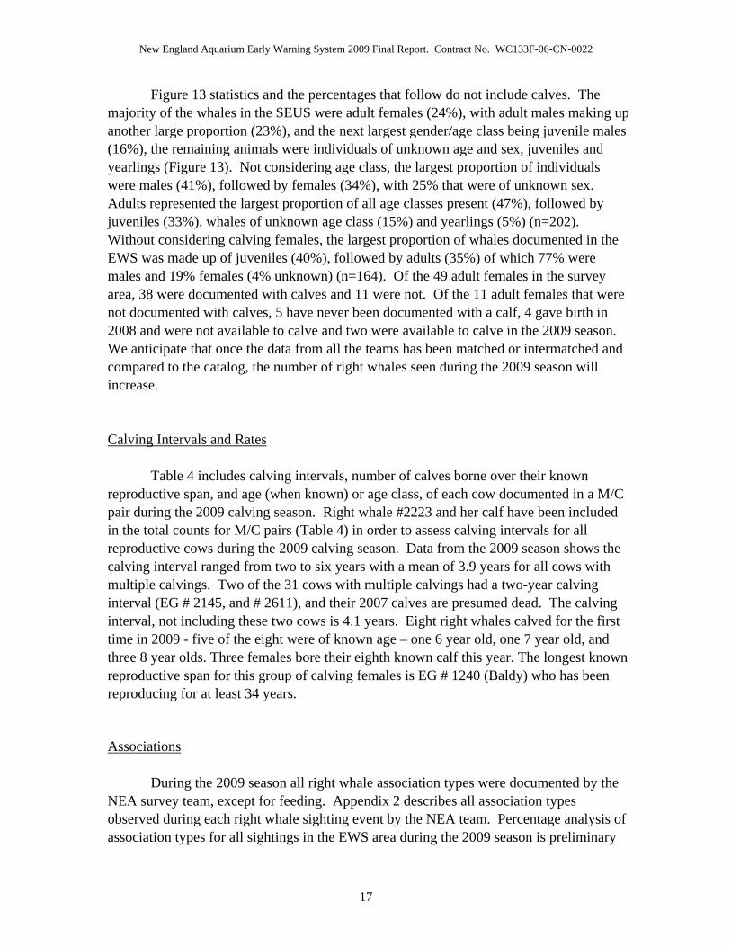
Figure 13 statistics and the percentages that follow do not include calves. The majority of the whales in the SEUS were adult females (24%), with adult males making up another large proportion (23%), and the next largest gender/age class being juvenile males (16%), the remaining animals were individuals of unknown age and sex, juveniles and yearlings (Figure 13). Not considering age class, the largest proportion of individuals were males (41%), followed by females (34%), with 25% that were of unknown sex. Adults represented the largest proportion of all age classes present (47%), followed by juveniles (33%), whales of unknown age class (15%) and yearlings (5%) (n=202). Without considering calving females, the largest proportion of whales documented in the EWS was made up of juveniles (40%), followed by adults (35%) of which 77% were males and 19% females (4% unknown) (n=164). Of the 49 adult females in the survey area, 38 were documented with calves and 11 were not. Of the 11 adult females that were not documented with calves, 5 have never been documented with a calf, 4 gave birth in 2008 and were not available to calve and two were available to calve in the 2009 season. We anticipate that once the data from all the teams has been matched or intermatched and compared to the catalog, the number of right whales seen during the 2009 season will increase. Calving Intervals and Rates
Table 4 includes calving intervals, number of calves borne over their known
reproductive span, and age (when known) or age class, of each cow documented in a M/C pair during the 2009 calving season. Right whale #2223 and her calf have been included in the total counts for M/C pairs (Table 4) in order to assess calving intervals for all reproductive cows during the 2009 calving season. Data from the 2009 season shows the calving interval ranged from two to six years with a mean of 3.9 years for all cows with multiple calvings. Two of the 31 cows with multiple calvings had a two-year calving interval (EG # 2145, and # 2611), and their 2007 calves are presumed dead. The calving interval, not including these two cows is 4.1 years. Eight right whales calved for the first time in 2009 - five of the eight were of known age – one 6 year old, one 7 year old, and three 8 year olds. Three females bore their eighth known calf this year. The longest known reproductive span for this group of calving females is EG # 1240 (Baldy) who has been reproducing for at least 34 years.
Associations
During the 2009 season all right whale association types were documented by the
NEA survey team, except for feeding. Appendix 2 describes all association types observed during each right whale sighting event by the NEA team. Percentage analysis of association types for all sightings in the EWS area during the 2009 season is preliminary
17

New England Aquarium Early Warning System 2009 Final Report. Contract No. WC133F-06-CN-0022
while data continues to be processed for other EWS aerial survey teams (Figure 14). Total numbers for association types documented in the EWS survey area, are as follows: 49 % M/C or Mother / Yearling pairs, 25 % SAGs, 15 % Other, (including pairs, trios, M/C with others if not in a SAG), and 11 % Singletons (n=1,839) (Figure 14). Following the analysis of datasets from all teams, these figures are expected to vary slightly.
Vessel Sightings
The tracks of commercial shipping traffic that carry an AIS transponder were recorded during the EWS 2009 season surveys, and plotted in Figure 15 (See Appendix 1 for the AIS carriage requirements for vessels). This plot contains the track of the vessel as it moved through the habitat and represents the density of traffic within a given area over the course of the season. Figure 16 displays the same data on density but displaying only tanker and cargo ship type, (not including tugs, dredges and pilot boats). Figure 17 represents average vessel speed of all commercial shipping traffic (including tugs, dredges and some pilot boats). Figure 18 displays average speed for tanker and cargo ships. Figures 15 to 19 only represent shipping traffic during periods when the NEA survey aircraft was airborne. Figure 19 displays plots for vessel traffic that is not required to carry AIS and was observed during surveys, recorded abeam of the survey aircraft (plot does not include the track or speed of the vessel).
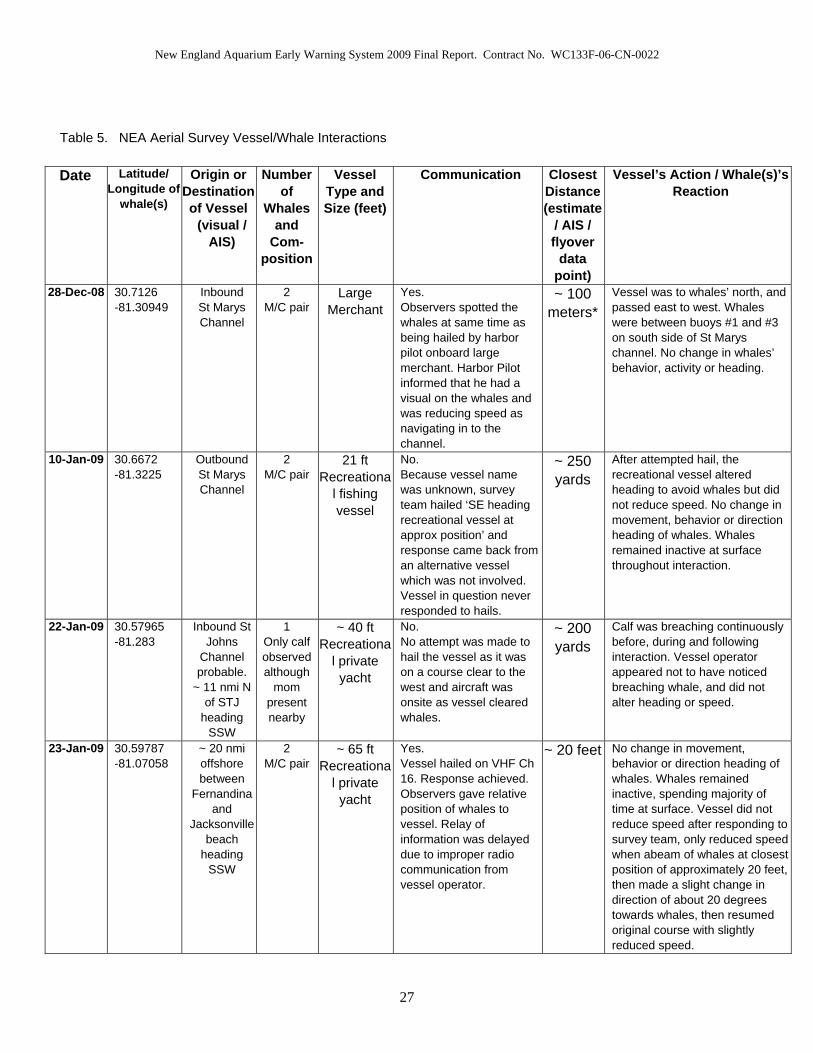
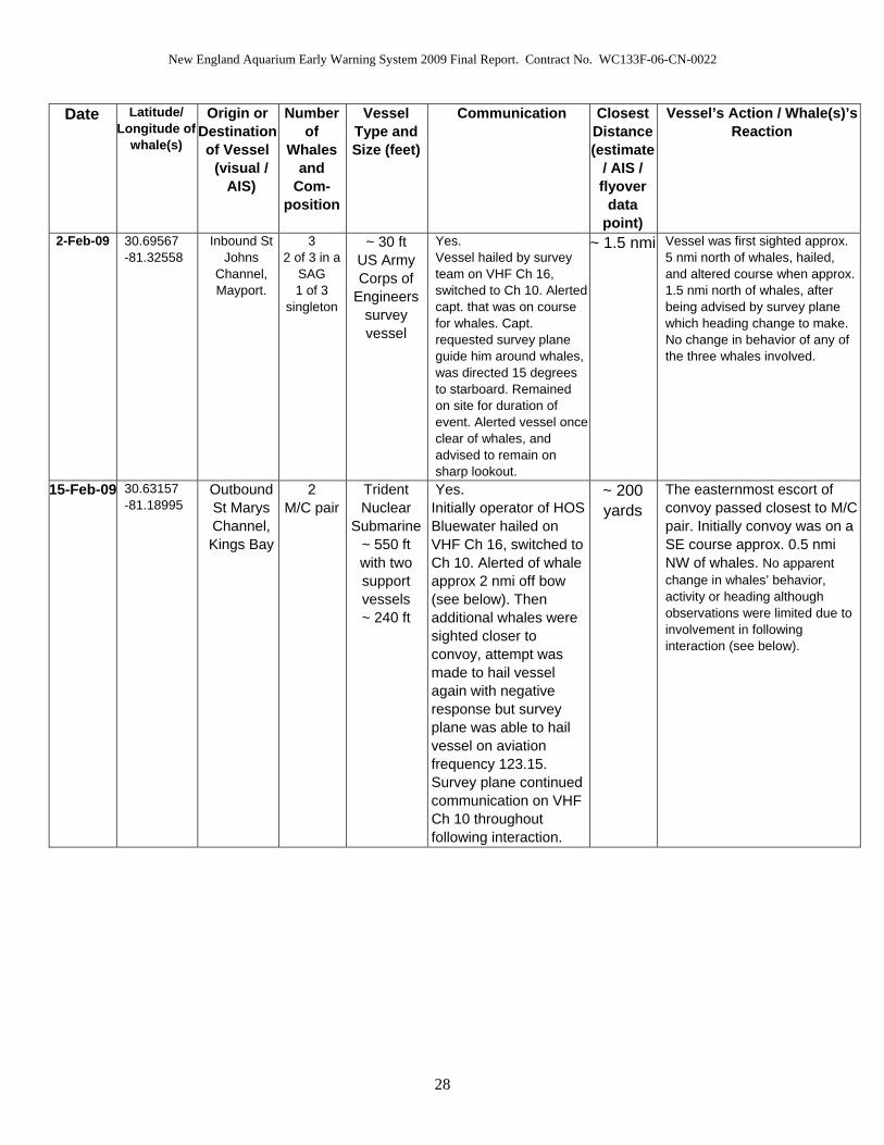
Vessel/Whale Interactions During the 2009 season the NEA survey aircraft documented 14 vessel/whale
interaction events involving 21 vessels (Table 5). The 21 vessels involved are not all unique, 4 of the 21 are duplicates since they were involved in consecutive interactions with multiple groups of whales. When the survey team visually determined that a vessel was on a course likely to result in the vessel and whale(s) being less than one nmi apart, an attempt to contact the vessel operator was made via Marine VHF Ch. 16, when possible. The 21 vessels involved consisted of eight recreational pleasure crafts, four submarine escorts, two submarines, two survey vessels, two large merchant vessels, one tug alone, one casino vessel and one kayak. The NEA survey team was able to make positive contact in seven of the 14 interaction events documented. Of the seven situations where no communication was achieved between survey team and vessel operator, no hail attempt was made in three cases, either because the vessel was already clear when survey team sighted the interaction, or no form of communication was available such as the case involving the kayaker. All four of the incidents where vessels were hailed resulting in negative contact, involved small recreational vessels. In several interactions where communication was successful, the survey team communicated with a key point of contact, responsible for coordinating other vessels involved. For example, during the
18

New England Aquarium Early Warning System 2009 Final Report. Contract No. WC133F-06-CN-0022
interaction with the submarine and escort vessels, communication was maintained with the escort vessel operator who in turn communicated with the rest of the convoy. Thirteen of the 21 vessels involved were responsible for Close Approach Interactions.
Mortalities and Injuries Mortalities that either occurred during the 2009 season in the EWS survey area or
presumed mortalities that became evident post-season which relate to the individuals documented in the EWS season, are described in the following text. Injuries that occurred during the 2009 season or were first documented during the season are described in the following text, with subsequent descriptions of these individuals post-season when known. Mortalities and injuries are broken down into three sections; entanglements, injury and additional mortality. Table 6 summarizes mortality and injury events during the 2009 season. Not all of the event details, or surrounding descriptions occurred in the CEWS area, or were documented by the NEA team. Event descriptions compile data contributed from various research entities when relevant, and reference is credited in the following text. Entanglement:
During the 2009 season, EWS survey teams documented five previously unknown
right whale entanglement cases. In addition, one previously known entangled whale was sighted in the area (# 3346, ‘Kingfisher’). Categorization of ‘Fatal’ in Table 6 has been determined as negative for cases where entangled whales have been seen gear free and in good health conditions following disentanglement, or ‘unknown’ when the whale has not been re-sighted whether disentanglement events were successful or not. It cannot be definitively stated that an entanglement is not life threatening when any gear remains on the animal since the severity can worsen considerably over time, and therefore whales that maintain any degree of entanglement are classified as ‘unknown’.
On 08 December 2008, an entangled right whale was discovered and documented by the NEA survey team, approximately 16 nmi (29.6 km) northeast of Jacksonville Beach, FL. The line wrapped around the rostrum, through the mouth, with a tight body wrap. There were two trailing lines, with one bitter end stopping just aft of the flukes and the other terminating approximately 350 ft behind the whale. The whale was identified as #3294, an animal of unknown age, first sighted in 2002, and previously sighted gear free in April 2008. Right whale #3294 was sighted again during the 2009 season by the WTGA team on 18 December at which time a Georgia Department of Natural Resources (GDNR) on-water response team were able to attach a telemetry buoy to a tangle of line which appeared to originate from the flippers. The following day it became apparent that the buoy was adrift, and it was recovered by the GDNR response team, with
19

New England Aquarium Early Warning System 2009 Final Report. Contract No. WC133F-06-CN-0022
approximately 402 ft (134 m) of line attached to it. The whale was re-sighted on 01 February 2009 by the NEA team and following documentation from NEA, WTGA aerial teams and FWC, NOAA and PCCS on-water responders, it is thought that this whale is now gear free. On 26 December 2008 the FWC aerial team sighted an entangled whale with two loops of yellow line wrapped through the mouth, meeting in a knot towards the rear of the body and trailing approximately 300 ft aft of the flukes with one yellow and one white buoy at the end. On the same day, the FWC on-water response team was able to affix a telemetry buoy to the trailing line, and remove buoys and 360 ft of line aft of the attached telemetry buoy. This whale was identified as the 2007 calf of #1701, last seen in the Bay of Fundy 25 September 2008 gear free. Argos and GPS signals were not strong, although the FWC survey plane was able to relocate the whale tracking VHF transmissions on 27 December 2008. A multi-agency team successfully cut the two loops across the back, attached a replacement telemetry buoy closer to the body with an additional float to aid in the shedding of the gear. Based on telemetry data it appeared that the buoy became adrift of the whale in the early hours of 28 December 2008. The adrift buoy was retrieved that same day with approximately 100 ft of line attached to it, and the whale was next seen gear-free by the WTGA team, 07 January 2009 involved in a SAG, and subsequently multiple times throughout the season. It is believed that right whale 2007 calf of #1701 is currently gear free. A severely entangled whale was discovered 14 January 2009 by the WTGA survey team approximately 15 nmi offshore of GA. The whale, identified as the 2003 Calf of #1711 and subsequently named “Bridle” #3311, had multiple lengths of line anchored in the mouthline and trailing alongside the body. At least one line exited the right mouthline, passing over the upper jaw to a small buoy and tangle of line on the left side of the head close to the eye. The line had cut deeply into the upper jaw and lower lip. The GDNR on-water team was able to mount a response, secure a telemetry buoy to the trailing gear, remove some of the trailing line, and place a small Norwegian buoy in front of the telemetry buoy. This whale was re-sighted 15, 18 and 22 January by the FWC aerial survey team. A disentanglement attempt was made on 22 January, and the Norwegian buoy was removed. The next disentanglement attempt on 23 January found the whale to be highly evasive and it continuously maneuvered away from boat approaches. Further documentation was obtained from re-sights on 01 February by WTGA aerial survey team when another on-water disentanglement attempt was made, then nearly a month later on 04 March by FWC aerial team. The line cutting across the lower lip had incised deeply, there was a bad infestation of orange and white cyamids that had expanded across the head, and skin condition had also generally declined. On 05 March, the WTGA team located the whale, and provided aerial support for a boat-based sedation attempt. Following drug administration the whale was still highly evasive. On 06 March the disentanglement team and on-board veterinarians, successfully administered two doses of sedative which caused a notable change in behavior; specifically a more tolerable response to the boat approaches. A successful cut was made to the line exiting the lower jaw,
20
New England Aquarium Early Warning System 2009 Final Report. Contract No. WC133F-06-CN-0022
foreward of the knot where lines over the rostrum and lower lip converge. This left a short length of line in the mouthline and line trailing from the left flipper, although approximately 400 ft of line came loose and was recovered. The team noted some trailing line at depth but assessed that it may become free over time, however the health of this whale remains a cause for serious concern. On 31 January 2009 the NEA aerial survey team discovered an entangled right whale with line exiting the left mouthline, crossing over the head towards the right flipper and trailing at least one whale-length beyond the flukes. An on-water GDNR team was able to respond and deploy a telemetry buoy on the trailing line. This whale was identified as #3420, a five-year old female previously seen gear-free in the Bay of Fundy 11 September 2008. Telemetry fixes were sporadic and of low quality, it was suspected that the buoy was fouled or poorly oriented on the whale. On 25 February 2009 the USCG retrieved the telemetry buoy off of Mount Pleasant, NY. It had come adrift with 51 ft of line attached to it. There have been no further sightings of #3420 and the nature of any remaining line is not known. The WTGA survey team discovered an entangled right whale following the survey flight of 07 February 2009. The whale later identified as a juvenile, 2007 Calf of #2614, had a single wrapping line around the rostrum and two trailing lines stretching approximately 30 and 20 feet behind the flukes. The previously known sighting of this whale was on 05 January 2009 by Marineland and MRC off the coast of FL, showed the whale to be gear free. Following a re-sight of this animal on 09 February, the GDNR on-water response team was able to deploy a telemetry buoy to one of the two trailing lines, and a cut was attempted but the whale became more evasive at successive boat approaches. On 12 February 2009 a series of cuts were made by a multi-agency on-water disentanglement team. A cut was made to the line wrapping the rostrum and very close to the right mouthline, leaving a short length of line exiting the right side of the mouth and a longer length on the left, although the team assessed that this will likely be shed over time. This whale was last sighted by the PCCS aerial survey team in Cape Cod Bay (CCB) on 10 March 2009 actively feeding, although it is unclear as to whether all of the gear had been shed. Injuries:
During the 2009 season, EWS survey teams documented two right whales that had
visible injuries. The injury documented on the 2009 calf of #2145 was observed on multiple sightings and is not considered to be life threatening. The wound of 2009 calf of #2660 was only documented on one sighting, and this serious injury is thought to have led to this calf’s death.
A wound on the right flank of the 2009 calf of #2145 was first observed by the GDNR boat-based platform, during a hydrophone recording session on 29 December 2008. Clay George, of GDNR sent images from this cruise to NEA and shark experts for
21

New England Aquarium Early Warning System 2009 Final Report. Contract No. WC133F-06-CN-0022
review. A shark researcher from Massachusetts Division of Marine Fisheries, unofficially provided his opinion that this wound appeared to be the result of a shark bite, most likely a white shark. The calf was first sighted in the SEUS by the FWC aerial survey team on 19 December 2008 with no visibly apparent superficial wounds, although two small marks are evident in the same region where a wound later became apparent. The next sighting of this calf was by the NEA team, on 25 December where a wound is beginning to be evident on the right flank of this calf. In the sighting on 27 December, documented by the NEA aerial survey team, the semi-circle shape of the wound is starting to be visible. It is a possibility that the wound is not evident in aerial images from earlier sightings as it would have been too fresh for cyamids to have infested the exposed area, and marks are less evident from more distant, aerial photographs. Subsequent boat-based and aerial images (09 February 2009 image, Figure 20) show two large bite-shaped marks on the right flank, with orange/pink coloration from cyamid infestation and additional surrounding white scrape lines. This superficial wound is not categorized a serious injury according to the criteria for cuts from entanglement or ship strikes (Knowlton and Kraus, 2001), since the mark is not estimated to be deeper than 8cm (3.1 inches). Interestingly, several sharks were sighted within the EWS, and two sightings allowed for opportunistic photographic documentation, for which species identification was later confirmed as that of white sharks (Carcharodon carcharias). No new wounds were evident on the mother of this calf, and the calf was monitored closely during the 2009 season when it was sighted on multiple occasions with no apparent hindrance to its health. The 2009 calf of #2145 has not been categorized as ‘Fatal’ in Table 6 since the injury was not considered serious, and the calf was seen multiple times in an apparently healthy condition during the EWS 2009 season and subsequently in the Bay of Fundy critical habitat (August 2009).
The calf of #2660 “Gannet” was first sighted with her mother by the NEA team in the CEWS area on 12 February 2009. This was the only sighting of this calf by any aerial survey team during the EWS 2009 season, and following analysis of photo documentation it was noticed that the calf was missing part of its left fluke (Figure 21). The severed edge appears to be a clean cut based on aerial images. No blood was observed in the surrounding water and the calf was swimming normally. The next sighting of right whale #2660 was on 15 February 2009 when she was associated with an unidentified juvenile and her calf was not observed anywhere within the surrounding area. A calf carcass was discovered on 17 February 2009 and towed in by the FWC on-water response team. The identification of this carcass is unknown as of August 2009, until results have been processed from genetic sampling. Considering the time frame of the documented injury, carcass discovery, and estimated time of death from necropsy, it is feasible the carcass is that of 2009 calf of #2660. Identification cannot be verified by matching the fluke injury since the body had been heavily predated upon, apparently while still alive, by sharks (see Mortalities below). In the SEUS calving area, when a mother has been documented with a calf and subsequently documented without the calf, if environmental conditions during the sighting are good enough to be confident that the calf would have been seen if present, we assume that the calf has died. Since a carcass was not positively matched to this calf, this
22
New England Aquarium Early Warning System 2009 Final Report. Contract No. WC133F-06-CN-0022
23
presumed mortality has been accounted for in the mortalities table, represented by the sighting of #2660 alone on 15 February, which is also the reason the calf’s injury has been classified as fatal.
In addition, on the final day of the EWS season, 31 March 2009 a report was received from the USCG of a 30 ft recreational vessel travelling approximately 22 kts striking a suspected right whale four nmi (7.4 km) south of Port Royal Sound, SC. The impact did severe damage to the vessel. USCG responded to distress calls and reported seeing a suspected right whale at the surface and a trail of blood in the water. Although aerial surveys dedicated a search to the area, no teams sighted any whales in the vicinity and therefore no photographic documentation exists for this event. The event is currently under investigation by NOAA Fisheries Service Law Enforcement personnel. Additional Mortalities:
On 17 February 2009 the FWC aerial survey team discovered a dead calf carcass
approximately 13 nmi north-northeast of the St. Augustine inlet during a routine SEWS survey. It was towed in by an on-water FWC team, and the necropsy took place the following day on Buck Island, on the south shore of the St Johns River. Bob Bonde of the US Geological Survey (USGS) was leading the necropsy with a multi-agency team (FWC, Jacksonville Zoo, University of Florida and Marineland). The calf was estimated to be a week to 10 days old. The cause of death has not been positively determined, although it appears to have bled to death from premortem shark predation. There is a possibility that this could be the calf of #2660 “Gannet” (see Injuries above). Two days had passed between sighting this mom without her calf and discovering the unidentified carcass. In addition, the calf’s severed fluke injury may have contributed to the cause of ultimate death. It is not possible to match the identification of this carcass to #2660’s calf based on the fluke injury since the condition of the carcass was moderately decomposed and heavily scavenged. Although the main body cavity was intact the fluke was gone and therefore the necropsy team could not confirm the identity as that of #2660’s calf. Identification will be determined pending genetic sampling analysis by Trent University, Ontario, Canada. If identification of the carcass is not a genetic match with calf of #2660 then it can be presumed that an additional calf was lost during the 2009 season.
In addition to confirmed calf mortalities with carcass retrievals, the 2009 season mom #2320, “Piper” was documented in CCB, MA by PCCS on 14 and 17 April 2009 without her calf. Piper (#2320) was first sighted with a calf during the 2009 EWS season by WTGA, and on eight subsequent days by various EWS research teams. The environmental conditions were excellent during the 17 April 2009 sighting, and the survey team was confident that they would have seen a calf while on site if it had been present. The 2009 calf of #2320 is presumed dead. Based on the above information, a minimum of two of the 39 mothers documented with their calves during the 2009 season are suspected to have lost their calves.

New England Aquarium Early Warning System 2009 Final Report. Contract No. WC133F-06-CN-0022
TABLES AND FIGURES
Table 1. NEA Aerial Survey Effort (including contingency surveys)
Number of Available
Survey Days
Number of Surveys Flown/ Percent
Number of Full
Surveys
Number of Partial Surveys
Total Available Transect
Miles (nmi)
Total Transect
Miles Flown (nmi)/Percen
t of Total
Available
Percent of Transect Miles
Flown in Beaufort <3
Number of Transect
Miles Flown in Beaufort
< 3 / Percent of
Total Available
121 71 40 31 49,142 23,879 20,344
58.7 % 48.6 % 85.2 % 41.4 %
Table 2. NEA Aerial Contingency Survey Effort
Type of Contingency
Survey
Number of Surveys Flown
Number of Full
Surveys
Number of Partial Surveys
Total Transect
Miles Flown
Number of Transect
Miles Flown in Beaufort
< 3
Percent Flown in
Beaufort < 3 of Total Available
Northern 2-plane 3 2 1 1,003 871 86.8 %
Southern 2-plane 1 1 0 424.3 424.3 100 %
1-plane 2 1 1 813.1 813.1 100 %
24

New England Aquarium Early Warning System 2009 Final Report. Contract No. WC133F-06-CN-0022
Table 3. NEA Aerial Survey Right Whale Sighting Frequency
Beaufort < 4 Beaufort > 4
Total Transect Miles Flown (nmi) 20,344 3,535
Number of Right Whale Sighting Events with Calculable Sighting Distances 285 14
Sightings per nmi of Effort for Sightings with Calculable Sighting Distances 0.014 0.004
Number of Right Whale Sighting Events 410 20
Sightings per nmi of Effort 0.020 0.006
25

New England Aquarium Early Warning System 2009 Final Report. Contract No. WC133F-06-CN-0022
Table 4. Calving Intervals for 2009 Season Mother / Calf Pairs
2009 Mom/Calf
Pairs
Age/Age Class
Number of Calves (including 2009 calf)
Calving Interval
1012 A 7 calves- First w/calf 12/18/08 NEA 41142 A 8 calves- First w/calf 02/01/09 NEA 51151 A 6 calves- First w/calf 12/15/08 NEA 31204 A 7 calves- First w/calf 02/26/09 NEA 41233 A 5 calves- First w/calf 03/09/09 NEA 51240 A 8 calves- First w/calf 1/09/09 VMSM 41246 A 7 calves- First w/calf 01/05/09 WTGA 41266 A 7 calves- First w/calf 12/18/08 FWC 51281 A 7 calves- First w/calf 01/19/09 WTGA 31303 A 6 calves- First w/calf 02/17/09 FWC 41310 A 7 calves- First w/calf 01/05/09 WTSC 41315 A 5 calves- First w/calf 01/22/09 NEA 41334 A 8 calves- First w/calf 1/10/09 NEA 41503 24 4 calves- First w/calf 12/18/08 WTSC 31515 A 6 calves- First w/calf 12/29/08 WTGA 61608 23 2 calves- First w/calf 12/3/08 WTGA 61611 23 3 calves- First w/calf 01/14/09 WTGA 31612 A 5 calves- First w/calf 12/28/08 NEA 61711 22 2 calves- First w/calf 01/02/09 WTGA 61817 A 4 calves- First w/calf 01/05/09 NEA 31946 20 4 calves- First w/calf 11/25/08 WTSC 3
1970** A 4 calves- First w/calf 02/25/09 WTSC 42123 18 4 calves- First w/calf 12/29/08 WTGA 32145 18 4 calves- First w/calf 12/19/08 FWC 22223* 17 2 calves- First w/calf 12/29/08 UNCW 42320 A 2 calves- First w/calf 12/29/08 WTGA 32503 14 2 calves- First w/calf 01/28/09 NEA 32520 A 4 calves- First w/calf 02/06/09 WTGA 62611 13 2 calves- First w/calf 01/04/09 WTGA 22660 13 2 calves- First w/calf 02/12/09 NEA. Lost calf. 32791 12 2 calves- First w/calf 02/21/09 FWC 33101 8 1 calf- First w/calf 02/01/09 NEA NA3108 8 1 calf- First w/calf 12/30/08 FWC NA
3139** 8 1 calf- First w/calf 02/28/09 WTGA NA3290 7 1 calf- First w/calf 02/02/09 FWC NA3317 6 1 calf- First w/calf 02/26/09 NEA NA3320 A 1 calf- First w/calf 12/04/08 NEA NA3370 U 1 calf- First w/calf 02/21/09 WTGA NA3440 A 1 calf- First w/calf 01/10/09 WTSC NA
*Not seen in the SEUS (only seen in NC) **Never sighted by Central EWS team
26
New England Aquarium Early Warning System 2009 Final Report. Contract No. WC133F-06-CN-0022
Table 5. NEA Aerial Survey Vessel/Whale Interactions
Date Latitude/ Longitude of
whale(s)
Origin or Destination of Vessel
(visual / AIS)
Number of
Whales and
Com-position
Vessel Type and Size (feet)
Communication Closest Distance (estimate
/ AIS / flyover
data point)
Vessel’s Action / Whale(s)’s Reaction
28-Dec-08 30.7126 -81.30949
Inbound St Marys Channel
2 M/C pair
Large Merchant
Yes. Observers spotted the whales at same time as being hailed by harbor pilot onboard large merchant. Harbor Pilot informed that he had a visual on the whales and was reducing speed as navigating in to the channel.
~ 100 meters*
Vessel was to whales’ north, and passed east to west. Whales were between buoys #1 and #3 on south side of St Marys channel. No change in whales’ behavior, activity or heading.
10-Jan-09 30.6672 -81.3225
Outbound St Marys Channel
2 M/C pair
21 ft Recreationa
l fishing vessel
No. Because vessel name was unknown, survey team hailed ‘SE heading recreational vessel at approx position’ and response came back from an alternative vessel which was not involved. Vessel in question never responded to hails.
~ 250 yards
After attempted hail, the recreational vessel altered heading to avoid whales but did not reduce speed. No change in movement, behavior or direction heading of whales. Whales remained inactive at surface throughout interaction.
22-Jan-09 30.57965 -81.283
Inbound St Johns
Channel probable.
~ 11 nmi N of STJ
heading SSW
1 Only calf observed although
mom present nearby
~ 40 ft Recreationa
l private yacht
No. No attempt was made to hail the vessel as it was on a course clear to the west and aircraft was onsite as vessel cleared whales.
~ 200 yards
Calf was breaching continuously before, during and following interaction. Vessel operator appeared not to have noticed breaching whale, and did not alter heading or speed.
23-Jan-09 30.59787 -81.07058
~ 20 nmi offshore between
Fernandina and
Jacksonville beach
heading SSW
2 M/C pair
~ 65 ft Recreationa
l private yacht
Yes. Vessel hailed on VHF Ch 16. Response achieved. Observers gave relative position of whales to vessel. Relay of information was delayed due to improper radio communication from vessel operator.
~ 20 feet No change in movement, behavior or direction heading of whales. Whales remained inactive, spending majority of time at surface. Vessel did not reduce speed after responding to survey team, only reduced speed when abeam of whales at closest position of approximately 20 feet, then made a slight change in direction of about 20 degrees towards whales, then resumed original course with slightly reduced speed.
27
New England Aquarium Early Warning System 2009 Final Report. Contract No. WC133F-06-CN-0022
Date Latitude/ Longitude of
whale(s)
Origin or Destination of Vessel
(visual / AIS)
Number of
Whales and
Com-position
Vessel Type and Size (feet)
Communication Closest Distance (estimate
/ AIS / flyover
data point)
Vessel’s Action / Whale(s)’s Reaction
2-Feb-09 30.69567 -81.32558
Inbound St Johns
Channel, Mayport.
3 2 of 3 in a
SAG 1 of 3
singleton
~ 30 ft US Army Corps of
Engineers survey vessel
Yes. Vessel hailed by survey team on VHF Ch 16, switched to Ch 10. Alerted capt. that was on course for whales. Capt. requested survey plane guide him around whales, was directed 15 degrees to starboard. Remained on site for duration of event. Alerted vessel once clear of whales, and advised to remain on sharp lookout.
~ 1.5 nmi Vessel was first sighted approx. 5 nmi north of whales, hailed, and altered course when approx. 1.5 nmi north of whales, after being advised by survey plane which heading change to make. No change in behavior of any of the three whales involved.
15-Feb-09 30.63157 -81.18995
Outbound St Marys Channel, Kings Bay
2 M/C pair
Trident Nuclear
Submarine~ 550 ft with two support vessels ~ 240 ft
Yes. Initially operator of HOS Bluewater hailed on VHF Ch 16, switched to Ch 10. Alerted of whale approx 2 nmi off bow (see below). Then additional whales were sighted closer to convoy, attempt was made to hail vessel again with negative response but survey plane was able to hail vessel on aviation frequency 123.15. Survey plane continued communication on VHF Ch 10 throughout following interaction.
~ 200 yards
The easternmost escort of convoy passed closest to M/C pair. Initially convoy was on a SE course approx. 0.5 nmi NW of whales. No apparent change in whales’ behavior, activity or heading although observations were limited due to involvement in following interaction (see below).
28
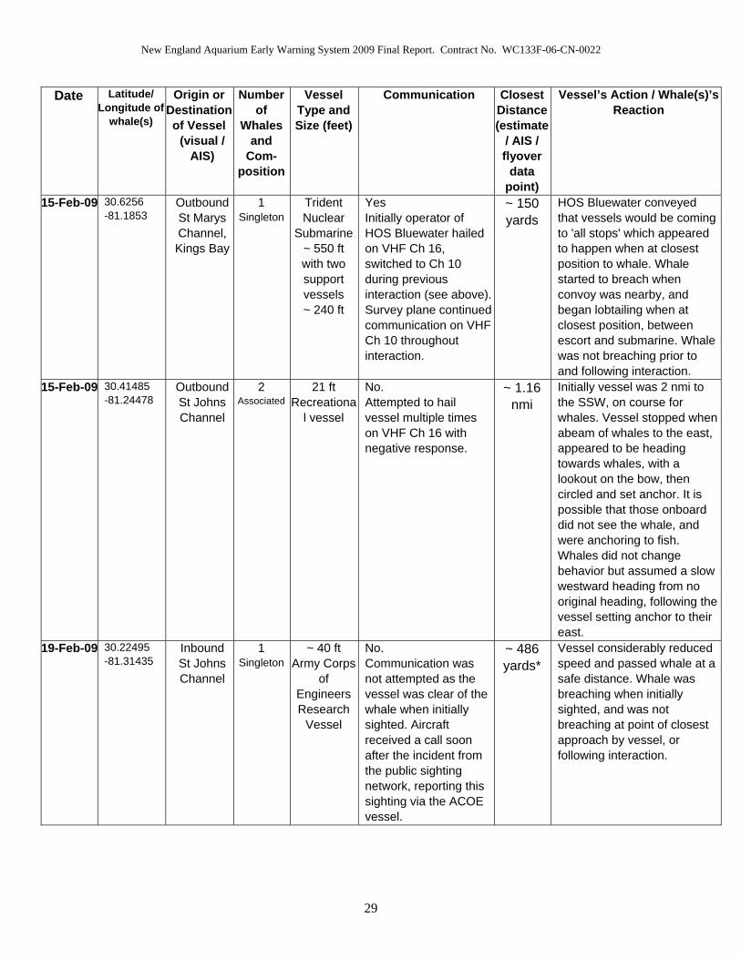
New England Aquarium Early Warning System 2009 Final Report. Contract No. WC133F-06-CN-0022
Date Latitude/ Longitude of
whale(s)
Origin or Destination of Vessel
(visual / AIS)
Number of
Whales and
Com-position
Vessel Type and Size (feet)
Communication Closest Distance (estimate
/ AIS / flyover
data point)
Vessel’s Action / Whale(s)’s Reaction
15-Feb-09 30.6256 -81.1853
Outbound St Marys Channel, Kings Bay
1 Singleton
Trident Nuclear
Submarine~ 550 ft with two support vessels ~ 240 ft
Yes Initially operator of HOS Bluewater hailed on VHF Ch 16, switched to Ch 10 during previous interaction (see above). Survey plane continued communication on VHF Ch 10 throughout interaction.
~ 150 yards
HOS Bluewater conveyed that vessels would be coming to 'all stops' which appeared to happen when at closest position to whale. Whale started to breach when convoy was nearby, and began lobtailing when at closest position, between escort and submarine. Whale was not breaching prior to and following interaction.
15-Feb-09 30.41485 -81.24478
Outbound St Johns Channel
2 Associated
21 ft Recreationa
l vessel
No. Attempted to hail vessel multiple times on VHF Ch 16 with negative response.
~ 1.16 nmi
Initially vessel was 2 nmi to the SSW, on course for whales. Vessel stopped when abeam of whales to the east, appeared to be heading towards whales, with a lookout on the bow, then circled and set anchor. It is possible that those onboard did not see the whale, and were anchoring to fish. Whales did not change behavior but assumed a slow westward heading from no original heading, following the vessel setting anchor to their east.
19-Feb-09 30.22495 -81.31435
Inbound St Johns Channel
1 Singleton
~ 40 ft Army Corps
of Engineers Research
Vessel
No. Communication was not attempted as the vessel was clear of the whale when initially sighted. Aircraft received a call soon after the incident from the public sighting network, reporting this sighting via the ACOE vessel.
~ 486 yards*
Vessel considerably reduced speed and passed whale at a safe distance. Whale was breaching when initially sighted, and was not breaching at point of closest approach by vessel, or following interaction.
29

New England Aquarium Early Warning System 2009 Final Report. Contract No. WC133F-06-CN-0022
Date Latitude/ Longitude of
whale(s)
Origin or Destination of Vessel
(visual / AIS)
Number of
Whales and
Com-position
Vessel Type and Size (feet)
Communication Closest Distance (estimate
/ AIS / flyover
data point)
Vessel’s Action / Whale(s)’s Reaction
19-Feb-09 30.74895 -81.23534
1 of 2 Outbound St Johns Channel,
Jacksonville
2 of 2 Outbound St Marys Channel,
Fernandina.
2 M/C pair
1 of 2 Tug alone ~ 110 ft 2 of 2
Freighter, large
merchant
1 of 2 Yes. Hailed on VHF Ch 16, Capt. responded immediately and switched to Ch 10. Capt. requested advisement on best change of course to avoid. Following communication with freighter (see below) capt. advised that he had copied coordinates of whales. 2 of 2 Yes. Initial attempts to hail harbor pilot on Ch 11 (pilots working ch.) with negative contact. Vessel capt. hailed on Ch 16, switched to Ch 10. Coordinates of whales relayed, and capt. responded that he would alter course to avoid. Tug and freighter coordinated navigation on Ch 10.
1 of 2 ~ 0.52 nmi*
2 of 2 ~ 2.51 nmi*
Tug was clear of whales to the east and freighter was coordinating with tug to pass sea buoy on its port side. Freighter was clear of whales to the south by over 2 nmi. Initially the mom calf pair were traveling slowly to the south. Following interaction whales had stopped traveling and were resting at the surface facing in a north direction.
27-Feb-09 30.32722 -81.14138
Outbound St Johns Channel
2 M/C pair
~ 21 ft Recreationa
l sport fishing vessel
No. Attempted to hail multiple times on VHF Ch 16 with negative contact.
~ 627 yards
Vessel cleared whales to the south, continuing on a WSW heading, towards another M/C pair (see below). No change in vessel heading or speed. Whales remained resting at surface throughout interaction, no change in activity.
30

New England Aquarium Early Warning System 2009 Final Report. Contract No. WC133F-06-CN-0022
Date Latitude/ Longitude of
whale(s)
Origin or Destination of Vessel
(visual / AIS)
Number of
Whales and
Com-position
Vessel Type and Size (feet)
Communication Closest Distance (estimate
/ AIS / flyover
data point)
Vessel’s Action / Whale(s)’s Reaction
27-Feb-09 30.33002 -81.11123
Outbound St Johns Channel
2 M/C pair
~ 21 ft Recreationa
l sport fishing vessel
No. Attempted to hail multiple times on VHF Ch 16 with negative contact.
~ 1 nmi After clearing the previous M/C pair, vessel continued towards next M/C pair and passed to the south. It did not appear to the survey team that vessel operator was aware of either group of whales. No change in vessel heading or speed. Whales remained resting at surface, calf rolling, with body contact between pair, throughout interaction, no change in activity.
27-Feb-09 30.3723 -81.34818
1+2 of 3 Outbound
St Augustine probable
3 of 3 Outbound St Johns Channel
2 M/C pair
1 of 3 ~ 40 ft
Recreational private yacht
2 of 3 ~ 35 ft
Recreational vessel
3 of 3
~ 200 ft Casino
cruise ship
Yes. Initially negative response to hails on Ch 16. 2 of 3 eventually responded, switched Ch 10. Vessel informed survey plane that he was coordinating navigations with 2 other vessels planning to converge at the mouth of the channel and continue north. Requested switch Ch 68 in order for all vessels involved to follow guidance. Survey plane guided 1+2 of 3 at risk of collision, clear of the whales by suggesting alter course to stbd. Positive contact was made with 3 of 3 on Ch 16 switched Ch 10. Capt responded that he planned on staying to east of whales.
1 of 3 ~ 750 yards
2 of 3 ~ 700 yards
3 of 3
~ 1 nmi
1 of 3 altered course to starboard and was clear of whales. Vessel did not appear to reduce speed. 2 of 3 did not appear to have altered course to a great enough degree and was requested to come further to stbd, then was clear of whales to east. Vessel did not appear to reduce speed. 3 of 3 was clear of whales to the north east.
31

New England Aquarium Early Warning System 2009 Final Report. Contract No. WC133F-06-CN-0022
Date Latitude/ Longitude of
whale(s)
Origin or Destination of Vessel
(visual / AIS)
Number of
Whales and
Com-position
Vessel Type and Size (feet)
Communication Closest Distance (estimate
/ AIS / flyover
data point)
Vessel’s Action / Whale(s)’s Reaction
7-Mar-09 30.25763 -81.37748
Jacksonville Beach
2 M/C Pair
~ 10 ft Kayak
No. No direct means of communicating available, although law enforcement were alerted via ground contact.
~ 100 ft During the time that survey plane was on site, kayaker was to the west of the whales. Initial sighting of kayaker with whales was at 0923 (L). Upon relocation of whales at 1112 (L), there were no vessels in the vicinity of the whales. M/C pair continued to log at surface throughout interaction.
*Data from AIS
32

New England Aquarium Early Warning System 2009 Final Report. Contract No. WC133F-06-CN-0022
Table 6. Entanglement, Injury and Additional Mortality.
Entanglements
Date Event Fatal Right
Whale
Sex Age Notes
08-Dec-08 Discovery and first documentation of
Entanglement
No #3294 U A Attached buoy became adrift and recovered with line.
Whale appeared to be gear free on 01 Feb 2009 off FL coast.
26-Dec-08 Discovery and first documentation of
Entanglement
No 2007 Calf of #1701
U 2 Successful disentanglement cuts made.
Attached buoy became adrift and recovered with line.
Whale sighted gear free 07 Jan 2009 and multiple times following this in SEUS
14-Jan-09 Discovery and first documentation of
Entanglement
Unk #3311
‘Bridle’
U 6 Multiple disentanglement attempts, successful sedation and cuts made.
Whale has not been sighted following responses, nature of gear remaining unknown
and health is of serious concern.
31-Jan-09 Discovery and first documentation of
Entanglement
Unk #3420 F 5 Attached buoy became adrift and recovered off NJ with line.
Whale has not been sighted following response, nature of gear remaining unknown.
7-Feb-09 Discovery and first documentation of
Entanglement
No 2007 Calf of #2614
U 2 Successful disentanglement cuts made.
Whale appears to be gear free in Cape Cod Bay 10 March 2009 - sighted actively feeding.
10-Feb-09 First SEUS 2009 season sighting of
previous entanglement case
Unk #3346
Kingfisher
M 6 Known previous entanglement case
33

New England Aquarium Early Warning System 2009 Final Report. Contract No. WC133F-06-CN-0022
Injury
Date Event Fatal Right
Whale
ID
Sex Age Notes
19-Dec-08 First documentation of calf
No 2009 Calf of #2145
M Calf Calf documented with suspected shark bite wound on right flank
12-Feb-09* First and only documentation of calf
Yes 2009 Calf of #2660
U Calf Calf documented missing half of left fluke. Probable ship strike. Possible carcass retrieval
17 Feb 2009 although ID not yet matched from genetic sample.
31-Mar-09 Report of suspected vessel strike to USCG off SC
Unk Unk U U Recreational vessel sent a distress call. USCG responded. Personnel reported seeing a whale after the strike but species identification not
confirmed.
Additional Mortalities
Date Event Fatal Right
Whale
ID
Sex Age Notes
15-Feb-09* First documentation of #2660 without calf
Yes 2009 Calf of #2660
Unk Calf Lost calf sometime between 2/12 and 2/15.
Could possibly be the carcass towed in on 2/17
17-Feb-09* Dead Calf off Florida coast
Yes Unk F ~ 7-10
d
Cause of death not determined.
Necropsy suggests traumas and bleeding to death from premortem shark predation.
14, 17-Apr-09
First and second documentations of
#2320 without calf
Yes 2009 Calf of #2320
Unk ~ 3.5 months
#2320 sighted two times without her calf in Cape Cod Bay
* All of these events could represent the same incident of injury leading to mortality. This cannot be confirmed until genetic samples have been processed.
34

New England Aquarium Early Warning System 2009 Final Report. Contract No. WC133F-06-CN-0022
Figure 1. CEWS Survey Area.
Cartography: Kerry Lagueux / New England Aquarium
Projected in Universe Transverse Mercator, Zone 17, using North American Datum 1983.
35
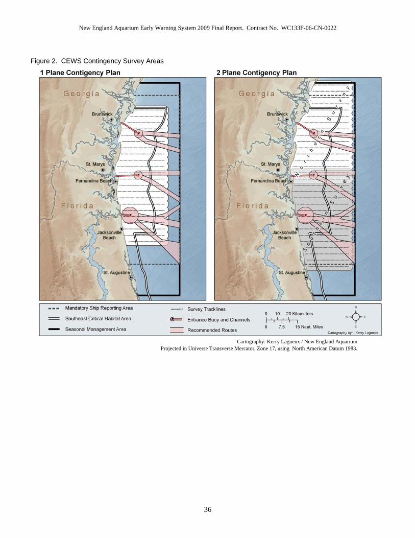
New England Aquarium Early Warning System 2009 Final Report. Contract No. WC133F-06-CN-0022
Figure 2. CEWS Contingency Survey Areas
Cartography: Kerry Lagueux / New England Aquarium
Projected in Universe Transverse Mercator, Zone 17, using North American Datum 1983.
36
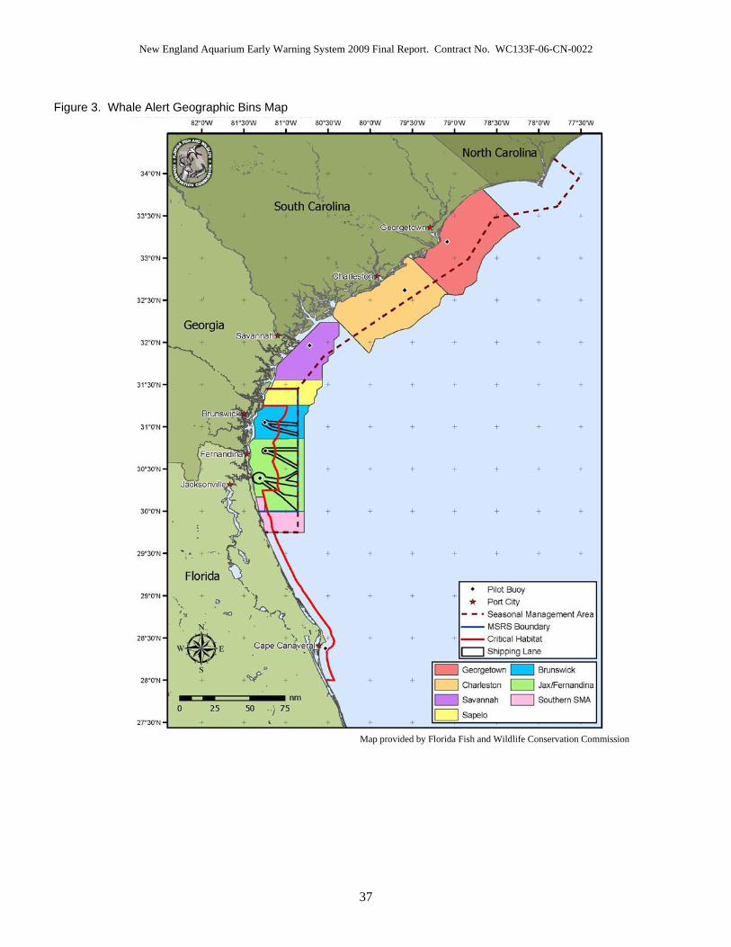
New England Aquarium Early Warning System 2009 Final Report. Contract No. WC133F-06-CN-0022
Figure 3. Whale Alert Geographic Bins Map
Map provided by Florida Fish and Wildlife Conservation Commission
37

New England Aquarium Early Warning System 2009 Final Report. Contract No. WC133F-06-CN-0022
Figure 4. NEA Aerial Survey Effort
Cartography: Kerry Lagueux / New England Aquarium
Projected in Universe Transverse Mercator, Zone 17, using North American Datum 1983.
38

New England Aquarium Early Warning System 2009 Final Report. Contract No. WC133F-06-CN-0022
Figure 5. NEA Aerial Survey Right Whale Sighting Events
Cartography: Kerry Lagueux / New England Aquarium
Projected in Universal Transverse Mercator, Zone 17, using North American Datum 1983.
39
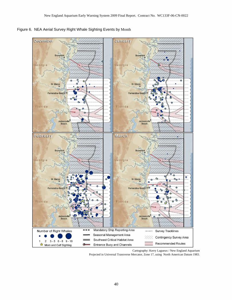
New England Aquarium Early Warning System 2009 Final Report. Contract No. WC133F-06-CN-0022
40
Figure 6. NEA Aerial Survey Right Whale Sighting Events by Month
Cartography: Kerry Lagueux / New England Aquarium
Projected in Universal Transverse Mercator, Zone 17, using North American Datum 1983.

New England Aquarium Early Warning System 2009 Final Report. Contract No. WC133F-06-CN-0022
Figure 7. NEA Aerial Survey Effort in trackline nmi displayed in 5 day blocks
0
500
1000
1500
2000
2500
Dec
1-5
Dec
6-1
0
Dec
11-
15
Dec
16-
20
Dec
21-
25
Dec
26-
30
Dec
31-
Jan
4
Jan
5-9
Jan
10-1
4
Jan
15-1
9
Jan
20-2
4
Jan
25-2
9
Jan
30-F
eb 3
Feb
4-8
Feb
9-13
Feb
14-1
8
Feb
19-2
3
Feb
24-2
8
Mar
1-5
Mar
6-1
0
Mar
11-
15
Mar
16-
20
Mar
21-
25
Mar
26-
31
Date
Trac
klin
e M
iles
Flow
n (n
m i)
Figure 8. Temporal Occurrence of Right Whales for NEA Aerial Surveys displayed in 5 day blocks.
Total numbers include individuals, mothers, and calves.
0
20
40
60
80
100
120
140
160
180
Dec
1-5
Dec
6-1
0
Dec
11-
15
Dec
16-
20
Dec
21-
25
Dec
26-
30
Dec
31-
Jan
4
Jan
5-9
Jan
10-1
4
Jan
15-1
9
Jan
20-2
4
Jan
25-2
9
Jan
30-F
eb 3
Feb
4-8
Feb
9-13
Feb
14-1
8
Feb
19-2
3
Feb
24-2
8
Mar
1-5
Mar
6-1
0
Mar
11-
15
Mar
16-
20
Mar
21-
25
Mar
26-
31
Date
Tota
l Num
ber o
f Wha
les
41

New England Aquarium Early Warning System 2009 Final Report. Contract No. WC133F-06-CN-0022
Figure 9. Whales per nmi trackline of NEA Aerial Survey Effort displayed in 5 day blocks
0.000000.010000.020000.030000.040000.050000.060000.070000.080000.09000
Dec
1-5
Dec
6-1
0D
ec 1
1-15
Dec
16-
20D
ec 2
1-25
Dec
26-
30D
ec 3
1-Ja
n 4
Jan
5-9
Jan
10-1
4Ja
n 15
-19
Jan
20-2
4Ja
n 25
-29
Jan
30-F
eb 3
Feb
4-8
Feb
9-13
Feb
14-1
8Fe
b 19
-23
Feb
24-2
8M
ar 1
-5M
ar 6
-10
Mar
11-
15M
ar 1
6-20
Mar
21-
25M
ar 2
6-31
Date
Wha
les
per n
mi E
ffort
Figure 10. Temporal Occurrence of Right Whales. Mom/calf pairs vs. individuals during NEA surveys displayed in 5 day blocks.
0
10
20
30
40
50
60
70
80
90
100
Dec
1-5
Dec
6-1
0
Dec
11-
15
Dec
16-
20
Dec
21-
25
Dec
26-
30
Dec
31-
Jan
4
Jan
5-9
Jan
10-1
4
Jan
15-1
9
Jan
20-2
4
Jan
25-2
9
Jan
30-F
eb 3
Feb
4-8
Feb
9-13
Feb
14-1
8
Feb
19-2
3
Feb
24-2
8
Mar
1-5
Mar
6-1
0
Mar
11-
15
Mar
16-
20
Mar
21-
25
Mar
26-
31
Date
Num
ber o
f Wha
les
Individuals Cow/Calf Pairs
42

New England Aquarium Early Warning System 2009 Final Report. Contract No. WC133F-06-CN-0022
Figure 11. NEA Aerial Survey Sighting Distances (n=299)
0
5
10
15
20
25
30
35
40
0.1
0.3
0.5
0.7
0.9
1.1
1.3
1.5
1.7
1.9
2.1
2.3
2.5
2.7
2.9
3.1
3.3
3.5
3.7
3.9
4.1
4.3
4.5
4.7
4.9
5.1
5.3
5.5
5.7
5.9
Sighting Distance (nmi)
Num
ber o
f Sig
htin
gs
Figure 12. NEA Aerial Survey Sighting Distances with Beaufort Sea State (SS) Considered (n=299)
0
5
10
15
20
25
30
35
40
0.1
0.3
0.5
0.7
0.9
1.1
1.3
1.5
1.7
1.9
2.1
2.3
2.5
2.7
2.9
3.1
3.3
3.5
3.7
3.9
4.1
4.3
4.5
4.7
4.9
5.1
5.3
5.5
5.7
5.9
Sighting Distance (nmi)
Num
ber o
f Sig
htin
gs
SS less than 4 SS more than or equal to 4
43

New England Aquarium Early Warning System 2009 Final Report. Contract No. WC133F-06-CN-0022
Figure 13. Demographic Structure of the EWS Area for all Non-Calf Right Whales
19%
5%
9%
23%17%
1%
11%
15%
Adult Females withCalves (n=38)
Adult Females withoutCalves (n=11)
Juvenile Females (n=18)
Adult Males (n=44)
Juvenile Males (n=35)
Adults of unknown sex(n=2)
Juveniles of unknown sex(n=23)
Unknown age andknown/unknown sex(n=31)
Age Class
Gender Adults Juveniles Yearlings Unknown
Age Grand Total
Females 49 18 0 2 69 Males 44 33 2 4 83 Unknown Sex 2 15 8 25 50
Grand Total 95 66 10 31 202
44

New England Aquarium Early Warning System 2009 Final Report. Contract No. WC133F-06-CN-0022
Figure 14. Association Types for all Right Whales Sighted by EWS Aerial Survey Teams
25%
49%
15%
11%
SAGM/C or Mother/Yearling pairOther – pairs, trios, includes M/C with others if not in a SAGSingleton
SAG 459 M/C or Mother/Yearling pair 902 Other – pairs, trios, includes M/C with others if not in a SAG 277 Singleton 201
45
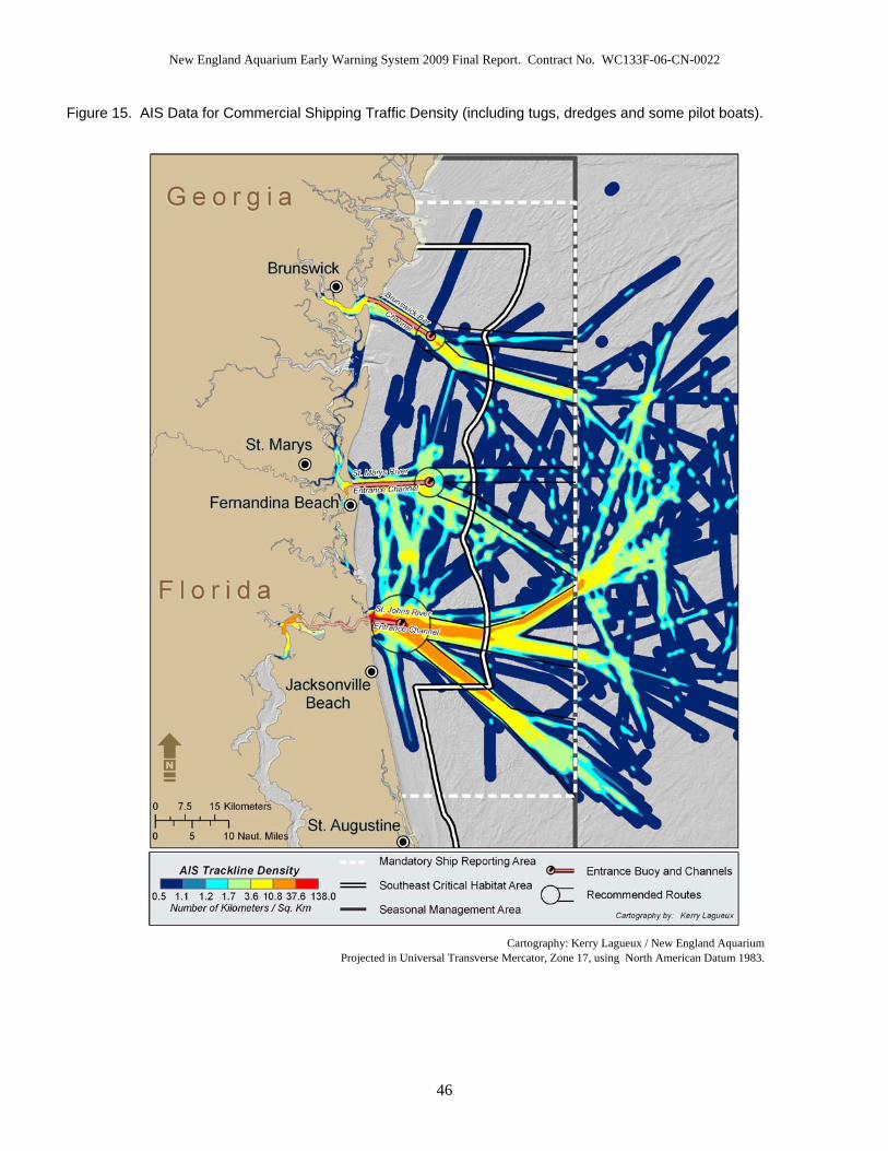
New England Aquarium Early Warning System 2009 Final Report. Contract No. WC133F-06-CN-0022
Figure 15. AIS Data for Commercial Shipping Traffic Density (including tugs, dredges and some pilot boats).
Cartography: Kerry Lagueux / New England Aquarium
Projected in Universal Transverse Mercator, Zone 17, using North American Datum 1983.
46

New England Aquarium Early Warning System 2009 Final Report. Contract No. WC133F-06-CN-0022
Figure 16. AIS Data for Commercial Tanker and Cargo Traffic Density
Cartography: Kerry Lagueux / New England Aquarium
Projected in Universal Transverse Mercator, Zone 17, using North American Datum 1983.
47
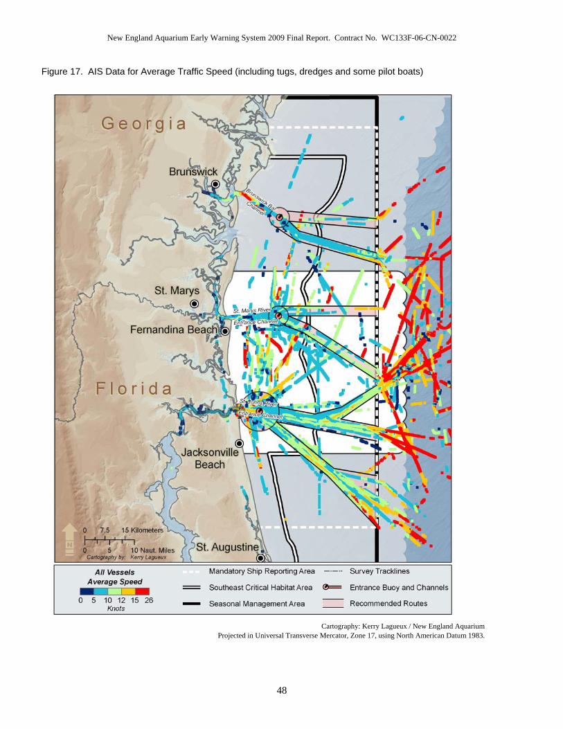
New England Aquarium Early Warning System 2009 Final Report. Contract No. WC133F-06-CN-0022
Figure 17. AIS Data for Average Traffic Speed (including tugs, dredges and some pilot boats)
Cartography: Kerry Lagueux / New England Aquarium
Projected in Universal Transverse Mercator, Zone 17, using North American Datum 1983.
48

New England Aquarium Early Warning System 2009 Final Report. Contract No. WC133F-06-CN-0022
Figure 18. AIS Data for Average Traffic Speed of Commercial Tanker and Cargo Vessels
Cartography: Kerry Lagueux / New England Aquarium
Projected in Universe Transverse Mercator, Zone 17, using North American Datum 1983
49

New England Aquarium Early Warning System 2009 Final Report. Contract No. WC133F-06-CN-0022
50
Figure 19. Ship Traffic (not required to carry AIS) Recorded Visually during NEA Aerial Surveys
Cartography: Kerry Lagueux / New England Aquarium
Projected in Universe Transverse Mercator, Zone 17, using North American Datum 1983.

New England Aquarium Early Warning System 2009 Final Report. Contract No. WC133F-06-CN-0022
Figure 20. Right Whale 2009 Calf of #2145 documented on 09 February 2009 by NEA Aerial Survey Team
Photo: Jessica Taylor / New England Aquarium
Figure 21. Right Whale 2009 Calf of #2660 documented on 12 February 2009 by NEA Aerial Survey Team
Photo: Jonathan Cunha / New England Aquarium .
51

New England Aquarium Early Warning System 2009 Final Report. Contract No. WC133F-06-CN-0022
DISCUSSION The coastal waters of Florida and Georgia, and possibly the Carolinas are currently the only known calving ground for the North Atlantic right whale. For 15 years there has been extensive survey effort in the heart of the calving ground (Georgia and Florida) in the form of EWS surveys. Originally, these surveys were designed to reduce the potential for vessel strikes in the calving ground. Over the past 15 years, the program of education, outreach, and regulatory measures implemented to reduce vessel strikes of right whales has grown dramatically. The southeast calving ground, located off some of the busiest ports along the eastern seaboard, is now arguably one of the most comprehensively monitored areas for right whales. On 09 December 2008 the Right Whale Ship Strike Reduction Rule was implemented which mandates, as one of many measures, that relevant vessels greater than or equal to 65 ft (19.8 m) must operate at speeds restricted to 10 knots or less within Seasonal Management Areas. With this critical mandate in place, the chance of having large, compliant vessels involved in a ship strike should be significantly reduced, especially when combined with the aerial survey effort and communication networks that have been refined over the past 15 years. The near daily aerial surveys in Florida and Georgia, and more recently South Carolina for the duration of the calving season meshed with the MSRS, Recommended Routes, and the Ship Strike Reduction Rule have all resulted in a safer habitat for this species. In addition to the main objective of the EWS, these surveys have contributed thousands of photo-documented right whale sightings to the North Atlantic Right Whale Catalog. These data play an integral role in the understanding of habitat use, demographics and reproductive success of this population. The teamwork and active participation of many agencies and interests is essential to the effectiveness of these surveys in mitigating collisions with right whales. The ability of the survey teams to alert their ground contact from as far as 35 nmi (64.8 km) from shore is the crucial catalyst to this network. Each survey teams’ ground contact receives the right whale sighting information from the survey aircraft and initiates many notifications via pagers. USCG Office of Aids to Navigation in Miami transmits right whale sighting information via NAVTEX. The USCG also transmits Notices to Mariners over VHF marine-band radio while the survey teams’ ground contact updates the MSRS. Simultaneously, the Harbor Pilot Associations at the ports of Jacksonville, Fernandina, Brunswick and Savannah monitor pagers, cell phones, or email for information transmitted by the survey teams or FACSFACJAX and relay this information to ships being piloted to/from their respective ports. This transmission of near-real time data, which propels a chain reaction of alerts and notifications along the coastline of the SEUS, is what distinguishes these aerial surveys as a potentially meaningful conservation tool. However, this tool as a primary measure for collision mitigation has limitations on many fronts. First, reduced visibility and weather that is too severe for survey aircrafts to be launched, results in numerous days with no survey effort. In turn, near real-time sightings cannot be provided to vessels during days of inclement weather. Second, in order for this effort to be effective, vessel operators must take measures to reduce the risk of a strike from occurring whenever transiting through the calving ground whether
52

New England Aquarium Early Warning System 2009 Final Report. Contract No. WC133F-06-CN-0022
sightings are available or not. Third, the information provided to vessels that are outbound from a port in the critical habitat is limited to NAVTEX messages (which provide information every four hours) as opposed to the near real-time data provided by the MSRS for incoming vessels. Fourth, the EWS system has not been proven as an effective measure in preventing vessel strikes from smaller, recreational vessels that typically operate at fast speeds and are not bound by the mandatory ship strike reduction rule. Finally, sightings reported are related to the survey teams’ ability to sight groups of whales which is dependent on a variety of factors including whales’ dive and respiration patterns. During the 2009 season, there was a suspected vessel strike injury documented in the SEUS, severing a portion of the left side of a calf’s fluke. Unfortunately, this could not be confirmed as the calf subsequently disappeared, and a calf carcass found days later had been predated on by sharks to such a degree that the fluke area was gone and thus not able to be assessed. In addition to the above suspected strike, there was a report received of a small recreational vessel striking a whale on the final day of the season off the coast of SC. A total of 14 vessel/whale interactions were witnessed and mitigated by the NEA aerial survey team. 21 vessels were involved in these events, of which 13 were involved in ‘Close Approach’ interactions coming within 500 yards of a right whale(s). Various vessel types were involved, although the limiting factor to efficient mitigation during interactions was the success in establishing communication with vessel operators. It is consistently difficult or impossible to hail the attention of small recreational vessel captains, particularly when travelling at high speeds. Every attempted hail directed at a vessel other than a small recreational vessel, successfully resulted in positive contact in order to coordinate interaction mitigation. Commercial vessel operators and harbor pilots were cooperative to coordination attempts from the survey team.
The process of assessing the effectiveness of the Right Whale Ship Strike Reduction Rule for mitigating risk from large merchant vessels is complicated and will require the area to be monitored for several years. Measuring vessel compliance with these new regulations will be essential for this process as only high levels of compliance will allow for a useful assessment of the potential benefit to right whales. AIS is a valuable tool for monitoring compliance, and efforts by NEA as well as state and Federal agencies are underway to evaluate vessel compliance.
The use of passive acoustic monitoring as a tool for gathering information on temporal whale abundance in the vicinity of busy shipping channels made considerable advancements during the 2009 season. However, technology has not yet advanced enough in order to localize exact positions of whales on a real-time scale. The Ship Strike Reduction Rule in conjunction with present education and outreach, and survey efforts, provide the best chance for mitigating risks to the North Atlantic right whale population. A review of the mortality and injury data maintained by NEA shows a total of 83 mortalities and 106 serious injuries documented between 1970 and the present (Knowlton and Kraus 2001; NMFS Stock Assessment Report, 2008; New England Aquarium unpublished data). Serious injuries include cuts from entanglements or ship strikes
53

New England Aquarium Early Warning System 2009 Final Report. Contract No. WC133F-06-CN-0022
deeper than 8 cm, as well as all whales carrying any kind of gear. It is likely that the severed left fluke documented on the calf of #2660 led to mortality, and possible that this coincides with the calf carcass discovered off the coast of FL. Since identification has not been confirmed through genetic analysis, these have been counted as two separate events; one serious injury and one mortality. Twenty-eight of the 83 (34%) known mortalities documented since 1970 were the result of ship strikes and 10 (12%) were caused by entanglements. The remainder were either of unknown causes or neonates. Thirty of the 83 (36%) mortalities have occurred in the SEUS from SC to Texas including 6 ship strikes, 1 entanglement, 4 of unknown cause, and 19 calves. Tracking the geographic area of where an injury from vessel strike or entanglement interaction occurred is hard to discern as animals that survive can swim long distances with their injury. Right whale carcasses are not always retrieved following fatal interactions, and this cryptic mortality makes it hard to provide a comprehensive assessment of threats to this species. Of the 106 serious injuries (66 entanglements, 39 vessel strikes, and 1 unknown), 11 entanglements and 9 vessel strikes were initially documented in the SEUS, and at least two of the entanglements and 8 of the vessel strikes were known to have occurred in the SEUS region. Using contributed data from all survey groups and opportunistic sightings; identification of all right whales photographed in the SEUS 2009 season is currently being conducted. These data continue to provide an understanding of how the critical habitat and adjacent areas in the SEUS are being utilized by the population throughout the winter. As of August 2009, 39 M/C pairs were documented during the 2009 right whale calving season, and 38 M/C pairs are known to have been in the EWS survey area. The NEA aerial survey team documented 36 (92%) of the 39 known M/C pairs. Of the 39 M/C pairs observed, two (5%) had previously calved in 2007 (in both cases, the 2007 calves are presumed dead), eleven (28%) had previously calved in 2006, ten (26%) had previously calved in 2005, three (8%) had previously calved in 2004, five (13%) had previously calved in 2003 and eight (20%) had never calved before. Of the 31 females with multiple calvings, 58% had a calving interval higher than three years (between four and six years), considerably higher than last year when only 11% had calving intervals of more than three years. The mean calving interval for this population between 1993-1998 was over 5 years (Kraus et al., 2001) and had increased from a 3.67 year average between 1980-1992 (Knowlton et al., 1994). The mean calving interval using contributed data for all known M/C pairs in all regions in 2009 is 3.9 years. This is a higher interval period when compared with the 2008 calving season (3.0 yr) although total numbers of M/C pairs were considerably higher this year than in any year previously documented. The 2009 mean calving interval of 3.9 years is shorter than the average documented in the late 1990’s. Of the 39 mothers documented in the 2009 season, 17 are of known age ranging from 6 to 24 years of age. Of the eight females in the EWS survey area that calved for the first time one was age six, one was age seven, three were age eight, and three were of unknown ages, making the average age of first time moms 7.4 yrs. This is lower than the mean age for first calving of 11.4 years documented through 2005 (Kraus and Rolland, 2007) and represents a hopeful sign that perhaps the reproductive health of the population is improving.
54

New England Aquarium Early Warning System 2009 Final Report. Contract No. WC133F-06-CN-0022
55
An opportunistic sighting off of NC, was the only sighting of the one calving female (#2223, “Calvin”), which was never documented within the SEUS survey area. Right whale #2223 is 17 years of age, has had two known calves in her reproductive history, with four years between these calving events. During the 2005 season, #2223 and her calf, were also first observed off the coast of NC. Documentation was by USCG on 30 December, 2004 and the whale was subsequently sighted multiple times further south within the EWS area throughout the 2005 season, whereas this year the only sighting of this whale was off of coastal NC. One M/C pair (#1240) was first sighted opportunistically off of VA, and subsequently many times in the EWS area. Right whale #1240 is of unknown age, although she gave birth to her first known calf in 1974 and therefore is presumed to be at least 45 yrs of age. In the 2009 season she had her eighth known calf, and was present in the calving grounds with her daughter (#1503) and grand-daughter (#2503) that were also 2009 season moms. Though all the individuals observed in the SEUS have not been identified, preliminary analysis indicates that the largest proportion of individuals that were not M/C pairs were juveniles (40%), many of which were involved in surface active groups. Since the SEUS is not known to be a feeding ground, the presence and the behavior of these non-M/C pairs suggests the habitat may serve another function, at least in some years. The high number of calves born in the past eight winters and the documented increase in juvenile, non-calving female and adult male presence in the SEUS warrants further exploration to define this additional function of the calving ground.
In conclusion, the SEUS critical habitat has one of the highest densities of commercial shipping traffic transiting through, along the eastern seaboard, and can now be considered one of the most well monitored habitats for North Atlantic right whales. The combination of near-daily aerial surveys, an extensive communications network, and comprehensive regulatory measures will likely serve to reduce risk of vessel collisions with right whales. Although it is too early to determine whether these combined measures have in fact been successful, careful assessment of the recently implemented Right Whale Ship Strike Reduction Rule is a high priority, as this regulation is set to expire 5 years after its implementation unless evidence is clear that it is proving beneficial. The joint efforts by the survey teams, NOAA Fisheries, USN, USCG and USACE to monitor and implement protective measures in this only known calving ground must continue in order to protect this most vulnerable segment of the population, and allow for it to grow and thrive.

New England Aquarium Early Warning System 2009 Final Report. Contract No. WC133F-06-CN-0022
ABBREVIATIONS
AFF Automatic Flight Following AIS Automated Identification System CCB Cape Cod Bay CEWS Central EWS survey area covered by the New England
Aquarium. CFR Code of Federal Regulations COAA Centro de Observação Astronómica no Algarve DIGITS Data Image Gathering and Information Tracking System ELT Emergency Locator Transmitter EPIRB Emergency Position Indicating Radio Beacon EWS Early Warning System FAA Federal Aviation Administration FACSFAC JAX
Fleet Area Control and Surveillance Facility, Jacksonville
FL Florida FWC Florida Fish and Wildlife Conservation Commission’s Fish and
Wildlife Research Institute GA Georgia GDNR Georgia Department of Natural Resources GIS Geographic Information System GPS Global Positioning System ID Identification IFAW International Fund for Animal Welfare IFR Instrument Flight Rules IMO International Maritime Organization M/C Mom (or Cow) calf pair association MA Massachusetts Marineland Marineland Right Whale Project MMSI Mobile Maritime Service Identities MRC Marine Resources Council MSR / MSRS Mandatory Ship Reporting System NARWC North Atlantic Right Whale Consortium NAVTEX The primary means for transmitting coastal urgent marine safety
information to ships worldwide. NAVTEX is broadcast from Coast Guard facilities around the United States including Miami, FL. The Coast Guard began operating NAVTEX from Boston in 1983
NC North Carolina NEA New England Aquarium NEFSC NOAA’s National Marine Fisheries Service, Northeast Fisheries
56

New England Aquarium Early Warning System 2009 Final Report. Contract No. WC133F-06-CN-0022
57
Science Center NEUS Northeast United States NEWS Northern Early Warning System survey area covered by the
Wildlife Trust, Georgia survey team. NOAA Fisheries Service
National Oceanic and Atmospheric Administration’s National Marine Fisheries Service
PCCS Provincetown Center for Coastal Studies PIC Pilot in Command PLB Personal Locator Beacon SAG Surface Active Group SEUS Southeast United States SEWS Southern Early Warning System survey area covered by Florida
Fish and Wildlife Conservation Commission’s Fish and Wildlife Research Institute survey team
SIC Second in Command SC South Carolina SS Beaufort sea-state UNCW University of North Carolina, Wilmington URI University of Rhode Island USACE United States Army Corps of Engineers USCG United States Coast Guard USGS US Geological Survey USN United States Navy VHF Very-high-frequency VMSM Virginia Aquarium & Marine Science Center WTGA Wildlife Trust, Georgia WTSC Wildlife Trust, South Carolina aerial survey team.
UNITS OF MEASURE
d Days ft Feet hr Hour km Kilometers kts Knots m Metres MHz Megahertz Mph Miles per hour nmi Nautical miles

New England Aquarium Early Warning System 2009 Final Report. Contract No. WC133F-06-CN-0022
DEFINITION OF TERMS # Example, ‘#2320’ refers to right whale catalog number 2320 in
accordance with the North Atlantic Right Whale Catalog. Occasionally denoted as EG#2320 referring to Eubalaena glacialis
Adult 9 years of age or older Associated Whales that are within several body lengths of each other and
coordinating their movements at the surface CEWS Central Early Warning System: Refers to the survey area
covered by the New England Aquarium team. The regular survey area is from 30°50N to 30°17N, although summary data provided in this report for the CEWS area includes a selection of days when contingency surveys were flown.
Close Approach Event
A vessel/whale interaction when the observed vessel comes within 500 yards at the closest distance to the whale(s).
Effort Any time that the aircraft is above water and observers have a visibility of one nmi or greater.
EWS area The survey area covered by northern, central and southern Early Warning System aerial survey teams. This does not include the WTSC survey area.
Individuals Whales which are not 2009 season moms or calves. These include singletons, members of; pairs, associations, and surface active groups.
Intentional Close Approach
An interaction event when the survey team believes that the vessel operator is aware of the presence of the whales and intentionally approaches within 500 yards.
Intermatch Code
A code given to a whale by NEA that has been matched for more than one sighting but the catalog # is unknown
Juvenile 1 – 8 years of age Logger 2000 Computerized logging program created by IFAW and designed
for compatibility with the Right Whale Consortium database Neonate A calf less than four weeks old OTHER Alternative sources of sighting information reported through the
EWS system. These were reliable sources such as Navy, US Coast Guard or the volunteer sighting network.
Presumed Dead
For a calf in the SEUS: When mother has been seen in the SEUS post calving without her calf during good sighting conditions at least once.
Season Code A code given to a whale by different organizations (other than NEA) to assist in the recognition of individuals in the field, based on matching within the season’s sightings, when the catalog # is unknown
58

New England Aquarium Early Warning System 2009 Final Report. Contract No. WC133F-06-CN-0022
59
SEUS Southeast United States. When referred to in the context of this report, the SEUS area includes survey areas of WTSC, NEWS, CEWS, and SEWS.
Sighting Event
An event by which the aircraft breaks from the trackline and a whale or group of whales are circled until they are positively identified as right whales.
Survey Effort Trackline nmi flown not including cross legs, transit miles or any deviation from tracklines.
Unavoidable Close Approach
A Close Approach Event when the survey team determines that the vessel’s operator cannot alter course due to navigational safety and/or restricted maneuverability.
Unit of Survey Effort
One unit is equivalent to one nmi flown when the survey team is on effort i.e. any time that the aircraft is above water and observers have a visibility of one nmi or greater.
Vessel/Whale Interaction Event
A situation when the survey team visually determines that a vessel is on a course that will result in the vessel and whale(s) being less than one nautical mile apart and communication between survey team and vessel are attempted in order to prevent collision or mitigate an interaction.
Whale Refers to north Atlantic right whale except for when indicated otherwise
Whales per nmi Effort
Individual whales per nautical mile of survey trackline

New England Aquarium Early Warning System 2009 Final Report. Contract No. WC133F-06-CN-0022
REFERENCES CITED Brown, M. W., S .D. Kraus, D. E. Gaskin, and B. N. White. 1994. Sexual composition and analysis of reproductive females in the North Atlantic right whale (Eubalaena glacialis), population. Mar. Mamm. Sci. 10: 253-265. Federal Register 59 FR 28793-28834 1994. National Marine Fisheries Service Final Rule 06/03/1994. Designated Critical Habitat; Northern Right Whale. Hamiltion, P. K. 2002. Associations among North Atlantic Right Whales. M. S. Thesis. University of Massachusetts, Boston.
Knowlton, A.R., S.D. Kraus, and R.D. Kennney. 1994. Reproduction in North Atlantic right whales (Eubalaena glacialis). Canadian Journal of Zoology. Vol. 72:1297-1305.
Knowlton, A.R., 1997. The Regulation of Shipping to Protect North Atlantic Right Whales: Need and Feasibility. For Master of Marine Affairs degree, University of Rhode Island. 188 pp.
Knowlton, A. R., S. D. Kraus. 2001. Mortality and serious injury of northern right whales (Eubalaena glacialis) in the western North Atlantic Ocean. Journal of Cetacean Research and Management (special issue 2): 193-208. Kraus, S. D., K. E. Moore, C. E. Price, M. J. Crone, W. A. Watkins, H. E. Winn and J. H. Prescott. 1986. “The Use of Photographs to Identify Individual North Atlantic Right Whales (Eubalaena glacialis),” pp. 145-151, Right Whales: Past and Present Status, Special Issue No.10. Reports of the International Whaling Commission, Cambridge, England. Kraus, S. D., P. K. Hamilton, R .D. Kenney, A. R. Knowlton and C. K. Slay. 2001. Reproductive Parameters of the North Atlantic right whale. Journal of Cetacean Research and Management (special issue) 2: 231-236.
Kraus, S. D. and R. M. Rolland. 2007. The Urban Whale. North Atlantic Right Whales at the Crossroads.
Pace III, R. M., S. D. Kraus, P. K. Hamilton, A. R. Knowlton. Life on the Edge : Examining Noth Atlantic Right Whale Population Viability Using Updated Reproduction Data and Survival Estimates. Oral Presentation 17th Biennial Conference on the Biology of Marine Mammals. Cape Town, South Africa. November 29- December 3, 2007.
Payne, R., O. Brazier, E. M. Dorsey, J. S. Perkins, V .J. Rowntree, and A. Titus. 1983. “External features in southern right whales (Eubalaena australis) and their use in identifying individuals,” pp. 371-445 in R. Payne, ed., Communication and Behavior of Whales. Westview Press. Boulder, CO.
60

New England Aquarium Early Warning System 2009 Final Report. Contract No. WC133F-06-CN-0022
ACKNOWLEDGEMENTS
First and foremost we must mention and thank the NEA right whale aerial survey observers of the 2009 season. These surveys would never be possible without the loyalty and extreme dedication of a team of highly qualified individuals. The New England Aquarium’s EWS team consisted of Jonathan Cunha, Kara Mahoney-Robinson and Zachary Swaim.
FACSFAC JAX, Naval Air Station Jacksonville went to great lengths to keep the system running efficiently with whale sightings from dredges and military vessels. The USCG group Mayport and station Brunswick displayed a great willingness to help with the effort, as did the USACE, South Atlantic Division and the U.S. Navy. Showing particular consideration were Lt. Delamere of USCG and Bernice Perez-Snyder of U.S. Navy. On more than one occasion during the 2009 season the cooperation of the St. Johns Bar pilots and the Cumberland Sound pilots and the Brunswick Bar pilots was invaluable. The assistance of Barb Zoodsma of NOAA Fisheries Service was greatly appreciated throughout the course of the season, as well as Clay George of GDNR and Tom Pitchford of FWC. The coordination among the various aerial survey teams is of extreme importance and we thank the dedication and support from Tricia Naessig of Wildlife Trust, and Katie Jackson of FWC, and their hardworking observers. With extreme gratitude we thank the EWS pilots Holly Friedman, Ken Pearson, Ron Salmon and Mike Vigus for their dedication and many long hours in the air. Also, Roy Hanan and Brad Payne of Eagle Cap Aviation for use of the aircraft and their willingness to accommodate our ongoing effort. Great appreciation goes to the USACE, USCG, U.S. Navy, and NOAA Fisheries Service for providing funding to enable the EWS 2009 aerial surveys.
61
New England Aquarium Early Warning System 2009 Final Report. Contract No. WC133F-06-CN-0022
APPENDIX 1 IMO Carriage Requirement
The 73rd Session of the International Maritime Organization’s (IMO) Maritime Safety Committee decided the following ships would be required to carry AIS equipment: All ships of 300 gross tonnage and upwards-engaged on international voyages and cargo ships of 500 gross tonnage and upwards not engaged on international voyages and passenger ships irrespective of size shall be fitted with AIS, as follows:
• Ships constructed on or after 1 July 2002; • Ships engaged on international voyages constructed before 1 July 2002; • In the case of passenger ships, not later than 1 July 2003; • In the case of tankers, not later than the first "safety equipment survey" after
1 July 2003; • In the case of ships, other than passenger ships and tankers, of 50,000 gross
tonnage and upwards, not later than 1 July 2004; • In the case of ships, other than passenger ships and tankers, of 10,000 gross
tonnage and upwards but less than 50,000 gross tonnage, not later than 1 July 2005;
• In the case of ships, other than passenger ships and tankers, of 3,000 gross tonnage and upwards but less than 10,000 gross tonnage, not later than 1 July 2006;
• In the case of ships, other than passenger ships and tankers, of 300 gross tonnage and upwards but less than 3,000 gross tonnage, not later than 1 July 2007; and
• In the case of ships not engaged on international voyages constructed before July 2002.
Source: http://www.navcen.uscg.gov/marcomms/ais.htm
The United States Coast Guard also requires AIS on certain vessels not subject to SOLAS.
• Commercial self-propelled vessel 65 feet of greater in VTS areas or on international voyage (not including fishing and passenger vessels) operating on U.S. navigable waters
• Towing vessels 26 feet or greater and 600 horsepower or passenger vessels (150+ passengers) in a VTS area.
62

New England Aquarium Early Warning System 2009 Final Report. Contract No. WC133F-06-CN-0022 APPENDIX 2
63
Right Whale Catalog Number
Intermatch Code Year Month Day Time
(L) Letter Latitude Longitude Area Region Behaviors
2008 12 3 1100 A 30.75155 81.33615 GA SEUS
2008 12 3 1140 B 30.66618 81.0841 FL SEUS MOPN
2008 12 3 1215 C 30.68112 81.08324 FL SEUS
2008 12 3 1709 D 31.1013 80.87437 GA SEUS BOD CNT, W/CALF
2008 12 3 1709 E 31.1013 80.87437 GA SEUS BOD CNT, CALF W/MOM
2008 12 4 0944 A 30.78485 81.07982 GA SEUS
3320 2008 12 4 1016 B 30.79043 81.2837 GA SEUS W/CALF
2009CalfOf3320 2008 12 4 1016 C 30.79043 81.2837 GA SEUS CALF W/MOM
2008 12 5 1007 A 30.76563 81.13158 GA SEUS
2008 12 6 1011 A 30.75145 81.00294 GA SEUS
2008 12 6 1236 B 30.53083 81.24278 FL SEUS
3294 2008 12 8 1248 A 30.43855 81.19189 FL SEUS FRST ENTGL, RACE
1151 2008 12 15 1026 A 30.8443 81.27383 GA SEUS W/CALF
2009CalfOf1151 2008 12 15 1026 B 30.8443 81.27383 GA SEUS CALF W/MOM
2008 12 15 1205 C 30.70848 81.2667 GA SEUS BODO
2320 2008 12 15 1205 D 30.70848 81.2667 GA SEUS BODO
3320 2008 12 15 1629 E 30.5275 81.16641 FL SEUS NURS, W/CALF
2009CalfOf3320 2008 12 15 1629 F 30.5275 81.16641 FL SEUS CALF W/MOM, NURS

New England Aquarium Early Warning System 2009 Final Report. Contract No. WC133F-06-CN-0022 APPENDIX 2
64
Right Whale Catalog Number
Intermatch Code Year Month Day Time
(L) Letter Latitude Longitude Area Region Behaviors
1012 2008 12 18 1105 A 30.5917 81.33462 FL SEUS BOD CNT, W/CALF
2009CalfOf1012 2008 12 18 1105 B 30.5917 81.33462 FL SEUS BLK BEL, BLK CHN, BOD CNT, CALF W/MOM, ROLL
1012 2008 12 18 1211 C 30.54293 81.16235 FL SEUS NURS, W/CALF
2009CalfOf1012 2008 12 18 1211 D 30.54293 81.16235 FL SEUS CALF W/MOM, NURS
2320 2008 12 21 1140 A 30.56962 81.31902 FL SEUS
2008 12 21 1140 B 30.56962 81.31902 FL SEUS
2008 12 24 1008 A 30.75057 81.19189 GA SEUS
2320 2008 12 24 1008 B 30.75057 81.19189 GA SEUS
1151 2008 12 24 1143 C 30.57233 81.30013 FL SEUS BOD CNT, W/CALF
2009CalfOf1151 2008 12 24 1143 D 30.57233 81.30013 FL SEUS BOD CNT, CALF W/MOM
1012 2008 12 24 1239 E 30.42407 81.24041 FL SEUS BOD CNT, BODO, BRCH, LBTL, W/CALF
2009CalfOf1012 2008 12 24 1239 F 30.42407 81.24041 FL SEUS BOD CNT, CALF W/MOM
2145 2008 12 25 1323 A 30.59439 81.34478 FL SEUS BOD CNT, BODO, W/CALF
2009CalfOf2145 2008 12 25 1323 B 30.59439 81.34478 FL SEUS BOD CNT, BODO, CALF W/MOM, WH BEL, WH CHN
2320 2008 12 25 1405 C 30.61765 81.2887 FL SEUS
2008 12 25 1417 D 30.60487 81.29668 FL SEUS BODO
1266 2008 12 27 1124 A 30.26725 81.20243 FL SEUS W/CALF
2009CalfOf1266 2008 12 27 1124 B 30.26725 81.20243 FL SEUS CALF W/MOM

New England Aquarium Early Warning System 2009 Final Report. Contract No. WC133F-06-CN-0022 APPENDIX 2
65
Right Whale Catalog Number
Intermatch Code Year Month Day Time
(L) Letter Latitude Longitude Area Region Behaviors
2008 12 27 1133 C 30.2931 81.19389 FL SEUS SAG
2008 12 27 1133 D 30.2931 81.19389 FL SEUS SAG
2008 12 27 1133 E 30.2931 81.19389 FL SEUS SAG
1608 2008 12 27 1231 F 30.38522 81.1576 FL SEUS W/CALF
2009CalfOf1608 2008 12 27 1231 G 30.38522 81.1576 FL SEUS CALF W/MOM
1012 2008 12 27 1335 H 30.53428 81.25912 FL SEUS W/CALF
2009CalfOf1012 2008 12 27 1335 I 30.53428 81.25912 FL SEUS CALF W/MOM
2145 2008 12 27 1539 J 30.7417 81.27322 GA SEUS W/CALF
2009CalfOf2145 2008 12 27 1539 K 30.7417 81.27322 GA SEUS CALF W/MOM
2008 12 27 1635 L 30.81742 81.2635 GA SEUS
2008 12 28 1037 A 30.44383 81.29087 FL SEUS
3320 2008 12 28 1205 B 30.65277 81.18602 FL SEUS BOD CNT, W/CALF
2009CalfOf3320 2008 12 28 1205 C 30.44383 81.18602 FL SEUS BOD CNT, CALF W/MOM, ROLL
2008 12 28 1213 D 30.66482 81.3187 FL SEUS BLK BEL, BLK CHN, BRCH, FEM, LBTL
2008 12 28 1218 #1 30.66302 81.30905 FL SEUS BODO, SAG
2008 12 28 1218 E 30.66302 81.30905 FL SEUS BODO, SAG
2007CalfOf2430 2008 12 28 1218 F 30.66302 81.30905 FL SEUS BODO, SAG
2008 12 28 1218 G 30.66302 81.30905 FL SEUS BODO, SAG

New England Aquarium Early Warning System 2009 Final Report. Contract No. WC133F-06-CN-0022 APPENDIX 2
66
Right Whale Catalog Number
Intermatch Code Year Month Day Time
(L) Letter Latitude Longitude Area Region Behaviors
3681 2006Calfof1281 2008 12 28 1218 H 30.66302 81.30905 FL SEUS BODO, SAG
2008 12 28 1218 I 30.66302 81.30905 FL SEUS BODO, SAG
2145 2008 12 28 1410 J 30.7126 81.30949 GA SEUS W/CALF
2009CalfOf2145 2008 12 28 1410 K 30.7126 81.30949 GA SEUS CALF W/MOM
3320 2008 12 28 1438 L 30.60192 81.16323 FL SEUS W/CALF
2009CalfOf3320 2008 12 28 1438 M 30.60162 81.16323 FL SEUS CALF W/MOM
1612 2008 12 28 1546 N 30.8255 81.17446 GA SEUS W/CALF
2009Calfof1612 2008 12 28 1546 O 30.8255 81.17446 GA SEUS CALF W/MOM
2145 2008 12 29 0926 A 30.83408 81.37724 GA SEUS BOD CNT, BODO, W/CALF
2009CalfOf2145 2008 12 29 0926 B 30.83408 81.37724 GA SEUS BOD CNT, BODO, CALF W/MOM
2008 12 29 1055 #1 30.68497 81.32975 FL SEUS SAG
2008 12 29 1055 C 30.68497 81.32975 FL SEUS SAG
2008 12 29 1055 D 30.68497 81.32975 FL SEUS SAG
1612 2008 12 29 1114 E 30.62263 81.1439 FL SEUS BOD CNT, W/CALF
2009Calfof1612 2008 12 29 1114 F 30.62263 81.1439 FL SEUS BOD CNT, CALF W/MOM
2008 12 30 1048 A 30.68154 81.3389 FL SEUS
3320 2008 12 30 1204 B 30.57927 81.17235 FL SEUS W/CALF
2009CalfOf3320 2008 12 30 1204 C 30.57927 81.17235 FL SEUS CALF W/MOM
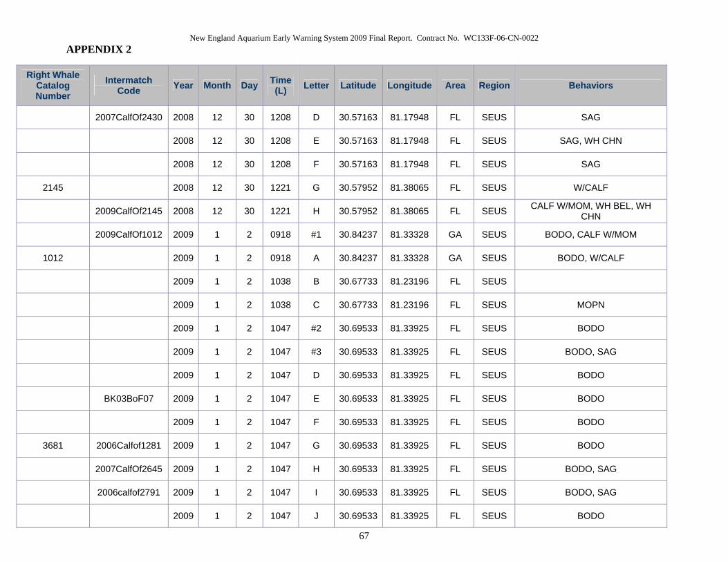
New England Aquarium Early Warning System 2009 Final Report. Contract No. WC133F-06-CN-0022 APPENDIX 2
67
Right Whale Catalog Number
Intermatch Code Year Month Day Time
(L) Letter Latitude Longitude Area Region Behaviors
2007CalfOf2430 2008 12 30 1208 D 30.57163 81.17948 FL SEUS SAG
2008 12 30 1208 E 30.57163 81.17948 FL SEUS SAG, WH CHN
2008 12 30 1208 F 30.57163 81.17948 FL SEUS SAG
2145 2008 12 30 1221 G 30.57952 81.38065 FL SEUS W/CALF
2009CalfOf2145 2008 12 30 1221 H 30.57952 81.38065 FL SEUS CALF W/MOM, WH BEL, WH CHN
2009CalfOf1012 2009 1 2 0918 #1 30.84237 81.33328 GA SEUS BODO, CALF W/MOM
1012 2009 1 2 0918 A 30.84237 81.33328 GA SEUS BODO, W/CALF
2009 1 2 1038 B 30.67733 81.23196 FL SEUS
2009 1 2 1038 C 30.67733 81.23196 FL SEUS MOPN
2009 1 2 1047 #2 30.69533 81.33925 FL SEUS BODO
2009 1 2 1047 #3 30.69533 81.33925 FL SEUS BODO, SAG
2009 1 2 1047 D 30.69533 81.33925 FL SEUS BODO
BK03BoF07 2009 1 2 1047 E 30.69533 81.33925 FL SEUS BODO
2009 1 2 1047 F 30.69533 81.33925 FL SEUS BODO
3681 2006Calfof1281 2009 1 2 1047 G 30.69533 81.33925 FL SEUS BODO
2007CalfOf2645 2009 1 2 1047 H 30.69533 81.33925 FL SEUS BODO, SAG
2006calfof2791 2009 1 2 1047 I 30.69533 81.33925 FL SEUS BODO, SAG
2009 1 2 1047 J 30.69533 81.33925 FL SEUS BODO

New England Aquarium Early Warning System 2009 Final Report. Contract No. WC133F-06-CN-0022 APPENDIX 2
68
Right Whale Catalog Number
Intermatch Code Year Month Day Time
(L) Letter Latitude Longitude Area Region Behaviors
1012 2009 1 2 1109 K 30.63878 81.21923 FL SEUS W/CALF
2009CalfOf1012 2009 1 2 1109 L 30.63878 81.21923 FL SEUS CALF W/MOM
2145 2009 1 2 1205 M 30.59795 81.20157 FL SEUS W/CALF
2009CalfOf2145 2009 1 2 1205 N 30.59795 81.20157 FL SEUS CALF W/MOM, WH CHN
2009 1 2 1219 O 30.5788 81.31002 FL SEUS BODO
CT05SEUS08 2009 1 2 1219 P 30.5788 81.31002 FL SEUS BODO
2008CalfOf2753 2009 1 2 1232 Q 30.58042 81.30571 FL SEUS BODO, YRLG
2009 1 2 1542 R 30.25588 81.21172 FL SEUS
3180 2009 1 4 1008 A 30.37284 81.27872 FL SEUS W/CALF
2009CalfOf3108 2009 1 4 1008 B 30.37284 81.27872 FL SEUS CALF W/MOM
2145 2009 1 4 1232 C 30.65603 81.38337 FL SEUS W/CALF
2009CalfOf2145 2009 1 4 1232 D 30.65603 81.38337 FL SEUS CALF W/MOM
2320 2009 1 4 1337 E 30.7011 81.32114 FL SEUS W/CALF
2009Calfof2320 2009 1 4 1337 F 30.7011 81.32114 FL SEUS CALF W/MOM
1012 2009 1 4 1344 G 30.65806 81.21937 FL SEUS W/CALF
2009CalfOf1012 2009 1 4 1344 H 30.65806 81.21937 FL SEUS CALF W/MOM
3320 2009 1 4 1508 I 30.86152 81.28602 GA SEUS W/CALF
2009CalfOf3320 2009 1 4 1508 J 30.86152 81.28602 GA SEUS CALF W/MOM
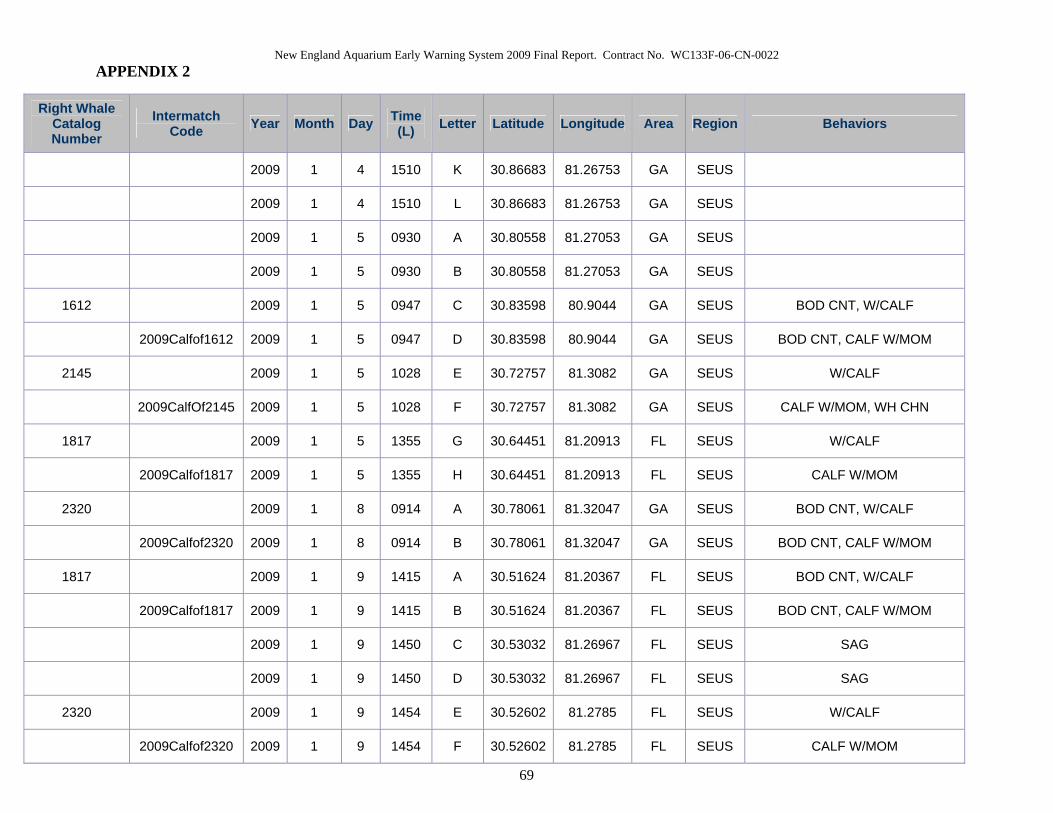
New England Aquarium Early Warning System 2009 Final Report. Contract No. WC133F-06-CN-0022 APPENDIX 2
69
Right Whale Catalog Number
Intermatch Code Year Month Day Time
(L) Letter Latitude Longitude Area Region Behaviors
2009 1 4 1510 K 30.86683 81.26753 GA SEUS
2009 1 4 1510 L 30.86683 81.26753 GA SEUS
2009 1 5 0930 A 30.80558 81.27053 GA SEUS
2009 1 5 0930 B 30.80558 81.27053 GA SEUS
1612 2009 1 5 0947 C 30.83598 80.9044 GA SEUS BOD CNT, W/CALF
2009Calfof1612 2009 1 5 0947 D 30.83598 80.9044 GA SEUS BOD CNT, CALF W/MOM
2145 2009 1 5 1028 E 30.72757 81.3082 GA SEUS W/CALF
2009CalfOf2145 2009 1 5 1028 F 30.72757 81.3082 GA SEUS CALF W/MOM, WH CHN
1817 2009 1 5 1355 G 30.64451 81.20913 FL SEUS W/CALF
2009Calfof1817 2009 1 5 1355 H 30.64451 81.20913 FL SEUS CALF W/MOM
2320 2009 1 8 0914 A 30.78061 81.32047 GA SEUS BOD CNT, W/CALF
2009Calfof2320 2009 1 8 0914 B 30.78061 81.32047 GA SEUS BOD CNT, CALF W/MOM
1817 2009 1 9 1415 A 30.51624 81.20367 FL SEUS BOD CNT, W/CALF
2009Calfof1817 2009 1 9 1415 B 30.51624 81.20367 FL SEUS BOD CNT, CALF W/MOM
2009 1 9 1450 C 30.53032 81.26967 FL SEUS SAG
2009 1 9 1450 D 30.53032 81.26967 FL SEUS SAG
2320 2009 1 9 1454 E 30.52602 81.2785 FL SEUS W/CALF
2009Calfof2320 2009 1 9 1454 F 30.52602 81.2785 FL SEUS CALF W/MOM

New England Aquarium Early Warning System 2009 Final Report. Contract No. WC133F-06-CN-0022 APPENDIX 2
70
Right Whale Catalog Number
Intermatch Code Year Month Day Time
(L) Letter Latitude Longitude Area Region Behaviors
2145 2009 1 9 1536 G 30.60193 81.41553 FL SEUS BOD CNT, W/CALF
2009CalfOf2145 2009 1 9 1536 H 30.60193 81.41553 FL SEUS BOD CNT, CALF W/MOM
2009 1 10 1006 A 30.72541 81.33009 GA SEUS
1012 2009 1 10 1009 B 30.72658 81.33155 GA SEUS BOD CNT, W/CALF
2009CalfOf1012 2009 1 10 1009 C 30.72658 81.33155 GA SEUS BOD CNT, CALF W/MOM, LBTL
3320 2009 1 10 1019 D 30.67488 81.34365 FL SEUS W/CALF
2009CalfOf3320 2009 1 10 1019 E 30.67488 81.34365 FL SEUS CALF W/MOM
2009 1 10 1029 F 30.74389 81.21252 GA SEUS MOPN
3320 2009 1 10 1117 G 30.6672 81.3225 FL SEUS NURS, W/CALF
2009CalfOf3320 2009 1 10 1117 H 30.6672 81.3225 FL SEUS CALF W/MOM, NURS
2009 1 10 1125 I 30.7529 81.34577 GA SEUS
1334 2009 1 10 1210 J 30.59031 81.14661 FL SEUS W/CALF
2009CalfOf1334 2009 1 10 1210 K 30.59031 81.14661 FL SEUS CALF W/MOM
2009 1 10 1343 L 30.50312 81.29395 FL SEUS
2009 1 10 1343 M 30.50312 81.29395 FL SEUS
2145 2009 1 10 1347 N 30.5273 81.28288 FL SEUS BOD CNT, W/CALF
2009CalfOf2145 2009 1 10 1347 O 30.5273 81.28288 FL SEUS BOD CNT, CALF W/MOM, ROLL, WH BEL, WH CHN
2009 1 10 1543 P 30.345 81.22895 FL SEUS BOD CNT, BRCH

New England Aquarium Early Warning System 2009 Final Report. Contract No. WC133F-06-CN-0022 APPENDIX 2
71
Right Whale Catalog Number
Intermatch Code Year Month Day Time
(L) Letter Latitude Longitude Area Region Behaviors
2009 1 10 1543 Q 30.345 81.22895 FL SEUS BOD CNT
1012 2009 1 11 1102 A 30.49585 81.21301 FL SEUS W/CALF
2009CalfOf1012 2009 1 11 1102 B 30.49585 81.21301 FL SEUS CALF W/MOM
2145 2009 1 11 1130 C 30.5346 81.2552 FL SEUS W/CALF
2009CalfOf2145 2009 1 11 1130 D 30.5346 81.2552 FL SEUS CALF W/MOM
1946 2009 1 11 1139 E 30.56127 81.3284 FL SEUS W/CALF
2009Calfof1946 2009 1 11 1139 F 30.56127 81.3284 FL SEUS CALF W/MOM
2009 1 11 1156 G 30.57331 81.34978 FL SEUS
2009 1 11 1228 H 30.66925 81.1709 FL SEUS LBTL
2009 1 11 1228 I 30.66925 81.1709 FL SEUS
2320 2009 1 14 1317 A 30.34595 81.28093 FL SEUS BOD CNT, W/CALF
2009Calfof2320 2009 1 14 1317 B 30.34595 81.28093 FL SEUS BOD CNT, CALF W/MOM
2009 1 14 1353 C 30.47357 81.20444 FL SEUS SAG
BK03BoF07 2009 1 14 1353 D 30.47357 81.20444 FL SEUS SAG
2007CalfOf2645 2009 1 14 1353 E 30.47357 81.20444 FL SEUS SAG
1817 2009 1 14 1405 F 30.47193 81.19052 FL SEUS W/CALF
2009Calfof1817 2009 1 14 1405 G 30.47193 81.19052 FL SEUS CALF W/MOM
2009 1 14 1554 H 30.83902 81.20135 GA SEUS SAG

New England Aquarium Early Warning System 2009 Final Report. Contract No. WC133F-06-CN-0022 APPENDIX 2
72
Right Whale Catalog Number
Intermatch Code Year Month Day Time
(L) Letter Latitude Longitude Area Region Behaviors
2009 1 14 1554 I 30.83902 81.20135 GA SEUS SAG
2009 1 14 1603 J 30.84307 81.1884 GA SEUS W/YRLG
2008CalfOf3115 2009 1 14 1603 K 30.84307 81.1884 GA SEUS YRLG W/MOM
2009 1 15 1428 A 30.60447 81.30814 FL SEUS
2009 1 15 1428 B 30.60447 81.30814 FL SEUS
2320 2009 1 18 1030 A 30.58773 81.23397 FL SEUS BOD CNT, W/CALF
2009Calfof2320 2009 1 18 1030 B 30.58773 81.23397 FL SEUS BOD CNT, CALF W/MOM
1817 2009 1 18 1038 C 30.56314 81.22917 FL SEUS BOD CNT, HDLFT, W/CALF
2009Calfof1817 2009 1 18 1038 D 30.56314 81.22997 FL SEUS BOD CNT, CALF W/MOM
2123 2009 1 18 1059 E 30.64723 81.2135 FL SEUS BOD CNT, W/CALF
2009Calfof2123 2009 1 18 1059 F 30.64723 81.2135 FL SEUS BOD CNT, CALF W/MOM, WH CHN
2009 1 19 1100 A 30.39905 81.21495 FL SEUS BOD CNT
2009 1 19 1100 B 30.39905 81.21495 FL SEUS BOD CNT, ROLL, WH BEL, WH CHN
2009 1 19 1156 C 30.41367 81.22615 FL SEUS
2009 1 19 1156 D 30.41367 81.22615 FL SEUS
2009 1 19 1259 E 30.52913 81.24993 FL SEUS BOD CNT
2009 1 19 1259 F 30.52913 81.24993 FL SEUS BOD CNT
2009 1 19 1625 G 30.84343 81.17647 GA SEUS

New England Aquarium Early Warning System 2009 Final Report. Contract No. WC133F-06-CN-0022 APPENDIX 2
73
Right Whale Catalog Number
Intermatch Code Year Month Day Time
(L) Letter Latitude Longitude Area Region Behaviors
2009 1 19 1635 H 30.85203 81.25022 GA SEUS
2009 1 19 1644 I 30.85022 81.25022 GA SEUS BLK BEL, BLK CHN, FLIP, LBTL, W/CALF UNPH
N/A 2009 1 19 1659 N/A 30.83323 81.31853 GA SEUS 1 UNPHOTOGRAPHED RIGHT WHALES
2009 1 21 1344 A 31.25053 80.92414 GA SEUS
1281 2009 1 21 1411 B 31.12483 81.17953 GA SEUS W/CALF
2009CalfOf1281 2009 1 21 1411 C 31.12483 81.17953 GA SEUS CALF W/MOM
2009 1 21 1427 D 31.15532 81.13676 GA SEUS
2009 1 21 1427 E 31.15532 81.13676 GA SEUS
2009 1 21 1433 F 31.12398 81.11726 GA SEUS
2007CalfOf3360 2009 1 21 1433 G 31.12398 81.11726 GA SEUS
2611 2009 1 21 1545 H 30.87485 81.191 GA SEUS W/CALF
2009CalfOf2611 2009 1 21 1545 I 30.87485 81.191 GA SEUS CALF W/MOM
1012 2009 1 21 1619 J 30.79805 81.27527 GA SEUS BOD CNT, W/CALF
2009CalfOf1012 2009 1 21 1619 K 30.79805 81.27527 GA SEUS BLK BEL, BOD CNT, CALF W/MOM
2123 2009 1 21 1622 L 30.7801 81.29 GA SEUS W/CALF, WH CHN
2009Calfof2123 2009 1 21 1622 M 30.7801 81.29 GA SEUS CALF W/MOM
1246 2009 1 21 1627 N 30.78212 81.28243 GA SEUS BODO, W/CALF
2009CalfOf1246 2009 1 21 1627 O 30.78212 81.28243 GA SEUS BODO, CALF W/MOM

New England Aquarium Early Warning System 2009 Final Report. Contract No. WC133F-06-CN-0022 APPENDIX 2
74
Right Whale Catalog Number
Intermatch Code Year Month Day Time
(L) Letter Latitude Longitude Area Region Behaviors
3660 2006Calfof2660 2009 1 21 1640 P 30.72267 81.24211 GA SEUS BEL/BEL, SAG, WH BEL, WH CHN
2009 1 21 1640 Q 30.72267 81.24211 GA SEUS BEL/BEL, BLK BEL, SAG
SE07BK08 2009 1 21 1646 R 30.73365 81.2324 GA SEUS WH CHN
2009 1 21 1646 S 30.73365 81.2324 GA SEUS WH CHN
2009 1 21 1715 T 30.68885 81.24085 FL SEUS
1711 2009 1 22 1013 A 31.06168 81.2661 GA SEUS W/CALF
2009CalfOf1711 2009 1 22 1013 B 31.06168 81.2661 GA SEUS CALF W/MOM
2009 1 22 1030 C 31.23356 81.16808 GA SEUS
1711 2009 1 22 1118 D 31.04772 81.26379 GA SEUS W/CALF
2009CalfOf1711 2009 1 22 1118 E 31.04772 81.26379 GA SEUS CALF W/MOM, WH CHN
2009 1 22 1228 F 30.84143 81.26072 GA SEUS BOD CNT, BODO
2009 1 22 1228 G 30.84143 81.26072 GA SEUS BOD CNT, BODO
2007CalfOf3360 2009 1 22 1228 H 30.84143 81.26072 GA SEUS BOD CNT, BODO
2009 1 22 1233 I 30.82465 81.23061 GA SEUS SAG
2009 1 22 1233 J 30.82465 81.23061 GA SEUS SAG
2611 2009 1 22 1248 K 30.83163 81.1875 GA SEUS W/CALF, WH CHN
2009CalfOf2611 2009 1 22 1248 L 30.83163 81.1875 GA SEUS CALF W/MOM
1315 2009 1 22 1316 M 30.72913 81.29939 GA SEUS NURS, W/CALF
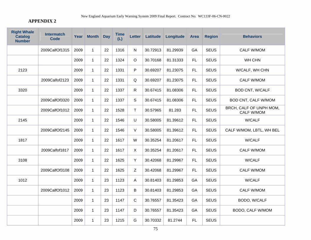
New England Aquarium Early Warning System 2009 Final Report. Contract No. WC133F-06-CN-0022 APPENDIX 2
75
Right Whale Catalog Number
Intermatch Code Year Month Day Time
(L) Letter Latitude Longitude Area Region Behaviors
2009CalfOf1315 2009 1 22 1316 N 30.72913 81.29939 GA SEUS CALF W/MOM
2009 1 22 1324 O 30.70168 81.31333 FL SEUS WH CHN
2123 2009 1 22 1331 P 30.69207 81.23075 FL SEUS W/CALF, WH CHN
2009Calfof2123 2009 1 22 1331 Q 30.69207 81.23075 FL SEUS CALF W/MOM
3320 2009 1 22 1337 R 30.67415 81.08306 FL SEUS BOD CNT, W/CALF
2009CalfOf3320 2009 1 22 1337 S 30.67415 81.08306 FL SEUS BOD CNT, CALF W/MOM
2009CalfOf1012 2009 1 22 1528 T 30.57965 81.283 FL SEUS BRCH, CALF OF UNPH MOM, CALF W/MOM
2145 2009 1 22 1546 U 30.58005 81.39612 FL SEUS W/CALF
2009CalfOf2145 2009 1 22 1546 V 30.58005 81.39612 FL SEUS CALF W/MOM, LBTL, WH BEL
1817 2009 1 22 1617 W 30.35254 81.20617 FL SEUS W/CALF
2009Calfof1817 2009 1 22 1617 X 30.35254 81.20617 FL SEUS CALF W/MOM
3108 2009 1 22 1625 Y 30.42068 81.29967 FL SEUS W/CALF
2009CalfOf3108 2009 1 22 1625 Z 30.42068 81.29967 FL SEUS CALF W/MOM
1012 2009 1 23 1123 A 30.81403 81.29853 GA SEUS W/CALF
2009CalfOf1012 2009 1 23 1123 B 30.81403 81.29853 GA SEUS CALF W/MOM
2009 1 23 1147 C 30.76557 81.35423 GA SEUS BODO, W/CALF
2009 1 23 1147 D 30.76557 81.35423 GA SEUS BODO, CALF W/MOM
2009 1 23 1215 G 30.70332 81.2744 FL SEUS

New England Aquarium Early Warning System 2009 Final Report. Contract No. WC133F-06-CN-0022 APPENDIX 2
76
Right Whale Catalog Number
Intermatch Code Year Month Day Time
(L) Letter Latitude Longitude Area Region Behaviors
2009 1 23 1236 E 30.71222 81.27398 GA SEUS BLK BEL, BLK CHN, BODO
2007Calfof1701 2009 1 23 1236 F 30.71222 81.27398 GA SEUS BLK CHN, BODO
3440 2009 1 23 1355 H 30.59317 81.0715 FL SEUS W/CALF
2009CalfOf3440 2009 1 23 1355 I 30.59317 81.0715 FL SEUS CALF W/MOM
3660 2006Calfof2660 2009 1 23 1411 J 30.5684 81.2067 FL SEUS BEL/BEL, BOD CNT, WH BEL, WH CHN
2008CalfOf2753 2009 1 23 1411 K 30.5684 81.2067 FL SEUS BEL/BEL, BOD CNT, WH BEL, WH CHN
2006CalfOf1248 2009 1 23 1420 L 30.56388 81.2055 FL SEUS
2008calfof2330 2009 1 23 1427 M 30.60892 81.25992 FL SEUS BLK BEL, BLK CHN, BRCH
2320 2009 1 23 1439 N 30.53753 81.30784 FL SEUS BOD CNT, W/CALF
2009Calfof2320 2009 1 23 1439 O 30.53753 81.30784 FL SEUS BOD CNT, CALF W/MOM
1503 2009 1 23 1450 P 30.52568 81.05386 FL SEUS NURS, W/CALF
2009Calfof1503 2009 1 23 1450 Q 30.52568 81.05386 FL SEUS CALF W/MOM, NURS
1608 2009 1 23 1556 R 30.27514 81.15993 FL SEUS NURS, W/CALF
2009CalfOf1608 2009 1 23 1556 S 30.27514 81.15993 FL SEUS CALF W/MOM, NURS
2009 1 24 1009 A 30.71435 81.24979 GA SEUS SAG
2009 1 24 1009 B 30.71435 81.24979 GA SEUS SAG, WH CHN
3660 2009 1 24 1009 C 30.71435 81.24979 GA SEUS SAG, WH BEL, WH CHN
2009 1 24 1009 D 30.71435 81.24979 GA SEUS SAG

New England Aquarium Early Warning System 2009 Final Report. Contract No. WC133F-06-CN-0022 APPENDIX 2
77
Right Whale Catalog Number
Intermatch Code Year Month Day Time
(L) Letter Latitude Longitude Area Region Behaviors
2007CalfOf3360 2009 1 24 1009 E 30.71435 81.24979 GA SEUS SAG
2009 1 24 1009 F 30.71435 81.24979 GA SEUS SAG
2009 1 24 1009 G 30.71435 81.24979 GA SEUS SAG, WH BEL, WH CHN
2009 1 24 1104 H 30.62695 81.35155 FL SEUS BODO
2009 1 24 1104 I 30.62695 81.35155 FL SEUS BODO
2320 2009 1 24 1113 J 30.63865 81.12109 FL SEUS W/CALF
2009Calfof2320 2009 1 24 1113 K 30.63865 81.12109 FL SEUS CALF W/MOM
1012 2009 1 24 1309 L 30.49642 81.20582 FL SEUS W/CALF
2009CalfOf1012 2009 1 24 1309 M 30.49642 81.20582 FL SEUS CALF W/MOM
2009 1 28 1109 A 30.74 81.3068 GA SEUS BODO
2009 1 28 1123 B 30.72368 81.18085 GA SEUS BODO
2503 2009 1 28 1218 C 30.6855 81.37519 FL SEUS W/CALF
2009Calfof2503 2009 1 28 1218 D 30.6855 81.37519 FL SEUS CALF W/MOM
3320 2009 1 28 1241 E 30.64447 81.35567 FL SEUS BODO, W/CALF
2009CalfOf3320 2009 1 28 1241 F 30.64447 81.35567 FL SEUS BODO, CALF W/MOM
2320 2009 1 28 1255 G 30.6525 81.31633 FL SEUS BOD CNT, W/CALF
2009Calfof2320 2009 1 28 1255 H 30.6525 81.3003 FL SEUS BOD CNT, CALF W/MOM
1315 2009 1 28 1332 I 30.58417 81.31633 FL SEUS BODO, W/CALF
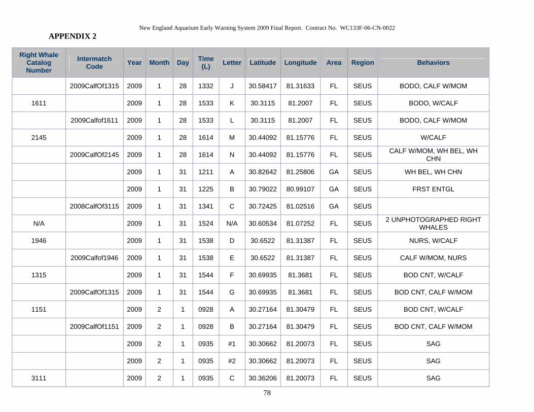
New England Aquarium Early Warning System 2009 Final Report. Contract No. WC133F-06-CN-0022 APPENDIX 2
78
Right Whale Catalog Number
Intermatch Code Year Month Day Time
(L) Letter Latitude Longitude Area Region Behaviors
2009CalfOf1315 2009 1 28 1332 J 30.58417 81.31633 FL SEUS BODO, CALF W/MOM
1611 2009 1 28 1533 K 30.3115 81.2007 FL SEUS BODO, W/CALF
2009Calfof1611 2009 1 28 1533 L 30.3115 81.2007 FL SEUS BODO, CALF W/MOM
2145 2009 1 28 1614 M 30.44092 81.15776 FL SEUS W/CALF
2009CalfOf2145 2009 1 28 1614 N 30.44092 81.15776 FL SEUS CALF W/MOM, WH BEL, WH CHN
2009 1 31 1211 A 30.82642 81.25806 GA SEUS WH BEL, WH CHN
2009 1 31 1225 B 30.79022 80.99107 GA SEUS FRST ENTGL
2008CalfOf3115 2009 1 31 1341 C 30.72425 81.02516 GA SEUS
N/A 2009 1 31 1524 N/A 30.60534 81.07252 FL SEUS 2 UNPHOTOGRAPHED RIGHT WHALES
1946 2009 1 31 1538 D 30.6522 81.31387 FL SEUS NURS, W/CALF
2009Calfof1946 2009 1 31 1538 E 30.6522 81.31387 FL SEUS CALF W/MOM, NURS
1315 2009 1 31 1544 F 30.69935 81.3681 FL SEUS BOD CNT, W/CALF
2009CalfOf1315 2009 1 31 1544 G 30.69935 81.3681 FL SEUS BOD CNT, CALF W/MOM
1151 2009 2 1 0928 A 30.27164 81.30479 FL SEUS BOD CNT, W/CALF
2009CalfOf1151 2009 2 1 0928 B 30.27164 81.30479 FL SEUS BOD CNT, CALF W/MOM
2009 2 1 0935 #1 30.30662 81.20073 FL SEUS SAG
2009 2 1 0935 #2 30.30662 81.20073 FL SEUS SAG
3111 2009 2 1 0935 C 30.36206 81.20073 FL SEUS SAG

New England Aquarium Early Warning System 2009 Final Report. Contract No. WC133F-06-CN-0022 APPENDIX 2
79
Right Whale Catalog Number
Intermatch Code Year Month Day Time
(L) Letter Latitude Longitude Area Region Behaviors
2009 2 1 0935 D 30.30662 81.20073 FL SEUS SAG
2009 2 1 0935 E 30.30662 81.20073 FL SEUS SAG
2009 2 1 0935 F 30.30662 81.20073 FL SEUS SAG
2009 2 1 0935 G 30.30662 81.20073 FL SEUS SAG
2009 2 1 0935 H 30.30662 81.20073 FL SEUS SAG
2009 2 1 1031 I 30.35975 81.2122 FL SEUS
3101 2009 2 1 1103 J 30.44802 81.24663 FL SEUS NURS, W/CALF
2009Calfof3101 2009 2 1 1103 K 30.44802 81.24663 FL SEUS CALF W/MOM, NURS
2320 2009 2 1 1131 L 30.50165 81.38406 FL SEUS BODO, W/CALF
2009Calfof2320 2009 2 1 1131 M 30.50165 81.38406 FL SEUS BODO, CALF W/MOM
2009 2 1 1218 N 30.77407 81.26431 GA SEUS LN GONE
2009 2 1 1255 O 30.80382 81.34092 GA SEUS BODO
N/A 2009 2 1 1338 N/A 30.74819 81.26179 GA SEUS 1 UNPHOTOGRAPHED RIGHT WHALE
2007Calfof1701 2009 2 1 1635 P 30.72012 81.24229 GA SEUS BLK CHN, FLIP
N/A 2009 2 1 1717 N/A 30.76743 81.25269 GA SEUS 2 UNPHOTOGRAPHED RIGHT WHALES
1315 2009 2 2 0920 A 30.84155 81.33857 GA SEUS MOPN, W/CALF
2009CalfOf1315 2009 2 2 0920 B 30.84155 81.33857 GA SEUS CALF W/MOM
2007CalfOf1425 2009 2 2 1031 C 30.69567 81.32558 FL SEUS SAG

New England Aquarium Early Warning System 2009 Final Report. Contract No. WC133F-06-CN-0022 APPENDIX 2
80
Right Whale Catalog Number
Intermatch Code Year Month Day Time
(L) Letter Latitude Longitude Area Region Behaviors
2009 2 2 1031 D 30.69567 81.32558 FL SEUS SAG
2009 2 2 1031 E 30.69784 81.3198 FL SEUS
2009 2 2 1210 F 30.28312 81.308 FL SEUS
2009 2 2 1211 G 30.2758 81.30468 FL SEUS SAG
2009 2 2 1211 H 30.2758 81.30468 FL SEUS SAG
2009 2 2 1211 I 30.2758 81.30468 FL SEUS SAG, WH BEL, WH CHN
2007CalfOf3360 2009 2 2 1220 J 30.27967 81.3213 FL SEUS BODO, SAG
2009 2 2 1220 K 30.27967 81.3213 FL SEUS BODO, SAG
2009 2 2 1225 L 30.2841 81.31834 FL SEUS BEL/BEL
CT03RB06 2009 2 2 1225 M 30.2841 81.31834 FL SEUS BEL/BEL, UW EXH, WH BEL, WH CHN
2008calfof2330 2009 2 2 1238 N 30.25392 81.31931 FL SEUS BLK BEL, BLK CHN, BRCH
2008CalfOf1245 2009 2 5 1351 A 30.74018 81.3426 GA SEUS
2009 2 5 1448 #1 30.55383 81.28047 FL SEUS BOD CNT
CT05SEUS08 2009 2 5 1448 B 30.55383 81.28047 FL SEUS BOD CNT
2009 2 5 1448 C 30.55383 81.28047 FL SEUS BOD CNT
3101 2009 2 5 1453 D 30.58837 81.34299 FL SEUS BOD CNT, W/CALF
2009Calfof3101 2009 2 5 1453 E 30.58837 81.34299 FL SEUS BOD CNT, CALF W/MOM
1151 2009 2 5 1455 F 30.57967 81.37029 FL SEUS W/CALF

New England Aquarium Early Warning System 2009 Final Report. Contract No. WC133F-06-CN-0022 APPENDIX 2
81
Right Whale Catalog Number
Intermatch Code Year Month Day Time
(L) Letter Latitude Longitude Area Region Behaviors
2009CalfOf1151 2009 2 5 1455 G 30.57967 81.37029 FL SEUS CALF W/MOM
1281 2009 2 5 1502 H 30.59138 81.41269 FL SEUS BOD CNT, BODO, W/CALF
2009CalfOf1281 2009 2 5 1502 I 30.59138 81.41269 FL SEUS BLK BEL, BLK CHN, BOD CNT, BODO, CALF W/MOM, MALE
2009 2 5 1510 J 30.55015 81.27557 FL SEUS MOPN, SAG
2009 2 5 1510 K 30.55015 81.27557 FL SEUS SAG
2009 2 5 1510 L 30.55015 81.27557 FL SEUS BLK CHN, SAG
CT05SEUS08 2009 2 5 1510 M 30.55015 81.27557 FL SEUS SAG
1503 2009 2 5 1547 N 30.43077 81.14635 FL SEUS BOD CNT, W/CALF
2009Calfof1503 2009 2 5 1547 O 30.43077 81.14635 FL SEUS BOD CNT, CALF W/MOM
1315 2009 2 5 1641 P 30.50561 81.39543 FL SEUS BODO, W/CALF
2009CalfOf1315 2009 2 5 1641 Q 30.50561 81.39543 FL SEUS BODO, CALF W/MOM
1281 2009 2 6 0920 A 30.65022 81.40728 FL SEUS W/CALF
2009CalfOf1281 2009 2 6 0920 B 30.65022 81.40728 FL SEUS CALF W/MOM
2611 2009 2 6 1002 C 30.78492 81.20832 GA SEUS LOG, W/CALF
2009CalfOf2611 2009 2 6 1002 D 30.78492 81.20832 GA SEUS CALF W/MOM, LOG
2009 2 6 1007 E 30.77843 81.28282 GA SEUS
2007Calfof1701 2009 2 6 1007 F 30.77843 81.28282 GA SEUS
1151 2009 2 6 1056 G 30.67443 81.29605 FL SEUS W/CALF

New England Aquarium Early Warning System 2009 Final Report. Contract No. WC133F-06-CN-0022 APPENDIX 2
82
Right Whale Catalog Number
Intermatch Code Year Month Day Time
(L) Letter Latitude Longitude Area Region Behaviors
2009CalfOf1151 2009 2 6 1056 H 30.67443 81.29605 FL SEUS CALF W/MOM
1315 2009 2 6 1102 I 30.68628 81.37887 FL SEUS W/CALF
2009CalfOf1315 2009 2 6 1102 J 30.68628 81.37887 FL SEUS CALF W/MOM
2009 2 6 1157 K 30.48908 81.30645 FL SEUS BEL/BEL, BLK BEL, BLK CHN, BOD CNT, BODO, UW EXH
2009 2 6 1157 L 30.48908 81.30645 FL SEUS BEL/BEL, BOD CNT, BODO, UW EXH
2009 2 6 1241 M 30.4725 81.30325 FL SEUS
2009 2 6 1241 N 30.4725 81.30325 FL SEUS BOD CNT
2009 2 6 1241 O 30.4725 81.30325 FL SEUS BOD CNT
2009 2 6 1250 P 30.49583 81.32368 FL SEUS
2009 2 6 1250 Q 30.49583 81.32368 FL SEUS
2009 2 6 1250 R 30.49583 81.32368 FL SEUS
1315 2009 2 7 0915 A 30.84372 81.34897 GA SEUS W/CALF
2009CalfOf1315 2009 2 7 0915 B 30.84372 81.34897 GA SEUS CALF W/MOM
2009 2 7 0921 C 30.85205 81.2563 GA SEUS
2009 2 7 0939 D 30.82372 80.85722 GA SEUS MOPN
2009 2 7 0945 E 30.81174 80.7706 GA SEUS SAG, WH CHN
3570 2009 2 7 0945 F 30.81174 80.7706 GA SEUS SAG
2009 2 7 0945 G 30.81174 80.7706 GA SEUS SAG

New England Aquarium Early Warning System 2009 Final Report. Contract No. WC133F-06-CN-0022 APPENDIX 2
83
Right Whale Catalog Number
Intermatch Code Year Month Day Time
(L) Letter Latitude Longitude Area Region Behaviors
2009 2 7 0945 H 30.81174 80.7706 GA SEUS SAG, WH BEL, WH CHN
2009 2 7 0945 I 30.81174 80.7706 GA SEUS SAG
2123 2009 2 7 1026 J 30.72868 81.29973 GA SEUS BOD CNT, W/CALF, WH CHN
2009Calfof2123 2009 2 7 1026 K 30.72868 81.29973 GA SEUS BOD CNT, CALF W/MOM
2009 2 7 1030 L 30.72665 81.22311 GA SEUS BOD CNT, BODO
2009 2 7 1030 M 30.72665 81.22311 GA SEUS BOD CNT, BODO
2009 2 7 1040 N 30.73543 81.18715 GA SEUS
2009 2 7 1114 0 30.63707 81.26902 FL SEUS BEL/BEL, SAG
2009 2 7 1114 P 30.63707 81.26902 FL SEUS BEL/BEL, SAG
2009 2 7 1116 Q 30.6646 81.26248 FL SEUS SAG
2009 2 7 1116 R 30.6646 81.26248 FL SEUS SAG
2009 2 7 1159 S 30.56417 81.05883 FL SEUS
2611 2009 2 7 1209 T 30.55908 81.13558 FL SEUS BOD CNT, W/CALF
2009CalfOf2611 2009 2 7 1209 U 30.55908 81.13558 FL SEUS BOD CNT, CALF W/MOM
3320 2009 2 7 1209 V 30.55908 81.13558 FL SEUS NURS, W/CALF
2009CalfOf3320 2009 2 7 1209 W 30.55908 81.13558 FL SEUS CALF W/MOM, NURS
1012 2009 2 7 1218 X 30.57071 81.23133 FL SEUS BODO, W/CALF
2009CalfOf1012 2009 2 7 1218 Y 30.57071 81.23133 FL SEUS BODO, CALF W/MOM

New England Aquarium Early Warning System 2009 Final Report. Contract No. WC133F-06-CN-0022 APPENDIX 2
84
Right Whale Catalog Number
Intermatch Code Year Month Day Time
(L) Letter Latitude Longitude Area Region Behaviors
2009 2 7 1335 Z 30.50578 81.07854 FL SEUS
1817 2009 2 7 1405 AA 30.48807 81.18787 FL SEUS BLK BEL, BLK CHN, BOD CNT, NURS, W/CALF
2009Calfof1817 2009 2 7 1405 BB 30.48807 81.18787 FL SEUS BOD CNT, CALF W/MOM, NURS
3101 2009 2 7 1408 CC 30.47688 81.20869 FL SEUS BOD CNT, W/CALF
2009Calfof3101 2009 2 7 1408 DD 30.47688 81.20869 FL SEUS BOD CNT, CALF W/MOM
2009 2 7 1426 EE 30.43084 81.34535 FL SEUS
1315 2009 2 8 0920 A 30.75315 81.41997 GA SEUS W/CALF
2009CalfOf1315 2009 2 8 0920 B 30.75315 81.41997 GA SEUS CALF W/MOM
1946 2009 2 8 1005 C 30.75453 81.27084 GA SEUS BOD CNT, W/CALF
2009Calfof1946 2009 2 8 1005 D 30.75453 81.27084 GA SEUS BOD CNT, CALF W/MOM
2009 2 8 1009 E 30.77483 81.2587 GA SEUS
2009 2 8 1137 F 30.24385 81.14744 FL SEUS
2009 2 8 1137 G 30.24385 81.14744 FL SEUS
2009 2 8 1137 H 30.24385 81.14744 FL SEUS
2008CalfOf3115 2009 2 8 1141 I 30.23972 81.15456 FL SEUS
2009 2 8 1141 J 30.23972 81.15456 FL SEUS
3440 2009 2 8 1216 K 30.32865 81.1771 FL SEUS NURS, W/CALF
2009CalfOf3440 2009 2 8 1216 L 30.32865 81.1771 FL SEUS CALF W/MOM, NURS
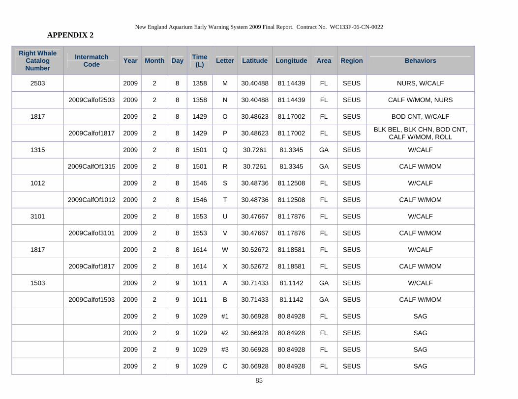
New England Aquarium Early Warning System 2009 Final Report. Contract No. WC133F-06-CN-0022 APPENDIX 2
85
Right Whale Catalog Number
Intermatch Code Year Month Day Time
(L) Letter Latitude Longitude Area Region Behaviors
2503 2009 2 8 1358 M 30.40488 81.14439 FL SEUS NURS, W/CALF
2009Calfof2503 2009 2 8 1358 N 30.40488 81.14439 FL SEUS CALF W/MOM, NURS
1817 2009 2 8 1429 O 30.48623 81.17002 FL SEUS BOD CNT, W/CALF
2009Calfof1817 2009 2 8 1429 P 30.48623 81.17002 FL SEUS BLK BEL, BLK CHN, BOD CNT, CALF W/MOM, ROLL
1315 2009 2 8 1501 Q 30.7261 81.3345 GA SEUS W/CALF
2009CalfOf1315 2009 2 8 1501 R 30.7261 81.3345 GA SEUS CALF W/MOM
1012 2009 2 8 1546 S 30.48736 81.12508 FL SEUS W/CALF
2009CalfOf1012 2009 2 8 1546 T 30.48736 81.12508 FL SEUS CALF W/MOM
3101 2009 2 8 1553 U 30.47667 81.17876 FL SEUS W/CALF
2009Calfof3101 2009 2 8 1553 V 30.47667 81.17876 FL SEUS CALF W/MOM
1817 2009 2 8 1614 W 30.52672 81.18581 FL SEUS W/CALF
2009Calfof1817 2009 2 8 1614 X 30.52672 81.18581 FL SEUS CALF W/MOM
1503 2009 2 9 1011 A 30.71433 81.1142 GA SEUS W/CALF
2009Calfof1503 2009 2 9 1011 B 30.71433 81.1142 GA SEUS CALF W/MOM
2009 2 9 1029 #1 30.66928 80.84928 FL SEUS SAG
2009 2 9 1029 #2 30.66928 80.84928 FL SEUS SAG
2009 2 9 1029 #3 30.66928 80.84928 FL SEUS SAG
2009 2 9 1029 C 30.66928 80.84928 FL SEUS SAG
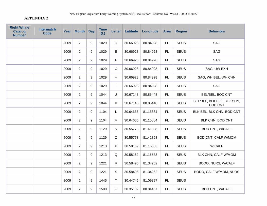
New England Aquarium Early Warning System 2009 Final Report. Contract No. WC133F-06-CN-0022 APPENDIX 2
86
Right Whale Catalog Number
Intermatch Code Year Month Day Time
(L) Letter Latitude Longitude Area Region Behaviors
2009 2 9 1029 D 30.66928 80.84928 FL SEUS SAG
2009 2 9 1029 E 30.66928 80.84928 FL SEUS SAG
2009 2 9 1029 F 30.66928 80.84928 FL SEUS SAG
2009 2 9 1029 G 30.66928 80.84928 FL SEUS SAG, UW EXH
2009 2 9 1029 H 30.66928 80.84928 FL SEUS SAG, WH BEL, WH CHN
2009 2 9 1029 I 30.66928 80.84928 FL SEUS SAG
2009 2 9 1044 J 30.67143 80.85448 FL SEUS BEL/BEL, BOD CNT
2009 2 9 1044 K 30.67143 80.85448 FL SEUS BEL/BEL, BLK BEL, BLK CHN, BOD CNT
2009 2 9 1104 L 30.64665 81.15884 FL SEUS BLK BEL, BLK CHN, BOD CNT
2009 2 9 1104 M 30.64665 81.15884 FL SEUS BLK CHN, BOD CNT
2009 2 9 1129 N 30.55778 81.41898 FL SEUS BOD CNT, W/CALF
2009 2 9 1129 O 30.55778 81.41898 FL SEUS BOD CNT, CALF W/MOM
2009 2 9 1213 P 30.58162 81.16683 FL SEUS W/CALF
2009 2 9 1213 Q 30.58162 81.16683 FL SEUS BLK CHN, CALF W/MOM
2009 2 9 1221 R 30.58496 81.34262 FL SEUS BODO, NURS, W/CALF
2009 2 9 1221 S 30.58496 81.34262 FL SEUS BODO, CALF W/MOM, NURS
2009 2 9 1445 T 30.44745 81.09897 FL SEUS
2009 2 9 1500 U 30.35102 80.84457 FL SEUS BOD CNT, W/CALF

New England Aquarium Early Warning System 2009 Final Report. Contract No. WC133F-06-CN-0022 APPENDIX 2
87
Right Whale Catalog Number
Intermatch Code Year Month Day Time
(L) Letter Latitude Longitude Area Region Behaviors
2009 2 9 1500 V 30.35102 80.84457 FL SEUS BOD CNT, CALF W/MOM
2009 2 9 1535 W 30.3314 81.12368 FL SEUS BLK CHN, SAG
2009 2 9 1535 X 30.3314 81.12368 FL SEUS BLK BEL, BLK CHN, FCL, FEM, SAG
2009 2 9 1535 Y 30.3314 81.12368 FL SEUS SAG, WH BEL, WH CHN
2009 2 9 1620 AA 30.27024 81.33752 FL SEUS BODO, CALF W/MOM
2009 2 9 1620 Z 30.27024 81.33752 FL SEUS BODO, W/CALF
1315 2009 2 10 0923 A 30.69128 81.32332 FL SEUS BOD CNT, W/CALF
2009CalfOf1315 2009 2 10 0923 B 30.69128 81.32332 FL SEUS BOD CNT, CALF W/MOM
2503 2009 2 10 0934 C 30.81148 81.43778 GA SEUS BOD CNT, W/CALF
2009Calfof2503 2009 2 10 0934 D 30.81148 81.43778 GA SEUS BOD CNT, CALF W/MOM
2753 2009 2 10 0949 E 30.8287 81.13097 GA SEUS MOPN
2008CalfOf2753 2009 2 10 1004 F 30.89282 81.12576 GA SEUS MOPN, WH CHN
2009 2 10 1004 G 30.89282 81.12576 GA SEUS SAG
2009 2 10 1004 H 30.89282 81.12576 GA SEUS SAG
2009 2 10 1004 I 30.89282 81.12576 GA SEUS SAG
CT03RB06 2009 2 10 1004 J 30.89282 81.12576 GA SEUS SAG, WH BEL, WH CHN
2007calfof1620 2009 2 10 1004 K 30.89282 81.12576 GA SEUS SAG
2009 2 10 1018 L 30.85977 81.06368 GA SEUS

New England Aquarium Early Warning System 2009 Final Report. Contract No. WC133F-06-CN-0022 APPENDIX 2
88
Right Whale Catalog Number
Intermatch Code Year Month Day Time
(L) Letter Latitude Longitude Area Region Behaviors
2009 2 10 1018 M 30.85977 81.06368 GA SEUS
2009 2 10 1023 #1 30.8731 81.05528 GA SEUS
2009 2 10 1023 #2 30.8731 81.05528 GA SEUS
2009 2 10 1023 N 30.8731 81.05528 GA SEUS APPR, SAG
2009 2 10 1023 O 30.8731 81.05528 GA SEUS APPR, SAG
BK01BOF07 2009 2 10 1023 P 30.8731 81.05528 GA SEUS BLK BEL, MALE, SAG
2009 2 10 1023 Q 30.8731 81.05528 GA SEUS SAG, WH CHN
2009 2 10 1023 R 30.8731 81.05528 GA SEUS FCL, FEM, SAG
1012 2009 2 10 1041 S 30.78418 80.81156 GA SEUS W/CALF
2009CalfOf1012 2009 2 10 1041 T 30.78418 80.81156 GA SEUS CALF W/MOM
1281 2009 2 10 1109 U 30.77592 81.4352 GA SEUS W/CALF
2009CalfOf1281 2009 2 10 1109 V 30.77592 81.4352 GA SEUS CALF W/MOM
2009 2 10 1150 W 30.6696 81.2821 FL SEUS BODO, SAG
2009 2 10 1150 X 30.6696 81.2821 FL SEUS BODO, SAG
2520 2009 2 10 1210 Y 30.62483 81.1883 FL SEUS BLK BEL, BLK CHN, BOD CNT, W/CALF
2009CalfOf2520 2009 2 10 1210 Z 30.62483 81.1883 FL SEUS BOD CNT, CALF W/MOM
2009 2 10 1443 AA 30.55705 81.22559 FL SEUS BEL/BEL, BLK BEL, BODO
2009 2 10 1443 BB 30.55705 81.22559 FL SEUS BEL/BEL, BODO, WH BEL, WH CHN
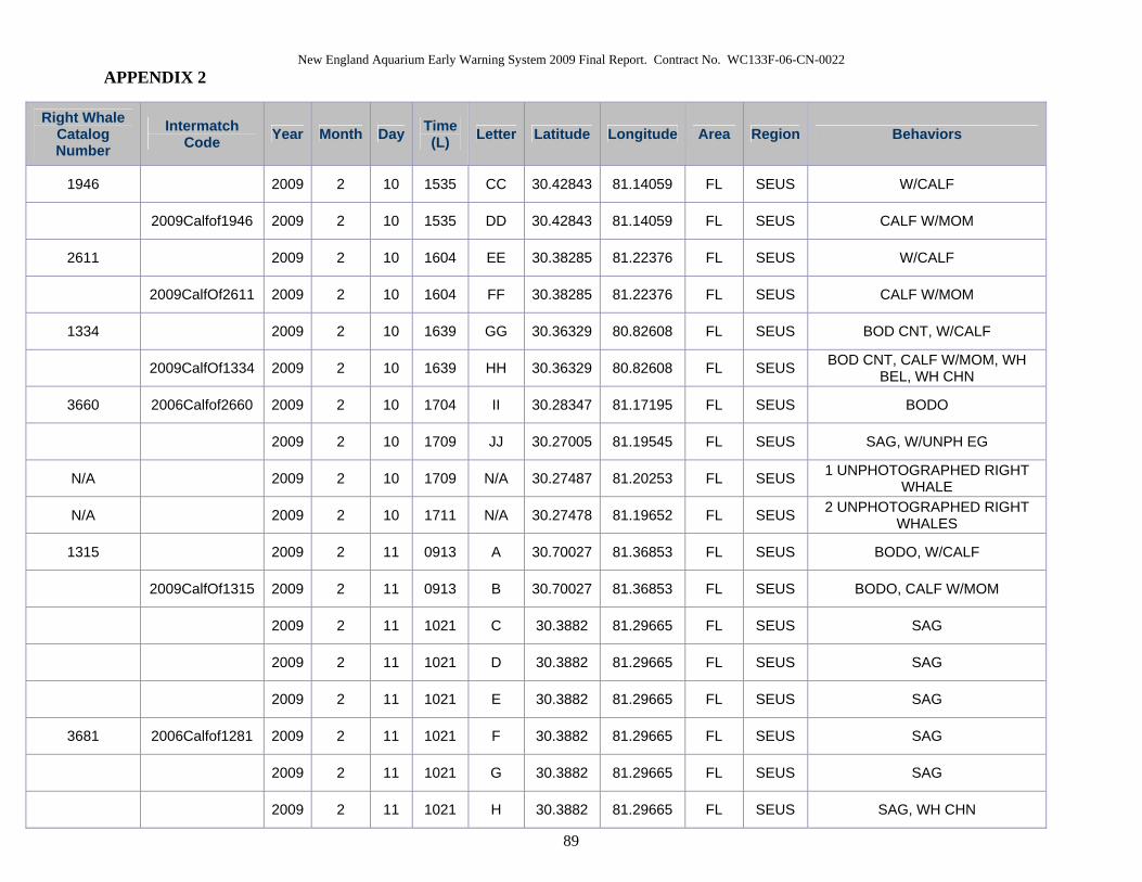
New England Aquarium Early Warning System 2009 Final Report. Contract No. WC133F-06-CN-0022 APPENDIX 2
89
Right Whale Catalog Number
Intermatch Code Year Month Day Time
(L) Letter Latitude Longitude Area Region Behaviors
1946 2009 2 10 1535 CC 30.42843 81.14059 FL SEUS W/CALF
2009Calfof1946 2009 2 10 1535 DD 30.42843 81.14059 FL SEUS CALF W/MOM
2611 2009 2 10 1604 EE 30.38285 81.22376 FL SEUS W/CALF
2009CalfOf2611 2009 2 10 1604 FF 30.38285 81.22376 FL SEUS CALF W/MOM
1334 2009 2 10 1639 GG 30.36329 80.82608 FL SEUS BOD CNT, W/CALF
2009CalfOf1334 2009 2 10 1639 HH 30.36329 80.82608 FL SEUS BOD CNT, CALF W/MOM, WH BEL, WH CHN
3660 2006Calfof2660 2009 2 10 1704 II 30.28347 81.17195 FL SEUS BODO
2009 2 10 1709 JJ 30.27005 81.19545 FL SEUS SAG, W/UNPH EG
N/A 2009 2 10 1709 N/A 30.27487 81.20253 FL SEUS 1 UNPHOTOGRAPHED RIGHT WHALE
N/A 2009 2 10 1711 N/A 30.27478 81.19652 FL SEUS 2 UNPHOTOGRAPHED RIGHT WHALES
1315 2009 2 11 0913 A 30.70027 81.36853 FL SEUS BODO, W/CALF
2009CalfOf1315 2009 2 11 0913 B 30.70027 81.36853 FL SEUS BODO, CALF W/MOM
2009 2 11 1021 C 30.3882 81.29665 FL SEUS SAG
2009 2 11 1021 D 30.3882 81.29665 FL SEUS SAG
2009 2 11 1021 E 30.3882 81.29665 FL SEUS SAG
3681 2006Calfof1281 2009 2 11 1021 F 30.3882 81.29665 FL SEUS SAG
2009 2 11 1021 G 30.3882 81.29665 FL SEUS SAG
2009 2 11 1021 H 30.3882 81.29665 FL SEUS SAG, WH CHN
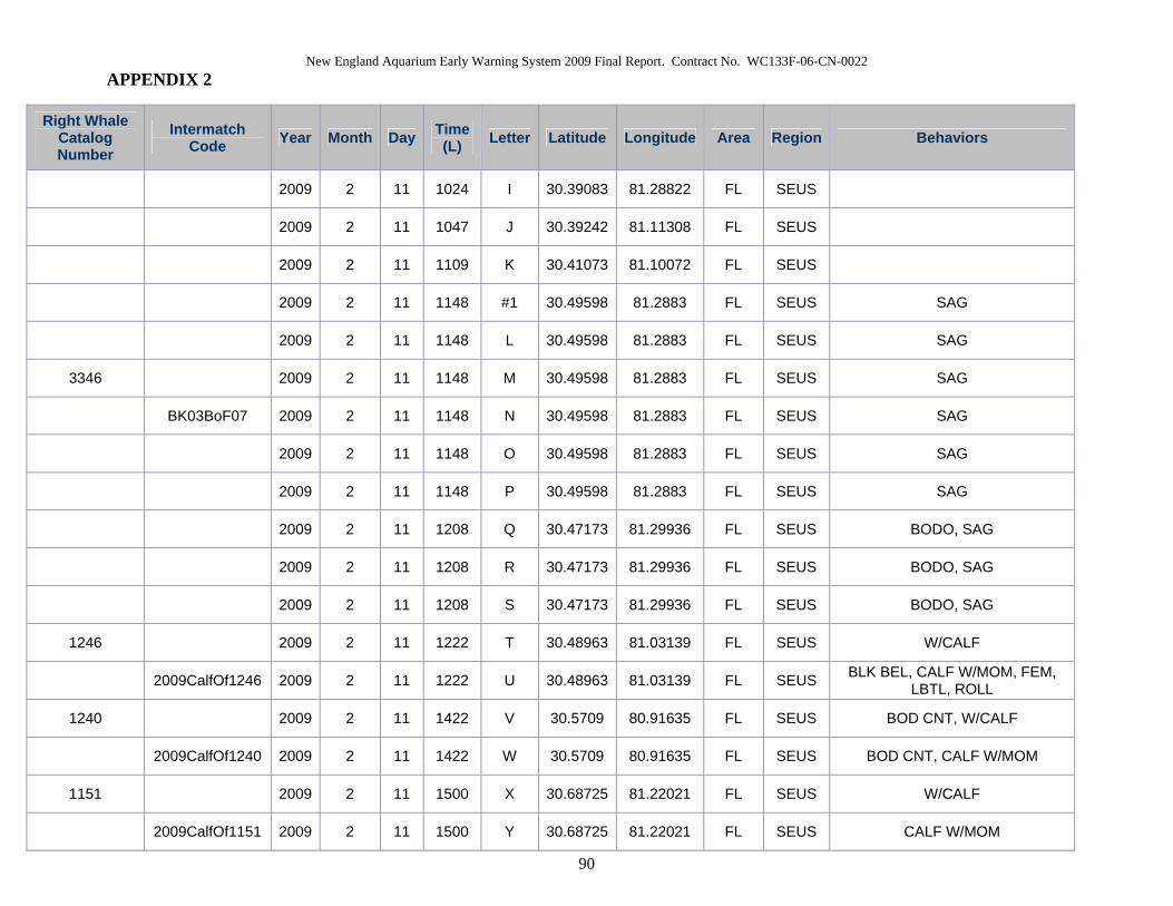
New England Aquarium Early Warning System 2009 Final Report. Contract No. WC133F-06-CN-0022 APPENDIX 2
90
Right Whale Catalog Number
Intermatch Code Year Month Day Time
(L) Letter Latitude Longitude Area Region Behaviors
2009 2 11 1024 I 30.39083 81.28822 FL SEUS
2009 2 11 1047 J 30.39242 81.11308 FL SEUS
2009 2 11 1109 K 30.41073 81.10072 FL SEUS
2009 2 11 1148 #1 30.49598 81.2883 FL SEUS SAG
2009 2 11 1148 L 30.49598 81.2883 FL SEUS SAG
3346 2009 2 11 1148 M 30.49598 81.2883 FL SEUS SAG
BK03BoF07 2009 2 11 1148 N 30.49598 81.2883 FL SEUS SAG
2009 2 11 1148 O 30.49598 81.2883 FL SEUS SAG
2009 2 11 1148 P 30.49598 81.2883 FL SEUS SAG
2009 2 11 1208 Q 30.47173 81.29936 FL SEUS BODO, SAG
2009 2 11 1208 R 30.47173 81.29936 FL SEUS BODO, SAG
2009 2 11 1208 S 30.47173 81.29936 FL SEUS BODO, SAG
1246 2009 2 11 1222 T 30.48963 81.03139 FL SEUS W/CALF
2009CalfOf1246 2009 2 11 1222 U 30.48963 81.03139 FL SEUS BLK BEL, CALF W/MOM, FEM, LBTL, ROLL
1240 2009 2 11 1422 V 30.5709 80.91635 FL SEUS BOD CNT, W/CALF
2009CalfOf1240 2009 2 11 1422 W 30.5709 80.91635 FL SEUS BOD CNT, CALF W/MOM
1151 2009 2 11 1500 X 30.68725 81.22021 FL SEUS W/CALF
2009CalfOf1151 2009 2 11 1500 Y 30.68725 81.22021 FL SEUS CALF W/MOM

New England Aquarium Early Warning System 2009 Final Report. Contract No. WC133F-06-CN-0022 APPENDIX 2
91
Right Whale Catalog Number
Intermatch Code Year Month Day Time
(L) Letter Latitude Longitude Area Region Behaviors
2008CalfOf1408 2009 2 11 1654 Z 30.56995 81.24618 FL SEUS BRCH, MOPN
2009 2 12 0925 A 30.82675 81.22293 GA SEUS SAG
2009 2 12 0925 B 30.82675 81.22293 GA SEUS SAG
2009 2 12 0925 C 30.82675 81.22293 GA SEUS SAG
2009 2 12 0925 D 30.82675 81.22293 GA SEUS SAG
2009 2 12 0925 E 30.82675 81.22293 GA SEUS SAG
2009 2 12 0936 F 30.83338 81.2004 GA SEUS
2009 2 12 0936 G 30.83338 81.2004 GA SEUS WH CHN
2009 2 12 1034 H 30.72338 81.38171 GA SEUS BEL UP, BLK BEL, BOD CNT, W/CALF
2009 2 12 1034 I 30.70698 81.38171 FL SEUS BOD CNT, CALF W/MOM
2009 2 12 1047 J 30.70698 81.34962 FL SEUS BOD CNT, W/CALF
2009 2 12 1047 K 30.70698 81.34962 FL SEUS BOD CNT, CALF W/MOM
2009 2 12 1055 L 30.75065 81.18505 GA SEUS SAG
2009 2 12 1055 M 30.75065 81.18505 GA SEUS SAG
2009 2 12 1055 N 30.75065 81.18505 GA SEUS SAG
2009 2 12 1055 O 30.75065 81.18505 GA SEUS SAG
2009 2 12 1055 P 30.75065 81.18505 GA SEUS SAG
2009 2 12 1055 Q 30.75065 81.18505 GA SEUS SAG
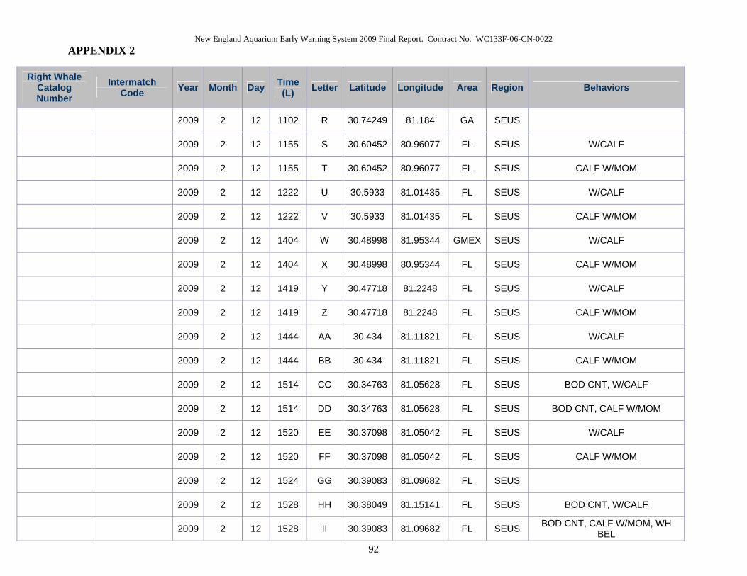
New England Aquarium Early Warning System 2009 Final Report. Contract No. WC133F-06-CN-0022 APPENDIX 2
92
Right Whale Catalog Number
Intermatch Code Year Month Day Time
(L) Letter Latitude Longitude Area Region Behaviors
2009 2 12 1102 R 30.74249 81.184 GA SEUS
2009 2 12 1155 S 30.60452 80.96077 FL SEUS W/CALF
2009 2 12 1155 T 30.60452 80.96077 FL SEUS CALF W/MOM
2009 2 12 1222 U 30.5933 81.01435 FL SEUS W/CALF
2009 2 12 1222 V 30.5933 81.01435 FL SEUS CALF W/MOM
2009 2 12 1404 W 30.48998 81.95344 GMEX SEUS W/CALF
2009 2 12 1404 X 30.48998 80.95344 FL SEUS CALF W/MOM
2009 2 12 1419 Y 30.47718 81.2248 FL SEUS W/CALF
2009 2 12 1419 Z 30.47718 81.2248 FL SEUS CALF W/MOM
2009 2 12 1444 AA 30.434 81.11821 FL SEUS W/CALF
2009 2 12 1444 BB 30.434 81.11821 FL SEUS CALF W/MOM
2009 2 12 1514 CC 30.34763 81.05628 FL SEUS BOD CNT, W/CALF
2009 2 12 1514 DD 30.34763 81.05628 FL SEUS BOD CNT, CALF W/MOM
2009 2 12 1520 EE 30.37098 81.05042 FL SEUS W/CALF
2009 2 12 1520 FF 30.37098 81.05042 FL SEUS CALF W/MOM
2009 2 12 1524 GG 30.39083 81.09682 FL SEUS
2009 2 12 1528 HH 30.38049 81.15141 FL SEUS BOD CNT, W/CALF
2009 2 12 1528 II 30.39083 81.09682 FL SEUS BOD CNT, CALF W/MOM, WH BEL

New England Aquarium Early Warning System 2009 Final Report. Contract No. WC133F-06-CN-0022 APPENDIX 2
93
Right Whale Catalog Number
Intermatch Code Year Month Day Time
(L) Letter Latitude Longitude Area Region Behaviors
2009 2 12 1550 JJ 30.33154 81.30556 FL SEUS W/CALF
2009 2 12 1550 KK 30.33154 81.30556 FL SEUS CALF W/MOM
2009 2 12 1557 LL 30.34643 81.15877 FL SEUS
2009 2 12 1557 MM 30.34643 81.15877 FL SEUS
2009 2 12 1602 NN 30.3522 81.0633 FL SEUS
2009 2 12 1602 OO 30.3522 81.0633 FL SEUS
2009 2 12 1619 PP 30.2577 80.87044 FL SEUS W/CALF
2009 2 12 1619 QQ 30.2577 80.87044 FL SEUS CALF W/MOM
2009 2 12 1634 RR 30.30505 81.05791 FL SEUS W/CALF
2009 2 12 1634 SS 30.30505 81.05791 FL SEUS CALF W/MOM
2009 2 12 1635 TT 30.30487 81.08337 FL SEUS W/CALF
2009 2 12 1635 UU 30.30487 81.16845 FL SEUS CALF W/MOM
2009 2 12 1643 VV 30.30392 81.16845 FL SEUS W/CALF
2009 2 12 1643 WW 30.30392 81.16845 FL SEUS CALF W/MOM
2009 2 13 1019 A 30.35152 80.88855 FL SEUS
1151 2009 2 13 1052 B 30.42868 81.31245 FL SEUS W/CALF
2009CalfOf1151 2009 2 13 1052 C 30.42868 81.31245 FL SEUS CALF W/MOM
2320 2009 2 13 1113 D 30.48913 81.1961 FL SEUS BOD CNT, W/CALF

New England Aquarium Early Warning System 2009 Final Report. Contract No. WC133F-06-CN-0022 APPENDIX 2
94
Right Whale Catalog Number
Intermatch Code Year Month Day Time
(L) Letter Latitude Longitude Area Region Behaviors
2009Calfof2320 2009 2 13 1113 E 30.48913 81.1961 FL SEUS BOD CNT, CALF W/MOM
3108 2009 2 13 1124 F 30.47473 81.18125 FL SEUS NURS, W/CALF
2009CalfOf3108 2009 2 13 1124 G 30.47473 81.18125 FL SEUS CALF W/MOM, NURS
2009 2 13 1323 H 30.58577 81.21848 FL SEUS
2009 2 13 1407 I 30.613 81.26241 FL SEUS
3320 2009 2 13 1535 J 30.81799 81.12818 GA SEUS BOD CNT, W/CALF
2009CalfOf3320 2009 2 13 1535 K 30.81799 81.12818 GA SEUS BOD CNT, CALF W/MOM
3440 2009 2 13 1550 L 30.85118 81.12832 GA SEUS BOD CNT, W/CALF
2009CalfOf3440 2009 2 13 1550 M 30.85118 81.12832 GA SEUS BOD CNT, CALF W/MOM
2009CalfOf1281 2009 2 13 1603 0 30.81188 81.37428 GA SEUS CALF W/MOM, LOG
1281 2009 2 13 1603 N 30.81188 81.37428 GA SEUS LOG, W/CALF
2611 2009 2 14 1208 A 30.33652 81.25581 FL SEUS W/CALF
2009CalfOf2611 2009 2 14 1208 B 30.3365 81.25581 FL SEUS CALF W/MOM
1608 2009 2 14 1315 C 30.64396 81.12576 FL SEUS W/CALF
2009CalfOf1608 2009 2 14 1315 D 30.64396 81.12576 FL SEUS CALF W/MOM
2009 2 14 1319 E 30.63383 81.17831 FL SEUS
2009 2 14 1319 F 30.63383 81.17831 FL SEUS
2123 2009 2 14 1327 G 30.63157 81.25981 FL SEUS BOD CNT, W/CALF

New England Aquarium Early Warning System 2009 Final Report. Contract No. WC133F-06-CN-0022 APPENDIX 2
95
Right Whale Catalog Number
Intermatch Code Year Month Day Time
(L) Letter Latitude Longitude Area Region Behaviors
2009Calfof2123 2009 2 14 1327 H 30.63157 81.25981 FL SEUS BOD CNT, CALF W/MOM
3101 2009 2 14 1356 I 30.73345 81.30805 GA SEUS W/CALF
2009Calfof3101 2009 2 14 1356 J 30.73345 81.30805 GA SEUS CALF W/MOM
1281 2009 2 14 1420 K 30.7823 81.38018 GA SEUS W/CALF
2009CalfOf1281 2009 2 14 1420 L 30.7823 81.38018 GA SEUS CALF W/MOM
2009 2 15 1023 A 30.6256 81.1853 FL SEUS BRCH, LBTL, VIDEO
1315 2009 2 15 1030 B 30.63157 81.18995 FL SEUS BOD CNT, W/CALF
2009CalfOf1315 2009 2 15 1030 C 30.63157 81.18995 FL SEUS BOD CNT, CALF W/MOM
2009 2 15 1106 D 30.63157 81.18995 FL SEUS
2009 2 15 1106 E 30.61448 81.12987 FL SEUS
2009 2 15 1129 F 30.41485 81.24478 FL SEUS
2009 2 15 1129 G 30.41485 81.24478 FL SEUS
N/A 2009 2 17 836 N/A 30.48841 81.19458 FL SEUS 1 UNPHOTOGRAPHED RIGHT WHALES
2009 2 17 0930 A 30.25858 81.03383 FL SEUS BEL/BEL
2009 2 17 0930 B 30.25858 81.03383 FL SEUS BEL/BEL, BLK CHN
2009 2 17 0948 C 30.28975 80.96098 FL SEUS
2009 2 17 0948 D 30.28975 80.96098 FL SEUS
2009 2 17 0948 E 30.28975 80.96098 FL SEUS

New England Aquarium Early Warning System 2009 Final Report. Contract No. WC133F-06-CN-0022 APPENDIX 2
96
Right Whale Catalog Number
Intermatch Code Year Month Day Time
(L) Letter Latitude Longitude Area Region Behaviors
2009 2 17 1000 F 30.27212 80.96945 FL SEUS BEL/BEL, SAG, WH CHN
2009 2 17 1000 G 30.27212 80.96945 FL SEUS BEL/BEL, SAG, WH BEL, WH CHN
2009 2 17 1048 H 30.3854 80.96208 FL SEUS
2009 2 17 1048 I 30.3854 80.96208 FL SEUS
2009 2 17 1048 J 30.3854 80.96208 FL SEUS
2009 2 17 1116 K 30.43397 80.82844 FL SEUS BOD CNT, W/CALF
2009 2 17 1116 L 30.43397 80.82844 FL SEUS BOD CNT, CALF W/MOM
2009 2 17 1142 M 30.49418 81.19791 FL SEUS SAG
2009 2 17 1142 N 30.49418 81.19791 FL SEUS SAG
2009 2 17 1154 O 30.43032 81.16219 FL SEUS W/CALF
2009 2 17 1154 P 30.43032 81.16219 FL SEUS CALF W/MOM, LBTL
2009 2 17 1207 Q 30.41993 81.27113 FL SEUS
2009 2 17 1207 R 30.41993 81.27113 FL SEUS
2009 2 17 1212 S 30.45514 81.29147 FL SEUS NURS, W/CALF
2009 2 17 1212 T 30.45514 81.29147 FL SEUS CALF W/MOM, NURS
2009 2 17 1224 U 30.49538 81.23628 FL SEUS
2009 2 17 1224 V 30.49538 81.23628 FL SEUS
2009 2 17 1224 W 30.49538 81.23628 FL SEUS

New England Aquarium Early Warning System 2009 Final Report. Contract No. WC133F-06-CN-0022 APPENDIX 2
97
Right Whale Catalog Number
Intermatch Code Year Month Day Time
(L) Letter Latitude Longitude Area Region Behaviors
2009 2 17 1232 X 30.48997 81.22359 FL SEUS LBTL
2009 2 17 1241 Y 30.47668 81.18743 FL SEUS
2009 2 17 1247 Z 30.48155 81.0962 FL SEUS
2009 2 17 1310 AA 30.5682 81.33175 FL SEUS BODO, SAG
2009 2 17 1310 BB 30.5682 81.33175 FL SEUS BODO, SAG
2009 2 17 1310 CC 30.5682 81.33175 FL SEUS BODO, SAG
2009 2 17 1310 DD 30.5682 81.33175 FL SEUS BODO, SAG
2009 2 17 1530 EE 30.69702 80.84743 FL SEUS W/CALF
2009 2 17 1530 FF 30.69702 80.84743 FL SEUS CALF W/MOM
2009 2 17 1557 GG 30.74092 81.23117 GA SEUS
2008calfof2330 2009 2 19 1158 A 30.79682 81.27068 GA SEUS BLK BEL, BOD CNT
2009 2 19 1158 B 30.79682 81.27068 GA SEUS BOD CNT
2009 2 19 1202 C 30.79685 81.26925 GA SEUS MOPN
1315 2009 2 19 1225 D 30.70483 81.06832 FL SEUS BOD CNT, W/CALF
2009CalfOf1315 2009 2 19 1225 E 30.70483 81.06832 FL SEUS BOD CNT, CALF W/MOM
1142 2009 2 19 1236 F 30.74895 81.23534 GA SEUS BODO, W/CALF
2009Calfof1142 2009 2 19 1236 G 30.74895 81.23534 GA SEUS BODO, CALF W/MOM
2009 2 19 1355 H 30.22495 81.31435 FL SEUS BODO

New England Aquarium Early Warning System 2009 Final Report. Contract No. WC133F-06-CN-0022 APPENDIX 2
98
Right Whale Catalog Number
Intermatch Code Year Month Day Time
(L) Letter Latitude Longitude Area Region Behaviors
2145 2009 2 19 1418 I 30.3319 81.12753 FL SEUS BLK CHN, BOD CNT, W/CALF
2009CalfOf2145 2009 2 19 1418 J 30.3319 81.12753 FL SEUS BOD CNT, CALF W/MOM, WH BEL
2009 2 19 1431 K 30.31733 81.2505 FL SEUS BOD CNT
2009 2 19 1431 L 30.31733 81.2505 FL SEUS BOD CNT
2008CalfOf1245 2009 2 22 1112 A 30.82316 81.29801 GA SEUS SAG
2009 2 22 1112 B 30.82316 81.29801 GA SEUS SAG
BK01BOF07 2009 2 22 1119 C 30.82421 81.29888 GA SEUS
2009 2 22 1128 D 30.8396 81.2945 GA SEUS BOD CNT
2009 2 22 1128 E 30.8396 81.2945 GA SEUS BOD CNT
2009 2 22 1132 F 30.8338 81.28523 GA SEUS
BK01BOF07 2009 2 22 1149 G 30.8317 81.29035 GA SEUS
2009 2 25 0935 A 30.26858 81.19865 FL SEUS
2009 2 25 0935 B 30.26853 81.19865 FL SEUS
2791 2009 2 25 1012 C 30.35128 81.27522 FL SEUS W/CALF
2009Calfof2791 2009 2 25 1012 D 30.35128 81.27522 FL SEUS CALF W/MOM
1817 2009 2 25 1151 E 30.58408 81.26199 FL SEUS BOD CNT, W/CALF
2009Calfof1817 2009 2 25 1151 F 30.58408 81.26199 FL SEUS BOD CNT, CALF W/MOM
3108 2009 2 25 1234 G 30.62133 81.30848 FL SEUS W/CALF
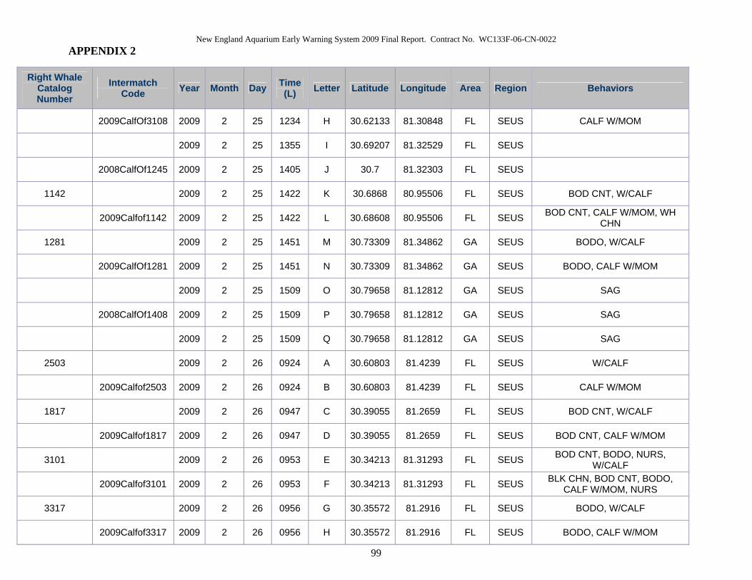
New England Aquarium Early Warning System 2009 Final Report. Contract No. WC133F-06-CN-0022 APPENDIX 2
99
Right Whale Catalog Number
Intermatch Code Year Month Day Time
(L) Letter Latitude Longitude Area Region Behaviors
2009CalfOf3108 2009 2 25 1234 H 30.62133 81.30848 FL SEUS CALF W/MOM
2009 2 25 1355 I 30.69207 81.32529 FL SEUS
2008CalfOf1245 2009 2 25 1405 J 30.7 81.32303 FL SEUS
1142 2009 2 25 1422 K 30.6868 80.95506 FL SEUS BOD CNT, W/CALF
2009Calfof1142 2009 2 25 1422 L 30.68608 80.95506 FL SEUS BOD CNT, CALF W/MOM, WH CHN
1281 2009 2 25 1451 M 30.73309 81.34862 GA SEUS BODO, W/CALF
2009CalfOf1281 2009 2 25 1451 N 30.73309 81.34862 GA SEUS BODO, CALF W/MOM
2009 2 25 1509 O 30.79658 81.12812 GA SEUS SAG
2008CalfOf1408 2009 2 25 1509 P 30.79658 81.12812 GA SEUS SAG
2009 2 25 1509 Q 30.79658 81.12812 GA SEUS SAG
2503 2009 2 26 0924 A 30.60803 81.4239 FL SEUS W/CALF
2009Calfof2503 2009 2 26 0924 B 30.60803 81.4239 FL SEUS CALF W/MOM
1817 2009 2 26 0947 C 30.39055 81.2659 FL SEUS BOD CNT, W/CALF
2009Calfof1817 2009 2 26 0947 D 30.39055 81.2659 FL SEUS BOD CNT, CALF W/MOM
3101 2009 2 26 0953 E 30.34213 81.31293 FL SEUS BOD CNT, BODO, NURS, W/CALF
2009Calfof3101 2009 2 26 0953 F 30.34213 81.31293 FL SEUS BLK CHN, BOD CNT, BODO, CALF W/MOM, NURS
3317 2009 2 26 0956 G 30.35572 81.2916 FL SEUS BODO, W/CALF
2009Calfof3317 2009 2 26 0956 H 30.35572 81.2916 FL SEUS BODO, CALF W/MOM
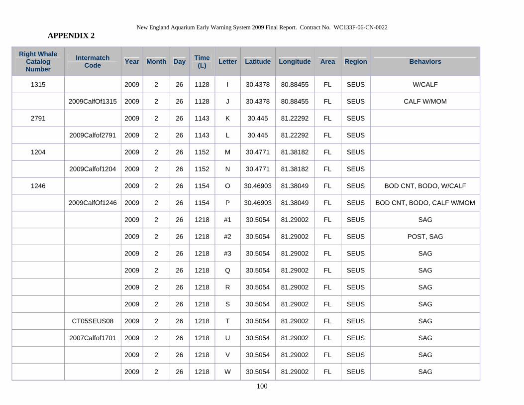
New England Aquarium Early Warning System 2009 Final Report. Contract No. WC133F-06-CN-0022 APPENDIX 2
100
Right Whale Catalog Number
Intermatch Code Year Month Day Time
(L) Letter Latitude Longitude Area Region Behaviors
1315 2009 2 26 1128 I 30.4378 80.88455 FL SEUS W/CALF
2009CalfOf1315 2009 2 26 1128 J 30.4378 80.88455 FL SEUS CALF W/MOM
2791 2009 2 26 1143 K 30.445 81.22292 FL SEUS
2009Calfof2791 2009 2 26 1143 L 30.445 81.22292 FL SEUS
1204 2009 2 26 1152 M 30.4771 81.38182 FL SEUS
2009Calfof1204 2009 2 26 1152 N 30.4771 81.38182 FL SEUS
1246 2009 2 26 1154 O 30.46903 81.38049 FL SEUS BOD CNT, BODO, W/CALF
2009CalfOf1246 2009 2 26 1154 P 30.46903 81.38049 FL SEUS BOD CNT, BODO, CALF W/MOM
2009 2 26 1218 #1 30.5054 81.29002 FL SEUS SAG
2009 2 26 1218 #2 30.5054 81.29002 FL SEUS POST, SAG
2009 2 26 1218 #3 30.5054 81.29002 FL SEUS SAG
2009 2 26 1218 Q 30.5054 81.29002 FL SEUS SAG
2009 2 26 1218 R 30.5054 81.29002 FL SEUS SAG
2009 2 26 1218 S 30.5054 81.29002 FL SEUS SAG
CT05SEUS08 2009 2 26 1218 T 30.5054 81.29002 FL SEUS SAG
2007Calfof1701 2009 2 26 1218 U 30.5054 81.29002 FL SEUS SAG
2009 2 26 1218 V 30.5054 81.29002 FL SEUS SAG
2009 2 26 1218 W 30.5054 81.29002 FL SEUS SAG
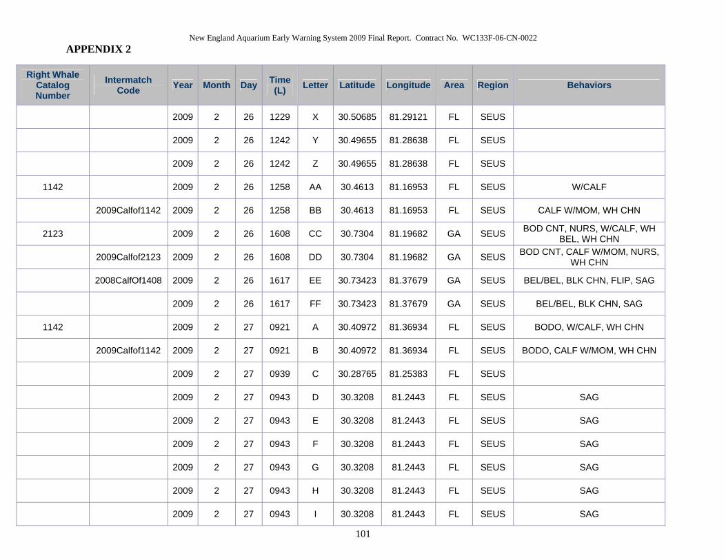
New England Aquarium Early Warning System 2009 Final Report. Contract No. WC133F-06-CN-0022 APPENDIX 2
101
Right Whale Catalog Number
Intermatch Code Year Month Day Time
(L) Letter Latitude Longitude Area Region Behaviors
2009 2 26 1229 X 30.50685 81.29121 FL SEUS
2009 2 26 1242 Y 30.49655 81.28638 FL SEUS
2009 2 26 1242 Z 30.49655 81.28638 FL SEUS
1142 2009 2 26 1258 AA 30.4613 81.16953 FL SEUS W/CALF
2009Calfof1142 2009 2 26 1258 BB 30.4613 81.16953 FL SEUS CALF W/MOM, WH CHN
2123 2009 2 26 1608 CC 30.7304 81.19682 GA SEUS BOD CNT, NURS, W/CALF, WH BEL, WH CHN
2009Calfof2123 2009 2 26 1608 DD 30.7304 81.19682 GA SEUS BOD CNT, CALF W/MOM, NURS, WH CHN
2008CalfOf1408 2009 2 26 1617 EE 30.73423 81.37679 GA SEUS BEL/BEL, BLK CHN, FLIP, SAG
2009 2 26 1617 FF 30.73423 81.37679 GA SEUS BEL/BEL, BLK CHN, SAG
1142 2009 2 27 0921 A 30.40972 81.36934 FL SEUS BODO, W/CALF, WH CHN
2009Calfof1142 2009 2 27 0921 B 30.40972 81.36934 FL SEUS BODO, CALF W/MOM, WH CHN
2009 2 27 0939 C 30.28765 81.25383 FL SEUS
2009 2 27 0943 D 30.3208 81.2443 FL SEUS SAG
2009 2 27 0943 E 30.3208 81.2443 FL SEUS SAG
2009 2 27 0943 F 30.3208 81.2443 FL SEUS SAG
2009 2 27 0943 G 30.3208 81.2443 FL SEUS SAG
2009 2 27 0943 H 30.3208 81.2443 FL SEUS SAG
2009 2 27 0943 I 30.3208 81.2443 FL SEUS SAG

New England Aquarium Early Warning System 2009 Final Report. Contract No. WC133F-06-CN-0022 APPENDIX 2
102
Right Whale Catalog Number
Intermatch Code Year Month Day Time
(L) Letter Latitude Longitude Area Region Behaviors
2009 2 27 0943 J 30.3208 81.2443 FL SEUS SAG
2009 2 27 0943 K 30.3208 81.2443 FL SEUS SAG
2009 2 27 0950 L 30.40798 81.25314 FL SEUS LBTL
2009 2 27 0955 M 30.39267 81.25845 FL SEUS BOD CNT
2009 2 27 0955 N 30.39267 81.25845 FL SEUS BLK CHN, BOD CNT, UW EXH
1817 2009 2 27 1032 O 30.2945 81.05348 FL SEUS W/CALF
2009Calfof1817 2009 2 27 1032 P 30.2945 81.05348 FL SEUS CALF W/MOM
3101 2009 2 27 1106 Q 30.32722 81.14138 FL SEUS W/CALF
2009Calfof3101 2009 2 27 1106 R 30.32722 81.14138 FL SEUS CALF W/MOM
1303 2009 2 27 1118 S 30.33002 81.11123 FL SEUS BOD CNT, W/CALF
2009Calfof1303 2009 2 27 1118 T 30.33002 81.11123 FL SEUS BOD CNT, CALF W/MOM, WH BEL, WH CHN
2108 2009 2 27 1131 U 30.30825 81.15948 FL SEUS NURS, W/CALF
2009CalfOf3108 2009 2 27 1131 V 30.30825 81.15948 FL SEUS CALF W/MOM, NURS
2320 2009 2 27 1157 W 30.3723 81.34818 FL SEUS W/CALF
2009Calfof2320 2009 2 27 1157 X 30.3723 81.34818 FL SEUS CALF W/MOM
1142 2009 2 27 1222 Y 30.40685 81.35297 FL SEUS W/CALF
2009Calfof1142 2009 2 27 1222 Z 30.40685 81.35297 FL SEUS CALF W/MOM
1142 2009 2 27 1306 AA 30.39647 81.35225 FL SEUS W/CALF
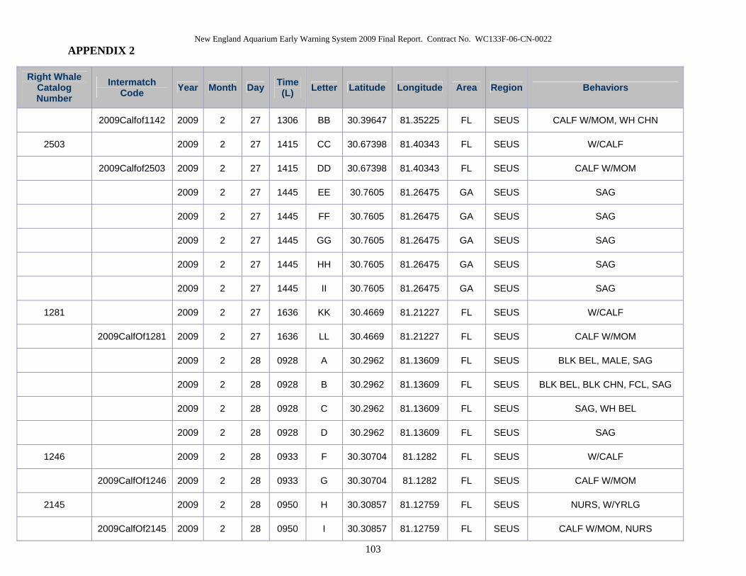
New England Aquarium Early Warning System 2009 Final Report. Contract No. WC133F-06-CN-0022 APPENDIX 2
103
Right Whale Catalog Number
Intermatch Code Year Month Day Time
(L) Letter Latitude Longitude Area Region Behaviors
2009Calfof1142 2009 2 27 1306 BB 30.39647 81.35225 FL SEUS CALF W/MOM, WH CHN
2503 2009 2 27 1415 CC 30.67398 81.40343 FL SEUS W/CALF
2009Calfof2503 2009 2 27 1415 DD 30.67398 81.40343 FL SEUS CALF W/MOM
2009 2 27 1445 EE 30.7605 81.26475 GA SEUS SAG
2009 2 27 1445 FF 30.7605 81.26475 GA SEUS SAG
2009 2 27 1445 GG 30.7605 81.26475 GA SEUS SAG
2009 2 27 1445 HH 30.7605 81.26475 GA SEUS SAG
2009 2 27 1445 II 30.7605 81.26475 GA SEUS SAG
1281 2009 2 27 1636 KK 30.4669 81.21227 FL SEUS W/CALF
2009CalfOf1281 2009 2 27 1636 LL 30.4669 81.21227 FL SEUS CALF W/MOM
2009 2 28 0928 A 30.2962 81.13609 FL SEUS BLK BEL, MALE, SAG
2009 2 28 0928 B 30.2962 81.13609 FL SEUS BLK BEL, BLK CHN, FCL, SAG
2009 2 28 0928 C 30.2962 81.13609 FL SEUS SAG, WH BEL
2009 2 28 0928 D 30.2962 81.13609 FL SEUS SAG
1246 2009 2 28 0933 F 30.30704 81.1282 FL SEUS W/CALF
2009CalfOf1246 2009 2 28 0933 G 30.30704 81.1282 FL SEUS CALF W/MOM
2145 2009 2 28 0950 H 30.30857 81.12759 FL SEUS NURS, W/YRLG
2009CalfOf2145 2009 2 28 0950 I 30.30857 81.12759 FL SEUS CALF W/MOM, NURS
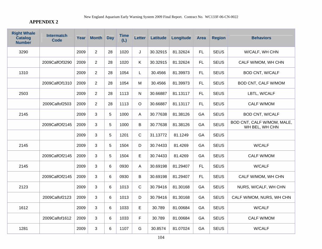
New England Aquarium Early Warning System 2009 Final Report. Contract No. WC133F-06-CN-0022 APPENDIX 2
104
Right Whale Catalog Number
Intermatch Code Year Month Day Time
(L) Letter Latitude Longitude Area Region Behaviors
3290 2009 2 28 1020 J 30.32915 81.32624 FL SEUS W/CALF, WH CHN
2009CalfOf3290 2009 2 28 1020 K 30.32915 81.32624 FL SEUS CALF W/MOM, WH CHN
1310 2009 2 28 1054 L 30.4566 81.39973 FL SEUS BOD CNT, W/CALF
2009CalfOf1310 2009 2 28 1054 M 30.4566 81.39973 FL SEUS BOD CNT, CALF W/MOM
2503 2009 2 28 1113 N 30.66887 81.13117 FL SEUS LBTL, W/CALF
2009Calfof2503 2009 2 28 1113 O 30.66887 81.13117 FL SEUS CALF W/MOM
2145 2009 3 5 1000 A 30.77638 81.38126 GA SEUS BOD CNT, W/CALF
2009CalfOf2145 2009 3 5 1000 B 30.77638 81.38126 GA SEUS BOD CNT, CALF W/MOM, MALE, WH BEL, WH CHN
2009 3 5 1201 C 31.13772 81.1249 GA SEUS
2145 2009 3 5 1504 D 30.74433 81.4269 GA SEUS W/CALF
2009CalfOf2145 2009 3 5 1504 E 30.74433 81.4269 GA SEUS CALF W/MOM
2145 2009 3 6 0930 A 30.69198 81.29407 FL SEUS W/CALF
2009CalfOf2145 2009 3 6 0930 B 30.69198 81.29407 FL SEUS CALF W/MOM, WH CHN
2123 2009 3 6 1013 C 30.79416 81.30168 GA SEUS NURS, W/CALF, WH CHN
2009Calfof2123 2009 3 6 1013 D 30.79416 81.30168 GA SEUS CALF W/MOM, NURS, WH CHN
1612 2009 3 6 1033 E 30.789 81.00684 GA SEUS W/CALF
2009Calfof1612 2009 3 6 1033 F 30.789 81.00684 GA SEUS CALF W/MOM
1281 2009 3 6 1107 G 30.8574 81.07024 GA SEUS W/CALF
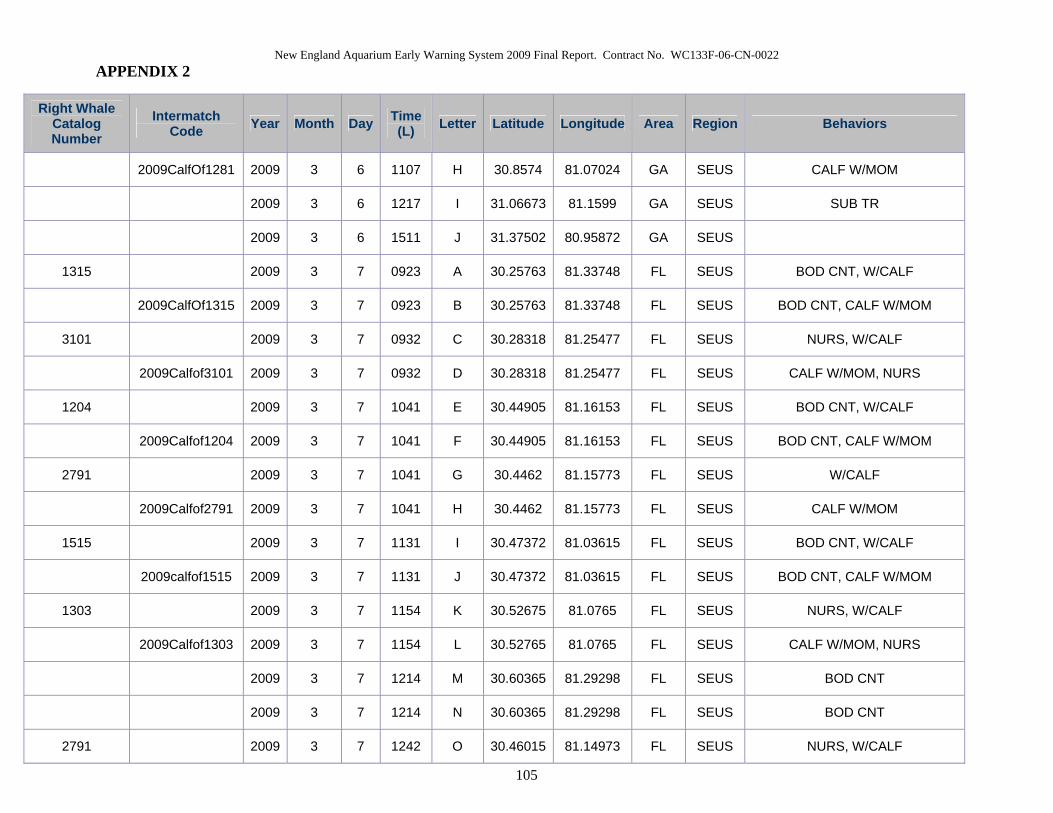
New England Aquarium Early Warning System 2009 Final Report. Contract No. WC133F-06-CN-0022 APPENDIX 2
105
Right Whale Catalog Number
Intermatch Code Year Month Day Time
(L) Letter Latitude Longitude Area Region Behaviors
2009CalfOf1281 2009 3 6 1107 H 30.8574 81.07024 GA SEUS CALF W/MOM
2009 3 6 1217 I 31.06673 81.1599 GA SEUS SUB TR
2009 3 6 1511 J 31.37502 80.95872 GA SEUS
1315 2009 3 7 0923 A 30.25763 81.33748 FL SEUS BOD CNT, W/CALF
2009CalfOf1315 2009 3 7 0923 B 30.25763 81.33748 FL SEUS BOD CNT, CALF W/MOM
3101 2009 3 7 0932 C 30.28318 81.25477 FL SEUS NURS, W/CALF
2009Calfof3101 2009 3 7 0932 D 30.28318 81.25477 FL SEUS CALF W/MOM, NURS
1204 2009 3 7 1041 E 30.44905 81.16153 FL SEUS BOD CNT, W/CALF
2009Calfof1204 2009 3 7 1041 F 30.44905 81.16153 FL SEUS BOD CNT, CALF W/MOM
2791 2009 3 7 1041 G 30.4462 81.15773 FL SEUS W/CALF
2009Calfof2791 2009 3 7 1041 H 30.4462 81.15773 FL SEUS CALF W/MOM
1515 2009 3 7 1131 I 30.47372 81.03615 FL SEUS BOD CNT, W/CALF
2009calfof1515 2009 3 7 1131 J 30.47372 81.03615 FL SEUS BOD CNT, CALF W/MOM
1303 2009 3 7 1154 K 30.52675 81.0765 FL SEUS NURS, W/CALF
2009Calfof1303 2009 3 7 1154 L 30.52765 81.0765 FL SEUS CALF W/MOM, NURS
2009 3 7 1214 M 30.60365 81.29298 FL SEUS BOD CNT
2009 3 7 1214 N 30.60365 81.29298 FL SEUS BOD CNT
2791 2009 3 7 1242 O 30.46015 81.14973 FL SEUS NURS, W/CALF
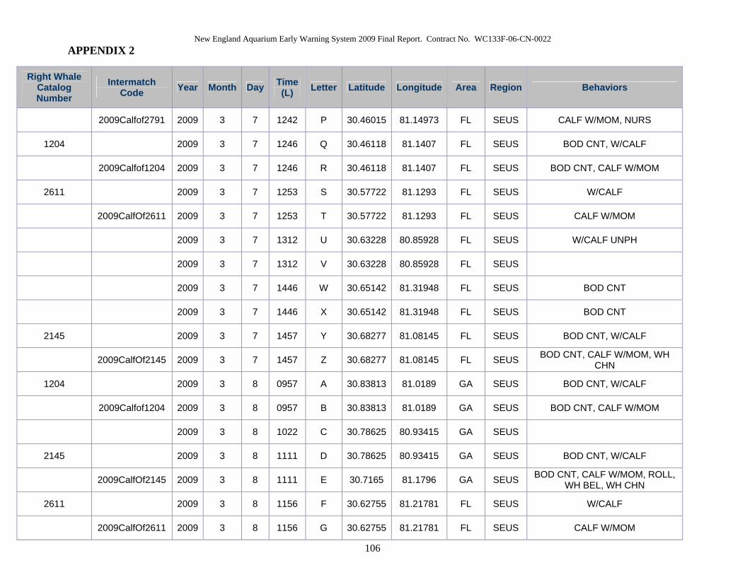
New England Aquarium Early Warning System 2009 Final Report. Contract No. WC133F-06-CN-0022 APPENDIX 2
106
Right Whale Catalog Number
Intermatch Code Year Month Day Time
(L) Letter Latitude Longitude Area Region Behaviors
2009Calfof2791 2009 3 7 1242 P 30.46015 81.14973 FL SEUS CALF W/MOM, NURS
1204 2009 3 7 1246 Q 30.46118 81.1407 FL SEUS BOD CNT, W/CALF
2009Calfof1204 2009 3 7 1246 R 30.46118 81.1407 FL SEUS BOD CNT, CALF W/MOM
2611 2009 3 7 1253 S 30.57722 81.1293 FL SEUS W/CALF
2009CalfOf2611 2009 3 7 1253 T 30.57722 81.1293 FL SEUS CALF W/MOM
2009 3 7 1312 U 30.63228 80.85928 FL SEUS W/CALF UNPH
2009 3 7 1312 V 30.63228 80.85928 FL SEUS
2009 3 7 1446 W 30.65142 81.31948 FL SEUS BOD CNT
2009 3 7 1446 X 30.65142 81.31948 FL SEUS BOD CNT
2145 2009 3 7 1457 Y 30.68277 81.08145 FL SEUS BOD CNT, W/CALF
2009CalfOf2145 2009 3 7 1457 Z 30.68277 81.08145 FL SEUS BOD CNT, CALF W/MOM, WH CHN
1204 2009 3 8 0957 A 30.83813 81.0189 GA SEUS BOD CNT, W/CALF
2009Calfof1204 2009 3 8 0957 B 30.83813 81.0189 GA SEUS BOD CNT, CALF W/MOM
2009 3 8 1022 C 30.78625 80.93415 GA SEUS
2145 2009 3 8 1111 D 30.78625 80.93415 GA SEUS BOD CNT, W/CALF
2009CalfOf2145 2009 3 8 1111 E 30.7165 81.1796 GA SEUS BOD CNT, CALF W/MOM, ROLL, WH BEL, WH CHN
2611 2009 3 8 1156 F 30.62755 81.21781 FL SEUS W/CALF
2009CalfOf2611 2009 3 8 1156 G 30.62755 81.21781 FL SEUS CALF W/MOM

New England Aquarium Early Warning System 2009 Final Report. Contract No. WC133F-06-CN-0022 APPENDIX 2
107
Right Whale Catalog Number
Intermatch Code Year Month Day Time
(L) Letter Latitude Longitude Area Region Behaviors
2009 3 8 1204 H 30.61595 81.12418 FL SEUS SAG
2009 3 8 1204 I 30.61959 81.12755 FL SEUS SAG
BK01BOF07 2009 3 8 1204 J 30.61595 81.12755 FL SEUS SAG
2009 3 8 1204 K 30.61595 81.12755 FL SEUS SAG
2009 3 8 1219 L 30.63587 81.12418 FL SEUS
2009 3 8 1238 M 30.61489 80.97034 FL SEUS
2791 2009 3 8 1301 N 30.58527 81.07333 FL SEUS NURS, W/CALF
2009Calfof2791 2009 3 8 1301 O 30.58527 81.07333 FL SEUS CALF W/MOM, NURS
1315 2009 3 8 1626 P 30.5203 81.10986 FL SEUS W/CALF
2009CalfOf1315 2009 3 8 1626 Q 30.5203 81.10986 FL SEUS BLK CHN, CALF W/MOM, CHN BRCH
1233 2009 3 9 1147 A 30.57675 81.16531 FL SEUS NURS, W/CALF
2009CalfOf1233 2009 3 9 1147 B 30.57675 81.16531 FL SEUS CALF W/MOM, NURS
2791 2009 3 9 1206 C 30.69688 81.1484 FL SEUS W/CALF
2009Calfof2791 2009 3 9 1206 D 30.69688 81.1484 FL SEUS CALF W/MOM
3317 2009 3 9 1209 E 30.62932 81.12617 FL SEUS W/CALF
2009Calfof3317 2009 3 9 1209 F 30.62932 81.12617 FL SEUS CALF W/MOM
1315 2009 3 9 1405 G 30.48452 81.97548 GMEX SEUS BOD CNT, W/CALF
2009CalfOf1315 2009 3 9 1405 H 30.48452 81.97548 GMEX SEUS BOD CNT, CALF W/MOM
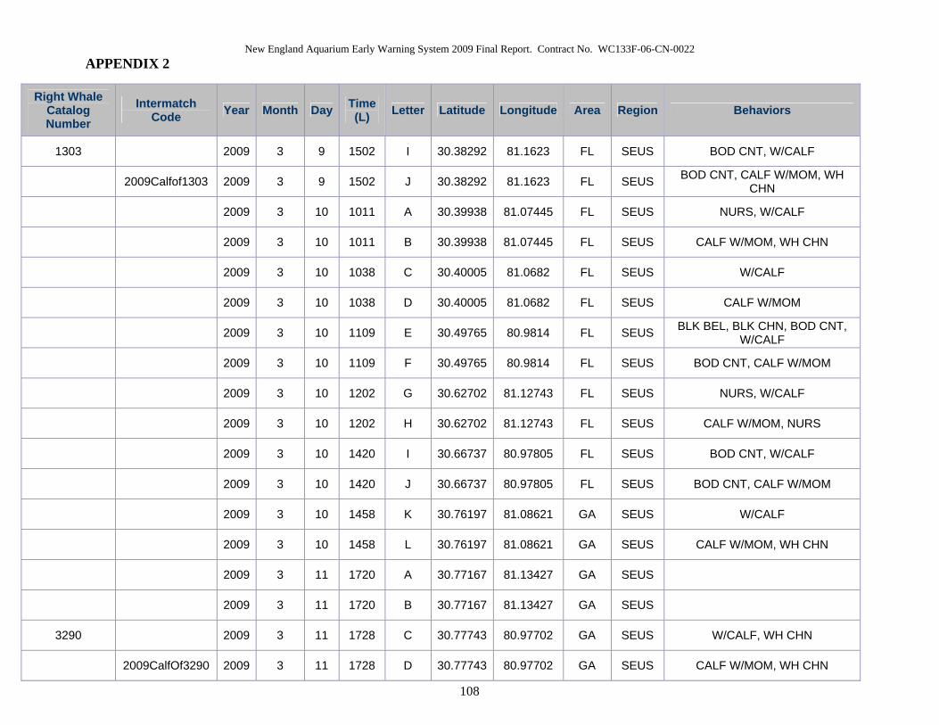
New England Aquarium Early Warning System 2009 Final Report. Contract No. WC133F-06-CN-0022 APPENDIX 2
108
Right Whale Catalog Number
Intermatch Code Year Month Day Time
(L) Letter Latitude Longitude Area Region Behaviors
1303 2009 3 9 1502 I 30.38292 81.1623 FL SEUS BOD CNT, W/CALF
2009Calfof1303 2009 3 9 1502 J 30.38292 81.1623 FL SEUS BOD CNT, CALF W/MOM, WH CHN
2009 3 10 1011 A 30.39938 81.07445 FL SEUS NURS, W/CALF
2009 3 10 1011 B 30.39938 81.07445 FL SEUS CALF W/MOM, WH CHN
2009 3 10 1038 C 30.40005 81.0682 FL SEUS W/CALF
2009 3 10 1038 D 30.40005 81.0682 FL SEUS CALF W/MOM
2009 3 10 1109 E 30.49765 80.9814 FL SEUS BLK BEL, BLK CHN, BOD CNT, W/CALF
2009 3 10 1109 F 30.49765 80.9814 FL SEUS BOD CNT, CALF W/MOM
2009 3 10 1202 G 30.62702 81.12743 FL SEUS NURS, W/CALF
2009 3 10 1202 H 30.62702 81.12743 FL SEUS CALF W/MOM, NURS
2009 3 10 1420 I 30.66737 80.97805 FL SEUS BOD CNT, W/CALF
2009 3 10 1420 J 30.66737 80.97805 FL SEUS BOD CNT, CALF W/MOM
2009 3 10 1458 K 30.76197 81.08621 GA SEUS W/CALF
2009 3 10 1458 L 30.76197 81.08621 GA SEUS CALF W/MOM, WH CHN
2009 3 11 1720 A 30.77167 81.13427 GA SEUS
2009 3 11 1720 B 30.77167 81.13427 GA SEUS
3290 2009 3 11 1728 C 30.77743 80.97702 GA SEUS W/CALF, WH CHN
2009CalfOf3290 2009 3 11 1728 D 30.77743 80.97702 GA SEUS CALF W/MOM, WH CHN
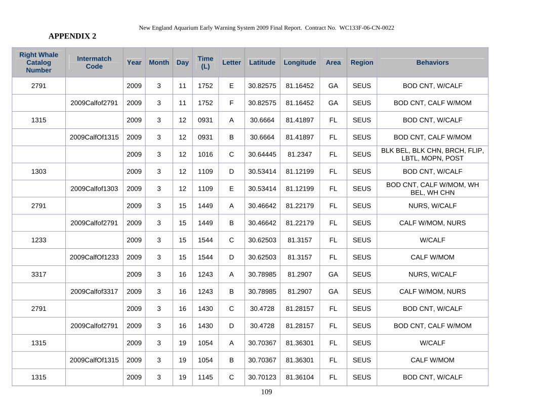
New England Aquarium Early Warning System 2009 Final Report. Contract No. WC133F-06-CN-0022 APPENDIX 2
109
Right Whale Catalog Number
Intermatch Code Year Month Day Time
(L) Letter Latitude Longitude Area Region Behaviors
2791 2009 3 11 1752 E 30.82575 81.16452 GA SEUS BOD CNT, W/CALF
2009Calfof2791 2009 3 11 1752 F 30.82575 81.16452 GA SEUS BOD CNT, CALF W/MOM
1315 2009 3 12 0931 A 30.6664 81.41897 FL SEUS BOD CNT, W/CALF
2009CalfOf1315 2009 3 12 0931 B 30.6664 81.41897 FL SEUS BOD CNT, CALF W/MOM
2009 3 12 1016 C 30.64445 81.2347 FL SEUS BLK BEL, BLK CHN, BRCH, FLIP, LBTL, MOPN, POST
1303 2009 3 12 1109 D 30.53414 81.12199 FL SEUS BOD CNT, W/CALF
2009Calfof1303 2009 3 12 1109 E 30.53414 81.12199 FL SEUS BOD CNT, CALF W/MOM, WH BEL, WH CHN
2791 2009 3 15 1449 A 30.46642 81.22179 FL SEUS NURS, W/CALF
2009Calfof2791 2009 3 15 1449 B 30.46642 81.22179 FL SEUS CALF W/MOM, NURS
1233 2009 3 15 1544 C 30.62503 81.3157 FL SEUS W/CALF
2009CalfOf1233 2009 3 15 1544 D 30.62503 81.3157 FL SEUS CALF W/MOM
3317 2009 3 16 1243 A 30.78985 81.2907 GA SEUS NURS, W/CALF
2009Calfof3317 2009 3 16 1243 B 30.78985 81.2907 GA SEUS CALF W/MOM, NURS
2791 2009 3 16 1430 C 30.4728 81.28157 FL SEUS BOD CNT, W/CALF
2009Calfof2791 2009 3 16 1430 D 30.4728 81.28157 FL SEUS BOD CNT, CALF W/MOM
1315 2009 3 19 1054 A 30.70367 81.36301 FL SEUS W/CALF
2009CalfOf1315 2009 3 19 1054 B 30.70367 81.36301 FL SEUS CALF W/MOM
1315 2009 3 19 1145 C 30.70123 81.36104 FL SEUS BOD CNT, W/CALF

New England Aquarium Early Warning System 2009 Final Report. Contract No. WC133F-06-CN-0022 APPENDIX 2
110
Right Whale Catalog Number
Intermatch Code Year Month Day Time
(L) Letter Latitude Longitude Area Region Behaviors
2009CalfOf1315 2009 3 19 1145 D 30.70123 81.36104 FL SEUS BOD CNT, CALF W/MOM
2009 3 19 1215 E 30.61223 81.15897 FL SEUS
2009 3 19 1259 F 30.54438 81.27534 FL SEUS SAG
2009 3 19 1259 G 30.54438 81.27534 FL SEUS SAG
2009 3 19 1259 H 30.54438 81.27534 FL SEUS BEL/BEL, SAG
2009 3 19 1313 I 30.5378 81.26808 FL SEUS
2009 3 19 1440 J 30.52792 81.28527 FL SEUS SAG
2009 3 19 1440 K 30.52792 81.28527 FL SEUS SAG
2009 3 19 1440 L 30.52792 81.28527 FL SEUS SAG
2009 3 19 1440 M 30.52792 81.28527 FL SEUS SAG
2791 2009 3 19 1445 N 30.51767 81.25307 FL SEUS BOD CNT, W/CALF
2009Calfof2791 2009 3 19 1445 O 30.51767 81.25307 FL SEUS BOD CNT, CALF W/MOM
1233 2009 3 19 1516 P 30.5066 81.18885 FL SEUS BOD CNT, W/CALF
2009CalfOf1233 2009 3 19 1516 Q 30.5066 81.18885 FL SEUS BOD CNT, CALF W/MOM
3317 2009 3 20 1752 A 30.37232 81.16325 FL SEUS BOD CNT, W/CALF
2009Calfof3317 2009 3 20 1752 B 30.37232 81.16325 FL SEUS BOD CNT, CALF W/MOM
1233 2009 3 23 1659 A 30.4509 81.15024 FL SEUS W/CALF
2009CalfOf1233 2009 3 23 1659 B 30.4509 81.15024 FL SEUS CALF W/MOM

New England Aquarium Early Warning System 2009 Final Report. Contract No. WC133F-06-CN-0022 APPENDIX 2
111
Right Whale Catalog Number
Intermatch Code Year Month Day Time
(L) Letter Latitude Longitude Area Region Behaviors
1233 2009 3 24 1410 A 30.64245 81.14098 FL SEUS W/CALF
2009CalfOf1233 2009 3 24 1410 B 30.64245 81.14098 FL SEUS CALF W/MOM
1303 2009 3 30 1245 A 30.81348 80.82149 GA SEUS W/CALF
2009Calfof1303 2009 3 30 1245 B 30.81348 80.82149 GA SEUS CALF W/MOM