r&d66 vol 1 guidance for the safe development of housing ... · the safe development of housing...
TRANSCRIPT
Guidance for the SafeDevelopment of Housing onLand Affected by Contamination
R&D Publication 66: 2008 Volume 1

2 Guidance for the Safe Development of Housing on Land Affected by Contamination R&D66: 2008 Volume 1
THIS PAGE IS INTENTIONALLY BLANK

The safe development of housing on Brownfield land is a fundamental element in the delivery ofsustainable development. The Barker review commented “housing is a basic human need –fundamental to economic and social well being”. Accordingly house building rates need to risesubstantially to avoid increased homelessness and social division – but this should not be at theexpense of losing our precious green open spaces.
Paramount to the sustainability of such development is the management of environmental risksboth during construction and also to ensure the subsequent safe occupation by the newresidents. This Guidance has been written to support and supplement the substantial body ofexisting advice in this field. Our aim has been to ensure that it is consistent with current bestpractice, it aligns with the Model Procedures and that it provides pragmatic and accessibleadvice which is equally useful and relevant to developers, regulators and their specialist advisors.
George FordyceHead of Engineering PolicyNHBC
Howard PricePrincipal Policy OfficerChartered Institute of Environmental Health
Guidance for the Safe Development of Housing on Land Affected by Contamination R&D66: 2008 Volume 1 3
Foreword
Sheena EngineerLand Contamination Policy Manager Environment Agency
Louise Beale and Hugh MallettEnviros Buro Happold

4 Guidance for the Safe Development of Housing on Land Affected by Contamination R&D66: 2008 Volume 1
Publication and acknowledgements
This document is published jointly by the following organisations and is available for download fromtheir respective websites; the NHBC (National House-Building Council) [www.nhbcbuilder.co.uk],the Environment Agency [www.environment-agency.gov.uk] and the Chartered Institute ofEnvironmental Health [www.cieh.org].
© NHBC and Environment Agency 2008
This publication may be reproduced free of charge in any format or medium for research, privatestudy or for internal circulation within an organisation. This is subject to it being reproducedaccurately and not in a misleading context. The material must be acknowledged as jointcopyright of the NHBC with the Environment Agency and the title of the publication specified.
The authors of this report are employed by Buro Happold and Enviros. The work reported herewas carried out under a contract with the NHBC dated 30th January 2007. Any views expressedare not necessarily those of the NHBC, the Environment Agency or the CIEH. The publication isdesigned to provide accurate and authoritative information on the safe development of housingon land affected by contamination. It is made available on the understanding that neither theauthors not the publishing organisations are engaged in providing a specific professional service.Whilst every effort has been made to ensure the accuracy and completeness of the document,no warranty or fitness is provided or implied. The authors and the officers of the publishingorganisations accept no responsibility for any loss or damage arising from the interpretation oruse of the information, or reliance upon views contained herein.
This report has been developed from R&D66 published in 2000. That document was producedunder the Environment Agency R&D Project P5-24 by CES and was jointly funded by theEnvironment Agency and the National House-Building Council (NHBC). This current report up-dates R&D66 (2000) by reference to numerous publications but most importantly to theEnvironment Agency Model procedures (CLR11).
The preparation of the report which was sponsored by the NHBC was carried out by aconsortium drawn from Buro Happold and Enviros overseen by a steering group consisting ofGeorge Fordyce (NHBC), Trevor Howard (Environment Agency) and Bill Baker (Chartered Instituteof Environmental Health). The main authors were Hugh Mallett (Buro Happold) and Louise Beale(Enviros) who gratefully acknowledge the advice and assistance provided by the Steering Groupand also by their respective colleagues, most notably Maddy Bardsley, Heidi Hutchings and TimRolfe (Enviros) and Simon Pilkington and Louise Taffel Andureau (Buro Happold).
Foreword 3Acknowledgements 4Executive summary 7
Introduction 9General 9Content and structure 9Readership 10Objectives 10Background 10Policy, regulation and guidance 13Roles and responsibilities 18The technical framework 19
Phase 1: Hazard identification and assessment
1.1 Objectives 211.2 Site definition and description 221.3 History 221.4 Current use 261.5 Environmental setting 271.6 Initial conceptual site model 311.7 Preliminary risk assessment 33
Phase 2: Risk estimation and evaluation
2.1 Objectives 372.2 Investigation design 382.3 Investigation techniques 412.4 Sampling and analysis planning 442.5 Planning monitoring programmes 492.6 Generic quantitative risk assessment (GQRA) 492.7 Detailed Quantitative Risk Assessment (DQRA) 552.8 Risk evaluation 572.9 Waste management 58
Phase 3: Remediation; design, implementation and verification
3.1 Objectives 613.2 Remediation options appraisal 643.3 Determination of preferred remediation strategy 693.4 Implementation of remediation strategy 703.5 Long-term monitoring and maintenance 723.6 Verification 73
References 77Bibliography 81
Guidance for the Safe Development of Housing on Land Affected by Contamination R&D66: 2008 Volume 1 5
Volume 1Contents

6 Guidance for the Safe Development of Housing on Land Affected by Contamination R&D66: 2008 Volume 1
THIS PAGE IS INTENTIONALLY BLANK

This Guidance has been prepared on behalf of the NHBC (National House-Building Council), theEnvironment Agency and the Chartered Institute of Environmental Health (CIEH). It updatesearlier guidance (R&D66 – published in 2000) on the redevelopment of land affected bycontamination. The guidance, whilst written to be relevant to housing development on such sites,is also generally applicable to other forms of development, to existing developments and toundeveloped land, where such sites are on land affected by contamination.
In the period since publication of R&D66 in 2000, a substantial body of technical guidance hasbeen produced by the Environment Agency and others, including most importantly theEnvironment Agency Model Procedures (CLR11). These Model Procedures now form aframework within which the assessment of all sites of land affected by contamination should becarried out. This Guidance has therefore been prepared to accord with the Model Procedures,but has been written and published in a manner designed to enable the practical application ofgood practice within this framework by all of the relevant parties.
The Government’s repeated commitment to the redevelopment of land affected by contamination(for both housing and other developments) emphasises the continued need for the adoption ofthe good practice procedures described here. Such good practice satisfies the requirements ofguidance relevant to development regulated through the planning regime. In addition,development which complies with this good practice guidance will “as a minimum” ensure thatthe land is not capable of “determination” as Contaminated Land under Part 2A of theEnvironmental Protection Act.
This Guidance describes in some detail the structured series of activities involved in the phasedprocess of the management of land affected by contamination [Chart A].
• Phase 1 describes the process and activities involved in hazard identification and assessment;• Phase 2 describes the process and activities involved in risk estimation and evaluation; and• Phase 3 describes the process and activities involved in remediation; design, implementation
and verification.
The text in the Guidance is supported by a series of Appendices and technical Annexes whichare presented in Volume 2.
KEY WORDSLand affected by contamination; contaminated land; Planning Policy Statement 23; Part 2AEnvironmental Protection Act; housing development; site investigation, risk assessment; riskmanagement; remediation, verification.
Guidance for the Safe Development of Housing on Land Affected by Contamination R&D66: 2008 Volume 1 7
Executive summary

8 Guidance for the Safe Development of Housing on Land Affected by Contamination R&D66: 2008 Volume 1
Phase 1: Hazard identification and assessment
Phase 2: Risk estimation and evaluation
Phase 3: Remediation; design,implementation andverification
Define objectives
Initial conceptual site model (CSM)
Preliminary Risk Assessment
Progress to Phase 2
Progress to Phase 3
Site definition and description, history, current land use, environmental setting
Any potentially significantpollutant linkages identified?
Are generic assessment criteriaavailable and suitable?
Define objectives
Determination of Remediation Strategy
Implementation of remediation works
Monitoring and maintenance (long-term)
Verification
Final ReportFinal Report Final Report
Remediation options appraisal
Define objectives
Risk Evaluation
Refine/define initial conceptual site model
Generic Quantitative Risk Assessment (GQRA)
Investigation: design, identify appropriatetechniques, sampling and analysis plan,
implementation, monitoring
YES
NO
NO
NO
NO
NO
YES
YES
YES
YES
Is CSM (sources, pathways, receptors) sufficiently defined to
allow Preliminary Risk Assessment?
Is CSM sufficiently welldefined to allow GQRA?
Detailed Quantitative RiskAssessment (DQRA)
No further action
No further action
Are there any unacceptable risks?
Chart A The phased process of the management of land affected by contamination

General
This report has been prepared on behalf of the National House-Building Council (NHBC), whofunded the work, the Environment Agency and the Chartered Institute of Environmental Health(CIEH). It updates the first edition of R&D66 published in 2000 (Environment Agency/NHBC2000a), by reference to a substantial body of new regulation, guidance and advice. In particular,this update has been carried out to ensure consistency with the Model Procedures [CLR11](Defra and Environment Agency 2004a). The guidance is particularly focussed on thedevelopment of housing on land affected by contamination. However, the advice is generallyapplicable to other forms of development and to existing developments.
Content and structure
The contents and structure of this report have been guided by R&D66 (Environment Agency/NHBC 2000a) and by Model Procedures (Defra and Environment Agency 2004a). This introductionsets out the basis of the technical guidance which follows. The principles of the identification andassessment of land contamination are briefly described. These technical/policy issues are thenset into the context of housing policy. The main technical guidance of the report is presented inthe three chapters of Volume 1, whose titles reflect the three phases of the process of managingland contamination. This text is supported by a series of Appendices and technical Annexes inVolume 2. A Glossary of technical terms and acronyms is presented at Appendix 1 and a listingof organisations involved in matters related to and affected by contamination at Appendix 2.
The policy, legislative and regulatory framework within which this guidance operates is complex.It is briefly described below (pages 11 to 16), with some text describing how the regime operatesin Northern Ireland, Wales and Scotland given in Appendix 3.
The structured procedure for managing the potential risks associated with the development ofhousing on land affected by contamination is illustrated in a flow chart (Chart A). The text in thereport follows this logical sequence. Phase 1 describes the tasks necessary to develop an initialconceptual site model. Phase 2 sets out the processes and techniques necessary to confirm ordeny the validity of the potential pollutant linkages in this model. Various methods or tools arethen described which aid in the assessment of the level of risk particular to each site. Phase 3describes the process of the appraisal and selection of remediation techniques, its implementationand verification. Each of those Phases of work is detailed by its own flow chart (Charts 1, 2 and 3).This process is also illustrated by a ‘case study’ in Volume 2.
Terminology of the phases in the management of land contamination
Guidance for the Safe Development of Housing on Land Affected by Contamination R&D66: 2008 Volume 1 9
Table 0.1
Introduction
Terminology used in R&D66: 2008
Phase 1: Hazard identification and assessment [Chart 1]
Phase 2: Risk estimation and evaluation [Chart 2]
Phase 3: Remediation; design, implementation and verification [Chart 3]
Terminology used in Model Procedures (CLR11)
Risk Assessment (Preliminary)[Figure 2A]
Risk Assessment (GQRA and DQRA)[Figures 2B and 2C]
Options Appraisal and Implementation [Figures 3A, 3B, 3C and 4A, 4B, 4C]

Readership
This report is relevant to all of the various parties involved in the development of land affected bycontamination. Particular attention is given to those involved in housing development, but theadvice is also relevant to parties concerned with existing development on land affected bycontamination and/or concerned with other types of development.
The parties who will find this report helpful are:
• housebuilders;• developers;• local authority and Environment Agency regulators;• consultants who advise all of the above; and• other professionals who advise landowners, developers etc. (such as chartered surveyors,
insurers, funders etc.).
Objectives
The objectives of this guidance are:
1. To provide concise, accessible advice which is useful, practical and readily capable of implementation by all parties;
2. To describe both the process and examples of good practice in the risk based approach to the assessment of land affected by contamination (but also pitfalls to avoid);
3. To facilitate safe development by the production of consistent procedures, the improvement of data acquisition, interpretation and presentation;
4. To outline the roles and responsibilities of the various parties (e.g. the local authority regulator, the Environment Agency etc.); and
5. To encourage early liaison and a co-operative partnership approach between developers, advisors and regulators.
Consistent application of the principles set out in this report will assist in:
• The provision of confidence to all stakeholders with an interest in the development of housingon land affected by contamination;
• Ensuring that the decision making process is robust, open, transparent, provides traceabilityand properly reflects site specific variability; and
• The reduction of financial risk and residual liabilities.
Background
Pollutant linkages
Government policy in relation to land affected by historic contamination is founded on a ‘suitablefor use’ approach (Defra 2006a). This approach informs consideration of sites on land affectedby contamination under each of the three main drivers for assessment and remediation, namely:
1. Voluntary action;2. Development under the planning regime; and 3. Regulatory action to mitigate unacceptable risks, for example, under Part 2A of the
Environmental Protection Act 1990.
In order for a risk to be realised related to land affected by contamination, a ‘pollutant linkage’must exist. A pollutant linkage requires the presence of:
• a source of contamination;• a receptor capable of being harmed; and• a pathway capable of exposing a receptor to the contaminant.
10 Guidance for the Safe Development of Housing on Land Affected by Contamination R&D66: 2008 Volume 1
Introduction
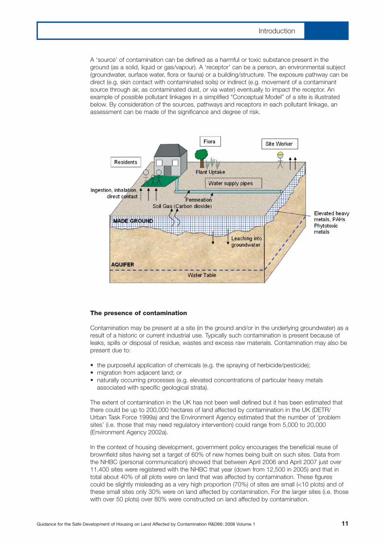
A ‘source’ of contamination can be defined as a harmful or toxic substance present in theground (as a solid, liquid or gas/vapour). A ‘receptor’ can be a person, an environmental subject(groundwater, surface water, flora or fauna) or a building/structure. The exposure pathway can bedirect (e.g. skin contact with contaminated soils) or indirect (e.g. movement of a contaminantsource through air, as contaminated dust, or via water) eventually to impact the receptor. Anexample of possible pollutant linkages in a simplified “Conceptual Model” of a site is illustratedbelow. By consideration of the sources, pathways and receptors in each pollutant linkage, anassessment can be made of the significance and degree of risk.
The presence of contamination
Contamination may be present at a site (in the ground and/or in the underlying groundwater) as aresult of a historic or current industrial use. Typically such contamination is present because ofleaks, spills or disposal of residue, wastes and excess raw materials. Contamination may also bepresent due to:
• the purposeful application of chemicals (e.g. the spraying of herbicide/pesticide);• migration from adjacent land; or• naturally occurring processes (e.g. elevated concentrations of particular heavy metals
associated with specific geological strata).
The extent of contamination in the UK has not been well defined but it has been estimated thatthere could be up to 200,000 hectares of land affected by contamination in the UK (DETR/Urban Task Force 1999a) and the Environment Agency estimated that the number of ‘problemsites’ (i.e. those that may need regulatory intervention) could range from 5,000 to 20,000(Environment Agency 2002a).
In the context of housing development, government policy encourages the beneficial reuse ofbrownfield sites having set a target of 60% of new homes being built on such sites. Data fromthe NHBC (personal communication) showed that between April 2006 and April 2007 just over11,400 sites were registered with the NHBC that year (down from 12,500 in 2005) and that intotal about 40% of all plots were on land that was affected by contamination. These figurescould be slightly misleading as a very high proportion (70%) of sites are small (<10 plots) and ofthese small sites only 30% were on land affected by contamination. For the larger sites (i.e. thosewith over 50 plots) over 80% were constructed on land affected by contamination.
Guidance for the Safe Development of Housing on Land Affected by Contamination R&D66: 2008 Volume 1 11
Introduction

Housing policy
The Government has acknowledged that there are substantial challenges to be faced in the UKwith regard to home provision, namely:
• there is a significant gap between the supply of and demand for new homes;• from 1970 to 2000 the level of new house building fell by 50% (to rates of around 175,000 per
annum in 2000) whilst the number of households increased by 30%;• the latest forecasts indicate that the number of households in England will grow by some
223,000 per annum of which 70% are single person households; and• the Government has set ambitious targets to reduce the number of people in temporary
accommodation, Bed & Breakfast accommodation, and sleeping rough.
In order to understand the issues better, the Government commissioned a review of housingsupply (Barker 2003a and 2004a). This review of housing supply clearly identified that the housingmarket had not responded sufficiently to meet the demand for new homes. At the time of thereport, Government plans for new homes totalled 150,000 per annum. The Government responseto the Barker report (ODPM 2005a) signalled a commitment to build more homes for futuregenerations, in particular to increase the rate of new housing build to 200,000 per annum. Morerecent policy statements have indicated the target will be raised with 2 million new homes to bebuilt by 2016 and 3 million by 2020 (Y Cooper – Ministerial Statement, Hansard 23 July 2007).
In addition to this statistical information, the Barker report also identified some important socialaspects related to this lack of provision. In some key phrases, the report noted:
“Housing is a basic human need which is fundamental to our economic and social well being.” and “For many, housing is becoming less affordable.”
The report recognised this fundamental aspect of housing by noting that “homes are more thanshelter” for people, because having a home will place people as a part of a community. It will provideaccess to the wide variety of services that are the basis of our social fabric (healthcare, schools, socialservices etc.). Homes are also the most significant element of a person’s/family’s financial stability.
One of the conclusions of the review (Barker 2003a) with respect to the rates of housebuildingwas “continuation at current rates is not realistic unless homelessness and social division areaccepted”. Barker made a number of recommendations with respect to housing policy, includingthat more land should be allocated for development. It was recognised that such a policy wouldhave environmental impacts. However, it was also recognised that these impacts could bereduced by ensuring that land is used efficiently, that “the most valuable undeveloped land ispreserved” and that “land which society values least is used”. The Government’s response tothese reports has recognised and accepted the basis of these recommendations. Recent policystatements have again signalled the importance the Government places upon the issue ofhousing: “putting affordable housing within the reach not just of the few but of the many is vitalboth to meeting individual aspirations and a better future for our country” (G. Brown July 2007).
The Government’s special advisor on brownfield land, English Partnerships, recognises thatmuch remains to be done in the sustainable reuse of brownfield sites, but was encouraged thatin 2005, 74% of new housing was built on such land. In its guide to practitioners (EnglishPartnerships 2006a) the importance of the complex inter-relationships necessary to realise thesepolicy aspirations is stressed. “Unlocking brownfield land successfully is about vision, leadership,professional skills and using the latest technologies. Creating sustainable environments should beat the forefront in brownfield projects, with land being reused to provide housing, employmentand recreation - - -”. “ - - - Land reuse though is not an end in itself; it is also about local peoplebeing engaged in the development process and helping to shape the future use of the areas inwhich they live, work and spend their leisure time.”
In its response to English Partnerships work in developing a National Brownfield Strategy, theGovernment acknowledged that the re-use of brownfield land lies at the heart of a wide range ofits policies for the revival of our towns and cities and achieving more sustainable patterns ofdevelopment (CLG 2008a).
12 Guidance for the Safe Development of Housing on Land Affected by Contamination R&D66: 2008 Volume 1
Introduction

The implications for land affected by contamination are clear. The beneficial reuse of brownfieldsites for housing can meet these policy aspirations. However, what is also paramount is that anysuch development must be carried out in a way which is safe for the residents of such sites, safefor their neighbours and without risks being realised to the environment.
Policy, regulation and guidance
European Directives
Soil Framework Directive [Proposed]The proposal to establish a framework for the protection of soil was first published in September2006 (EU 2006a). The document recognises that many countries already have in place someprovision for soil protection. However because there is no EU legislation on soil protection, theproposal aims to establish a common strategy for the protection and sustainable use of soil. Theproposed strategy is to; integrate issues regarding soil into other policies; preserve soil function;prevent threats to soil and to mitigate impacts. The draft Directive was not approved by EUmember States in 2007 and at the time of writing this report, the European Commission wasconsidering the future of the Soil Framework Directive.
Water Framework Directive [Directive 92/43/EEC]The Water Framework Directive (EU 2000a) established a framework for the protection of inlandsurface waters, coastal waters and groundwater that, amongst other matters; prevents furtherdeterioration, protects and enhances the status of aquatic ecosystems and ensures theprogressive reduction of and prevention of future groundwater pollution. The Directive wastransposed into UK law in 2003 and is being implemented to an agreed timetable.
Waste Framework Directive [Directive 2006/12/EEC]The Waste Framework Directive (EU 2006b) provides a definition of waste that informs theEnvironment Agency’s regulatory position (Ref Environment Agency 2006d). [See also Annex 7 ofthis report]. The Directive also lists different types of waste in the European Waste Catalogue(EWC). The excavation, treatment and re-use of contaminated soils (and groundwaters) onbrownfield sites may involve materials which fall within this definition of ‘waste’ and therefore fallinto the waste regulatory regime and require description under the EWC.
Landfill Directive [1999/31/EEC – supplemented by Council Decision 2003/33/EC]The objective of the Landfill Directive (EU 1999a) was to prevent or reduce as much as possiblethe environmental impacts of landfills and landfilling operations. Wastes consigned to landfill mustnow comply with the criteria and procedures defined by the EU. Implementation of this Directivehas had a significant impact upon the development of land affected by contamination, as costsfor disposal to landfill have increased substantially and the number of landfills capable ofaccepting these wastes has reduced.
National policy
The Government’s ‘suitable for use’ policy with respect to land affected by historic contamination:
• ensures land is suitable for its current use;• ensures land is made suitable for planned future use(s); and• limits the scope of remediation to that necessary to mitigate unacceptable risks.
The adoption of this policy will also ensure appropriate reconciliation of the variousenvironmental, social and economic needs with respect to land affected by contamination.
English Partnerships guidance is aimed at assisting the decision making process at each phaseof brownfield redevelopment (English Partnerships 2006a). It acknowledges that theredevelopment of brownfield land tends to be more complex and may expose developers tomore risk than on greenfield sites.
Guidance for the Safe Development of Housing on Land Affected by Contamination R&D66: 2008 Volume 1 13
Introduction

Strategic planning
Spatial StrategiesSpatial Strategies [Regional Spatial Strategies in England (various authors and dates), the WalesSpatial Plan (Welsh Assembly Government 2004a), National Planning Framework for Scotland(Scottish Executive 2004a); N. Ireland – Shaping our future 2025 (Department for RegionalDevelopment Northern Ireland 2001a)] aim to make the planning system play a more strategicand proactive role in sustainable development. Land affected by contamination is a materialplanning consideration in these strategies and soils are identified as one of the environmentalconsiderations for sustainable development to be considered in such strategies. TheEnvironment Agency is recommending that all such plans and strategies draw appropriateattention to the potential for contamination and that all developments incorporate proper riskassessment, remediation and long-term management. In some key messages the EnvironmentAgency stresses the importance of the Water Framework Directive, a holistic (‘area based’)approach to remediation which encourages sustainable remediation, enables appropriatedevelopment and which is appropriately validated.
Brownfield Action PlansThe Sustainable Communities Plan (SCP), published by the ODPM in February 2003 (ODPM2005b), refers to the proposed National Brownfield Strategy (English Partnerships 2003a) withthe specific aim of bringing a significant proportion of previously used land back into beneficialuse. Accordingly, the Government called upon the RDAs to produce Brownfield Land ActionPlans. Such Plans will be produced in co-operation with local authorities and other relevantagencies and statutory bodies and will fit closely with the Regional Economic Strategies andRegional Housing Strategies.
Legislation, regulation and guidance
There are two primary legislative/regulatory drivers which require the assessment of land affectedby contamination prior to the re-development of a site:
1. The Town and Country Planning Act (1990) (OPSI 1990a) and related Planning Guidance;2. Building Regulations (2000) (OPSI 2000a).
The particular Regulations and Guidance associated with these primary instruments vary betweenEngland, Wales, Scotland and Northern Ireland (see Appendix 3). Other regulatory regimesrelevant to the development of land affected by contamination (e.g. regarding environmentalassessment, controlled waters and waste) are also briefly described below. In addition to theseRegulations and Guidance which apply solely with respect to development, Part 2A [Part 3 inNorthern Ireland] of The Environmental Protection Act 1990 (as inserted by Section 57 of theEnvironment Act 1995) and associated Statutory Guidance (Defra 2006a) which apply principallywith respect to historic contamination, are also significant in the development context.
The planning regimeIn circumstances where sites are subject to redevelopment, the developer assumes responsibilityfor the costs of any remediation necessary to ensure safe development. Proposals fordevelopment are subject to scrutiny via the planning system. Developers must demonstrate tothe satisfaction of the local authority that they have addressed all matters of material planningconsideration (including contamination). In circumstances where land affected by contaminationis to be redeveloped, advice provided under the planning regime is relevant [PPS 23 in England(ODPM 2004a) and PAN33 in Scotland (Scottish Executive 2000a) – see Appendix 3]. Thesedocuments provide advice on the implications of contamination for the planning system andadvise local authorities about the determination of planning applications when the site is, or maybe, contaminated. These guidance documents include clear statements that consideration of landquality and potential impacts arising from development are a “material planning consideration”. A key provision of planning guidance is to ensure that the land is made suitable for its proposednew use. For example, PPS 23 states that local planning authorities must be satisfied that “thepotential for contamination and any risks arising are properly assessed” [i.e. that the conceptualsite model is sufficiently well designed] “and that the development incorporates any necessaryremediation and subsequent management measures to deal with unacceptable risks”.
14 Guidance for the Safe Development of Housing on Land Affected by Contamination R&D66: 2008 Volume 1
Introduction

On sites where the land is known or suspected to be affected by contamination, developers mustprovide sufficient information with the planning application to demonstrate the existence (orotherwise) of contamination, its nature, extent, and the risks it may pose as well as evidence thatsuch risks can be mitigated to an acceptably low level. It is recognised that following the phasedapproach (described in both Model Procedures and R&D66: 2008) does not necessarily mean thata detailed site investigation is required with every planning application. However, applicants areadvised that as a minimum a desk study (including a walkover survey) should be carried out. ThisDesk Study will be sufficient only if it is capable of developing a conceptual site model identifyingthe sources of contamination and the pathways linking them to receptors. In addition, the DeskStudy report must identify the means by which the pollutant linkages can be broken.
The expectation should be that on land affected by contamination, developers will have to carryout a phased programme of assessment which will include intrusive investigations. In order toensure mutual understanding regarding the likelihood and possible extent of contamination and any implications for the proposed development, developers should, wherever practical, carry outpre-application discussions with all interested parties of the local authority (in particular, planning,environmental health, contaminated land officers and Building Control).
If the desk study confirms the potential presence of contamination, then further studies andinvestigations by the developer must be carried out to assess risks and identify the need for andscope of any remediation. Any remediation must remove unacceptable risk and make the site suitablefor its new use. As a minimum, any such remediated and redeveloped sites should not be capable ofbeing determined as contaminated land under Part 2A of the Environmental Protection Act 1990.PPS 23 also encourages developers and local authority regulators to utilise the opportunitiespresented by the development of land affected by contamination to enhance the environment.
Building RegulationsThe Building Regulations (OPSI 2000a) aim to make sure that people living in and around buildingscan do so without adverse effects upon their health and safety. The Regulations also set minimumrequirements for the functioning of the building (e.g. environmental performance, accessibility etc.).The Guidance for meeting the requirements of the Regulations is set out in a series of relatedpublications. Approved Document C (ODPM 2004b) deals with land affected by contamination andit requires that:
• reasonable provisions are made to secure the health and safety of persons in and about thebuilding;
• people and the buildings themselves are safeguarded against contaminants on or in the sitewhich will be occupied by the building and land associated with it; and
• people and the buildings themselves are safeguarded against contaminants on or in groundwaterbeneath the site which will be occupied by the building and land associated with it.
The Building Regulations require builders/developers to obtain building control approval of newdevelopments. This is achieved by means of an independent check carried out by a buildingcontrol provider (see below) whose responsibility it is to determine that the Regulations have beencomplied with.
The Environmental Protection Act and Statutory GuidancePart 2A of the Environmental Protection Act 1990 and the Statutory Guidance (Defra 2006a, WAG2006a and Scottish Executive 2006a) describe the contaminated land regime and is primarilyaimed at dealing with the legacy of contamination. The main objective of this regime is theprovision of a system to identify and remediate sites where, for the current use, contamination isgiving rise to unacceptable risks to people or the environment. The government also anticipatedthat this regime would encourage voluntary remediation by land owners/occupiers. Under thisregime, responsibility for dealing with the costs of remediation accord with the polluter paysprinciple. If the ‘polluter’ cannot be found, this liability passes to the current landowner (or otherparties identified via a series of tests set out in the Statutory Guidance).
Guidance for the Safe Development of Housing on Land Affected by Contamination R&D66: 2008 Volume 1 15
Introduction
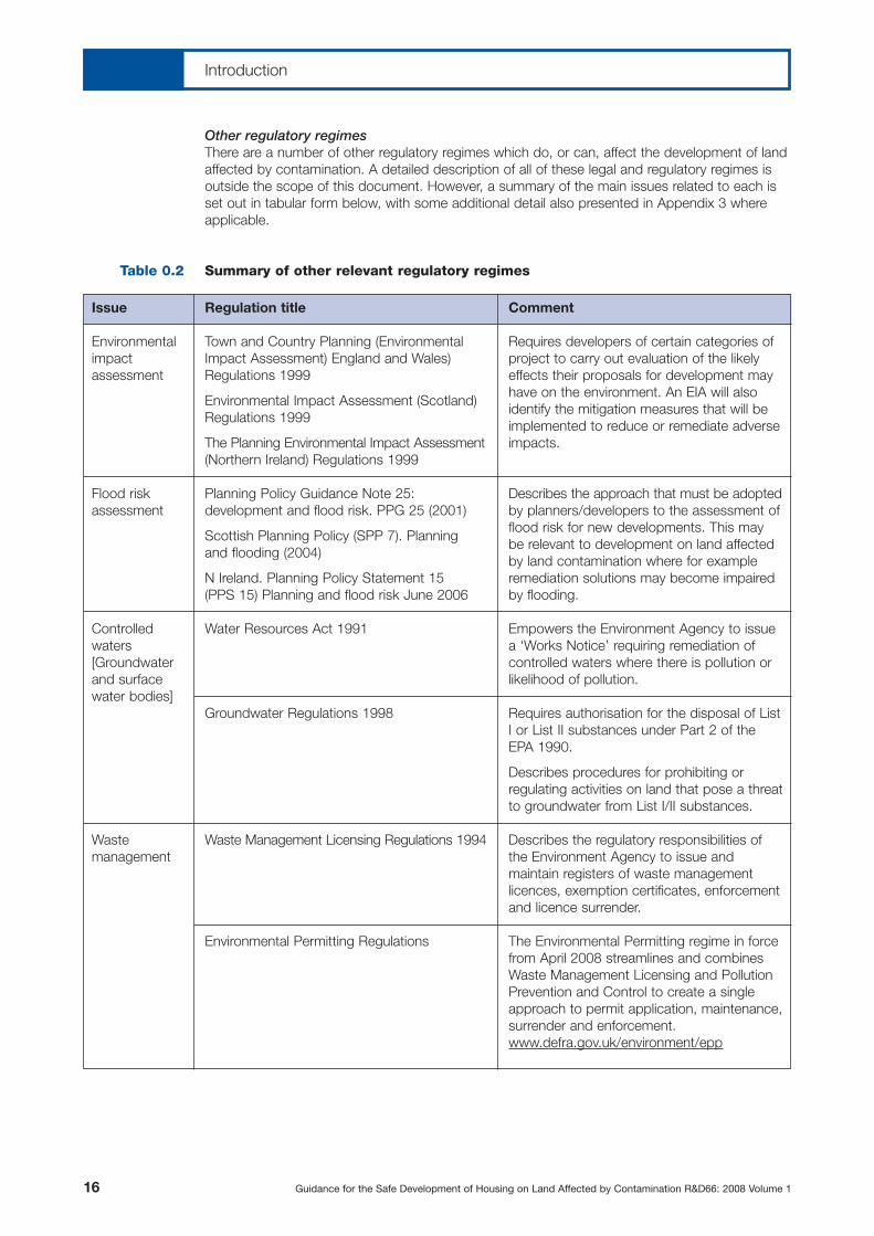
Other regulatory regimesThere are a number of other regulatory regimes which do, or can, affect the development of landaffected by contamination. A detailed description of all of these legal and regulatory regimes isoutside the scope of this document. However, a summary of the main issues related to each isset out in tabular form below, with some additional detail also presented in Appendix 3 whereapplicable.
Summary of other relevant regulatory regimes
16 Guidance for the Safe Development of Housing on Land Affected by Contamination R&D66: 2008 Volume 1
Table 0.2
Issue
Environmentalimpactassessment
Flood riskassessment
Controlledwaters[Groundwaterand surfacewater bodies]
Wastemanagement
Regulation title
Town and Country Planning (EnvironmentalImpact Assessment) England and Wales)Regulations 1999
Environmental Impact Assessment (Scotland)Regulations 1999
The Planning Environmental Impact Assessment(Northern Ireland) Regulations 1999
Planning Policy Guidance Note 25:development and flood risk. PPG 25 (2001)
Scottish Planning Policy (SPP 7). Planning and flooding (2004)
N Ireland. Planning Policy Statement 15 (PPS 15) Planning and flood risk June 2006
Water Resources Act 1991
Groundwater Regulations 1998
Waste Management Licensing Regulations 1994
Environmental Permitting Regulations
Comment
Requires developers of certain categories ofproject to carry out evaluation of the likelyeffects their proposals for development mayhave on the environment. An EIA will alsoidentify the mitigation measures that will beimplemented to reduce or remediate adverseimpacts.
Describes the approach that must be adoptedby planners/developers to the assessment offlood risk for new developments. This maybe relevant to development on land affectedby land contamination where for exampleremediation solutions may become impairedby flooding.
Empowers the Environment Agency to issuea ‘Works Notice’ requiring remediation ofcontrolled waters where there is pollution orlikelihood of pollution.
Requires authorisation for the disposal of ListI or List II substances under Part 2 of theEPA 1990.
Describes procedures for prohibiting orregulating activities on land that pose a threatto groundwater from List I/II substances.
Describes the regulatory responsibilities ofthe Environment Agency to issue andmaintain registers of waste managementlicences, exemption certificates, enforcementand licence surrender.
The Environmental Permitting regime in forcefrom April 2008 streamlines and combinesWaste Management Licensing and PollutionPrevention and Control to create a singleapproach to permit application, maintenance,surrender and enforcement.www.defra.gov.uk/environment/epp
Introduction

Financial RegulationsA number of financial incentives have been introduced by the Government in order to incentivisethe development of land affected by contamination and other brownfield sites. ContaminatedLand Tax Credit Land Remediation Relief (Schedule 22 Finance Act 2001 (OPSI 2001a)) wasintroduced to provide 150 per cent accelerated tax credit to cover the costs of cleaning up landaffected by contamination. This relief is subject to conditions which essentially relate to costsbeing incurred because of the presence of contamination which would not have been incurredfor a comparable greenfield site. This was extended to cover Japanese Knotweed in 2008.
Wastes disposed of at landfill sites are subject to landfill tax. In 2007/8, the rate of landfill tax was£24/tonne and is to increase at £3 per annum until 2010. Contaminated spoil arising from thereclamation of land affected by contamination may be exempt from landfill tax subject to certainconditions, provided the reclamation; involves the reduction or removal of harmful contaminantsfrom the site and facilitates development (or the provision of amenity/agricultural uses). Thisexemption will be phased out from 2012.
Early consultation with HM Revenue and Customs about either form of tax relief is recommendedto ensure eligibility and to allow for processing of applications www.hmrc.gov.uk. The Treasury haverecently proposed changes to these Financial Regulations www.hm-treasury.gov.uk. It appears likelythat the tax credit scheme will be replaced by ‘Derelict Land Relief’, the details of which are yet tobe finalised, but may be broadly similar to the original scheme. However, it also appears likely thatthe exemption from landfill tax for development schemes on land affected by contamination is likelyto be withdrawn, although details for transitional measures (if any) have not been determined.
Guidance for the Safe Development of Housing on Land Affected by Contamination R&D66: 2008 Volume 1 17
Introduction
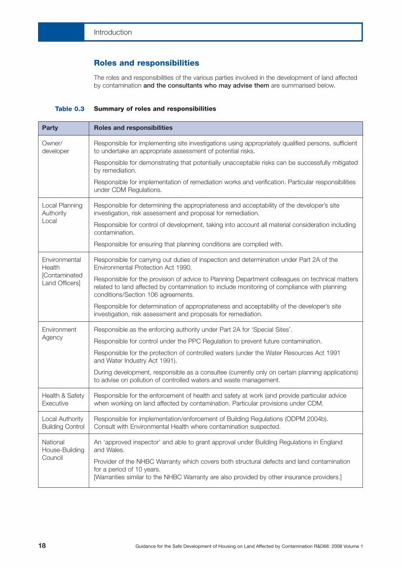
Roles and responsibilities
The roles and responsibilities of the various parties involved in the development of land affectedby contamination and the consultants who may advise them are summarised below.
Summary of roles and responsibilities
18 Guidance for the Safe Development of Housing on Land Affected by Contamination R&D66: 2008 Volume 1
Table 0.3
Party
Owner/developer
Local PlanningAuthorityLocal
EnvironmentalHealth[ContaminatedLand Officers]
EnvironmentAgency
Health & SafetyExecutive
Local AuthorityBuilding Control
NationalHouse-BuildingCouncil
Roles and responsibilities
Responsible for implementing site investigations using appropriately qualified persons, sufficientto undertake an appropriate assessment of potential risks.
Responsible for demonstrating that potentially unacceptable risks can be successfully mitigatedby remediation.
Responsible for implementation of remediation works and verification. Particular responsibilitiesunder CDM Regulations.
Responsible for determining the appropriateness and acceptability of the developer’s siteinvestigation, risk assessment and proposal for remediation.
Responsible for control of development, taking into account all material consideration includingcontamination.
Responsible for ensuring that planning conditions are complied with.
Responsible for carrying out duties of inspection and determination under Part 2A of theEnvironmental Protection Act 1990.
Responsible for the provision of advice to Planning Department colleagues on technical mattersrelated to land affected by contamination to include monitoring of compliance with planningconditions/Section 106 agreements.
Responsible for determination of appropriateness and acceptability of the developer’s siteinvestigation, risk assessment and proposals for remediation.
Responsible as the enforcing authority under Part 2A for ‘Special Sites’.
Responsible for control under the PPC Regulation to prevent future contamination.
Responsible for the protection of controlled waters (under the Water Resources Act 1991 and Water Industry Act 1991).
During development, responsible as a consultee (currently only on certain planning applications)to advise on pollution of controlled waters and waste management.
Responsible for the enforcement of health and safety at work (and provide particular advice when working on land affected by contamination. Particular provisions under CDM.
Responsible for implementation/enforcement of Building Regulations (ODPM 2004b). Consult with Environmental Health where contamination suspected.
An ‘approved inspector’ and able to grant approval under Building Regulations in England and Wales.
Provider of the NHBC Warranty which covers both structural defects and land contaminationfor a period of 10 years.[Warranties similar to the NHBC Warranty are also provided by other insurance providers.]
Introduction

The technical framework
In the UK, the ‘suitable for use’ approach ensures that the management of land affected bycontamination is risk based. This risk based approach applies to consideration of such landunder both Part 2A of the Environmental Protection Act 1990 and under planning, and isdescribed in the Model Procedures (Defra/Environment Agency 2004a). This document providesa technical framework on which decisions about land affected by contamination are based. Thisframework assists all stakeholders involved in making management decisions about such land:landowners, developers, regulators and their professional advisors. [The framework in ModelProcedures has also informed the structure and content of this document, R&D66: 2008]. It is recommended that all elements of the investigations, assessment and remediation of landaffected by contamination are properly referenced to and compliant with, relevant guidance (such as Model Procedures), British Standards (such as BS10175 (BSI 2001a) and BS5930 (BSI 1999a)) and other industry good practice documents referred to throughout this document.
To support this risk based approach, Government Departments, the Environment Agency andothers (e.g. CIRIA, CL:AIRE, CIEH, BRE and AGS) have produced a considerable body oftechnical guidance, information and advice. This documentation is referred to throughout thetechnical advice in this report (Chapters 1 to 3) and is also listed in the references andbibliography at the end of this Volume 1.
One element of this body of guidance is concerned with ‘guideline values’. These values areconcentrations of particular chemical determinands in soils which can be used as genericassessment criteria in the assessment of risk to people. A series of reports presenting these SoilGuideline Values (SGVs) were published by the Environment Agency in 2002/2003 (seeBibliography). Concerns were expressed by a number of bodies about the use/practicality ofsome of these SGVs in response to which the Government set up an SGV Task Force. As aresult of the work of this Task Force, proposals for a way forward were published for publicconsultation (Defra 2006b). At the time of preparing this report, the results of Defra’sconsideration of the consultation responses has not been published. However, the technicalguidance presented in Chapters 1 to 3 has been drafted so as not be reliant on any particularthreshold values.
In its response to English Partnerships National Brownfield Strategy, the Government signalled itsintention to set up a National Brownfield Forum (CLG 2008a). The stated aim of this Forum is to“bring together Whitehall Departments, the Environment Agency, the Health Protection Agencyand industry stakeholders with the aim of promoting a more cohesive and inclusive approach topolicy development and to encourage the exchange of best practice and knowledge”.
Guidance for the Safe Development of Housing on Land Affected by Contamination R&D66: 2008 Volume 1 19
Introduction

20 Guidance for the Safe Development of Housing on Land Affected by Contamination R&D66: 2008 Volume 1
1.1Define objectives
1.2Site definition and description
1.3Determine site history
1.5Determine environmental setting
1.7Carry out Preliminary Risk Assessment
1.4Determine current land use (storage/use/disposal potentially hazardous materials)
1.6Describe initial conceptual site model,
(identify all potentially significant pollutant linkages)
Progress to Phase 2 Compile
Final Report
NO
NO
NO
NO
YES
YES
YES
YES
Is site use/planned use appropriately defined?
Have any potentially significant risks been identified?
Data sufficient?
Phase 1: Hazard identification and assessmentChart 1
Carry outnecessary
further deskresearch
No further action
Is site area/boundary appropriately defined?
1.1: Reference numbers in boxes refer to the relevant sections in the report.
Landowner data. British Geological SurveyMap information. Previous investigations.
Environment Agency website.
Landowner data. Regulatory information. Site walkover survey.
Landowner data. Regulatory information.Ordnance Survey Maps.
Site walkover survey.
Will available data allow plausibility of pollutant linkages to be assessed?

Objectives
General
The overall aim of the Phase 1 work (often referred to as a “Desk Study”) is to identify and assessthe potential hazards that could be present on a particular site. It is important to remember thatthere will always be some site specific factors which, in combination are particular to that site.Every site must therefore be considered unique and thus considered on its own merits. Theprocess of hazard identification and assessment begins with the description of the context of thesite and the definition of the risk assessment objectives. It progresses by means of a series oftasks to conclude with a Preliminary Risk Assessment as illustrated in Chart 1 [and by the CaseStudy, Chart 1A in Volume 2].
The process of hazard identification and assessment thus comprises:
• Definition of objectives [Section 1.1.2];• Description of the site, in terms of location, extent, boundaries and current appearance
[Section 1.2];• Determination of the history of the site land use [Section 1.3];• Identification of the current land use, including use/storage of hazardous materials etc.
[Section 1.4];• Description of environmental setting and establishment of site sensitivity [Section 1.5];• Description of the initial conceptual site model [Section 1.6].
The results of these tasks will allow a Preliminary Risk Assessment to be undertaken [see Section1.7] which in turn will inform the identification of potentially significant pollutant linkages anddetermine the need for and scope of any further investigations (desk based or intrusive) in Phase 2.
Definition of objectives
Both the objectives and the scope of the assessment will vary according to who commissionsthe work, their reasons for such a commission as well as site specific factors, such as anyregulatory involvement/action; the particular development proposals; funding; timescale etc.
The setting of appropriate, well defined and relevant objectives is crucial to all stages of theredevelopment of land affected by contamination. Lack of precision and/or clarity in settingobjectives will inevitably increase uncertainties. This can lead to inappropriate conclusions beingdrawn and recommendations for further work which later turn out to be inadequate (i.e. thescope of work was underestimated) or unnecessary (i.e. an appropriately scoped Phase 1 wouldhave negated the need for, or reduced the scope of, such further work). Objectives for Phase 1,the hazard identification stage therefore should include the following:
• to construct an initial conceptual site model;• to enable a preliminary risk assessment;• to inform the need for and scope of further work (desk based or intrusive investigations);• to assess the potential for formal determination as Contaminated Land.
Guidance for the Safe Development of Housing on Land Affected by Contamination R&D66: 2008 Volume 1 21
1.1
1.1.1
1.1.2
Phase 1Hazard identification and assessment
Remember:The sequence/timing of these tasks can be critical. For example, the site locationand extent must be clearly established and defined before any of the subsequenttasks can be carried out.

Hazard identification and assessmentPhase 1
Site definition and description
Typically the information defining “the site” and providing an initial description will be provided bythe land owner (or agent). This initial information will be supplemented by data gathered fromother tasks as the desk study progresses. At the outset of any desk study it is crucial tounderstand the exact area occupied by the study site. Ideally a plan will be provided clearlyshowing the site’s boundaries however this is not always the case. Should only an address orgrid reference be provided for a site confirmation of the site’s boundaries must be sought byrequesting the client/site owner/agent etc. either to provide a plan showing the boundaries orannotate a plan provided by the report producer. Site ownership boundaries particularly onindustrial sites can often not reflect boundaries as shown on contemporary maps and can formunusual shapes which are not intuitive. It is therefore inadvisable for the site boundary to bedefined by anyone but the client or site owner. Incorrectly identified site areas can lead tosignificant errors in the assessment of risks and can result in abortive work (both costly andembarrassing to all parties!).
Typically a small scale plan showing the site boundaries will be accompanied by a large scalemap showing the site location in a regional context. Ideally a national grid reference will also beprovided. If the grid reference is not provided by the commissioning party, this must be identified,agreed and included in the desk study report.
Having defined the site area, an accurate description of what currently occupies the area (i.e.buildings, hard standing, tanks) is required. This description should be kept concise but thelocation of sources of potential contamination such as tanks should be clearly defined. Wheremultiple similar features are present a suitable labelling system should be adopted and adheredto throughout the report (including figures). Descriptions of the condition of potentialcontaminating features such as tanks should also be made. The site description should includethe following information:
History
Sources of historic information
Understanding the history of a site or parcel of land is crucial to understanding the potential forcontaminants to be present on a site. It can also provide a useful indicator as to the likelylocation of those contaminants. The identification of the historic land uses of a site is usuallydetermined utilising a number of sources of information. The most common sources aretabulated below (in alphabetical order) and described in more detail in the following text. A listingof useful sources is also given in CLR3 (Department of the Environment 1994a).
Although now rather dated (and thus not referring to some of the more recent data sources nowavailable) the listing in CLR3 is an important reference to several sources of information notcaptured by the current commercial providers (see below).
22 Guidance for the Safe Development of Housing on Land Affected by Contamination R&D66: 2008 Volume 1
1.2
1.3
1.3.1
Remember:A site name (or even post code) is not a unique identifier. Your desk study may be on a site of the correct name, but it may relate to the wrong part of the country.A six figure National Grid Reference (NGR) uniquely identifies the a site and must beused to locate the land in question and must be stated in the report.
• the lie of the land (topography)
• access to the site (i.e. names of roads,entrances etc.)
• the presence of any surface water features
• the proportion and make up of hardstanding areas compared to areas of softlandscaping
• the layout of the site
• current site activities
• the nature of surrounding land uses
• information on any areas of identifiedcontamination including those onsurrounding sites should be listed.
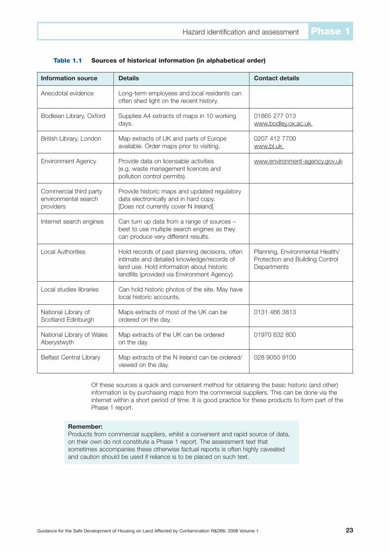
Sources of historical information (in alphabetical order)
Of these sources a quick and convenient method for obtaining the basic historic (and other)information is by purchasing maps from the commercial suppliers. This can be done via theinternet within a short period of time. It is good practice for these products to form part of thePhase 1 report.
Hazard identification and assessment Phase 1
Guidance for the Safe Development of Housing on Land Affected by Contamination R&D66: 2008 Volume 1 23
Table 1.1
Remember:Products from commercial suppliers, whilst a convenient and rapid source of data,on their own do not constitute a Phase 1 report. The assessment text thatsometimes accompanies these otherwise factual reports is often highly caveatedand caution should be used if reliance is to be placed on such text.
Information source
Anecdotal evidence
Bodleian Library, Oxford
British Library, London
Environment Agency
Commercial third partyenvironmental searchproviders
Internet search engines
Local Authorities
Local studies libraries
National Library ofScotland Edinburgh
National Library of WalesAberystwyth
Belfast Central Library
Details
Long-term employees and local residents canoften shed light on the recent history.
Supplies A4 extracts of maps in 10 workingdays.
Map extracts of UK and parts of Europeavailable. Order maps prior to visiting.
Provide data on licensable activities (e.g. waste management licences andpollution control permits).
Provide historic maps and updated regulatorydata electronically and in hard copy.[Does not currently cover N Ireland]
Can turn up data from a range of sources –best to use multiple search engines as theycan produce very different results.
Hold records of past planning decisions, oftenintimate and detailed knowledge/records ofland use. Hold information about historiclandfills (provided via Environment Agency).
Can hold historic photos of the site. May havelocal historic accounts.
Maps extracts of most of the UK can beordered on the day.
Map extracts of the UK can be ordered on the day.
Map extracts of the N Ireland can be ordered/viewed on the day.
Contact details
01865 277 013www.bodley.ox.ac.uk
0207 412 7700www.bl.uk
www.environment-agency.gov.uk
Planning, Environmental Health/Protection and Building ControlDepartments
0131 466 3813
01970 632 800
028 9050 9100

Historic maps
BackgroundThe first comprehensive UK wide map series was produced by Ordnance Survey from the mid1800s. The first maps were surveyed by County at a scale of 1:2,500 (1:25 inch) and are calledthe County Series. Later versions of the County Series were also available at a scale of 1:6 inch(1:10,560), which were superseded by 1:10,000 scale maps post decimalisation. Larger scale 1:25,000 maps are also available from Ordnance Survey from the mid 1800s though due to theirscale they are of limited use. If required, earlier maps can be available for some areas thoughgenerally these are not commercially available but can be sourced via the libraries listed.
Mapped evidence of site historyHistoric plans can provide the following information:
• the history of industrial and other uses of a site and the surrounding area;• the type of industrial activity undertaken i.e. early Ordnance Survey maps often identify
industrial uses such as acid works, gas works, or lead works whereas later (or large scale)maps often only label these features as ‘Works’ or ‘Factory’ etc.;
• the layout of the site, including locations of buildings and tanks etc. at the date of the map; and• evidence of excavations and infilling (e.g. mounds of material and earthworks).
When reviewing historic maps, as well as the obvious labelling identifying historic use of the buildingson the site, there is often other relevant information to be gained from their study. For example:
• distinctive names such as Gasworks Road, Clay Pit Lane etc. shown on maps indicate theformer presence/proximity of such potential sources of contamination;
• the disappearance of cut features such as pits and quarries or water features such as canalbasins or ponds can indicate land filling;
• re-routed water courses will indicate linear areas of infilling;• care must be taken when interpreting slope marking symbols (which sometimes are not well
defined) as it is very important to interpret spoil heaps or excavation features correctly.
The identification of site history from historic maps must be undertaken diligently. It is wrong toassume that this is a simple task that can be undertaken by untrained staff. The interpretation ofmapped information requires care, precision and understanding. Important information regardingthe meanings of abbreviations and symbols used on Ordnance Survey maps is given in CLR3(Department of the Environment 1994a) to which appropriate reference must be made.
Description of site history For the purposes of clarity and accuracy the reporting of historic reviews should be divided intotwo sections; on-site history and off-site history. All comments should be in chronological orderstarting with the oldest information. It is important that factual mapped information is accuratelyreported. For example, where the use of buildings have not been specifically identified the featurecould be described as “a large (20,000m2 approx) unlabelled building likely to have been ofcommercial/industrial use”.
Evidence of activities within the site boundary should be recorded and dates when featuresappear/disappear should be stated. Activities and features of note include all potentiallycontaminative land uses as well as pits, ponds, quarries, railway cuttings etc. which may have beenfilled. When describing features within the site boundary the text must avoid ambiguity. This canbe achieved by using the term ‘in’ (i.e. “tanks were present in the north of the site”) rather than ‘to’which could suggest features off-site (i.e. “tanks were present to the north of the site”). It is alsoimportant that the reported age of activities/features is accurately given. For example if a petrolstation is shown on the 1965 map, but is not recorded on the 1935 map the most appropriatedescription is “A petrol station was constructed on the site at sometime between 1935 and 1965”.It is misleading to imply that the petrol station dated from 1965 (i.e. “a petrol station was presenton-site from 1965”) as this could affect the period, extent and nature of the contamination.
Typically off-site historical descriptions should be concentrated on an area up to 250m around thesite boundary. Features at greater distances should only be described if they are particularly large or
24 Guidance for the Safe Development of Housing on Land Affected by Contamination R&D66: 2008 Volume 1
1.3.2
Hazard identification and assessmentPhase 1
have the potential to affect the land quality at the site (e.g. landfills) or the wider environmentalquality of the site (e.g. power stations, large facilities such as oil refineries etc.). The distance anddirection from the site boundary should be given as part of any off-site feature described. Particularcare should be taken when defining the distance of a landfill from the site as it is most importantto measure from the nearest landfill boundary rather than the central location of the landfill.
In report text describing both on and off-site histories there can be a tendency for features whichhave no potential to cause contamination (i.e. roads, housing etc.) to be overly detailed. This canmake the history excessively long and can detract from the features which are of potentialconcern. In such cases general comments such as “the area becomes developed with housingby 1980” can be made which adequately demonstrate an awareness of this history withoutdetracting from an appropriate focus on land quality.
It is good practice to include a copy of all available maps in reports. An example of a site historyis presented in CLR3 (Department of the Environment 1994a).
CaveatsIt is important to remember that historic maps (and plans) do not provide a comprehensive descriptionof a site’s history. They provide details of the site from a date prior to the publication of the map (i.e. asnapshot in time). The period between map editions can be substantial (i.e. several decades). Not allmap series are available for every date range in many areas of the UK and therefore there will be gapsin this mapped record for some sites. Potentially contaminative land uses could have come and gonein such periods and may therefore not be a part of this particular record. In addition, there will bepotentially contaminative land uses which do not make it on to the map record, for example, smallscale storage/use of hazardous materials, illegal/unlicensed waste disposal activities etc.
Different map series do map different features utilising differing symbols which can result infeatures disappearing from maps which may have remained on-site. Some features are also notmapped for security reasons such as airfields and other military installations. These areas aremostly shown as blank white areas on the map. This absence of any mapped information can beconspicuous and in such cases, there may often be clues in the map record. For example, thefirst record of an airfield or flying club on a map dating from the 1950s should be taken as anindication that this may have been a war-time airfield, occupied by the Ministry of Defence or theUSAF and thus subject to further enquiry.
Historic aerial photos
Historic aerial photographs are available for most UK cities and are available from a number ofspecialist commercial providers including the Ordnance Survey www.ordnancesurvey.co.uk. Thereare also a series of aerial photographs taken between 1939 and 1954 by the Luftwaffe, RAF andUSAAF which are available from various third party commercial companies and can prove invaluablein identifying features that are poorly mapped or are unclear such as spoil heaps and pits.
The internet
The internet can, on occasion, prove to be an invaluable source of a variety of information on thelocal area and/or the activities of a site. The use of search engines can enable rapid and easyaccess to relatively obscure data which otherwise would be very difficult and/or time consumingto source. However, in addition to authoritative/accredited information there is also the potentialfor erroneous or mischievous data to be retrieved from internet searches.
Examples of useful web sites include www.controltowers.co.uk which holds historic and currentdetails of war time airfields. This can prove particularly useful as these airfields are ‘blanked out’ onhistoric maps. A source of near current detail of a site can be obtained from digital satellite imageryof the earth’s surface via an internet search engine. Reference to this photography can be useful in
Guidance for the Safe Development of Housing on Land Affected by Contamination R&D66: 2008 Volume 1 25
1.3.3
1.3.4
Remember:The reliability of all information sources should always be carefully assessed and thesource of any such data properly referenced in the report.
Hazard identification and assessment Phase 1

site orientation prior to or during a site walkover survey and also for subsequent reference (althoughthe user should always determine the date of such imagery as it can be several years old).
Internet search engines should also be interrogated for accounts of local history. For examplesearching for a named factory/location will often reveal useful very detailed accounts of land useproviding site specific data on the nature and extent of potential contamination associated withactivities on the site.
Local Authorities
Local Authorities retain a great deal of publically available data that could prove useful forassessing the history of a site (usually at a relatively modest cost). It can however take some timefor this information to be sourced from the Authority. Information available on potential useincludes: details of planning consents, the planning register, information held by theenvironmental protection team and information of past landfilling activities.
Libraries
As well as the national libraries listed in Table 1.1 above, local studies libraries can provide aservice that allows a search of their records for relevant documentation. These can includebooks, local newspapers, local photographs and historic accounts not available from otherlocations. Some industrial/former military sites have histories written by former employees whichcan prove extremely useful however such documents are not commonly available. Additionally, inparticular regions or for certain topics, there may be specialist books or publications whichprovide invaluable data. For example in London, books such as The Lost Rivers of London(Barton 1992a) and The London County Council Bomb damage maps (Saunders & Woolven2005a) are essential references. Similarly, ‘The Mighty Eighth’ (www.mightyeighth.org) providesdetails on the activities of the US Army Air Force based in the UK during World War II. Booksand other publications which may be difficult to find are accessible via Inter Library loan.
Other sources
As described above (Section 1.3.1) other sources of information are listed in CLR3 (Departmentof the Environment 1994a). Detailed accounts of site histories may also be available from thecorporate entities who previously occupied the site and in many cases have carried out theiractivities for many decades. For example, detailed accounts of many of the former gasworks areavailable from British Gas properties, details of steelworks from Corus, information on coalmining activities from the Coal Authority. The Law Society and Coal Authority have published aDirectory (and guidance) of coal mining and brine subsidence claims (Law Society 2006a).
Anecdotal evidence of the past uses of a site can also be obtained (often by a walkover survey – seebelow) from people who either worked on a site and/or who lived in its vicinity. Although care shouldbe exercised in the use of such information (and its anecdotal nature must always be appropriatelyreported) such data can be invaluable and may not be available from any other source.
Current use
Details about the current site use can be determined from a number of sources however a criticalelement in determining the current use of a site is the undertaking of a site walkover survey.
Site walkover survey
Site walkover surveys should be conducted utilising an aide memoire (site visit questionnaire)which is tailored to the type of site being audited i.e. active single use site, derelict or non-operational site, industrial estate etc. An example of such a questionnaire is given in Annex 1.Such surveys should be carried out only after essential base data has been obtained andassessed (see Section 1.2). A camera should always be taken on a site walkover. Photographsshould be taken of; potential contamination sources, areas of visual contamination, of the sitearea as a whole and of any ‘unusual’ features (i.e. plants which are suspected to be Japanese
26 Guidance for the Safe Development of Housing on Land Affected by Contamination R&D66: 2008 Volume 1
1.3.5
1.3.6
1.3.7
1.4
1.4.1
Hazard identification and assessmentPhase 1

Knotweed, possible vent stacks, unusual grid patterns on the site surface, manholes andpossible breather pipes etc.) current activities and standards of housekeeping etc.
There may be health and safety aspects associated with carrying out walkover surveys (e.g. loneworking on derelict sites, sites with no power/lighting where internal access is required) and theseshould always be determined prior to the visit. Many organisations will have their own proceduresfor working in such circumstances to ensure the welfare of the surveyor, which normally includesas standard practice the availability of a mobile phone on all site walkover surveys.
The objectives of a site walkover survey will vary to reflect the specifics of both the site itself andalso the nature of the project. Typically, the objectives will include the following:
• to identify and assess visual and olfactory evidence of contamination e.g. staining of concrete/soils, odours, presence of gas protection measures etc.;
• to identify locations of potential sources of contamination and assess their condition i.e. tanklocation, presence/condition of secondary containment/bunds, location of fill points, processareas etc.;
• to identify surrounding land uses and any potentially contaminating activities;• to identify/verify the presence of potential receptors (on- and off-site) which may be affected
by the identified sources;• to obtain information on activities/procedures and standards of housekeeping etc. (e.g. by
interview with a site manager or appropriate staff and review of site environmental records); and• to assess site access and potential investigation locations and constraints.
Environmental setting
Identification
The determination of a site’s geological, hydrogeological, hydrological and ecological setting (andthat of the surrounding area) is a crucial element of the Phase 1 work. These factors need to bedetermined to establish the vulnerability of the site with respect to the potential for contaminationof the surface and sub-surface aqueous environments. Typical data requirements and thesources of such data needed to inform the subsequent sensitivity assessment are summarised inTables 1.2 to 1.6 below. The availability of information may vary greatly between sites.
Topography
Guidance for the Safe Development of Housing on Land Affected by Contamination R&D66: 2008 Volume 1 27
1.5
1.5.1
Key information
Elevation of site in metres above Ordnance Datum;
Location relative to nearest built up area or prominentgeographical feature;
Landscape description such as slope of land; abruptchanges of slope, cuttings and embankments etc.(e.g. slope down to river can give an indication of bothsurface water run-off direction but also localgroundwater flow).
Sources
Ordnance Survey maps (various scales);
Aerial photography;
Visual observations from walkover survey.
Remember:It is highly desirable that the site walkover survey is carried out subsequent to theinitial determination of historical use. This enables any features identified by the mapreview to be examined and assessed on the ground. For example, areas of adjacentoff-site quarrying – are those quarries still holes in the ground? Have they been infilled?Have they been developed and if so is there evidence of remediation measures? etc.
Table 1.2
Hazard identification and assessment Phase 1
Geology
28 Guidance for the Safe Development of Housing on Land Affected by Contamination R&D66: 2008 Volume 1
Table 1.3
Key information
Made Ground – nature, thickness and variability.
Drift (including recent unconsolidated deposits such asglacial and river deposits) – strata, description,thickness.
Solid strata, description, thickness, relevant structuralinformation (e.g. faulting, folding).
Mining – is the site within the zone of influence of currentor former below ground or opencast mine workings,mine entries, subsidence.
Radon – is the site in an area of radon potential.
Sources
Previous site investigations.
1:10,000 British Geological Survey (BGS) maps(1:50,000 maps can show significant areas of madeground e.g. landfills).
BGS maps (typically also include vertical and horizontalcross sections and may indicate depth to solid geology).
BGS regional appendices (accompany 1:50,000 scalemaps).
Institute of Geological Sciences (predecessor to theBGS) Mineral Assessment Reports (accompany1:25,000 maps of areas where sand and gravel depositsexist, include strata description, borehole logs,photographs). Last published in 1990, available directlyfrom the BGS (01159 363241) but not currently ongeneral sale. May be stored in public libraries.
BGS maps (typically also include vertical and horizontalcross sections and may indicate depth to variousstrata). Borehole logs (BGS).
BGS maps.
The Coal Authority.
Indicative Atlas of Radon in England and Wales[www.bre.co.uk/radon/protect.html]. Radon indwellings in Scotland 1996. Radon in dwellings inNorthern Ireland 1999.
Hazard identification and assessmentPhase 1

Hydrogeology
* requires written request for information, in letter or email form. Information will be chargeableand can take up to 3 months to be provided. Charges and response time vary with volume ofinformation requested.
Guidance for the Safe Development of Housing on Land Affected by Contamination R&D66: 2008 Volume 1 29
Table 1.4
Key information
In England, Wales and Northern Ireland. AquiferClassification; Scotland does not have a formalclassification system comparable with that of Englandand Wales although SEPA is now classifyinggroundwater bodies for the purpose of the WFD.
Soil vulnerability.
Groundwater flow mechanisms;
Groundwater flow direction and depth;
Surface water/groundwater interaction;
Groundwater quality.
Groundwater abstractions (within a minimum of 1km ofthe site boundary).
Source Protection Zones.
Discharges to ground, pollution incidents togroundwater.
Sources
Environment Agency Groundwater Vulnerability maps(1:100,000) and accompanying regional appendices.
In Scotland, Hydrogeological Map of Scotland BGS1:625 000 and for soil vulnerability 1:625 000Groundwater Vulnerability Map of Scotland.
BGS Hydrogeological maps (only cover parts ofcountry where significant groundwater exists).
Environment Agency records*.
Commercial providers of regulatory search reports.
Local Authority (hold records of private generallydomestic unlicensed abstractions where known).
Environment Agency website.
Commercial providers of regulatory search reports.
Regulatory search report providers such as Landmarkand GroundSure.
Environment Agency*.
Hazard identification and assessment Phase 1

Hydrology
Ecology
Assessment of site sensitivity
The sensitivity (vulnerability) of the site is then assessed on the basis of this data set, which willalso enable identification of potential contaminant migration pathways. It is important that thecharacterisation of site sensitivity is logical, transparent, robust and repeatable. A schemedescribing terms of sensitivity for groundwater, surface waters and ecology is presented in Annex 2.The assessment of site sensitivity by personnel with an appropriate, relevant technical backgroundwill increase the technical rigour and repeatability of the assessment. For example description of
30 Guidance for the Safe Development of Housing on Land Affected by Contamination R&D66: 2008 Volume 1
Table 1.5
Table 1.6
1.5.2
Key information
Nearby surface watercourses and local surface waternetwork (proximity to site and flow direction);
Proximity to coastal waters.
Surface water abstractions;
Licensed discharges and pollution incidents to surfacewater.
River quality [RQO (river quality objectives) includingchemical assessment criteria].
Flood zones.
Coastal waters [presence of marine nature reserves(MNRs), Special Area of Conservation (SACs), SpecialProtected Area (SPAs)].
Sources
Ordnance Survey maps
Environment Agency records
Commercial providers of regulatory search reports
Environment Agency website www.environment-agency.gov.uk
Environment Agency website www.environment-agency.gov.uk
Natural England website www.naturalengland.org.uk(‘nature on the map’ section)
Key information
Sites with ecological designations within 1km
National Nature Reserves (NNR)
Local Nature Reserves (LNR) (Local Authority NatureReserves in Northern Ireland)
Sites of Special Scientific Interest (SSSI). Areas ofSpecial Scientific Interest (ASSI) in Northern Ireland)
National Parks
Areas of Outstanding Natural Beauty (AONB) (NationalScenic Areas in Scotland)
Special Areas of Conservation (SAC)
Heritage Costs
Ramsar Sites
Special Protection Areas (SPA)
Regional Parks (Scotland Only)
Likelihood of the presence of protected species on-site
Sources
Commercial providers of regulatory search reports
Natural England
Scottish Natural Heritage
Countryside Council for Wales
Environment and Heritage Service
Hazard identification and assessmentPhase 1

a site where the groundwater sensitivity has been classified as “High” could be as follows:
“The site is underlain by a Major Aquifer with groundwater abstraction within 1km. This groundwater is likely to provide baseflow to a sensitive watercourse less than 100m from the site boundary. The site is within the Source Catchment protection zone (Zone II).”
The sensitivity of particular receptors at/adjacent to the site must then be taken intoaccount during the subsequent risk assessment.
Initial conceptual site model
The following text from Model Procedures (Defra/Environment Agency 2004a) describes how thePhase 1 information (including data from the site walkover survey) is combined to develop aninitial conceptual site model. “A conceptual model represents the characteristics of the site indiagrammatic or written form that shows the possible relationships between contaminants,pathways and receptors.” “The term pollutant linkage is used to describe a particularcombination of contaminant-pathway-receptor.”
Getting the conceptual site model right and demonstrating a clear understanding of all potentialpollutant linkages at this stage is crucial. It can then be used as a basis for designing a groundinvestigation, which tests the conceptual site model. If any potential pollutant linkages are missedthen the site investigation is unlikely to be sufficient. Areas of uncertainty, e.g. exact location offormer land uses or unknown ground conditions, also need to be highlighted. The conceptual sitemodel is a device for improving our understanding of something, in this case the pollutant linkagesidentified for a site. It summarises the nature of a problem for which a solution is being sought.
The format of the conceptual site model is likely to be based on the complexity of the site. Forinstance the pollutant linkages associated with a residential house in an undeveloped arealocated directly on a Non Aquifer with no nearby watercourses may be easily described in words.However, increased numbers of pollutant linkages may be easier explained in a table or 3D crosssection, or a combination of both.
Example initial conceptual site model
Guidance for the Safe Development of Housing on Land Affected by Contamination R&D66: 2008 Volume 1 31
1.6
Figure 1.2
Hazard identification and assessment Phase 1

Contaminant sources
Potential contaminants associated with former and current land uses and other local factors needto be established. Naturally occurring contaminants can be associated with particular geologies.Contaminants can also migrate from adjacent land uses. The Department of the Environment’sIndustry Profiles describe specific industrial processes and the chemicals that are commonly foundon industrial land. A summary of this information is given in CLR8 (Environment Agency 2002b) andalso in R&D66: 2000 (reproduced here in Volume 2 Annex 3). However, not all contaminantslisted with a particular land use will require assessment on all sites. For instance chloride is anessential micronutrient and is not considered an important contaminant in most soils, although itmay be toxic to plants and have a detrimental effect on the performance of building materials atelevated concentrations (Environment Agency 2002b). Some sites may have significantconcentrations of contaminants not indicated for a particular land use due to their infrequentoccurrence, e.g. some toxic chlorinated solvents (used as degreasers). The opinions of a chemistor similar specialist should be sought at this stage to confirm the main contaminants of concern.
Receptors
Information on receptors may be obtained from the site walkover, the environmental setting and anyproposed development plans. On any particular site, receptors can include any or all the following:
• human health (e.g. site occupants, adjacent land users, maintenance workers, trespassers);• water environment (e.g. groundwater, surface water, coastal waters, artificial drainage);• ecosystems (e.g. flora and fauna); and• construction/building materials (including services).
Consideration should be given to how each receptor may be affected by the identified contaminantsand to the sensitivity of that receptor. For example, separation of ‘site residents’ may be requiredinto a number of more specific classes, such as; adults, children and elderly people for example.Similarly, groundwater resources would be sub-divided into Major and Minor Aquifers, to reflecttheir respective sensitivity (see Annex 2). Certain determinands have greater significance for somereceptors than others. For example, phytotoxic metals such as copper and zinc can affect floraat much lower concentrations than those of concern to human health. The Industry Profiles andCLR8 identify receptors which are most likely to be at risk from exposure to these contaminants.
Pathways
The pathways by which a sensitive receptor may be exposed to a contaminant source can beidentified from the earlier desk study. Geological maps can provide information on the presenceof permeable strata through which contaminants present at the ground surface could migrate togroundwater. Exposure to contaminant sources can be either direct or indirect as indicated inTable 1.7 below.
Examples of potential exposure pathways
32 Guidance for the Safe Development of Housing on Land Affected by Contamination R&D66: 2008 Volume 1
1.6.1
1.6.2
1.6.3
Table 1.7
Receptor
People (Human Health)and animals (fauna)
Controlled waters
Flora (plants)
Buildings and structures
Direct pathways
Direct contact, dermal absorption,soil ingestion
Spillage/loss/run off direct toreceiving water
Direct contact with contaminatedsoils
Direct contact with contaminatedsoils
Indirect pathways
Inhalation of dust/vapours, ingestion of fruitand vegetables and/or waters; migration ofhazardous gases/vapours via permeable strata
Migration via permeable unsaturated strata,run off via drainage/sewers etc.
Uptake via root system, migration ofhazardous gases/vapours via permeable strata
Migration of hazardous gases/vapours viapermeable strata
Hazard identification and assessmentPhase 1

Updating the conceptual site model
The conceptual site model is likely to change to reflect the situation for an existing developmentand during/after proposed development. It is important that the model is updated with newinformation as the investigation, risk assessment, selection of remediation measures andimplementation of risk management proceeds. For example, a model based on the risk ofexposure of occupants of future development to contamination in soil by direct contact wouldneed to be modified if, during ground investigation, waste deposits capable of producing landfillgas were encountered. The risks associated with accumulation of gases in confined spaceswould then need to be considered. Further investigations of gas concentrations in the groundmay be required, and the data from these may result in further amendments to the conceptualsite model to reflect a new pollutant linkage.
The conceptual site model might also be updated if the form of the proposed development ischanged. For example on a development incorporating private gardens that could be cultivatedby residents for vegetables the conceptual model could include identification of toxic heavymetals to which residents could be exposed by eating contaminated produce. On a site with noprivate gardens and managed public open space, consumption of vegetables grown incontaminated soil may not be a relevant pollutant linkage.
Preliminary risk assessment
Contaminated land risk assessment is based on development of a conceptual model for the site.As discussed in Section 1.6 the initial conceptual site model is a representation of therelationships between contaminant sources, pathways and receptors developed on the basis ofhazard identification. Risk assessment is the process of collating known information on a hazardor set of hazards in order to estimate actual or potential risks to receptors. The guiding principlebehind this approach is an attempt to establish connecting links between a hazardous source,via an exposure pathway to a potential receptor, referred to as a ‘pollutant linkage’. The objectiveof a Preliminary Risk Assessment is to identify the nature and magnitude of the potential risks.This involves consideration of:
• each potential pollutant linkage (contaminant source – pathway – receptor);• current status of the site, construction activity, proposed new use etc.;• short-term (acute) and long-term (chronic) risks;• uncertainty (does enough data exist to provide confidence in the assessment?).
This approach is in accordance with the Statutory Guidance on Contaminated Land (Defra 2006a,WAG 2006a and Scottish Executive 2006a) and the Model Procedures (Defra/Environment Agency2004a).
Risk is based on a consideration of both:
• the likelihood of an event (probability) [takes into account both the presence of the hazard andreceptor and the integrity of the pathway]; and
• the severity of the potential consequence [takes into account both the potential severity of thehazard and the sensitivity of the receptor].
A pollutant linkage must first be established before tests for probability and consequence areapplied. If there is no pollutant linkage then there is no potential risk. For example, whenassessing the risks to groundwater from surface contamination at a site where groundwater ispresent within a Major Aquifer which is overlain by clay of significant thickness (say for example
Guidance for the Safe Development of Housing on Land Affected by Contamination R&D66: 2008 Volume 1 33
1.6.4
1.7
Remember:The conceptual site model is the key to the development of a proper understanding ofland affected by contamination. Such a model must inform all three phases of work.An inadequate understanding of the conceptual site model will inevitably give rise toerrors, delays and inefficiencies in subsequent enabling or development activity.
Hazard identification and assessment Phase 1

50m) and there are no development proposals to penetrate the clay, then there is no plausiblepollutant linkage. Consequently, the risks to the Major Aquifer need not be subject to formal riskassessment. In such circumstances, reports should clearly state the source and the receptor butstate that because there is no linkage there is no risk.
There is a need for a logical, transparent and repeatable system in defining the categories ofseverity of consequence and likelihood as well as for the risk itself.
Severity (consequence) can be defined as the adverse effects (or harm) arising from a definedhazard, which impairs the quality of human health or the environment in the short or longer term.For example a consequence defined as “Severe” could be defined as “Highly elevatedconcentrations likely to result in ‘significant harm’ to human health as defined by the EPA 1990,Part 2A, if exposure occurs”. The type and form of the contaminant needs to be known in orderto understand the effect on humans and therefore severity of potential harm. For instancedifferent forms of cyanide behave differently. Complex cyanide (“blue billy”) is relatively “non toxic”whereas free cyanide is “highly toxic” (Environment Agency 2002b).
Probability can be defined as the chance of a particular event occurring in a given period oftime. For example, a “High Likelihood” could be defined as “where an event would appear verylikely in the short-term and almost inevitable over the long-term, or there is evidence at thereceptor of harm or pollution”.
A scheme defining the various categories of severity and likelihood, based upon CIRIA 552(CIRIA 2001a) is presented in Annex 4.
Risk classification
Once the consequence and probability have been classified for a pollutant linkage they can becompared to produce a risk category from “very high risk” to “very low risk”. It is not possible toidentify a risk rating of “no risk” as the acceptability of risk may depend on the viewpoint of thestakeholder concerned. It may be necessary to deal with a risk even if it is “very low” althoughthis action may not be urgent. The following classification of risk has been developed to assist inqualitative assessment of potentially unacceptable risks.
Categorisation of risk
It is also important that these terms describing the various levels of risk are appropriately defined.The definitions set out below are also taken from CIRIA 2001a. These are not “statutory”definitions and other terms may be used, provided that appropriate definitions accompany theterms of risk description.
34 Guidance for the Safe Development of Housing on Land Affected by Contamination R&D66: 2008 Volume 1
1.7.1
Table 1.8
Severe
High likelihood
Likely
Low likelihood
Unlikely
Medium Mild Minor
Very high risk High risk Moderate risk Low risk
High risk Moderate risk Moderate/low risk Low risk
Moderate risk Moderate/low risk Low risk Very low risk
Moderate/low risk Low risk Very low risk Very low risk
Consequence
Pro
bab
ility
(Li
kelih
oo
d)
Hazard identification and assessmentPhase 1

Description of risk levels
Guidance for the Safe Development of Housing on Land Affected by Contamination R&D66: 2008 Volume 1 35
Term
Very high risk
High risk
Moderate risk
Low risk
Very low risk
Description
There is a high probability that severe harm could arise to a designated receptor froman identified hazard at the site without appropriate remediation action.
Harm is likely to arise to a designated receptor from an identified hazard at the sitewithout appropriate remediation action.
It is possible that without appropriate remediation action harm could arise to adesignated receptor. It is relatively unlikely that any such harm would be severe, and if any harm were to occur it is more likely that such harm would be relatively mild.
It is possible that harm could arise to a designated receptor from an identified hazard. It is likely that, at worst if any harm was realised any effects would be mild.
The presence of an identified hazard does not give rise to the potential to cause harmto a designated receptor.
Table 1.9
Hazard identification and assessment Phase 1

36 Guidance for the Safe Development of Housing on Land Affected by Contamination R&D66: 2008 Volume 1
Phase 2: Risk estimation and evaluationChart 2
2.1Define objectives of site investigation
2.2Investigation design
2.4Sampling and Analysis Plan
2.5Monitoring
2.8Risk Evaluation
2.6Generic Quantitative Risk Assessment
(GQRA)
2.7Detailed Quantitative Risk Assessment
(DQRA)
Progress to Phase 3Compile
Final Report
NO
YES
YES
NO
NO
YES
Are generic assessment criteriaavailable/suitable?
Would further detailed QRA help?
No further action
• Design Principles – Method Statement• Health & Safety – Health & Safety Plan
• Number and frequency of monitoring visits.• Number and type of samples collected.
INVESTIGATIONIMPLEMENTATION(Note that siteconditions may not be as anticipated,flexibility may berequired.)
• Target potential sources.• Identify presence of sensitive receptors.• Determine integrity of pathways.• Due regard to proposed future use.
• Number and locations of samples.• Type of contamination.• Analysis required.• Use of appropriate field screening • instrumentation
• Delineate areas of identified contamination.• Review initial site investigation findings.• Undertake further chemical analysis or • monitoring if required.
Refine initial conceptual site model (CSM). Is it sufficiently well
defined to allow GQRA?
2.1: Reference numbers in boxes refer to the relevant sections in the report.
2.3Identify appropriate investigation
techniques
Due regard to:• Site constraints (e.g. size, access).• Anticipated ground conditions.• Requirement for monitoring, installations, • geotechnical information.
Are there any unacceptable risks?
NO
YES

Objectives
General
The overall aim of the work in Phase 2 is to estimate and evaluate the potential risks that havebeen identified in the Phase 1 Desk Study. The process of risk estimation and evaluation thereforebegins with the initial conceptual site model and progresses by means of various field, laboratoryand office based activities to refine that model and thus determine those risks which arepotentially unacceptable as illustrated in Chart 2 [and by the Case Study, Chart 2A in Volume 2].
The process of risk estimation and evaluation thus comprises:
• Definition of objectives [Section 2.1.2];• Design of the investigation [Section 2.2];• Employment of appropriate investigation techniques [Section 2.3];• Sampling and analysis [Section 2.4] and monitoring [Section 2.5];• Quantitative risk assessment [Section 2.6].
The testing and refinement of the initial conceptual site model will be achieved either by furthermore detailed desk based study and/or by an appropriately focussed site investigation. The siteinvestigation, must be informed by the data obtained during the Phase 1 desk study and willtherefore be designed to test all of the identified potential pollutant linkages.
Aspects of the conceptual site model additional to the presence, extent (lateral and vertical) andconcentrations of contamination must also be addressed in Phase 2. For example, as well as thedetermination of the site geology and hydrogeology, the physical parameters of both the soil andgroundwater regimes must be investigated (e.g. density, particle size distribution, porosity,hydraulic conductivity etc.).
Definition of objectives
Setting appropriate objectives which encompass both the geotechnical and geoenvironmentalaspects without compromising the requirements of each discipline is crucial. If the objectives arenot well determined, inefficiencies will be inevitable, in the worst case involving omission of vitaldata or duplication of work. Typically the objectives would include:
• Determination of the ground conditions (soil and rock strata, groundwater);• Determination of geotechnical, geochemical and radiological conditions (of soils and water);• Determination of the soil gas regime;• Determination of unacceptable risks.
The objectives, must also:
• be framed to address the overall aims of the particular project;• be well defined and appropriate;• reflect the particulars of the planned use of the land (continuation of current use or its
redevelopment);• take account of any site specific issues or constraints.
Guidance for the Safe Development of Housing on Land Affected by Contamination R&D66: 2008 Volume 1 37
2.1
2.1.1
2.1.2
Phase 2Risk estimation and evaluation
Remember:Wherever possible, site investigations should combine aspects of both contaminationand geotechnics (AGS 2000a).
Risk estimation and evaluationPhase 2
For example, an appropriate objective might be; “To determine the physical and chemical natureof the near surface (<1m) soils”. Such a well defined objective will enable the site investigationdesigner to ensure that both the method of investigation and the sampling and analysis plan canbe designed to ensure that the objective is achieved.
An example of an inappropriate objective (which superficially may appear similar) is “To dig tentrial pits”. It is clear that this objective could be satisfied, but with completely inadequate resultsas it would not relate to the conceptual site model, the site investigation design or the overallobjectives of a particular project.
The objectives, once identified should be described in writing and included in the final report.
Investigation design
Design principles
As described above a site investigation must be designed to test all elements of the initialconceptual site model (i.e. potential sources, pathways and receptors). The investigation designmust also take into account any site specific constraints (many of which will also have beenidentified in the Phase 1 work). The extent of the site (in three dimensions) must also be reflectedin the site investigation methodology. Typically a well designed site investigation will employ anumber of the available techniques (described in 2.3 below) in combination, to ensure the variousobjectives are addressed.
In designing a site investigation, consideration must be given to:
i. the aerial extent of the site and its accessibility;ii. the depth intervals occupied by the strata of interest;iii. any specific locations of potential contaminant sources;iv. any parameters that will vary with time;v. the presence of controlled waters (groundwater or surface water bodies) which could
form contaminant migration pathways or could be receptors to any contamination;vi. the soil gas regime;vii. any potential contaminant sources with ‘unusual’ properties (e.g. dense phase non
aqueous liquids which will sink through an aquifer to the top of an aquiclude and then migrate following gravity rather than groundwater flow direction);
viii. any potential contaminant sources which should also be investigated by on-site measurement (e.g. volatile compounds or radionuclides etc.);
ix. particular sampling techniques/storage vessels necessary to recover and maintain the integrity of particular contaminants;
x. the site investigation health and safety plan ( which must reflect the potential hazards identified in the Phase 1 desk study);
xi. the need for on-site environmental monitoring (e.g. of site personnel, dust etc.);xii. time, budget and any other particular site constraints.
Almost inevitably there will be conflict between the possible design responses to such issues.Often a balance is achieved by designing the investigation (including the chemical analysis) inphases (CIRIA 1995a, British Standards 1999a and British Standards 2001a, EnvironmentAgency 2001a).
The usual sequence is:
i. An exploratory site investigation designed to prove the basis of the ground model; to confirm the existence (or absence) of potential hazards suspected from the Phase 1 studyand to provide a level of data across the whole of the site area;
ii. A detailed (or main) investigation designed; to better define the ground model; to describe in more detail the nature and extent of identified contamination (in three dimensions); to confirm areas where contaminants are absent/below relevant thresholds); to examine areas of unusual variation; to focus on particular contaminant types etc.;
38 Guidance for the Safe Development of Housing on Land Affected by Contamination R&D66: 2008 Volume 1
2.2
2.2.1

iii. A supplementary investigation designed to fully define particular facets of the conceptual model (often linked to the design of remediation treatment etc.).
Not all site investigations will require all of the three phases described above. It may be the casethat an exploratory level site investigation provides sufficient data to enable an appropriatelyrigorous risk assessment and assessment of the need for and scope of remediation treatment.Often, on sites where limited (if any) potential pollutant linkages have been identified in the Phase 1work, a site investigation carried out primarily for geotechnical purposes, may also include alimited exploratory level of investigation of contamination for confirmatory purposes.
Health and safety
Health and safety is the responsibility of everyone involved to ensure that site investigations aremanaged and conducted safely. There is a substantial body of legislation to be considered andadhered to in site investigation to minimise risks to the health and safety of the site workers,visitors, neighbours etc. All intrusive site investigations are governed by the Construction (Designand Management) Regulations (CDM) 2007 (HSC 2007a and associated Approved Code ofPractice (HSC 2007b)) which came into force in 2007. The key aim of these Regulations is tointegrate health and safety into the management of the project and to encourage everyone towork together to:
• Improve project planning and management resulting in improved competence, cooperation,communication, coordination and control;
• Ensure efforts related to Health and Safety are targeted where they can do the most good andreduce bureaucracy; and
• Identify hazards early, so they can be eliminated or reduced at the planning and design stageand that residual risk can be mitigated.
For all site investigations a risk assessment should be carried out. This risk assessment will formthe basis of the Health and Safety Plan. This document should include details of the residualrisks, how they are to be mitigated e.g. safe working procedure, individuals’ responsibilities andcontact details for emergency services, utility companies and key personnel. The Health andSafety Plan is a living document and should be kept on-site and updated as necessary. Tool boxtalks should be held to ensure that all people working on the site are competent, and aware ofsafe working procedures and residual risks. Where more than one party is working on a site eachgroup must cooperate and coordinate their work to reduce health and safety risks and ensuresafe working procedures are adopted.
A common hazard associated with site investigations is the presence of underground services.Sufficient time must be allowed to obtain sub-surface service plans (water, gas, electric etc.) fromthe appropriate utility companies. Safe systems of working must be adopted for working in areaswhere such services exist (HSE 2001a). A similar approach must be adopted when working inthe vicinity of overhead services (HSE 1997a).
The Sampling and Analysis Plan
The Sampling and Analysis Plan is an essential tool in the site investigation design [see CLR4(Department of the Environment1994b), CIRIA (1995a), BS 5930 (BSI 1999a), EnvironmentAgency (2001a), BS10175 (BSI 2001a) and AGS (2000a)].
Such a plan should describe the locations of all sampling points (in three dimensions) andprovide appropriate justification (i.e. why something is being done). It will include broad definitionof any instrumentation to be installed in boreholes etc. (e.g. groundwater or soil gas monitoringwells). It will describe any particular requirements for sampling (e.g. volume of sample, type ofvessel, use of preservative etc.). Such a plan may also describe the monitoring regime (e.g. forgroundwater level and chemistry, or for soil gas) although this may also be in a separate
Guidance for the Safe Development of Housing on Land Affected by Contamination R&D66: 2008 Volume 1 39
2.2.2
2.2.3
Remember:Health and safety is everybody’s responsibility.
Risk estimation and evaluation Phase 2

document. Further information on the design of groundwater monitoring is given by theEnvironment Agency (2006a) and for soil gas monitoring by CIRIA (2007a).
The design of a Sampling and Analysis Plan typically combines two elements:
i. Targeted sampling [sampling is focussed on known or suspected sources of contamination];ii. Non targeted sampling [sampling is carried out systematically on a grid defined in terms
of pattern and spacing. Detail about such systematic sampling strategies is given in CLR4 (Dept of Environment 1994b)].
The decision on whether to adopt one or other of these elements or to utilise them both incombination must be based upon the conceptual site model. That is; an understanding of theground conditions, the contaminant sources, the potential migration pathways, the averagingarea(s), how the data is to be interpreted, the requirements of the risk assessment as well as thedevelopment plan itself. It will of course also reflect aspects such as the time available, siteconstraints (e.g. presence of buildings/structures etc.) as well as cost. Notwithstanding theimportance of these aspects, the critical influence must be that of the conceptual site model.
The conceptual site model must also inform the density of sampling. There is no “standard”sampling density for any particular phase of site investigation. Typically, the exploratory level siteinvestigation will utilise a lower density (i.e. a larger spacing say 50m to 100m centres) than thedetailed investigation (where spacing of 20m to 25m has been referred to (British StandardInstitute 2001a). However the British Standard also emphasises the importance of site specificfactors and the conceptual site model. For example, such a pre-defined spacing may beinappropriate for a site of very large of very small aerial extent. A larger spacing may beappropriate for a site where the ground conditions are more uniform/predictable. A tighter gridmay be required where ground conditions are suspected to be highly variable or where localisedareas of contamination are suspected. Judgement must be used to determine an appropriatesampling and analysis plan. Such judgement will need to take into account all of the factorsdescribed above, most particularly the specifics of the conceptual site model.
Uncertainty
No matter how many samples are taken and how much chemical analysis or monitoring isundertaken there will always be elements of uncertainty with respect to the ground conditionsand the chemistry of the various strata, the groundwater and surface waters as well as the soilgas regime. This uncertainty reflects not only the partial nature of the sampling, theheterogeneous nature of many soils being investigated, but also temporal variations. Thisuncertainty needs to be considered in all subsequent stages (i.e. risk assessment, remediationdesign and implementation) and by all relevant parties. It is useful to quantify the levels ofuncertainty that are associated with any particular site investigation design. The report CLR4(Department of Environment 1994b) described a simple procedure for estimating the confidencelevel of identifying a “hotspot” of contamination for particular sampling grids. It is a salutarylesson that on a 1 hectare site even with 150 sampling points on a herringbone pattern there isstill a 5% chance that the investigation will not detect a localised area of contaminationoccupying 100m2. [More detailed information on the uncertainty associated with soil samplingand its quantification has been the subject of considerable research (Taylor and Ramsey 2004aand 2005a). This level of uncertainty is then compounded by consideration of the actual volumeof soil sampled and analysed (typically a very small proportion [tiny fractions of a percent] of thewhole soil mass) as well as uncertainties in the laboratory analysis (see Section 2.4 below).]
40 Guidance for the Safe Development of Housing on Land Affected by Contamination R&D66: 2008 Volume 1
2.2.4
Remember:A well designed site investigation aims to reduce uncertainty to a reasonableminimum whilst recognising that it exists and then taking it into account during thesubsequent decisions on risk assessment, remediation design, verification etc.
Risk estimation and evaluationPhase 2

Investigation techniques
Selection
Detailed guidance on-site investigation techniques is given in the two relevant British Standards.BS5930 (BSI 1999a) presents a code of practice for site investigations. BS 10175 (BSI 2001a)describes the code of practice for the investigation of potentially contaminated sites. Othersources of information about site investigation techniques are presented in documentationpublished by the Environment Agency (2000b), CIRIA (1995a) and the AGS (2000a). Asdescribed above, the techniques selected will be determined by consideration of the objectivesof the site investigation together with the conceptual site model and any site specific constraints.
The choice of techniques(s) adopted will therefore reflect amongst other issues:
• Access;• The presence of buildings, structures and hardstanding;• The nature of activities on the site (i.e. operational or vacant etc.);• The strata anticipated, depth to water table etc.;• The sampling and monitoring regimes anticipated; and• The time period and budget available.
Site investigation may involve both intrusive and non intrusive methods. Non intrusive methodscan be useful because they are not disruptive and can cover relatively large areas rapidly.However, they do not measure chemical parameters directly and the data derived from themshould be confirmed by appropriate intrusive investigations, sampling and analysis. Nonetheless,they can prove very useful in the general description/definition of ground conditions and in thefocussing of intrusive techniques.
Non intrusive techniques
The principle non intrusive site investigation techniques are discussed in some detail in a reportby CIRIA (2002a) and summarised in Table 2.1 below. The Environment Agency also providesguidance regarding the use of non intrusive techniques (Environment Agency 2000c andEnvironment Agency 2000d).
Guidance for the Safe Development of Housing on Land Affected by Contamination R&D66: 2008 Volume 1 41
2.3
2.3.1
2.3.2
Risk estimation and evaluation Phase 2

Summary of non intrusive techniques
42 Guidance for the Safe Development of Housing on Land Affected by Contamination R&D66: 2008 Volume 1
Table 2.1
Technique and description
Aerial infrared photography:detects differences in reflectedenergy
Ground penetrating radar:radar antennae transmitselectromagnetic energy in pulseform; the pulses are reflected bythe subsurface and then picked upby a receiving antennae
Electro magnetometers: based on the effects of groundconductivity on the transmission ofelectromagnetic energy generatedby either natural or man-madesources
Electrical resistivity: measurement of apparent resistivityalong a linear array of electrodes,to produce an image-contoured2D cross-section
Seismic exploration:based on the generation of seismicwaves on the ground surface andthe measurement of the time takenby the waves to travel from thesource, through the rock mass to aseries of geophones
Pros
Can cover large areas in a smallamount of time by using remotecontrolled model aircraft
Can highlight distressed vegetationresulting from contaminated groundor landfill gases
Rapid acquisition of data
High resolution of near surface targets
Can detect hydrocarbons
Helps identify depth to bedrock
Detection of non-metallic, metallicnon-ferrous and ferrous objects
Can detect electrically conductiveinorganic pollutants and ferrousobjects (metal drums, undergroundstorage tanks)
Used to identify near-surface water-borne pollution
Can detect electrically conductiveinorganic pollutants such as leachate
Can be used to differentiate betweensaturated and unsaturated soils
Used to define the location anddelineation of the subsurface, forexample the base of a landfill site orpathways such as faults
Facilitates the acquisition of repeat‘time-lapse’ datasets, enabling themonitoring of pollutant migration andthe progress of remediation
Used to define the location anddelineation of the subsurface, forexample the base of a landfill site orthe depth to groundwater
Seismic refraction can help identifysettlement
Cons
Results can be caused by naturaleffects such as waterlogging anddrought
Height of the aircraft can bedifficult to judge and can influencethe results
Flying restrictions may apply
Poor signal penetration inconductive ground
Cannot image beneathgroundwater
Presence of high conductivity areassuch as clay layers can attenuatethe electromagnetic energy
Only suitable for relatively evenground
Presence of high conductivity areassuch as clay layers can attenuatethe electromagnetic energy
Can be affected by ‘noise’ such ascables and pipes
Contact resistance problems canbe encountered in high resistivityground
Very difficult to use on hardstanding
Coarsening of resolution withincreasing depth
Slow production of data
Presence of significant ambientnoise (e.g. busy road) may inhibitthe use of seismic refraction
Seismic reflection not well suitedfor near-surface site investigations
Risk estimation and evaluationPhase 2

Intrusive investigation techniques
There is a very wide range of intrusive investigations techniques, each of which will have particularproperties which will need to be taken into account during selection of the preferred method(s).Typically more than one technique will be used in combination. The various advantages anddisadvantages of the commonly used intrusive techniques are summarised in Table 2.2 below.
Summary of site investigation techniques
Guidance for the Safe Development of Housing on Land Affected by Contamination R&D66: 2008 Volume 1 43
2.3.3
Table 2.2
Technique
Trial pits
Windowsamplers
Shell andaugerboreholes
Rotaryboreholes
Pros
Relatively quick easy and low cost to exploreground to 4m depth (or so)
Provides good opportunity for visualexamination, logging and sampling
Provides rapid widespread coverage
Samples suitable for geotechnical andchemical classification
Allows installation of small diameter monitoringinstrumentation
Limited spoil for disposal. Easy reinstatement
Capable of boring through most soils.
Permits undisturbed sampling and in situtesting for geotechnical purposes.
Larger volume arisings facilitate visualexamination, logging and sampling
Permits larger diameter installation (50mmpipework inside 150mm filter)
Capable of drilling though solid strata
Permits installation (50mm pipework inside150mm filter)
Cons
Potentially disruptive of site operations/conditions
Reinstatement – can be difficult and costly (e.g. reinstatement of hardstanding)
Potential for damage to below groundstructures
Constrained to above water table working
Potential for cross contamination
Installation of monitoring instrumentation notrecommended
Poor recovery and slow progress in coarsegranular materials
Relatively small volume samples not alwaysrepresentative
Potential for loss of VOCs
Installations have limited annular filter pack/response zone
Cobbles etc. inhibit progress and sampling. Not capable of drilling though rock
Access can be problematic
Drilling can disturb the natural groundwater/soil gas regimes.
Potential for losses of fine grained materialand VOCs
Potential to create migration pathways
Core recovery in soft/loose soils poor orrequires special techniques. Shell and augeroften required to start holes
Flush medium can be problematic (e.g. waterflush impacts groundwater/air flush canimpact soil gas regime/encourage migrationof gases/vapours)
Risk estimation and evaluation Phase 2

Sampling and analysis planning
Sampling (of soils, waters and gases/vapours) must be taken in accordance with the samplingand analysis plan (Section 2.2.3 above). This should then ensure that all the subsequent samplesare representative and of sufficient volume and quality to allow the planned chemical andgeotechnical analysis. When designing the sampling and analysis plan, consideration must begiven to the type of analysis to be carried out and the use to which the data is to be put. Thismay influence, for instance, whether disturbed or undisturbed samples are required, or whetherspot samples or composite samples are required.
Sampling of soils
The decision of what soil material should be sampled will be determined by the sampling andanalysis plan including consideration of the likely source and likely behaviour of the substances beingsampled, as well as site observations regarding the geology and any evidence of contamination.
Representative samples of soils should be taken in accordance with the well defined protocoldesigned to; minimise cross contamination and loss of volatile compounds etc. and placed incontainers appropriate for the subsequent suite of analyses. Samples must be properly labelled(AGS 2000a) immediately in permanent ink and packed in a cold cool box in a manner sufficient tosurvive transport. The potential for cross contamination can be avoided by the use of appropriateequipment, cleansing materials etc. The recording of the location of where the samples were takenfrom and their description is critical to the subsequent assessment. Samples should be kept cooland dark and despatched to the laboratory as soon as practicable. If hazardous substances (suchas asbestos) are known or suspected to be present or previous investigations have indicated thatlevels of particular contaminants are very elevated, such information should be passed on to thelaboratory to facilitate appropriate handling and sample preparation.
Sampling of surface water and groundwater
Surface waterSamples can be taken from static (lakes/lagoons) or moving water bodies (streams/rivers etc.).There are particular health and safety precautions to be considered in such circumstances.Sampling of surface water is described in detail in BS 6068 (BSI various dates). Meters andprobes (e.g. for pH, conductivity, temperature etc.) used at the time of sampling provide usefulsupport data to the laboratory analyses. Sterilised sample containers must be obtained and usedfrom the analytical laboratory (some with appropriate preservatives). The comments regardingsample labelling, packing and transportation given above for soil samples are also pertinent forsurface water samples.
GroundwaterThe technique/equipment selected to sample groundwater from boreholes will be dependantupon several factors such as:
• The aquifer characteristics (depth to water, permeability etc.);• The design of the monitoring well (diameter, volume of the well, location of the screened
section and pipework);• The likely nature of the contaminant (i.e. floating product [LNAPL], sinking product [DNAPL] or
dissolved phase);• The monitoring regime (i.e. a single occasion or a programme of visits).
44 Guidance for the Safe Development of Housing on Land Affected by Contamination R&D66: 2008 Volume 1
2.4
2.4.1
2.4.2
Remember:When taking samples in the field it is important always to refer back to the Samplingand Analysis Plan to ensure a proper understanding of where, why and what thesamples are being taken for.
Risk estimation and evaluationPhase 2

Prior to sampling of newly installed wells, cleaning and development may be required (dependantupon the monitoring programme, the specifics of the hydrogeological regime and the sensitivityof the resulting data). Sampling should not be carried out until the aquifer and the water in thewell and gravel pack are in equilibrium (up to 14 days, though this is often not possible). Whensampling dissolved contaminants, the sample must be taken only after purging of the well (waterstanding in a well becomes stagnant affecting its oxidation state and losing volatiles).
Typically, well head parameters should be monitored periodically during purging. Sampling shouldbe undertaken once the parameter readings have stabilised. Alternatively, it is common practicetop remove three times well volumes during purging, although there are concerns regarding thesuitability of this approach, which is based on an American study. This approach should thereforeonly be used when monitoring of well head parameters is not practicable.
The potential for sediment to be present in a groundwater sample should be minimised (e.g.using lower flow rates, sample well above base of well etc.). Filtering of samples is best carriedout by the laboratory, except where the sample vessel contains a preservative such as an acid.The sampling itself can be carried out by a range of techniques ranging from simple bailers andWaterra check valves through to a number of pumps (from temporary pumps used from thesurface to semi permanent installations in the well). The selection of a preferred technique willreflect; the depth to groundwater, volume to be pumped, length and frequency of the monitoringprogramme etc. The comments regarding sample labelling, packing and transportation givenabove for soil samples are also pertinent for groundwater samples.
Soil gasComments with respect to the sampling of soil gases and vapours are given in Section 2.5.2.
Quality Assurance
Depending upon the particular requirements of any investigation, consideration should be givento the use of “blank” or “duplicate” samples. The objective of such samples is to demonstratethat the sampling and subsequent analysis have been undertaken to an acceptable degree ofaccuracy and precision. Blank samples include “trip” blanks (prepared by the laboratory beforesampling) and “equipment” blanks (prepared in the field with a known solution using standardequipment). “Duplicate” samples are two samples taken from one source, but the identity of thesample point is not given to the laboratory. The duplicate data should be within 20% of eachother provided the concentrations are substantially above the detection limit. There will begreater variability when concentrations are closer to the detection limit.
Scheduling of chemical analysis
The scheduling of chemical analyses on samples of soils and waters collected from aprogramme of site investigation will refer to the Sampling and Analysis Plan (itself informed by theInitial Conceptual Site Model) as well as the observations from the site investigation itself.Therefore the design of the analytical suites will refer to advice on the contaminants anticipatedfrom particular historic and current land uses [from CLR8 (Defra/Environment Agency 2002a) andany relevant DoE Industry Profiles]. However the analyses scheduled must also take account ofthe sample descriptions and exploratory hole logs to ensure that possible clues to their chemistry(i.e. odour, appearance etc.) are appropriately investigated at the laboratory.
Chemical analyses should be carried out at laboratories appropriately equipped (with staff andresources) and accredited (e.g. by UKAS) to carry out the particular analyses being scheduled.The Environment Agency MCERTS scheme has been devised to provide assurance of thereliability of data from laboratory tests to promote quality and consistency in data from differentlaboratories. It sets limits for the precision and bias that must be achieved for analysis ofparticular substances and describes appropriate quality assurance procedures, including the useof reference materials MCERTS accreditation applies to analysis of individual parameters ratherthan to the laboratory as a whole (Environment Agency 2006b). Chemical analysis should becarried out by laboratories using MCERTS accredited techniques wherever these are available.In order to assist and simplify the process of scheduling chemical analysis, many laboratorieshave a range of ‘standard’ suites. Whilst this is a useful aide, it is no substitute for interrogation
Guidance for the Safe Development of Housing on Land Affected by Contamination R&D66: 2008 Volume 1 45
2.4.3
2.4.4
Risk estimation and evaluation Phase 2

of the data by an environmental chemist and the selection of a suite specific to the site beinginvestigated. Without this degree of scrutiny, it is common to find that; an inappropriate analyticalsuite has been scheduled, that key determinands have been omitted, or that inappropriately highlimits of detection have been agreed etc.
On receipt of the analytical data from the laboratory an initial high level review of that data mustbe carried out. The objective of this review is to determine whether the data set is consistentwith field observations etc. or whether it may contain apparent anomalies. For example:
• soils which appeared “oily” were recorded in the field, but the analyses for TPH do not reportelevated concentrations of hydrocarbon; or
• analysis of soils where no visual/olfactory evidence of contamination was observed, recordedconcentrations of all determinands below “background”.
In such circumstances it is essential that the data is double checked with the laboratory. Ifdoubts persist then it is recommended that the suspect sample(s) is/are re-analysed. If this initialreview is not carried out, then often by the time a detailed assessment of the analytical data isundertaken, the sample is no longer valid, or may have been disposed off and there is noopportunity for validating the data.
Field test kits
There are a number of analytical tools now available which are suitable for use outside thelaboratory (and laboratory controlled conditions). Such field test kits can range from relativelysimple screening tools, to sophisticated instruments such as portable gas chromatographymachines (see Table 2.3). The Environment Agency has recognised the potential value of suchfield test kits and a trade association (FASA) has recently been set up to promote their use[www.fieldanalysis.co.uk].
46 Guidance for the Safe Development of Housing on Land Affected by Contamination R&D66: 2008 Volume 1
2.4.5
Remember:It is most important that in scheduling samples of soils and waters for chemicalanalysis that the analytical suite; responds to the initial conceptual site model,reflects observations on-site and has been determined by, or in consultation with, an appropriately qualified environmental chemist.
Remember:It is important that data from field test kits is always supported by sampledescription and by confirmatory laboratory analytical data as well as an awarenessof any specific limitations of the kit.
Risk estimation and evaluationPhase 2

Summary of field test kits
Guidance for the Safe Development of Housing on Land Affected by Contamination R&D66: 2008 Volume 1 47
Table 2.3
Technique and description
PID (photo ionisation detector) UV light source ionises compounds,causing them to become electricallycharged, creating a current that canbe measured
FID (flame ionisation detector)Hydrogen flame produces highlevels of heat to break bonds oforganic compounds, formingpositive ions detected by a changein flame conductivity
XRFBased on the effects of groundconductivity on the transmission ofelectromagnetic energy generatedby either natural or man-madesources
PAH RaPID assaysUses enzyme linkedimmunosorbant; PAH samplemixed with PAH-enzymeconjugate; magnetic fieldseparates antibodies with boundPAH or PAH-enzyme conjugate;residual conjugate catalyses colourreaction measured byspectrophotometer inverselyproportional to PAH concentration
Portable Gas Chromatograph/Mass SpectrometerGas samples pumped into column;soil and water samples loaded intoglass vials in an attachable oven,then headspace flushed intomachine
Pros
Handheld analyser for detection ofhazardous compounds in air
Interchangeable filter tubes availablefor specific contaminant detection
FID detects flammable gases/vapour.Very sensitive – measurement rangeas low as 0.1ppm. Results availablewithin 30-75 seconds. Battery packwith 10hours of operation.Reasonably robust. Designed foruse outdoors/on-site
Tests soil, air filters and thin filmsamples. Simultaneous analysis ofup to 25 elements
Non-destructive chemical analysis.Measurement range from ppm tohigh % levels
Rechargeable batteries allow 8-12hours of continued use
Measures PAHs in soil and water
1-50 samples in 60min
Analyses VOCs in air, water and soil
Can be operated in Selected IonMode and MS-only mode(appropriate for screening activities)
Identifies compounds in range ofparts per thousand
No cool-down time requiredbetween sample runs
Cons
Not selective for contaminantsother than benzene, methylenechloride or butadiene
When used to measure total levelof VOCs, cannot distinguishbetween different compounds.Sensitive to damp weather
Transportation of kit ( hydrogencylinder) problematic. Notintrinsically safe. Not gas typespecific and requires oxygen(>13% approx) to record accurately
Radioactive sourceExpensive piece of equipment
Turnaround time per sample: 1-2min
Does not differentiate betweendifferent PAHs or other relatedcompounds
Water samples must be of neutralpH
Soil type can affect the recovery ofthe contaminant
Degree of accuracy can be poor andresults often measured in rangesrather than point concentrations.
Machine weighs 16kg. Not readily“site portable”. Expensive piece ofkit
Only lasts for up to 3hoursbetween recharges
Susceptible to interference.Instrument calibration can be asource of error.
Results available within 10min
continued >
Risk estimation and evaluation Phase 2

Summary of field test kits continued
48 Guidance for the Safe Development of Housing on Land Affected by Contamination R&D66: 2008 Volume 1
Table 2.3
Technique and description
Chemical kit – analysis ofinorganicsUses self-filling ampoules forphotometric analysis of watersamples. Colour reaction resultsfrom mixing sample with vacuum-sealed reagents pre-packed inampoule
Chemical kit – analysis oftoxicityMeasures luminescence changecaused by a toxic sample, usingnaturally occurring luminescentbacteria
Chemical kit – analysis of TPHs,PAHs and PCBsUses UV fluorescence where lightfrom a mercury lamp is directedthrough an excitation filter toirradiate a sample extract
In situ probe – analysis of VOCsand SVOCsMembrane interface probe collectscontinuous vertical profiles ofcontamination distribution usinggas detectors
In situ probe – analysis ofpetroleum hydrocarbonsLaser pulses light down a fibreoptic cable, which causespetroleum hydrocarbons to emitfluorescence
Pros
Range of colorimetric tests availablefor over 45 analytes
Media: water and soil
Measurement range: ppm
Less than 2min per sample
Kits available for organics, metals,water-soluble contaminants,hydrocarbons and SVOCs. 22samples in 75min
Test includes presence of unknownsand the effect of contaminantmixtures
Soil and water samples
Can separately measure GROs,EPHs and PCBs
Measurement range: from 0.1ppm
Screens for VOCs and SVOCs in soiland groundwater in both free anddissolved phases
Up to 80m of probing can beperformed daily
Detects gasoline, jet fuel, lubricatingoils, coal tar, creosote, PAHs, BTEXetc. in soil
Specially designed to detect heavy-end hydrocarbons
More than 90 linear meters ofcontinuous testing per day
Concentrations from free-phase toresidual concentrations
Cons
Each analyte is tested for using adifferent kit
Care must be taken to select testampoules that will register theappropriate LoD
Biased towards acutely toxiccompounds
Test can be affected by pH andcoloured extracts
Potential ethical concerns
Colour quenching can be an issuewith very high PAH concentrations
Quenching can also occur whentesting for a non dominant species
Deployed from a Cone PenetrationTesting unit, therefore requires useof a drilling rig
Relatively expensive
Ground conditions can affectperformance
Deployed from a Cone PenetrationTesting unit, therefore requires useof a drilling rig
Relatively expensive
Ground conditions can affectperformance
Risk estimation and evaluationPhase 2

Planning monitoring programmes
Monitoring programmes are most commonly employed to record parameters about the surfacewater, groundwater or soil gas regimes on a site. This reflects the potential for these parametersto vary with time, weather conditions etc.
Water monitoring
The monitoring of groundwater and surface water is essentially a repeat programme of sampling(described in 2.4 above) carried out at pre-determined intervals. Such a programme shouldspecify the duration and frequency of the sampling events within the programme as well as thechemical parameters to be recorded. It is recommended that proposals for groundwater orsurface water sampling are discussed with the Environment Agency prior to implementation.
Soil gas and vapours monitoring
The monitoring of soil gas and vapours is described in some detail in a series of recent reports;CIRIA (2007a), NHBC (2007a) and (Wilson et al 2008a). A British Standard was also published atthe end of 2007 (BSI 2007a). Advice is given with respect to:
• appropriate monitoring methodologies;• the design of monitoring programmes;• available instrumentation;• the parameters to be recorded;• the protocol for recording the data obtained;• the presentation of the data.
Field data should be corroborated by analytical data. Gas sampling and analysis is relatively rapidand will enable confirmation of routine on-site measurements and quantify any hazardous/odorous trace components. Gas samples can be taken in either pressurised or non pressurisedsampling vessels. A well defined sampling protocol will ensure consistent practice and provideconfidence in the resulting data (CIRIA 2007a).
Generic Quantitative Risk Assessment (GQRA)
General
The data obtained from site investigation is then used to refine the initial conceptual site model.The potential pollutant linkages identified in Phase 1 will be confirmed or discounted. Some newpollutant linkages, for which there was no evidence at Phase 1, may also be identified.
For both new and existing housing developments, it is essential to estimate and evaluate boththe long and the short-term risks to human heath. For new developments, this will includeconsideration of risks during construction and post-development. It is also important to considerrisks to non human receptors such as surface waters, groundwater, flora and fauna. Developersneed to be satisfied that any contaminants in the ground are not likely to damage buildingmaterials, services or underground structures. The presence of phytotoxic contaminants (toxic toplants) must be addressed in areas of the development where plants are to be grown, such asgardens and landscaped areas. Some sites may have sensitive ecosystems, such as ponds orwoodland, which need to be protected.
Risk estimation is carried out either by using authoritative and scientific generic assessmentcriteria (e.g. Soil Guideline Values with respect to human health) or by deriving site-specificassessment criteria which are tailored to the particular circumstances of the site. The process ofGQRA involves the comparison of the values of contaminant concentrations determined by theinvestigation of the site (by means of an appropriate sampling and analytical strategy) againstrelevant generic assessment criteria for the identified contaminants of concern.
Guidance for the Safe Development of Housing on Land Affected by Contamination R&D66: 2008 Volume 1 49
2.5
2.5.1
2.5.2
2.6
2.6.1
Risk estimation and evaluation Phase 2

GQRA for Human Health
The CLEA modelIn 2002 DEFRA and The Environment Agency published technical documents relevant to theassessment of human health risks arising from contaminants in soil. The main ContaminatedLand Reports (CLRs) 7-10, described the CLEA (Contaminated Land Exposure Assessment)software and Soil Guideline Values (SGVs) for various substances (see Bibliography). This CLEAsoftware was updated in 2005 with the publication of CLEA UK (beta). These documents arecurrently the key instruments in the UK for the generic assessment of risks to human health risksfrom land affected by contamination. Accordingly, in 2002 DEFRA withdrew the DoE ICRCLguidance note 59/83 on contaminated land which had been widely used since 1987.
The CLEA software models the risks to human health from long-term exposure to contaminants,via various pathways, for a range of standard land use scenarios. To date SGVs have been setfor nine contaminants – arsenic, cadmium, chromium, lead, nickel, mercury, selenium, phenol,toluene and ethyl-benzene. TOX Reports, providing background toxicological information havebeen produced for 23 substances (see reference list).
Standard land usesSGVs have been set for the following land uses:
• Residential homes with or without plant uptake;• Allotments;• Commercial/Industrial land use.
Currently there are no SGVs for other common land use scenarios, such as schools, playingfields and public open space etc. Where the conceptual model for a site does not fit with one ofthese standard land uses, SGVs for a more sensitive use can provide conservative screeningvalues, appropriate for generic assessment. For example, if assessing a playing field land use,SGVs for residential use without plant uptake will provide a conservative screening value,whereas SGVs for commercial/industrial land use would not. Failure against conservativescreening values indicates a need to carry out a Detailed Quantitative Risk Assessment (seeSection 2.7) or some other form of risk mitigation.
Routes to exposureSGVs are also dependant on a number of assumptions, for example relating to soil conditions(pH and organic carbon content), the behaviour and type of pollutants and the availability ofreceptors. The CLEA model allows consideration of the following pathways:
Outdoor inhalation of soil vapour Indoor inhalation of soil vapour
Outdoor ingestion of soil Indoor ingestion of dust
Skin contact with outdoor soil Skin contact with indoor dust
Outdoor inhalation of fugitive dust Indoor inhalation of dust
Consumption of homegrown vegetables Ingestion of soil attached to vegetables.
Consideration may also need to be given to other exposure routes which may be present on adevelopment site. Many developments will incorporate barriers to exposure independent of anyassessment of contamination, for example, areas of hardstanding provided for car parking. Thepresence of such features should be duly reflected in the consideration of exposure pathwaysand incorporated in the risk assessment.
Statistical assessmentThe value of a contaminant concentration which is considered representative of thecontamination on the site (or part of a site) must be derived from the statistical analysis of thechemical analytical data obtained from the investigation (Defra/Environment Agency 2002c(CLR7)). Recently guidance was developed (CIEH/CL:AIRE 2008a) to improve the generalstatistical approach and to support new Defra policy in this area in accordance with the “WayForward” consultative document (Defra 2006c).
50 Guidance for the Safe Development of Housing on Land Affected by Contamination R&D66: 2008 Volume 1
2.6.2
Risk estimation and evaluationPhase 2

The previous guidance (Defra/Environment Agency 2002c) indicates that the mean value testshould be used to compare a representative mean of the data (upper confidence limit of themean, the US95 value) against the SGV. The US95 is a calculated value below which the actualaverage soil concentration will be 19 times out of 20 (i.e. 95% of the time). In other words,comparison of the US95 value against relevant assessment criteria can provide a reasonabledegree of confidence that the actual average concentration of contaminant on the site is below(or above) that criterion.
Consideration must also be given to the relevant averaging area and to the most appropriatemethod of grouping the data, both of which must relate to the conceptual model. For instance,the data can be grouped spatially (i.e. for individual zones within a site) or by particular strata.The required approach may vary for different contaminants, as some may be associated withspecific current or historical activities carried out in a particular location while others may beassociated with materials (such as made ground) brought on to level the site.
Where individual, or a small number of samples contain much higher or lower concentrations thanthe rest of the dataset, statistical tests should be used to determine whether or not those unusualdata form part of the same statistical distribution. The maximum value test is recommended todetermine statistical outliers (Defra/Environment Agency 2002c) but other statistical methods(e.g. Rosner’s test and the Q test) can also be appropriate. [Note: CIEH and CL:AIRE arecurrently preparing further guidance/advice on statistical treatment of data.] If statistical outliersare identified, this should lead to a review of the data. Such a review should critically examine:
• The potential for error introduced by sampling;• The validity of the chemical analytical results;• The potential on-site source;• The description of the soil sample (e.g. on the trial pit log).
This will assist in determining the treatment of the outlier in the subsequent risk assessment.
Comparison of data against SGVsWhen the US95 values of contaminants fall below the appropriate SGV, those particularcontaminants and/or the areas of the site for which they are representative, can be considerednot to pose unacceptable risks to human health. Where concentrations of contaminants exceedthe SGV, the presumption is that there is sufficient evidence for potentially unacceptable risk tohuman health to warrant further consideration. This further consideration might be investigationto establish, on the basis of more detailed data, whether there is an unacceptable risk, or toproceed to the implementation of remediation action. In a contaminated land advice note (Defra2005a) guidance was issued which:
• confirmed that in order to determine a site as “Contaminated Land” under Part 2A of the EPA1990 there has to be “significant possibility of significant harm” (SPOSH); and
• stated that SGVs mark the concentration of a substance in soil below which human exposurecan be considered to represent a “tolerable” or “minimal” level of risk.
On this basis DEFRA went on to say that concentrations of substances in soil equal to, or notsignificantly greater than, an SGV would not necessarily satisfy the legal test of representing a
Guidance for the Safe Development of Housing on Land Affected by Contamination R&D66: 2008 Volume 1 51
Example:For a site where chromium contamination is associated with a particular type of fillmaterial, division and characterisation of data by the various types of Made Groundmay be appropriate. Conversely, on the site of a former plating works, where soilcontamination is associated with former chromium plating tanks, spatial division ofdata would be required.
Remember:Statistical outliers should never be ignored or summarily dismissed as “errors” or“anomalies”.
Risk estimation and evaluation Phase 2

“significant possibility of significant harm”. In 2006, in its Way Forward document (Defra 2006c),DEFRA consulted on possible and technical options for resolving this and other areas ofuncertainty. To date final, guidance has not been published.
Other UK Generic Assessment CriteriaMany consultants have developed their own generic assessment criteria (GACs) incorporatingUK policy conditions with some using the CLEA model and others using alternative models fordeterminands for which there are no published SGVs. In 2007, a series of GACs were derivedand published (CIEH/LQM 2007a) using the CLEA model beta version for 31 determinands forthe four standard scenarios. The resulting published report also included full details oftoxicological source information etc. These criteria may be considered suitable as a primaryscreening tool for the assessment of minimal risk levels. However, all of these various GACs mustbe used with some caution as they have not been formally reviewed or endorsed by Governmentor the Environment or Health Protection Agencies.
Cautionary note on the use of International Generic Assessment CriteriaInternational generic guideline values may also be of use as decision support tools whenassessing a new contaminant, although such “guidelines” have no regulatory standing in the UK.Such guidance may have been developed in accordance with policy decisions which are differentto the UK and therefore these guideline values can be difficult to modify to be compliant with theUK context. The guidance often refers to a standard soil with particular properties and thereforeadjustments to the values may need to be made for UK soils. Associated detailed reviews ofchemicals including the toxicological data may assist in a detailed risk assessment. Riskassessors must always be aware of the basis for these various international threshold values toensure their applicability in the UK context and that the EA preferred approach in the absence ofpublished SGVs is to move to a Detailed Quantitative Risk Assessment and the derivation of sitespecific criteria via CLEA.
RadioactivityThreshold values at which radioactive substances come under statutory control with reference toUK legislation are defined in the Radioactive Substances Act 1993. The interaction betweenradiation and Part 2A is defined in the Statutory Guidance (Defra 2006a) which defines thecriteria above which the local authority should regard harm as being caused. The “RadioactivelyContaminated Land Exposure Assessment Methodology” (RCLEA) is Defra’s recommendedapproach for GQRA related to land affected by radiological contamination. It applies to long-termradiation exposure situations and complements the CLEA model for non radioactivecontaminants. The methodology is based on a set of mathematical models and data thatcalculate radiation doses from radionuclides in the soil (Defra 2006d, 2006e, 2006f).
ExplosivesThere are no UK generic guidelines for levels of explosives in soil but the Environment Agencyhave produced research reports on the toxicity and fate/transport of selected explosivecompounds (EA 2000c). The US Environmental Protection Agency in Region 3 has carried outgeneric risk assessment to establish acceptable levels of these contaminants based on theirtoxic effects www.epa.gov/region03.
AsbestosThere are no UK generic guidelines related to the presence of asbestos in soils.
52 Guidance for the Safe Development of Housing on Land Affected by Contamination R&D66: 2008 Volume 1
Remember:1. Government endorsed Soil Guideline Values (SGVs) currently exist for nine
contaminants although toxicological background data has been produced toenable production of guideline values for a total of 23 substances (including thenine with SGVs).
2. Care should be taken when using guidelines values derived by others, especially without consideration of UK policy, and supporting evidence on their backgroundshould be provided.
3. Exceedance of an SGV does not necessarily mean that there is an unacceptable risk to human health but that further consideration is required.
Risk estimation and evaluationPhase 2

GQRA and controlled waters
Information on groundwater quality at a site is obtained directly from sampling and chemicalanalysis of groundwater within wells installed in boreholes and indirectly from leaching tests(which are largely restricted to metals). Leaching tests on soil samples are also important,particularly when soil/made ground has previously been protected from leaching by the presenceof buildings or hardstanding.
Guidance is provided in CLR1 on estimating and evaluating risks to groundwater and surfacewater (Department of the Environment 1994c). This provides a framework for assessing theimpact of contaminated land on groundwater and surface water. The Environment Agency hasdeveloped a tiered methodology (Environment Agency 2006c) to derive remedial targets for soiland groundwater to protect water resources. Although primarily aimed at deriving remedial targetsfor site remediation, the methodology also predicts the impact on water receptors for a given setof site conditions and so can also be used to determine whether remedial action is required.
Risks to water quality are largely related to the toxicity and mobility or leachability of soilcontaminants rather than just the total contaminant concentration. The first tier of the assessment(Tier 1) is carried out by comparing measures or estimates of the concentration of contaminantsin the soil pore water (e.g. from leachability tests) with the guidelines acceptable in the targetwater resources. The initial Tier 1 assessment is thus used as a screen to determine which, ifany, of the soil contaminants could potentially pose a threat to water resources. [Tier 2 and Tier 3assessments are carried out at the Detailed Quantitative Risk Assessment stage – see Section 2.7.]
The Environment Agency has published advice to third parties on the pollution of controlledwaters with respect to Part 2A (Environment Agency 2002d) and has revised guidance on theassessment of contaminant leachability (Environment Agency 2006c). The results of theseanalyses should be compared with relevant water quality standards, which may also includebackground water quality. The Drinking Water Standards (OPSI 2000a) should be used for initialcomparison, although care in their use is needed as they are only strictly applicable to waterintended for human consumption. Chemical analysis results can also be compared toEnvironmental Quality Standards (EQS) for fresh and salt waters as derived from the ECDangerous Substances Directive (Ref 76/464/EEC). EQSs are given as annual average figuresand they indicate the concentration of the specific substance that is protective of aquatic life,which are typically aquatic invertebrates or fish. Some EQSs vary with water hardness and sothis parameter must be included in the analytical suite. The Environment Agency is currentlydrafting further guidance on the assessment of TPH data (Environment Agency in preparation)and on the setting of remedial targets.
As with the soil standards, international generic assessment criteria for protection of groundwatermay also be considered in GQRA. However, caution must be adopted if they are referred to asthey have no regulatory status in the UK.
GQRA and the built environment
Various contaminants can represent a risk to buildings and structures, for example through anexplosive risk (e.g. methane) or by material degradation (e.g. sulphate attack on below groundconcrete). Useful guidance on the assessment and management of risks to buildings, buildingmaterials and services from land affected by contamination has been published by theEnvironment Agency (Environment Agency 2000d).
Generic guidance in relation to assessing risks to buildings from soil gas is included in a numberof publications. Assessment concentrations relating to the components of landfill gas are given inWaste Management paper 27 (Department of the Environment 1991a) and Approved DocumentC in relation to the Buildings Regulations (ODPM 2004b and OPSI 2000a). Detailed guidance oninvestigation, risk assessment and development of gas contaminated land has been publishedby CIRIA (2007a); NHBC (2007a); CIEH (2008a) Wilson & Card (1999a); British Standards (BSI2007a) and the BRE (1991a and 2001a). The approach in all of this recent guidance is based onthe calculation of a Gas Screening Value (GSV). The GSV is calculated by multiplying the gasconcentration (% v/v) by the borehole flow rate for each borehole (l/hr). The GSV can then be
Guidance for the Safe Development of Housing on Land Affected by Contamination R&D66: 2008 Volume 1 53
2.6.3
2.6.4
Risk estimation and evaluation Phase 2

compared against derived thresholds to define the “Characteristic Situation” for the site (CIRIA2007a) or a “traffic light” colour code (NHBC 2007a) which in turn informs the risk assessmentand the need for and scope of remediation action.
Approved Document C (ODPM 2004b) also considers the types of contaminants that may be leftin situ beneath building footprints and requires the treatment by removal, filling or sealing of oiland tarry materials, corrosive liquids and combustible materials beneath proposed buildings.Where high levels of contamination are found, removal is often the only viable option ascontaminants can migrate if/when the groundwater regime is influenced by the development.Approved Document C recommends that in such circumstances, specialist advice is sought andthat the local authority environmental health officer is consulted.
Sulphate can adversely affect buried concrete structures by sulphate attack. Measurements ofsulphate and pH can be made to allow assessment and appropriate classification based onguidance from the Building Research Establishment (BRE 1994a).
Currently, the various water companies refer to different standards when assessing the potentialrisks to water supply pipework. A number rely on guidance published by the water supplyindustry body, WRAS (2002a). However, the derivation of the various thresholds in that guidanceis not clear and is not risk based. More recent guidance (UKWIR 2004a) has proposed that theassessment of the hazard to water pipes should based on consideration of the three pathwaysfor exposure of the pipework to ground contamination, namely: contact with migratinggroundwater, permeation of vapour and direct contact with soils.
GQRA and ecological systems
Assessment criteria for risks to ecological systems are currently less well developed than thosefor human health and water quality. The Environment Agency in conjunction with others includingNatural England, the Countryside Council for Wales and Scottish Natural Heritage is developing aframework for ecological risk assessment which is supported by Government. This framework isbeing developed to support decisions regarding risk to eco-receptors from contaminated landunder Part 2A and was subject to public consultation (Environment Agency 2004a). The majorecological drivers which are increasingly underpinning legislation and policy are looking tomaintain (if already in good or appropriate condition) or otherwise enhance or restore ecologicalreceptors. Therefore, achieving an Environmental Quality Standard (EQS) for an aquaticenvironment may not be good enough if that allows the existing quality of the environment todeteriorate. For example under the Water Framework Directive (WFD) the default is “GoodEcological Status” and only very prescribed exceptions will be allowed to fall below this standard.Under the WFD the prescriptions do not only relate to water quality but include quantity,geomorphological and aquatic biological regimes and these, together with water quality, are allsurrogates for measuring/assessing the condition of aquatic habitat.
This approach is not confined to the WFD. Planning policy guidance (DCLG 2005a) and thelatest PAS2010 (BSI 2006a) (a British Standard code of practice which aims to effectivelymanage/protect biodiversity in planning) also reflect this philosophy. Assessment of the risks toaquatic fauna as a result of deterioration in water quality can be made by comparison againstEnvironmental Quality Standards (EQS), but this does not address risks posed by changes orremoval of habitat. Consideration needs to be given to the effect of development on protectedspecies (for example badgers, bats and Great Crested Newts), designated areas of nature orecological importance (such as Sites of Special Scientific Interest) and the wider environment(such as the protection of trees, hedgerows and other flora and fauna). Advice on these issuesmay be obtained from Natural England, the Countryside Council for Wales and Scottish NaturalHeritage or from local nature conservation groups. Dutch Intervention Values (DIV) for somecompounds are based on ecotoxicological risk rather than human health and therefore may beappropriate for comparative purposes for particular ecological receptors.
54 Guidance for the Safe Development of Housing on Land Affected by Contamination R&D66: 2008 Volume 1
2.6.5
Risk estimation and evaluationPhase 2

Detailed Quantitative Risk Assessment (DQRA)
General
In some instances generic guideline criteria are either unsuitable, unavailable or exceeded. Inthese cases it will be necessary either to use other generic criteria or to calculate site specificassessment criteria, based on toxicity data and calculated exposure. A specialist risk assessorwill almost certainly be needed to undertake the work, which should be based upon thecomprehensive risk assessment guidance provided in the Model Procedures (Defra/EnvironmentAgency 2004a). Developers should note that while generic criteria or models developed in othercountries, for example the Netherlands or the USA, could potentially be appropriate, it isessential to critically examine the assumptions built into the criteria or models and determine ifthey are applicable to the site conditions and to the UK policy and good practice (see thediscussion above in Section 2.6.2).
The regulatory authorities will need to be satisfied with the site-specific criteria proposed and theapproach used in its derivation. The risk assessor should therefore produce a documentedassessment which can be evaluated by the regulator, who will be looking for transparency inderiving values, evidence of sound science and clarity in any assumptions made. Annex 5includes guidance on choosing appropriate site specific risk assessment models and the datarequirements for such models. It also includes a précis of currently available risk assessmentmodels. Issues for consideration when undertaking DQRA with respect to human health andcontrolled waters are described below.
DQRA and human health
In many cases the CLEA guideline values (SGVs) or other comparable generic screening valueswill be appropriate to estimate the long-term risks to human health that may be associated withnew or existing housing developments. However, where there is concern about risks to humansalready living on a site, for example, because an SGV has been exceeded, it may be necessaryto establish site-specific criteria for use in DQRA. Contaminants for which TOX reports do notexist will need a toxicity review which could be several days work by a toxicologist.
When deriving a guideline value for a substance for which there is no TOX report, referenceshould be made to the approach outlined in CLR9 (Environment Agency 2002b). This prioritisesvarious data sources, starting with authoritative bodies in the UK, then European Commissioncommittees and international authoritative bodies (such as the World Health Organisation), thenother national organisations and finally “authoritative bodies but for different purposes”. TheHealth Protection Agency (HPA) is currently drafting clarification notes and toxicologicalcompendia for various determinands which, when available, will assist in this process. Some ofthe international thresholds are based upon toxicological data and this data may assist in aDQRA. However, as described for GQRA, care must be taken when using any such data toensure that is relevant to (or can be adjusted to) UK conditions.
Detailed site specific criteria may also be required where the conceptual site model differs fromthat in the standard land uses. This might involve changes to one or more parts of theconceptual model, such as:
• To the receptor (e.g. changes to exposure times or the ages of the receptor might be requiredwhen considering users of a recreation area at an adult prison or a playing field at a school);
• To the pathway (e.g. changes to dermal contact at a sports field, or differences in buildingcharacteristics and depths of contamination for a volatile contaminants, or introduction of anew pathway such as eating fruit from trees on-site or swimming in a lake or removal of apathway (e.g. the area is completely covered with hardstanding but volatile contaminants mayget into buildings or outdoor air); or
• To the source (e.g. a combination of contaminants may have additive effects, synergistic (morethan additive) effects or antagonistic effects – further details on looking at additive effects areprovided in CLR9 (Environment Agency 2002b) and Environment Agency (2005a).
Guidance for the Safe Development of Housing on Land Affected by Contamination R&D66: 2008 Volume 1 55
2.7
2.7.1
2.7.2
Risk estimation and evaluation Phase 2

Many generic guideline values are not fixed for each defined land use, but vary according to soilcharacteristics. For example, soil organic matter affects benzo(a)pyrene by binding it to the soilso that its potential for mobilisation is reduced. It is therefore important to analyse for soil organicmatter when assessing risks from organic compounds such as B(a)P. Soil pH also has an effecton the mobility of many contaminants. Thus, an appropriate guideline value must be derived bytaking such factors into account (Environment Agency 2002c, updated version of CLR10anticipated 2008).
Bioavailability and bioaccessibilityBioavailability refers to the amount of contaminant from soil taken up by the body (i.e. entersbodily fluids). Bioaccessibility relates to the laboratory estimate of the fraction of a substance thatis soluble in the gastrointestinal tract and therefore available for absorption (Environment Agency2007a). There has been very little validation of bioaccessibility techniques with actual data onhumans or animals. Bioaccessibility data using a physiologically based technique can be used toinform the risk assessment and adjust the uptake via a particular pathway. However, itslimitations should be borne in mind and it should not be used on its own without othersupporting evidence, e.g. geochemical information. The limitations/uncertainties ofbioaccessibility data have been well documented by the Environment Agency (2005b and2007a). A working group set up by CL:AIRE in 2007, is currently developing a framework aimingto assist in the use and interpretation of bioaccessibility data. The CIEH is currently sponsoringthe preparation of guidance for regulators. A draft ISO on the application of methods for theassessment of bioavailability is also currently being developed (British Standards 2008a).
Controlled waters
If leachability test results exceed relevant generic environmental standards then more detailedassessment of the fate and transport of contaminants in the subsurface may be undertakenusing the following guidance. Further stages in the methodology for deriving remedial targetsconsider dilution of infiltrating water in the aquifer (Tier 2) and then more complex processessuch as attenuation or degradation are incorporated in Tiers 3 and 4 [Environment Agency2006c] and ConsimV2 [www.consim.co.uk]. These assessments require substantially more datathan a generic (Tier 1) assessment.
In deriving site-specific assessment criteria for pollution of controlled waters it is important toconsider the requirements of EU and UK legislation. In particular the Groundwater Directive (Ref80/68/EEC 1979a) requires that List I substances are prevented from entering groundwater andentry of List II substances is minimised to prevent pollution of groundwater. It should be noted thatthe Groundwater Directive will be replaced by the Groundwater Daughter Directive within the WaterFramework Directive (WFD). There are already a small number of substances (e.g. nitrates andpesticides) within the WFD for which minimum standards are already in place. Similar requirementsrelating to surface water bodies are made under the Dangerous Substances Directive.
Natural (background) water quality should be protected and land remediated to a standard thatensures this. However, this may not be appropriate and in all circumstances cost/benefit shouldbe considered when assessing the need for and type of remediation to be undertaken. Theenvironment agencies hold and publish water quality monitoring data that may be used forassessment purposes. Water quality information is also included in a number of documentspublished by the drinking water inspectorate www.dwi.gov.uk.
56 Guidance for the Safe Development of Housing on Land Affected by Contamination R&D66: 2008 Volume 1
2.7.3
Risk estimation and evaluationPhase 2

Risk evaluation
The purpose of risk evaluation is to establish whether there is a need for risk managementaction. This involves the collation and review of all information relating to the site in order to:
• Address areas of uncertainty and their possible effect on risk estimates;• Identify risks that are considered unacceptable in both the short and long-term;• Set provisional risk management objectives for addressing the unacceptable risks.
Risk estimation from short-term exposure [Acute risk]
In some cases there may be risks to human health from short-term exposure to contaminants,for example from direct contact with temporary stockpiles of excavated material or wherecontaminants at depth have been exposed. Such risks may occur when construction work re-exposes contaminants or excavation releases volatiles or generates dust. Similar risks may occuron existing development where maintenance, repair or refurbishment may involve excavation ofthe ground. Where such potential risks are identified, exposure will initially be to the developer’sworkforce and therefore, risk mitigation measures should be described in appropriate health andsafety advice. Evaluation of any such acute risks should be combined with the evaluation oflong-term risks to human health and other receptors as described in Sections 2.6 and 2.7.
There are currently no UK guideline values for assessing acute risks from soil contamination,although occupational exposure limits have been set for exposure to contaminants in vapour anddusts (HSE 2005a). Where separate short-term effects from exposure to contamination areknown, it may be advisable to consider a one off high soil ingestion rate, when deriving sitespecific assessment criteria (Environment Agency 2002c). Consideration should also be given tomaximum concentrations rather than US95 values etc. When considering one off movements ofvapours, controls on nearby personnel and monitoring may be more appropriate. A conservativeapproach to substances that could pose acute risks and where there is no recognised standard,would be to move directly to remediation action, rather than to try to derive a standard.
Components of development
Different components of a residential development, for example homes with gardens or flats withcommon areas, may have different sensitivities to contamination, based on an assessment of therisks with each component. Components of residential development might include:
• The dwelling unit as an entity (taking into account various structural options which may beemployed, for example ground bearing slab, suspended floor) where exposure of receptors tocertain contaminants is not influenced by associated external areas such as gardens;
• The dwelling unit in combination with i. a private gardenii. a communal gardeniii. a hard landscaped area;
• a private garden comprising soft landscaping;• a communal garden/common areas comprising soft landscaping;• hard landscaping.
There are a number of possible exposure scenarios which may occur if pathways are createdfollowing completion and occupation of a development. Penetration of cover materials due toexcavation can occur, for example in the case of extensions, swimming pools, ornamentalplanting or drainage maintenance and construction. This may result in temporary surfacestockpiling and longer term disposal of materials by spreading at ground level. Occupants of thedwelling, particularly very young children playing in gardens and communal areas and consumersof vegetables grown on the property, could be subject to accidental or uncontrolled exposure tothe contaminant. Infiltration of site drainage by contaminated surface water or groundwater mayadversely impact the quality of receiving waters or aquatic systems.
Guidance for the Safe Development of Housing on Land Affected by Contamination R&D66: 2008 Volume 1 57
2.8
2.8.1
2.8.2
Risk estimation and evaluation Phase 2

Identification of unacceptable risks
The identification of potentially unacceptable risks therefore commences with a comparison ofthe measured concentrations of contaminants in the soil (derived from the results of siteinvestigation) with relevant generic or site specific assessment criteria. Risk evaluation involvesthe collation and review of this information in the context of the proposed development and itsdetailed components. It must involve qualification of the significance of this information withreference to the associated technical uncertainties, and especially the degree of confidence inthe accuracy and sufficiency of the data produced, and consideration as to whether theassumptions used in the risk estimation are likely to have over or underestimated the risk. If theresults of the above comparisons are marginal, the risk assessor may:
i. seek to obtain more data to refine the risk estimates;ii. adopt a precautionary approach which assumes that the risks involved are unacceptable.
Often a cost/benefit analysis of these two options will inform the selection of the subsequentaction. For example, on a site where slightly elevated gas concentrations have been found, ratherthan undertake an extensive monitoring programme it may be decided to adopt a precautionarydesign (i.e. install gas protection measures), thus saving time in the overall constructionprogramme. The nature of the risk also needs to be taken into account. For example, if on a site,phytotoxic metals are recorded at concentrations marginally above relevant criteria, the financialand environmental consequences are relatively small and easily corrected, compared to thepotential risks associated with elevated concentrations of landfill gases, together with thedifficulties of retro-fitting gas protection measures.
Waste management
Development of brownfield sites often involves the production, handling and disposal of excesssoil arisings as “waste”. Typical wastes include demolition materials and soils (including MadeGround) which may or may not be contaminated. Appropriate classification (and often pre-treatment) of waste is required prior to either re-use on-site or off-site disposal. Duty of Careassociated with handling waste can have time and cost implications for the developer.
The definition and classification of waste are complex issues and must be fully understood atboth this site investigation stage (where consideration of waste will influence the design of thesite investigation, the sampling and analysis plan etc.) but also during remediation and siteredevelopment (see Section 3). A summary of the waste management aspects of thedevelopment of land affected by contamination are provided in Annex 7.
58 Guidance for the Safe Development of Housing on Land Affected by Contamination R&D66: 2008 Volume 1
2.8.3
2.9
Remember:It is also important at this stage to take proper account of risk perception issues asthis must be considered in both the identification of unacceptable risks and also inthe setting of remediation objectives. Some more detailed information of riskperception and communication issues is presented in Annex 6.
Risk estimation and evaluationPhase 2

Guidance for the Safe Development of Housing on Land Affected by Contamination R&D66: 2008 Volume 1 59
THIS PAGE IS INTENTIONALLY BLANK

60 Guidance for the Safe Development of Housing on Land Affected by Contamination R&D66: 2008 Volume 1
Phase 3: Remediation; design, implementation and verificationChart 3
3.1Development of remediation objectives
3.3Determination of remediation strategy
3.4Implementation of remediation strategy
3.5Long-term monitoring and maintenance
3.6Verification
Compile Final Report
YES
YES
NO
NO
Are there any long-term requirements?
Regulator approval required to discharge planningconditions and other permits and licenses.
Long-term, i.e. after completion of remediationworks/development.
Identify remediation objectives to mitigatepotentially significant risks as identified throughthe various phases of site investigation andproposed end use of the site.
• Contamination related;• Engineering related;• Management related.
Carry out verification sampling/monitoring as detailed in the remediation works methodstatement.
Detail:• how remediation works will be undertaken;• level of verification and supervision required;• identify health and safety and environmental • risks and mitigation measures;• methods to deal with unforeseen contamination;• establish verification criteria;• confirm methods of development construction • to mitigate risks from residual contamination.
Has regulatory approval beenobtained?
3.1: Reference numbers in boxes refer to the relevant sections in the report.
3.2Remediation Options Appraisal
• Identify an appropriate and cost effective • way to break the pollutant linkages that • give rise to potentially significant risks.
• Any scheme needs to be:• – Effective;• – Practical;• – Cost effective;• – Durable.
Detail:• actual remediation work carried out;• areas of residual contamination;• validation sampling locations and results;• supporting documentation, e.g. waste transfer • notes.

Objectives
General
The overall aim of the work in Phase 3 is to design, implement and verify the remediation worksnecessary to mitigate the potentially unacceptable risks identified in Phase 2. The remediationprocess therefore begins with development of the remediation objectives and the optionsappraisal process. It progresses by means of various remediation activities including verificationas illustrated in Chart 3 [and by the Case Study, Chart 3A in Volume 2].
The process of remediation design, implementation and verification thus comprises:
• Definition of remediation objectives [Sections 3.1.2 to 3.1.5];• Appraisal of the options for remediation and selection of a preferred strategy [Sections 3.2 and
3.3];• Planning and implementation of the remediation strategy];• Long-term monitoring and maintenance [Section 3.5];• Preparation of Verification Report [Section 3.6].
The conceptual site model, refined from the results of the site investigation, will play a crucial rolein the identification of the remediation options and the eventual selection of a preferred remediationscheme. During the remediation itself, it is very likely that additional data will be obtained requiringfurther refinement of the conceptual model.
In 2008 the Environment Agency published a consultation draft of Guidance on Verification(Environment Agency 2008a) which emphasised:
• The need to plan verification as in integral part of remediation; and• The importance of the conceptual model and the development of multiple lines of evidence.
Setting objectivesThe risk assessment(s) carried out at the conclusion of the Phase 2 works will have identified allpotentially unacceptable risks. The remediation objectives must manage the risks associated witheach pollutant linkage identified in the conceptual model. On many sites, a range of objectivesmay be established in response to the different nature of the risks associated with differentpollutant linkages. For example, on a site containing fill material consisting largely of degradablewaste material with associated unacceptable risks, the associated preliminary remediationobjectives could be summarised as set out in Table 3.1.
Guidance for the Safe Development of Housing on Land Affected by Contamination R&D66: 2008 Volume 1 61
3.1
3.1.1
3.1.2
Phase 3Remediation; design, implementationand verification
Remember:All relevant data including the final description of the conceptual site model must becaptured in the Verification Report.

Example summary of preliminary remediation objectives
In addition to the remediation objectives, legal obligations will also exist. A wider consideration ofthe circumstances of the land and its management context must also inform the remedial process.For example, there will be site specific particulars about the development itself (i.e. its layout andlikely methods of construction) as well as requirements and/or aspirations of the Regulators (andother possible stakeholders). Some examples of such circumstances are set out in Table 3.2).
Examples of site specific constraints
Typically remediation objectives are considered in one of three groups:
1. Contamination related;2. Engineering related; and3. Management related.
These objectives are described in turn below.
Contamination related objectives
Contamination remediation objectives must be based on the conceptual model for the site andmust define the desired end condition. They can be qualitative or quantitative but must alwaysrelate to the risk assessment. Contamination related objectives are the most important of thethree (types of objectives) and wherever possible should drive the selection of a remediationoption. Examples of contamination related objectives are given below:
62 Guidance for the Safe Development of Housing on Land Affected by Contamination R&D66: 2008 Volume 1
Table 3.1
Table 3.2
3.1.3
Unacceptable risks
Damage to plants from phytotoxic heavy metals
Explosion caused by methane ingress into buildings
Human health effects through direct contact with soil
Pollution of groundwater by substances leached out ofthe fill
Preliminary remediation objectives
Prevention of contact between contaminated soil andthe root zone in planted areas
Prevention of methane migration into areas close to thebuildings
Prevention of contact between contaminated soil andhumans in gardens, play areas and public open spaces
Reduction of leaching from contaminated soil bypreventing water infiltration
Type of circumstance
Commercial
Legal
Physical
Engineering
Other
Typical issues
Time, cost and extent of liabilities.
Need to meet certain conditions or to obtain license/permits.Need to manage any civil and criminal liabilities.
Location, size, current use, access to the site and boundary issues.
Need to engineer the ground to ensure safe construction and/or to protect existingbuildings.
Need to ensure suitable amenities/other facilities, for example, provision of suitablegardens as part of an existing or future development.
Public perception.
Remediation; design, implementation and verificationPhase 3

• Qualitative i. The remediated site must be suitable for occupation by people in homes with private
gardens.ii. All below ground fuel tanks and associated hydrocarbon contamination must be removed
from site.• Quantitative
i. The average (US95) residual concentration of lead in the topsoils and subsoils on-site (within 1m of the ground surface) after remediation must not exceed 450mg/kg.
ii. The maximum concentration of polyaromatic hydrocarbons [the sum of benzo(b)flouranthene, benzo(k)flouranthene, benzo(ghi)perylene and indeno(1,2,3-cd)pyrene] in any of the observation wells shall not exceed 0.1ug/l.
Engineering related objectives
The improvement, maintenance or modification of the engineering properties of the physicalground conditions on a site are commonly an important aspect of a remediation project.Improvements in stability of the site or changes in ground levels may be required in order toconstruct the proposed development. There may be a need to overcome conflicts between afavoured remediation technique which deals with contamination and the engineering objectives ofthe project. For example, lime stabilisation may reduce mobility of some contaminants but it willalso change the soil properties. Changes to soil properties can be either negative, for examplesome stabilisation techniques can increase the soil pH causing aggressive soil conditions forburied concrete; or positive, such as improving bearing capacity. In any development project it isimportant that the construction process does not create new pathways by which contaminationmay migrate (e.g. by piles driven through contaminated Made Ground and a low permeability clayinto underlying sands and gravels – a sensitive aquifer). Other ground improvement techniquescan also have un-wanted effects on contamination (e.g. dynamic compaction can encourage off-site migration of ground gas). Examples of engineering related objectives are given below:
• The remediated soil must have a bearing capacity and settlement characteristics sufficient tosupport a two storey building.
• The clay capping must have a CBR value of not less than 5%.
Management related objectives
Management related objectives often relate to aspects of the remediation process itself, but alsoto the site after remediation has been completed. For example, the costs of a particularremediation option may exceed the budget, making the development not financially viable.Programme constraints may conflict with the use of a particular remediation technology (ortechnologies). On sites where there are existing buildings or structures to be retained, or whereexisting activities are to continue, remediation activities will have to be designed and carried outto avoid unnecessary disruption. A common objective on development sites is that oncompletion of the development (i.e. occupation by the homeowner) there will be no requirementfor any further monitoring. Examples of management related objectives are given below:
• The houses on the development need to be ready for occupation by the end of the Financial Year. • Groundwater treatment wells and pipework must not impede below ground works/piling etc.
Guidance for the Safe Development of Housing on Land Affected by Contamination R&D66: 2008 Volume 1 63
3.1.4
3.1.5
Remember:It is crucial that remediation objectives are defined at the start of the process andthat all objectives are considered. If they are incorrect or incomplete then theremediation scheme will not be effective or efficient. This process should be clearlydocumented. Objectives are contamination, engineering or management related.
Remediation; design, implementation and verification Phase 3
Measurement of objectives
Once the remediation objectives have been defined, remediation criteria specific to the site andto the defined objectives need to be identified. The remediation criteria provide the measuresagainst which compliance with remediation objectives will be assessed during and after theimplementation of the remediation strategy. For example:
• How will the remediation objective be measured?[For example; the outcome of an ex situ bioremediation scheme may be a measuredreduction in the concentration of the contamination in the soil heap. For a cover system, theproperties of the capping in terms of its thickness and engineered properties are moreappropriate than measuring contaminant concentration beneath it.]
• Where is the remediation objective to be measured?[For example; the media type, location of samples, and extent of area/volume to be covered.]
• When will the objective be measured?[For example; periodic measurement of contaminant concentrations during bioremediation.]
Remediation options appraisal
The options appraisal process
Having identified the remediation objectives, an appraisal of potentially suitable remediationoptions must be carried out. Conceptually, remediation action will involve breaking the pollutantlinkage or linkages by use of one or more of the following methods:
• source control: technical action either to remove or in some way modify the source(s) of thecontamination. Examples might include excavation and removal, bioremediation or soil venting;
• pathway control: technical action to reduce the ability of the contaminant source to pose athreat to receptors by inhibiting or controlling the pathway. Examples would include the use ofengineered cover systems over contaminants left in situ or the use of membranes to preventgas ingress into buildings;
• receptor control: non-technical actions or controls that alter the likelihood of receptors cominginto contact with the contaminants, for example altering the site layout.
A wide range of different techniques can be used individually or in combination to achieve abreak in a pollutant linkage. The options appraisal will consider a technique’s effectiveness indealing with the contaminants of concern, but will also give consideration of the widercircumstances of the site (Table 3.2).
Short listing of the potential remediation options should take account of the available informationand any associated uncertainties. For example, a technique may be initially identified aspotentially suitable on the basis of its general effectiveness, but later, more site-specificevaluation may eventually lead to it being discounted. The short listed options will then besubject to detailed analysis to consider the advantages and disadvantages of each approach.
The analysis will have to balance a range of issues taking account of the wider circumstances ofthe site and any specific requirements of the remediation objectives. The analysis should be ascomprehensive as possible, necessitating the collection of additional information as appropriate.The range of issues to be considered includes:
• costs and benefits (including finance considerations and liability); • effectiveness of meeting remediation objectives (including site-specific criteria, timeliness,
durability, risk-based and non risk-based objectives); • wider environmental effects (including disruption to amenity, emissions, sustainability); • regulatory requirements (meeting certain conditions or obtaining a licence or permit);• practical operational issues (for example, site access, availability of services, agreed access); and• aftercare issues (for example, the need to maintain and inspect remediation systems or to
establish longer term groundwater or gas monitoring).
64 Guidance for the Safe Development of Housing on Land Affected by Contamination R&D66: 2008 Volume 1
3.1.6
3.2
3.2.1
Remediation; design, implementation and verificationPhase 3

The selection of evaluation criteria is a site specific matter although many criteria will be commonto many sites and techniques. This assessment may be carried out on a simple qualitative basisor may involve more detailed semi-quantitative assessment (an example of which is given inTable 3.3 overleaf). In either case it is advisable that some prioritisation or weighting is applied tothese different factors, so that the most relevant, balanced assessment can be made. It may beworth investing more time and resources in this selection process where the choices to be madeare particularly difficult, for example if a wide range of different stakeholders is involved.
However, it is very important that the process is carefully documented with a high degree of clarityand transparency, to enable the selection of the final strategy to be explained to the differentstakeholders, such as the general public, company shareholders, local authority (Planning andEnvironmental Health Departments as well as Contaminated Land Officers) and the EnvironmentAgency. Further information on this selection process can be found in the Model Procedures(Environment Agency 2001a) and an example of the quantitative approach is set out overleaf.
Waste management
Development of brownfield sites often involves the production, handling, treatment and disposalof waste. Typical wastes include demolition materials and soils (including made ground) whichmay or may not be contaminated. Appropriate classification and often pre-treatment, of waste isrequired prior to either re-use on-site or off-site disposal. Duty of Care associated with handlingwaste can have time and cost implications for the developer.
The definition and classification of waste are complex issues and must be fully understood atboth the site investigation stage (see Chapter 2) but also in the appraisal of remediation options,the implementation of remediation works and during subsequent development. A summary ofthe waste management aspects of the development of land affected by contamination areprovided in Annex 7.
Guidance for the Safe Development of Housing on Land Affected by Contamination R&D66: 2008 Volume 1 65
3.2.2
Remember:The options appraisal process should be wide ranging, transparent and recorded. It must also refer to the remediation objectives specific to the site.
Remediation; design, implementation and verification Phase 3

Example of quantitative remediation evaluation criteria for hydrocarboncontamination of soils
Note: The quantitative remediation evaluation in Table 3.3 is an example of a tool which caninform the decision making process. But it does not make the decision for you.
Remediation treatment options
An increasing number of remediation treatment methods are available commercially in the UK. In order to arrive at the optimum strategy in terms of its ability to meet the remediation objectivescareful consideration of the applications and reliability of each is required and discussions withremediation contractors at an early stage can be very helpful. Remediation treatment falls intotwo main categories: either involving direct action on the contaminants and their behaviour orthrough control of the pathway; or alternatively involving management of the receptor behaviourto alter its ability to come into contact with contaminants.
66 Guidance for the Safe Development of Housing on Land Affected by Contamination R&D66: 2008 Volume 1
Table 3.3
3.2.3
7
5
6
10
5
33
4
5
3
5
2
19
52
H
H
H
H
H
L
L
L
L
L
8
5
6
7
9
35
2
3
4
3
2
14
49
8
5
7
1
9
30
5
1
3
5
2
16
46
5
8
7
10
2
32
2
2
5
1
5
15
47
10
10
10
10
10
50
5
5
5
5
5
25
75
8
8
5
7
9
37
2
3
2
3
4
14
51
Bio
rem
edia
tio
n(e
x si
tu)
Exc
avat
ion
and
o
n-si
te d
isp
osa
l
Exc
avat
ion
and
o
ff-s
ite
dis
po
sal
Nat
ural
at
tenu
atio
n
Max
imum
p
oss
ible
sco
re
Pri
ori
ty
Remediation objective
Eliminate further contamination of groundwaterby hydrocarbons.
Adopt a strategy which minimises health andsafety risks during implementation.
Ground must be able to support factory outletand leisure centre.
Landfill space is scarce – neither Agency norLocal Authority wish to see material disposedoff-site to landfill.
Time period limited to 13 months.
Total Score High Priority Factors
Developer wants no long-term residual liabilityi.e. a clean site.
Regulatory acceptance.
Budget set at £0.75 million.
Developer does not want responsibility forlong-term monitoring.
Public health issues such as noise, dust andodour are managed.
Total Score Low Priority Factors
Combined Total
Co
ntai
nmen
t
Remediation; design, implementation and verificationPhase 3

Direct action – physical techniquesPhysical techniques result in the removal or separation and segregation of contaminants from soiland groundwater. Technologies consist of both in situ and ex situ methods. Physical treatmentsmay be combined with chemical and biological treatments to provide an enhanced process andin general, do not destroy the contaminant. Physical techniques may be used to treat bothorganic (e.g. petroleum hydrocarbons) or inorganic (e.g. metals) contaminants. Physicaltechniques include:
• civil engineering approaches, for example containment using cover systems, containmentusing in-ground barriers, and excavation and disposal;
• physical based approaches, for example dual phase vacuum extraction, air sparging; physico-chemical washing, soil vapour extraction and soil washing;
• thermal based approaches, for example incineration, thermal desorption and vitrification.
Direct action – chemical techniquesChemical approaches typically rely on the application of chemical compounds to react with thecontaminants to convert them to harmless products which pose no risk to sensitive receptors.Chemical treatments are applicable to organic and inorganic contaminants. In many casestechnology selection is driven by the ground conditions and contaminant type. Chemicaltechniques include:
• chemical based approaches, for example chemical oxidation using hydrogen peroxide orpermanganate, chromium reduction (for example using molasses), reactive walls, soil flushingand solvent extraction;
• solidification and stabilisation based approaches, for example cement and pozzolan systems,lime based systems.
Direct action – biological techniquesBiological approaches rely on the use of micro organisms (bacteria and fungi) to carry out aerobicor anaerobic treatment of contaminants. These processes can be carried out both in situ and exsitu. Treatment technologies usually rely on creating appropriate conditions for microbial growthand are usually applicable for the treatment of organic contaminants. The technologies may relyon indigenous microbial species or can be augmented by the addition of microbes. Biologicaltechniques include; bioventing; in situ bioremediation; landfarming; and windrow turning, biopilingand monitored natural attenuation (when extended time scales are available for remediation).
Management actionManagement action can include the following:
• changing the land use; • changing the site layout; • controlling the behaviour of receptor/site use (for example through the use of planning
conditions and restrictive covenants).
In particular circumstances, the development plan itself for a site affected by land contaminationcan be designed to meet some of the remediation objectives. For example, a residentialdevelopment comprising blocks of flats with hard standing providing roads and parking areascan meet remediation objectives:
• to ensure that there is an effective barrier between residents/visitors and ground contamination;and
• to minimise leaching of contaminants into groundwater (by means of inhibiting rainwaterinfiltration).
However, some design elements of housing development projects on land affected bycontamination, can give rise to the potential for adverse impacts (see Table 3.4 below). Suchaspects will require particular consideration in the design solution.
Guidance for the Safe Development of Housing on Land Affected by Contamination R&D66: 2008 Volume 1 67
Remediation; design, implementation and verification Phase 3

Examples of potential issues for development design options
Published guidanceThe Environment Agency has prepared Remediation Position Statements (available on theirwebsite www.environment-agency.gov.uk) describing fifteen of the remediation technologies usedon land affected by contamination. These documents inform industry and other interested partieson how the Environment Agency applies risk based regulation to the remediation ofcontaminated land. The statements provide:
• a brief description of the technology;• the applicability of the treatment process to different types of contaminated materials and
contaminant groups;• a summary of the waste management licensing implications associated with each technology; and• relevant exemptions and exclusions from the waste management licensing regime.
The Environment Agency has also produced a series of Remedial Treatment Action Data Sheetswhich describe six particular remediation treatment actions for dealing with soil and groundwatercontamination. The Data Sheets have been designed to assist with the evaluation and selection ofthe best practicable technique for remediation when dealing with one or more significant pollutantlinkages. They include information on effectiveness, reasonableness, practicability and durabilityand are also available on the Environment Agency website www.environment-agency.gov.uk.
Available remediation technologies are summarised in Annex 8 of this guidance [reproduced fromR&D66: 2000 (Environment Agency/NHBC 2000a)]. All of those listed are commercially availablein the UK, although some have a limited track record. For each technology, details of thefollowing are provided:
• technology description and contaminants that can be treated by the technology; • media that can be treated (for example soil types, groundwater); • treatment timescales and technical limitations.
68 Guidance for the Safe Development of Housing on Land Affected by Contamination R&D66: 2008 Volume 1
Table 3.4
Design element
Building design
Piled foundations
Specialist foundations
Drainage
Soakaways
‘Open ditch’ drainage systems,storm water balancing ponds etc.
Site levels
Commentary
High rise flats may not enable gas protection measures to be as easily installedas low rise housing with ventilated sub floor voids.
Houses with gardens as opposed to flats with landscaped areas will requireadditional thicknesses of cover to protect residents from contaminants.
Potential to create preferential flow paths for contaminant migration throughlow permeability strata to underlying aquifers.
Incorporation of granular material (e.g. in vibro piles) may create preferentialcontaminant flow paths to underlying aquifers.
Preferential flow paths may be created for upward migration of volatilecontaminants into dwellings.
Where limestone is used as below ground aggregate, acidity (low pH) in thesoil may cause it to decompose to produce carbon dioxide.
Preferential flow paths may be created for contaminants to surface water systems.
Soakaways encourage infiltration and can therefore enhance mobilisation ofcontaminants into the receiving stratum.
May create increased potential for unnecessary exposure of sensitive receptorsfor example humans to contaminants remaining on-site.
Excavation of material to create new site levels may increase exposure tocontaminants formerly at depth.
Remediation; design, implementation and verificationPhase 3

Determination of preferred remediation strategy
From the detailed analysis of short listed remediation options, a preferred remediation strategycan be established. A remediation strategy is defined in Model Procedures (Defra/EnvironmentAgency 2004a) as “a plan that involves one or more remediation options to reduce or control therisks from all the relevant pollutant linkages associated with the site”. The options appraisalprocess should be well documented, to enable regulators and other interested parties tounderstand the various considerations and priorities which have informed the determination ofthe preferred remediation strategy.
Documentation and approvals
The various processes of remediation are subject to a number of regulatory controls requiringpermission to proceed with the works. These are in addition to any planning consent andapprovals under Building Regulations, CDM Regulations and other occupational health andsafety legislation. As described above, early consultation/liaison with the relevant Regulator(s) isencouraged as it will enable a common understanding to be established at the commencementof the process, minimising the potential for subsequent delay, abortive work, etc.
The most common regulatory controls comprise:
• Conditions to a Planning Permission often require plans for works to be submitted and agreedbefore commencement of work on-site. Such plans normally include requirements formonitoring, verification and submission of a Verification Report;
• Waste management licensing under Waste Management Licensing Regulations 1994* (asamended) (including registered exemptions, mobile treatment licences and EnvironmentAgency enforcement positions);
• Consignment Notes for moving Hazardous Waste (Hazardous Waste (England & Wales)Regulations 2005;
• Permits under the Pollution Prevention and Control Regulations (2000)*;• Authorisations under Part 1 of Environmental Protection Act 1990;• Authorisations under the Groundwater Regulations 1998 (including discharge of listed
substances to groundwater);• Consents under the Water Resources Act 1991 (including abstraction licences) and the Water
Industry Act 1991 (including discharge consents and dewatering activities).
[Note: * indicates Regulations which will be replaced by the Environmental Permitting Programme(EPP) from April 2008 (Ref DEFRA 2007a (draft regulations)). The EPP is a joint EnvironmentAgency, Defra and Welsh Assembly Government initiative that will affect the existing wastemanagement licensing and pollution prevention control regimes. The focus is on streamlining andsimplifying environmental permitting and compliance systems (e.g. the processes of obtaining,varying and transferring permits). It will be a risk based approach.]
If there is any doubt over whether an appropriate authorisation, licence or consent is or is notrequired then the views of the relevant Regulator should be sought before any such works arecommenced. The documentation submitted to the Regulator(s) during this approvals processmust include all reports of ground investigations, risk assessments, remediation options appraisaland the remediation strategy. The remediation strategy must include:
• A statement of the site-specific remediation objectives and the short list of remediation optionsincluding an explanation of the basis on which the selection of objectives and feasibleremediation options was made;
• A description of the most appropriate remediation option for each relevant pollutant linkage;• A description of the remediation strategy, how it meets the objectives for individual pollutant
linkages and the site as a whole;• The need for and extent of long-term monitoring and maintenance.
At this stage it may also be appropriate to seek community acceptance of the proposals, especiallywhere remediation works are likely to be highly visible and result in a certain amount of disruption.
Guidance for the Safe Development of Housing on Land Affected by Contamination R&D66: 2008 Volume 1 69
3.3
3.3.1
Remediation; design, implementation and verification Phase 3

Implementation of remediation strategy
General considerations
Having determined the preferred remediation strategy, a plan must be developed of how thisstrategy is to be implemented on a particular site. Such a plan will need to take into account:
• Whether the remediation consists of a single or multiple activities;• Whether the remediation is being carried out as part of development (i.e. integrated with site
preparation, earthworks or foundation construction) or as works independent of any otherconstruction/development works;
• How the remediation works are to be recorded such that a Verification Report can beprepared demonstrating successful implementation to all stakeholders; and
• How ‘completion’ of the remediation works will be determined; and the need for and scope ofany long-term monitoring and maintenance.
The overall objective of the implementation plan is to ensure the successful implementation of theremediation works, its verification and documentation.
The implementation plan
The implementation plan should set out the design and specification for the remediation works.Important elements in the plan will:
• Confirm the remediation objective(s);• Ensure the information describing the remediation strategy provides enough detail to enable
proper specification of the work, procurement, method statements etc.;• Determine the scope of supervision (e.g. level and experience) during the remediation works,
monitoring and verification;• Ensure all relevant regulatory requirements will be addressed and met; and• Describe how uncertainties will be managed (e.g. how variations in ground conditions/
unexpected contamination will be dealt with).
Typically the planning for the implementation of remediation works will involve consideration ofmatters outside of the scientific/technical elements of the remediation process itself (as describedin Section 3.1). Some of these aspects may be addressed outside of any formal implementationplan (commercial/confidential arrangements between contracting parties for instance). However,it is important that whoever is managing the implementation programme as a whole ensures thatall of these aspects have been properly addressed.
Developer’s requirementsThe interests and constraints of the Developer/Client will frame the overall management of theproject. Aspects such as the programme, the procurement, the resources and roles of thevarious parties together with the communication strategy will normally be defined by or agreedwith the Developer.
Legal/contractual arrangementsSuch arrangements will also have a strong Developer focus and will include conditions ofcontract, warranties, insurances as well as matters relating to technical specifications. The timetaken to complete these legal agreements can be protracted, sometimes leading to the veryunsatisfactory situation of work being carried out (or even being finished) before legal/contractualagreements have been reached. Insurance policies can play an important role in remediationprojects but are often misunderstood. Professional indemnity insurance will insure the consultantagainst claims of negligence made by the client. Unless negligence is accepted or proven, aclaim against this policy will not be successful. There are a number of insurance policies whichcan be obtained relevant to remediation works and/or specific to a site. This area is complex andadvice should be obtained via specialist insurers or brokers.
There will also be conditions or agreements with the local authority or Environment Agencyregulators which often define elements of the work (see Section 3.3.1). This regulatory framework
70 Guidance for the Safe Development of Housing on Land Affected by Contamination R&D66: 2008 Volume 1
3.4
3.4.1
3.4.2
Remediation; design, implementation and verificationPhase 3

needs to be understood at an early stage to ensure that all such conditions and/or legalagreements are in place in time to avoid delay to project implementation.
Financial aspectsThe costs of a remediation project are clearly a critical factor. In some projects, where theremediation works are a relatively simple activity carried out as preliminary works prior todevelopment, the overall level of expenditure can be relatively modest. Conversely, whereprojects are complex, including several techniques over a large area of land, with various(perhaps difficult) contaminants over a prolonged period, the total costs can be substantial,running into millions or tens of millions of pounds.
In providing a cost plan, consideration needs to be given to both sources of expenditure andpossible sources of funds or cost relief. Costs will typically include:
• capital costs of the remediation;• maintenance/running costs;• costs of spoil disposal;• professional fees (for supervision, data assessment, reporting etc.);• analytical costs;• insurance premiums;• project management.
In addition, as with any construction project an allowance should be made for contingencies. Theextent of the contingency should reflect the degree of uncertainty related to: the ground conditions;the achievement of remediation objectives etc.
The current tax relief available for remediation of brownfield sites is changing in 2008 when DerelictLand Relief is likely to be introduced (similar to the existing 150% tax relief scheme – which hasbeen extended to cover derelict land and Japanese Knotweed). Exemption from landfill tax for siteremediation will be phased out from 2012. At the time of writing this report, these measures have yetto be fully defined and reference should be made to HM Revenue and Customs www.hmrc.gov.uk.
Scientific/technical elementsThese elements are usually defined in the Implementation Plan and would typically includedescriptions of:
• The objectives (of each element) of the remediation and the scope of the programme of work.• Any site constraints, operational requirements etc.• The planned programme of site supervision, monitoring and verification.• Arrangements for data management.• Management of uncertainty and contingency planning.• The proposed outline of the Verification Report.• Anticipated long-term monitoring and maintenance.
Implementation on-site
Remediation works, whether undertaken independently or as part of development works, willnormally come within the requirements of the Construction (Design and Management)Regulations 2007 (CDM Regulations) (HSC 2007a). Under these Regulations there are duties forClients, Designers and Contractors. These duties will make sure that; reasonable steps are takento ensure that the arrangements for managing the project are suitable and that the constructionwork can be carried out so far as is reasonably practicable without risk to the health and safetyof any person. Reference must be made to the Regulations and Approved Code of Practice todetermine the particular requirements pertinent to any specific remediation project.
Guidance for the Safe Development of Housing on Land Affected by Contamination R&D66: 2008 Volume 1 71
3.4.3
Remember:The implementation plan must address not only the remediation objectives (andassociated technical issues) but also the requirements of the developer, the legal/contractual arrangements and the financial aspects.
Remediation; design, implementation and verification Phase 3

Remediation works should be carried out by a contractor (and/or specialist sub contractors) withthe appropriate experience and/or expertise particular to the technique(s) being adopted. Similarly,the supervision of such works must also be carried out by appropriately qualified, experiencedscientists/engineers. The level of supervision must reflect the type of work being undertaken aswell as the complexity of the ground conditions on the site (the geology, geochemistry,groundwater regime, soil gas regime etc.). Less experienced staff should be supported by moreexperienced/specialist colleagues on-site (e.g. by periodic visits etc.) and from the office. Theroles and responsibilities of all the staff time (contractor, sub contractors, testing and supervisorystaff etc.) must be clearly defined (e.g. in the Implementation Plan) and understood. It is alsoimportant that planned regular progress meetings are held (appropriately recorded) and thatgood communications are maintained between all parties throughout the programme of work.
The maintenance of a good record of the works is essential. Typically this will comprise site notes,daily diaries, progress reports, site instructions and variations, photographs, drawings etc. The use ofa proforma to assist in recording of daily or periodic site visits is often helpful in promoting rigour andconsistency. Such records are particularly valuable to ensure that the details of change are captured.In almost all projects, variation from initial plans is to be expected. In these circumstances, thereasons prompting change should be recorded and the adopted solution must be documented (inwords and/or drawings and/or photographs). If the variation is substantial (and could, for example,depart from the remediation strategy agreed with the regulatory authority), then the relevant authority(or authorities) must be informed and their agreement to the variation sought (if practicable). In thesecircumstances, it must be recognised that there is often a balance to be struck between the‘ideal’ envisaged in the Remediation Strategy and the practicalities of the situation on the site.
Verification
Verification is an important aspect of the implementation of any remediation scheme(Environment Agency 2007b (draft)). Typically, verification activities will be carried out throughoutthe whole of the period that remediation works are in progress and are described here in moredetail in Section 3.6. The Environment Agency recommend (Defra/Environment Agency 2004a)that on completion of the Implementation Plan a Verification Plan is developed which outlines thespecific data which will be collected to satisfy the objectives.
Long-term monitoring and maintenance
General
Long-term monitoring and/or maintenance will not be required on sites where the remediationhas been designed specifically to avoid such a requirement and where the verification hasadequately demonstrated that all the remediation objectives have been met within appropriatetimescales. Under such circumstances, a Verification Report (sometimes called a CompletionReport) can be prepared without the need for an on-going programme of monitoring and/ormaintenance. Verification Reporting is described in Section 3.6.
However, on some sites, it may always have been anticipated (and therefore set out in theRemediation Strategy) that a long-term programme of monitoring and/or maintenance would berequired at the completion of the remediation works themselves. Alternatively, it is possible thatthe need for such an on-going programme, although not anticipated in the original strategy,becomes apparent during verification. In all cases where on-going monitoring/maintenance isrequired, such a programme must be defined and described in a Monitoring/Maintenance Plan.Such a Plan will describe:
• The scope and context of the monitoring/maintenance activities.• The detailed specification of the work.• The roles and responsibilities for carrying the work out.• The locations, frequency and duration of monitoring.• The detail of analyses to be performed (analytical suite, limits of detection, etc.).• The criteria for data evaluation.• The mechanics for recording, collating and reporting data.
72 Guidance for the Safe Development of Housing on Land Affected by Contamination R&D66: 2008 Volume 1
3.4.4
3.5
3.5.1
Remediation; design, implementation and verificationPhase 3

It is important that due consideration is given to the definition of ‘failure’ against acceptancecriteria. For example it may not be appropriate to determine failure based on a single or limitednumber of monitoring points/occasions for determinands which are not critical to the site or itsremediation. Similarly a relatively small exceedance of a pre-determined concentration may notsignal a ‘failure’ of the remediation which necessitates further remediation action. Therefore it isrecommended that significant failure should be defined in the Monitoring/Maintenance Plan andthat it should reflect a sustained and substantial exceedance of important determinands.
The Monitoring Plan will also define the response action(s) that will be taken if the monitoringdata indicates a significant failure of the remediation works/the remediation objectives. It is goodpractice to set out the potential response actions in an escalating hierarchy. For example, asequence of typical response actions would be:
1. To verify the measured data;2. To obtain supporting/ancillary data or increased frequency of monitoring;3. To determine the nature and extent of the problem areas by further specific site investigation
and monitoring (on an increased frequency and a tighter grid of locations);4. To revise conceptual model and carry out DQRA based on all available data;5. To determine the need for and scope of additional remediation action (modifications of existing
or new technique); and6. Implementation and verification of such remediation.
Maintenance activities
Maintenance activities will reflect both the nature of the remediation that has been implementedas well as the nature of the hazard being mitigated. The need for and scope of any maintenanceactivities will be identified in the Remediation Strategy, but is likely to be finally defined postremediation when the particulars of the scheme are a reality. The objective of maintenance work oractivities is to ensure that the remediation structure continues to function and operate as designed.For example, for a perimeter gravel filled vent trench, the maintenance activity could comprise theperiodic inspection (e.g. at 6 month intervals) to check for degradation of the freely venting surface(e.g. by encroachment of vegetation) and treatment by weeding, cutting back on the application ofweed killer. For active gas protection systems, the programme of maintenance would consist of periodic inspection and servicing at recommended intervals by specialist engineers (often thesupplier/installer). For systems such as permeable reactive barriers, periodic rejuvenation of theactive element may be required. Whenever a remediation scheme is designed which includes along-term maintenance element, it is most important that the management of such a system, interms of both personnel and finance is well defined, robust and can guarantee longevity.
The timescale over which maintenance activities are to be carried out must also be defined. It is likelythat in many cases the termination of such activity will depend upon monitoring data rather than apre-determined number of years. For example, maintenance of the perimeter gas vent trench wouldbe required until some other form of remediation was carried out to enable development (subjectto its own remediation strategy), or the soil gas regime inside the gassing site fell to belowhazardous levels. Maintenance activities must be recorded and reported to relevant stakeholdersin accordance with provisions agreed in the Remediation Strategy and/or the Maintenance Plan.
Verification
Objective
The overall objective of verification activities is to demonstrate the achievement of theremediation objectives set out in the Remediation Strategy and Verification Plan. It is also likelythat verification will be required to provide evidence that:
• planning/permit/licence conditions have been complied with;• environmental management goals (e.g. dust generation, migration of run-off, soil gas and
vapours, groundwater contamination) have been controlled.
Guidance for the Safe Development of Housing on Land Affected by Contamination R&D66: 2008 Volume 1 73
3.5.2
3.6
3.6.1
Remediation; design, implementation and verification Phase 3
Some particular remediation activities take place over a prolonged period of time (e.g.bioremediation of soils, groundwater treatment, etc.). In such circumstances, verification willprovide data demonstrating whether the intended remediation action (such as reduction incontaminant concentration) is taking place at the expected rate. If the data is indicating that theremediation action is not occurring as predicted, action(s) must be carried out to react to thatdata (e.g. to increase the speed of the remediation, or the length of the remediation programme,or to decrease the remediation target etc.). Again any substantial change to the remediationobjectives must be communicated to all relevant parties and agreed (as appropriate).
Common verification activities
Verification often involves the sampling and chemical analysis of soils on the site, using both insitu test kits and off-site laboratories. This data will be used to:
• Determine the nature and extent of the residual contamination (together with its location);• Ensure appropriate classification for waste disposal; and• Confirm the chemical nature of soils imported to site (and thus to ensure compliance with both
the remediation objectives and with the contract specification).
Similarly, sampling and chemical analysis of groundwater and surface waters (at an agreedfrequency and at agreed locations) is commonly undertaken. This data will demonstrate that:
• The remediation treatment is achieving the required effect on contamination concentrations;• That any authorised discharges or construction works are not impacting groundwater or
surface water contaminant concentrations to unacceptable levels; and• That treatment of soil gases/vapours has reduced their concentrations and/or that barrier/
venting systems have managed the gas/vapour regimes to meet the remediation objectives.
Competence
It is important that the people obtaining the verification samples/data are both competent to doso and (usually) are independent of the contractor (or specialist sub contractor). This will ensurethat there can be no conflict of interest (actual or perceived) and that the samples or data arecollected by people with appropriate training, equipment etc. and are properly recorded (e.g. thesamples’ locations are defined and the samples themselves properly described etc.).
Reporting
A Verification Report will be prepared on successful completion of the remediation works (which mayor may not include post remediation monitoring). The Environment Agency has recently produced aConsultation Draft of guidance related to verification, including the preparation of Verification Reports(Environment Agency 2008a). In common with all such reports, the standard of presentation, theuse of English (including punctuation and grammar) is important. Clear and concise communicationwithin Verification reports will benefit all the parties involved, by reducing misunderstanding andenabling discharge of any relevant planning condition (see 3.6.5). Guidance on good practice inwriting ground reports has also recently been published by the AGS (AGS 2008a).
The objective of the Verification Report is to document all aspects of the remediation worksundertaken at the site. In the past, many remediation projects were carried out without beingproperly or permanently recorded. Subsequent further work on such sites (e.g. for redevelopmentetc.) inevitably has led to major programmes of site investigations, monitoring, risk assessmentsetc. all of which would have been unnecessary had proper records been kept and presented in aVerification Report.
The Verification Report should describe the site, the remediation objectives, remediationtechniques, verification and monitoring data in succinct text supported by drawings, figures,photographs, etc. The source data must also accompany this text, either as appendices to themain report or as reports in their own right, to which cross reference is then made. “As built”drawings are an essential component of Verification Reports. Photographs also provide goodevidence of the remediation activities on the site.
74 Guidance for the Safe Development of Housing on Land Affected by Contamination R&D66: 2008 Volume 1
3.6.2
3.6.3
3.6.4
Remediation; design, implementation and verificationPhase 3

Contents
The typical contents of a Verification Report are given below and described in more detail inFigure 4B, Output 5 of Model Procedures (Defra/Environment Agency, 2004a). However, it isimportant that the Verification Report is specific to the site and to the remediation actions thathave been carried out. Normally the Verification Report will include:
1. A description of the site background;2. A summary of all relevant site investigation reports;3. A statement of the remediation objectives;4. A description of the remediation works;5. The verification data (sample locations/analytical results);6. Project photographs;7. As built drawings;8. Records of consultations with Regulators;9. Duty of Care paperwork;10. Environmental monitoring data;11. A description of any residual contamination; 12. Any arrangements for post remediation management.
Consideration must be given to the maintenance and accessibility of Verification Reports. Tofacilitate handling and storage it is increasingly common that such reports are stored on CD.However, it is also recommended that hard copies are also maintained by appropriate bodies asa safeguard (e.g. against corruption of the disk etc). Typically such reports would be retained bythe Consultant or Contractor (but often this is only required by contract for 6 or 12 years), by thelandowner and by the local authority regulator.
Normally, on receipt of a Verification Report, the local planning authority will take advice fromtheir environmental health/contaminated land officers (and the Environment Agency in somecircumstances) and if satisfied, formally discharge the relevant planning condition by writing tothe applicant. If there is no such planning condition, the local authority or Environment Agencyshould nevertheless acknowledge receipt of the Verification Report. While liability remains withthe developer/their insurers, they will often look to obtain ‘sign off’ of these reports by therelevant regulator(s). Regulators will not do this however, or issue their own verification of theworks, but they may be willing to do one or more of the following:
• indicate whether they have reviewed the report;• state whether they are satisfied with the level of detail provided;• confirm that it appears to be reasonable given the data presented; • make a statement about whether (based on the information supplied) they are currently
considering the need for any enforcement action under various regulatory regimes.
It is important to understand that it remains the developer’s responsibility to ensure that theyhave met the remediation objectives, made the site suitable for use and adequately protected allof the relevant receptors.
Guidance for the Safe Development of Housing on Land Affected by Contamination R&D66: 2008 Volume 1 75
3.6.5
Remember:No remediation activities should take place without being properly recorded in aVerification Report.
Remediation; design, implementation and verification Phase 3

76 Guidance for the Safe Development of Housing on Land Affected by Contamination R&D66: 2008 Volume 1
THIS PAGE IS INTENTIONALLY BLANK

AGS, Guidelines for Combined Geoenvironmental and Geotechnical Investigations, 2000a
AGS, Guide to good practice in writing ground reports, 2008a
Barker K, Review of Housing Supply, Interim Report, 2003a
Barker K, Review of Housing Supply, Final Report, 2004a
Barton N J, The Lost Rivers of London, 1992a
Building Research Establishment (BRE), Report 212, Construction of New Buildings on GasContaminated Land, 1991a
Building Research Establishment (BRE), Performance of Building Materials in Contaminated Land,1994
Building Research Establishment (BRE), Report 414, Protective measures for housing on gascontaminated land, 2001a
Building Research Establishment (BRE), Special Digest 1, Concrete in Aggressive Ground, 2005a
British Standards Institute (BSI) BS5930, The Code of Practice for Site Investigations, 1999a
British Standards Institute (BSI) BS10175, Investigation of potentially contaminated sites, Code ofpractice, 2001a
British Standards Institute (BSI) (PAS 2010), Planning to halt the loss of biodiversity, 2006a
British Standards Institute (BSI) BS 8485, Code of practice for the characterization andremediation of ground gas in brownfield developments, 2007a
British Standards Institute (BSI) ISO/CD 17402, Soil quality – Guidance for the selection andapplication of methods for the assessment of bioavailability of contaminants in soil and soilmaterial, 2008a
British Standards Institute BS 6068, Water Quality (various dates)
Wilson S A, Card G B and Haines S, Ground Gas Handbook, 2008a (in print)
CIEH/CL:AIRE, Guidance on comparing soil contamination data with a critical concentration, 2008a
CIEH/LQM, Generic Assessment Criteria for Human Health Risk Assessment, 2007a
CIRIA, SP103, Remedial Treatment for Contaminated Land: Volume III, Site Investigation andAssessment, 1995a
CIRIA, 552, Contaminated Land Risk Assessment, A Guide to Good Practice, 2001a
CIRIA, C562, Geophysics in Engineering Investigations, 2002a
CIRIA, C665, Assessing risks posed by hazardous ground gases to buildings, 2007a
CIRIA, Investigation & Assessment of Volatiles at Brownfield Sites (in preparation, anticipated 2008a)
Commission of the European Communities, Proposal for a Directive of the European Parliamentand of the Council – Establishing a Proposal for the Protection of Soil and Amending Directive2004/35/EC, 2006a
Communities and Local Government (CLG), Securing the future supply of brownfield land, 2008a
DCLG, Planning policy Statement 9 (PPS9), Biodiversity and Geological Conservation, 2005a
DEFRA, Soil Guideline Values and the Determination of Land as Contaminated Land under PartIIA, CLAN 02/05, 2005a
DEFRA, Circular 01/2006, Environmental Protection Act 1990: Part 2A Contaminated Land, 2006a
Guidance for the Safe Development of Housing on Land Affected by Contamination R&D66: 2008 Volume 1 77
References

DEFRA, Assessing Risks from Land Contamination – A Proportionate Approach, Soil GuidelineValues: The Way Forward, 2006b
DEFRA, Guidance Note on the Statistical Analysis of Land Contamination – A ProportionateApproach, Soil Guideline Values: The Way Forward, 2006c
DEFRA, Environmental Permitting (England and Wales) Regulations, 2007a (draft)
DEFRA/Environment Agency, Potential Contaminants for the Assessment of Land (CLR8), 2002a
DEFRA/Environment Agency, Contaminants in Soil: Collation of Toxicological Data and IntakeValues for Humans: Inorganic Cyanide TOX05, 2002b
DEFRA/Environment Agency, Assessment of Risks to Human Health from Land Contamination:An Overview of the Development of Soil Guideline Values and Related Research (CLR7), 2002c
DEFRA/Environment Agency, Model Procedures for the Management of Land Contamination(CLR11), 2004a
DETR/Urban Task Force, Towards an Urban Renaissance, 1999a
Department of the Environment (DoE), Landfill Gas, Waste Management paper 27, 2nd edition, 1991a
Department for Regional Development Northern Ireland, Shaping Our Future, The Regional
Development Strategy for Northern Ireland 2025, 2001a
Department of the Environment (DoE)/RPS Consultants Ltd, Documentary Research on IndustrialSites (CLR3), 1994a
Department of the Environment (DoE)/The Centre for Research for the Built Environment,Sampling Strategies for Contaminated Land (CLR4), 1994b
Department of the Environment (DoE)/Aspinwall & Co, A framework for assessing the impact ofcontaminated land on groundwater and surface water (CLR1), 1994c
Dutch National Institute of Public Health and the Environment, Circular on Target Values andIntervention Values for Soil Remediation, 2000a
EEC, Groundwater Directive 80/68/EEC, 1979a
English Partnerships, Towards a National Brownfield Strategy, 2003a
English Partnerships, The Brownfield Guide: a practitioner’s guide to land reuse in England, 2006a
Environment Agency/NHBC, Guidance for the Safe Development of Housing on Land Affectedby Contamination R&D66, 2000a
Environment Agency, Technical aspects of site investigation in relation to land contamination,R&D Technical report P5-065/TR, 2000b
Environment Agency, Guidance on the selection of non intrusive techniques for groundwaterpollution studies, R&D Technical report P2-178/TR/2, 2000c
Environment Agency, Non intrusive techniques for groundwater pollution studies, R&D Technicalreport P2-178/TR/1, 2000d
Environment Agency, Collation of toxicological data and development of guideline values forexplosive substances, P5-036/01, 2000c
Environment Agency, Risks of contaminated land to buildings, building materials and services,P331, 2000d
Environment Agency, Secondary Model Procedure for the Development of Appropriate SoilSampling Strategies for Land Contamination, 2001a
Environment Agency, Dealing with Contaminated Land in England, 2002a
Environment Agency, Contaminants in soil: collation of toxicological data and intake values forhumans (CLR9), 2002b
Environment Agency, The contaminated land exposure assessment model (CLEA): technicalbasis and algorithms (CLR10), 2002c (updated version proposed 2008)
78 Guidance for the Safe Development of Housing on Land Affected by Contamination R&D66: 2008 Volume 1
References

Environment Agency, Technical advice to third parties on pollution of controlled waters for Part2A of the Environmental Protection Act 1990, 2002d
Environment Agency, Soil screening values for use in UK ecological risk assessment, 2004a
Environment Agency, The UK approach for evaluating the human health risks from petroleumhydrocarbons in soils, 2005a
Environment Agency, Bioaccessibility Science Update, 2005b
Environment Agency, Guidance on the design and installation of groundwater quality monitoringpoints, (Science Report SC020093), 2006a
Environment Agency, Performance Standard for Laboratories Undertaking Chemical testing ofSoil, 2006b
Environment Agency, Remedial Targets Methodology, R&D Publication 95, 2006c
Environment Agency, The Definition of Waste – Developing Greenfield and Brownfield Sites, 2006d
Environment Agency, Bioaccessibility Science Update, 2007a
Environment Agency, Verification of Remediation of Land Contamination, Science ReportNC/00/38/SR, 2007b (draft)
Environment Agency, Verification of remediation of land contamination, Consultation Draft, 2008a
Environment Agency, Total Petroleum Hydrocarbons in Groundwater: Risk Assessment (inpreparation)
HSC (Health and Safety Commission), The Construction (Design and Management) Regulations,2007a
HSC (Health and Safety Commission), Managing Health and Safety in Construction (Design andManagement) Regulations 2007 Approved Code of Practice, 2007b
HSE (The Health and Safety Executive), Avoidance of Danger From Overhead Lines, GS6, 1997a
HSE (The Health and Safety Executive), Avoiding danger from underground services HSG47, 2001a
HSE (The Health and Safety Executive), Occupational Exposure Limits (EH40), 2005a
EU, Landfill Directive 1999/31/EEC, supplemented by Council Decision 2003/33/EC, 1999a
EU, Water Framework Directive, Directive 92/43/EEC, 2000a
EU, The thematic strategy for soil protection, 2006a
EU, Waste Framework Directive, Directive 2006/12/EEC, 2006b
Law Society, Coal Mining and Brine Subsidence Claims Searches, 2006a
NHBC, Guidance on Evaluation of Development Proposals on sites where methane and carbondioxide are present, 2007a
ODPM, Planning Policy Statement 23 (PPS23), Planning and Pollution Control, 2004a
ODPM, Approved Document C – Site preparation and resistance to contaminants and moisture,2004b
ODPM, Government Response to Kate Barker’s Review of Housing Supply: The SupportingAnalysis, 2005a
ODPM, Sustainable Communities: Homes for All, 2005b
OPSI, The Town and Country Planning Act, 1990a (as amended)
OPSI, The Building Regulations, 2000a
OPSI, The Water Supply (Water Quality) Regulations (Part III, Regulation4), 2000b
OPSI, Schedule 22 Finance Act, 2001a
Saunders A and Woolven R, London County Council Bomb Damage Maps 1939-1945, 2005a
Scottish Executive, Planning Advice Note PAN33, Development of Contaminated Land, 2000a
Guidance for the Safe Development of Housing on Land Affected by Contamination R&D66: 2008 Volume 1 79
References

Scottish Executive, National Planning Framework for Scotland, 2004a
Scottish Executive, Paper SE/2006/44 (Statutory Guidance; Edition 2) 2006a
Taylor P D, Ramsey M H and Potts P J, Balancing measurement uncertainty against financialbenefits: a comparison of in situ and ex situ analysis of contaminated land, EnvironmentalScience and Technology 38, 2004a
Taylor P D and Ramsey M H, Cost-effective investigation of contaminated land: application of theinnovative OCLI method to organic contamination, Contaminated Land and Reclamation, 2005a
UKWIR, Pipe Materials Selection and Specification for use in Contaminated Land – Final ProjectReport 04/WM/03/0, 2004a
Welsh Assembly Government, People, Places, Futures The Wales Spatial Plan, 2004a
Welsh Assembly Government, Part 2a Statutory Guidance on Contaminated Land, 2006a
Wilson S A and Card G B, Reliability and Risk in gas Protection Design, 1999a
WRAS, The Selection of Materials for Water Supply Pipes to be Laid in Contaminated Land,WRAS Information and Guidance Note No 9-04-03, 2002a
80 Guidance for the Safe Development of Housing on Land Affected by Contamination R&D66: 2008 Volume 1
References

CIRIA Special Publications (Remedial treatment for Contaminated Land)
Volume 1 – introduction and guide. SP101. CIRIA. 1998.
Volume 2 – decommissioning decontamination and demolition. SP102. Harris M R, Herbert S Mand Smith M A. 1995.
Volume 3 – site investigation and assessment. SP103. Harris M R, Herbert S M and Smith M A.1995.
Volume 4 – classification and selection of remedial methods. SP104. Harris M R, Herbert S Mand Smith M A. 1995.
Volume 5 – excavation and disposal. SP105. Harris M R, Herbert S M and Smith M A.
Volume 6 – containment and hydraulic measures.. SP106. Harris M R, Herbert S M and Smith M A.1996.
Volume 7 – ex situ remedial methods for soils, sludges and sediments. SP107. Harris M R,Herbert S M and Smith M A. 1995.
Volume 8 – ex situ remedial methods for contaminated groundwater and other liquids. SP108.Harris M R, Herbert S M and Smith M A. 1995.
Volume 9 – in situ methods of remediation. SP109. Harris M R, Herbert S M and Smith M A. 1995.
Volume 10 – special situations. SP110. Harris M R, Herbert S M and Smith M A. 1995.
Volume 11 – planning and management. SP111. Harris M R, Herbert S M and Smith M A. 1995.
Volume 12 – policy and legislation. SP112. Harris M R, Herbert S M, Smith M A and Mylrea K.1998.
Environment Agency CLR Reports
CLR1 – A framework for assessing the impact of contaminated land on groundwater and surfacewater. Report by Aspinwall & Co. Volumes 1 & 2. Department of the Environment, 1994.
CLR2 – Guidance on preliminary site inspection of contaminated land. Report by AppliedEnvironmental Research Centre Ltd. Volume 1. DOE, 1994. Volume 2. Department of theEnvironment, 1994.
CLR3 – Documentary research on industrial sites. Report by RPS Group plc. Department of theEnvironment, 1994.
CLR4 – Sampling strategies for contaminated land. Report by The Centre for Research into theBuilt Environment, The Nottingham Trent University. Department of the Environment, 1994.
CLR5 – Information systems for land contamination. Report by Meta Generics Ltd. Departmentof the Environment, 1994.
CLR6 – Prioritisation and categorisation procedure for sites which may be contaminated. Reportby M J Carter Associates. Department of the Environment, 1995.
CLR7 – Assessment of risks to human health from land contamination: an overview of thedevelopment of guideline values and related research. Environment Agency and Defra, 2002.
CLR8 – Priority contaminants report. Environment Agency and Defra, 2002.
CLR9 – Contaminants in soil:collation of toxicological data and intake values for humans.Environment Agency and Defra, 2002.
Guidance for the Safe Development of Housing on Land Affected by Contamination R&D66: 2008 Volume 1 81
Bibliography

CLR10 – The contaminated land exposure assessment model (CLEA): technical basis andalgorithms. Environment Agency and Defra, 2002.
CLR11 – Model Procedures for the Management of Land Contamination Environment Agencyand Defra, 2004. (Please note that this includes a structured guide to key relevant technicalmaterials from a range of sources).
CLR12 – A quality approach for contaminated land consultancy. Report by the EnvironmentalIndustries Commission in association with the Laboratory of the Government Chemist.Department of the Environment, 1997.
CLR13 – Using RCLEA – the Radioactively Contaminated Land Exposure AssessmentMethodology Defra, 2006. Draft.
CLR14 – The Radioactively Contaminated Land Exposure Assessment Methodology – TechnicalReport Defra, 2007, Interim.
CLR15 – The RCLEA software application Defra, 2006. Draft.
Environment Agency TOX Reports
TOX1 Arsenic – Contaminants in soil: collation of toxicological data and intake values forhumans. Arsenic. Published March 2002.
TOX2 Benzo[a]pyrene – Contaminants in soil: collation of toxicological data and intake valuesfor humans. Benzo[a]pyrene. Published May 2002.
TOX3 Cadmium – Contaminants in soil: collation of toxicological data and intake values forhumans. Cadmium. Published March 2002.
TOX4 Chromium – Contaminants in soil: collation of toxicological data and intake values forhumans. Chromium. Published March 2002.
TOX5 Inorganic cyanide – Contaminants in soil: collation of toxicological data and intake valuesfor humans. Compounds of inorganic cyanide. Published March 2002.
TOX6 Lead – Contaminants in soil: collation of toxicological data and intake values for humans.Lead. Published March 2002.
TOX7 Mercury – Contaminants in soil: collation of toxicological data and intake values forhumans. Mercury. Published March 2002.
TOX8 Nickel – Contaminants in soil: collation of toxicological data and intake values for humans.Nickel. Published March 2002.
TOX9 Phenol – Contaminants in soil: collation of toxicological data and intake values forhumans. Phenol. Published November 2003.
TOX10 Selenium – Contaminants in soil: collation of toxicological data and intake values forhumans. Selenium. Published March 2002.
TOX11 Benzene – Contaminants in soil: collation of toxicological data and intake values forhumans. Benzene. Published April 2003.
TOX12 Dioxins, Furans and dioxin-like PCBs – Contaminants in soil: collation of toxicologicaldata and intake values for humans. Dioxins, Furans and dioxin-like PCBs. Published April 2003.
TOX14 Toluene – Contaminants in soil: collation of toxicological data and intake values forhumans. Toluene. Published April 2003.
TOX16 1,1,2,2-tetrachloroethane and 1,1,1,2-tetrachloroethane – Contaminants in soil:collation of toxicological data and intake values for humans. 1,1,2,2-tetrachloroethane and1,1,1,2-tetrachloroethane. Published June 2004.
TOX17 Ethylbenzene – Contaminants in soil: collation of toxicological data and intake values forhumans. Ethylbenzene. Published April 2004.
TOX18 Vinyl chloride – Contaminants in soil: collation of toxicological data and intake values forhumans. Vinyl chloride. Published June 2004.
82 Guidance for the Safe Development of Housing on Land Affected by Contamination R&D66: 2008 Volume 1
Bibliography

TOX19 Xylenes – Contaminants in soil: collation of toxicological data and intake values forhumans. Xylenes.
TOX20 Naphthalene – Contaminants in soil: collation of toxicological data and intake values forhumans. Naphthalene. Published December 2003.
TOX21 Carbon tetrachloride – Contaminants in soil: collation of toxicological data and intakevalues for humans. Carbon tetrachloride. Published February 2005.
TOX22 1,2-dichloroethane – Contaminants in soil: collation of toxicological data and intakevalues for humans. 1,2-dichloroethane. Published October 2004.
TOX23 Tetrachloroethene – Contaminants in soil: collation of toxicological data and intakevalues for humans. Tetrachloroethene. Published June 2004.
TOX24 Trichloroethene – Contaminants in soil: collation of toxicological data and intake valuesfor humans. Trichloroethene. Published October 2004.
TOX25 1,1,1-trichlorethane – Contaminants in soil: collation of toxicological data and intakevalues for humans. 1,1,1-trichlorethane. Published June 2004.
Environment Agency SGV Reports
SGV1 Arsenic – Soil Guideline Values for Arsenic Contamination. Published March 2002.
SGV3 Cadmium – Soil Guideline Values for Cadmium Contamination. Published March 2002.
SVG4 Chromium – Soil Guideline Values for Chromium Contamination. Published March 2002.
SGV5 Inorganic Mercury – Soil Guideline Values for Compounds of Inorganic MercuryContamination. Published March 2002.
SGV7 Nickel – Soil Guideline Values for Nickel Contamination. Published March 2002.
SGV8 Phenol – Soil Guideline Values for Phenol Contamination. Published October 2005.
SGV9 Selenium – Soil Guideline Values for Selenium Contamination. Published March 2002.
SGV10 Lead – Soil Guideline Values for Lead Contamination. Published March 2002.
SGV15 Toluene – Soil Guideline Values for Toluene Contamination. Published December 2004.
SGV16 Ethylbenzene – Soil Guideline Values for Ethylbenzene Contamination. Re-publishedApril 2005.
Guidance for the Safe Development of Housing on Land Affected by Contamination R&D66: 2008 Volume 1 83
Bibliography

Chartered Institute of Environmental Health Chadwick Court, 15 Hatfields, London SE1 8DJTel 020 7928 6006 Fax 020 7827 5831Email [email protected] Web www.cieh.orgRegistered Charity No. 290350
Environment AgencyRio House, Waterside Drive, Aztec WestAlmondsbury, Bristol BS32 4UDTel 08708 506 506Email [email protected] Web www.environment-agency.gov.uk
National House-Building CouncilBuildmark House, Chiltern AvenueAmersham HP6 5APTel 0844 633 1000Fax 0844 633 0022Email [email protected] www.nhbcbuilder.co.uk
ISBN 10 1-904306-82-9ISBN 13 978-1-904306-82-5