pueblo dam pob article "under pressure"
TRANSCRIPT
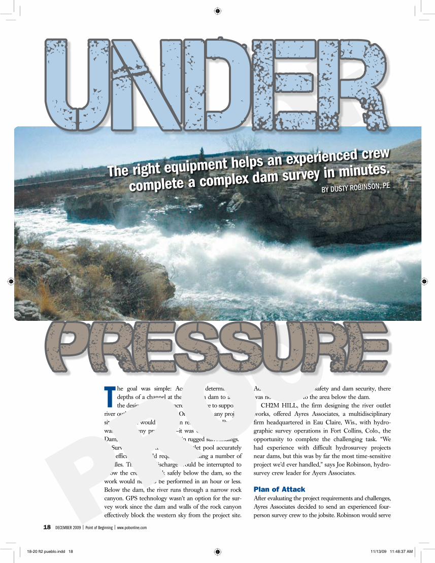
T he goal was simple: Accurately determine the depths of a channel at the base of a dam to aid in the design of a mass concrete structure to support a
river outlet works connection. On just about any project site, the work would have been relatively easy. But this was not just any project site—it was Colorado’s Pueblo Dam, an immense structure set in rugged surroundings.
Surveying the bottom of the outlet pool accurately and efficiently would require overcoming a number of hurdles. The water discharge would be interrupted to allow the crew to work safely below the dam, so the work would need to be performed in an hour or less. Below the dam, the river runs through a narrow rock canyon. GPS technology wasn’t an option for the sur-vey work since the dam and walls of the rock canyon effectively block the western sky from the project site.
Additionally, for boater safety and dam security, there was no boat access to the area below the dam.
CH2M HILL, the firm designing the river outlet works, offered Ayres Associates, a multidisciplinary firm headquartered in Eau Claire, Wis., with hydro-graphic survey operations in Fort Collins, Colo., the opportunity to complete the challenging task. “We had experience with difficult hydrosurvey projects near dams, but this was by far the most time-sensitive project we’d ever handled,” says Joe Robinson, hydro-survey crew leader for Ayers Associates.
Plan of AttackAfter evaluating the project requirements and challenges, Ayres Associates decided to send an experienced four-person survey crew to the jobsite. Robinson would serve
18 December 2009 | Point of beginning | www.pobonline.com
The right equipment helps an experienced crew
complete a complex dam survey in minutes.BY DUSTY ROBINSON, PE
18-20 ft2 pueblo.indd 18 11/13/09 11:48:37 AM
19www.rpls.com | Point of beginning | December 2009
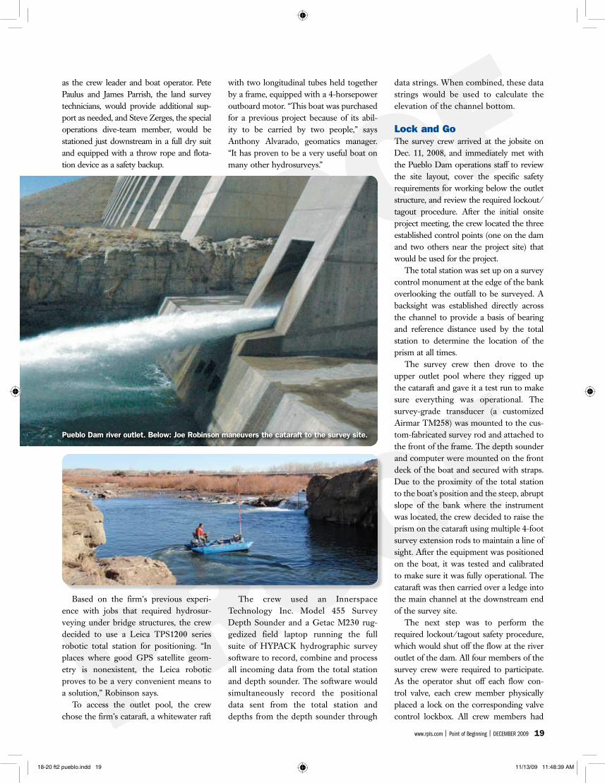
as the crew leader and boat operator. Pete Paulus and James Parrish, the land survey technicians, would provide additional sup-port as needed, and Steve Zerges, the special operations dive-team member, would be stationed just downstream in a full dry suit and equipped with a throw rope and flota-tion device as a safety backup.
Based on the firm’s previous experi-ence with jobs that required hydrosur-veying under bridge structures, the crew decided to use a Leica TPS1200 series robotic total station for positioning. “In places where good GPS satellite geom-etry is nonexistent, the Leica robotic proves to be a very convenient means to a solution,” Robinson says.
To access the outlet pool, the crew chose the firm’s cataraft, a whitewater raft
with two longitudinal tubes held together by a frame, equipped with a 4-horsepower outboard motor. “This boat was purchased for a previous project because of its abil-ity to be carried by two people,” says Anthony Alvarado, geomatics manager. “It has proven to be a very useful boat on many other hydrosurveys.”
The crew used an Innerspace Technology Inc. Model 455 Survey Depth Sounder and a Getac M230 rug-gedized field laptop running the full suite of HYPACK hydrographic survey software to record, combine and process all incoming data from the total station and depth sounder. The software would simultaneously record the positional data sent from the total station and depths from the depth sounder through
data strings. When combined, these data strings would be used to calculate the elevation of the channel bottom.
Lock and GoThe survey crew arrived at the jobsite on Dec. 11, 2008, and immediately met with the Pueblo Dam operations staff to review the site layout, cover the specific safety requirements for working below the outlet structure, and review the required lockout/tagout procedure. After the initial onsite project meeting, the crew located the three established control points (one on the dam and two others near the project site) that would be used for the project.
The total station was set up on a survey control monument at the edge of the bank overlooking the outfall to be surveyed. A backsight was established directly across the channel to provide a basis of bearing and reference distance used by the total station to determine the location of the prism at all times.
The survey crew then drove to the upper outlet pool where they rigged up the cataraft and gave it a test run to make sure everything was operational. The survey-grade transducer (a customized Airmar TM258) was mounted to the cus-tom-fabricated survey rod and attached to the front of the frame. The depth sounder and computer were mounted on the front deck of the boat and secured with straps. Due to the proximity of the total station to the boat’s position and the steep, abrupt slope of the bank where the instrument was located, the crew decided to raise the prism on the cataraft using multiple 4-foot survey extension rods to maintain a line of sight. After the equipment was positioned on the boat, it was tested and calibrated to make sure it was fully operational. The cataraft was then carried over a ledge into the main channel at the downstream end of the survey site.
The next step was to perform the required lockout/tagout safety procedure, which would shut off the flow at the river outlet of the dam. All four members of the survey crew were required to participate. As the operator shut off each flow con-trol valve, each crew member physically placed a lock on the corresponding valve control lockbox. All crew members had
Pueblo Dam river outlet. Below: Joe Robinson maneuvers the cataraft to the survey site.
18-20 ft2 pueblo.indd 19 11/13/09 11:48:39 AM
20 December 2009 | Point of beginning | www.pobonline.com
their own keys that they kept with them until the work was completed to ensure that the water could not be turned back on until everyone was accounted for and had personally removed their locks. “As soon
as the water was shut off, the clock began to tick,” Robinson says. “It was crucial that the work be performed efficiently so as to not disturb the normal operation of the dam for an extended period of time.”
After the lockout/tagout procedure, the survey crew members returned to their stations. As Robinson maneuvered the cataraft upstream toward the area to be surveyed, Paulus locked the Leica TPS onto the prism above the boat. The instrument’s automatic target recognition sensor automatically tracked the prism
while the boat was in the water. The con-troller, also located on the boat, received continuous information from the TPS through a radio link. This information was then communicated through a GSI code to the onboard laptop.
The cataraft engine, depth sounder, Leica TPS, computer and software all had to work together without error. “The dam operators were holding the crew to a very short time frame. Equipment problems probably would have led to abandoning the work,” Robinson says.
In Record TimeProper preparation and coordination paid off. The crew gathered the needed data and was able to return to the control cen-ter in less than one hour from the time the water was shut off. The Ayres Associates team subsequently provided CH2M HILL with the processed data in an ASCII text format, CAD drawings (including a 3D surface of the river bottom) and a map of the results along with the survey report.
“The time constraints and other vari-ables made this a challenging project,” Robinson says, “but the use of an experi-enced crew and the right tools allowed us to meet the requirements.”
Dusty Robinson, PE, is a civil engineer for
Ayres Associates (www.ayresassociates.com).
He can be reached at 970/223-5556 or
[email protected]. For additional
information about the firm’s hydrosurvey
work, contact Anthony Alvarado at alvaradoa@
ayresassociates.com. More information about
CH2M HILL can be found at www.ch2m.com.
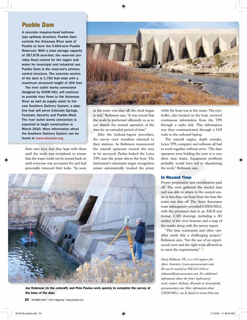
Joe Robinson (in the cataraft) and Pete Paulus work quickly to complete the survey at the base of the dam.
Pueblo Dam A concrete massive-head buttress-type spillway structure, Pueblo Dam controls the Arkansas River west of Pueblo to form the 5.664-acre Pueblo Reservoir. With a total storage capacity of 357,678 acre-feet, the reservoir pro-vides flood control for the region and water for municipal and industrial use. Pueblo Dam is the reservoir’s primary control structure. The concrete section of the dam is 1,750 feet wide with a maximum structural height of 250 feet.
The river outlet works connection designed by CH2M HILL will continue to provide river flows to the Arkansas River as well as supply water to the new Southern Delivery System, a pipe-line that will serve Colorado Springs, Fountain, Security and Pueblo West. The river outlet works connection is expected to begin construction in March 2010. More information about the Southern Delivery System can be found at www.sdswater.org.
18-20 ft2 pueblo.indd 20 11/13/09 11:48:45 AM