proposed regional policy statement - gw€¦ · proposed regional policy statement for the ... 12...
TRANSCRIPT
Proposed Regional Policy Statement for the Wellington region 2009
Prop
osed
Reg
ion
al Policy Statem
ent fo
r the W
elling
ton
regio
n 2009
Water, air, earth and energy: elements in Greater Wellington’s logo that combine to create and sustain life. Greater Wellington promotes
Quality for Life by ensuring our environment is protected while meeting the economic, cultural and social needs of the community.
FOR MORE INFORMATION, PLEASE CONTACT:
Greater Wellington 142 Wakefield Street P O Box 11646 Wellington 6142
T 04 384 5708 F 04 385 6960
[email protected] www.gw.govt.nz/rps
Published March 2009GW/EP-G-08/200
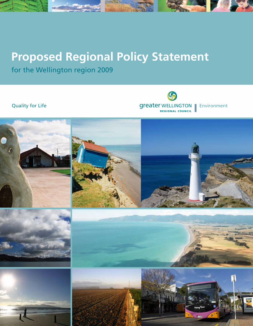
Photographs used for the ‘coastal environment’ in section 3.2, ‘historic heritage’ in section 3.5 and cover and ‘natural hazards’ in section 3.8 and cover were taken by Iain Dawe. The Air quality photograph in section 3.1 was taken by Paul Denton. Remaining photographs are copyright Greater Wellington.
Proposed Regional Policy Statement for the Wellington region
Contents
Chair’s foreword
User Guide
1. Introduction ...................................................................................................................................................1
1.1 Setting the scene ....................................................................................................................................1
1.2 The purpose and content of the Regional Policy Statement ...............................................................1
1.3 The resource management policy and planning framework ..............................................................2
2. Promoting sustainable management in the Wellington region ................................................................7
2.1 A sustainable region ...............................................................................................................................7
2.2 The Wellington region ...........................................................................................................................8
2.3 Community outcomes for the Wellington region ................................................................................9
2.4 Integrating management of our natural and physical resources ...................................................... 10
2.5 Application of the Regional Policy Statement across physical and jurisdictional boundaries ........ 12
3. Resource management issues, objectives and summary of policies and methods to achieve the objectives in the Regional Policy Statement ...................................................................................... 13
3.1 Air quality (objectives 1 – 2) ................................................................................................................ 15
3.2 Coastal environment (including public access) (objectives 3 – 8)...................................................... 19
3.3 Energy, infrastructure and waste (objectives 9 – 11) ......................................................................... 27
3.4 Fresh water (including public access) (objectives 8, 12 – 14) ............................................................. 33
3.5 Historic heritage (objective 15)............................................................................................................ 41
3.6 Indigenous ecosystems (objective 16) .................................................................................................43
3.7 Landscape (objective 17) ...................................................................................................................... 47
3.8 Natural hazards (objectives 18 – 20) ................................................................................................... 51
3.9 Regional form, design and function (objective 21) ............................................................................57
3.10 Resource management with tangata whenua (objectives 22 – 27) ..................................................63
3.11 Soils and minerals (objective 28 – 30) .................................................................................................67
4. Policies and methods ..................................................................................................................................73
4.1 Regulatory policies – direction for district and regional plans and the Regional Land Transport Strategy (policies 1 – 33) ..................................................................................................... 79
4.2 Regulatory policies – matters to be considered (policies 34 – 60) .................................................. 101
4.3 Allocation of responsibilities (policies 61, 62 & 63) .......................................................................... 125
4.4 Non-regulatory policies (policies 64 – 69) ......................................................................................... 129
4.5 Methods to implement policies ......................................................................................................... 133
4.5.1 Regulatory methods (methods 1 – 5) .................................................................................... 137
4.5.2 Non-regulatory methods – information and guidance (methods 6 – 25) ........................... 138
4.5.3 Non-regulatory methods – integrating management (methods 26 – 46) .......................... 141
Proposed Regional Policy Statement for the Wellington region
4.5.4 Non-regulatory methods – identification and investigation (methods 47 – 51) ................ 143
4.5.5 Non-regulatory methods – providing support (methods 52 – 55) ......................................144
5. Monitoring the Regional Policy Statement and the anticipated environmental result ...................... 145
5.1 Procedures for monitoring ................................................................................................................. 145
5.2 Anticipated environmental results .................................................................................................... 146
6. Principal reasons for objectives, policies and methods ......................................................................... 155
Appendix 1: Rivers and lakes with values for protection ............................................................................. 157
Appendix 2: Regional urban design principles .............................................................................................. 163
Appendix 3: Definitions ................................................................................................................................... 167
Appendix 4: References ................................................................................................................................... 177
LISt of tAbLeS
Table 1: Air quality objectives and titles of policies and methods to achieve the objectives .................... 17
Table 2: Coastal environment objectives and titles of policies and methods to achieve the objectives ... 21
Table 3: Energy, infrastructure and waste objectives and titles of policies and methods to achieve the objectives .....................................................................................................................................30
Table 4: Fresh water objectives and titles of policies and methods to achieve the objectives ..................36
Table 5: Historic heritage objective and titles of policies and methods to achieve the objective .............42
Table 6a: Indigenous ecosystems objective and titles of policies and methods to achieve the objective ......................................................................................................................................45
Table 6b: Allocation of functions for indigenous biodiversity in accordance with the Resource Management Act ...............................................................................................................................46
Table 7: Landscape objective and titles of policies and methods to achieve the objective .......................48
Table 8a: Natural hazards objectives and titles of policies and methods to achieve the objectives ...........54
Table 8b: Allocation of functions for natural hazards in accordance with the Resource Management Act ...............................................................................................................................56
Table 9: Regional form objective and titles of policies and methods to achieve the objective ................. 59
Table 10: Resource management with tangata whenua objectives and titles of policies and methods to achieve the objectives ................................................................................................................... 65
Table 11: Soils and minerals objectives and titles of policies and methods to achieve the objectives ........ 70
Table 12: Allocation of responsibilities for land use controls for natural hazards ...................................... 126
Table 13: Allocation of responsibilities for land use controls for hazardous substances ........................... 127
Table 14: Objectives and the anticipated environmental results from implementing the policies and methods in the Regional Policy Statement ............................................................................ 146
Table 15: Rivers and lakes with significant amenity and recreational values .............................................. 157
Table 16: River and lakes with significant indigenous ecosystems............................................................... 158
Proposed Regional Policy Statement for the Wellington region
LISt of fIguReS
Figure 1: The resource management policy and planning framework ...........................................................3
Figure 2: Wellington region and city and district council boundaries ............................................................8
Figure 3: Regional focus areas ........................................................................................................................ 122
Proposed Regional Policy Statement for the Wellington region i
Chair’s foreword
Imagine the Wellington region in 10, 20 or even 50 years’ time. What will our environment look like? What will be driving our economy and what resources will we need for these activities? How will we travel long and short distances? How will we deal with our waste and ensure our rivers and beaches are clean enough for swimming?
Greater Wellington’s proposed Regional Policy Statement addresses these sorts of questions. It sets out how we’ll manage our land, air, water, soil, minerals, energy and ecosystems in a way that provides for the present without compromising the ability of future generations to meet their own needs.
The law requires that regional and district council plans give effect to the Regional Policy Statement, so the contents of this document will ultimately have a direct bearing on how you can manage your own property and, more importantly, how your local council manages its physical environment.
Because of its importance, this proposed Regional Policy Statement has been shaped by detailed work in collaboration with other councils in our region and extensive feedback on the draft document released last year. It is basically a set of agreed parameters for activities that have an impact on our physical environment
However, we know that behaviour changes are most likely to occur if they spring from knowledge and belief rather than regulation. Thus, even if this Regional Policy Statement was not required by law, the worsening state of the global environment would be a compelling reason for us to be having these sorts of discussions and making these sorts of proposals.
Many believe that our planet has reached a tipping point in terms of the sustainability of life. Even if that is not the case, there is clear evidence that boundless consumption has depleted or damaged physical resources to the extent that we must fundamentally change our approach to the environment if we want to continue with reasonable living standards in the future.
Now with the world also in major recession – possibly the worst since the 1930s – it is tempting to forget about environmental needs and focus on economic measures. But previous experience tells us that this is neither a sensible nor a necessary trade-off.
Environmental and economic progress in the 21st century both demand that we use our resources more sensibly, especially those in limited supply or those which are highly valued. This Regional Policy Statement represents a turning point in how we’ll approach these difficult decisions.
It’s important that we continue to have feedback on these proposals before the document is finalised, so please read it carefully and take advantage of this opportunity to help us shape the future of the Wellington region.
Hon Fran Wilde QSOChair, Greater Wellington Regional Council
March 2009

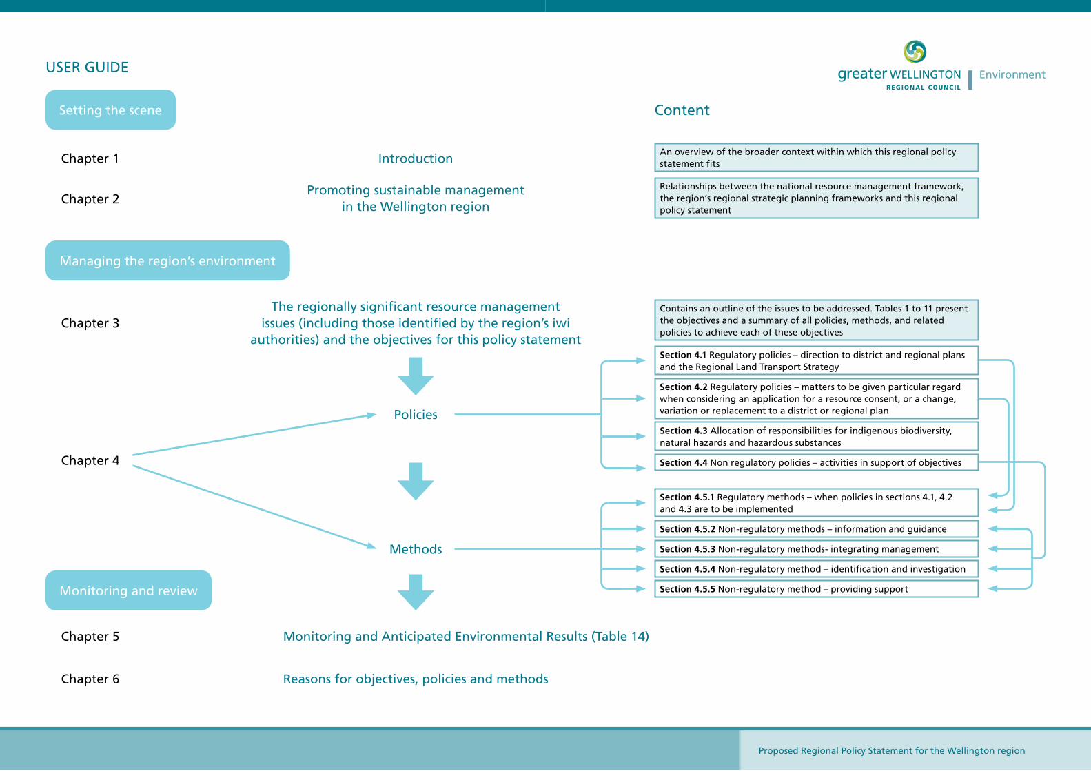
User Guide
Proposed Regional Policy Statement for the Wellington region
Promoting sustainable management in the Wellington region
The regionally significant resource management issues (including those identified by the region’s iwi
authorities) and the objectives for this policy statement
Policies
Reasons for objectives, policies and methods
Methods
Chapter 4
Chapter 1
Chapter 2
Introduction
Content
Chapter 3
Chapter 5
Chapter 6
Monitoring and Anticipated Environmental Results (Table 14)
Setting the scene
Managing the region’s environment
Monitoring and review
Section 4.5.2 Non-regulatory methods – information and guidance
Section 4.5.3 Non-regulatory methods- integrating management
Section 4.5.4 Non-regulatory method – identification and investigation
Section 4.5.5 Non-regulatory method – providing support
Section 4.5.1 Regulatory methods – when policies in sections 4.1, 4.2 and 4.3 are to be implemented
Section 4.1 Regulatory policies – direction to district and regional plans and the Regional Land Transport Strategy
Section 4.3 Allocation of responsibilities for indigenous biodiversity, natural hazards and hazardous substances
Section 4.4 Non regulatory policies – activities in support of objectives
Section 4.2 Regulatory policies – matters to be given particular regard when considering an application for a resource consent, or a change, variation or replacement to a district or regional plan
USER GUIdE
An overview of the broader context within which this regional policy statement fits
Relationships between the national resource management framework, the region’s regional strategic planning frameworks and this regional policy statement
Contains an outline of the issues to be addressed. Tables 1 to 11 present the objectives and a summary of all policies, methods, and related policies to achieve each of these objectives
Proposed Regional Policy Statement for the Wellington region
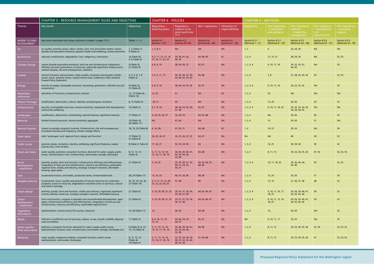
ChAPTER 3 – RESoURCE MANAGEMENT ISSUES ANd objECTIvES ChAPTER 4 – PoLICIES ChAPTER 4 – METhodS
Themes Key words objectives Regulatory – directing plans
Regulatory – matters to be given particular ????
Non- regulatory Allocation of responsibilities
Regulatory Non regulatory – information and guidance
Non-regulatory method – integrating management
Non-regulatory – investigation and identification
Non-regulatory – providing support
WhERE To FINd IN doCUMENT
key words associated with issues outlined in chapter 3 pages 13-71 Tables 1 – 11 Section 4.1 (policies 1-33)
Section 4.2 (policies 34- 60)
Section 4.4 (policies 64 – 69)
Section 4.3 (policies 61 – 63)
Section 4.5.1 (Methods 1 – 5)
Section 4.5.2 (Methods 6 – 25)
Section 4.5.3 (Methods 26 – 46)
Section 4.5.4 (Methods 47 – 51)
Section 4.5.5 (Methods 52 – 55)
Air air quality, amenity values, odour, smoke, dust, fine particulate matter, carbon dioxide and equivalent emissions, people’s health and wellbeing, reverse sensitivity
1, 2 (Table 1); 9 (Table 4)
1, 2, 8, 9 NA NA NA 1, 2 6 26, 29, 30 NA NA
biodiversity reduced, modification, degradation, loss, indigenous, restoration 16 (Table 6); 3, 4 (Table 2)
4, 5, 11, 12, 13, 14, 15, 16, 17, 22, 23
34, 36, 41, 42, 46, 59
64, 68, 69 61 1, 2, 4 12, 15, 21 28, 29, 34 NA 52, 53
Climate change carbon dioxide equivalent emissions, land use and infrastructure integration, efficient use and conservation of resources, regionally significant infrastructure, natural hazards, risk and consequences, resilience
9 (Table 3); 21 (Table 9)
6, 8, 9, 10 38, 54, 56, 57 65, 67 NA 1, 2, 3, 4 9, 10, 11, 16 29, 32, 35, 41, 44, 45
NA 55
Coastal natural character and processes, water quality, ecosystem and people’s health, access, mauri, amenity values, coastal marine area, subdivision, New Zealand Coastal Policy Statement
3, 4, 5, 6, 7, 8 (Table 2)
3, 4, 5, 11, 15 34, 35, 36, 37, 39, 42, 46, 52, 54, 55
64, 68 NA 1, 2, 4 7, 8 27, 28, 29, 34, 36 50 52, 53
Energy security of supply, renewable resources, harvesting, generation, efficient use and conservation
9 (Table 3); 21 (Table 9)
6, 8, 9, 10, 38, 44, 54, 55, 56 65, 67 NA 1, 2, 3, 4 9, 10, 11, 16 29, 32, 35, 45 NA 55
hazardous substances
allocation of functions, contaminants, ecotoxic 12, 13 (Table 4); (Table 13)
13, 33 41 NA 63 1, 2, 4 24 NA NA NA
historic heritage modification, destruction, culture, identity, archaeological, ancestors 8, 15 (Table 5) 20, 21 45 NA NA 1, 2, 4 13, 20 29, 36 50 52
Infrastructure security, incompatible land uses, reverse sensitivity, integrated with development, community wellbeing
10 (Table 3) 6, 7, 9, 10, 38, 44, 54, 55, 56, 57, 58
65, 67 NA 1, 2, 3, 4 9, 10, 11, 16, 25 29, 32, 33, 34, 35, 36, 39, 44, 45
NA NA
Landscapes modification, destruction, outstanding, natural features, significant amenity 17 (Table 7) 4, 24, 25, 26, 27 34, 49, 55, 64, 67, 68 NA 1, 2, 4 NA 29, 36 49 52
Minerals limited mineral resources, reverse sensitivity, aggregate 10 (Table 3); 30 (Table 11)
NA 41, 60 NA NA 1, 2, 4 15 29, 30 51 NA
Natural hazards impact on people, property, business, infrastructure, risk and consequences, increased intensity and frequency, climate change effects
18, 19, 20 (Table 8) 4, 14, 28, 41, 50, 51 64, 68, 62 1, 4 14, 23 29, 34 NA 54
open space refer ‘landscapes’ and ‘regional form, design and function’ 17 (Table 7); 21 (Table 9)
24, 25, 26, 27 24, 25, 26, 27, 52 64, 67 NA NA NA 40 50 52
Public access amenity values, recreation, identity, wellbeing, significant features, coastal marine area, rivers & lakes
8 (Table 2; Table 4) 17, 26, 27 52, 53, 54, 56 64 NA 1, 3, 4 16, 25 38, 39, 40 50 52
Rivers and lakes water quality, pollution, ecosystem function, demand for water, supply, public access, sedimentation, toxic contaminants, stormwater, sewage, discharges
8, 12, 13, 14 (Table 4)
5, 11, 12, 13, 14, 15, 16, 17, 18, 19,
34, 36, 39, 40, 41, 42, 43, 44, 46, 52, 58
64, 68 NA 1, 2, 4 8, 11, 15 29, 33, 34, 35, 36 47, 50 52, 53, 55
Rural development – subdivision
amenity, quality, form and function, infrastructure efficiency and effectiveness, integration of land use and infrastructure, resource use efficiency, sustainable regional form, vitality and vibrancy, strategic transport network, affordable housing, open space
21 (Table 9) 3, 10, 32 35, 39, 40, 41, 42, 44, 51, 54, 55, 56, 57
64, 65, 66, 67, 68, 69
NA 1, 2, 3, 4 10, 11, 18, 25 29, 36, 40, 44, 45, 46
50 52, 55
Soils accelerated erosion, soil health, productive lands, contaminated land 28, 29 (Table 11) 13, 14, 33 40, 41, 59, 60 68, 69 NA 1, 2, 4 15, 24 29, 30 51 54
Tangata whenua involvement, mauri, quality and quantity of natural resources for customary purposes, access to resources, degradation and destruction of spiritual, cultural and historic heritage
22, 23, 24, 25, 26, 27 (Table 10)
3, 5, 11, 15, 16, 20, 21, 22, 23, 24, 25
47, 48 66 NA 1, 2, 4 13, 19 31, 36, 37, 38 48 52
Urban design amenity, quality, form and function, vitality and vibrancy, regionally significant centres, density, mixed use, strategic transport network, affordable housing
21 (Table 9) 3, 10, 29, 30, 31, 32 35, 41, 51, 53, 54, 55, 56, 57, 58
64, 65, 66, 67 NA 1, 2, 3, 4 9, 10, 11, 16, 17, 18, 25
29, 36, 39, 40, 41, 42, 43, 45, 46
50 52
Urban development – subdivision
form and function, compact vs sporadic and uncoordinated development, open space, infrastructure efficiency and effectiveness, integration of land use and infrastructure, resource use efficiency, sustainable regional form
21 (Table 9) 3, 10, 29, 30, 31, 32 35, 41, 51, 53, 54, 56, 57, 58
64, 65, 66, 67 NA 1, 2, 3, 4 9, 10, 11, 13, 16, 18, 25
29, 36, 39, 40, 41, 42, 43, 45, 46
50 52
vegetation disturbance
sedimentation, erosion prone hill country, clearance 16, 28 (Table 11) 14, 40, 59 64, 68 NA 1, 2, 4 15, 29, 30 NA 52
Waste efficient vs inefficient use of resources, reduce, re-use, recycle, landfills, disposal costs and effects
11 (Table 3) 8, 9, 10, 12, 14, 15, 19
43, 44, 54, 55, 56, 57
65, 67 NA NA 9, 10, 11, 17 29, 35 NA 55
Water quality – fresh and coastal
pollution, ecosystem function, demand for water, supply, public access, sedimentation ecotoxic, toxic contaminants, stormwater, sewage, discharges eco
6 (Table 2); 8, 12, 13, 14 (Table 4)
5, 11, 12, 13, 14, 15, 16, 17, 18, 19,
34, 36, 39, 40, 41, 42, 43, 44, 46, 52, 58
64, 68 NA 1, 2, 4 8, 11, 15 29, 33, 34, 35, 36 47, 50 52, 53, 55
Wetlands water quality, indigenous habitat, ecosystem function, public access, sedimentation, stormwater, discharges
8, 12, 13, 14 (Table 4); 16 (Table 6)
5, 11, 12, 13, 14, 15, 16, 17, 18, 19,
22, 23, 34, 36, 39, 40, 41, 42, 43, 44, 46, 52, 58
61, 64, 68 NA 1, 2, 4 8, 11, 15 29, 33, 34, 35, 36 47 52, 53, 55

Chapter One
Introduction
Proposed Regional Policy Statement for the Wellington region 1
1. Introduction
1.1 Setting the scene
This chapter provides an outline of the Regional Policy Statement’s role within the wider resource management framework.
This is the second such statement prepared for the Wellington region under the Resource Management Act, 1991. Since the adoption of the Act, a lot has been learnt about what is effective resource management and what is not. This experience is reflected in the significantly revised format and the more targeted and directive approach of this Regional Policy Statement, which is more likely to achieve the outcomes sought. These outcomes – described as anticipated environmental results in Chapter 4 – are the measures against which the success of this framework will be measured in the future.
This Regional Policy Statement is not simply a collection of discrete policies. The policies are intended to complement each other and provide a robust, integrated approach to promoting the sustainable management of natural and physical resources.
Chapter 1 also outlines the documents which have informed the identification of regional issues and assisted in the development of objectives for the region. It also assists users to navigate between the sections and understand how these policies relate to each other.
1.2 the purpose and content of the Regional Policy Statement
The purpose of the Resource Management Act is to promote sustainable management of natural and physical resources. Natural and physical resources include land, water, air, soil, minerals and energy, all forms of plants and animals and all structures.
The Act requires every regional council to prepare a regional policy statement which is designed to achieve the purpose by providing an overview of the resource management issues for the region, and outlining the policies and methods required to achieve the integrated management of the region’s natural and physical resources.
Sustainable management is defined in the Act as:
Managing the use, development, and protection of natural and physical resources in a way, or at a rate, which enables people and communities to provide for their social, economic, and cultural wellbeing and for their health and safety while:
(a) Sustaining the potential of natural and physical resources (excluding minerals) to meet the reasonably foreseeable needs of future generations; and
(b) Safeguarding the life-supporting capacity of air, water, soil and ecosystems; and(c) Avoiding, remedying, or mitigating any adverse effects of activities on the environment.
The Act defines the ‘environment’ as including:
(a) Ecosystems and their constituent parts, including people and communities; and(b) All natural and physical resources; and(c) Amenity values; and(d) The social, economic, aesthetic, and cultural conditions which affect the matters stated in
paragraphs (a) to (c) of this definition or which are affected by these matters.
Proposed Regional Policy Statement for the Wellington region2
Section 62 of the Act sets out the content of regional policy statements, as follows:
(1) A regional policy statement must state:(a) the significant resource management issues for the region; and(b) the resource management issues of significance to –
(i) iwi authorities in the region; and(ii) the board of a foreshore and seabed reserve, to the extent that those issues relate to that
reserve; and(c) the objectives sought to be achieved by the statement; and(d) the policies in regard to the issues and objectives, and an explanation of those policies; and(e) the methods (excluding rules) used, or to be used, to implement the policies; and(f) the principal reasons for adopting the objectives, policies and methods of implementation set
out in the statement; and(g) the environmental results anticipated from implementation of the policies and methods; and(h) the processes for dealing with issues that cross local authority boundaries, and issues
between territorial authorities or between regions; and(i) the local authority responsible in the whole or any part of the region for specifying the
objectives, policies and methods for the control of the use of land – (i) to avoid or mitigate natural hazards or any group of hazards;(ii) to prevent or mitigate the adverse effects of the storage and use, disposal, or
transportation of hazardous substances; and(iii) to maintain indigenous biological diversity; and
(j) the procedures used to monitor the efficiency and effectiveness of policies or methods contained in the statement; and
(k) any other information required for the purpose of the regional council’s functions, powers and duties under this Act.
1.3 the resource management policy and planning framework
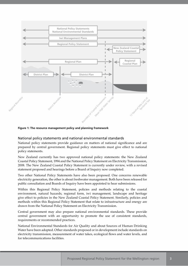
The Resource Management Act provides for a framework of policy statements, standards and plans, each of which must achieve the purpose of the Act – to promote sustainable management. Figure 1 illustrates where the Regional Policy Statement fits within this framework.
The Act also requires planning documents recognised by an iwi authority – such as iwi management plans – to be taken into account when preparing a regional policy statement or plans.
How issues are handled when they cross jurisdictional boundaries is addressed in section 2.5.
Proposed Regional Policy Statement for the Wellington region 3
figure 1: the resource management policy and planning framework
National policy statements and national environmental standardsNational policy statements provide guidance on matters of national significance and are prepared by central government. Regional policy statements must give effect to national policy statements.
New Zealand currently has two approved national policy statements: the New Zealand Coastal Policy Statement, 1994 and the National Policy Statement on Electricity Transmission, 2008. The New Zealand Coastal Policy Statement is currently under review, with a revised statement proposed and hearings before a Board of Inquiry now completed.
Two other National Policy Statements have also been proposed. One concerns renewable electricity generation, the other is about freshwater management. Both have been released for public consultation and Boards of Inquiry have been appointed to hear submissions.
Within this Regional Policy Statement, policies and methods relating to the coastal environment, natural hazards, regional form, iwi management, landscape and heritage give effect to policies in the New Zealand Coastal Policy Statement. Similarly, policies and methods within this Regional Policy Statement that relate to infrastructure and energy are drawn from the National Policy Statement on Electricity Transmission.
Central government may also prepare national environmental standards. These provide central government with an opportunity to promote the use of consistent standards, requirements or recommended practices.
National Environmental Standards for Air Quality and about Sources of Human Drinking Water have been adopted. Other standards proposed or in development include standards on electricity transmission, measurement of water takes, ecological flows and water levels, and for telecommunications facilities.
Regio
nal B
ound
ary
Distric
t Bou
ndar
y
Boun
dary
of C
oasta
l Env
ironm
ent
Mea
n High
Wat
er Sp
rings
New Zealand Coastal Policy Statement
Regional Coastal Plan
National Policy Statements National environmental Standards
Iwi Management Plans
Regional Policy Statement
Regional Plan
District PlanDistrict Plan
12 N
autic
al M
ile Li
mit
of
Terri
toria
l Sea
Proposed Regional Policy Statement for the Wellington region4
Iwi management plansAn iwi management plan is a general term given to any planning document recognised by an iwi authority and lodged with a regional, district or city council. Where relevant, councils must take these into account when preparing a regional policy statement, regional plan or district plan.
Regional plansRegional plans must give effect to a regional policy statement and any national policy statement. Regional plans can contain rules that:
• control the use of land– for soil conservation– for quality or quantity of water, or for ecosystems in water bodies and the coast– to avoid or mitigate natural hazards– to prevent or mitigate adverse effects from the storage, use, disposal or
transportation of hazardous substances• control the taking, use, damming, and diversion of water, and control the quantity,
level and flow of water in any waterbody• control the discharges of contaminants into or onto land, air, or water• control the harvesting or enhancement of aquatic organisms to avoid, remedy or
mitigate effects• allocate a natural resource.
The Resource Management Act requires each region to prepare a regional coastal plan. Rules in a regional coastal plan promote integrated management of the coastal marine area.
All regional plans are prepared by regional councils.
District plansAll district and city councils must prepare district plans. Rules in district plans control the use of land, including subdivision. District plans must give effect to a regional policy statement and any national policy statements and national environmental standards.
Other strategies and companion statutesThere are a number of other national strategies promulgated by central government and its agencies that are not prepared under the Resource Management Act and have no statutory bearing on the content of a regional policy statement. However, they assist in the identification of natural and physical resource management issues, choices made at a national level, priorities for action if New Zealand is to reach goals for the future and often contain objectives. Some of these choices, actions and objectives are reliant upon implementation of resource management activities by local authorities.
Documents which informed this Regional Policy Statement include the New Zealand Energy Strategy to 2050 (2007), the New Zealand Energy Efficiency and Conservation Strategy (2007), the Regional Renewable Energy Assessment for the Wellington Region (2006), the New Zealand Urban Design Protocol (2006) and National Priorities for Action for Protecting Biodiversity on Private Land (2007).
The Wellington Regional Strategy – a sustainable economic growth strategy for the region – provided the basis for the policies and methods on regional form, design and function. Similarly, the Wellington Regional Land Transport Strategy has contributed to policies and methods on energy, infrastructure and regional form, design and function. Long term council community plans, developed by Wellington Regional Council and the district and city councils, have also informed the development of policies and methods in this Regional Policy Statement.
Proposed Regional Policy Statement for the Wellington region 5
There are also a number of statutes that can be thought of as companions of the Resource Management Act, in that their purpose can be interpreted as further supporting the sustainable management of natural and physical resources (e.g. the Conservation Act, the Reserves Act, and the Local Government Act), or have some other relationship with resource management functions (e.g. the Civil Defence Emergency Management Act, the Hazardous Substances and New Organisms Act and the Biosecurity Act).
In considering the appropriateness of objectives, and the efficiency and effectiveness of specific policies and methods for inclusion in the Regional Policy Statement – in other words, when undertaking an ‘assessment of alternatives’ and costs and benefits (as required by Section 32 of the Resource Management Act), these other statutory frameworks are relevant and they may provide alternative and better means for addressing some issues.
Chapter Two
Promoting sustainable management in the Wellington region
Proposed Regional Policy Statement for the Wellington region 7
2. Promoting sustainable management in the Wellington region
2.1 A sustainable region
The Wellington region has a long and eventful history, not the least of which is its Maori identification as “Te Upoko o Te Ika a Maui” or the Head of Maui’s fish. The head of the fish, in Maori thinking, is the sweetest part.
Hutia te rito o te harakeke. Kei hea te komako e ko?
Ki mai nei ki ahau. He aha te mea nui o te ao?
Maku e ki atu: He tangata, he tangata, he tangata.
If you were to pluck out the centre shoot of the flax bush, where would the bellbird sing?
If you were to ask me “What is the most important thing in the world?” I would reply, “it is people, people, people.”
This whakatauki, or proverb, is a metaphor for nurturing and sustainably managing the environment for the good of all. It can be used to symbolise the role of the environment, family and community in nurturing the individual and environment. When harvesting flax, only the outer leaves are harvested to ensure regeneration of the plant. If the flax is not nurtured and protected, the bellbird, which relies on flax for survival, is threatened. Likewise, people are endangered if our natural and physical resources are not properly cared for. People and our institutions are central in this dynamic, underpinning the role we have as guardians of resources for current and future generations.
The Regional Policy Statement is mandated by the Resource Management Act. It’s purpose is to promote the sustainable management of natural and physical resources in the Wellington region. Sustainable management in the Resource Management Act encapsulates the idea of environmental sustainability. In other words, natural and physical resources can be used and developed by people and communities to provide for their economic, social and cultural wellbeing, and health and safety, but in such a way that ensures the potential of these resources are sustained for future generations, and ecological systems retain their life-supporting capacity and are not overly degraded.
Tangata whenua consider that the life force – mauri – of natural systems needs to be protected. If it is compromised by unwise resource use, this would also constitute a risk for the people dependent on those resources. This concept is reflected in the current approach to sustainability, which takes into account the interdependence of the many parts of the ecosystem, including people. The Resource Management Act refers to “safeguarding the life supporting capacity of air, water, soils and ecosystems.”
Proposed Regional Policy Statement for the Wellington region8
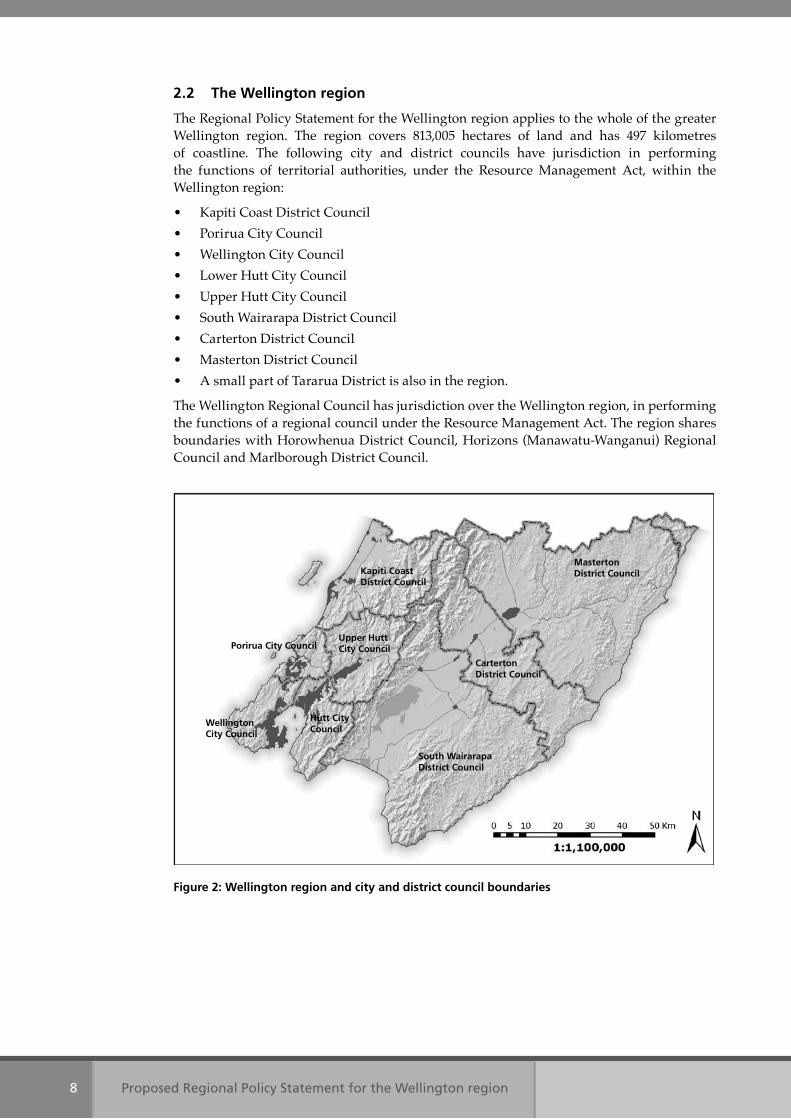
2.2 the Wellington region
The Regional Policy Statement for the Wellington region applies to the whole of the greater Wellington region. The region covers 813,005 hectares of land and has 497 kilometres of coastline. The following city and district councils have jurisdiction in performing the functions of territorial authorities, under the Resource Management Act, within the Wellington region:
• Kapiti Coast District Council• Porirua City Council• Wellington City Council• Lower Hutt City Council• Upper Hutt City Council• South Wairarapa District Council• Carterton District Council• Masterton District Council• A small part of Tararua District is also in the region.
The Wellington Regional Council has jurisdiction over the Wellington region, in performing the functions of a regional council under the Resource Management Act. The region shares boundaries with Horowhenua District Council, Horizons (Manawatu-Wanganui) Regional Council and Marlborough District Council.
Kapiti Coast District Council
Masterton District Council
South Wairarapa District Council
Carterton District Council
upper Hutt City Council
Hutt City Council
Porirua City Council
Wellington City Council
figure 2: Wellington region and city and district council boundaries
Proposed Regional Policy Statement for the Wellington region 9
In addition to these representative arrangements, there are five recognised tangata whenua tribal groups in the region. They are Ngati Raukawa, Ngati Toa, Rangitane, Ngati Kahungunu, and Taranaki Whanui, which includes Te Ati Awa, Taranaki, Ngati Tama and Ngati Ruanui. These tribes are currently represented by the following seven iwi authorities.
• Te Runanga o Raukawa Inc • Te Runanga o Atiawa ki Whakarongotai Inc • Te Runanga o Toa Rangatira Inc • The Wellington Tenths Trust • Te Runanganui o Taranaki Whanui ki te Upoko o te Ika a Maui • Kahungunu ki Wairarapa• Rangitane o Wairarapa Inc.
2.3 Community outcomes for the Wellington region
There is a wide range of factors – political, social, cultural, economic and environmental -that can influence the region’s move towards or away from sustainability. The Regional Policy Statement helps promote sustainability by identifying the significant resource management issues of the region, then setting out objectives, policies and methods to address these issues using the means available under the Resource Management Act.
There are other regional and national policy documents that also play a role in contributing towards sustainability and that address social, economic, cultural and environmental issues for the region. Some of these contribute to the formulation of objectives and policies contained within the Regional Policy Statement, as noted in section 1.3.
Key documents prepared by Wellington Regional Council and the region’s city and district councils are the Wellington Regional Strategy (the region’s sustainable economic growth framework), the Regional Land Transport Strategy, and the long term council community plans prepared by all local authorities.
So what do these documents suggest our region will be like, if we manage our natural and physical resources sustainably? The outcomes below are identified as key outcomes for the region within the Wellington Regional Strategy (June 2007) and in Wellington Regional Council’s Long Term Council Community Plan 2006 – 2016 (amended June 2007).
Community OutcomesHealthy environment – We have clean water, fresh air and healthy soils. Well functioning and diverse ecosystems make up an environment that can support our needs. Resources are used efficiently. There is minimal waste and pollution.
Connected community – Our connections and access are efficient, quick and easy – locally, nationally and internationally. Our communication networks, air and sea ports, roads and public transport systems enable us to link well with others, both within and outside the region.
Quality lifestyle – Living in the Wellington region is enjoyable and people feel safe. A variety of lifestyles can be pursued. Our art, sport, recreation and entertainment scenes are enjoyed by all community members – and attract visitors.
Entrepreneurial and innovation region – Innovation and new endeavours are welcomed and encouraged. Ideas are exchanged across all sectors, resulting in a creative business culture. We have excellent education and research institutions, and benefit from being the seat of government.
Sense of place – We have a deep sense of pride in the Wellington region and there is a strong community spirit. We value the region’s unique characteristics – its rural, urban and harbour landscapes, its climate, its central location, and it capital city.
Proposed Regional Policy Statement for the Wellington region10
Essential services – High quality and secure infrastructure and services meet our everyday needs. These are developed and maintained to support the sustainable growth of the region, now and in the future.
Prosperous community – All members of our community prosper from a strong and growing economy. A thriving business sector attracts and retains a skilled and productive workforce.
Healthy community – Our physical and mental health is protected. Living and working environments are safe, and everyone has access to health care. Every opportunity is taken to recognise and provide for good health.
Prepared community – We can cope with emergency events. Individuals and businesses are able to take responsibility for their own well-being. Effective emergency management systems are in place.
Strong and tolerant community – People are important. All members of our community are empowered to participate in decision making and to contribute to society. We celebrate diversity and welcome newcomers, while recognising the importance of our tangata whenua.
This Regional Policy Statement is an integral document in helping the Wellington Regional Council and the region’s city and district councils to support the achievement of this region’s community outcomes. We can aim to reduce greenhouse gas emissions by reducing the use of fossil fuels for transport – for example, by investing in better public transport, encouraging more walking and cycling, reducing the need for travel, and steering development to achieve more integrated land use. There are policies in this Regional Policy Statement, particularly those under the banner of ‘urban form, design and function’, to this effect. We can also plan for some of the consequences of climate change and adapt where and how we live to cope with the likely changes. And, there are policies under the banner of ‘natural hazards’, ‘energy, infrastructure and waste’, and ‘regional form, design and function’, to this effect. However, regional policy statements cannot respond to all of the issues and challenges that face our communities in attaining these outcomes. For example, a regional policy statement may not be the best mechanism to manage biosecurity issues, or be the most appropriate strategic planning document in which to speculate about the region’s potential future capacity to support environmental refugees as a result of climate change effects in the wider Pacific region or beyond.
2.4 Integrating management of natural and physical resources
The management of activities so that the life supporting capacity of natural and physical resources is sustained can only be achieved if there is consideration of multiple resources and processes. A prime role of the Regional Policy Statement is to integrate management of the natural and physical resources of the region in response to issues of regional significance, including those issues of significance to iwi authorities.
But what does ‘integrated management’ mean, and why is this approach so important?
Resources co-exist and interact with one another and are impacted on by the activities people undertake. Kaitiakitanga, the environmental guardianship practiced by tangata whenua, has its foundation in the world view that all life and the elements within the natural world which support life – such as land and water – are connected. People are a part of the natural order, not superior to it. The land and everything within and upon it is interrelated. Land management, river management, and maintaining and developing transport or housing infrastructure all utilise resources and can have an effect upon natural processes.
Integration must occur at a range of scales and in a variety of contexts. The effects of activities can be localised or extensive, or they can be temporary or permanent. For example, an industry may subject a local community to objectionable odour, while runoff from rural land into streams can have adverse effects throughout the catchment or in the receiving environment
Proposed Regional Policy Statement for the Wellington region 11
in the coastal marine area, some distance away. Similarly, visual effects may be significant for some distance, perhaps even in a neighbouring region. Water catchments are often an appropriate scale for assessing effects because many effects are generally contained within a catchment and assume relevance to a definable community of interest. In an urban context, specified distances or travel times to essential services – such as transit nodes, a central business district, fire station, school or hospital – often provide an equivalent to ‘catchment’ in considering the inter-relationships between where people live, work and play, and how they access various places and services in going about their life. Integrated management is relevant to managing the inter-relationships between infrastructure and its associated services and any natural resource associated with it. It is also relevant to productive enterprise in rural areas and the natural resources upon which these enterprises rely.
Taking a whole of catchment approach is promoted within this Regional Policy Statement. It means considering the full mix of purposes, uses or activities within a catchment, in terms of how these interact and contribute to outcomes within the catchment and for receiving environments beyond – such as in relation to indigenous ecosystems, soil productivity, water quality, erosion and stormwater control, or natural hazards. This approach suggests a need to work with multiple parties to establish shared objectives for a catchment and to ensure uses and activities are working towards the same goals or at least are not working against their attainment.
Just as it is essential to recognise and manage resources in an interconnected way, it is also vital to involve people in a meaningful way. Natural and physical resources are better managed when the social, economic and cultural factors that surround and drive their use or protection is taken into account. Decisions made about the management of resources are more effective and lasting if they reflect choices made by the community in terms of what it is best or most able to do. If integrated management is to be successful, it must recognise differing community and customary values, interests, skills, capacity and aspirations.
Many agencies share responsibility for providing direction to ensure resources are sustainably managed. To ensure that their objectives and policies are coherent and mutually supportive, it is essential that a common understanding of resource issues and sustainable management is shared. The processes adopted in dealing with day-to-day issues need to be closely aligned.
Wellington Regional Council and the region’s city and district councils oversee the management of natural and physical resources on behalf of the community. Although legislation such as the Resource Management Act directs councils to perform certain functions and to manage defined resources, there is considerable discretion in terms of how this is to be achieved. In practical terms, councils make judgements about the appropriateness of a particular activity in a particular place. All places are part of a wider context and community. It is for the community to provide direction to the council on many of the effects arising from new activities. In attributing value to the environment, councils need to engage with communities and provide appropriate opportunities for comment about the management of resources. The Resource Management Act also charges councils with the responsibility of taking into account the principles of the Treaty of Waitangi when managing natural and physical resources. This includes the right of Maori to retain rangatiratanga and manage resources according to kaitiakitanga.
This Regional Policy Statement for the Wellington region has a key role in integrating the management of natural and physical resources. It identifies the resource management issues of regional significance, recognising the shared responsibility and the need for a common understanding of issues. It then sets out objectives, policies and methods that recognise the interaction and connection between different resources, the range of scales in which an issue can be addressed and the need to consider the social, economic cultural and environmental factors alongside one another. Ultimately, the Regional Policy Statement focuses on the matters that it can influence to make progress towards a sustainable region.
Proposed Regional Policy Statement for the Wellington region12
2.5 Application of the Regional Policy Statement across physical and jurisdictional boundaries
Natural and physical resources and processes do not stop at city, district or regional boundaries. Wellington Regional Council, the region’s district and city councils, and neighbouring councils need processes to address issues that cross boundaries. These issues can be geographic or jurisdictional.
Wellington Regional Council and the region’s district and city councils will promote consistent and integrated application of the objectives, policies and methods contained in this Regional Policy Statement. To this end, they will:
• Encourage agencies in the region to make provision, where appropriate, for the management of regionally significant issues in a manner consistent with objectives and policies stated in this document
• Review district and regional plans to give effect to the Regional Policy Statement• Consult neighbouring regional councils over the preparation of plans prepared under
the Resource Management Act• Promote a collaborative approach to managing resource consent applications where
the request for a consent involves decisions to be taken by a district or city council, or Wellington Regional Council
• Promote an integrated approach to managing resource consent applications where the application site or effects arising from the proposed activity cross regional or district boundaries and have implications for adjoining local authorities
• Investigate transferring and delegating powers, functions and duties to other authorities, including iwi authorities, where this will result in more effective or efficient resource management.
Wellington Regional Council and the region’s district and city councils share some functions in accordance with the Resource Management Act. This is for the control of the use of land for the avoidance or mitigation of natural hazards; maintaining and enhancing indigenous biodiversity; and preventing or mitigating any adverse effects of the storage, use, disposal, or transportation of hazardous substances. The policies which describe how these responsibilities have been allocated are in chapter 4.3
Chapter Three
Resource Management issues, objectives and summary of policies and methods to achieve the objectives in the Regional Policy Statement
Proposed Regional Policy Statement for the Wellington region 13
3. Resource management issues, objectives and summary of policies and methods to achieve the objectives in the Regional Policy Statement
This chapter provides an overview of the regionally significant resource management issues, (including the issues of significance to iwi authorities) addressed by the Regional Policy Statement. They are addressed under topic headings:
• air quality • coastal environment • energy, infrastructure and waste• fresh water• historic heritage• indigenous ecosystems• landscape• natural hazards• regional form, design and function• resource management with tangata whenua• soils and minerals.
Each topic includes a summary table showing all the objectives that relate to that topic and the titles of the policies and methods that will achieve those objectives. The table also includes a reference to other policies that need to be considered alongside to gain a complete view of the issue across the full scope of the Regional Policy Statement.
Proposed Regional Policy Statement for the Wellington region 15
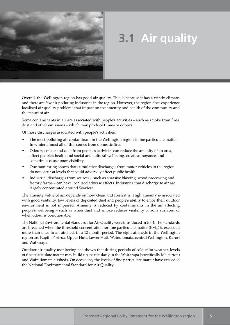
Overall, the Wellington region has good air quality. This is because it has a windy climate, and there are few air polluting industries in the region. However, the region does experience localised air quality problems that impact on the amenity and health of the community and the mauri of air.
Some contaminants in air are associated with people’s activities – such as smoke from fires, dust and other emissions – which may produce fumes or odours.
Of those discharges associated with people’s activities:
• The most polluting air contaminant in the Wellington region is fine particulate matter. In winter almost all of this comes from domestic fires
• Odours, smoke and dust from people’s activities can reduce the amenity of an area, affect people’s health and social and cultural wellbeing, create annoyance, and sometimes cause poor visibility
• Our monitoring shows that cumulative discharges from motor vehicles in the region do not occur at levels that could adversely affect public health
• Industrial discharges from sources – such as abrasive blasting, wood processing and factory farms – can have localised adverse effects. Industries that discharge to air are largely concentrated around Seaview.
The amenity value of air depends on how clean and fresh it is. High amenity is associated with good visibility, low levels of deposited dust and people’s ability to enjoy their outdoor environment is not impaired. Amenity is reduced by contaminants in the air affecting people’s wellbeing – such as when dust and smoke reduces visibility or soils surfaces, or when odour is objectionable.
The National Environmental Standards for Air Quality were introduced in 2004. The standards are breached when the threshold concentration for fine particulate matter (PM10) is exceeded more than once in an airshed, in a 12 month period. The eight airsheds in the Wellington region are Kapiti, Porirua, Upper Hutt, Lower Hutt, Wainuiomata, central Wellington, Karori and Wairarapa.
Outdoor air quality monitoring has shown that during periods of cold calm weather, levels of fine particulate matter may build up, particularly in the Wairarapa (specifically Masterton) and Wainuiomata airsheds. On occasions, the levels of fine particulate matter have exceeded the National Environmental Standard for Air Quality.
3.1 Air quality
Proposed Regional Policy Statement for the Wellington region16
The regionally significant resource management issues for air quality are:
1. Impacts on amenity and wellbeing from odour, smoke and dustOdour, smoke and dust affect amenity values and people’s wellbeing. These effects are generally localised and result from the following activities or land uses:
(a) odour from activities – such as, rendering, spray painting and solvent use, landfills, sewage treatment plants, silage feeding and effluent spreading
(b) smoke from domestic fires and backyard burning(c) dust from land uses or activities – such as, earthworks, quarries, and land clearance.
2. Health effects from discharges of fine particulate matter Fine particulate matter predominantly discharged from domestic fires, occasionally reaches concentrations that can harm people’s health. This can happen in valleys and areas where levels of fine particulate matter may build up during periods of cold calm weather.
Table 1: Air quality Objective 2
Table 1: Air quality Objective 1
Prop
osed
Reg
ion
al Policy Statem
ent fo
r the W
elling
ton
regio
n17
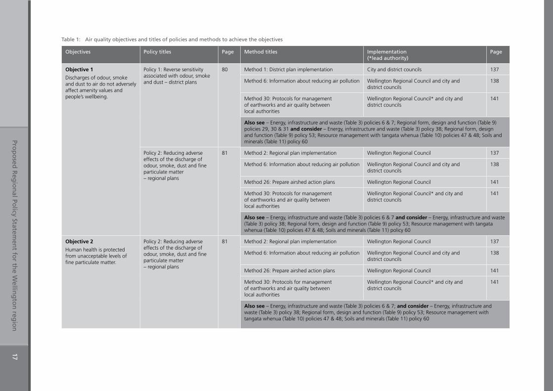
Table 1: Air quality objectives and titles of policies and methods to achieve the objectives
Objectives Policy titles Page Method titles Implementation (*lead authority)
Page
Objective 1
Discharges of odour, smoke and dust to air do not adversely affect amenity values and people’s wellbeing.
Policy 1: Reverse sensitivity associated with odour, smoke and dust – district plans
80 Method 1: District plan implementation City and district councils 137
Method 6: Information about reducing air pollution Wellington Regional Council and city and district councils
138
Method 30: Protocols for management of earthworks and air quality between local authorities
Wellington Regional Council* and city and district councils
141
Also see – Energy, infrastructure and waste (Table 3) policies 6 & 7; Regional form, design and function (Table 9) policies 29, 30 & 31 and consider – Energy, infrastructure and waste (Table 3) policy 38; Regional form, design and function (Table 9) policy 53; Resource management with tangata whenua (Table 10) policies 47 & 48; Soils and minerals (Table 11) policy 60
Policy 2: Reducing adverse effects of the discharge of odour, smoke, dust and fine particulate matter – regional plans
81 Method 2: Regional plan implementation Wellington Regional Council 137
Method 6: Information about reducing air pollution Wellington Regional Council and city and district councils
138
Method 26: Prepare airshed action plans Wellington Regional Council 141
Method 30: Protocols for management of earthworks and air quality between local authorities
Wellington Regional Council* and city and district councils
141
Also see – Energy, infrastructure and waste (Table 3) policies 6 & 7 and consider – Energy, infrastructure and waste (Table 3) policy 38; Regional form, design and function (Table 9) policy 53; Resource management with tangata whenua (Table 10) policies 47 & 48; Soils and minerals (Table 11) policy 60
Objective 2
Human health is protected from unacceptable levels of fine particulate matter.
Policy 2: Reducing adverse effects of the discharge of odour, smoke, dust and fine particulate matter – regional plans
81 Method 2: Regional plan implementation Wellington Regional Council 137
Method 6: Information about reducing air pollution Wellington Regional Council and city and district councils
138
Method 26: Prepare airshed action plans Wellington Regional Council 141
Method 30: Protocols for management of earthworks and air quality between local authorities
Wellington Regional Council* and city and district councils
141
Also see – Energy, infrastructure and waste (Table 3) policies 6 & 7; and consider – Energy, infrastructure and waste (Table 3) policy 38; Regional form, design and function (Table 9) policy 53; Resource management with tangata whenua (Table 10) policies 47 & 48; Soils and minerals (Table 11) policy 60
Proposed Regional Policy Statement for the Wellington region 19
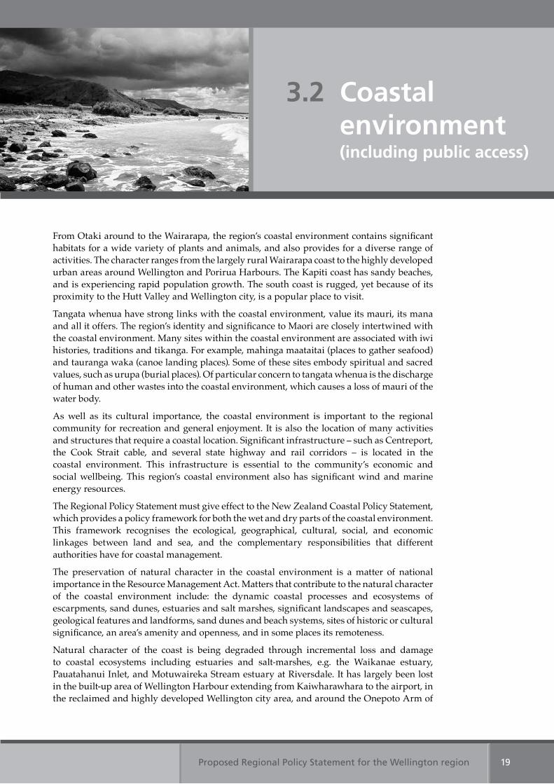
From Otaki around to the Wairarapa, the region’s coastal environment contains significant habitats for a wide variety of plants and animals, and also provides for a diverse range of activities. The character ranges from the largely rural Wairarapa coast to the highly developed urban areas around Wellington and Porirua Harbours. The Kapiti coast has sandy beaches, and is experiencing rapid population growth. The south coast is rugged, yet because of its proximity to the Hutt Valley and Wellington city, is a popular place to visit.
Tangata whenua have strong links with the coastal environment, value its mauri, its mana and all it offers. The region’s identity and significance to Maori are closely intertwined with the coastal environment. Many sites within the coastal environment are associated with iwi histories, traditions and tikanga. For example, mahinga maataitai (places to gather seafood) and tauranga waka (canoe landing places). Some of these sites embody spiritual and sacred values, such as urupa (burial places). Of particular concern to tangata whenua is the discharge of human and other wastes into the coastal environment, which causes a loss of mauri of the water body.
As well as its cultural importance, the coastal environment is important to the regional community for recreation and general enjoyment. It is also the location of many activities and structures that require a coastal location. Significant infrastructure – such as Centreport, the Cook Strait cable, and several state highway and rail corridors – is located in the coastal environment. This infrastructure is essential to the community’s economic and social wellbeing. This region’s coastal environment also has significant wind and marine energy resources.
The Regional Policy Statement must give effect to the New Zealand Coastal Policy Statement, which provides a policy framework for both the wet and dry parts of the coastal environment. This framework recognises the ecological, geographical, cultural, social, and economic linkages between land and sea, and the complementary responsibilities that different authorities have for coastal management.
The preservation of natural character in the coastal environment is a matter of national importance in the Resource Management Act. Matters that contribute to the natural character of the coastal environment include: the dynamic coastal processes and ecosystems of escarpments, sand dunes, estuaries and salt marshes, significant landscapes and seascapes, geological features and landforms, sand dunes and beach systems, sites of historic or cultural significance, an area’s amenity and openness, and in some places its remoteness.
Natural character of the coast is being degraded through incremental loss and damage to coastal ecosystems including estuaries and salt-marshes, e.g. the Waikanae estuary, Pauatahanui Inlet, and Motuwaireka Stream estuary at Riversdale. It has largely been lost in the built-up area of Wellington Harbour extending from Kaiwharawhara to the airport, in the reclaimed and highly developed Wellington city area, and around the Onepoto Arm of
3.2 Coastal environment (including public access)
Proposed Regional Policy Statement for the Wellington region20
Porirua Harbour. Areas that still have high natural character are under increasing pressure for development, particularly along the Kapiti and Wairarapa coasts, and Pauatahanui Inlet.
The maintenance of public access to and along the coastal marine area is another matter of national importance in the Resource Management Act. Where land is publicly owned, public access can be enhanced by providing walking tracks and recreational areas. Where land is privately owned, city and district councils can take esplanade reserves or strips as part of subdivisions. To date, there has been no strategic planning in the region that has identified where public access should be enhanced. Where esplanade reserves and strips have been taken for public access, city and district councils sometimes struggle to maintain them. Even where there is legal access, it is not always aligned with access that is physically possible.
The coastal marine area is the final receiving environment for contaminants carried in streams and stormwater from rural and urban land uses. In addition, there are four discharges of treated sewage effluent from the region’s four main cities, numerous sewage ‘overflow’ discharges and other minor discharges. Sediment from earthworks is affecting coastal water quality and shellfish beds, and stormwater sediments contaminated with heavy metals and other toxic substances are building up on the sea bed of Wellington and Porirua harbours to levels that could adversely affect aquatic life. High levels of microbial contamination in sewage and stormwater discharges can make coastal water unsuitable for swimming and could transmit diseases to marine mammals.
Seawalls, vehicle use in the coastal environment and earthworks are examples of activities that modify dunes, foreshores and the seabed. They cause adverse effects on the natural physical and ecological processes that underpin the proper functioning of the coastal environment, including the coastal marine area.
The regionally significant resource management issues for the coastal environment are:
1. Adverse effects on the natural character of the coastal environmentThe natural character of the region’s coastal environment has been, and continues to be, adversely affected by activities such as earthworks, changes in land use and the placement of structures.
2. Coastal water quality and ecosystemsDischarges of stormwater, sewage, sediment and other contaminants to the coast are adversely affecting the health of coastal ecosystems, the suitability of coastal water for recreation and shellfish gathering, mauri and amenity.
3. Human activities interfere with natural coastal processesHuman activities have modified and continue to interfere with natural physical and ecological coastal processes. For example:
(a) Seawalls alter sediment movement along beaches and estuaries and can cause erosion problems in some areas and deposition problems in others
(b) Sand dunes and dune vegetation are being destroyed by development, vehicles, and trampling by people and animals
(c) Some land uses and earthworks can cause increased rates of sedimentation in low energy receiving environments, smothering aquatic life, for example in Porirua Harbour.
4. Public access to and along the coastal marine area, lakes and riversThere have been inconsistent approaches to the taking of access strips or esplanade reserves as part of subdivisions. This has meant that public access to and along the coastal marine area, lakes and rivers is not always provided, or has been provided in places where people can not take advantage of it. Even where physical access is available, it is not always possible if access ways are not well maintained.
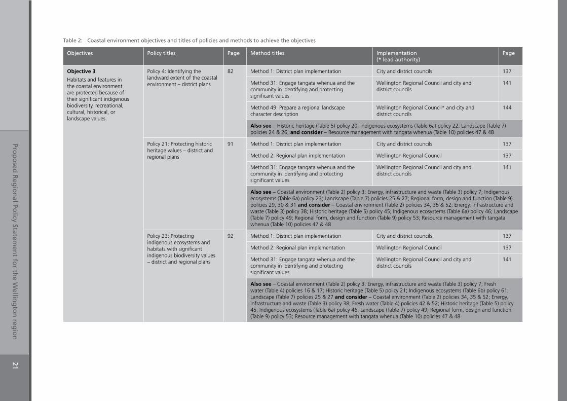
Table 2: Coastal environment Objectives 3, 4 & 5
Table 2: Coastal environment Objective 6
Table 6a: Indigenous ecosystems Objective 16
Table 2: Coastal environment Objective 7
Table 8a: Natural hazards Objectives 18 & 19
Table 2: Coastal environment
Table 4: Fresh water Objective 8
Prop
osed
Reg
ion
al Policy Statem
ent fo
r the W
elling
ton
regio
n21
Table 2: Coastal environment objectives and titles of policies and methods to achieve the objectives
Objectives Policy titles Page Method titles Implementation (* lead authority)
Page
Objective 3
Habitats and features in the coastal environment are protected because of their significant indigenous biodiversity, recreational, cultural, historical, or landscape values.
Policy 4: Identifying the landward extent of the coastal environment – district plans
82 Method 1: District plan implementation City and district councils 137
Method 31: Engage tangata whenua and the community in identifying and protecting significant values
Wellington Regional Council and city and district councils
141
Method 49: Prepare a regional landscape character description
Wellington Regional Council* and city and district councils
144
Also see – Historic heritage (Table 5) policy 20; Indigenous ecosystems (Table 6a) policy 22; Landscape (Table 7) policies 24 & 26; and consider – Resource management with tangata whenua (Table 10) policies 47 & 48
Policy 21: Protecting historic heritage values – district and regional plans
91 Method 1: District plan implementation City and district councils 137
Method 2: Regional plan implementation Wellington Regional Council 137
Method 31: Engage tangata whenua and the community in identifying and protecting significant values
Wellington Regional Council and city and district councils
141
Also see – Coastal environment (Table 2) policy 3; Energy, infrastructure and waste (Table 3) policy 7; Indigenous ecosystems (Table 6a) policy 23; Landscape (Table 7) policies 25 & 27; Regional form, design and function (Table 9) policies 29, 30 & 31 and consider – Coastal environment (Table 2) policies 34, 35 & 52; Energy, infrastructure and waste (Table 3) policy 38; Historic heritage (Table 5) policy 45; Indigenous ecosystems (Table 6a) policy 46; Landscape (Table 7) policy 49; Regional form, design and function (Table 9) policy 53; Resource management with tangata whenua (Table 10) policies 47 & 48
Policy 23: Protecting indigenous ecosystems and habitats with significant indigenous biodiversity values – district and regional plans
92 Method 1: District plan implementation City and district councils 137
Method 2: Regional plan implementation Wellington Regional Council 137
Method 31: Engage tangata whenua and the community in identifying and protecting significant values
Wellington Regional Council and city and district councils
141
Also see – Coastal environment (Table 2) policy 3; Energy, infrastructure and waste (Table 3) policy 7; Fresh water (Table 4) policies 16 & 17; Historic heritage (Table 5) policy 21; Indigenous ecosystems (Table 6b) policy 61; Landscape (Table 7) policies 25 & 27 and consider – Coastal environment (Table 2) policies 34, 35 & 52; Energy, infrastructure and waste (Table 3) policy 38; Fresh water (Table 4) policies 42 & 52; Historic heritage (Table 5) policy 45; Indigenous ecosystems (Table 6a) policy 46; Landscape (Table 7) policy 49; Regional form, design and function (Table 9) policy 53; Resource management with tangata whenua (Table 10) policies 47 & 48
Prop
osed
Reg
ion
al Policy Statem
ent fo
r the W
elling
ton
regio
n22
Objectives Policy titles Page Method titles Implementation (* lead authority)
Page
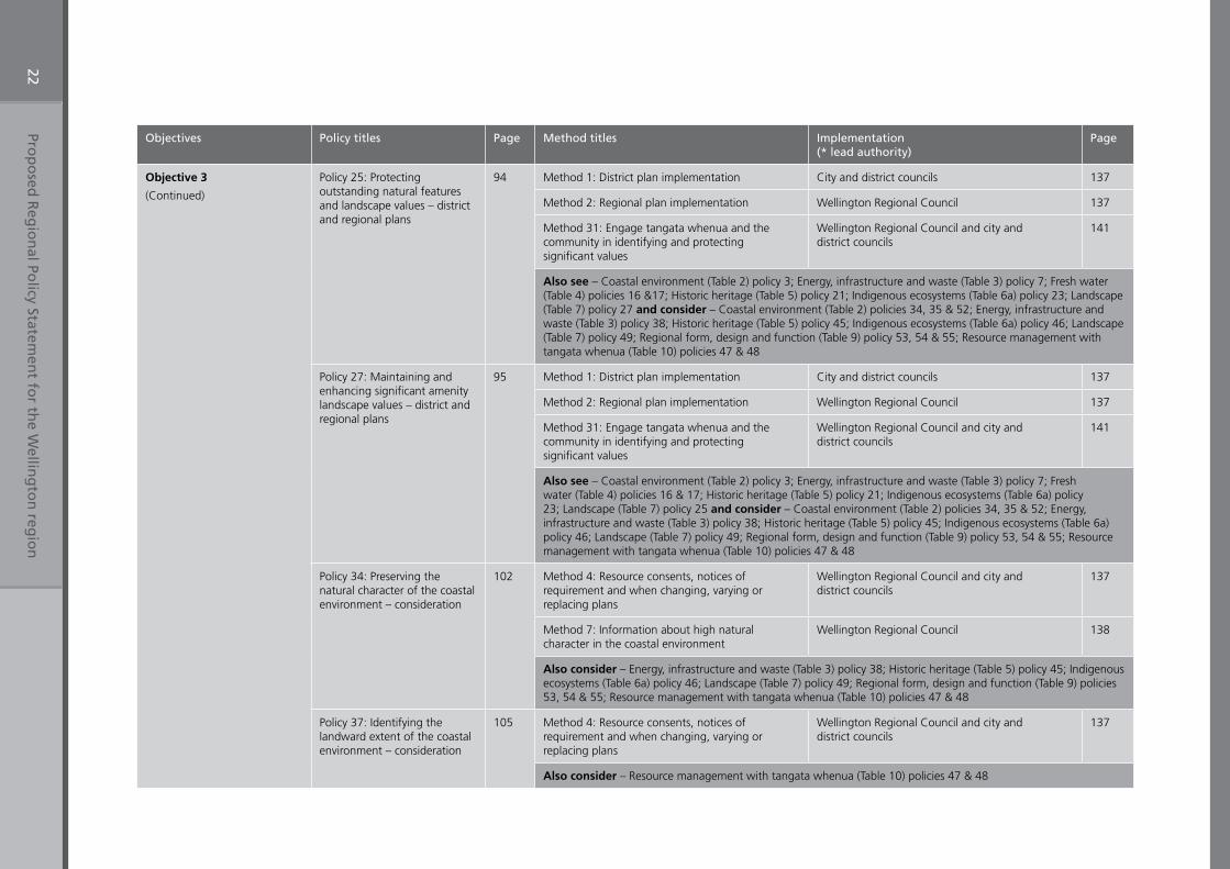
Objective 3
(Continued)
Policy 25: Protecting outstanding natural features and landscape values – district and regional plans
94 Method 1: District plan implementation City and district councils 137
Method 2: Regional plan implementation Wellington Regional Council 137
Method 31: Engage tangata whenua and the community in identifying and protecting significant values
Wellington Regional Council and city and district councils
141
Also see – Coastal environment (Table 2) policy 3; Energy, infrastructure and waste (Table 3) policy 7; Fresh water (Table 4) policies 16 &17; Historic heritage (Table 5) policy 21; Indigenous ecosystems (Table 6a) policy 23; Landscape (Table 7) policy 27 and consider – Coastal environment (Table 2) policies 34, 35 & 52; Energy, infrastructure and waste (Table 3) policy 38; Historic heritage (Table 5) policy 45; Indigenous ecosystems (Table 6a) policy 46; Landscape (Table 7) policy 49; Regional form, design and function (Table 9) policy 53, 54 & 55; Resource management with tangata whenua (Table 10) policies 47 & 48
Policy 27: Maintaining and enhancing significant amenity landscape values – district and regional plans
95 Method 1: District plan implementation City and district councils 137
Method 2: Regional plan implementation Wellington Regional Council 137
Method 31: Engage tangata whenua and the community in identifying and protecting significant values
Wellington Regional Council and city and district councils
141
Also see – Coastal environment (Table 2) policy 3; Energy, infrastructure and waste (Table 3) policy 7; Fresh water (Table 4) policies 16 & 17; Historic heritage (Table 5) policy 21; Indigenous ecosystems (Table 6a) policy 23; Landscape (Table 7) policy 25 and consider – Coastal environment (Table 2) policies 34, 35 & 52; Energy, infrastructure and waste (Table 3) policy 38; Historic heritage (Table 5) policy 45; Indigenous ecosystems (Table 6a) policy 46; Landscape (Table 7) policy 49; Regional form, design and function (Table 9) policy 53, 54 & 55; Resource management with tangata whenua (Table 10) policies 47 & 48
Policy 34: Preserving the natural character of the coastal environment – consideration
102 Method 4: Resource consents, notices of requirement and when changing, varying or replacing plans
Wellington Regional Council and city and district councils
137
Method 7: Information about high natural character in the coastal environment
Wellington Regional Council 138
Also consider – Energy, infrastructure and waste (Table 3) policy 38; Historic heritage (Table 5) policy 45; Indigenous ecosystems (Table 6a) policy 46; Landscape (Table 7) policy 49; Regional form, design and function (Table 9) policies 53, 54 & 55; Resource management with tangata whenua (Table 10) policies 47 & 48
Policy 37: Identifying the landward extent of the coastal environment – consideration
105 Method 4: Resource consents, notices of requirement and when changing, varying or replacing plans
Wellington Regional Council and city and district councils
137
Also consider – Resource management with tangata whenua (Table 10) policies 47 & 48
Prop
osed
Reg
ion
al Policy Statem
ent fo
r the W
elling
ton
regio
n23
Objectives Policy titles Page Method titles Implementation (* lead authority)
Page
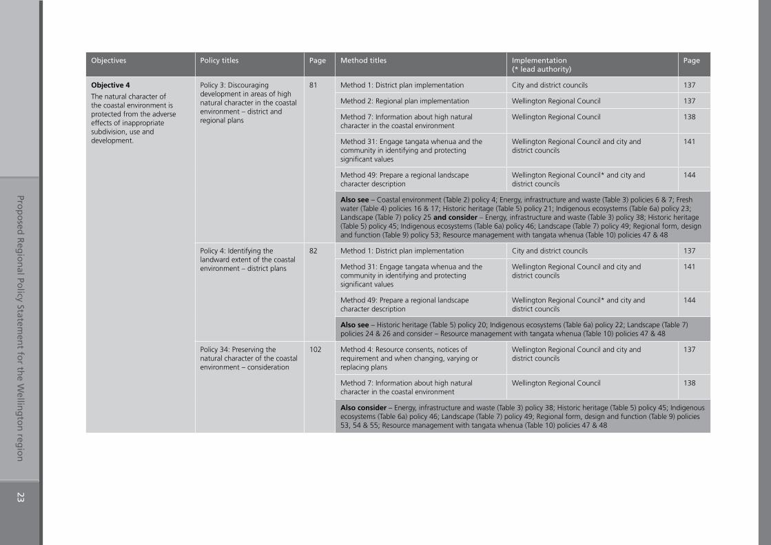
Objective 4
The natural character of the coastal environment is protected from the adverse effects of inappropriate subdivision, use and development.
Policy 3: Discouraging development in areas of high natural character in the coastal environment – district and regional plans
81 Method 1: District plan implementation City and district councils 137
Method 2: Regional plan implementation Wellington Regional Council 137
Method 7: Information about high natural character in the coastal environment
Wellington Regional Council 138
Method 31: Engage tangata whenua and the community in identifying and protecting significant values
Wellington Regional Council and city and district councils
141
Method 49: Prepare a regional landscape character description
Wellington Regional Council* and city and district councils
144
Also see – Coastal environment (Table 2) policy 4; Energy, infrastructure and waste (Table 3) policies 6 & 7; Fresh water (Table 4) policies 16 & 17; Historic heritage (Table 5) policy 21; Indigenous ecosystems (Table 6a) policy 23; Landscape (Table 7) policy 25 and consider – Energy, infrastructure and waste (Table 3) policy 38; Historic heritage (Table 5) policy 45; Indigenous ecosystems (Table 6a) policy 46; Landscape (Table 7) policy 49; Regional form, design and function (Table 9) policy 53; Resource management with tangata whenua (Table 10) policies 47 & 48
Policy 4: Identifying the landward extent of the coastal environment – district plans
82 Method 1: District plan implementation City and district councils 137
Method 31: Engage tangata whenua and the community in identifying and protecting significant values
Wellington Regional Council and city and district councils
141
Method 49: Prepare a regional landscape character description
Wellington Regional Council* and city and district councils
144
Also see – Historic heritage (Table 5) policy 20; Indigenous ecosystems (Table 6a) policy 22; Landscape (Table 7) policies 24 & 26 and consider – Resource management with tangata whenua (Table 10) policies 47 & 48
Policy 34: Preserving the natural character of the coastal environment – consideration
102 Method 4: Resource consents, notices of requirement and when changing, varying or replacing plans
Wellington Regional Council and city and district councils
137
Method 7: Information about high natural character in the coastal environment
Wellington Regional Council 138
Also consider – Energy, infrastructure and waste (Table 3) policy 38; Historic heritage (Table 5) policy 45; Indigenous ecosystems (Table 6a) policy 46; Landscape (Table 7) policy 49; Regional form, design and function (Table 9) policies 53, 54 & 55; Resource management with tangata whenua (Table 10) policies 47 & 48
Prop
osed
Reg
ion
al Policy Statem
ent fo
r the W
elling
ton
regio
n24
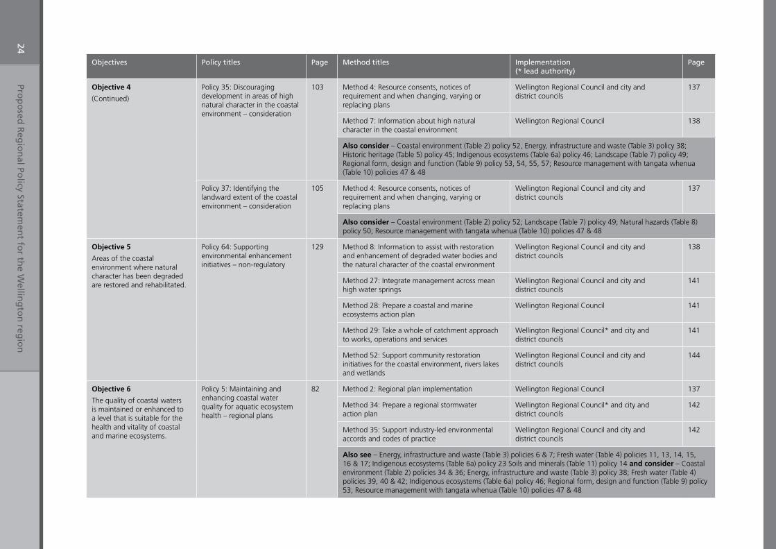
Objectives Policy titles Page Method titles Implementation (* lead authority)
Page
Objective 4
(Continued)
Policy 35: Discouraging development in areas of high natural character in the coastal environment – consideration
103 Method 4: Resource consents, notices of requirement and when changing, varying or replacing plans
Wellington Regional Council and city and district councils
137
Method 7: Information about high natural character in the coastal environment
Wellington Regional Council 138
Also consider – Coastal environment (Table 2) policy 52, Energy, infrastructure and waste (Table 3) policy 38; Historic heritage (Table 5) policy 45; Indigenous ecosystems (Table 6a) policy 46; Landscape (Table 7) policy 49; Regional form, design and function (Table 9) policy 53, 54, 55, 57; Resource management with tangata whenua (Table 10) policies 47 & 48
Policy 37: Identifying the landward extent of the coastal environment – consideration
105 Method 4: Resource consents, notices of requirement and when changing, varying or replacing plans
Wellington Regional Council and city and district councils
137
Also consider – Coastal environment (Table 2) policy 52; Landscape (Table 7) policy 49; Natural hazards (Table 8) policy 50; Resource management with tangata whenua (Table 10) policies 47 & 48
Objective 5
Areas of the coastal environment where natural character has been degraded are restored and rehabilitated.
Policy 64: Supporting environmental enhancement initiatives – non-regulatory
129 Method 8: Information to assist with restoration and enhancement of degraded water bodies and the natural character of the coastal environment
Wellington Regional Council and city and district councils
138
Method 27: Integrate management across mean high water springs
Wellington Regional Council and city and district councils
141
Method 28: Prepare a coastal and marine ecosystems action plan
Wellington Regional Council 141
Method 29: Take a whole of catchment approach to works, operations and services
Wellington Regional Council* and city and district councils
141
Method 52: Support community restoration initiatives for the coastal environment, rivers lakes and wetlands
Wellington Regional Council and city and district councils
144
Objective 6
The quality of coastal waters is maintained or enhanced to a level that is suitable for the health and vitality of coastal and marine ecosystems.
Policy 5: Maintaining and enhancing coastal water quality for aquatic ecosystem health – regional plans
82 Method 2: Regional plan implementation Wellington Regional Council 137
Method 34: Prepare a regional stormwater action plan
Wellington Regional Council* and city and district councils
142
Method 35: Support industry-led environmental accords and codes of practice
Wellington Regional Council and city and district councils
142
Also see – Energy, infrastructure and waste (Table 3) policies 6 & 7; Fresh water (Table 4) policies 11, 13, 14, 15, 16 & 17; Indigenous ecosystems (Table 6a) policy 23 Soils and minerals (Table 11) policy 14 and consider – Coastal environment (Table 2) policies 34 & 36; Energy, infrastructure and waste (Table 3) policy 38; Fresh water (Table 4) policies 39, 40 & 42; Indigenous ecosystems (Table 6a) policy 46; Regional form, design and function (Table 9) policy 53; Resource management with tangata whenua (Table 10) policies 47 & 48
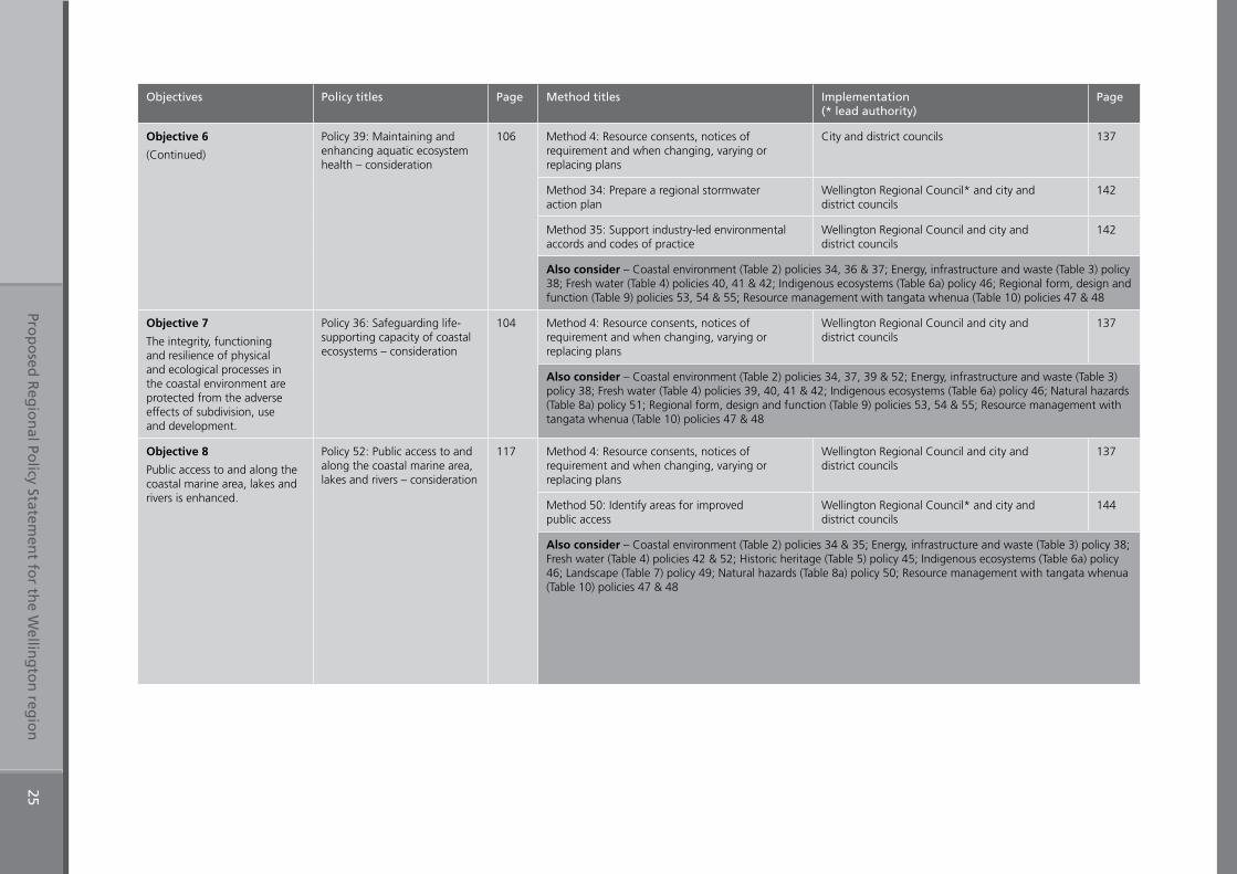
Prop
osed
Reg
ion
al Policy Statem
ent fo
r the W
elling
ton
regio
n25
Objectives Policy titles Page Method titles Implementation (* lead authority)
Page
Objective 6
(Continued)
Policy 39: Maintaining and enhancing aquatic ecosystem health – consideration
106 Method 4: Resource consents, notices of requirement and when changing, varying or replacing plans
City and district councils 137
Method 34: Prepare a regional stormwater action plan
Wellington Regional Council* and city and district councils
142
Method 35: Support industry-led environmental accords and codes of practice
Wellington Regional Council and city and district councils
142
Also consider – Coastal environment (Table 2) policies 34, 36 & 37; Energy, infrastructure and waste (Table 3) policy 38; Fresh water (Table 4) policies 40, 41 & 42; Indigenous ecosystems (Table 6a) policy 46; Regional form, design and function (Table 9) policies 53, 54 & 55; Resource management with tangata whenua (Table 10) policies 47 & 48
Objective 7
The integrity, functioning and resilience of physical and ecological processes in the coastal environment are protected from the adverse effects of subdivision, use and development.
Policy 36: Safeguarding life-supporting capacity of coastal ecosystems – consideration
104 Method 4: Resource consents, notices of requirement and when changing, varying or replacing plans
Wellington Regional Council and city and district councils
137
Also consider – Coastal environment (Table 2) policies 34, 37, 39 & 52; Energy, infrastructure and waste (Table 3) policy 38; Fresh water (Table 4) policies 39, 40, 41 & 42; Indigenous ecosystems (Table 6a) policy 46; Natural hazards (Table 8a) policy 51; Regional form, design and function (Table 9) policies 53, 54 & 55; Resource management with tangata whenua (Table 10) policies 47 & 48
Objective 8
Public access to and along the coastal marine area, lakes and rivers is enhanced.
Policy 52: Public access to and along the coastal marine area, lakes and rivers – consideration
117 Method 4: Resource consents, notices of requirement and when changing, varying or replacing plans
Wellington Regional Council and city and district councils
137
Method 50: Identify areas for improved public access
Wellington Regional Council* and city and district councils
144
Also consider – Coastal environment (Table 2) policies 34 & 35; Energy, infrastructure and waste (Table 3) policy 38; Fresh water (Table 4) policies 42 & 52; Historic heritage (Table 5) policy 45; Indigenous ecosystems (Table 6a) policy 46; Landscape (Table 7) policy 49; Natural hazards (Table 8a) policy 50; Resource management with tangata whenua (Table 10) policies 47 & 48
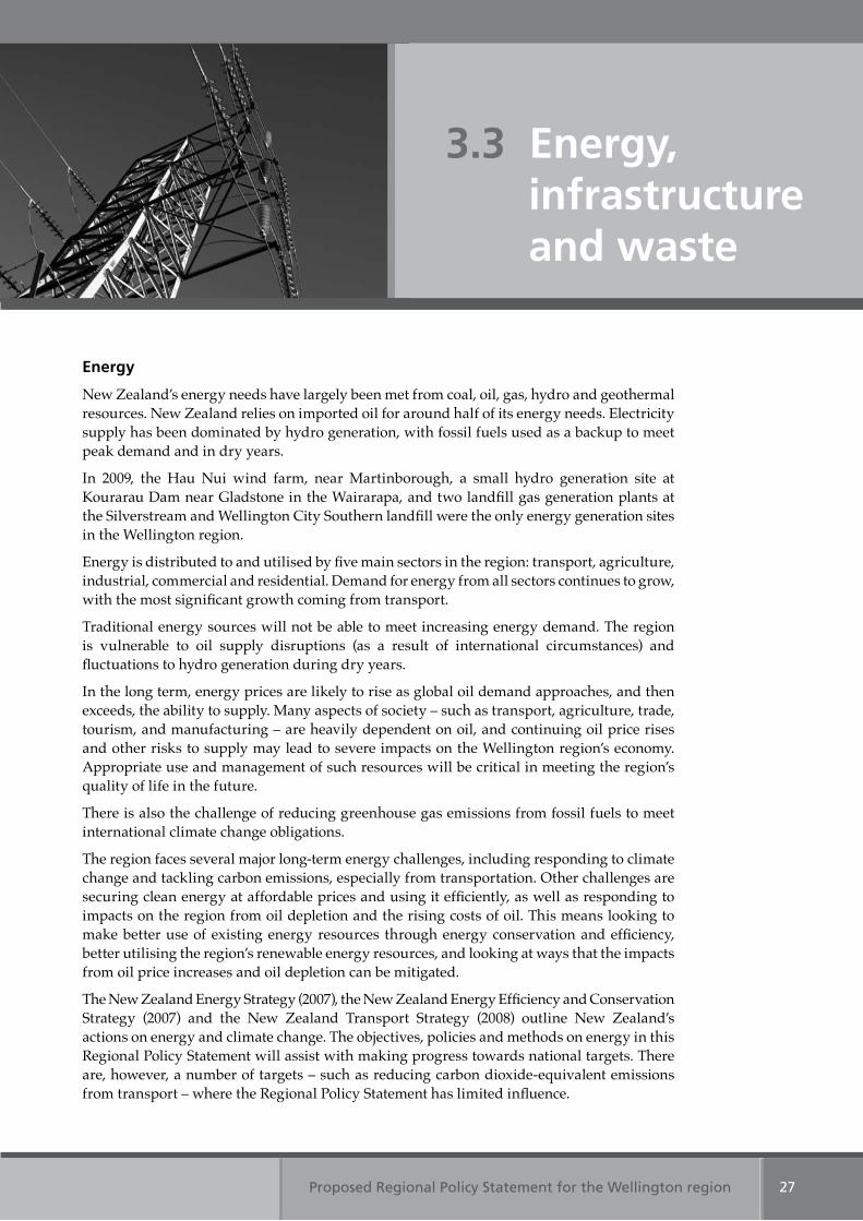
Proposed Regional Policy Statement for the Wellington region 27
Energy
New Zealand’s energy needs have largely been met from coal, oil, gas, hydro and geothermal resources. New Zealand relies on imported oil for around half of its energy needs. Electricity supply has been dominated by hydro generation, with fossil fuels used as a backup to meet peak demand and in dry years.
In 2009, the Hau Nui wind farm, near Martinborough, a small hydro generation site at Kourarau Dam near Gladstone in the Wairarapa, and two landfill gas generation plants at the Silverstream and Wellington City Southern landfill were the only energy generation sites in the Wellington region.
Energy is distributed to and utilised by five main sectors in the region: transport, agriculture, industrial, commercial and residential. Demand for energy from all sectors continues to grow, with the most significant growth coming from transport.
Traditional energy sources will not be able to meet increasing energy demand. The region is vulnerable to oil supply disruptions (as a result of international circumstances) and fluctuations to hydro generation during dry years.
In the long term, energy prices are likely to rise as global oil demand approaches, and then exceeds, the ability to supply. Many aspects of society – such as transport, agriculture, trade, tourism, and manufacturing – are heavily dependent on oil, and continuing oil price rises and other risks to supply may lead to severe impacts on the Wellington region’s economy. Appropriate use and management of such resources will be critical in meeting the region’s quality of life in the future.
There is also the challenge of reducing greenhouse gas emissions from fossil fuels to meet international climate change obligations.
The region faces several major long-term energy challenges, including responding to climate change and tackling carbon emissions, especially from transportation. Other challenges are securing clean energy at affordable prices and using it efficiently, as well as responding to impacts on the region from oil depletion and the rising costs of oil. This means looking to make better use of existing energy resources through energy conservation and efficiency, better utilising the region’s renewable energy resources, and looking at ways that the impacts from oil price increases and oil depletion can be mitigated.
The New Zealand Energy Strategy (2007), the New Zealand Energy Efficiency and Conservation Strategy (2007) and the New Zealand Transport Strategy (2008) outline New Zealand’s actions on energy and climate change. The objectives, policies and methods on energy in this Regional Policy Statement will assist with making progress towards national targets. There are, however, a number of targets – such as reducing carbon dioxide-equivalent emissions from transport – where the Regional Policy Statement has limited influence.
3.3 Energy, infrastructure and waste
Proposed Regional Policy Statement for the Wellington region28
The region contains significantly greater renewable energy resources than are currently used. Wind, biofuels and solar (for hot water systems), have been identified as possible renewable energy generation sources for the region. There is also the potential for small-scale renewable energy generation including small-scale hydro in the region. Tidal currents in Cook Strait and, to a lesser extent, wave action in Cook Strait and off the Wairarapa coast are also significant renewable energy resources, but technological advances are required to realise this potential.
Infrastructure
The transport network, airports, the port, telecommunication facilities, the rail network and other utilities, including energy transmission and distribution networks, are significant physical resources. This infrastructure forms part of national or regional networks and enables communities to provide for their social, economic, and cultural wellbeing and their health and safety. The efficient use and development of such infrastructure can be adversely affected by development. For example, land development can encroach on infrastructure or interfere with its efficient use.
The National Policy Statement on Electricity Transmission (2008) sets out objectives and policies to enable the management of effects on the electricity transmission network under the Resource Management Act. The Statement recognises that efficient and secure electricity transmission plays a vital role in the well-being of New Zealand and makes it explicit that electricity transmission is to be considered a matter of national significance.
Waste
Dealing with waste is a mounting problem because some of the resources discarded still have value, landfills use land that could be otherwise productive and landfill disposal has adverse effects on the environment. These can include reverse sensitivity effects, whereby a newly established activity may be adversely affected by an existing landfill and may need to protect itself from these effects.
Landfills should be the last resort for unwanted materials. This is because they produce leachate and methane gas from the degradation of materials and organic matter, and because landfill space is finite. In 2004 there were 10 municipal landfills in the Wellington region, in 2007 there were five, and two more will close over the next ten years.
The amount of waste needs to be reduced to ensure potentially valuable resources are used efficiently, reduce the need to develop new landfills and extend the life of existing landfills. In 2007 nearly 400,000 tonnes of material was sent to landfills in the Wellington region. At least 20 per cent and in some areas as much as 60 to 70 per cent could have been recycled or composted. This occurs because there is no market for the final product or there are no facilities in New Zealand to process the materials. While some materials are sent overseas for recycling or resource recovery, this option may not be viable in the long-term, so finding local solutions will become more important.
The Local Government Act requires city and district councils to prepare waste management plans that make provision for the collection and reduction, reuse, recycling, recovery, treatment, or disposal of waste in the district, and provide for its effective and efficient implementation. The Regional Policy Statement has no role in the development or implementation of waste management plans.
Proposed Regional Policy Statement for the Wellington region 29
Table 3: Energy, infrastructure and waste Objectives 9 & 10
Table 9: Regional form Objective 21
Table 3: Energy, infrastructure and waste Objective 11
Table 3: Energy, infrastructure and waste Objective 10
The regionally significant resource management issues for energy, infrastructure and waste are:
1. Energy The Wellington region is dependant on externally generated electricity and overseas-sourced fossil fuels and is therefore vulnerable to supply disruptions and energy shortages. However, significant renewable energy resources exist within the region.
2. InfrastructureInfrastructure enables communities to provide for their social, economic and cultural wellbeing. The management, use and operation of infrastructure can be adversely affected when incompatible land uses occur under, over, on, or alongside.
3. WasteWe cannot continue to generate the current waste volumes because of the costs of disposal, limited space in existing landfills and because it is inefficient to dispose of potentially valuable resources. Developing new landfills also poses significant challenges economically, environmentally and socially.
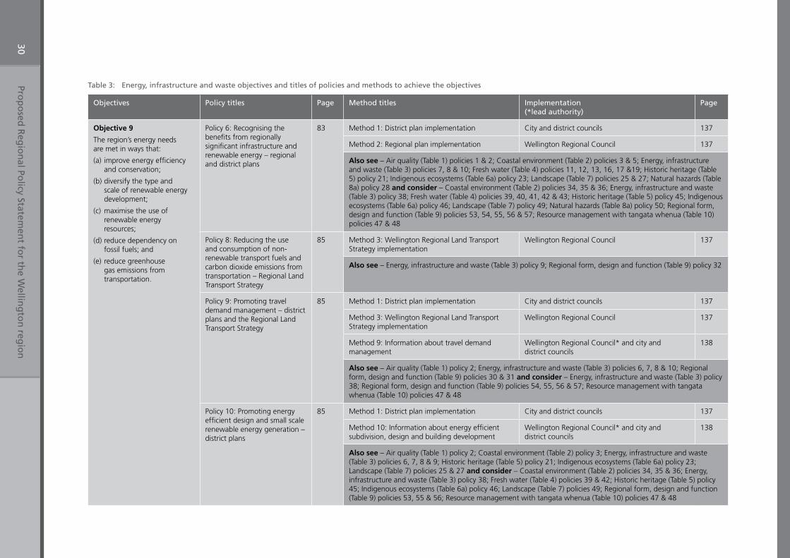
Prop
osed
Reg
ion
al Policy Statem
ent fo
r the W
elling
ton
regio
n30
Table 3: Energy, infrastructure and waste objectives and titles of policies and methods to achieve the objectives
Objectives Policy titles Page Method titles Implementation (*lead authority)
Page
Objective 9
The region’s energy needs are met in ways that:
(a) improve energy efficiency and conservation;
(b) diversify the type and scale of renewable energy development;
(c) maximise the use of renewable energy resources;
(d) reduce dependency on fossil fuels; and
(e) reduce greenhouse gas emissions from transportation.
Policy 6: Recognising the benefits from regionally significant infrastructure and renewable energy – regional and district plans
83 Method 1: District plan implementation City and district councils 137
Method 2: Regional plan implementation Wellington Regional Council 137
Also see – Air quality (Table 1) policies 1 & 2; Coastal environment (Table 2) policies 3 & 5; Energy, infrastructure and waste (Table 3) policies 7, 8 & 10; Fresh water (Table 4) policies 11, 12, 13, 16, 17 &19; Historic heritage (Table 5) policy 21; Indigenous ecosystems (Table 6a) policy 23; Landscape (Table 7) policies 25 & 27; Natural hazards (Table 8a) policy 28 and consider – Coastal environment (Table 2) policies 34, 35 & 36; Energy, infrastructure and waste (Table 3) policy 38; Fresh water (Table 4) policies 39, 40, 41, 42 & 43; Historic heritage (Table 5) policy 45; Indigenous ecosystems (Table 6a) policy 46; Landscape (Table 7) policy 49; Natural hazards (Table 8a) policy 50; Regional form, design and function (Table 9) policies 53, 54, 55, 56 & 57; Resource management with tangata whenua (Table 10) policies 47 & 48
Policy 8: Reducing the use and consumption of non-renewable transport fuels and carbon dioxide emissions from transportation – Regional Land Transport Strategy
85 Method 3: Wellington Regional Land Transport Strategy implementation
Wellington Regional Council 137
Also see – Energy, infrastructure and waste (Table 3) policy 9; Regional form, design and function (Table 9) policy 32
Policy 9: Promoting travel demand management – district plans and the Regional Land Transport Strategy
85 Method 1: District plan implementation City and district councils 137
Method 3: Wellington Regional Land Transport Strategy implementation
Wellington Regional Council 137
Method 9: Information about travel demand management
Wellington Regional Council* and city and district councils
138
Also see – Air quality (Table 1) policy 2; Energy, infrastructure and waste (Table 3) policies 6, 7, 8 & 10; Regional form, design and function (Table 9) policies 30 & 31 and consider – Energy, infrastructure and waste (Table 3) policy 38; Regional form, design and function (Table 9) policies 54, 55, 56 & 57; Resource management with tangata whenua (Table 10) policies 47 & 48
Policy 10: Promoting energy efficient design and small scale renewable energy generation – district plans
85 Method 1: District plan implementation City and district councils 137
Method 10: Information about energy efficient subdivision, design and building development
Wellington Regional Council* and city and district councils
138
Also see – Air quality (Table 1) policy 2; Coastal environment (Table 2) policy 3; Energy, infrastructure and waste (Table 3) policies 6, 7, 8 & 9; Historic heritage (Table 5) policy 21; Indigenous ecosystems (Table 6a) policy 23; Landscape (Table 7) policies 25 & 27 and consider – Coastal environment (Table 2) policies 34, 35 & 36; Energy, infrastructure and waste (Table 3) policy 38; Fresh water (Table 4) policies 39 & 42; Historic heritage (Table 5) policy 45; Indigenous ecosystems (Table 6a) policy 46; Landscape (Table 7) policies 49; Regional form, design and function (Table 9) policies 53, 55 & 56; Resource management with tangata whenua (Table 10) policies 47 & 48
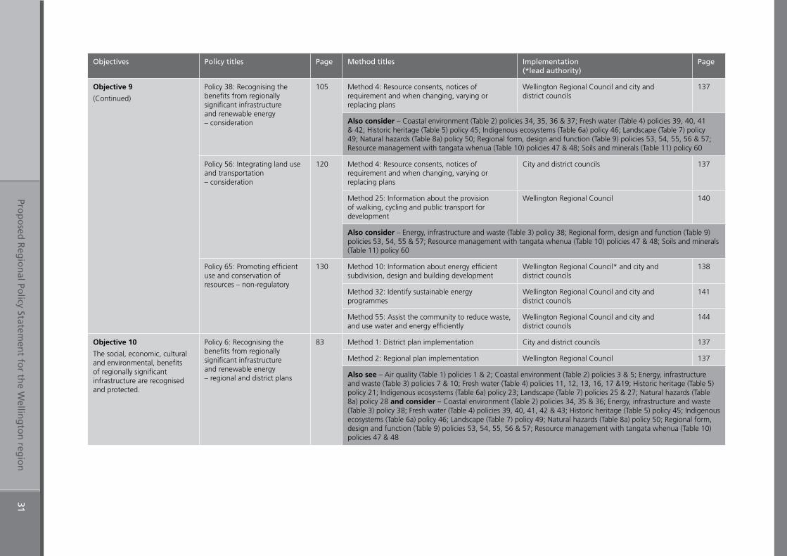
Prop
osed
Reg
ion
al Policy Statem
ent fo
r the W
elling
ton
regio
n31
Objectives Policy titles Page Method titles Implementation (*lead authority)
Page
Objective 9
(Continued)
Policy 38: Recognising the benefits from regionally significant infrastructure and renewable energy – consideration
105 Method 4: Resource consents, notices of requirement and when changing, varying or replacing plans
Wellington Regional Council and city and district councils
137
Also consider – Coastal environment (Table 2) policies 34, 35, 36 & 37; Fresh water (Table 4) policies 39, 40, 41 & 42; Historic heritage (Table 5) policy 45; Indigenous ecosystems (Table 6a) policy 46; Landscape (Table 7) policy 49; Natural hazards (Table 8a) policy 50; Regional form, design and function (Table 9) policies 53, 54, 55, 56 & 57; Resource management with tangata whenua (Table 10) policies 47 & 48; Soils and minerals (Table 11) policy 60
Policy 56: Integrating land use and transportation – consideration
120 Method 4: Resource consents, notices of requirement and when changing, varying or replacing plans
City and district councils 137
Method 25: Information about the provision of walking, cycling and public transport for development
Wellington Regional Council 140
Also consider – Energy, infrastructure and waste (Table 3) policy 38; Regional form, design and function (Table 9) policies 53, 54, 55 & 57; Resource management with tangata whenua (Table 10) policies 47 & 48; Soils and minerals (Table 11) policy 60
Policy 65: Promoting efficient use and conservation of resources – non-regulatory
130 Method 10: Information about energy efficient subdivision, design and building development
Wellington Regional Council* and city and district councils
138
Method 32: Identify sustainable energy programmes
Wellington Regional Council and city and district councils
141
Method 55: Assist the community to reduce waste, and use water and energy efficiently
Wellington Regional Council and city and district councils
144
Objective 10
The social, economic, cultural and environmental, benefits of regionally significant infrastructure are recognised and protected.
Policy 6: Recognising the benefits from regionally significant infrastructure and renewable energy – regional and district plans
83 Method 1: District plan implementation City and district councils 137
Method 2: Regional plan implementation Wellington Regional Council 137
Also see – Air quality (Table 1) policies 1 & 2; Coastal environment (Table 2) policies 3 & 5; Energy, infrastructure and waste (Table 3) policies 7 & 10; Fresh water (Table 4) policies 11, 12, 13, 16, 17 &19; Historic heritage (Table 5) policy 21; Indigenous ecosystems (Table 6a) policy 23; Landscape (Table 7) policies 25 & 27; Natural hazards (Table 8a) policy 28 and consider – Coastal environment (Table 2) policies 34, 35 & 36; Energy, infrastructure and waste (Table 3) policy 38; Fresh water (Table 4) policies 39, 40, 41, 42 & 43; Historic heritage (Table 5) policy 45; Indigenous ecosystems (Table 6a) policy 46; Landscape (Table 7) policy 49; Natural hazards (Table 8a) policy 50; Regional form, design and function (Table 9) policies 53, 54, 55, 56 & 57; Resource management with tangata whenua (Table 10) policies 47 & 48
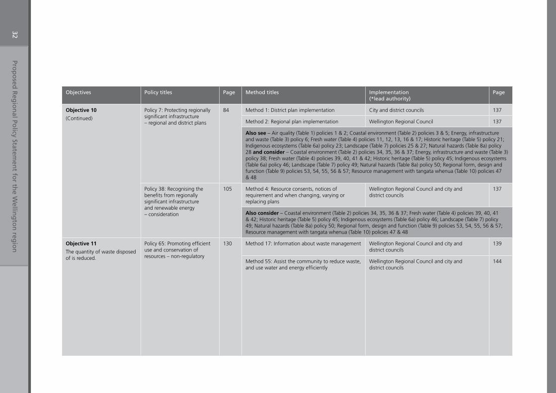
Prop
osed
Reg
ion
al Policy Statem
ent fo
r the W
elling
ton
regio
n32
Objectives Policy titles Page Method titles Implementation (*lead authority)
Page
Objective 10
(Continued)
Policy 7: Protecting regionally significant infrastructure – regional and district plans
84 Method 1: District plan implementation City and district councils 137
Method 2: Regional plan implementation Wellington Regional Council 137
Also see – Air quality (Table 1) policies 1 & 2; Coastal environment (Table 2) policies 3 & 5; Energy, infrastructure and waste (Table 3) policy 6; Fresh water (Table 4) policies 11, 12, 13, 16 & 17; Historic heritage (Table 5) policy 21; Indigenous ecosystems (Table 6a) policy 23; Landscape (Table 7) policies 25 & 27; Natural hazards (Table 8a) policy 28 and consider – Coastal environment (Table 2) policies 34, 35, 36 & 37; Energy, infrastructure and waste (Table 3) policy 38; Fresh water (Table 4) policies 39, 40, 41 & 42; Historic heritage (Table 5) policy 45; Indigenous ecosystems (Table 6a) policy 46; Landscape (Table 7) policy 49; Natural hazards (Table 8a) policy 50; Regional form, design and function (Table 9) policies 53, 54, 55, 56 & 57; Resource management with tangata whenua (Table 10) policies 47 & 48
Policy 38: Recognising the benefits from regionally significant infrastructure and renewable energy – consideration
105 Method 4: Resource consents, notices of requirement and when changing, varying or replacing plans
Wellington Regional Council and city and district councils
137
Also consider – Coastal environment (Table 2) policies 34, 35, 36 & 37; Fresh water (Table 4) policies 39, 40, 41 & 42; Historic heritage (Table 5) policy 45; Indigenous ecosystems (Table 6a) policy 46; Landscape (Table 7) policy 49; Natural hazards (Table 8a) policy 50; Regional form, design and function (Table 9) policies 53, 54, 55, 56 & 57; Resource management with tangata whenua (Table 10) policies 47 & 48
Objective 11
The quantity of waste disposed of is reduced.
Policy 65: Promoting efficient use and conservation of resources – non-regulatory
130 Method 17: Information about waste management Wellington Regional Council and city and district councils
139
Method 55: Assist the community to reduce waste, and use water and energy efficiently
Wellington Regional Council and city and district councils
144
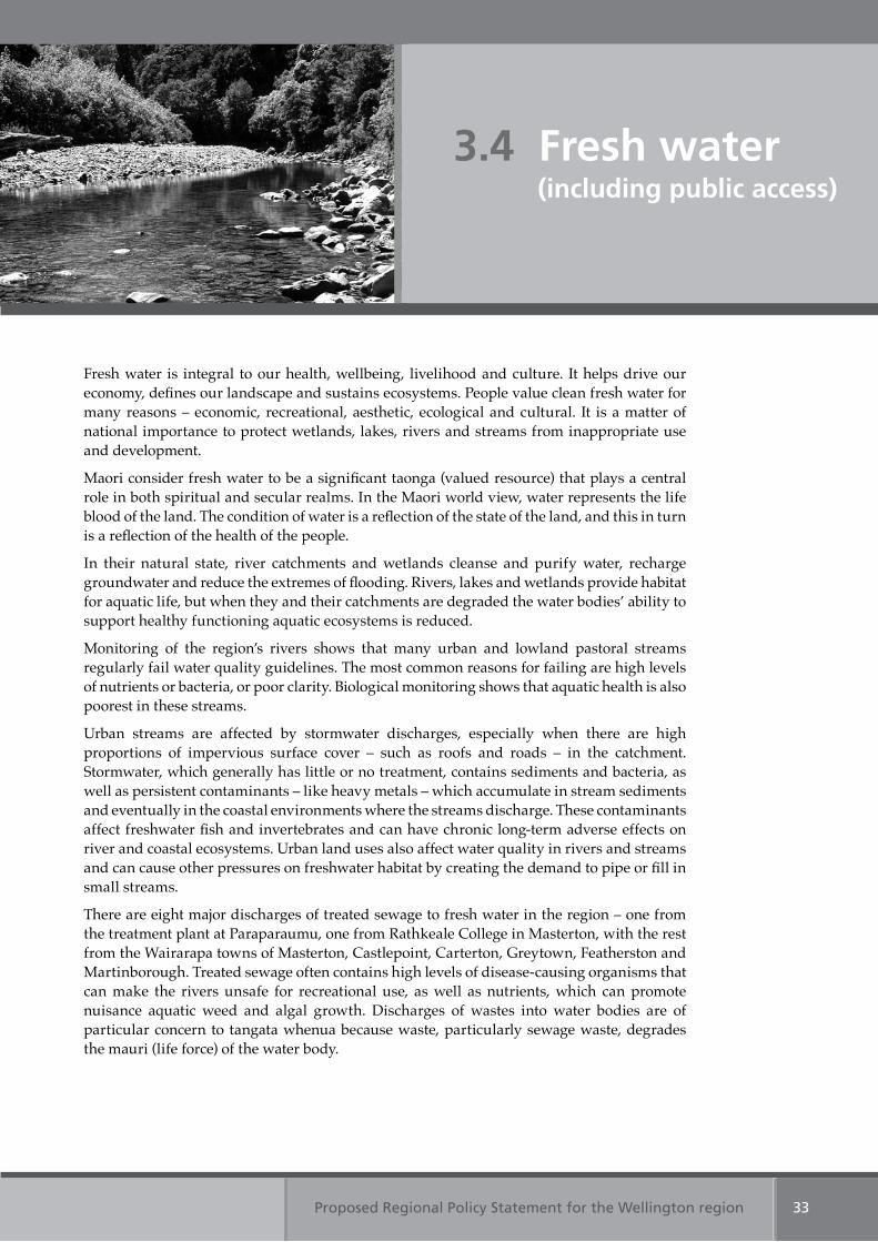
Proposed Regional Policy Statement for the Wellington region 33
3.4 Fresh water (including public access)
Fresh water is integral to our health, wellbeing, livelihood and culture. It helps drive our economy, defines our landscape and sustains ecosystems. People value clean fresh water for many reasons – economic, recreational, aesthetic, ecological and cultural. It is a matter of national importance to protect wetlands, lakes, rivers and streams from inappropriate use and development.
Maori consider fresh water to be a significant taonga (valued resource) that plays a central role in both spiritual and secular realms. In the Maori world view, water represents the life blood of the land. The condition of water is a reflection of the state of the land, and this in turn is a reflection of the health of the people.
In their natural state, river catchments and wetlands cleanse and purify water, recharge groundwater and reduce the extremes of flooding. Rivers, lakes and wetlands provide habitat for aquatic life, but when they and their catchments are degraded the water bodies’ ability to support healthy functioning aquatic ecosystems is reduced.
Monitoring of the region’s rivers shows that many urban and lowland pastoral streams regularly fail water quality guidelines. The most common reasons for failing are high levels of nutrients or bacteria, or poor clarity. Biological monitoring shows that aquatic health is also poorest in these streams.
Urban streams are affected by stormwater discharges, especially when there are high proportions of impervious surface cover – such as roofs and roads – in the catchment. Stormwater, which generally has little or no treatment, contains sediments and bacteria, as well as persistent contaminants – like heavy metals – which accumulate in stream sediments and eventually in the coastal environments where the streams discharge. These contaminants affect freshwater fish and invertebrates and can have chronic long-term adverse effects on river and coastal ecosystems. Urban land uses also affect water quality in rivers and streams and can cause other pressures on freshwater habitat by creating the demand to pipe or fill in small streams.
There are eight major discharges of treated sewage to fresh water in the region – one from the treatment plant at Paraparaumu, one from Rathkeale College in Masterton, with the rest from the Wairarapa towns of Masterton, Castlepoint, Carterton, Greytown, Featherston and Martinborough. Treated sewage often contains high levels of disease-causing organisms that can make the rivers unsafe for recreational use, as well as nutrients, which can promote nuisance aquatic weed and algal growth. Discharges of wastes into water bodies are of particular concern to tangata whenua because waste, particularly sewage waste, degrades the mauri (life force) of the water body.
Proposed Regional Policy Statement for the Wellington region34
Land uses affect the state of rivers and streams and, consequently, the coast. Nearly half the land in the region is used for agriculture. Rivers and streams in these catchments have poor biological health and water quality, and are more likely to suffer from algal growth in late summer when conditions are driest and warmest, and river flows are at their lowest. Groundwater around Te Horo, Otaki and in the Wairarapa valley is also affected by land uses, and in some areas has elevated levels of nitrate. This could be from farming or from septic tanks.
Accommodating people’s needs for water is becoming more and more difficult because some water resources in the region are already fully allocated and others are close to full allocation. In the Wairarapa, the amount of water taken for farm pasture irrigation has more than doubled over the last 10 years and increasing populations in the region’s urban areas means demand for water supply is expected to increase. The pressure on water resources is also likely to increase as a result of climate change. Some predicted effects are that the central and eastern Wairarapa will become drier, and droughts will occur more frequently and persist for longer periods.
Groundwater levels in some Wairarapa aquifers are declining year by year. Lowered groundwater levels can affect the flow of springs and rivers and streams, and water levels in wetlands, which can eventually dry up. If continued abstractions keep the groundwater level low, the dependent ecosystems can be permanently affected.
Prolonged low flows in rivers mean there is less habitat available for aquatic life and the adverse effects of contamination are worse because of reduced dilution. Low flows in summer mean water temperatures and algal growths increase, especially if there is no riparian vegetation. Because people’s need to take water is greatest at times of low rainfall, abstractions generally lower river flows when aquatic life is already stressed.
The introduction and spread of aquatic pests are a threat to the health of aquatic ecosystems. In wetlands, exotic plants such as willows and blackberry can displace wetland plants and do not provide suitable habitat for wetland species. Pests – such as didymo and pest fish – also have potential for significant adverse effects.
It is a matter of national importance to maintain and enhance public access to and along rivers and lakes. There is little information about the state of public access to rivers and lakes in the region. Where land is publicly owned, public access has generally been enhanced with the provision of walking tracks and recreational areas. For example, major rivers such as the Hutt, Waikanae and Ruamahanga, which are managed for flood protection or soil conservation purposes, have good access for recreational use.
Where land is privately owned, city and district councils can take esplanade reserves or strips as part of subdivisions. To date, there has been no strategic planning in the region that has identified where public access should be enhanced. Where esplanade reserves and strips have been taken for public access, city and district councils sometimes struggle to maintain them. Even where there is legal access, it is not always aligned with access that is physically possible.
Proposed Regional Policy Statement for the Wellington region 35
Table 4: Fresh water Objective 12
Table 4: Fresh water Objectives 12 & 13;
Table 6a: Indigenous ecosystems Objective 16
The regionally significant resource management issues for fresh water are:
1. Pollution is affecting water quality in water bodiesThe water quality of rivers and streams, lakes, wetlands and groundwater in the region is being polluted by discharges and by intensive land uses.
2. Poor ecosystem function in rivers, lakes and wetlands The ecosystem function of some rivers, lakes and wetlands has been impaired, with some wetland and lowland stream ecosystems coming under particular pressure. Some activities that can impair ecosystem function are:
(a) filling in gullies and ephemeral streams and straightening or piping small streams(b) lining stream banks and beds with rock or concrete (c) removing streamside vegetation(d) works in rivers, particularly during low flows(e) the introduction and spread of aquatic pests, including didymo and pest fish, and
weeds in wetlands which displace wetland plants(f) stock access to river and stream beds, lake beds and wetlands, and their margins(g) creating impermeable land within a catchment through asphalting, concreting and
building structures(h) taking water from rivers and groundwater connected to rivers, wetlands and springs.
3. There is increasing demand on limited water resources There is a limited amount of water in rivers and groundwater aquifers available for human use and demand is increasing. The amount of water taken for farm pasture irrigation has more than doubled over the last 10 years. Increasing populations in the region’s urban areas also mean increased demand for water.
An additional issue shared with the coastal environment is:
4. Public access to and along the coastal marine area, lakes and riversThere have been inconsistent approaches to the taking of access strips or esplanade reserves as part of subdivisions. This has meant that public access to and along the coastal marine area, lakes and rivers is not always provided, or has been provided in places where people can not take advantage of it. Even where physical access is available, it is not always possible if access ways are not well maintained.
Table 2: Coastal environment
Table 4: Fresh water Objective 8
Table 4: Fresh water Objective 14
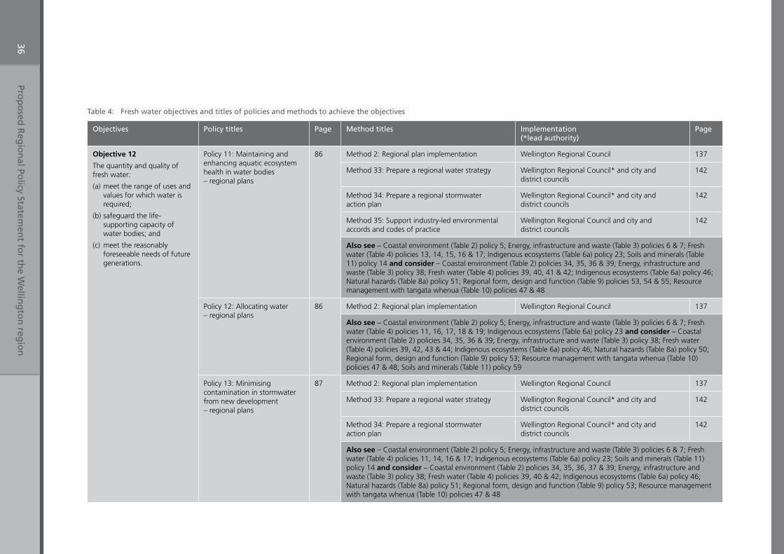
Prop
osed
Reg
ion
al Policy Statem
ent fo
r the W
elling
ton
regio
n36
Table 4: Fresh water objectives and titles of policies and methods to achieve the objectives
Objectives Policy titles Page Method titles Implementation (*lead authority)
Page
Objective 12
The quantity and quality of fresh water:
(a) meet the range of uses and values for which water is required;
(b) safeguard the life-supporting capacity of water bodies; and
(c) meet the reasonably foreseeable needs of future generations.
Policy 11: Maintaining and enhancing aquatic ecosystem health in water bodies – regional plans
86 Method 2: Regional plan implementation Wellington Regional Council 137
Method 33: Prepare a regional water strategy Wellington Regional Council* and city and district councils
142
Method 34: Prepare a regional stormwater action plan
Wellington Regional Council* and city and district councils
142
Method 35: Support industry-led environmental accords and codes of practice
Wellington Regional Council and city and district councils
142
Also see – Coastal environment (Table 2) policy 5; Energy, infrastructure and waste (Table 3) policies 6 & 7; Fresh water (Table 4) policies 13, 14, 15, 16 & 17; Indigenous ecosystems (Table 6a) policy 23; Soils and minerals (Table 11) policy 14 and consider – Coastal environment (Table 2) policies 34, 35, 36 & 39; Energy, infrastructure and waste (Table 3) policy 38; Fresh water (Table 4) policies 39, 40, 41 & 42; Indigenous ecosystems (Table 6a) policy 46; Natural hazards (Table 8a) policy 51; Regional form, design and function (Table 9) policies 53, 54 & 55; Resource management with tangata whenua (Table 10) policies 47 & 48
Policy 12: Allocating water – regional plans
86 Method 2: Regional plan implementation Wellington Regional Council 137
Also see – Coastal environment (Table 2) policy 5; Energy, infrastructure and waste (Table 3) policies 6 & 7; Fresh water (Table 4) policies 11, 16, 17, 18 & 19; Indigenous ecosystems (Table 6a) policy 23 and consider – Coastal environment (Table 2) policies 34, 35, 36 & 39; Energy, infrastructure and waste (Table 3) policy 38; Fresh water (Table 4) policies 39, 42, 43 & 44; Indigenous ecosystems (Table 6a) policy 46; Natural hazards (Table 8a) policy 50; Regional form, design and function (Table 9) policy 53; Resource management with tangata whenua (Table 10) policies 47 & 48; Soils and minerals (Table 11) policy 59
Policy 13: Minimising contamination in stormwater from new development – regional plans
87 Method 2: Regional plan implementation Wellington Regional Council 137
Method 33: Prepare a regional water strategy Wellington Regional Council* and city and district councils
142
Method 34: Prepare a regional stormwater action plan
Wellington Regional Council* and city and district councils
142
Also see – Coastal environment (Table 2) policy 5; Energy, infrastructure and waste (Table 3) policies 6 & 7; Fresh water (Table 4) policies 11, 14, 16 & 17; Indigenous ecosystems (Table 6a) policy 23; Soils and minerals (Table 11) policy 14 and consider – Coastal environment (Table 2) policies 34, 35, 36, 37 & 39; Energy, infrastructure and waste (Table 3) policy 38; Fresh water (Table 4) policies 39, 40 & 42; Indigenous ecosystems (Table 6a) policy 46; Natural hazards (Table 8a) policy 51; Regional form, design and function (Table 9) policy 53; Resource management with tangata whenua (Table 10) policies 47 & 48
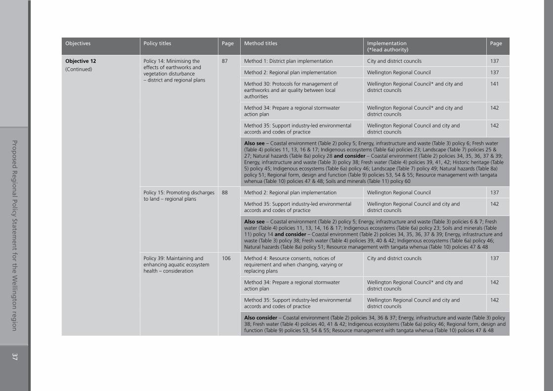
Prop
osed
Reg
ion
al Policy Statem
ent fo
r the W
elling
ton
regio
n37
Objectives Policy titles Page Method titles Implementation (*lead authority)
Page
Objective 12
(Continued)
Policy 14: Minimising the effects of earthworks and vegetation disturbance – district and regional plans
87 Method 1: District plan implementation City and district councils 137
Method 2: Regional plan implementation Wellington Regional Council 137
Method 30: Protocols for management of earthworks and air quality between local authorities
Wellington Regional Council* and city and district councils
141
Method 34: Prepare a regional stormwater action plan
Wellington Regional Council* and city and district councils
142
Method 35: Support industry-led environmental accords and codes of practice
Wellington Regional Council and city and district councils
142
Also see – Coastal environment (Table 2) policy 5; Energy, infrastructure and waste (Table 3) policy 6; Fresh water (Table 4) policies 11, 13, 16 & 17; Indigenous ecosystems (Table 6a) policies 23; Landscape (Table 7) policies 25 & 27; Natural hazards (Table 8a) policy 28 and consider – Coastal environment (Table 2) policies 34, 35, 36, 37 & 39; Energy, infrastructure and waste (Table 3) policy 38; Fresh water (Table 4) policies 39, 41, 42; Historic heritage (Table 5) policy 45; Indigenous ecosystems (Table 6a) policy 46; Landscape (Table 7) policy 49; Natural hazards (Table 8a) policy 51; Regional form, design and function (Table 9) policies 53, 54 & 55; Resource management with tangata whenua (Table 10) policies 47 & 48; Soils and minerals (Table 11) policy 60
Policy 15: Promoting discharges to land – regional plans
88 Method 2: Regional plan implementation Wellington Regional Council 137
Method 35: Support industry-led environmental accords and codes of practice
Wellington Regional Council and city and district councils
142
Also see – Coastal environment (Table 2) policy 5; Energy, infrastructure and waste (Table 3) policies 6 & 7; Fresh water (Table 4) policies 11, 13, 14, 16 & 17; Indigenous ecosystems (Table 6a) policy 23; Soils and minerals (Table 11) policy 14 and consider – Coastal environment (Table 2) policies 34, 35, 36, 37 & 39; Energy, infrastructure and waste (Table 3) policy 38; Fresh water (Table 4) policies 39, 40 & 42; Indigenous ecosystems (Table 6a) policy 46; Natural hazards (Table 8a) policy 51; Resource management with tangata whenua (Table 10) policies 47 & 48
Policy 39: Maintaining and enhancing aquatic ecosystem health – consideration
106 Method 4: Resource consents, notices of requirement and when changing, varying or replacing plans
City and district councils 137
Method 34: Prepare a regional stormwater action plan
Wellington Regional Council* and city and district councils
142
Method 35: Support industry-led environmental accords and codes of practice
Wellington Regional Council and city and district councils
142
Also consider – Coastal environment (Table 2) policies 34, 36 & 37; Energy, infrastructure and waste (Table 3) policy 38; Fresh water (Table 4) policies 40, 41 & 42; Indigenous ecosystems (Table 6a) policy 46; Regional form, design and function (Table 9) policies 53, 54 & 55; Resource management with tangata whenua (Table 10) policies 47 & 48
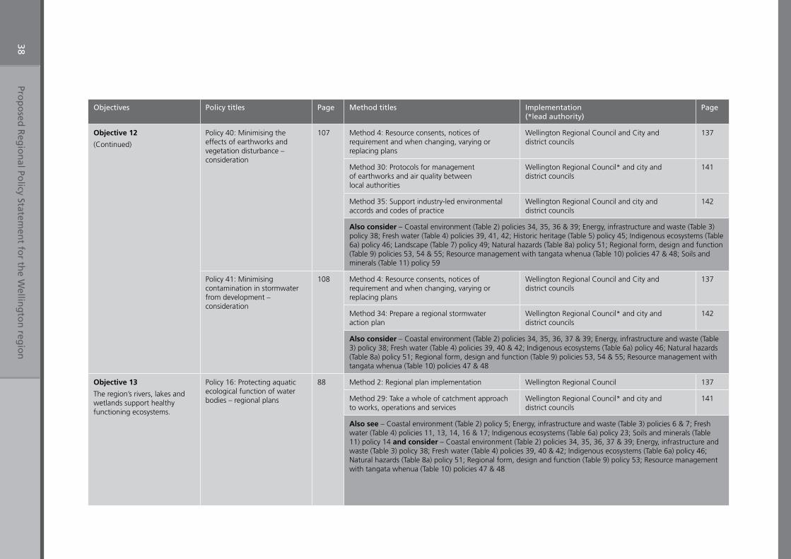
Prop
osed
Reg
ion
al Policy Statem
ent fo
r the W
elling
ton
regio
n38
Objectives Policy titles Page Method titles Implementation (*lead authority)
Page
Objective 12
(Continued)
Policy 40: Minimising the effects of earthworks and vegetation disturbance – consideration
107 Method 4: Resource consents, notices of requirement and when changing, varying or replacing plans
Wellington Regional Council and City and district councils
137
Method 30: Protocols for management of earthworks and air quality between local authorities
Wellington Regional Council* and city and district councils
141
Method 35: Support industry-led environmental accords and codes of practice
Wellington Regional Council and city and district councils
142
Also consider – Coastal environment (Table 2) policies 34, 35, 36 & 39; Energy, infrastructure and waste (Table 3) policy 38; Fresh water (Table 4) policies 39, 41, 42; Historic heritage (Table 5) policy 45; Indigenous ecosystems (Table 6a) policy 46; Landscape (Table 7) policy 49; Natural hazards (Table 8a) policy 51; Regional form, design and function (Table 9) policies 53, 54 & 55; Resource management with tangata whenua (Table 10) policies 47 & 48; Soils and minerals (Table 11) policy 59
Policy 41: Minimising contamination in stormwater from development – consideration
108 Method 4: Resource consents, notices of requirement and when changing, varying or replacing plans
Wellington Regional Council and City and district councils
137
Method 34: Prepare a regional stormwater action plan
Wellington Regional Council* and city and district councils
142
Also consider – Coastal environment (Table 2) policies 34, 35, 36, 37 & 39; Energy, infrastructure and waste (Table 3) policy 38; Fresh water (Table 4) policies 39, 40 & 42; Indigenous ecosystems (Table 6a) policy 46; Natural hazards (Table 8a) policy 51; Regional form, design and function (Table 9) policies 53, 54 & 55; Resource management with tangata whenua (Table 10) policies 47 & 48
Objective 13
The region’s rivers, lakes and wetlands support healthy functioning ecosystems.
Policy 16: Protecting aquatic ecological function of water bodies – regional plans
88 Method 2: Regional plan implementation Wellington Regional Council 137
Method 29: Take a whole of catchment approach to works, operations and services
Wellington Regional Council* and city and district councils
141
Also see – Coastal environment (Table 2) policy 5; Energy, infrastructure and waste (Table 3) policies 6 & 7; Fresh water (Table 4) policies 11, 13, 14, 16 & 17; Indigenous ecosystems (Table 6a) policy 23; Soils and minerals (Table 11) policy 14 and consider – Coastal environment (Table 2) policies 34, 35, 36, 37 & 39; Energy, infrastructure and waste (Table 3) policy 38; Fresh water (Table 4) policies 39, 40 & 42; Indigenous ecosystems (Table 6a) policy 46; Natural hazards (Table 8a) policy 51; Regional form, design and function (Table 9) policy 53; Resource management with tangata whenua (Table 10) policies 47 & 48
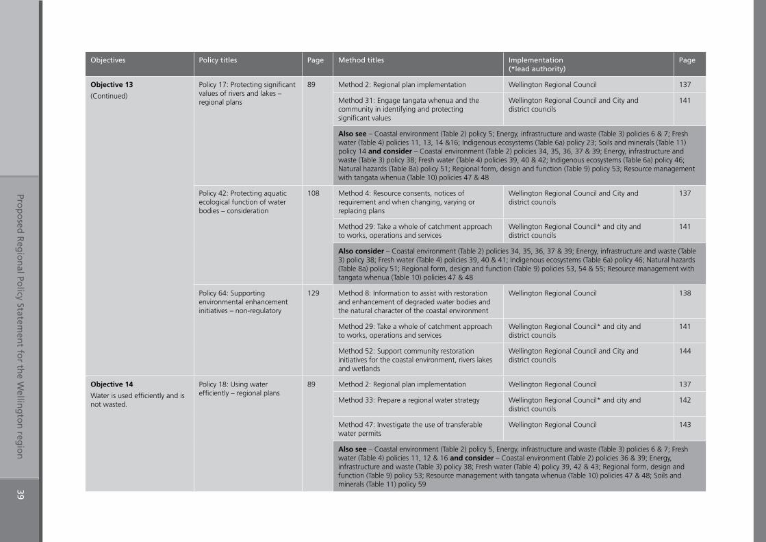
Prop
osed
Reg
ion
al Policy Statem
ent fo
r the W
elling
ton
regio
n39
Objectives Policy titles Page Method titles Implementation (*lead authority)
Page
Objective 13
(Continued)
Policy 17: Protecting significant values of rivers and lakes – regional plans
89 Method 2: Regional plan implementation Wellington Regional Council 137
Method 31: Engage tangata whenua and the community in identifying and protecting significant values
Wellington Regional Council and City and district councils
141
Also see – Coastal environment (Table 2) policy 5; Energy, infrastructure and waste (Table 3) policies 6 & 7; Fresh water (Table 4) policies 11, 13, 14 &16; Indigenous ecosystems (Table 6a) policy 23; Soils and minerals (Table 11) policy 14 and consider – Coastal environment (Table 2) policies 34, 35, 36, 37 & 39; Energy, infrastructure and waste (Table 3) policy 38; Fresh water (Table 4) policies 39, 40 & 42; Indigenous ecosystems (Table 6a) policy 46; Natural hazards (Table 8a) policy 51; Regional form, design and function (Table 9) policy 53; Resource management with tangata whenua (Table 10) policies 47 & 48
Policy 42: Protecting aquatic ecological function of water bodies – consideration
108 Method 4: Resource consents, notices of requirement and when changing, varying or replacing plans
Wellington Regional Council and City and district councils
137
Method 29: Take a whole of catchment approach to works, operations and services
Wellington Regional Council* and city and district councils
141
Also consider – Coastal environment (Table 2) policies 34, 35, 36, 37 & 39; Energy, infrastructure and waste (Table 3) policy 38; Fresh water (Table 4) policies 39, 40 & 41; Indigenous ecosystems (Table 6a) policy 46; Natural hazards (Table 8a) policy 51; Regional form, design and function (Table 9) policies 53, 54 & 55; Resource management with tangata whenua (Table 10) policies 47 & 48
Policy 64: Supporting environmental enhancement initiatives – non-regulatory
129 Method 8: Information to assist with restoration and enhancement of degraded water bodies and the natural character of the coastal environment
Wellington Regional Council 138
Method 29: Take a whole of catchment approach to works, operations and services
Wellington Regional Council* and city and district councils
141
Method 52: Support community restoration initiatives for the coastal environment, rivers lakes and wetlands
Wellington Regional Council and City and district councils
144
Objective 14
Water is used efficiently and is not wasted.
Policy 18: Using water efficiently – regional plans
89 Method 2: Regional plan implementation Wellington Regional Council 137
Method 33: Prepare a regional water strategy Wellington Regional Council* and city and district councils
142
Method 47: Investigate the use of transferable water permits
Wellington Regional Council 143
Also see – Coastal environment (Table 2) policy 5, Energy, infrastructure and waste (Table 3) policies 6 & 7; Fresh water (Table 4) policies 11, 12 & 16 and consider – Coastal environment (Table 2) policies 36 & 39; Energy, infrastructure and waste (Table 3) policy 38; Fresh water (Table 4) policy 39, 42 & 43; Regional form, design and function (Table 9) policy 53; Resource management with tangata whenua (Table 10) policies 47 & 48; Soils and minerals (Table 11) policy 59
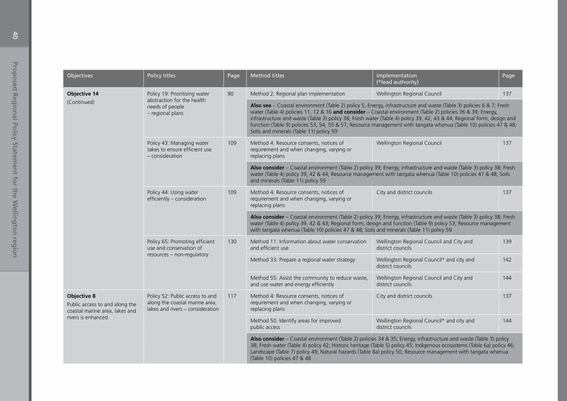
Prop
osed
Reg
ion
al Policy Statem
ent fo
r the W
elling
ton
regio
n40
Objectives Policy titles Page Method titles Implementation (*lead authority)
Page
Objective 14
(Continued)
Policy 19: Prioritising water abstraction for the health needs of people – regional plans
90 Method 2: Regional plan implementation Wellington Regional Council 137
Also see – Coastal environment (Table 2) policy 5, Energy, infrastructure and waste (Table 3) policies 6 & 7; Fresh water (Table 4) policies 11, 12 & 16 and consider – Coastal environment (Table 2) policies 36 & 39; Energy, infrastructure and waste (Table 3) policy 38; Fresh water (Table 4) policy 39, 42, 43 & 44; Regional form, design and function (Table 9) policies 53, 54, 55 & 57; Resource management with tangata whenua (Table 10) policies 47 & 48; Soils and minerals (Table 11) policy 59
Policy 43: Managing water takes to ensure efficient use – consideration
109 Method 4: Resource consents, notices of requirement and when changing, varying or replacing plans
Wellington Regional Council 137
Also consider – Coastal environment (Table 2) policy 39; Energy, infrastructure and waste (Table 3) policy 38; Fresh water (Table 4) policy 39, 42 & 44; Resource management with tangata whenua (Table 10) policies 47 & 48; Soils and minerals (Table 11) policy 59
Policy 44: Using water efficiently – consideration
109 Method 4: Resource consents, notices of requirement and when changing, varying or replacing plans
City and district councils 137
Also consider – Coastal environment (Table 2) policy 39; Energy, infrastructure and waste (Table 3) policy 38; Fresh water (Table 4) policy 39, 42 & 43; Regional form, design and function (Table 9) policy 53; Resource management with tangata whenua (Table 10) policies 47 & 48; Soils and minerals (Table 11) policy 59
Policy 65: Promoting efficient use and conservation of resources – non-regulatory
130 Method 11: Information about water conservation and efficient use
Wellington Regional Council and City and district councils
139
Method 33: Prepare a regional water strategy Wellington Regional Council* and city and district councils
142
Method 55: Assist the community to reduce waste, and use water and energy efficiently
Wellington Regional Council and City and district councils
144
Objective 8
Public access to and along the coastal marine area, lakes and rivers is enhanced.
Policy 52: Public access to and along the coastal marine area, lakes and rivers – consideration
117 Method 4: Resource consents, notices of requirement and when changing, varying or replacing plans
City and district councils 137
Method 50: Identify areas for improved public access
Wellington Regional Council* and city and district councils
144
Also consider – Coastal environment (Table 2) policies 34 & 35; Energy, infrastructure and waste (Table 3) policy 38; Fresh water (Table 4) policy 42; Historic heritage (Table 5) policy 45; Indigenous ecosystems (Table 6a) policy 46; Landscape (Table 7) policy 49; Natural hazards (Table 8a) policy 50; Resource management with tangata whenua (Table 10) policies 47 & 48
Proposed Regional Policy Statement for the Wellington region 41
Historic heritage provides a connection to those who lived before us. It helps us define who we are and contributes to our sense of place. Once destroyed, it cannot be replaced.
Our history is found in both the tangible physical remains and in the intangible values associated with our ancestors. Historic heritage is not just about history, but also culture, archaeology, architecture, science and technology. For Maori, places of cultural and historic heritage are integral to wellbeing. Historic heritage resources provide continuity between the past and the present that, properly maintained, will continue into the future.
In the Wellington region, there is a wide range of historic heritage resources. The region’s built heritage documents important aspects of our past. Archaeological sites contain evidence of how people have lived in the past, perhaps for centuries. For tangata whenua, there are many sites of cultural significance that provide important connections with ancestors.
In the Wellington region, many heritage places still retain high integrity and are in good condition. However, some have suffered from inappropriate subdivision, use and development. Incremental development is resulting in a loss of historic heritage in some of the region’s towns, particularly in higher density inner centres where heritage buildings are being inappropriately modified or replaced by new buildings. Archaeological sites have been destroyed, sometimes without being properly recorded, and the evidence they contained about life in the past can never be recovered.
Since 2003, Wellington Regional Council and the region’s district and city councils have had an obligation under the Resource Management Act to identify and provide for the protection of the region’s historic heritage. Until then councils were only required to have “particular regard” to the protection of heritage values. Councils have improved district plan protection for historic heritage since this change. All district and city councils in the Wellington region require resource consent for the demolition, relocation or for substantial alterations of heritage buildings listed in plans. However, more work is still required, particularly for archaeological sites.
The regionally significant resource management issue for historic heritage is:
1. Inappropriate modification and destruction of historic heritage.Loss of heritage values as a result of inappropriate modification, use and destruction of historic heritage.
Table 5: Historic heritage Objective 15
Table 10: Resource Management with tangata whenua Objective 27
3.5 Historic heritage
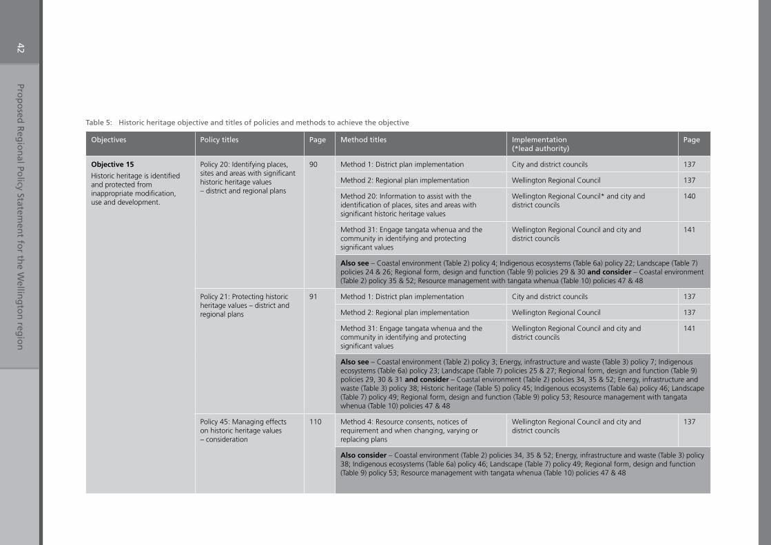
Prop
osed
Reg
ion
al Policy Statem
ent fo
r the W
elling
ton
regio
n42
Table 5: Historic heritage objective and titles of policies and methods to achieve the objective
Objectives Policy titles Page Method titles Implementation (*lead authority)
Page
Objective 15
Historic heritage is identified and protected from inappropriate modification, use and development.
Policy 20: Identifying places, sites and areas with significant historic heritage values – district and regional plans
90 Method 1: District plan implementation City and district councils 137
Method 2: Regional plan implementation Wellington Regional Council 137
Method 20: Information to assist with the identification of places, sites and areas with significant historic heritage values
Wellington Regional Council* and city and district councils
140
Method 31: Engage tangata whenua and the community in identifying and protecting significant values
Wellington Regional Council and city and district councils
141
Also see – Coastal environment (Table 2) policy 4; Indigenous ecosystems (Table 6a) policy 22; Landscape (Table 7) policies 24 & 26; Regional form, design and function (Table 9) policies 29 & 30 and consider – Coastal environment (Table 2) policy 35 & 52; Resource management with tangata whenua (Table 10) policies 47 & 48
Policy 21: Protecting historic heritage values – district and regional plans
91 Method 1: District plan implementation City and district councils 137
Method 2: Regional plan implementation Wellington Regional Council 137
Method 31: Engage tangata whenua and the community in identifying and protecting significant values
Wellington Regional Council and city and district councils
141
Also see – Coastal environment (Table 2) policy 3; Energy, infrastructure and waste (Table 3) policy 7; Indigenous ecosystems (Table 6a) policy 23; Landscape (Table 7) policies 25 & 27; Regional form, design and function (Table 9) policies 29, 30 & 31 and consider – Coastal environment (Table 2) policies 34, 35 & 52; Energy, infrastructure and waste (Table 3) policy 38; Historic heritage (Table 5) policy 45; Indigenous ecosystems (Table 6a) policy 46; Landscape (Table 7) policy 49; Regional form, design and function (Table 9) policy 53; Resource management with tangata whenua (Table 10) policies 47 & 48
Policy 45: Managing effects on historic heritage values – consideration
110 Method 4: Resource consents, notices of requirement and when changing, varying or replacing plans
Wellington Regional Council and city and district councils
137
Also consider – Coastal environment (Table 2) policies 34, 35 & 52; Energy, infrastructure and waste (Table 3) policy 38; Indigenous ecosystems (Table 6a) policy 46; Landscape (Table 7) policy 49; Regional form, design and function (Table 9) policy 53; Resource management with tangata whenua (Table 10) policies 47 & 48
Proposed Regional Policy Statement for the Wellington region 43
An ecosystem may be described as a community of plants, animals and micro-organisms interacting with each other and their surrounding environment.
Healthy ecosystems provide us with life’s essentials – such as plants and animals for food, fibre for clothing, timber for construction. This is true even in an industrialised age, although the connections are less immediately obvious. Healthy ecosystems supply us with ‘services’ that support life on this planet – such as:
• processes that purify air and water• decomposition and detoxification of wastes• creation and maintenance of productive soils • reduction of the impact of climate extremes• capture of carbon and maintenance of a functioning atmosphere.
Ecosystems are dynamic (constantly changing) and the many diverse natural processes that drive ecosystems are as important as the species within them. In addition, all parts of an ecosystem are interconnected. The species that make up an ecosystem, including humans, cannot exist in isolation from the other species and non-living parts of the ecosystem. The primacy of healthy ecosystems is central to Maori cultural values, whereby harm to mauri directly affects the wellbeing of the people. More specifically, degradation of ecosystems threatens mahinga kai (places where food is gathered) and other natural resources used for customary purposes.
The Wellington region has a distinctive range of ecosystems – such as forests, mountains, wetlands, lakes, rivers and coastal and marine ecosystems. Some ecosystems have a high degree of ‘indigenousness’- such as the Tararua and Orongorongo ranges, while others are dominated by exotic species– such as pastoral farmlands.
The area of indigenous ecosystems has been in decline since humans first settled in our region. This loss greatly accelerated from the time of European settlement. Around 70 per cent of the indigenous forest and more than 90 per cent of the wetlands that existed as recently as 1840, have been cleared for agriculture and urban development. Indigenous forest continues to be lost in the region. Most of the remaining forest and wetlands and dune systems have been degraded or modified in some way. In addition, many of the processes that ensure ecosystems remain healthy and viable into the future have been compromised, including reproduction, recruitment, dispersal and migration.
3.6 Indigenous ecosystems
Proposed Regional Policy Statement for the Wellington region44
Human actions that continue to impact on the remaining indigenous ecosystems include:
• modification and, in some cases, destruction of ecosystems by pest plants and animals, grazing animals and clearance of indigenous vegetation
• contamination of aquatic ecosystems by sediment, pollutants and nutrients• destruction of ecosystems as a result of development• draining wetlands and channelling or piping of natural waterways• contamination of coastal ecosystems by stormwater and sewage discharges.
Ecosystem health can be measured in a number of ways, including loss of individual species, loss of overall diversity of species, loss of an ecosystem’s ability to function on an ongoing basis, and loss of complete ecosystems and types of ecosystems. While the dramatic collapse of species or whole ecosystems can capture attention, the gradual erosion of ecosystems’ sustainability is also a significant issue.
The regionally significant resource management issues for indigenous ecosystems are:
1. The region’s indigenous ecosystems are reduced in extentThe region’s indigenous ecosystems have been significantly reduced in extent, specifically:
(a) wetlands(b) lowland forests(c) lowland streams (d) coastal dunes and escarpments (e) estuaries(f) eastern ‘dry land’ forests.
2. The region’s remaining indigenous ecosystems are under threatThe region’s remaining indigenous ecosystems continue to be degraded or lost.
Table 6: Indigenous ecosystems Objective 16
Table 6: Indigenous ecosystems Objective 16
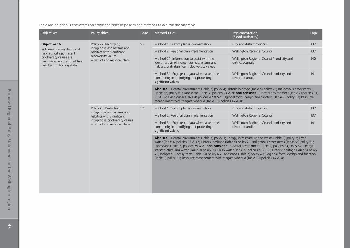
Prop
osed
Reg
ion
al Policy Statem
ent fo
r the W
elling
ton
regio
n45
Table 6a: Indigenous ecosystems objective and titles of policies and methods to achieve the objective
Objectives Policy titles Page Method titles Implementation (*lead authority)
Page
Objective 16
Indigenous ecosystems and habitats with significant biodiversity values are maintained and restored to a healthy functioning state.
Policy 22: Identifying indigenous ecosystems and habitats with significant biodiversity values – district and regional plans
92 Method 1: District plan implementation City and district councils 137
Method 2: Regional plan implementation Wellington Regional Council 137
Method 21: Information to assist with the identification of indigenous ecosystems and habitats with significant biodiversity values
Wellington Regional Council* and city and district councils
140
Method 31: Engage tangata whenua and the community in identifying and protecting significant values
Wellington Regional Council and city and district councils
141
Also see – Coastal environment (Table 2) policy 4; Historic heritage (Table 5) policy 20; Indigenous ecosystems (Table 6b) policy 61; Landscape (Table 7) policies 24 & 26 and consider – Coastal environment (Table 2) policies 34, 35 & 36; Fresh water (Table 4) policies 42 & 52; Regional form, design and function (Table 9) policy 53; Resource management with tangata whenua (Table 10) policies 47 & 48
Policy 23: Protecting indigenous ecosystems and habitats with significant indigenous biodiversity values – district and regional plans
92 Method 1: District plan implementation City and district councils 137
Method 2: Regional plan implementation Wellington Regional Council 137
Method 31: Engage tangata whenua and the community in identifying and protecting significant values
Wellington Regional Council and city and district councils
141
Also see – Coastal environment (Table 2) policy 3; Energy, infrastructure and waste (Table 3) policy 7; Fresh water (Table 4) policies 16 & 17; Historic heritage (Table 5) policy 21; Indigenous ecosystems (Table 6b) policy 61; Landscape (Table 7) policies 25 & 27 and consider – Coastal environment (Table 2) policies 34, 35 & 52; Energy, infrastructure and waste (Table 3) policy 38; Fresh water (Table 4) policies 42 & 52; Historic heritage (Table 5) policy 45; Indigenous ecosystems (Table 6a) policy 46; Landscape (Table 7) policy 49; Regional form, design and function (Table 9) policy 53; Resource management with tangata whenua (Table 10) policies 47 & 48
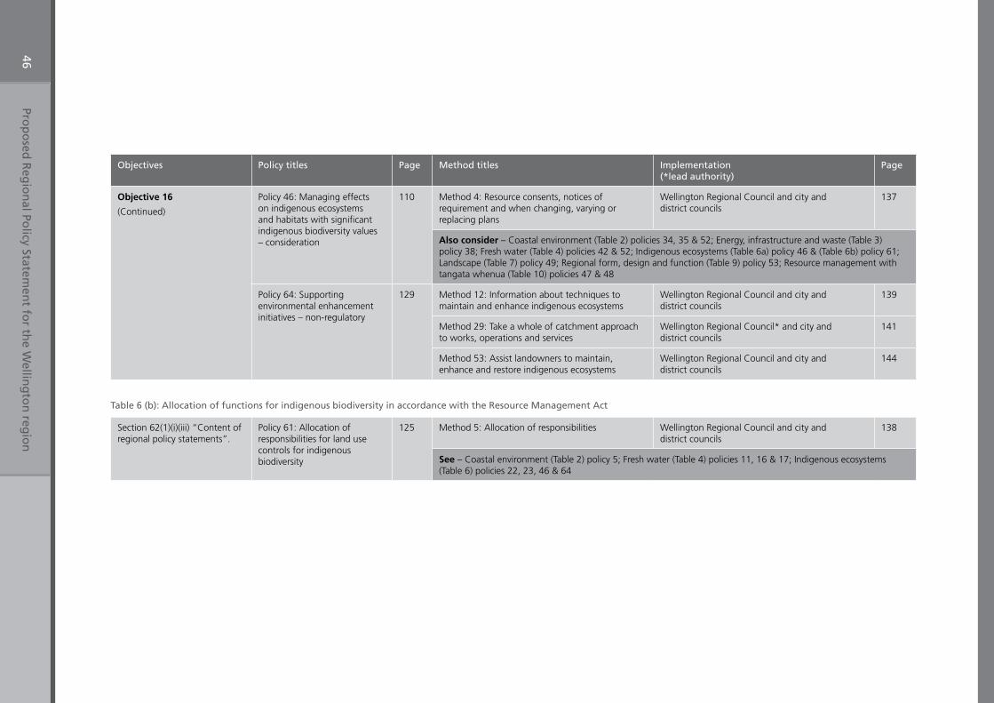
Prop
osed
Reg
ion
al Policy Statem
ent fo
r the W
elling
ton
regio
n46
Objectives Policy titles Page Method titles Implementation (*lead authority)
Page
Objective 16
(Continued)
Policy 46: Managing effects on indigenous ecosystems and habitats with significant indigenous biodiversity values – consideration
110 Method 4: Resource consents, notices of requirement and when changing, varying or replacing plans
Wellington Regional Council and city and district councils
137
Also consider – Coastal environment (Table 2) policies 34, 35 & 52; Energy, infrastructure and waste (Table 3) policy 38; Fresh water (Table 4) policies 42 & 52; Indigenous ecosystems (Table 6a) policy 46 & (Table 6b) policy 61; Landscape (Table 7) policy 49; Regional form, design and function (Table 9) policy 53; Resource management with tangata whenua (Table 10) policies 47 & 48
Policy 64: Supporting environmental enhancement initiatives – non-regulatory
129 Method 12: Information about techniques to maintain and enhance indigenous ecosystems
Wellington Regional Council and city and district councils
139
Method 29: Take a whole of catchment approach to works, operations and services
Wellington Regional Council* and city and district councils
141
Method 53: Assist landowners to maintain, enhance and restore indigenous ecosystems
Wellington Regional Council and city and district councils
144
Table 6 (b): Allocation of functions for indigenous biodiversity in accordance with the Resource Management Act
Section 62(1)(i)(iii) “Content of regional policy statements”.
Policy 61: Allocation of responsibilities for land use controls for indigenous biodiversity
125 Method 5: Allocation of responsibilities Wellington Regional Council and city and district councils
138
See – Coastal environment (Table 2) policy 5; Fresh water (Table 4) policies 11, 16 & 17; Indigenous ecosystems (Table 6) policies 22, 23, 46 & 64
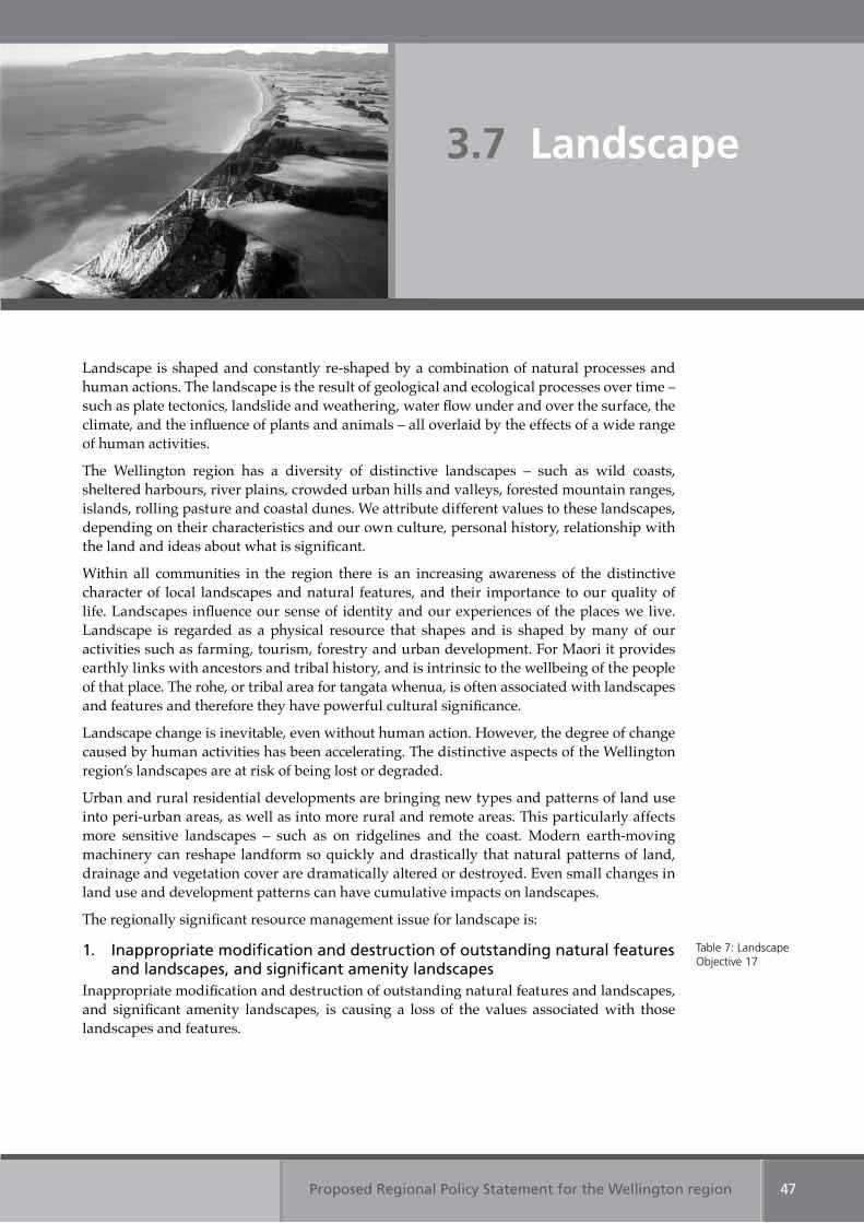
Proposed Regional Policy Statement for the Wellington region 47
Landscape is shaped and constantly re-shaped by a combination of natural processes and human actions. The landscape is the result of geological and ecological processes over time – such as plate tectonics, landslide and weathering, water flow under and over the surface, the climate, and the influence of plants and animals – all overlaid by the effects of a wide range of human activities.
The Wellington region has a diversity of distinctive landscapes – such as wild coasts, sheltered harbours, river plains, crowded urban hills and valleys, forested mountain ranges, islands, rolling pasture and coastal dunes. We attribute different values to these landscapes, depending on their characteristics and our own culture, personal history, relationship with the land and ideas about what is significant.
Within all communities in the region there is an increasing awareness of the distinctive character of local landscapes and natural features, and their importance to our quality of life. Landscapes influence our sense of identity and our experiences of the places we live. Landscape is regarded as a physical resource that shapes and is shaped by many of our activities such as farming, tourism, forestry and urban development. For Maori it provides earthly links with ancestors and tribal history, and is intrinsic to the wellbeing of the people of that place. The rohe, or tribal area for tangata whenua, is often associated with landscapes and features and therefore they have powerful cultural significance.
Landscape change is inevitable, even without human action. However, the degree of change caused by human activities has been accelerating. The distinctive aspects of the Wellington region’s landscapes are at risk of being lost or degraded.
Urban and rural residential developments are bringing new types and patterns of land use into peri-urban areas, as well as into more rural and remote areas. This particularly affects more sensitive landscapes – such as on ridgelines and the coast. Modern earth-moving machinery can reshape landform so quickly and drastically that natural patterns of land, drainage and vegetation cover are dramatically altered or destroyed. Even small changes in land use and development patterns can have cumulative impacts on landscapes.
The regionally significant resource management issue for landscape is:
1. Inappropriate modification and destruction of outstanding natural features and landscapes, and significant amenity landscapes
Inappropriate modification and destruction of outstanding natural features and landscapes, and significant amenity landscapes, is causing a loss of the values associated with those landscapes and features.
Table 7: Landscape Objective 17
3.7 Landscape
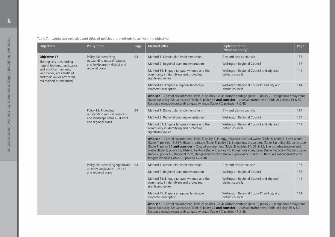
Prop
osed
Reg
ion
al Policy Statem
ent fo
r the W
elling
ton
regio
n48
Table 7: Landscape objective and titles of policies and methods to achieve the objective
Objectives Policy titles Page Method titles Implementation (*lead authority)
Page
Objective 17
The region’s outstanding natural features, landscapes and significant amenity landscapes, are identified and their values protected, maintained or enhanced.
Policy 24: Identifying outstanding natural features and landscapes – district and regional plans
93 Method 1: District plan implementation City and district councils 137
Method 2: Regional plan implementation Wellington Regional Council 137
Method 31: Engage tangata whenua and the community in identifying and protecting significant values
Wellington Regional Council and city and district councils
141
Method 49: Prepare a regional landscape character description
Wellington Regional Council* and city and district councils
144
Also see – Coastal environment (Table 2) policies 3 & 4; Historic heritage (Table 5) policy 20; Indigenous ecosystems (Table 6a) policy 22; Landscape (Table 7) policy 26 and consider – Coastal environment (Table 2) policies 35 & 52; Resource management with tangata whenua (Table 10) policies 47 & 48
Policy 25: Protecting outstanding natural features and landscape values – district and regional plans
94 Method 1: District plan implementation City and district councils 137
Method 2: Regional plan implementation Wellington Regional Council 137
Method 31: Engage tangata whenua and the community in identifying and protecting significant values
Wellington Regional Council and city and district councils
141
Also see – Coastal environment (Table 2) policy 3; Energy, infrastructure and waste (Table 3) policy 7; Fresh water (Table 4) policies 16 &17; Historic heritage (Table 5) policy 21; Indigenous ecosystems (Table 6a) policy 23; Landscape (Table 7) policy 27 and consider – Coastal environment (Table 2) policies 34, 35 & 52; Energy, infrastructure and waste (Table 3) policy 38; Historic heritage (Table 5) policy 45; Indigenous ecosystems (Table 6a) policy 46; Landscape (Table 7) policy 49; Regional form, design and function (Table 9) policies 53, 54 & 55; Resource management with tangata whenua (Table 10) policies 47 & 48
Policy 26: Identifying significant amenity landscapes – district and regional plans
94 Method 1: District plan implementation City and district councils 137
Method 2: Regional plan implementation Wellington Regional Council 137
Method 31: Engage tangata whenua and the community in identifying and protecting significant values
Wellington Regional Council and city and district councils
141
Method 49: Prepare a regional landscape character description
Wellington Regional Council* and city and district councils
144
Also see – Coastal environment (Table 2) policies 3 & 4; Historic heritage (Table 5) policy 20; Indigenous ecosystems (Table 6a) policy 22; Landscape (Table 7) policy 24 and consider – Coastal environment (Table 2) policy 35 & 52; Resource management with tangata whenua (Table 10) policies 47 & 48
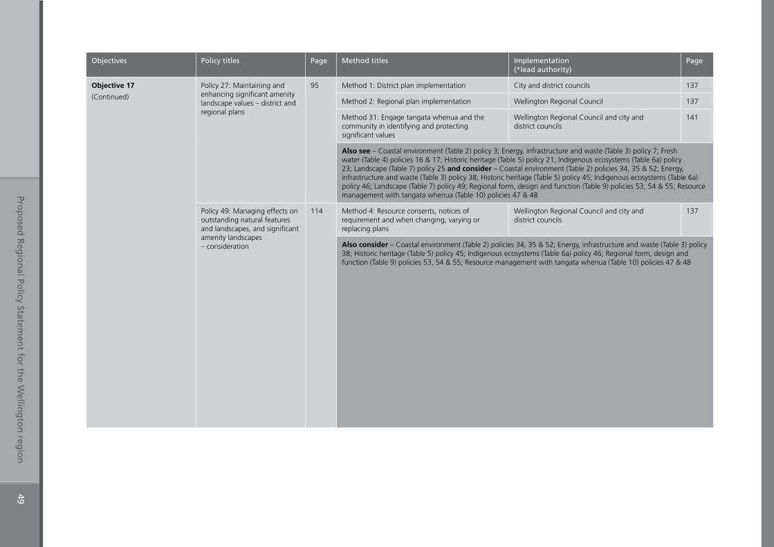
Prop
osed
Reg
ion
al Policy Statem
ent fo
r the W
elling
ton
regio
n49
Objectives Policy titles Page Method titles Implementation (*lead authority)
Page
Objective 17
(Continued)
Policy 27: Maintaining and enhancing significant amenity landscape values – district and regional plans
95 Method 1: District plan implementation City and district councils 137
Method 2: Regional plan implementation Wellington Regional Council 137
Method 31: Engage tangata whenua and the community in identifying and protecting significant values
Wellington Regional Council and city and district councils
141
Also see – Coastal environment (Table 2) policy 3; Energy, infrastructure and waste (Table 3) policy 7; Fresh water (Table 4) policies 16 & 17; Historic heritage (Table 5) policy 21; Indigenous ecosystems (Table 6a) policy 23; Landscape (Table 7) policy 25 and consider – Coastal environment (Table 2) policies 34, 35 & 52; Energy, infrastructure and waste (Table 3) policy 38; Historic heritage (Table 5) policy 45; Indigenous ecosystems (Table 6a) policy 46; Landscape (Table 7) policy 49; Regional form, design and function (Table 9) policies 53, 54 & 55; Resource management with tangata whenua (Table 10) policies 47 & 48
Policy 49: Managing effects on outstanding natural features and landscapes, and significant amenity landscapes – consideration
114 Method 4: Resource consents, notices of requirement and when changing, varying or replacing plans
Wellington Regional Council and city and district councils
137
Also consider – Coastal environment (Table 2) policies 34, 35 & 52; Energy, infrastructure and waste (Table 3) policy 38; Historic heritage (Table 5) policy 45; Indigenous ecosystems (Table 6a) policy 46; Regional form, design and function (Table 9) policies 53, 54 & 55; Resource management with tangata whenua (Table 10) policies 47 & 48
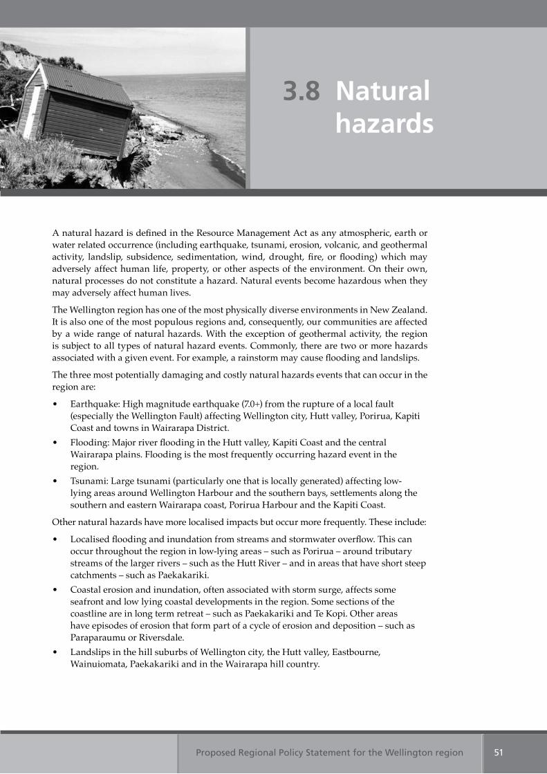
Proposed Regional Policy Statement for the Wellington region 51
A natural hazard is defined in the Resource Management Act as any atmospheric, earth or water related occurrence (including earthquake, tsunami, erosion, volcanic, and geothermal activity, landslip, subsidence, sedimentation, wind, drought, fire, or flooding) which may adversely affect human life, property, or other aspects of the environment. On their own, natural processes do not constitute a hazard. Natural events become hazardous when they may adversely affect human lives.
The Wellington region has one of the most physically diverse environments in New Zealand. It is also one of the most populous regions and, consequently, our communities are affected by a wide range of natural hazards. With the exception of geothermal activity, the region is subject to all types of natural hazard events. Commonly, there are two or more hazards associated with a given event. For example, a rainstorm may cause flooding and landslips.
The three most potentially damaging and costly natural hazards events that can occur in the region are:
• Earthquake: High magnitude earthquake (7.0+) from the rupture of a local fault (especially the Wellington Fault) affecting Wellington city, Hutt valley, Porirua, Kapiti Coast and towns in Wairarapa District.
• Flooding: Major river flooding in the Hutt valley, Kapiti Coast and the central Wairarapa plains. Flooding is the most frequently occurring hazard event in the region.
• Tsunami: Large tsunami (particularly one that is locally generated) affecting low-lying areas around Wellington Harbour and the southern bays, settlements along the southern and eastern Wairarapa coast, Porirua Harbour and the Kapiti Coast.
Other natural hazards have more localised impacts but occur more frequently. These include:
• Localised flooding and inundation from streams and stormwater overflow. This can occur throughout the region in low-lying areas – such as Porirua – around tributary streams of the larger rivers – such as the Hutt River – and in areas that have short steep catchments – such as Paekakariki.
• Coastal erosion and inundation, often associated with storm surge, affects some seafront and low lying coastal developments in the region. Some sections of the coastline are in long term retreat – such as Paekakariki and Te Kopi. Other areas have episodes of erosion that form part of a cycle of erosion and deposition – such as Paraparaumu or Riversdale.
• Landslips in the hill suburbs of Wellington city, the Hutt valley, Eastbourne, Wainuiomata, Paekakariki and in the Wairarapa hill country.
3.8 Natural hazards
Proposed Regional Policy Statement for the Wellington region52
• Drought, especially in central Wairarapa and the coastal hills between Flat Point and Castle Point.
• Wild fire, particularly in hill suburbs on urban fringes near heavily vegetated slopes, including western and southern Wellington suburbs, Eastbourne, Wainuiomata, Hutt valley and Porirua, and farmland in the eastern Wairarapa hill country.
• High winds that can occur throughout the region and cause widespread damage to buildings, infrastructure and forestry.
• Sedimentation and erosion of rivers and streams, river mouths and tidal inlets, that can exacerbate the flood risk by raising bed levels and undermining banks.
People’s actions, including mitigation measures and ongoing development in areas at high risk from natural hazards, can cause or increase the risk from natural hazards. Examples include seawalls or groynes that can cause localised erosion of the adjacent shoreline, and building on landslip prone slopes. Stopbanks and seawalls can also create a sense of security and encourage further development, increasing the extent and value of the assets at risk.
In the medium to long term, climate change effects have the potential to increase both the frequency and magnitude of natural hazard events that already occur in the region.
A major consequence of climate change is sea level rise. The sea level is expected to rise over half a metre by 2100.1 The main natural hazards associated with a rise in sea levels are coastal erosion and inundation. Sea level rise will also put increasing pressure on the coastal margin. As the shoreline adjusts, sediment will be redistributed around the coast and may cause shorelines to form new orientations. Beaches that are currently stable may begin to erode as the shoreline adjusts to a higher water level, while those that are currently eroding may experience an increased rate of retreat.
Climate change is expected to increase the intensity and duration of westerly weather systems and reduce easterly conditions. This will exacerbate differences in the regional climate, by bringing higher rainfall to the west and reducing coastal rains in the east. It will also bring longer periods of northerly gales to the entire region, particularly in the spring months. Western and southern areas of the region may also have higher rainfall in the winter, increasing the landslide risk during wet winters, particularly in extreme rainfall events. This will put pressure on stormwater systems and flood protection works. Higher rainfall may also result in higher rates of sedimentation at river mouths and in estuaries, increasing the flood risk in those areas by raising the base level of the river bed.
It is also expected that central and eastern Wairarapa will become drier over the next 100 years. Droughts will occur more frequently and persist for longer periods. Research suggests that winter rainfall will decline in the long term, which may lead to a reduction in groundwater recharge rates and pressure on water resources. Dry conditions also result in a heightened risk of wild fire.
1 Intergovernmental Panel on Climate Change (IPCC) (2007), Climate Change 2007: The Physical Science Basis. Summary for Policymakers. Contribution of working group I to the fourth assessment report of the IPCC, 18pp.
Proposed Regional Policy Statement for the Wellington region 53
Table 8a: Natural hazards Objectives 18, 19 & 20
Table 8a: Natural hazards Objective 20
Table 8a: Natural hazards Objectives 18, 19 & 20
The regionally significant resource management issues for natural hazards are:
1. Effects of natural hazardsNatural hazard events in the Wellington region have an adverse impact on people and communities, businesses, property and infrastructure.
2. Human actions can increase risk and consequences from natural hazardsPeople’s actions including mitigation measures and ongoing development in areas at risk from natural hazards can cause, or increase, the risk and consequences from natural hazards.
3. Climate change will increase both the magnitude and frequency of natural hazard events
Climate change will increase the risks from natural hazard events that already occur within the region, particularly:
(a) sea level rise, exacerbating the effects of coastal erosion and inundation and river flooding in low lying areas, especially during storm surge
(b) increased frequency and intensity of storm events, adding to the risk from floods, landslides, severe wind, storm surge, coastal erosion and inundation
(c) increased frequency of drought, placing pressure on water resources and increasing the wild fire risk
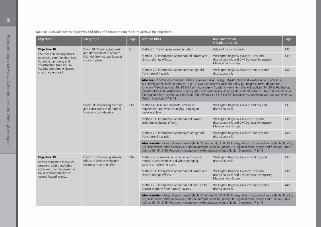
Prop
osed
Reg
ion
al Policy Statem
ent fo
r the W
elling
ton
regio
n54
Table 8a: Natural hazards objectives and titles of policies and methods to achieve the objectives
Objectives Policy titles Page Method titles Implementation (*lead authority)
Page
Objective 18
The risks and consequences to people, communities, their businesses, property and infrastructure from natural hazards and climate change effects are reduced.
Policy 28: Avoiding subdivision and development in areas at high risk from natural hazards – district plans
96 Method 1: District plan implementation City and district councils 137
Method 14: Information about natural hazard and climate change effects
Wellington Regional Council*, city and district councils and Civil Defence Emergency Management Group
139
Method 22: Information about areas at high risk from natural hazards
Wellington Regional Council* and city and district councils
140
Also see – Coastal environment (Table 2) policies 3 & 4; Energy, infrastructure and waste (Table 3) policies 6 & 7; Fresh water (Table 4) policies 14 & 16; Natural hazards (Table 8b) policy 62; Regional form, design and function (Table 9) policies 29, 30 & 31 and consider – Coastal environment (Table 2) policies 34, 35 & 36; Energy, infrastructure and waste (Table 3) policy 38; Fresh water (Table 4) policy 42; Natural hazards (Table 8a) policies 50 & 51; Regional form, design and function (Table 9) policies 53, 54 & 55; Resource management with tangata whenua (Table 10) policies 47 & 48
Policy 50: Minimising the risks and consequences of natural hazards – consideration
115 Method 4: Resource consents, notices of requirement and when changing, varying or replacing plans
Wellington Regional Council and city and district councils
137
Method 14: Information about natural hazard and climate change effects
Wellington Regional Council*, city and district councils and Civil Defence Emergency Management Group
139
Method 22: Information about areas at high risk from natural hazards
Wellington Regional Council* and city and district councils
140
Also consider – Coastal environment (Table 2) policies 34, 35 & 36; Energy, infrastructure and waste (Table 3) policy 38; Fresh water (Table 4) policy 42; Natural hazards (Table 8a) policy 51; Regional form, design and function (Table 9) policies 53, 54 & 55; Resource management with tangata whenua (Table 10) policies 47 & 48
Objective 19
Hazard mitigation measures, structural works and other activities do not increase the risk and consequences of natural hazard events.
Policy 51: Minimising adverse effects of hazard mitigation measures – consideration
116 Method 4: Consideration – resource consents, notices of requirement and when changing, varying or reviewing plans
Wellington Regional Council and city and district councils
137
Method 14: Information about natural hazard and climate change effects
Wellington Regional Council*, city and district councils and Civil Defence Emergency Management Group
139
Method 23: Information about natural features to protect property from natural hazards
Wellington Regional Council* and city and district councils
140
Also consider – Coastal environment (Table 2) policies 34, 35 & 36; Energy, infrastructure and waste (Table 3) policy 38; Fresh water (Table 4) policy 42; Natural hazards (Table 8a) policy 50; Regional form, design and function (Table 9) policies 53, 54 & 55; Resource management with tangata whenua (Table 10) policies 47 & 48
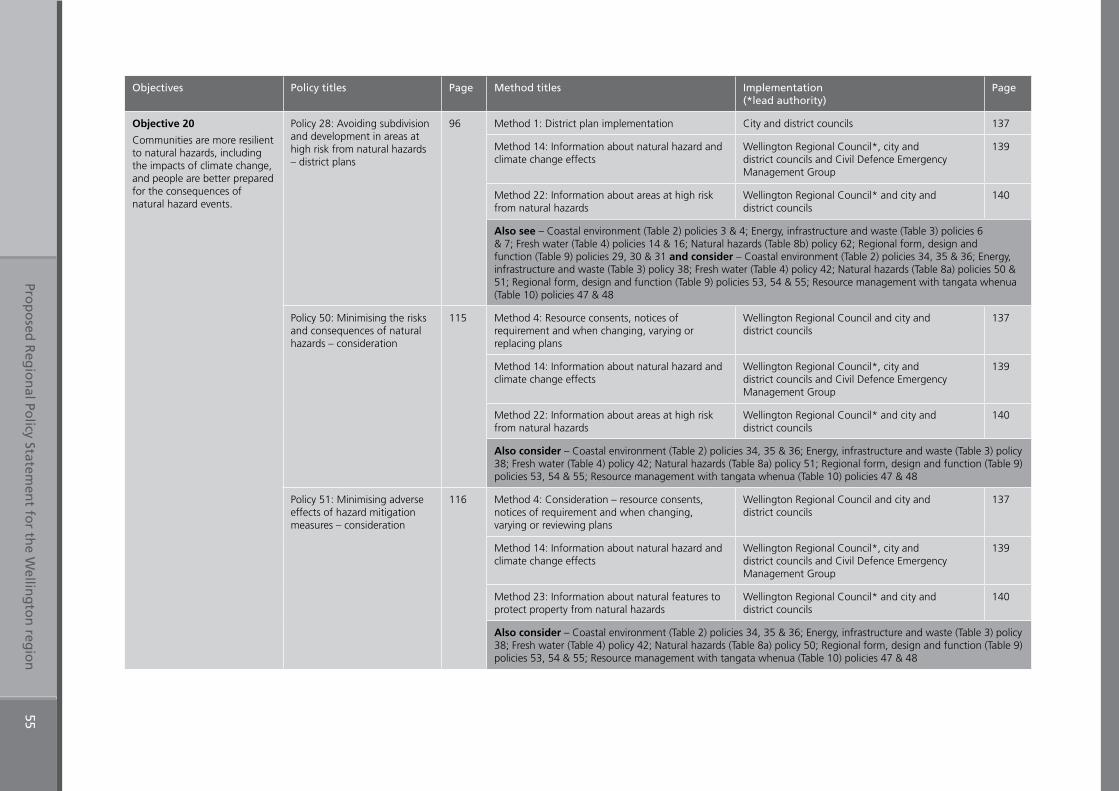
Prop
osed
Reg
ion
al Policy Statem
ent fo
r the W
elling
ton
regio
n55
Objectives Policy titles Page Method titles Implementation (*lead authority)
Page
Objective 20
Communities are more resilient to natural hazards, including the impacts of climate change, and people are better prepared for the consequences of natural hazard events.
Policy 28: Avoiding subdivision and development in areas at high risk from natural hazards – district plans
96 Method 1: District plan implementation City and district councils 137
Method 14: Information about natural hazard and climate change effects
Wellington Regional Council*, city and district councils and Civil Defence Emergency Management Group
139
Method 22: Information about areas at high risk from natural hazards
Wellington Regional Council* and city and district councils
140
Also see – Coastal environment (Table 2) policies 3 & 4; Energy, infrastructure and waste (Table 3) policies 6 & 7; Fresh water (Table 4) policies 14 & 16; Natural hazards (Table 8b) policy 62; Regional form, design and function (Table 9) policies 29, 30 & 31 and consider – Coastal environment (Table 2) policies 34, 35 & 36; Energy, infrastructure and waste (Table 3) policy 38; Fresh water (Table 4) policy 42; Natural hazards (Table 8a) policies 50 & 51; Regional form, design and function (Table 9) policies 53, 54 & 55; Resource management with tangata whenua (Table 10) policies 47 & 48
Policy 50: Minimising the risks and consequences of natural hazards – consideration
115 Method 4: Resource consents, notices of requirement and when changing, varying or replacing plans
Wellington Regional Council and city and district councils
137
Method 14: Information about natural hazard and climate change effects
Wellington Regional Council*, city and district councils and Civil Defence Emergency Management Group
139
Method 22: Information about areas at high risk from natural hazards
Wellington Regional Council* and city and district councils
140
Also consider – Coastal environment (Table 2) policies 34, 35 & 36; Energy, infrastructure and waste (Table 3) policy 38; Fresh water (Table 4) policy 42; Natural hazards (Table 8a) policy 51; Regional form, design and function (Table 9) policies 53, 54 & 55; Resource management with tangata whenua (Table 10) policies 47 & 48
Policy 51: Minimising adverse effects of hazard mitigation measures – consideration
116 Method 4: Consideration – resource consents, notices of requirement and when changing, varying or reviewing plans
Wellington Regional Council and city and district councils
137
Method 14: Information about natural hazard and climate change effects
Wellington Regional Council*, city and district councils and Civil Defence Emergency Management Group
139
Method 23: Information about natural features to protect property from natural hazards
Wellington Regional Council* and city and district councils
140
Also consider – Coastal environment (Table 2) policies 34, 35 & 36; Energy, infrastructure and waste (Table 3) policy 38; Fresh water (Table 4) policy 42; Natural hazards (Table 8a) policy 50; Regional form, design and function (Table 9) policies 53, 54 & 55; Resource management with tangata whenua (Table 10) policies 47 & 48
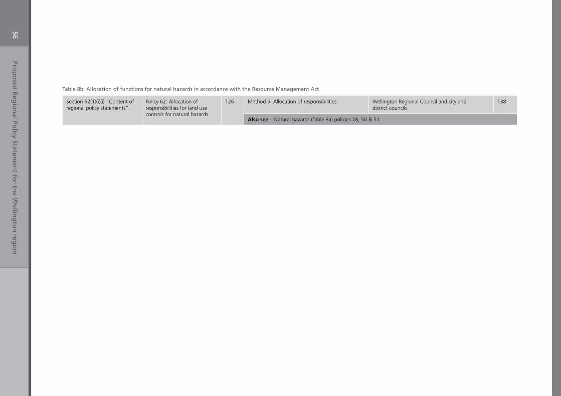
Prop
osed
Reg
ion
al Policy Statem
ent fo
r the W
elling
ton
regio
n56
Table 8b: Allocation of functions for natural hazards in accordance with the Resource Management Act
Section 62(1)(i)(i) “Content of regional policy statements”.
Policy 62: Allocation of responsibilities for land use controls for natural hazards
126 Method 5: Allocation of responsibilities Wellington Regional Council and city and district councils
138
Also see – Natural hazards (Table 8a) policies 28, 50 & 51
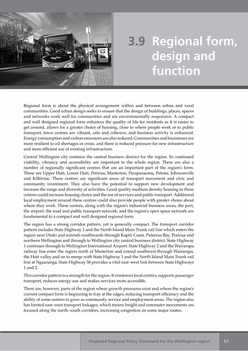
Proposed Regional Policy Statement for the Wellington region 57
Regional form is about the physical arrangement within and between urban and rural communities. Good urban design seeks to ensure that the design of buildings, places, spaces and networks work well for communities and are environmentally responsive. A compact and well designed regional form enhances the quality of life for residents as it is easier to get around, allows for a greater choice of housing, close to where people work or to public transport, town centres are vibrant, safe and cohesive, and business activity is enhanced. Energy consumption and carbon emissions are also reduced. Communities and businesses are more resilient to oil shortages or crisis, and there is reduced pressure for new infrastructure and more efficient use of existing infrastructure.
Central Wellington city contains the central business district for the region. Its continued viability, vibrancy and accessibility are important to the whole region. There are also a number of regionally significant centres that are an important part of the region’s form. These are Upper Hutt, Lower Hutt, Porirua, Masterton, Paraparaumu, Petone, Johnsonville and Kilbirnie. These centres are significant areas of transport movement and civic and community investment. They also have the potential to support new development and increase the range and diversity of activities. Good quality medium density housing in these centres could increase housing choice and the use of services and public transport. Additional local employment around these centres could also provide people with greater choice about where they work. These centres, along with the region’s industrial business areas, the port, the airport, the road and public transport network, and the region’s open space network are fundamental to a compact and well designed regional form.
The region has a strong corridor pattern, yet is generally compact. The transport corridor pattern includes State Highway 1 and the North Island Main Trunk rail line which enters the region near Otaki and extends southwards through Kapiti Coast, Pukerua Bay, Porirua and northern Wellington and through to Wellington city central business district. State Highway 1 continues through to Wellington International Airport. State Highway 2 and the Wairarapa railway line enter the region north of Masterton and extend southwest through Wairarapa, the Hutt valley and on to merge with State Highway 1 and the North Island Main Trunk rail line at Ngauranga. State Highway 58 provides a vital east–west link between State Highways 1 and 2.
This corridor pattern is a strength for the region. It reinforces local centres, supports passenger transport, reduces energy use and makes services more accessible.
There are, however, parts of the region where growth pressures exist and where the region’s current compact form is beginning to fray at the edges, reducing transport efficiency and the ability of some centres to grow as community service and employment areas. The region also has limited east–west transport linkages, which means freight and commuter movements are focused along the north–south corridors, increasing congestion on some major routes.
3.9 Regional form, design and function
Proposed Regional Policy Statement for the Wellington region58
In certain locations, the region’s urban design has also been weakened by poorly designed developments which negatively affect the look, feel, health, safety, vitality and vibrancy of those areas.
The region’s form, design and function have been examined by the region’s nine local authorities, in conjunction with the region’s iwi authorities, central government and business, education, research and voluntary sector interests, as part of the development of the Wellington Regional Strategy (2007), a sustainable economic growth strategy for the Wellington region. The Wellington Regional Strategy focuses on leadership and partnership, growing the region’s economy and good regional form. It is recognised that the region’s form is a key component to making the Wellington region ‘internationally competitive’.
The regionally significant resource management issues for regional form, design and function are:
1. Poor quality urban designPoor quality urban design can adversely affect public health, social equity, land values, the vibrancy of local centres and economies, and the provision of, and access to, civic services. It can also increase the use of non-renewable resources and vehicle emissions in the region.
2. Sporadic and uncoordinated developmentUncoordinated and sporadic development (including of infrastructure) can adversely affect the region’s compact form. This can, among other things, result in:
(a) new development that is poorly located in relation to existing infrastructure (such as roads, sewage and stormwater systems) and is costly or otherwise difficult to service
(b) development in locations that restrict access to the significant physical resource in the region – such as aggregate
(c) the loss of rural or open space land valued for its productive, ecological, aesthetic and recreational qualities
(d) insufficient population densities to support public transport and other public services(e) new infrastructure that can encourage development in locations that undermine
existing centres and industrial employment areas.
3. Integration of land use and transportationA lack of integration between land use and the region’s transportation network can create patterns of development that increase the need for travel, the length of journeys and reliance on private motor vehicles, resulting in:
(a) increased emissions to air from a variety of pollutants, including greenhouse gases(b) increased use of energy and reliance on non-renewable resources(c) reduced opportunities for alternate means of travel (such as walking and cycling) and
increased costs associated with upgrading roads(d) increased road congestion leading to restricted movement of goods and services to,
from and within the region, and compromising the efficient operation of the transport network.
Table 3: Energy, infrastructure and waste Objective 10
Table 9: Regional form, design and function Objective 21
Table 9: Regional form, design and function Objective 21
Table 9: Regional form, design and function Objective 21
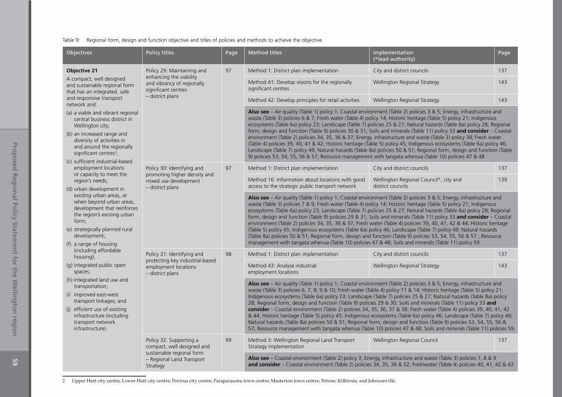
Prop
osed
Reg
ion
al Policy Statem
ent fo
r the W
elling
ton
regio
n59
Table 9: Regional form, design and function objective and titles of policies and methods to achieve the objective
Objectives Policy titles Page Method titles Implementation (*lead authority)
Page
Objective 21
A compact, well designed and sustainable regional form that has an integrated, safe and responsive transport network and:
(a) a viable and vibrant regional central business district in Wellington city;
(b) an increased range and diversity of activities in and around the regionally significant centres2;
(c) sufficient industrial-based employment locations or capacity to meet the region’s needs;
(d) urban development in existing urban areas, or when beyond urban areas, development that reinforces the region’s existing urban form;
(e) strategically planned rural development;
(f) a range of housing (including affordable housing);
(g) integrated public open spaces;
(h) integrated land use and transportation;
(i) improved east-west transport linkages; and
(j) efficient use of existing infrastructure (including transport network infrastructure).
Policy 29: Maintaining and enhancing the viability and vibrancy of regionally significant centres – district plans
97 Method 1: District plan implementation City and district councils 137
Method 41: Develop visions for the regionally significant centres
Wellington Regional Strategy 143
Method 42: Develop principles for retail activities Wellington Regional Strategy 143
Also see – Air quality (Table 1) policy 1; Coastal environment (Table 2) policies 3 & 5; Energy, infrastructure and waste (Table 3) policies 6 & 7; Fresh water (Table 4) policy 14; Historic heritage (Table 5) policy 21; Indigenous ecosystems (Table 6a) policy 23; Landscape (Table 7) policies 25 & 27; Natural hazards (Table 8a) policy 28; Regional form, design and function (Table 9) policies 30 & 31; Soils and minerals (Table 11) policy 33 and consider – Coastal environment (Table 2) policies 34, 35, 36 & 37; Energy, infrastructure and waste (Table 3) policy 38; Fresh water (Table 4) policies 39, 40, 41 & 42; Historic heritage (Table 5) policy 45; Indigenous ecosystems (Table 6a) policy 46; Landscape (Table 7) policy 49; Natural hazards (Table 8a) policies 50 & 51; Regional form, design and function (Table 9) policies 53, 54, 55, 56 & 57; Resource management with tangata whenua (Table 10) policies 47 & 48
Policy 30: Identifying and promoting higher density and mixed use development – district plans
97 Method 1: District plan implementation City and district councils 137
Method 16: Information about locations with good access to the strategic public transport network
Wellington Regional Council*, city and district councils
139
Also see – Air quality (Table 1) policy 1; Coastal environment (Table 2) policies 3 & 5; Energy, infrastructure and waste (Table 3) policies 7 & 9; Fresh water (Table 4) policy 14; Historic heritage (Table 5) policy 21; Indigenous ecosystems (Table 6a) policy 23; Landscape (Table 7) policies 25 & 27; Natural hazards (Table 8a) policy 28; Regional form, design and function (Table 9) policies 29 & 31; Soils and minerals (Table 11) policy 33 and consider – Coastal environment (Table 2) policies 34, 35, 36 & 37; Fresh water (Table 4) policies 39, 40, 41, 42 & 44; Historic heritage (Table 5) policy 45; Indigenous ecosystems (Table 6a) policy 46; Landscape (Table 7) policy 49; Natural hazards (Table 8a) policies 50 & 51; Regional form, design and function (Table 9) policies 53, 54, 55, 56 & 57 ; Resource management with tangata whenua (Table 10) policies 47 & 48; Soils and minerals (Table 11) policy 59
Policy 31: Identifying and protecting key industrial-based employment locations – district plans
98 Method 1: District plan implementation City and district councils 137
Method 43: Analyse industrial employment locations
Wellington Regional Strategy 143
Also see – Air quality (Table 1) policy 1; Coastal environment (Table 2) policies 3 & 5; Energy, infrastructure and waste (Table 3) policies 6, 7, 8, 9 & 10; Fresh water (Table 4) policy 11 & 14; Historic heritage (Table 5) policy 21; Indigenous ecosystems (Table 6a) policy 23; Landscape (Table 7) policies 25 & 27; Natural hazards (Table 8a) policy 28; Regional form, design and function (Table 9) policies 29 & 30; Soils and minerals (Table 11) policy 33 and consider – Coastal environment (Table 2) policies 34, 35, 36, 37 & 38; Fresh water (Table 4) policies 39, 40, 41, 42 & 44; Historic heritage (Table 5) policy 45; Indigenous ecosystems (Table 6a) policy 46; Landscape (Table 7) policy 49; Natural hazards (Table 8a) policies 50 & 51; Regional form, design and function (Table 9) policies 53, 54, 55, 56 & 57; Resource management with tangata whenua (Table 10) policies 47 & 48; Soils and minerals (Table 11) policies 59
Policy 32: Supporting a compact, well designed and sustainable regional form – Regional Land Transport Strategy
99 Method 3: Wellington Regional Land Transport Strategy implementation
Wellington Regional Council 137
Also see – Coastal environment (Table 2) policy 3; Energy, infrastructure and waste (Table 3) policies 7, 8 & 9 and consider – Coastal environment (Table 2) policies 34, 35, 36 & 52; Freshwater (Table 4) policies 40, 41, 42 & 43
2 Upper Hutt city centre; Lower Hutt city centre; Porirua city centre; Paraparaumu town centre; Masterton town centre; Petone; Kilbirnie; and Johnsonville.
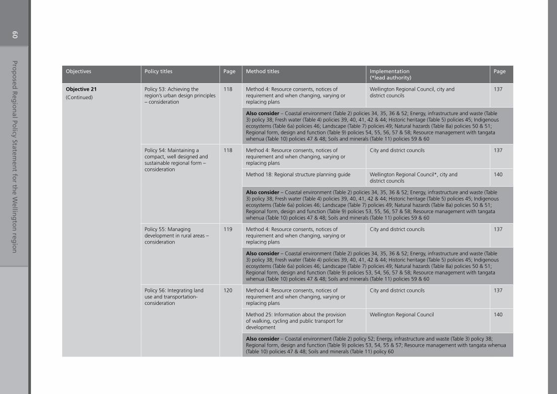
Prop
osed
Reg
ion
al Policy Statem
ent fo
r the W
elling
ton
regio
n60
Objectives Policy titles Page Method titles Implementation (*lead authority)
Page
Objective 21
(Continued)
Policy 53: Achieving the region’s urban design principles – consideration
118 Method 4: Resource consents, notices of requirement and when changing, varying or replacing plans
Wellington Regional Council, city and district councils
137
Also consider – Coastal environment (Table 2) policies 34, 35, 36 & 52; Energy, infrastructure and waste (Table 3) policy 38; Fresh water (Table 4) policies 39, 40, 41, 42 & 44; Historic heritage (Table 5) policies 45; Indigenous ecosystems (Table 6a) policies 46; Landscape (Table 7) policies 49; Natural hazards (Table 8a) policies 50 & 51; Regional form, design and function (Table 9) policies 54, 55, 56, 57 & 58; Resource management with tangata whenua (Table 10) policies 47 & 48; Soils and minerals (Table 11) policies 59 & 60
Policy 54: Maintaining a compact, well designed and sustainable regional form – consideration
118 Method 4: Resource consents, notices of requirement and when changing, varying or replacing plans
City and district councils 137
Method 18: Regional structure planning guide Wellington Regional Council*, city and district councils
140
Also consider – Coastal environment (Table 2) policies 34, 35, 36 & 52; Energy, infrastructure and waste (Table 3) policy 38; Fresh water (Table 4) policies 39, 40, 41, 42 & 44; Historic heritage (Table 5) policies 45; Indigenous ecosystems (Table 6a) policies 46; Landscape (Table 7) policies 49; Natural hazards (Table 8a) policies 50 & 51; Regional form, design and function (Table 9) policies 53, 55, 56, 57 & 58; Resource management with tangata whenua (Table 10) policies 47 & 48; Soils and minerals (Table 11) policies 59 & 60
Policy 55: Managing development in rural areas – consideration
119 Method 4: Resource consents, notices of requirement and when changing, varying or replacing plans
City and district councils 137
Also consider – Coastal environment (Table 2) policies 34, 35, 36 & 52; Energy, infrastructure and waste (Table 3) policy 38; Fresh water (Table 4) policies 39, 40, 41, 42 & 44; Historic heritage (Table 5) policies 45; Indigenous ecosystems (Table 6a) policies 46; Landscape (Table 7) policies 49; Natural hazards (Table 8a) policies 50 & 51; Regional form, design and function (Table 9) policies 53, 54, 56, 57 & 58; Resource management with tangata whenua (Table 10) policies 47 & 48; Soils and minerals (Table 11) policies 59 & 60
Policy 56: Integrating land use and transportation- consideration
120 Method 4: Resource consents, notices of requirement and when changing, varying or replacing plans
City and district councils 137
Method 25: Information about the provision of walking, cycling and public transport for development
Wellington Regional Council 140
Also consider – Coastal environment (Table 2) policy 52; Energy, infrastructure and waste (Table 3) policy 38; Regional form, design and function (Table 9) policies 53, 54, 55 & 57; Resource management with tangata whenua (Table 10) policies 47 & 48; Soils and minerals (Table 11) policy 60
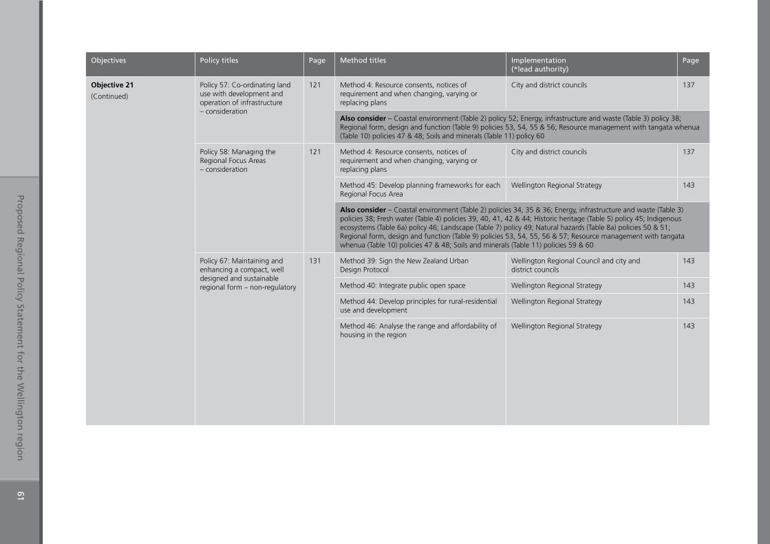
Prop
osed
Reg
ion
al Policy Statem
ent fo
r the W
elling
ton
regio
n61
Objectives Policy titles Page Method titles Implementation (*lead authority)
Page
Objective 21
(Continued)
Policy 57: Co-ordinating land use with development and operation of infrastructure – consideration
121 Method 4: Resource consents, notices of requirement and when changing, varying or replacing plans
City and district councils 137
Also consider – Coastal environment (Table 2) policy 52; Energy, infrastructure and waste (Table 3) policy 38; Regional form, design and function (Table 9) policies 53, 54, 55 & 56; Resource management with tangata whenua (Table 10) policies 47 & 48; Soils and minerals (Table 11) policy 60
Policy 58: Managing the Regional Focus Areas – consideration
121 Method 4: Resource consents, notices of requirement and when changing, varying or replacing plans
City and district councils 137
Method 45: Develop planning frameworks for each Regional Focus Area
Wellington Regional Strategy 143
Also consider – Coastal environment (Table 2) policies 34, 35 & 36; Energy, infrastructure and waste (Table 3) policies 38; Fresh water (Table 4) policies 39, 40, 41, 42 & 44; Historic heritage (Table 5) policy 45; Indigenous ecosystems (Table 6a) policy 46; Landscape (Table 7) policy 49; Natural hazards (Table 8a) policies 50 & 51; Regional form, design and function (Table 9) policies 53, 54, 55, 56 & 57; Resource management with tangata whenua (Table 10) policies 47 & 48; Soils and minerals (Table 11) policies 59 & 60
Policy 67: Maintaining and enhancing a compact, well designed and sustainable regional form – non-regulatory
131 Method 39: Sign the New Zealand Urban Design Protocol
Wellington Regional Council and city and district councils
143
Method 40: Integrate public open space Wellington Regional Strategy 143
Method 44: Develop principles for rural-residential use and development
Wellington Regional Strategy 143
Method 46: Analyse the range and affordability of housing in the region
Wellington Regional Strategy 143
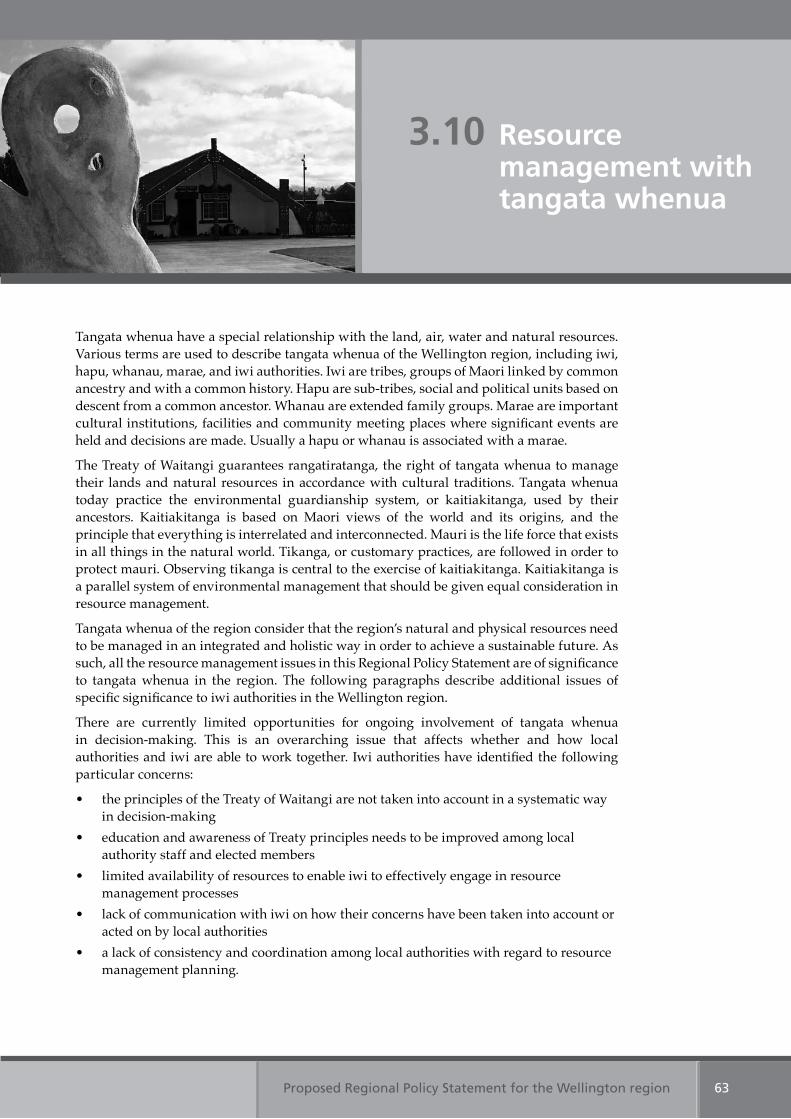
Proposed Regional Policy Statement for the Wellington region 63
Tangata whenua have a special relationship with the land, air, water and natural resources. Various terms are used to describe tangata whenua of the Wellington region, including iwi, hapu, whanau, marae, and iwi authorities. Iwi are tribes, groups of Maori linked by common ancestry and with a common history. Hapu are sub-tribes, social and political units based on descent from a common ancestor. Whanau are extended family groups. Marae are important cultural institutions, facilities and community meeting places where significant events are held and decisions are made. Usually a hapu or whanau is associated with a marae.
The Treaty of Waitangi guarantees rangatiratanga, the right of tangata whenua to manage their lands and natural resources in accordance with cultural traditions. Tangata whenua today practice the environmental guardianship system, or kaitiakitanga, used by their ancestors. Kaitiakitanga is based on Maori views of the world and its origins, and the principle that everything is interrelated and interconnected. Mauri is the life force that exists in all things in the natural world. Tikanga, or customary practices, are followed in order to protect mauri. Observing tikanga is central to the exercise of kaitiakitanga. Kaitiakitanga is a parallel system of environmental management that should be given equal consideration in resource management.
Tangata whenua of the region consider that the region’s natural and physical resources need to be managed in an integrated and holistic way in order to achieve a sustainable future. As such, all the resource management issues in this Regional Policy Statement are of significance to tangata whenua in the region. The following paragraphs describe additional issues of specific significance to iwi authorities in the Wellington region.
There are currently limited opportunities for ongoing involvement of tangata whenua in decision-making. This is an overarching issue that affects whether and how local authorities and iwi are able to work together. Iwi authorities have identified the following particular concerns:
• the principles of the Treaty of Waitangi are not taken into account in a systematic way in decision-making
• education and awareness of Treaty principles needs to be improved among local authority staff and elected members
• limited availability of resources to enable iwi to effectively engage in resource management processes
• lack of communication with iwi on how their concerns have been taken into account or acted on by local authorities
• a lack of consistency and coordination among local authorities with regard to resource management planning.
3.10 Resource management with tangata whenua
Proposed Regional Policy Statement for the Wellington region64
Mauri can be harmed by insensitive resource use. For example, the health and vitality of the sea, streams and rivers and the plants and animals they support can be threatened by activities – such as discharges of pollutants; stormwater and sewage; runoff of contaminants from land; excessive water use; changing the course of water bodies, or diverting water between catchments or rivers. Maori consider that rivers are the life blood of the land and that the wellbeing of natural resources is reflected in the wellbeing of people. Similarly, the mauri of the land and air and the plants and animals they support can be harmed by practices such as clearance of vegetation, soil disturbance and disposal of wastes.
Insensitive resource use also threatens mahinga kai (customary food gathering) and natural resources used for customary purposes. Tangata whenua are also sometimes prevented from accessing sites where customary resources are found. Degradation or loss of nga kai (traditional foods), mataitai (areas of importance for food gathering) and flora and fauna compromise the mana (authority) of tangata whenua by impairing their ability to fulfil their role and responsibilities in relation to kaitiakitanga and manaakitanga (their responsibilities of care for guests). Foods of traditional importance include, but are not limited to, forest kai, seafood, eels and whitebait.
Growth and development pressure on and around significant cultural heritage sites has led to widespread destruction and degradation of places, sites and areas with spiritual, cultural or historic heritage value of significance to tangata whenua.
The resource management issues of specific significance to iwi authorities in the Wellington region are:
1. Lack of involvement in resource management decision-makingLack of tangata whenua involvement in resource management decision-making.
2. Loss of mauriLoss of mauri, particularly in relation to fresh and coastal waters.
3. Quality, quantity and access to mahinga kai and natural resources used for customary purposes
Continuing loss of quality, quantity, and access to mahinga kai and natural resources used for customary purposes.
4. Degradation and destruction of spiritual and cultural historic heritage values
Degradation and destruction of places, sites and areas with spiritual, cultural or historic heritage value to tangata whenua.
Table 10: Resource management with tangata whenua Objectives 22, 23 & 24
Table 10: Resource management with tangata whenua Objective 25
Table 10: Resource management with tangata whenua Objective 26
Table 10: Resource management with tangata whenua Objective 27
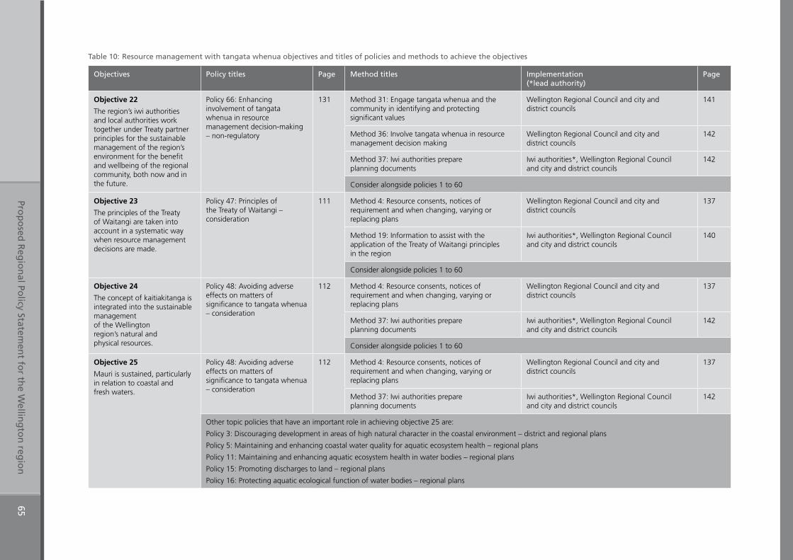
Prop
osed
Reg
ion
al Policy Statem
ent fo
r the W
elling
ton
regio
n65
Table 10: Resource management with tangata whenua objectives and titles of policies and methods to achieve the objectives
Objectives Policy titles Page Method titles Implementation (*lead authority)
Page
Objective 22
The region’s iwi authorities and local authorities work together under Treaty partner principles for the sustainable management of the region’s environment for the benefit and wellbeing of the regional community, both now and in the future.
Policy 66: Enhancing involvement of tangata whenua in resource management decision-making – non-regulatory
131 Method 31: Engage tangata whenua and the community in identifying and protecting significant values
Wellington Regional Council and city and district councils
141
Method 36: Involve tangata whenua in resource management decision making
Wellington Regional Council and city and district councils
142
Method 37: Iwi authorities prepare planning documents
Iwi authorities*, Wellington Regional Council and city and district councils
142
Consider alongside policies 1 to 60
Objective 23
The principles of the Treaty of Waitangi are taken into account in a systematic way when resource management decisions are made.
Policy 47: Principles of the Treaty of Waitangi – consideration
111 Method 4: Resource consents, notices of requirement and when changing, varying or replacing plans
Wellington Regional Council and city and district councils
137
Method 19: Information to assist with the application of the Treaty of Waitangi principles in the region
Iwi authorities*, Wellington Regional Council and city and district councils
140
Consider alongside policies 1 to 60
Objective 24
The concept of kaitiakitanga is integrated into the sustainable management of the Wellington region’s natural and physical resources.
Policy 48: Avoiding adverse effects on matters of significance to tangata whenua – consideration
112 Method 4: Resource consents, notices of requirement and when changing, varying or replacing plans
Wellington Regional Council and city and district councils
137
Method 37: Iwi authorities prepare planning documents
Iwi authorities*, Wellington Regional Council and city and district councils
142
Consider alongside policies 1 to 60
Objective 25
Mauri is sustained, particularly in relation to coastal and fresh waters.
Policy 48: Avoiding adverse effects on matters of significance to tangata whenua – consideration
112 Method 4: Resource consents, notices of requirement and when changing, varying or replacing plans
Wellington Regional Council and city and district councils
137
Method 37: Iwi authorities prepare planning documents
Iwi authorities*, Wellington Regional Council and city and district councils
142
Other topic policies that have an important role in achieving objective 25 are:
Policy 3: Discouraging development in areas of high natural character in the coastal environment – district and regional plans
Policy 5: Maintaining and enhancing coastal water quality for aquatic ecosystem health – regional plans
Policy 11: Maintaining and enhancing aquatic ecosystem health in water bodies – regional plans
Policy 15: Promoting discharges to land – regional plans
Policy 16: Protecting aquatic ecological function of water bodies – regional plans
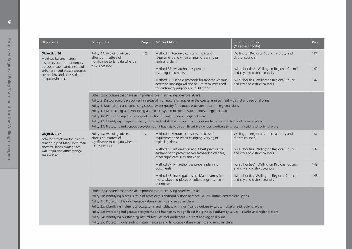
Prop
osed
Reg
ion
al Policy Statem
ent fo
r the W
elling
ton
regio
n66
Objectives Policy titles Page Method titles Implementation (*lead authority)
Page
Objective 26
Mahinga kai and natural resources used for customary purposes, are maintained and enhanced, and these resources are healthy and accessible to tangata whenua.
Policy 48: Avoiding adverse effects on matters of significance to tangata whenua – consideration
112 Method 4: Resource consents, notices of requirement and when changing, varying or replacing plans
Wellington Regional Council and city and district councils
137
Method 37: Iwi authorities prepare planning documents
Iwi authorities*, Wellington Regional Council and city and district councils
142
Method 38: Prepare protocols for tangata whenua access to mahinga kai and natural resources used for customary purposes on public land
Iwi authorities, Wellington Regional Council and city and district councils
142
Other topic policies that have an important role in achieving objective 26 are:
Policy 3: Discouraging development in areas of high natural character in the coastal environment – district and regional plans
Policy 5: Maintaining and enhancing coastal water quality for aquatic ecosystem health – regional plans
Policy 11: Maintaining and enhancing aquatic ecosystem health in water bodies – regional plans
Policy 16: Protecting aquatic ecological function of water bodies – regional plans
Policy 22: Identifying indigenous ecosystems and habitats with significant biodiversity values – district and regional plans
Policy 23: Protecting indigenous ecosystems and habitats with significant indigenous biodiversity values – district and regional plans
Objective 27
Adverse effects on the cultural relationship of Maori with their ancestral lands, water, sites, wahi tapu and other taonga are avoided.
Policy 48: Avoiding adverse effects on matters of significance to tangata whenua – consideration
112 Method 4: Resource consents, notices of requirement and when changing, varying or replacing plans
Wellington Regional Council and city and district councils
137
Method 13: Information about best practice for earthworks to protect Maori archaeological sites, other significant sites and koiwi
Iwi authorities, Wellington Regional Council and city and district councils
139
Method 37: Iwi authorities prepare planning documents
Iwi authorities*, Wellington Regional Council and city and district councils
142
Method 48: Investigate use of Maori names for rivers, lakes and places of cultural significance in the region
Iwi authorities, Wellington Regional Council and city and district councils
143
Other topic policies that have an important role in achieving objective 27 are:
Policy 20: Identifying places, sites and areas with significant historic heritage values– district and regional plans
Policy 21: Protecting historic heritage values – district and regional plans
Policy 22: Identifying indigenous ecosystems and habitats with significant biodiversity values – district and regional plans
Policy 23: Protecting indigenous ecosystems and habitats with significant indigenous biodiversity values – district and regional plans
Policy 24: Identifying outstanding natural features and landscapes – district and regional plans
Policy 25: Protecting outstanding natural features and landscape values – district and regional plans
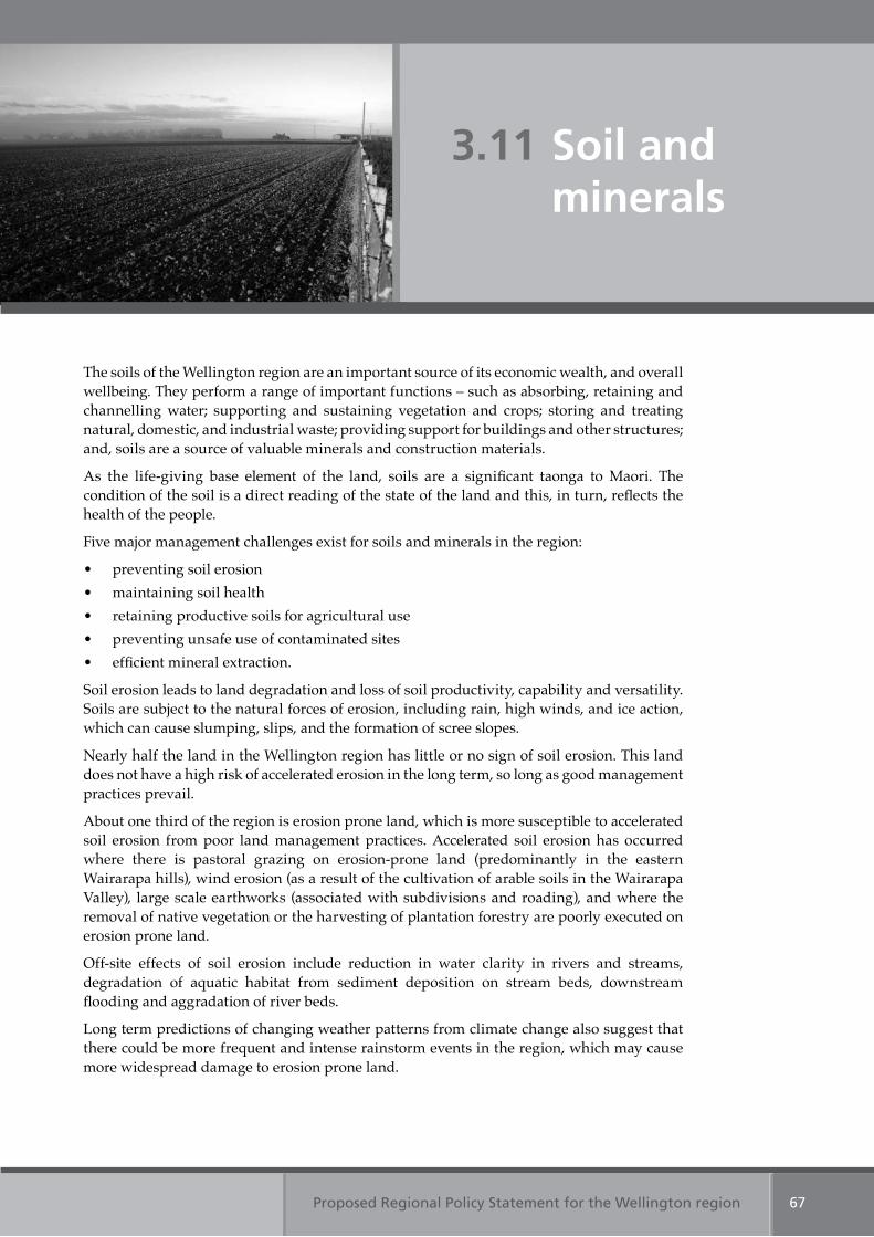
Proposed Regional Policy Statement for the Wellington region 67
3.11 Soil and minerals
The soils of the Wellington region are an important source of its economic wealth, and overall wellbeing. They perform a range of important functions – such as absorbing, retaining and channelling water; supporting and sustaining vegetation and crops; storing and treating natural, domestic, and industrial waste; providing support for buildings and other structures; and, soils are a source of valuable minerals and construction materials.
As the life-giving base element of the land, soils are a significant taonga to Maori. The condition of the soil is a direct reading of the state of the land and this, in turn, reflects the health of the people.
Five major management challenges exist for soils and minerals in the region:
• preventing soil erosion • maintaining soil health • retaining productive soils for agricultural use• preventing unsafe use of contaminated sites • efficient mineral extraction.
Soil erosion leads to land degradation and loss of soil productivity, capability and versatility. Soils are subject to the natural forces of erosion, including rain, high winds, and ice action, which can cause slumping, slips, and the formation of scree slopes.
Nearly half the land in the Wellington region has little or no sign of soil erosion. This land does not have a high risk of accelerated erosion in the long term, so long as good management practices prevail.
About one third of the region is erosion prone land, which is more susceptible to accelerated soil erosion from poor land management practices. Accelerated soil erosion has occurred where there is pastoral grazing on erosion-prone land (predominantly in the eastern Wairarapa hills), wind erosion (as a result of the cultivation of arable soils in the Wairarapa Valley), large scale earthworks (associated with subdivisions and roading), and where the removal of native vegetation or the harvesting of plantation forestry are poorly executed on erosion prone land.
Off-site effects of soil erosion include reduction in water clarity in rivers and streams, degradation of aquatic habitat from sediment deposition on stream beds, downstream flooding and aggradation of river beds.
Long term predictions of changing weather patterns from climate change also suggest that there could be more frequent and intense rainstorm events in the region, which may cause more widespread damage to erosion prone land.
Proposed Regional Policy Statement for the Wellington region68
Soil health refers to the biological, chemical and physical qualities of the soil that support the soil’s ecosystems. Unlike soil erosion problems, which are generally obvious, soil health problems are less evident, but no less important. Soil health can be compromised or degraded through contamination, compaction and the loss of minerals and nutrients.
Intensive land use and the desire to increase productivity of arable land has led to the use of phosphate-based fertilisers. Most of the cropping and horticultural land in the region has elevated levels of available phosphate. Phosphate attaches to soil particles and, if washed off land and into rivers, can promote nuisance aquatic weed or algal growth. Some areas are more prone to these problems than others.
On land used for dairying, and to a lesser extent for horticulture, there is evidence of soil compaction and elevated nitrogen concentrations. Soil compaction reduces soil pore spaces, which reduces water infiltration and increases run-off.
Soils contain the necessary minerals and nutrients to enable plants and animals to grow. A consequence of intensive farming is that soils are unable to sustain high levels of growth unless those minerals and nutrients are replaced. Soil monitoring to date shows that soil organic matter is slowly declining in arable soils in the region.
The region has a small amount of land that could be described as highly productive and suitable for multiple use such as for growing a wide range of crops, pasture and forest, and for supporting grazing animals. This land is described as Class I and II land under the Land Use Capability classification.
Class I and II land in the region is found in the river valleys of the Otaki and Ruamahanga rivers and around the townships of Otaki, Featherston, Greytown, Carterton, and Masterton. There is growing pressure to develop some of this land, especially around Otaki and Greytown. The total area of Class I land in the region is small, about 0.6 per cent of the total land area (4800 hectares). Class II land is about 1.7 per cent (13,800 hectares).
Contaminated land arises where hazardous substances are found or are reasonably likely to occur at levels that could have significant adverse effects on the environment. It is the legacy of poor land and/or waste management. There are more than 1,600 sites in the region that have a history of using, storing or manufacturing hazardous substances, including closed landfills. Contaminated land can make land unsuitable or unsafe for future land uses.
In the Wellington region, sand, rock, gravel and limestone are mined from rivers, beaches, coastal cliffs and inland quarries. Oil and gas exploration are also ongoing in parts of Wairarapa and Kapiti. As the region’s population continues to expand, the demand for mineral resources, particularly aggregate (crushed rock used in building, roading and other construction), will increase. Mineral resources are fixed in location, unevenly distributed and finite. Extraction processes, sites and transportation routes can create adverse environmental effects. If activities sensitive to the effects of extraction and processing are established nearby, reverse sensitivity can arise – such as a new garden centre needing to screen itself from dust.
Similarly, the transportation of mineral resources around, through and out of the region can give rise to adverse effects. There are benefits to allowing extraction and processing by extractive industries as close as possible to the location of use of the final product to avoid distributing adverse effects across a greater area than necessary to meet the need for these resources.

Proposed Regional Policy Statement for the Wellington region 69
Table 11: Soils and minerals Objectives 28 & 29
Table 11: Soils and minerals Objective 29
Table 11: Soils and minerals Objective 29
The regionally significant resource management issues for soils and minerals are:
1. Accelerated soil erosionSome land management practices accelerate soil erosion and reduce soil quality. Soil loss can lead to increased sedimentation of waterways and subsequent effects on the coastal marine area. Soil loss can also decrease farm production, soil biodiversity and ecosystem function.
2. Reduction of soil healthSome land use practices are reducing the health and productive capability of soil, leading to the loss of its life-supporting capacity.
3. Highly productive agricultural land under threat from developmentThe Wellington region has a small total area of highly productive agricultural land (Class I and II land). This land is under threat from development, including residential development and the construction of roads.
4. Contaminated landSome land where hazardous substances have been manufactured, used or stored – such as gas works, petrol stations, landfills, and sheep dips – have contaminated soils. Development of that land for new uses may not be safe if soils are contaminated.
5. Limited mineral resources There are limited mineral resources in the region and demand for these will increase. The benefits of extracting mineral resources locally are greater than sourcing it from outside the region. If the extraction of mineral resources within the region is constrained, demand will have to be met from outside the region, with higher social, economic and environmental costs.
Table 11: Soils and minerals Objective 30
Table 11: Soils and minerals Objective 29
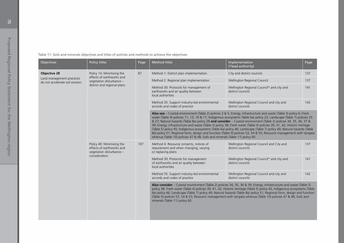
Prop
osed
Reg
ion
al Policy Statem
ent fo
r the W
elling
ton
regio
n70
Table 11: Soils and minerals objectives and titles of policies and methods to achieve the objectives
Objectives Policy titles Page Method titles Implementation (*lead authority)
Page
Objective 28
Land management practices do not accelerate soil erosion.
Policy 14: Minimising the effects of earthworks and vegetation disturbance – district and regional plans
87 Method 1: District plan implementation City and district councils 137
Method 2: Regional plan implementation Wellington Regional Council 137
Method 30: Protocols for management of earthworks and air quality between local authorities
Wellington Regional Council* and city and district councils
141
Method 35: Support industry-led environmental accords and codes of practice
Wellington Regional Council and city and district councils
142
Also see – Coastal environment (Table 2) policies 3 & 5; Energy, infrastructure and waste (Table 3) policy 6; Fresh water (Table 4) policies 11, 13, 16 & 17; Indigenous ecosystems (Table 6a) policy 23; Landscape (Table 7) policies 25 & 27; Natural hazards (Table 8a) policy 28 and consider – Coastal environment (Table 2) policies 34, 35, 36, 37 & 39; Energy, infrastructure and waste (Table 3) policy 38; Fresh water (Table 4) policies 39, 41, 42; Historic heritage (Table 5) policy 45; Indigenous ecosystems (Table 6a) policy 46; Landscape (Table 7) policy 49; Natural hazards (Table 8a) policy 51; Regional form, design and function (Table 9) policies 53, 54 & 55; Resource management with tangata whenua (Table 10) policies 47 & 48; Soils and minerals (Table 11) policy 60
Policy 40: Minimising the effects of earthworks and vegetation disturbance – consideration
107 Method 4: Resource consents, notices of requirement and when changing, varying or replacing plans
Wellington Regional Council and City and district councils
137
Method 30: Protocols for management of earthworks and air quality between local authorities
Wellington Regional Council* and city and district councils
141
Method 35: Support industry-led environmental accords and codes of practice
Wellington Regional Council and city and district councils
142
Also consider – Coastal environment (Table 2) policies 34, 35, 36 & 39; Energy, infrastructure and waste (Table 3) policy 38; Fresh water (Table 4) policies 39, 41, 42; Historic heritage (Table 5) policy 45; Indigenous ecosystems (Table 6a) policy 46; Landscape (Table 7) policy 49; Natural hazards (Table 8a) policy 51; Regional form, design and function (Table 9) policies 53, 54 & 55; Resource management with tangata whenua (Table 10) policies 47 & 48; Soils and minerals (Table 11) policy 60
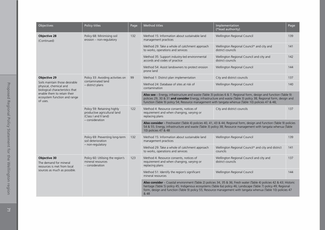
Prop
osed
Reg
ion
al Policy Statem
ent fo
r the W
elling
ton
regio
n71
Objectives Policy titles Page Method titles Implementation (*lead authority)
Page
Objective 28
(Continued)
Policy 68: Minimising soil erosion – non-regulatory
132 Method 15: Information about sustainable land management practices
Wellington Regional Council 139
Method 29: Take a whole of catchment approach to works, operations and services
Wellington Regional Council* and city and district councils
141
Method 35: Support industry-led environmental accords and codes of practice
Wellington Regional Council and city and district councils
142
Method 54: Assist landowners to protect erosion prone land
Wellington Regional Council 144
Objective 29
Soils maintain those desirable physical, chemical and biological characteristics that enable them to retain their ecosystem function and range of uses.
Policy 33: Avoiding activities on contaminated land – district plans
99 Method 1: District plan implementation City and district councils 137
Method 24: Database of sites at risk of contamination
Wellington Regional Council 140
Also see – Energy, infrastructure and waste (Table 3) policies 6 & 7; Regional form, design and function (Table 9) policies 29, 30 & 31 and consider Energy, infrastructure and waste (Table 3) policy 38; Regional form, design and function (Table 9) policy 54; Resource management with tangata whenua (Table 10) policies 47 & 48;
Policy 59: Retaining highly productive agricultural land (Class I and II land) – consideration
122 Method 4: Resource consents, notices of requirement and when changing, varying or replacing plans
City and district councils 137
Also consider – Freshwater (Table 4) policies 40, 41, 43 & 44; Regional form, design and function (Table 9) policies 54 & 55; Energy, infrastructure and waste (Table 3) policy 38; Resource management with tangata whenua (Table 10) policies 47 & 48
Policy 69: Preventing long-term soil deterioration – non-regulatory
132 Method 15: Information about sustainable land management practices
Wellington Regional Council 139
Method 29: Take a whole of catchment approach to works, operations and services
Wellington Regional Council* and city and district councils
141
Objective 30
The demand for mineral resources is met from local sources as much as possible.
Policy 60: Utilising the region’s mineral resources – consideration
123 Method 4: Resource consents, notices of requirement and when changing, varying or replacing plans
Wellington Regional Council and city and district councils
137
Method 51: Identify the region’s significant mineral resources
Wellington Regional Council 144
Also consider – Coastal environment (Table 2) policies 34, 35 & 36; Fresh water (Table 4) policies 42 & 43; Historic heritage (Table 5) policy 45; Indigenous ecosystems (Table 6a) policy 46; Landscape (Table 7) policy 49; Regional form, design and function (Table 9) policy 55; Resource management with tangata whenua (Table 10) policies 47 & 48
Chapter Four
Policies and methods
Proposed Regional Policy Statement for the Wellington region 73
4. Policies and methods
This chapter presents the policies and methods that, when implemented, will achieve the objectives of this Regional Policy Statement and address the regionally significant resource management issues (including the issues of significance to iwi authorities). The resource management issues and objectives are presented in the previous chapter under topic headings.
Within this Chapter, the policies and then the methods are listed in numeric order.
Chapter 4 is divided into five sections. The first four sections set out the policies, organised according to their type:
• Section 4.1 contains policies that direct district or regional plans, or the Wellington Regional Land Transport Strategy
• Section 4.2 contains policies that are to be considered when processing and deciding upon a resource consent, notice of requirement, or a change, variation or replacement to regional, city or district plans
• Section 4.3 contains policies that allocate responsibilities for indigenous biodiversity, natural hazards and hazardous substances
• Section 4.4 contains policies that outline non-regulatory actions
The fifth section sets out the methods for implementing the policies. There are two main groups of methods:
• Regulatory methods, implementing policies in sections 4.1, 4.2 and 4.3• Non-regulatory methods, that implement the policies in section 4.4 or that support the
delivery of the other policies.
Each of the five sections includes a summary table in which the policy or method titles are provided. This serves only as a guide, as the policy and associated methods are not reproduced in full within these summary tables.
Alongside each of the policies, in the margin, is a cross reference to pertinent objectives, methods and related policies. These must be read in association with each policy, to appreciate the relationships between these policies and methods.
Within chapter 4, words and terms for which definitions are provided are presented in italics in the explanation, when the definition is directly relevant to interpretation of the policy in which the word or term is used. All definitions are provided in Appendix 3.
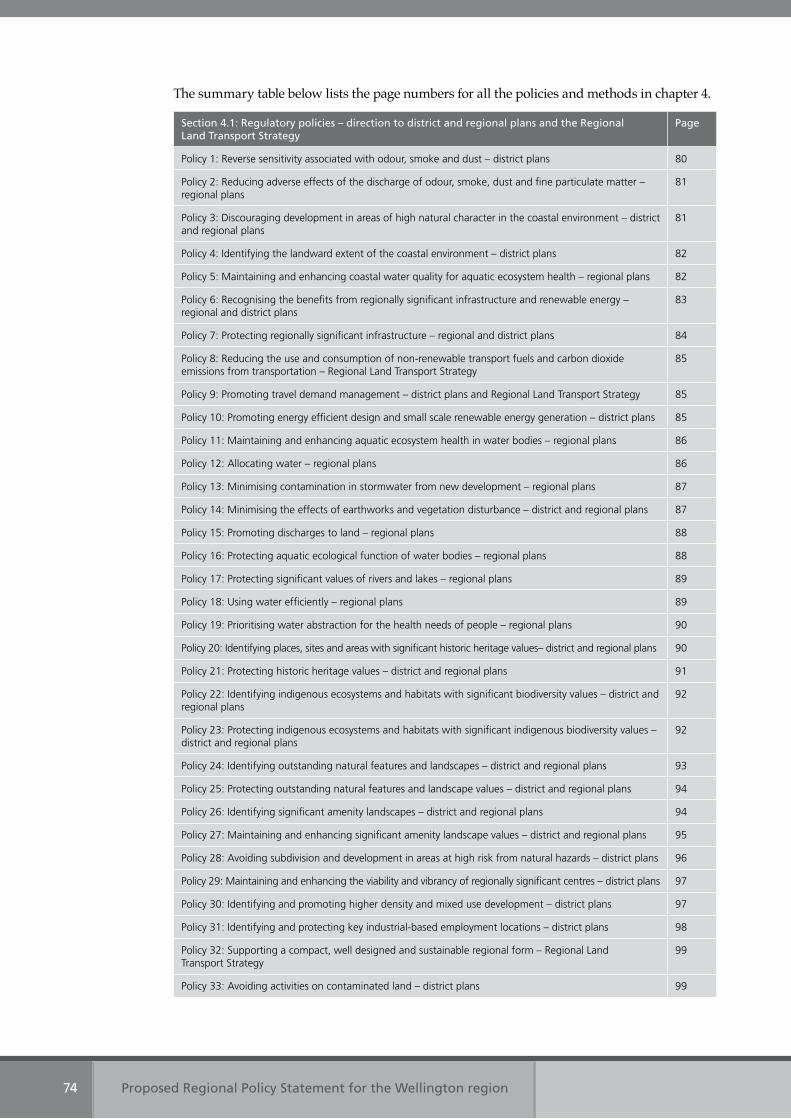
Proposed Regional Policy Statement for the Wellington region74
The summary table below lists the page numbers for all the policies and methods in chapter 4.
Section 4.1: Regulatory policies – direction to district and regional plans and the Regional Land Transport Strategy
Page
Policy 1: Reverse sensitivity associated with odour, smoke and dust – district plans 80
Policy 2: Reducing adverse effects of the discharge of odour, smoke, dust and fine particulate matter – regional plans
81
Policy 3: Discouraging development in areas of high natural character in the coastal environment – district and regional plans
81
Policy 4: Identifying the landward extent of the coastal environment – district plans 82
Policy 5: Maintaining and enhancing coastal water quality for aquatic ecosystem health – regional plans 82
Policy 6: Recognising the benefits from regionally significant infrastructure and renewable energy – regional and district plans
83
Policy 7: Protecting regionally significant infrastructure – regional and district plans 84
Policy 8: Reducing the use and consumption of non-renewable transport fuels and carbon dioxide emissions from transportation – Regional Land Transport Strategy
85
Policy 9: Promoting travel demand management – district plans and Regional Land Transport Strategy 85
Policy 10: Promoting energy efficient design and small scale renewable energy generation – district plans 85
Policy 11: Maintaining and enhancing aquatic ecosystem health in water bodies – regional plans 86
Policy 12: Allocating water – regional plans 86
Policy 13: Minimising contamination in stormwater from new development – regional plans 87
Policy 14: Minimising the effects of earthworks and vegetation disturbance – district and regional plans 87
Policy 15: Promoting discharges to land – regional plans 88
Policy 16: Protecting aquatic ecological function of water bodies – regional plans 88
Policy 17: Protecting significant values of rivers and lakes – regional plans 89
Policy 18: Using water efficiently – regional plans 89
Policy 19: Prioritising water abstraction for the health needs of people – regional plans 90
Policy 20: Identifying places, sites and areas with significant historic heritage values– district and regional plans 90
Policy 21: Protecting historic heritage values – district and regional plans 91
Policy 22: Identifying indigenous ecosystems and habitats with significant biodiversity values – district and regional plans
92
Policy 23: Protecting indigenous ecosystems and habitats with significant indigenous biodiversity values – district and regional plans
92
Policy 24: Identifying outstanding natural features and landscapes – district and regional plans 93
Policy 25: Protecting outstanding natural features and landscape values – district and regional plans 94
Policy 26: Identifying significant amenity landscapes – district and regional plans 94
Policy 27: Maintaining and enhancing significant amenity landscape values – district and regional plans 95
Policy 28: Avoiding subdivision and development in areas at high risk from natural hazards – district plans 96
Policy 29: Maintaining and enhancing the viability and vibrancy of regionally significant centres – district plans 97
Policy 30: Identifying and promoting higher density and mixed use development – district plans 97
Policy 31: Identifying and protecting key industrial-based employment locations – district plans 98
Policy 32: Supporting a compact, well designed and sustainable regional form – Regional Land Transport Strategy
99
Policy 33: Avoiding activities on contaminated land – district plans 99
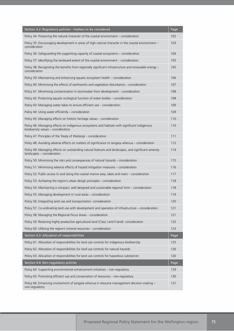
Proposed Regional Policy Statement for the Wellington region 75
Section 4.2: Regulatory policies – matters to be considered Page
Policy 34: Preserving the natural character of the coastal environment – consideration 102
Policy 35: Discouraging development in areas of high natural character in the coastal environment – consideration
103
Policy 36: Safeguarding life-supporting capacity of coastal ecosystems – consideration 104
Policy 37: Identifying the landward extent of the coastal environment – consideration 105
Policy 38: Recognising the benefits from regionally significant infrastructure and renewable energy – consideration
105
Policy 39: Maintaining and enhancing aquatic ecosystem health – consideration 106
Policy 40: Minimising the effects of earthworks and vegetation disturbance – consideration 107
Policy 41: Minimising contamination in stormwater from development – consideration 108
Policy 42: Protecting aquatic ecological function of water bodies – consideration 108
Policy 43: Managing water takes to ensure efficient use – consideration 109
Policy 44: Using water efficiently – consideration 109
Policy 45: Managing effects on historic heritage values – consideration 110
Policy 46: Managing effects on indigenous ecosystems and habitats with significant indigenous biodiversity values – consideration
110
Policy 47: Principles of the Treaty of Waitangi – consideration 111
Policy 48: Avoiding adverse effects on matters of significance to tangata whenua – consideration 112
Policy 49: Managing effects on outstanding natural features and landscapes, and significant amenity landscapes – consideration
114
Policy 50: Minimising the risks and consequences of natural hazards – consideration 115
Policy 51: Minimising adverse effects of hazard mitigation measures – consideration 116
Policy 52: Public access to and along the coastal marine area, lakes and rivers – consideration 117
Policy 53: Achieving the region’s urban design principles – consideration 118
Policy 54: Maintaining a compact, well designed and sustainable regional form – consideration 118
Policy 55: Managing development in rural areas – consideration 119
Policy 56: Integrating land use and transportation- consideration 120
Policy 57: Co-ordinating land use with development and operation of infrastructure – consideration 121
Policy 58: Managing the Regional Focus Areas – consideration 121
Policy 59: Retaining highly productive agricultural land (Class I and II land)- consideration 122
Policy 60: Utilising the region’s mineral resources – consideration 123
Section 4.3: Allocation of responsibilities Page
Policy 61: Allocation of responsibilities for land use controls for indigenous biodiversity 125
Policy 62: Allocation of responsibilities for land use controls for natural hazards 126
Policy 63: Allocation of responsibilities for land use controls for hazardous substances 126
Section 4.4: Non-regulatory policies Page
Policy 64: Supporting environmental enhancement initiatives – non-regulatory 129
Policy 65: Promoting efficient use and conservation of resources – non-regulatory 130
Policy 66: Enhancing involvement of tangata whenua in resource management decision-making – non-regulatory
131
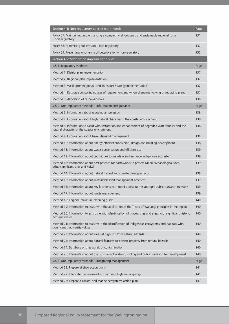
Proposed Regional Policy Statement for the Wellington region76
Section 4.4: Non-regulatory policies (continued) Page
Policy 67: Maintaining and enhancing a compact, well designed and sustainable regional form – non-regulatory
131
Policy 68: Minimising soil erosion – non-regulatory 132
Policy 69: Preventing long-term soil deterioration – non-regulatory 132
Section 4.5: Methods to implement policies
4.5.1: Regulatory methods Page
Method 1: District plan implementation 137
Method 2: Regional plan implementation 137
Method 3: Wellington Regional Land Transport Strategy implementation 137
Method 4: Resource consents, notices of requirement and when changing, varying or replacing plans 137
Method 5: Allocation of responsibilities 138
4.5.2: Non-regulatory methods – information and guidance Page
Method 6: Information about reducing air pollution 138
Method 7: Information about high natural character in the coastal environment 138
Method 8: Information to assist with restoration and enhancement of degraded water bodies and the natural character of the coastal environment
138
Method 9: Information about travel demand management 138
Method 10: Information about energy efficient subdivision, design and building development 138
Method 11: Information about water conservation and efficient use 139
Method 12: Information about techniques to maintain and enhance indigenous ecosystems 139
Method 13: Information about best practice for earthworks to protect Maori archaeological sites, other significant sites and koiwi
139
Method 14: Information about natural hazard and climate change effects 139
Method 15: Information about sustainable land management practices 139
Method 16: Information about key locations with good access to the strategic public transport network 139
Method 17: Information about waste management 139
Method 18: Regional structure planning guide 140
Method 19: Information to assist with the application of the Treaty of Waitangi principles in the region 140
Method 20: Information to assist the with identification of places, sites and areas with significant historic heritage values
140
Method 21: Information to assist with the identification of indigenous ecosystems and habitats with significant biodiversity values
140
Method 22: Information about areas at high risk from natural hazards 140
Method 23: Information about natural features to protect property from natural hazards 140
Method 24: Database of sites at risk of contamination 140
Method 25: Information about the provision of walking, cycling and public transport for development 140
4.5.3: Non-regulatory methods – integrating management Page
Method 26: Prepare airshed action plans 141
Method 27: Integrate management across mean high water springs 141
Method 28: Prepare a coastal and marine ecosystems action plan 141
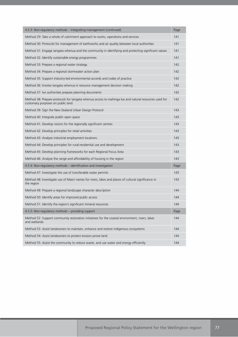
Proposed Regional Policy Statement for the Wellington region 77
4.5.3: Non-regulatory methods – integrating management (continued) Page
Method 29: Take a whole of catchment approach to works, operations and services 141
Method 30: Protocols for management of earthworks and air quality between local authorities 141
Method 31: Engage tangata whenua and the community in identifying and protecting significant values 141
Method 32: Identify sustainable energy programmes 141
Method 33: Prepare a regional water strategy 142
Method 34: Prepare a regional stormwater action plan 142
Method 35: Support Industry-led environmental accords and codes of practice 142
Method 36: Involve tangata whenua in resource management decision making 142
Method 37: Iwi authorities prepare planning documents 142
Method 38: Prepare protocols for tangata whenua access to mahinga kai and natural resources used for customary purposes on public land
142
Method 39: Sign the New Zealand Urban Design Protocol 143
Method 40: Integrate public open space 143
Method 41: Develop visions for the regionally significant centres 143
Method 42: Develop principles for retail activities 143
Method 43: Analyse industrial employment locations 143
Method 44: Develop principles for rural-residential use and development 143
Method 45: Develop planning frameworks for each Regional Focus Area 143
Method 46: Analyse the range and affordability of housing in the region 143
4.5.4: Non-regulatory methods – identification and investigation Page
Method 47: Investigate the use of transferable water permits 143
Method 48: Investigate use of Maori names for rivers, lakes and places of cultural significance in the region
143
Method 49: Prepare a regional landscape character description 144
Method 50: Identify areas for improved public access 144
Method 51: Identify the region’s significant mineral resources 144
4.5.5: Non-regulatory methods – providing support Page
Method 52: Support community restoration initiatives for the coastal environment, rivers, lakes and wetlands
144
Method 53: Assist landowners to maintain, enhance and restore indigenous ecosystems 144
Method 54: Assist landowners to protect erosion prone land 144
Method 55: Assist the community to reduce waste, and use water and energy efficiently 144

Section 4.1
Regulatory policies – direction to district and regional plans and the Regional Land Transport Strategy
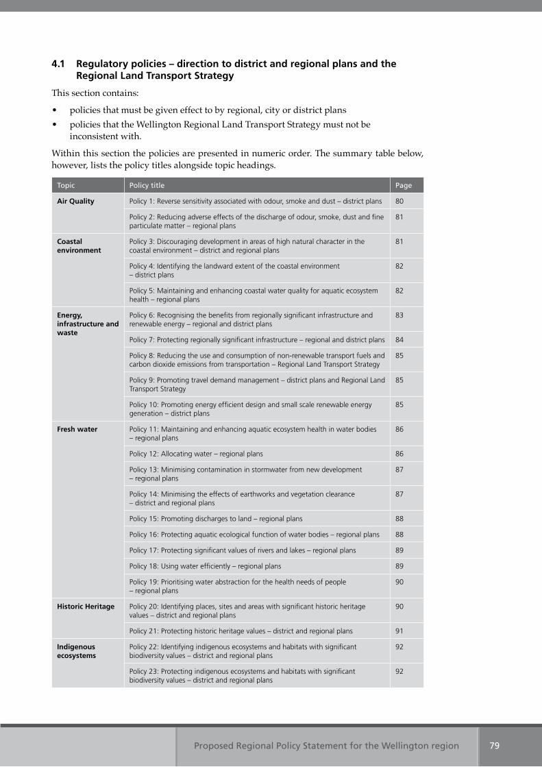
Proposed Regional Policy Statement for the Wellington region 79
4.1 Regulatory policies – direction to district and regional plans and the Regional Land Transport Strategy
This section contains:
• policies that must be given effect to by regional, city or district plans • policies that the Wellington Regional Land Transport Strategy must not be
inconsistent with.
Within this section the policies are presented in numeric order. The summary table below, however, lists the policy titles alongside topic headings.
Topic Policy title Page
Air Quality Policy 1: Reverse sensitivity associated with odour, smoke and dust – district plans 80
Policy 2: Reducing adverse effects of the discharge of odour, smoke, dust and fine particulate matter – regional plans
81
Coastal environment
Policy 3: Discouraging development in areas of high natural character in the coastal environment – district and regional plans
81
Policy 4: Identifying the landward extent of the coastal environment – district plans
82
Policy 5: Maintaining and enhancing coastal water quality for aquatic ecosystem health – regional plans
82
Energy, infrastructure and waste
Policy 6: Recognising the benefits from regionally significant infrastructure and renewable energy – regional and district plans
83
Policy 7: Protecting regionally significant infrastructure – regional and district plans 84
Policy 8: Reducing the use and consumption of non-renewable transport fuels and carbon dioxide emissions from transportation – Regional Land Transport Strategy
85
Policy 9: Promoting travel demand management – district plans and Regional Land Transport Strategy
85
Policy 10: Promoting energy efficient design and small scale renewable energy generation – district plans
85
Fresh water Policy 11: Maintaining and enhancing aquatic ecosystem health in water bodies – regional plans
86
Policy 12: Allocating water – regional plans 86
Policy 13: Minimising contamination in stormwater from new development – regional plans
87
Policy 14: Minimising the effects of earthworks and vegetation clearance – district and regional plans
87
Policy 15: Promoting discharges to land – regional plans 88
Policy 16: Protecting aquatic ecological function of water bodies – regional plans 88
Policy 17: Protecting significant values of rivers and lakes – regional plans 89
Policy 18: Using water efficiently – regional plans 89
Policy 19: Prioritising water abstraction for the health needs of people – regional plans
90
Historic Heritage Policy 20: Identifying places, sites and areas with significant historic heritage values – district and regional plans
90
Policy 21: Protecting historic heritage values – district and regional plans 91
Indigenous ecosystems
Policy 22: Identifying indigenous ecosystems and habitats with significant biodiversity values – district and regional plans
92
Policy 23: Protecting indigenous ecosystems and habitats with significant biodiversity values – district and regional plans
92
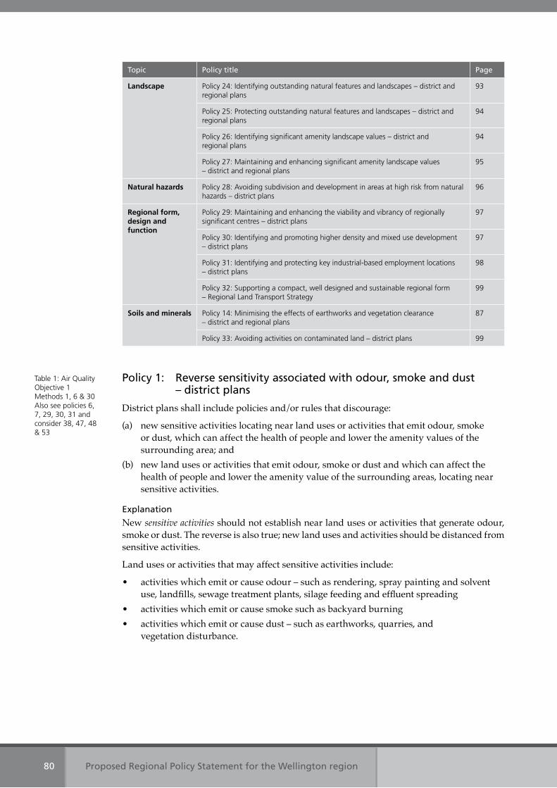
Proposed Regional Policy Statement for the Wellington region80
Topic Policy title Page
Landscape Policy 24: Identifying outstanding natural features and landscapes – district and regional plans
93
Policy 25: Protecting outstanding natural features and landscapes – district and regional plans
94
Policy 26: Identifying significant amenity landscape values – district and regional plans
94
Policy 27: Maintaining and enhancing significant amenity landscape values – district and regional plans
95
Natural hazards Policy 28: Avoiding subdivision and development in areas at high risk from natural hazards – district plans
96
Regional form, design and function
Policy 29: Maintaining and enhancing the viability and vibrancy of regionally significant centres – district plans
97
Policy 30: Identifying and promoting higher density and mixed use development – district plans
97
Policy 31: Identifying and protecting key industrial-based employment locations – district plans
98
Policy 32: Supporting a compact, well designed and sustainable regional form – Regional Land Transport Strategy
99
Soils and minerals Policy 14: Minimising the effects of earthworks and vegetation clearance – district and regional plans
87
Policy 33: Avoiding activities on contaminated land – district plans 99
Policy 1: Reverse sensitivity associated with odour, smoke and dust – district plans
District plans shall include policies and/or rules that discourage:
(a) new sensitive activities locating near land uses or activities that emit odour, smoke or dust, which can affect the health of people and lower the amenity values of the surrounding area; and
(b) new land uses or activities that emit odour, smoke or dust and which can affect the health of people and lower the amenity value of the surrounding areas, locating near sensitive activities.
Explanation
New sensitive activities should not establish near land uses or activities that generate odour, smoke or dust. The reverse is also true; new land uses and activities should be distanced from sensitive activities.
Land uses or activities that may affect sensitive activities include:
• activities which emit or cause odour – such as rendering, spray painting and solvent use, landfills, sewage treatment plants, silage feeding and effluent spreading
• activities which emit or cause smoke such as backyard burning• activities which emit or cause dust – such as earthworks, quarries, and
vegetation disturbance.
Table 1: Air Quality Objective 1 Methods 1, 6 & 30 Also see policies 6, 7, 29, 30, 31 and consider 38, 47, 48 & 53
Proposed Regional Policy Statement for the Wellington region 81
Policy 2: Reducing adverse effects of the discharge of odour, smoke, dust and fine particulate matter – regional plans
Regional plans shall include policies and/or rules that:
(a) protect or enhance the amenity values of neighbouring areas from discharges of odour, smoke and dust; and
(b) protect people’s health from discharges of dust, smoke and fine particulate matter.
Explanation
The amenity value of air reflects how clean and fresh it is. High amenity is associated with good visibility, low levels of deposited dust and with people’s ability to enjoy their outdoor environment. Amenity is reduced by contaminants in the air affecting people’s wellbeing – such as when dust or smoke reduces visibility or soils surfaces, or when odour is objectionable.
Protecting people’s health from discharges to air includes considering the effects of fine particulate matter discharged from human activities. The Wairarapa (specifically Masterton), and Wainuiomata are the airsheds known to be at risk of exceeding the National Environmental Standards for Air Quality, in relation to fine particulate matter (PM10), during cold calm winter nights. Domestic fires are the main source of fine particulate emissions in these airsheds during winter.
Policy 3: Discouraging development in areas of high natural character in the coastal environment – district and regional plans
District and regional plans shall include policies, rules and/or methods that discourage:
(a) new subdivision and/or development; and (b) inappropriate use;
on land in the coastal environment with high natural character.
Explanation
Although it is a matter of national importance to preserve the natural character of the coastal environment, the Resource Management Act does not preclude appropriate use and development in the coastal environment.
The New Zealand Coastal Policy Statement further establishes a requirement to define what form of subdivision, use, development or occupation would be appropriate in the coastal environment and where it would be appropriate.
Policy 3 supports these requirements, along with policies 54 and 55, which promote a compact, well designed and sustainable regional form.
Case law has established that ‘natural character’ does not necessarily mean pristine or completely unmodified character. Natural character occurs on a continuum, from pristine to totally modified. Most of the coastal environment has some element of natural character and, conversely, some degree or element of modification.
Policy 3 requires district and regional plans to discourage new subdivision and development, and inappropriate use in areas considered to have ‘high’ natural character. Councils must assess land in the coastal environment to ascertain which areas have high natural character, in order to discourage new subdivision and development in these areas, and to determine what would be inappropriate use on this land, depending on the attributes associated with an area’s high natural character.
Policy 35 outlines the factors to be considered in making an assessment of the degree of natural character of a place, site or area in the coastal environment. When making a determination as
Table 1: Air Quality Objective 1 Methods 2, 6, 26 & 30 Also see policies 6, 7 and consider 38, 47, 48 & 53
Table 2: Coastal environmentObjective 4Methods 1, 2, 7, 31 & 49Also see policies 4, 6, 7, 16, 17, 21, 23, 25 and consider 38, 45, 46, 49, 47, 48 & 53
Proposed Regional Policy Statement for the Wellington region82
to whether the degree of natural character is high in a particular location, in accordance with policy 3, the factors provided in policy 35 should be used.
Policy 35 will need to be considered alongside policy 3 when changing, varying or replacing a district or regional plan.
Related policies within this Regional Policy Statement direct regional and district plans to identify and protect historic heritage places, sites and areas (policies 20 and 21), ecosystems with significant biodiversity value (policies 22 and 23), outstanding natural features and landscapes (policies 24 and 25), and significant amenity landscape values (policies 26 and 27) – using the criteria outlined in each policy, and guidance that will be developed to assist with implementation of the Regional Policy Statement (method 7).
Policy 4: Identifying the landward extent of the coastal environment – district plans
District plans shall include policies and/or rules to identify the landward extent of the coastal environment using the following criteria:
(a) any area or landform dominated by coastal vegetation or habitat; (b) any landform affected by active coastal processes, excluding tsunami; (c) any landscapes or features, including coastal escarpments, that contribute to the
natural character, visual quality or amenity value of the coast; and(d) any site, structure, place or area of historic heritage value adjacent to, or connected
with, the coastal marine area, which derives its heritage value from a coastal location.
Explanation
Policy 4 identifies those natural and physical resources that, because of their form, function, or value, give particular parts of the region a coastal character.
Tsunami are excluded from the criteria because they are not ‘an active coastal process’, but are generated by submarine fault rupture, landslide or volcanic eruption. Active coastal processes include: storm surge, inundation, liquefaction, aeolian (the action of wind on coastal landforms and features, such as dunes), and the effects of sea level rise.
The criteria used in policy 4 reflect the New Zealand Coastal Policy Statement’s intended field of influence, in terms of the landward extent of the coastal environment.
This policy does not direct how the use, development and protection of the identified natural and physical resources of the coastal environment should be managed. Other policies provide guidance on these matters.
Policy 5: Maintaining and enhancing coastal water quality for aquatic ecosystem health – regional plans
Regional plans shall include policies and rules to:
(a) require, as a minimum, water quality in the coastal marine area to be maintained or enhanced so that it sustains healthy ecosystems; and
(b) manage coastal water quality for other identified purposes.
Explanation
A high standard of water quality is an essential requirement for maintaining the health of ecosystems in the coastal marine area.
This policy means that discharges, after reasonable mixing, cannot cause water quality to be unsuitable for sustaining healthy, functioning ecosystems.
Table 2: Coastal environmentObjectives 3 & 4Methods 1 , 31 & 49Also see policies 20, 22, 24, 26 and consider 47 & 48
Table 2: Coastal environmentObjective 6Method 2, 34 & 35Also see policies 6, 7, 11, 13, 14, 15, 16,17, 23 and consider 34, 36, 37, 38, 39, 40, 41, 42, 46, 47, 48, 53, 54 & 55
Proposed Regional Policy Statement for the Wellington region 83
Most contaminants and sediments that arrive in the coastal marine area are carried by rivers, streams and stormwater drains. Fresh water quality in rivers and streams is addressed in policies 11 and 13. Policy 15 promotes the discharge of contaminants to land and policy 14 seeks to minimise erosion and sediment runoff, prior to plan controls being established in accordance with policy 16.
Other purposes include, and are not limited to, contact recreation and food gathering.
Policy 6: Recognising the benefits from regionally significant infrastructure and renewable energy – regional and district plans
District and regional plans shall include policies that recognise:
(a) the social, economic, cultural and environmental benefits of regionally significant infrastructure including:(i) people can travel to, from and around the region efficiently;(ii) public health and safety is maintained through the provision of essential services,
supply of potable water and the collection and transfer of sewage;(iii) people have access to energy so as to meet their needs; and (iv) people have access to telecommunication services.
(b) the social, economic, cultural and environmental benefits of energy generated from renewable energy resources including:(i) security of supply and diversification of our energy sources;(ii) reducing dependency on imported energy resources; and(iii) reducing greenhouse gas emissions.
Explanation
Energy generated from renewable energy and regionally significant infrastructure can provide benefits both within and outside the region. Renewable energy benefits are not only generated by large scale renewable energy projects but also smaller scale projects.
Renewable energy means energy produced from solar, wind, hydro, geothermal, biomass, tidal wave and ocean current sources.
Imported energy resources include as oil, natural gas and coal.
When considering the benefits from renewable energy generation the contribution towards national goals in the New Zealand Energy Strategy (2007) and the National Energy Efficiency and Conservation Strategy (2007) will also need to be given regard.
Regionally significant infrastructure includes:
• pipelines for the distribution or transmission of natural or manufactured gas or petroleum
• strategic telecommunications facilities, as defined in section 5 of the Telecommunications Act 2001
• strategic radio communications facilities, as defined in section 2(1) of the Radio Communications Act 1989
• the national electricity grid, as defined by the Electricity Governance Rules 2003 • facilities for the generation and transmission of electricity where it is supplied to the
national electricity grid • the local authority water supply network and water treatment plants • the local authority wastewater and stormwater networks, systems and wastewater
treatment plants
Table 3: Energy, infrastructure and wasteObjectives 9 & 10Methods 1 & 2Also see policies 1, 2, 3, 5, 7, 8, 10, 11, 12, 13, 16, 17, 21, 23, 25, 27, 28 and consider 35, 36, 37, 38, 39, 40, 41, 42, 45, 46, 47, 48, 49, 50, 53, 54, 55, 56 & 57
Proposed Regional Policy Statement for the Wellington region84
• the Strategic Transport Network, as defined in the Wellington Regional Land Transport Strategy 2007-2016
• Wellington city bus terminal and Wellington Railway Station terminus • Wellington International Airport• Commercial Port Areas within Wellington Harbour (including Miramar, Burnham and
Seaview wharves) and adjoining land and storage tanks for bulk liquids.
Essential services include potable water and the collection and transfer of sewage and stormwater.
Policy 7: Protecting regionally significant infrastructure – regional and district plans
District and regional plans shall include policies and rules that protect regionally significant infrastructure from incompatible new land uses or activities under, over, or alongside.
Explanation
Regionally significant infrastructure is an important physical resource that enables people and communities to provide for their social, economic and cultural wellbeing, and their health and safety.
Regionally significant infrastructure includes:
• pipelines for the distribution or transmission of natural or manufactured gas or petroleum
• strategic telecommunications facilities, as defined in section 5 of the Telecommunications Act 2001
• strategic radio communications facilities, as defined in section 2(1) of the Radio Communications Act 1989
• the national electricity grid, as defined by the Electricity Governance Rules 2003 • facilities for the generation and transmission of electricity where it is supplied to the
national electricity grid• the local authority water supply network and water treatment plants • the local authority wastewater and stormwater • the Strategic Transport Network, as defined in the Wellington Regional Land Transport
Strategy 2007-2016• Wellington City bus terminal and Wellington Railway Station terminus • Wellington International Airport • Commercial Port Areas within Wellington Harbour (including Miramar, Burnham and
Seaview wharves) and adjoining land and storage tanks for bulk liquids.
Incompatible land uses or activities are those which adversely affect the efficient operation of infrastructure or restrict its ability to be maintained. It may also include new land uses that are sensitive to activities associated with infrastructure.
Protecting regionally significant infrastructure does not mean that all land uses or activities under, over, or alongside are prevented. The Wellington Regional Council and city and district councils will need to ensure that activities provided for in a district or regional plan are compatible with the efficient operation and maintenance of the infrastructure and any effects that may be associated with that infrastructure.
Policy 11 of the National Policy Statement on Electricity Transmission requires that, in achieving protection for the transmission network, consultation occurs with the operator of the national grid to identify appropriate buffer corridors.
Table 3: Energy, infrastructure and wasteObjective 10Methods 1 & 2Also see policies 1, 2, 3, 5, 6, 8, 9,10, 11, 12, 13, 15, 16, 17, 19, 21, 23, 25, 27, 28 and consider 35, 36, 37, 38, 39, 40, 41, 42, 43, 45, 46, 47, 48, 49, 50, 53, 54, 55, 56 & 57
Proposed Regional Policy Statement for the Wellington region 85
Policy 8: Reducing the use and consumption of non-renewable transport fuels and carbon dioxide emissions from transportation – Regional Land Transport Strategy
The Wellington Regional Land Transport Strategy shall include objectives and policies that promote a reduction in:
(a) the consumption of non-renewable transport fuels; and(b) the emission of carbon dioxide from transportation.
Explanation
Transportation is a significant and growing contributor to the consumption of non-renewable fuels and the emission of carbon dioxide. In 2004, 86 per cent of the oil consumed in New Zealand was used by the transport sector. The transport sector also accounts for around 45 per cent of the country’s carbon dioxide emissions. Carbon dioxide is a greenhouse gas that contributes to climate change.
The Wellington Regional Land Transport Strategy is a statutory document, prepared under the Land Transport Act 1998, which Wellington Regional Council must produce. It is a strategy for the development of the region’s land transport system over the next 10 years and provides policies to guide regional transport decisions and action programmes.
The Wellington Regional Land Transport Strategy will play an important role in ensuring that the demand for non-renewable energy and the emissions of carbon dioxide are reduced through improving the passenger transport network, promoting an increased uptake in walking and cycling, managing the demand for travel and increasing travel efficiency. It is, however, only one of the mechanisms to achieve national targets for reducing carbon dioxide-equivalent emissions from transportation and complements other central government and industry mechanisms.
Policy 9: Promoting travel demand management – district plans and the Regional Land Transport Strategy
District plans and the Wellington Regional Land Transport Strategy shall include policies to promote travel demand management mechanisms that reduce:
(a) the use and consumption of non-renewable transport fuels; and (b) carbon dioxide emissions from transportation.
Explanation
Travel demand management includes a range of mechanisms – such as travel behavioural change programmes, road pricing tools and improvements to the efficiency of the existing network.
Land use planning is important in managing demand for travel. Land use patterns – such as higher density or mixed use development in areas close to good public transport links and community facilities, or community facilities and employment close to where people live – can reduce dependence on the private car, the need to travel and journey lengths. It is also important to ensure good connectivity within and between settlements to optimise walking, cycling and public transport.
Policy 10: Promoting energy efficient design and small scale renewable energy generation – district plans
District plans shall include policies that:
(a) promote energy efficient design and the use of small scale renewable energy generation; and(b) provide for energy efficient alterations to existing buildings.
Table 3: Energy, infrastructure and wasteObjective 9Method 3Also see policies 9 & 32
Table 3: Energy, infrastructure and wasteObjective 9Methods 1, 3 & 9Also see policies 2, 6, 7, 8, 10, 30, 31 and consider 38, 47, 48, 54, 55, 56 & 57
Table 3: Energy, infrastructure and waste Objective 9Methods 1 & 10Also see policies 2 3, 6, 7, 8, 9, 11, 12, 16, 17, 18, 19, 21, 23, 25, 27 and consider 34, 35, 36, 38, 39, 42, 45, 46, 47, 48, 49, 53, 55 & 56
Proposed Regional Policy Statement for the Wellington region86
Explanation
Orientation, layout and design can have a significant influence on the energy efficiency of developments. Improved energy efficiency can be achieved by:
• enabling everyday services – such as shops, schools, businesses and community facilities to be accessed by walking and cycling
• enabling easy access to public transport services• locating and designing infrastructure and services to support walking, cycling or the
use public transport • enabling the efficient use of the sun as a source of power and heating• incorporating renewable energy generation facilities – such as solar panels and
domestic scale wind turbines
Small scale renewable energy generation facilities include solar generation particularly for water heating and wind turbines used for on-site or domestic use.
Energy efficient alteration may include alterations of buildings for the installation of solar water heating systems or domestic scale wind turbines.
Policy 11: Maintaining and enhancing aquatic ecosystem health in water bodies – regional plans
Regional plans shall include policies, rules and/or methods that:
(a) require, as a minimum, that water quality, flows and water levels, and the aquatic habitat of all water bodies are to be managed for the purpose of maintaining or enhancing aquatic ecosystem health; and
(b) manage water bodies for other identified purposes
Explanation
Regional plans will establish limits for water quality, flows and water levels that safeguard aquatic habitats and ecosystems in water bodies.
The narrative standard for aquatic ecosystems in the Third Schedule to the Resource Management Act will be used as the basis for safeguarding what is needed for aquatic ecosystem protection in terms of water quality. The flows and water levels required for aquatic ecosystems will be guided by the “Guidelines for the selection of methods to determine ecological flows and water levels” (Ministry for the Environment, 2008).
Some water bodies may also be managed for other purposes – such as trout fishery, contact recreation, water supply, groundwater protection, or cultural purposes. Where they are identified in regional plans, management purposes will establish limits and guide decisions on water quality, flows and water levels, and managing aquatic habitat.
Where a water body is assigned more than one management purpose in a regional plan, water quality, river flows and water levels shall not be less than the limits established for aquatic ecosystem health.
Policy 12: Allocating water – regional plans
Regional plans shall include policies and/or rules that:
(a) establish allocation limits for the total amount of water that can be taken from rivers without compromising aquatic ecosystem health; and
(b) establish allocation limits for the total amount of water that can be taken from groundwater, taking into account the aquatic ecosystem health of rivers, lakes and wetlands, and preventing saltwater intrusion.
Table 4: Fresh water Objective 12Methods 2, 33, 34 & 35Also see policies 5, 6, 7, 13, 14, 15, 16, 17, 23 and consider 34, 35, 36, 38, 39, 40, 41, 42, 46, 47, 48 51, 53, 54 & 55
Table 4: Fresh water Objective 12Methods 2 Also see policies 5, 6, 7, 11, 16, 17, 18, 19, 23 and consider 34, 35, 36, 38, 39, 42, 43, 44, 46, 47, 48, 50, 53 & 59
Proposed Regional Policy Statement for the Wellington region 87
Explanation
Policy 12 directs the establishment of allocation limits for rivers and groundwater in a regional plan. Allocation limits for rivers are the total amount of water that is available to be taken from a river, including water behind any dam, while safeguarding aquatic ecosystem health as required by Policy 11.
Groundwater allocation limits must safeguard the needs of dependent ecosystems in groundwater-fed streams and wetlands, and prevent saltwater intrusion.
Policy 13: Minimising contamination in stormwater from new development – regional plans
Regional plans shall include policies, rules and/or methods that protect aquatic ecosystem health by minimising ecotoxic and other contaminants in stormwater that discharges into water, or onto or into land that may enter water, from new subdivision and development.
Explanation
Ecotoxic contaminants in this policy are substances that are capable of causing ill health, injury or death to any living organism – such as heavy metals, polycyclic aromatic hydrocarbons, organochlorine pesticides and antifouling compounds. Carried in stormwater, ecotoxic contaminants can bind with sediment and accumulate where the sediment settles, on the seabed or the bed of a freshwater body, particularly in low energy aquatic receiving environments.
Wellington and Porirua Harbours are places where ecotoxic contaminants in bottom sediments have been found to occur at concentrations that exceed guidelines for aquatic life.
There may be other low energy aquatic receiving environments in the region – such as inlets, estuaries, lakes, wetlands and lowland streams – in which the sediments contain elevated ecotoxic contaminants that may threaten aquatic life, but which have not yet been monitored.
Reducing the rate of accumulation of sediment with ecotoxic contaminants derived from surrounding catchments can be achieved by requiring stormwater treatment devices for discharges from new subdivision and development.
Discharges to land that may enter water include discharges to existing and new stormwater infrastructure.
Stormwater design features set out in policy 41 will also reduce accumulation rates of ecotoxic contaminants in the sediments of low energy aquatic receiving environments. Policy 41 is directed at city and district councils when they are considering district plan provisions and resource consents for new subdivisions and land use. This policy and policy 41 provide an integrated approach to managing the adverse effects of stormwater discharges.
Policy 14: Minimising the effects of earthworks and vegetation disturbance – district and regional plans
Regional and district plans shall include policies, rules and methods that control earthworks and vegetation disturbance to minimise:
(a) erosion; and(b) silt and sediment runoff into water, or onto land that may enter water, so that aquatic
ecosystem health is safeguarded.
Table 4: Fresh water Objective 12Methods 2, 33 & 34Also see policies 5, 6, 7, 11, 14, 16, 17, 23 and consider 34, 35, 36, 37, 38, 39, 40, 42, 46, 47, 48, 51 & 53
Table 4: Fresh water Table 11: Soils and mineralsObjectives 12 & 28Methods 1, 2, 30, 34 & 35Also see policies 5, 6, 11, 13, 16, 17, 23, 25, 27, 28 and consider 34, 35, 36, 37, 38, 39, 41, 42, 45, 46, 47, 48, 49, 51, 53, 54, 55 & 60
Proposed Regional Policy Statement for the Wellington region88
Explanation
An area of overlapping jurisdiction between Wellington Regional Council and district and city councils is the ability to control earthworks and vegetation disturbance, including clearance. Many small scale earthworks – such as driveways and retaining walls – can cumulatively contribute large amounts of silt to stormwater and water bodies, as do large scale earthworks on erosion prone land.
This policy is to ensure that Wellington Regional Council and district and city councils integrate the control of earthworks and vegetation disturbance in their regional and district plans. Method 30 is for Wellington Regional Council and city and district councils to develop a protocol for earthworks and erosion from vegetation disturbance. The protocol will assist with implementation of the policy.
Some activities, such as major road construction, are likely to require resource consents from both the regional council and city or district councils, who will work together to control the effects of the activity.
Vegetation disturbance includes harvesting plantation forestry.
Policy 15: Promoting discharges to land – regional plans
Regional plans shall include policies, rules and/or methods that:
(a) promote discharges of human and/or animal waste to land rather than water, particularly discharges of sewage; and
(b) promote the use of collective sewage treatment systems that discharge to land
while maintaining groundwater quality and soil health.
Explanation
Well managed land-based discharges can avoid adverse effects on water bodies, including degradation of the mauri of water bodies, that results from waste, particularly human waste (however well treated), being put into surface water instead of being returned to the land.
Collective sewage treatment systems can service groups of houses, removing the need for each of them to accommodate effluent treatment and disposal on site.
The quality at which groundwater is maintained will be determined by water quality standards in regional plans, as directed by policy 11.
Soil health in the context of this policy refers to the ability of soil to function so that plant and animal productivity is sustained, groundwater flows are maintained and human health and habitation is supported. Public health risk will need to be considered when rules are developed in regional plans.
Policy 16: Protecting aquatic ecological function of water bodies – regional plans
Regional plans shall include policies, rules and/or methods that:
(a) promote the retention of in-stream habitat diversity by retaining natural features – such as pools, runs, riffles, and the river’s natural form;
(b) promote the retention of natural flow regimes – such as flushing flows;(c) promote the protection and reinstatement of riparian habitat;(d) promote the installation of off-line water storage over dams in river beds;(e) discourage the reclamation, piping, straightening or concrete lining of rivers; (f) prevent stock access to rivers, lakes and wetlands;
Table 4: Fresh water Objective 12Methods 2 & 35Also see policies 5, 6, 7, 11, 13, 14, 16, 17, 23 and consider 34, 35, 36, 37, 38, 39, 40, 42, 46, 47, 48 & 51
Table 4: Fresh water Objective 13Methods 2 & 29Also see policies 5, 6, 7, 11, 13, 14, 16, 17, 23 and consider 34, 35, 36, 37, 38, 39, 40, 42, 46, 47, 48, 51 & 53
Proposed Regional Policy Statement for the Wellington region 89
(g) discourage the diversion of water into or from wetlands – unless the diversion is necessary to restore the hydrological variation to the wetland;
(h) prevent the removal or destruction of indigenous plants in wetlands and lakes; and(i) maintain fish passage.
Explanation
Habitat diversity, which is described in clauses (a), (b) and (c), is essential for aquatic ecosystems to survive and be self-sustaining. When areas of habitat in one part of the river, lake or wetland are degraded or destroyed by activities described in clauses (e), (f), (g) and (h), critical parts of the ecosystem may be permanently affected with consequent effects elsewhere in the ecosystem. Specific policies and regional rules can set out where it is important to retain habitat for ecological function.
Off-line water storage is constructed out of the river and does not cause adverse effects such as barriers to fish that in-stream dams can.
Riparian means land areas beside and connected to streams, rivers and lakes.
Policy 17: Protecting significant values of rivers and lakes – regional plans
Regional plans shall include policies and rules that protect:
(a) the significant amenity and recreational values associated with the rivers and lakes listed in Appendix 1; and
(b) the significant indigenous ecosystems associated with the rivers and lakes listed in Appendix 1.
Explanation
The rivers and lakes with significant amenity and recreational values listed in Appendix 1 were identified by the community as places that are regularly used for fishing, swimming, picnicking and other recreational activities. These rivers and lakes are listed in Table 15 of Appendix 1.
The rivers and lakes with significant indigenous ecosystems were selected using indicators of aquatic invertebrate community health, the diversity of indigenous migratory fish species, the presence of nationally threatened fish species and the location of inanga spawning habitat. The criteria used to assess rivers and lakes with significant indigenous ecosystems are explained underneath Table 16 in Appendix 1.
Policy 18: Using water efficiently – regional plans
Regional plans shall include policies, rules and/or methods that:
(a) promote the efficient use of water; and(b) promote water harvesting, including off-line water storage.
Explanation
Using water efficiently and water harvesting when it is in abundant supply will make more water available when there is a shortage. Efficient use means minimising water wastage during the abstraction, distribution and final use of the water.
Water harvesting means taking and storing water from water bodies when the availability is high and using it when there is a water shortage.
Table 4: Fresh water Objective 13Methods 2 & 31Appendix 1Also see policies 5, 6, 7, 11, 13, 14, 16, 23 and consider 34, 35, 36, 37, 38, 39, 40, 41, 42, 46, 47, 48, 51 & 53
Table 4: Fresh water Objective 14Methods 2, 33 & 46Also see policies 6, 7, 11, 12, 16 and consider 36, 38, 39, 42, 43, 47, 48, 53 & 59
Proposed Regional Policy Statement for the Wellington region90
Policy 19: Prioritising water abstraction for the health needs of people – regional plans
Regional plans shall include policies and/or rules that give priority to the abstraction of water for the health needs of people, including:
(a) the taking of water by any statutory authority that has a duty for public water supply under any Act of Parliament;
(b) the taking of water for reticulation into a public water supply network; and(c) the taking of water for domestic and community supplies.
Explanation
This policy recognises the need to prioritise the taking of water. The Resource Management Act, in section 14, gives priority for water to be taken for firefighting purposes and an individual’s reasonable domestic needs or the needs of an individual’s animals for drinking water, provided there are no adverse effects on the environment. This policy gives the same priority to the abstraction of water by public authorities for public water supply over other takes of water.
Policy 20: Identifying places, sites and areas with significant historic heritage values – district and regional plans
Regional and district plans shall identify places, sites and areas with significant historic heritage values using the following criteria, and having determined that the place, site or area makes an important contribution to an understanding and appreciation of history and culture under one or more of the criteria:
(a) Historic values: these relate to the history of a place and how it demonstrates important historical themes, events, people or experiences.(i) Themes: the place is associated with important themes in history or patterns
of development.(ii) Events: the place has an association with an important event or events in local,
regional or national history.(iii) People: the place is associated with the life or works of an individual, group
or organisation that has made a significant contribution to the district, region or nation.
(iv) Social: the place is associated with everyday experiences from the past and contributes to our understanding of the culture and life of the district, region or nation.
(b) Physical values: these values relate to the physical evidence present.(i) Archaeological: there is potential for archaeological investigation to contribute
new or important information about the human history of the district, region or nation.
(ii) Architectural: the place is notable for its style, design, form, scale, materials, ornamentation, period, craftsmanship or other architectural values.
(iii) Technological: the place provides evidence of the history of technological development or demonstrates innovation or important methods of construction or design.
(iv) Integrity: the significant physical values of the place have been largely unmodified.(v) Age: the place is particularly old in the context of human occupation of the
Wellington region.
Table 4: Fresh water Objective 14Method 2Also see policies 6, 7, 11, 12, 16 and consider 36, 38, 39, 42, 43, 44, 47, 48, 53, 54, 55, 57 & 59
Table 2: Coastal environment Objective 3Table 5: Historic heritage Objective 15Methods 1, 2, 20 & 31Also see policies 4, 22, 24, 26, 29, 30 and consider 35, 47, 48 & 52
Proposed Regional Policy Statement for the Wellington region 91
(vi) Group or townscape values: the place is strongly associated with other natural or cultural features in the landscape or townscape, and/or contributes to the heritage values of a wider townscape or landscape setting, and/or it is a landmark.
(c) Social values: these values relate to the meanings that a place has for a particular community or communities. (i) Sentiment: the place has strong or special associations with a particular cultural
group or community for spiritual, political, social, religious, ethnic, national, symbolic or commemorative reasons.
(ii) Recognition: the place is held in high public esteem for its historic heritage values, or its contribution to the sense of identity of a community, to the extent that if it was damaged or destroyed it would cause a sense of loss.
(d) Tangata whenua values: the place is sacred or important to Maori for spiritual, cultural or historical reasons.
(e) Surroundings: the setting or context of the place contributes to an appreciation and understanding of its character, history and/or development.
(f) Rarity: the place is unique or rare within the district or region.(g) Representativeness: the place is a good example of its type or era.
Explanation
Policy 20 provides criteria to ensure significant historic heritage resources are identified in district and regional plans in a consistent way. Greater Wellington, district and city councils are required to assess a place, site or area against all the criteria, but may use additional criteria. A place, site or area identified must, however, fit one or more of the listed criteria in terms of making an important contribution to an understanding and appreciation of history and culture in a district in order to have significant historic heritage values.
Regional plans will identify significant historic heritage in the coastal marine area and the beds of lakes and rivers; district plans will identify significant historic heritage for all other land.
Method 20 is to provide guidance with using the criteria in policy 20 to identify places, sites and areas with significant historic heritage values.
Policy 21: Protecting historic heritage values – district and regional plans
District and regional plans shall include policies, rules and/or other methods that:
(a) protect the significant historic heritage values associated with places, sites and areas identified in accordance with policy 20, from inappropriate subdivision, use, and development; and
(b) avoid the destruction of unidentified archaeological sites and wahi tapu with significant historic heritage values.
Explanation
Appropriate subdivision, use and development respects historic heritage values. Planning for, developing and using a historic place, site or area must be done with full understanding of its value. In addition, destruction of, or damage to, places, sites and areas of historic heritage needs to be avoided when unidentified sites are discovered.
Policy 21(a) is not intended to prevent change to historic heritage, but rather to ensure that change is carefully considered. The places, sites or areas with significant historic heritage values identified in policy 20, and the degree of significance of those values, will influence what activities would be deemed to be appropriate or inappropriate.
Table 2: Coastal environment Objective 4 Table 5: Historic heritage Objective 15Methods 1, 2 & 31Also see policies 3, 7, 23, 25, 27, 29, 30 & 31 and consider 34, 35, 38, 45, 46, 47, 48, 49, 52 & 53
Proposed Regional Policy Statement for the Wellington region92
Policy 21(b) requires district and regional plans assess which activities could destroy unidentified archaeological sites or wahi tapu with significant historic heritage values and ensure such activities avoid adverse effects.
Policy 45 will need to be considered alongside policy 21 when changing, varying or replacing a district or regional plan.
Policy 22: Identifying indigenous ecosystems and habitats with significant biodiversity values – district and regional plans
District and regional plans shall identify indigenous ecosystems and habitats with significant indigenous biodiversity values that meet one or more of the following criteria:
(a) Representativeness: high representativeness values are given to particular ecosystems and habitats that were once typical and commonplace in a district or in the region, and: (i) are no longer commonplace; or(ii) are poorly represented in existing protected areas.
(b) Rarity: the ecosystem or habitat has biological physical features that are scarce or threatened in a local, regional or national context. This can include individual species, rare and distinctive biological communities and physical features that are unusual or rare.
(c) Diversity: the ecosystem or habitat has a natural diversity of ecological units, ecosystems, species and physical features within an area.
(d) Ecological context of an area: the ecosystem or habitat:(i) enhances connectivity or otherwise buffers representative, rare or diverse
indigenous ecosystems and habitats; or(ii) provides seasonal or core habitat for threatened indigenous species.
(e) Tangata whenua values: the ecosystem or habitat contains characteristics of special spiritual, historical or cultural significance to tangata whenua, identified in accordance with tikanga Maori.
Explanation
Policy 22 sets out criteria as guidance that must be considered in identifying indigenous ecosystems and habitats with significant biodiversity values. These criteria need to be considered in all assessments but the relevance of each will depend on the individual cases.
Policy 22 will ensure that significant biodiversity values are identified in district and regional plans in a consistent way. Wellington Regional Council, and district and city councils are required to assess indigenous ecosystems and habitats against all the criteria. To be identified as having significant biodiversity values, an indigenous ecosystem or habitat must fit one or more of the listed criteria.
Regional plans will identify indigenous ecosystems and habitats with significant biodiversity values in the coastal marine area, wetlands and the beds of lakes and rivers. District plans will identify indigenous ecosystems and habitats with significant biodiversity values for all land, except the coastal marine area and the beds of lakes and rivers.
Policy 23: Protecting indigenous ecosystems and habitats with significant indigenous biodiversity values – district and regional plans
District and regional plans shall include policies, rules and methods to protect indigenous ecosystems and habitats with significant biodiversity values from inappropriate subdivision, use and development.
Table 2: Coastal environment Objective 3Table 6a: Indigenous ecosystems Objective 16Methods 1, 2, 21 & 31Also see policies 4, 20, 24, 26, 61 and consider 34, 35, 36, 42, 47, 48, 52 & 53
Table 2: Coastal environment Objective 4Table 6a: Indigenous ecosystems Objective 16Methods 1, 2 & 31Appendices 1 Also see policies 3, 7, 16, 17, 21, 25, 27 & 61 and consider 34, 35, 38, 42, 45, 46, 47, 48, 49, 52 & 53
Proposed Regional Policy Statement for the Wellington region 93
Explanation
Policy 23 applies to provisions in regional and district plans.
Table 16 in Appendix 1 identifies ecosystems, habitats and areas with regionally significant indigenous biodiversity values located in river and lake environments.
Policy 46 will need to be considered alongside policy 23 when changing, varying or replacing a regional or district plan.
Policy 24: Identifying outstanding natural features and landscapes – district and regional plans
District and regional plans shall identify outstanding natural features and landscapes using the following criteria, and having determined that the natural feature or landscape is exceptional or out of the ordinary under one or more of the criteria and the natural components dominate over the influence of human activity:
(a) Natural science values: these values relate to the geological, ecological, topographical and natural process components of the natural feature or landscape:(i) Representativeness: the combination of natural components that form the feature
or landscape strongly typifies the character of an area. (ii) Research and education: all or parts of the feature or landscape are important for
natural science research and education.(iii) Rarity: the feature or landscape is unique or rare within the district or region, and
few comparable examples exist.(iv) Ecosystem functioning: the presence of healthy ecosystems is clearly evident in the
feature or landscape.(b) Aesthetic values: these values relate to scenic perceptions of the feature or landscape:
(i) Coherence: the patterns of land cover and land use are in harmony with the underlying natural pattern of landform and there are no significant discordant elements of land cover or land use.
(ii) Vividness: the feature or landscape is visually striking and is widely recognised within the local and wider community for its memorable and sometimes iconic qualities.
(iii) Naturalness: the feature or landscape appears largely unmodified by human activity and the patterns of landform and land cover appear to be largely the result of intact and healthy natural systems.
(c) Expressiveness (legibility): the feature or landscape clearly shows the formative natural processes and/or historic influences that led to its existing character.
(d) Transient values: the consistent and noticeable occurrence of transient natural events, such as seasonal change in vegetation or in wildlife movement, contributes to the character of the feature or landscape.
(e) Shared and recognised values: the feature or landscape is widely known and is highly valued for its contribution to local identity within the immediate and wider community.
(f) Tangata whenua values: Maori values inherent in the feature or landscape add to the feature or landscape being recognised as a special place.
(g) Historical associations: knowledge of historic events that occurred in and around the feature or landscape is widely held and substantially influences and adds to the value the community attaches to the natural feature or landscape.
Table 2: Coastal environment Objective 3Table 7: Landscape Objective 17Methods 1, 2, 31 & 49Also see policies 3, 4, 20, 22, 26 and consider 35, 47, 48 & 52
Proposed Regional Policy Statement for the Wellington region94
Explanation
Policy 24 provides criteria to ensure outstanding natural features and landscapes are consistently identified in district and regional plans. The criteria are consistent with significant case law and commonly used landscape assessment methodologies.
The Wellington Regional Council, district and city councils are required to assess landscapes and natural features against all the criteria, but may use additional criteria. An outstanding landscape or natural feature must fit one or more of the listed criteria and will be exceptional and out of the ordinary in accordance with that criteria and the natural components will dominate over the influence of human activity.
Regional plans will identify outstanding natural features and landscapes in the coastal marine area and the beds of lakes and rivers; district plans will identify outstanding natural features and landscapes for all other land.
Method 49 outlines the development of a regional landscape character description which will describe and categorise the region’s landscapes to assist with implementing policy 24.
Policy 25: Protecting outstanding natural features and landscape values – district and regional plans
Where outstanding natural features and landscapes have been identified in accordance with policy 24, district and regional plans shall include policies, rules and/or methods that protect outstanding natural features and landscape values from inappropriate subdivision, use or development.
Explanation
Appropriate subdivision, use and development respects those values identified within the landscape or natural feature. Planning for, developing and undertaking activities within an identified outstanding landscape or natural feature must be done with a full understanding of its value.
Policy 25 is not intended to prevent change, but rather to ensure that change is carefully considered and is appropriate in relation to the landscape values identified in policy 24.
Policy 26: Identifying significant amenity landscape values – district and regional plans
District and regional plans shall identify significant amenity landscapes using the following criteria and having determined the landscape has important landscape value under one or more of the criteria:
(a) Natural science values: these values relate to the geological, ecological, topographical and natural process components of the natural feature or landscape:(i) Representativeness: the combination of natural components that form the feature
or landscape strongly typifies the character of an area. (ii) Research and education: all or parts of the feature or landscape are important for
natural science research and education.(iii) Rarity: the feature or landscape is unique or rare within the district or region, and
few comparable examples exist.(iv) Ecosystem functioning: the presence of healthy ecosystems is clearly evident in the
feature or landscape.(b) Aesthetic values: these values relate to scenic perceptions of the feature or landscape:
(i) Coherence: the patterns of land cover and land use are in harmony with the underlying natural pattern of landform and there are no significant discordant elements of land cover or land use.
Table 2: Coastal environment Objective 4Table 7: Landscape Objective 17Methods 1, 2 & 31Also see policies 3, 7, 16 , 17, 21, 23, 27 and consider 34,35, 38, 45, 46, 47, 48, 49, 52, 53, 54 & 55
Table 2: Coastal environment Objective 3Table 7: Landscape Objective 17Methods 1, 2, 31 & 49Also see policies 4, 20, 22, 24 and consider 35, 47, 48 & 52

Proposed Regional Policy Statement for the Wellington region 95
(ii) Vividness: the feature or landscape is visually striking and is widely recognised within the local and wider community for its memorable and sometimes iconic qualities.
(iii) Naturalness: the feature or landscape appears largely unmodified by human activity and the patterns of landform and land cover appear to be largely the result of intact and healthy natural systems.
(c) Expressiveness (legibility): the feature or landscape clearly shows the formative natural processes and/or historic influences that led to its existing character.
(d) Transient values: the consistent and noticeable occurrence of transient natural events, such as seasonal change in vegetation or in wildlife movement, contributes to the character of the feature or landscape.
(e) Shared and recognised values: the feature or landscape is widely known and is highly valued for its contribution to local identity within the immediate and wider community.
(f) Tangata whenua values: Maori values inherent in the feature or landscape add to the feature or landscape being recognised as a special place.
(g) Historical associations: knowledge of historic events that occurred in and around the feature or landscape is widely held and substantially influences and adds to the value the community attaches to the natural feature or landscape.
Explanation
Policy 26 provides criteria to ensure significant amenity landscapes are consistently identified in district and regional plans. The criteria are consistent with significant case law and commonly used landscape assessment methodologies.
Wellington Regional Council and district and city councils are required to assess landscapes and natural features against all the criteria, but may use other criteria. A significant amenity landscape will have important amenity values and make an important contribution to the maintenance of amenity values in the district, city or region, and may be dominated by either natural elements or human activity.
Regional plans will identify significant amenity landscapes in the coastal marine area and the beds of lakes and rivers; district plans will identify significant amenity landscapes for all other land.
Method 49 outlines the development of a regional landscape character description which will describe and categorise the region’s landscapes to assist with implementing policy 26.
Policy 27: Maintaining and enhancing significant amenity landscapes – district and regional plans
Where significant amenity landscapes have been identified in accordance with policy 26, district and regional plans shall include policies, rules and/or methods that maintain or enhance the significant amenity landscape values.
Explanation
Appropriate subdivision, use and development respects those values identified within the landscape or natural feature. Planning for, developing and undertaking activities within an identified significant amenity landscape must be done with a full understanding of its values.
Policy 27 is not intended to prevent change, but rather to ensure that change is carefully considered and is appropriate in relation to the landscape values identified in policy 26.
Table 2: Coastal environment Objective 4Table 7: Landscape Objective 17Methods 1, 2 & 31Also see policies 3, 7, 16 , 17, 21, 23, 25 and consider 34,35, 38, 45, 46, 47, 48, 49, 52, 53, 54 & 55
Proposed Regional Policy Statement for the Wellington region96
Policy 28: Avoiding subdivision and development in areas at high risk from natural hazards – district plans
District plans shall:
(a) identify areas at high risk from natural hazards; and(b) include policies and rules to avoid subdivision and development in those areas.
Explanation
The term areas at high risk refers to those areas potentially affected by natural hazard events that are likely to cause moderate to high levels of damage to the subdivision or development, including the buildings, infrastructure, or land on which it is situated, or which require extensive mitigation works.
Areas at high risk from natural hazards are those areas that would experience serious consequences in a hazard event – such as fault rupture zones, beaches that experience cyclical or long term erosion, failure prone hill slopes, or areas that are subject to serious flooding – and those areas facing potential adverse impacts from climate change.
This policy will require district plans to prevent new development in areas that would require extensive hazard mitigation works. Extensive mitigation works are those involving structural works that:
• cover and/or affect a large geographical area• may adversely modify natural processes• significantly alter the natural landscape• have high establishment and maintenance costs• leave a residual risk, and/or• are likely to be permanent, and their effects irreversible.
This policy promotes a risk-based approach, taking into consideration the characteristics of the natural hazard, its likelihood, potential impacts and the vulnerability of development. Examples of how this may be achieved include: fault rupture avoidance zones 20 metres either side of a fault trace; setback distances from an eroding coastline; hazard areas on floodplains; or, requirements for a geotechnical investigation before development proceeds on a hill slope identified as prone to failure.
Guidance documents that could be used to assist in the process include:
• Risk Management Standard AS/NZS 4360:2004• Guidelines for assessing planning policy and consent requirements for landslide
prone land, Geological and Nuclear Sciences (2008)• Planning for development of land on or close to active faults, Ministry for the
Environment (2003).
This policy also recognises and supports the Civil Defence Emergency Management principles – of risk reduction, readiness, response and recovery – in order to encourage more resilient communities that are better prepared for natural hazards, including climate change impacts. Policy 28 will act to reduce risk associated with natural hazards. The risks are to people and communities, including their businesses and civic infrastructure.
This policy and the Civil Defence Emergency Management framework recognise the need to involve communities in preparing for natural hazards. If people are prepared and able to cope, the impacts from a natural hazard event are effectively reduced.
Table 8a: Natural hazards Objective 18Methods 1, 14 & 22Also see policies 3, 6, 7, 14 ,16, 29, 30, 31 & 62 and consider 34, 35, 36, 38, 42, 47, 48, 50, 51, 53, 54 & 55
Proposed Regional Policy Statement for the Wellington region 97
Policy 29: Maintaining and enhancing the viability and vibrancy of regionally significant centres – district plans
District plans shall include policies, rules and/or methods that encourage a range of land use activities that maintain and enhance the viability and vibrancy of the regional central business district in Wellington city and the following centres of regional significance:
(a) Upper Hutt city centre;(b) Lower Hutt city centre;(c) Porirua city centre;(d) Paraparaumu town centre;(e) Masterton town centre(f) Petone;(g) Kilbirnie; and(h) Johnsonville.
Explanation
The region’s central business district in Wellington city and the centres of regional significance identified in policy 29 were identified in the Wellington Regional Strategy as regionally significant centres for economic development, transport movement, civic and community investment.
The Wellington central business district is the regional central business district, with 73,000 people working there each day. The regionally significant centres are the civic centres of Upper Hutt city centre, Lower Hutt city centre, Porirua city centre, Paraparaumu town centre, Masterton town centre, and other major centres of Petone, Kilbirnie and Johnsonville. Maintaining and enhancing the viability and vibrancy of these centres is important in order to encourage investment and development that supports an increased range and diversity of activities. It is also important for their prosperity and resilience in the face of social and economic change.
The range of appropriate land uses to be encouraged through this policy will vary depending on the character and context of each centre. For this reason, policy 29 requires the region’s district and city councils to determine the range of land uses to be encouraged in order to maintain and enhance the viability and vibrancy of the relevant centre managed through its district plan. However, when maintaining and enhancing the regionally significant centres within a district, councils also need to consider the viability and vibrancy of the regionally significant centres outside their district.
Policy 30: Identifying and promoting higher density and mixed use development – district plans
District plans shall:
(a) identify key centres suitable for higher density and/or mixed use development; (b) identify locations, with good access to the strategic public transport network, suitable
for higher density and/or mixed use development; and (c) include policies, rules and/or methods that encourage higher density and/or mixed use
development in and around these centres and locations,
so as to maintain and enhance a compact, well designed and sustainable regional form.
Table 9: Regional form, design and function Objective 21Methods 1, 41 & 42Also see policies 1, 6, 7, 14, 21, 23, 25, 27, 28, 30, 31 & 33 and consider 34, 35, 36, 37, 38, 39, 40, 41, 42, 45, 46, 47, 48, 49, 50, 51, 53, 45, 55, 56 & 57
Table 9: Regional form, design and function Objective 21Methods 1 & 16Also see policies 1, 3, 5, 7, 9, 14, 21, 23, 25, 27, 28, 29, 31 & 33 and consider 34, 35, 36, 37, 39, 40, 41, 42, 44, 45, 46, 47, 48, 49, 50, 51, 53, 54, 55, 56, 57 & 59
Proposed Regional Policy Statement for the Wellington region98
Explanation
Policy 30 directs district and city councils to determine key centres and other locations with good access to the strategic public transport network, suitable for higher density or mixed use development, where they will reinforce the region’s compact form. District plans will then need to include policies, rules and/or other methods to encourage higher density and mixed use activities in these locations to support this form.
Objective 21 outlines the range of elements to be achieved by a compact, well designed and sustainable regional form. This includes a viable and vibrant regional central business district in Wellington city and an increased range and diversity of activities in and around other centres listed in policy 29.
Key centres include the regionally significant centres identified in policy 29, as well as other significant local centres that a city or district council considers are integral to the functioning of the region’s or a district’s form.
Higher density and mixed use development can be achieved in a number of ways – such as infill development, comprehensive re-development and/or multi-storey developments that support complementary living and other uses.
Mixed use development means a variety of compatible and complementary uses within an area. This can include any combination of residential, commercial, industrial, business, retail, institutional or recreational uses.
Density is a measure of how compact development is in a given area. For example, the number of people per square kilometre, the variety of land uses or activities (mixed use development) per square kilometre, or square meters of retail space per square kilometre of land area.
The strategic public transport network is those parts of the region’s passenger transport network that provide a high level of service along corridors with high demand for public transport. It connects the region’s centres with the central business district in Wellington city. It includes the rail network and key bus corridors within Wellington region.
Locations with good access to the strategic public transport network include those:
• within reasonable walk times to stops or stations on the strategic public transport network (research indicates a walk time of up to 10 minutes is ‘reasonable’)
• with frequent and reliable public transport services• with accessibility, by public transport, to key destinations in the region, and• without physical barriers to public transport (for example, busy roads, lack of footpaths
or crossing facilities, steep hills).
Policy 31: Identifying and protecting key industrial-based employment locations – district plans
District plans should include policies, rules and/or methods that identify and protect key industrial-based employment locations where they maintain and enhance a compact, well designed and sustainable regional form.
Explanation
This policy uses “should” to recognise that in some locations there is limited information about the supply of and demand for industrial employment activities, and that this makes it difficult for city and district councils to identify key industrial based employment locations.
Objective 21 outlines the range of elements to be achieved by a compact, well designed and sustainable regional form.
Table 9: Regional form, design and function Objective 21Methods 1 & 43Also see policies 1, 3, 5, 6, 7, 8, 9, 10, 11, 14, 21, 23, 25, 27, 28, 29, 30 & 33 and consider 34, 35, 36, 37, 38, 39, 40, 41, 42, 44, 45, 46, 47, 48, 49, 50, 51, 53, 54, 55, 56, 57 & 59
Proposed Regional Policy Statement for the Wellington region 99
The introduction of non-industrial uses such as large scale retail, wholesaling activities, showrooms, offices and residential activities into industrial-based employment locations can displace industrial employment activities from established industrial areas. Key industrial-based employment locations that maintain and enhance the region’s compact form need to be protected in order to, amongst other matters, reduce the demand for new infrastructure, and promote the efficient use of existing infrastructure.
Policy 32: Supporting a compact, well designed and sustainable regional form – Regional Land Transport Strategy
The Wellington Regional Land Transport Strategy shall contain objectives and policies that support the maintenance and enhancement of a compact, well designed and sustainable regional form.
Explanation
The Wellington Regional Land Transport Strategy provides a policy framework for regional transport decisions that play an important role in the maintenance and enhancement of a compact, and well designed and sustainable regional form.
Objective 21 outlines the elements that are to be achieved by a compact, well designed and sustainable regional form. Elements of particular relevance will include efficient use of existing infrastructure and improved east west transport linkages.
Policy 33: Avoiding activities on contaminated land – district plans
District plans shall include policies and rules that do not allow activities on contaminated land if that activity could be adversely affected by the contamination.
Explanation
Policy 33 directs city and district councils to include policies and rules in their district plans to control land uses on contaminated land.
The Ministry for the Environment has compiled a list of 53 hazardous activities and industries capable of contaminating soil and causing adverse effects on the environment, including people. This alerts district and city councils to the likelihood of soil contamination, and therefore the need for further investigation. If land has been used for a hazardous activity or industry – such as a landfill or timber treatment plant – the actual level of any contamination needs to be determined before new land uses are allowed to be established on the site.
Table 9: Regional form, design and function Objective 21Method 3Also see policies 3, 8, 9, 34, 35, 36, 40, 41, 42, 43, 52
Table 11: Soils and minerals Objective 29Methods 1 & 24Also see policies 6, 7, 29, 30 & 31 and consider 38, 47, 48 & 54

Section 4.2
Regulatory policies – matters to be considered
Proposed Regional Policy Statement for the Wellington region 101
4.2 Regulatory policies – matters to be considered
This section contains the policies that need to be given particular regard when assessing and deciding on resource consents, notices of requirement, or when changing, varying or replacing city, district or regional plans. Within this section, policies are presented in numeric order, although the summary table below lists the policy titles by topic headings.
Topic Policy titles Page
Coastal environment
Policy 34: Preserving the natural character of the coastal environment – consideration
102
Policy 35: Discouraging development in areas of high natural character in the coastal environment – consideration
103
Policy 36: Safeguarding the life-supporting capacity of coastal ecosystems – consideration
104
Policy 37: Identifying the landward extent of the coastal environment – consideration
105
Policy 52: Public access to and along the coastal marine area, lakes and rivers – consideration
117
Energy, infrastructure and waste
Policy 38: Recognising the benefits of regionally significant infrastructure and renewable energy – consideration
105
Fresh water Policy 39: Maintaining and enhancing aquatic ecosystem health – consideration 106
Policy 40: Minimising the effects of earthworks and vegetation disturbance – consideration
107
Policy 41: Minimising contamination in stormwater from development – consideration
108
Policy 42: Protecting aquatic ecological function of water bodies – consideration 108
Policy 43: Managing water takes to ensure efficient use – consideration 109
Policy 44: Using water efficiently – consideration 109
Policy 52: Public access to and along the coastal marine area, lakes and rivers – consideration
117
Historic heritage Policy 45: Managing effects on historic heritage values – consideration 110
Indigenous ecosystems
Policy 46: Managing effects on indigenous ecosystems, habitats and areas with significant indigenous biodiversity values – consideration
110
Landscape Policy 49: Managing effects on outstanding natural features and landscapes, and significant amenity landscapes – consideration
114
Natural hazards Policy 50: Minimising the risks and consequences of natural hazards – consideration
115
Policy 51: Minimising adverse effects of hazard mitigation measures – consideration
116
Regional form, design and function
Policy 53: Achieving the region’s urban design principles – consideration 118
Policy 54: Maintaining a compact, well designed and sustainable regional form – consideration
118
Policy 55: Managing development in rural areas – consideration 119
Policy 56: Integrating land use and transportation- consideration 120
Policy 57: Co-ordinating land use with development and operation of infrastructure – consideration
121
Policy 58: Managing the Regional Focus Areas – consideration 121
Proposed Regional Policy Statement for the Wellington region102
Topic Policy titles Page
Resource management with tangata whenua
Policy 47: Principles of the Treaty of Waitangi – consideration 111
Policy 48: Avoiding adverse effects on matters of significance to tangata whenua – consideration
112
Soils and minerals Policy 40: Minimising the effects of earthworks and vegetation disturbance – consideration
107
Policy 59: Retaining highly productive agricultural land (Class I and II land) – consideration
122
Policy 60: Utilising the region’s mineral resources – consideration 123
Policy 34: Preserving the natural character of the coastal environment – consideration
When considering an application for a resource consent, notice of requirement, or a change, variation or replacement to a district or regional plan, particular regard shall be given to preserving the natural character of the coastal environment by:
(a) minimising any adverse effects from point source and non-point source discharges, so that aquatic ecosystem health is safeguarded;
(b) protecting the special values of estuaries and bays, beaches and dune systems, including the unique physical processes that occur within and between them, so that healthy ecosystems are maintained;
(c) maintaining or enhancing amenity – such as, open space and scenic values – and opportunities for recreation and the enjoyment of the coast by the public;
(d) minimising any significant adverse effects from use and enjoyment of the coast by the public;
(e) safeguarding the life supporting capacity of coastal and marine ecosystems;(f) maintaining or enhancing biodiversity and the functioning of ecosystems; and(g) protecting scientific and geological features.
Explanation
Preserving the natural character of the coastal environment is a matter of regional and national importance.
Not all values that contribute to the natural character of the coastal environment are included within the sub-clauses of this policy, as these values are addressed in other policies. For example, policies 20, 22, 24 and 26 direct plans to identify significant historic heritage, indigenous ecosystems and amenity landscape values, and outstanding natural features and landscapes using specified criteria. Policies 21, 23, 25 and 27 then require the protection of these identified values. These policies apply to the whole region, including the coastal environment, and so each of these policies will identify values for protection within the coastal environment.
Policy 34 applies to subdivision, use and development in the coastal environment, the landward extent of which is required to be defined or given particular regard by policies 5 and 37.
Policy 34(b) refers to the special values of estuaries and bays, beaches and dune systems. These values include the unique physical processes that occur within and between these features and include those resulting from the interaction between coastal and river dynamics. Such areas are important in providing spawning areas and nursery areas for juveniles of aquatic species. Similarly, the interaction and thus the interface between land and sea creates
Table 2: Coastal environment Objectives 3 & 4Methods 4 & 7Also consider policies 38, 45, 46, 47, 48, 49, 53, 54 & 55
Proposed Regional Policy Statement for the Wellington region 103
important recreation opportunities and amenity values, as well as being a natural defence against coastal hazards.
Preserving those special qualities and dynamic processes can be achieved in a number of ways, including the use of setbacks from the coastal marine area and other water bodies, and/or the use of buffer zones.
Policy 35: Discouraging development in areas of high natural character in the coastal environment – consideration
When considering a notice of requirement or a change, variation or replacement to a district or regional plan, particular regard shall be given to discouraging new subdivision and development, and inappropriate use, on land in the coastal environment with high natural character. All of the following factors shall be used in determining the degree of natural character:
(a) The extent to which natural elements, patterns and processes occur, including:(i) natural elements: the products of natural processes – such as landforms, water
forms, vegetation and land cover;(ii) natural processes: the ecological, climatic and geophysical processes that underlie
the expression and character of the place, site or area;(iii) natural patterns: the visual expression or spatial distribution of natural elements
which are, or which appear to be, a product of natural processes; and/or(iv) surroundings: the setting or context, such that the place, site or area contributes to
an understanding of the natural history of the wider area.(b) The nature and extent of modifications to the place, site or area, including, but not
limited to:(i) physical alterations by people to the landscape, its landforms, waterforms,
vegetation, land cover and to the natural patterns associated with these elements;(ii) the presence, location, scale and density of buildings and structures, including
infrastructure, whether appearing to be interconnected or isolated, and the degree of intrusiveness of these structures on the natural character of the place;
(iii) the temporal character of the modification – such as, whether it is fleeting or temporary, transitory, transitional or a permanent alteration to the character of the place, site or area; and/or
(iv) any existing influences or pressures on the dynamic ecological and geophysical processes contributing to the presence and patterns of natural elements, such that these may change and the natural elements and/or patterns may become threatened over time.
(c) Social values: the place, site or area has meaning for a particular community or communities, including:(i) sentimental: the natural character of a place, site or area has a strong or special
association with a particular community; and/or(ii) recognition: the place, site or area is held in high public esteem for its
natural character value, or its contribution to the sense of identity of a particular community.
Explanation
Policy 35 intends to give effect to a requirement, under the Resource Management Act and the New Zealand Coastal Policy Statement, to preserve the natural character of the coastal environment, which is a matter of national importance.
Table 2: Coastal environment Objective 4Methods 4 & 7 Also consider policies 38, 45, 46, 47, 48, 49, 50, 52, 53, 54, 55 & 57
Proposed Regional Policy Statement for the Wellington region104
Discouraging new subdivision and development, and inappropriate use in places, sites or areas with high natural character in the coastal environment is also a matter of regional importance.
Case law has established that natural character does not necessarily mean pristine or completely unmodified character. Natural character occurs on a continuum, from pristine to totally modified. Most of the coastal environment has some element of unmodified natural character and, conversely, some degree or element of modification.
Policy 35 (a) contains factors which contribute ‘natural’ attributes to an area, while the factors within clause (b) are about people’s influence in or upon the area, which can compromise, modify or otherwise diminish the natural character of the area. Clause (c) encourages consideration of how people value a particular place. In determining the degree of natural character, the factors within clauses (a) and (b) must be contrasted against each other, and considered alongside the matters contained in clause (c).
Generally, an area of high natural character is likely to be dominated by natural elements rather than by the influence of human activities, and/or the natural elements will be out of the ordinary or otherwise regarded as important in terms of one or more of the factors outlined within policy 35(a) and (c). Alternatively, an area of high natural character may be regarded as having qualities which are relatively uncompromised by human activities and influence, as specified within 35(b).
Policy 35 applies to subdivision, use and development in the coastal environment, the landward extent of which is required to be defined or given particular regard by policies 5 and 37.
Policy 35 is not intended to prevent change, but rather to ensure that change is carefully considered and is appropriate in relation to the natural character values in the coastal environment, identified in policy 35.
Policies 45, 46, 47, 48, 49, 50, 52, 53, 54, 55 and 57 will need to be considered alongside policy 35, when changing, varying or replacing a district or regional plan, as these assist with assessments of what might be considered ‘appropriate’ use and development or conversely, ‘inappropriate’ use and development.
Policy 36: Safeguarding life-supporting capacity of coastal ecosystems – consideration
When considering an application for a resource consent, notice of requirement, or a change, variation or replacement to a district or regional plan, particular regard shall be given to safeguarding the life-supporting capacity of coastal and marine ecosystems by maintaining or enhancing:
(a) any area within the intertidal or subtidal zone that contains unique, rare, distinctive or representative marine life or habitats;
(b) areas used by marine mammals as breeding, feeding or haul out sites;(c) habitats in the coastal environment that are important during the vulnerable life stages
of indigenous species;(d) habitats, corridors and routes important for preserving the range, abundance, and
diversity of indigenous and migratory species;(e) any area that contain indigenous coastal ecosystems and habitats that are particularly
vulnerable to modification – such as, estuaries, lagoons, coastal wetlands, dunelands, rocky reef systems and salt marshes; and
(f) the integrity, functioning and resilience of physical and ecological processes.
Table 2: Coastal environment Objective 7Method 4 Also consider policies 34, 37, 38, 39, 40, 41, 42, 46, 47, 48, 51, 52, 53, 54 & 55
Proposed Regional Policy Statement for the Wellington region 105
Explanation
This policy describes habitats and types of areas that are typically sensitive and vulnerable to development pressures. Because some of these areas and habitats straddle the land and water interface, they will need to be controlled through both regional and district plans. Plans will need to control activities that affect these habitats, species and areas.
The integrity, functioning and resilience of habitats and processes in the coastal environment includes having particular regard to activities that affect the dynamic processes and features arising from the natural movement of sediment, water and air, the natural movement of biota, the composition of the natural substrate, and the natural biodiversity, productivity and biotic patterns.
Policy 37: Identifying the landward extent of the coastal environment – consideration
When considering an application for a resource consent, notice of requirement, or a change, variation or replacement to a district plan, particular regard shall be given to whether the proposal is within the coastal environment using the following criteria:
(a) any area or landform dominated by coastal vegetation or habitat; (b) any landform affected by active coastal processes, excluding tsunami; (c) any landscapes or features, including coastal escarpments, that contribute to the
natural character, visual quality or amenity value of the coast; and(d) any site, structure, place or area of historic heritage value adjacent to, or connected
with, the coastal marine area, which derives its heritage value from a coastal location.
Explanation
Policies 3, 4, 34, 35 and 36 contain reference to land in the coastal environment. Policy 4 and 37 provide direction about how to identify the spatial extent of the coastal environment, for application of these policies.
Policy 37 identifies those natural and physical resources which, because of their form, function or value, give particular parts of the Wellington region a coastal character.
Policy 37 shall cease to have effect when policy 4 is given effect through a district plan.
Policy 38: Recognising the benefits from regionally significant infrastructure and renewable energy – consideration
When considering an application for a resource consent, notice of requirement or a change, variation or replacement to a district or regional plan, particular regard shall be given to:
(a) the social, economic, cultural and environmental benefits of regionally significant infrastructure and/or energy generated from renewable energy resources; and
(b) the nationally significant wind and marine renewable energy resources within the region and the need for electricity generation facilities to locate where these resources exist.
Explanation
The benefits of energy generated from renewable energy resources include:
• security of and the diversification of our energy sources• reducing our dependency on imported energy resources – such as oil, natural gas
and coal• reducing greenhouse gas emissions.
Table 2: Coastal environment Objectives 3, 4, 5, 6 & 7Method 4Also consider policies 47, 48, 49, 50 & 52
Table 3: Energy, infrastructure and wasteObjectives 9 & 10Method 4Also consider policies 35, 36, 37, 38, 39, 40, 41, 42, 45, 46, 47, 48, 49, 50, 53, 54, 55, 56, 57, 59 & 60
Proposed Regional Policy Statement for the Wellington region106
The benefits are not only generated by large scale renewable energy projects but also smaller scale, distributed generation projects.
The benefits of regionally significant infrastructure include:
• people can efficiently move around the region, and to and from• public health and safety is maintained through the provision of essential services
– such as potable water and the collection and transfer of sewage or stormwater• people have access to energy to meet their needs• people have access to telecommunication services.
Energy generation from renewable energy and regionally significant infrastructure can provide benefits both within and outside the region.
Regionally significant infrastructure includes:
• pipelines for the distribution or transmission of natural or manufactured gas or petroleum
• strategic telecommunications facilities, as defined in section 5 of the Telecommunications Act 2001
• strategic radio communications facilities, as defined in section 2(1) of the Radio Communications Act 1989
• the national electricity grid, as defined by the Electricity Governance Rules 2003• facilities for the generation and transmission of electricity where it is supplied to the
national electricity grid• the local authority water supply network and water treatment plants• the local authority wastewater and stormwater• the Strategic Transport Network, as defined in the Wellington Regional Land Transport
Strategy 2007-2016• Wellington City bus terminal and Wellington Railway Station terminus• Wellington International Airport• Commercial Port Areas within Wellington Harbour (including Miramar, Burnham and
Seaview wharves) and adjoining land and storage tanks for bulk liquids.
When considering the benefits from renewable energy generation, the contribution towards national goals in the New Zealand Energy Strategy (2007) and the National Energy Efficiency and Conservation Strategy (2007) will also need to be given regard.
The national significance of the Wellington region’s marine and wind resources is identified in two reports. These reports are ‘Marine Energy – Development of Marine Energy in New Zealand with particular reference to the Greater Wellington Region Case Study by Power Projects Ltd, June 2008’ and, ‘Wind Energy – Estimation of Wind Speed in the Greater Wellington Region, NIWA, January 2008’.
Policy 38(a) shall cease to have effect once policy 6 is given effect in a relevant district or regional plan.
Policy 39: Maintaining and enhancing aquatic ecosystem health – consideration
When considering an application for a resource consent, notice of requirement, or a change, variation or replacement to a regional or district plan, particular regard shall be given to:
(a) requiring, as a minimum, that water quality, flows and water levels of water bodies are managed for the purpose of maintaining or enhancing aquatic ecosystem health;
Table 2: Coastal environmentTable 4: Fresh water Objectives 6 & 12Methods 4, 34 & 35Also consider policies 34, 36, 38, 40, 41, 42, 46, 47, 48 & 53
Proposed Regional Policy Statement for the Wellington region 107
(b) requiring, as a minimum, that water quality in the coastal marine area is maintained or enhanced so that it sustains healthy aquatic ecosystems; and
(c) managing water bodies and the water quality of coastal water for other purposes identified in regional plans.
Explanation
Water management purposes for water bodies and coastal waters are to be established in regional plans as required by policies 5 and 11.
District and city councils could implement this policy by requiring setback distances between buildings and rivers, wetlands and the coastal marine area to protect riparian areas, limiting the amount of impervious surfaces allowed in new developments in some catchments, requiring rooftop rainwater collection for gardens, requiring roadside swales, filter strips and ‘rain gardens’ for stormwater runoff instead of kerb and channelling, encouraging advanced community sewerage schemes rather than septic tanks in areas where groundwater is vulnerable, and encouraging the treatment of stormwater at source in car parks and industrial yards.
Policy 40: Minimising the effects of earthworks and vegetation disturbance – consideration
When considering an application for a resource consent, notice of requirement, or a change, variation or replacement to a regional or district plan, particular regard shall be given to controlling earthworks and vegetation disturbance to minimise:
(a) erosion; and(b) silt and sediment runoff into water, or onto or into land that may enter water, so that
healthy aquatic ecosystems are sustained.
Explanation
An area of overlapping jurisdiction between Wellington Regional Council and district and city councils is the ability to control earthworks and vegetation disturbance. Many small scale earthworks – such as driveways and retaining walls – can cumulatively contribute large amounts of silt to stormwater and water bodies, as do large scale earthworks on erosion prone land.
This policy provides for consideration of earthworks and vegetation disturbance to minimise erosion and sediment runoff prior to plan controls being adopted by regional and district plans in accordance with policy 14. This policy shall cease to have effect once policy 14 is implemented in regional and district plans.
Policies 14 and 40 are to ensure that Wellington Regional Council and district and city councils integrate the control earthworks and vegetation disturbance in their regional and district plans. Method 30 is for Wellington Regional Council and district and city councils to develop a protocol for earthworks and erosion from vegetation disturbance. The protocol will assist with implementation of policies 14 and 40.
Some activities – such as major road construction – are likely to require resource consents from both Wellington regional council and district or city councils, which will work together to control the effects of the activity.
Vegetation disturbance includes harvesting plantation forestry.
Table 4: Fresh water Table 11: Soils and mineralsObjectives 12 & 28Methods 4, 30 & 35Also consider policies 34, 35, 36, 38, 39, 41, 42, 45, 46, 47, 48, 49, 51, 53, 54, 55 & 59
Proposed Regional Policy Statement for the Wellington region108
Policy 41: Minimising contamination in stormwater from development – consideration
When considering an application for a resource consent, notice of requirement, or a change, variation or replacement to a district plan, the adverse effects of stormwater run-off from subdivision and development shall be reduced by having particular regard to:
(a) limiting the area of new impervious surfaces in the stormwater catchment;(b) using water permeable surfaces to reduce the volume of stormwater leaving a site;(c) restricting zinc or copper roofing materials, or requiring their effects to be mitigated;(d) collecting water from roofs for domestic or garden use while protecting public health;(e) using soakpits for the disposal of stormwater, where the soil type is suitable for this
purpose, and groundwater will not be adversely affected;(f) using roadside swales, filter strips and rain gardens;(g) using constructed wetland treatment areas; (h) using in situ treatment devices; and (i) using stormwater attenuation techniques that reduce the velocity and quantity of
stormwater discharges.
Explanation
The stormwater design and treatment approaches set out in this policy are to reduce adverse effects of subdivision and development on the quantity and quality of stormwater. Clauses in the policy are aimed at achieving hydraulic neutrality and aquatic ecosystem health when land is developed. It is important to take an integrated approach to management of the adverse effects of stormwater discharges, particularly on low energy aquatic receiving environments – such as Wellington Harbour, Porirua Harbour, inlets, estuaries, lakes, lowland streams and wetlands.
Policy 42: Protecting aquatic ecological function of water bodies – consideration
When considering an application for a resource consent, notice of requirement, or a change, variation or replacement to a district or regional plan, particular regard shall be given to:
(a) maintaining or enhancing the functioning of ecosystems in the water body; (b) maintaining or enhancing the ecological functions of riparian margins;(c) minimising the effect of the proposal on groundwater recharge areas that are
connected to surface water bodies;(d) protecting the significant amenity and recreational values of rivers and lakes, including
those identified in Appendix 1;(e) protecting the significant indigenous ecosystems of rivers and lakes, including those
identified in Appendix 1; (f) retaining natural flow regimes;(g) maintaining fish passage; (h) protecting and reinstating riparian habitat, in particular riparian habitat that is
important for fish spawning;(i) preventing stock access to rivers lakes and wetlands; and(j) preventing the removal or destruction of indigenous wetland plants in wetlands.
Table 4: Fresh water Objective 12Methods 4 & 34Also consider policies 34, 35, 36 & 37 38 39, 40, 42, 46, 47, 48, 51, 53, 54 & 55
Table 4: Fresh water Objective 13Method 4 & 29Appendix 1Also consider policies 34, 35, 36, 37, 38, 39, 40, 41, 46, 47, 48 & 51
Proposed Regional Policy Statement for the Wellington region 109
Explanation
This policy identifies key elements of habitat diversity that are essential for healthy aquatic ecosystems to survive and be self-sustaining.
When areas of habitat in one part of a river or lake are degraded or destroyed by people’s activities, critical parts of the ecosystem may be permanently affected, with consequential effects elsewhere in the ecosystem. Specific policies and regional rules can set out where it is important to retain habitat for ecological function.
Policy 42 provides for consideration of ecosystem functions prior to regional plan policies, rules and/or methods being adopted in accordance with policies 16 and 17. Policy 42 shall cease to have effect once the regional plan is operative in accordance with policies 16 and 17. However, it will continue to be relevant to matters controlled by district and city councils as policy 16 only applies to regional plans.
The rivers and lakes with significant amenity and recreational values listed in Table 15 of Appendix 1 were identified by the community as places that are regularly used for recreational activities.
The rivers and lakes with significant indigenous ecosystems listed in Table 16 (Appendix 1), were selected using indicators of aquatic invertebrate community health, the diversity of indigenous migratory fish species, the presence of nationally threatened fish species and the location of inanga spawning habitat. The criteria used to assess rivers and lakes with significant indigenous ecosystems are given in Appendix 1.
Policy 43: Managing water takes to ensure efficient use – consideration
When considering an application for a resource consent to take water, particular regard shall be given to:
(a) whether the applicant has demonstrated that the volume of water sought is reasonable and justifiable for the intended use, including consideration of soil and crop type when water is taken for irrigation purposes;
(b) requiring the consent holder to measure and report the actual amount of water taken; and
(c) requiring the consent holder to adopt water conservation and demand management measures and demonstrate how water will be used efficiently.
Explanation
Efficient water use relies on people taking only the amount of water that is needed and having systems in place to avoid waste. The amount of water taken should be measured and reported on to allow assessment as to whether allocation limits and permissible low flows and water levels have been set at appropriate levels.
Policy 44: Using water efficiently – consideration
When considering an application for a resource consent, or a change, variation or replacement to a district plan, particular regard shall be given to requiring water collection, water demand management options, and water reuse and/or water recycling measures, so that water is used efficiently.
Explanation
Objective 12 intends to safeguard the values of water, while Objective 14 seeks that water is used efficiently and is not wasted. These objectives are promoted via policies 18 and 43, about efficient use and water harvesting. Policy 44 is another part of this inter-related suite of policies to promote the efficient use of water.
Table 4: Fresh water Objective 14Methods 4 Also consider policies 38, 39, 42, 44, 47, 48 & 59
Table 4: Fresh water Objective 14Methods 4Also consider policies 38, 39, 42, 43, 47, 48, 53, 59 & 60

Proposed Regional Policy Statement for the Wellington region110
Supplying water to new subdivisions and developments increases the amount of water taken from water bodies. Rainwater collection from roofs, water recycling and greywater reuse can reduce this demand, especially in water short areas or in times of water shortage.
Roof water and recycled water can be a threat to public health but is appropriate for garden irrigation, and can be used for toilet flushing in some circumstances.
Policy 45: Managing effects on historic heritage values – consideration
When considering an application for a resource consent, notice of requirement, or a change, variation or replacement to a district or regional plan, a determination shall be made as to whether an activity may affect a place, site or area with historic heritage value, and in determining whether an activity is inappropriate particular regard shall be given to:
(a) the degree to which historic heritage values will be lost, damaged or destroyed; (b) the irreversibility of adverse effects on heritage values;(c) the opportunities to remedy or mitigate any previous damage to heritage values; (d) the degree to which previous changes that have heritage value in their own right are
respected and retained;(e) the probability of damage to immediate or adjacent heritage values;(f) the magnitude or scale of any effect on heritage values;(g) the degree to which unique or special materials and/or craftsmanship are retained;(h) whether the activity will lead to cumulative adverse effects on historic heritage; and(i) whether the relationships between distinct elements of an historic place, site or area
will be maintained.
Explanation
Policy 45 provides an interim assessment framework prior to the identification of places, areas and sites with significant historic heritage value in accordance with policy 20, and the adoption of plan provisions for protection of these sites and management of effects on unidentified sites in accordance with policy 21.
In determining whether an activity may affect places, sites and areas with historic heritage value the criteria in policy 20 should be used.
This policy shall cease to have effect once policies 20 and 21 are in place in the relevant district or regional plans.
Policy 46: Managing effects on indigenous ecosystems and habitats with significant indigenous biodiversity values – consideration
When considering an application for a resource consent, notice of requirement, or a change, variation or replacement to a district or regional plan, a determination shall be made as to whether an activity may affect indigenous ecosystems, habitats or areas with significant indigenous biodiversity values, and in determining whether the proposed activity is inappropriate particular regard shall be given to:
(a) maintaining connections within, or corridors between, habitats of indigenous flora and fauna, and/or enhancing the connectivity between fragmented indigenous habitats;
(b) providing adequate buffering around areas of significant indigenous ecosystems and habitats from other land uses;
(c) maintaining water bodies in their natural state;(d) avoiding the incremental loss of indigenous ecosystems and habitats; (e) providing seasonal or core habitat for specific indigenous species;
Table 5: Historic heritage Objective 15Method 4 Also consider policies 34, 35, 38, 46, 47, 48, 49, 52 & 53
Table 6a: Indigenous ecosystems Objective 16Method 4Also consider policies 34, 35, 38, 42, 46, 47, 48, 49, 52, 53 & 61
Proposed Regional Policy Statement for the Wellington region 111
(f) avoiding the cumulative adverse effects of the incremental loss of indigenous ecosystems and habitats;
(g) protecting the life supporting capacity of indigenous ecosystems and habitats;(h) remedying or mitigating adverse effects on the indigenous biodiversity values where
avoiding adverse effects is not practicably achievable; and(i) the need for a precautionary approach when assessing the potential for adverse effects
on indigenous ecosystems and habitats.
Explanation
Policy 46 provides an interim assessment framework for councils, resource consent applicants and other interested parties, prior to the identification of ecosystems, habitats and areas with significant indigenous biodiversity values in accordance with policy 22, and the adoption of plan provisions for protection in accordance with policy 23.
In determining whether an activity may affect significant indigenous biodiversity values, the criteria in policy 22 should be used.
This policy shall cease to have effect once policies 22 and 23 are in place in an operative district or regional plan.
Policy 47: Principles of the Treaty of Waitangi – consideration
When considering an application for a resource consent, notice of requirement, or a change, variation or replacement to a district or regional plan, particular regard shall be given to:
(a) the principles of the Treaty of Waitangi; and(b) Waitangi Tribunal reports and settlement decisions relating to the Wellington region.
Explanation
The Treaty of Waitangi (the Treaty) is a founding document of New Zealand. It encompasses guiding principles for the engagement of iwi with local authorities in relation to resource management. Tangata whenua of the region maintain the primacy of the Maori version of the Treaty, in accordance with the international rule of contra preferendum.3
The Treaty principles are derived from the Treaty as a whole, its underlying meaning, intention and spirit. There is no definitive list of Treaty principles. Accordingly, the principles have evolved through statements of the Court of Appeal, Waitangi Tribunal and Government. Many of the principles are directly relevant to resource management matters, as they have arisen out of claims before the Waitangi Tribunal concerning land, water and other natural resources.
A systematic approach to taking the principles of the Treaty into account involves applying agreed meaning. Greater Wellington and the region’s iwi authorities have jointly signed a charter of understanding which contains principles to assist in promoting dialogue and engagement between iwi and local authorities. The principles are:
• The Crown’s right to govern and make laws (kawanatanga). In signing the Treaty of Waitangi, it is recognised that iwi ceded their right to govern to the Crown, in exchange for the Crown recognising and guaranteeing the exercise of rangatiratanga (self-determination) by iwi and hapu over their resources. In exchange for ceding sovereignty, Maori are accorded the protection of the Crown. The powers and functions of local authorities are expressions of kawanatanga. This principle requires local authorities and iwi to recognise respective rights.
3 Contra preferendum requires that any international treaty that has two interpretations should be recognised in the language of the indigenous people (Charter of Understanding between Te Tangata Whenua o Te Upoko o te Ika a Maui and Wellington Regional Council, (July 2000).
Table 10: Resource management with tangata whenuaObjective 23Methods 4 & 19Consider alongside policies 1 to 60
Proposed Regional Policy Statement for the Wellington region112
• Maori to retain rangatiratanga, which refers to the chieftainship and authority over lands, taonga and other valued resources. This includes the ability to manage resources according to Maori cultural preferences (kaitiakitanga). Taonga includes such intangible assets as the Maori language and the mauri of natural resources.4 Government has recognised the right for iwi to organise and to control resources they own. Application of this principle requires those exercising kawanatanga (governance) to recognise the exercise of rangatiratanga (self-determination) and kaitiakitanga (guardianship) by iwi.
• Partnership, including a duty for partners to act reasonably and in good faith. This principle may be expressed through shared decision-making.
• Active protection of Maori in the use of their lands, waters and other resources. This principle requires that the duty of protection of Maori interests in resource management is not simply a passive one, but active to the fullest extent practicable.
• A duty to consult with Maori, including early consultation. While not all matters may in practice require consultation, environmental matters and control of resources as they affect Maori access to mahinga kai require consultation with the iwi or hapu concerned. Local authorities should have regard to the different levels of iwi, hapu, whanau and marae decision-making structures when undertaking consultation. For example, site specific issues may require consultation with hapu, whanau or marae.
• Mutual benefit, that is, iwi and local authorities are able to gain from the relationship and enjoy benefits. Sometimes this is expressed as the need for compromise by parties, and the balancing of competing interests.
• The right of development. Iwi are not just bound by the methods and technologies available at the signing of the Treaty of Waitangi, but have the right to use new methods and technologies.5
Waitangi Tribunal reports relating to the region and settlement decisions should be referred to for guidance on resource management issues of significance to iwi. These reports often describe the value and history of a site or place which can further inform assessments of effects and resource management decision making.
Policy 48: Avoiding adverse effects on matters of significance to tangata whenua – consideration
When considering an application for a resource consent, notice of requirement, or a change, variation or replacement to a district or regional plan, particular regard shall be given to avoiding adverse effects on:
(a) the exercise of kaitiakitanga; (b) mauri, particularly in relation to fresh and coastal waters;(c) mahinga kai and areas of natural resources used for customary purposes; and(d) places, sites and areas with significant spiritual or cultural historic heritage value to
tangata whenua.
Explanation
There are several ways of gathering information on matters of significance to the region’s tangata whenua, including, but not limited to, the following:
• referring to relevant the iwi authorities and/or iwi management plan(s)• requesting a cultural assessment6
4 See Report of the Waitangi Tribunal on the Motunui-Waitara Claim (Wai 6), March 1983, section 10; Report of the Waitangi Tribunal on the Kaituna River Claim (Wai 4), November 1984, sections 4 and 5; and Report of the Waitangi Tribunal on the Manukau Claim (Wai 8), July 1985, section 8.
5 Wellington Regional Council (2000) The charter of understanding between Te Tangata Whenua o Te Upoko o te Ika a Maui and Wellington Regional Council. Wellington
6 A cultural assessment may include, but is not limited to, Maori history, Treaty claims and settlements, presence of significant sites, social effects and recommendations for avoiding, remedying and mitigating adverse effects
Table 10: Resource management with tangata whenuaObjectives 24, 25, 26 and 27Methods 4, 13, 37, 38 & 48Consider alongside policies 1 to 60
Proposed Regional Policy Statement for the Wellington region 113
• seeking technical assistance• working with iwi authorities, hapu, whanau or tangata whenua associated with specific
marae to identify potential effects on cultural values and kaitiakitanga.
Kaitiakitanga refers to the expression of Maori authority, mana ethics and guardianship and may be exercised in respect of a particular locality, place or resource. Kaitiakitanga (guardianship) involves the protection of mauri and a duty to care for the environment so that it remains in as good as, or better, state for future generations.
Kaitiakitanga is linked inextricably to rangatiratanga (self-determination) as it may only be practised by those iwi, hapu or whanau that possess customary authority in their area. Kaitiaki (those who exercise kaitiakitanga) are knowledgeable about the local environment and resources. The ways in which iwi, hapu, or whanau define kaitiakitanga relating to ancestral land, water and other taonga, and how they wish to have their kaitiaki role recognised, is a matter for them to decide and communicate to local authorities. There are various methods of kaitiakitanga natural resources customary regulations, including rahui, or placing a temporary restriction or ban.
Mauri is the life force that exists in all things in the natural world, including people. Mauri comprises both physical and spiritual qualities. Mauri can be harmed by insensitive resource use. For example, the health and vitality of the sea, streams and rivers and the plants and animals they support can be threatened by activities such as discharges of pollutants, stormwater, sewage and runoff of contaminants from land; excessive water use; changing the course of water bodies or diverting water between catchments or rivers. Maori consider that rivers are the life blood of the land and that the wellbeing of a river is reflected in the wellbeing of people. Similarly, the mauri of the land and air and the plants and animals they support can be harmed by practices such as clearance of vegetation, soil disturbance and disposal of wastes. The mauri of coastal waters is harmed by pollutants and sewage, and by insensitive use and development which diminishes the natural character, life-supporting capacity and ecosystem health of the coastal environment.
Mauri can be restored, maintained or enhanced through sensitive management which supports the restoration of the natural character of the place, and the health and vitality of the ecosystem it supports.
Mahinga kai is the customary gathering of food and natural materials and the places where those resources are gathered.7 Resources used for cultural purposes include, but are not limited to, flora and fauna for rongoa Maori (medicine); flora and fauna for weaving (for example, pingao, kiekie, bird feathers); and wood, such as totara, for carving purposes. Access to these resources is important for continuing cultural traditions.
Threats to mahinga kai and natural resources include degradation of water quality in fresh water and marine environments through poor stormwater, sewage and run-off management; loss of water resources and associated ecosystems through water abstraction, drainage and flood management works; exclusion from access to mahinga kai through the construction of physical barriers such as roads or through changes in ownership, management and control. Major threats to natural resources used for customary purposes are similar to the threats to mahinga kai, including development, changing land use, loss of ecosystems, poor management and disposal of wastes, unsustainable resource use, and exclusion from access to sites where valued cultural resources are found.
Many places, sites and areas in the region that are associated with Maori histories, traditions and tikanga are sites of heritage value. Such sites are valued because of the historical and traditional practices and events associated with them. Places, sites and areas with Maori
7 Ngai Tahu Claims Settlement Act 1998, Section 167.
Proposed Regional Policy Statement for the Wellington region114
historic heritage value are important because of their social, cultural and spiritual significance not only to Maori, but to all people of the Wellington region. They are an integral part of the region’s heritage and provide links between the past, present and future generations.
Some heritage sites are wahi tapu, sacred places of immense importance. Places can be considered sacred because of past events or activities (such as a battle or ceremony), or where the whenua (placenta) is returned to the earth, or where a valued resource is found.
Places, sites and areas with significant spiritual or cultural historic heritage values to tangata whenua include wahi tapu and other sites, features of historical, spiritual or cultural significance to tangata whenua, and the cultural and spiritual values associated with them.These include, but are not limited to:
• tauranga waka (canoe landing places)• mahinga mataitai (places for gathering seafood, fishing grounds and reefs)• taonga raranga (plants used for weaving, such as kiekie and pingao)• wahi tipuna (ancestral sites)• landscape features referred to in whakatauki (proverbs and stories)• landscape features that define iwi boundaries, e.g. mountains, streams, rivers, estuaries• coastal access points• residential sites such as pa, marae, papakainga• urupa (burial sites)• historic battlegrounds.
The identification of these heritage values rests with iwi, hapu, whanau and marae in accordance with their kaitiaki responsibilities.
Policy 49: Managing effects on outstanding natural features and landscapes, and significant amenity landscapes – consideration
When considering an application for a resource consent, notice of requirement or a change, variation or replacement to a district or regional plan, a determination shall be made as to whether an activity may affect an outstanding natural feature and landscape, or significant amenity landscape, and/or in determining whether an activity is inappropriate particular regard shall be given to:
(a) the degree to which the natural feature or landscape values will be modified, damaged or destroyed including:(i) the duration and frequency of any effect, and/or(ii) the magnitude or scale of any effect;
(b) the irreversibility of adverse effects on landscape values;(c) the resilience of the natural feature place or area to change;(d) the opportunities to remedy or mitigate previous damage to natural feature or
landscape values; and(e) whether the activity will lead to cumulative adverse effects on the natural feature or
landscape values.
Explanation
Policy 49 provides an interim assessment framework for councils and resource consent applicants prior to the identification of outstanding natural features and landscapes, and significant amenity landscapes, in accordance with policies 24 and 26, and the adoption of plan provisions for protection in accordance with policies 25 and 27. Policy 49 shall cease to have effect once policies 24, 25, 26 and 27 are in place in the relevant district or regional plan.
Table 7: Landscape Objective 17Methods 4 Also consider policies 34, 35, 38, 45, 46, 47, 48, 52, 53, 54 & 55
Proposed Regional Policy Statement for the Wellington region 115
In determining whether an activity may affect an outstanding natural feature or landscape, the criteria in policy 24 should be used. In determining whether an activity may affect a significant amenity landscape, the criteria in policy 26 should be used.
When assessing the degree to which natural feature or landscape value will be modified, damaged or destroyed and its duration and frequency this may include short-term, long-term or recurring effects. The magnitude or scale of effects may include the number of sites affected, the spatial distribution, the context and the potential of a proposed activity to change its character.
The irreversibility of adverse effects on landscape values may include loss of unique or rare features, or limited or impractical opportunity for avoidance or remediation.
The resilience of the natural feature or landscape to change may relate to the ability of the natural feature or landscape to assimilate change or its vulnerability to the effects of the proposed activity.
Cumulative adverse effects on natural feature or landscape values include the loss of multiple sites of identified landscape value, or the potential for a proposed activity to contribute to incremental change in landscape character.
Policy 50: Minimising the risks and consequences of natural hazards – consideration
When considering an application for a resource consent, notice of requirement, or a change, variation or replacement to a district or regional plan, the risk and consequences of natural hazards on people, communities, their property and infrastructure shall be minimised, having particular regard to:
(a) the frequency and magnitude of the range of natural hazards that may adversely affect the proposal or development, including residual risk;
(b) the potential for climate change and sea level rise to increase the frequency or magnitude of a hazard event;
(c) whether the location of the development will foreseeably require hazard mitigation works in the future;
(d) the potential for injury or loss of life, social disruption and emergency management and civil defence implications – such as access routes to and from the site;
(e) any risks and consequences beyond the development site;(f) the impact of the proposed development on any natural features that act as a buffer,
and where development should not interfere with their ability to reduce the risks of natural hazards;
(g) avoiding development in areas at high risk from natural hazards;(h) the potential need for hazard adaptation and mitigation measures in moderate risk
areas; and(i) the need to locate habitable floor areas and access routes above the 1:100 year flood
level, in identified flood hazard areas.
Explanation
Policy 50 aims to minimise the risk and consequences of natural hazards events through sound preparation, investigation and planning prior to development. This policy reflects a need to employ a precautionary, risk based approach, taking into consideration the likelihood of the hazard and the vulnerability of the development.
Table 8a: Natural hazards Objective 18Methods 4, 14 & 22Also consider policies 34, 35, 36, 38, 42, 47, 48, 51, 53, 54 & 55
Proposed Regional Policy Statement for the Wellington region116
Typical natural hazards in the region include, but are not limited to:
• floodingandinundation(river,stormwater,coastal)• earthquake(groundshaking,amplification,liquefaction)• coastalhazards(erosion,stormsurge,tsunami)• massmovement(landslip,rockfall).
Othersitespecifichazardsmaybecomeapparentduringthecourseofanassessmentforaproposalordevelopment;however,thoseabovearethemostserioushazardstoconsider.
Policy50referstoresidual risk, whichistheriskthatremainsafterprotectionworksareputinplace.Stopbanks,seawallsandrevetmentsandotherengineeredprotectionworkscancreateasenseofsecurityandencouragefurtherdevelopment.Inturn,thisincreasestheextentandvalueofassetsthatcouldbedamagediftheprotectionworksfailoranextremeeventexceedsthestructuraldesignparameters.
Policy50(g)willceasetohaveeffectoncepolicy28hasbeengiveneffecttointherelevantdistrictplan.
The term areas at high risk referstothoseareaspotentiallyaffectedbynaturalhazardeventsthatarelikelytocausemoderatetohighlevelsofdamagetothesubdivisionordevelopment,includingthelandonwhichitissituated.Itappliestoareasthatfaceagenuineprobabilityofexperiencingsignificantadverseimpactsinahazardevent–suchassuchasfaultrupturezones,beachesthatexperiencecyclicalorlongtermerosion,failurepronehillslopes,orareasthataresubjecttorepeatedflooding.
Policy50(i)requiresthatparticularregardtobegiven,inidentifiedfloodhazardareas,totheneedtolocatefloorlevelsabovetheexpectedlevelofa1in100yearfloodor1percentannualexceedanceprobability (AEP), tominimisedamages. Italso recognises thataccessroutesshouldbelocatedabovethislevel,toallowevacuationoremergencyservicesaccesstoandfromasite.Theclauseusesthe1percentannualexceedanceprobabilityasaminimumstandard,allowingforthepossibilitythatitmayneedtobehigherincertainareas,dependingonthelevelofrisk.
Topromotemoreresilientcommunitiesthatarebetterpreparedfornaturalhazards,includingclimatechangeimpacts,thereisaneedtosupporttheCivilDefenceEmergencyManagementprinciplesofhazardsand/orriskreduction,readiness,responseandrecovery.
Reductionisconcernedwithminimisingtheadverseimpactsfromnaturalhazardsthroughsoundplanningandmanagement.Readiness isaboutpreparing forhazardeventsbeforethey occur and involves local authorities, civil defence emergencymanagement and thecommunity.Animportantwaytoachievethisisthroughpubliceducationandbyprovidinginformation and advice in order to raise awareness of natural hazard issues. Responseandrecoveryaretheimportantfunctionscarriedoutbylocalauthoritiesandcivildefenceemergencymanagementduringandafteracivildefenceemergency.
Thepolicyrecognisestheneedtoinvolvethecommunityinpreparingfornaturalhazards.Ifpeoplearepreparedandabletocope,theimpactsfromanaturalhazardeventareeffectivelyreduced.
Policy 51: Minimising adverse effects of hazard mitigation measures – consideration
Whenconsideringanapplicationforaresourceconsent,noticeofrequirement,orachange,variation or replacement to a district or regional plan, for hazard mitigation measures,particularregardshallbegivento:
(a) theneedforstructuralprotectionworksorhardengineeringmethods;
Table 8a: Natural hazards Objective 19Methods 4, 14 & 23Also consider policies 34, 35, 36, 38, 42, 47, 48, 50, 53, 54 & 55
Proposed Regional Policy Statement for the Wellington region 117
(b) whether non-structural or soft engineering methods are a more appropriate option; (c) avoiding structural protection works or hard engineering methods unless it is
necessary to protect existing development or property from unacceptable risk and the works form part of a long-term hazard management strategy that represents the best practicable option for the future;
(d) the cumulative effects of isolated structural protection works; and(e) residual risk remaining after mitigation works are in place,
so that they reduce and do not increase the risks of natural hazards.
Explanation
Objective 18 seeks to reduce the risks and consequences from natural hazards, while Objective 19 aims to ensure activities, including hazard mitigation measures, do not increase the risk and consequences from natural hazards. Policy 51 promotes these objectives.
Having established there is a need for protection works, non-structural and soft engineering methods should be the first option for hazard mitigation. Structural measures or hard engineering methods can have significant environmental effects and should be considered as the least desirable option for natural hazard control. Where there is an unacceptable risk to development or property, there may be a place for structural measures or hard engineering methods, if they are part of a long-term hazard management strategy that includes other measures.
The risk that remains after protection works are put in place is known as the residual risk. Stopbanks, seawalls, and revetments and other engineered protection works can create a sense of security and encourage further development. In turn, this increases the extent and value of assets that could be damaged if the protection works fail or an extreme event exceeds the structural design parameters.
Policy 52: Public access to and along the coastal marine area, lakes and rivers – consideration
When considering an application for a resource consent, notice of requirement, or a change, variation or replacement to a district plan, particular regard shall be given to enhancing public access to, and along, areas of the coastal marine area, and lakes and rivers with:
(a) places, sites and areas with significant historic heritage values identified in accordance with policy 20;
(b) areas of indigenous ecosystems and habitats, and areas with significant indigenous biodiversity values identified in accordance with policy 22;
(c) outstanding natural features and landscapes identified in accordance with policy 24;(d) significant amenity landscapes identified in accordance with policy 26;(e) places, sites and areas with high natural character identified in accordance with policy
35; and(f) the rivers and lakes identified in table 15 of Appendix 1,except where there is a need to protect:(g) sensitive indigenous habitats of species;(h) the health or safety of people;(i) sensitive cultural and historic heritage values; and/or(j) the integrity and security of regionally significant infrastructure.
Table 2: Coastal environment Table 4: FreshwaterObjective 8Methods 4 & 52Appendix 1 Also consider policies 34, 35, 38, 42, 45, 46, 47, 48, 49 & 50
Proposed Regional Policy Statement for the Wellington region118
Explanation
Providing public access to and along rivers, lakes and the coastal marine area is most desirable where that access can contribute to people’s enjoyment of these resources and the values associated with them. The values listed in policy 52 contribute to people’s recreational enjoyment and appreciation of the coastal marine area, rivers and lakes.
Policy 52 recognises that district and city councils have a key role to play as they are responsible for requiring the creation of esplanade reserves and strips in any proposed coastal development or development, alongside lakes and rivers, when considering resource consents for the purposes set out in section 229 of the Resource Management Act.
Enhancing public access may include taking esplanade reserves or strips.
Policy 52 does not limit other efforts to enhance access, or the range of values to which access could be enhanced. Policy 52 outlines the need to consider access to areas of significance required to be identified in accordance with this Regional Policy Statement.
Policy 52 outlines that when implementing the policy, there may be circumstances where public access to the coastal marine area, lakes and rivers is not desirable – such as to provide security for regionally significant infrastructure or to prevent harm to the public.
Policy 53: Achieving the region’s urban design principles – consideration
When considering an application for a resource consent, notice of requirement, or a change, variation or replacement to a district or regional plan, for development, particular regard shall be given to achieving the region’s urban design principles in Appendix 2.
Explanation
The region’s urban design principles are based on the seven design qualities described in the New Zealand Urban Design Protocol. The region’s urban design principles seek to ensure developments, including infrastructure, consider the following design elements:
• context• character• choice• connections• creativity• custodianship• collaboration.
Policy 54: Maintaining a compact, well designed and sustainable regional form – consideration
When considering an application for a resource consent, or a change, variation or replacement to a district plan for urban development beyond the region’s urban areas (as at March 2009), particular regard shall be given to whether:
(a) the proposed development is the most appropriate option to achieve Objective 21; (b) the proposed development is consistent with the Council’s growth and/or development
framework or strategy that describes where and how future urban development should occur in that district; and/or
(c) a structure plan has been prepared.
Explanation
Urban development beyond the region’s urban areas has the potential to reinforce or undermine a compact, well designed and sustainable regional form.
Table 9: Regional form, design and function Objective 27Method 4 Appendix 2Also consider policies 34, 35, 36, 37, 39, 40, 41, 42, 44, 45, 46, 47, 48, 49, 50, 51, 52, 54, 55, 56, 57, 58 & 59
Table 9: Regional form, design and function Objective 27Methods 4 & 18Also consider policies 34, 35, 36, 38, 39, 40, 41, 42, 44, 45, 46, 47, 48, 49, 50, 51, 52, 53, 55, 56, 57, 58 & 59
Proposed Regional Policy Statement for the Wellington region 119
The region’s urban areas (as at March 2009) include urban, residential, suburban, town centre, commercial, community, business and industrial zones identified in the Wellington city, Porirua city, Lower Hutt city, Upper Hutt city, Kapiti coast and Wairarapa combined district plans.
Urban development is subdivision, use and development that is characterised by its planned reliance on reticulated services (such as water supply and drainage) by its generation of traffic, and would include activities (such as manufacturing), which are usually provided for in urban areas. It also typically has lot sizes of less than 3000 square metres.
Examples of growth and/or development frameworks or strategies in the region are:
• the Upper Hutt City Council Growth Strategy• Wellington City Northern Growth Management Framework• Kapiti Coast: Choosing Futures Development Management Strategy and local outcome
statements contained in the Kapiti Coast Long Term Council Community Plan.
Policies 53 and 55 also need to be considered in conjunction with policy 54. In addition, there are also a range of ‘related policies’ in the Regional Policy Statement that set out matters to be considered in order to manage effects on natural resources.
Structure planning integrates land use with infrastructure – such as transport networks, community services and the physical resources. Structure planning should also help to deliver high quality urban design.
The content and detail of structure plans will vary depending on the scale of development. Notwithstanding this, structure plans, as a minimum, should address:
• provision of an appropriate mix of land uses and land use densities
• how environmental constraints (for example, areas at high risk from natural hazards) and areas of value (for example, indigenous ecosystems, rivers, streams and ephemeral watercourses, wetlands, areas or places with historic heritage, outstanding landscapes, or significant amenity landscapes) are to be managed
• integration with existing and proposed infrastructure services, such as, connections to existing and proposed transportation systems and provision of public and active transport linkages
• the integration of the development with adjoining land use activities
• development staging or sequencing
• how the region’s urban design principles will be implemented.
Policy 55: Managing development in rural areas – consideration
When considering an application for a resource consent or a change, variation or replacement to a district plan, in rural areas (as at March 2009), particular regard shall be given to whether:
(a) the proposal will result in a loss of productivity of the rural area, including cumulative impacts that would reduce the potential for food and other primary production;
(b) the proposal will reduce aesthetic and open space values in rural areas between and around settlements;
(c) the proposals location, design or density will minimise demand for non-renewable energy resources; and
(d) the proposal is consistent with the relevant city or district council growth and/or development framework or strategy that addresses future rural development; or
Table 9: Regional form, design and function Objective 21Method 4 Also consider policies 34, 35, 36, 38, 39, 40, 41, 42, 44, 45, 46, 47, 48, 49, 50, 51, 52, 53, 54, 56, 57, 58, 59 & 60
Proposed Regional Policy Statement for the Wellington region120
(e) in the absence of such a framework or strategy, the proposal will increase pressure for public services and infrastructure beyond existing infrastructure capacity.
Explanation
Policy 55 addresses development in the region’s rural areas. This includes residential and other forms of development.
Rural areas (as at March 2009) include all areas not defined as the region’s urban areas (as at March 2009).
The region’s urban areas (as at March 2009) include urban, residential, suburban, town centre, commercial, community, business and industrial zones identified in the Wellington city, Porirua city, Lower Hutt city, Upper Hutt city, Kapiti coast and Wairarapa combined district plans.
Settlements are clusters of residential lots.
Demand for non–renewable energy resources can be minimised by locating residential developments close to public transport services, through energy efficient design and on-site use of renewable energy resources.
Policy 56: Integrating land use and transportation – consideration
When considering an application for a resource consent, notice of requirement, or a change, variation or replacement to a district plan, for subdivision, use or development, particular regard shall be given to the following matters, in making progress towards achieving the key outcomes of the Wellington Regional Land Transport Strategy:
(a) whether traffic generated by the proposed development can be accommodated within the existing transport network and the impacts on the efficiency, reliability or safety of the network;
(b) connectivity with, or provision of access to, public services or activities, open spaces or recreational areas;
(c) whether there is good access to the strategic public transport network;(d) provision of safe and attractive environments for walking and cycling; and(e) minimising the demands for new, or upgrades to existing, transport
network infrastructure.
Explanation
Progress towards the Wellington Regional Land Transport Strategy key outcomes cannot be achieved by that Strategy alone. Subdivision, use and development decisions also need to consider impacts on the Strategy’s outcomes.
Policy 56 lists matters that need to be given particular regard when considering all proposals in terms of their effect on land transport outcomes.
The Wellington Regional Land Transport Strategy key outcomes are:
• increased peak period passenger transport mode share• increased mode share for pedestrians and cyclists• reduced greenhouse gas emissions• reduced severe road congestion• improved regional road safety• improved land use and transport integration• improved regional freight efficiency.
Table 9: Regional form, design and function Objective 21Methods 4 & 25Also consider policies 38, 47, 48, 52, 53, 54, 55, 57 & 60
Proposed Regional Policy Statement for the Wellington region 121
The strategic public transport network is those parts of the region’s passenger transport network that provide a high level of service along corridors with high demand for public transport.
Locations with good access to the strategic public transport network include those:
• within reasonable walk times to stops or stations on the strategic public transport network (research indicates a walk time of up to 10 minutes is ‘reasonable’)
• with frequent and reliable public transport services• with accessibility, by public transport, to key destinations in the region• without physical barriers to public transport (for example, busy roads, lack of footpaths
or crossing facilities, steep hills).
Policy 57: Co-ordinating land use with development and operation of infrastructure – consideration
When considering an application for a resource consent, notice of requirement, or a plan change, variation or replacement to a district plan for subdivision, use or development, particular regard shall be given to whether the proposed subdivision, use or development is located and sequenced to:
(a) make efficient use of existing infrastructure capacity; and/or(b) coordinate with the development and operation of new infrastructure.
Explanation
Subdivision, use and development, (including infrastructure) decisions have a direct baring upon or relationship to the sequencing and development of new infrastructure, including new infrastructure for the region’s strategic transport network. The region’s strategic transport network is described in the Wellington Regional Land Transport Strategy 2007-2016.
Policy 58: Managing the Regional Focus Areas – consideration
When considering an application for a resource consent, notice of requirement, or a change, variation, or a replacement to a district plan, for subdivision, use or development, particular regard shall be given to the management goals for the Regional Focus Areas described in the Wellington Regional Strategy.
Explanation
The Regional Focus Areas are described in the Wellington Regional Strategy. The location of these sites is shown in Figure 3 below. The Regional Focus Areas are predicted to either come under significant development pressure (for example, the northern Waikanae edge and Pauatahanui Inlet) or provide significant development opportunities for a range of land use activities (for example, Porirua, Aotea and Linden, and Upper Hutt). They are areas of critical importance to the achievement of a compact and well designed regional form. The identification of these areas does not mean that they are being promoted for development, without being carefully assessed to ensure the region’s compact form is to be retained and adverse affects are appropriately managed.
Objective 21 outlines the elements to be achieved by a compact, well designed and sustainable regional form.
Table 9: Regional form, design and function Objective 21Method 4Also consider policies 38, 47, 48, 52, 53, 54, 55, 56 & 60
Table 9: Regional form, design and function Objective 21Methods 4 & 45Also consider policies 34, 35, 36, 38, 39, 40, 41, 42, 44, 45, 46, 47, 48, 49, 50, 51, 53, 54, 55, 56, 57, 59 & 60
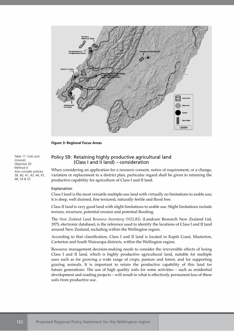
Proposed Regional Policy Statement for the Wellington region122
Figure 3: Regional Focus Areas
Policy 59: Retaining highly productive agricultural land (Class I and II land) – consideration
When considering an application for a resource consent, notice of requirement, or a change, variation or replacement to a district plan, particular regard shall be given to retaining the productive capability for agriculture of Class I and II land.
Explanation
Class I land is the most versatile multiple-use land with virtually no limitations to arable use; it is deep, well drained, fine textured, naturally fertile and flood free.
Class II land is very good land with slight limitations to arable use. Slight limitations include texture, structure, potential erosion and potential flooding.
The New Zealand Land Resource Inventory (NZLRI), (Landcare Research New Zealand Ltd, 1975, electronic database), is the reference used to identify the locations of Class I and II land around New Zealand, including within the Wellington region.
According to that classification, Class I and II land is located in Kapiti Coast, Masterton, Carterton and South Wairarapa districts, within the Wellington region.
Resource management decision-making needs to consider the irreversible effects of losing Class I and II land, which is highly productive agricultural land, suitable for multiple uses such as for growing a wide range of crops, pasture and forest, and for supporting grazing animals. It is important to retain the productive capability of this land for future generations. The use of high quality soils for some activities – such as residential development and roading projects – will result in what is effectively permanent loss of these soils from productive use.
Table 11: Soils and mineralsObjective 29Method 4Also consider policies 38, 40, 41, 43, 44, 47, 48, 54 & 55
Proposed Regional Policy Statement for the Wellington region 123
Policy 60: Utilising the region’s mineral resources – consideration
When considering an application for a resource consent, notice of requirement, or a change, variation or replacement to a district or regional plan, particular regard shall be given to:
(a) the social, economic, and environmental benefits from utilising mineral resources within the region; and
(b) protecting significant mineral resources from incompatible or inappropriate land uses alongside.
Explanation
Policy 60 directs that particular regard be given to the social, economic, and environmental benefits of utilising mineral resources within the region. It also requires that particular regard be given to protecting significant mineral resources from incompatible and inappropriate land use alongside. Examples of methods to protect significant mineral resources include the use of buffer areas in which sensitive activities may be restricted, and the use of noise reduction measures and visual screening.
Significant mineral resources are deposits of minerals, the extraction of which is of importance in order to meet the current and future mineral needs of the region.
Method 51, when implemented, will identify the locations of significant mineral resources within the region.
Table 11: Soils and mineralsObjective 30Methods 4 & 51Also consider policies 34, 35, 36, 42, 43, 45, 46, 47, 48, 49 & 55

Section 4.3
Allocation of responsibilities

Proposed Regional Policy Statement for the Wellington region 125
4.3 Allocation of responsibilities
This section contains the policies that allocate the responsibilities for indigenous biodiversity, natural hazards and hazardous substances between Wellington Regional Council and the region’s district and city councils. Within this section policies are presented in numeric order, although in the summary table, policy titles are listed under key topics.
Topic Policy title Page
Indigenous ecosystems
Policy 61: Allocation of responsibilities for land use controls for indigenous biodiversity
125
Natural hazards Policy 62: Allocation of responsibilities for land use controls for natural hazards 126
Hazardous substances
Policy 63: Allocation of responsibilities for land use controls for hazardous substances
126
Policy 61: Allocation of responsibilities for land use controls for indigenous biodiversity
Regional and district plans shall recognise and provide for the responsibilities below, when developing objectives, policies and methods, including rules, to maintain indigenous biodiversity:
(a) Wellington Regional Council shall be responsible for developing objectives, policies, and methods in the regional policy statement for the control of the use of land to maintain indigenous biological diversity;
(b) Wellington Regional Council shall be responsible for developing objectives, policies, rules and/or methods in regional plans for the control of the use of land to maintain and enhance ecosystems in water bodies and coastal water. This includes land within the coastal marine area, wetlands and the beds of lakes and rivers; and
(c) City and district councils shall be responsible for developing objectives, policies, rules and/or methods in district plans for the control of the use of land for the maintenance of indigenous biological diversity. This excludes land within the coastal marine area and the beds of lakes and rivers.
Explanation
In accordance with section 62 of the Resource Management Act, policy 61 sets out the local authorities in the Wellington region responsible for specifying the objectives, policies and methods for the control of the use of land to maintain indigenous biological diversity.
District and city councils in the Wellington region have primary responsibility for controlling the use of land to maintain indigenous biological diversity (other than in the coastal marine area and the beds of lakes and rivers) through the creation of objectives, policies and rules in their district plans.
Wellington Regional Council has the primary responsibility for the control of the use of land to maintain and enhance indigenous ecosystems in water bodies (including wetlands) and coastal water.
Table 6b: Indigenous ecosystems Method 5See policies 5, 11, 16, 17, 22, 23, 46 & 47
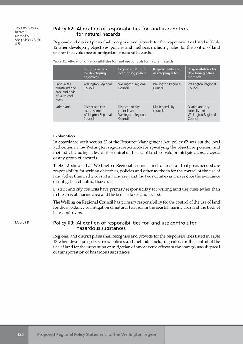
Proposed Regional Policy Statement for the Wellington region126
Policy 62: Allocation of responsibilities for land use controls for natural hazards
Regional and district plans shall recognise and provide for the responsibilities listed in Table 12 when developing objectives, policies and methods, including rules, for the control of land use for the avoidance or mitigation of natural hazards.
Table 12: Allocation of responsibilities for land use controls for natural hazards
Responsibilities for developing objectives
Responsibilities for developing policies
Responsibilities for developing rules
Responsibilities for developing other methods
Land in the coastal marine area and beds of lakes and rivers
Wellington Regional Council
Wellington Regional Council
Wellington Regional Council
Wellington Regional Council
Other land District and city councils and Wellington Regional Council
District and city councils and Wellington Regional Council
District and city councils
District and city councils and Wellington Regional Council
Explanation
In accordance with section 62 of the Resource Management Act, policy 62 sets out the local authorities in the Wellington region responsible for specifying the objectives policies, and methods, including rules for the control of the use of land to avoid or mitigate natural hazards or any group of hazards.
Table 12 shows that Wellington Regional Council and district and city councils share responsibility for writing objectives, policies and other methods for the control of the use of land (other than in the coastal marine area and the beds of lakes and rivers) for the avoidance or mitigation of natural hazards.
District and city councils have primary responsibility for writing land use rules (other than in the coastal marine area and the beds of lakes and rivers).
The Wellington Regional Council has primary responsibility for the control of the use of land for the avoidance or mitigation of natural hazards in the coastal marine area and the beds of lakes and rivers.
Policy 63: Allocation of responsibilities for land use controls for hazardous substances
Regional and district plans shall recognise and provide for the responsibilities listed in Table 13 when developing objectives, policies and methods, including rules, for the control of the use of land for the prevention or mitigation of any adverse effects of the storage, use, disposal or transportation of hazardous substances.
Table 8b: Natural hazardsMethod 5See policies 28, 50 & 51
Method 5
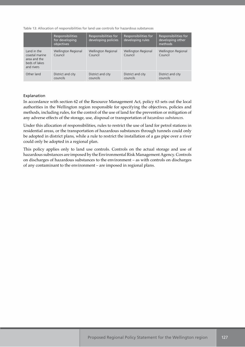
Proposed Regional Policy Statement for the Wellington region 127
Table 13: Allocation of responsibilities for land use controls for hazardous substances
Responsibilities for developing objectives
Responsibilities for developing policies
Responsibilities for developing rules
Responsibilities for developing other methods
Land in the coastal marine area and the beds of lakes and rivers
Wellington Regional Council
Wellington Regional Council
Wellington Regional Council
Wellington Regional Council
Other land District and city councils
District and city councils
District and city councils
District and city councils
Explanation
In accordance with section 62 of the Resource Management Act, policy 63 sets out the local authorities in the Wellington region responsible for specifying the objectives, policies and methods, including rules, for the control of the use of land for the prevention or mitigation of any adverse effects of the storage, use, disposal or transportation of hazardous substances.
Under this allocation of responsibilities, rules to restrict the use of land for petrol stations in residential areas, or the transportation of hazardous substances through tunnels could only be adopted in district plans, while a rule to restrict the installation of a gas pipe over a river could only be adopted in a regional plan.
This policy applies only to land use controls. Controls on the actual storage and use of hazardous substances are imposed by the Environmental Risk Management Agency. Controls on discharges of hazardous substances to the environment – as with controls on discharges of any contaminant to the environment – are imposed in regional plans.

Non-regulatory policies
Section 4.4
Proposed Regional Policy Statement for the Wellington region 129
4.4 Non-regulatory policies
This section contains policies that outline non-regulatory actions required to help achieve the objectives of this Regional Policy Statement. Within this section the policies are presented in numeric order, although in the summary table, below, the policy titles are listed under topic headings.
Topic Policy title Page
Coastal environment
Policy 64: Supporting environmental enhancement initiatives – non-regulatory 129
Energy, infrastructure and waste
Policy 65: Promoting efficient use and conservation of resources – non-regulatory 130
Fresh water Policy 64: Supporting environmental enhancement initiatives – non-regulatory 129
Policy 65: Promoting efficient use and conservation of resources – non-regulatory 130
Indigenous ecosystems
Policy 64: Supporting environmental enhancement initiatives – non-regulatory 129
Resource management with tangata whenua
Policy 66: Enhancing involvement of tangata whenua in resource management decision-making – non-regulatory
131
Regional form, design and function
Policy 67: Maintaining and enhancing a compact, well designed and sustainable regional form – non-regulatory
131
Soils and minerals Policy 68: Minimising soil erosion – non-regulatory 132
Policy 69: Preventing long-term soil deterioration – non-regulatory 132
Policy 64: Supporting environmental enhancement initiatives – non-regulatory
Take a whole of catchment approach that recognises the inter-relationship between land and water, and support environmental enhancement initiatives to restore and enhance:
(a) coastal features, ecosystems and habitats;(b) aquatic ecosystems and habitats; and(c) indigenous ecosystems and habitats.
Explanation
The natural character of the coast has been degraded. Restoring and enhancing coastal features and ecosystems helps restore natural character and enhances people’s use and enjoyment of the coastal environment.
A regulatory approach cannot restore aquatic ecosystems from the effects of many existing and historical activities. Resource consent holders cannot be obliged to remedy existing effects unless they are caused by their particular activity. Where historical activities have affected an aquatic ecosystem, restoration measures such as riparian planting or the removal of concrete linings or contaminated material can help restore the habitat.
Setting right the effects of historical activities that have reduced the extent and quality of indigenous ecosystems and habitats in the region can be facilitated by providing information about the importance of these ecosystems and habitats, and by providing financial incentives to promote their maintenance, enhancement and restoration. Wellington Regional Council and district and city councils can, through their operations, play a role in the restoration and
Table 2: Coastal environment Objective 3Table 4: Fresh water Objective 13Table 6a Indigenous biodiversityObjective 16Methods 5, 8, 12, 27, 28, 29, 52 & 53
Proposed Regional Policy Statement for the Wellington region130
enhancement of indigenous ecosystems and habitats – such as, in reserve management plans, pest control, storm-water management, and roadside vegetation management.
Taking a whole of catchment approach is promoted within this Regional Policy Statement. It means considering the full mix of purposes, uses or activities within a catchment, in terms of how these interact and contribute to outcomes within the catchment and for receiving environments beyond – such as in relation to indigenous ecosystems, soil productivity, water quality, erosion and stormwater control, or natural hazards. This approach suggests a need to work with multiple parties to establish shared objectives for a catchment and to ensure uses and activities are working towards the same goals or at least are not working against their attainment.
Policy 65: Promoting efficient use and conservation of resources – non-regulatory
To promote conservation and efficient use of resources by:
(a) reducing, reusing and recycling waste;(b) using water and energy efficiently; and(c) conserving water and energy.
Explanation
For waste management, using resources efficiently means following the waste hierarchy: reducing use of resources, including unnecessary packaging; reusing unwanted goods that are still ‘fit for purpose’; recycling new products from discarded materials; and recovering resources – such as energy – before disposing of the remaining waste safely. If resources are used efficiently, the amount of unwanted materials disposed of at landfills and at sewage treatment plants will be reduced.
Similar principles apply for reducing energy demand and conserving energy. This includes minimising use, reducing the need to use and being more efficient in use.
Some of the ways to efficiently use and conserve water include reducing water demand and wastage by:
• setting targets for reducing leakage from reticulated water supplies within each district• providing information to water suppliers and water users on how to conserve water
and use it as efficiently as possible• providing information about long-term rainfall and drought predictions• investigating the use of transferable water permits.
Leaks from water reticulation systems can waste over 15 per cent of treated water. Water supply authorities already have programmes for repair and maintenance, and it is vital that targets are set so that development of such programmes continues and wastage is reduced.
Water efficient household appliances and garden watering tied to garden needs, along with fixing dripping taps and planting locally appropriate plants, are some of the ways that people could make the water delivered to their house go further.
Weather predictions can help people prepare for possible weather extremes, for example by buying in stock feed or ensuring water reserves are at full capacity. Transferring water permits, or parts of water permits, allows allocated water to be used by as many people as the resource can sustain.
Table 3: Energy, infrastructure and waste Objectives 9 & 11Table 4: FreshwaterObjective 14Methods 10, 11, 17, 32, 33 & 55
Proposed Regional Policy Statement for the Wellington region 131
Policy 66: Enhancing involvement of tangata whenua in resource management decision-making – non-regulatory
To enhance involvement of tangata whenua in resource management decision-making by improving opportunities for iwi authority representatives to participate in local authority decision-making.
Explanation
Active engagement by local authorities with tangata whenua requires an open mind and a genuine willingness to allow the views of tangata whenua representatives to influence decision-making.
Maori have a long history of settlement of the Wellington region, known as Te Upoko o te Ika a Maui (the head of the fish of Maui). Iwi authority refers to the body that represents an iwi and is recognised by that iwi as having the authority to do so. Refer to chapter 2 for a list of the current iwi authorities representing tangata whenua in the Wellington region.
Policy 67: Maintaining and enhancing a compact, well designed and sustainable regional form – non-regulatory
To maintain and enhance a compact, well designed and sustainable regional form by:
(a) implementing the New Zealand Urban Design Protocol;(b) promoting best practice on the location and design of rural residential development;(c) recognising and enhancing the role of the region’s open space network; and(d) encouraging a range of housing types and developments to meet the community’s
social and economic needs, including affordable housing and improve the health, safety and well-being of the community.
Explanation
The New Zealand Urban Design Protocol promotes a national cross-sector commitment to the principles of good urban design. It provides access to resources, training and a network of signatories with a range of urban design experience.
The New Zealand Urban Design Protocol plays an important role in improving the quality of urban design in the region.
Rural residential activities offer investment, development and growth opportunities, but present challenges in terms of rural productivity, provision of infrastructure and sustainable management.
Best practice guidance will look at how districts and cities can benefits from rural residential activities while:
• maintaining rural economies that are functioning and productive• managing sensitive environmental and amenity values• avoiding natural hazards• considering infrastructure limitations and requirements• managing urban development and protecting future urban development areas.
The region’s open space network has helped define the region’s existing urban form and is a fundamental element of quality of life for residents. The region’s open space is managed by a number of organisations, including Wellington Regional Council, the region’s district and city councils and the Department of Conservation. Policy 67 seeks to enhance the role of the region’s open space network in supporting the region’s compact form. This will require authorities to work together and identify gaps and opportunities.
Table 10: Resource management with tangata whenuaObjective 22Methods 31, 36 & 37Consider alongside policies 1 to 60
Table 9: Regional form, design and function Objective 21Methods 39, 40, 44 & 46
Proposed Regional Policy Statement for the Wellington region132
Housing design and the quality of housing developments can have a significant role in improving housing choice and affordability. Different housing types, particularly those that are less land intensive, can offer greater opportunities for more affordable housing. Likewise, housing developments that incorporate, or are well connected to, transport infrastructure and services, employment opportunities and community centres are likely to enhance the social and economic wellbeing of residents.
At present housing in the region generally becomes more affordable with distance from the regional central business district and other places of work. This has negative implications in terms of travel demand, associated living costs, access to employment and community networks. It can also limit economic development opportunities by reducing the ability of businesses to attract and retain a workforce with appropriate skills.
Policy 68: Minimising soil erosion – non-regulatory
To minimise soil erosion by encouraging sustainable land management practices and taking a whole of catchment approach.
Explanation
Sustainable land management practices are methods and techniques that reduce soil erosion – such as soil conservation plantings, land retirement and conservation tilling. These practices can apply to activities such as pastoral farming, plantation forestry, subdivisions and roading.
Taking a whole of catchment approach is promoted within this Regional Policy Statement. It means considering the full mix of purposes, uses or activities within a catchment, in terms of how these interact and contribute to outcomes within the catchment and for receiving environments beyond – such as in relation to indigenous ecosystems, soil productivity, water quality, erosion and stormwater control, or natural hazards. This approach suggests a need to work with multiple parties to establish shared objectives for a catchment and to ensure uses and activities are working towards the same goals or at least are not working against their attainment.
Policy 69: Preventing long-term soil deterioration – non-regulatory
To retain healthy soil ecosystem functioning by promoting and encouraging sustainable agricultural practices that do not cause soil contamination, compaction or loss of or minerals or nutrients.
Explanation
Soil compaction, mineral and/or nutrient depletion, and soil contamination may cause irreversible degradation to soil ecosystem health. Retaining soil on land avoids contamination of water bodies.
Soil compaction occurs when the weight of livestock or heavy machinery compresses soil, causing it to lose pore space. Soil contamination, in the context of this policy, refers to the presence of pesticides and heavy metals in the natural soil environment.
Table 11: Soils and mineralsObjective 28Methods 15, 29, 35 & 54
Table 11: Soils and mineralsObjective 29Methods 15 & 29
Section 4.5
Methods to implement policies
Proposed Regional Policy Statement for the Wellington region 133
4.5 Methods to implement policies
This section contains the methods for implementing the policies set out in sections 4.1 to 4.4. It is divided into two main groups of methods: regulatory methods that implement the policies in sections 4.1, 4.2 and 4.3; and non-regulatory methods that implement the policies in section 4.4 or support the delivery of the other policies.
The non-regulatory methods are subdivided into four types:
• information and/or guidance• integrating management • identification and investigation• providing support.
Under each non-regulatory method the key organisations who may implement the methods are indicated. An asterisk * indicates the lead authority responsible for implementation, if this is designated. The delivery and timing of methods is subject to long term council community planning and annual plan schedules.
Within section 4.5 the methods are presented in numeric order, although in the summary table below, methods are listed under key topics.
Key topic Method title Page
Air quality Method 1: District plan implementation 137
Method 2: Regional plan implementation 137
Method 6: Information about reducing air pollution 138
Method 26: Prepare airshed action plans 141
Method 30: Protocols for management of earthworks and air quality between local authorities
141
Coastal environment
Method 1: District plan implementation 137
Method 2: Regional plan implementation 137
Method 4: Resource consents, notices of requirement and when changing, varying or replacing plans
137
Method 7: Information about high natural character in the coastal environment 138
Method 8: Information to assist with restoration and enhancement of degraded water bodies and the natural character of the coastal environment
138
Method 27: Integrate management across mean high water springs 141
Method 28: Prepare a coastal and marine ecosystems action plan 141
Method 29: Take a whole of catchment approach to works, operations and services
141
Method 31: Engage tangata whenua and the community in identifying and protecting significant values
141
Method 34: Prepare a regional stormwater action plan 142
Method 35: Support Industry-led environmental accords and codes of practice 142
Method 49: Prepare a regional landscape character description 144
Method 50: Identify areas for improved public access 144
Method 52: Support community restoration initiatives for the coastal environment, rivers, lakes and wetlands
144
Proposed Regional Policy Statement for the Wellington region134
Key topic Method title Page
Energy, infrastructure and waste
Method 1: District plan implementation 137
Method 2: Regional plan implementation 137
Method 3: Wellington Regional Land Transport Strategy implementation 137
Method 4: Resource consents, notices of requirement and when changing, varying or replacing plans
137
Method 9: Information about travel demand management 138
Method 10: Information about energy efficient subdivision, design and building development
138
Method 17: Information about waste management 139
Method 25: Information about the provision of walking, cycling and public transport for development
140
Method 32: Identify sustainable energy programmes 141
Method 55: Assist the community to reduce waste, and use water and energy efficiently
144
Fresh water Method 1: District plan implementation 137
Method 2: Regional plan implementation 137
Method 4: Resource consents, notices of requirement and when changing, varying or replacing plans
137
Method 8: Information to assist with restoration and enhancement of degraded water bodies and the natural character of the coastal environment
138
Method 11: Information about water conservation and efficient use 139
Method 29: Take a whole of catchment approach to works, operations and services 141
Method 30: Protocols for management of earthworks and air quality between local authorities
141
Method 31: Engage tangata whenua and the community in identifying and protecting significant values
141
Method 33: Prepare a regional water strategy 142
Method 34: Prepare a regional stormwater action plan 142
Method 35: Support Industry-led environmental accords and codes of practice 142
Method 47: Investigate the use of transferable water permits 143
Method 50: Identify areas for improved public access 144
Method 52: Support community restoration initiatives for the coastal environment, rivers, lakes and wetlands
144
Method 55: Assist the community to reduce waste, and use water and energy efficiently
144
Heritage Method 1: District plan implementation 137
Method 2: Regional plan implementation 137
Method 4: Resource consents, notices of requirement and when changing, varying or replacing plans
137
Method 20: Information to assist with the identification of places, sites and areas with significant historic heritage values
140
Method 31: Engage tangata whenua and the community in identifying and protecting significant values
141
Proposed Regional Policy Statement for the Wellington region 135
Key topic Method title Page
Indigenous ecosystems
Method 1: District plan implementation 137
Method 2: Regional plan implementation 137
Method 4: Resource consents, notices of requirement and when changing, varying or replacing plans
137
Method 5: Allocation of responsibilities 138
Method 12: Information about techniques to maintain and enhance indigenous ecosystems
139
Method 21: Information to assist with the identification of indigenous ecosystems and habitats with significant biodiversity values
140
Method 29: Take a whole of catchment approach to works, operations and services
141
Method 31: Engage tangata whenua and the community in identifying and protecting significant values
141
Method 53: Assist landowners to maintain, enhance and restore indigenous ecosystems
144
Landscape Method 1: District plan implementation 137
Method 2: Regional plan implementation 137
Method 4: Resource consents, notices of requirement and when changing, varying or replacing plans
137
Method 31: Engage tangata whenua and the community in identifying and protecting significant values
141
Method 49: Prepare a regional landscape character description 144
Natural hazards Method 1: District plan implementation 137
Method 4: Resource consents, notices of requirement and when changing, varying or replacing plans
137
Method 5: Allocation of responsibilities 138
Method 14: Information about natural hazard and climate change effects 139
Method 22: Information about areas at high risk from natural hazards 140
Method 23: Information about natural features to protect property from natural hazards
140
Regional form, design and function
Method 1: District plan implementation 137
Method 2: Regional plan implementation 137
Method 3: Wellington Regional Land Transport Strategy implementation 137
Method 4: Resource consents, notices of requirement and when changing, varying or replacing plans
137
Method 16: Information about key locations with good access to the strategic public transport network
139
Method 18: Regional structure planning guide 140
Method 25: Information about the provision of walking, cycling and public transport for development
140
Method 39: Sign the New Zealand Urban Design Protocol 143
Method 40: Integrate public open space 143
Proposed Regional Policy Statement for the Wellington region136
Key topic Method title Page
Regional form, design and function
(Continued)
Method 41: Develop visions for the regionally significant centres 143
Method 42: Develop principles for retail activities 143
Method 43: Analyse industrial employment locations 143
Method 44: Develop principles for rural-residential use and development 143
Method 45: Develop planning frameworks for each Regional Focus Area 143
Method 46: Analyse the range and affordability of housing in the region 143
Resource management with tangata whenua
Method 4: Resource consents, notices of requirement and when changing, varying or replacing plans
137
Method 13: Information about best practice for earthworks to protect Maori archaeological sites, other significant sites and koiwi
139
Method 19: Information to assist with the application of the Treaty of Waitangi principles in the region
140
Method 31: Engage tangata whenua and the community in identifying and protecting significant values
141
Method 36: Involve tangata whenua in resource management decision making 142
Method 37: Iwi authorities prepare planning documents 142
Method 38: Prepare protocols for tangata whenua access to mahinga kai and natural resources used for customary purposes on public land
142
Method 48: Investigate use of Maori names for rivers, lakes and places of cultural significance in the region
143
Soils and minerals Method 1: District plan implementation 137
Method 2: Regional plan implementation 137
Method 4: Resource consents, notices of requirement and when changing, varying or replacing plans
137
Method 15: Information about sustainable land management practices 138
Method 24: Database of sites at risk of contamination 140
Method 29: Take a whole of catchment approach to works, operations and services
141
Method 30: Protocols for management of earthworks and air quality between local authorities
141
Method 35: Support Industry-led environmental accords and codes of practice 142
Method 51: Identify the region’s significant mineral resources 144
Method 54: Assist landowners to protect erosion prone land 144
Proposed Regional Policy Statement for the Wellington region 137
4.5.1 Regulatory methods
Method 1: District plan implementationThe process to amend district plans to implement policies 1, 3, 4, 6, 7, 10, 14, 20, 21, 22, 23, 24, 25, 26, 27, 28, 29, 30, 31 and 33 will commence on, or before, the date on which the relevant council commences the review of its district plan pursuant to section 79 of the Resource Management Act 1991.
District and city councils may implement these policies earlier by plan change, and in the case of a ‘rolling review’ the policies must be implemented at the time of commencing the review of the relevant part(s) of the plan.
District and city councils that will implement method 1 are:
• WellingtonCityCouncil• PoriruaCityCouncil• KapitiCoastDistrictCouncil• HuttCityCouncil• UpperHuttCityCouncil• SouthWairarapaDistrictCouncil• CartertonDistrictCouncil• MastertonDistrictCouncil• TararuaDistrictCouncilforlandwithintheWellingtonregion.
Policies3and4withrespecttothecoastalenvironmentdonotapplytoUpperHuttCityCouncil.
Policies 1, 3, 4, 6, 7, 10, 14, 20, 21, 24, 25, 26, 27, 28, 29, 30, 31 and33donot apply toTararua DistrictCouncil.
Method 2: Regional plan implementationThe process to amend regional plans to implement policies 2, 3, 5, 6, 7, 11, 12, 13, 14, 15, 16, 17, 18, 19, 20, 21, 22, 23, 24, 25, 26 and 27 will commence on, or before, the date on which Wellington Regional Council commences the review of its regional plans pursuant to section 79 of the Resource Management Act 1991.
Method 3: Wellington Regional Land Transport Strategy implementationThe process to amend the Wellington Regional Land Transport Strategy to implement policies 8, 9 and 32 will commence on, or before, the date on which Wellington Regional Council commences the review pursuant to section 176 of the Land Transport Act 1998.
Method 4: Resource consents, notices of requirement and when changing, varying or replacing plans
Policies 34 to 60 will be implemented when considering a resource consent, notice of requirement, or when changing, varying or replacing a district or regional plan.
Localauthoritiesthatwillimplementmethod4are:
• WellingtonRegionalCouncil• WellingtonCityCouncil• PoriruaCityCouncil• KapitiCoastDistrictCouncil• HuttCityCouncil• UpperHuttCityCouncil• SouthWairarapaDistrictCouncil• CartertonDistrictCouncil
Policies 1, 3, 4, 6, 7, 10, 14, 20, 21, 22, 23, 24, 25, 26, 27, 28, 29, 30, 31 & 33
Policies 2, 3, 5, 6, 7, 11, 12, 13, 14, 15, 16, 17, 18, 19, 20, 21, 22, 23, 24, 25, 26 & 27
Policies 8, 9 & 32
Policies 34 – 60
Proposed Regional Policy Statement for the Wellington region138
• Masterton District Council• Tararua District Council where a proposal relates to land within the Wellington region.
Method 5: Allocation of responsibilitiesLocal authorities are responsible for the land use control for biological diversity, natural hazards and hazardous substances, as described in policies 61, 62 and 63.
Local authorities that will implement method 5 are:
• Wellington Regional Council • Wellington City Council• Porirua City Council• Kapiti Coast District Council• Hutt City Council• Upper Hutt City Council• South Wairarapa District Council• Carterton District Council• Masterton District Council• Tararua District Council for land within the Wellington region.
4.5.2 Non-regulatory methods – information and guidance
Method 6: Information about reducing air pollutionPrepare and disseminate information to promote:
(a) best practice techniques to reduce discharges of odour, smoke and dust;(b) understanding the causes of air pollution and the steps people can take to reduce it;
and(c) homeowners adopting cleaner forms of heating and insulation for their houses.
Implementation: Wellington Regional Council and city and district councils
Method 7: Information about high natural character in the coastal environmentDisseminate information held by Wellington Regional Council about places, site and areas with high natural character in the coastal environment.
Implementation: Wellington Regional Council
Method 8: Information to assist with restoration and enhancement of degraded water bodies and the natural character of the coastal environment
Prepare and disseminate information about the restoration and enhancement of degraded water bodies and the natural character of the coastal environment, including about eco-sourcing.
Implementation: Wellington Regional Council and city and district councils
Method 9: Information about travel demand management Prepare and disseminate information about how travel demand management mechanisms can be encouraged through district plans.
Implementation: Wellington Regional Council* and city and district councils
Method 10: Information about energy efficient subdivision, design and building development
Prepare and disseminate information about how to carry out energy efficient subdivision design and building development.
Implementation: Wellington Regional Council and city and district councils
Policies 60, 61 & 62
Policies 1 & 2
Policy 3, 34 & 35
Policies 64
Policy 9
Policy 10
* lead authority responsible for implementation
Proposed Regional Policy Statement for the Wellington region 139
Method 11: Information about water conservation and efficient usePrepare and disseminate information about water conservation and the efficient use of water.
Implementation: Wellington Regional Council and city and district councils
Method 12: Information about techniques to maintain and enhance indigenous ecosystems
Prepare and disseminate information about the maintenance, restoration and enhancement of indigenous ecosystems and habitats.
Implementation: Wellington Regional Council and city and district councils
Method 13: Information about best practice for earthworks to protect Maori archaeological sites, other significant sites and koiwi
Prepare and disseminate information about best practice, in consultation with iwi authorities, for resource consent holders, applicants and others undertaking earthworks, to ensure Maori archaeological sites and other significant sites and koiwi (human bones) are appropriately protected.
Implementation: Iwi authorities, Wellington Regional Council, and city and district councils
Method 14: Information about natural hazard and climate change effectsPrepare and disseminate information about natural hazards and climate change effects in order to:
(a) guide local authority decision-making; and(b) raise awareness and understanding of natural hazards
Implementation: Wellington Regional Council*, city and district councils, and Civil Defence Emergency Management Group
Method 15: Information about sustainable land management practicesPrepare and disseminate information about sustainable land management practices, including:
(a) soil capability in terms of its limitations;(b) soil conservation methods and techniques, including the retirement of erosion prone
land from pastoral farming;(c) causes of poor soil health, and practices and techniques to improve degraded soil
health and ecological function; and(d) best practice techniques to prevent soil erosion and sediment run-off from vegetation
clearance and earthworks.
Implementation: Wellington Regional Council
Method 16: Information about locations with good access to the strategic public transport network
Prepare and disseminate information to support the identification of locations with good access to the strategic public transport network.
Implementation: Wellington Regional Council* and city and district councils
Method 17: Information about waste managementPrepare and disseminate information about how to reduce, reuse or recycle waste.
Implementation: Wellington Regional Council and city and district councils*
Policy 64
Policy 64
Policy 48
Policies 28, 50 & 51
Policies 68 & 69
Policy 30
Policy 65
* lead authority responsible for implementation
Proposed Regional Policy Statement for the Wellington region140
Method 18: Regional structure planning guidePrepare a structure planning guide about integrating land use with infrastructure and for delivering high quality urban design.
Implementation: Wellington Regional Council* and city and district councils
Method 19: Information to assist with the application of the Treaty of Waitangi principles in the region
Prepare and disseminate information, for resource management decision-making, on the meaning and application of the principles of the Treaty of Waitangi in the Wellington region.
Implementation: Iwi authorities*, Wellington Regional Council and city and district councils
Method 20: Information to assist with the identification of places, sites and areas with significant historic heritage values
Prepare information to assist with interpretation of the criteria set out in policy 20, which requires the identification of places, sites and areas with significant historic heritage values.
Implementation: Wellington Regional Council* and city and district councils
Method 21: Information to assist with the identification of indigenous ecosystems and habitats with significant biodiversity values
Prepare and disseminate information to assist with the interpretation of the criteria set out in policy 22, which requires the identification of indigenous ecosystems and habitats with significant indigenous biodiversity values.
Implementation: Wellington Regional Council* and city and district councils
Method 22: Information about areas at high risk from natural hazardsPrepare and disseminate information about how to identify areas at high risk from natural hazards, as relevant to the development of hazard management strategies to guide decision-making.
Implementation: Wellington Regional Council * and city and district councils
Method 23: Information about natural features to protect property from natural hazards
Prepare and disseminate information about how to identify features in the natural environment that can offer natural protection to property from the effects of erosion and inundation.
Implementation: Wellington Regional Council * and city and district councils
Method 24: Database of sites at risk of contaminationMaintain a database of sites:
(a) with a history of storing, using or manufacturing hazardous substances;(b) where major spills involving hazardous substances have occurred; and(c) where analysis of soil or water samples has confirmed that the site is contaminated.
Implementation: Wellington Regional Council
Method 25: Information about the provision of walking, cycling and public transport for development
Prepare and disseminate information about how to provide for walking, cycling and public transport.
Implementation: Wellington Regional Council
Policy 54
Policy 47
Policy 20
Policy 22
Policies 28 & 50
Policy 51
Policy 33
Policy 56
* lead authority responsible for implementation
Proposed Regional Policy Statement for the Wellington region 141
4.5.3 Non-regulatory methods – integrating management
Method 26: Prepare airshed action plans Prepare airshed action plans, where needed, to determine how levels of fine particulate matter will be reduced.
Implementation: Wellington Regional Council
Method 27: Integrate management across mean high water springsClarify local authority management across mean high water springs by: (a) reviewing memoranda of understanding between local authorities for matters that
cross mean high water springs; and(b) developing other non-statutory plans, where necessary, for areas and issues that impact
on the coastal environment. Implementation: Wellington Regional Council* and city and district councils
Method 28: Prepare a coastal and marine ecosystems action planIdentify degraded indigenous habitats and ecosystems in the coastal environment that warrant restoration or enhancement programmes, and prepare a coastal and marine ecosystem action plan.
Implementation: Wellington Regional Council
Method 29: Take a whole of catchment approach to works, operations and servicesTake a whole of catchment approach that recognises the inter-relationships between the values of natural resources when undertaking and planning works, operations and services.
Implementation: Wellington Regional Council* and city and district councils
Method 30: Protocol for management of earthworks and air quality between local authorities
Prepare protocols to guide changes to district and regional plans to avoid gaps and unnecessary overlaps in the regulation of:(a) earthworks, including vegetation disturbance; and(b) management of odour, smoke and dust.Implementation: Wellington Regional Council* and city and district councils
Method 31: Engagement with tangata whenua and the community in identifying and protecting significant values
Involve iwi, hapu, marae or whanau and the community in the:(a) identification and protection of significant places, sites and areas with significant
historic heritage values;(b) identification and protection of outstanding natural features, landscape, and significant
amenity landscapes values;(c) identification and protection indigenous ecosystems and habitats with significant
biodiversity values; and(d) protection of the values associated with the rivers and lakes identified in Appendix 1.Implementation: Wellington Regional Council and city and district councils
Method 32: Identify sustainable energy programmes Identify sustainable energy programmes, to improve energy efficiency and conservation, reduce emissions of carbon dioxide and minimise the region’s vulnerability to energy supply disruptions or shortages.
Implementation: Wellington Regional Council* and city and district councils
Policy 2
Policy 64
Policy 64
Policies 16, 42, 64, 68 & 69
Policies 1, 2, 14 & 40
Policies 4, 17, 20, 21, 22, 23, 24, 25, 26, 27, 35, 64 & 66
Policy 65
* lead authority responsible for implementation
Proposed Regional Policy Statement for the Wellington region142
Method 33: Prepare a regional water strategyPrepare a regional water strategy to guide local authorities on:
(a) sustainable water use;(b) demand management and security of supply; and(c) rural and urban water quality.
Implementation: Wellington Regional Council* and city and district councils
Method 34: Prepare a regional stormwater action planPrepare a regional stormwater action plan that is developed and agreed to by the region’s local authorities.
Implementation: Wellington Regional Council* and city and district councils
Method 35: Support industry-led environmental accords and codes of practiceSupport industry-led environmental accords and codes of practice – such as the Dairying and Clean Streams Accord and the New Zealand Environmental Code of Practice for Plantation Forestry – where these will lead to the achievement of objectives in this Regional Policy Statement.
Implementation: Wellington Regional Council and city and district councils
Method 36: Involve tangata whenua in resource management decision makingIn consultation with iwi authorities, appoint representatives with current accreditation in the Ministry for the Environment ‘Making Good Decisions Programme’ to committees that hear applications for resource consents, notices of requirement and changes, variations or replacements to district or regional plans or the Regional Policy Statement that affect matters of significance to tangata whenua.Implementation: Wellington Regional Council and city and district councils
Method 37: Iwi authorities prepare planning documentsPrepare planning documents, where iwi authorities wish to do so, to support the implementation of policy 48 and identify:
(a) sites and resources where there has been a loss of mauri and the priorities for restoration; (b) values associated with water bodies, including water bodies that should be managed
for customary purposes, and criteria for their management;(c) mahinga kai (customary food gathering areas) and areas of natural resources used for
customary purposes and priorities for their protection and restoration; (d) places, areas and sites with significant spiritual or cultural historic heritage values, and
appropriate behaviours in relation to those places, sites and areas; and/or(e) areas that should be monitored and the indicators to be used to measure the state of:
(i) mauri of natural resources; (ii) water bodies managed for cultural purposes; (iii) mahinga kai and areas of natural resources used for customary purposes; and (iv) places, areas and sites with significant spiritual or cultural historic heritage value.
Implementation: Iwi authorities*, Wellington Regional Council and city and district councils
Method 38: Prepare protocols for tangata whenua access to mahinga kai and natural resources used for customary purposes on public land
Prepare protocols to define where and how tangata whenua can access significant mahinga kai and areas of natural resources used for customary purposes, on public land managed by local authorities.Implementation: Wellington Regional Council, iwi authorities and city and district councils
Policy 11, 13, 18 & 65
Policy 5, 11, 13, 14, 39 & 41
Policies 5, 11,14, 15, 39, 40 & 68
Policy 66
Policy 48
Policy 48
* lead authority responsible for implementation
Proposed Regional Policy Statement for the Wellington region 143
Method 39: Sign the New Zealand Urban Design ProtocolBecome a signatory to the New Zealand Urban Design Protocol and develop a joint local authority urban design action plan.
Implementation: Wellington Regional Council and city and district councils
Method 40: Integrate public open spaceIdentify gaps and opportunities to improve integration of public open space and develop a regionally agreed action plan.
Implementation: Wellington Regional Strategy
Method 41: Develop visions for the regionally significant centres Develop a vision for each regionally significant centre identified in policy 29, and formulate a statement about the role that each plays in contributing to an overall vision for the region.
Implementation: Wellington Regional Strategy
Method 42: Develop principles for retail activitiesDevelop regional principles to manage the location of retail activities.
Implementation: Wellington Regional Strategy
Method 43: Analyse industrial employment locationsAnalyse factors and trends affecting supply and demand of industrial based employment locations.
Implementation: Wellington Regional Strategy
Method 44: Develop principles for rural-residential use and developmentDevelop regional principles to guide the identification of areas suitable for rural-residential development and promote best practice rural-residential use and design.
Implementation: Wellington Regional Strategy
Method 45: Develop planning for each Regional Focus AreaDevelop growth and/or development frameworks or strategies for each Regional Focus Area.
Implementation: Wellington Regional Strategy
Method 46: Analyse the range and affordability of housing in the regionComplete a regional analysis of housing, including range and affordability, and explore with private sector developers innovative housing design and/or developments that increase the range of types and affordability in the region.
Implementation: Wellington Regional Strategy
4.5.4 Non-regulatory methods – identification and investigation
Method 47: Investigate the use of transferable water permitsInvestigate whether allowing water permits to be transferred will provide a more equitable use of allocated water.
Implementation: Wellington Regional Council
Method 48: Investigate use of Maori names for rivers, lakes and places of cultural significance in the region
Investigate ways in which Maori names for rivers, lakes and places of cultural significance in the Wellington region can be used.
Implementation: Iwi authorities, Wellington Regional Council, and city and district councils
Policy 67
Policy 67
Policy 29
Policy 29
Policy 31
Policy 67
Policy 58
Policy 67
Policy 65
Policy 48
* lead authority responsible for implementation
Proposed Regional Policy Statement for the Wellington region144
Method 49: Prepare a regional landscape character description Develop and disseminate a regional landscape character description that describes and categorises the region’s landscapes to assist with identifying outstanding natural features and landscapes, and significant amenity landscapes.
Note: The description will not identify outstanding natural features and landscapes, and significant amenity landscapes. It will provide an agreed methodology to consistently define and describe the region’s landscapes and natural features.
Implementation: Wellington Regional Council* and city and district councils
Method 50: Identify areas for improved public accessIdentify areas of the coast, lakes and rivers where public access should be improved.
Implementation: Wellington Regional Council * and city and district councils
Method 51: Identify the region’s significant mineral resources. Identify the location of significant mineral resources in the region
Implementation: Wellington Regional Council * and city and district councils
4.5.5 Non-regulatory methods – providing support
Method 52: Support community restoration initiatives for the coastal environment, rivers, lakes and wetlands
Provide practical support for community restoration initiatives for the coastal environment, rivers, lakes and wetlands.
Implementation: Wellington Regional Council and city and district councils
Method 53: Assist landowners to maintain, enhance and restore indigenous ecosystems
Assist landowners to maintain, enhance and/or restore indigenous ecosystems including by, but not limited to:
(a) assisting with the costs of legally protecting indigenous ecosystems by way of open space covenants with Queen Elizabeth the Second National Trust (QEII);
(b) assisting with the costs of controlling pest plants and animals; and(c) supporting landowners to restore significant indigenous ecosystems by fencing
and planting.
Implementation: Wellington Regional Council and city and district councils
Method 54: Assist landowners to protect erosion prone landAssist landowners to protect erosion prone land through soil conservation planting.
Implementation: Wellington Regional Council
Method 55: Assist the community to reduce waste, and use water and energy efficiently
Assist the community to adopt sustainable practices to:
(a) reduce, reuse or recycle waste;(b) use water and energy efficiently; and(c) conserve water and energy.
Implementation: Wellington Regional Council and city and district councils
Policy 3, 4, 24 & 26
Policy 52
Policy 60
Policy 64
Policy 64
Policy 68
Policy 65
* lead authority responsible for implementation
Chapter Five
Monitoring the Regional Policy Statement and the anticipated environmental results
Proposed Regional Policy Statement for the Wellington region 145
5. Monitoring the Regional Policy Statement and the anticipated environmental results
This chapter sets out the procedures to be used to monitor the efficiency and effectiveness of the policies and methods in the Regional Policy Statement. It then lists the anticipated environmental results of implementing the Regional Policy Statement, which will be used to measure whether the overall objectives are being achieved.
5.1 Procedures for monitoring
5.1.1 Integrated monitoringWellington Regional Council has a Regional Monitoring Strategy that will be reviewed in response to this Regional Policy Statement. The Regional Monitoring Strategy will be reviewed in collaboration with all the local authorities in the region, to promote integrated monitoring of the region’s natural and physical resources.
The process of revising the Regional Monitoring Strategy will also seek input, and potentially also monitoring assistance from iwi authorities and key stakeholders.
Monitoring of natural and physical resources occurs under several pieces of legislation. The Resource Management Act requires local authorities to monitor a number of factors, including the state of the environment in their region or district and the effectiveness and efficiency of policies, rules or other methods in its policy statement or its plan. Local authorities are also required to monitor and report on their long-term council community plan prepared under the Local Government Act 2004. The Wellington Regional Strategy, the sustainable economic growth strategy for the region, has indicators that are monitored to measure its progress, and proposes to develop a Genuine Progress Indicator (GPI) to measure progress across and inter-relationships between economic, environmental, social and cultural aspects of community wellbeing. The Regional Land Transport Strategy is also monitored and reported on annually.
5.1.2 Reporting on a review of the results of state of the environment monitoringState of the environment monitoring is a key component of checking whether the Regional Policy Statement policies and methods are effective. Wellington Regional Council prepares state of the environment reports that outline whether the objectives in the Regional Policy Statement are being achieved. The objectives are long-term goals. Their achievement will be reported in a state of the environment report for the region, which is prepared every six years, using the anticipated environmental results listed in Table 14. The last state of the environment report for the Wellington region (Measuring Up) was published in 2005.
Monitoring the state of the environment includes regular monitoring of resources – such as monitoring water quality at selected sites for selected indicators at monthly intervals – and targeted investigations. It also includes surveys and interviews with people and organisations on their perceptions of the quality of the environment. Reporting on the state of the environment will also draw from monitoring of councils’ long term council community plans, the Wellington Regional Strategy and the Regional Land Transport Strategy.
When developing monitoring programmes, local authorities will place an emphasis on measuring environmental indicators that enable the anticipated environmental results of the Regional Policy Statement to be assessed. Indicators will be developed as part of the review of the Regional Monitoring Strategy, for those anticipated environmental results not currently monitored, and monitoring programmes will be initiated.
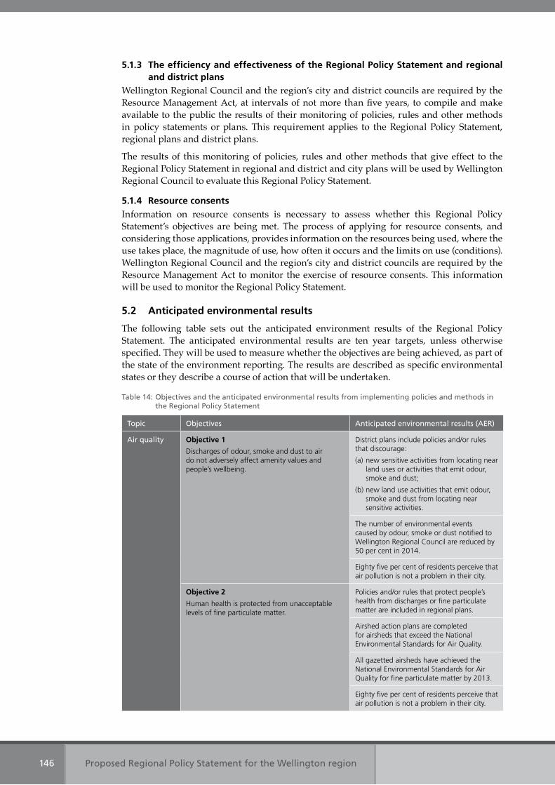
Proposed Regional Policy Statement for the Wellington region146
5.1.3 The efficiency and effectiveness of the Regional Policy Statement and regional and district plans
Wellington Regional Council and the region’s city and district councils are required by the Resource Management Act, at intervals of not more than five years, to compile and make available to the public the results of their monitoring of policies, rules and other methods in policy statements or plans. This requirement applies to the Regional Policy Statement, regional plans and district plans.
The results of this monitoring of policies, rules and other methods that give effect to the Regional Policy Statement in regional and district and city plans will be used by Wellington Regional Council to evaluate this Regional Policy Statement.
5.1.4 Resource consentsInformation on resource consents is necessary to assess whether this Regional Policy Statement’s objectives are being met. The process of applying for resource consents, and considering those applications, provides information on the resources being used, where the use takes place, the magnitude of use, how often it occurs and the limits on use (conditions). Wellington Regional Council and the region’s city and district councils are required by the Resource Management Act to monitor the exercise of resource consents. This information will be used to monitor the Regional Policy Statement.
5.2 Anticipated environmental results
The following table sets out the anticipated environment results of the Regional Policy Statement. The anticipated environmental results are ten year targets, unless otherwise specified. They will be used to measure whether the objectives are being achieved, as part of the state of the environment reporting. The results are described as specific environmental states or they describe a course of action that will be undertaken.
Table 14: Objectives and the anticipated environmental results from implementing policies and methods in the Regional Policy Statement
Topic Objectives Anticipated environmental results (AER)
Air quality Objective 1
Discharges of odour, smoke and dust to air do not adversely affect amenity values and people’s wellbeing.
District plans include policies and/or rules that discourage:
(a) new sensitive activities from locating near land uses or activities that emit odour, smoke and dust;
(b) new land use activities that emit odour, smoke and dust from locating near sensitive activities.
The number of environmental events caused by odour, smoke or dust notified to Wellington Regional Council are reduced by 50 per cent in 2014.
Eighty five per cent of residents perceive that air pollution is not a problem in their city.
Objective 2
Human health is protected from unacceptable levels of fine particulate matter.
Policies and/or rules that protect people’s health from discharges or fine particulate matter are included in regional plans.
Airshed action plans are completed for airsheds that exceed the National Environmental Standards for Air Quality.
All gazetted airsheds have achieved the National Environmental Standards for Air Quality for fine particulate matter by 2013.
Eighty five per cent of residents perceive that air pollution is not a problem in their city.
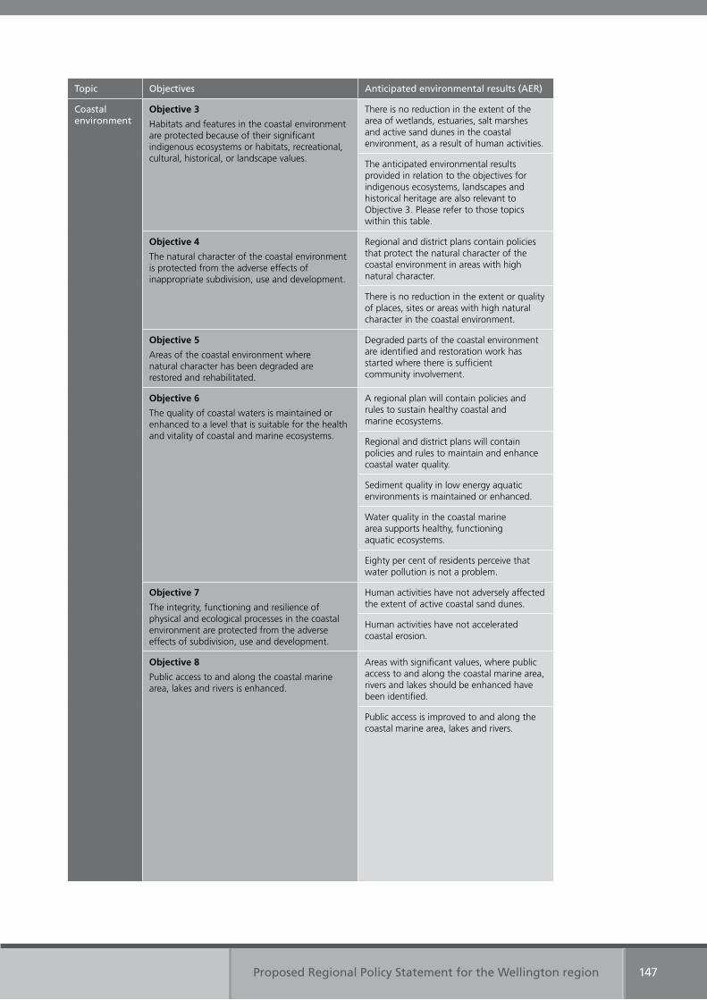
Proposed Regional Policy Statement for the Wellington region 147
Topic Objectives Anticipated environmental results (AER)
Coastal environment
Objective 3
Habitats and features in the coastal environment are protected because of their significant indigenous ecosystems or habitats, recreational, cultural, historical, or landscape values.
There is no reduction in the extent of the area of wetlands, estuaries, salt marshes and active sand dunes in the coastal environment, as a result of human activities.
The anticipated environmental results provided in relation to the objectives for indigenous ecosystems, landscapes and historical heritage are also relevant to Objective 3. Please refer to those topics within this table.
Objective 4
The natural character of the coastal environment is protected from the adverse effects of inappropriate subdivision, use and development.
Regional and district plans contain policies that protect the natural character of the coastal environment in areas with high natural character.
There is no reduction in the extent or quality of places, sites or areas with high natural character in the coastal environment.
Objective 5
Areas of the coastal environment where natural character has been degraded are restored and rehabilitated.
Degraded parts of the coastal environment are identified and restoration work has started where there is sufficient community involvement.
Objective 6
The quality of coastal waters is maintained or enhanced to a level that is suitable for the health and vitality of coastal and marine ecosystems.
A regional plan will contain policies and rules to sustain healthy coastal and marine ecosystems.
Regional and district plans will contain policies and rules to maintain and enhance coastal water quality.
Sediment quality in low energy aquatic environments is maintained or enhanced.
Water quality in the coastal marine area supports healthy, functioning aquatic ecosystems.
Eighty per cent of residents perceive that water pollution is not a problem.
Objective 7
The integrity, functioning and resilience of physical and ecological processes in the coastal environment are protected from the adverse effects of subdivision, use and development.
Human activities have not adversely affected the extent of active coastal sand dunes.
Human activities have not accelerated coastal erosion.
Objective 8
Public access to and along the coastal marine area, lakes and rivers is enhanced.
Areas with significant values, where public access to and along the coastal marine area, rivers and lakes should be enhanced have been identified.
Public access is improved to and along the coastal marine area, lakes and rivers.
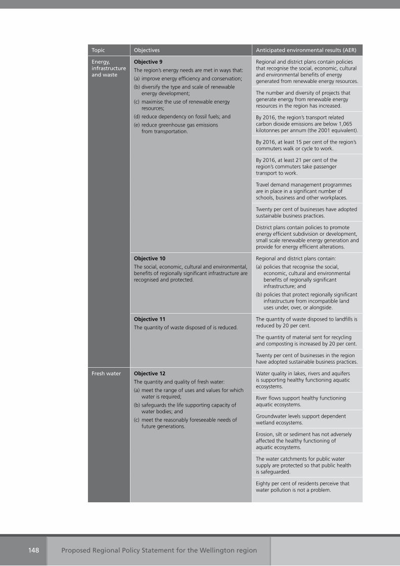
Proposed Regional Policy Statement for the Wellington region148
Topic Objectives Anticipated environmental results (AER)
Energy, infrastructure and waste
Objective 9
The region’s energy needs are met in ways that:
(a) improve energy efficiency and conservation;
(b) diversify the type and scale of renewable energy development;
(c) maximise the use of renewable energy resources;
(d) reduce dependency on fossil fuels; and
(e) reduce greenhouse gas emissions from transportation.
Regional and district plans contain policies that recognise the social, economic, cultural and environmental benefits of energy generated from renewable energy resources.
The number and diversity of projects that generate energy from renewable energy resources in the region has increased.
By 2016, the region’s transport related carbon dioxide emissions are below 1,065 kilotonnes per annum (the 2001 equivalent).
By 2016, at least 15 per cent of the region’s commuters walk or cycle to work.
By 2016, at least 21 per cent of the region’s commuters take passenger transport to work.
Travel demand management programmes are in place in a significant number of schools, business and other workplaces.
Twenty per cent of businesses have adopted sustainable business practices.
District plans contain policies to promote energy efficient subdivision or development, small scale renewable energy generation and provide for energy efficient alterations.
Objective 10
The social, economic, cultural and environmental, benefits of regionally significant infrastructure are recognised and protected.
Regional and district plans contain:
(a) policies that recognise the social, economic, cultural and environmental benefits of regionally significant infrastructure; and
(b) policies that protect regionally significant infrastructure from incompatible land uses under, over, or alongside.
Objective 11
The quantity of waste disposed of is reduced.
The quantity of waste disposed to landfills is reduced by 20 per cent.
The quantity of material sent for recycling and composting is increased by 20 per cent.
Twenty per cent of businesses in the region have adopted sustainable business practices.
Fresh water Objective 12
The quantity and quality of fresh water:
(a) meet the range of uses and values for which water is required;
(b) safeguards the life supporting capacity of water bodies; and
(c) meet the reasonably foreseeable needs of future generations.
Water quality in lakes, rivers and aquifers is supporting healthy functioning aquatic ecosystems.
River flows support healthy functioning aquatic ecosystems.
Groundwater levels support dependent wetland ecosystems.
Erosion, silt or sediment has not adversely affected the healthy functioning of aquatic ecosystems.
The water catchments for public water supply are protected so that public health is safeguarded.
Eighty per cent of residents perceive that water pollution is not a problem.
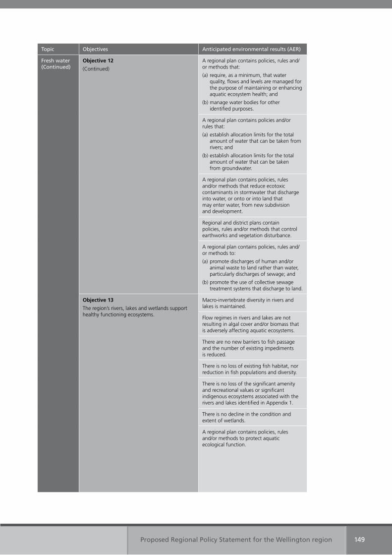
Proposed Regional Policy Statement for the Wellington region 149
Topic Objectives Anticipated environmental results (AER)
Fresh water(Continued)
Objective 12
(Continued)
A regional plan contains policies, rules and/or methods that:
(a) require, as a minimum, that water quality, flows and levels are managed for the purpose of maintaining or enhancing aquatic ecosystem health; and
(b) manage water bodies for other identified purposes.
A regional plan contains policies and/or rules that:
(a) establish allocation limits for the total amount of water that can be taken from rivers; and
(b) establish allocation limits for the total amount of water that can be taken from groundwater.
A regional plan contains policies, rules and/or methods that reduce ecotoxic contaminants in stormwater that discharge into water, or onto or into land that may enter water, from new subdivision and development.
Regional and district plans contain policies, rules and/or methods that control earthworks and vegetation disturbance.
A regional plan contains policies, rules and/or methods to:
(a) promote discharges of human and/or animal waste to land rather than water, particularly discharges of sewage; and
(b) promote the use of collective sewage treatment systems that discharge to land.
Objective 13
The region’s rivers, lakes and wetlands support healthy functioning ecosystems.
Macro-invertebrate diversity in rivers and lakes is maintained.
Flow regimes in rivers and lakes are not resulting in algal cover and/or biomass that is adversely affecting aquatic ecosystems.
There are no new barriers to fish passage and the number of existing impediments is reduced.
There is no loss of existing fish habitat, nor reduction in fish populations and diversity.
There is no loss of the significant amenity and recreational values or significant indigenous ecosystems associated with the rivers and lakes identified in Appendix 1.
There is no decline in the condition and extent of wetlands.
A regional plan contains policies, rules and/or methods to protect aquatic ecological function.
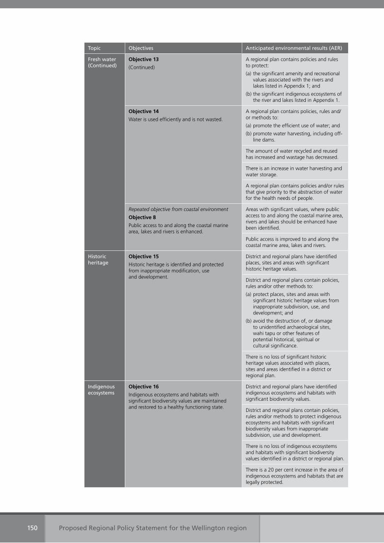
Proposed Regional Policy Statement for the Wellington region150
Topic Objectives Anticipated environmental results (AER)
Fresh water(Continued)
Objective 13
(Continued)
A regional plan contains policies and rules to protect:
(a) the significant amenity and recreational values associated with the rivers and lakes listed in Appendix 1; and
(b) the significant indigenous ecosystems of the river and lakes listed in Appendix 1.
Objective 14
Water is used efficiently and is not wasted.
A regional plan contains policies, rules and/or methods to:
(a) promote the efficient use of water; and
(b) promote water harvesting, including off-line dams.
The amount of water recycled and reused has increased and wastage has decreased.
There is an increase in water harvesting and water storage.
A regional plan contains policies and/or rules that give priority to the abstraction of water for the health needs of people.
Repeated objective from coastal environment
Objective 8
Public access to and along the coastal marine area, lakes and rivers is enhanced.
Areas with significant values, where public access to and along the coastal marine area, rivers and lakes should be enhanced have been identified.
Public access is improved to and along the coastal marine area, lakes and rivers.
Historic heritage
Objective 15
Historic heritage is identified and protected from inappropriate modification, use and development.
District and regional plans have identified places, sites and areas with significant historic heritage values.
District and regional plans contain policies, rules and/or other methods to:
(a) protect places, sites and areas with significant historic heritage values from inappropriate subdivision, use, and development; and
(b) avoid the destruction of, or damage to unidentified archaeological sites, wahi tapu or other features of potential historical, spiritual or cultural significance.
There is no loss of significant historic heritage values associated with places, sites and areas identified in a district or regional plan.
Indigenous ecosystems
Objective 16
Indigenous ecosystems and habitats with significant biodiversity values are maintained and restored to a healthy functioning state.
District and regional plans have identified indigenous ecosystems and habitats with significant biodiversity values.
District and regional plans contain policies, rules and/or methods to protect indigenous ecosystems and habitats with significant biodiversity values from inappropriate subdivision, use and development.
There is no loss of indigenous ecosystems and habitats with significant biodiversity values identified in a district or regional plan.
There is a 20 per cent increase in the area of indigenous ecosystems and habitats that are legally protected.
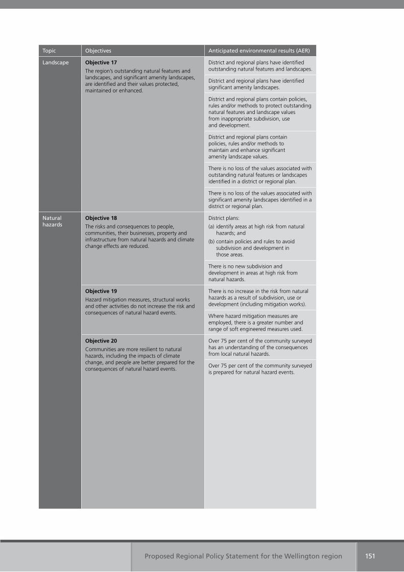
Proposed Regional Policy Statement for the Wellington region 151
Topic Objectives Anticipated environmental results (AER)
Landscape Objective 17
The region’s outstanding natural features and landscapes, and significant amenity landscapes, are identified and their values protected, maintained or enhanced.
District and regional plans have identified outstanding natural features and landscapes.
District and regional plans have identified significant amenity landscapes.
District and regional plans contain policies, rules and/or methods to protect outstanding natural features and landscape values from inappropriate subdivision, use and development.
District and regional plans contain policies, rules and/or methods to maintain and enhance significant amenity landscape values.
There is no loss of the values associated with outstanding natural features or landscapes identified in a district or regional plan.
There is no loss of the values associated with significant amenity landscapes identified in a district or regional plan.
Natural hazards
Objective 18
The risks and consequences to people, communities, their businesses, property and infrastructure from natural hazards and climate change effects are reduced.
District plans:
(a) identify areas at high risk from natural hazards; and
(b) contain policies and rules to avoid subdivision and development in those areas.
There is no new subdivision and development in areas at high risk from natural hazards.
Objective 19
Hazard mitigation measures, structural works and other activities do not increase the risk and consequences of natural hazard events.
There is no increase in the risk from natural hazards as a result of subdivision, use or development (including mitigation works).
Where hazard mitigation measures are employed, there is a greater number and range of soft engineered measures used.
Objective 20
Communities are more resilient to natural hazards, including the impacts of climate change, and people are better prepared for the consequences of natural hazard events.
Over 75 per cent of the community surveyed has an understanding of the consequences from local natural hazards.
Over 75 per cent of the community surveyed is prepared for natural hazard events.
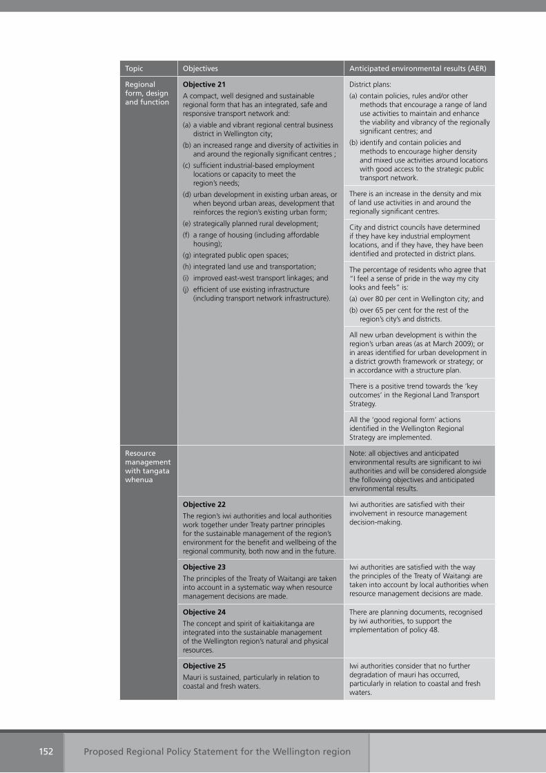
Proposed Regional Policy Statement for the Wellington region152
Topic Objectives Anticipated environmental results (AER)
Regional form, design and function
Objective 21
A compact, well designed and sustainable regional form that has an integrated, safe and responsive transport network and:
(a) a viable and vibrant regional central business district in Wellington city;
(b) an increased range and diversity of activities in and around the regionally significant centres ;
(c) sufficient industrial-based employment locations or capacity to meet the region’s needs;
(d) urban development in existing urban areas, or when beyond urban areas, development that reinforces the region’s existing urban form;
(e) strategically planned rural development;
(f) a range of housing (including affordable housing);
(g) integrated public open spaces;
(h) integrated land use and transportation;
(i) improved east-west transport linkages; and
(j) efficient of use existing infrastructure (including transport network infrastructure).
District plans:
(a) contain policies, rules and/or other methods that encourage a range of land use activities to maintain and enhance the viability and vibrancy of the regionally significant centres; and
(b) identify and contain policies and methods to encourage higher density and mixed use activities around locations with good access to the strategic public transport network.
There is an increase in the density and mix of land use activities in and around the regionally significant centres.
City and district councils have determined if they have key industrial employment locations, and if they have, they have been identified and protected in district plans.
The percentage of residents who agree that “I feel a sense of pride in the way my city looks and feels” is:
(a) over 80 per cent in Wellington city; and
(b) over 65 per cent for the rest of the region’s city’s and districts.
All new urban development is within the region’s urban areas (as at March 2009); or in areas identified for urban development in a district growth framework or strategy; or in accordance with a structure plan.
There is a positive trend towards the ‘key outcomes’ in the Regional Land Transport Strategy.
All the ‘good regional form’ actions identified in the Wellington Regional Strategy are implemented.
Resource management with tangata whenua
Note: all objectives and anticipated environmental results are significant to iwi authorities and will be considered alongside the following objectives and anticipated environmental results.
Objective 22
The region’s iwi authorities and local authorities work together under Treaty partner principles for the sustainable management of the region’s environment for the benefit and wellbeing of the regional community, both now and in the future.
Iwi authorities are satisfied with their involvement in resource management decision-making.
Objective 23
The principles of the Treaty of Waitangi are taken into account in a systematic way when resource management decisions are made.
Iwi authorities are satisfied with the way the principles of the Treaty of Waitangi are taken into account by local authorities when resource management decisions are made.
Objective 24
The concept and spirit of kaitiakitanga are integrated into the sustainable management of the Wellington region’s natural and physical resources.
There are planning documents, recognised by iwi authorities, to support the implementation of policy 48.
Objective 25
Mauri is sustained, particularly in relation to coastal and fresh waters.
Iwi authorities consider that no further degradation of mauri has occurred, particularly in relation to coastal and fresh waters.
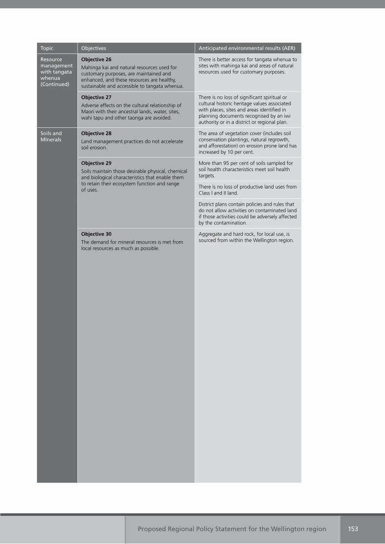
Proposed Regional Policy Statement for the Wellington region 153
Topic Objectives Anticipated environmental results (AER)
Resource management with tangata whenua(Continued)
Objective 26
Mahinga kai and natural resources used for customary purposes, are maintained and enhanced, and these resources are healthy, sustainable and accessible to tangata whenua.
There is better access for tangata whenua to sites with mahinga kai and areas of natural resources used for customary purposes.
Objective 27
Adverse effects on the cultural relationship of Maori with their ancestral lands, water, sites, wahi tapu and other taonga are avoided.
There is no loss of significant spiritual or cultural historic heritage values associated with places, sites and areas identified in planning documents recognised by an iwi authority or in a district or regional plan.
Soils and Minerals
Objective 28
Land management practices do not accelerate soil erosion.
The area of vegetation cover (includes soil conservation plantings, natural regrowth, and afforestation) on erosion prone land has increased by 10 per cent.
Objective 29
Soils maintain those desirable physical, chemical and biological characteristics that enable them to retain their ecosystem function and range of uses.
More than 95 per cent of soils sampled for soil health characteristics meet soil health targets.
There is no loss of productive land uses from Class I and II land.
District plans contain policies and rules that do not allow activities on contaminated land if those activities could be adversely affected by the contamination.
Objective 30
The demand for mineral resources is met from local resources as much as possible.
Aggregate and hard rock, for local use, is sourced from within the Wellington region.

Chapter Six
Principal reasons for objectives, policies and methods
Proposed Regional Policy Statement for the Wellington region 155
6. Principal reasons for objectives, policies and methods
This chapter presents the principal reasons for adopting the objectives, policies and methods of the Regional Policy Statement.
Detailed reasons for each provision are included in reports on the consideration of alternatives, benefits and costs that accompany the Regional Policy Statement. This analysis is required by section 32 of the Resource Management Act. It requires an evaluation of the extent to which each objective in the Regional Policy Statement is the most appropriate way to achieve the purpose of the Resource Management Act and whether, having regard to their efficiency and effectiveness, the policies and methods are the most appropriate for achieving the objectives.
6.1 Objectives
All objectives in the Regional Policy Statement have been adopted to address the regionally significant resource management issues (including the resource management issues of significance to iwi authorities). These issues were identified from an analysis of the state of the environment, feedback received from city and district councils, the community, and by working with iwi authorities in the region. Achievement of the objectives will promote the sustainable management of natural and physical resources.
6.2 Policies
Policies in the Regional Policy Statement set the courses of action that are to be followed to achieve the objectives. There are two types of policies:
• policies that are referred to as ‘regulatory’. These policies will be delivered through regional plans, district and city plans, the Wellington Regional Land Transport Strategy, resource consents and notices of requirements.
• policies that are referred to as ‘non-regulatory’. These policies will be implemented through actions that do not involve regulation or statutory processes under the Resource Management Act.
Both regulatory and non-regulatory policies are needed in the Regional Policy Statement to achieve the objectives.
6.2.1 Regulatory Policies 1–7, 9–31, and 33 direct the matters that shall or should be included in the policies, rules and/or other methods of regional or district plans. The plans must give effect to these policies. The policies are necessary to achieve the objectives while allowing Wellington Regional Council and each city and district to work out with their communities the most appropriate way of giving effect to the Regional Policy Statement.
Policies 9, 10 and 32 direct the Wellington Regional Land Transport Strategy, which cannot be inconsistent with the Regional Policy Statement. The policies are necessary to provide appropriate direction on the role of land transport in promoting sustainable management.
Policies 34–60 provide direction on the assessment and consideration of resource consent applications, notices of requirement, or changes, variations or replacements to city, district or regional plans. Particular regard must be given to these policies when resource management decisions are made by Wellington Regional Council and the region’s district and city councils.
Proposed Regional Policy Statement for the Wellington region156
Policies 61–63 allocate responsibility for the control of the use of land in relation to indigenous biological diversity, natural hazards, and the storage, use disposal or transportation of hazardous substances. These policies are necessary to satisfy the requirements of section 62(1)(i) of the Resource Management Act.
6.2.2 Non-regulatory Policies 64–69 are non-regulatory policies that direct specific actions to help achieve the objectives, such as the provision of information and works and services. They are needed where regulatory policies alone cannot achieve the objectives.
6.3 Methods
Methods in the Regional Policy Statement state the actions needed to implement the policies. As with the policies, there are two types of methods – regulatory and non-regulatory.
6.3.1 Regulatory Method 1 implements the policies that direct what shall or should be included in district plans. Method 2 implements the policies that direct what shall be included in regional plans. These methods are necessary to clarify when regional and district plans must give effect to the Regional Policy Statement.
Method 3 implements the policies that relate to the Wellington Regional Land Transport Strategy. The method is necessary to clarify when the Wellington Regional Land Transport Strategy must implement the policies.
Method 4 implements policies that direct the matters to be considered when making decisions on resource consent applications, notices of requirement, plan changes, variations or replacements to district or regional plans.
Method 5 implements policies that allocate local authority responsibility for the control of the use of land in relation to indigenous biological diversity, natural hazards, and the use, storage, disposal or transportation of hazardous substances. The method is necessary to satisfy section 62(1)(i) of the Resource Management Act.
6.3.2 Non-regulatory Methods 6–25 set out specific information including guidance that will be prepared. These methods are needed to provide people and communities with information that will enable them to understand, contribute and actively participate in the sustainable management of the region’s natural and physical resources or to enable Wellington Regional Council and the region’s city and district councils to implement relevant policies in the Regional Policy Statement.
Methods 26–46 set out actions that will be taken by Wellington Regional Council and other organisations to manage resources in an integrated way. These methods are needed to ensure that where resources are managed by more than one agency, it is done collaboratively.
Methods 47–51 set out where investigation of natural and physical resources is necessary to implement the policies. The methods address gaps in information that need to be addressed, as a priority, to promote the sustainable management of natural and physical resources.
Methods 52–55 set out where support and assistance is necessary to implement the policies.

Appendices
Appendix One
Rivers and lakes with values requiring protection
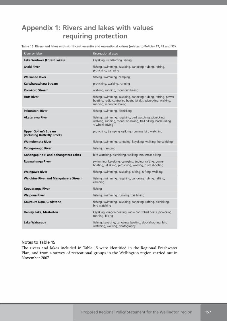
Proposed Regional Policy Statement for the Wellington region 157
Appendix 1: Rivers and lakes with values requiring protection
Table 15: Rivers and lakes with significant amenity and recreational values (relates to Policies 17, 42 and 52).
River or lake Recreational uses
Lake Waitawa (Forest Lakes) kayaking, windsurfing, sailing
Otaki River fishing, swimming, kayaking, canoeing, tubing, rafting, picnicking, camping
Waikanae River fishing, swimming, camping
Kaiwharawhara Stream picnicking, walking, running
Korokoro Stream walking, running, mountain biking
Hutt River fishing, swimming, kayaking, canoeing, tubing, rafting, power boating, radio controlled boats, jet skis, picnicking, walking, running, mountain biking
Pakuratahi River fishing, swimming, picnicking
Akatarawa River fishing, swimming, kayaking, bird watching, picnicking, walking, running, mountain biking, trail biking, horse riding, 4-wheel driving
Upper Gollan’s Stream (including Butterfly Creek)
picnicking, tramping walking, running, bird watching
Wainuiomata River fishing, swimming, canoeing, kayaking, walking, horse riding
Orongorongo River fishing, tramping
Kohangapiripiri and Kohangatera Lakes bird watching, picnicking, walking, mountain biking
Ruamahanga River swimming, kayaking, canoeing, tubing, rafting, power boating, jet skiing, picnicking, walking, duck shooting
Waingawa River fishing, swimming, kayaking, tubing, rafting, walking
Waiohine River and Mangatarere Stream fishing, swimming, kayaking, canoeing, tubing, rafting, camping
Kopuaranga River fishing
Waipoua River fishing, swimming, running, trail biking
Kouraura Dam, Gladstone fishing, swimming, kayaking, canoeing, rafting, picnicking, bird watching
Henley Lake, Masterton kayaking, dragon boating, radio controlled boats, picnicking, running, biking
Lake Wairarapa fishing, kayaking, canoeing, boating, duck shooting, bird watching, walking, photography
Notes to Table 15The rivers and lakes included in Table 15 were identified in the Regional Freshwater Plan, and from a survey of recreational groups in the Wellington region carried out in November 2007.
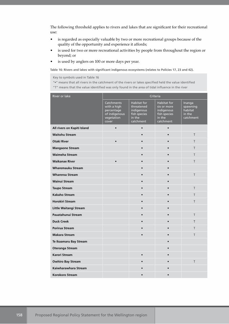
Proposed Regional Policy Statement for the Wellington region158
The following threshold applies to rivers and lakes that are significant for their recreational use:
• is regarded as especially valuable by two or more recreational groups because of the quality of the opportunity and experience it affords;
• is used for two or more recreational activities by people from throughout the region or beyond; or
• is used by anglers on 100 or more days per year.
Table 16: Rivers and lakes with significant indigenous ecosystems (relates to Policies 17, 23 and 42).
Key to symbols used in Table 16
“•” means that all rivers in the catchment of the rivers or lakes specified held the value identified
“T” means that the value identified was only found in the area of tidal influence in the river
River or lake Criteria
Catchments with a high percentage of indigenous vegetation cover
Habitat for threatened indigenous fish species in the catchment
Habitat for six or more indigenous fish species in the catchment
Inanga spawning habitat in the catchment
All rivers on Kapiti Island • • •
Waitohu Stream • • T
Otaki River • • • T
Mangaone Stream • • T
Waimeha Stream • • T
Waikanae River • • • T
Wharemauku Stream • •
Whareroa Stream • • T
Wainui Stream • •
Taupo Stream • • T
Kakaho Stream • • T
Horokiri Stream • • T
Little Waitangi Stream • •
Pauatahunui Stream • • T
Duck Creek • • T
Porirua Stream • • T
Makara Stream • • T
Te Ikaamaru Bay Stream •
Oteranga Stream •
Karori Stream • •
Owhiro Bay Stream • • T
Kaiwharawhara Stream • •
Korokoro Stream • •
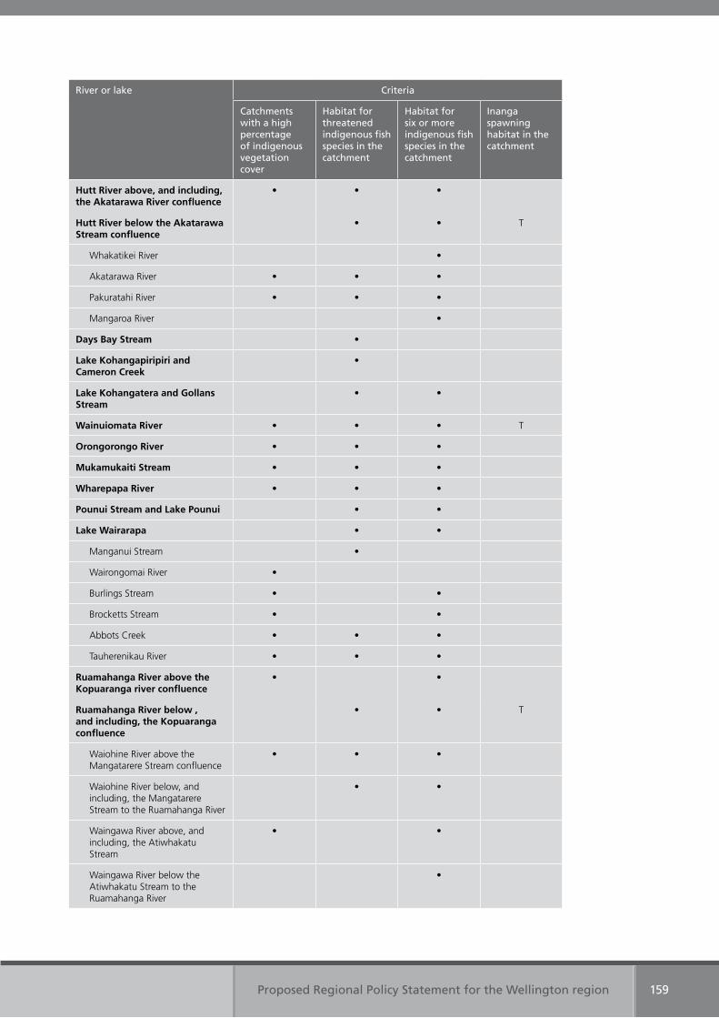
Proposed Regional Policy Statement for the Wellington region 159
River or lake Criteria
Catchments with a high percentage of indigenous vegetation cover
Habitat for threatened indigenous fish species in the catchment
Habitat for six or more indigenous fish species in the catchment
Inanga spawning habitat in the catchment
Hutt River above, and including, the Akatarawa River confluence
• • •
Hutt River below the Akatarawa Stream confluence
• • T
Whakatikei River •
Akatarawa River • • •
Pakuratahi River • • •
Mangaroa River •
Days Bay Stream •
Lake Kohangapiripiri and Cameron Creek
•
Lake Kohangatera and Gollans Stream
• •
Wainuiomata River • • • T
Orongorongo River • • •
Mukamukaiti Stream • • •
Wharepapa River • • •
Pounui Stream and Lake Pounui • •
Lake Wairarapa • •
Manganui Stream •
Wairongomai River •
Burlings Stream • •
Brocketts Stream • •
Abbots Creek • • •
Tauherenikau River • • •
Ruamahanga River above the Kopuaranga river confluence
• •
Ruamahanga River below , and including, the Kopuaranga confluence
• • T
Waiohine River above the Mangatarere Stream confluence
• • •
Waiohine River below, and including, the Mangatarere Stream to the Ruamahanga River
• •
Waingawa River above, and including, the Atiwhakatu Stream
• •
Waingawa River below the Atiwhakatu Stream to the Ruamahanga River
•
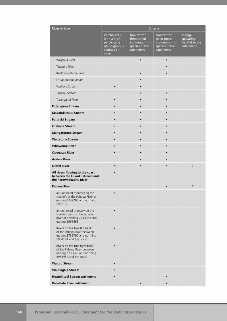
Proposed Regional Policy Statement for the Wellington region160
River or lake Criteria
Catchments with a high percentage of indigenous vegetation cover
Habitat for threatened indigenous fish species in the catchment
Habitat for six or more indigenous fish species in the catchment
Inanga spawning habitat in the catchment
Waipoua River • •
Tauweru River •
Ruakokopatuna River • •
Oruapouanui Stream •
Waihora Stream • •
Tauanui Stream • •
Turanganui River • • •
Putangirua Stream • • •
Makatukutuku Stream • • •
Pararaki Stream • • •
Otakaha Stream • • •
Mangatoetoe Stream • • •
Waitetuna Stream • • •
Whawanui River • • •
Opouawe River • • •
Awhea River • •
Oterei River • • • T
All rivers flowing to the coast between the Huariki Stream and the Rerewhakaaitu River
•
Pahaoa River • T
an unnamed tributary on the true left of the Pahaoa River at easting 2742200 and northing 5992169
•
an unnamed tributary on the true left bank of the Pahaoa River at northing 2739983 and easting 5991469
•
Rivers on the true left bank of the Pahaoa River between easting 2732790 and northing 5984194 and the coast.
•
Rivers on the true right bank of the Pahaoa River between easting 2733640 and northing 5981454 and the coast.
•
Waiuru Stream •
Waihingaia Stream •
Huatokitoki Stream catchment • •
Kaiwhata River catchment • •
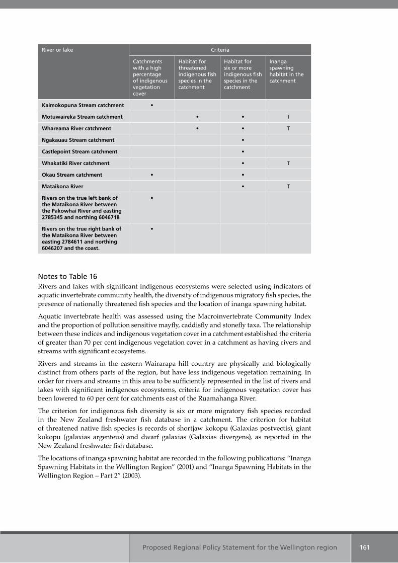
Proposed Regional Policy Statement for the Wellington region 161
River or lake Criteria
Catchments with a high percentage of indigenous vegetation cover
Habitat for threatened indigenous fish species in the catchment
Habitat for six or more indigenous fish species in the catchment
Inanga spawning habitat in the catchment
Kaimokopuna Stream catchment •
Motuwaireka Stream catchment • • T
Whareama River catchment • • T
Ngakauau Stream catchment •
Castlepoint Stream catchment •
Whakatiki River catchment • T
Okau Stream catchment • •
Mataikona River • T
Rivers on the true left bank of the Mataikona River between the Pakowhai River and easting 2785345 and northing 6046718
•
Rivers on the true right bank of the Mataikona River between easting 2784611 and northing 6046207 and the coast.
•
Notes to Table 16Rivers and lakes with significant indigenous ecosystems were selected using indicators of aquatic invertebrate community health, the diversity of indigenous migratory fish species, the presence of nationally threatened fish species and the location of inanga spawning habitat.
Aquatic invertebrate health was assessed using the Macroinvertebrate Community Index and the proportion of pollution sensitive mayfly, caddisfly and stonefly taxa. The relationship between these indices and indigenous vegetation cover in a catchment established the criteria of greater than 70 per cent indigenous vegetation cover in a catchment as having rivers and streams with significant ecosystems.
Rivers and streams in the eastern Wairarapa hill country are physically and biologically distinct from others parts of the region, but have less indigenous vegetation remaining. In order for rivers and streams in this area to be sufficiently represented in the list of rivers and lakes with significant indigenous ecosystems, criteria for indigenous vegetation cover has been lowered to 60 per cent for catchments east of the Ruamahanga River.
The criterion for indigenous fish diversity is six or more migratory fish species recorded in the New Zealand freshwater fish database in a catchment. The criterion for habitat of threatened native fish species is records of shortjaw kokopu (Galaxias postvectis), giant kokopu (galaxias argenteus) and dwarf galaxias (Galaxias divergens), as reported in the New Zealand freshwater fish database.
The locations of inanga spawning habitat are recorded in the following publications: “Inanga Spawning Habitats in the Wellington Region” (2001) and “Inanga Spawning Habitats in the Wellington Region – Part 2” (2003).

Appendix Two
Regional urban design principles

Proposed Regional Policy Statement for the Wellington region 163
Appendix 2: Regional urban design principles
The region’s urban design principles are adapted from the New Zealand Urban Design Protocol and are as follows:
1. Context
Quality urban design sees buildings, places and spaces not as isolated elements but as part of the whole town or city.
In this regard quality urban design:
(a) takes a long-term view(b) recognises and builds on landscape context and character(c) results in buildings and places that are adapted to local climatic conditions(d) provides for public transport, roading, cycling and walking networks that are
integrated with each other and the land uses they serve(e) examines each project in relation to its setting and ensures that each development fits
in with and enhances its surroundings(f) understands the social, cultural and economic context as well as physical elements and
relationships(g) considers the impact on the health of the population who live and work there(h) celebrates cultural identity and recognises the heritage values of a place(i) ensures incremental development contributes to an agreed and coherent overall result.
2. Character
Quality urban design reflects and enhances the distinctive character and culture of our urban environment, and recognises that character is dynamic and evolving, not static.
In this regard quality urban design:
(a) reflects the unique identity of each town, city and neighbourhood and strengthens the positive characteristics that make each place distinctive
(b) protects and manages our heritage, including buildings, places and landscapes(c) protects public open space, and improves the quality, quantity and distribution of local
open space over the long term(d) protects and enhances distinctive landforms, water bodies and indigenous plants and
animals(e) provides a positive contribution to the environmental health of urban streams, the
harbours, beaches and their catchments(f) creates locally appropriate, and where relevant, inspiring, architecture, spaces and
places(g) reflects and celebrates our unique New Zealand culture and identity and celebrates our
multicultural society.
3. Choice
Quality urban design fosters diversity and offers people choice in the urban form of our towns and cities, and choice in densities, building types, transport options, and activities. Flexible and adaptable design provides for unforeseen uses, and creates resilient and robust towns and cities.
Proposed Regional Policy Statement for the Wellington region164
In this regard quality urban design:
(a) ensures urban environments provide opportunities for all, especially the disadvantaged
(b) allows people to choose different sustainable lifestyle options, locations, modes of transport, types of buildings and forms of tenure
(c) encourages a diversity of activities within mixed use developments and neighbourhoods
(d) supports designs which are flexible and adaptable and which will remain useful over the long term
(e) ensures public spaces are accessible by everybody, including people with disabilities.
4. Connections
Good connections enhance choice, support social cohesion, make places lively and safe, and facilitate contact among people. Quality urban design recognises how all networks -streets, railways, walking and cycling routes, services, infrastructure, and communication networks – connect and support healthy neighbourhoods, towns and cities. Places with good connections between activities and with careful placement of facilities benefit from reduced travel times and lower environmental impacts. Where physical layouts and activity patterns are easily understood, residents and visitors can navigate around the city easily.
In this regard quality urban design:
(a) creates safe, attractive and secure pathways and links between centres and landmarks and neighbourhoods
(b) facilitates green networks that link public and private open space(c) places a high priority on walking, cycling and public transport(d) anticipates travel demands and provides a sustainable choice of integrated transport
modes(e) improves accessibility to public services and facilities(f) treats streets and other thoroughfares as positive spaces with multiple functions(g) provides formal and informal opportunities for social and cultural interaction(h) facilitates access to services and efficient movement of goods and people(i) provides environments that encourage people to become more physically active.
5. Creativity
Quality urban design encourages creative and innovative approaches. Creativity adds richness and diversity, and turns a functional place into a memorable place. Creativity facilitates new ways of thinking, and willingness to think through problems afresh, to experiment and rewrite rules, to harness new technology, and to visualise new futures. Creative urban design supports a dynamic urban cultural life and fosters strong urban identities.
In this regard quality urban design:
(a) emphasises innovative and imaginative solutions(b) combines processes and design responses that enhance the experience we have of
urban environments(c) incorporates art and artists in the design process at an early stage to contribute to
creative approaches(d) values public art that is integrated into a building, space or place(e) builds a strong and distinctive local identity
Proposed Regional Policy Statement for the Wellington region 165
(f) utilises new technology(g) incorporates different cultural perspectives.
6. Custodianship
Quality urban design reduces the environmental impacts of our towns and cities through environmentally sustainable and responsive design solutions. Custodianship recognises the lifetime costs of buildings and infrastructure, and aims to hand on places to the next generation in as good or better condition. Stewardship of our towns includes the concept of kaitiakitanga. It creates enjoyable, safe public spaces, a quality environment that is cared for, and a sense of ownership and responsibility in all residents and visitors.
In this regard quality urban design:
(a) protects landscapes, ecological systems and cultural heritage values(b) manages the use of resources carefully, through environmentally responsive and
sustainable design solutions(c) manages land wisely(d) utilises ‘green’ technology in the design and construction of buildings and
infrastructure(e) incorporates renewable energy sources and passive solar gain(f) creates buildings, spaces, places and transport networks that are safer, with less crime
and fear of crime(g) avoids or mitigates the effects of natural and man-made hazards(h) considers the ongoing care and maintenance of buildings, spaces, places and networks(i) uses design to improve the environmental performance of infrastructure(j) considers the impact of design on people’s health.
7. Collaboration
Towns and cities are designed incrementally as we make decisions on individual projects. Quality urban design requires good communication and coordinated actions from all decision-makers: central government, local government, professionals, transport operators, developers and users. To improve our urban design capability we need integrated training, adequately funded research and shared examples of best practice.
In this regard quality urban design:
(a) supports a common vision that can be achieved over time(b) depends on leadership at many levels(c) uses a collaborative approach to design that acknowledges the contributions of many
different disciplines and perspectives(d) involves communities in meaningful decision-making processes(e) acknowledges and celebrates examples of good practice(f) recognises the importance of training in urban design and research at national,
regional and local levels.
Appendix Three
Definitions
Proposed Regional Policy Statement for the Wellington region 167
Appendix 3: Definitions
1 in 100 year flood: This return period ratio refers to the probability of a hazard event occurring in any given year. A 1 in 100 year probability means that a hazard event has a one per cent chance of occurring in a 12 month period (i.e. a one per cent annual exceedance probability – see below). This means that more than one 100 year event may occur over the course of a century.
Abstraction: Taking water from a water body.
Aeolian: A term that relates to the wind, usually in reference to fine materials transported and deposited by the wind (e.g. wind blown sand, silt or loess). Can also be used to refer to the process of erosion by the wind i.e. aeolian erosion. Aeolian processes commonly occur in dry conditions, in river beds and in coastal environments.
Aggradation: A term used in geology for the accumulation of sediment in rivers and nearby landforms. Aggradation occurs when sediment supply exceeds the ability of a river to transport the sediment.
Aggregate: A broad category of coarse particulate material used in construction, which includes sand, gravel, crushed stone, slag and recycled concrete. Aggregates are a component of composite materials such as concrete and asphalt concrete.
Airshed: Local air management areas, as gazetted by the Minister for the Environment on 1 September 2005, for air quality management purposes.
Amenity values: As defined in the Resource Management Act.
Those natural or physical qualities and characteristics of an area that contribute to people’s appreciation of its pleasantness, aesthetic coherence, and cultural and recreational attributes.
Annual exceedence probability:
A measure of the likelihood, usually expressed as a percentage, of a natural hazard event exceeding a particular magnitude. A one per cent annual exceedence probability event has a one per cent (or 1:100) chance of occurring at a location in any given year.
Bed: As defined in the Resource Management Act.
(a) In relation to any river—
(i) for the purposes of esplanade reserves, esplanade strips, and subdivision, the space of land which the waters of the river cover at its annual fullest flow without overtopping its banks:
(ii) i n all other cases, the space of land which the waters of the river cover at its fullest flow without overtopping its banks; and
(b) In relation to any lake, except a lake controlled by artificial means,—
(i) for the purposes of esplanade reserves, esplanade strips, and subdivision, the space of land which the waters of the lake cover at its annual highest level without exceeding its margin:
(ii) in all other cases, the space of land which the waters of the lake cover at its highest level without exceeding its margin; and
(c) In relation to any lake controlled by artificial means, the space of land which the waters of the lake cover at its maximum permitted operating level; and
(d) In relation to the sea, the submarine areas covered by the internal waters and the territorial sea.
Biological diversity:(or biodiversity)
As defined in the Resource Management Act.
Biological diversity (biodiversity) means the variability among living organisms, and the ecological complexes of which they are a part, including diversity within species, between species, and of ecosystems.
Proposed Regional Policy Statement for the Wellington region168
Coastal environment: Includes the coastal marine area and the adjacent landward environment, to the extent it has the following characteristics or attributes, (in accordance with policies 5 and 37):
a) any area or landform dominated by coastal vegetation or habitat
b) any landform affected by active coastal processes, excluding tsunami
c) any landscapes or features, including coastal escarpments, that contribute to the natural character, visual quality or amenity value of the coast
d) any site, structure, place or area of historic heritage value adjacent to, or connected with, the coastal marine area, which derives its heritage value from a coastal location.
Coastal feature: A distinctive characteristic or part of the coastal environment that has arisen as a result of coastal processes.
Coastal hazards: Coastal processes that have the potential to adversely affect human life, property or infrastructure including erosion, sedimentation, storm surge, inundation, tsunami.
Coastal marine area: As defined in the Resource Management Act.
The foreshore, sea bed and coastal water, and the air space above the water:
(a) of which the seaward boundary is the outer limits of the territorial sea;
(b) of which the landward boundary is the line of mean high water springs, except that where that line crosses a river, the landward boundary at that point shall be whichever is the lesser of:
(i) one kilometre upstream from the mouth of the river; or
(ii) the point upstream that is calculated by multiplying the width of the river mouth by five.
Coastal processes: Dynamic natural, physical and ecological relationships and events, that are characteristically coastal in their occurrence, nature and effects, that act to shape a coastline, its landforms and features – such as, beaches, wave cut platforms – and including processes of: wave formation, breaking and dissipation; swash run-up; nearshore currents; sediment transport, erosion and deposition.
Coastal water: As defined in the Resource Management Act.
Sea water within the outer limits of the territorial sea and includes:
(a) sea water with a substantial freshwater component; and
(b) sea water in estuaries, fiords, inlets, harbours, or embayments.
Contact recreation: Recreational activities that involve contact with water, including swimming and paddling.
Contaminant: As defined in the Resource Management Act,
Includes any substance (including gases, odorous compounds, liquids, solids, and micro-organisms) or energy (excluding noise) or heat, that either by itself or in combination with the same, similar, or other substances, energy, or heat—
(a) when discharged into water, changes or is likely to change the physical, chemical, or biological condition of water; or
(b) when discharged onto or into land or into air, changes or is likely to change the physical, chemical, or biological condition of the land or air onto or into which it is discharged.
Compact, well designed and sustainable regional form:
As described in Objective 21, section 3.9, table 9.
Consequences: The effects on the community of a natural hazard event including injury or loss of life, damage to land, buildings and property, financial costs, and general business and social disruption.
Proposed Regional Policy Statement for the Wellington region 169
Contaminated land: As defined in the Resource Management Act.
Land of one or more of the following kinds:
(a) if there is an applicable national environmental standard on contaminants in soil, the land is more contaminated than the standard allows; or
(b) if there is no applicable national environmental standard on contaminants in soil, the land has a hazardous substance in or on it that
(i) has significant adverse effects on the environment; or
(ii) is reasonably likely to have significant adverse effects on the environment.
Cultural assessment: A report prepared to consider and assess the potential impacts of an activity on the cultural values within an area.
A cultural assessment may include, but is not limited to, Maori history, Treaty claims and settlements, presence of significant sites, social effects and recommendations for avoiding, remedying and mitigating adverse effects.
DDT: Dichloro-Diphenyl-Trichloroethane (DDT) is an organochlorine insecticide. It is a neuro-toxin and suspected carcinogen. It accumulates in the body, is highly persistent in the environment and is extremely toxic to aquatic life.
Density: How compact development is in a given area. For example, the number of people per square kilometre, the variety of land uses or activities (mixed use development) per square kilometre, or square meters of retail space per square kilometre of land area.
District plan: As defined in the Resource Management Act.
An operative plan approved by a territorial authority under Schedule 1; and includes all operative changes to such a plan (whether arising from a review or otherwise)
Ecosystem: Any system of interacting terrestrial or aquatic organisms within their natural and physical environment.
Ecosystem function: The interactions between organisms and the physical environment, such as in nutrient cycling, soil development and water budgeting.
Ecotoxic contaminants: Substances that are capable of causing ill health, injury or death to any living organism – such as heavy metals, polycyclic aromatic hydrocarbons, organochlorine pesticides and antifouling compounds.
Environmental weeds: Plant species outside their natural range that have invasive attributes and can alter ecological processes in indigenous ecosystems and habitats.
Ephemeral stream: A stream that is not permanently flowing, or flows only during and after rain events.
Esplanade reserves: As defined in the Resource Management Act.
A reserve within the meaning of the Reserves Act 1977 which is either a local purpose reserve within the meaning of section 23 of that Act, if vested in the territorial authority under section 239, or, a reserve vested in the Crown or regional council, under section 237D; and which is vested in the territorial authority, regional council, or the Crown for the purpose or purposes set out in section 229 of the Resource Management Act.
Esplanade strips: As defined in the Resource Management Act.
A strip of land created by the registration of an instrument in accordance with section 232 of the Resource Management Act for a purpose or purposes set out in section 229 of the Resource Management Act.
Fault: A fracture in the crust or between two large blocks of rock in which one side of the fracture has moved relative to the other. This movement can be vertical, horizontal or a combination of the two.
Fault rupture: As stresses build along a fault due to movement either side of the fracture plane, a point is reached when the rocks are unable to accommodate the strain. When the shear strength of the rocks is exceeded, a fault will rupture. If this rupturing occurs rapidly, it results in an earthquake.
Fault trace: Sometimes referred to as a fault line, is the visible surface expression of a fault that has ruptured the ground surface. Faults do not usually consist of a single, clean fracture and the term fault zone is used when referring to the area of deformation that is associated with the fault plane.
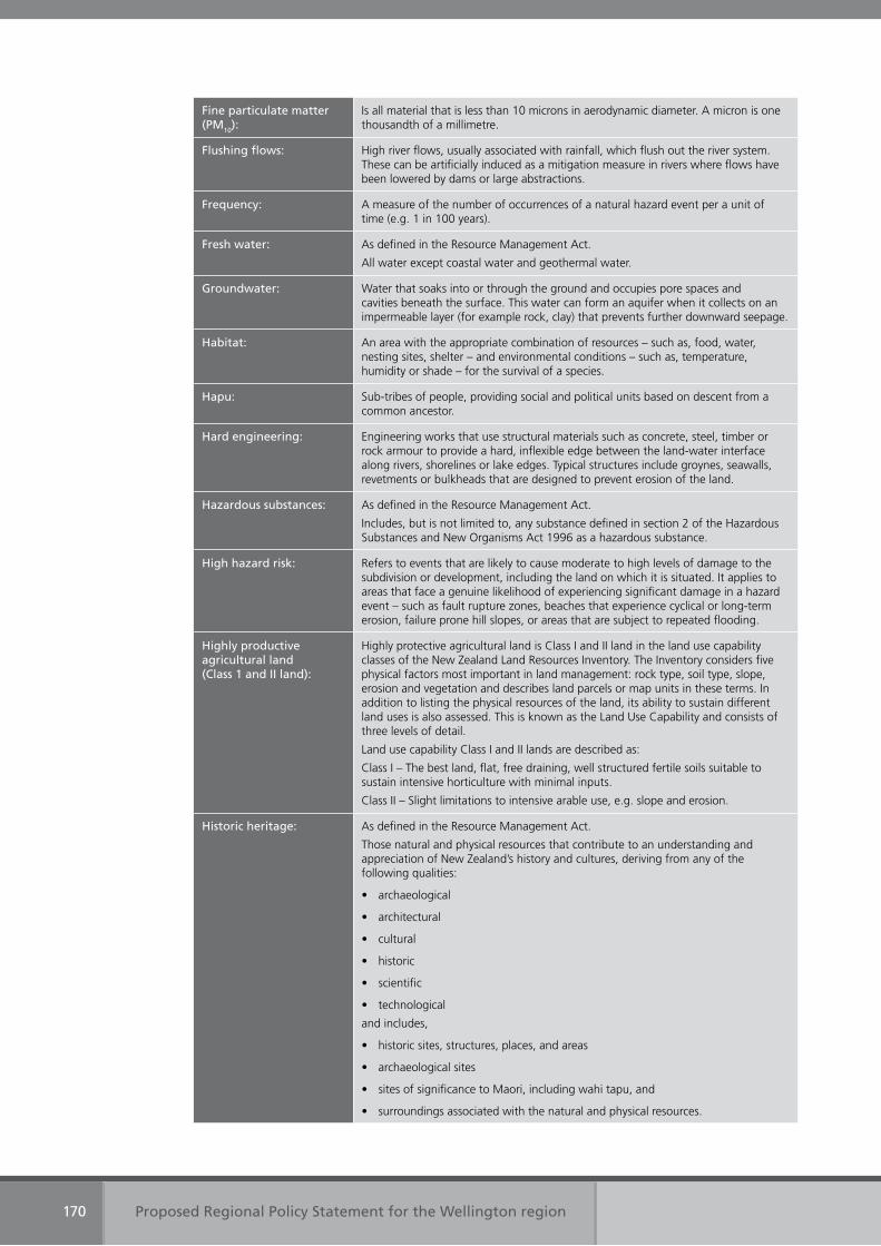
Proposed Regional Policy Statement for the Wellington region170
Fine particulate matter (PM10):
Is all material that is less than 10 microns in aerodynamic diameter. A micron is one thousandth of a millimetre.
Flushing flows: High river flows, usually associated with rainfall, which flush out the river system. These can be artificially induced as a mitigation measure in rivers where flows have been lowered by dams or large abstractions.
Frequency: A measure of the number of occurrences of a natural hazard event per a unit of time (e.g. 1 in 100 years).
Fresh water: As defined in the Resource Management Act.
All water except coastal water and geothermal water.
Groundwater: Water that soaks into or through the ground and occupies pore spaces and cavities beneath the surface. This water can form an aquifer when it collects on an impermeable layer (for example rock, clay) that prevents further downward seepage.
Habitat: An area with the appropriate combination of resources – such as, food, water, nesting sites, shelter – and environmental conditions – such as, temperature, humidity or shade – for the survival of a species.
Hapu: Sub-tribes of people, providing social and political units based on descent from a common ancestor.
Hard engineering: Engineering works that use structural materials such as concrete, steel, timber or rock armour to provide a hard, inflexible edge between the land-water interface along rivers, shorelines or lake edges. Typical structures include groynes, seawalls, revetments or bulkheads that are designed to prevent erosion of the land.
Hazardous substances: As defined in the Resource Management Act.
Includes, but is not limited to, any substance defined in section 2 of the Hazardous Substances and New Organisms Act 1996 as a hazardous substance.
High hazard risk: Refers to events that are likely to cause moderate to high levels of damage to the subdivision or development, including the land on which it is situated. It applies to areas that face a genuine likelihood of experiencing significant damage in a hazard event – such as fault rupture zones, beaches that experience cyclical or long-term erosion, failure prone hill slopes, or areas that are subject to repeated flooding.
Highly productive agricultural land (Class 1 and II land):
Highly protective agricultural land is Class I and II land in the land use capability classes of the New Zealand Land Resources Inventory. The Inventory considers five physical factors most important in land management: rock type, soil type, slope, erosion and vegetation and describes land parcels or map units in these terms. In addition to listing the physical resources of the land, its ability to sustain different land uses is also assessed. This is known as the Land Use Capability and consists of three levels of detail.
Land use capability Class I and II lands are described as:
Class I – The best land, flat, free draining, well structured fertile soils suitable to sustain intensive horticulture with minimal inputs.
Class II – Slight limitations to intensive arable use, e.g. slope and erosion.
Historic heritage: As defined in the Resource Management Act.
Those natural and physical resources that contribute to an understanding and appreciation of New Zealand’s history and cultures, deriving from any of the following qualities:
• archaeological
• architectural
• cultural
• historic
• scientific
• technological
and includes,
• historic sites, structures, places, and areas
• archaeological sites
• sites of significance to Maori, including wahi tapu, and
• surroundings associated with the natural and physical resources.
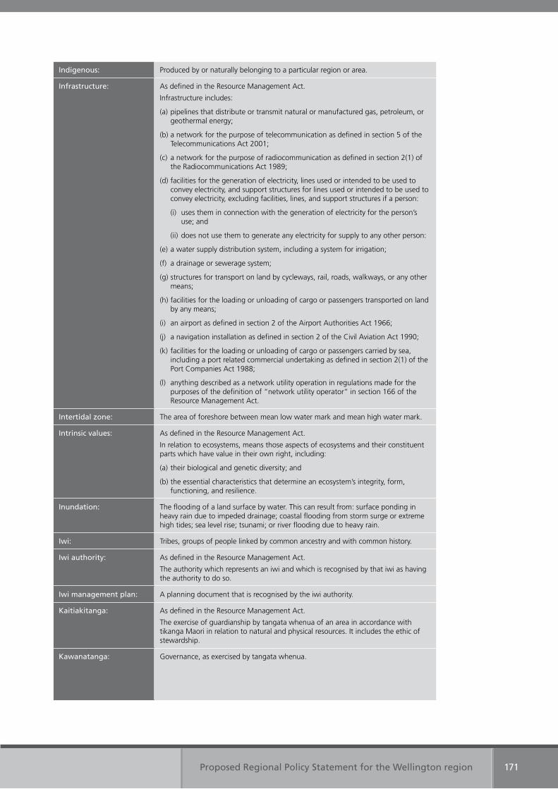
Proposed Regional Policy Statement for the Wellington region 171
Indigenous: Produced by or naturally belonging to a particular region or area.
Infrastructure: As defined in the Resource Management Act.
Infrastructure includes:
(a) pipelines that distribute or transmit natural or manufactured gas, petroleum, or geothermal energy;
(b) a network for the purpose of telecommunication as defined in section 5 of the Telecommunications Act 2001;
(c) a network for the purpose of radiocommunication as defined in section 2(1) of the Radiocommunications Act 1989;
(d) facilities for the generation of electricity, lines used or intended to be used to convey electricity, and support structures for lines used or intended to be used to convey electricity, excluding facilities, lines, and support structures if a person:
(i) uses them in connection with the generation of electricity for the person’s use; and
(ii) does not use them to generate any electricity for supply to any other person:
(e) a water supply distribution system, including a system for irrigation;
(f) a drainage or sewerage system;
(g) structures for transport on land by cycleways, rail, roads, walkways, or any other means;
(h) facilities for the loading or unloading of cargo or passengers transported on land by any means;
(i) an airport as defined in section 2 of the Airport Authorities Act 1966;
(j) a navigation installation as defined in section 2 of the Civil Aviation Act 1990;
(k) facilities for the loading or unloading of cargo or passengers carried by sea, including a port related commercial undertaking as defined in section 2(1) of the Port Companies Act 1988;
(l) anything described as a network utility operation in regulations made for the purposes of the definition of “network utility operator” in section 166 of the Resource Management Act.
Intertidal zone: The area of foreshore between mean low water mark and mean high water mark.
Intrinsic values: As defined in the Resource Management Act.
In relation to ecosystems, means those aspects of ecosystems and their constituent parts which have value in their own right, including:
(a) their biological and genetic diversity; and
(b) the essential characteristics that determine an ecosystem’s integrity, form, functioning, and resilience.
Inundation: The flooding of a land surface by water. This can result from: surface ponding in heavy rain due to impeded drainage; coastal flooding from storm surge or extreme high tides; sea level rise; tsunami; or river flooding due to heavy rain.
Iwi: Tribes, groups of people linked by common ancestry and with common history.
Iwi authority: As defined in the Resource Management Act.
The authority which represents an iwi and which is recognised by that iwi as having the authority to do so.
Iwi management plan: A planning document that is recognised by the iwi authority.
Kaitiakitanga: As defined in the Resource Management Act.
The exercise of guardianship by tangata whenua of an area in accordance with tikanga Maori in relation to natural and physical resources. It includes the ethic of stewardship.
Kawanatanga: Governance, as exercised by tangata whenua.
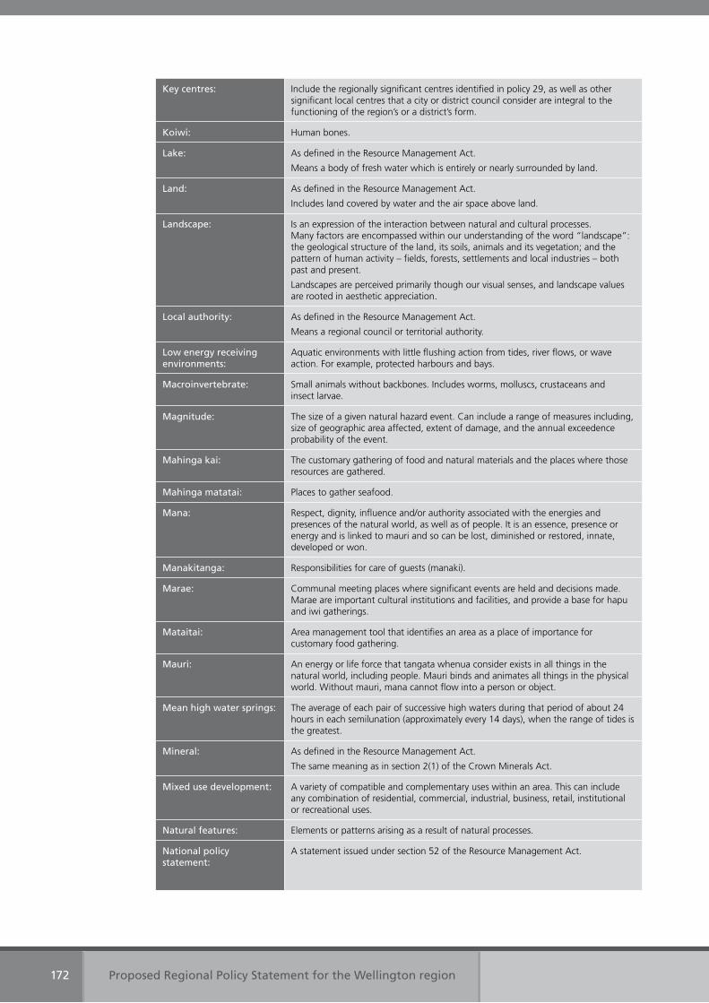
Proposed Regional Policy Statement for the Wellington region172
Key centres: Include the regionally significant centres identified in policy 29, as well as other significant local centres that a city or district council consider are integral to the functioning of the region’s or a district’s form.
Koiwi: Human bones.
Lake: As defined in the Resource Management Act.
Means a body of fresh water which is entirely or nearly surrounded by land.
Land: As defined in the Resource Management Act.
Includes land covered by water and the air space above land.
Landscape: Is an expression of the interaction between natural and cultural processes. Many factors are encompassed within our understanding of the word “landscape”: the geological structure of the land, its soils, animals and its vegetation; and the pattern of human activity – fields, forests, settlements and local industries – both past and present.
Landscapes are perceived primarily though our visual senses, and landscape values are rooted in aesthetic appreciation.
Local authority: As defined in the Resource Management Act.
Means a regional council or territorial authority.
Low energy receiving environments:
Aquatic environments with little flushing action from tides, river flows, or wave action. For example, protected harbours and bays.
Macroinvertebrate: Small animals without backbones. Includes worms, molluscs, crustaceans and insect larvae.
Magnitude: The size of a given natural hazard event. Can include a range of measures including, size of geographic area affected, extent of damage, and the annual exceedence probability of the event.
Mahinga kai: The customary gathering of food and natural materials and the places where those resources are gathered.
Mahinga matatai: Places to gather seafood.
Mana: Respect, dignity, influence and/or authority associated with the energies and presences of the natural world, as well as of people. It is an essence, presence or energy and is linked to mauri and so can be lost, diminished or restored, innate, developed or won.
Manakitanga: Responsibilities for care of guests (manaki).
Marae: Communal meeting places where significant events are held and decisions made. Marae are important cultural institutions and facilities, and provide a base for hapu and iwi gatherings.
Mataitai: Area management tool that identifies an area as a place of importance for customary food gathering.
Mauri: An energy or life force that tangata whenua consider exists in all things in the natural world, including people. Mauri binds and animates all things in the physical world. Without mauri, mana cannot flow into a person or object.
Mean high water springs: The average of each pair of successive high waters during that period of about 24 hours in each semilunation (approximately every 14 days), when the range of tides is the greatest.
Mineral: As defined in the Resource Management Act.
The same meaning as in section 2(1) of the Crown Minerals Act.
Mixed use development: A variety of compatible and complementary uses within an area. This can include any combination of residential, commercial, industrial, business, retail, institutional or recreational uses.
Natural features: Elements or patterns arising as a result of natural processes.
National policy statement:
A statement issued under section 52 of the Resource Management Act.
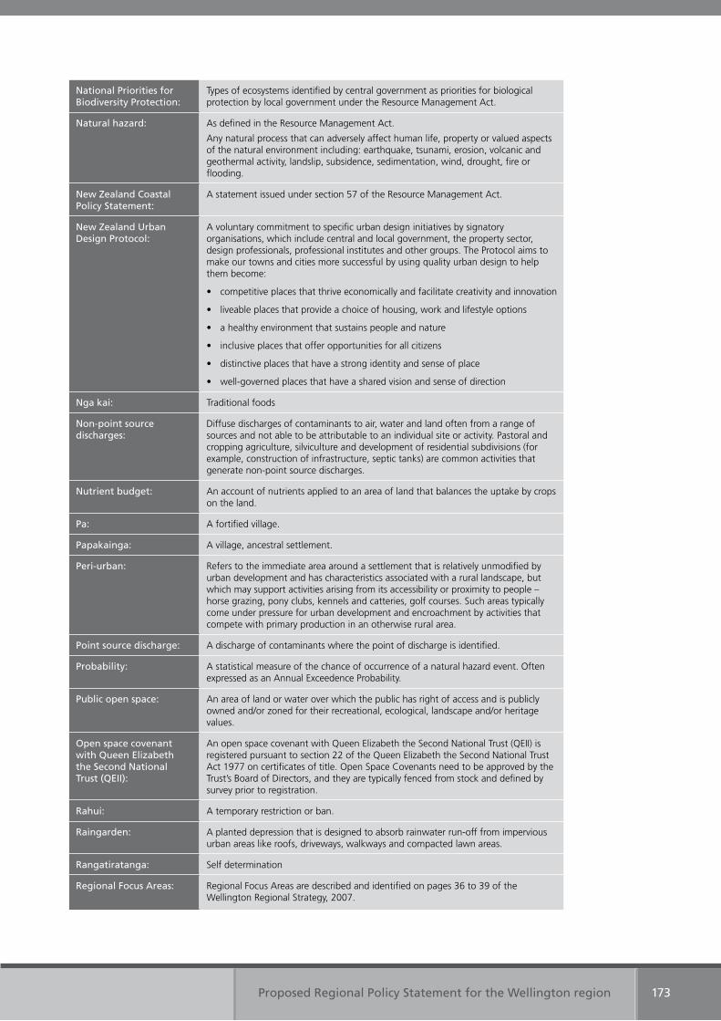
Proposed Regional Policy Statement for the Wellington region 173
National Priorities for Biodiversity Protection:
Types of ecosystems identified by central government as priorities for biological protection by local government under the Resource Management Act.
Natural hazard: As defined in the Resource Management Act.
Any natural process that can adversely affect human life, property or valued aspects of the natural environment including: earthquake, tsunami, erosion, volcanic and geothermal activity, landslip, subsidence, sedimentation, wind, drought, fire or flooding.
New Zealand Coastal Policy Statement:
A statement issued under section 57 of the Resource Management Act.
New Zealand Urban Design Protocol:
A voluntary commitment to specific urban design initiatives by signatory organisations, which include central and local government, the property sector, design professionals, professional institutes and other groups. The Protocol aims to make our towns and cities more successful by using quality urban design to help them become:
• competitive places that thrive economically and facilitate creativity and innovation
• liveable places that provide a choice of housing, work and lifestyle options
• a healthy environment that sustains people and nature
• inclusive places that offer opportunities for all citizens
• distinctive places that have a strong identity and sense of place
• well-governed places that have a shared vision and sense of direction
Nga kai: Traditional foods
Non-point source discharges:
Diffuse discharges of contaminants to air, water and land often from a range of sources and not able to be attributable to an individual site or activity. Pastoral and cropping agriculture, silviculture and development of residential subdivisions (for example, construction of infrastructure, septic tanks) are common activities that generate non-point source discharges.
Nutrient budget: An account of nutrients applied to an area of land that balances the uptake by crops on the land.
Pa: A fortified village.
Papakainga: A village, ancestral settlement.
Peri-urban: Refers to the immediate area around a settlement that is relatively unmodified by urban development and has characteristics associated with a rural landscape, but which may support activities arising from its accessibility or proximity to people – horse grazing, pony clubs, kennels and catteries, golf courses. Such areas typically come under pressure for urban development and encroachment by activities that compete with primary production in an otherwise rural area.
Point source discharge: A discharge of contaminants where the point of discharge is identified.
Probability: A statistical measure of the chance of occurrence of a natural hazard event. Often expressed as an Annual Exceedence Probability.
Public open space: An area of land or water over which the public has right of access and is publicly owned and/or zoned for their recreational, ecological, landscape and/or heritage values.
Open space covenant with Queen Elizabeth the Second National Trust (QEII):
An open space covenant with Queen Elizabeth the Second National Trust (QEII) is registered pursuant to section 22 of the Queen Elizabeth the Second National Trust Act 1977 on certificates of title. Open Space Covenants need to be approved by the Trust’s Board of Directors, and they are typically fenced from stock and defined by survey prior to registration.
Rahui: A temporary restriction or ban.
Raingarden: A planted depression that is designed to absorb rainwater run-off from impervious urban areas like roofs, driveways, walkways and compacted lawn areas.
Rangatiratanga: Self determination
Regional Focus Areas: Regional Focus Areas are described and identified on pages 36 to 39 of the Wellington Regional Strategy, 2007.
Proposed Regional Policy Statement for the Wellington region174
Regional form: Is the physical layout or arrangement of our urban and rural communities and how they link together. For example, transport networks (e.g. roads, rail, ports), and the patterns of residential, industrial, commercial and other uses alongside or around these networks, and in relation to the topography and geography of the region (e.g. its ranges and valleys, rivers, lakes and coastline). It includes the physical appearance or urban design, housing choice and density; and the arrangement of open spaces.
Regional plan: As defined in the Resource Management Act.
An operative plan (including a regional coastal plan) approved by a regional council or the Minister of Conservation under Schedule 1; and includes all operative changes to such a plan (whether arising from a review or otherwise)
Regionally significant centres:
The regionally significant centres are:
• Central business district in Wellington city
• Upper Hutt city centre
• Lower Hutt city centre
• Porirua city centre
• Paraparaumu town centre
• Masterton town centre
• Petone
• Kilbirnie
• Johnsonville
Regionally significant infrastructure:
Regionally significant infrastructure includes:
• pipelines for the distribution or transmission of natural or manufactured gas or petroleum
• strategic telecommunications facilities, as defined in section 5 of the Telecommunications Act 2001
• strategic radio communications facilities, as defined in section 2(1) of the Radio Communications Act 1989
• the national electricity grid, as defined by the Electricity Governance Rules 2003
• facilities for the generation and transmission of electricity where it is supplied to the national electricity grid
• the local authority water supply network and water treatment plants
• the local authority wastewater and stormwater networks, systems and wastewater treatment plants
• the Strategic Transport Network, as defined in the Wellington Regional Land Transport Strategy 2007-2016
• Wellington City bus terminal and Wellington Railway Station terminus
• Wellington International Airport
• Commercial Port Areas within Wellington Harbour (including Miramar, Burnham and Seaview wharves) and adjoining land and storage tanks for bulk liquids.
Renewable energy: As defined in the Resource Management Act.
Energy produced from solar, wind, hydro, geothermal, biomass, tidal wave and ocean current sources.
Residential activity: The use of a premise for any domestic or related purpose by persons living in the premises alone or in the family and/or non-family groups, whether any person is subject to care, supervision or not. A place of residence is typically where a person sleeps and keeps their personal belongings.
Residual risk: The risk to a subdivision or development that remains after implementation of risk treatment or hazard mitigation works.
Reverse sensitivity: Where a newly established activity may be adversely affected by an existing activity and may need to protect itself from the effects of the existing activity. For example, when a noise sensitive land use establishes next to an airport, the new land use may be required to protect itself with noise insulation, rather than requiring the existing lawful activity to reduce the noise it generates.
Proposed Regional Policy Statement for the Wellington region 175
Revetment: A structure placed either parallel or perpendicular to a shoreline or riverbank in order to protect property or land from erosion. These are designed to be porous and are commonly built with rocks. This allows water to flow through the cavities, slowing and absorbing the energy from the water flow and allowing finer sediments to deposit in the pore spaces. Rip-rap, gabions, groynes and breakwaters are all types of revetment.
Riffles: A shallow, fast flowing section of a stream or river where the water velocity exceeds the upstream and downstream water velocity because of the steeper gradient or shallow depth.
Risk A combination of the probability of a natural hazard and the consequences that would result from an event of a given magnitude. Commonly expressed by the formula: risk = hazard x vulnerability.
Riparian: Any land that adjoins or directly influences or is influenced by, a water body.
River: As defined in the Resource Management Act.
A continually or intermittently flowing body of fresh water; and includes a stream and modified watercourse; but does not include any artificial watercourse (including an irrigation canal, water supply race, canal for the supply of water for electricity power generation, and farm drainage canal).
Rohe: Tribal areas for iwi.
Rural areas (as at March 2009):
Rural areas (as at March 2009) include all areas not defined as the region’s urban areas (as at March 2009).
Sedimentation: The process of sediment deposition by wind or water, particularly in river, lake, coastal or marine environments.
Sensitive activities Activities which suffer should they experience adverse effects typically associated with some lawful activities. For example, dust or noise from a quarry or port facility, noise in an entertainment precinct, smells from a sewage treatment facility. Activity considered sensitive includes, any residential activity, any early childhood education centre, and any hotel or other accommodation activity. It may also include hospitals and respite care facilities.
Sewage: The liquid wastes of a community, including toilet wastes and sometimes trade waste, before treatment. Sewage effluent is the liquid residue after treatment, and sewage sludge is the solid residue after treatment.
Significant amenity landscapes:
Significant amenity landscapes are:
(a) important but not clearly exceptional landscape value under one or more of the criteria in an area where natural components dominate; or
(b) important (including exceptional) landscape value under one or more of the criteria in an area where the influence of human activity on landscape character dominates natural components.
Significant mineral resources:
Are deposits of minerals, the extraction of which is of importance in order to meet the current and future mineral needs of the region.
Soft engineering: Works such as beach nourishment and dune rebuilding that use non-structural materials (e.g. sand, cobbles, native plants) to mimic natural coastal features that can act to mitigate the impacts from natural hazards.
Storm surge: A temporary elevation in water at the shoreline caused by a combination of low air pressure, large waves (wave set-up) and strong onshore winds (wind set-up). Storm surge can elevate water levels by over one metre. A storm tide occurs when a storm surge coincides with high tide.
Stormwater: Water that accumulates as a result of rain, particularly during heavy or prolonged rainfall, and includes runoff from urban areas such as roads and roofs, whether flowing overland or in channels or pipes through a catchment.
Strategic public transport network:
The strategic public transport network is those parts of the region’s passenger transport network that provide a high level of service along corridors with high demand for public transport. It connects the region’s centres with the central business district in Wellington city. It includes the rail network and key bus corridors within the Wellington region.
Proposed Regional Policy Statement for the Wellington region176
Subdivision of land: Set out in section 218 of the Resource Management Act.
Swales: Inter-dune depressions that occur between dune crests. Also refers to concave hollows that are designed to hold stormwater run-off and allow the water to soak into the ground.
Tangata whenua: Maori with ancestral claims to a particular area of land and resources. Literally, translated as “people of the land.” Iwi are tangata whenua of a particular rohe, while all Maori are tangata whenua of Aotearoa (New Zealand).
Taonga: Treasures, valued resources, both tangible and intangible.
Taonga raranga: Valued plants used for weaving, such as kiekie and pingao.
Tauranga waka: Canoe landing places
Tikanga: Customary practices and values, typically followed in order to protect mauri and/or mana.
Travel demand management:
Includes a range of mechanisms designed to influence or change travel behaviour – such as road pricing tools and improvements to the efficiency of the existing transport network.
Tsunami: A series of waves generated by the sudden displacement of a water surface. The three main generating mechanisms are submarine fault ruptures, landslides or volcanic activity. Most commonly occur in open ocean, but can also occur in harbours and lakes.
Urban areas (as at March 2009):
The region’s urban areas (as at March 2009) include urban, residential, suburban, town centre, commercial, community, business and industrial zones identified in the Wellington city, Porirua city, Lower Hutt city, Upper Hutt city, Kapiti coast and Wairarapa combined district plans.
Urban development: Urban development is subdivision, use and development that is characterised by its planned reliance on reticulated services (such as water supply and drainage) by its generation of traffic, and would include activities (such as manufacturing), which are usually provided for in urban areas. It also typically has lots sizes of less than 3000 square metres.
Urupa: Burial sites.
Vulnerability: The exposure or susceptibility of a development, building, business or community to the effects from a natural hazard event.
Water body: As defined in the Resource Management Act.
Freshwater or geothermal water in a river, lake, stream, pond, wetland or aquifer, or any part thereof, that is not located within the coastal marine area.
Water harvesting: Taking water from water bodies when the amount of water is plentiful, and storing it outside the water body.
Wahi tapu: Places of sacredness and immense importance for tangata whenua. Wahi tapu areas can be prohibited or forbidden places, or private places, where permission should be sought for access, and protocols followed.
Wahi tipuna: Ancestral sites.
Wellington Regional Strategy:
The Wellington Regional Strategy is a sustainable economic growth strategy for the Wellington region developed by greater Wellington’s nine local authorities, in conjunction with central government and the region’s business, education, research and voluntary sector interests. It aims to make the Wellington region internationally competitive.
Wetland: As defined in the Resource Management Act.
Permanently or intermittently wet areas, shallow water, and land water margins that support a natural ecosystem of plants and animals that are adapted to wet conditions.
Whanau: An extended family group.

Appendix Four
References
Proposed Regional Policy Statement for the Wellington region 177
Appendix 4: References
Bindoff, N.L., J. Willebrand, V. Artale, A, Cazenave, J. Gregory, S. Gulev, K. Hanawa, C. Le Quéré, S. Levitus, Y. Nojiri, C.K. Shum, L.D. Talley and A. Unnikrishnan, (2007) Observations: Oceanic Climate Change and Sea Level. In: Climate Change 2007: The Physical Science Basis. Contribution of Working Group I to the Fourth Assessment Report of the Intergovernmental Panel on Climate Change [Solomon, S., D. Qin, M. Manning, Z. Chen, M. Marquis, K.B. Averyt, M. Tignor and H.L. Miller (eds.)]. Cambridge University Press, Cambridge, United Kingdom and New York, NY, USA.
Carterton District Council (2006) Carterton District Council Long term Council Community Plan 2006 – 20016. Carterton
Church, J., White, N., Coleman, R., Lambeck, K. & Mitrovica, J. (2004) Estimates of the regional distribution of sea level rise over the 1950-2000 period. Journal of Climate, 17 (13), 2609-2624.
Department of Conservation (1994) New Zealand Coastal Policy Statement. Wellington. ISB 0-478-01589-S
Energy Efficiency and Conservation Authority (2006) Renewable Energy Assessment: Greater Wellington Region. Prepared by Sinclair Knight Merz. Auckland
Greater Wellington Regional Council (2001) Inanga Spawning Habitats in the Wellington Region. Wellington. Publication No. WRC/RP-T-01/59
Greater Wellington Regional Council (2003) Inanga spawning habitats in the Wellington Region – Part 2 – Wairarapa. Wellington. Publication No. GW WRC/RP-G-02/65
Greater Wellington Regional Council (2005) Measuring up: the state of the environment report for the Wellington region 2005. Wellington. Publication No. GW/ENV-G-05-278
Greater Wellington Regional Council (2006) Our region – their future: A discussion document on the review of the Regional Policy Statement for the Wellington Region. Wellington. Publication No. GW/RP-G-06/83
Greater Wellington Regional Council (2007) A sustainable region. Detailed information. Amended 2006-16 Ten-Year Plan (incorporating the 2006/7 Annual Plan). Wellington. Publication No. GW/SP-G-07/108
Greater Wellington Regional Council (2007). Wellington Regional Land Transport Strategy 2007-2016. Wellington. Publication No. GW/TSD-G-07/175
Greater Wellington Regional Council (2007). Wellington Regional Strategy: Internationally Competitive Wellington: A Sustainable Economic Growth Strategy for our Region. Prepared by the regions nine local authorities in association with Positively Wellington Business. Wellington. Publication No. GW/SP-G-07/01
Hannah, J. (2004) An updated analysis of long term sea level change in New Zealand. Geophysical Research Letters, 31, L03307.
Hutt City Council (2006) Hutt City: Your City – Your Say: 2006 – 2017 Community Plan. Lower Hutt
Holgate, S. & Woodworth, P. (2004) Evidence for enhanced coastal sea level rise during the 1990s. Geophysical Research Letters, 31, L07305.
Intergovernmental Panel on Climate Change (IPCC) (2007) Climate Change 2007: The Physical Science Basis. Summary for Policymakers. Contribution of working group I to the fourth assessment report of the IPCC, 18pp.
Proposed Regional Policy Statement for the Wellington region178
Kapiti Coast District Council (2006) Kapiti Coast Choosing Futures Community Plan 2006. Paraparaumu
Masterton District Council (2006) Shaping our Future: Masterton District Long term Council Community Plan. Masterton
Ministry of Economic Development (2007) New Zealand Energy Strategy to 2050. Powering our future: Towards a sustainable low emissions energy system. Wellington
Ministry for the Environment (2005) New Zealand Urban Design Protocol. Wellington. ME579
Ministry for the Environment (2007) Protecting our Places – Introducing the national priorities for protecting rare and threatened native biodiversity on private land. ME799
Ministry for the Environment (2004) Resource Management (National Environmental Standards relating to certain air pollutants, dioxins, and other toxics) Regulations 2004.
Ministry for the Environment (2007) Resource Management (National Environmental Standards for Sources of Human Drinking Water) Regulations 2007.
Ministry for the Environment (2008) Resource Management (National Environmental Standards for Telecommunication Facilities) Regulations 2008
Ministry for the Environment (2008) National Policy Statement on Electricity Transmission.
New Zealand Government (2007) New Zealand Energy Efficiency and Conservation Strategy. ISBN 978-0-478-19502-6.
Porirua City Council (2006) Long term Council Community Plan: Porirua City Council 2006 – 2016. Porirua City Council
South Wairarapa District Council (2007) South Wairarapa Council Community Plan 2006 – 2016. Martinborough
Upper Hutt City Council (2006) Long Term Council Community Plan (LTCCP) – upperhuttcity@2016. Upper Hutt
Waitangi Tribunal (1983) Report of the Waitangi Tribunal on the Motunui-Waitara claim (Wai 6). Wellington. ISSN 0113-4124. ISBN 0-908810-03-02
Waitangi Tribunal (1984). Report of the Waitangi Tribunal on the Kaituna River claim. Wellington. ISSN 0113-4124P. ISBN 0-908810-04-0
Waitangi Tribunal (1985) Report of the Waitangi Tribunal on the Manukau claim (Wai 8). Wellington. ISSN 0113-4124. ISBN 0-908810-06-7
Wellington City Council (2006) Wellington City Council Long term Council Community Plan 2006/7 – 2016/7. Wellington
Wellington Regional Council (2000) The charter of understanding between Te Tangata Whenua o Te Upoko o te Ika a Maui and Wellington Regional Council. Wellington
Proposed Regional Policy Statement for the Wellington region 2009
Water, air, earth and energy: elements in Greater Wellington’s logo that combine to create and sustain life. Greater Wellington promotes
Quality for Life by ensuring our environment is protected while meeting the economic, cultural and social needs of the community.
FOR MORE INFORMATION, PLEASE CONTACT:
Greater Wellington 142 Wakefield Street P O Box 11646 Wellington 6142
T 04 384 5708 F 04 385 6960
[email protected] www.gw.govt.nz/rps
Published March 2009GW/EP-G-08/200
Photographs used for the ‘coastal environment’ in section 3.2, ‘historic heritage’ in section 3.5 and cover and ‘natural hazards’ in section 3.8 and cover were taken by Iain Dawe. The Air quality photograph in section 3.1 was taken by Paul Denton. Remaining photographs are copyright Greater Wellington.
Prop
osed
Reg
ion
al Policy Statem
ent fo
r the W
elling
ton
regio
n 2009