proposed plan fort totten coast guard station queens… · fort totten coast guard station queens,...
TRANSCRIPT

Page 1 of 10
U.S. Army Corps of Engineers, Formerly Used Defense Site Program
PROPOSED PLAN Fort Totten Coast Guard Station Queens, New York, New York FUDS Project No. C02NY0057 June 2015
THE U.S. ARMY CORPS OF ENGINEERS ANNOUNCES PROPOSED PLAN
INTRODUCTION
This Proposed Plan identifies the Preferred Alternative for addressing lead-impacted soil that results in unacceptable risk to human health at the Fort Totten Coast Guard Station (CGS) Formerly Used Defense Site (FUDS) in Queens, New York City, New York. This Proposed Plan also provides the rationale for this preference and describes other cleanup alternatives evaluated for this site. This document is issued by the United States Army Corps of Engineers (USACE), the lead agency for site activities, in coordination with the New York State Department of Environmental Conservation (NYSDEC), the support agency.
The USACE, in coordination with the NYSDEC, will select a final remedy for the site after reviewing and considering all information submitted during the public comment period. The Preferred Alternative may be modified or another response action presented in this plan may be selected based on new information or public comments. Therefore, the public is encouraged to review and comment on all of the alternatives presented in this Proposed Plan.
The USACE is issuing this Proposed Plan as part of its public participation responsibilities under Section 117 (a) of the Comprehensive Environmental Response, Compensation, and Liability Act (CERCLA, 42 USC § 9617(a) and Section 300.430 (f)(3) of the National Oil and Hazardous Substances Pollution Contingency Plan (NCP). This Proposed Plan does not affect response actions at other sites under the jurisdiction of the USACE.
This Proposed Plan summarizes information that can be found in greater detail in the Final Remedial Investigation (RI) Report, the Final Feasibility Study (FS) Report, and other documents contained in the information repository file for the site located at the
Bay Terrace Library, 18-36 Bell Blvd., Bayside, New York. The USACE and the NYSDEC encourage the public to review these documents to gain a more comprehensive understanding of the site and remedial activities conducted to date. The documents are also available at the project web site: http://www.nan.usace.army.mil/FortTotten .
MARK YOUR CALENDAR!
PUBLIC MEETING: June 30, 2015 at 7:00 PM The USACE will hold a public meeting to explain the Proposed Plan and all of the alternatives presented in the FS Report. The meeting will be held at “The Bay Terrace Jewish Center,” 13-00 209th Street, Bayside, New York 11360. Verbal and written comments will also be accepted at the meeting. PUBLIC COMMENT PERIOD June 18, 2015 through July 24, 2015 The USACE will accept written comments on the Proposed Plan during the public comment period. The public may provide written comments during the public meeting or they can be mailed to: U.S. Army Corps of Engineers New York District Attn.: Mr. Gregory J. Goepfert 26 Federal Plaza, CENAN-PP-E Room 1811 New York, New York 10278
SITE HISTORY AND BACKGROUND
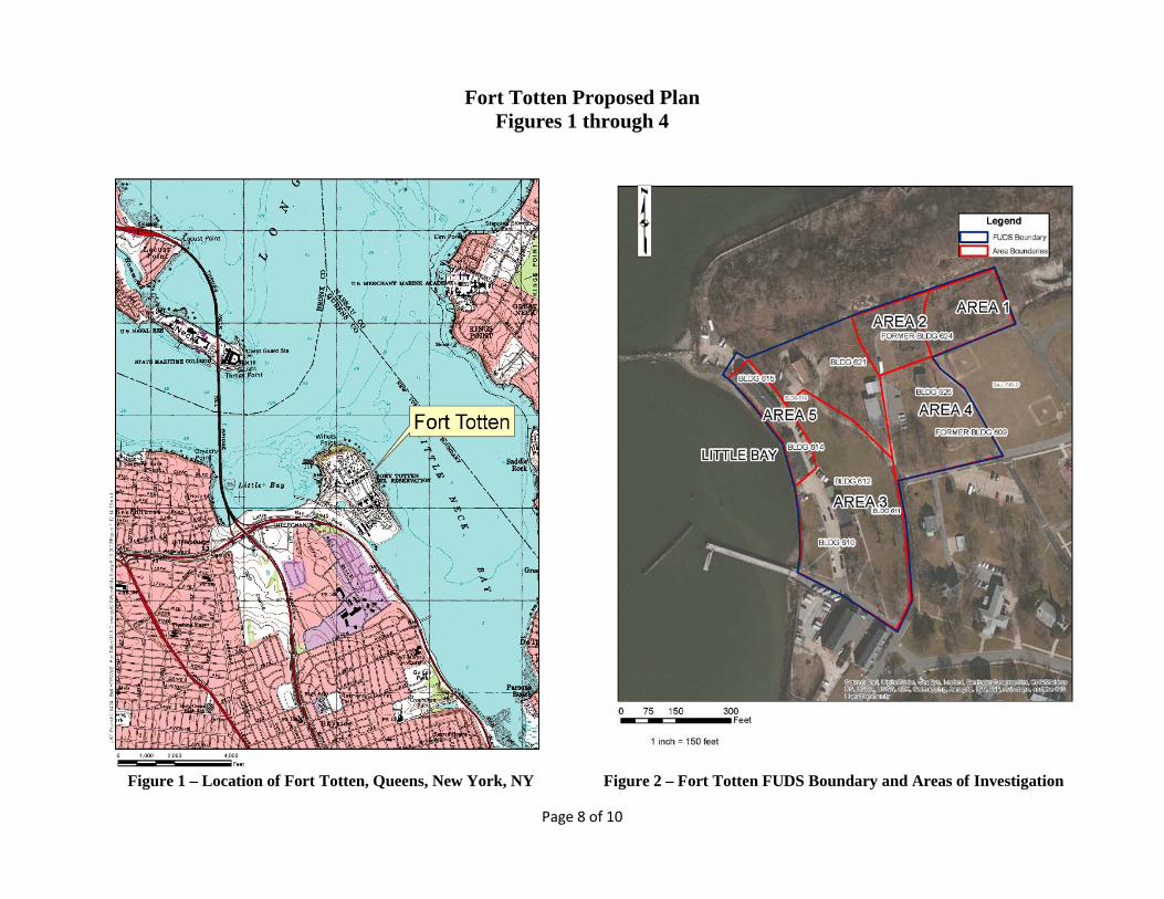
Fort Totten is located in the northwest portion of Long Island, on the Willets Point peninsula in Queens, New York City, New York (Figure 1). The Department of Defense (DoD) acquired Fort Totten, a 146.75-acre property, between 1857 and 1943 for

Page 2 of 10
the coastal defense of Long Island Sound and the eastern entrance to the East River. Historically, Fort Totten also served as a post-Civil War hospital, an engineering school, and a training site for the West Point Cadets. The US Army Reserve portion of Fort Totten is currently the Headquarters for the 77th Army Reserve Command. In 1968, the Department of the Army conveyed 9.6 acres of the property to the United States Coast Guard (USCG), retaining ownership of the remaining 137.15 acres. The 9.6 acre FUDS includes the 1.8 acre ball fields. This Proposed Plan is limited to the FUDS property.
Early investigations covered the entire area of the FUDS property and the adjacent ball field. Based on the results of these early investigations, the following five areas were identified for subsequent investigations (Figure 2).
Area 1 (Former Fill Area): Area 1 (Figures 3 and 4) was created when the Army placed excavated soil in a low spot of the recreation field to eliminate periods of standing water. The soil came from excavation of parking lots associated with former and existing vehicle maintenance shops on the Army-owned portion of Fort Totten.
Area 2 (Building 624): Building 624 was originally constructed as a workshop and was later used for storage, including the storage of pesticides.
Area 3 (Buildings 610, 611, and 612): This area was originally investigated due to the presence of a transformer south of Building 610 that was suspected of containing polychlorinated biphenyls (PCBs). PCBs were not detected in the area.
Area 4 (Building 625) - A concrete pad adjacent to Building 625 originally supported two electrical transformers suspected of containing PCBs. PCBs were not detected in the area.
Area 5 (Building 615): Building 615 was originally used as a torpedo and mine repair facility. The armaments contained mercury in their guidance systems and when repair required removal of the mercury, it was disposed of into the floor drains. During investigation activities (to locate the exit point of floor drains), mercury-impacted soil was excavated to the extent possible from outside of the building in 2006 and 2007. The excavation was limited by underground structures and active utilities.
SITE CHARACTERISTICS
Investigations and studies related to chemical releases at the site were carried out from 1988 to 2014 and included the following as documented in the Final RI and FS Reports:
• 1988 Site Investigation • 1997/1998 Phase I Remedial Investigation • 1999/2000 Phase II remedial Investigation • 2004 Supplemental Remedial Investigation • 2009 Background study for metals and Semi-
Volatile Organic Compounds (SVOCs) • 2009 Feasibility Study • 2011/2012 Second Supplemental Remedial
Investigation • 2014 Feasibility Study
Over the course of the investigations and studies, 102 shallow soil borings were conducted and more than 345 soil samples were collected for laboratory analysis. Groundwater, surface water, sediment, and indoor air in Building 615 were also sampled. The results were used to determine the nature and extent of site contamination and to calculate potential risk to human health and the environment. The investigation data and risk assessments are documented in the Final RI Report and are summarized below.
SUMMARY OF SITE RISKS
Results of the soil sampling identified elevated concentrations of polycyclic aromatic hydrocarbons (PAHs) and metals relative to background concentrations present at Fort Totten. The Fort Totten background concentrations were established through collection of soil from 15 locations at Fort Totten that were outside of the investigation areas. The Final RI Report concluded that the PAHs are attributable to historic urban fill and that the only metal, media, and area requiring remedial action is lead in soil in Area 1, as ingestion of soils at portions of Area 1 which exceed lead background levels may cause elevated blood lead levels in children.
Results of the groundwater sampling identified concentrations of PAHs, sodium, and chloroform in groundwater that exceed New York State Class A groundwater guidance criteria. Fort Totten CGS FUDS is currently supplied by municipal water and there is no foreseeable future use of groundwater for drinking water purposes. The Final RI Report concluded that risk from exposure to groundwater is

Page 3 of 10
not a concern based on the results of a qualitative risk evaluation conducted on 2012 groundwater data. Earlier investigations also evaluated the potential for ecological impacts in the terrestrial areas and in Little Bay. A screening level ecological risk assessment of the terrestrial areas indicated that an ecological risk assessment was not necessary. The potential ecological impact from mercury at Fort Totten on Little Bay was investigated further. These investigations found that concentrations of mercury in Little Bay sediment were not significantly higher than the concentrations in sediment in other portions of Long Island Sound and New York Harbor. A No Further Action Record of Decision (ROD) was issued for Little Bay in 2003 after additional fish and shellfish tissue sampling confirmed that mercury from the site did not pose a significant threat to human health and the environment.
Based on the findings of the risk assessment and other information provided in the Final RI Report, no further action is proposed at the ballfield, or at Areas 2, 3, 4 & 5, and the only media and area requiring remedial action is soil in Area 1 due to lead. The RI indicated Area 1 was unsuitable for unlimited use / unrestricted exposure. Although the risk assessments indicate no unacceptable risks at Areas 2, 3, 4 & 5, the NYSDEC’s soil clean up objectives (SCOs) were exceeded at several sampling locations; therefore, NYSDEC intends to issue an Environmental Notice for the property (as a State-issued land use control).
SCOPE AND ROLE
The proposed Remedial Action will be the final action at the site. The purpose of this Remedial Action is to address lead found in surface and shallow-subsurface soils in Area 1. The affected area of the site is depicted on Figure 3.
Lead is a naturally occurring metal. It is used in the production of batteries, ammunition, and metal products, and was also used as an additive to gasoline before 1996. Elevated levels of lead in soil in Area 1 at Fort Totten CGS FUDS are a result of the Army placing soil that was excavated from another portion of Fort Totten in a low spot of the recreation field to eliminate an area where intermittent standing water occurred. The soil came from excavation of parking lots associated with former and existing vehicle maintenance shops on the Army-owned portion of Fort Totten CGS FUDS. Lead is also present at Fort Totten CGS FUDS as a
result of the urban setting and proximity to industrial areas, and was detected in background samples.
REMEDIAL ACTION OBJECTIVES
A FS consists of identifying Remedial Action Objectives (RAOs), evaluating physical, hydrogeologic, and geochemical conditions, and identifying and evaluating general response actions to achieve the RAOs. The potential options incorporate remedial technologies, which are subsequently used to develop comprehensive remedial alternatives for the Site.
The RAO at Area 1 is to prevent or reduce the potential for a child’s ingestion of soils with total lead concentrations significantly above background concentrations; background concentrations (522.5 milligrams per kilogram (mg/kg) in shallow soils and 448.9 mg/kg in deep soils) are by comparison, slightly above the 400 mg/kg NYSDEC soil cleanup objective.
The Preliminary Remedial Goal (PRG) for lead in Area 1 soil is Fort Totten background. The RG is to reduce lead concentrations in surface and subsurface site soil so that the average lead concentration does not exceed the average Fort Totten surface soil background concentration, with 95 percent confidence. Remediation to Fort Totten background will address the elevated lead concentrations present in soils in Area 1 that are attributable to previous Army activities. It is expected that the average lead concentration of remaining post-excavation soils will also meet the NYSDEC soil cleanup objective (400 milligrams per kilogram or parts per million).
REMEDIAL ACTION ALTERNATIVES
The following four remedial alternatives were evaluated in the FS.
ALTERNATIVE 1 – NO ACTION
Capital Cost: $0 O&M $0 Present Worth: $0 Alternative Timeframe: Not applicable
Alternative 1 provides for no action to address soil contamination in Area 1. Evaluation of a No Action alternative is required under CERCLA in order to establish a baseline for comparison to other alternatives. Under this alternative:
• Land Use Controls (LUCs) would not be implemented and therefore potential future residents may experience soil exposures causing unacceptable risks.

Page 4 of 10
• No monitoring would occur to determine if further remedial action is necessary.
ALTERNATIVE 2 – LAND USE CONTROLS (LUCS)
Capital Cost: $ 73,435 30 Year O&M $132,695 Present Worth: $206,130 Construction Timeframe: one year Alternative Timeframe: indefinite
(costs were estimated for 30 years)
Alternative 2 provides for LUCs at Area 1. Land use controls in the form of access and land use restrictions and a security fence are proposed for this alternative. Under this alternative:
• Land use restrictions would consist of administrative restriction of the use of the property through changes to the site management plan. If the property is sold, the ownership transfer documents would need to describe the contamination at the site.
• A pre-design investigation would be conducted to determine the extent of the surface soil with lead concentrations above background. The investigation results would be used to determine the exact location of the security fence.
• A six foot tall security fence would be erected around Area 1 to prevent human exposure to the contaminated soil. It is estimated that 580 feet of fence would be required (an area extending slightly beyond the area would be fenced). Warning signs would be posted on the fence restricting entry to authorized personnel only.
• The government would be responsible for maintenance of the fence.
• Five-year reviews, as required by CERCLA, would continue indefinitely.
ALTERNATIVE 3 – SOIL COVER CAP WITH LUCS
Capital Cost: $156,527 30 Year O&M $126,107 Present Worth: $282,635 Construction Timeframe: 1.5 years Alternative Timeframe: Indefinite
(costs were estimated for 30 Years)
Alternative 3 provides for placement of a soil cover cap at Area 1 with LUCs. Under this alternative:
• Land use restrictions would be implemented in the same manner as under alternative 2.
• A pre-design investigation would be conducted to determine the extent of the surface soil with lead concentrations above background. The investigation results would be used to determine the exact location of the soil cover cap.
• The portion of Area 1 with lead concentrations above background would be capped with a geo-membrane placed on top of the grubbed soil. Additional soil would be placed on top of the cap and seeded. A storm water management system would be installed to prevent runoff into the adjacent wetland. A fence and signage would be installed to prohibit activities that would disturb or interfere with the integrity or function of the cap.
• The government would be responsible for monitoring and maintenance of the soil cover cap and the fence.
• Five-year reviews, as required by CERCLA, would continue.
ALTERNATIVE 4 – REMOVAL, OFF-SITE DISPOSAL, AND BACKFILL
Capital Cost: $450,934 O&M Not Applicable Present Worth: $450,934 Construction Timeframe: one year Alternative Timeframe: one year
Alternative 4 provides for removal and off-site disposal of contaminated soils in Area 1. Under this alternative:
• A pre-design investigation would be conducted to determine the extent of soil with lead concentrations above background. The investigation results would be used to determine the planned extent of the excavation.
• To meet the RAO for lead in soil, it is expected that an area of 20,000 square feet will need to be removed by excavation. Confirmatory soil sampling would occur following the excavation.
• The excavated area would be backfilled with certified clean soil and be seeded with grass.
• Approximately 1,667 cubic yards of excavated soil would be transported to a permitted disposal facility. The soil volume estimate is based on removal of soil to an assumed depth of 1.5 feet in the eastern half of the remedial area and up to 3 feet in the western half of the remedial area.

Page 5 of 10
CRITERIA FOR EVALUATING THE ALTERNATIVES
As documented in the FS, a detailed analysis was performed on all of the alternatives presented for the Fort Totten CGS FUDS. The FS used the criteria listed below, per Section 300.430 (e)(9)(iii) of the NCP, to assess each remedial alternative. These nine criteria are summarized as follows:
THRESHOLD CRITERIA
Overall Protectiveness of Human Health and the Environment determines whether an alternative eliminates, reduces, or controls threats to public health and the environment.
Compliance with Applicable or Relevant and Appropriate Requirements (ARARs) evaluates whether the alternative meets Federal and State environmental statutes, regulations, and other requirements that pertain to the site, or whether a waiver is justified. ARARs generally fall into one of three categories: chemical-specific, location-specific or action-specific. Chemical-specific ARARs are usually health or risk-based restrictions on the amount or concentration of a chemical that may be found in, or discharged to the environment. Location-specific ARARs prevent damage to unique or sensitive areas, such as floodplains, historic places, wetlands, and fragile ecosystems. Action-specific ARARs control remedial activities involving the design or use of certain equipment, or regulate discrete actions, such as hazardous waste management or landfill capping.
PRIMARY BALANCING CRITERIA
Long-term Effectiveness and Permanence considers the ability of an alternative to maintain protection of human health and the environment over time.
Reduction of Toxicity, Mobility, or Volume of Contaminants through Treatment evaluates an alternative's use of treatment to reduce the harmful effects of principal contaminants, their ability to move in the environment, and the amount of contamination present.
Short-term Effectiveness considers the length of time needed to implement an alternative and the risks the alternative poses to workers, residents, and the environment during implementation.
Implementability considers the technical and administrative feasibility of implementing the alternative, including factors such as the relative availability of goods and services.
Cost includes estimated capital and annual operations and maintenance costs, as well as present worth cost. Present worth cost is the total cost of an alternative over time in terms of today's dollar value. Cost estimates are expected to be accurate within a range of +50 to -30 percent.
MODIFYING CRITERIA
State Acceptance considers whether the NYSDEC agrees with the USACE’s analyses and recommendations, as described in the Remedial Investigation reports, Feasibility Study and Proposed Plan.
Community Acceptance considers whether the local community agrees with USACE's analyses and preferred alternative. Comments received on the Proposed Plan are an important indicator of community acceptance.
EVALUATION OF ALTERNATIVES
The nine criteria summarized above were used to evaluate the four remedial alternatives individually and against each other in order to identify the preferred alternative. This section of the Proposed Plan profiles the relative performance of each alternative against the nine criteria, noting how it compares to the other alternatives under consideration. The nine criteria fall into three groups: threshold criteria, primary balancing criteria, and modifying criteria. A description of the purposes of the three groups follows:
• Threshold criteria, which are requirements that each alternative must meet in order to be eligible for selection.
• Primary balancing criteria, which are used to weigh major trade-offs among alternatives.
• Modifying criteria, which may be considered to the extent that information is available during the FS, but can be fully considered only after public comment is received on the Proposed Plan.
The nine evaluation criteria are discussed below. The detailed analysis of alternatives can be found in the Final FS Report.
1. Overall Protection of Human Health and the Environment All of the Alternatives except Alternative 1 – No Action would provide protection of human health and the environment by eliminating, reducing, or controlling risk through removal, a soil cover cap, and/or LUCs. Alternatives 2, 3 & 4 would be protective of human health and the environment.
Page 6 of 10
2. Compliance with ARARs There are no chemical- or location-specific ARARs. Alternative 3 would comply with the action-specific ARARs that apply to landfill capping. Alternatives 2 and 4 do not have any action-specific ARARs.
.
3. Long-Term Effectiveness and Permanence Alternative 1 will not provide a permanent solution or long-term effectiveness. Alternative 2 would provide long-term protection for only as long as the LUCs and the fence remained in place and effective. Alternatives 2 and 3 would have similar requirements associated with maintenance of LUCs and the fence for perpetuity; however, Alternative 3 has the significant added benefit of the presence of the soil cap in the event that LUCs or the fence become compromised. Alternatives 3 and 4 provide long-term effectiveness. Alternative 4 provides a more permanent solution than Alternative 3, because Alternative 4 would remove the contaminated soil from the site.
4. Reduction of Toxicity, Mobility, or Volume (TMV) of Contaminants through Treatment Alternatives 1, 2, and 3 would not reduce the TMV of the contaminants through treatment because they do not include treatment as part of the alternative. Although not “treatment”, excavation as specified in Alternative 4 would result in a reduction of TMV of contaminants at the site.
5. Short-term Effectiveness Alternative 1, the No Action alternative, would have no short-term impacts on human health and the environment. Potential impact to workers for exposure to contaminated soil in Alternative 2 would be minimized through design and construction plans. Alternatives 3 and 4 would likely have impacts on workers and also possibly visitors and nearby residents during remedial action from the generation of fugitive dust. This impact can be minimized by using water to wet down the work area. Additionally, during the invasive remediation activities, as would occur for Alternatives 3 and 4, ambient air would be monitored for airborne dust at the perimeter of Area 1. Traffic controls would be implemented, as appropriate, to minimize inconveniences caused by heavy vehicle traffic associated with Alternatives 3 and 4.
6. Implementability All the alternatives can easily be implemented using commonly employed methods, equipment,
materials, and personnel. Alternative 1 is the easiest to implement because no action is taken. Alternative 2 is easily implemented with readily available resources. Alternatives 3 and 4 would require the most experienced personnel to implement because of the skill required in surveying, sampling, soil cover cap construction, excavation, and backfilling.
7. Cost The cost of each alternative increases with the level of effort required to implement. Alternative 1 has the lowest cost ($0), followed by Alternative 2 ($206,130), Alternative 3 ($282,635), and Alternative 4 ($450,934).
8. State/Support Agency Acceptance This criterion is continually evaluated as NYSDEC participates in all aspects of the evaluation and selection of a remedy. NYSDEC will issue its official position in a comment letter after the public comment period has ended.
9. Community Acceptance Community acceptance of the Preferred Alternative will be evaluated after the public comment period ends and will be described in the Decision Document for the site.
PREFERRED ALTERNATIVE FOR THE FORT TOTTEN CGS FUDS
The Preferred Alternative for cleaning up the Fort Totten CGS FUDS Area 1 is Alternative 4; removal of soil to lead background concentrations, off-site disposal, and backfill.
The Preferred Alternative was selected over the other alternatives because it is expected to achieve substantial and long-term risk reduction through excavation and disposal, allowing the property to be used for any purpose.
Based on information currently available, the USACE believes the Preferred Alternative meets the threshold criteria and provides the best balance of tradeoffs among the other alternatives. The USACE expects the Preferred Alternative to satisfy the following statutory requirements of CERCLA §121(b): (1) be protective of human health and the environment; (2) comply with ARARs; (3) be cost-effective; and (4) utilize permanent solutions and alternative treatment technologies or resource recovery technologies to the maximum extent practicable.

Page 7 of 10
The USACE is providing information regarding the Preferred Alternative for cleaning up the site to the public through a public meeting, publication of this Proposed Plan, and an announcement published in the Bayside Times. USACE will select a final remedy for the site after reviewing and considering all comments submitted during the 30-day public comment period.
The Preferred Alternative can change in response to public comment or new information. The USACE, in coordination with NYSDEC, may modify the Preferred Alternative or select another alternative presented in this plan based on new information or public comments. Therefore, the public is encouraged to review and comment on all the alternatives presented in this Proposed Plan. The USACE will respond to public comments via the “Responsiveness Summary” provided in the Decision Document. The Decision Document will present the final selected remedy for the site.
The dates for the public comment period, the date, location, and time of the public meeting, and the address to send written comments to are provided on the front page of this Proposed Plan.
GLOSSARY OF TERMS
Specialized terms used in this Proposed Plan are defined below:
Administrative Record: The body of documents the USACE used to form the basis for selection of a response.
Applicable or Relevant and Appropriate Requirements (ARAR): Federal and state requirements for cleanup, control, and environmental protection that a selected remedy for a site will meet.
Below ground surface (bgs): depth in feet below the surrounding ground surface.
Contaminants of Concern (COC): Chemicals in media at a site that could pose risk to current or future human and/or ecological receptors.
Capital Costs: Expenses related to the labor, equipment, and material costs of construction.
Comprehensive Environmental Response, Compensation, and Liability Act (CERCLA): established prohibitions and requirements concerning closed and abandoned hazardous
waste sites, provided for liability of persons responsible for releases of hazardous waste at these sites, and established a trust fund to provide for cleanup when no responsible party can be identified.
Decision Document: A document that is a consolidated source of information about the site, the remedy selection process, and the selected remedy for cleanup under the CERCLA process.
Feasibility Study (FS): The FS identifies and evaluates the most appropriate technical approaches to address contamination problems at a CERCLA site.
Human Health Risk Assessment (HHRA): A study of the actual or potential danger to human health from hazardous substances at a specific site. The HHRA estimates the risk to human health at a site if no response action is taken.
Land Use Controls (LUCs): Actions taken by USACE that helps minimize the potential for human exposure to contamination by ensuring appropriate land or resource use.
National Oil and Hazardous Substance Pollution Contingency Plan (NCP): USEPA’s regulations governing all cleanups under CERCLA.
Operations and Maintenance (O&M) Cost: The cost and timeframe of operating labor, maintenance, materials, energy, disposal, and administrative components of the remedy.
Present Worth Cost: The present worth of a future investment or payment that is calculated using a predetermined discount or interest rate. Present worth cost is the amount of money which, if invested in the current year, would be sufficient to cover all the costs over time associated with a remedial action.
Proposed Plan: A document that presents the preferred remedial alternative for public comment.
Remedial Action: Action taken to cleanup contamination at a site to acceptable standards.
Remedial Investigation (RI): A detailed study of a site. The RI may include an investigation of air, soil, surface water, and/or groundwater to determine the source(s) and extent of contamination at a site.
Page 8 of 10
Fort Totten Proposed Plan Figures 1 through 4
Figure 1 – Location of Fort Totten, Queens, New York, NY Figure 2 – Fort Totten FUDS Boundary and Areas of Investigation

Page 9 of 10
Figure 3 - Area Addressed by the FS Alternatives Figure 4 – Area 1, View North Towards Ft. Totten Fortifications

Page 10 of 10
COMMUNITY PARTICIPATION
USE THIS SPACE TO WRITE YOUR COMMENTS
Your input on the Proposed Plan for the Fort Totten Coast Guard Station site (also known as the Engineer School / Fort Totten FUDS) in Queens, New York is important to the USACE. Comments provided by the public are valuable in helping the USACE select a final remedy for the site.
You may use the space below to write your comments, then fold and mail. Comments must be postmarked by July 24, 2015. If you have questions about the comment period, please contact Mr. Gregory J. Goepfert, USACE Project Manager, at (917) 790-8235. Please mail your comments to U.S. Army Corps of Engineers, New York District, Attn: Mr. G. Goepfert, CENAN-PP-E, Room 1811, 26 Federal Plaza, New York, New York 10278.
___________________________________________________________ ___________________________________________________________ ___________________________________________________________ ___________________________________________________________ ___________________________________________________________ ___________________________________________________________ ___________________________________________________________ ___________________________________________________________ ___________________________________________________________ ___________________________________________________________ ___________________________________________________________ ___________________________________________________________ ___________________________________________________________ ___________________________________________________________ ___________________________________________________________ ___________________________________________________________
Name: ___________________________________________
Address: ___________________________________________
City: ___________________________________________
State: ________________________________Zip________