proposed amendment 1 to the official plan for the regional municipality...
TRANSCRIPT
Council Attachment 1
Proposed Amendment 1
to the Official Plan
for the Regional
Municipality of York
File 19OP-2009-001
2
AMENDMENT 1
TO THE OFFICIAL PLAN FOR
THE REGIONAL MUNICPALITY OF YORK PART A - THE PREAMBLE 1. Purpose of the Amendment:
This Amendment expands the Urban Area of the Town of East Gwillimbury to provide opportunities for urban growth to the year 2031.
2. Location:
This urban expansion is within the Town of East Gwillimbury as shown on attached Figures 1 to 8, being excerpts from Maps 1 to 6, Maps 8 and 11 of the York Region Official Plan – December 2009.
3. Basis:
Places to Grow, The Growth Plan for the Greater Golden Horseshoe requires that Regional population and employment forecasts prescribed through Schedule 3 to the Growth Plan be allocated to local municipalities. Further the Growth Plan requires that comprehensive municipal reviews undertake land budget analysis to justify urban expansions. Regional population and employment forecasts and land budget was received and endorsed by Regional Council in January 2009. Population and employment forecasts were confirmed when the Draft York Regional Official Plan was released for public review and comment in June 2009. The updated York Region Official Plan was adopted in December 2009 with Table 1 to the Plan identifying the population and employment forecasts to 2031 allocated to local municipalities. A refined Regional land budget analysis, endorsed by Regional Council in March 2010, has resulted from ongoing discussions with local municipalities regarding land supply, the reduction in the total employment numbers to 780,000 and refinement of land take-outs for environmental features and non-developable lands within white belt areas. Further, urban expansion is not permitted into either the Protected Countryside of the Greenbelt Plan Area or into the Oak Ridges Moraine Conservation Plan Area.
3
The land budget analysis has indicated that additional urban land designations are required in each white belt community to meet the 2031 growth forecasts.
The Ministry of Municipal Affairs and Housing has advised that that designation of proposed urban expansions in the white belt communities requires a public review and amendment process separate from the Official Plan. This Proposed Amendment provides for identification of an urban expansion area in the Town of East Gwillimbury consistent with the growth management work undertaken by the Region and the Town of East Gwillimbury as well as amending policies that referred to future urban expansion and the definition of New Community Area which referred to asterisks on Map 1. PART B - THE AMENDMENT All of the Amendment entitled PART B - THE AMENDMENT, consisting of the attached Figures 1 to 8 being excerpts from Maps 1 to 6, Map 8, and Map 11 of the York Region Official Plan – December 2009, constitutes Amendment 1 to the Official Plan for the Region of York. The Official Plan for the Region of York is hereby amended by the following: 1. That Policy 5.1.13 is deleted in it’s entirety with renumbering of subsequent
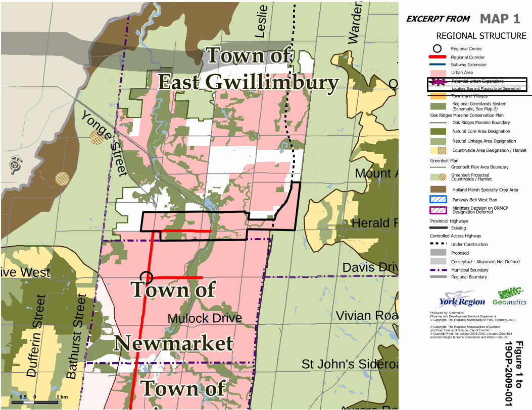
policies. 2. That Map 1 – Regional Structure as shown on Figure 1 following is amended:
a. By deleting the magenta coloured asterisk in the Town of East Gwillimbury; b. By deleting the legend reference to “Potential Urban Expansions Location,
Size and Phasing to be determined” and the asterisk in the legend. c. By designating the lands outlined in black and coloured pink within the
Town of East Gwillimbury as Urban Area and continuing to identify lands within the subject lands as part of the Regional Greenlands System and a Regional Corridor.
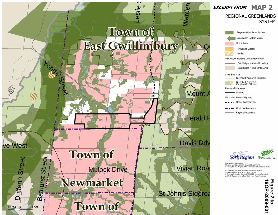
3. That Map 2 - Regional Greenlands System as shown on Figure 2 following is
amended by designating the lands outlined in black and coloured pink within the Town of East Gwillimbury as Urban Area and continuing to identify lands within the subject lands as part of the Regional Greenlands System.
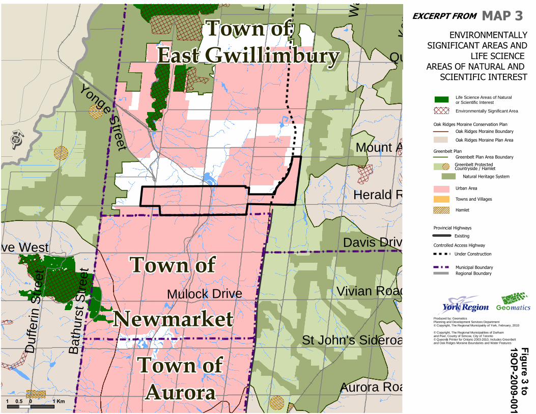
4. That Map 3 - Environmentally Significant Areas and Life Science Areas of
Natural and Scientific Interest as shown on Figure 3 following is amended by designating the lands outlined in black and coloured pink within the Town of East Gwillimbury as Urban Area.
4
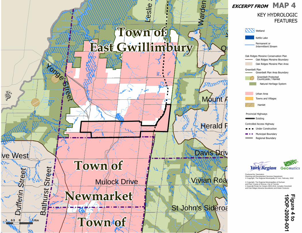
5. That Map 4 – Key Hydrologic Features as shown on Figure 4 following is
amended by designating the lands outlined in black and coloured pink within the Town of East Gwillimbury as Urban Area and continuing to identify Wetlands and Permanent or Intermittent Streams within the subject lands.
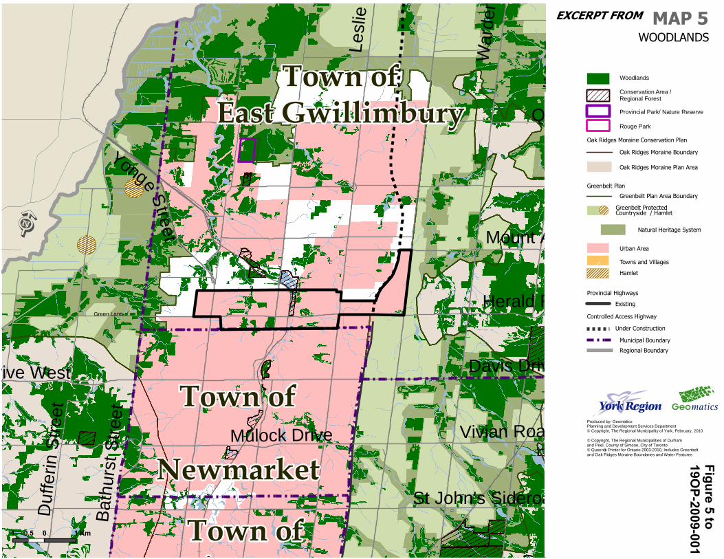
6. That Map 5 – Woodlands as shown on Figure 5 following is amended by
designating the lands outlined in black and coloured pink within the Town of East Gwillimbury as Urban Area and continuing to identify Woodlands and Conservation Areas/Regional Forest within the subject lands.
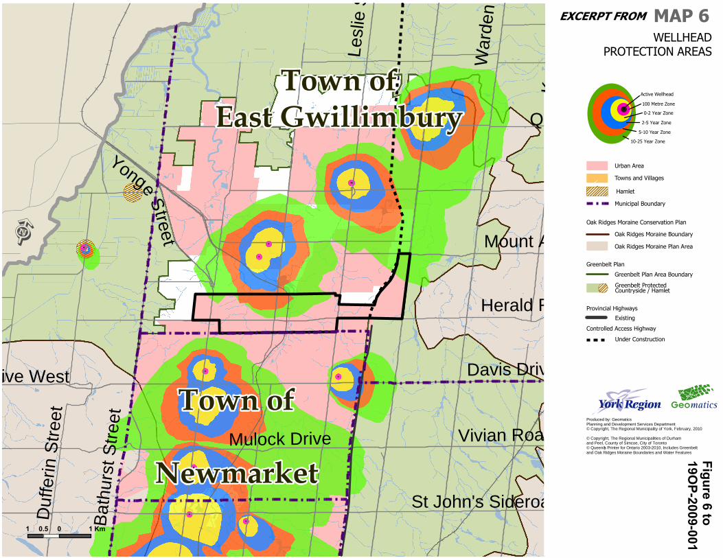
7. That Map 6 – Wellhead Protection Areas as shown on Figure 6 following is
amended by designating the lands outlined in black and coloured pink within the Town of East Gwillimbury as Urban Area and continuing to identify lands within the subject lands as part of the Wellhead Protection Area.
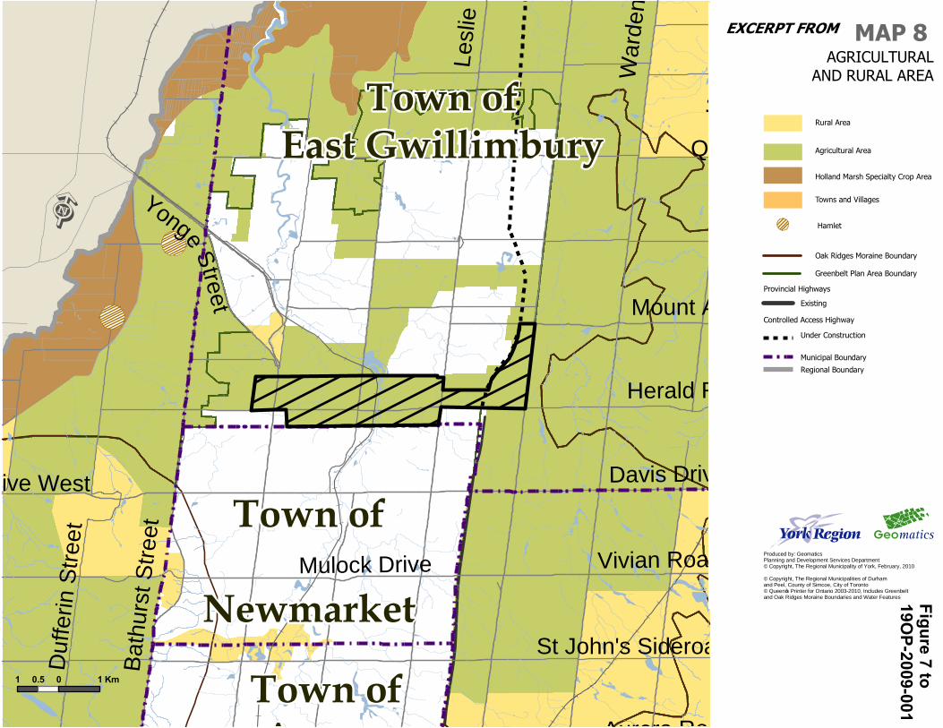
8. That Map 8 – Agricultural and Rural Areas as shown on Figure 7 following is
amended by deleting the lands hatched in black from the Agricultural Area in the Town of East Gwillimbury.
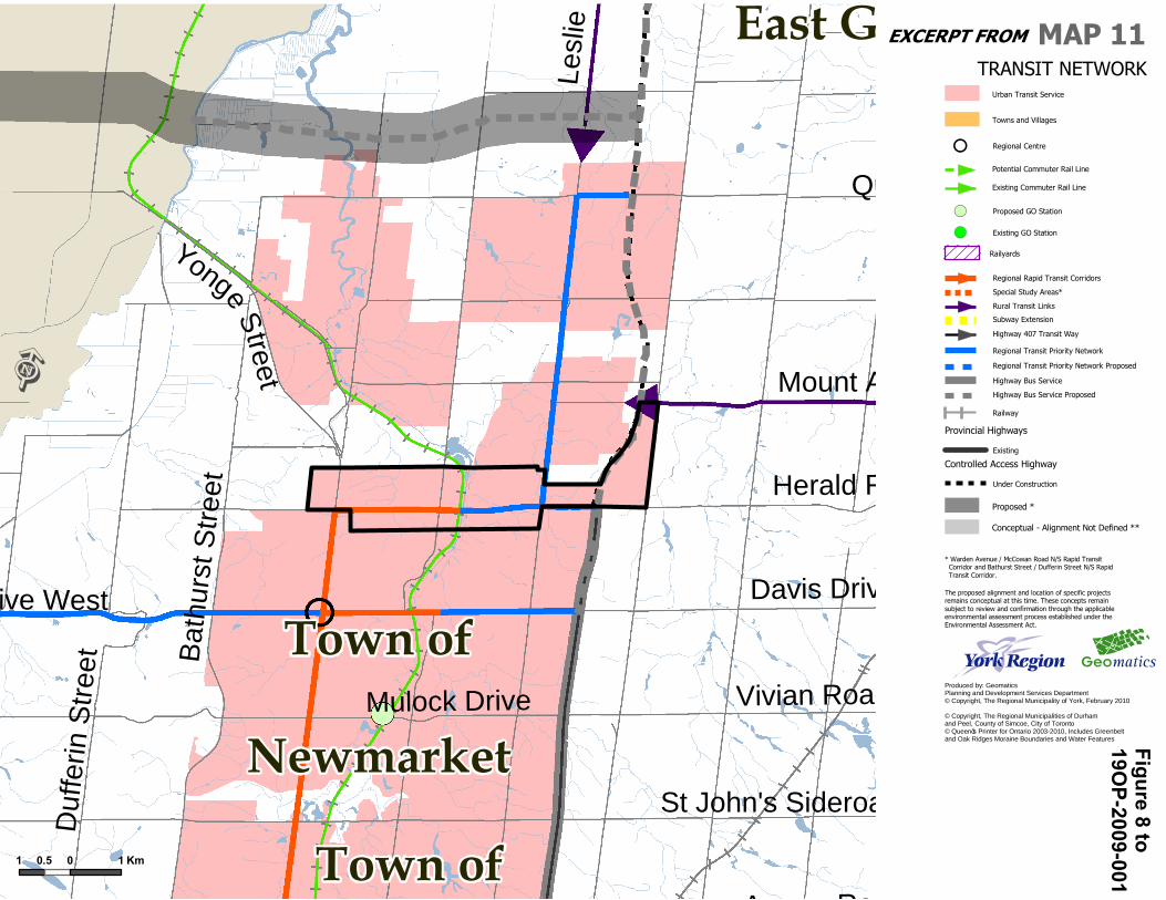
9. That Map 11 Transit Network as shown on Figure 8 following is amended by
designating the lands outlined in black and coloured pink within the Town of East Gwillimbury as Urban Area and continuing to identify Regional Rapid Transit Corridors and Regional Transit Priority Network and Existing Commuter Rail Line within the subject lands.
P07 - Planning Committee\2010\March\Proposed ROPA 1 - East Gwillimbury Urban Expansion.doc
+
Town ofEast Gwillimbury
Town ofAurora
Town of
Newmarket
Davis Drive West Davis Drive
Vivian Road
Mount Albert Road
War
den
Aven
ue
Yonge Street
Queensville Sideroad
Aurora Road
Lesl
ie S
treet
Bath
urst
Stre
et
St John's Sideroad
Duf
ferin
Stre
et
Kenn
edy
Roa
d
Herald Road
Mulock Drive
Ë
1 0 10.5 km
MAP 1REGIONAL STRUCTURE
Regional Corridor
Regional Centre+
Produced by: GeomaticsPlanning and Development Services Department© Copyright, The Regional Municipality of York, February, 2010
© Copyright, The Regional Municipalities of Durham and Peel, County of Simcoe, City of Toronto© Queen’s Printer for Ontario 2003-2010, Includes Greenbelt and Oak Ridges Moraine Boundaries and Water Features
Under Construction
Existing
Conceptual - Alignment Not Defined
Proposed
Provincial Highways
Municipal Boundary
Regional Boundary
Oak Ridges Moraine Boundary
Natural Core Area Designation
Natural Linkage Area Designation
Oak Ridges Moraine Conservation Plan
Countryside Area Designation / Hamlet
Greenbelt Protected Countryside / Hamlet
Greenbelt PlanGreenbelt Plan Area Boundary
Towns and Villages
Urban Area
Subway Extension
Controlled Access Highway
Ministers Decision on ORMCPDesignation Deferred
Potential Urban Expansions
Location, Size and Phasing to be Determined
Regional Greenlands System(Schematic, See Map 2)
Parkway Belt West Plan
Holland Marsh Specialty Crop Area
Figure 1 to19O
P-2009-001EXCERPT FROM
Town ofEast Gwillimbury
Town ofAurora
Town of
Newmarket
Davis Drive West Davis Drive
Vivian Road
Mount Albert Road
War
den
Aven
ue
Yonge Street
Queensville Sideroad
Aurora Road
Lesl
ie S
treet
Bath
urst
Stre
et
St John's Sideroad
Duf
ferin
Stre
et
Kenn
edy
Roa
d
Herald Road
Mulock Drive
Ë
1 0 10.5 Km
MAP 2
Produced by: GeomaticsPlanning and Development Services Department© Copyright, The Regional Municipality of York, February, 2010
© Copyright, The Regional Municipalities of Durham and Peel, County of Simcoe, City of Toronto© Queen’s Printer for Ontario 2003-2010, Includes Greenbelt and Oak Ridges Moraine Boundaries and Water Features
Under Construction
Existing
Provincial Highways
Municipal Boundary
Controlled Access Highway
REGIONAL GREENLANDSSYSTEM
Regional Greenlands System
Greenbelt PlanGreenbelt Plan Area Boundary
Towns and Villages
Urban Area
Greenlands System Vision
Oak Ridges Moraine Boundary
Oak Ridges Moraine Conservation Plan
Oak Ridges Moraine Plan Area
Hamlet
Regional Boundary
Greenbelt ProtectedCountryside / Hamlet
1:52,642
Figure 2 to19O
P-2009-001EXCERPT FROM
Town ofEast Gwillimbury
Town ofAurora
Town of
Newmarket
Davis Drive West Davis Drive
Vivian Road
Mount Albert Road
War
den
Aven
ue
Yonge Street
Queensville Sideroad
Aurora Road
Lesl
ie S
treet
Bath
urst
Stre
et
St John's Sideroad
Duf
ferin
Stre
et
Kenn
edy
Roa
d
Herald Road
Mulock Drive
Ë
1 0 10.5 Km
Produced by: GeomaticsPlanning and Development Services Department© Copyright, The Regional Municipality of York, February, 2010
© Copyright, The Regional Municipalities of Durham and Peel, County of Simcoe, City of Toronto© Queen’s Printer for Ontario 2003-2010, Includes Greenbelt and Oak Ridges Moraine Boundaries and Water Features
MAP 3ENVIRONMENTALLY
SIGNIFICANT AREAS ANDLIFE SCIENCE
AREAS OF NATURAL AND SCIENTIFIC INTEREST
Life Science Areas of Naturalor Scientific Interest
Environmentally Significant Area
Regional Boundary
Oak Ridges Moraine Boundary
Oak Ridges Moraine Conservation Plan
Oak Ridges Moraine Plan Area
Natural Heritage System
Greenbelt PlanGreenbelt Plan Area Boundary
Towns and Villages
Urban Area
Municipal Boundary
Under Construction
Existing
Provincial Highways
Controlled Access Highway
Hamlet
Greenbelt Protected Countryside / Hamlet
Figure 3 to19O
P-2009-001EXCERPT FROM
Town ofEast Gwillimbury
Town ofAurora
Town of
Newmarket
Davis Drive West Davis Drive
Vivian Road
Mount Albert Road
War
den
Aven
ue
Yonge Street
Queensville Sideroad
Aurora Road
Lesl
ie S
treet
Bath
urst
Stre
et
St John's Sideroad
Duf
ferin
Stre
et
Kenn
edy
Roa
d
Herald Road
Mulock Drive
Ë
1 0 10.5 Km
Produced by: GeomaticsPlanning and Development Services Department© Copyright, The Regional Municipality of York, February, 2010
© Copyright, The Regional Municipalities of Durham and Peel, County of Simcoe, City of Toronto© Queen’s Printer for Ontario 2003-2010, Includes Greenbelt and Oak Ridges Moraine Boundaries and Water Features
MAP 4KEY HYDROLOGIC
FEATURES
Wetland
Kettle Lake
Permanent or Intermittent Stream
Regional Boundary
Oak Ridges Moraine BoundaryOak Ridges Moraine Conservation Plan
Oak Ridges Moraine Plan Area
Natural Heritage System
Greenbelt PlanGreenbelt Plan Area Boundary
Towns and Villages
Urban Area
Municipal Boundary
Under Construction
Existing
Provincial Highways
Controlled Access Highway
Hamlet
Greenbelt ProtectedCountryside / Hamlet
Figure 4 to19O
P-2009-001EXCERPT FROM
Green Lane
Town ofEast Gwillimbury
Town ofAurora
Town of
Newmarket
Davis Drive West Davis Drive
Vivian Road
Mount Albert Road
War
den
Aven
ue
Yonge Street
Queensville Sideroad
Aurora Road
Lesl
ie S
treet
Bath
urst
Stre
et
St John's Sideroad
Duf
ferin
Stre
et
Kenn
edy
Roa
d
Herald Road
Mulock Drive
Ë
1 0 10.5 Km
Produced by: GeomaticsPlanning and Development Services Department© Copyright, The Regional Municipality of York, February, 2010
© Copyright, The Regional Municipalities of Durham and Peel, County of Simcoe, City of Toronto© Queen’s Printer for Ontario 2003-2010, Includes Greenbelt and Oak Ridges Moraine Boundaries and Water Features
MAP 5WOODLANDS
Conservation Area /Regional Forest
Woodlands
Municipal Boundary
Regional Boundary
Oak Ridges Moraine Boundary
Oak Ridges Moraine Conservation Plan
Oak Ridges Moraine Plan Area
Natural Heritage System
Greenbelt Plan
Greenbelt Plan Area Boundary
Towns and Villages
Urban Area
Rouge Park
Under Construction
Existing
Provincial Highways
Controlled Access Highway
Hamlet
Greenbelt Protected Countryside / Hamlet
Provincial Park/ Nature Reserve
Figure 5 to19O
P-2009-001EXCERPT FROM
!!
!!
!
!
!
!
!!
!
!
!
!!
!
Town ofEast Gwillimbury
Town of
Newmarket
Davis Drive West Davis Drive
Vivian Road
Mount Albert Road
War
den
Aven
ue
Yonge Street
Queensville Sideroad
Aurora Road
Lesl
ie S
treet
Bath
urst
Stre
et
St John's Sideroad
Duf
ferin
Stre
et
Kenn
edy
Roa
d
Herald Road
Mulock Drive
Ë
1 0 10.5 Km
Produced by: GeomaticsPlanning and Development Services Department© Copyright, The Regional Municipality of York, February, 2010
© Copyright, The Regional Municipalities of Durham and Peel, County of Simcoe, City of Toronto© Queen’s Printer for Ontario 2003-2010, Includes Greenbelt and Oak Ridges Moraine Boundaries and Water Features
MAP 6WELLHEAD
PROTECTION AREAS
0-2 Year Zone
5-10 Year Zone
10-25 Year Zone
100 Metre Zone
Active Wellhead
2-5 Year Zone
!.
Municipal Boundary
Towns and Villages
Urban Area
Oak Ridges Moraine Boundary
Oak Ridges Moraine Conservation Plan
Oak Ridges Moraine Plan Area
Under Construction
Existing
Provincial Highways
Controlled Access Highway
Greenbelt Plan
Greenbelt Plan Area Boundary
Hamlet
Greenbelt Protected Countryside / Hamlet
Figure 6 to19O
P-2009-001EXCERPT FROM
Town ofEast Gwillimbury
Town ofAurora
Town of
Newmarket
Davis Drive West Davis Drive
Vivian Road
Mount Albert Road
War
den
Aven
ue
Yonge Street
Queensville Sideroad
Aurora Road
Lesl
ie S
treet
Bath
urst
Stre
et
St John's Sideroad
Duf
ferin
Stre
et
Kenn
edy
Roa
d
Herald Road
Mulock Drive
Ë
1 0 10.5 Km
Produced by: GeomaticsPlanning and Development Services Department© Copyright, The Regional Municipality of York, February, 2010
© Copyright, The Regional Municipalities of Durham and Peel, County of Simcoe, City of Toronto© Queen’s Printer for Ontario 2003-2010, Includes Greenbelt and Oak Ridges Moraine Boundaries and Water Features
Under Construction
Existing
Provincial Highways
Municipal Boundary
Regional Boundary
Controlled Access Highway
MAP 8AGRICULTURAL
AND RURAL AREA
Holland Marsh Specialty Crop Area
Rural Area
Agricultural Area
Oak Ridges Moraine Boundary
Greenbelt Plan Area Boundary
Towns and Villages
Hamlet
Figure 7 to19O
P-2009-001EXCERPT FROM
East Gwillimbury
Town ofAurora
Town of
Newmarket
Davis Drive West Davis Drive
Vivian Road
Mount Albert Road
Yonge Street
Queensville Sideroad
Aurora Road
Lesl
ie S
treet
Bath
urst
Stre
et
St John's Sideroad
Duf
ferin
Stre
et
Herald Road
Mulock Drive
Ë
1 0 10.5 Km
Produced by: GeomaticsPlanning and Development Services Department© Copyright, The Regional Municipality of York, February 2010
© Copyright, The Regional Municipalities of Durham and Peel, County of Simcoe, City of Toronto© Queen’s Printer for Ontario 2003-2010, Includes Greenbelt and Oak Ridges Moraine Boundaries and Water Features
MAP 11TRANSIT NETWORK
Regional Centre+
Urban Transit Service
Towns and Villages
Potential Commuter Rail Line
Existing Commuter Rail Line
Proposed GO Station!(
Existing GO Station!(
Highway 407 Transit Way
Regional Transit Priority Network
Rural Transit Links
Railway
Railyards
Subway Extension
Regional Transit Priority Network Proposed
Highway Bus Service
Highway Bus Service Proposed
Under Construction
Existing
Provincial Highways
Controlled Access Highway
The proposed alignment and location of specific projectsremains conceptual at this time. These concepts remain subject to review and confirmation through the applicableenvironmental assessment process established under theEnvironmental Assessment Act.
Regional Rapid Transit Corridors
Special Study Areas*
* Warden Avenue / McCowan Road N/S Rapid Transit Corridor and Bathurst Street / Dufferin Street N/S Rapid Transit Corridor.
Proposed *
Conceptual - Alignment Not Defined **
Figure 8 to19O
P-2009-001EXCERPT FROM