project concept report – page 2 p.i. number: 722030 reports... · urban collector & minor...
TRANSCRIPT
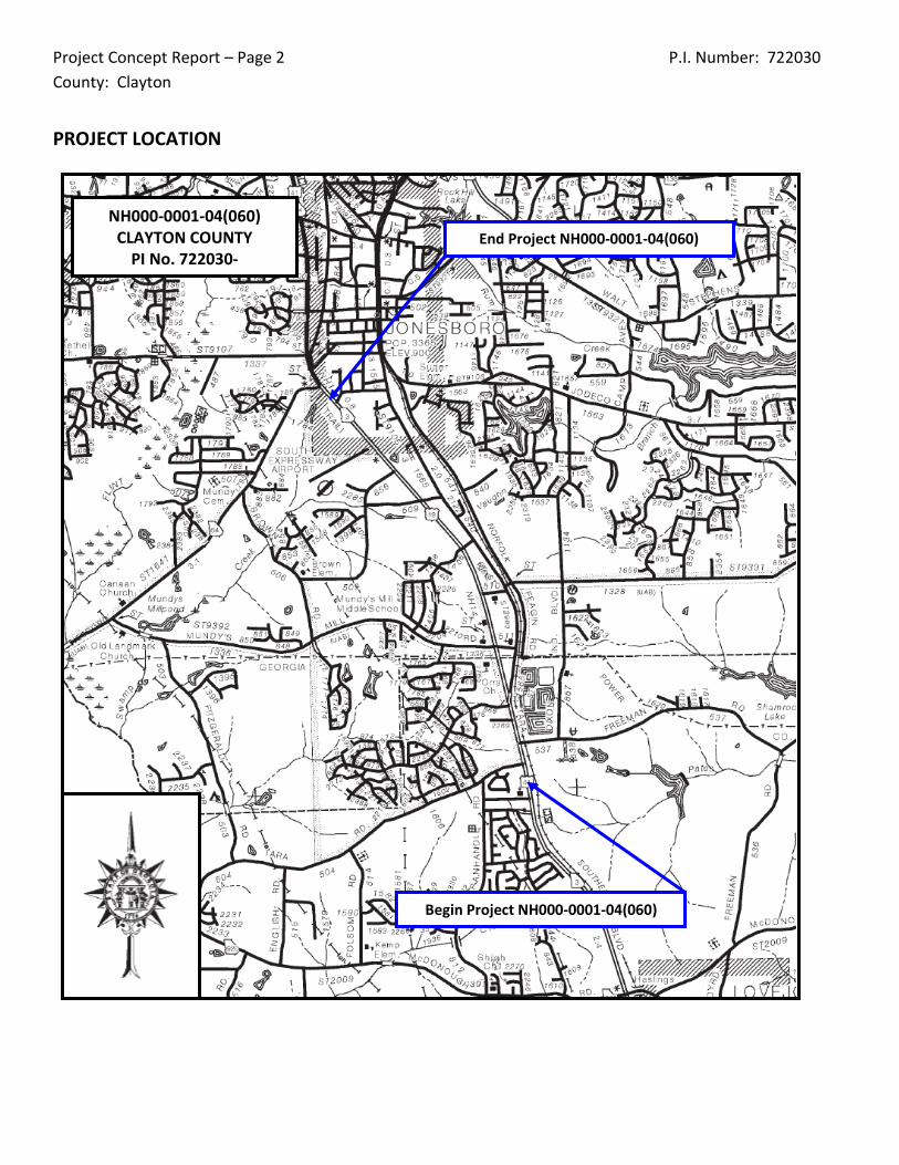
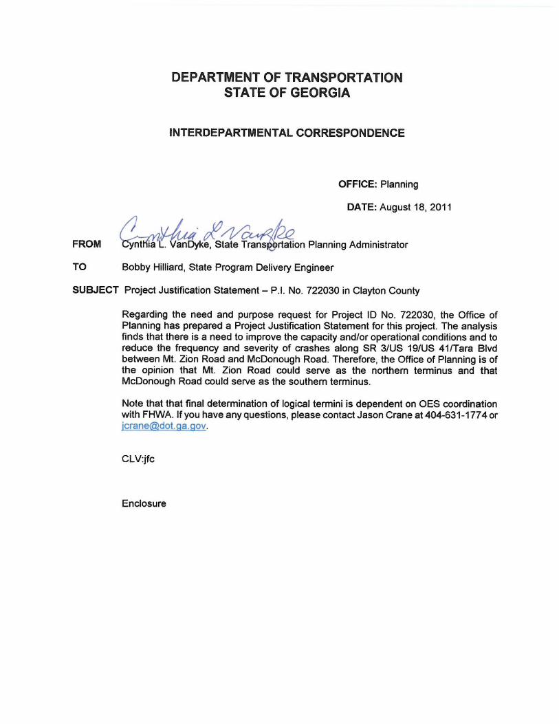
Project Concept Report – Page 2 P.I. Number: 722030 County: Clayton
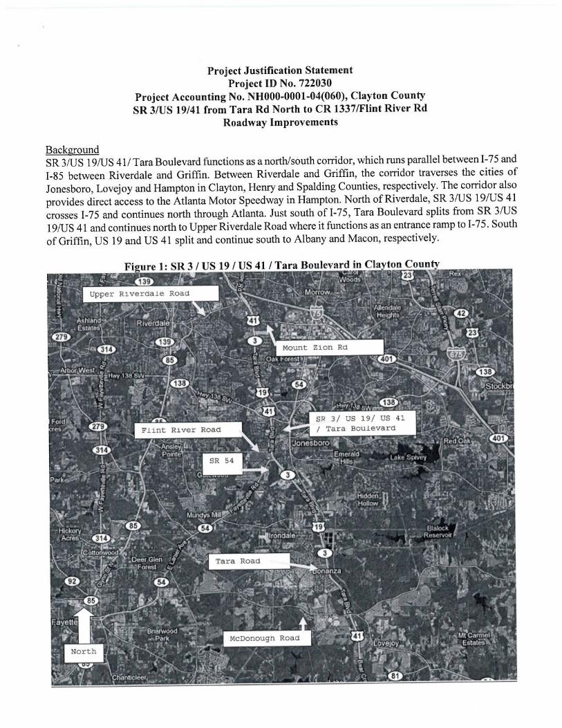
PROJECT LOCATION
NH000-0001-04(060) CLAYTON COUNTY
PI No. 722030- End Project NH000-0001-04(060)
Begin Project NH000-0001-04(060)
Project Concept Report – Page 3 P.I. Number: 722030 County: Clayton
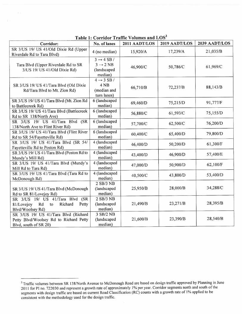
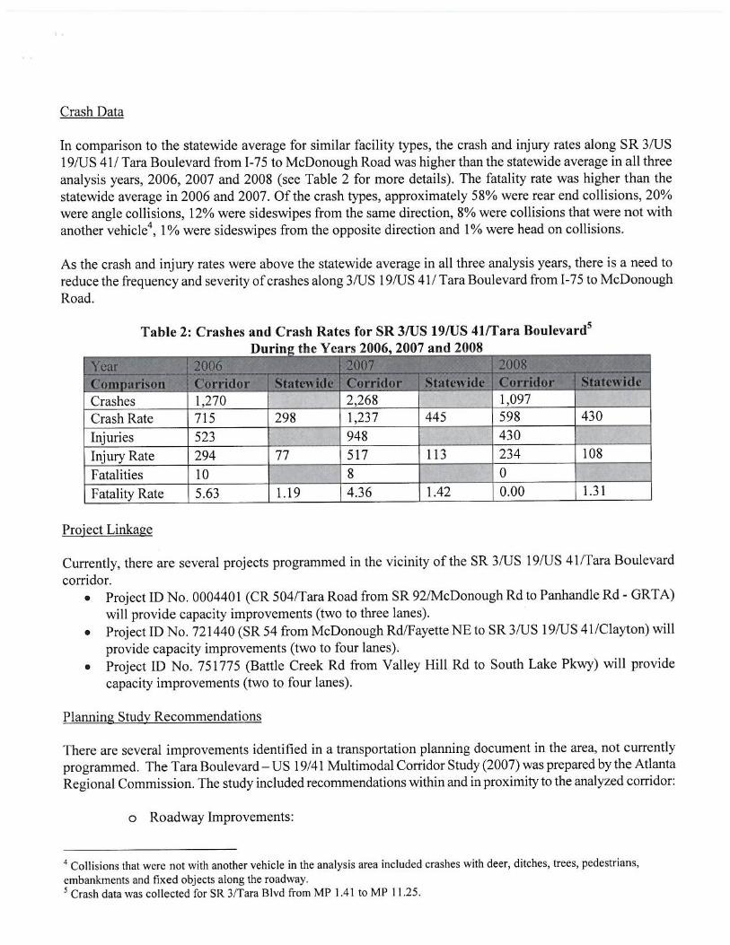
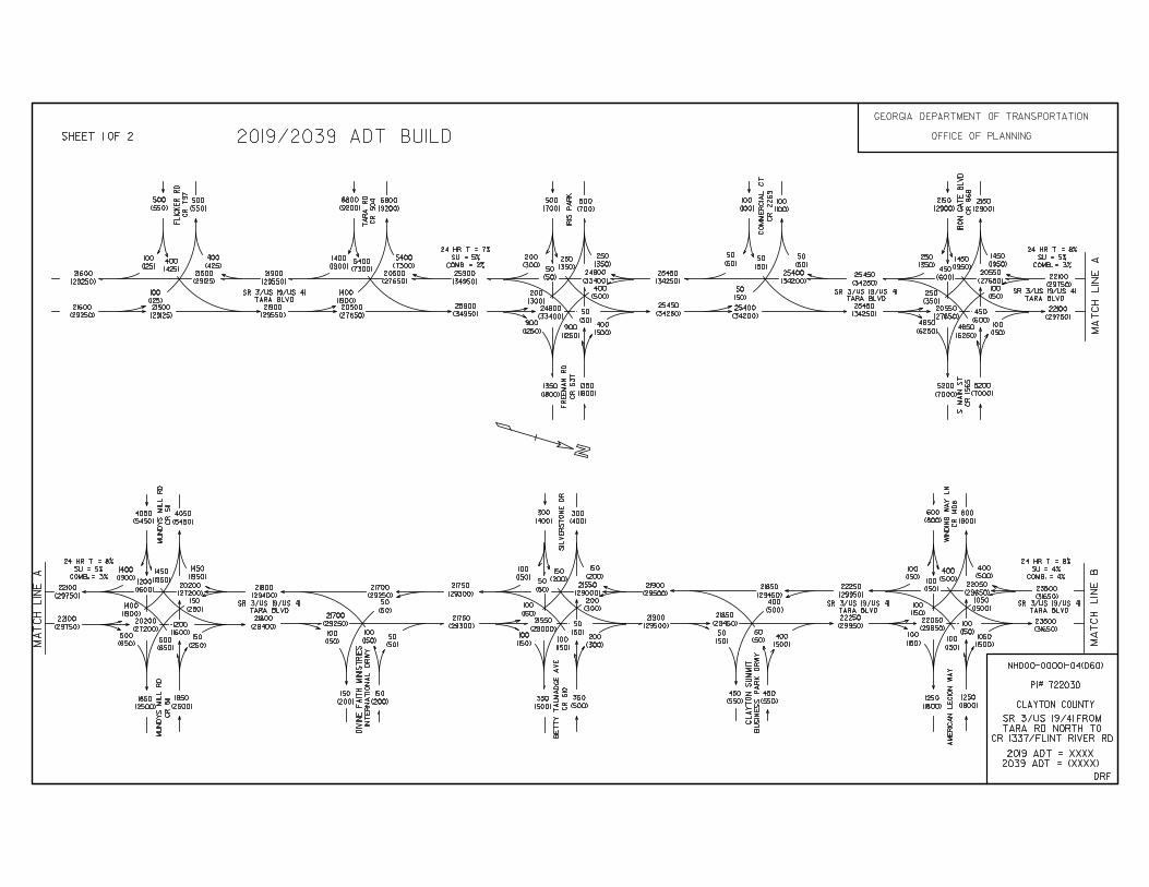
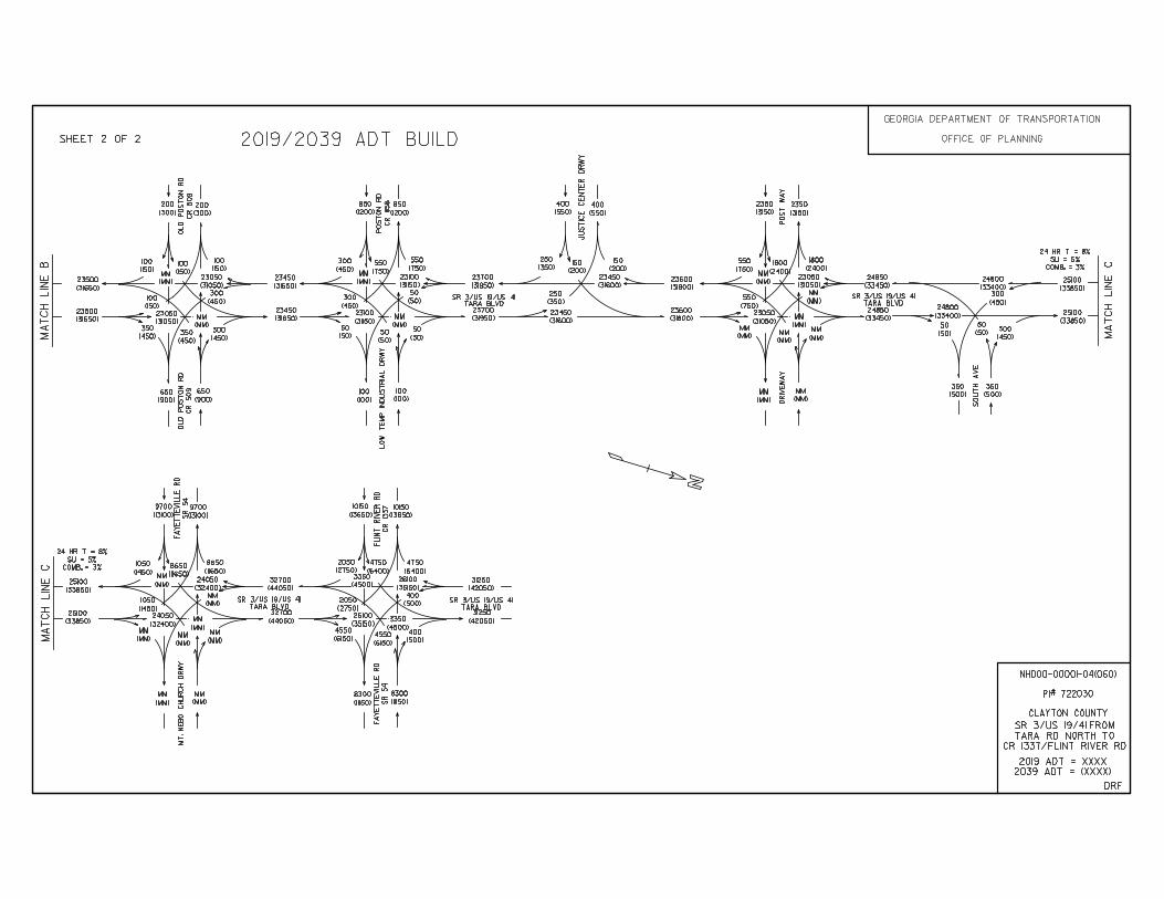
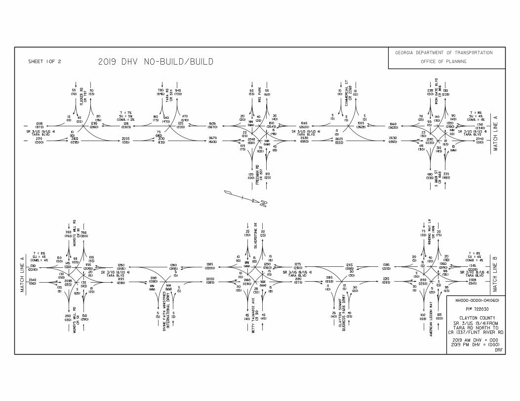
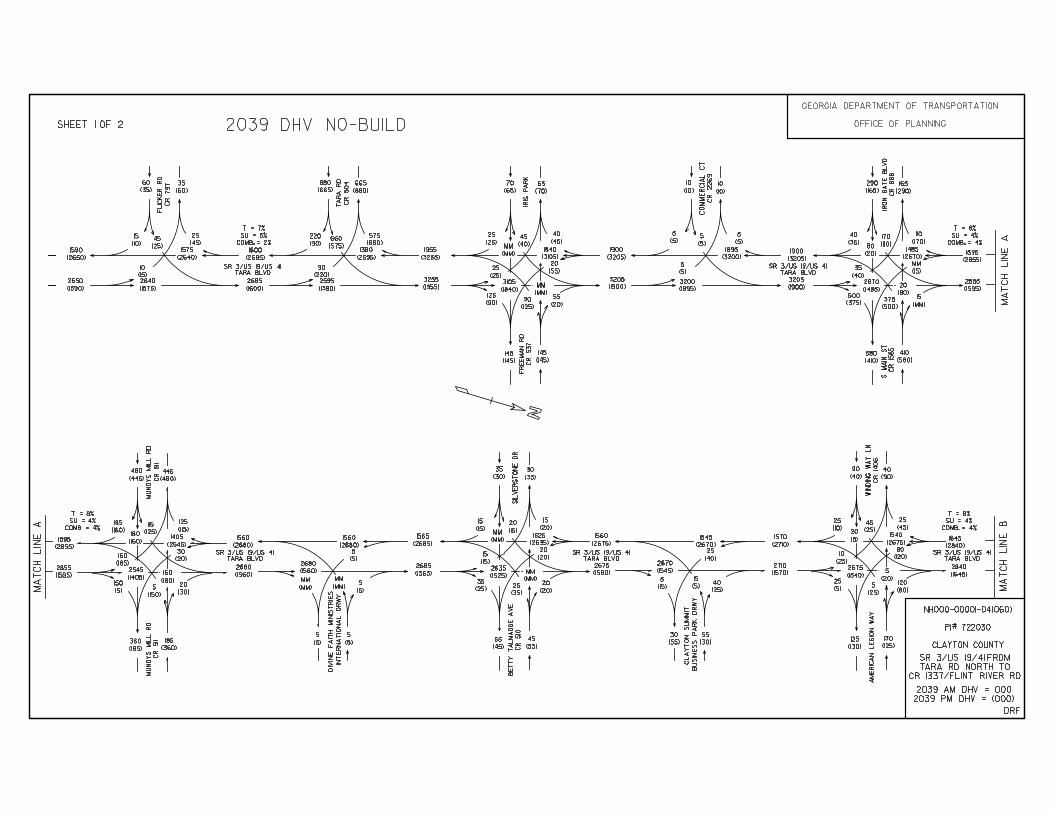
PLANNING & BACKGROUND DATA Project Justification Statement: There is a need to reduce the frequency and severity of crashes along SR 3/US 19/US 41/Tara Boulevard from Mt. Zion Road to McDonough Road where the crash and injury rates were above the statewide average between the years 2006 and 2008. There is also a need to improve the capacity and/or operations of SR3/US19/US 41/Tara Boulevard corridor from Mt. Zion Road to McDonough Road where level of service (LOS) is anticipated to range between ‘D’ and ‘F’ in the future year conditions (2039). Please see the attached Project Justification Statement for more information. Description of the proposed project: Project NH000-0001-04(060) consists of the widening and reconstruction of 3.32 miles of the US 19/41/SR 3 existing 4-lane rural section into a 6-lane urban section. The project begins approximately 1355’ south of the Tara Road intersection just south of CR 54/ and ends before the intersection of SR 54 at US 19/41/SR 3. The project lies entirely within Clayton County beginning approximately 2 miles north of Lovejoy and ending in Jonesboro. The project extends the existing 6-lane section from just south of SR 54 southward until Tara Road where the traffic volumes decrease by 15 percent. Federal Oversight: Full Oversight Exempt State Funded Other MPO: Atlanta Regional Commission (ARC) MPO Project ID CL-AR-247 Regional Commission:Atlanta Regional Commission RC Project ID N/A Congressional District(s): 13 Projected Traffic: ADT Current Year (2011): 60,400 Open Year (2019): 65,400 Design Year (2039): 88,100 Traffic Projections Performed by: GDOT Office or Planning Functional Classification (Mainline): Urban Principal Arterial Is this a 3R (Resurfacing, Restoration, & Rehabilitation) Project? No Yes
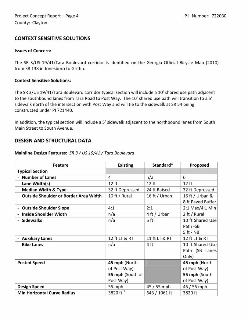
Project Concept Report – Page 4 P.I. Number: 722030 County: Clayton
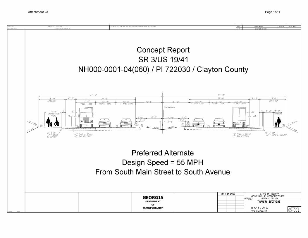
CONTEXT SENSITIVE SOLUTIONS Issues of Concern: The SR 3/US 19/41/Tara Boulevard corridor is identified on the Georgia Official Bicycle Map (2010) from SR 138 in Jonesboro to Griffin. Context Sensitive Solutions: The SR 3/US 19/41/Tara Boulevard corridor typical section will include a 10’ shared use path adjacent to the southbound lanes from Tara Road to Post Way. The 10’ shared use path will transition to a 5’ sidewalk north of the intersection with Post Way and will tie to the sidewalk at SR 54 being constructed under PI 721440. In addition, the typical section will include a 5’ sidewalk adjacent to the northbound lanes from South Main Street to South Avenue. DESIGN AND STRUCTURAL DATA Mainline Design Features: SR 3 / US 19/41 / Tara Boulevard
Feature Existing Standard* Proposed Typical Section - Number of Lanes 4 n/a 6 - Lane Width(s) 12 ft 12 ft 12 ft - Median Width & Type 32 ft Depressed 24 ft Raised 32 ft Depressed - Outside Shoulder or Border Area Width 10 ft / Rural 16 ft / Urban 16 ft / Urban &
8 ft Paved Buffer - Outside Shoulder Slope 4:1 2:1 2:1 Max/4:1 Min - Inside Shoulder Width n/a 4 ft / Urban 2 ft / Rural - Sidewalks n/a 5 ft 10 ft Shared Use
Path -SB 5 ft - NB
- Auxiliary Lanes 12 ft LT & RT 11 ft LT & RT 12 ft LT & RT - Bike Lanes n/a 4 ft 10 ft Shared Use
Path (SB Lanes Only)
Posted Speed 45 mph (North of Post Way) 55 mph (South of Post Way)
45 mph (North of Post Way) 55 mph (South of Post Way)
Design Speed 55 mph 45 / 55 mph 45 / 55 mph Min Horizontal Curve Radius 3820 ft 1 643 / 1061 ft 3820 ft
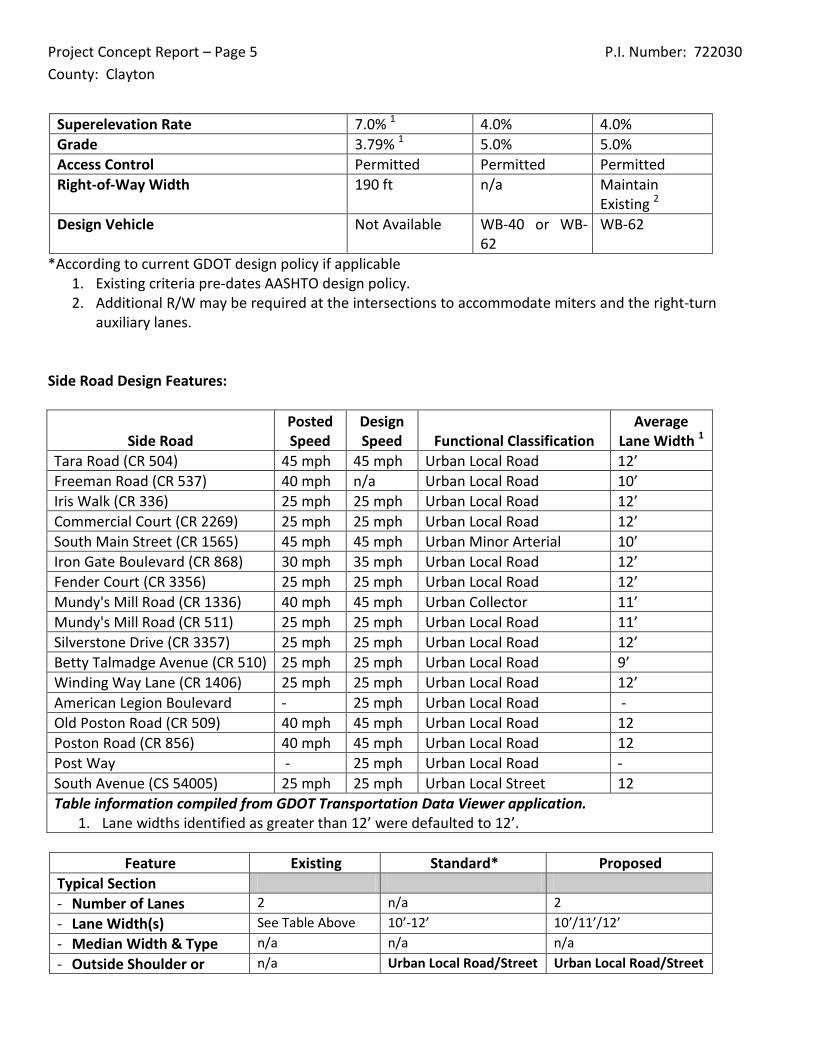
Project Concept Report – Page 5 P.I. Number: 722030 County: Clayton
Superelevation Rate 7.0% 1 4.0% 4.0% Grade 3.79% 1 5.0% 5.0% Access Control Permitted Permitted Permitted Right-of-Way Width 190 ft n/a Maintain
Existing 2 Design Vehicle Not Available WB-40 or WB-
62 WB-62
*According to current GDOT design policy if applicable 1. Existing criteria pre-dates AASHTO design policy. 2. Additional R/W may be required at the intersections to accommodate miters and the right-turn
auxiliary lanes. Side Road Design Features:
Side Road Posted Speed
Design Speed Functional Classification
Average Lane Width 1
Tara Road (CR 504) 45 mph 45 mph Urban Local Road 12’ Freeman Road (CR 537) 40 mph n/a Urban Local Road 10’ Iris Walk (CR 336) 25 mph 25 mph Urban Local Road 12’ Commercial Court (CR 2269) 25 mph 25 mph Urban Local Road 12’ South Main Street (CR 1565) 45 mph 45 mph Urban Minor Arterial 10’ Iron Gate Boulevard (CR 868) 30 mph 35 mph Urban Local Road 12’ Fender Court (CR 3356) 25 mph 25 mph Urban Local Road 12’ Mundy's Mill Road (CR 1336) 40 mph 45 mph Urban Collector 11’ Mundy's Mill Road (CR 511) 25 mph 25 mph Urban Local Road 11’ Silverstone Drive (CR 3357) 25 mph 25 mph Urban Local Road 12’ Betty Talmadge Avenue (CR 510) 25 mph 25 mph Urban Local Road 9’ Winding Way Lane (CR 1406) 25 mph 25 mph Urban Local Road 12’ American Legion Boulevard - 25 mph Urban Local Road - Old Poston Road (CR 509) 40 mph 45 mph Urban Local Road 12 Poston Road (CR 856) 40 mph 45 mph Urban Local Road 12 Post Way - 25 mph Urban Local Road - South Avenue (CS 54005) 25 mph 25 mph Urban Local Street 12 Table information compiled from GDOT Transportation Data Viewer application.
1. Lane widths identified as greater than 12’ were defaulted to 12’.
Feature Existing Standard* Proposed Typical Section - Number of Lanes 2 n/a 2 - Lane Width(s) See Table Above 10’-12’ 10’/11’/12’ - Median Width & Type n/a n/a n/a - Outside Shoulder or n/a Urban Local Road/Street Urban Local Road/Street
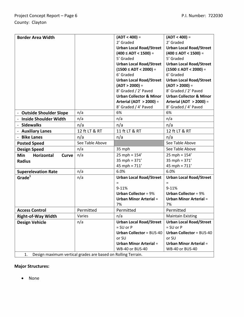
Project Concept Report – Page 6 P.I. Number: 722030 County: Clayton
Border Area Width (ADT < 400) = 2’ Graded Urban Local Road/Street (400 ≤ ADT < 1500) = 5’ Graded Urban Local Road/Street (1500 ≤ ADT < 2000) = 6’ Graded Urban Local Road/Street (ADT > 2000) = 8’ Graded / 2’ Paved Urban Collector & Minor Arterial (ADT > 2000) = 8’ Graded / 4’ Paved
(ADT < 400) = 2’ Graded Urban Local Road/Street (400 ≤ ADT < 1500) = 5’ Graded Urban Local Road/Street (1500 ≤ ADT < 2000) = 6’ Graded Urban Local Road/Street (ADT > 2000) = 8’ Graded / 2’ Paved Urban Collector & Minor Arterial (ADT > 2000) = 8’ Graded / 4’ Paved
- Outside Shoulder Slope n/a 6% 6% - Inside Shoulder Width n/a n/a n/a - Sidewalks n/a n/a n/a - Auxiliary Lanes 12 ft LT & RT 11 ft LT & RT 12 ft LT & RT - Bike Lanes n/a n/a n/a Posted Speed See Table Above See Table Above Design Speed n/a 35 mph See Table Above Min Horizontal Curve Radius
n/a 25 mph = 154’ 35 mph = 371’ 45 mph = 711’
25 mph = 154’ 35 mph = 371’ 45 mph = 711’
Superelevation Rate n/a 6.0% 6.0% Grade1 n/a Urban Local Road/Street
= 9-11% Urban Collector = 9% Urban Minor Arterial = 7%
Urban Local Road/Street = 9-11% Urban Collector = 9% Urban Minor Arterial = 7%
Access Control Permitted Permitted Permitted Right-of-Way Width Varies n/a Maintain Existing Design Vehicle n/a Urban Local Road/Street
= SU or P Urban Collector = BUS-40 or SU Urban Minor Arterial = WB-40 or BUS-40
Urban Local Road/Street = SU or P Urban Collector = BUS-40 or SU Urban Minor Arterial = WB-40 or BUS-40
1. Design maximum vertical grades are based on Rolling Terrain. Major Structures:
• None
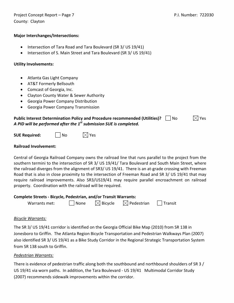
Project Concept Report – Page 7 P.I. Number: 722030 County: Clayton
Major Interchanges/Intersections:
• Intersection of Tara Road and Tara Boulevard (SR 3/ US 19/41) • Intersection of S. Main Street and Tara Boulevard (SR 3/ US 19/41)
Utility Involvements:
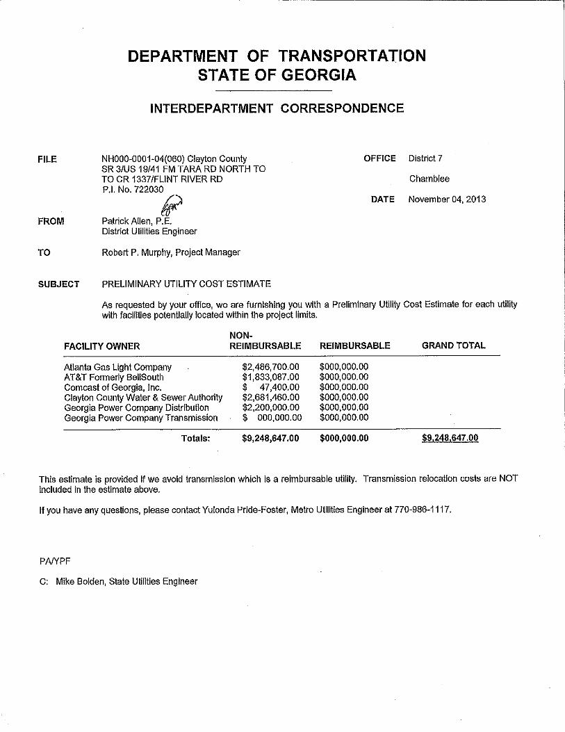
• Atlanta Gas Light Company • AT&T Formerly Bellsouth • Comcast of Georgia, Inc. • Clayton County Water & Sewer Authority • Georgia Power Company Distribution • Georgia Power Company Transmission
Public Interest Determination Policy and Procedure recommended (Utilities)? No Yes A PID will be performed after the 1st submission SUE is completed. SUE Required: No Yes Railroad Involvement: Central of Georgia Railroad Company owns the railroad line that runs parallel to the project from the southern termini to the intersection of SR 3/ US 19/41/ Tara Boulevard and South Main Street, where the railroad diverges from the alignment of SR3/ US 19/41. There is an at-grade crossing with Freeman Road that is also in close proximity to the intersection of Freeman Road and SR 3/ US 19/41 that may require railroad improvements. Also SR3/US19/41 may require parallel encroachment on railroad property. Coordination with the railroad will be required. Complete Streets - Bicycle, Pedestrian, and/or Transit Warrants:
Warrants met: None Bicycle Pedestrian Transit
Bicycle Warrants:
The SR 3/ US 19/41 corridor is identified on the Georgia Official Bike Map (2010) from SR 138 in Jonesboro to Griffin. The Atlanta Region Bicycle Transportation and Pedestrian Walkways Plan (2007) also identified SR 3/ US 19/41 as a Bike Study Corridor in the Regional Strategic Transportation System from SR 138 south to Griffin.
Pedestrian Warrants:
There is evidence of pedestrian traffic along both the southbound and northbound shoulders of SR 3 / US 19/41 via worn paths. In addition, the Tara Boulevard - US 19/41 Multimodal Corridor Study (2007) recommends sidewalk improvements within the corridor.
Project Concept Report – Page 8 P.I. Number: 722030 County: Clayton
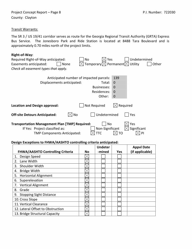
Transit Warrants:
The SR 3 / US 19/41 corridor serves as route for the Georgia Regional Transit Authority (GRTA) Express Bus Service. The Jonesboro Park and Ride Station is located at 8488 Tara Boulevard and is approximately 0.70 miles north of the project limits. Right-of-Way: Required Right-of-Way anticipated: No Yes Undetermined Easements anticipated: None Temporary Permanent Utility Other Check all easement types that apply.
Anticipated number of impacted parcels: 139 Displacements anticipated: Total: 0
Businesses: 0 Residences: 0 Other: 0
Location and Design approval: Not Required Required Off-site Detours Anticipated: No Undetermined Yes Transportation Management Plan [TMP] Required: No Yes
If Yes: Project classified as: Non-Significant Significant TMP Components Anticipated: TTC TO PI
Design Exceptions to FHWA/AASHTO controlling criteria anticipated:
FHWA/AASHTO Controlling Criteria No Undeter-mined Yes
Appvl Date (if applicable)
1. Design Speed 2. Lane Width 3. Shoulder Width 4. Bridge Width 5. Horizontal Alignment 6. Superelevation 7. Vertical Alignment 8. Grade 9. Stopping Sight Distance 10. Cross Slope 11. Vertical Clearance 12. Lateral Offset to Obstruction 13. Bridge Structural Capacity
Project Concept Report – Page 9 P.I. Number: 722030 County: Clayton
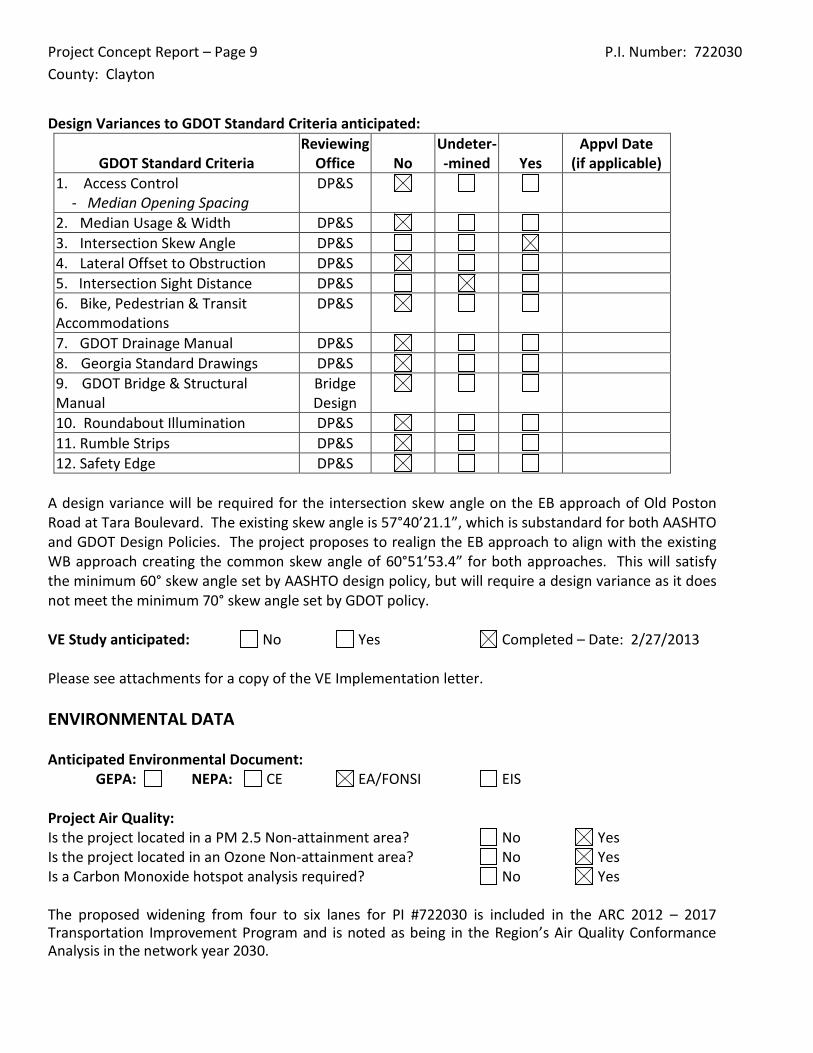
Design Variances to GDOT Standard Criteria anticipated:
GDOT Standard Criteria Reviewing
Office No Undeter--mined Yes
Appvl Date (if applicable)
1. Access Control - Median Opening Spacing
DP&S
2. Median Usage & Width DP&S 3. Intersection Skew Angle DP&S 4. Lateral Offset to Obstruction DP&S 5. Intersection Sight Distance DP&S 6. Bike, Pedestrian & Transit Accommodations
DP&S
7. GDOT Drainage Manual DP&S 8. Georgia Standard Drawings DP&S 9. GDOT Bridge & Structural Manual
Bridge Design
10. Roundabout Illumination DP&S 11. Rumble Strips DP&S 12. Safety Edge DP&S
A design variance will be required for the intersection skew angle on the EB approach of Old Poston Road at Tara Boulevard. The existing skew angle is 57°40’21.1”, which is substandard for both AASHTO and GDOT Design Policies. The project proposes to realign the EB approach to align with the existing WB approach creating the common skew angle of 60°51’53.4” for both approaches. This will satisfy the minimum 60° skew angle set by AASHTO design policy, but will require a design variance as it does not meet the minimum 70° skew angle set by GDOT policy. VE Study anticipated: No Yes Completed – Date: 2/27/2013 Please see attachments for a copy of the VE Implementation letter. ENVIRONMENTAL DATA Anticipated Environmental Document: GEPA: NEPA: CE EA/FONSI EIS Project Air Quality: Is the project located in a PM 2.5 Non-attainment area? No Yes Is the project located in an Ozone Non-attainment area? No Yes Is a Carbon Monoxide hotspot analysis required? No Yes The proposed widening from four to six lanes for PI #722030 is included in the ARC 2012 – 2017 Transportation Improvement Program and is noted as being in the Region’s Air Quality Conformance Analysis in the network year 2030.
Project Concept Report – Page 10 P.I. Number: 722030 County: Clayton
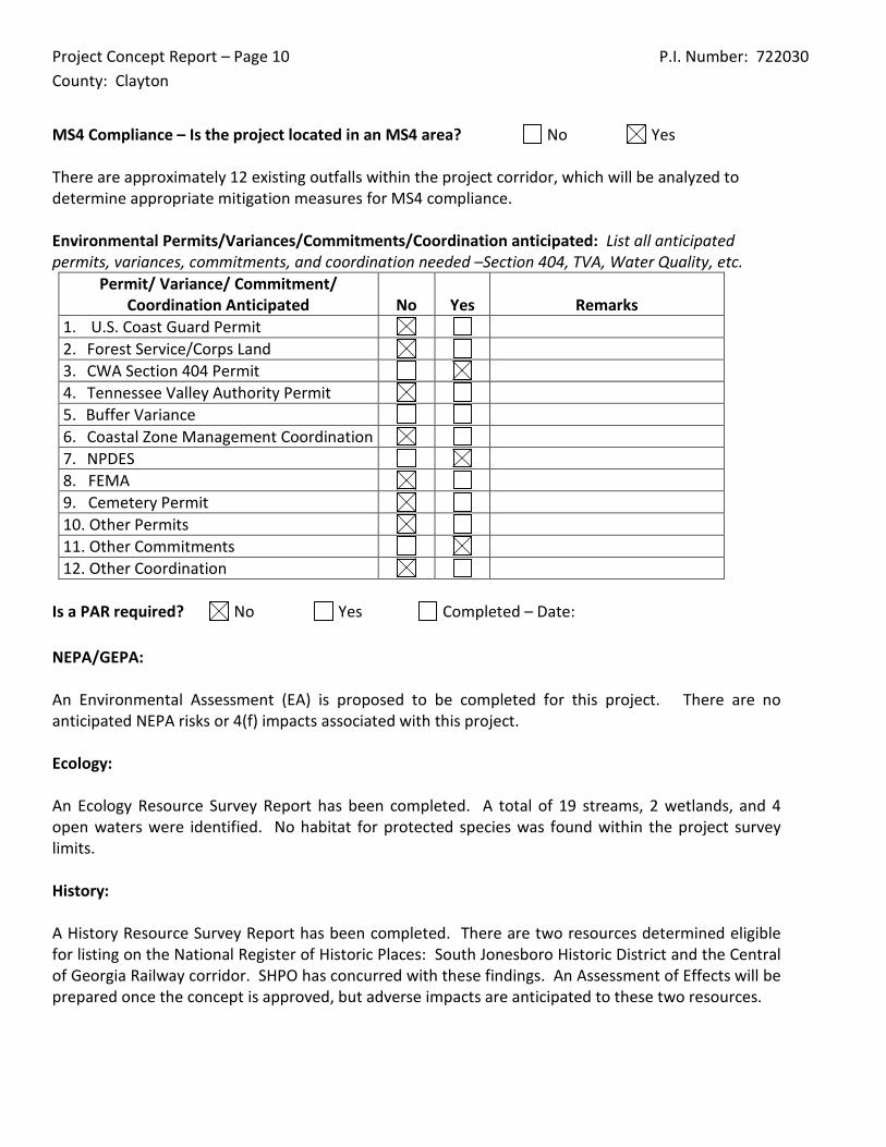
MS4 Compliance – Is the project located in an MS4 area? No Yes There are approximately 12 existing outfalls within the project corridor, which will be analyzed to determine appropriate mitigation measures for MS4 compliance. Environmental Permits/Variances/Commitments/Coordination anticipated: List all anticipated permits, variances, commitments, and coordination needed –Section 404, TVA, Water Quality, etc.
Permit/ Variance/ Commitment/ Coordination Anticipated No Yes Remarks
1. U.S. Coast Guard Permit 2. Forest Service/Corps Land 3. CWA Section 404 Permit 4. Tennessee Valley Authority Permit 5. Buffer Variance 6. Coastal Zone Management Coordination 7. NPDES 8. FEMA 9. Cemetery Permit 10. Other Permits 11. Other Commitments 12. Other Coordination
Is a PAR required? No Yes Completed – Date: NEPA/GEPA: An Environmental Assessment (EA) is proposed to be completed for this project. There are no anticipated NEPA risks or 4(f) impacts associated with this project. Ecology: An Ecology Resource Survey Report has been completed. A total of 19 streams, 2 wetlands, and 4 open waters were identified. No habitat for protected species was found within the project survey limits. History: A History Resource Survey Report has been completed. There are two resources determined eligible for listing on the National Register of Historic Places: South Jonesboro Historic District and the Central of Georgia Railway corridor. SHPO has concurred with these findings. An Assessment of Effects will be prepared once the concept is approved, but adverse impacts are anticipated to these two resources.
Project Concept Report – Page 11 P.I. Number: 722030 County: Clayton
Archeology: Archaeological field surveys have been completed and no sites eligible for listing on the National Register of Historic Places was identified within the project limits. These findings will require approval by GDOT and concurrence by SHPO. Air & Noise: A Type I Noise Impact Assessment in accordance with current GDOT Noise Policy (effective July 2011) will be prepared. The noise assessment will include noise barrier analysis for abatement of noise impacts, if applicable. An Air Assessment Report will be prepared for the project. The project is within nonattainment areas for PM2.5 and ozone. The assessment will include a Letter of Determination for PM 2.5, analysis of project impacts to PM 2.5, carbon monoxide, Mobile Source Air Toxics, and ozone. Public Involvement: A Public Information Open House (PIOH) was held October 18, 2012 at Mundy’s Mill Middle School in Jonesboro, Georgia. A total of 41 people attended the PIOH and there were 12 comments registered. The summary of comments is as follows: Number Opposed 1 Number in Support 7 Uncommitted 3 Conditional 1 Comments provided by respondents included concerns about the use of tax money on the project, property impacts, the need for additional traffic lights at Freeman Road, Iris walk, and Betty Talmadge Boulevard, and concerns about pedestrian safety, including a need for crosswalks with signals and lighting along the corridor. Upon approval of the Draft EA, a Public Hearing Open House will be held. Major stakeholders: In addition to the traveling public, major stakeholders include property owners along the corridor and Clayton County. CONSTRUCTION Issues potentially affecting constructability/construction schedule:
• The existing signalized intersections along the project corridor are coordinated with the use of pavement loops. It was noted during the Initial Concept meeting that the signals may need to
Project Concept Report – Page 12 P.I. Number: 722030 County: Clayton
be upgraded with the use of camera detection prior to any obliteration of the existing pavement or widening so that signal coordination could be maintained during construction. This would allow a minimum number of signals to be down at any given time.
Early Completion Incentives recommended for consideration: No Yes PROJECT RESPONSIBILITIES Project Activities:
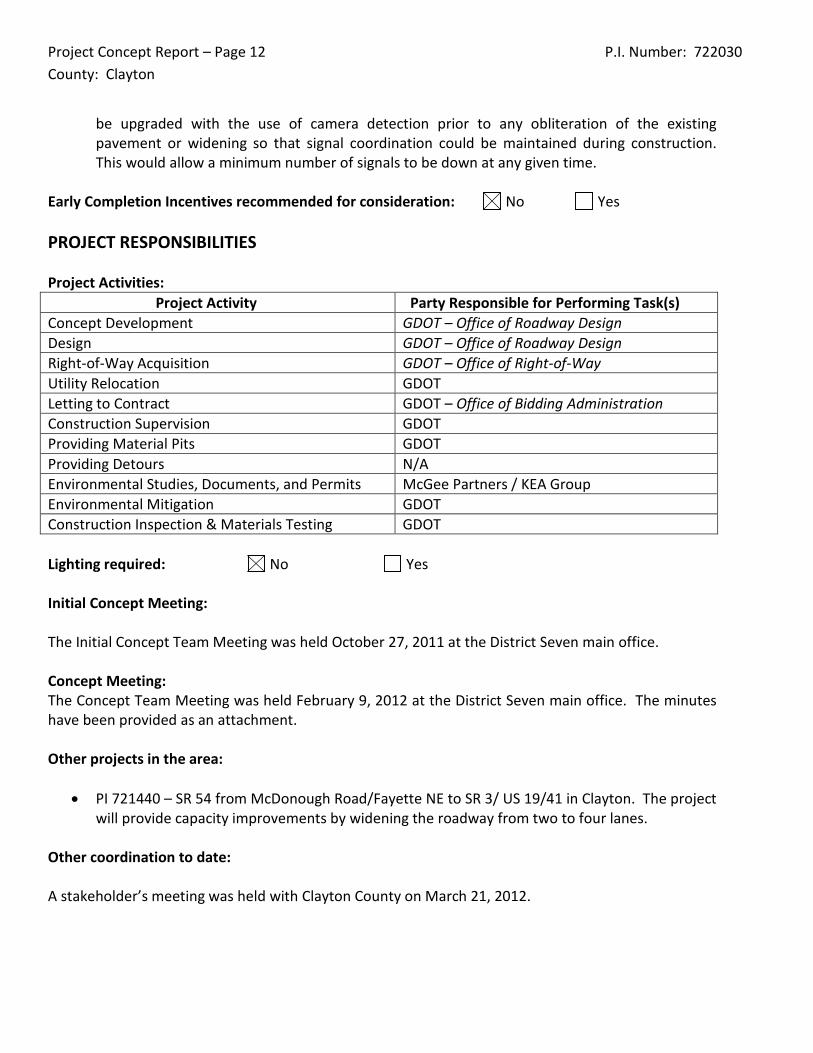
Project Activity Party Responsible for Performing Task(s) Concept Development GDOT – Office of Roadway Design Design GDOT – Office of Roadway Design Right-of-Way Acquisition GDOT – Office of Right-of-Way Utility Relocation GDOT Letting to Contract GDOT – Office of Bidding Administration Construction Supervision GDOT Providing Material Pits GDOT Providing Detours N/A Environmental Studies, Documents, and Permits McGee Partners / KEA Group Environmental Mitigation GDOT Construction Inspection & Materials Testing GDOT Lighting required: No Yes Initial Concept Meeting: The Initial Concept Team Meeting was held October 27, 2011 at the District Seven main office. Concept Meeting: The Concept Team Meeting was held February 9, 2012 at the District Seven main office. The minutes have been provided as an attachment. Other projects in the area:
• PI 721440 – SR 54 from McDonough Road/Fayette NE to SR 3/ US 19/41 in Clayton. The project will provide capacity improvements by widening the roadway from two to four lanes.
Other coordination to date: A stakeholder’s meeting was held with Clayton County on March 21, 2012.
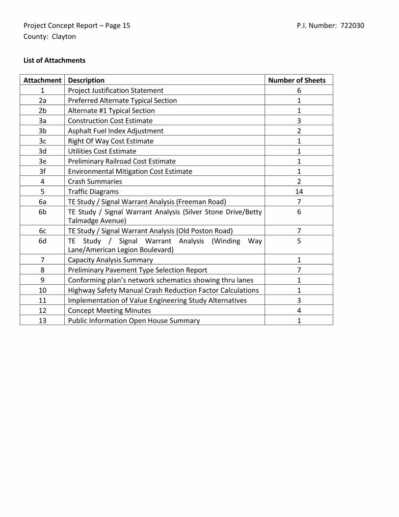
Project Concept Report – Page 15 P.I. Number: 722030 County: Clayton
List of Attachments Attachment Description Number of Sheets
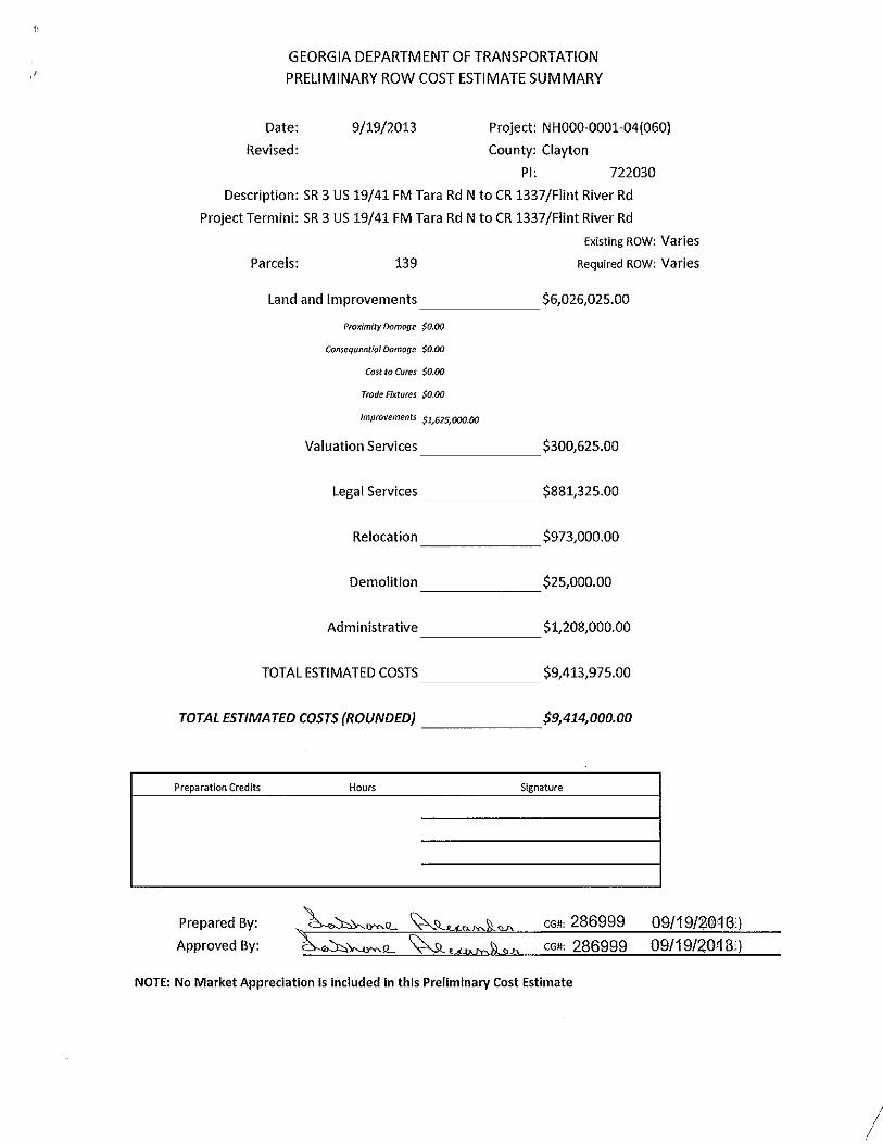
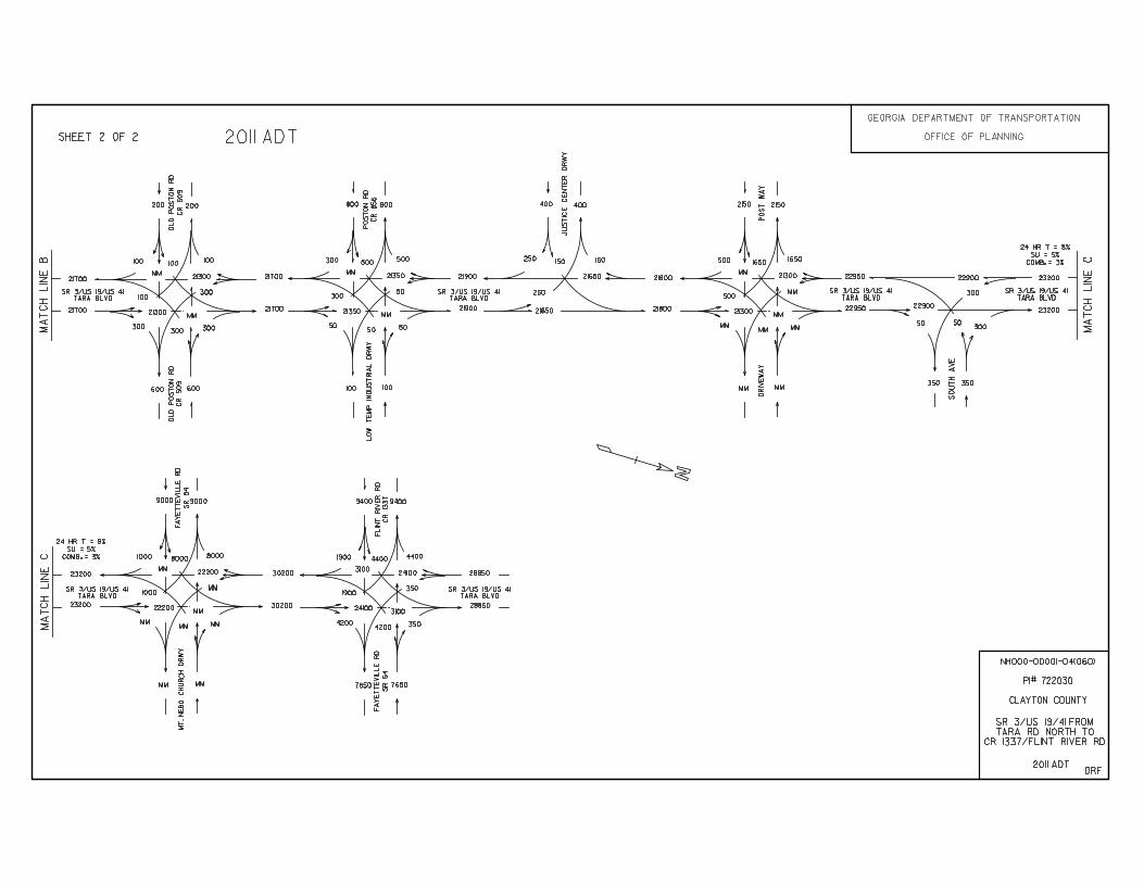
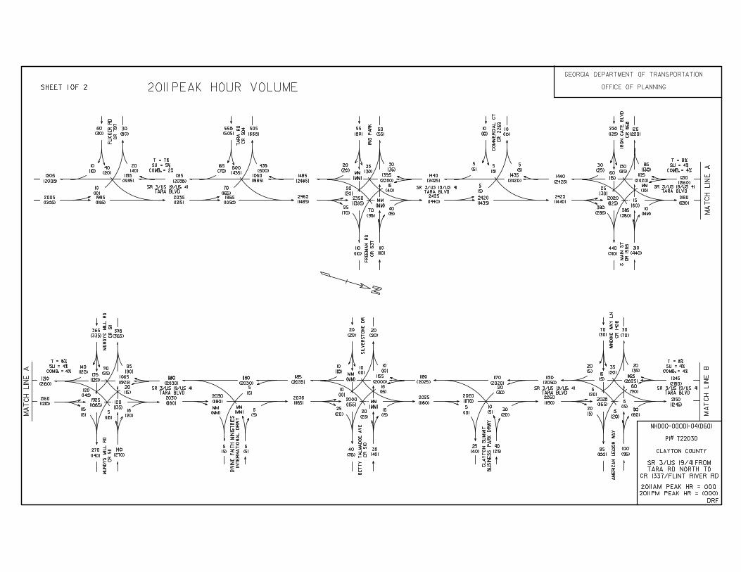
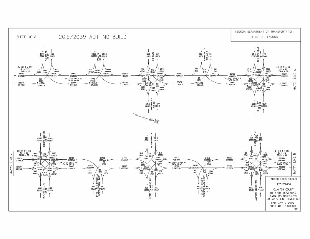
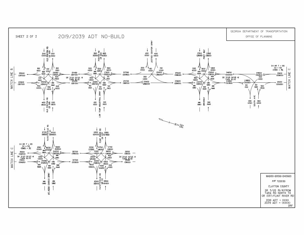
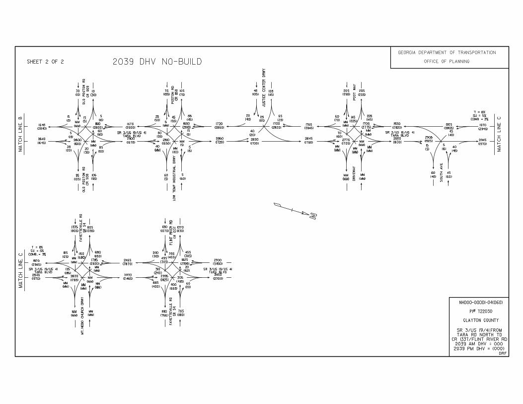
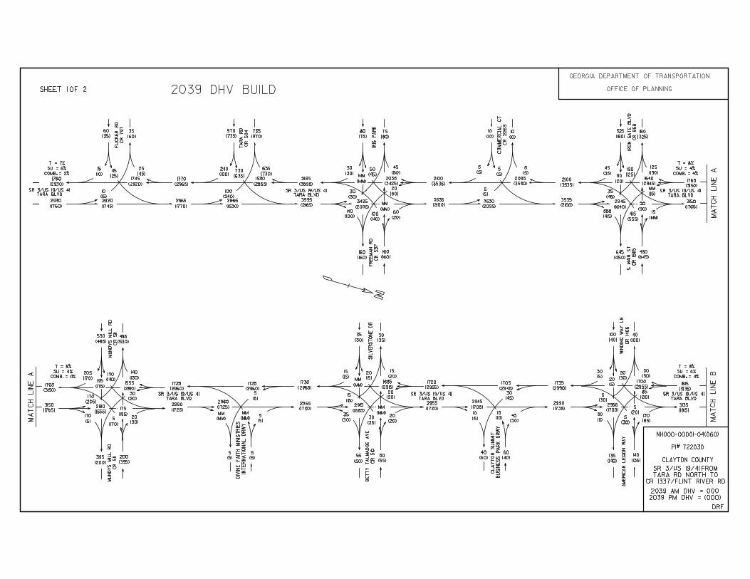
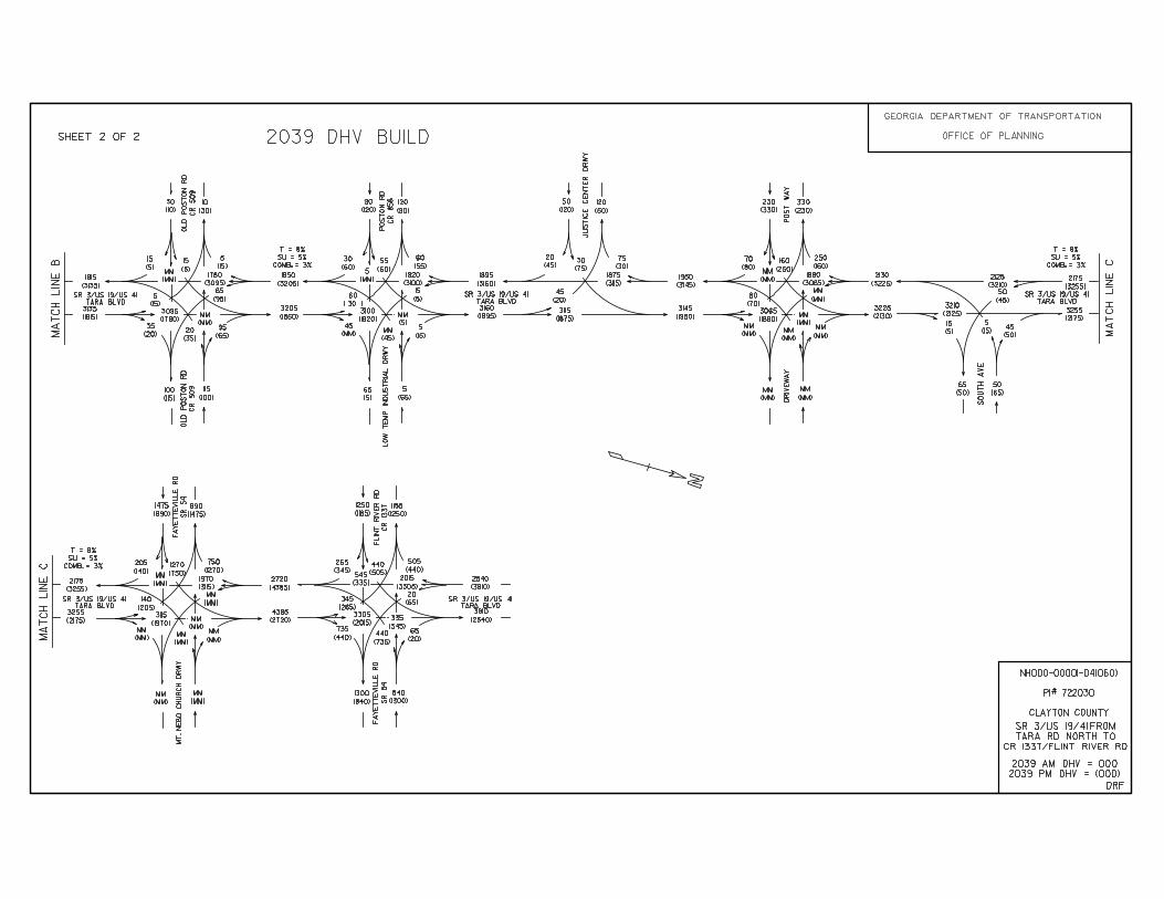
1 Project Justification Statement 6 2a Preferred Alternate Typical Section 1 2b Alternate #1 Typical Section 1 3a Construction Cost Estimate 3 3b Asphalt Fuel Index Adjustment 2 3c Right Of Way Cost Estimate 1 3d Utilities Cost Estimate 1 3e Preliminary Railroad Cost Estimate 1 3f Environmental Mitigation Cost Estimate 1 4 Crash Summaries 2 5 Traffic Diagrams 14
6a TE Study / Signal Warrant Analysis (Freeman Road) 7 6b TE Study / Signal Warrant Analysis (Silver Stone Drive/Betty
Talmadge Avenue) 6
6c TE Study / Signal Warrant Analysis (Old Poston Road) 7 6d TE Study / Signal Warrant Analysis (Winding Way
Lane/American Legion Boulevard) 5
7 Capacity Analysis Summary 1 8 Preliminary Pavement Type Selection Report 7 9 Conforming plan’s network schematics showing thru lanes 1
10 Highway Safety Manual Crash Reduction Factor Calculations 1 11 Implementation of Value Engineering Study Alternatives 3 12 Concept Meeting Minutes 4 13 Public Information Open House Summary 1
Shoulder
2%
Travel Lane Travel Lane Travel Lane
GADOTLOWNDES
2%
Travel LaneTravel LaneTravel Lane
GADOTLOWNDES
Profile Grade
12’-0" 12’-0"
2’-0"
6’-0" 10’-0" 10’-0" 6’-0"
16’-0" 16’-0"
2’-0" 2’-0"
6:1 NORMAL
4%
VARIESRATE
S.E.
RATE
S.E.4%
CL
12’-0"12’-0"
2%2:1 MAX
2:1
MAX
12’ Gap Pattern16" Rumble Strip
12’-0" 12’-0"
2%
2:1 MAX
2:1
MAX
12’ Gap Pattern16" Rumble Strip
16"
12"
2%
16"
12"
2%
5’-0"
Sidewalk
6’-0"
74’-0"
36’-0"
TP 7 CURB & GUTTER6" X 30" -
36’-0"
10’-0"
74’-0"
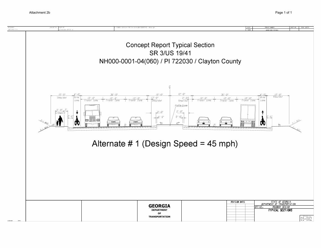
NH000-0001-04(060) / PI 722030 / Clayton County
SR 3/US 19/41
Concept Report
GEORGIA
TRANSPORTATION
OF
DEPARTMENT
REVISION DATES
DRAWING No.
DEPARTMENT OF TRANSPORTATIONSTATE OF GEORGIA
8/30/2013
USER:amoultrie
GPLOT-V8
gplotborder-V8i-PO.tbl
M:\722030- US19 & 41 SR3 Tara Blvd\DGN\722030TYPS-Preferred Alternate.dgn SHEET NO.PROJECT NUMBER
TOTAL SHEETS
OFFICE: ROADWAY DESIGN
TYPICAL SECTIONS
SR SR 3 / US 41
Tara Boulevard 05-001
NH000-0001-04(060)
3:44:57 PM
GPLN
STATE
GA
6/20/2011
16’-0" 6’-0"
Trail
Shared Use
& GUTTERTP 7 CURB 6" X 30" -
2’ 2’
Shoulder
16’-0"6’-0"
From South Main Street to South Avenue
Design Speed = 55 MPH
Preferred Alternate
Attachment 2a Page 1of 1
REVISION DATES
DRAWING No.
DEPARTMENT OF TRANSPORTATIONSTATE OF GEORGIA
8/30/2013
USER:amoultrie
GPLOT-V8
gplotborder-V8i-PO.tbl
M:\722030- US19 & 41 SR3 Tara Blvd\DGN\722030TYPS - Bogus.dgn SHEET NO.PROJECT NUMBER
TOTAL SHEETS
OFFICE: ROADWAY DESIGN
TYPICAL SECTIONS
05-002
NH000-0001-04(060)
3:46:57 PM
GPLN
STATE
GA
6/20/2011
CL
Profile Grade
2%
12’-0"12’-0"Travel Lane Travel Lane
0’-6" 0’-6"
4% 4%
12’-0"Travel Lane
GADOTLOWNDES
2%
12’-0" 12’-0"Travel LaneTravel Lane
12’-0"
Travel Lane
GADOTLOWNDES
ShoulderShoulder
36’-0"36’-0" 12’-0" 12’-0"
2’-0" 2’-0"
4’-0"
Lane
Bike
4’-0"
Lane
Bike
NH000-0001-04(060) / PI 722030 / Clayton County
SR 3/US 19/41
Concept Report Typical Section
Alternate # 1 (Design Speed = 45 mph)
2%
5’-0"
2:1 MAX
2:1
MAX
Shoulder
2’-6"
12’-0"
Sidewalk
2%
Shoulder
2’-6"
12’-0"
GEORGIA
TRANSPORTATION
OF
DEPARTMENT
2:1
MAX
2:1 MAX
2’
2’-0" 2’-0"
Attachment 2b Page 1 of 1
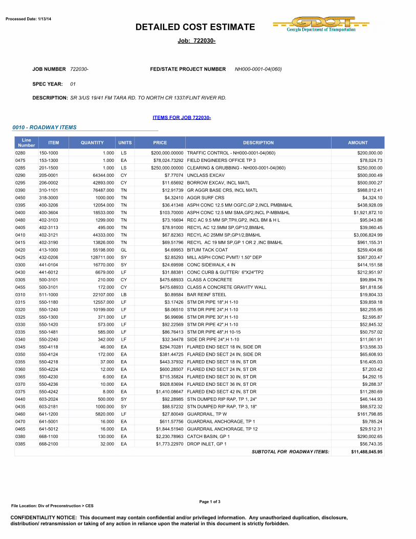
DETAILED COST ESTIMATEProcessed Date: 1/13/14
Job: 722030-
722030-JOB NUMBER
DESCRIPTION: SR 3/US 19/41 FM TARA RD. TO NORTH CR 1337/FLINT RIVER RD.
SPEC YEAR: 01
ITEMS FOR JOB 722030-
0010 - ROADWAY ITEMS
LineNumber ITEM QUANTITY UNITS PRICE DESCRIPTION AMOUNT
0280 150-1000 1.000 LS $200,000.00000 TRAFFIC CONTROL - NH000-0001-04(060) $200,000.00
0475 153-1300 1.000 EA $78,024.73292 FIELD ENGINEERS OFFICE TP 3 $78,024.73
0285 201-1500 1.000 LS $250,000.00000 CLEARING & GRUBBING - NH000-0001-04(060) $250,000.00
0290 205-0001 64344.000 CY $7.77074 UNCLASS EXCAV $500,000.49
0295 206-0002 42893.000 CY $11.65692 BORROW EXCAV, INCL MATL $500,000.27
0390 310-1101 76487.000 TN $12.91739 GR AGGR BASE CRS, INCL MATL $988,012.41
0450 318-3000 1000.000 TN $4.32410 AGGR SURF CRS $4,324.10
0395 400-3206 12054.000 TN $36.41348 ASPH CONC 12.5 MM OGFC,GP 2,INCL PMBM&HL $438,928.09
0400 400-3604 18533.000 TN $103.70000 ASPH CONC 12.5 MM SMA,GP2,INCL P-MBM&HL $1,921,872.10
0480 402-3103 1299.000 TN $73.16694 REC AC 9.5 MM SP,TPII,GP2, INCL BM & H L $95,043.86
0405 402-3113 495.000 TN $78.91000 RECYL AC 12.5MM SP,GP1/2,BM&HL $39,060.45
0410 402-3121 44333.000 TN $67.82363 RECYL AC 25MM SP,GP1/2,BM&HL $3,006,824.99
0415 402-3190 13826.000 TN $69.51796 RECYL AC 19 MM SP,GP 1 OR 2 ,INC BM&HL $961,155.31
0420 413-1000 55198.000 GL $4.69953 BITUM TACK COAT $259,404.66
0425 432-0206 128711.000 SY $2.85293 MILL ASPH CONC PVMT/ 1.50" DEP $367,203.47
0300 441-0104 16770.000 SY $24.69598 CONC SIDEWALK, 4 IN $414,151.58
0430 441-6012 6679.000 LF $31.88381 CONC CURB & GUTTER/ 6"X24"TP2 $212,951.97
0305 500-3101 210.000 CY $475.68933 CLASS A CONCRETE $99,894.76
0455 500-3101 172.000 CY $475.68933 CLASS A CONCRETE GRAVITY WALL $81,818.56
0310 511-1000 22107.000 LB $0.89584 BAR REINF STEEL $19,804.33
0315 550-1180 12557.000 LF $3.17426 STM DR PIPE 18",H 1-10 $39,859.18
0320 550-1240 10199.000 LF $8.06510 STM DR PIPE 24",H 1-10 $82,255.95
0325 550-1300 371.000 LF $6.99696 STM DR PIPE 30",H 1-10 $2,595.87
0330 550-1420 573.000 LF $92.22569 STM DR PIPE 42",H 1-10 $52,845.32
0335 550-1481 585.000 LF $86.76413 STM DR PIPE 48",H 10-15 $50,757.02
0340 550-2240 342.000 LF $32.34478 SIDE DR PIPE 24",H 1-10 $11,061.91
0345 550-4118 46.000 EA $294.70281 FLARED END SECT 18 IN, SIDE DR $13,556.33
0350 550-4124 172.000 EA $381.44725 FLARED END SECT 24 IN, SIDE DR $65,608.93
0355 550-4218 37.000 EA $443.37932 FLARED END SECT 18 IN, ST DR $16,405.03
0360 550-4224 12.000 EA $600.28507 FLARED END SECT 24 IN, ST DR $7,203.42
0365 550-4230 6.000 EA $715.35824 FLARED END SECT 30 IN, ST DR $4,292.15
0370 550-4236 10.000 EA $928.83694 FLARED END SECT 36 IN, ST DR $9,288.37
0375 550-4242 8.000 EA $1,410.08647 FLARED END SECT 42 IN, ST DR $11,280.69
0440 603-2024 500.000 SY $92.28985 STN DUMPED RIP RAP, TP 1, 24" $46,144.93
0435 603-2181 1000.000 SY $88.57232 STN DUMPED RIP RAP, TP 3, 18" $88,572.32
0460 641-1200 5820.000 LF $27.80049 GUARDRAIL, TP W $161,798.85
0470 641-5001 16.000 EA $611.57756 GUARDRAIL ANCHORAGE, TP 1 $9,785.24
0465 641-5012 16.000 EA $1,844.51940 GUARDRAIL ANCHORAGE, TP 12 $29,512.31
0380 668-1100 130.000 EA $2,230.78963 CATCH BASIN, GP 1 $290,002.65
0385 668-2100 32.000 EA $1,773.22970 DROP INLET, GP 1 $56,743.35
SUBTOTAL FOR ROADWAY ITEMS: $11,488,045.95
FED/STATE PROJECT NUMBER NH000-0001-04(060)
File Location: Div of Preconstruction > CES
CONFIDENTIALITY NOTICE: This document may contain confidential and/or privileged information. Any unauthorized duplication, disclosure,distribution/ retransmission or taking of any action in reliance upon the material in this document is strictly forbidden.
Page 1 of 3

DETAILED COST ESTIMATEProcessed Date: 1/13/14
Job: 722030-
0020 - PERMANENT EROSION CONTROL
LineNumber ITEM QUANTITY UNITS PRICE DESCRIPTION AMOUNT
0150 163-0240 922.000 TN $141.27800 MULCH $130,258.32
0155 167-1000 2.000 EA $152.33055 WATER QUALITY MONITORING AND SAMPLING $304.66
0160 167-1500 30.000 MO $395.11866 WATER QUALITY INSPECTIONS $11,853.56
0165 700-6910 56.000 AC $623.79194 PERMANENT GRASSING $34,932.35
0170 700-7000 112.000 TN $54.39868 AGRICULTURAL LIME $6,092.65
0175 700-8000 8.000 TN $494.89108 FERTILIZER MIXED GRADE $3,959.13
0180 700-8100 22400.000 LB $4.88440 FERTILIZER NITROGEN CONTENT $109,410.56
0185 710-9000 9072.000 SY $0.31562 PERM SOIL REINFORCING MAT $2,863.30
0190 716-2000 148169.000 SY $0.21200 EROSION CONTROL MATS, SLOPES $31,411.83
SUBTOTAL FOR PERMANENT EROSION CONTROL: $331,086.36
0030 - TEMPORARY EROSION CONTROL
LineNumber ITEM QUANTITY UNITS PRICE DESCRIPTION AMOUNT
0205 163-0232 28.000 AC $438.47178 TEMPORARY GRASSING $12,277.21
0200 163-0300 11.000 EA $1,124.17641 CONSTRUCTION EXIT $12,365.94
0210 163-0503 11.000 EA $397.01852 CONSTR AND REMOVE SILT CONTROL GATE,TP 3 $4,367.20
0215 163-0520 84.000 LF $5.33978 CONSTR AND REMOVE TEMP PIPE SLOPE DRAIN $448.54
0220 163-0527 15.000 EA $250.00000 CNST/REM RIP RAP CKDM,STN P RIPRAP/SN BG $3,750.00
0225 163-0528 8640.000 LF $3.00000 CONSTR AND REM FAB CK DAM -TP C SLT FN $25,920.00
0230 163-0550 243.000 EA $128.60962 CONS & REM INLET SEDIMENT TRAP $31,252.14
0235 165-0010 12170.000 LF $4.05448 MAINT OF TEMP SILT FENCE, TP A $49,343.02
0240 165-0030 810.000 LF $2.52183 MAINT OF TEMP SILT FENCE, TP C $2,042.68
0245 165-0041 4320.000 LF $1.00000 MAINT OF CHECK DAMS - ALL TYPES $4,320.00
0250 165-0087 11.000 EA $88.86807 MAINT OF SILT CONTROL GATE, TP 3 $977.55
0255 165-0101 11.000 EA $483.25407 MAINT OF CONST EXIT $5,315.79
0260 165-0105 243.000 EA $27.72138 MAINT OF INLET SEDIMENT TRAP $6,736.30
0265 171-0010 24340.000 LF $0.07935 TEMPORARY SILT FENCE, TYPE A $1,931.38
0270 171-0030 1619.000 LF $4.12582 TEMPORARY SILT FENCE, TYPE C $6,679.70
0275 643-8200 1000.000 LF $59.82374 BARRIER FENCE (ORANGE), 4 FT $59,823.74
SUBTOTAL FOR TEMPORARY EROSION CONTROL: $227,551.19
0040 - SIGNING AND MARKING
LineNumber ITEM QUANTITY UNITS PRICE DESCRIPTION AMOUNT
0195 001-0000 1.000 $ $105,000.00000 MISC ITEMS SIGNING & MARKING $105,000.00
SUBTOTAL FOR SIGNING AND MARKING: $105,000.00
0050 - TRAFFIC SIGNALS
LineNumber ITEM QUANTITY UNITS PRICE DESCRIPTION AMOUNT
0005 001-0000 1.000 $ $70,000.00000 MISC ITEMS TRAFFIC SIGNAL - TARA RD. $70,000.00
0010 001-0000 1.000 $ $70,000.00000 MISC ITEMS TRAFFIC SIGNAL - S. MAIN ST. $70,000.00
0015 001-0000 1.000 $ $70,000.00000 MISC ITEMS TRAFFIC SIGNAL - MUNDY'S MILL RD. $70,000.00
0020 001-0000 1.000 $ $70,000.00000 MISC ITEMS TRAFFIC SIGNAL - POSTON RD. $70,000.00
0025 001-0000 1.000 $ $70,000.00000 MISC ITEMS TRAFFIC SIGNAL - POST WAY $70,000.00
SUBTOTAL FOR TRAFFIC SIGNALS: $350,000.00
COST GROUP FOR JOB 722030-
LINENUMBER UNIT CALCULATION
RULE QUANTITY PRICE COST GROUP ID DESCRIPTION AMOUNT
00000001 LS NORM 1.000 $600,000.00 MISC MISCELLANEOUS (LS) $600,000.00
SUBTOTAL: $600,000.00
TOTALS FOR JOB 722030-
File Location: Div of Preconstruction > CES
CONFIDENTIALITY NOTICE: This document may contain confidential and/or privileged information. Any unauthorized duplication, disclosure,distribution/ retransmission or taking of any action in reliance upon the material in this document is strictly forbidden.
Page 2 of 3
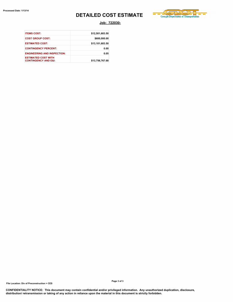
DETAILED COST ESTIMATEProcessed Date: 1/13/14
Job: 722030-
ITEMS COST: $12,501,683.50
COST GROUP COST: $600,000.00
ESTIMATED COST: $13,101,683.50
CONTINGENCY PERCENT: 0.00
ENGINEERING AND INSPECTION: 0.05ESTIMATED COST WITHCONTINGENCY AND E&I: $13,756,767.68
File Location: Div of Preconstruction > CES
CONFIDENTIALITY NOTICE: This document may contain confidential and/or privileged information. Any unauthorized duplication, disclosure,distribution/ retransmission or taking of any action in reliance upon the material in this document is strictly forbidden.
Page 3 of 3
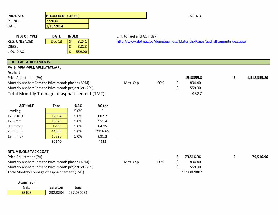
PROJ. NO. CALL NO.P.I. NO. DATE
INDEX (TYPE) DATE INDEX Link to Fuel and AC Index:REG. UNLEADED Dec-13 3.241$ DIESEL 3.823$ LIQUID AC 559.00$
LIQUID AC ADJUSTMENTSPA=[((APM-APL)/APL)]xTMTxAPLAsphaltPrice Adjustment (PA) 1518355.8 1,518,355.80$ Monthly Asphalt Cement Price month placed (APM) Max. Cap 60% 894.40$ Monthly Asphalt Cement Price month project let (APL) 559.00$ Total Monthly Tonnage of asphalt cement (TMT) 4527
ASPHALT Tons %AC AC tonLeveling 5.0% 012.5 OGFC 12054 5.0% 602.712.5 mm 19028 5.0% 951.49.5 mm SP 1299 5.0% 64.9525 mm SP 44333 5.0% 2216.6519 mm SP 13826 5.0% 691.3
90540 4527
BITUMINOUS TACK COATPrice Adjustment (PA) 79,516.96$ 79,516.96$ Monthly Asphalt Cement Price month placed (APM) Max. Cap 60% 894.40$ Monthly Asphalt Cement Price month project let (APL) 559.00$ Total Monthly Tonnage of asphalt cement (TMT) 237.0809807
Bitum TackGals gals/ton tons
55198 232.8234 237.080981
NH000-0001-04(060)7220301/13/2014
http://www.dot.ga.gov/doingbusiness/Materials/Pages/asphaltcementindex.aspx
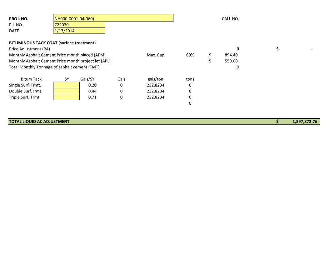
PROJ. NO. CALL NO.P.I. NO. DATE
NH000-0001-04(060)7220301/13/2014
BITUMINOUS TACK COAT (surface treatment)Price Adjustment (PA) 0 -$ Monthly Asphalt Cement Price month placed (APM) Max. Cap 60% 894.40$ Monthly Asphalt Cement Price month project let (APL) 559.00$ Total Monthly Tonnage of asphalt cement (TMT) 0
Bitum Tack SY Gals/SY Gals gals/ton tonsSingle Surf. Trmt. 0.20 0 232.8234 0Double Surf.Trmt. 0.44 0 232.8234 0Triple Surf. Trmt 0.71 0 232.8234 0
0
TOTAL LIQUID AC ADJUSTMENT 1,597,872.76$
DEPARTMENT OF TRANSPORTATION STATE OF GEORGIA
INTERDEPARTMENT CORRESPONDENCE
FILE: PI #722030, Clayton County OFFICE: State Utilities Office
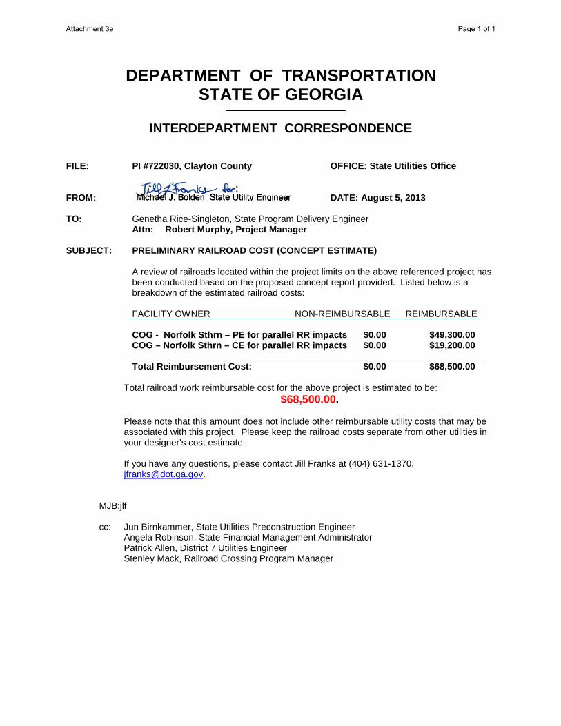
FROM: DATE: August 5, 2013 TO: Genetha Rice-Singleton, State Program Delivery Engineer Attn: Robert Murphy, Project Manager SUBJECT: PRELIMINARY RAILROAD COST (CONCEPT ESTIMATE)
A review of railroads located within the project limits on the above referenced project has been conducted based on the proposed concept report provided. Listed below is a breakdown of the estimated railroad costs: FACILITY OWNER NON-REIMBURSABLE REIMBURSABLE COG - Norfolk Sthrn – PE for parallel RR impacts $0.00 $49,300.00 COG – Norfolk Sthrn – CE for parallel RR impacts $0.00 $19,200.00 Total Reimbursement Cost: $0.00 $68,500.00
Total railroad work reimbursable cost for the above project is estimated to be: $68,500.00.
Please note that this amount does not include other reimbursable utility costs that may be associated with this project. Please keep the railroad costs separate from other utilities in your designer’s cost estimate.
If you have any questions, please contact Jill Franks at (404) 631-1370, [email protected].
MJB:jlf cc: Jun Birnkammer, State Utilities Preconstruction Engineer Angela Robinson, State Financial Management Administrator Patrick Allen, District 7 Utilities Engineer Stenley Mack, Railroad Crossing Program Manager
Attachment 3e Page 1 of 1
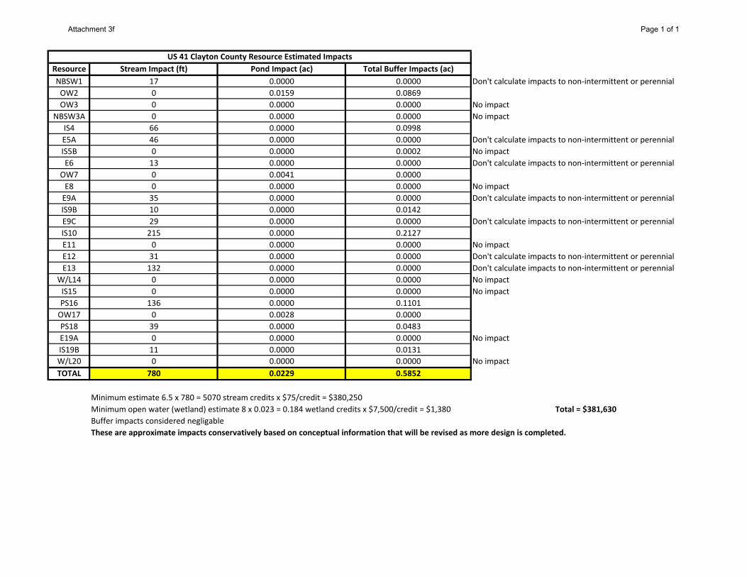
Resource Stream Impact (ft) Pond Impact (ac) Total Buffer Impacts (ac)
NBSW1 17 0.0000 0.0000 Don't calculate impacts to non-intermittent or perennial
OW2 0 0.0159 0.0869
OW3 0 0.0000 0.0000 No impact
NBSW3A 0 0.0000 0.0000 No impact
IS4 66 0.0000 0.0998
E5A 46 0.0000 0.0000 Don't calculate impacts to non-intermittent or perennial
IS5B 0 0.0000 0.0002 No impact
E6 13 0.0000 0.0000 Don't calculate impacts to non-intermittent or perennial
OW7 0 0.0041 0.0000
E8 0 0.0000 0.0000 No impact
E9A 35 0.0000 0.0000 Don't calculate impacts to non-intermittent or perennial
IS9B 10 0.0000 0.0142
E9C 29 0.0000 0.0000 Don't calculate impacts to non-intermittent or perennial
IS10 215 0.0000 0.2127
E11 0 0.0000 0.0000 No impact
E12 31 0.0000 0.0000 Don't calculate impacts to non-intermittent or perennial
E13 132 0.0000 0.0000 Don't calculate impacts to non-intermittent or perennial
W/L14 0 0.0000 0.0000 No impact
IS15 0 0.0000 0.0000 No impact
PS16 136 0.0000 0.1101
OW17 0 0.0028 0.0000
PS18 39 0.0000 0.0483
E19A 0 0.0000 0.0000 No impact
IS19B 11 0.0000 0.0131
W/L20 0 0.0000 0.0000 No impact
TOTAL 780 0.0229 0.5852
Minimum estimate 6.5 x 780 = 5070 stream credits x $75/credit = $380,250
Minimum open water (wetland) estimate 8 x 0.023 = 0.184 wetland credits x $7,500/credit = $1,380 Total = $381,630
Buffer impacts considered negligable
These are approximate impacts conservatively based on conceptual information that will be revised as more design is completed.
US 41 Clayton County Resource Estimated Impacts
Attachment 3f Page 1 of 1
PI Number:
Project Number:
Description:
Designer:
Date:
Notes:
Roadway Mileage Roadway Begin Milelog End Milelog
Information: SR 3 / US 41 3.33 6.86
http://tomcat1/GDOT_Ver1.1/GDOT_IntroPage.cfm
Collision Types, Weather Conditions & Pavement Surface Considtions:
Actual
Number of
Crashes
Percentage of
Total Crashes
Actual
Number of
Crashes
Percentage of
Total Crashes
Actual
Number of
Crashes
Percentage of
Total Crashes
Actual
Number of
Crashes
Percentage of
Total Crashes
Actual
Number of
Crashes
Percentage of
Total Crashes
321 100.0% 306 100.0% 314 100.0% 243 100.0% 1184 100.0%
178 55.5% 200 65.4% 165 52.5% 114 46.9% 657 55.5%
3 0.9% 1 0.3% 0 0.0% 2 0.8% 6 0.5%
140 43.6% 105 34.3% 149 47.5% 127 52.3% 521 44.0%
72 22.4% 44 14.4% 49 15.6% 48 19.8% 213 18.0%
2 0.6% 3 1.0% 6 1.9% 4 1.6% 15 1.3%
20 6.2% 21 6.9% 33 10.5% 19 7.8% 93 7.9%
199 62.0% 209 68.3% 190 60.5% 151 62.1% 749 63.3%
3 0.9% 2 0.7% 1 0.3% 0 0.0% 6 0.5%
25 7.8% 27 8.8% 35 11.1% 21 8.6% 108 9.1%
0 0.0% 1 0.3% 3 1.0% 1 0.4% 5 0.4%
0 0.0% 0 0.0% 0 0.0% 0 0.0% 0 0.0%
0 0.0% 0 0.0% 0 0.0% 0 0.0% 0 0.0%
0 0.0% 0 0.0% 0 0.0% 0 0.0% 0 0.0%
0 0.0% 1 0.3% 0 0.0% 0 0.0% 1 0.1%
2 0.6% 2 0.7% 0 0.0% 3 1.2% 7 0.6%
5 1.6% 5 1.6% 10 3.2% 3 1.2% 23 1.9%
3 0.9% 1 0.3% 3 1.0% 3 1.2% 10 0.8%
0 0.0% 0 0.0% 1 0.3% 0 0.0% 1 0.1%
0 0.0% 0 0.0% 0 0.0% 0 0.0% 0 0.0%
0 0.0% 0 0.0% 0 0.0% 0 0.0% 0 0.0%
0 0.0% 0 0.0% 0 0.0% 0 0.0% 0 0.0%
0 0.0% 0 0.0% 0 0.0% 0 0.0% 0 0.0%
0 0.0% 2 0.7% 1 0.3% 0 0.0% 3 0.3%
1 0.3% 1 0.3% 4 1.3% 1 0.4% 7 0.6%
0 0.0% 0 0.0% 0 0.0% 0 0.0% 0 0.0%
0 0.0% 0 0.0% 1 0.3% 0 0.0% 1 0.1%
0 0.0% 0 0.0% 0 0.0% 0 0.0% 0 0.0%
0 0.0% 1 0.3% 1 0.3% 0 0.0% 2 0.2%
1 0.3% 0 0.0% 0 0.0% 0 0.0% 1 0.1%
300 93.5% 284 92.8% 272 86.6% 221 90.9% 1077 91.0%
0 0.0% 1 0.3% 1 0.3% 0 0.0% 2 0.2%
1 0.3% 1 0.3% 4 1.3% 2 0.8% 8 0.7%
2 0.6% 0 0.0% 3 1.0% 5 2.1% 10 0.8%
0 0.0% 1 0.3% 4 1.3% 1 0.4% 6 0.5%
1 0.3% 0 0.0% 0 0.0% 0 0.0% 1 0.1%
0 0.0% 0 0.0% 0 0.0% 0 0.0% 0 0.0%
3 0.9% 1 0.3% 2 0.6% 2 0.8% 8 0.7%
1 0.3% 0 0.0% 0 0.0% 0 0.0% 1 0.1%
0 0.0% 0 0.0% 0 0.0% 0 0.0% 0 0.0%
0 0.0% 3 1.0% 1 0.3% 0 0.0% 4 0.3%
0 0.0% 0 0.0% 1 0.3% 0 0.0% 1 0.1%
1 0.3% 1 0.3% 2 0.6% 0 0.0% 4 0.3%
0 0.0% 0 0.0% 0 0.0% 1 0.4% 1 0.1%
122 38.0% 115 37.6% 113 36.0% 87 35.8% 437 36.9%
114 35.5% 116 37.9% 133 42.4% 84 34.6% 447 37.8%
47 14.6% 36 11.8% 44 14.0% 41 16.9% 168 14.2%
38 11.8% 39 12.7% 24 7.6% 31 12.8% 132 11.1%
47 14.6% 47 15.4% 29 9.2% 25 10.3% 148 12.5%
34 10.6% 39 12.7% 48 15.3% 29 11.9% 150 12.7%
7 2.2% 9 2.9% 12 3.8% 8 3.3% 36 3.0%
223 69.5% 206 67.3% 217 69.1% 179 73.7% 825 69.7%
10 3.1% 5 1.6% 8 2.5% 2 0.8% 25 2.1%
54 16.8% 63 20.6% 38 12.1% 51 21.0% 206 17.4%
267 83.2% 243 79.4% 274 87.3% 191 78.6% 975 82.3%
0 0.0% 0 0.0% 0 0.0% 1 0.4% 1 0.1%
0 0.0% 0 0.0% 1 0.3% 0 0.0% 1 0.1%
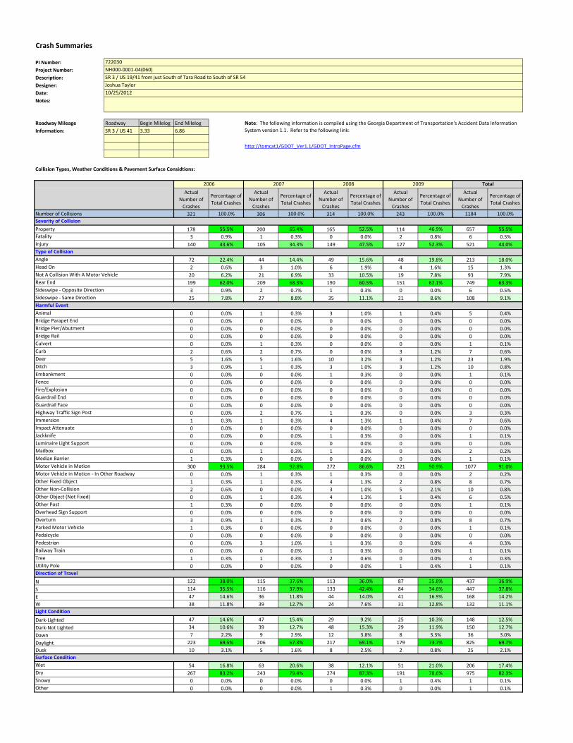
Crash Summaries
Harmful Event
Direction of Travel
722030
NH000-0001-04(060)
SR 3 / US 19/41 from just South of Tara Road to South of SR 54
Joshua Taylor
10/25/2012
Fatality
Injury
Angle
Head On
Not A Collision With A Motor Vehicle
Rear End
Note: The following information is compiled using the Georgia Department of Transportation's Accident Data Information
System version 1.1. Refer to the following link:
2006 2007 2008 2009 Total
Type of Collision
Number of Collisions
Property
Severity of Collision
Sideswipe - Opposite Direction
Sideswipe - Same Direction
N
S
E
Median Barrier
Motor Vehicle in Motion
Motor Vehicle in Motion - In Other Roadway
Other Fixed Object
Other Non-Collision
Other Object (Not Fixed)
Other Post
Overhead Sign Support
Overturn
Parked Motor Vehicle
Utility Pole
Fence
Fire/Explosion
Guardrail End
Animal
Bridge Parapet End
Bridge Pier/Abutment
Bridge Rail
Culvert
Curb
Deer
Ditch
Embankment
Guardrail Face
Highway Traffic Sign Post
Immersion
Impact Attenuate
Jackknife
Tree
Railway Train
Pedestrian
Pedalcycle
Dusk
Wet
Dry
Snowy
Other
W
Dark-Lighted
Dark-Not Lighted
Dawn
Daylight
Light Condition
Surface Condition
Mailbox
Luminaire Light Support
PI Number:
Project Number:
Description:
Designer:
Date:
Notes:
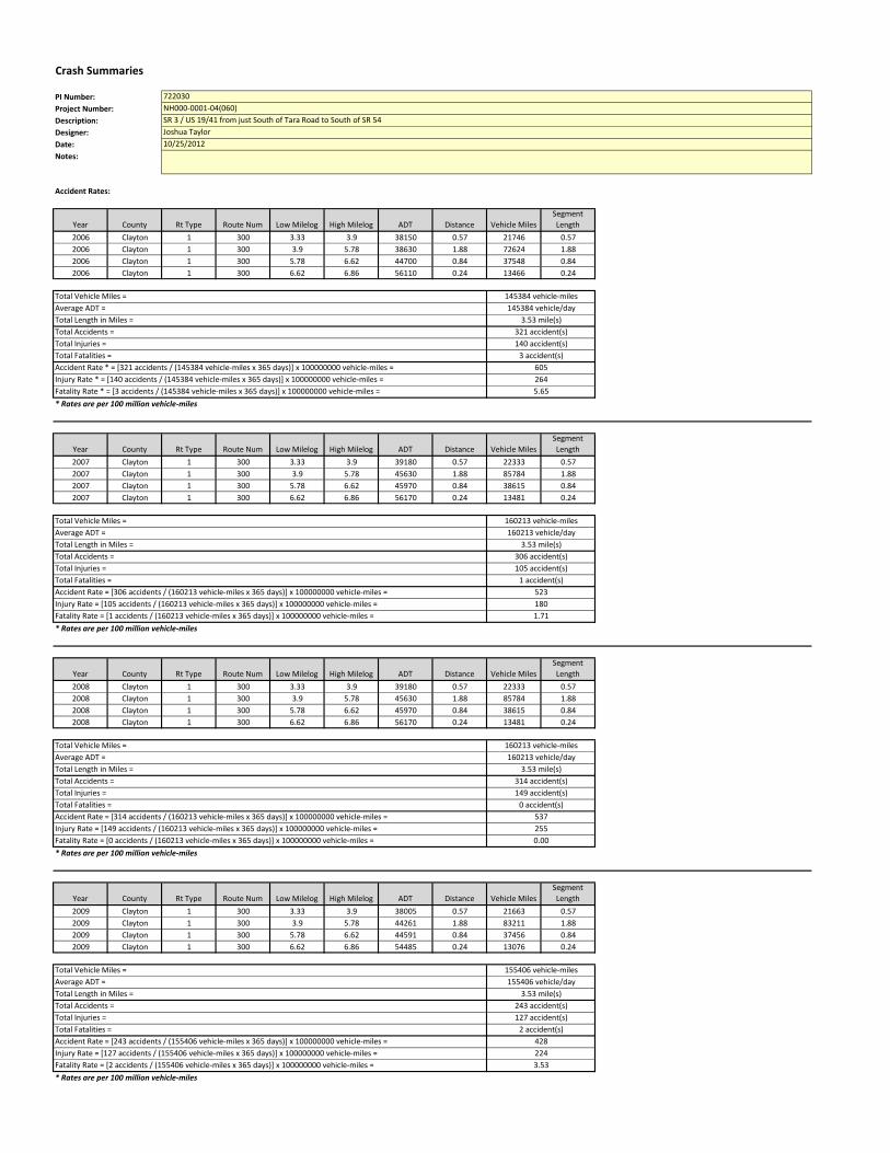
Crash Summaries
722030
NH000-0001-04(060)
SR 3 / US 19/41 from just South of Tara Road to South of SR 54
Joshua Taylor
10/25/2012
Accident Rates:
Year County Rt Type Route Num Low Milelog High Milelog ADT Distance Vehicle Miles
Segment
Length
2006 Clayton 1 300 3.33 3.9 38150 0.57 21746 0.57
2006 Clayton 1 300 3.9 5.78 38630 1.88 72624 1.88
2006 Clayton 1 300 5.78 6.62 44700 0.84 37548 0.84
2006 Clayton 1 300 6.62 6.86 56110 0.24 13466 0.24
* Rates are per 100 million vehicle-miles
Year County Rt Type Route Num Low Milelog High Milelog ADT Distance Vehicle Miles
Segment
Length
2007 Clayton 1 300 3.33 3.9 39180 0.57 22333 0.57
2007 Clayton 1 300 3.9 5.78 45630 1.88 85784 1.88
2007 Clayton 1 300 5.78 6.62 45970 0.84 38615 0.84
2007 Clayton 1 300 6.62 6.86 56170 0.24 13481 0.24
* Rates are per 100 million vehicle-miles
Year County Rt Type Route Num Low Milelog High Milelog ADT Distance Vehicle Miles
Segment
Length
2008 Clayton 1 300 3.33 3.9 39180 0.57 22333 0.57
2008 Clayton 1 300 3.9 5.78 45630 1.88 85784 1.88
2008 Clayton 1 300 5.78 6.62 45970 0.84 38615 0.84
2008 Clayton 1 300 6.62 6.86 56170 0.24 13481 0.24
* Rates are per 100 million vehicle-miles
Year County Rt Type Route Num Low Milelog High Milelog ADT Distance Vehicle Miles
Segment
Length
2009 Clayton 1 300 3.33 3.9 38005 0.57 21663 0.57
2009 Clayton 1 300 3.9 5.78 44261 1.88 83211 1.88
2009 Clayton 1 300 5.78 6.62 44591 0.84 37456 0.84
2009 Clayton 1 300 6.62 6.86 54485 0.24 13076 0.24
* Rates are per 100 million vehicle-miles
145384 vehicle/day
145384 vehicle-milesTotal Vehicle Miles =
Average ADT =
3.53 mile(s)Total Length in Miles =
Accident Rate * = [321 accidents / (145384 vehicle-miles x 365 days)] x 100000000 vehicle-miles =
Injury Rate * = [140 accidents / (145384 vehicle-miles x 365 days)] x 100000000 vehicle-miles =
Fatality Rate * = [3 accidents / (145384 vehicle-miles x 365 days)] x 100000000 vehicle-miles =
605
264
5.65
Total Accidents =
Total Injuries =
Total Fatalities =
321 accident(s)
140 accident(s)
3 accident(s)
Total Length in Miles = 3.53 mile(s)
Total Accidents = 306 accident(s)
Total Injuries = 105 accident(s)
Total Vehicle Miles = 160213 vehicle-miles
Average ADT = 160213 vehicle/day
Fatality Rate = [1 accidents / (160213 vehicle-miles x 365 days)] x 100000000 vehicle-miles = 1.71
Total Vehicle Miles = 160213 vehicle-miles
Total Fatalities = 1 accident(s)
Accident Rate = [306 accidents / (160213 vehicle-miles x 365 days)] x 100000000 vehicle-miles = 523
Injury Rate = [105 accidents / (160213 vehicle-miles x 365 days)] x 100000000 vehicle-miles = 180
Total Injuries = 149 accident(s)
Total Fatalities = 0 accident(s)
Accident Rate = [314 accidents / (160213 vehicle-miles x 365 days)] x 100000000 vehicle-miles = 537
Average ADT = 160213 vehicle/day
Total Length in Miles = 3.53 mile(s)
Total Accidents = 314 accident(s)
Total Vehicle Miles = 155406 vehicle-miles
Average ADT = 155406 vehicle/day
Total Length in Miles = 3.53 mile(s)
Injury Rate = [149 accidents / (160213 vehicle-miles x 365 days)] x 100000000 vehicle-miles = 255
Fatality Rate = [0 accidents / (160213 vehicle-miles x 365 days)] x 100000000 vehicle-miles = 0.00
Accident Rate = [243 accidents / (155406 vehicle-miles x 365 days)] x 100000000 vehicle-miles = 428
Injury Rate = [127 accidents / (155406 vehicle-miles x 365 days)] x 100000000 vehicle-miles = 224
Fatality Rate = [2 accidents / (155406 vehicle-miles x 365 days)] x 100000000 vehicle-miles = 3.53
Total Accidents = 243 accident(s)
Total Injuries = 127 accident(s)
Total Fatalities = 2 accident(s)


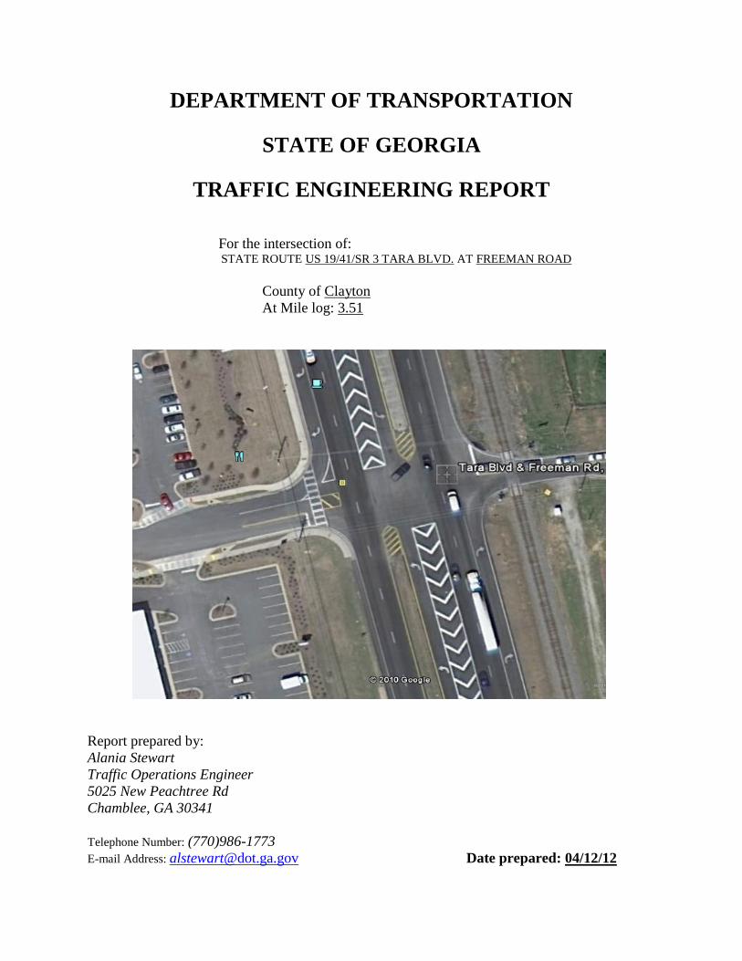
DEPARTMENT OF TRANSPORTATION
STATE OF GEORGIA
TRAFFIC ENGINEERING REPORT
For the intersection of: STATE ROUTE US 19/41/SR 3 TARA BLVD. AT FREEMAN ROAD
County of Clayton
At Mile log: 3.51
Report prepared by:
Alania Stewart
Traffic Operations Engineer
5025 New Peachtree Rd
Chamblee, GA 30341
Telephone Number: (770)986-1773
E-mail Address: [email protected] Date prepared: 04/12/12
Traffic Engineering Report
State Route US 19/41/SR 3 TARA BLVD. AT FREEMAN RD.
Date 04/12/2012
Page 2 of 7
LOCATION: This study was performed at the intersection of State Route US 19/41/SR 3 Tara Blvd. at
Freeman Rd. in Clayton County.
REASON FOR INVESTIGATION:
This traffic study was requested by a concerned citizen who had a dilemma in entering onto Tara
Blvd. from Freeman Road due to high traffic volume and potential near-missed accidents.
DESCRIPTION OF THE INTERSECTION:
US 19/ 41/ State Route 3/Tara Blvd. is a four lane roadway with a divided grass median
and left turn lanes in each approach on Tara Blvd. at Freeman Road. State Route 3 is
classified as a Principal Arterial which runs North/South in Clayton County and connects the
cities of Love Joy, Hampton and Griffin, Georgia. The current AADT for Tara Blvd. is
39180. This corridor serves a significant amount of commuters during the weekdays, both
AM and PM peak period, as well as during NASCAR Racing Events. The nearest signalized
intersection is approximately 830 feet in the southbound direction.
Freeman Road is a two lane local road with an AADT of 1900 that serves the residents
of The Garden of Love Joy Town Homes and Shoppes of Love Joy Strip Mall with
approximately fourteen businesses to serve the neighboring forty-six town house
development.
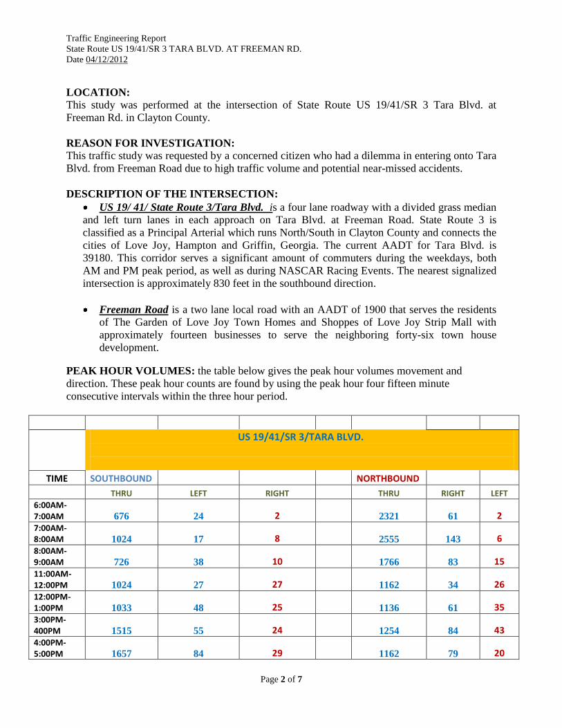
PEAK HOUR VOLUMES: the table below gives the peak hour volumes movement and
direction. These peak hour counts are found by using the peak hour four fifteen minute
consecutive intervals within the three hour period.
US 19/41/SR 3/TARA BLVD.
TIME SOUTHBOUND NORTHBOUND
THRU LEFT RIGHT
THRU RIGHT LEFT
6:00AM-7:00AM 676 24 2
2321 61 2
7:00AM-8:00AM 1024 17 8
2555 143 6
8:00AM- 9:00AM 726 38 10
1766 83 15
11:00AM-12:00PM 1024 27 27
1162 34 26
12:00PM-1:00PM 1033 48 25
1136 61 35
3:00PM-400PM 1515 55 24 1254 84 43 4:00PM- 5:00PM 1657 84 29
1162 79 20
Traffic Engineering Report
State Route US 19/41/SR 3 TARA BLVD. AT FREEMAN RD.
Date 04/12/2012
Page 3 of 7
5:00PM- 6:00PM 1972 73 32
1240 100 32
TOTAL 9627 366 157
12596 645 179
FREEMAN ROAD
TIME WESTBOUND EASTBOUND
THRU LEFT RIGHT
THRU LEFT RIGHT
6:00AM-7:00AM 0 29 33
0 12 6
7:00AM- 8:00AM 0 37 67
0 5 9
8:00AM-9:00AM 5 39 36
0 2 5
11:00AM- 12:00PM 1 31 17
0 10 28
12:00PM-1:00PM 0 49 17
3 10 26
3:00PM-4:00PM 2 74 38
2 11 31
4:00PM-5:00PM 2 65 36
3 5 34
5:00PM- 6:00PM 0 62 56
3 14 22
TOTAL 10 386 300
11 69 161
SIGNAL WARRANT ANALYSIS: 70 % right-turn reduction was applied to the mainline volumes for the calculations. This location
meet signal warrants for a stop and go signal.
EXISTING TRAFFIC CONTROL:
US 19/41/State Route 3 is currently free-flowing at this intersection
Freeman Road is stop-condition at this intersection
VEHICLE SPEEDS: The District 7 completed a speed study for this section of roadway.
The posted speed limit on US 19/41/SR 3 is 55 MPH.
The posted speed limit on Freeman Road is 40 MPH.
The 85th
percentile in this area is 63 MPH.
Traffic Engineering Report
State Route US 19/41/SR 3 TARA BLVD. AT FREEMAN RD.
Date 04/12/2012
Page 4 of 7
PEDESTRIAN MOVEMENTS:
There were minimal pedestrians visible during the traffic counts or during any of the other site
visits. There is an existing crosswalk at the intersection with ADA ramps; however, there are no
existing sidewalks along Tara Blvd for pedestrians or on the side streets.
PARKING:
There was no parking observed or expected at the intersection.
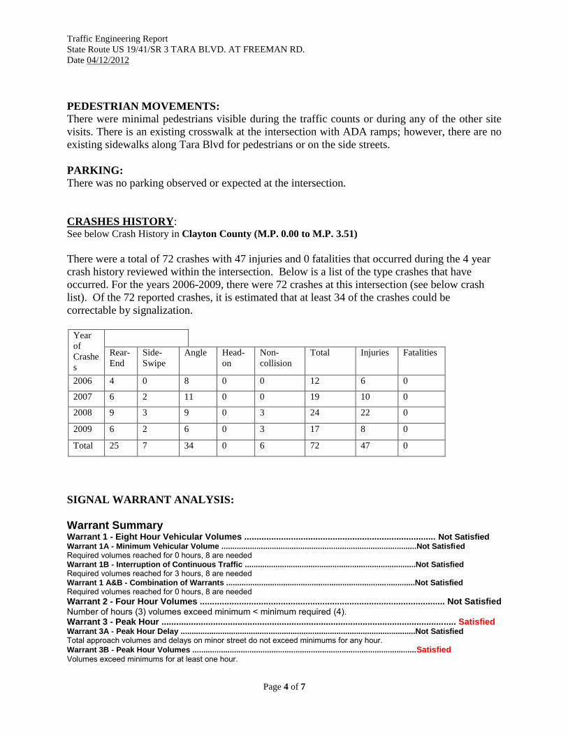
CRASHES HISTORY: See below Crash History in Clayton County (M.P. 0.00 to M.P. 3.51)
There were a total of 72 crashes with 47 injuries and 0 fatalities that occurred during the 4 year
crash history reviewed within the intersection. Below is a list of the type crashes that have
occurred. For the years 2006-2009, there were 72 crashes at this intersection (see below crash
list). Of the 72 reported crashes, it is estimated that at least 34 of the crashes could be
correctable by signalization.
Year
of
Crashe
s
Rear-
End
Side-
Swipe
Angle Head-
on
Non-
collision
Total
Injuries Fatalities
2006 4 0 8 0 0 12 6 0
2007 6 2 11 0 0 19 10 0
2008 9 3 9 0 3 24 22 0
2009 6 2 6 0 3 17 8 0
Total 25 7 34 0 6 72 47 0
SIGNAL WARRANT ANALYSIS:
Warrant Summary Warrant 1 - Eight Hour Vehicular Volumes .............................................................................. Not Satisfied Warrant 1A - Minimum Vehicular Volume .........................................................................................Not Satisfied Required volumes reached for 0 hours, 8 are needed Warrant 1B - Interruption of Continuous Traffic ..............................................................................Not Satisfied Required volumes reached for 3 hours, 8 are needed Warrant 1 A&B - Combination of Warrants ......................................................................................Not Satisfied Required volumes reached for 0 hours, 8 are needed
Warrant 2 - Four Hour Volumes .................................................................................................... Not Satisfied Number of hours (3) volumes exceed minimum < minimum required (4). Warrant 3 - Peak Hour ........................................................................................................................ Satisfied Warrant 3A - Peak Hour Delay ...........................................................................................................Not Satisfied Total approach volumes and delays on minor street do not exceed minimums for any hour.
Warrant 3B - Peak Hour Volumes ......................................................................................................Satisfied Volumes exceed minimums for at least one hour.
Traffic Engineering Report
State Route US 19/41/SR 3 TARA BLVD. AT FREEMAN RD.
Date 04/12/2012
Page 5 of 7
Warrant 4 - Pedestrian Volumes ............................................................................................................. Not Satisfied Required 4 Hr pedestrian volume reached for 0 hour(s) and the single hour volume for 0 hour(s) Warrant 5 - School Crossing ................................................................................................................... Not Satisfied Number of gaps > .0 seconds (0) exceeds the number of minutes in the crossing period (0). Warrant 6 - Coordinated Signal System ................................................................................................. Not Satisfied No adjacent coordinated signals are present Warrant 7 - Crash Experience ................................................................................................................. Not Satisfied Number of accidents (5) meet minimum (5) but volumes do not. Warrant 8 - Roadway Network ........................................................................................................ Satisfied
After reviewing the warrant criteria for the above intersection it was determined that the minor
street traffic suffers excessive delay entering or crossing the major street during one hour of the
day. The signal warrant analysis was performed using the seventy percent right-turn reduction
volume criteria of Table 4C-1. Warrant 1, of the Manual on Uniform Traffic Control Devices
states that it may be used when the major street speed exceeds 40 MPH and the existing posted
speed limit along is 55MPH and the 85th
percentile is 63MPH. Therefore, the 70% right-turn
reduction was use the satisfied the signal warrants.
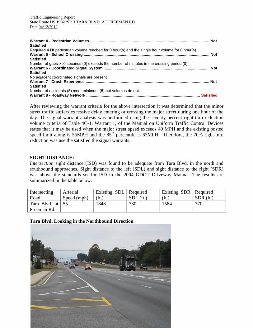
SIGHT DISTANCE:
Intersection sight distance (ISD) was found to be adequate from Tara Blvd. in the north and
southbound approaches. Sight distance to the left (SDL) and sight distance to the right (SDR)
was above the standards set for ISD in the 2004 GDOT Driveway Manual. The results are
summarized in the table below.
Intersecting
Road
Arterial
Speed (mph)
Existing SDL
(ft.)
Required
SDL (ft.)
Existing SDR
(ft.)
Required
SDR (ft.)
Tara Blvd. at
Freeman Rd.
55 1848 730 1584 770
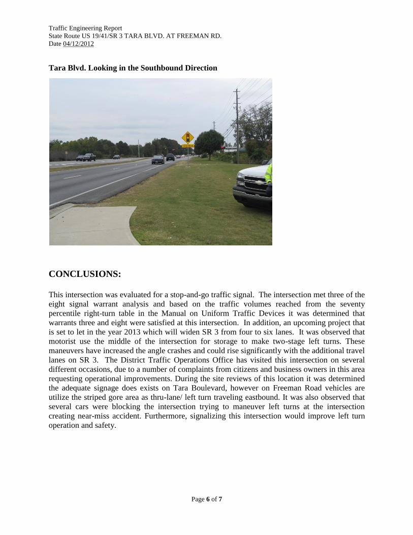
Tara Blvd. Looking in the Northbound Direction
Traffic Engineering Report
State Route US 19/41/SR 3 TARA BLVD. AT FREEMAN RD.
Date 04/12/2012
Page 6 of 7
Tara Blvd. Looking in the Southbound Direction
CONCLUSIONS:
This intersection was evaluated for a stop-and-go traffic signal. The intersection met three of the
eight signal warrant analysis and based on the traffic volumes reached from the seventy
percentile right-turn table in the Manual on Uniform Traffic Devices it was determined that
warrants three and eight were satisfied at this intersection. In addition, an upcoming project that
is set to let in the year 2013 which will widen SR 3 from four to six lanes. It was observed that
motorist use the middle of the intersection for storage to make two-stage left turns. These
maneuvers have increased the angle crashes and could rise significantly with the additional travel
lanes on SR 3. The District Traffic Operations Office has visited this intersection on several
different occasions, due to a number of complaints from citizens and business owners in this area
requesting operational improvements. During the site reviews of this location it was determined
the adequate signage does exists on Tara Boulevard, however on Freeman Road vehicles are
utilize the striped gore area as thru-lane/ left turn traveling eastbound. It was also observed that
several cars were blocking the intersection trying to maneuver left turns at the intersection
creating near-miss accident. Furthermore, signalizing this intersection would improve left turn
operation and safety.
Traffic Engineering Report
State Route US 19/41/SR 3 TARA BLVD. AT FREEMAN RD.
Date 04/12/2012
Page 7 of 7
RECOMMENDATION:
Option 1:
The District Seven Traffic Operations recommends signalizing this intersection.
Option 2:
The District Seven Traffic Operations recommends the closure of the median or make it a
directional median opening at this intersection to reduce angle accidents.
PREPARED BY: ___________________________ DATE: _________
District Traffic Operations Engineer
RECOMMENDED BY: ___________________________ DATE: _________
District Traffic Engineer
RECOMMENDED BY: ___________________________ DATE: _________
State Traffic Engineer
RECOMMENDED BY: _________________________________ DATE: _________
Director of Operations
Traffic Engineering Report Appendix Traffic Count Summary Sheets
Accident diagram
Signal Warrant Analysis Summary
.
DEPARTMENT OF TRANSPORTATION
STATE OF GEORGIA
TRAFFIC ENGINEERING REPORT
SR 3 / Tara Blvd.
Clayton County, Georgia
Mile log: 4.67 – 4.77
Report prepared by:
Patrick S. Werho
Traffic Operations Engineer
5025 New Peachtree Rd
Chamblee, GA 30341
Telephone Number: (770)986-1773
E-mail Address: [email protected] Date prepared: 4/4/2012
Traffic Engineering Report
SR 3 Tara Blvd.
4/4/2012
Page 2 of 5
LOCATION:
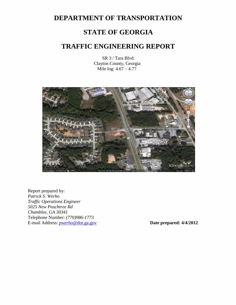
This study was conducted for the intersection of State Route 3 Tara Boulevard and County
Roads Silver Stone Drive and Betty Talmadge Ave.
REASON FOR INVESTIGATION:
This traffic study was requested by concerned citizens, stating that there are safety concerns at
the intersection of State Route 3 Tara Boulevard at Silver Stone Drive and Betty Talmadge Ave.
DESCRIPTION OF THE STATE ROUTE:
State Route 3 is a four lane road that is classified as an Urban Principal Arterial. State Route
3 has 12 foot wide travel lanes with left and right turn lanes and a grass median. The Urban
Principal Arterial runs North /South in Clayton County. The current AADT obtained from the
Department Road Information System for State Route 3 is 46,250 between Mile log 4.67 to
4.77. The nearest signalized intersection is approximately 2222 feet south of Silver Stone
Drive and Betty Talmadge Ave.
Silver Stone Drive is a two lane, no outlet County Road with 11 foot wide travel lanes.
Betty Talmadge Ave is a two lane, County Road with 9.5 foot wide travel lanes and used as a
cut-thru road from South Main Street/Noah’s Ark Road.
TRAFFIC VOLUMES:
The traffic volumes were taken for an eight hour period, movement and direction. These peak
hour counts are found by using the peak hour four fifteen minute consecutive intervals within the
two hour period. No Pedestrian traffic was present; two Pedestrians did place signs on the Right
of Way.
SIGNAL WARRANT ANALYSIS
Based on the compiled information this intersection did not meet any of the Nine Signal
Warrants.
Traffic Engineering Report
SR 3 Tara Blvd.
4/4/2012
Page 3 of 5
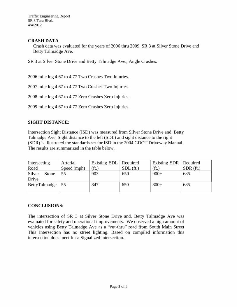
CRASH DATA
Crash data was evaluated for the years of 2006 thru 2009, SR 3 at Silver Stone Drive and
Betty Talmadge Ave.
SR 3 at Silver Stone Drive and Betty Talmadge Ave., Angle Crashes:
2006 mile log 4.67 to 4.77 Two Crashes Two Injuries.
2007 mile log 4.67 to 4.77 Two Crashes Two Injuries.
2008 mile log 4.67 to 4.77 Zero Crashes Zero Injuries.
2009 mile log 4.67 to 4.77 Zero Crashes Zero Injuries.
SIGHT DISTANCE:
Intersection Sight Distance (ISD) was measured from Silver Stone Drive and. Betty
Talmadge Ave. Sight distance to the left (SDL) and sight distance to the right
(SDR) is illustrated the standards set for ISD in the 2004 GDOT Driveway Manual.
The results are summarized in the table below.
Intersecting
Road
Arterial
Speed (mph)
Existing SDL
(ft.)
Required
SDL (ft.)
Existing SDR
(ft.)
Required
SDR (ft.)
Silver Stone
Drive
55 903 650 900+ 685
BettyTalmadge 55 847 650 800+ 685
CONCLUSIONS:
The intersection of SR 3 at Silver Stone Drive and. Betty Talmadge Ave was
evaluated for safety and operational improvements. We observed a high amount of
vehicles using Betty Talmadge Ave as a “cut-thru” road from South Main Street
This Intersection has no street lighting. Based on compiled information this
intersection does meet for a Signalized intersection.
Traffic Engineering Report
SR 3 Tara Blvd.
4/4/2012
Page 4 of 5
RECOMMENDATION:
The District Seven Office of Traffic Operations recommends no improvements at
this time.
PREPARED BY: ___________________________ DATE: _________
District Traffic Operations Engineer
RECOMMENDED BY: ___________________________ DATE: _________
District Traffic Engineer
RECOMMENDED BY: ___________________________ DATE: _________
State Traffic Engineer
RECOMMENDED BY: _________________________________ DATE: _________
Director of Operations
Traffic Engineering Report
SR 3 Tara Blvd.
4/4/2012
Page 5 of 5
Traffic Engineering Report Appendix
Crash Diagram
Crash Data 2006-2009
Signal Warrant Analysis

Traffic Engineering Report
SR 3 Tara Blvd.
4/4/2012
Page 6 of 5
.
DEPARTMENT OF TRANSPORTATION
STATE OF GEORGIA
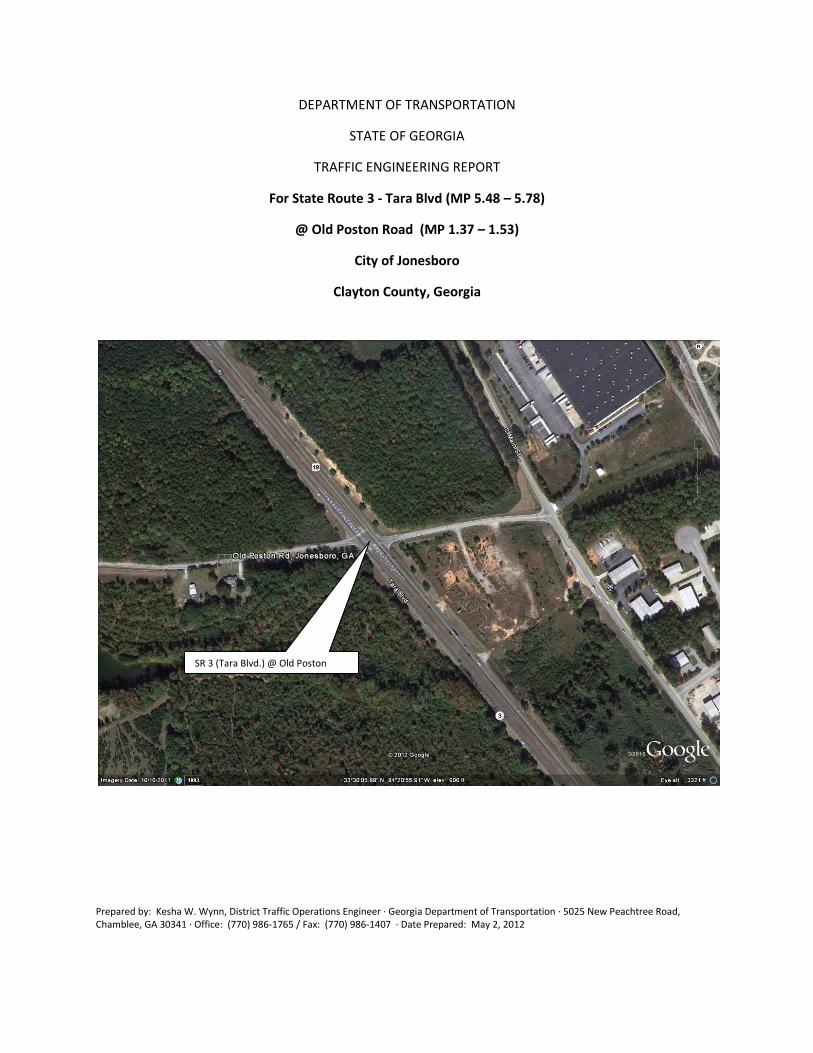
TRAFFIC ENGINEERING REPORT
For State Route 3 - Tara Blvd (MP 5.48 – 5.78)
@ Old Poston Road (MP 1.37 – 1.53)
City of Jonesboro
Clayton County, Georgia
Prepared by: Kesha W. Wynn, District Traffic Operations Engineer ∙ Georgia Department of Transportation ∙ 5025 New Peachtree Road, Chamblee, GA 30341 ∙ Office: (770) 986-1765 / Fax: (770) 986-1407 ∙ Date Prepared: May 2, 2012
SR 3 (Tara Blvd.) @ Old Poston
Road
Traffic Engineering Report SR 3 (Tara Blvd.) at Old Poston Road Date: 3/20/2012
Page 2 of 7
Location:
The intersection at State Route 3 (Tara Blvd.) at Old Poston Road is located in the City of Jonesboro in Clayton County.
Reason for the Investigation:
A traffic engineering study was recommended by the citizens of Jonesboro for the evaluation of operational deficiencies for a traffic signal at the intersection of SR 166 (Duncan Memorial Hwy) at Post Road.
Description of Intersection:
State Route 3 (Tara Blvd.) @ Old Poston Road) is a four way stop controlled intersection. Pedestrian
facilities are not present at the intersection. There are not any street lights that are directly facing the
intersection. Two power poles are present, one located in the south-west and one located in the south-
east quadrants of the intersection. The nearest signalized intersection is about 1550 feet north at the
intersection of State Route 3 (Tara Blvd.) and Poston Road.
State Route 3 (Tara Blvd.) is a four lane roadway that is classified as an Urban Principal Arterial. State
Route 3 has 12 ft wide travel lanes with left and right turn lanes, a grassed median and grass shoulders.
The Urban Principal Arterial runs north-south in Clayton County. The current AADT obtained from the
Department Road Information System for State Route 3 is 46,250 between Milelog 5.48 and Milelog
5.78. The posted speed limit is 55 miles per hour (MPH).
Old Poston Road is a two lane county road that is classified as an Urban Local. Old Poston Road has 11 ft
wide travel lanes with grassed shoulders. The Urban Local runs east-west in Clayton County. The
current AADT obtained from the Department Road Information System for Old Poston Road is 2,202
between Milelog 1.37 and Milelog 1.53. The posted speed limit is 40 MPH.
Traffic Volumes in vehicles per day (vpd):
Latest year percent trucks: 0%
Latest year 24 hour percent trucks: 0%
Year SR 3 @ MP 5.48 Count Station
(vpd)
Old Poston Road @ MP 1.37 Count Station
(vpd)
2011 (Current AADT) 46200 2202
2010 (Previous AADT) 46190 1623
Traffic Engineering Report SR 3 (Tara Blvd.) at Old Poston Road Date: 3/20/2012
Page 3 of 7
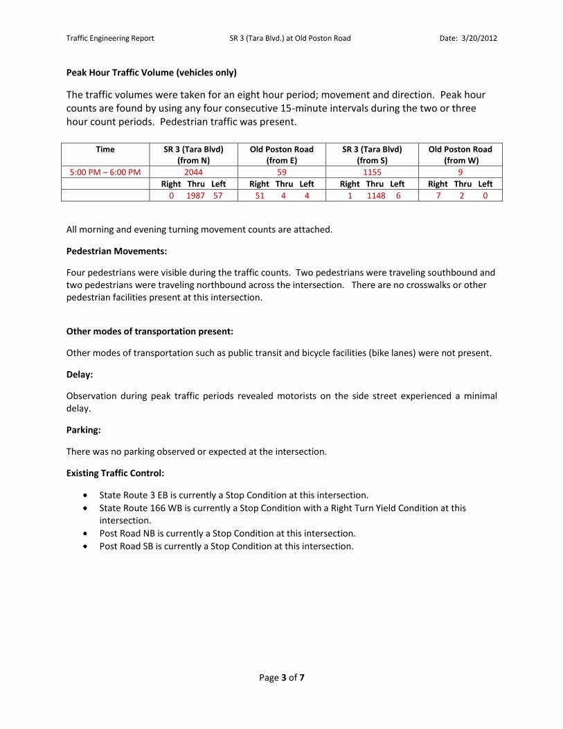
Peak Hour Traffic Volume (vehicles only)
The traffic volumes were taken for an eight hour period; movement and direction. Peak hour counts are found by using any four consecutive 15-minute intervals during the two or three hour count periods. Pedestrian traffic was present.
Time SR 3 (Tara Blvd)
(from N) Old Poston Road
(from E) SR 3 (Tara Blvd)
(from S) Old Poston Road
(from W)
5:00 PM – 6:00 PM 2044 59 1155 9
Right Thru Left Right Thru Left Right Thru Left Right Thru Left
0 1987 57 51 4 4 1 1148 6 7 2 0
All morning and evening turning movement counts are attached.
Pedestrian Movements:
Four pedestrians were visible during the traffic counts. Two pedestrians were traveling southbound and two pedestrians were traveling northbound across the intersection. There are no crosswalks or other pedestrian facilities present at this intersection.
Other modes of transportation present:
Other modes of transportation such as public transit and bicycle facilities (bike lanes) were not present.
Delay:
Observation during peak traffic periods revealed motorists on the side street experienced a minimal delay.
Parking:
There was no parking observed or expected at the intersection.
Existing Traffic Control:
State Route 3 EB is currently a Stop Condition at this intersection.
State Route 166 WB is currently a Stop Condition with a Right Turn Yield Condition at this intersection.
Post Road NB is currently a Stop Condition at this intersection.
Post Road SB is currently a Stop Condition at this intersection.
Traffic Engineering Report SR 3 (Tara Blvd.) at Old Poston Road Date: 3/20/2012
Page 4 of 7
Signal Warrant Analysis
A traffic signal warrant analysis was performed for SR 3 at Old Poston Road. Eight signal warrant analysis were performed for this intersection. The intersection failed to meet the requirements for all eight signal warrants. A summary of the analysis is shown in the chart below.
Warrants Satisfied Not Satisfied
Warrant 1 – Eight Hour Vehicular Volumes Warrant 1A - Minimum Vehicular Volume Warrant 1B – Interruption of Continuous Traffic Warrant 1 A & B – Combination of Warrants
Warrant 2 – Four Hour Vehicular Volumes
Warrant 3 – Peak Hour Warrant 3A - Peak Hour Delay Warrant 3B – Peak Hour Volumes
Warrant 4 – Pedestrian Volumes
Warrant 5 – School Crossing
Warrant 6 – Coordinated Signal System
Warrant 7 – Crash Experience
Warrant 8 – Roadway Network
*Full Signal Warrant Analysis is attached.
Accident History:
Crash reports for this intersection indicate 17 crashes have occurred between 2005 and 2009. The
collisions are mostly “rear-end” collisions located on the roadway. Most of these collisions occurred
during daylight and dry conditions. The number of collisions and the location of impacts are shown in
the tables below.
Year Collision Summary Beg MP End MP Number of Accidents Number of Vehicles Number of Injuries Number of Fatalities
2005 5.48 5.78 6 11 2 0
2006 5.48 5.78 5 10 5 1
2007 5.48 5.78 4 10 1 0
2008 5.48 5.78 1 2 0 0
2009 5.48 5.78 1 2 5 0
Total - - 17 35 15 1
Year Type of Collisions Not with Angle Vehicle Head-On Rear-End Sideswipe (same direction) Sideswipe (opp direction)
2005 2 1 0 3 0 0
2006 3 1 0 1 0 0
2007 0 0 1 3 0 0
2008 1 0 0 0 0 0
2009 0 0 0 1 0 0
Total 6 2 1 8 0 0
Traffic Engineering Report SR 3 (Tara Blvd.) at Old Poston Road Date: 3/20/2012
Page 5 of 7
Accident History (continued):
Location of Impacts Gore Median Off Roadway On Roadway On Shoulder Ramp
0 0 1 16 0 0
The Crash Data (2005 to 2009) and Collision Diagram are attached.
Sight Distance:
The intersection sight distance meets AASHTO standards for the following sight distances: State Route 3
SB (looking left); Old Poston Road EB and Old Poston Road WB (looking left and right). The sight
distances for State Route 3 NB (looking left and right) and State Route 3 SB (looking right) did not meet
the intersection sight distance criteria. The sight distances on State Route 3 NB (looking left and right)
and State Route 3 NB (looking right) is obstructed by the elevation (hill-top) of the roadway on Old
Poston Road. The results are summarized in the table below.
The results are summarized in the table below.
Intersecting
Road
Arterial Speed
(mph)
Existing SDL (ft.) Required SDL
(ft.)
Existing SDR (ft.) Required SDR
(ft.)
SR 3 NB
(Tara Blvd.)
55 429 650 590 685
SR 3 SB
(Tara Blvd.)
55 900 650 465 685
Old Poston Road
EB
40 1400 445 690 445
Old Poston Road
WB
40 597 445 1500 445
Conclusion:
The intersection of State Route 3 at Old Poston Road was evaluated for a signal for safety and
operational improvements. Based on the compiled information, this intersection does not meet for a
signalized intersection.
Traffic Engineering Report SR 3 (Tara Blvd.) at Old Poston Road Date: 3/20/2012
Page 6 of 7
Recommendation:
The District Seven Office of Traffic Operations recommends that the intersection at State Route 3 and Old Poston Road to remain as is. However, a request for another review of the intersection may be submitted for another operational study in 2 years.
If the community wants to address the sight distances that did not meet the intersection sight distance criteria, a request can be submitted to Clayton County Department of Transportation for further review.
PREPARED BY: ___________________________________ DATE: __________
District Traffic Operations Manager
RECOMMENDED BY: ___________________________________ DATE: __________
District Traffic Engineer
RECOMMENDED BY: ___________________________________ DATE: __________
State Traffic Operations Engineer
APPROVED BY: ___________________________________ DATE: __________
Director of Operations
cc: file
Traffic Engineering Report SR 3 (Tara Blvd.) at Old Poston Road Date: 3/20/2012
Page 7 of 7
Traffic Engineering Report Appendix
Traffic Counts
Crash Data 2005-2009
Signal Warrant Analysis
Collision Diagram
Location Map
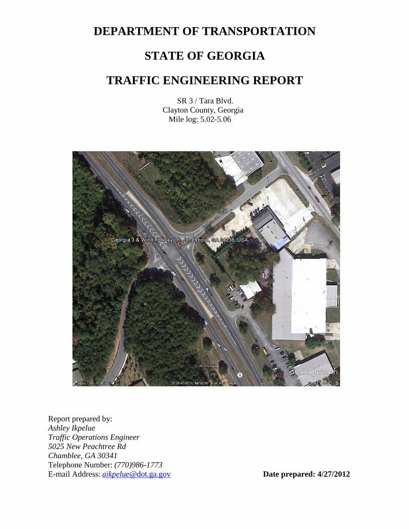
DEPARTMENT OF TRANSPORTATION
STATE OF GEORGIA
TRAFFIC ENGINEERING REPORT
SR 3 / Tara Blvd.
Clayton County, Georgia
Mile log: 5.02-5.06
Report prepared by:
Ashley Ikpelue
Traffic Operations Engineer
5025 New Peachtree Rd
Chamblee, GA 30341
Telephone Number: (770)986-1773
E-mail Address: [email protected] Date prepared: 4/27/2012
Traffic Engineering Report
SR 3 Tara Blvd.
4/27/2012
Page 2 of 5
LOCATION:
This study was conducted for the intersection of State Route 3 Tara Boulevard and County
Roads Winding Way Lane and American Legion Boulevard.
REASON FOR INVESTIGATION:
This traffic study was requested by concerned citizens, stating that there are safety concerns at
the intersection of State Route 3 Tara Boulevard at Winding Way Lane and American Legion
Boulevard.
DESCRIPTION OF THE STATE ROUTE:
State Route 3 is a four lane road that is classified as an Urban Principal Arterial. State Route 3
has 12 foot wide travel lanes with left and right turn lanes and a grass median. The Urban
Principal Arterial runs North /South in Clayton County. The current AADT obtained from the
Department Road Information System for State Route 3 is 46,250 between Mile log 5.02 to 5.06.
The nearest signalized intersection is approximately 0.76 miles north of State Route 3 and
Winding Way Lane/American Legion Blvd.
American Legion Blvd is a two lane, County Road with 10 foot wide travel lanes. The current
AADT is 2,202.
Winding Way Lane is a two lane, County Road with 12 foot wide travel lanes. The current
AADT is 2,202.
TRAFFIC VOLUMES:
The traffic volumes were taken for an eight hour period, movement and direction. These peak
hour counts are found by using the peak hour four fifteen minute consecutive intervals within the
two hour period. No Pedestrian traffic was present during our counts.
SIGNAL WARRANT ANALYSIS
Based on the compiled information this intersection did not satisfy any of the nine signal
warrants.
CRASH DATA
Crash data was evaluated for the years of 2005 thru 2009, SR 3 at Winding Way Lane and
American Legion Blvd.
SR 3 at Winding Way Lane and American Legion Blvd (mile log 5.02 to 5.06)
Angle Crashes:
2005: Two crashes; one injury
Traffic Engineering Report
SR 3 Tara Blvd.
4/27/2012
Page 3 of 5
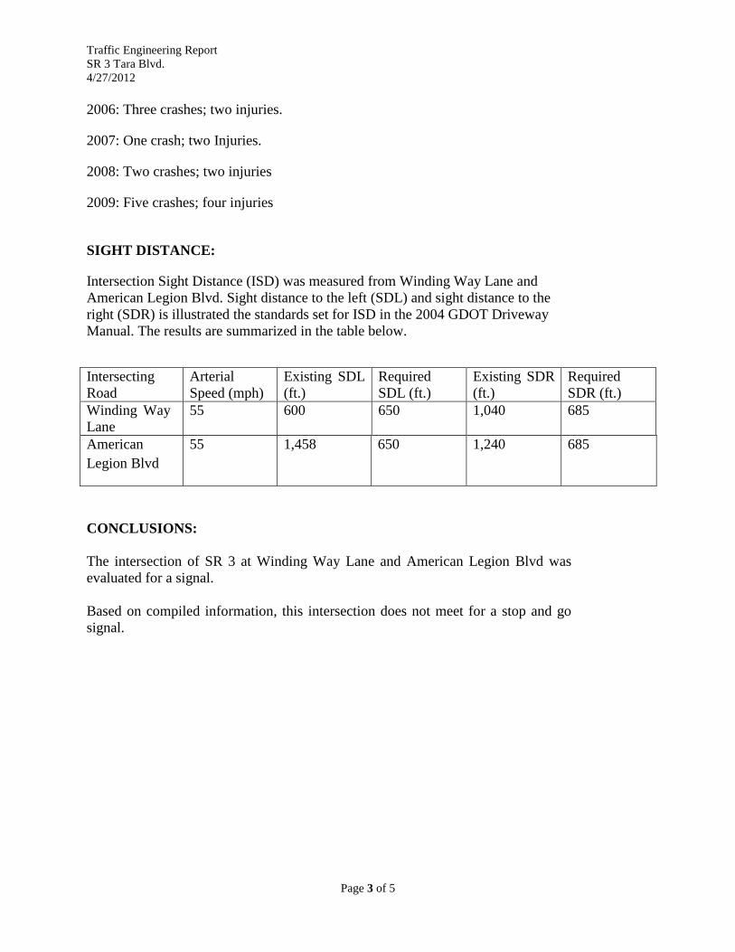
2006: Three crashes; two injuries.
2007: One crash; two Injuries.
2008: Two crashes; two injuries
2009: Five crashes; four injuries
SIGHT DISTANCE:
Intersection Sight Distance (ISD) was measured from Winding Way Lane and
American Legion Blvd. Sight distance to the left (SDL) and sight distance to the
right (SDR) is illustrated the standards set for ISD in the 2004 GDOT Driveway
Manual. The results are summarized in the table below.
Intersecting
Road
Arterial
Speed (mph)
Existing SDL
(ft.)
Required
SDL (ft.)
Existing SDR
(ft.)
Required
SDR (ft.)
Winding Way
Lane
55 600 650 1,040 685
American
Legion Blvd
55 1,458 650 1,240 685
CONCLUSIONS:
The intersection of SR 3 at Winding Way Lane and American Legion Blvd was
evaluated for a signal.
Based on compiled information, this intersection does not meet for a stop and go
signal.
Traffic Engineering Report
SR 3 Tara Blvd.
4/27/2012
Page 4 of 5
RECOMMENDATION:
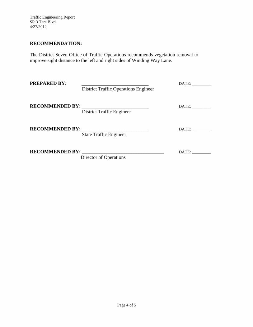
The District Seven Office of Traffic Operations recommends vegetation removal to
improve sight distance to the left and right sides of Winding Way Lane.
PREPARED BY: ___________________________ DATE: _________
District Traffic Operations Engineer
RECOMMENDED BY: ___________________________ DATE: _________
District Traffic Engineer
RECOMMENDED BY: ___________________________ DATE: _________
State Traffic Engineer
RECOMMENDED BY: _________________________________ DATE: _________
Director of Operations
Traffic Engineering Report
SR 3 Tara Blvd.
4/27/2012
Page 5 of 5
Traffic Engineering Report Appendix
Crash Diagram
Crash Data 2005-2009
Signal Warrant Analysis
Traffic Counts
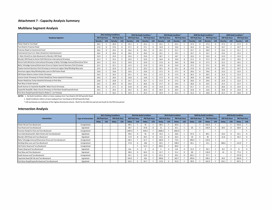
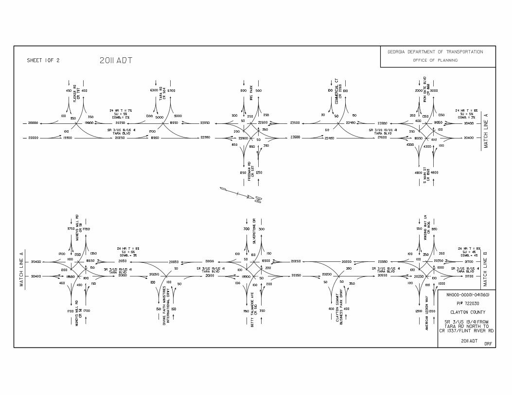
Attachment 7 - Capacity Analysis Summary
Multilane Segment Analysis
Density LOS Density LOS Density LOS Density LOS Density LOS Density LOS Density LOS Density LOS Density LOS Density LOS
20.4 C 20.4 C 22.1 C 22.1 C 22.1 C 22.1 C 27.3 D 27.3 D 27.3 D 27.3 D
27.0 D 27.0 D 27.1 D 27.1 D 19.4 C 19.4 C 34.4 D 34.4 D 23.7 C 23.7 C
26.6 D 29.2 D 26.6 D 29.1 D 19.1 C 21.1 C 33.7 D 36.9 E 23.3 C 25.7 C
26.6 D 26.6 D 26.6 D 26.6 D 19.1 C 19.1 C 33.7 D 33.7 D 23.3 C 23.3 C
25.9 C 25.9 C 25.6 C 25.6 C 18.7 C 18.7 C 32.0 D 32.0 D 22.9 C 22.9 C
22.2 C 22.2 C 22.0 C 22.0 C 16.0 B 16.0 B 27.2 D 27.2 D 19.5 C 19.5 C
24.4 C 22.2 C 24.0 C 22.0 C 17.6 B 16.0 B 29.8 D 27.3 D 21.5 C 19.5 C
22.1 C 22.1 C 21.9 C 21.9 C 15.9 B 15.9 B 27.2 D 27.2 D 19.5 C 19.5 C
22.4 C 22.4 C 22.2 C 22.2 C 16.1 B 16.1 B 27.6 D 27.6 D 19.7 C 19.7 C
23.8 C 23.8 C 23.6 C 23.6 C 17.2 B 17.2 B 29.6 D 29.6 D 21.0 C 21.0 C
24.3 C 24.3 C 24.1 C 24.1 C 17.5 B 17.5 B 30.3 D 30.3 D 21.4 C 21.4 C
24.0 C 24.0 C 23.8 C 23.8 C 17.3 B 17.3 B 29.8 D 29.8 D 21.1 C 21.1 C
23.8 C 23.8 C 23.7 C 23.7 C 17.2 B 17.2 B 29.6 D 29.6 D 21.0 C 21.0 C
24.5 C 26.9 D 24.4 C 26.6 D 17.7 B 19.4 C 30.6 D 33.5 D 21.5 C 23.7 C
30.2 D 27.1 D 32.8 D 29.5 D 21.8 C 19.6 C 41.7 E 37.3 E 26.6 D 23.9 C
24.4 C 24.4 C 26.4 D 26.4 D 26.4 D 26.4 D 32.8 D 32.8 D 32.8 D 32.8 D
21.2 C 23.5 C 22.9 C 25.5 C 22.9 C 25.5 C 31.3 D 34.8 D 31.3 D 34.8 D
NOTES: 1. No Build Conditions reflect a 4-lane roadway from Tara Road to SR 54/Fayetville Road.
2. Build Conditions reflect a 6-lane roadway from Tara Road to SR 54/Fayetville Road.
* LOS and density are indicative of the highest directional volume. North for the AM time period and South for the PM time period
Intersection Analysis
Delay LOS Delay LOS Delay LOS Delay LOS Delay LOS Delay LOS Delay LOS Delay LOS Delay LOS Delay LOS
Flicker Rd and Tara Boulevard Unsignalized 48.5 F 76 F 48.5 F 83.9 F - F 510.5 F - F 510.5 F
Tara Road and Tara Boulevard Signalized 28.7 C 47.8 D 21 C 32.1 C 65 E 103.9 F 39.3 D 60.9 E
Freeman Road/Iris Park and Tara Boulevard Unsignalized 1387.5 F 910.4 F 1668.3 F 1462.9 F - F - F - F - F
Iron Gate Boulevard/S. Main Street and Tara Boulevard Signalized 39.6 D 36 D 33.4 C 28.6 C 67.4 E 80.1 F 43.4 D 43.1 D
Mundy's Mill Road and Tara Boulevard Signalized 17.9 B 39.5 D 15.6 B 26.4 C 50 D 90 F 21.8 C 46.2 D
Betty Talmadge Avenue/Silverstone Drive and Tara Boulevard Unsignalized 146.1 F 61.7 F 160.9 F 73.6 F 396.9 F 219.5 F - F - F
Winding Way Lane and Tara Boulevard Unsignalized 27.8 D 168 F 69.5 F 348.9 F 69.1 F 23.1 C 586.6 F 115.9 F
Old Poston Road and Tara Boulevard Unsignalized - F 52.3 F 430.3 F 80.6 F - F - F - F - F
Poston Road and Tara Boulevard Signalized 8.6 A 9 A 5 A 6.8 A 21.3 C 26.1 C 8.3 A 8 A
Post Way and Tara Boulevard Signalized 38.6 D 64.2 E 31.7 C 51.2 D 80 F 130.4 F 41 D 77.4 E
South Avenue and Tara Boulevard Unsignalized 43.1 E 23.6 C 121.1 F 30.5 D 101.2 F 47.7 E - F 137.8 F
Fayetville Road (SR 54) and Tara Boulevard Signalized 310.5 F 163 F 309.8 F 162.7 F 395.8 F 190.1 F 44.3 F 202.8 F
Flint River Road/Fayetville Road and Tara Boulevard Signalized 55.5 E 91.7 F 57.8 E 91.9 F 99.9 F 161.9 F 132.1 F 207.1 F
Mundy's Mill Road to Divine Faith Ministries International Driveway
Divine Faith Ministries International Driveway to Betty Talmadge Avenue/Silverstone Drive
Betty Talmadge Avenue/Silverstone Drive to Clayton Summit Business Park Driveway
Clayton Summit Business Park Driveway to American Legion Way/Winding Way Lane
American Legion Way/Winding Way Lane to Old Poston Road
Flicker Road to Tara Road
Tara Road to Freeman Road
Freeman Road to Commercial Court
Commercial Court to S. Main Street/Iron Gate Boulevard
S. Main Street/Iron Gate Boulevard to Mundy's Mill Road
2011 Existing Conditions
AM Peak Hour PM Peak Hour
2039 No Build Condition 1
Roadway Segment
2019 No Build Condition 1
AM Peak Hour PM Peak Hour
2019 Build Condition 2
AM Peak Hour PM Peak Hour
2039 Build Condition 2
AM Peak Hour PM Peak Hour AM Peak Hour PM Peak Hour
Old Poston Road to Justice Center Driveway
Justice Center Driveway to Poston Road/Low Temp Industrial Driveway
Poston Road/Low Temp Industrial Driveway to Post Way
Post Way to South Avenue
South Avenue to Fayetville Road/Mt. Nebo Church Driveway
Fayetville Road/Mt. Nebo Church Driveway to Flint River Road/Fayetville Road
Flint River Road/Fayetville Road to Robert E. Lee Parkway
2011 Existing Conditions 2019 No Build Condition
Type of IntersectionIntersection
2019 Build Condition 2039 No Build Condition 2039 Build Condition
AM Peak Hour PM Peak Hour AM Peak Hour PM Peak Hour AM Peak Hour PM Peak Hour AM Peak Hour PM Peak Hour AM Peak Hour PM Peak Hour
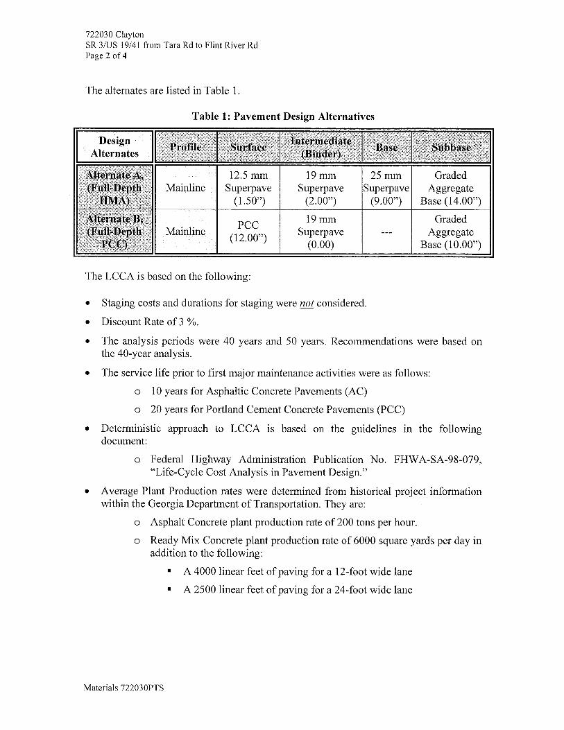
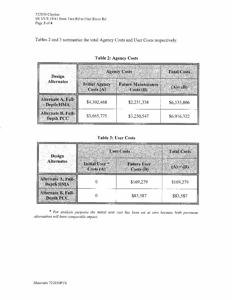
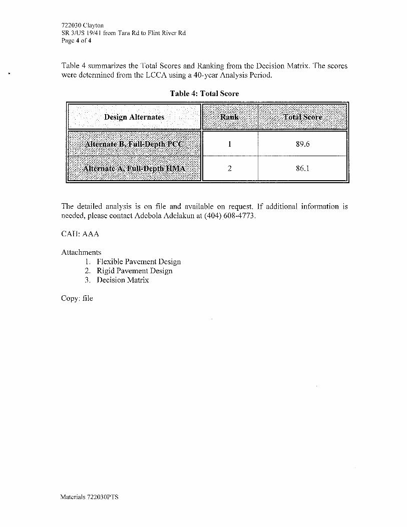
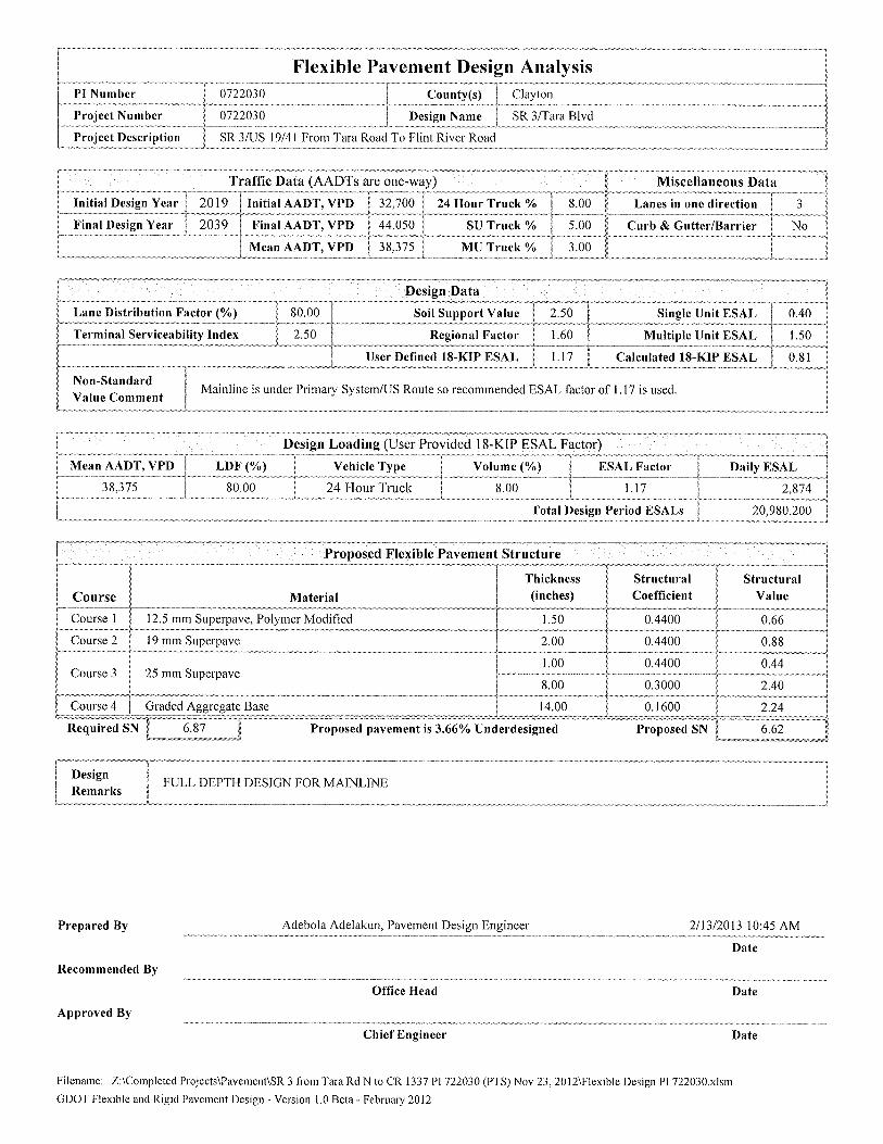
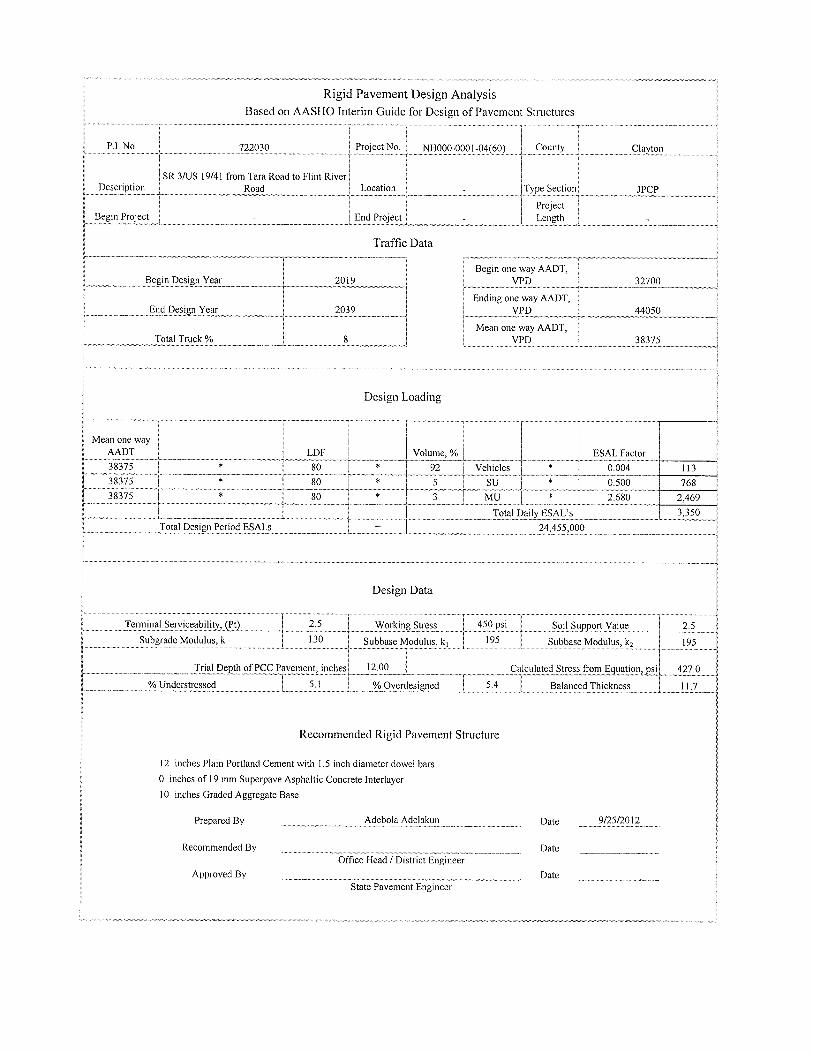
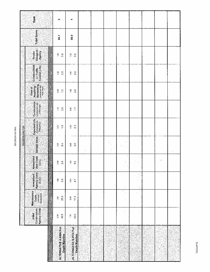
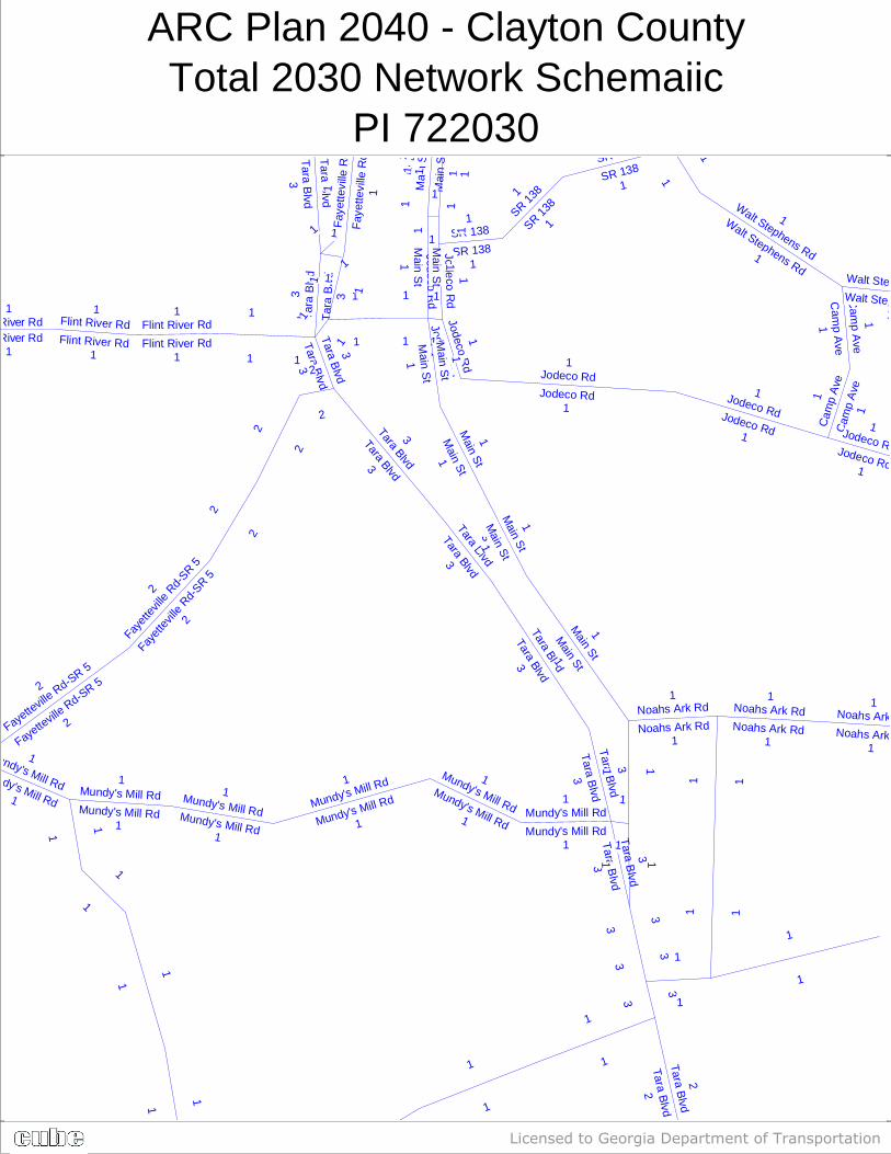
ARC Plan 2040 - Clayton CountyTotal 2030 Network Schemaiic
PI 722030
Licensed to Georgia Department of Transportation
Mundy's Mill RdMundy's Mill Rd
1
1Mundy's Mill Rd
Mundy's Mill Rd1
1
Mundy's Mill Rd
Mundy's Mill Rd
1
1
Mundy's Mill Rd
Mundy's Mill Rd1
1
Mundy's Mill Rd
Mundy's Mill Rd
1
1
1
1
Fayette
ville R
d-SR 5
Fayette
ville R
d-SR 5
2
2
Cam
p A
ve
Cam
p A
ve
1
1
Jodeco Rd
Jodeco Rd
1
1Jodeco Rd
Jodeco Rd
1
1
Jodeco Rd
Jodeco Rd
1
1
Jodeco Rd
Jodeco Rd
1
1
Cam
p Ave
Cam
p Ave
1 1
Walt Stephens Rd
Walt Stephens Rd1
1
Walt Stephens Rd
Walt Stephens Rd
1
SR 138SR 138
1
1
1
SR 138SR 138
1
1
J od e co Rd
J od e co Rd
1 1
11
3
3
1
1
Tara Blvd
Tara Blvd
2
2
Tara B
lvdT
ara Blvd
3
3
3
3
1 1
Tara B
lvdT
ara Blvd
3
3
1
1
Mundy's Mill Rd
Mundy's Mill Rd
1
1
Tara BlvdTara Blvd3
3
Tara BlvdTara Blvd3
3
Tara BlvdTara Blvd3
3
Tar
a B
lvd
Tar
a B
lvd
33
1
1
1
1
Tara Blvd
Tara Blvd
3
3
Tar a B
lvdT
ar a Blvd
3 3
1
1
1
1
1
1
1
1
1
1
1
1
11
3
3
Noahs Ark RdNoahs Ark Rd
1
1
11
Noahs Ark Rd
Noahs Ark Rd
1
1
Main St
Main St1
11 1
Main S
tM
ain St1
1
Main S
tM
ain St1
1
1
1
Main S
tM
ain St
1 1
Main S
t
Main S
t
1 1
1
1
SR 1381
Ma i
n S
t
Ma i
n S
t
11
Flint River RdFlint River Rd
1
1
Flint River Rd
Flint River Rd
1
1
1
1
SR 1381
Fayet
tevil
le Rd-
SR 5
Fayet
tevil
le Rd-
SR 52
2
2
2
2
2
SR 138
SR 138
1
1
11
11
1
1 1
1
1
1
Fay
ette
v il le
Rd
Fay
ette
v il le
Rd
11
1
1
1
1Noahs Ark Rd
Noahs Ark Rd
1
1
Flint River Rd
Flint River Rd
1
1
2
2

Attachment 11: Highway Safety Manual Crash Reduction Factor Calculations
Proposed Concept for a Urban Six Lane Divided Roadway
The Highway Safety Manual (HSM) has been referenced for the availability of a Predictive Method analysis using a
Safety Performance Function (SPF) with associated Crash Modification Factors (CMF). The concept for the
roadway on this project is classified by the HSM as an Urban Multilane (Six Lane) Divided roadway. There is no
HSM SPF for this facility type thus a HSM Predictive Method analysis is of no value.
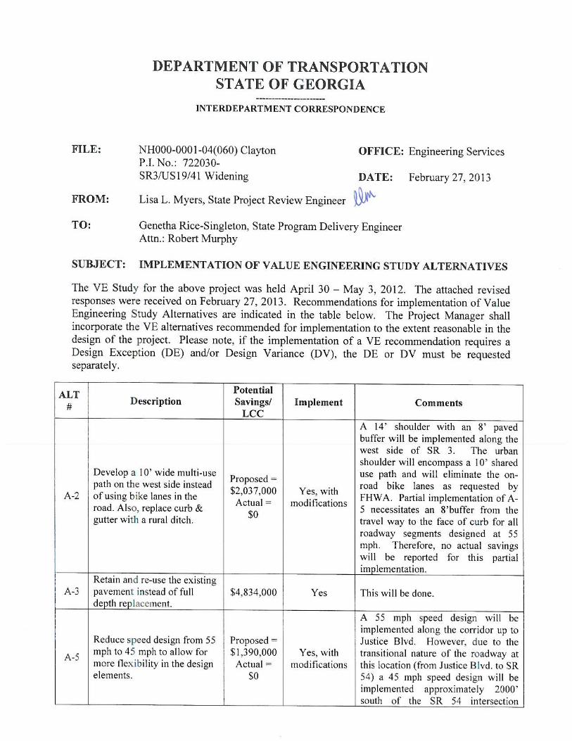
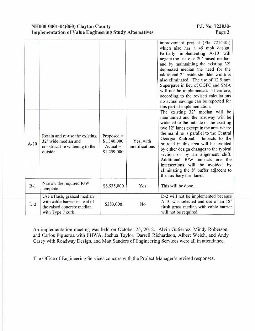
Page 1 of 4
CONCEPT TEAM MEETING MINUTES Clayton County
P.I. 722030 SR 3/US 19/41 fm Tara Rd north to CR 1337/Flint River Rd
February 9, 2012 Meeting Agenda
Introductions:
1. Robert Murphy PM began the meeting with introductions
a. Project Justification Statement-read by Robert Murphy then gave a brief
description of the project and project limits. Mr. Murphy also informed the team
of the current project schedule and upcoming baseline milestones.
b. Logical Termini-David Zoeckler with Engineering Services wanted to know why
the limits did not extend to McDonough Road which is a much bigger intersection
with more traffic. It was noted that there was a significant drop in traffic at Tara
Road. Robert Murphy indicated to the team that there are no plans to extend
the project limits to McDonough Road.
c. Public Involvement- a PIOH and PHOH will be required. It was suggested that
officials from the Atlanta Motor Speedway be contacted to participate in the
PIOH. Mr. Murphy indicated that he would contact Clayton County and schedule
a stakeholders meeting.
d. Landscaping requirements-the median is currently grassed and landscaping is
not proposed. Mr. Murphy indicated that there is no agreement with the Local
Government to provide landscaping for this project.
e. Interface with other Projects in the area- Design recommended reducing the
project termini to tie into proposed project, PI 721440, which includes
improvements to the intersection of SR 54 and SR3/US 19/41. This project is in
final design and proposes triple lefts onto SR 3/US 19/41 northbound.
f. Railroad Coordination with Central of Ga. Railroad Co.-Railroad coordination
will be required. Richard Crowley noted the following items need to be
considered:
-The railroad may request a future track on the west side.
-Wall may be required to protect future track.
-Railroad will want a crossing closure. The closure does not have to be on this
project.
-A 3 day closure will be required for upgrading crossing at Freeman Road. It was
noted that public involvement for the crossing can be included in the PIOH.
-Permanent easement will be required for the existing right turn bay within the
railroad R/W at the intersection of Freeman Road and SR 3.

Page 2 of 4
g. Right of Way Requirement/Relocates/est. Cost/GDOT Responsibility- Mrs.
Sherry Phillips with District 7 R/W Indicated that the preliminary ROW cost
estimate will need to be updated since the parcel count has changed from 140 to
184. Design team also indicated that they will look at all options available so
impacts can be minimized.
2. Design Team Member /Theresa Holder P.E./Fletcher Miller/Josh Taylor
a. Design Criteria Proposed–Joshua Taylor provided an overview of the proposed
project. The preferred alternative would widen the corridor from 4 to 6 lanes with
a 24’ raised median, bike lanes, and urban shoulders. The design speed would be
lowered to 45 mph and sidewalk would only be provided on the western side of
the corridor. This alternate was preferred because it reduces the project
footprint. It was also noted in the ICTM that several pedestrian fatalities have
occurred along the corridor. The second alternative would provide the same
typical section with the addition of an extra 10 feet of pavement between the
edge of travel and curb and gutter to accommodate pedestrians and a 55mph
design speed. This alternate will increase the project footprint.
Open Comments:
a. Planning: VVIICCKKII GGAAVVAALLAASS iinnddiiccaatteedd tthhaatt sshhee wwiillll aatttteenndd tthhee ssttaakkeehhoollddeerrss mmeeeettiinngg wwiitthh
CCllaayyttoonn CCoouunnttyy
b. District 7 Traffic Operations: Alania Stewart noted that the 85% percentile speed along
the corridor was 68 mph. Traffic counts were recently taken at Freeman Road
intersection due to complaints received from citizens. A traffic signal was not warranted
at the intersection. She does not recommend lowering the speed limit. Mr. Murphy
requested District 7 to perform signal warrant analysis for all unsignalized intersections
within project limits.
c. Environmental: Mrs. Lenor Bromberg Associate Vice President with Kennedy Eng.
Associates Group informed the team of all environmental activities such as Ecology and
History surveys are complete and have been submitted to GDOT for review. There is a
cemetery at Tara Road and an Old Battlefield located ½ mile south of project termini.
Several streams are located along the corridor that will require stream buffer variances.
Full air quality and noise modeling will be required. USTs are expected. Environmental
approval is expected in 08/2013.
d. District 7 Preconstruction: Scott Lee noted that the description should be changed since
it includes reducing the frequency and severity of crashes. Lowering the speed limit
may increase the crashes along the corridor.
e. Utilities: Yulonda Pride-Foster noted that GDOT will be responsible for reimbursable
utilities since a PFA is not applicable. It is anticipated that significant utility
Page 3 of 4
reimbursement will be required near the railroad property. She will complete the PID
and utility cost estimate prior to submission of the concept report.
Georgia Power representative, stated that GP has two transmission crossings along the corridor, one south of Mundy’s Mill Road and one at Old Poston Road. 95% of the lines are overhead. Georgia Power has lines along the west side of Tara Blvd. from Tara road to S. Main Street. Yulonda
Pride-Foster noted that GDOT will need to reimburse GA Power if we impact their lines.
Jun Birnkammer noted that Quad Level B SUE will be performed. SUE will also need to
pick up all the utilities along the railroad property. There are 7 of 9 documented utility
owners.
f. Survey: Carlos Dizon noted that an additional 1600 feet of survey was requested by
design. Survey is 30% complete and design can tentatively expect the DTM in April
2012. It was recommended that survey pick up the railroad track centerline along the
corridor as well.
g. Construction: No personnel present
h. County: No personnel present
Attendees include:
Page 4 of 4
Robert Murphy P.M. Program Delivery
Theresa Holder P.E. Roadway Design
Bobby Plunkett Ga. Power Company
Yulounda Pride Foster District 7 Utilities
Keisha Jackson GDOT OES
Funmi Adesesan GDOT OES
Jill Franks GDOT R/R Utilities
Richard Crowley GDOT R/R Utilities
Raymond Chandler GDOT Utilities/SUE
Jun Birnkammer GDOT Utilities/SUE
David Zoeckler Engineering Services
Jan Phelps GDOT Utilities/SUE
Steven Boockholdt Roadway Design
Joshua Taylor Roadway Design
Fletcher Miller Roadway Design
Latonya White District 7 R/W
LaKeisha Brooks District 7 R/W
Janet Barksdale District 7 R/W
Lenor Bromberg Kennedy Engineering Group
Tommy Crochet McGee Partners Inc.
Jonathan Walker District 7 Utilities
Alania Stewart District 7 Traffic Operations
Scott Lee District 7 Preconstruction
Vicki Gavalas District 7 Planning
Carlos Dizon District 7 Survey
Sherry Phillips District 7 R/W