problem statement summaries 2014-10-27...
TRANSCRIPT
Issue and Problem Statement Summaries
State Land Use Review | Office of Planning, 27‐Oct‐14 Page 1 of 14
Introduction
Over the past month, OP has worked to develop problem statements from Task Force input received to‐date that will inform and guide further analysis of the State’s land use system. The draft problem statements attempt to clarify the problems that need be to be addressed by providing clarification, references, and data to more clearly think about improvements to the land use system. The problem statements represent a broad spectrum of perspectives and interests in the State’s land use process.
To develop the problem statements, OP compiled all of the comments and concerns raised by the Task Force during the first four meetings. OP then clustered and analyzed those comments to generate the following eleven issue or problem areas:
1. No consensus on the need for major reform
2. Public participation 3. “The land use process takes too long” 4. Project‐by‐project review doesn’t foster effective project or plan
implementation 5. “The LUC process duplicates county zoning” 6. “LUC should go back to a quasi‐legislative process” 7. Certainty and predictability for parties 8. Protection of resources 9. Implementation 10. Comprehensive analysis for informed decisions 11. Adequacy of enforcement of Chapter 205
Each problem statement includes viewpoints expressed over the course of the Task Force meetings and a summary analysis of the issue or problem by OP staff.
A brief summary of overall findings and implications for system review and improvements is provided in the final section of this document.
The Appendices contain land use and LUC docket data and graphs that have been used in OP’s analysis. The docket data is based on information compiled from OP and LUC files. The information provided to‐date is only representative of general trends and conditions, since the database does not have complete data records for all LUC dockets.
DRAFT
Issue and Problem Statement Summaries
State Land Use Review | Office of Planning, 27‐Oct‐14 Page 2 of 14
1. No consensus on the need for major reform
There is no consensus that major revisions are needed to the LUC process and Chapter 205, HRS.
Viewpoints
LUC process and system is doing what it is intended to do, just needs tweaking
Basic land use districts are good idea, broad umbrellas; shouldn’t change
Quasi‐judicial process allows for in‐depth review of project impacts
State agencies get a say, counties are at table
System offers broad protection for conservation lands
System/process is myopic and redundant of county processes
Process takes too long; adds cost to development
Counties more capable now of planning and land use decision making at level impacted by project proposals
LUC getting into project details; away from broad classification of original LUC process
Analysis
Is Ch 205 and LUC process working in meeting the intent of the State Land Use Law?
Few scattered, large scale subdivisions of land like those approved by local boards prior to enactment of Ch 205
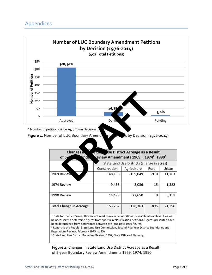
Ninety percent (90%) of petitions acted on between 1976‐2014 were approved (see Fig 1)
Increase in Urban district lands from 2% to 5% of all lands since law enacted: 21,200 acres (28%) by 5‐year boundary reviews of 1969, 1974, and 1992 (see Fig 2); since 1975 when contested case proceedings were instituted, 45,000 acres (about 1,125 acres annually) reclassified to Urban (see Fig 2)
Conservation district managed by a State agency whose functions are to protect conservation values
LUC process provides due process protections for parties with interests in the redistricting; protects State interests where counties don’t have primary resource management responsibilities
On the other hand, faced with affordable housing gap, lengthy and costly development process, serious infrastructure and facility deficits, regulatory system that can’t adjust to changing market and community concerns, gradual erosion in agricultural lands and rural sprawl, and more frequent conflicts between competing public values that make land use decision making contentious, with no effective means to resolve these issues upfront.
There are divergent points of view as to how well the system—and the processes used—are working, reflecting the interests of the stakeholder
Consensus on how to improve the system is difficult, since each perspective/point of view is a legitimate expression of the public interest
Stakeholders—advocates and critics—are familiar with system; as seen in past reform efforts, stakeholders are reluctant to support system change if it doesn’t meet their interests
Effective reform requires understanding the different perspectives and what the underlying needs and concerns are, and balancing how those needs and concerns are met
DRAFT
Issue and Problem Statement Summaries
State Land Use Review | Office of Planning, 27‐Oct‐14 Page 3 of 14
2. Public participation
The general public has a difficult time participating effectively in land use decisions—particularly in cases where there are competing public interests in land use.
Viewpoints
Public participation in the LUC process is hampered by:
No easy means to testify or be involved; need to travel and attend all hearings
Inadequate signage and notification of proposed LUC projects
Citizens need for help to demystify the process
Too many points of intervention in entire development process, causing delays and uncertainty
Public intervenors extend LUC hearings; if appealed, even longer delays
In county planning, lots of opportunities for community/public involvement in county plan revisions and updates
In county‐level land use decision making, public participation is limited in hearings, there’s political/special interest influence, based on developers’ studies
LUC process offers only real opportunity for citizen participation in land use decisions
Analysis
Public has legitimate interests in meaningful representation in land use decision making: they bear direct impacts of approvals (e.g., traffic) as well as cost of servicing new projects through increased property taxes or degradation of infrastructure/services; ensures interests of non‐monetized public goods, like public trust resources, are protected. When these concerns aren’t represented well or addressed in land use decision making, public wants a seat at the table
LUC process provides an opportunity for public participation not available in other states—and for advocates, not available in county land use decision making. Participants through intervention are given an equal footing in presenting their position and arguments through the quasi‐judicial process.
Counties provide for extensive public engagement in county plan revision processes. While conflicting public interests are embedded in county plans, conflicts over land use tend to crystallize around specific project proposals. Project‐specific approvals at county level typically are decided in legislative hearings without opportunities afforded by LUC process.
State and county parties to LUC present the positions of their respective administrations; in developing positions must balance a host of policy objectives and State agency interests and priorities, thus interests may not align with individual community/public interest perspectives
Access and notification procedures of LUC can be improved: use of site‐specific signage and noticing to inform local communities, like those used by counties; greater use of Internet to share LUC documents and records; consideration of ways to make intervention more effective
Intervention in LUC petitions not common—less than 20% have intervenors—not all are public intervenors. Would all parties and public be better served with other means (additional checks and balances) to deal with land use conflicts where there are competing public interests?
One model to consider: Oregon and Washington among several states that have pioneered establishment of land use appeals boards to hear land use disputes
DRAFT

Issue and Problem Statement Summaries
State Land Use Review | Office of Planning, 27‐Oct‐14 Page 4 of 14
3. “The land use process takes too long”
Most frequent criticism is that the land use process takes too long, contributing to delays and higher cost for development.
Viewpoints
Getting land use permits for development generally takes 7‐10 years
Projects are entitled for 20 years but often still not developed; process needs to be easier
Slow processing of ministerial permits
Land use system has too many intervention points, potential for lawsuits in land use system—if you go to court on every issue, will take years to build
State level review lengthens development timetable by duplicating county processes and addressing same impacts: too much detail/complexity, time and cost of project review
Need full and deliberate examination of project impacts on public trust resources
Analysis
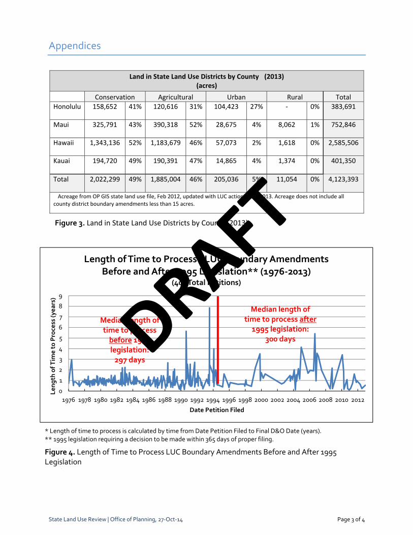
LUC decision making adds at least one year to development process. Median length of time for processing from date filed to final decision and order has not changed significantly since 1976: from median of 297 days for 1976‐1995 period to 300 days post‐1995 (see Fig 4).
EA/EISs often done at LUC stage since Ch 343 requires EA/EISs for first discretionary permit in land use process. Time to process EA/EISs often attributed to LUC process, but accepted document also serves county approvals. EA/EISs typically take 1 to 2+ years to prepare/process.
Streamlining of redistricting process by increasing acreage threshold for county boundary amendments might shorten processing time, but also precludes level of scrutiny and means to address impacts on public trust resources and State infrastructure and facilities
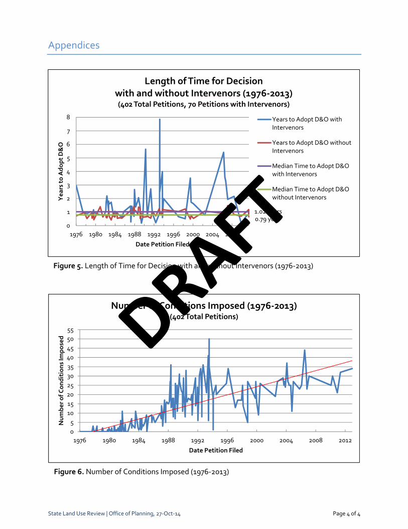
Intervention in a docket typically lengthens the processing time for LUC approvals. Petitions with intervenors take a little over a year (371 days) or 29% longer to decide (see Fig 11).
Court appeals of decisions are relatively infrequent, but can result in substantial delays where land use policy conflicts exist. E.g., Koa Ridge project: filed in 2000, approved three times by LUC, appealed to court three times, and currently pending Supreme Court approval on the latest 2012 LUC approval
Delays in project development are not always due to the LUC or land use process, but may be due to economic/market factors (slowing economy, project financing, change in landownership), delays in county entitlement process, failure to secure requisite infrastructure improvements to service project (e.g., water sources still to be identified years later). Delays of 10 to 20 years are not uncommon based on annual reports filed with the LUC.
Concerns point to need to examine other models for making system more responsive without compromising desired land use objectives; see related discussion points in Project‐by‐project review and Duplication with counties
Under Oregon law, statewide planning program requires that development permits must be processed within 120 days.
In California, some counties have initiated priority processing for land use applications that include Smart Growth features. Projects that score a certain amount of points on a checklist of criteria could qualify for quicker review and save months in processing time.
DRAFT
Issue and Problem Statement Summaries
State Land Use Review | Office of Planning, 27‐Oct‐14 Page 5 of 14
4. Project‐by‐project review doesn’t foster effective project or plan implementation
LUC redistricting in response to individual petitions for development sometimes yields mixed results in plan implementation at the regional level.
Viewpoints
Project‐by‐project review:
Gets into details not relevant to determining the appropriate district classification and is duplicative of county zoning and permitting processes
Is reactive to landowner and developer interests; is regulatory, not planning; should be proactive based on big picture
State checks on growth are at project‐level; in other states, checks are at county plan‐level
But, provides a second level of review for public trust resources
Ensures full examination of concerns and impacts
Analysis
Prior to 1975, LUC used quasi‐legislative process to reclassify districts—no individual project reviews or approvals, no conditions imposed. Following the 1974 Supreme Court ruling on Town v. Land Commission, Ch 205 was amended to eliminate five‐year boundary review and require LUC to decide boundary amendments on a case‐by‐case basis using a quasi‐judicial process.
LUC project‐specific review provides opportunity for full examination of project and its impacts. State and county interests are represented, addressed, and mitigated as needed.
Since 1976, most petitions are approved by LUC, with or without intervenors (1976‐2014). Over time, LUC proceedings have delved into greater project detail, resulting in general increase in the number of conditions imposed from zero in 1976 to median of 25 conditions post‐1995 (see Fig 6). See Duplication with counties regarding perceived problems with State project approvals.
Difficulties with individual project review process in practice:
Hard to analyze cumulative and regional impacts, imperfect data; hard to argue against “no significant loss/impact” from single project on a project‐by‐project basis
Studies and project plans required to meet content requirements often leads to investment, entitlement, and specific mitigations too early in land use process, creating difficulties complying with representations/conditions as projects stall or morph over time in response to market change. Only petitioners with deep pockets survive.
Can’t coordinate regional infrastructure requirements or address regional concerns on a project‐by‐project basis, often too burdensome for developer
Limited ability to address numerous—often conflicting—State agency plans and policy priorities or emerging issues like climate change on a project‐by‐project basis
Other states such as California, Maryland, and Rhode Island require certain general plan elements and provide financial and technical assistance during the preparation of their plans.
In some states, state planning agencies review and approve local plans to ensure consistency with state plan and planning policies.
DRAFT
Issue and Problem Statement Summaries
State Land Use Review | Office of Planning, 27‐Oct‐14 Page 6 of 14
5. “The LUC process duplicates county zoning”
Critics contend the LUC process is duplicative of county zoning; supporters assert there’s a need for separate State review.
Viewpoints
Same impacts are being considered at State and county levels
LUC is too regulatory, too detailed in review and conditions (e.g., street light types, road treatments—not all have State significance)
There is increased county capacity to make solid, informed land use decisions
Counties are doing more comprehensive planning, and engage community more
There are redundant processes at each ‘permit'; challengeable at each level
Hawaii’s uniqueness; there’s a need for second level of review for public trust resources
LUC review provides for in‐depth analysis of projects, citizen participation in decision making process
Analysis
Perceived redundancy is partly due to the quasi‐judicial review which relies on project‐specific data and conditions to hold petitioner accountable for performance, at too early a stage in the development process.
However, claims of redundancy ignore:
Different functional responsibilities of State and county, e.g., regarding water, State is concerned with resource protection; county more concerned with water delivery as purveyors.
Assertion that State level review comports with public trust obligation in island state (e.g., precautionary principle/showing abundance of caution in fragile ecosystem)
Current process offers mechanism for State to express legitimate interests in land use; State doesn’t have veto power over county plan and county land use designations.
Duplicative review is more evident as county planning department capacities and functions, along with zoning codes, have become increasingly sophisticated, complex, and data‐driven, with extensive community involvement in planning processes.
While county planning capabilities have matured, land use decisions are still subject to local development pressure. Not uncommonly, county decision‐makers override analysis and recommendations of planning staff/planning departments. This is an important driver in desire for checks and balances in land use system.
State review is viewed as more insulated from development pressure
State is assumed to offer a broader perspective incorporating resource management concerns.
In other states, checks and balance is at the comprehensive plan level (Oregon, Washington, Maryland, others). In Hawaii, check is at State project‐specific LUC review.
DRAFT
Issue and Problem Statement Summaries
State Land Use Review | Office of Planning, 27‐Oct‐14 Page 7 of 14
6. “LUC should go back to a quasi‐legislative process”
Viewpoints
Complaints about the quasi‐judicial process:
Too much detail regarding conditions; too much time spent on procedures
Judicial appeals too long—limit intervention
State role too regulatory, leave details to the county
Support for quasi‐judicial:
Avoids impropriety of pecuniary or political benefits from approvals (e.g., developer contributions to elected decision‐makers)
Intervenors have full opportunity to present evidence and witnesses, cross‐examine parties
Decisions are based on written findings and evidence, which must meet standards in law; difficult to appeal a legislative decision.
Analysis
A note about quasi‐judicial vs. quasi‐legislative hearings. Quasi‐judicial or contested case hearings are governed by HRS Ch 91: with administrative court‐like rules for evidence, witnesses, cross‐examination, and decisions based on findings of fact. Ch 91 requirements for judicial review are well‐established and facilitate judicial appeals.
By comparison, legislative decisions such as zone changes approved by county councils are subject to a debatable standard of review with discretion in application of rule, and are thus more difficult to appeal.
Prior to 1974 Town decision, LUC redistricted using quasi‐legislative process; multiple proposals were acted on. In Town v. Land Use Commission, Supreme Court ruled redistricting of a parcel is adjudicative of property rights and must be conducted as contested case hearing under Ch 91. In 1975, Ch 205 was amended to conform to the requirement for contested case hearings.
Detailed quasi‐judicial review of project impacts and mitigation supports transparent, informed decision making; but also diverts attention and resources away from comprehensive planning and plan implementation.
The quasi‐judicial process also provides a unique opportunity for State to address its interests with respect to project impacts on agency resource, facility and infrastructure concerns; there is no other mechanism for State to ensure that impacts on areas of State concern are addressed.
While intervention in LUC process is generally granted and provides citizen groups opportunity to participate, it is still most effective when there is professional legal support, which is a barrier to intervention. From 1976 to present, there were intervenors in 70 petitions, 17%of all petitions (see Fig 5).
Hawaii is unique as the only state doing state‐level land use ‘zoning’ approvals. Hawaii is also unique as the only state using quasi‐judicial process for zoning approvals of any kind.
In other states, public participation and environmental advocacy are well‐developed, yet are able to balance development and protection without project approvals using quasi‐judicial process. Oregon and Washington among states that have pioneered establishment of land use appeals boards to hear land use disputes.
DRAFT
Issue and Problem Statement Summaries
State Land Use Review | Office of Planning, 27‐Oct‐14 Page 8 of 14
7. Certainty and predictability for parties
All stakeholders want certainty and predictability in land use outcomes.
Viewpoints
Intervenors with opportunity to challenge/appeal introduce uncertainty, lack of predictability for developers
Too many intervention points, disruptive to development process
County planning process a strength, but plans not adhered to
No clear standards, rules to follow; case‐by‐case negotiation on mitigation for project approvals
Growth boundaries known for a while, but not making infrastructure, facility improvements for growth—results in project delays
Developers need flexibility to be able to modify approved projects to adapt to economic/market changes
Outdated EAs/EISs and projects on books many years later—how to deal with these
Do we need police powers when we are built out?
Analysis
Uncertainty and lack of predictability in land use system is a function of many factors:
In LUC process, decision making and development process can be disrupted by intervenors, appeals, options for order to show cause; conditions imposed with project approvals don’t provide flexibility in dealing with changing conditions and markets over time
Multiple decision points in the approval/development process where documents/applications are subject to unclear or uncertain standards or can be appealed
Another dimension of predictability for developers and public—lack of infrastructure investment in support of long‐range land use plans/growth boundaries
Results in delays in funding infrastructure improvements required for new growth
Delays projects
Results in case‐by‐case negotiation for mitigation measures
Difficulty balancing “entitlement” for developer and changing conditions/expectations of community and public agencies
Public agencies providing infrastructure/facilities and community members also rely on land use decisions that conform to adopted land use plans as means to provide for orderly growth and change in communities
In Oregon, state land use program provides predictability by requiring that clear objective standards be used when reviewing land use permit applications; under Oregon law, applicants are protected from arbitrary or inconsistent decisions.
As noted elsewhere, some states also provide specialized administrative appeals mechanisms to hear cases where land use decisions have not resulted in predictable outcomes
DRAFT
Issue and Problem Statement Summaries
8. Protection of resources
Can we increase system effectiveness in protecting valued agricultural, rural, and conservation land resources?
Viewpoints
Done a good job of protecting ag and conservation lands, and a poor job of providing housing or urban expansion
Too much land in the Agricultural district, it’s a catch‐all
Conservation district under DLNR authority is good
Give more authority to counties for defining uses and regulating Ag and Rural districts
However…not enough consideration of ag resource concerns in boundary amendments
Critical conservation or agricultural resource lands to preserve are not identified
Problems with regulating non‐ag uses in the Agricultural district
Inadequate definition of Rural; limited use of Rural district
Lands in Ag or other districts that should be reclassified to Conservation due to natural and cultural resources found on land
Analysis
Agricultural Lands
The pattern of urban reclassification of best agricultural lands occurs due to:
Good ag land is also good for urban uses
‘Insignificant loss’ finding that results from piecemeal, project‐by‐project decision making
Lack of complete picture of what lands should be protected and strategy for protection
Incomplete process of identifying those lands that should be protected for agricultural production into the future. Counties generally map agricultural lands in their GPs, DPs, but the process of identifying Important Agricultural Lands (IAL)—as defined in Ch 205—is incomplete.
Sec 205‐6, special permits, allow for essentially a use variance that undermines intent of Ag district to protect agricultural uses; special permit used to permit non‐agricultural uses, notably vacation rentals in Ag district. Use of special permit promotes the impermanence syndrome, which occurs with conversion of ag lands to non‐ag uses (usually higher value uses), increasing price of farm land, discouraging ag investments and loss of supporting ag services/suppliers.
Ch 205 provisions contribute to permitting of non‐ag uses in Ag district
Typical lot sizes and densities more suited for urban settings. In other states and localities, ag lot sizes are much higher than 1‐ 2 acres (e.g. Oregon 80‐acre minimum lot size for designated farm land, 120‐acre minimum lot size for forest land).
Over the years, repeated amendments to allowed uses in Ag district in Ch 205 (from 5 in 1965? to 21 currently) have weakened the nexus to agricultural production and farming
Land use regulation—even IAL designation—is not sufficient to assure agriculture’s future in Hawaii. A strong ag land use policy must be complemented and supported with a robust system of programs and other tools that promote ag as a business and protect best ag land where there is a compelling public interest to do so.
DRAFT
Issue and Problem Statement Summaries
State Land Use Review | Office of Planning, 27‐Oct‐14 Page 10 of 14
8. Protection of resources (contd)
Rural Lands
Limited use of Rural district is largely because the district was defined after the original district boundaries were established. Rural requested by a limited set of small landowners. Less than 1% of land statewide is classified in the Rural District, and there is no land in Rural on Oahu.
In retrospect, the original law and boundaries overlooked the important distinctions between urban and rural communities and the land use challenges of planning, servicing, and maintaining working lands for farming, ranching, and forestry.
Plantation towns and rural centers were designated Urban, even though urban land use and development standards are inappropriate for use in the context of rural settlements and rural infrastructure. All working and open lands not designated as conservation were designated Agricultural, even if they had little agricultural resource value.
Ch 205 Rural District standards and uses are inappropriate for managing rural landscapes and settlements—encourages low‐density sprawl and increases demand for extensive infrastructure and services. There is no flexibility to texturize or differentiate rural communities and land use patterns; rural communities in effect are urban.
An important consideration in rural land use planning is that there are permanent natural, economic, and cultural resource values in these lands. Rural lands need to be viewed as not just premature for development, but a permanent part of Hawaii’s landscape.
The potential for preserving some of Hawaii’s open space, rural communities, and working lands lies in ability to redefine Rural and Agricultural District and their standards, and provide for expansion of the Rural District.
Conservation Lands and Protection of Conservation Resource Values
Concerns raised in this process indicate that there is not a clear vision or broad understanding of what critical conservation resources and conservation resource lands should be protected and how they will be protected.
Land use plans should have a basis in protecting sensitive lands and making that apparent region by region. Such an effort would result in a more integrated picture of what lands should be protected and those that can be developed to meet urban needs.
Trust for Public Lands and OHA’s Greenprint project is one such effort that could inform whether critical resource lands outside the conservation district would benefit from further protection.
Continuing challenges for land use system
Coastal development and shoreline dynamics
Response to climate change, sea level rise, decreasing rainfall, changes in habitats and impact on biota, thinning of groundwater basal lens.
Natural hazards such as lava flow, tsunami inundation
Managing non‐point pollution, stormwater runoff, wastewater impacts on conservation resources
Balancing conservation values with human use values, such as with water resource management and habitat protection.
DRAFT
Issue and Problem Statement Summaries
State Land Use Review | Office of Planning, 27‐Oct‐14 Page 11 of 14
9. Implementation System falls short in providing adequate infrastructure and public facilities in planned
growth areas and providing effective long term protection to valued resource lands.
Viewpoints
State plans are absent or not updated to inform LUC or counties
County planning process a strength, but plans not adhered to
No long‐range comprehensive planning and coordination between State and county capital improvement planning; State and LUC should get involved in county planning process (GP, community plans, community plan amendments)
No fiscal discipline in capital improvement planning and development – planning not tied to CIP
No incentives for planned growth and infrastructure development
Long delays in projects approved but no development
Need certainty with flexibility to deal with market changes
Need equity in paying for growth: developers expected to pay full cost of improvements to mitigate projects, increases cost of housing/development or significantly delays development
Public shouldn’t pay for growth or infrastructure development that it does not ask for or benefit from
Analysis
Hawaii State Plan, Ch 226, provides framework for statewide planning system, but in its current form, does not provide vision, discipline, or effective coordination for statewide land use system, e.g., State functional plans intended to guide allocation of State resources are over 20 years old and aren’t utilized
State resources are devoted to project‐by‐project review rather than regional or long‐range comprehensive planning and coordinated plan implementation
Regional infrastructure cannot be created one project at a time
Reliance on conditions of approval to provide necessary infrastructure results in ad hoc improvement/investment strategy based on developer’s ability to provide improvements
County plans aren’t fiscally constrained, and phasing components are conceptual at best; lack the means to coordinate planned growth with infrastructure/facility development
State lacks coordinated resource protection strategies, such as agricultural resource strategy, or unified investment strategy for planned community development/growth
Implementation and financing tools such as impact fees, community facilities districts , tax increment financing, transfer of development rights are used on mainland to support growth management; counties have statutory authority for these and others, but are not used much
Need a system that invests in planned growth, reduces the cost of infrastructure development to approved projects, and discourages private investments where they are not desired
Other state practices include:
Smart Growth Sub‐Cabinet (Maryland)
Fiscal discipline (Washington)
Targeted funding to growth areas (Maryland)
DRAFT
Issue and Problem Statement Summaries
State Land Use Review | Office of Planning, 27‐Oct‐14 Page 12 of 14
10. Comprehensive analysis for informed decisions
There’s a desire for in‐depth, comprehensive analysis for informed decision making on land use proposals, but this is hampered by difficulty in obtaining data and adequacy of models.
Viewpoints
Cumulative impacts of projects being approved aren’t taken into account; not looking at what’s been approved or waiting in the wings
Vision not clear when county plan revisions aren’t timely (who’s providing overall guidance?)
Carrying capacity is needed vs. carrying capacity is impossible to measure
Criteria and guidelines for decision making too broad, subject to interpretation
Environmental studies paid for by project developer
Need for shared baseline data to support long‐term regional planning, such as housing data
Planning thresholds, e.g., for transportation, aren’t known until projects proposed at LUC and zoning
System isn’t responding well to broad systemic issues like food security, water, affordable housing
Analysis
In practice, analysis for individual projects:
Relies on environmental docs and studies by project proponent
Struggles with assessing regional and cumulative impact on a project‐by‐project basis
Relies on substantive agency reviews configured to respond to projects in permitting mode rather than planning mode
Variability of staff review results in lack of consistency in the review and application of standards and criteria
Data is scattered among State and county agencies without regional integration
Lack of shared thresholds and link to regional planning analysis for individual projects, like for transportation, results in case‐by‐case negotiation with affected State or county agency, increases uncertainty and reduces predictability
Desire for complete information on cumulative, regional impacts and mitigation for land use decision making forces investment in detailed plans and studies too early in process which
Tends to lock in investment back expectations
Creates inconsistencies due to changing market conditions and detailed design plans
Requires commitment to representation and conditions get locked in
In California, pursuant to the California Environmental Quality Act, information developed in individual environmental impact reports is incorporated into a database, which is maintained by the state planning agency and can be used to reduce delay and duplication in preparation of subsequent environmental impact reports.
DRAFT
Issue and Problem Statement Summaries
State Land Use Review | Office of Planning, 27‐Oct‐14 Page 13 of 14
11. Adequacy of enforcement of Chapter 205
Viewpoints
Conditions imposed by the LUC aren’t sufficiently clear to allow enforcement by the counties; too detailed or duplicative of counties
Conditions and compliance with representations hold developers accountable
Inadequate enforcement of conditions
LUC has limited authority to enforce conditions
Developers need more flexibility when market or project changes over time; certainty but flexibility desired
Enforcement of uses in Ag district is a problem
Analysis
The LUC is authorized to determine whether an action is a violation of its conditions, to order that the violation cease, and to revert the Petition Area to its former or other classification for violations of such conditions. (Hawaii Administrative Rules §§ 15‐15‐98 – 15‐15‐104.1 Declaratory Orders, and 15‐15‐93 Enforcement of conditions, representations, or commitments). LUC, however, does not have the power to enforce a cease and desist order, such as the power to fine.
Typically, counties enforce their own zoning ordinances which should incorporate the restrictions imposed by Ch 205 and often include the conditions imposed by the LUC. Counties are independently empowered to enforce the broader restrictions imposed either by State statute or LUC order. However, this power has not been exercised, leaving enforcement to private citizens or to the limited enforcement powers of the LUC.
Is the use of the Order to Show Cause proceeding an insufficient enforcement too? Over the last 10 years, the LUC has considered three petitions for an Order to Show Cause: (1) Kuilima; (2) Bridge Aina Lea; and (3) Kaonoulu Ranch. In Kuilima, intervenors asked the LUC to revert the Petition Area for failing to comply with conditions on a timely basis. The LUC decision is still pending. In Bridge Aina Lea, the LUC reverted the Petition Area to its original classification when Petitioner failed to deliver its affordable housing units as required. The circuit court reversed the LUC decision, and the appeal to the Hawaii Supreme Court is pending. In Kaonoulu Ranch, intervenors requested an order to show cause because the use was changed from light industrial to commercial and residential which was not in substantial compliance with the original representations. The LUC determined there was good cause to issue the order to show cause, but Petitioners agreed to file a motion to amend to bring the project into conformance.
Because reversion is such a harsh penalty, it is not appropriate for all violations. The value of the Order to Show Cause proceeding as a threat, therefore, may outweigh its value as an actual punishment. But if the counties are not enforcing the LUC conditions, either the LUC considers imposing an extremely harsh penalty, the public finds the resources to enforce the LUC conditions, or the Petitioner is allowed to violate the LUC conditions without consequences.
DRAFT

Issue and Problem Statement Summaries
State Land Use Review | Office of Planning, 27‐Oct‐14 Page 14 of 14
Implications for System Improvements
There is no consensus that Hawaii’s land use system—Ch 205 in particular—is broken. There is general agreement that:
The system appears to have done its job in curtailing “rampant” development; although we don’t know what our landscape would have looked like if the system had not been in place for the last 50 years; and
The State needs to have a role in land use planning and management in Hawaii.
While there’s no agreement about system change, stakeholders are uniformly dissatisfied with how the system performs and what the system delivers: we are not getting the kind of quality growth or resource protection that is desired.
Hawaii’s land use system has not changed significantly in the 53 years since it was enacted. What opportunities are we missing by resisting change given growth in county planning capacity and the emergence of new science and best planning practices since 1961? Could we be doing a better job of:
Providing for quality development and resource protection that produce the desired outcomes we want from our land use system;
Being more responsive to local and global market trends and value shifts; and
Anticipating and resolving land use conflicts where there are competing public interests?
Going forward. Four overarching themes or questions emerged from the concerns expressed by Task Force members—questions central to creating a system that engenders trust in our land use decision making processes. System issues and recommendations for system change or improvements need to be evaluated in terms of the following questions:
What is the appropriate role of the State and how should State interests be expressed in our land use system?
How do we provide checks & balances to increase trust in the system and in its performance?
How can we achieve more effective growth management and resource protection?
How can we make the land use process more efficient without compromising public participation and resource management and protection?
DRAFT
Appendices
State Land Use Review | Office of Planning, 27‐Oct‐14 Page 1 of 4
Land Use Commission Docket and Petition Information
Please note the following:
The data used to generate the tables and graphs in the Appendices is derived from the Office of Planning’s files and may not reflect the complete record of Land Use Commission dockets.
The data does not include county district boundary amendments, or those projects which are less than 15 acres.
DRAFT
Appendices
State Land Use Review | Office of Planning, 27‐Oct‐14 Page 2 of 4
308, 91%
26, 8%5, 1%
0
50
100
150
200
250
300
350
Approved Denied Pending
Number of Petitions
Number of LUC Boundary Amendment Petitions by Decision (1976‐2014)
(402 Total Petitions)
Changes in State Land Use District Acreage as a Result of 5‐year Boundary Review Amendments 1969�, 1974², 1990³
State Land Use Districts (change in acres)
Conservation Agriculture Rural Urban
1969 Review 148,196 ‐159,049 ‐910 11,763
1974 Review ‐9,433 8,036 15 1,382
1990 Review 14,499 22,650 0 8,151
Total Change in Acreage 153,262 ‐128,363 ‐895 21,296
� Data for the first 5‐Year Review not readily available. Additional research into archival files will be necessary to determine figures from specific reclassification petitions. Figures presented have been determined from differences between pre‐ and post‐1969 figures. ² Report to the People: State Land Use Commission, Second Five‐Year District Boundaries and Regulations Review, February 1975 (p. 25) ³ State Land Use District Boundary Review, 1992, State Office of Planning.
Figure 2. Changes in State Land Use District Acreage as a Result of 5‐year Boundary Review Amendments 1969, 1974, 1990
Figure 1. Number of LUC Boundary Amendment Petitions by Decision (1976‐2014)
* Number of petitions since 1975 Town Decision.
DRAFT
Appendices
State Land Use Review | Office of Planning, 27‐Oct‐14 Page 3 of 4
0
1
2
3
4
5
6
7
8
9
1976 1978 1980 1982 1984 1986 1988 1990 1992 1994 1996 1998 2000 2002 2004 2006 2008 2010 2012
Length of Tim
e to Proce
ss (years)
Date Petition Filed
Length of Time to Process* LUC Boundary Amendments Before and After 1995 Legislation** (1976‐2013)
(402 Total Petitions)
Median length of time to process before 1995 legislation: 297 days
Median length of time to process after1995 legislation:
300 days
Land in State Land Use Districts by County� (2013) (acres)
Conservation Agricultural Urban Rural Total
Honolulu 158,652 41% 120,616 31% 104,423 27% ‐ 0% 383,691
Maui 325,791 43% 390,318 52% 28,675 4% 8,062 1% 752,846
Hawaii 1,343,136 52% 1,183,679 46% 57,073 2% 1,618 0% 2,585,506
Kauai 194,720 49% 190,391 47% 14,865 4% 1,374 0% 401,350
Total 2,022,299 49% 1,885,004 46% 205,036 5% 11,054 0% 4,123,393
� Acreage from OP GIS state land use file, Feb 2012, updated with LUC actions thru 2013. Acreage does not include all county district boundary amendments less than 15 acres.
Figure 3. Land in State Land Use Districts by County (2013)
Figure 4. Length of Time to Process LUC Boundary Amendments Before and After 1995 Legislation ( 6 )
* Length of time to process is calculated by time from Date Petition Filed to Final D&O Date (years). ** 1995 legislation requiring a decision to be made within 365 days of proper filing.
DRAFT
Appendices
State Land Use Review | Office of Planning, 27‐Oct‐14 Page 4 of 4
0
5
10
15
20
25
30
35
40
45
50
55
1976 1980 1984 1988 1992 1996 2000 2004 2008 2012
Number of Conditions Im
pose
d
Date Petition Filed
Number of Conditions Imposed (1976‐2013)(402 Total Petitions)
1.02 years0.79 year
0
1
2
3
4
5
6
7
8
1976 1980 1984 1988 1992 1996 2000 2004 2008
Years to Adopt D&O
Date Petition Filed
Length of Time for Decision with and without Intervenors (1976‐2013)(402 Total Petitions, 70 Petitions with Intervenors)
Years to Adopt D&O with Intervenors
Years to Adopt D&O without Intervenors
Median Time to Adopt D&O with Intervenors
Median Time to Adopt D&O without Intervenors
Figure 5. Length of Time for Decision with and without Intervenors (1976‐2013)
Figure 6. Number of Conditions Imposed (1976‐2013)
DRAFT