prioritising springs of ecological significance in the ... · report dwlbc 2009/16 prioritising...
TRANSCRIPT

Prioritising springs of
ecological significance in
the Flinders Ranges
2009/16

Prioritising springs of ecological significance in the Flinders Ranges
Melissa White and Glen Scholz
Knowledge and Information Division Department of Water, Land and Biodiversity Conservation
31st December 2008
Report DWLBC 2009/16
Knowledge and Information Division Department of Water, Land and Biodiversity Conservation 25 Grenfell Street, Adelaide GPO Box 2834, Adelaide SA 5001 Telephone National (08) 8463 6946 International +61 8 8463 6946 Fax National (08) 8463 6999 International +61 8 8463 6999 Website www.dwlbc.sa.gov.au Disclaimer The Department of Water, Land and Biodiversity Conservation and its employees do not warrant or make any representation regarding the use, or results of the use, of the information contained herein as regards to its correctness, accuracy, reliability, currency or otherwise. The Department of Water, Land and Biodiversity Conservation and its employees expressly disclaims all liability or responsibility to any person using the information or advice. Information contained in this document is correct at the time of writing. © Government of South Australia, through the Department of Water, Land and Biodiversity Conservation 2009 This work is Copyright. Apart from any use permitted under the Copyright Act 1968 (Cwlth), no part may be reproduced by any process without prior written permission obtained from the Department of Water, Land and Biodiversity Conservation. Requests and enquiries concerning reproduction and rights should be directed to the Chief Executive, Department of Water, Land and Biodiversity Conservation, GPO Box 2834, Adelaide SA 5001. ISBN 978-1-921528-48-4 Preferred way to cite this publication White, M and Scholz, G, 2008, Prioritising springs of ecological significance in the Flinders Ranges, DWLBC Report 2009/16, Government of South Australia, through Department of Water, Land and Biodiversity Conservation, Adelaide Download this document at: http://www.dwlbc.sa.gov.au/publications/reports/html
Report DWLBC 2009/16 Prioritising springs of ecological significance in the Flinders Ranges
ii
FOREWORD
South Australia’s unique and precious natural resources are fundamental to the economic and social wellbeing of the State. It is critical that these resources are managed in a sustainable manner to safeguard them both for current users and for future generations.
The Department of Water, Land and Biodiversity Conservation (DWLBC) strives to ensure that our natural resources are managed so that they are available for all users, including the environment.
In order for us to best manage these natural resources it is imperative that we have a sound knowledge of their condition and how they are likely to respond to management changes. DWLBC scientific and technical staff continues to improve this knowledge through undertaking investigations, technical reviews and resource modelling.
Scott Ashby CHIEF EXECUTIVE DEPARTMENT OF WATER, LAND AND BIODIVERSITY CONSERVATION

Report DWLBC 2009/16 Prioritising springs of ecological significance in the Flinders Ranges
iii
Report DWLBC 2009/16 Prioritising springs of ecological significance in the Flinders Ranges
iv
ACKNOWLEDGEMENTS
This project was funded by the South Australian Arid Lands Natural Resource Management Board and would not have been successful without the support and engagement of the Pastoralists of the Flinders Ranges who allowed access to their springs and provided valuable knowledge on spring processes and function on their properties:
- Beltana/Puttapa Station; Graham Ragless
- Gum Creek Station; Bill McIntosh
- Oratunga Station; Gini Lee
- Willow Springs Station; Brendon and Carmel Reynolds
- Yadlamalka Station; Trevor Jones
Thankyou also to the hydrogeologists, especially Graham Green and ecologists at DWLBC who provided valuable input when developing the conceptual diagram for springs in the Flinders Ranges.

Report DWLBC 2009/16 Prioritising springs of ecological significance in the Flinders Ranges
v
Report DWLBC 2009/16 Prioritising springs of ecological significance in the Flinders Ranges
vi
CONTENTS FOREWORD............................................................................................................................ ii
ACKNOWLEDGEMENTS....................................................................................................... iv
SUMMARY...............................................................................................................................1
1. INTRODUCTION...............................................................................................................3 1.1 WATER IN THE FLINDERS RANGES.......................................................................3
1.1.1 What is a spring? .................................................................................................................4 1.1.2 Why are springs important? .................................................................................................4 1.1.3 Why exclude stock from springs? ........................................................................................5
1.2 PROJECT OBJECTIVES ...........................................................................................6 2. SPRINGS IN THE FLINDERS RANGES ..........................................................................7
2.1 CONCEPTUAL UNDERSTANDING...........................................................................7 3. PRIORITISATION OF SPRINGS ......................................................................................9
3.1 FIELD ASSESSMENT ATTRIBUTES ......................................................................10 3.1.1 Page 1 (Site Information) ...................................................................................................11 3.1.2 Page 2 (Ecosystem Values and Threats) ..........................................................................11 3.1.3 Page 3 (Spring Condition)..................................................................................................11 3.1.4 Page 4 (Spring Restoration Potential and Investment Priority) .........................................12
4. RESULTS OF PRIORITISATION ...................................................................................17
5. CONCLUSIONS AND RECOMMENDATIONS...............................................................19
APPENDICES........................................................................................................................21
A. AQUATIC ECOSYSTEMS – SALINITY THRESHOLDS..........................................21 B. BELTANA / PUTTAPA: UNNAMED SPRING...........................................................24 C. GUM CREEK: ALDOONA SPRING .........................................................................28 D. GUM CREEK: CHARLIES CAMP SPRING..............................................................32 E. GUM CREEK: DOODNEY’S WELL SPRING...........................................................36 F. GUM CREEK: WERTA SPRING..............................................................................40 G. ORATUNGA: 1ST SPRING .......................................................................................44 H. ORATUNGA: 2ND SPRING.......................................................................................48 I. ORATUNGA: 3RD SPRING.......................................................................................52 J. WILLOW SPRINGS: LITTLE SPRING .....................................................................56 K. WILLOW SPRINGS: REEDY CREEK SPRING .......................................................60 L. WILLOW SPRINGS: YADNAPUNDA SPRING........................................................64 M. YADLAMALKA: PETTANA SPRING ........................................................................68
UNITS OF MEASUREMENT .................................................................................................73
GLOSSARY ...........................................................................................................................75
REFERENCES.......................................................................................................................79
Report DWLBC 2009/16 Prioritising springs of ecological significance in the Flinders Ranges
vii
LIST OF FIGURES
Figure 1. Example of a permanent pool located in a temporary stream on Puttapa Station (photograph M.White, 2008). .................................................................................3
Figure 2. Aboriginal rock engravings at a spring indicating the cultural importance of springs to the Adnyamathanha People (photograph M.White, 2008). .................4
Figure 3. Yadnapunda Spring on Willow Creek Station, an example of an aesthetically pleasing spring environment that attracts tourists (photograph M.White, 2008)....5
Figure 4. Preliminary conceptual diagram of spring features and processes in the Flinders Ranges. .................................................................................................................8
Figure 5. The project planning cycle, DEH 2007 (unpublished)............................................9
LIST OF TABLES
Table 1. Summary of the field assessment and investment prioritisation sheets from the 13 springs visited in October 2008. ..........................................................................17
Table A.1. Aquatic Ecosystems Salinity Thresholds. Editor: Glen Scholz DWLBC South Australia, revised 2008 ........................................................................................21
Table A.2. Categories of Lake ecosystem salinity (Reference 5, 6 and 7).............................23

Report DWLBC 2009/16 Prioritising springs of ecological significance in the Flinders Ranges
1
SUMMARY
This project was initiated by the South Australian Arid Lands (SAAL) NRM Board as part of their inventory of gaining a spatial understanding of where springs occur in the Flinders Ranges. The importance of having a conceptual understanding of why and how springs occur in the landscape adds value to the spatial inventory and allows the development of a prioritisation framework for undertaking on-ground management and conservation of springs on pastoral properties. As part of the spring protection program, the SAAL Board have already begun fencing of springs at properties where the springs are either considered important, as deemed by the SAAL board, or if the landholder is dedicated to installing offspring watering-points on their property.
Springs are described as flowing water (Boulton and Williams, 1996) where groundwater reaches the surface (Eamus et al, 2006). In the Flinders Ranges, springs mainly exist in the creek lines at the lowest topographical point in a fractured rock environment where groundwater is expressed at the surface. Springs may flow permanently, seasonally or episodically and are influenced by those factors affecting groundwater recharge and aquifer pressure.
Springs were once the most reliable source of water in the semi-arid environment of the Flinders Ranges. When the creeks weren’t flowing they were a vital water source to the Aboriginal people and the European explorers. Today, the springs are still used as a source of water for stock in the pastoral industry.
The springs are important habitat areas for aquatic flora and fauna when the streams have no surface flow, while also being source areas for the dispersal of these aquatic plant and animal species when the streams are flowing.
This project consisted of two components with the first stage developing a diagrammatic conceptual model of how springs function, built on the DWLBC and National Land and Water Resources Audit project (Scholz and Fee, 2008) that created ten conceptual diagrams out of the 17 identified distinct wetland types in South Australia. The second component to be undertaken in this project was to develop and pilot a condition assessment framework for prioritising springs. Both methods (conceptual diagram and condition assessment) will evolve and be refined as more work and information on the springs is investigated.
The assessment framework was adopted from River Health Contact Group, the focus of which is the development of the national NRM Monitoring and Evaluation Framework Indicators for river health. The group developed an Indicator Protocol: Riverine Vegetation (Roberts et al. 2009) and was used in this project for evaluating spring condition. The condition assessment framework was piloted on 13 springs that were visited in October 2008 when a rapid qualitative ecological assessment was undertaken.
The assessment framework was successful in identifying where on-ground management should be focused and once a full inventory of spring type and condition is completed, it will provide a powerful tool for the SAAL NRM Board to use in determining spring prioritisation for their conservation objectives.

Report DWLBC 2009/16 Prioritising springs of ecological significance in the Flinders Ranges
2
Report DWLBC 2009/16 Prioritising springs of ecological significance in the Flinders Ranges
3
1. INTRODUCTION
This project will form part of an ongoing assessment programme that will be updated as more springs visited is increased along with information and understanding of springs are researched in the Flinders Ranges of South Australia. This report is a review of current knowledge on springs to formulate a background and conceptual understanding of spring function across the landscape and to test the condition assessment framework that was developed on the 13 springs that were visited in October 2008.
1.1 WATER IN THE FLINDERS RANGES Water in the arid landscape has played a significant role in occupation and settlement since humans first arrived in Australia more than 60,000 years ago. Permanent sources of water were integral to maintaining the Aboriginal people within the Flinders Ranges who are generally identify today as the Adnyamathanha People. Historical records indicate six other distinct language groups had territorial connections with the Flinders Ranges and surroundings namely the Pirlatapa, Yardliyawarra, Ngadjuri, Nukunu, Pankarla and Kunyani peoples (Jones and McEntee, 1996). For early European explorers of South Australia, like Edward John Eyre, locating water was a first priority, especially permanent sources that then became depots that allowed for further exploration.
In 1851 when pastoral leases were first issued, it was the wettest year since European occupation of the Flinders Ranges area; rainfall did not exceed that record again till 1992 (Mincham, 1996). Many good years followed throughout the 1850’s until the Great Drought set in during 1864 and devastated all the over-stocked country north of Mt Remarkable (Melrose). Pastoral practices greatly changed after the Great Drought with more wells and dams built to increase watering places and stock numbers were decreased (Mincham, 1996).
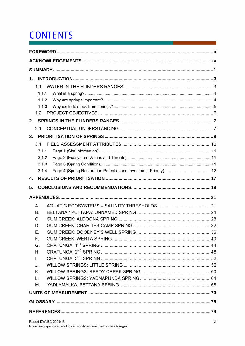
A diverse array of aquatic ecosystems exist in the Flinders Ranges and include: permanent and temporary freshwater pools and (Figure 1); salt lakes; and springs (Boulton and Williams, 1996). There are no large natural freshwater lakes in the ranges. Most natural standing freshwater is found within ephemeral pools in deflation basins on the plains (claypans) and rock pools in the ranges, that seldom persist for more than a few weeks (Boulton and Williams, 1996). This project will focus on the spring aquatic ecosystems in the Flinders Ranges, which provide the most reliable source of surface water.
Figure 1. Example of a permanent pool located in a temporary stream on
Puttapa Station (photograph M.White, 2008).
Report DWLBC 2009/16 Prioritising springs of ecological significance in the Flinders Ranges
4
1.1.1 WHAT IS A SPRING?
Springs occur in many different environments both across Australia and the world. For example, mound springs in the Lake Eyre Basin receive water from the Great Artesian Basin where rain that fell hundreds of kilometres away slowly travels through the aquifer creating pressure and a spring is formed at the surface (G. Green pers. comm. 2008). Fractured rock type springs in the Flinders Ranges are probably sourced from a more localised surface aquifer. Springs are described as flowing water (Boulton and Williams, 1996) where groundwater reaches the surface (Eamus et al, 2006).
Using pastoral knowledge, historical records and geological mapping of the Flinders Ranges, springs mainly exist in the creek lines. This is due to the fractured rock environment where groundwater is expressed at the surface at the lowest point in the surrounding terrain, which are usually the creek lines. Springs may flow permanently, seasonally or episodically (storm events) and are influenced by groundwater recharge and aquifer pressure.
1.1.2 WHY ARE SPRINGS IMPORTANT?
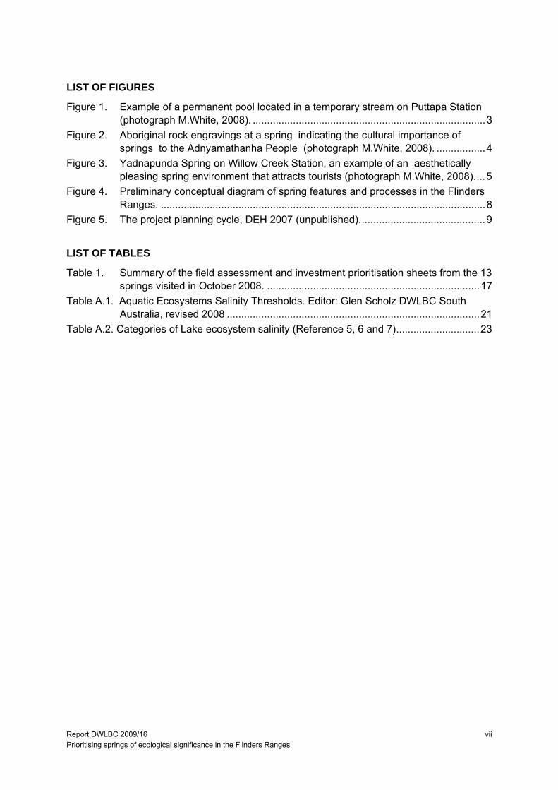
Springs were once the most reliable source of water in the semi-arid environment of the Flinders Ranges when the creeks weren’t flowing; they were a vital water source and important cultural areas to the Aboriginal people (Figure 2) and the European explorers. Today, the springs are still used as a source of water for stock and household water on some stations and, until recently, town water supplies (e.g. Wilmington till 1995) (Risby et al, 2003). In the pastoral industry, the introduction of groundwater wells has increased stock watering points across the landscape.
The springs are important refuge areas for aquatic flora and fauna when the streams have no surface flow while also being key source areas for the dispersal of these plant and animal species when the streams are flowing.
For the native terrestrial fauna, the springs are a vital source of water, especially during drought periods when all animals (natives, stock and ferals) compete for this valuable water resource.
Figure 2 Aboriginal rock engravings at a spring indicating the cultural importance of springs to the Adnyamathanha People (photograph M.White, 2008).
Report DWLBC 2009/16 Prioritising springs of ecological significance in the Flinders Ranges
5
1.1.3 WHY EXCLUDE STOCK FROM SPRINGS? In the rangelands any place with permanent, seasonal or temporary water is likely to be an important resource for wildlife. Protecting these areas preserves the ecosystem biota but also conserves the habitat. Habitat may vary from instream edges to riparian vegetation and, by excluding stock from these spring refuges, preserves the biota, habitat and water quality at the site. The SAAL NRM Board understands the importance of these water sources for the pastoral industry and invested in off-stream watering points in the region during 2004/05. At this time landholders undertook early on ground work (e.g. fencing) to protect wet areas and ecosystems before a spring prioritisation framework was developed.
By engaging landholders in this process it can be determined if access to some springs are needed as, with the advent or more reliable supplies of water (bores and piping), stock that continue to use such spring sites may be significantly degrading the wildlife value of these now relatively scarce resources (Ehmann, 2005).
Some problems that may arise from fencing off natural watering areas include increased numbers of foxes, cats, goats and rabbits taking up residence to exploit the resources of fenced off areas. This can partially undo the benefits of fencing if pest management is not built into the costs of maintaining the stock-excluded area. Native animals may also cause a problem in some areas. Ehmann (2005) reported that large numbers of kangaroos may overgraze local vegetation in fenced-off watering points, which can degrade the area.
The costs of fencing a watering point are not as great as they first appear. Calculations indicate that fencing an area of one hectare costs no more than $3 per year, loss in production (Ehmann, 2005). However larger costs need to be considered for the on-going maintenance of the fences and pest control.
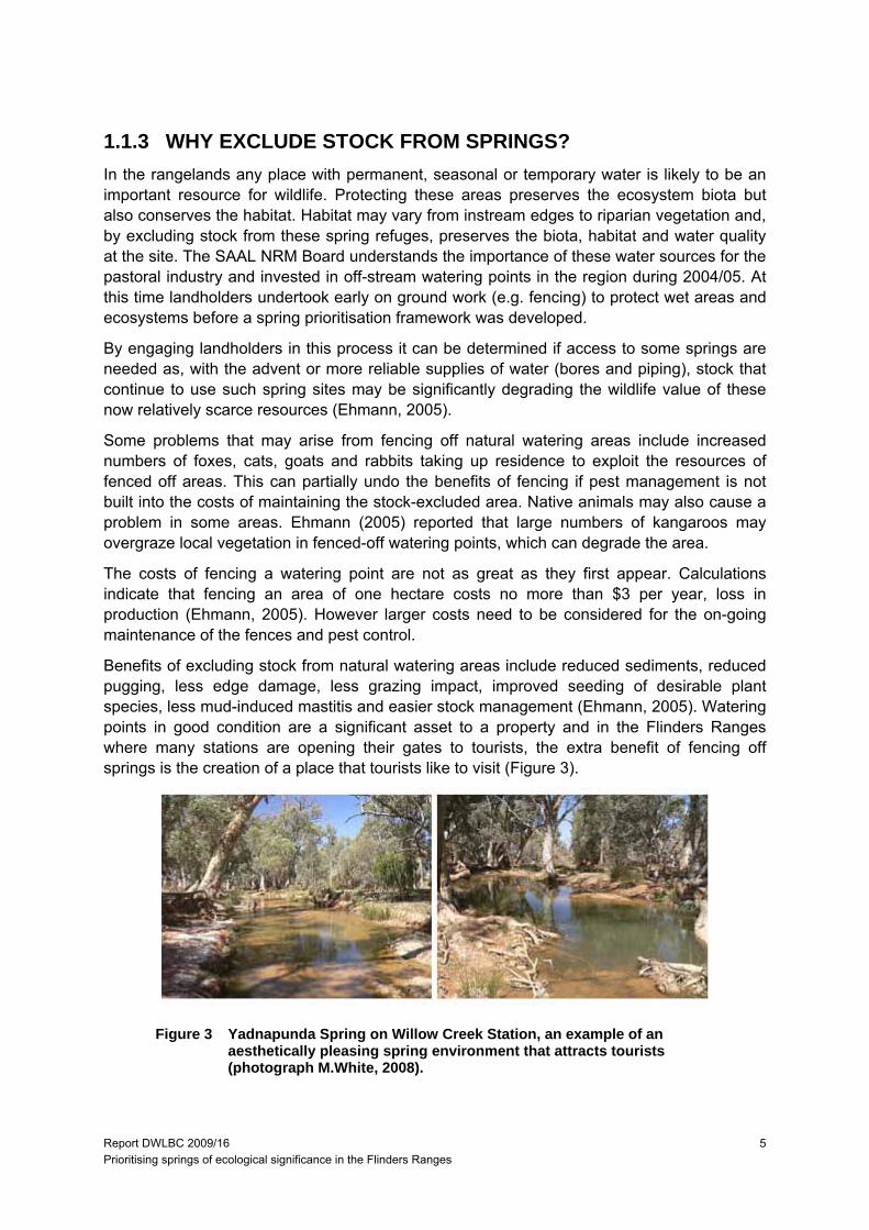
Benefits of excluding stock from natural watering areas include reduced sediments, reduced pugging, less edge damage, less grazing impact, improved seeding of desirable plant species, less mud-induced mastitis and easier stock management (Ehmann, 2005). Watering points in good condition are a significant asset to a property and in the Flinders Ranges where many stations are opening their gates to tourists, the extra benefit of fencing off springs is the creation of a place that tourists like to visit (Figure 3).
Figure 3 Yadnapunda Spring on Willow Creek Station, an example of an aesthetically pleasing spring environment that attracts tourists (photograph M.White, 2008).
Report DWLBC 2009/16 Prioritising springs of ecological significance in the Flinders Ranges
6
1.2 PROJECT OBJECTIVES The main project objective was to conceptualise current knowledge on spring processes to assist in understanding the ecological significance of springs in the semi-arid landscape of the Flinders Ranges. This is discussed in more detail in Section Two.
The project undertook five days of fieldwork and visited 13 springs across five properties in the Flinders Ranges, where a qualitative ecological survey was undertaken to look at the vegetation condition at each spring. Quantitative vegetation surveys may be required in future monitoring of some springs but was considered unnecessary for this first rapid assessment.
The information presented in Section Three will be used to start prioritising ecological significance of springs in the arid landscape. Ecological significance is determined by the duration of water in the springs and the flora and fauna associated with them.
The project outcomes from phase one of the project are:
- Development of a conceptual diagram of spring features and processes.
- Development and trial of the condition assessment at 13 springs.
- Baseline data collected at 13 springs used to test a prioritisation framework.
- Prioritisation framework identified the ecosystem values, riparian vegetation condition, restoration potential and investment priority of the 13 assessed springs.
Report DWLBC 2009/16 Prioritising springs of ecological significance in the Flinders Ranges
7
2. SPRINGS IN THE FLINDERS RANGES
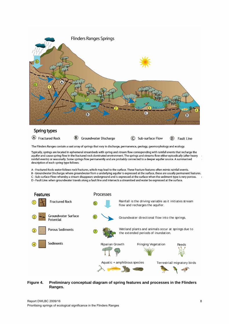
2.1 CONCEPTUAL UNDERSTANDING The Flinders Ranges contain numerous springs with varying discharge, permanence and geomorphology (Boulton and Williams, 1996). From the review conducted there appears to be limited published information on springs in the Flinders Ranges, with even less existing on their formation and hydrological processes. The information presented in this report is based on limited literature, landholder information, field observations and expert advice from hydrogeologists within DWLBC.
Typically, springs in the Flinders Ranges are located in ephemeral streambeds. These streams may flow episodically (after heavy rainfall events) or seasonally. Spring discharge occurs after the stream flow subsides.; The springs will continue to flow in response to the groundwater being recharged from the rain event. Permanent flowing springs have a reliable source of groundwater that is able to withstand dry seasons and droughts. The groundwater source for these permanent springs is probably supplied through larger regional processes/groundwater aquifers, rather than local sources.
The main requirements for managing springs in the Flinders Ranges are a conceptual understanding of spring hydrology and to map their distribution across the landscape. As more investigations are undertaken, it will be necessary to update this understanding to better represent the processes, with mapping and classifying the springs helping determine if any threats exist that may impact these aquatic ecosystems.
Four distinct hydrogeological processes can be distinguished that determine springs hydrological function in the Flinders Ranges. These (Figure 4) are summarised as:
A. Fractured Rock: water follows rock fractures, which may lead to the surface. These fracture features flow after rainfall events.
B. Groundwater Discharge: where groundwater from a deeper aquifer is expressed at the surface; these are usually permanent features.
C. Sub-surface Flow: whereby a stream disappears underground and is expressed at the surface; these may also be permanent features.
D. Fault-line: when groundwater travels along a fault line and intersects a streambed and water is expressed at the surface
Report DWLBC 2009/16 Prioritising springs of ecological significance in the Flinders Ranges
8
1
A
A
B
B
C
C
3
4
2
D
D
The Flinders Ranges contain a vast array of springs that vary in discharge, permanence, geology, geomorphology and ecology.
Typically, springs are located in ephemeral streambeds with spring and stream flow corresponding with rainfall events that recharge aquifer and cause spring flow in the fractured rock dominated environment. The springs and streams flow either episodically (after herainfall events) or seasonally. Some springs flow permanently and are probably connected to a deeper aquifer source. A summarisedescription of each spring type follows:
A - Fractured Rock: water follows rock fractures, which may lead to the surface. These fracture features often mimic rainfall events.B - Groundwater Discharge: where groundwater from a underlying aquifer is expressed at the surface, these are usually permanent C - Sub-surface Flow: whereby a stream disappears underground and is expressed at the surface when the sediment type is very poD - Fault Line: when groundwater travels along a fault line and intersects a streambed and water be expressed at the surface.
Fractured Rock
Fractured Rock
Groundwater SurfacePotential
Porous Sediments
Sediments
Groundwater Discharge Sub-surface Flow Fault Line
1
3
5
6
6
7
5
7
Rainfall is the driving variable as it initiates streamflow and recharges the aquifer.
Groundwater directional flow into the springs.
Wetland plants and animals occur at springs due tothe extended periods of inundation.
Riparian Growth ReedsFringing Vegetation
Aquatic + amphibious species Terrestrial/migratory birds
42
Figure 4. Preliminary conceptual diagram of spring features and processes in the Flinders Ranges.
Report DWLBC 2009/16 Prioritising springs of ecological significance in the Flinders Ranges
9
3. PRIORITISATION OF SPRINGS
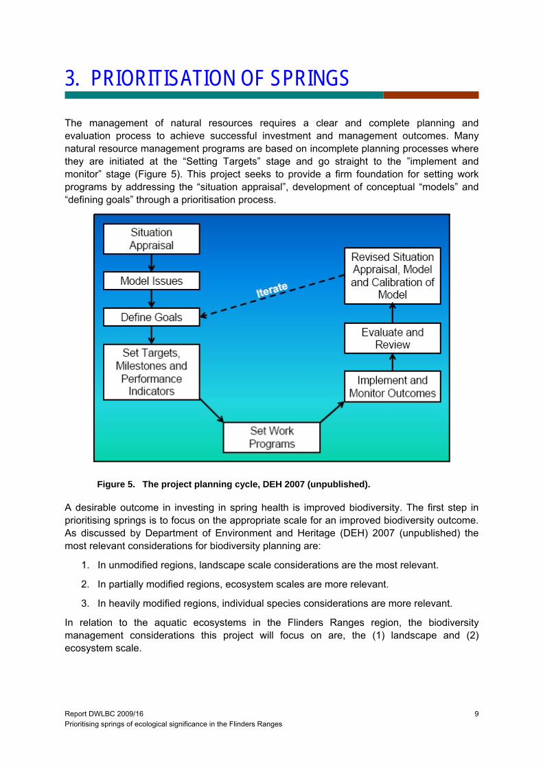
The management of natural resources requires a clear and complete planning and evaluation process to achieve successful investment and management outcomes. Many natural resource management programs are based on incomplete planning processes where they are initiated at the “Setting Targets” stage and go straight to the ”implement and monitor” stage (Figure 5). This project seeks to provide a firm foundation for setting work programs by addressing the “situation appraisal”, development of conceptual “models” and “defining goals” through a prioritisation process.
Figure 5. The project planning cycle, DEH 2007 (unpublished).
A desirable outcome in investing in spring health is improved biodiversity. The first step in prioritising springs is to focus on the appropriate scale for an improved biodiversity outcome. As discussed by Department of Environment and Heritage (DEH) 2007 (unpublished) the most relevant considerations for biodiversity planning are:
1. In unmodified regions, landscape scale considerations are the most relevant.
2. In partially modified regions, ecosystem scales are more relevant.
3. In heavily modified regions, individual species considerations are more relevant.
In relation to the aquatic ecosystems in the Flinders Ranges region, the biodiversity management considerations this project will focus on are, the (1) landscape and (2) ecosystem scale.
Report DWLBC 2009/16 Prioritising springs of ecological significance in the Flinders Ranges
10
In prioritising investment in springs this project focussed on four attributes: ecosystem function (its setting and value within the landscape); condition (naturalness); the threatening processes and; recoverability potential.
Within this context, prioritisation for investment was weighted towards those springs that have the greatest contribution as an aquatic ecosystem refuge within the catchment as well as those that have the greatest recoverability potential in relation to management investment and intervention. This means that those springs that are significantly ecologically impaired may have a lower priority for investment due to a low recovery potential. Those that are ecologically intact may also have a lower priority for investment due to their relative security under current environmental conditions and management regimes.
The primary focus of this spring prioritisation program is a rapid assessment to guide investment in improved aquatic ecosystem processes and function at the landscape and ecosystem scale. Biodiversity ‘conservation’ outcomes are a significant issue, but this process will require further investment through site flora and fauna surveys and is outside the scope of this projects objectives.
The first step in prioritising springs is to map their location across the landscape. Spatial understanding is fundamental to some key prioritisation questions for example:
- How many are there and what is the spatial distribution of springs in catchments?
- What is the landscape setting? Considering position within the catchment, elevation (uplands/lowlands), geomorphic processes and land tenure (pastoral/reserve).
- What ecosystem values need to be considered? For example the potential to support processes like dispersal and provision of drought refuge areas, or the level of and habitat diversity represented.
This section of the report first describes the background behind the prioritisation attributes and will then give examples of how this information can be applied to the 13 springs that were visited as examples. The assessment process for Puttapa Spring as a worked example and the assessments the rest of the springs visited are presented in Appendix 1.
3.1 FIELD ASSESSMENT ATTRIBUTES Each spring has an individual assessment sheet (see Puttapa Spring, pages 13 to 16 as an example), which is broken into four sections/pages.
- Page 1; includes the site information, a map and photos of the spring.
- Page 2; gives the ecosystem value and threats information.
- Page 3; gives the condition assessment values.
- Page 4; summarises the assessment information into the sites restoration potential and its investment priority.
The information presented in each section of the assessment sheet is further described below.

Report DWLBC 2009/16 Prioritising springs of ecological significance in the Flinders Ranges
11
3.1.1 PAGE 1 (SITE INFORMATION)
Spring hydrogeological process class is described here. By necessity this is a qualitative judgement though this may need to be reviewed as further investigations are undertaken on more springs across the landscape.
Springs physical dimensions are described at time of visit. This is a highly variable measure, as during drought the spring may be greatly reduced in size. This has not been used to classify the springs at this stage. It must be stated that during the October 2008 field visits, no recent rain had fallen and all of the springs had receded in size (as recorded by each landholder).
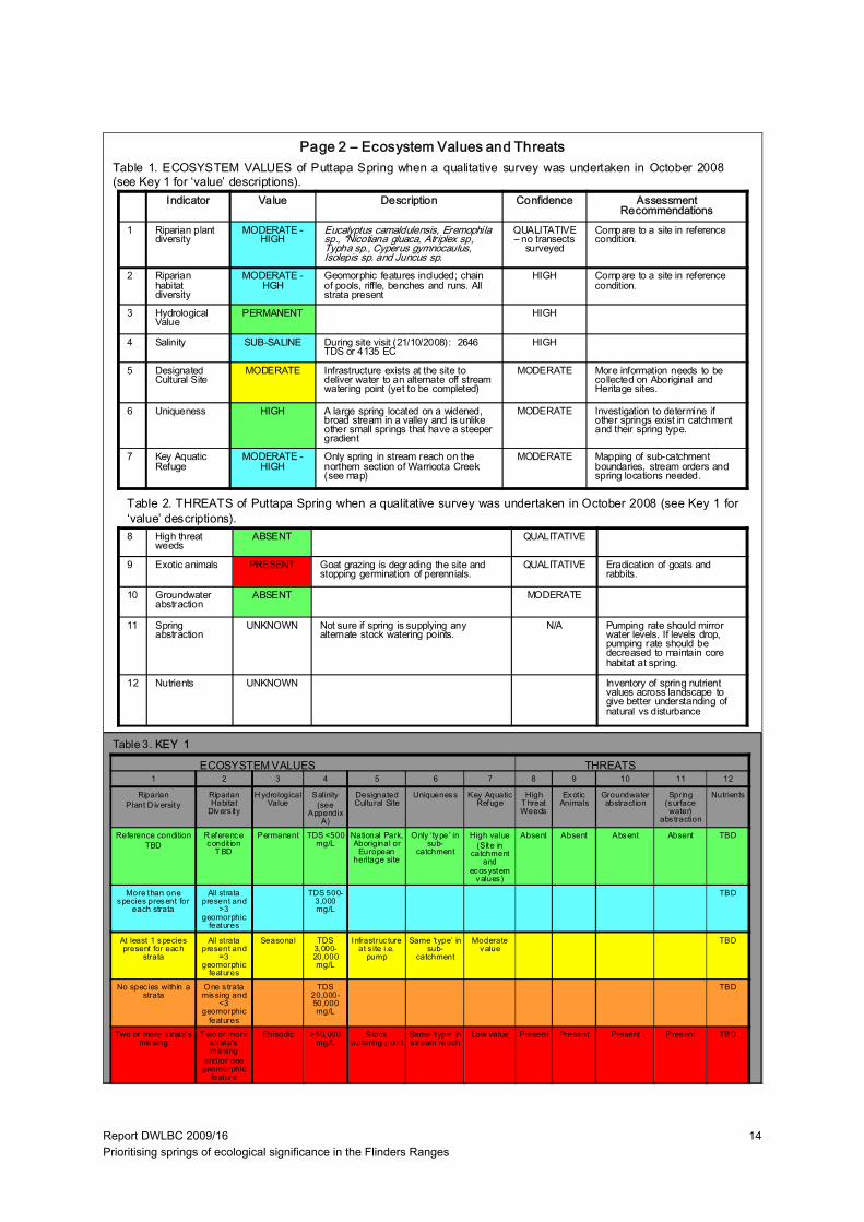
3.1.2 PAGE 2 (ECOSYSTEM VALUES AND THREATS)
This section comprises two tables, which are completed using the key at the bottom of the assessment page to describe the values assigned to each attribute. Currently values are by necessity assigned on a relative scale as more information is needed to correctly assign each attribute a value based on more quantitative criteria. The additional information needed includes:
- Springs in reference condition (near pristine) need to be assessed so values can be compared for: instream plant diversity; riparian plant diversity; and riparian habitat diversity.
- A complete inventory of cultural and heritage sites should be obtained as some springs may be important cultural, heritage and/or tourism sites, which will contribute to their value in the landscape.
- Sub-catchment boundaries are needed so each spring can be mapped for connectivity (key aquatic refuge) and uniqueness.
- The impact of nutrients on springs was highlighted during the literature review process and from talking with people who have worked in the area. No nutrient data was collected for this project but further information on nutrients should be investigated in the future.
3.1.3 PAGE 3 (SPRING CONDITION)
The Aquatic Ecosystems Task Group (AETG) formed the River Health Contact Group (RHCG) in May 2007 to provide advice on river health indicators for the National NRM Monitoring and Evaluation Framework. The RHCG was tasked with developing a nationally agreed methodology for assessing riparian vegetation condition. A major hurdle in developing a common methodology for a vegetation condition theme is that there are many methodologies available across Australia based on varying purposes and outcomes with a high degree of methodology turnover and evolution. Consensus on agreeing to a single vegetation condition assessment methodology that could achieve everyone’s desired outcomes was considered a near impossible task.
Progressing this issue the RHCG determined that it was the interpretation of the data for management that was of more significance than the specific methodology used to collect the data. The approach adopted was to design a framework based on the common elements of
Report DWLBC 2009/16 Prioritising springs of ecological significance in the Flinders Ranges
12
existing methods that would provide a consistent evaluation of vegetation condition. To be useful as an ongoing NRM tool the framework would need to potentially be able to accommodate data from a range of older methods as well as adapt to emerging methods and future developments. Roberts et al, (2009) developed the draft Riverine (Riparian) Condition protocol for the RHCG.
This project has adopted the framework (protocol) to assess the condition of springs. As an initial rapid assessment approach, this project has assigned attribute values for the sub-index categories through a qualitative field assessment (see example page 15). This provides the SAAL NRM region with a cost effective indication of the functional condition of the springs to base management decisions upon. If the decision is made to further invest in management at a site, a more quantitative assessment methodology can be undertaken for one or each sub-index category to provide a baseline for monitoring vegetation ecosystem change.
3.1.4 PAGE 4 (SPRING RESTORATION POTENTIAL AND INVESTMENT PRIORITY)
The final page of the assessment sheet summarises the information described on the three previous pages as reports on the restoration potential and investment of the spring. As the inventory is further increased to include more springs, some attribute data may change which potentially could change the investment priority. The prioritisation schedule of the springs should be reviewed and updated as additional information becomes available.
It should also be noted that by nature, vegetation communities in the Rangelands have attributes of resistance (withstand disturbance) and resilience (recover from disturbance) though it must be understood that rehabilitation of Rangeland ecosystems occurs over decades, especially if long dry periods persist. Long-term success of these rehabilitation projects in rangelands need both financial and land management support.
Report DWLBC 2009/16 Prioritising springs of ecological significance in the Flinders Ranges
13
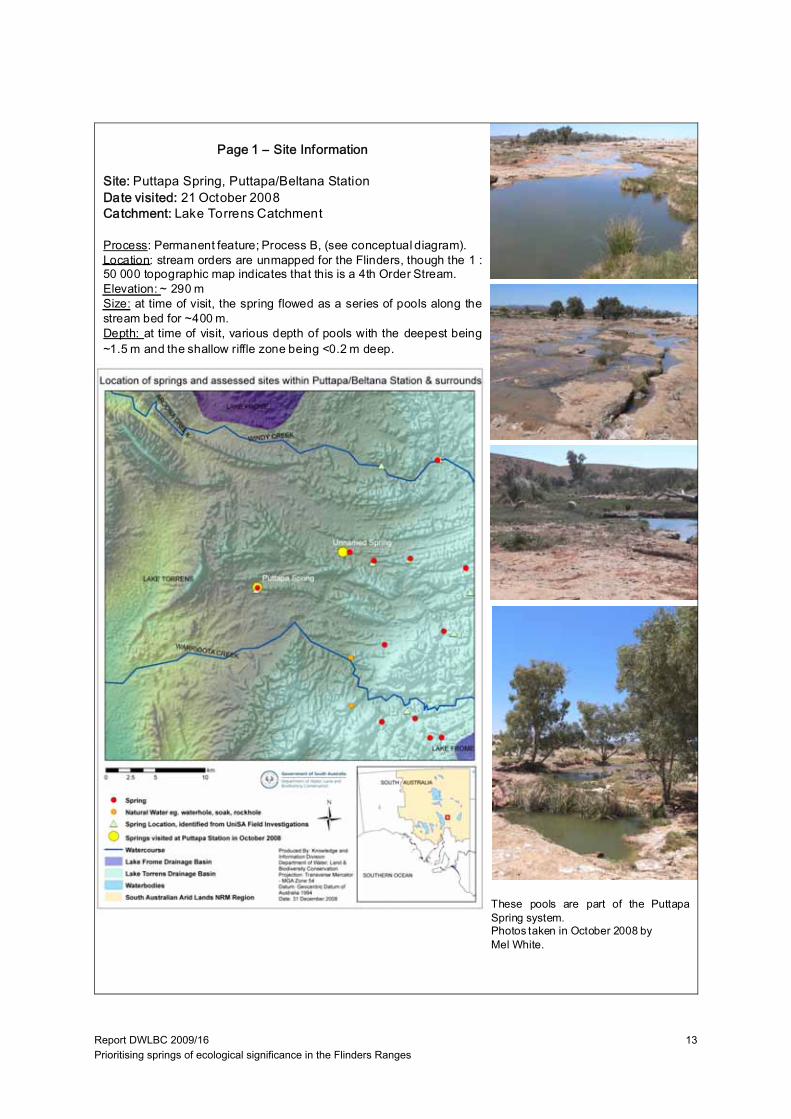
Page 1 – Site Information
Site: Puttapa Spring, Puttapa/Beltana StationDate visited: 21 October 2008Catchment: Lake Torrens Catchment
Process: Permanent feature; Process B, (see conceptual diagram).Location: stream orders are unmapped for the Flinders, though the 1 :50 000 topographic map indicates that this is a 4th Order Stream.Elevation: ~ 290 mSize: at time of visit, the spring flowed as a series of pools along thestream bed for ~400 m.Depth: at time of visit, various depth of pools with the deepest being~1.5 m and the shallow riffle zone being <0.2 m deep.
These pools are part of the PuttapaSpring system.Photos taken in October 2008 byMel White.
Report DWLBC 2009/16 Prioritising springs of ecological significance in the Flinders Ranges
14
Indicator Value Description Confidence Assessment Recommendations
1 Riparian plant diversity
MODERATE -HIGH
Eucalyptus camaldulensis, Eremophila sp., *Nicotiana gluaca, Atriplex sp, Typha sp., Cyperus gymnocaulus, Isolepis sp. and Juncus sp.
QUALITATIVE – no transects
surveyed
Compare to a site in reference condition.
2 Riparian habitat diversity
MODERATE -HGH
Geomorphic features included; chain of pools, riffle, benches and runs. All strata present
HIGH Compare to a site in reference condition.
3 Hydrological Value
PERMANENT HIGH
4 Salinity SUB-SALINE During site visit (21/10/2008): 2646 TDS or 4135 EC
HIGH
5 Designated Cultural Site
MODERATE Infrastructure exists at the site to deliver water to an alternate off stream watering point (yet to be completed)
MODERATE More information needs to be collected on Aboriginal and Heritage sites.
6 Uniqueness HIGH A large spring located on a widened, broad stream in a valley and is unlike other small springs that have a steeper gradient
MODERATE Investigation to determine if other springs exist in catchment and their spring type.
7 Key Aquatic Refuge
MODERATE -HIGH
Only spring in stream reach on the northern section of Warrioota Creek (see map)
MODERATE Mapping of sub-catchment boundaries, stream orders and spring locations needed.
8 High threat weeds
ABSENT QUALITATIVE
9 Exotic animals PRESENT Goat grazing is degrading the site and stopping germination of perennials.
QUALITATIVE Eradication of goats and rabbits.
10 Groundwater abstraction
ABSENT MODERATE
11 Spring abstraction
UNKNOWN Not sure if spring is supplying any alternate stock watering points.
N/A Pumping rate should mirror water levels. If levels drop, pumping rate should be decreased to maintain core habitat at spring.
12 Nutrients UNKNOWN Inventory of spring nutrient values across landscape to give better understanding of natural vs disturbance
Table 1. ECOSYSTEM VALUES of Puttapa Spring when a qualitative survey was undertaken in October 2008(see Key 1 for ‘value’ descriptions).
Table 2. THREATS of Puttapa Spring when a qualitative survey was undertaken in October 2008 (see Key 1 for‘value’ descriptions).
1 2 3 4 5 6 7 8 9 10 11 12
RiparianPlant D iversity
Riparian Habitat
Divers ity
H ydrological Value
Salinity (see
Appendix A)
Designated Cultural Site
Uniqueness Key Aquatic Refuge
High T hreat Weeds
Exot ic Animals
Groundwater abstract ion
Spring (surface water)
abs traction
Nutrients
Reference conditionTBD
R eference condit ion
T BD
Permanent TDS <500 mg/L
National Park, Aboriginal or
European heritage site
Only ‘type’ in sub-
catchment
High value(Site in
catchment and
ecosystem values)
Absent Absent Absent Absent TBD
More than one species present for
each strata
All strata present and
>3 geomorphic
features
TDS 500-3,000 mg/L
TBD
At least 1 species present for each
strata
All strata present and
=3 geomorphic
features
Seasonal TDS 3,000-20,000 mg/L
Infrastruc ture at s ite i.e.
pump
Same ‘type’ in sub-
catchment
Moderate value
TBD
No spec ies within a strata
One s trata missing and
<3 geomorphic
features
TDS 20,000-50,000 mg/L
TBD
Two or more s trata’s missing
T wo or more s trata’s missing
and/or one geomorphic
feature
Episodic >50,000 mg/L
Stock watering point
Same ‘type’ in s tream reach
Low value Present Present Present Present TBD
ECOSYSTEM VALUES THREATS
Page 2 – Ecosystem Values and Threats
Table 3. KEY 1

Report DWLBC 2009/16 Prioritising springs of ecological significance in the Flinders Ranges
15
Indicator Value Description Confidence Management Recommendations
13 Spatial Integrity LARGELY UNMODIFIED
There was a natural break in longitudinal continuity of river red gums with no evidence of clearing or grazing out of stratum.
QUALITATIVE No action
14 Nativeness LARGELY UNMODIFIED
No perennial weeds were recorded at the site.
QUALITATIVE No action
15 Structural Integrity SLIGHTLY MODIFIED
<50% cover of Atriplex sp. and sedges and grasses.
QUALITATIVE Reduce grazing at spring.
16 Age Structure SLIGHTLY MODIFIED
Some reduced canopy cover of red gums but not severe, only adult and some sub-adult trees present.
QUALITATIVE Reduce grazing so regeneration survival is increased.
17 Debris SLIGHTLY MODIFIED
There is probably reduced debris cover due to stock trampling
QUALITATIVE Reference condition needs to be determined
Indicator LARGELY UNMODIFIED
SLIGHTLY MODIF IED
MODERATELY MODIFIED
SUBSTANTIALLY MODIFIED
SEVERELY MODIFIED
SPATIAL INT EGRITY
No or litt le ev idence of broad scale loss of native vegetat ion
Width reduced by up to 1/3 and/or some breaks in cont inuity
About 50% of the native vegetation remains , either in strips or patches
Only small patches of well-separated nat ive vegetation remains
Lit tle or no remaining nat ive vegetation
NATIVENESS Vegetation predominately native, few weeds and no 'high threat' species .
Exotic species present but not dominat ing any strata, 'high threat' spec ies rare
One or more strata dominated by exotic spec ies, 'high threat' spec ies present
Most strata dominated by exotic species, 'high threat ' species abundant
Few native spec ies remaining, cover dominated by exot ic species
STRUCTURAL INT EGRITY
Number of s trata and cover w ithin each strata is similar to reference
Cover within one s tratum 50% lower or higher than reference
One stratum missing or extra cover within remaining stratum 50% lower or higher than reference
More than one s tratum completely altered from reference (lost or <10% remaining)
Struc ture completely altered from reference (eg. grass land shrubland, fores t pasture)
AGE ST RUCTURE Dominant strata with reference level of cover and at leas t three age classes present (juvenile, sub-adults and adults)
Reduced cover (75-50%) of dominant s trata, and/or only two age classes present
Reduced cover (75-50%) of dominant strata, and only one age class present
Reduced cover (<50%) of dominant s trata, and only one age class present
Dominant s trata mostly absent
DEBRIS Quantit ies and cover similar to reference
Some evidence of unnatural loss of debris (eg. firewood collec tion, trampling of leaf litter by s tock)
Quant it ies and/or cover 50% higher or lower than reference
Very small quant it ies of debris present
Debris most ly absent or completely dominating the s ites , with little or no living vegetation
KEY 2: Vegetation Condition Sub-Indices Attributes:
13. Spatial Integrity: Width of riparian vegetation (as defined by inundation dependent species). Longitudinal continuity continuous cover of dominant stratum along the channel. Connectedness of the riverine vegetation to other areas ofnative vegetation (riparian or terrestrial). Refer to spatial integrity row in Table 5 for assessment criteria.14. Nativeness: Percentage of non-native and high impact species. Abundance of non-native and high impact species in different strata. (This project will focus on perennials due to the arid system, annual cover is determined by rainfall which can coincide with site visits). Refer to nativeness row in Table 5 for assessment criteria.15. Structural Integrity: Number of strata and/or life forms. Cover for each stratum. Refer to structural integrity row in Table 5 for assessment criteria.16. Age Structure: Cover of canopy species. Presence (or abundance) of different age stages. Presence (orabundance) of large old trees. Refer to age structure row in Table 5 for assessment criteria.17. Debris: Abundance of fallen logs. Presence (or abundance) of standing dead trees. Percentage cover of litter. Referto debris row in Table 5 for assessment criteria.
Table 5. Attributes used to assess vegetation condition from the Indicator Protocol: Riverine Vegetation, National RiverHealth Contact Group (Roberts et al. 2009).
Table 4. VEGETATION CONDITION of Puttapa Spring when a qualitative survey was undertaken in October 2008.(see Key 2 for description of the ‘indicators’ and Table 5 for the attributes used to assess vegetation condition).
Page 3 – Spring Condition
Report DWLBC 2009/16 Prioritising springs of ecological significance in the Flinders Ranges
16
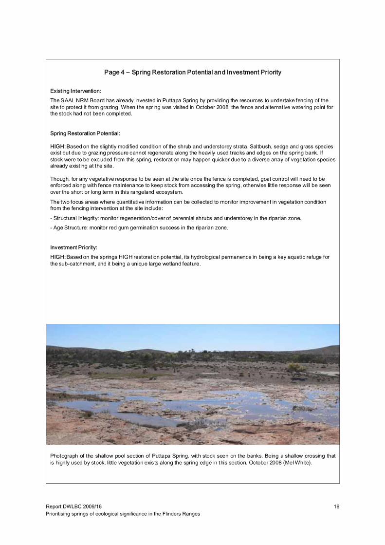
Existing Intervention:The SAAL NRM Board has already invested in Puttapa Spring by providing the resources to undertake fencing of the site to protect it from grazing. When the spring was visited in October 2008, the fence and alternative watering point for the stock had not been completed.
Spring Restoration Potential:
HIGH: Based on the slightly modified condition of the shrub and understorey strata. Saltbush, sedge and grass species exist but due to grazing pressure cannot regenerate along the heavily used tracks and edges on the spring bank. If stock were to be excluded from this spring, restoration may happen quicker due to a diverse array of vegetation species already existing at the site.
Though, for any vegetative response to be seen at the site once the fence is completed, goat control will need to be enforced along with fence maintenance to keep stock from accessing the spring, otherwise little response will be seen over the short or long term in this rangeland ecosystem.
The two focus areas where quantitative information can be collected to monitor improvement in vegetation condition from the fencing intervention at the site include:
- Structural Integrity: monitor regeneration/cover of perennial shrubs and understorey in the riparian zone. - Age Structure: monitor red gum germination success in the riparian zone.
Investment Priority:HIGH:Based on the springs HIGH restoration potential, its hydrological permanence in being a key aquatic refuge for the sub-catchment, and it being a unique large wetland feature.
Photograph of the shallow pool section of Puttapa Spring, with stock seen on the banks. Being a shallow crossing thatis highly used by stock, little vegetation exists along the spring edge in this section. October 2008 (Mel White).
Page 4 – Spring Restoration Potential and Investment Priority
Report DWLBC 2009/16 Prioritising springs of ecological significance in the Flinders Ranges
17
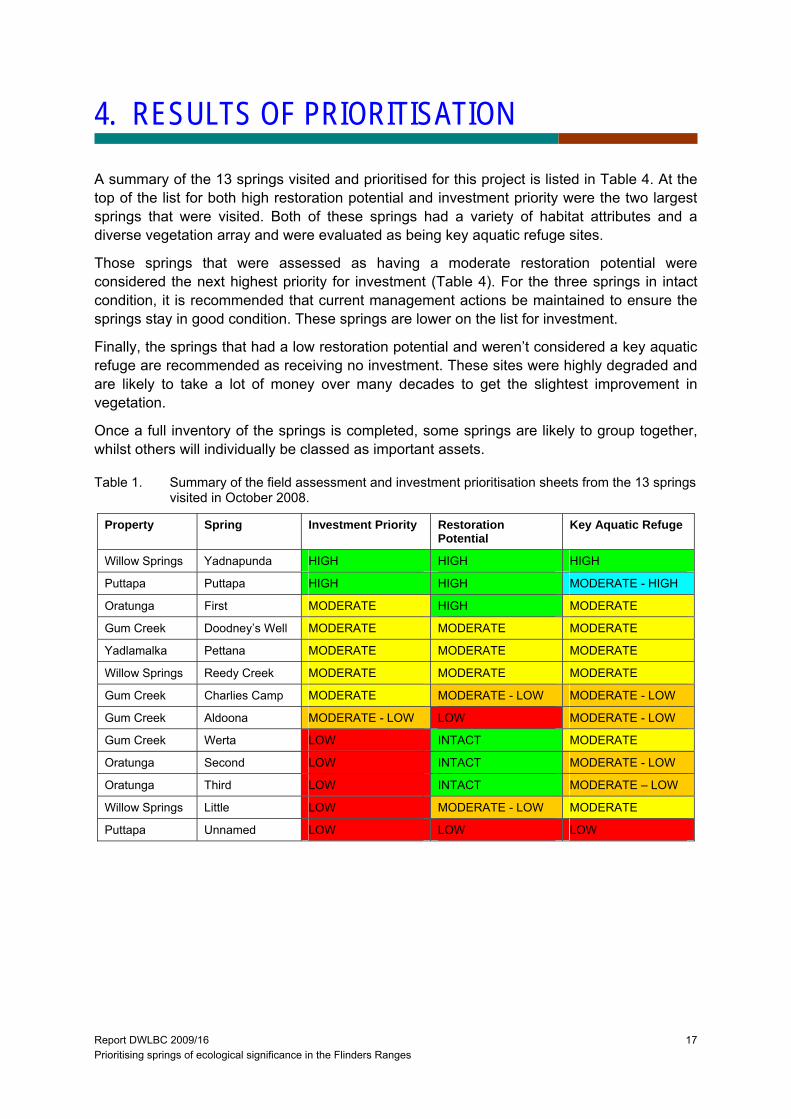
4. RESULTS OF PRIORITISATION
A summary of the 13 springs visited and prioritised for this project is listed in Table 4. At the top of the list for both high restoration potential and investment priority were the two largest springs that were visited. Both of these springs had a variety of habitat attributes and a diverse vegetation array and were evaluated as being key aquatic refuge sites.
Those springs that were assessed as having a moderate restoration potential were considered the next highest priority for investment (Table 4). For the three springs in intact condition, it is recommended that current management actions be maintained to ensure the springs stay in good condition. These springs are lower on the list for investment.
Finally, the springs that had a low restoration potential and weren’t considered a key aquatic refuge are recommended as receiving no investment. These sites were highly degraded and are likely to take a lot of money over many decades to get the slightest improvement in vegetation.
Once a full inventory of the springs is completed, some springs are likely to group together, whilst others will individually be classed as important assets.
Table 1. Summary of the field assessment and investment prioritisation sheets from the 13 springs visited in October 2008.
Property Spring Investment Priority Restoration Potential
Key Aquatic Refuge
Willow Springs Yadnapunda HIGH HIGH HIGH
Puttapa Puttapa HIGH HIGH MODERATE - HIGH
Oratunga First MODERATE HIGH MODERATE
Gum Creek Doodney’s Well MODERATE MODERATE MODERATE
Yadlamalka Pettana MODERATE MODERATE MODERATE
Willow Springs Reedy Creek MODERATE MODERATE MODERATE
Gum Creek Charlies Camp MODERATE MODERATE - LOW MODERATE - LOW
Gum Creek Aldoona MODERATE - LOW LOW MODERATE - LOW
Gum Creek Werta LOW INTACT MODERATE
Oratunga Second LOW INTACT MODERATE - LOW
Oratunga Third LOW INTACT MODERATE – LOW
Willow Springs Little LOW MODERATE - LOW MODERATE
Puttapa Unnamed LOW LOW LOW

Report DWLBC 2009/16 Prioritising springs of ecological significance in the Flinders Ranges
18
Report DWLBC 2009/16 Prioritising springs of ecological significance in the Flinders Ranges
19
5. CONCLUSIONS AND RECOMMENDATIONS
In conclusion, the findings from this project found that the method applied for undertaking an ecological assessment of springs in the Flinders Ranges worked well, but priorities are established based on limited information and a revision will be necessary once further sites are visited and more knowledge on spring condition and functional processes are learned.
The recommendations for the SAAL Board to further investigate prioritisation of springs in the Flinders Ranges include:
1. Aim towards completing a full inventory of spring type and condition in the Flinders Ranges using the rapid assessment method outlined in this report;
2. Springs in pristine or near-pristine condition be located and assessed (may be located in the National Parks) and used as reference condition sites;
3. Inclusion of sub-catchment boundaries and stream ordering data be investigated to help refine spring connectivity and hence key aquatic refuge attribute;
4. Climate change scenarios need to be investigated and included into the prioritisation framework;
5. Determine if the University of South Australia data can be used for classifying spring type and condition without further field assessments;
6. Include project findings of another SAAL NRM project on threatened fish and frog survey project in prioritising spring investment;
7. Investigate cultural and heritage information for prioritising spring investment;
8. Further investigate the role that nutrients plays in spring condition in the literature;
9. Undertake hydrochemical sampling program to identify spring connection with groundwater.

Report DWLBC 2009/16 Prioritising springs of ecological significance in the Flinders Ranges
20
Report DWLBC 2009/16 Prioritising springs of ecological significance in the Flinders Ranges
21
APPENDICES
A. AQUATIC ECOSYSTEMS – SALINITY THRESHOLDS
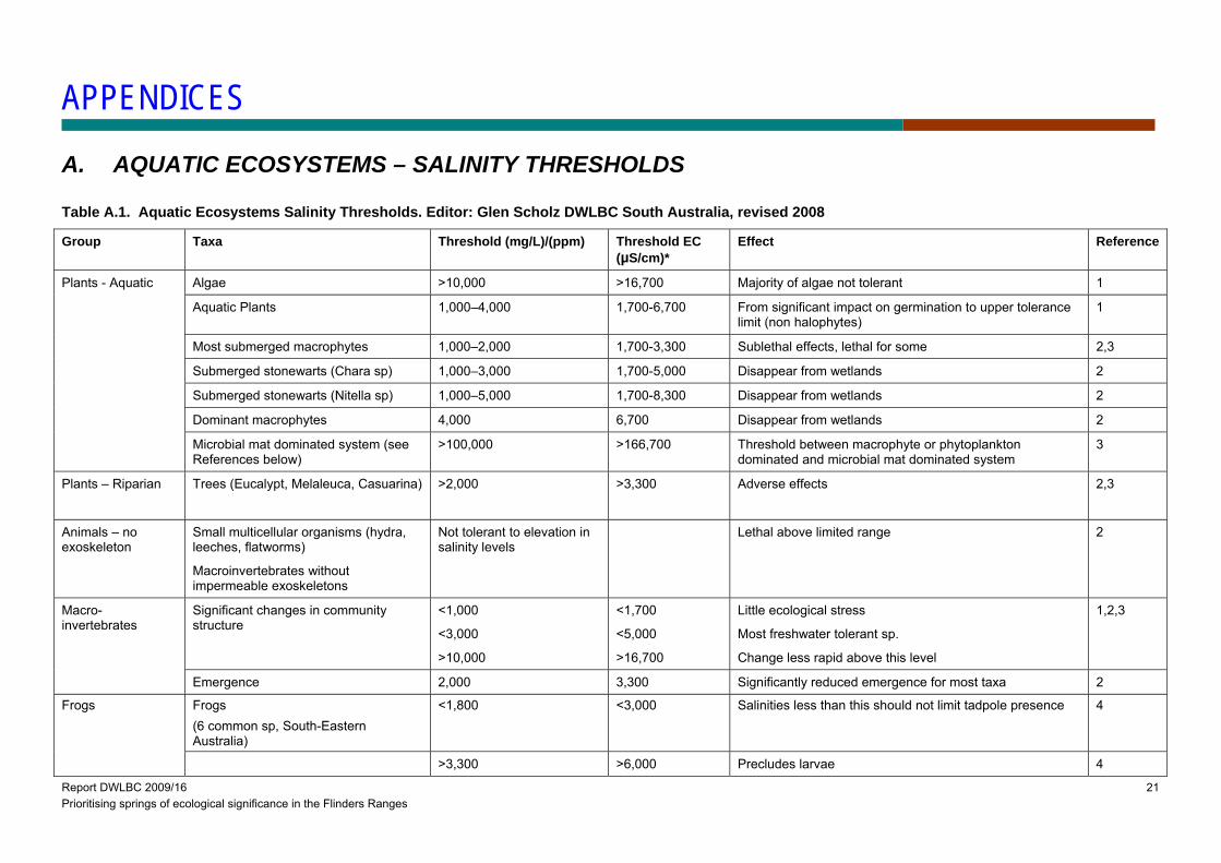
Table A.1. Aquatic Ecosystems Salinity Thresholds. Editor: Glen Scholz DWLBC South Australia, revised 2008
Group Taxa Threshold (mg/L)/(ppm) Threshold EC (µS/cm)*
Effect Reference
Plants - Aquatic Algae >10,000 >16,700 Majority of algae not tolerant 1
Aquatic Plants 1,000–4,000 1,700-6,700 From significant impact on germination to upper tolerance limit (non halophytes)
1
Most submerged macrophytes 1,000–2,000 1,700-3,300 Sublethal effects, lethal for some 2,3
Submerged stonewarts (Chara sp) 1,000–3,000 1,700-5,000 Disappear from wetlands 2
Submerged stonewarts (Nitella sp) 1,000–5,000 1,700-8,300 Disappear from wetlands 2
Dominant macrophytes 4,000 6,700 Disappear from wetlands 2
Microbial mat dominated system (see References below)
>100,000 >166,700 Threshold between macrophyte or phytoplankton dominated and microbial mat dominated system
3
Plants – Riparian
Trees (Eucalypt, Melaleuca, Casuarina) >2,000 >3,300 Adverse effects 2,3
Animals – no exoskeleton
Small multicellular organisms (hydra, leeches, flatworms)
Macroinvertebrates without impermeable exoskeletons
Not tolerant to elevation in salinity levels
Lethal above limited range 2
Macro-invertebrates
Significant changes in community structure
<1,000
<3,000
>10,000
<1,700
<5,000
>16,700
Little ecological stress
Most freshwater tolerant sp.
Change less rapid above this level
1,2,3
Emergence 2,000 3,300 Significantly reduced emergence for most taxa 2
Frogs Frogs (6 common sp, South-Eastern Australia)
<1,800 <3,000 Salinities less than this should not limit tadpole presence 4
>3,300 >6,000 Precludes larvae 4
Report DWLBC 2009/16 Prioritising springs of ecological significance in the Flinders Ranges
22
Fish Juvenile fish pre-hardened eggs 2,000-4,500 3,300-7,500 Adverse effects 2
Juvenile fish growth rate, survivorship 3,000-5,000 5,000-8,300 Optimal between these figures 2
Adult fish 8,800-10,000 14,700-16,700 Most are tolerant to this level 2,3
Birds
Water bird broods (see notes below) 15,300 25,500 Majority found below this level 2
*EC @25C to mg/L conversion 0.6, rounded to 100 EC.
References and notes (Table A):
(1) Neilsen DL, Brock MA, Rees GN, Baldwin DS (2003) Effects of increasing salinity on freshwater ecosystems in Australia. Australian Journal of Botany, 51, 655-665.
(2) Kimberly RJ, Cant J, Ryan T (2003) Responses of freshwater biota to rising salinity levels and implications for saline water management: a review. Australian Journal of Botany, 51, 703 – 713.
“Pulsed release of saline water into freshwater systems should be avoided as it is likely to cause higher mortality and loss of biodiversity in a system than does a slow build up to the same level.”
” …flushes of freshwater to saline systems at inappropriate times may have a negative impact on biodiversity…”
“Waterbirds are directly dependent upon macrophytes (for food, nesting and cover) and invertebrates (for food). However these taxonomic groups are likely to be adversely affected at salinity levels well below those causing direct affects on waterbirds (Stolley et al.)”
(3) Davis J, McGuire M, Halse S, Hamilton D, Horowitz P, McComb A, Froend R, Lyons M, Sim L (2003) What happens when you add salt: Predicting impacts of secondary salinisation on shallow aquatic ecosystems by using an alternative-states model. Australian Journal of Botany 51, 715-724, in Hart BT, Lake PS, Webb JA, Grace MR (2003) Ecological risk to aquatic systems from salinity increases. Australian Journal of Botany, 51, 689 – 702.
Three alternative were states identified in shallow wetlands influenced by increasing salinity:
Freshwater emergent macrophyte – dominated wetlands to;
Submerged macrophyte or phytoplankton – dominated wetlands to;
Microbial mat dominated systems.
(4) Michael J. Smith, Sabine Schreiber, Michele Kohout, Keely Ough, Joanne Potts, Ruth Lennie, Derek Turnbull, Changhao Jin, and Tim Clancy (2007). Associations between anuran tadpoles and salinity in a landscape mosaic of wetlands impacted by secondary salinisation. Freshwater Biology, Volume 52, Number 1, January 2007 , pp. 75-84(10).
Report DWLBC 2009/16 Prioritising springs of ecological significance in the Flinders Ranges
23
Table A.2. Categories of Lake ecosystem salinity (Reference 5, 6 & 7)
Category TDS (mg/L)
Fresh <500
Subsaline 500 - 3000
Hyposaline 3,000-20,000
Mesosaline 20,000 – 50,000
Hypersaline >50,000
References and notes (Table A.1):
(5) Hammer, U. T., 1986. Saline Lake Ecosystems of the World. Dr W. Junk Publishers, Dordrecht, 616 pp.
(6) Williams W.D. (1998) Salinity as a determinant of the structure of biological communities in salt lakes. Hydrobiologica 381: 191-201
(7) Timms, B. V., 1993. Saline lakes of the Paroo, inland New South Wales, Australia. Hydrobiologia 267: 269–289.
An extract from discussion with Lana Hedon QLD EPA 2008)
While many authors point to the temporal variability and arbitrary nature of any saline-fresh threshold, it is pretty clear there is a meaningful ecological transition between 1,000-4,000 mg/l and there is virtually unanimous support for 3,000 mg/l as the saline/fresh threshold (Williams 1981, Timms 1993, 1997, Timms & Boulton 2001, Hammer 1986 quoted by Timms 1993, Pinder et al. 2005, Halse et al. 1998).
Above 3,000 mg/l there is still a clear relationship between salinity level and types of halophyte fauna assemblages. Timms (1993) after Hammer (1986) suggested breaking saline wetlands into three categories: hypo-saline 3,000-20,000 mg/l, meso-saline 20,000-50,000 mg/l, hyper-saline > 50,000 mg/l). These cut-offs are supported by many studies although sometimes cut-off is 15,000 rather than 20,000 and sometimes 60,000 rather than 50,000 (e.g. Hales et al. 1998).

Report DWLBC 2009/16 Prioritising springs of ecological significance in the Flinders Ranges
24
B. BELTANA / PUTTAPA: UNNAMED SPRING
Page 1 – Site Information
Site: Unnamed Spring, Puttapa/Beltana StationDate Visited: 21 October 2008Catchment: Lake Torrens
Process: Likely to be either Process A or B (see conceptual diagram).Location: stream orders are unmapped for the Flinders, though the1 : 50 000 topographic map indicates that this is a 1st Order Stream.Elevation: ~ 350 mSize: at time of visit, the spring was a single pool ~ 5x5 mDepth: at time of visit, ~0.5 m.
Photographs of the single pool(unnamed, while trying to findFountain Spring).Photos taken in October 2008 byMel White.
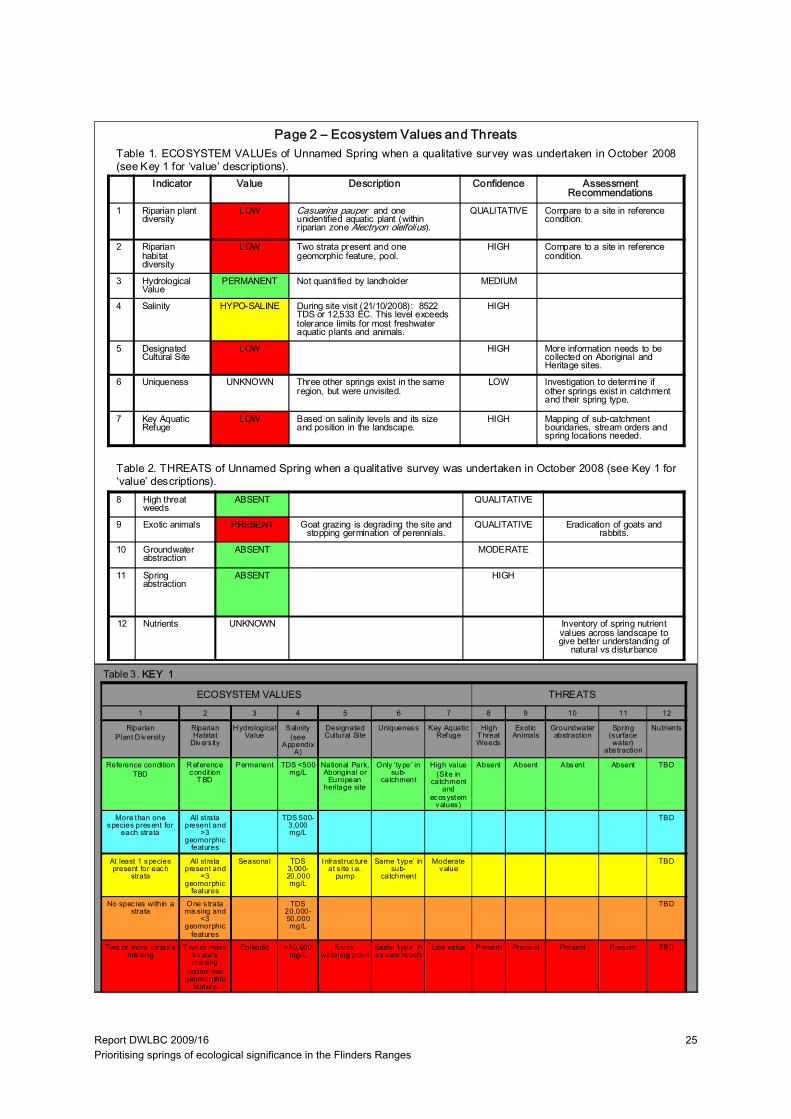
Report DWLBC 2009/16 Prioritising springs of ecological significance in the Flinders Ranges
25
Indicator Value Description Confidence Assessment Recommendations
1 Riparian plant diversity
LOW Casuarina pauper and one unidentified aquatic plant (within riparian zone Alectryon oleifolius).
QUALITATIVE Compare to a site in reference condition.
2 Riparian habitat diversity
LOW Two strata present and one geomorphic feature, pool.
HIGH Compare to a site in reference condition.
3 Hydrological Value
PERMANENT Not quantified by landholder MEDIUM
4 Salinity HYPO-SALINE During site visit (21/10/2008): 8522 TDS or 12,533 EC. This level exceeds tolerance limits for most freshwater aquatic plants and animals.
HIGH
5 Designated Cultural Site
LOW HIGH More information needs to be collected on Aboriginal and Heritage sites.
6 Uniqueness UNKNOWN Three other springs exist in the same region, but were unvisited.
LOW Investigation to determine if other springs exist in catchment and their spring type.
7 Key Aquatic Refuge
LOW Based on salinity levels and its size and position in the landscape.
HIGH Mapping of sub-catchment boundaries, stream orders and spring locations needed.
8 High threat weeds
ABSENT QUALITATIVE
9 Exotic animals PRESENT Goat grazing is degrading the site and stopping germination of perennials.
QUALITATIVE Eradication of goats and rabbits.
10 Groundwater abstraction
ABSENT MODERATE
11 Spring abstraction
ABSENT HIGH
12 Nutrients UNKNOWN Inventory of spring nutrient values across landscape to give better understanding of
natural vs disturbance
Table 1. ECOSYSTEM VALUEs of Unnamed Spring when a qualitative survey was undertaken in October 2008(see Key 1 for ‘value’ descriptions).
Table 2. THREATS of Unnamed Spring when a qualitative survey was undertaken in October 2008 (see Key 1 for‘value’ descriptions).
ECOSYSTEM VALUES THREATS
Page 2 – Ecosystem Values and Threats
Table 3. KEY 1
1 2 3 4 5 6 7 8 9 10 11 12
RiparianPlant D iversity
Riparian Habitat
Divers ity
H ydrological Value
Salinity (see
Appendix A)
Designated Cultural Site
Uniqueness Key Aquatic Refuge
High T hreat Weeds
Exot ic Animals
Groundwater abstract ion
Spring (surface water)
abs traction
Nutrients
Reference conditionTBD
R eference condit ion
T BD
Permanent TDS <500 mg/L
National Park, Aboriginal or
European heritage site
Only ‘type’ in sub-
catchment
High value(Site in
catchment and
ecosystem values)
Absent Absent Absent Absent TBD
More than one species present for
each strata
All strata present and
>3 geomorphic
features
TDS 500-3,000 mg/L
TBD
At least 1 species present for each
strata
All strata present and
=3 geomorphic
features
Seasonal TDS 3,000-20,000 mg/L
Infrastruc ture at s ite i.e.
pump
Same ‘type’ in sub-
catchment
Moderate value
TBD
No spec ies within a strata
One s trata missing and
<3 geomorphic
features
TDS 20,000-50,000 mg/L
TBD
Two or more s trata’s missing
T wo or more s trata’s missing
and/or one geomorphic
feature
Episodic >50,000 mg/L
Stock watering point
Same ‘type’ in s tream reach
Low value Present Present Present Present TBD

Report DWLBC 2009/16 Prioritising springs of ecological significance in the Flinders Ranges
26
Indicator Value Description Confidence Management Recommendations
13 Spatial Integrity SEVERELY MODIFIED
Only two trees present at the site QUALITATIVE Need to confirm what reference condition is for this area/stream order
14 Nativeness LARGELY UNMODIFIED
No perennial weeds were recorded at the site.
QUALITATIVE
15 Structural Integrity SUBSTANTIALLY MODIFIED
In the riparian zone, shrub-cover and groundcover are absent
QUALITATIVE Reduce grazing at spring.
16 Age Structure SEVERELY MODIFIED
Only two trees present with no regeneration at site.
QUALITATIVE Reduce grazing so regeneration survival is increased.
17 Debris SLIGHTLY MODIFIED
There is probably reduced debris QUALITATIVE Reference condition needs to be determined
LARGELY UNMODIFIED
SLIGHTLY MODIF IED
MODERAT ELY MODIFIED
SUBSTANTIALLY MODIFIED
SEVERELY MODIFIED
SPATIAL INTEGRITY
No or lit tle evidence of broad scale loss of nat ive vegetation
Width reduced by up to 1/3 and/or some breaks in continuity
About 50% of the nat ive vegetation remains , either in strips or patches
Only small patches of well-separated native vegetation remains
Lit tle or no remaining native vegetation
NATIVENESS Vegetat ion predominately native, few weeds and no 'high threat' species.
Exotic spec ies present but not dominating any strata, 'high threat ' species rare
One or more strata dominated by exot ic species , 'high threat' species present
Most strata dominated by exotic species, 'high threat ' species abundant
Few native spec ies remaining, cover dominated by exotic spec ies
STRUC TURAL INTEGRITY
Number of strata and cover within each strata is similar to reference
Cover within one stratum 50% lower or higher than reference
One s tratum missing or extra cover within remaining stratum 50% lower or higher than reference
More than one s tratum completely altered from reference (lost or <10% remaining)
Struc ture completely altered from reference (eg. grass land shrubland, fores t pasture)
AGE STRUC TURE
Dominant strata with reference level of cover and at least three age classes present (juvenile, sub-adults and adults)
Reduced cover (75-50%) of dominant strata, and/or only two age classes present
Reduced cover (75-50%) of dominant strata, and only one age class present
Reduced cover (<50%) of dominant s trata, and only one age class present
Dominant strata mos tly absent
DEBRIS Quantities and cover similar to reference
Some evidence of unnatural loss of debris (eg. f irewood collection, trampling of leaf litter by s tock)
Quant ities and/or cover 50% higher or lower than reference
Very small quant it ies of debris present
Debris mostly absent or completely dominating the sites, with lit tle or no liv ing vegetation
Table 5. Attributes used to assess vegetation condition from the Indicator Protocol: Riverine Vegetation, National RiverHealth Contact Group (Roberts et al. 2009).
Table 4. VEGETATION CONDITION of Unnamed Spring when a qualitative survey was undertaken in October 2008(see Key 2 for description of the ‘indicators’ and Table 5 for the attributes used to assess vegetation condition).
Page 3 – Spring Condition
KEY 2: Vegetation Condition Sub-Indices Attributes:
13. Spatial Integrity: Width of riparian vegetation (as defined by inundation dependent species). Longitudinal continuity continuous cover of dominant stratum along the channel. Connectedness of the riverine vegetation to other areas ofnative vegetation (riparian or terrestrial). Refer to spatial integrity row in Table 5 for assessment criteria.14. Nativeness: Percentage of non-native and high impact species. Abundance of non-native and high impact species in different strata. (This project will focus on perennials due to the arid system, annual cover is determined by rainfall which can coincide with site visits). Refer to nativeness row in Table 5 for assessment criteria.15. Structural Integrity: Number of strata and/or life forms. Cover for each stratum. Refer to structural integrity row in Table 5 for assessment criteria.16. Age Structure: Cover of canopy species. Presence (or abundance) of different age stages. Presence (orabundance) of large old trees. Refer to age structure row in Table 5 for assessment criteria.17. Debris: Abundance of fallen logs. Presence (or abundance) of standing dead trees. Percentage cover of litter. Referto debris row in Table 5 for assessment criteria.
Report DWLBC 2009/16 Prioritising springs of ecological significance in the Flinders Ranges
27
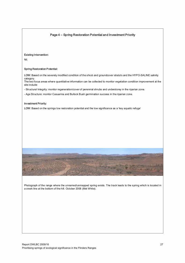
Existing Intervention:
Nil.
Spring Restoration Potential:
LOW: Based on the severely modified condition of the shrub and groundcover strata's and the HYPO-SALINE salinity category. The two focus areas where quantitative information can be collected to monitor vegetation condition improvement at the site include:- Structural Integrity: monitor regeneration/cover of perennial shrubs and understorey in the riparian zone.
- Age Structure: monitor Casuarina and Bullock Bush germination success in the riparian zone.
Investment Priority:
LOW: Based on the springs low restoration potential and the low significance as a ‘key aquatic refuge’
Photograph of the range where the unnamed/unmapped spring exists. The track leads to the spring which is located ina creek line at the bottom of the hill. October 2008 (Mel White).
Page 4 – Spring Restoration Potential and Investment Priority
Report DWLBC 2009/16 Prioritising springs of ecological significance in the Flinders Ranges
28
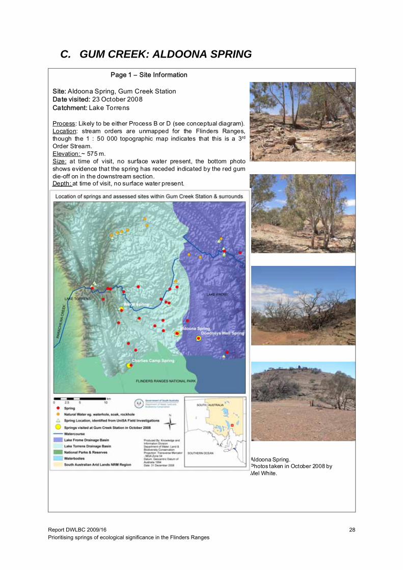
C. GUM CREEK: ALDOONA SPRING
Page 1 – Site Information
Site: Aldoona Spring, Gum Creek StationDate visited: 23 October 2008Catchment: Lake Torrens
Process: Likely to be either Process B or D (see conceptual diagram).Location: stream orders are unmapped for the Flinders Ranges,though the 1 : 50 000 topographic map indicates that this is a 3rd
Order Stream.Elevation: ~ 575 m.Size: at time of visit, no surface water present, the bottom photoshows evidence that the spring has receded indicated by the red gumdie-off on in the downstream section.Depth: at time of visit, no surface water present.
Aldoona Spring.Photos taken in October 2008 byMel White.

Report DWLBC 2009/16 Prioritising springs of ecological significance in the Flinders Ranges
29
Indicator Value Description Confidence Assessment Recommendations
1 Riparian plant diversity
LOW Eucalyptus camaldulensis only QUALITATIVE Compare to a site in reference condition.
2 Riparian habitat diversity
LOW One strata present and possibly only one geomorphic feature, riffle (no surface water present at time of survey)
HIGH Compare to a site in reference condition.
3 Hydrological Value
Historically PERMANENT
The spring dried for the 1s t time in 40years in 2007 since family farming on the property since the 1800’s
MODERATE
4 Salinity UNKNOWN No surface water present N/a
5 Designated Cultural Site
LOW Stock watering point till fence was erected 2004
MODERATE More information needs to be collected on Aboriginal and Heritage sites.
6 Uniqueness UNKNOWN Other springs in sub-catchment were not visited.
LOW Investigation to determine if other springs exist in catchment and their spring type.
7 Key Aquatic Refuge
MODERATE -LOW
Based on low ecosystem values and being historically permanent.
MODERATE Mapping of sub-catchment boundaries, stream orders and spring locations needed.
Table 1. ECOSYSTEM VALUES of Aldoona Spring when a qualitative survey was undertaken in October 2008(see Key 1 for ‘value’ descriptions).
Table 2. THREATS of Aldoona Spring when a qualitative survey was undertaken in October 2008 (see Key 1 for‘value’ descriptions).
ECOSYSTEM VALUES THREATS
8 High threat weeds
ABSENT QUALITATIVE
9 Exotic animals
ABSENT QUALITATIVE Eradication of goats and rabbits.
10 Groundwater abstraction
ABSENT LOW
11 Spring abstraction
ABSENT LOW
12 Nutrients UNKNOWN Inventory of spring nutrient values across landscape to give better understanding of natural vs disturbance
Page 2 – Ecosystem Values and Threats
Table 3. KEY 1
1 2 3 4 5 6 7 8 9 10 11 12
RiparianPlant Diversity
Riparian Habitat
D iversity
Hydrological Value
Salinity (see
Appendix A)
Des ignated Cultural Site
U niqueness Key Aquatic Refuge
High Threat Weeds
Exotic Animals
Groundwater abstraction
Spring (surface water)
abs trac tion
Nutrients
Reference condition
TBD
Reference condition
TBD
Permanent TDS <500 mg/L
Nat ional Park, Aboriginal or
European heritage site
Only ‘type’ in sub-
catchment
High value(Site in
catchment and
ecosystem values)
Absent Absent Absent Absent TBD
More than one species present for each s trata
All strata present and
>3 geomorphic
features
T DS 500-3,000 mg/L
TBD
At least 1 species present for each
strata
All strata present and
=3 geomorphic
features
Seasonal TDS 3,000-20,000 mg/L
Infrastructure at s ite i.e.
pump
Same ‘type’ in sub-
catchment
Moderate value
TBD
No species within a s trata
One s trata miss ing and
<3 geomorphic
features
TDS 20,000-50,000 mg/L
TBD
Two or more strata’s miss ing
Two or more strata’s miss ing
and/or one geomorphic
feature
Episodic >50,000 mg/L
Stock watering point
Same ‘type’ in s tream reach
Low value Present Present Present Present TBD

Report DWLBC 2009/16 Prioritising springs of ecological significance in the Flinders Ranges
30
Indicator Value Description Confidence Management Recommendations
13 Spatial Integrity LARGELY UNMODIFIED
There was no break in longitudinal continuity of river red gums.
QUALITATIVE
14 Nativeness LARGELY UNMODIFIED
No weeds were recorded at the site. QUALITATIVE
15 Structural Integrity SUBSTANTIALLYMODIFIED
In the riparian zone, shrub-cover and groundcover are severely reduced or absent due to long-term grazing at the site.
QUALITATIVE Reduce grazing at spring.
16 Age Structure SUBSTAINIALLY MODIFIED
There is some reduced canopy cover of the alive red gums, with complete loss of crown and eventual death of other red gums, only adult trees present.
QUALITATIVE Reduce grazing so regeneration survival is increased.
17 Debris SLIGHTLY MODIFIED
There is probably reduced debris cover due to stock trampling
QUALITATIVE Reference condition needs to be determined
Indicator LARGELY UNMODIFIED
SLIGHTLY MODIF IED
MODERATELY MODIF IED
SUBSTAN TIALLY MODIFIED
SEVERELY MODIFIED
SPATIAL INT EGRITY
No or lit tle evidence of broad scale loss of nat ive vegetation
Width reduced by up to 1/3 and/or some breaks in continuity
About 50% of the native vegetat ion remains, either in strips or patches
Only small patches of well-separated native vegetation remains
Little or no remaining native vegetation
NATIVENESS Vegetat ion predominately native, few weeds and no 'high threat' species.
Exot ic species present but not dominating any strata, 'high threat' spec ies rare
One or more s trata dominated by exotic spec ies, 'high threat' spec ies present
Most strata dominated by exotic species, 'high threat' species abundant
F ew native species remaining, cover dominated by exotic species
STRUCTURAL INT EGRITY
Number of strata and cover within each strata is similar to reference
Cover within one stratum 50% lower or higher than reference
One stratum missing or extra cover within remaining stratum 50% lower or higher than reference
More than one stratum completely altered from reference (lost or <10% remaining)
Structure completely altered from reference (eg. grassland shrubland, forest pasture)
AGE ST RUCTURE Dominant strata with reference level of cover and at least three age classes present (juvenile, sub-adults and adults)
Reduced cover (75-50%) of dominant strata, and/or only two age c lasses present
Reduced cover (75-50%) of dominant strata, and only one age class present
Reduced cover (<50%) of dominant strata, and only one age class present
Dominant strata most ly absent
DEBRIS Quantities and cover similar to reference
Some ev idence of unnatural loss of debris (eg. firewood collect ion, t rampling of leaf lit ter by stock )
Quantit ies and/or cover 50% higher or lower than reference
Very small quantit ies of debris present
Debris mos tly absent or completely dominating the sites, with litt le or no living vegetation
Table 4. VEGETATION CONDITION of Aldoona Spring when a qualitative survey was undertaken in October 2008(see Key 2 for description of the ‘indicators’ and Table 5 for the attributes used to assess vegetation condition).
Page 3 – Spring Condition
Table 5. Attributes used to assess vegetation condition from the Indicator Protocol: Riverine Vegetation, National RiverHealth Contact Group (Roberts et al. 2009).
KEY 2: Vegetation Condition Sub-Indices Attributes:
13. Spatial Integrity: Width of riparian vegetation (as defined by inundation dependent species). Longitudinal continuity continuous cover of dominant stratum along the channel. Connectedness of the riverine vegetation to other areas ofnative vegetation (riparian or terrestrial). Refer to spatial integrity row in Table 5 for assessment criteria.14. Nativeness: Percentage of non-native and high impact species. Abundance of non-native and high impact species in different strata. (This project will focus on perennials due to the arid system, annual cover is determined by rainfall which can coincide with site visits). Refer to nativeness row in Table 5 for assessment criteria.15. Structural Integrity: Number of strata and/or life forms. Cover for each stratum. Refer to structural integrity row in Table 5 for assessment criteria.16. Age Structure: Cover of canopy species. Presence (or abundance) of different age stages. Presence (orabundance) of large old trees. Refer to age structure row in Table 5 for assessment criteria.17. Debris: Abundance of fallen logs. Presence (or abundance) of standing dead trees. Percentage cover of litter. Referto debris row in Table 5 for assessment criteria.

Report DWLBC 2009/16 Prioritising springs of ecological significance in the Flinders Ranges
31
Existing Intervention
At time of visit the spring had been fenced for three years, though the five wire fence was loose enough to allow stock through the fence till they got used to following new tracks to the alternate watering point (water trough) located near the spring.
Spring Restoration Potential:
LOW: Based on the substantially modified condition of the shrub and understorey strata, the red gum dieback and current ephemerality of the site. At the time of visit, the area immediately surrounding the spring site was being highly disturbed by kangaroo and sheep and under continued management practices it will be extremely hard for any perennial vegetation to regenerate at the site. Restoration may may occur at the site if sheep and kangaroo access is denied, though due to place of spring and watering trough, the shortest route travelled is for animals to go through the fence highlighting the need for consideration to be given to the placement of a new watering point to achieve the desired outcome.
The two focus areas where quantitative information can be collected to monitor vegetation condition improvement from the fencing intervention at the site include:
- Structural Integrity: monitor regeneration/cover of perennial shrubs and understorey in the riparian zone.
- Age Structure: monitor red gum germination success in the riparian zone.
It is recommended that this site also be monitored for red gum crown condition to see if continued die back occurs.
Investment Priority:
MODERATE - LOW: Based on the low restoration potential and its low value as a key aquatic refuge. It is advised that fenced springs be used as pilot studies for understanding the processes in designing alternative watering points and also for developing and implementing spring management plans.
Aldoona Spring, evidence of downstream drying of spring indicated by dead red gums. October 2008 (Mel White).
Aldoona Spring (where the red gums are on right). This photo clearly indicates the importance of the groundwater in the Flinders Ranges system, as upstream of the groundwater fed spring there are no water dependant species ie. red gums growing in the creek line. October 2008 (Mel White).
Page 4 – Spring Restoration Potential & Investment Priority
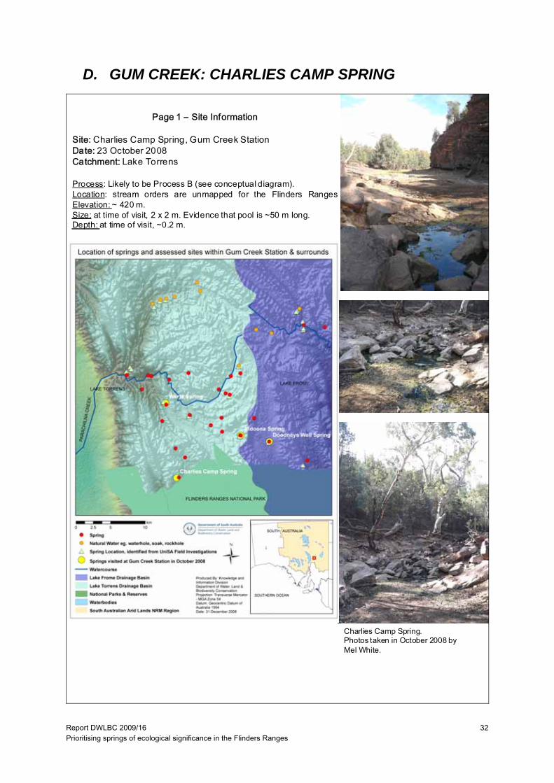
Report DWLBC 2009/16 Prioritising springs of ecological significance in the Flinders Ranges
32
D. GUM CREEK: CHARLIES CAMP SPRING
Page 1 – Site Information
Site: Charlies Camp Spring, Gum Creek StationDate: 23 October 2008Catchment: Lake Torrens
Process: Likely to be Process B (see conceptual diagram).Location: stream orders are unmapped for the Flinders RangesElevation: ~ 420 m.Size: at time of visit, 2 x 2 m. Evidence that pool is ~50 m long.Depth: at time of visit, ~0.2 m.
Charlies Camp Spring.Photos taken in October 2008 byMel White.
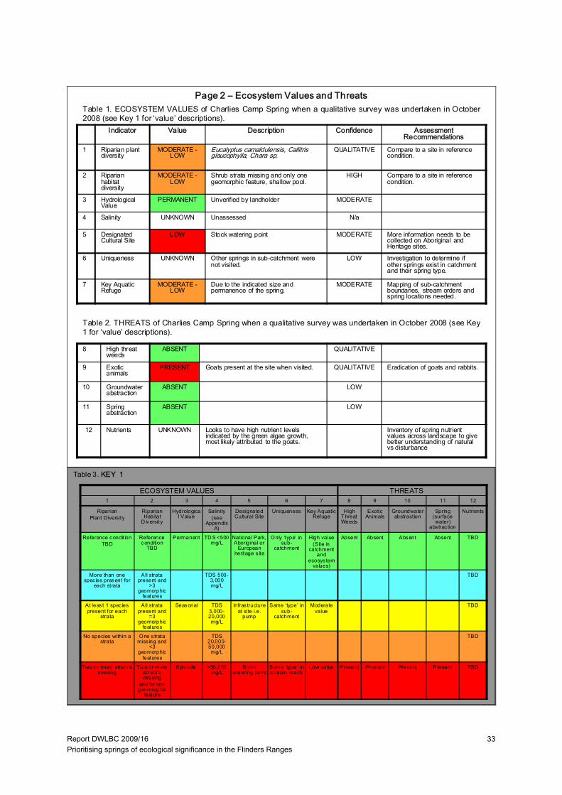
Report DWLBC 2009/16 Prioritising springs of ecological significance in the Flinders Ranges
33
Indicator Value Description Confidence Assessment Recommendations
1 Riparian plant diversity
MODERATE -LOW
Eucalyptus camaldulensis, Callitris glaucophylla, Chara sp.
QUALITATIVE Compare to a site in reference condition.
2 Riparian habitat diversity
MODERATE -LOW
Shrub strata missing and only one geomorphic feature, shallow pool.
HIGH Compare to a site in reference condition.
3 Hydrological Value
PERMANENT Unverified by landholder MODERATE
4 Salinity UNKNOWN Unassessed N/a
5 Designated Cultural Site
LOW Stock watering point MODERATE More information needs to be collected on Aboriginal and Heritage sites.
6 Uniqueness UNKNOWN Other springs in sub-catchment were not visited.
LOW Investigation to determine if other springs exist in catchment and their spring type.
7 Key Aquatic Refuge
MODERATE -LOW
Due to the indicated size and permanence of the spring.
MODERATE Mapping of sub-catchment boundaries, stream orders and spring locations needed.
Table 1. ECOSYSTEM VALUES of Charlies Camp Spring when a qualitative survey was undertaken in October2008 (see Key 1 for ‘value’ descriptions).
Table 2. THREATS of Charlies Camp Spring when a qualitative survey was undertaken in October 2008 (see Key1 for ‘value’ descriptions).
ECOSYSTEM VALUES THREATS
8 High threat weeds
ABSENT QUALITATIVE
9 Exotic animals
PRESENT Goats present at the site when visited. QUALITATIVE Eradication of goats and rabbits.
10 Groundwater abstraction
ABSENT LOW
11 Spring abstraction
ABSENT LOW
12 Nutrients UNKNOWN Looks to have high nutrient levels indicated by the green algae growth, most likely attributed to the goats.
Inventory of spring nutrient values across landscape to give better understanding of natural vs disturbance
Page 2 – Ecosystem Values and Threats
Table 3. KEY 1
1 2 3 4 5 6 7 8 9 10 11 12
RiparianPlant Divers ity
Riparian Habitat
D iversity
Hydrological Value
Salinity (see
Appendix A)
Designated Cultural Site
Uniqueness Key Aquatic Refuge
High T hreat Weeds
Exotic Animals
Groundwater abstract ion
Spring (surface water)
abs trac tion
Nutrients
Reference condit ionTBD
Reference condition
TBD
Permanent TD S <500 mg/L
National Park, Aboriginal or
European heritage s ite
Only ‘type’ in sub-
catchment
High value(Site in
catchment and
ecosys tem values)
Absent Absent Absent Absent TBD
More than one spec ies present for
each strata
All strata present and
>3 geomorphic
features
TDS 500-3,000 mg/L
TBD
At leas t 1 spec ies present for each
strata
All strata present and
=3 geomorphic
features
Seasonal TDS 3,000-20,000 mg/L
Infras tructure at site i.e.
pump
Same ‘type’ in sub-
catchment
Moderate value
TBD
No species within a strata
One s trata miss ing and
<3 geomorphic
features
TDS 20,000-50,000 mg/L
TBD
Two or more strata’s missing
Tw o or more strata’s missing
and/or one geomorphic
feature
Episodic >50,000 mg/L
Stock watering point
Same ‘type’ in s tream reach
Low value Present Present Present Present TBD
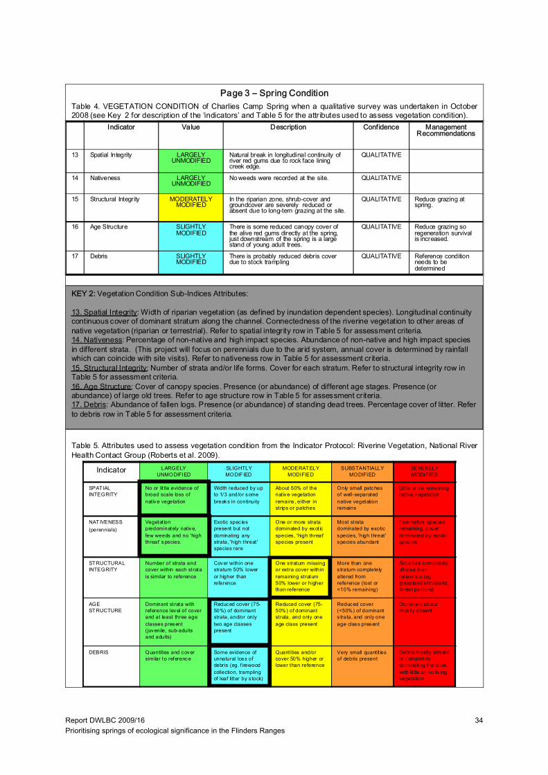
Report DWLBC 2009/16 Prioritising springs of ecological significance in the Flinders Ranges
34
Indicator Value Description Confidence Management Recommendations
13 Spatial Integrity LARGELY UNMODIFIED
Natural break in longitudinal continuity of river red gums due to rock face lining creek edge.
QUALITATIVE
14 Nativeness LARGELY UNMODIFIED
No weeds were recorded at the site. QUALITATIVE
15 Structural Integrity MODERATELY MODIFIED
In the riparian zone, shrub-cover and groundcover are severely reduced or absent due to long-tern grazing at the site.
QUALITATIVE Reduce grazing at spring.
16 Age Structure SLIGHTLY MODIFIED
There is some reduced canopy cover of the alive red gums directly at the spring, just downstream of the spring is a large stand of young adult trees.
QUALITATIVE Reduce grazing so regeneration survival is increased.
17 Debris SLIGHTLY MODIFIED
There is probably reduced debris cover due to stock trampling
QUALITATIVE Reference condition needs to be determined
Indicator LARGELY UNMODIFIED
SLIGHTLY MODIF IED
MODERAT ELY MODIFIED
SUBSTANTIALLY MODIFIED
SEVERELY MODIFIED
SPAT IAL INTEGRITY
No or lit tle evidence of broad scale loss of nat ive vegetation
Width reduced by up to 1/3 and/or some breaks in continuity
About 50% of the nat ive vegetation remains , either in strips or patches
Only small patches of well-separated native vegetation remains
Lit tle or no remaining native vegetation
NAT IVENESS(perennials)
Vegetat ion predominately native, few weeds and no 'high threat' species.
Exotic spec ies present but not dominating any strata, 'high threat ' species rare
One or more strata dominated by exot ic species , 'high threat' species present
Most strata dominated by exotic species, 'high threat ' species abundant
Few native spec ies remaining, cover dominated by exotic spec ies
STRUCTURAL INTEGRITY
Number of strata and cover within each strata is similar to reference
Cover within one stratum 50% lower or higher than reference
One s tratum missing or extra cover within remaining stratum 50% lower or higher than reference
More than one s tratum completely altered from reference (lost or <10% remaining)
Struc ture completely altered from reference (eg. grass land shrubland, fores t pasture)
AGE STRUCTURE
Dominant strata with reference level of cover and at least three age classes present (juvenile, sub-adults and adults)
Reduced cover (75-50%) of dominant strata, and/or only two age classes present
Reduced cover (75-50%) of dominant strata, and only one age class present
Reduced cover (<50%) of dominant s trata, and only one age class present
Dominant strata mos tly absent
DEBRIS Quantities and cover similar to reference
Some evidence of unnatural loss of debris (eg. f irewood collection, trampling of leaf litter by s tock)
Quant ities and/or cover 50% higher or lower than reference
Very small quant it ies of debris present
Debris mostly absent or completely dominating the sites, with lit tle or no liv ing vegetation
Table 4. VEGETATION CONDITION of Charlies Camp Spring when a qualitative survey was undertaken in October2008 (see Key 2 for description of the ‘indicators’ and Table 5 for the attributes used to assess vegetation condition).
Page 3 – Spring Condition
Table 5. Attributes used to assess vegetation condition from the Indicator Protocol: Riverine Vegetation, National RiverHealth Contact Group (Roberts et al. 2009).
KEY 2: Vegetation Condition Sub-Indices Attributes:
13. Spatial Integrity: Width of riparian vegetation (as defined by inundation dependent species). Longitudinal continuity continuous cover of dominant stratum along the channel. Connectedness of the riverine vegetation to other areas ofnative vegetation (riparian or terrestrial). Refer to spatial integrity row in Table 5 for assessment criteria.14. Nativeness: Percentage of non-native and high impact species. Abundance of non-native and high impact species in different strata. (This project will focus on perennials due to the arid system, annual cover is determined by rainfall which can coincide with site visits). Refer to nativeness row in Table 5 for assessment criteria.15. Structural Integrity: Number of strata and/or life forms. Cover for each stratum. Refer to structural integrity row in Table 5 for assessment criteria.16. Age Structure: Cover of canopy species. Presence (or abundance) of different age stages. Presence (orabundance) of large old trees. Refer to age structure row in Table 5 for assessment criteria.17. Debris: Abundance of fallen logs. Presence (or abundance) of standing dead trees. Percentage cover of litter. Referto debris row in Table 5 for assessment criteria.
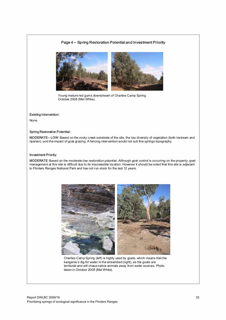
Report DWLBC 2009/16 Prioritising springs of ecological significance in the Flinders Ranges
35
Existing Intervention:
None.
Spring Restoration Potential:
MODERATE – LOW: Based on the rocky creek substrate of the site, the low diversity of vegetation (both instream and riparian), and the impact of goat grazing. A fencing intervention would not suit this springs topography.
Investment Priority:
MODERATE: Based on the moderate-low restoration potential. Although goat control is occurring on the property, goat management at this site is difficult due to its inaccessible location. However it should be noted that this site is adjacent to Flinders Ranges National Park and has not run stock for the last 12 years.
Young mature red gums downstream of Charlies Camp Spring. October 2008 (Mel White).
Charlies Camp Spring (left) is highly used by goats, which means that the kangaroo’s dig for water in the streambed (right), as the goats are territorial and will chase native animals away from water sources. Photo taken in October 2008 (Mel White).
Page 4 – Spring Restoration Potential and Investment Priority

Report DWLBC 2009/16 Prioritising springs of ecological significance in the Flinders Ranges
36
E. GUM CREEK: DOODNEY’S WELL SPRING
Page 1 – Site Information
Site: Doodney’s Well Spring, Gum Creek StationDate: 23 October 2008Catchment: Lake Frome
Process: Process D (see conceptual diagram), indicated byLandholderand fault mapping.Location: stream orders are unmapped for the Flinders, and it is toohard to determine this stream order on the 1 : 50 000 topographicmap due to the sub-catchment being located across maps.Elevation: ~ 520 m.Size: at time of visit, no surface water present, seasonal length till2007~1 km but reduces to a pool during dry times.Depth: at time of visit, no surface water present.
This Doodney’s Well spring was drywith the sedges along the bank startingto dry out.Photos taken in October 2008 byMel White.
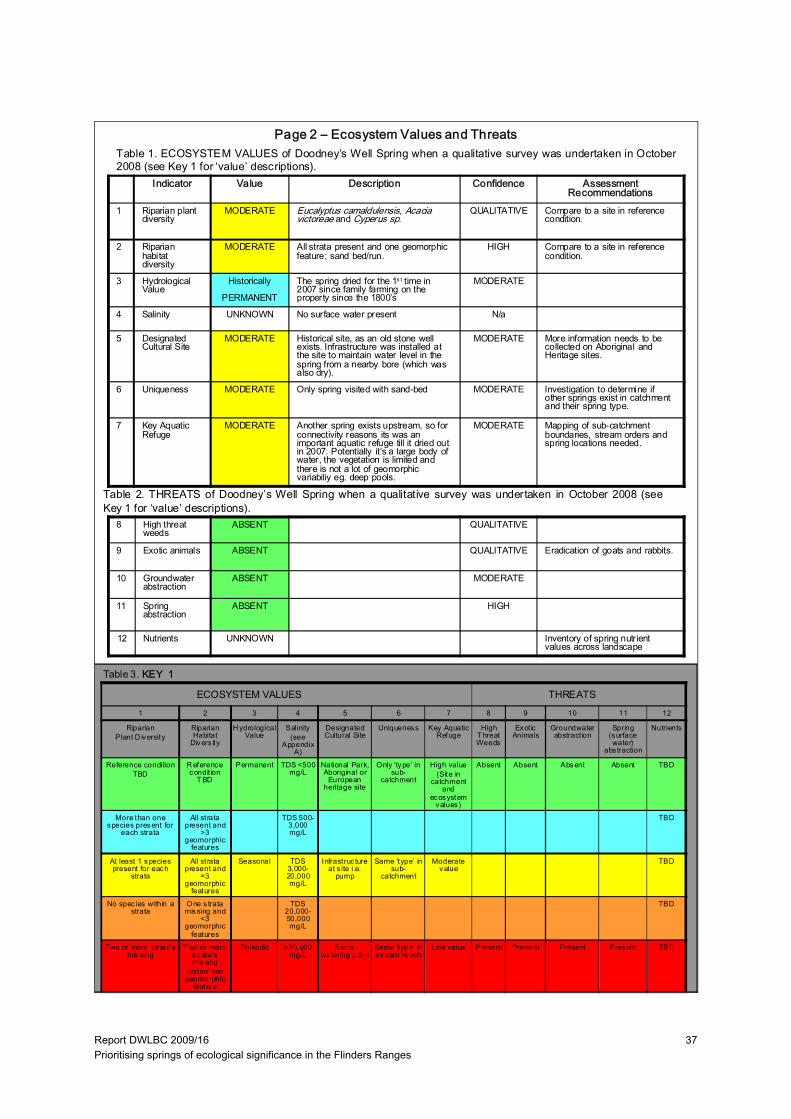
Report DWLBC 2009/16 Prioritising springs of ecological significance in the Flinders Ranges
37
Indicator Value Description Confidence Assessment Recommendations
1 Riparian plant diversity
MODERATE Eucalyptus camaldulensis, Acacia victoreae and Cyperus sp.
QUALITATIVE Compare to a site in reference condition.
2 Riparian habitat diversity
MODERATE All strata present and one geomorphic feature; sand bed/run.
HIGH Compare to a site in reference condition.
3 Hydrological Value
Historically
PERMANENT
The spring dried for the 1s t time in 2007 since family farming on the property since the 1800’s
MODERATE
4 Salinity UNKNOWN No surface water present N/a
5 Designated Cultural Site
MODERATE Historical site, as an old stone well exists. Infrastructure was installed at the site to maintain water level in the spring from a nearby bore (which was also dry).
MODERATE More information needs to be collected on Aboriginal and Heritage sites.
6 Uniqueness MODERATE Only spring visited with sand-bed MODERATE Investigation to determine if other springs exist in catchment and their spring type.
7 Key Aquatic Refuge
MODERATE Another spring exists upstream, so for connectivity reasons its was an important aquatic refuge till it dried out in 2007. Potentially it’s a large body of water, the vegetation is limited and there is not a lot of geomorphic variabiliy eg. deep pools.
MODERATE Mapping of sub-catchment boundaries, stream orders and spring locations needed.
Table 1. ECOSYSTEM VALUES of Doodney’s Well Spring when a qualitative survey was undertaken in October2008 (see Key 1 for ‘value’ descriptions).
Table 2. THREATS of Doodney’s Well Spring when a qualitative survey was undertaken in October 2008 (seeKey 1 for ‘value’ descriptions).
ECOSYSTEM VALUES THREATS
8 High threat weeds
ABSENT QUALITATIVE
9 Exotic animals ABSENT QUALITATIVE Eradication of goats and rabbits.
10 Groundwater abstraction
ABSENT MODERATE
11 Spring abstraction
ABSENT HIGH
12 Nutrients UNKNOWN Inventory of spring nutrient values across landscape
Page 2 – Ecosystem Values and Threats
Table 3. KEY 1
1 2 3 4 5 6 7 8 9 10 11 12
RiparianPlant D iversity
Riparian Habitat
Divers ity
H ydrological Value
Salinity (see
Appendix A)
Designated Cultural Site
Uniqueness Key Aquatic Refuge
High T hreat Weeds
Exot ic Animals
Groundwater abstract ion
Spring (surface water)
abs traction
Nutrients
Reference conditionTBD
R eference condit ion
T BD
Permanent TDS <500 mg/L
National Park, Aboriginal or
European heritage site
Only ‘type’ in sub-
catchment
High value(Site in
catchment and
ecosystem values)
Absent Absent Absent Absent TBD
More than one species present for
each strata
All strata present and
>3 geomorphic
features
TDS 500-3,000 mg/L
TBD
At least 1 species present for each
strata
All strata present and
=3 geomorphic
features
Seasonal TDS 3,000-20,000 mg/L
Infrastruc ture at s ite i.e.
pump
Same ‘type’ in sub-
catchment
Moderate value
TBD
No spec ies within a strata
One s trata missing and
<3 geomorphic
features
TDS 20,000-50,000 mg/L
TBD
Two or more s trata’s missing
T wo or more s trata’s missing
and/or one geomorphic
feature
Episodic >50,000 mg/L
Stock watering point
Same ‘type’ in s tream reach
Low value Present Present Present Present TBD
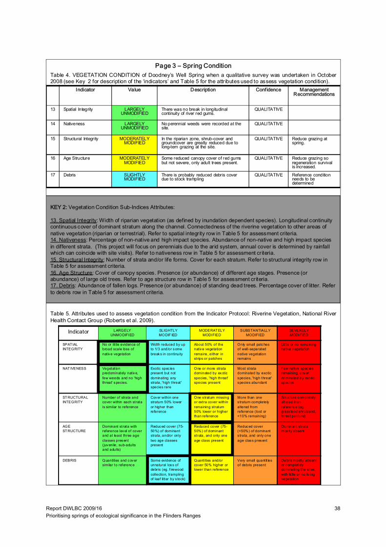
Report DWLBC 2009/16 Prioritising springs of ecological significance in the Flinders Ranges
38
Indicator Value Description Confidence Management Recommendations
13 Spatial Integrity LARGELY UNMODIFIED
There was no break in longitudinal continuity of river red gums.
QUALITATIVE
14 Nativeness LARGELY UNMODIFIED
No perennial weeds were recorded at the site.
QUALITATIVE
15 Structural Integrity MODERATELY MODIFIED
In the riparian zone, shrub-cover and groundcover are greatly reduced due to long-tern grazing at the site.
QUALITATIVE Reduce grazing at spring.
16 Age Structure MODERATELY MODIFIED
Some reduced canopy cover of red gums but not severe, only adult trees present.
QUALITATIVE Reduce grazing so regeneration survival is increased.
17 Debris SLIGHTLY MODIFIED
There is probably reduced debris cover due to stock trampling
QUALITATIVE Reference condition needs to be determined
Indicator LARGELY UNMODIFIED
SLIGHTLY MODIF IED
MODERAT ELY MODIFIED
SUBSTANTIALLY MODIFIED
SEVERELY MODIFIED
SPAT IAL INTEGRITY
No or lit tle evidence of broad scale loss of nat ive vegetation
Width reduced by up to 1/3 and/or some breaks in continuity
About 50% of the nat ive vegetation remains , either in strips or patches
Only small patches of well-separated native vegetation remains
Lit tle or no remaining native vegetation
NAT IVENESS Vegetat ion predominately native, few weeds and no 'high threat' species.
Exotic spec ies present but not dominating any strata, 'high threat ' species rare
One or more strata dominated by exot ic species , 'high threat' species present
Most strata dominated by exotic species, 'high threat ' species abundant
Few native spec ies remaining, cover dominated by exotic spec ies
STRUCTURAL INTEGRITY
Number of strata and cover within each strata is similar to reference
Cover within one stratum 50% lower or higher than reference
One s tratum missing or extra cover within remaining stratum 50% lower or higher than reference
More than one s tratum completely altered from reference (lost or <10% remaining)
Struc ture completely altered from reference (eg. grass land shrubland, fores t pasture)
AGE STRUCTURE
Dominant strata with reference level of cover and at least three age classes present (juvenile, sub-adults and adults)
Reduced cover (75-50%) of dominant strata, and/or only two age classes present
Reduced cover (75-50%) of dominant strata, and only one age class present
Reduced cover (<50%) of dominant s trata, and only one age class present
Dominant strata mos tly absent
DEBRIS Quantities and cover similar to reference
Some evidence of unnatural loss of debris (eg. f irewood collection, trampling of leaf litter by s tock)
Quant ities and/or cover 50% higher or lower than reference
Very small quant it ies of debris present
Debris mostly absent or completely dominating the sites, with lit tle or no liv ing vegetation
Table 4. VEGETATION CONDITION of Doodney’s Well Spring when a qualitative survey was undertaken in October2008 (see Key 2 for description of the ‘indicators’ and Table 5 for the attributes used to assess vegetation condition).
Page 3 – Spring Condition
Table 5. Attributes used to assess vegetation condition from the Indicator Protocol: Riverine Vegetation, National RiverHealth Contact Group (Roberts et al. 2009).
KEY 2: Vegetation Condition Sub-Indices Attributes:
13. Spatial Integrity: Width of riparian vegetation (as defined by inundation dependent species). Longitudinal continuity continuous cover of dominant stratum along the channel. Connectedness of the riverine vegetation to other areas ofnative vegetation (riparian or terrestrial). Refer to spatial integrity row in Table 5 for assessment criteria.14. Nativeness: Percentage of non-native and high impact species. Abundance of non-native and high impact species in different strata. (This project will focus on perennials due to the arid system, annual cover is determined by rainfall which can coincide with site visits). Refer to nativeness row in Table 5 for assessment criteria.15. Structural Integrity: Number of strata and/or life forms. Cover for each stratum. Refer to structural integrity row in Table 5 for assessment criteria.16. Age Structure: Cover of canopy species. Presence (or abundance) of different age stages. Presence (orabundance) of large old trees. Refer to age structure row in Table 5 for assessment criteria.17. Debris: Abundance of fallen logs. Presence (or abundance) of standing dead trees. Percentage cover of litter. Referto debris row in Table 5 for assessment criteria.
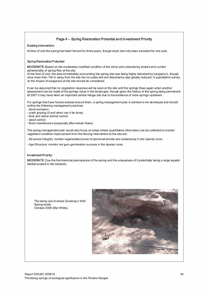
Report DWLBC 2009/16 Prioritising springs of ecological significance in the Flinders Ranges
39
Existing Intervention:
At time of visit the spring had been fenced for three years, though stock had only been excluded for one year.
Spring Restoration Potential:
MODERATE:Based on the moderately modified condition of the shrub and understorey strata's and current ephemerality of spring flow at the site. At the time of visit, the area immediately surrounding the spring site was being highly disturbed by kangaroo’s, though once more than 100 m away from the site the roo pads and soil disturbance was greatly reduced. A quantitative survey on the impact of kangaroos at the site should be considered.
It can be assumed that no vegetation response will be seen at the site until the springs flows again when another assessment can be made of the springs value in the landscape, though given the history of the spring being permanent till 2007 it may have been an important central refuge site due to the existence of more springs upstream.
For springs that have fences erected around them, a spring management plan is advised to be developed and should outline the following management practices:- stock exclusion- crash grazing (if and when can it be done)- feral and native animal control- weed control- fence maintenance (especially after stream flows)
The spring management plan would also focus on areas where quantitative information can be collected to monitor vegetation condition improvement from the fencing intervention at the site are:- Structural Integrity: monitor regeneration/cover of perennial shrubs and understorey in the riparian zone.
- Age Structure: monitor red gum germination success in the riparian zone.
Investment Priority:MODERATE: Due the the historical permanence of the spring and the uniqueness of it potentially being a large aquatic habitat located in the lowlands.
The damp soil of where Doodney’s Well Spring exists.October 2008 (Mel White).
Page 4 – Spring Restoration Potential and Investment Priority
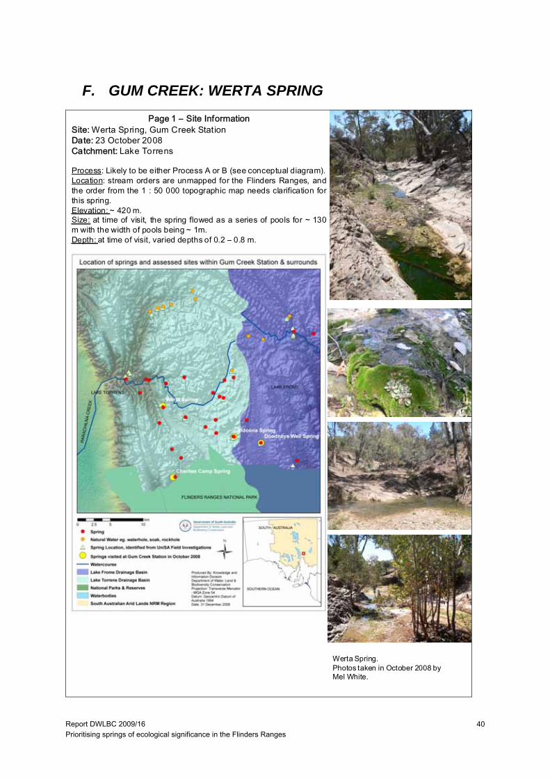
Report DWLBC 2009/16 Prioritising springs of ecological significance in the Flinders Ranges
40
F. GUM CREEK: WERTA SPRING
Page 1 – Site InformationSite: Werta Spring, Gum Creek StationDate: 23 October 2008Catchment: Lake Torrens
Process: Likely to be either Process A or B (see conceptual diagram).Location: stream orders are unmapped for the Flinders Ranges, andthe order from the 1 : 50 000 topographic map needs clarification forthis spring.Elevation: ~ 420 m.Size: at time of visit, the spring flowed as a series of pools for ~ 130m with the width of pools being ~ 1m.Depth: at time of visit, varied depths of 0.2 – 0.8 m.
Werta Spring.Photos taken in October 2008 byMel White.
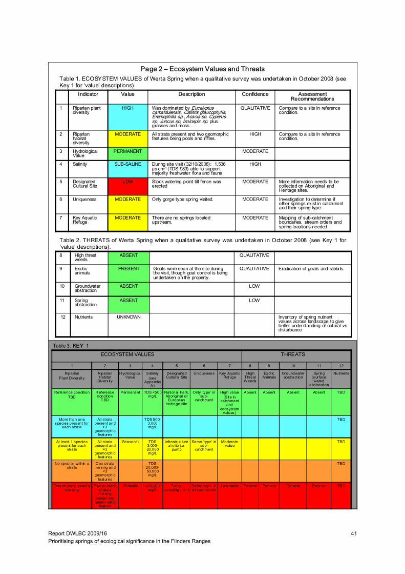
Report DWLBC 2009/16 Prioritising springs of ecological significance in the Flinders Ranges
41
Indicator Value Description Confidence Assessment Recommendations
1 Riparian plant diversity
HIGH Was dominated by Eucalyptus camaldulensis, Callitris glaucophylla, Eremophilla sp., Acacia sp. Cyperus sp, Juncus sp, Isoloepis sp. plus grasses and moss.
QUALITATIVE Compare to a site in reference condition.
2 Riparian habitat diversity
MODERATE All strata present and two geomorphic features being pools and riffles.
HIGH Compare to a site in reference condition.
3 Hydrological Value
PERMANENT MODERATE
4 Salinity SUB-SALINE During site visit (32/10/2008): 1,536 µs cm-1 (TDS 983) able to support majority freshwater flora and fauna
HIGH
5 Designated Cultural Site
LOW Stock watering point till fence was erected
MODERATE More information needs to be collected on Aboriginal and Heritage sites.
6 Uniqueness MODERATE Only gorge type spring visited. MODERATE Investigation to determine if other springs exist in catchment and their spring type.
7 Key Aquatic Refuge
MODERATE There are no springs located upstream.
MODERATE Mapping of sub-catchment boundaries, stream orders and spring locations needed.
Table 1. ECOSYSTEM VALUES of Werta Spring when a qualitative survey was undertaken in October 2008 (seeKey 1 for ‘value’ descriptions).
Table 2. THREATS of Werta Spring when a qualitative survey was undertaken in October 2008 (see Key 1 for‘value’ descriptions).
ECOSYSTEM VALUES THREATS
8 High threat weeds
ABSENT QUALITATIVE
9 Exotic animals
PRESENT Goats were seen at the site during the visit, though goat control is being undertaken on the property.
QUALITATIVE Eradication of goats and rabbits.
10 Groundwater abstraction
ABSENT LOW
11 Spring abstraction
ABSENT LOW
12 Nutrients UNKNOWN Inventory of spring nutrient values across landscape to give better understanding of natural vs disturbance
Page 2 – Ecosystem Values and Threats
Table 3. KEY 1
1 2 3 4 5 6 7 8 9 10 11 12
RiparianPlant D iversity
Riparian Habitat
Divers ity
H ydrological Value
Salinity (see
Appendix A)
Designated Cultural Site
Uniqueness Key Aquatic Refuge
High T hreat Weeds
Exot ic Animals
Groundwater abstract ion
Spring (surface water)
abs traction
Nutrients
Reference conditionTBD
R eference condit ion
T BD
Permanent TDS <500 mg/L
National Park, Aboriginal or
European heritage site
Only ‘type’ in sub-
catchment
High value(Site in
catchment and
ecosystem values)
Absent Absent Absent Absent TBD
More than one species present for
each strata
All strata present and
>3 geomorphic
features
TDS 500-3,000 mg/L
TBD
At least 1 species present for each
strata
All strata present and
=3 geomorphic
features
Seasonal TDS 3,000-20,000 mg/L
Infrastruc ture at s ite i.e.
pump
Same ‘type’ in sub-
catchment
Moderate value
TBD
No spec ies within a strata
One s trata missing and
<3 geomorphic
features
TDS 20,000-50,000 mg/L
TBD
Two or more s trata’s missing
T wo or more s trata’s missing
and/or one geomorphic
feature
Episodic >50,000 mg/L
Stock watering point
Same ‘type’ in s tream reach
Low value Present Present Present Present TBD
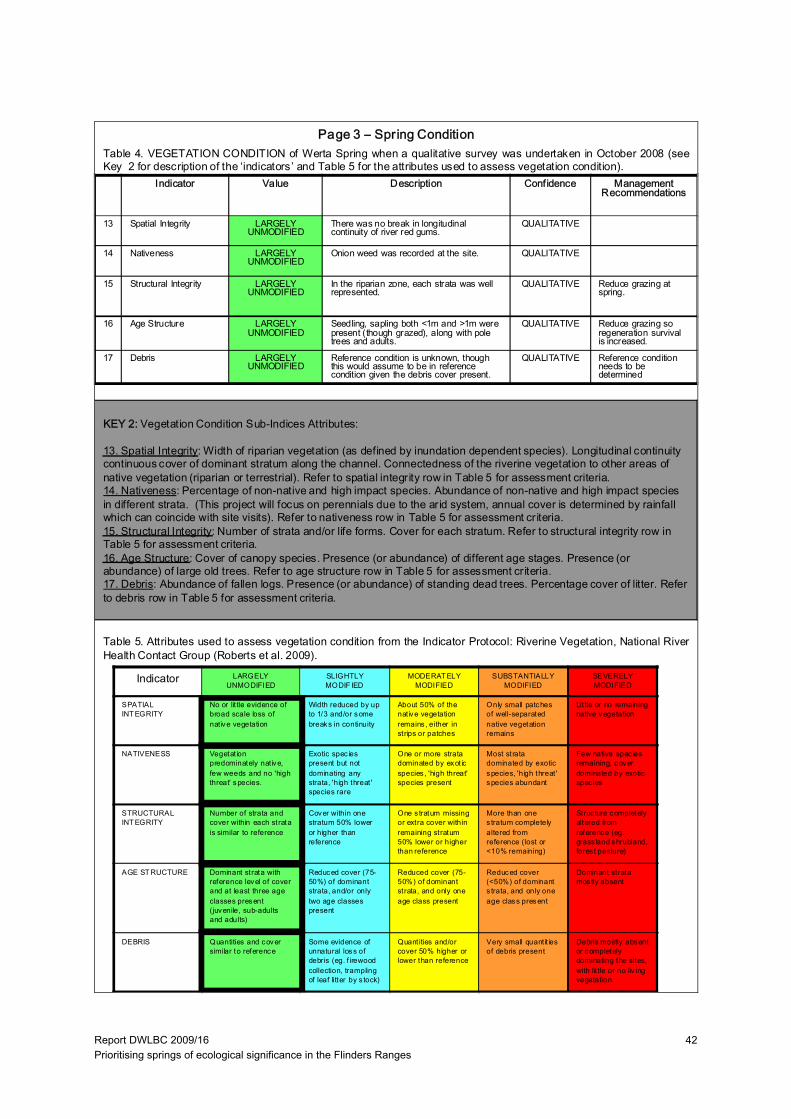
Report DWLBC 2009/16 Prioritising springs of ecological significance in the Flinders Ranges
42
Indicator Value Description Confidence Management Recommendations
13 Spatial Integrity LARGELY UNMODIFIED
There was no break in longitudinal continuity of river red gums.
QUALITATIVE
14 Nativeness LARGELY UNMODIFIED
Onion weed was recorded at the site. QUALITATIVE
15 Structural Integrity LARGELY UNMODIFIED
In the riparian zone, each strata was well represented.
QUALITATIVE Reduce grazing at spring.
16 Age Structure LARGELY UNMODIFIED
Seedling, sapling both <1m and >1m were present (though grazed), along with pole trees and adults.
QUALITATIVE Reduce grazing so regeneration survival is increased.
17 Debris LARGELY UNMODIFIED
Reference condition is unknown, though this would assume to be in reference condition given the debris cover present.
QUALITATIVE Reference condition needs to be determined
Indicator LARGELY UNMODIFIED
SLIGHTLY MODIF IED
MODERAT ELY MODIFIED
SUBSTANTIALLY MODIFIED
SEVERELY MODIFIED
SPATIAL INT EGRITY
No or lit tle evidence of broad scale loss of nat ive vegetation
Width reduced by up to 1/3 and/or some breaks in continuity
About 50% of the nat ive vegetation remains , either in strips or patches
Only small patches of well-separated native vegetation remains
Lit tle or no remaining native vegetation
NATIVENESS Vegetat ion predominately native, few weeds and no 'high threat' species.
Exotic spec ies present but not dominating any strata, 'high threat ' species rare
One or more strata dominated by exot ic species , 'high threat' species present
Most strata dominated by exotic species, 'high threat ' species abundant
Few native spec ies remaining, cover dominated by exotic spec ies
STRUCTURAL INT EGRITY
Number of strata and cover within each strata is similar to reference
Cover within one stratum 50% lower or higher than reference
One s tratum missing or extra cover within remaining stratum 50% lower or higher than reference
More than one s tratum completely altered from reference (lost or <10% remaining)
Struc ture completely altered from reference (eg. grass land shrubland, fores t pasture)
AGE ST RUCTURE Dominant strata with reference level of cover and at least three age classes present (juvenile, sub-adults and adults)
Reduced cover (75-50%) of dominant strata, and/or only two age classes present
Reduced cover (75-50%) of dominant strata, and only one age class present
Reduced cover (<50%) of dominant s trata, and only one age class present
Dominant strata mos tly absent
DEBRIS Quantities and cover similar to reference
Some evidence of unnatural loss of debris (eg. f irewood collection, trampling of leaf litter by s tock)
Quant ities and/or cover 50% higher or lower than reference
Very small quant it ies of debris present
Debris mostly absent or completely dominating the sites, with lit tle or no liv ing vegetation
Table 4. VEGETATION CONDITION of Werta Spring when a qualitative survey was undertaken in October 2008 (seeKey 2 for description of the ‘indicators’ and Table 5 for the attributes used to assess vegetation condition).
Page 3 – Spring Condition
Table 5. Attributes used to assess vegetation condition from the Indicator Protocol: Riverine Vegetation, National RiverHealth Contact Group (Roberts et al. 2009).
KEY 2: Vegetation Condition Sub-Indices Attributes:
13. Spatial Integrity: Width of riparian vegetation (as defined by inundation dependent species). Longitudinal continuity continuous cover of dominant stratum along the channel. Connectedness of the riverine vegetation to other areas ofnative vegetation (riparian or terrestrial). Refer to spatial integrity row in Table 5 for assessment criteria.14. Nativeness: Percentage of non-native and high impact species. Abundance of non-native and high impact species in different strata. (This project will focus on perennials due to the arid system, annual cover is determined by rainfall which can coincide with site visits). Refer to nativeness row in Table 5 for assessment criteria.15. Structural Integrity: Number of strata and/or life forms. Cover for each stratum. Refer to structural integrity row in Table 5 for assessment criteria.16. Age Structure: Cover of canopy species. Presence (or abundance) of different age stages. Presence (orabundance) of large old trees. Refer to age structure row in Table 5 for assessment criteria.17. Debris: Abundance of fallen logs. Presence (or abundance) of standing dead trees. Percentage cover of litter. Referto debris row in Table 5 for assessment criteria.

Report DWLBC 2009/16 Prioritising springs of ecological significance in the Flinders Ranges
43
Existing Intervention:The spring has been fenced. At the time of visit goats were seen inside the fence at the spring.
Spring Restoration Potential:
No restoration is required at the site given its intact nature. Ensure that current land management practices are maintained (goat control and no stock grazing). The current grazing of seedlings (see photo below) at the site may be attributed to both goats and kangaroo’s, though further investigation could be done to determine this but at this stage is probably not needed as there is some survival of red gum seedlings into sub adult trees (indicated by the range of age classes present).The two focus areas where quantitative information can be collected to monitor vegetation condition change/improvement at the site are:- Structural Integrity: monitor regeneration/cover of perennial shrubs and understorey in the riparian zone.
- Age Structure: monitor red gum germination success in the riparian zone.
Investment Priority:
LOW: This spring is in good condition with minimal threats noted, land management practices should be maintained.
Grazing of red gum saplings at Werta Spring. October 2008 (Mel White).
Page 4 – Spring Restoration Potential and Investment Priority
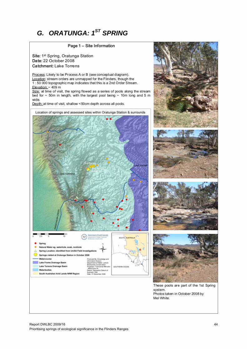
Report DWLBC 2009/16 Prioritising springs of ecological significance in the Flinders Ranges
44
G. ORATUNGA: 1ST SPRING
Page 1 – Site Information
Site: 1st Spring, Oratunga StationDate: 22 October 2008Catchment: Lake Torrens
Process: Likely to be Process A or B (see conceptual diagram).Location: stream orders are unmapped for the Flinders, though the1 : 50 000 topographic map indicates that this is a 2nd Order Stream.Elevation: ~ 409 mSize: at time of visit, the spring flowed as a series of pools along the streambed for ~ 50m in length, with the largest pool being ~ 10m long and 5 mwide.Depth: at time of visit, shallow <50cm depth across all pools.
These pools are part of the 1st Springsystem.Photos taken in October 2008 byMel White.
Report DWLBC 2009/16 Prioritising springs of ecological significance in the Flinders Ranges
45
Indicator Value Description Confidence Assessment Recommendations
1 Riparian plant diversity
HIGH Eucalyptus camaldulensis, Pittosporum augustifolium, Acacia tetragonophylla, A. rivalis, A victoriae, Dodonaea lobulate, Cyperus alterniflorus and Cyperus sp.
QUALITATIVE Compare to a site in reference condition.
2 Riparian habitat diversity
MODERATE All strata’s present and one geomorphic feature being pools.
HIGH Compare to a site in reference condition.
3 Hydrological Value
PERMANENT HIGH
4 Salinity SUB-SALINE During site visit (22/10/2008): 1,926 µs cm-1 (TDS 1232), able to support majority freshwater flora and fauna
HIGH
5 Designated Cultural Site
LOW No infrastructure exists at the site, is used as a stock watering point
HIGH More information needs to be collected on Aboriginal and Heritage sites.
6 Uniqueness MODERATE Two other springs occur in the same area that flow into the same stream.
MODERATE Investigation to determine if other springs exist in catchment and their spring type.
7 Key Aquatic Refuge
MODERATE Ecosystems values are moderate MODERATE Mapping of sub-catchment boundaries, stream orders and spring locations needed.
Table 1. ECOSYSTEM VALUES of 1st Spring when a qualitative survey was undertaken in October 2008 (seeKey 1 for ‘value’ descriptions).
Table 2. THREATS of 1st Spring when a qualitative survey was undertaken in October 2008 (see Key 1 for ‘value’descriptions).
ECOSYSTEM VALUES THREATS
8 High threat weeds
ABSENT QUALITATIVE
9 Exotic animals ABSENT Goat control is being undertaken at the station.
QUALITATIVE Eradication of goats and rabbits.
10 Groundwater abstraction
ABSENT MODERATE
11 Spring abstraction
ABSENT HIGH
12 Nutrients UNKNOWN Inventory of spring nutrient values across landscape to give better understanding of natural vs disturbance
Page 2 – Ecosystem Values and Threats
Table 3. KEY 1
1 2 3 4 5 6 7 8 9 10 11 12
RiparianPlant D iversity
Riparian Habitat
Divers ity
H ydrological Value
Salinity (see
Appendix A)
Designated Cultural Site
Uniqueness Key Aquatic Refuge
High T hreat Weeds
Exot ic Animals
Groundwater abstract ion
Spring (surface water)
abs traction
Nutrients
Reference conditionTBD
R eference condit ion
T BD
Permanent TDS <500 mg/L
National Park, Aboriginal or
European heritage site
Only ‘type’ in sub-
catchment
High value(Site in
catchment and
ecosystem values)
Absent Absent Absent Absent TBD
More than one species present for
each strata
All strata present and
>3 geomorphic
features
TDS 500-3,000 mg/L
TBD
At least 1 species present for each
strata
All strata present and
=3 geomorphic
features
Seasonal TDS 3,000-20,000 mg/L
Infrastruc ture at s ite i.e.
pump
Same ‘type’ in sub-
catchment
Moderate value
TBD
No spec ies within a strata
One s trata missing and
<3 geomorphic
features
TDS 20,000-50,000 mg/L
TBD
Two or more s trata’s missing
T wo or more s trata’s missing
and/or one geomorphic
feature
Episodic >50,000 mg/L
Stock watering point
Same ‘type’ in s tream reach
Low value Present Present Present Present TBD

Report DWLBC 2009/16 Prioritising springs of ecological significance in the Flinders Ranges
46
Indicator Value Description Confidence Management Recommendations
1 Spatial Integrity LARGELY UNMODIFIED
There was no break in longitudinal continuity of river red gums.
QUALITATIVE
2 Nativeness LARGELY UNMODIFIED
Wards weed and Onion weed were recorded at the site.
QUALITATIVE
3 Structural Integrity SLIGHTLY MODIFIED
In the riparian zone, shrub-cover is severely impacted from grazing with the only understorey being some sedge and grass species immediately surrounding the pools of water.
QUALITATIVE Reduce grazing at spring.
4 Age Structure MODERATELY MODIFIED
Some reduced canopy cover of red gums but not severe, only adult trees present.
QUALITATIVE Reduce grazing so regeneration survival is increased.
5 Debris SLIGHTLY MODIFIED
There is probably reduced debris cover due to stock trampling
QUALITATIVE Reference condition needs to be determined
Indicator LARGELY UNMODIFIED
SLIGHTLY MODIF IED
MODERAT ELY MODIFIED
SUBSTANTIALLY MODIFIED
SEVERELY MODIFIED
SPATIAL INT EGRITY
No or lit tle evidence of broad scale loss of nat ive vegetation
Width reduced by up to 1/3 and/or some breaks in continuity
About 50% of the nat ive vegetation remains , either in strips or patches
Only small patches of well-separated native vegetation remains
Lit tle or no remaining native vegetation
NATIVENESS Vegetat ion predominately native, few weeds and no 'high threat' species.
Exotic spec ies present but not dominating any strata, 'high threat ' species rare
One or more strata dominated by exot ic species , 'high threat' species present
Most strata dominated by exotic species, 'high threat ' species abundant
Few native spec ies remaining, cover dominated by exotic spec ies
STRUCTURAL INT EGRITY
Number of strata and cover within each strata is similar to reference
Cover within one stratum 50% lower or higher than reference
One s tratum missing or extra cover within remaining stratum 50% lower or higher than reference
More than one s tratum completely altered from reference (lost or <10% remaining)
Struc ture completely altered from reference (eg. grass land shrubland, fores t pasture)
AGE ST RUCTURE Dominant strata with reference level of cover and at least three age classes present (juvenile, sub-adults and adults)
Reduced cover (75-50%) of dominant strata, and/or only two age classes present
Reduced cover (75-50%) of dominant strata, and only one age class present
Reduced cover (<50%) of dominant s trata, and only one age class present
Dominant strata mos tly absent
DEBRIS Quantities and cover similar to reference
Some evidence of unnatural loss of debris (eg. f irewood collection, trampling of leaf litter by s tock)
Quant ities and/or cover 50% higher or lower than reference
Very small quant it ies of debris present
Debris mostly absent or completely dominating the sites, with lit tle or no liv ing vegetation
Table 4. VEGETATION CONDITION of 1st Spring when a qualitative survey was undertaken in October 2008 (see Key2 for description of the ‘indicators’ and Table 5 for the attributes used to assess vegetation condition).
Page 3 – Spring Condition
Table 5. Attributes used to assess vegetation condition from the Indicator Protocol: Riverine Vegetation, National RiverHealth Contact Group (Roberts et al. 2009).
KEY 2: Vegetation Condition Sub-Indices Attributes:
13. Spatial Integrity: Width of riparian vegetation (as defined by inundation dependent species). Longitudinal continuity continuous cover of dominant stratum along the channel. Connectedness of the riverine vegetation to other areas ofnative vegetation (riparian or terrestrial). Refer to spatial integrity row in Table 5 for assessment criteria.14. Nativeness: Percentage of non-native and high impact species. Abundance of non-native and high impact species in different strata. (This project will focus on perennials due to the arid system, annual cover is determined by rainfall which can coincide with site visits). Refer to nativeness row in Table 5 for assessment criteria.15. Structural Integrity: Number of strata and/or life forms. Cover for each stratum. Refer to structural integrity row in Table 5 for assessment criteria.16. Age Structure: Cover of canopy species. Presence (or abundance) of different age stages. Presence (orabundance) of large old trees. Refer to age structure row in Table 5 for assessment criteria.17. Debris: Abundance of fallen logs. Presence (or abundance) of standing dead trees. Percentage cover of litter. Referto debris row in Table 5 for assessment criteria.
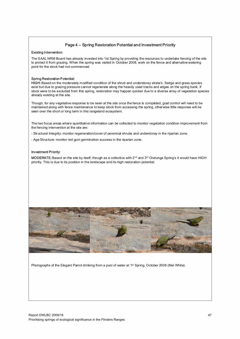
Report DWLBC 2009/16 Prioritising springs of ecological significance in the Flinders Ranges
47
Existing Intervention:
The SAAL NRM Board has already invested into 1st Spring by providing the resources to undertake fencing of the site to protect it from grazing. When the spring was visited in October 2008, work on the fence and alternative watering point for the stock had not commenced.
Spring Restoration Potential:HIGH:Based on the moderately modified condition of the shrub and understorey strata's. Sedge and grass species exist but due to grazing pressure cannot regenerate along the heavily used tracks and edges on the spring bank. If stock were to be excluded from this spring, restoration may happen quicker due to a diverse array of vegetation species already existing at the site.
Though, for any vegetative response to be seen at the site once the fence is completed, goat control will need to be maintained along with fence maintenance to keep stock from accessing the spring, otherwise little response will be seen over the short or long term in this rangeland ecosystem.
The two focus areas where quantitative information can be collected to monitor vegetation condition improvement from the fencing intervention at the site are:- Structural Integrity: monitor regeneration/cover of perennial shrubs and understorey in the riparian zone.
- Age Structure: monitor red gum germination success in the riparian zone.
Investment Priority:MODERATE:Based on the site by itself; though as a collective with 2nd and 3rd Oratunga Spring’s it would have HIGH priority. This is due to its position in the landscape and its high restoration potential.
Photographs of the Elegant Parrot drinking from a pool of water at 1st Spring. October 2008 (Mel White).
Page 4 – Spring Restoration Potential and Investment Priority
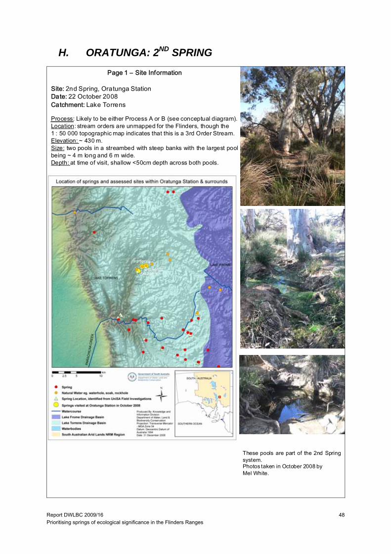
Report DWLBC 2009/16 Prioritising springs of ecological significance in the Flinders Ranges
48
H. ORATUNGA: 2ND SPRING
Page 1 – Site Information
Site: 2nd Spring, Oratunga StationDate: 22 October 2008Catchment: Lake Torrens
Process: Likely to be either Process A or B (see conceptual diagram).Location: stream orders are unmapped for the Flinders, though the1 : 50 000 topographic map indicates that this is a 3rd Order Stream.Elevation: ~ 430 m.Size: two pools in a streambed with steep banks with the largest poolbeing ~ 4 m long and 6 m wide.Depth: at time of visit, shallow <50cm depth across both pools.
These pools are part of the 2nd Springsystem.Photos taken in October 2008 byMel White.

Report DWLBC 2009/16 Prioritising springs of ecological significance in the Flinders Ranges
49
Indicator Value Description Confidence Assessment Recommendations
1 Riparian plant diversity
HIGH Eucalyptus camaldulensis, Acacia victoriae, Melaleuca glomerata, Cyperus alterniflorus, Cyperus sp., Isolespis sp. and some moss cover
QUALITATIVE Compare to a site in reference condition.
2 Riparian habitat diversity
MODERATE All strata present and one geomorphic unit being a pool.
HIGH Compare to a site in reference condition.
3 Hydrological Value
PERMANENT HIGH
4 Salinity SUB-SALINE During site visit (22/10/2008): 1,460 µs cm-1 (TDS 994) able to support majority freshwater flora and fauna
HIGH
5 Designated Cultural Site
LOW No infrastructure exists at the site, is used as a stock watering point
HIGH More information needs to be collected on Aboriginal and Heritage sites.
6 Uniqueness MODERATE Two other springs occur in the same area that flow into the same stream.
MODERATE Investigation to determine if other springs exist in catchment and their spring type.
7 Key Aquatic Refuge
MODERATE -LOW
Due to its small size MODERATE Mapping of sub-catchment boundaries, stream orders and spring locations needed.
Table 1. ECOSYSTEM VALUES of 2nd Spring when a qualitative survey was undertaken in October 2008 (seeKey 1 for ‘value’ descriptions).
Table 2. THREATS of 2nd Spring when a qualitative survey was undertaken in October 2008 (see Key 1 for ‘value’descriptions).
ECOSYSTEM VALUES THREATS
8 High threat weeds
ABSENT QUALITATIVE
9 Exotic animals ABSENT Goat control is being undertaken at the station.
QUALITATIVE Eradication of goats and rabbits.
10 Groundwater abstraction
ABSENT MODERATE
11 Spring abstraction
ABSENT HIGH
12 Nutrients UNKNOWN Inventory of spring nutrient values across landscape to give better understanding of natural vs disturbance
Page 2 – Ecosystem Values and Threats
Table 3. KEY 1
1 2 3 4 5 6 7 8 9 10 11 12
RiparianPlant D iversity
Riparian Habitat
Divers ity
H ydrological Value
Salinity (see
Appendix A)
Designated Cultural Site
Uniqueness Key Aquatic Refuge
High T hreat Weeds
Exot ic Animals
Groundwater abstract ion
Spring (surface water)
abs traction
Nutrients
Reference conditionTBD
R eference condit ion
T BD
Permanent TDS <500 mg/L
National Park, Aboriginal or
European heritage site
Only ‘type’ in sub-
catchment
High value(Site in
catchment and
ecosystem values)
Absent Absent Absent Absent TBD
More than one species present for
each strata
All strata present and
>3 geomorphic
features
TDS 500-3,000 mg/L
TBD
At least 1 species present for each
strata
All strata present and
=3 geomorphic
features
Seasonal TDS 3,000-20,000 mg/L
Infrastruc ture at s ite i.e.
pump
Same ‘type’ in sub-
catchment
Moderate value
TBD
No spec ies within a strata
One s trata missing and
<3 geomorphic
features
TDS 20,000-50,000 mg/L
TBD
Two or more s trata’s missing
T wo or more s trata’s missing
and/or one geomorphic
feature
Episodic >50,000 mg/L
Stock watering point
Same ‘type’ in s tream reach
Low value Present Present Present Present TBD

Report DWLBC 2009/16 Prioritising springs of ecological significance in the Flinders Ranges
50
Indicator Value Description Confidence Management Recommendations
13 Spatial Integrity LARGELY UNMODIFIED
There was no break in longitudinal continuity of river red gums.
QUALITATIVE
14 Nativeness LARGELY UNMODIFIED
Wards weed and Onion weed were recorded at the site.
QUALITATIVE
15 Structural Integrity SLIGHTLY MODIFIED
In the riparian zone, shrub-cover and groundcover are fairly intact with no evidence of severe grazing.
QUALITATIVE Reduce grazing at spring.
16 Age Structure MODERATELY MODIFIED
Some reduced canopy cover of red gums but not severe, only adult trees present.
QUALITATIVE Reduce grazing so regeneration survival is increased.
17 Debris SLIGHTLY MODIFIED
There is probably reduced debris cover due to stock trampling
QUALITATIVE Reference condition needs to be determined
Indicator LARGELY U NMODIFIED
SLIGHTLY MODIF IED
MODERATELY MODIF IED
SUBSTAN TIALLY MODIFIED
SEVERELY MODIFIED
SPATIAL INT EGRITY
No or litt le ev idence of broad scale loss of native vegetat ion
Width reduced by up to 1/3 and/or some breaks in continuity
About 50% of the native vegetat ion remains, either in strips or patches
Only small patches of well-separated native vegetation remains
Little or no remaining native vegetation
NATIVENESS(perennials)
Vegetation predominately native, few weeds and no 'high threat' species .
Exot ic species present but not dominating any strata, 'high threat' spec ies rare
One or more s trata dominated by exotic spec ies, 'high threat' spec ies present
Most strata dominated by exotic species, 'high threat' species abundant
F ew native species remaining, cover dominated by exotic species
STRUCTURAL INT EGRITY
Number of s trata and cover within each strata is similar to reference
Cover within one stratum 50% lower or higher than reference
One stratum missing or extra cover within remaining stratum 50% lower or higher than reference
More than one stratum completely altered from reference (lost or <10% remaining)
Structure completely altered from reference (eg. grassland shrubland, forest pasture)
AGE STRUCTURE
Dominant strata with reference level of cover and at leas t three age classes present (juvenile, sub-adults and adults)
Reduced cover (75-50%) of dominant strata, and/or only two age c lasses present
Reduced cover (75-50%) of dominant strata, and only one age class present
Reduced cover (<50%) of dominant strata, and only one age class present
Dominant strata most ly absent
DEBRIS Quant it ies and cover similar to reference
Some ev idence of unnatural loss of debris (eg. firewood collect ion, t rampling of leaf lit ter by stock )
Quantit ies and/or cover 50% higher or lower than reference
Very small quantit ies of debris present
Debris mos tly absent or completely dominating the sites, with litt le or no living vegetation
Table 4. VEGETATION CONDITION of 2nd Spring when a qualitative survey was undertaken in October 2008 (seeKey 2 for description of the ‘indicators’ and Table 5 for the attributes used to assess vegetation condition).
Page 3 – Spring Condition
Table 5. Attributes used to assess vegetation condition from the Indicator Protocol: Riverine Vegetation, National RiverHealth Contact Group (Roberts et al. 2009).
KEY 2: Vegetation Condition Sub-Indices Attributes:
13. Spatial Integrity: Width of riparian vegetation (as defined by inundation dependent species). Longitudinal continuity continuous cover of dominant stratum along the channel. Connectedness of the riverine vegetation to other areas ofnative vegetation (riparian or terrestrial). Refer to spatial integrity row in Table 5 for assessment criteria.14. Nativeness: Percentage of non-native and high impact species. Abundance of non-native and high impact species in different strata. (This project will focus on perennials due to the arid system, annual cover is determined by rainfall which can coincide with site visits). Refer to nativeness row in Table 5 for assessment criteria.15. Structural Integrity: Number of strata and/or life forms. Cover for each stratum. Refer to structural integrity row in Table 5 for assessment criteria.16. Age Structure: Cover of canopy species. Presence (or abundance) of different age stages. Presence (orabundance) of large old trees. Refer to age structure row in Table 5 for assessment criteria.17. Debris: Abundance of fallen logs. Presence (or abundance) of standing dead trees. Percentage cover of litter. Referto debris row in Table 5 for assessment criteria.
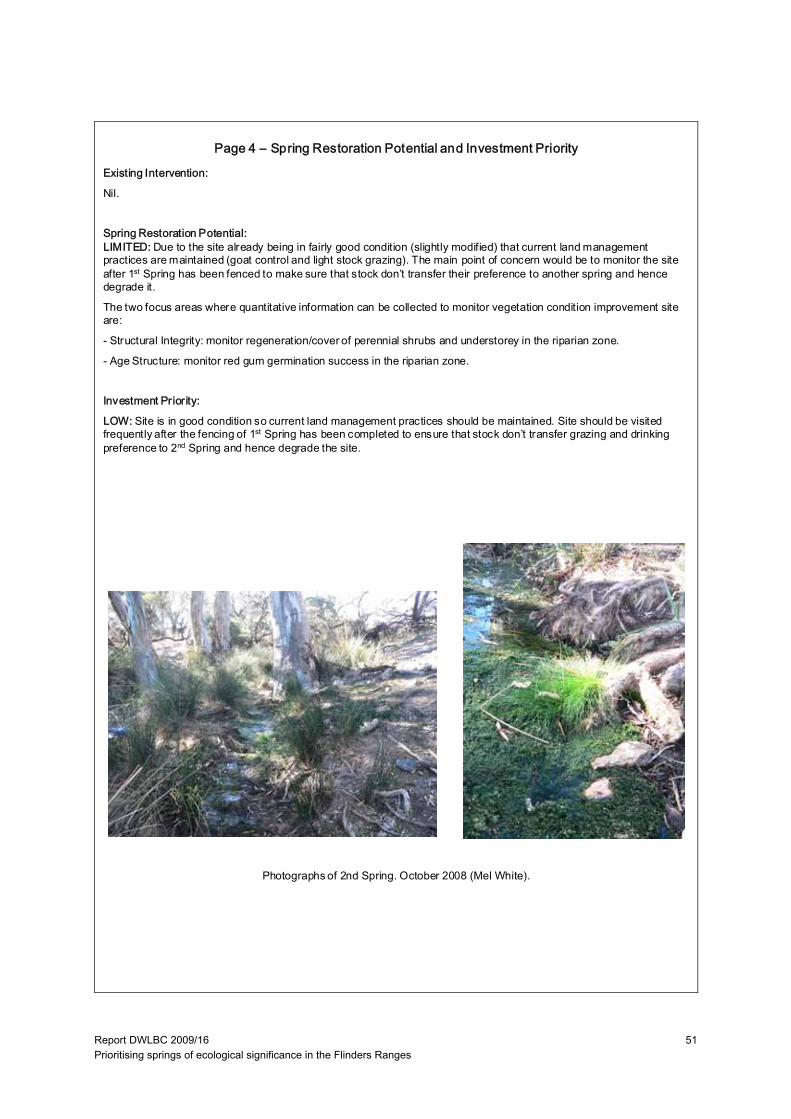
Report DWLBC 2009/16 Prioritising springs of ecological significance in the Flinders Ranges
51
Existing Intervention:
Nil.
Spring Restoration Potential:LIMITED: Due to the site already being in fairly good condition (slightly modified) that current land management practices are maintained (goat control and light stock grazing). The main point of concern would be to monitor the site after 1st Spring has been fenced to make sure that stock don’t transfer their preference to another spring and hence degrade it.
The two focus areas where quantitative information can be collected to monitor vegetation condition improvement site are:
- Structural Integrity: monitor regeneration/cover of perennial shrubs and understorey in the riparian zone.
- Age Structure: monitor red gum germination success in the riparian zone.
Investment Priority:
LOW: Site is in good condition so current land management practices should be maintained. Site should be visited frequently after the fencing of 1st Spring has been completed to ensure that stock don’t transfer grazing and drinking preference to 2nd Spring and hence degrade the site.
Photographs of 2nd Spring. October 2008 (Mel White).
Page 4 – Spring Restoration Potential and Investment Priority
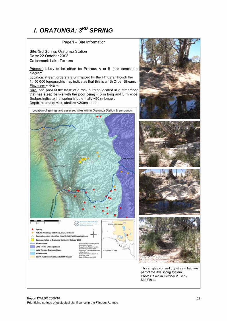
Report DWLBC 2009/16 Prioritising springs of ecological significance in the Flinders Ranges
52
I. ORATUNGA: 3RD SPRING
Page 1 – Site Information
Site: 3rd Spring, Oratunga StationDate: 22 October 2008Catchment: Lake Torrens
Process: Likely to be either be Process A or B (see conceptualdiagram).Location: stream orders are unmapped for the Flinders, though the1 : 50 000 topographic map indicates that this is a 4th Order Stream.Elevation: ~ 440 m.Size: one pool at the base of a rock outcrop located in a streambedthat has steep banks with the pool being ~ 3 m long and 5 m wide.Sedges indicate that spring is potentially ~50 m longer.Depth: at time of visit, shallow <20cm depth.
This single pool and dry stream bed arepart of the 3rd Spring system.Photos taken in October 2008 byMel White.
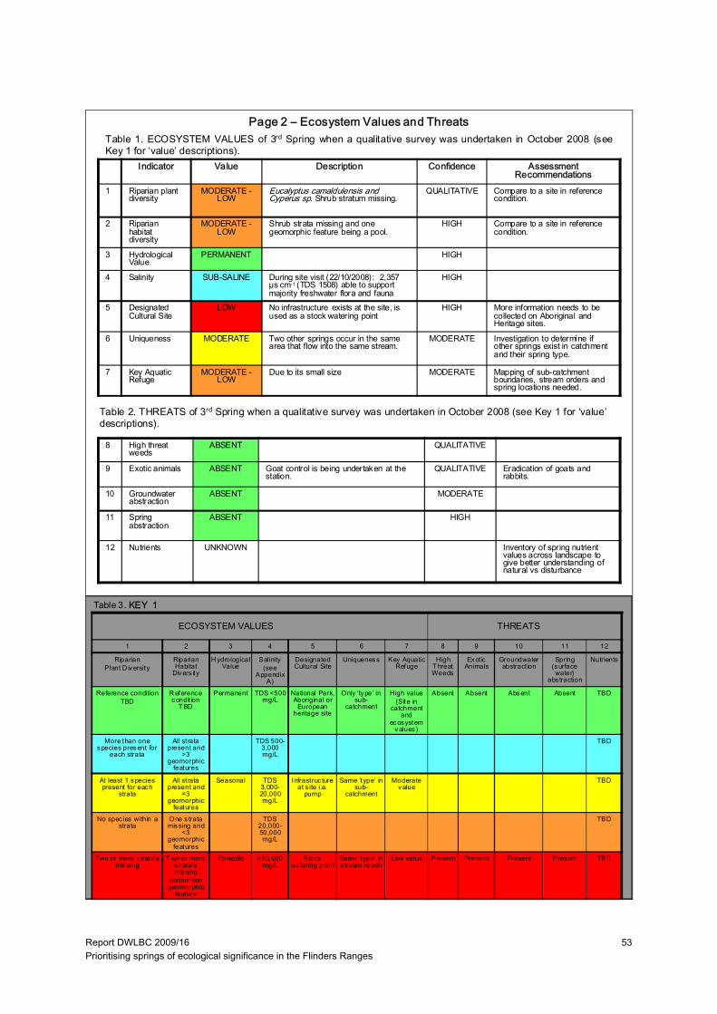
Report DWLBC 2009/16 Prioritising springs of ecological significance in the Flinders Ranges
53
Indicator Value Description Confidence Assessment Recommendations
1 Riparian plant diversity
MODERATE -LOW
Eucalyptus camaldulensis and Cyperus sp. Shrub stratum missing.
QUALITATIVE Compare to a site in reference condition.
2 Riparian habitat diversity
MODERATE -LOW
Shrub strata missing and one geomorphic feature being a pool.
HIGH Compare to a site in reference condition.
3 Hydrological Value
PERMANENT HIGH
4 Salinity SUB-SALINE During site visit (22/10/2008): 2,357 µs cm-1 (TDS 1508) able to support majority freshwater flora and fauna
HIGH
5 Designated Cultural Site
LOW No infrastructure exists at the site, is used as a stock watering point
HIGH More information needs to be collected on Aboriginal and Heritage sites.
6 Uniqueness MODERATE Two other springs occur in the same area that flow into the same stream.
MODERATE Investigation to determine if other springs exist in catchment and their spring type.
7 Key Aquatic Refuge
MODERATE -LOW
Due to its small size MODERATE Mapping of sub-catchment boundaries, stream orders and spring locations needed.
Table 1. ECOSYSTEM VALUES of 3rd Spring when a qualitative survey was undertaken in October 2008 (seeKey 1 for ‘value’ descriptions).
Table 2. THREATS of 3rd Spring when a qualitative survey was undertaken in October 2008 (see Key 1 for ‘value’descriptions).
ECOSYSTEM VALUES THREATS
8 High threat weeds
ABSENT QUALITATIVE
9 Exotic animals ABSENT Goat control is being undertaken at the station.
QUALITATIVE Eradication of goats and rabbits.
10 Groundwater abstraction
ABSENT MODERATE
11 Spring abstraction
ABSENT HIGH
12 Nutrients UNKNOWN Inventory of spring nutrient values across landscape to give better understanding of natural vs disturbance
Page 2 – Ecosystem Values and Threats
Table 3. KEY 1
1 2 3 4 5 6 7 8 9 10 11 12
RiparianPlant D iversity
Riparian Habitat
Divers ity
H ydrological Value
Salinity (see
Appendix A)
Designated Cultural Site
Uniqueness Key Aquatic Refuge
High T hreat Weeds
Exot ic Animals
Groundwater abstract ion
Spring (surface water)
abs traction
Nutrients
Reference conditionTBD
R eference condit ion
T BD
Permanent TDS <500 mg/L
National Park, Aboriginal or
European heritage site
Only ‘type’ in sub-
catchment
High value(Site in
catchment and
ecosystem values)
Absent Absent Absent Absent TBD
More than one species present for
each strata
All strata present and
>3 geomorphic
features
TDS 500-3,000 mg/L
TBD
At least 1 species present for each
strata
All strata present and
=3 geomorphic
features
Seasonal TDS 3,000-20,000 mg/L
Infrastruc ture at s ite i.e.
pump
Same ‘type’ in sub-
catchment
Moderate value
TBD
No spec ies within a strata
One s trata missing and
<3 geomorphic
features
TDS 20,000-50,000 mg/L
TBD
Two or more s trata’s missing
T wo or more s trata’s missing
and/or one geomorphic
feature
Episodic >50,000 mg/L
Stock watering point
Same ‘type’ in s tream reach
Low value Present Present Present Present TBD

Report DWLBC 2009/16 Prioritising springs of ecological significance in the Flinders Ranges
54
Indicator Value Description Confidence Management Recommendations
1 Spatial Integrity LARGELY UNMODIFIED
There was no break in longitudinal continuity of river red gums.
QUALITATIVE
2 Nativeness LARGELY UNMODIFIED
Wards weed and Onion weed were recorded at the site.
QUALITATIVE
3 Structural Integrity SLIGHTLY MODIFIED
In the riparian zone, shrub-cover and groundcover are fairly intact with no evidence of severe grazing.
QUALITATIVE Reduce grazing at spring.
4 Age Structure MODERATELY MODIFIED
Some reduced canopy cover of red gums but not severe, only adult trees present.
QUALITATIVE Reduce grazing so regeneration survival is increased.
5 Debris SLIGHTLY MODIFIED
There is probably reduced debris cover due to stock trampling
QUALITATIVE Reference condition needs to be determined
LARGELY UNMODIFIED
SLIGHTLY MODIF IED
MODERAT ELY MODIFIED
SUBSTANTIALLY MODIFIED
SEVERELY MODIFIED
SPATIAL INT EGRITY
No or lit tle evidence of broad scale loss of nat ive vegetation
Width reduced by up to 1/3 and/or some breaks in continuity
About 50% of the nat ive vegetation remains , either in strips or patches
Only small patches of well-separated native vegetation remains
Lit tle or no remaining native vegetation
NATIVENESS(perennials)
Vegetat ion predominately native, few weeds and no 'high threat' species.
Exotic spec ies present but not dominating any strata, 'high threat ' species rare
One or more strata dominated by exot ic species , 'high threat' species present
Most strata dominated by exotic species, 'high threat ' species abundant
Few native spec ies remaining, cover dominated by exotic spec ies
STRUCTURAL INT EGRITY
Number of strata and cover within each strata is similar to reference
Cover within one stratum 50% lower or higher than reference
One s tratum missing or extra cover within remaining stratum 50% lower or higher than reference
More than one s tratum completely altered from reference (lost or <10% remaining)
Struc ture completely altered from reference (eg. grass land shrubland, fores t pasture)
AGE ST RUCTURE Dominant strata with reference level of cover and at least three age classes present (juvenile, sub-adults and adults)
Reduced cover (75-50%) of dominant strata, and/or only two age classes present
Reduced cover (75-50%) of dominant strata, and only one age class present
Reduced cover (<50%) of dominant s trata, and only one age class present
Dominant strata mos tly absent
DEBRIS Quantities and cover similar to reference
Some evidence of unnatural loss of debris (eg. f irewood collection, trampling of leaf litter by s tock)
Quant ities and/or cover 50% higher or lower than reference
Very small quant it ies of debris present
Debris mostly absent or completely dominating the sites, with lit tle or no liv ing vegetation
Table 4. VEGETATION CONDITION of 3rd Spring when a qualitative survey was undertaken in October 2008 (see Key2 for description of the ‘indicators’ and Table 5 for the attributes used to assess vegetation condition).
Page 3 – Spring Condition
Table 5. Attributes used to assess vegetation condition from the Indicator Protocol: Riverine Vegetation, National RiverHealth Contact Group (Roberts et al. 2009).
KEY 2: Vegetation Condition Sub-Indices Attributes:
13. Spatial Integrity: Width of riparian vegetation (as defined by inundation dependent species). Longitudinal continuity continuous cover of dominant stratum along the channel. Connectedness of the riverine vegetation to other areas ofnative vegetation (riparian or terrestrial). Refer to spatial integrity row in Table 5 for assessment criteria.14. Nativeness: Percentage of non-native and high impact species. Abundance of non-native and high impact species in different strata. (This project will focus on perennials due to the arid system, annual cover is determined by rainfall which can coincide with site visits). Refer to nativeness row in Table 5 for assessment criteria.15. Structural Integrity: Number of strata and/or life forms. Cover for each stratum. Refer to structural integrity row in Table 5 for assessment criteria.16. Age Structure: Cover of canopy species. Presence (or abundance) of different age stages. Presence (orabundance) of large old trees. Refer to age structure row in Table 5 for assessment criteria.17. Debris: Abundance of fallen logs. Presence (or abundance) of standing dead trees. Percentage cover of litter. Referto debris row in Table 5 for assessment criteria.
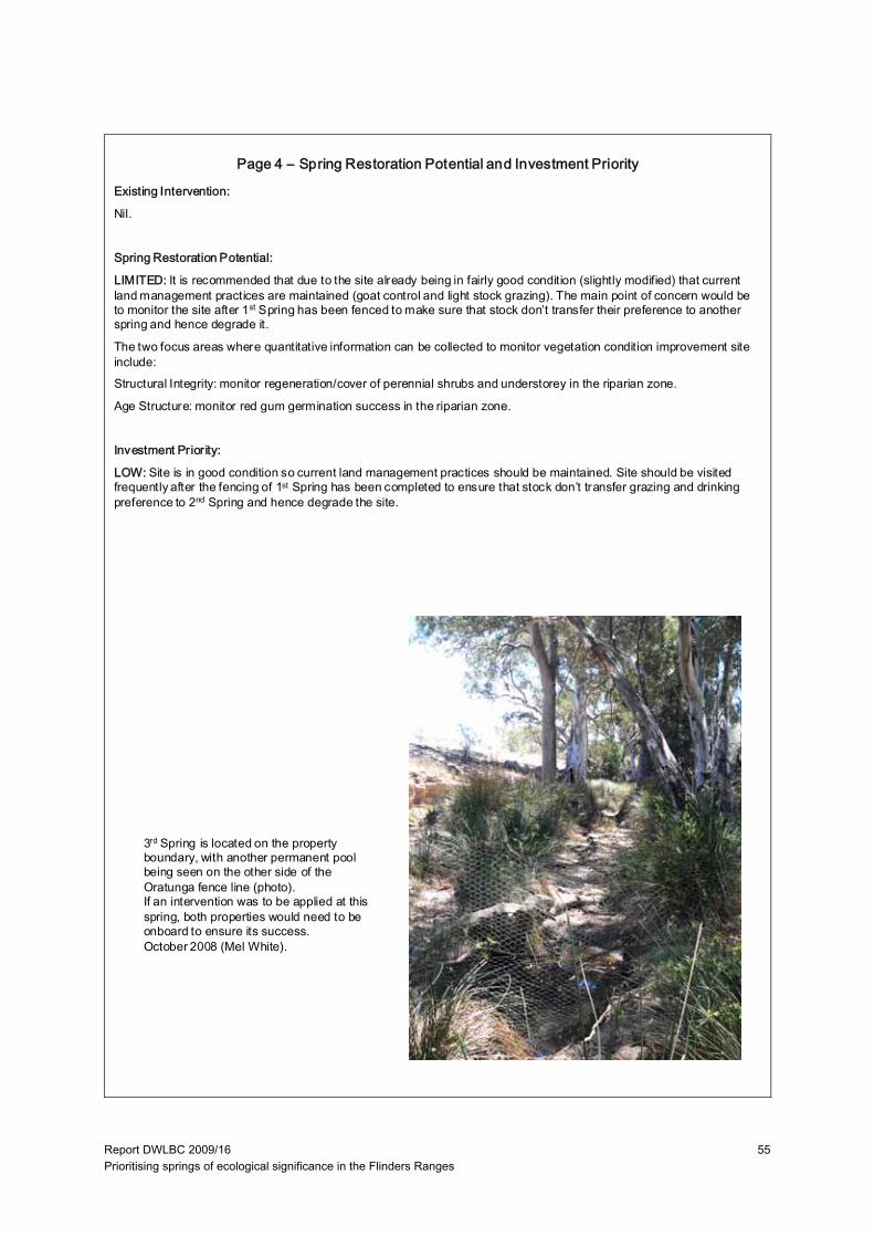
Report DWLBC 2009/16 Prioritising springs of ecological significance in the Flinders Ranges
55
Existing Intervention:
Nil.
Spring Restoration Potential:
LIMITED: It is recommended that due to the site already being in fairly good condition (slightly modified) that current land management practices are maintained (goat control and light stock grazing). The main point of concern would be to monitor the site after 1st Spring has been fenced to make sure that stock don’t transfer their preference to another spring and hence degrade it.
The two focus areas where quantitative information can be collected to monitor vegetation condition improvement site include:Structural Integrity: monitor regeneration/cover of perennial shrubs and understorey in the riparian zone.
Age Structure: monitor red gum germination success in the riparian zone.
Investment Priority:
LOW: Site is in good condition so current land management practices should be maintained. Site should be visited frequently after the fencing of 1st Spring has been completed to ensure that stock don’t transfer grazing and drinking preference to 2nd Spring and hence degrade the site.
3rd Spring is located on the property boundary, with another permanent pool being seen on the other side of the Oratunga fence line (photo). If an intervention was to be applied at this spring, both properties would need to be onboard to ensure its success.October 2008 (Mel White).
Page 4 – Spring Restoration Potential and Investment Priority
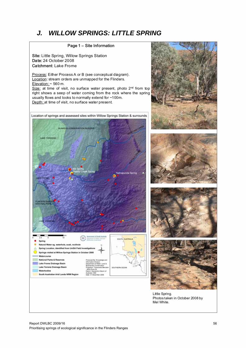
Report DWLBC 2009/16 Prioritising springs of ecological significance in the Flinders Ranges
56
J. WILLOW SPRINGS: LITTLE SPRING
Page 1 – Site Information
Site: Little Spring, Willow Springs StationDate: 24 October 2008Catchment: Lake Frome
Process: Either Process A or B (see conceptual diagram).Location: stream orders are unmapped for the Flinders.Elevation: ~ 560 m.Size: at time of visit, no surface water present, photo 2nd from topright shows a seep of water coming from the rock where the springusually flows and looks to normally extend for ~100m.Depth: at time of visit, no surface water present.
Little Spring.Photos taken in October 2008 byMel White.
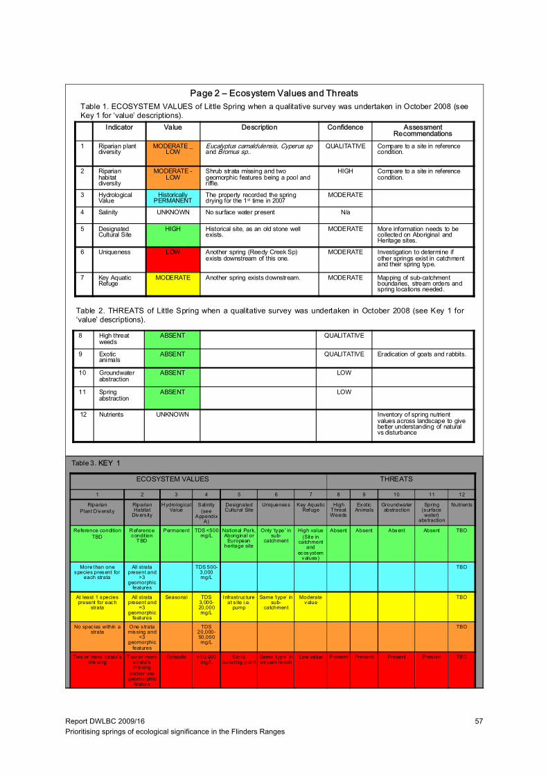
Report DWLBC 2009/16 Prioritising springs of ecological significance in the Flinders Ranges
57
Indicator Value Description Confidence Assessment Recommendations
1 Riparian plant diversity
MODERATE _ LOW
Eucalyptus camaldulensis, Cyperus sp and Bromus sp..
QUALITATIVE Compare to a site in reference condition.
2 Riparian habitat diversity
MODERATE -LOW
Shrub strata missing and two geomorphic features being a pool and riffle.
HIGH Compare to a site in reference condition.
3 Hydrological Value
Historically PERMANENT
The property recorded the spring drying for the 1st time in 2007
MODERATE
4 Salinity UNKNOWN No surface water present N/a
5 Designated Cultural Site
HIGH Historical site, as an old stone well exists.
MODERATE More information needs to be collected on Aboriginal and Heritage sites.
6 Uniqueness LOW Another spring (Reedy Creek Sp) exists downstream of this one.
MODERATE Investigation to determine if other springs exist in catchment and their spring type.
7 Key Aquatic Refuge
MODERATE Another spring exists downstream. MODERATE Mapping of sub-catchment boundaries, stream orders and spring locations needed.
Table 1. ECOSYSTEM VALUES of Little Spring when a qualitative survey was undertaken in October 2008 (seeKey 1 for ‘value’ descriptions).
Table 2. THREATS of Little Spring when a qualitative survey was undertaken in October 2008 (see Key 1 for‘value’ descriptions).
ECOSYSTEM VALUES THREATS
8 High threat weeds
ABSENT QUALITATIVE
9 Exotic animals
ABSENT QUALITATIVE Eradication of goats and rabbits.
10 Groundwater abstraction
ABSENT LOW
11 Spring abstraction
ABSENT LOW
12 Nutrients UNKNOWN Inventory of spring nutrient values across landscape to give better understanding of natural vs disturbance
Page 2 – Ecosystem Values and Threats
Table 3. KEY 1
1 2 3 4 5 6 7 8 9 10 11 12
RiparianPlant D iversity
Riparian Habitat
Divers ity
H ydrological Value
Salinity (see
Appendix A)
Designated Cultural Site
Uniqueness Key Aquatic Refuge
High T hreat Weeds
Exot ic Animals
Groundwater abstract ion
Spring (surface water)
abs traction
Nutrients
Reference conditionTBD
R eference condit ion
T BD
Permanent TDS <500 mg/L
National Park, Aboriginal or
European heritage site
Only ‘type’ in sub-
catchment
High value(Site in
catchment and
ecosystem values)
Absent Absent Absent Absent TBD
More than one species present for
each strata
All strata present and
>3 geomorphic
features
TDS 500-3,000 mg/L
TBD
At least 1 species present for each
strata
All strata present and
=3 geomorphic
features
Seasonal TDS 3,000-20,000 mg/L
Infrastruc ture at s ite i.e.
pump
Same ‘type’ in sub-
catchment
Moderate value
TBD
No spec ies within a strata
One s trata missing and
<3 geomorphic
features
TDS 20,000-50,000 mg/L
TBD
Two or more s trata’s missing
T wo or more s trata’s missing
and/or one geomorphic
feature
Episodic >50,000 mg/L
Stock watering point
Same ‘type’ in s tream reach
Low value Present Present Present Present TBD

Report DWLBC 2009/16 Prioritising springs of ecological significance in the Flinders Ranges
58
Indicator Value Description Confidence Management Recommendations
13 Spatial Integrity LARGELY UNMODIFIED
There was no break in longitudinal continuity of river red gums.
QUALITATIVE
14 Nativeness LARGELY UNMODIFIED
Onion weed was recorded at the site. QUALITATIVE
15 Structural Integrity MODERATELY MODIFIED
In the riparian zone, the shrub-cover is absent and the groundcover is greatly reduced due to long-tern grazing at the site.
QUALITATIVE Reduce grazing at spring.
16 Age Structure MODERATELY MODIFIED
Some reduced canopy cover of red gums but not severe, only adult trees present.
QUALITATIVE Reduce grazing so regeneration survival is increased.
17 Debris SLIGHTLY MODIFIED
There is probably reduced debris cover due to stock trampling
QUALITATIVE Reference condition needs to be determined
LARGELY UNMODIFIED
SLIGHTLY MODIF IED
MODERAT ELY MODIFIED
SUBSTANTIALLY MODIFIED
SEVERELY MODIFIED
SPATIAL INT EGRITY
No or lit tle evidence of broad scale loss of nat ive vegetation
Width reduced by up to 1/3 and/or some breaks in continuity
About 50% of the nat ive vegetation remains , either in strips or patches
Only small patches of well-separated native vegetation remains
Lit tle or no remaining native vegetation
NATIVENESS Vegetat ion predominately native, few weeds and no 'high threat' species.
Exotic spec ies present but not dominating any strata, 'high threat ' species rare
One or more strata dominated by exot ic species , 'high threat' species present
Most strata dominated by exotic species, 'high threat ' species abundant
Few native spec ies remaining, cover dominated by exotic spec ies
STRUCTURAL INT EGRITY
Number of strata and cover within each strata is similar to reference
Cover within one stratum 50% lower or higher than reference
One s tratum missing or extra cover within remaining stratum 50% lower or higher than reference
More than one s tratum completely altered from reference (lost or <10% remaining)
Struc ture completely altered from reference (eg. grass land shrubland, fores t pasture)
AGE ST RUCTURE Dominant strata with reference level of cover and at least three age classes present (juvenile, sub-adults and adults)
Reduced cover (75-50%) of dominant strata, and/or only two age classes present
Reduced cover (75-50%) of dominant strata, and only one age class present
Reduced cover (<50%) of dominant s trata, and only one age class present
Dominant strata mos tly absent
DEBRIS Quantities and cover similar to reference
Some evidence of unnatural loss of debris (eg. f irewood collection, trampling of leaf litter by s tock)
Quant ities and/or cover 50% higher or lower than reference
Very small quant it ies of debris present
Debris mostly absent or completely dominating the sites, with lit tle or no liv ing vegetation
Table 4. VEGETATION CONDITION of Little Spring when a qualitative survey was undertaken in October 2008 (seeKey 2 for description of the ‘indicators’ and Table 5 for the attributes used to assess vegetation condition).
Page 3 – Spring Condition
Table 5. Attributes used to assess vegetation condition from the Indicator Protocol: Riverine Vegetation, National RiverHealth Contact Group (Roberts et al. 2009).
KEY 2: Vegetation Condition Sub-Indices Attributes:
13. Spatial Integrity: Width of riparian vegetation (as defined by inundation dependent species). Longitudinal continuity continuous cover of dominant stratum along the channel. Connectedness of the riverine vegetation to other areas ofnative vegetation (riparian or terrestrial). Refer to spatial integrity row in Table 5 for assessment criteria.14. Nativeness: Percentage of non-native and high impact species. Abundance of non-native and high impact species in different strata. (This project will focus on perennials due to the arid system, annual cover is determined by rainfall which can coincide with site visits). Refer to nativeness row in Table 5 for assessment criteria.15. Structural Integrity: Number of strata and/or life forms. Cover for each stratum. Refer to structural integrity row in Table 5 for assessment criteria.16. Age Structure: Cover of canopy species. Presence (or abundance) of different age stages. Presence (orabundance) of large old trees. Refer to age structure row in Table 5 for assessment criteria.17. Debris: Abundance of fallen logs. Presence (or abundance) of standing dead trees. Percentage cover of litter. Referto debris row in Table 5 for assessment criteria.
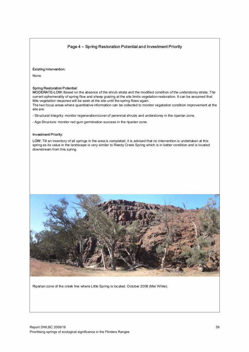
Report DWLBC 2009/16 Prioritising springs of ecological significance in the Flinders Ranges
59
Existing Intervention:
None.
Spring Restoration Potential:MODERATE-LOW: Based on the absence of the shrub strata and the modified condition of the understorey strata. The current ephemerality of spring flow and sheep grazing at the site limits vegetation restoration. It can be assumed that little vegetation response will be seen at the site until the spring flows again.The two focus areas where quantitative information can be collected to monitor vegetation condition improvement at the site are:
- Structural Integrity: monitor regeneration/cover of perennial shrubs and understorey in the riparian zone.
- Age Structure: monitor red gum germination success in the riparian zone.
Investment Priority:
LOW: Till an inventory of all springs in the area is completed, it is advised that no intervention is undertaken at this spring as its value in the landscape is very similar to Reedy Creek Spring which is in better condition and is located downstream from this spring.
Riparian zone of the creek line where Little Spring is located. October 2008 (Mel White).
Page 4 – Spring Restoration Potential and Investment Priority
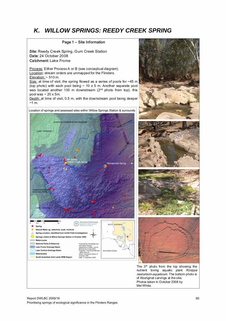
Report DWLBC 2009/16 Prioritising springs of ecological significance in the Flinders Ranges
60
K. WILLOW SPRINGS: REEDY CREEK SPRING
Page 1 – Site Information
Site: Reedy Creek Spring, Gum Creek StationDate: 24 October 2008Catchment: Lake Frome
Process: Either Process A or B (see conceptual diagram).Location: stream orders are unmapped for the Flinders.Elevation: ~ 510 m.Size: at time of visit, the spring flowed as a series of pools for ~45 m(top photo) with each pool being ~ 10 x 5 m. Another separate poolwas located another 100 m downstream (2nd photo from top), thispool was ~ 20 x 5m.Depth: at time of visit, 0.5 m, with the downstream pool being deeper~1 m.
The 3rd photo from the top showing thenutrient loving aquatic plant Rorippanasturtium-aquaticum. The bottom photo isof Aboriginal carvings at the site.Photos taken in October 2008 byMel White.
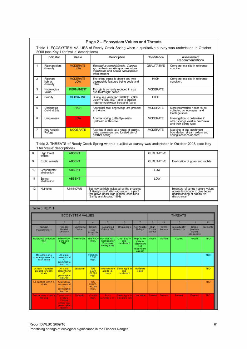
Report DWLBC 2009/16 Prioritising springs of ecological significance in the Flinders Ranges
61
Indicator Value Description Confidence Assessment Recommendations
1 Riparian plant diversity
MODERATE-LOW
Eucalyptus camaldulensis, Cyperus sp., Isolepis sp. Rorippa nasturtium-aquaticum and Cotula coronopifolia were present.
QUALITATIVE Compare to a site in reference condition.
2 Riparian habitat diversity
MODERATE-LOW
The shrub strata is absent and two geomorphic features being pools and riffles.
HIGH Compare to a site in reference condition.
3 Hydrological Value
PERMANENT Though is currently reduced in size due to drought period.
MODERATE
4 Salinity SUBSALINE During site visit (24/10/2008): 2,386 µs cm-1 (TDS 1527) able to support majority freshwater flora and fauna
HIGH
5 Designated Cultural Site
HIGH Aboriginal rock engravings are present at the site.
MODERATE More information needs to be collected on Aboriginal and Heritage sites.
6 Uniqueness LOW Another spring (Little Sp) exists upstream of this one.
MODERATE Investigation to determine if other springs exist in catchment and their spring type.
7 Key Aquatic Refuge
MODERATE A series of pools at a range of depths, being permanent and located d/s of another spring.
MODERATE Mapping of sub-catchment boundaries, stream orders and spring locations needed.
Table 1. ECOSYSTEM VALUES of Reedy Creek Spring when a qualitative survey was undertaken in October2008 (see Key 1 for ‘value’ descriptions).
Table 2. THREATS of Reedy Creek Spring when a qualitative survey was undertaken in October 2008, (see Key1 for ‘value’ descriptions).
ECOSYSTEM VALUES THREATS
8 High threat weeds
ABSENT QUALITATIVE
9 Exotic animals ABSENT QUALITATIVE Eradication of goats and rabbits.
10 Groundwater abstraction
ABSENT LOW
11 Spring abstraction
ABSENT LOW
12 Nutrients UNKNOWN But may be high indicated by the presence of Rorippa nasturtium-aquaticum, a plant that grows under high nutrient conditions (Sainty and Jacobs, 1994)
Inventory of spring nutrient values across landscape to give better understanding of natural vs disturbance
Page 2 – Ecosystem Values and Threats
Table 3. KEY 1
1 2 3 4 5 6 7 8 9 10 11 12
RiparianPlant D iversity
Riparian Habitat
Divers ity
H ydrological Value
Salinity (see
Appendix A)
Designated Cultural Site
Uniqueness Key Aquatic Refuge
High T hreat Weeds
Exot ic Animals
Groundwater abstract ion
Spring (surface water)
abs traction
Nutrients
Reference conditionTBD
R eference condit ion
T BD
Permanent TDS <500 mg/L
National Park, Aboriginal or
European heritage site
Only ‘type’ in sub-
catchment
High value(Site in
catchment and
ecosystem values)
Absent Absent Absent Absent TBD
More than one species present for
each strata
All strata present and
>3 geomorphic
features
TDS 500-3,000 mg/L
TBD
At least 1 species present for each
strata
All strata present and
=3 geomorphic
features
Seasonal TDS 3,000-20,000 mg/L
Infrastruc ture at s ite i.e.
pump
Same ‘type’ in sub-
catchment
Moderate value
TBD
No spec ies within a strata
One s trata missing and
<3 geomorphic
features
TDS 20,000-50,000 mg/L
TBD
Two or more s trata’s missing
T wo or more s trata’s missing
and/or one geomorphic
feature
Episodic >50,000 mg/L
Stock watering point
Same ‘type’ in s tream reach
Low value Present Present Present Present TBD

Report DWLBC 2009/16 Prioritising springs of ecological significance in the Flinders Ranges
62
Indicator Value Description Confidence Management Recommendations
13 Spatial Integrity LARGELY UNMODIFIED
There was no break in longitudinal continuity of river red gums.
QUALITATIVE
14 Nativeness LARGELY UNMODIFIED
Wards weed was recorded at the site. QUALITATIVE
15 Structural Integrity MODERATELY MODIFIED
In the riparian zone, the shrub strata is absent and groundcover strata is reduced due to long-tern grazing at the site.
QUALITATIVE Reduce grazing at spring.
15 Age Structure SLIGHTLY MODIFIED
Some reduced canopy cover of red gums but not severe, trees >10m tall trees present.
QUALITATIVE Reduce grazing so regeneration survival is increased.
17 Debris SLIGHTLY MODIFIED
There is probably reduced debris cover due to stock trampling
QUALITATIVE Reference condition needs to be determined
LARGELY UNMODIFIED
SLIGHTLY MODIF IED
MODERAT ELY MODIFIED
SUBSTANTIALLY MODIFIED
SEVERELY MODIFIED
SPATIAL INT EGRITY
No or lit tle evidence of broad scale loss of nat ive vegetation
Width reduced by up to 1/3 and/or some breaks in continuity
About 50% of the nat ive vegetation remains , either in strips or patches
Only small patches of well-separated native vegetation remains
Lit tle or no remaining native vegetation
NATIVENESS Vegetat ion predominately native, few weeds and no 'high threat' species.
Exotic spec ies present but not dominating any strata, 'high threat ' species rare
One or more strata dominated by exot ic species , 'high threat' species present
Most strata dominated by exotic species, 'high threat ' species abundant
Few native spec ies remaining, cover dominated by exotic spec ies
STRUCTURAL INT EGRITY
Number of strata and cover within each strata is similar to reference
Cover within one stratum 50% lower or higher than reference
One s tratum missing or extra cover within remaining stratum 50% lower or higher than reference
More than one s tratum completely altered from reference (lost or <10% remaining)
Struc ture completely altered from reference (eg. grass land shrubland, fores t pasture)
AGE ST RUCTURE Dominant strata with reference level of cover and at least three age classes present (juvenile, sub-adults and adults)
Reduced cover (75-50%) of dominant strata, and/or only two age classes present
Reduced cover (75-50%) of dominant strata, and only one age class present
Reduced cover (<50%) of dominant s trata, and only one age class present
Dominant strata mos tly absent
DEBRIS Quantities and cover similar to reference
Some evidence of unnatural loss of debris (eg. f irewood collection, trampling of leaf litter by s tock)
Quant ities and/or cover 50% higher or lower than reference
Very small quant it ies of debris present
Debris mostly absent or completely dominating the sites, with lit tle or no liv ing vegetation
Table 4. VEGETATION CONDITION of Reedy Creek Spring when a qualitative survey was undertaken in October2008 (see Key 2 for description of the ‘indicators’ and Table 5 for the attributes used to assess vegetation condition).
Page 3 – Spring Condition
Table 5. Attributes used to assess vegetation condition from the Indicator Protocol: Riverine Vegetation, National RiverHealth Contact Group (Roberts et al. 2009).
KEY 2: Vegetation Condition Sub-Indices Attributes:
13. Spatial Integrity: Width of riparian vegetation (as defined by inundation dependent species). Longitudinal continuity continuous cover of dominant stratum along the channel. Connectedness of the riverine vegetation to other areas ofnative vegetation (riparian or terrestrial). Refer to spatial integrity row in Table 5 for assessment criteria.14. Nativeness: Percentage of non-native and high impact species. Abundance of non-native and high impact species in different strata. (This project will focus on perennials due to the arid system, annual cover is determined by rainfall which can coincide with site visits). Refer to nativeness row in Table 5 for assessment criteria.15. Structural Integrity: Number of strata and/or life forms. Cover for each stratum. Refer to structural integrity row in Table 5 for assessment criteria.16. Age Structure: Cover of canopy species. Presence (or abundance) of different age stages. Presence (orabundance) of large old trees. Refer to age structure row in Table 5 for assessment criteria.17. Debris: Abundance of fallen logs. Presence (or abundance) of standing dead trees. Percentage cover of litter. Referto debris row in Table 5 for assessment criteria.
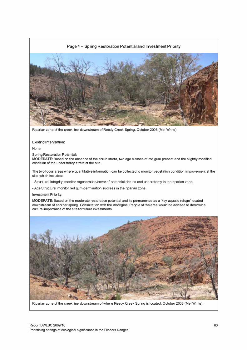
Report DWLBC 2009/16 Prioritising springs of ecological significance in the Flinders Ranges
63
Existing Intervention:
None.Spring Restoration Potential:MODERATE:Based on the absence of the shrub strata, two age classes of red gum present and the slightly modified condition of the understorey strata at the site.
The two focus areas where quantitative information can be collected to monitor vegetation condition improvement at the site, which includes:- Structural Integrity: monitor regeneration/cover of perennial shrubs and understorey in the riparian zone.
- Age Structure: monitor red gum germination success in the riparian zone.
Investment Priority:MODERATE:Based on the moderate restoration potential and its permanence as a ‘key aquatic refuge’ located downstream of another spring. Consultation with the Aboriginal People of the area would be advised to determine cultural importance of the site for future investments.
Riparian zone of the creek line downstream of where Reedy Creek Spring is located. October 2008 (Mel White).
Riparian zone of the creek line downstream of Reedy Creek Spring. October 2008 (Mel White).
Page 4 – Spring Restoration Potential and Investment Priority
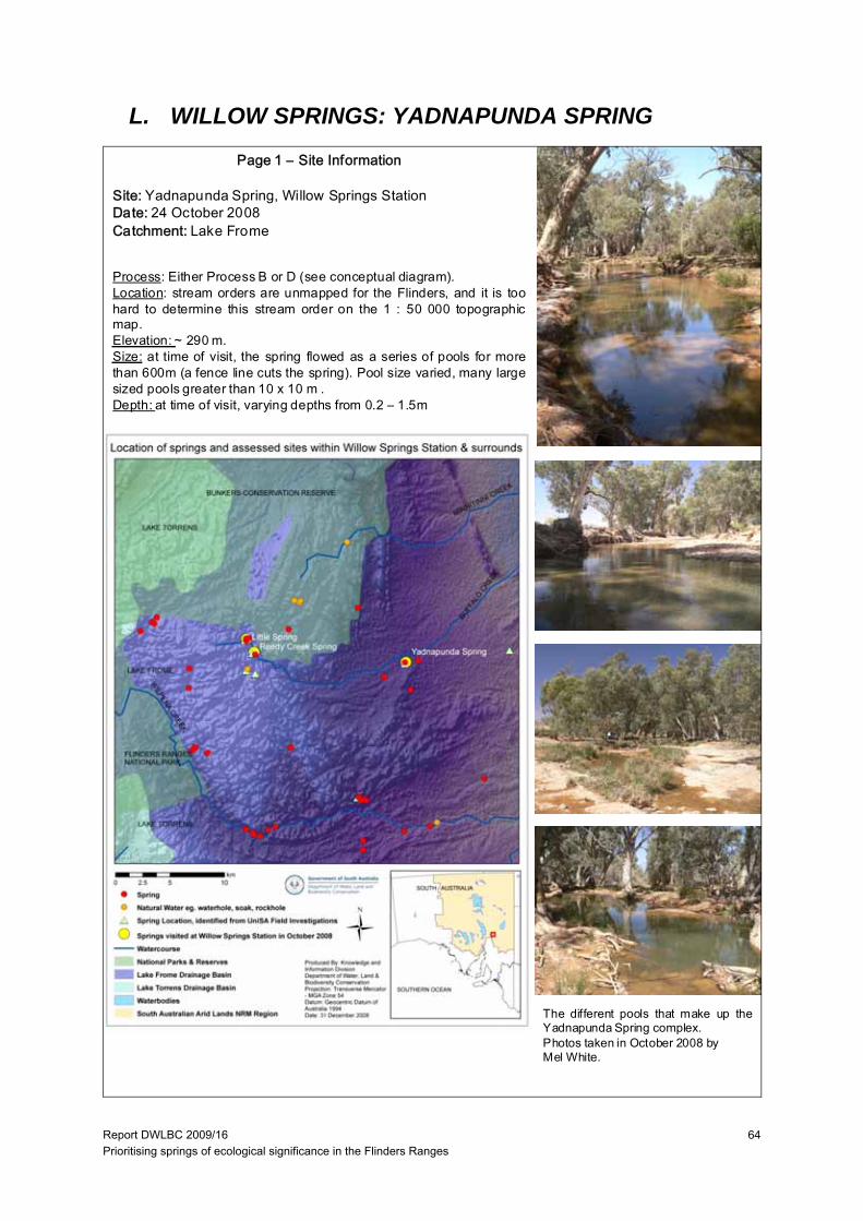
Report DWLBC 2009/16 Prioritising springs of ecological significance in the Flinders Ranges
64
L. WILLOW SPRINGS: YADNAPUNDA SPRING
Page 1 – Site Information
Site: Yadnapunda Spring, Willow Springs StationDate: 24 October 2008Catchment: Lake Frome
Process: Either Process B or D (see conceptual diagram).Location: stream orders are unmapped for the Flinders, and it is toohard to determine this stream order on the 1 : 50 000 topographicmap.Elevation: ~ 290 m.Size: at time of visit, the spring flowed as a series of pools for morethan 600m (a fence line cuts the spring). Pool size varied, many largesized pools greater than 10 x 10 m .Depth: at time of visit, varying depths from 0.2 – 1.5m
The different pools that make up theYadnapunda Spring complex.Photos taken in October 2008 byMel White.
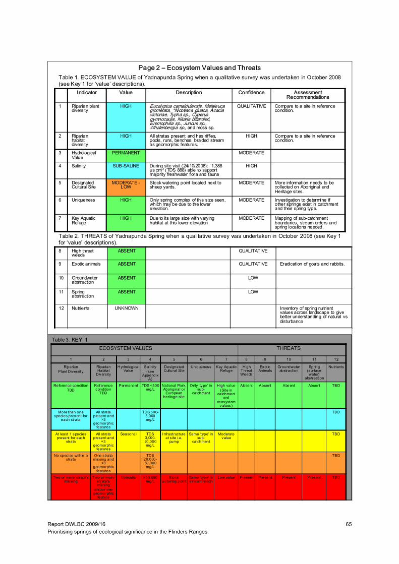
Report DWLBC 2009/16 Prioritising springs of ecological significance in the Flinders Ranges
65
Indicator Value Description Confidence Assessment Recommendations
1 Riparian plant diversity
HIGH Eucalyptus camaldulensis, Melaleuca glomerata, *Nicotiana gluaca, Acacia victoriae, Typha sp., Cyperus gymnocaulis, Nitaria billardieri, Eremophilia sp., Juncus sp., Whalenbergia sp., and moss sp.
QUALITATIVE Compare to a site in reference condition.
2 Riparian habitat diversity
HIGH All stratas present and has riffles, pools, runs, benches, braided stream as geomorphic features.
HIGH Compare to a site in reference condition.
3 Hydrological Value
PERMANENT MODERATE
4 Salinity SUB-SALINE During site visit (24/10/2008): 1,388 µs cm-1 (TDS 888) able to support majority freshwater flora and fauna
HIGH
5 Designated Cultural Site
MODERATE -LOW
Stock watering point located next to sheep yards.
MODERATE More information needs to be collected on Aboriginal and Heritage sites.
6 Uniqueness HIGH Only spring complex of this size seen, which may be due to the lower elevation.
MODERATE Investigation to determine if other springs exist in catchment and their spring type.
7 Key Aquatic Refuge
HIGH Due to its large size with varying habitat at this lower elevation
MODERATE Mapping of sub-catchment boundaries, stream orders and spring locations needed.
Table 1. ECOSYSTEM VALUE of Yadnapunda Spring when a qualitative survey was undertaken in October 2008(see Key 1 for ‘value’ descriptions).
Table 2. THREATS of Yadnapunda Spring when a qualitative survey was undertaken in October 2008 (see Key 1for ‘value’ descriptions).
ECOSYSTEM VALUES THREATS
8 High threat weeds
ABSENT QUALITATIVE
9 Exotic animals ABSENT QUALITATIVE Eradication of goats and rabbits.
10 Groundwater abstraction
ABSENT LOW
11 Spring abstraction
ABSENT LOW
12 Nutrients UNKNOWN Inventory of spring nutrient values across landscape to give better understanding of natural vs disturbance
Page 2 – Ecosystem Values and Threats
Table 3. KEY 1
1 2 3 4 5 6 7 8 9 10 11 12
RiparianPlant D iversity
Riparian Habitat
Divers ity
H ydrological Value
Salinity (see
Appendix A)
Designated Cultural Site
Uniqueness Key Aquatic Refuge
High T hreat Weeds
Exot ic Animals
Groundwater abstract ion
Spring (surface water)
abs traction
Nutrients
Reference conditionTBD
R eference condit ion
T BD
Permanent TDS <500 mg/L
National Park, Aboriginal or
European heritage site
Only ‘type’ in sub-
catchment
High value(Site in
catchment and
ecosystem values)
Absent Absent Absent Absent TBD
More than one species present for
each strata
All strata present and
>3 geomorphic
features
TDS 500-3,000 mg/L
TBD
At least 1 species present for each
strata
All strata present and
=3 geomorphic
features
Seasonal TDS 3,000-20,000 mg/L
Infrastruc ture at s ite i.e.
pump
Same ‘type’ in sub-
catchment
Moderate value
TBD
No spec ies within a strata
One s trata missing and
<3 geomorphic
features
TDS 20,000-50,000 mg/L
TBD
Two or more s trata’s missing
T wo or more s trata’s missing
and/or one geomorphic
feature
Episodic >50,000 mg/L
Stock watering point
Same ‘type’ in s tream reach
Low value Present Present Present Present TBD
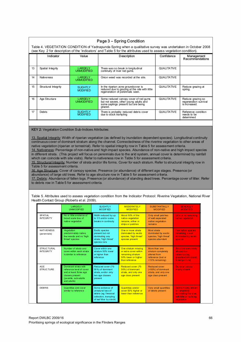
Report DWLBC 2009/16 Prioritising springs of ecological significance in the Flinders Ranges
66
Indicator Value Description Confidence Management Recommendations
13 Spatial Integrity LARGELY UNMODIFIED
There was no break in longitudinal continuity of river red gums.
QUALITATIVE
14 Nativeness LARGELY UNMODIFIED
Onion weed was recorded at the site. QUALITATIVE
15 Structural Integrity SLIGHTLY MODIFIED
In the riparian zone groundcover is reduced due to grazing at the site with little regeneration of perennials seen.
QUALITATIVE Reduce grazing at spring.
16 Age Structure LARGELY UNMODIFIED
Some reduced canopy cover of red gums but not severe, other young adults and some saplings present but are being grazed.
QUALITATIVE Reduce grazing so regeneration survival is increased.
17 Debris SLIGHTLY MODIFIED
There is probably reduced debris cover due to stock trampling
QUALITATIVE Reference condition needs to be determined
LARGELY UNMODIFIED
SLIGHTLY MODIF IED
MODERAT ELY MODIFIED
SUBSTANTIALLY MODIFIED
SEVERELY MODIFIED
SPATIAL INTEGRITY
No or lit tle evidence of broad scale loss of nat ive vegetation
Width reduced by up to 1/3 and/or some breaks in continuity
About 50% of the nat ive vegetation remains , either in strips or patches
Only small patches of well-separated native vegetation remains
Lit tle or no remaining native vegetation
NATIVENESS(perennials)
Vegetat ion predominately native, few weeds and no 'high threat' species.
Exotic spec ies present but not dominating any strata, 'high threat ' species rare
One or more strata dominated by exot ic species , 'high threat' species present
Most strata dominated by exotic species, 'high threat ' species abundant
Few native spec ies remaining, cover dominated by exotic spec ies
STRUC TURAL INTEGRITY
Number of strata and cover within each strata is similar to reference
Cover within one stratum 50% lower or higher than reference
One s tratum missing or extra cover within remaining stratum 50% lower or higher than reference
More than one s tratum completely altered from reference (lost or <10% remaining)
Struc ture completely altered from reference (eg. grass land shrubland, fores t pasture)
AGE STRUC TURE
Dominant strata with reference level of cover and at least three age classes present (juvenile, sub-adults and adults)
Reduced cover (75-50%) of dominant strata, and/or only two age classes present
Reduced cover (75-50%) of dominant strata, and only one age class present
Reduced cover (<50%) of dominant s trata, and only one age class present
Dominant strata mos tly absent
DEBRIS Quantities and cover similar to reference
Some evidence of unnatural loss of debris (eg. f irewood collection, trampling of leaf litter by s tock)
Quant ities and/or cover 50% higher or lower than reference
Very small quant it ies of debris present
Debris mostly absent or completely dominating the sites, with lit tle or no liv ing vegetation
Table 4. VEGETATION CONDITION of Yadnapunda Spring when a qualitative survey was undertaken in October 2008(see Key 2 for description of the ‘indicators’ and Table 5 for the attributes used to assess vegetation condition).
Page 3 – Spring Condition
Table 5. Attributes used to assess vegetation condition from the Indicator Protocol: Riverine Vegetation, National RiverHealth Contact Group (Roberts et al. 2009).
KEY 2: Vegetation Condition Sub-Indices Attributes:
13. Spatial Integrity: Width of riparian vegetation (as defined by inundation dependent species). Longitudinal continuity continuous cover of dominant stratum along the channel. Connectedness of the riverine vegetation to other areas ofnative vegetation (riparian or terrestrial). Refer to spatial integrity row in Table 5 for assessment criteria.14. Nativeness: Percentage of non-native and high impact species. Abundance of non-native and high impact species in different strata. (This project will focus on perennials due to the arid system, annual cover is determined by rainfall which can coincide with site visits). Refer to nativeness row in Table 5 for assessment criteria.15. Structural Integrity: Number of strata and/or life forms. Cover for each stratum. Refer to structural integrity row in Table 5 for assessment criteria.16. Age Structure: Cover of canopy species. Presence (or abundance) of different age stages. Presence (orabundance) of large old trees. Refer to age structure row in Table 5 for assessment criteria.17. Debris: Abundance of fallen logs. Presence (or abundance) of standing dead trees. Percentage cover of litter. Referto debris row in Table 5 for assessment criteria.

Report DWLBC 2009/16 Prioritising springs of ecological significance in the Flinders Ranges
67
Existing Intervention:
None existing, funding has recently been provided to fence by SAAL NRM BoardSpring Restoration Potential:HIGH:Grazing at the site currently impacts regeneration and cover of plants at the site though given diverse array of species present at the site suggests regeneration should happen more quickly than at other springs.
The two focus areas where quantitative information can be collected to monitor vegetation condition improvement at the site once fencing is completed are:- Structural Integrity: monitor regeneration/cover of perennial shrubs and understorey in the riparian zone.
- Age Structure: monitor red gum germination success in the riparian zone.
Investment Priority:HIGH:This spring has a high likelihood of being a key aquatic refuge that has a diverse array of spring habitats and riparian vegetation. It is recommended that for future assessments that a fish survey be undertaken at this site.
Yadnapunda Spring complex. October 2008 (Mel White).
Page 4 – Spring Restoration Potential and Investment Priority
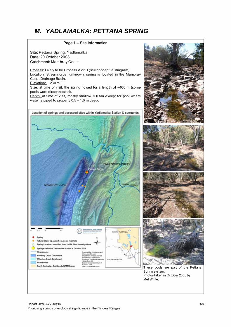
Report DWLBC 2009/16 Prioritising springs of ecological significance in the Flinders Ranges
68
M. YADLAMALKA: PETTANA SPRING
Page 1 – Site Information
Site: Pettana Spring, YadlamalkaDate: 20 October 2008Catchment: Mambray Coast
Process: Likely to be Process A or B (see conceptual diagram).Location: Stream order unknown, spring is located in the MambrayCoast Drainage Basin.Elevation: ~ 230 mSize: at time of visit, the spring flowed for a length of ~460 m (somepools were disconnected).Depth: at time of visit, mostly shallow < 0.5m except for pool wherewater is piped to property 0.5 – 1.0 m deep.
These pools are part of the PettanaSpring system.Photos taken in October 2008 byMel White.
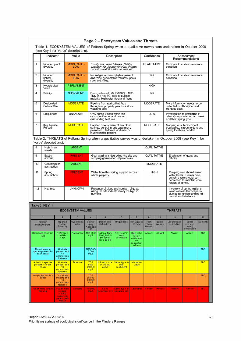
Report DWLBC 2009/16 Prioritising springs of ecological significance in the Flinders Ranges
69
Indicator Value Description Confidence Assessment Recommendations
1 Riparian plant diversity
MODERATE -LOW
Eucalyptus camaldulensis, Callitris glaucophylla, Acacia victoriae, Ptilotus obovatus and*Brassica tournefortii.
QUALITATIVE Compare to a site in reference condition.
2 Riparian habitat diversity
MODERATE -LOW
No sedges or marcophytes present and three geomprohic features, pools, runs and riffles.
HIGH Compare to a site in reference condition.
3 Hydrological Value
PERMANENT HIGH
4 Salinity SUB-SALINE During site visit (20/10/2008): 1098 TDS or 1716 EC. able to support majority freshwater flora and fauna
HIGH
5 Designated Cultural Site
MODERATE Pipeline from spring that feds throughout property plus its a stock watering point
MODERATE More information needs to be collected on Aboriginal and Heritage sites.
6 Uniqueness UNKNOWN Only spring visited within the catchment zone; and has no outstanding features
LOW Investigation to determine if other springs exist in catchment and their spring type.
7 Key Aquatic Refuge
MODERATE Located downstream of two other springs, central in sub-catchment, permanent, tadpoles and macro-invertebrates present.
MODERATE Mapping of sub-catchment boundaries, stream orders and spring locations needed.
Table 1. ECOSYSTEM VALUES of Pettana Spring when a qualitative survey was undertaken in October 2008(see Key 1 for ‘value’ descriptions).
Table 2. THREATS of Pettana Spring when a qualitative survey was undertaken in October 2008 (see Key 1 for‘value’ descriptions).
ECOSYSTEM VALUES THREATS
8 High threat weeds
ABSENT QUALITATIVE
9 Exotic animals
PRESENT Goat grazing is degrading the site and stopping germination of perennials.
QUALITATIVE Eradication of goats and rabbits.
10 Groundwater abstraction
ABSENT MODERATE
11 Spring abstraction
PRESENT Water from this spring is piped across whole property.
HIGH Pumping rate should mirror water levels. If levels drop, pumping rate should be decreased to maintain core habitat at spring.
12 Nutrients UNKNOWN Presence of algae and number of goats using the site indicate it may be high in nutrients
Inventory of spring nutrient values across landscape to give better understanding of natural vs disturbance
Page 2 – Ecosystem Values and Threats
Table 3. KEY 1
1 2 3 4 5 6 7 8 9 10 11 12
RiparianPlant D iversity
Riparian Habitat
Divers ity
H ydrological Value
Salinity (see
Appendix A)
Designated Cultural Site
Uniqueness Key Aquatic Refuge
High T hreat Weeds
Exot ic Animals
Groundwater abstract ion
Spring (surface water)
abs traction
Nutrients
Reference conditionTBD
R eference condit ion
T BD
Permanent TDS <500 mg/L
National Park, Aboriginal or
European heritage site
Only ‘type’ in sub-
catchment
High value(Site in
catchment and
ecosystem values)
Absent Absent Absent Absent TBD
More than one species present for
each strata
All strata present and
>3 geomorphic
features
TDS 500-3,000 mg/L
TBD
At least 1 species present for each
strata
All strata present and
=3 geomorphic
features
Seasonal TDS 3,000-20,000 mg/L
Infrastruc ture at s ite i.e.
pump
Same ‘type’ in sub-
catchment
Moderate value
TBD
No spec ies within a strata
One s trata missing and
<3 geomorphic
features
TDS 20,000-50,000 mg/L
TBD
Two or more s trata’s missing
T wo or more s trata’s missing
and/or one geomorphic
feature
Episodic >50,000 mg/L
Stock watering point
Same ‘type’ in s tream reach
Low value Present Present Present Present TBD
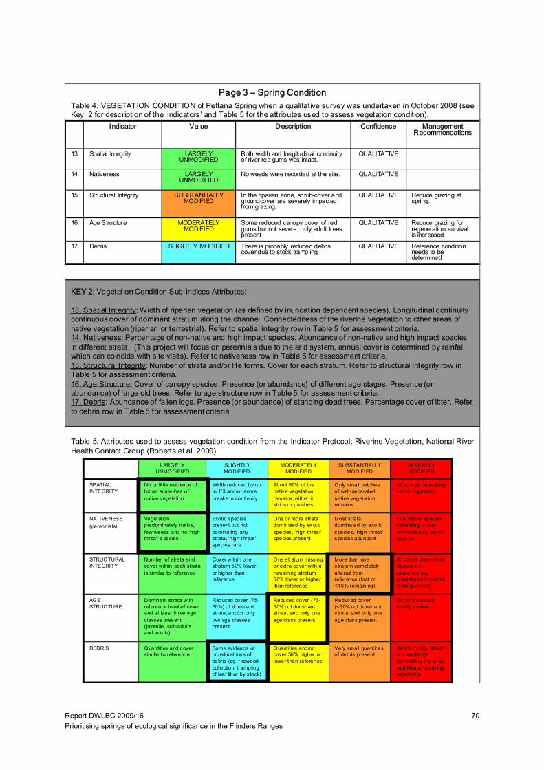
Report DWLBC 2009/16 Prioritising springs of ecological significance in the Flinders Ranges
70
Indicator Value Description Confidence Management Recommendations
13 Spatial Integrity LARGELY UNMODIFIED
Both width and longitudinal continuity of river red gums was intact.
QUALITATIVE
14 Nativeness LARGELY UNMODIFIED
No weeds were recorded at the site. QUALITATIVE
15 Structural Integrity SUBSTANTIALLY MODIFIED
In the riparian zone, shrub-cover and groundcover are severely impacted from grazing.
QUALITATIVE Reduce grazing at spring.
16 Age Structure MODERATELY MODIFIED
Some reduced canopy cover of red gums but not severe, only adult trees present
QUALITATIVE Reduce grazing for regeneration survival is increased.
17 Debris SLIGHTLY MODIFIED There is probably reduced debris cover due to stock trampling
QUALITATIVE Reference condition needs to be determined
LARGELY UNMODIFIED
SLIGHTLY MODIF IED
MODERAT ELY MODIFIED
SUBSTANTIALLY MODIFIED
SEVERELY MODIFIED
SPATIAL INTEGRITY
No or lit tle evidence of broad scale loss of nat ive vegetation
Width reduced by up to 1/3 and/or some breaks in continuity
About 50% of the nat ive vegetation remains , either in strips or patches
Only small patches of well-separated native vegetation remains
Lit tle or no remaining native vegetation
NATIVENESS(perennials)
Vegetat ion predominately native, few weeds and no 'high threat' species.
Exotic spec ies present but not dominating any strata, 'high threat ' species rare
One or more strata dominated by exot ic species , 'high threat' species present
Most strata dominated by exotic species, 'high threat ' species abundant
Few native spec ies remaining, cover dominated by exotic spec ies
STRUC TURAL INTEGRITY
Number of strata and cover within each strata is similar to reference
Cover within one stratum 50% lower or higher than reference
One s tratum missing or extra cover within remaining stratum 50% lower or higher than reference
More than one s tratum completely altered from reference (lost or <10% remaining)
Struc ture completely altered from reference (eg. grass land shrubland, fores t pasture)
AGE STRUC TURE
Dominant strata with reference level of cover and at least three age classes present (juvenile, sub-adults and adults)
Reduced cover (75-50%) of dominant strata, and/or only two age classes present
Reduced cover (75-50%) of dominant strata, and only one age class present
Reduced cover (<50%) of dominant s trata, and only one age class present
Dominant strata mos tly absent
DEBRIS Quantities and cover similar to reference
Some evidence of unnatural loss of debris (eg. f irewood collection, trampling of leaf litter by s tock)
Quant ities and/or cover 50% higher or lower than reference
Very small quant it ies of debris present
Debris mostly absent or completely dominating the sites, with lit tle or no liv ing vegetation
Table 4. VEGETATION CONDITION of Pettana Spring when a qualitative survey was undertaken in October 2008 (seeKey 2 for description of the ‘indicators’ and Table 5 for the attributes used to assess vegetation condition).
Page 3 – Spring Condition
Table 5. Attributes used to assess vegetation condition from the Indicator Protocol: Riverine Vegetation, National RiverHealth Contact Group (Roberts et al. 2009).
KEY 2: Vegetation Condition Sub-Indices Attributes:
13. Spatial Integrity: Width of riparian vegetation (as defined by inundation dependent species). Longitudinal continuity continuous cover of dominant stratum along the channel. Connectedness of the riverine vegetation to other areas ofnative vegetation (riparian or terrestrial). Refer to spatial integrity row in Table 5 for assessment criteria.14. Nativeness: Percentage of non-native and high impact species. Abundance of non-native and high impact species in different strata. (This project will focus on perennials due to the arid system, annual cover is determined by rainfall which can coincide with site visits). Refer to nativeness row in Table 5 for assessment criteria.15. Structural Integrity: Number of strata and/or life forms. Cover for each stratum. Refer to structural integrity row in Table 5 for assessment criteria.16. Age Structure: Cover of canopy species. Presence (or abundance) of different age stages. Presence (orabundance) of large old trees. Refer to age structure row in Table 5 for assessment criteria.17. Debris: Abundance of fallen logs. Presence (or abundance) of standing dead trees. Percentage cover of litter. Referto debris row in Table 5 for assessment criteria.
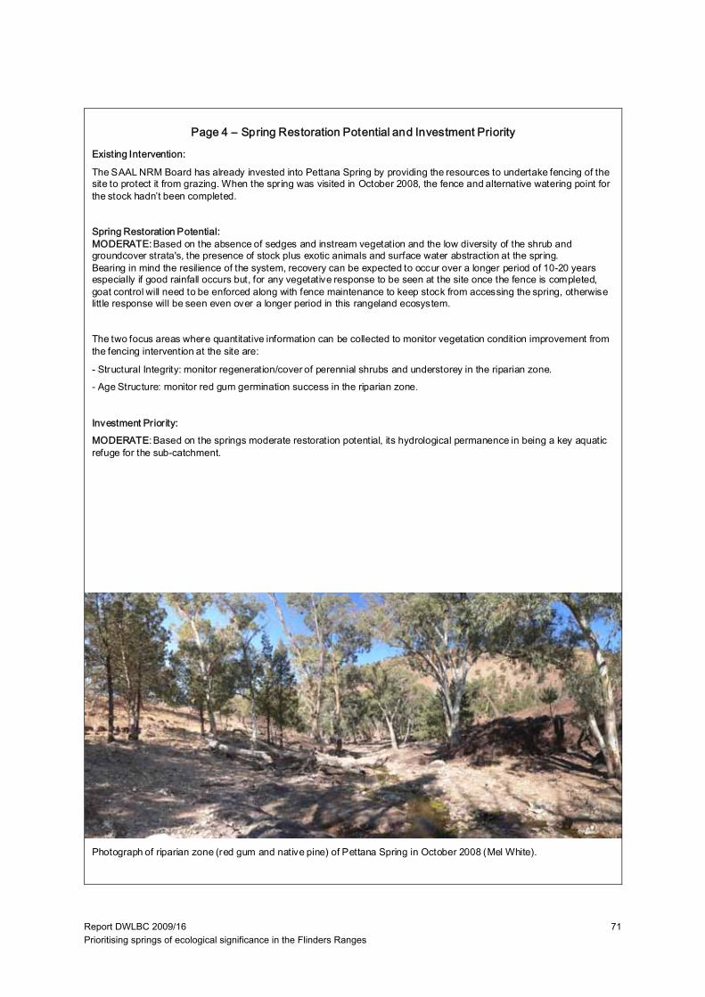
Report DWLBC 2009/16 Prioritising springs of ecological significance in the Flinders Ranges
71
Existing Intervention:
The SAAL NRM Board has already invested into Pettana Spring by providing the resources to undertake fencing of the site to protect it from grazing. When the spring was visited in October 2008, the fence and alternative watering point for the stock hadn’t been completed.
Spring Restoration Potential:MODERATE:Based on the absence of sedges and instream vegetation and the low diversity of the shrub and groundcover strata's, the presence of stock plus exotic animals and surface water abstraction at the spring. Bearing in mind the resilience of the system, recovery can be expected to occur over a longer period of 10-20 years especially if good rainfall occurs but, for any vegetative response to be seen at the site once the fence is completed, goat control will need to be enforced along with fence maintenance to keep stock from accessing the spring, otherwise little response will be seen even over a longer period in this rangeland ecosystem.
The two focus areas where quantitative information can be collected to monitor vegetation condition improvement from the fencing intervention at the site are:
- Structural Integrity: monitor regeneration/cover of perennial shrubs and understorey in the riparian zone. - Age Structure: monitor red gum germination success in the riparian zone.
Investment Priority:MODERATE: Based on the springs moderate restoration potential, its hydrological permanence in being a key aquatic refuge for the sub-catchment.
Photograph of riparian zone (red gum and native pine) of Pettana Spring in October 2008 (Mel White).
Page 4 – Spring Restoration Potential and Investment Priority

Report DWLBC 2009/16 Prioritising springs of ecological significance in the Flinders Ranges
72
Report DWLBC 2009/16 Prioritising springs of ecological significance in the Flinders Ranges
73
UNITS OF MEASUREMENT
Units of measurement commonly used (SI and non-SI Australian legal) Name of unit Symbol Definition in terms of other
metric units Quantity
day d 24 h time interval
gigalitre GL 106 m3 volume
gram g 10–3 kg mass
hectare ha 104 m2 area
hour h 60 min time interval
kilogram kg base unit mass
kilolitre kL 1 m3 volume
kilometre km 103 m length
litre L 10-3 m3 volume
megalitre ML 103 m3 volume
metre m base unit length
microgram μg 10-6 g mass
microlitre μL 10-9 m3 volume
milligram mg 10-3 g mass
millilitre mL 10-6 m3 volume
millimetre mm 10-3 m length
minute min 60 s time interval
second s base unit time interval
tonne t 1000 kg mass
year y 365 or 366 days time interval
Shortened forms
~ approximately equal to
EC electrical conductivity (µS/cm)
pH acidity

Report DWLBC 2009/16 Prioritising springs of ecological significance in the Flinders Ranges
74
Report DWLBC 2009/16 Prioritising springs of ecological significance in the Flinders Ranges
75
GLOSSARY Aquatic community — An association of interacting populations of aquatic organisms in a given water body or habitat
Aquatic ecosystem — The stream channel, lake or estuary bed, water, and/or biotic communities, and the habitat features that occur therein
Aquatic habitat — Environments characterised by the presence of standing or flowing water
Aquatic macrophytes — Any non-microscopic plant that requires the presence of water to grow and reproduce
Aquifer — An underground layer of rock or sediment that holds water and allows water to percolate through
Arid lands — In South Australia, arid lands are usually considered to be areas with an average annual rainfall of less than 250 mm and support pastoral activities instead of broadacre cropping
Artesian — An aquifer in which the water surface is bounded by an impervious rock formation; the water surface is at greater than atmospheric pressure, and hence rises in any well which penetrates the overlying confining aquifer
Basin — The area drained by a major river and its tributaries
Biodiversity — (1) The number and variety of organisms found within a specified geographic region. (2) The variability among living organisms on the earth, including the variability within and between species and within and between ecosystems
Catchment — That area of land determined by topographic features within which rainfall will contribute to run-off at a particular point
Diversity — The distribution and abundance of different kinds of plant and animal species and communities in a specified area
DWLBC — Department of Water, Land and Biodiversity Conservation (Government of South Australia)
EC — Electrical conductivity; 1 EC unit = 1 micro-Siemen per centimetre (µS/cm) measured at 25°C; commonly used as a measure of water salinity as it is quicker and easier than measurement by TDS
Ecological indicators — Plant or animal species, communities, or special habitats with a narrow range of ecological tolerance; for example, in forest areas, such indicators may be selected for emphasis and monitored during forest plan implementation because their presence and abundance serve as a barometer of ecological conditions within a management unit
Ecological processes — All biological, physical or chemical processes that maintain an ecosystem
Ecological values — The habitats, natural ecological processes and biodiversity of ecosystems
Ecology — The study of the relationships between living organisms and their environment
Ecosystem — Any system in which there is an interdependence upon, and interaction between, living organisms and their immediate physical, chemical and biological environment
Endangered species — Any species in danger of extinction throughout all or a significant portion of its range
Ephemeral streams or wetlands — Those streams or wetlands that usually contain water only on an occasional basis after rainfall events. Many arid zone streams and wetlands are ephemeral.
Erosion — Natural breakdown and movement of soil and rock by water, wind or ice; the process may be accelerated by human activities
Eutrophication — Degradation of water quality due to enrichment by nutrients (primarily nitrogen and phosphorus), causing excessive plant growth and decay. See also algal bloom
Report DWLBC 2009/16 Prioritising springs of ecological significance in the Flinders Ranges
76
Geological features — Include geological monuments, landscape amenity and the substrate of land systems and ecosystems
Geomorphic — Related to the physical properties of the rock, soil and water in and around a stream
Geomorphology — The scientific study of the landforms on the Earth’s surface and of the processes that have fashioned them
Groundwater — Water occurring naturally below ground level or water pumped, diverted and released into a well for storage underground; see also ‘underground water’
Habitat — The natural place or type of site in which an animal or plant, or communities of plants and animals, live
Hydrogeology — The study of groundwater, which includes its occurrence, recharge and discharge processes, and the properties of aquifers; see also ‘hydrology’
Hydrology — The study of the characteristics, occurrence, movement and utilisation of water on and below the Earth’s surface and within its atmosphere; see also ‘hydrogeology’
Hyporheic zone — The wetted zone among sediments below and alongside rivers; it is a refuge for some aquatic fauna
Impact — A change in the chemical, physical, or biological quality or condition of a water body caused by external sources
Monitoring — (1) The repeated measurement of parameters to assess the current status and changes over time of the parameters measured (2) Periodic or continuous surveillance or testing to determine the level of compliance with statutory requirements and/or pollutant levels in various media or in humans, animals, and other living things
Native species — Any animal and plant species originally in Australia; see also ‘indigenous species’
Natural recharge — The infiltration of water into an aquifer from the surface (rainfall, streamflow, irrigation etc). See also recharge area, artificial recharge
NRM — Natural Resources Management; all activities that involve the use or development of natural resources and/or that impact on the state and condition of natural resources, whether positively or negatively
Population — (1) For the purposes of natural resources planning, the set of individuals of the same species that occurs within the natural resource of interest. (2) An aggregate of interbreeding individuals of a biological species within a specified location
Recharge area — The area of land from which water from the surface (rainfall, streamflow, irrigation, etc.) infiltrates into an aquifer. See also artificial recharge, natural recharge
Restoration (of water bodies) — Actions that reinstate the pre-European condition of a water body
Riparian — Of, pertaining to, or situated or dwelling on the bank of a river or other water body
Riparian ecosystems — A transition between the aquatic ecosystem and the adjacent terrestrial ecosystem; these are identified by soil characteristics or distinctive vegetation communities that require free or unbound water
Riparian habitat — The transition zone between aquatic and upland habitat. These habitats are related to and influenced by surface or subsurface waters, especially the margins of streams, lakes, ponds, wetlands, seeps, and ditches
Riverine habitat — All wetlands and deep-water habitats within a channel, with two exceptions — wetlands dominated by trees, shrubs, persistent emergent mosses or lichens, and habitats with water that contains ocean-derived salt in excess of 0.5 parts per thousand
SAAL – South Australian Arid Lands
Seasonal watercourses or wetlands — Those watercourses or wetlands that contain water on a seasonal basis, usually over the winter–spring period, although there may be some flow or standing water at other times

Report DWLBC 2009/16 Prioritising springs of ecological significance in the Flinders Ranges
77
Stock use — The taking of water to provide drinking water for stock other than stock subject to intensive farming (as defined by the Act)
Sub-catchment — The area of land determined by topographical features within which rainfall will contribute to run-off at a particular point
Surface water — (a) water flowing over land (except in a watercourse), (i) after having fallen as rain or hail or having precipitated in any another manner, (ii) or after rising to the surface naturally from underground; (b) water of the kind referred to in paragraph (a) that has been collected in a dam or reservoir
Taxa — General term for a group identified by taxonomy, which is the science of describing, naming and classifying organisms
Watercourse — A river, creek or other natural watercourse (whether modified or not) and includes: a dam or reservoir that collects water flowing in a watercourse; a lake through which water flows; a channel (but not a channel declared by regulation to be excluded from the this definition) into which the water of a watercourse has been diverted; and part of a watercourse

Report DWLBC 2009/16 Prioritising springs of ecological significance in the Flinders Ranges
78
Report DWLBC 2009/16 Prioritising springs of ecological significance in the Flinders Ranges
79
REFERENCES
DEH 2007 (unpublished). Planning Concepts for the Conservation of biodiversity - Information to support regional Natural Resources Management Planning.
Eamus D, Hatton T, Cook P, Colvin C 2006. Ecohydrology: Vegetation function, water and resource management, CSIRO Publishing, Australia
Ehmann H 2005, South Australian Rangelands and Aboriginal Lands Wildlife Management Manual: a resource handbook, Department of Water Land and Biodiversity Conservation, Adelaide
Boulton, AJ and Williams, WD 1996, ‘Aquatic biota’, in Davies, M, Twidale, CR and Tyler, MJ (eds) The natural history of the Flinders Ranges, Department of Environment and Natural Resources, Adelaide, pp.102–112
Green, G 2008, ‘pers comm.’ Hydrogeologist with Department of Water, Land and Biodiversity Conservation, Adelaide.
Jones, PG and McEntee, JC 1996, ‘Aboriginal People of the Flinders Ranges’, in Davies, M, Twidale, CR & Tyler, MJ (eds) The natural history of the Flinders Ranges, Department of Environment and Natural Resources, Adelaide, pp.159-174
Mincham, H 1996, ‘History of Exploration and Settlement’, in Davies, M, Twidale, CR and Tyler, MJ (eds) The natural history of the Flinders Ranges, Department of Environment and Natural Resources, Adelaide, pp.1–14
Risby, L, Scholz, G, Vanlaarhoven, J and Deane, D 2003, Willochra Catchment hydrological and ecological assessment, Report DWLBC 2003/20/21, Department of Water, Land and Biodiversity Conservation, Adelaide
Roberts, J., Hale, J., Jansen, A., Dixon, I. and Kobryn, H. (2009). Indicator Protocol: River (riparian) vegetation. Supporting Report. Report prepared for River Health Consulting Group, Department of Water, Environment, Heritage and the Arts. January 2009.
Scholz, G & Fee, B 2008, A Framework for the Identification of Wetland Condition Indicators: A National Trial – South Australia Report DEP19, Government of South Australia, through Department of Water, Land and Biodiversity Conservation, Adelaide