prince william sound - alaska dec part 4 island... · oil recovery tactic. actual deployment should...
TRANSCRIPT
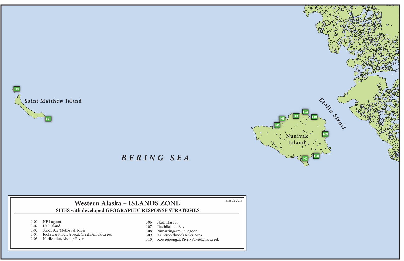
Nunivak Island
Saint Matthe w Island Etolin Strait
B E R I N G S E A
June 26, 2012Western Alaska – ISLANDS ZONE SITES with developed GEOGRAPHIC RESPONSE STRATEGIES
I-07I-08
I-09
I-10
I-03I-04
I-05
I-06
I-01
I-02
I-01 NE LagoonI-02 Hall IslandI-03 Shoal Bay/Mekoryuk RiverI-04 Iookswarat Bay/Jewoak Creek/Anluk CreekI-05 Nariksmiut/Ahding River
I-06 Nash HarborI-07 Duchikthluk BayI-08 Nunarriugarmiut LagoonI-09 Kaliksneethnook River AreaI-10 Koweejoongak River/Vakeekalik Creek


This is not intended for navigational use.
Geo
gra
ph
ic R
esp
on
se S
trate
gie
s fo
rW
est
ern
Ala
ska S
ubare
a, Is
lan
d Z
on
e
NUKA Research & Planning Group, LLC.June 26, 2012
Scale1mi.
1nm
1,000 yds.
FO-S02
01aEX
01bEX
NE Lagoon
NE Lagoon, WAK-I01Center of map at 60˚ 23.75' N Lat., 172˚ 36.95' W Lon.
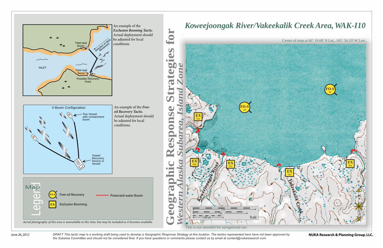
Free-oil Recovery
Exclusion Booming
FO-S
EX
Lege
ndMap
Aerial photography of this area is unavailable at this time, but may be included as it becomes available.
An example of the Free-oil Recovery Tactic. Actual deployment should be adjusted for local conditions.
An example of the Exclusion Booming Tactic. Actual deployment should be adjusted for local conditions.
Possible Recovery Point
Tidal-seal Boom
Tidal-seal Boom
INLET
Protected-water Boom
Tidal-seal Boom
V-Boom Configuration
Tow Vessel with containment boom
Towed Recovery Device or Vessel
NUKA Research & Planning Group, LLC.NOTE: Sensitive resource information can be found on other maps which can be accessed through the sensitive area section of the Western Alaska Subarea Contingency Plan: http://dec.alaska.gov/spar/perp/plans/scp_wak.htm.
Site
Inf
orm
atio
n fo
r W
este
rn A
lask
a, W
AK
-I01
Western Alaska Subarea Geographic Response Strategies DRAFT June 2012
WAK-I01
ID Location and Description Response Strategy Implementation Response Resources Staging Area Site Access Resources Protected (months)
Special Considerations
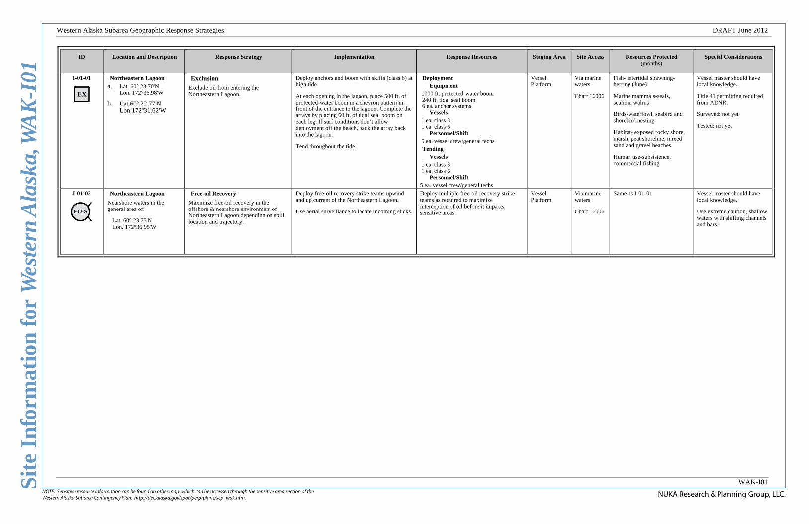
I-01-01
EX
Northeastern Lagoon
a. Lat. 60° 23.70'N Lon. 172°36.98'W
b. Lat.60º 22.77'N Lon.172º31.62'W
Exclusion Exclude oil from entering the Northeastern Lagoon.
Deploy anchors and boom with skiffs (class 6) at high tide.
At each opening in the lagoon, place 500 ft. of protected-water boom in a chevron pattern in front of the entrance to the lagoon. Complete the arrays by placing 60 ft. of tidal seal boom on each leg. If surf conditions don’t allow deployment off the beach, back the array back into the lagoon.
Tend throughout the tide.
Deployment Equipment
1000 ft. protected-water boom 240 ft. tidal seal boom 6 ea. anchor systems
Vessels 1 ea. class 3 1 ea. class 6
Personnel/Shift 5 ea. vessel crew/general techs Tending
Vessels 1 ea. class 3 1 ea. class 6
Personnel/Shift 5 ea. vessel crew/general techs
Vessel Platform
Via marine waters
Chart 16006
Fish- intertidal spawning-herring (June)
Marine mammals-seals, sealion, walrus
Birds-waterfowl, seabird and shorebird nesting
Habitat- exposed rocky shore, marsh, peat shoreline, mixed sand and gravel beaches
Human use-subsistence, commercial fishing
Vessel master should have local knowledge.
Title 41 permitting required from ADNR.
Surveyed: not yet
Tested: not yet
I-01-02
FO-S
Northeastern Lagoon
Nearshore waters in the general area of:
Lat. 60° 23.75'N Lon. 172°36.95'W
Free-oil Recovery
Maximize free-oil recovery in the offshore & nearshore environment of Northeastern Lagoon depending on spill location and trajectory.
Deploy free-oil recovery strike teams upwind and up current of the Northeastern Lagoon.
Use aerial surveillance to locate incoming slicks.
Deploy multiple free-oil recovery strike teams as required to maximize interception of oil before it impacts sensitive areas.
Vessel Platform
Via marine waters
Chart 16006
Same as I-01-01 Vessel master should have local knowledge.
Use extreme caution, shallow waters with shifting channels and bars.
This is not intended for navigational use.
Geo
gra
ph
ic R
esp
on
se S
trate
gie
s fo
rW
est
ern
Ala
ska S
ubare
a, Is
lan
d Z
on
e
NUKA Research & Planning Group, LLC.June 26, 2012
Lege
ndMap
Aerial photography of this area is unavailable at this time, but may be included as it becomes available.
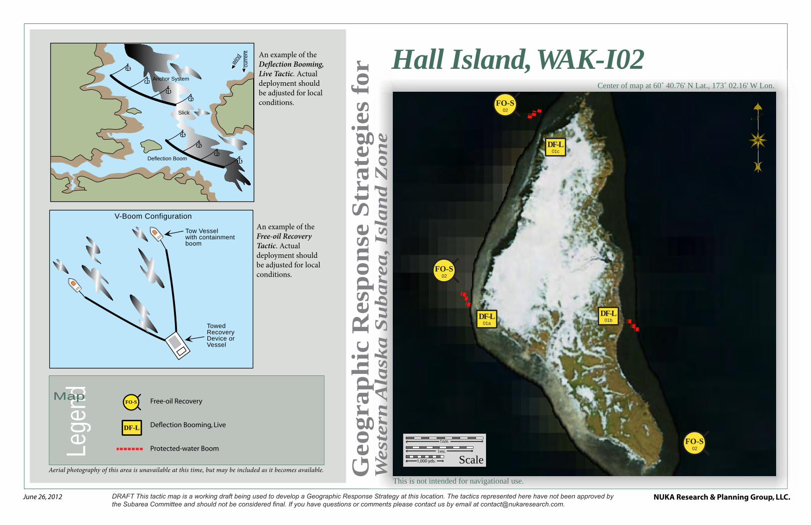
An example of the Free-oil Recovery Tactic. Actual deployment should be adjusted for local conditions.
An example of the Deflection Booming, Live Tactic. Actual deployment should be adjusted for local conditions.
V-Boom Configuration
Tow Vessel with containment boom
Towed Recovery Device or Vessel
Scale1mi.
1nm
1,000 yds.
FO-S02
FO-S02
FO-S02
01cDF-L
01aDF-L 01b
DF-L
Hall Island, WAK-I02Center of map at 60˚ 40.76' N Lat., 173˚ 02.16' W Lon.
Free-oil Recovery
Deflection Booming, Live
Protected-water Boom
FO-S
DF-L
Deflection Boom
Anchor System
wind
curre
nt
Slick
NUKA Research & Planning Group, LLC.NOTE: Sensitive resource information can be found on other maps which can be accessed through the sensitive area section of the Western Alaska Subarea Contingency Plan: http://dec.alaska.gov/spar/perp/plans/scp_wak.htm.
Site
Inf
orm
atio
n fo
r W
este
rn A
lask
a, W
AK
-I02
Western Alaska Subarea Geographic Response Strategies DRAFT June 2012
WAK-I02
ID Location and Description Response Strategy Implementation Response Resources Staging Area
Site Access
Resources Protected (months)
Special Considerations
I-02-01
Hall Island
Lat. 60° 39.36'N Lon. 173°07.36'W
Deflection-Live
Deflect oil that is going to impact the haul outs and rookery on Hall Island away from the area and into the channel for free oil collection.
Deploy anchors and boom with skiffs (class 6).
Use aerial surveillance to identify the incoming oil and its direction. At each location determined by the survey, hold in place with vessels the 3 sections of 300 ft. protected-water boom in a cascaded pattern in the path of the incoming oil.
Deflect incoming oil out for free oil collection.
Tend throughout the tide.
Deployment Equipment
900 ft. protected-water boom Vessels
6 ea. class 3 Personnel/Shift
18 ea. vessel crew/general techs Tending
Vessels 6 ea. class 3
Personnel/Shift 18 ea. vessel crew/general techs
Vessel Platform
Via marine waters
Chart 16006c
Marine mammals-walrus, seals, sealions
Birds-waterfowl, seabird and shorebird nesting
Habitat- exposed rocky shore
Vessel master should have local knowledge.
Consult with the National Marine Fisheries Service prior to implementing this tactic.
Surveyed: not yet
Tested: not yet
I-02-02
FO-S
Hall Island
Nearshore waters in the general area of:
Lat. 59° 51.47'N Lon. 164°19.61'W
Free-oil Recovery
Maximize free-oil recovery in the offshore & nearshore environment of Hall Island depending on spill location and trajectory.
Deploy free-oil recovery strike teams upwind and up current of the Hall Island.
Use aerial surveillance to locate incoming slicks.
Deploy multiple free-oil recovery strike teams as required to maximize interception of oil before it impacts sensitive areas.
Vessel Platform
Via marine waters
Chart 16006c
Same as I-02-01 Vessel master should have local knowledge.
Use extreme caution, shallow waters with shifting channels and bars.
This is not intended for navigational use.
Geo
gra
ph
ic R
esp
on
se S
trate
gie
s fo
rW
est
ern
Ala
ska S
ubare
a, Is
lan
d Z
on
e
NUKA Research & Planning Group, LLC.June 26, 2012
Lege
ndMap
Aerial photography of this area is unavailable at this time, but may be included as it becomes available.
An example of the Free-oil Recovery Tactic. Actual deployment should be adjusted for local conditions.
An example of the Deflection Booming, Live Tactic. Actual deployment should be adjusted for local conditions.
An example of the Exclusion Booming Tactic. Actual deployment should be adjusted for local conditions.
V-Boom Configuration
Tow Vessel with containment boom
Towed Recovery Device or Vessel
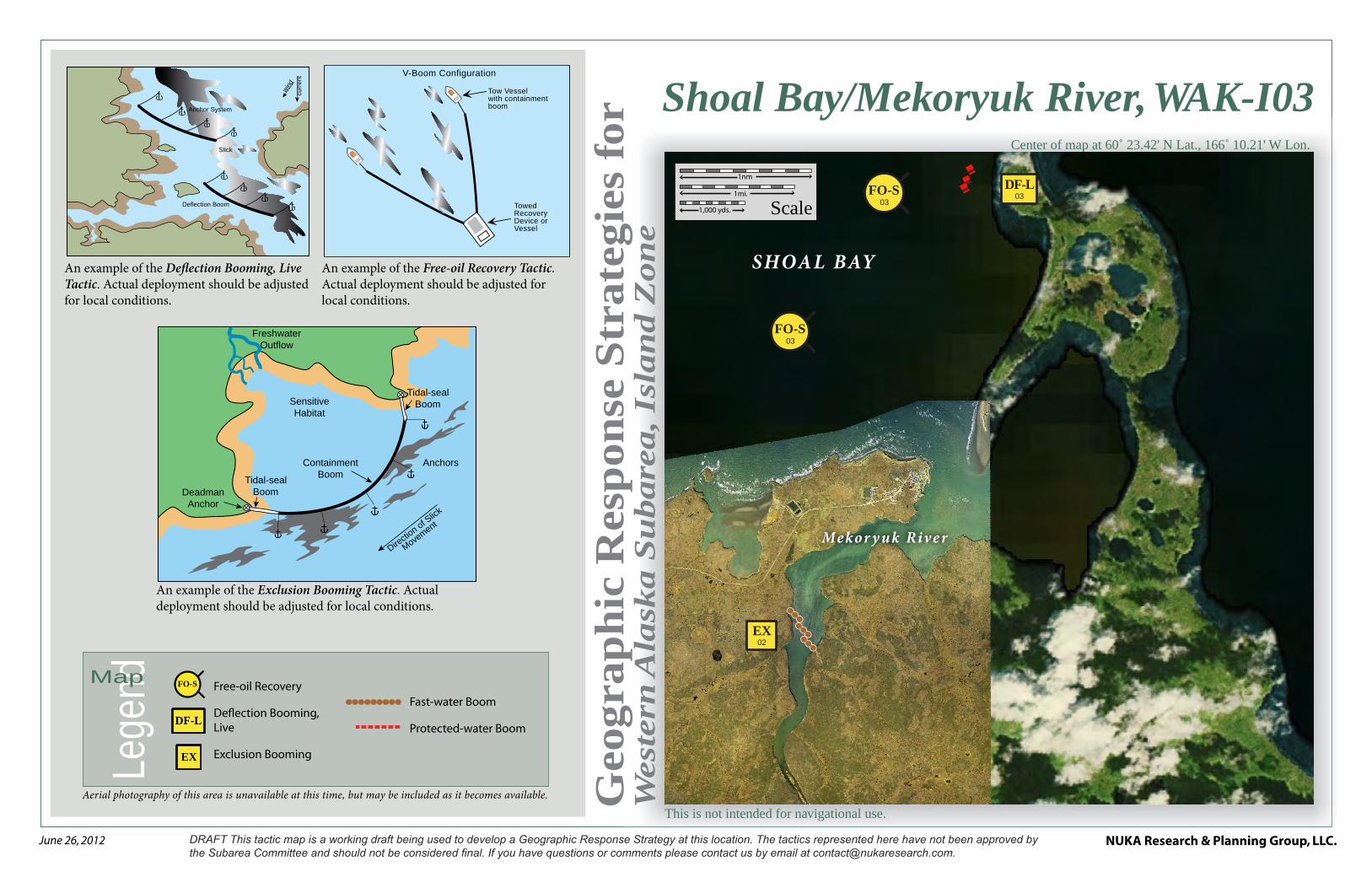
Shoal Bay/Mekoryuk River, WAK-I03Center of map at 60˚ 23.42' N Lat., 166˚ 10.21' W Lon.
Free-oil Recovery
Deflection Booming, Live
Exclusion Booming
FO-S
Scale1mi.
1nm
1,000 yds.
FO-S03
FO-S03
02EX
03DF-L
SHOAL BAY
Mekor y uk River
EX
Fast-water Boom
Protected-water Boom
Deflection Boom
Anchor System
wind
curre
nt
Slick
Freshwater Outflow
Deadman Anchor
Tidal-seal Boom
Tidal-seal Boom
Containment Boom
Anchors
Directio
n of Slick
Movement
Sensitive Habitat
DF-L
NUKA Research & Planning Group, LLC.NOTE: Sensitive resource information can be found on other maps which can be accessed through the sensitive area section of the Western Alaska Subarea Contingency Plan: http://dec.alaska.gov/spar/perp/plans/scp_wak.htm.
Site
Inf
orm
atio
n fo
r W
este
rn A
lask
a, W
AK
-I03
Western Alaska Subarea Geographic Response Strategies DRAFT June 2012
WAK-I03
ID Location and Description Response Strategy Implementation Response Resources Staging Area Site Access
Resources Protected (months)
Special Considerations
I-03-01
EX
Mekoryuk River/ Shoal Bay
Lat. 60° 21.57’N Lon. 166°12.90’W
Exclusion
Exclude oil from impacting the identified Shoal Bay.
Deploy anchors and boom with skiffs (class 6) at high tide.
Place 2150 ft. of protected-water boom in a chevron pattern in front of the entrance to the river. Complete the array by placing 60 ft. of tidal seal boom on each leg.
Tend throughout the tide.
Deployment Equipment
2150 ft. fast-water boom 3 ea. anchor systems
Vessels 6 ea. class 3 2 ea. class 6
Personnel/Shift 22 ea. vessel crew/general techs Tending
Vessels 6 ea. class 3 1 ea. class 6
Personnel/Shift 20 ea. vessel crew/general techs
Mekoryuk Via marine waters
Chart 16006
Fish- intertidal spawning-salmon (June-Sept.)
Marine mammals-seals, walrus
Birds-waterfowl, seabird and shorebird nesting
Habitat- exposed rocky shore, marsh, peat shoreline, exposed wavecut platform, sheltered tidal flats
Human use-subsistence
Vessel master should have local knowledge.
Title 41 permitting required from ADNR.
Surveyed: not yet
Tested: not yet
I-03-02
Cape Etolin/Shoal Bay
Lat. 60° 25.35'N Lon. 166°10.69’W
Deflection-Live
Deflect oil that is going to impact the haul outs and rookery Cape Etolin area away from the area free oil collection.
Deploy anchors and boom with skiffs (class 6).
Use aerial surveillance to identify the incoming oil and it’s direction. At the location determined by the survey, hold in place with vessels the 3 sections of 300 ft. protected-water boom in a cascaded pattern in the path of the incoming oil.
Deflect incoming oil out for free oil collection.
Tend throughout the tide.
Deployment Equipment
900 ft. protected-water boom 9 ea. anchor systems
Vessels/Personnel/Shift Same as I-03-01 Tending
Vessels/Personnel/Shift Same as I-03-01
Mekoryuk Via marine waters
Chart 16006
Same as I-03-01 Vessel master should have local knowledge.
Consult with the National Marine Fisheries Service prior to implementing this tactic.
I-03-03
FO-S
Mekoryuk River/ Shoal Bay
Nearshore waters in the general area of:
Lat. 60° 23.42'N Lon. 166°10.21'W
Free-oil Recovery
Maximize free-oil recovery in the offshore & nearshore environment of Mekoryuk River/ Shoal Bay depending on spill location and trajectory.
Deploy free-oil recovery strike teams upwind and up current of the Mekoryuk River/ Shoal Bay.
Use aerial surveillance to locate incoming slicks.
Deploy multiple free-oil recovery strike teams as required to maximize interception of oil before it impacts sensitive areas.
Mekoryuk Via marine waters
Chart 16006
Same as I-03-01 Vessel master should have local knowledge.
Use extreme caution, shallow waters with shifting channels and bars.
This is not intended for navigational use.
Geo
gra
ph
ic R
esp
on
se S
trate
gie
s fo
rW
est
ern
Ala
ska S
ubare
a, Is
lan
d Z
on
e
NUKA Research & Planning Group, LLC.June 26, 2012
Lege
ndMap
Aerial photography of this area is unavailable at this time, but may be included as it becomes available.
An example of the Free-oil Recovery Tactic. Actual deployment should be adjusted for local conditions.
An example of the Passive Recovery Tactic. Actual deployment should be adjusted for local conditions.
An example of the Deflection Booming, Live Tactic. Actual deployment should be adjusted for local conditions.
V-Boom Configuration
Tow Vessel with containment boom
Towed Recovery Device or Vessel
Deflection Boom
Anchor System
wind
curre
nt
Slick
Snare or Sorbent Boom
Passive Recovery
Scale1mi.
1nm
1,000 yds.
FO-S03
FO-S03
02bPR
02aPR
01DF-L
IO OKSWAR AT BAY
Anluk Creek
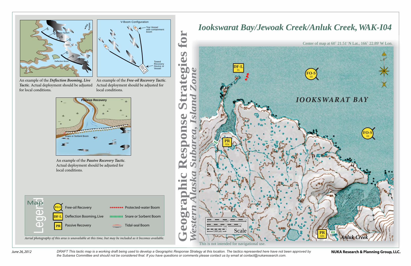
Iookswarat Bay/Jewoak Creek/Anluk Creek, WAK-I04
Center of map at 60˚ 21.51' N Lat., 166˚ 22.89' W Lon.
Free-oil Recovery
Deflection Booming, Live
Passive Recovery
FO-S
PR
Protected-water Boom
Snare or Sorbent Boom
Tidal-seal Boom
DF-L
NUKA Research & Planning Group, LLC.NOTE: Sensitive resource information can be found on other maps which can be accessed through the sensitive area section of the Western Alaska Subarea Contingency Plan: http://dec.alaska.gov/spar/perp/plans/scp_wak.htm.
Site
Inf
orm
atio
n fo
r W
este
rn A
lask
a, W
AK
-I04
Western Alaska Subarea Geographic Response Strategies DRAFT June 2012
WAK-I04
ID Location and Description Response Strategy Implementation Response Resources Staging Area
Site Access Resources Protected (months)
Special Considerations
I-04-01
Iookswarat Bay/Anluk Creek
Lat. 60° 23.62’N Lon. 166°28.57’W
Deflection-Live
Deflect oil that is going to impact the haul outs and rookery on Kikartik Rocks area away from the area for free oil collection.
Deploy anchors and boom with skiffs (class 6).
Use aerial surveillance to identify the incoming oil and its direction. At the location determined by the survey, hold the in place with vessels the 3 sections of 300 ft. protected-water boom in a cascaded pattern in the path of the incoming oil.
Deflect incoming oil out for free oil collection.
Tend throughout the tide.
Deployment Equipment
900 ft. protected-water boom Vessels
6 ea. class 3 1 ea. class 6
Personnel/Shift 20 ea. vessel crew/general techs Tending
Vessels 6 ea. class 3 1 ea. class 6
Personnel/Shift 20 ea. vessel crew/general techs
Vessel Platform
Via marine waters
Chart 16006
Fish- intertidal spawning-Arctic char
Marine mammals-seals
Birds-waterfowl, seabird and shorebird nesting
Habitat- exposed rocky shore, marsh, peat shoreline, Exposed wavecut platform, sheltered tidal flats
Human use-subsistence
Vessel master should have local knowledge.
Surveyed: not yet
Tested: not yet
I-04-02
PR
Iookswarat Bay
a. Lat. 60° 20.20’N
Lon. 166°24.79’W
Anluk Creek b. Lat. 60° 21.57’N
Lon. 166°12.90’W
Passive Recovery
Survey the area prior to deployment. Place passive recovery across entrances to the identified in the back of both bays.
Place and anchor snare line or sorbent boom across entrances in the back of both bays.
Replace as necessary to maximize the recovery.
Deployment Equipment
500 ft. snare line or sorbent boom 2 ea. small anchor systems 8 ea. anchor stakes (Adjust equipment to reflect survey
findings) Vessels/Personnel/Shift
Same as I-04-01 Tending
Vessels/Personnel/Shift Same as I-04-01
Vessel Platform
Via marine waters
Chart 16006
Same as I-04-01 Vessel master should have local knowledge.
Title 41 permitting required from ADNR.
I-04-03
FO-S
Iookswarat Bay/Anluk Creek
Nearshore waters in the general area of:
Lat. 60° 21.51'N Lon. 166°22.89'W
Free-oil Recovery
Maximize free-oil recovery in the offshore & nearshore environment of Iookswarat Bay/Anluk Creek depending on spill location and trajectory.
Deploy free-oil recovery strike teams upwind and up current of the Iookswarat Bay/Anluk Creek.
Use aerial surveillance to locate incoming slicks.
Deploy multiple free-oil recovery strike teams as required to maximize interception of oil before it impacts sensitive areas.
Mekoryuk Via marine waters
Chart 16006
Same as I-04-01 Vessel master should have local knowledge.
Use extreme caution, shallow waters with shifting channels and bars.
This is not intended for navigational use.
Geo
gra
ph
ic R
esp
on
se S
trate
gie
s fo
rW
est
ern
Ala
ska S
ubare
a, Is
lan
d Z
on
e
NUKA Research & Planning Group, LLC.June 26, 2012
Lege
ndMap
Aerial photography of this area is unavailable at this time, but may be included as it becomes available.
FO-S02
FO-S02
01aEX
01bEX
Scale1mi.
1nm
1,000 yds.
Nariksmiut River
Ahding River
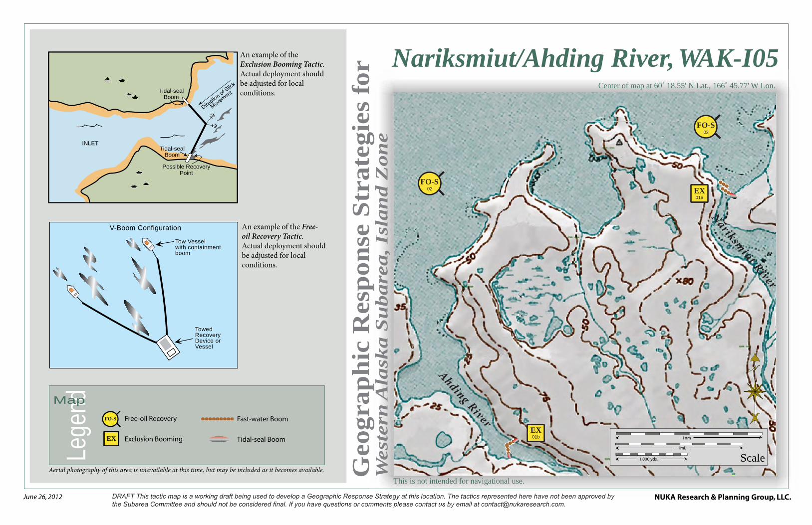
Nariksmiut/Ahding River, WAK-I05Center of map at 60˚ 18.55' N Lat., 166˚ 45.77' W Lon.
Free-oil Recovery
Exclusion Booming
FO-S
EX
Fast-water Boom
Tidal-seal Boom
An example of the Free-oil Recovery Tactic. Actual deployment should be adjusted for local conditions.
An example of the Exclusion Booming Tactic. Actual deployment should be adjusted for local conditions.
Possible Recovery Point
Tidal-seal Boom
Tidal-seal Boom
INLET
V-Boom Configuration
Tow Vessel with containment boom
Towed Recovery Device or Vessel

NUKA Research & Planning Group, LLC.NOTE: Sensitive resource information can be found on other maps which can be accessed through the sensitive area section of the Western Alaska Subarea Contingency Plan: http://dec.alaska.gov/spar/perp/plans/scp_wak.htm.
Site
Inf
orm
atio
n fo
r W
este
rn A
lask
a, W
AK
-I05
Western Alaska Subarea Geographic Response Strategies DRAFT June 2012
WAK-I05
ID Location and Description Response Strategy Implementation Response Resources Staging Area
Site Access Resources Protected (months)
Special Considerations
I-05-01
EX
Nariksmiut/Ahding River a. Lat. 60° 18.13'N
Lon. 166°42.79'W
b. Lat. 60° 16.62'N Lon. 166°46.02'W
Exclusion
Exclude oil from impacting the identified Nariksmiut & Ahding Rivers.
Deploy anchors and boom with skiffs (class 6) at high tide.
For (a) cascade 2 sections of fast-water boom across the channel at an angle to exclude the entrance. For (b) place boom in a chevron pattern in front of the entrance to the river. Complete each array by placing 60 ft. of tidal seal boom on each leg.
Tend throughout the tide.
Boom Lengths:
a. 750 ft
b. 550 ft
Deployment Equipment
1300 ft. fast-water boom 240 ft. tidal seal boom 8 ea. anchor systems
Vessels 1 ea. class 3 2 ea. class 6
Personnel/Shift 7 ea. vessel crew/general techs Tending
Vessels 1 ea. class 3 1 ea. class 6
Personnel/Shift 3 ea. vessel crew/general techs
Mekoryuk Via marine waters
Chart 16006
Fish- intertidal spawning-salmon (June-Sept.)
Marine mammals-seals, walrus
Birds-waterfowl, seabird and shorebird nesting
Habitat- exposed rocky shore, marsh, peat shoreline, sheltered tidal flats
Human use-subsistence
Vessel master should have local knowledge.
Title 41 permitting required from ADNR.
Surveyed: not yet
Tested: not yet
I-05-02
FO-S
Nariksmiut/Ahding River
Nearshore waters in the general area of:
Lat. 60° 18.55'N Lon. 166°45.77'W
Free-oil Recovery
Maximize free-oil recovery in the offshore & nearshore environment of Nariksmiut/Ahding River depending on spill location and trajectory.
Deploy free-oil recovery strike teams upwind and up current of the Nariksmiut/Ahding River.
Use aerial surveillance to locate incoming slicks.
Deploy multiple free-oil recovery strike teams as required to maximize interception of oil before it impacts sensitive areas.
Mekoryuk Via marine waters
Chart 16006
Same as I-05-01 Vessel master should have local knowledge.
Use extreme caution, shallow waters with numerous submerged hazards.
This is not intended for navigational use.
Geo
gra
ph
ic R
esp
on
se S
trate
gie
s fo
rW
est
ern
Ala
ska S
ubare
a, Is
lan
d Z
on
e
NUKA Research & Planning Group, LLC.June 26, 2012
Lege
ndMap
Aerial photography of this area is unavailable at this time, but may be included as it becomes available.
An example of the Free-oil Recovery Tactic. Actual deployment should be adjusted for local conditions.
An example of the Exclusion Booming Tactic. Actual deployment should be adjusted for local conditions.
Possible Recovery Point
Tidal-seal Boom
Tidal-seal Boom
INLET
V-Boom Configuration
Tow Vessel with containment boom
Towed Recovery Device or Vessel
Scale
2 nm2 mi.
2,000 yds.
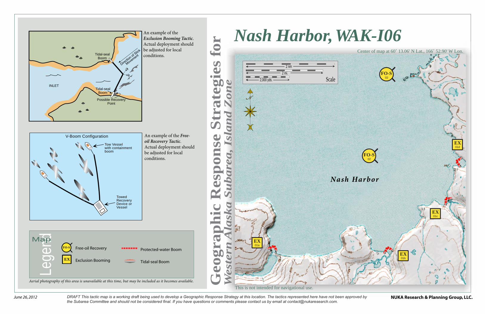
Nash Harbor
FO-S02
FO-S02
01dEX
01cEX
01bEX
01aEX
Nash Harbor, WAK-I06Center of map at 60˚ 13.06' N Lat., 166˚ 52.90' W Lon.
Free-oil Recovery
Exclusion Booming
FO-S
EX
Protected-water Boom
Tidal-seal Boom
NUKA Research & Planning Group, LLC.NOTE: Sensitive resource information can be found on other maps which can be accessed through the sensitive area section of the Western Alaska Subarea Contingency Plan: http://dec.alaska.gov/spar/perp/plans/scp_wak.htm.
Site
Inf
orm
atio
n fo
r W
este
rn A
lask
a, W
AK
-I06
Western Alaska Subarea Geographic Response Strategies DRAFT June 2012
WAK-I06
ID Location and Description Response Strategy Implementation Response Resources Staging Area Site Access
Resources Protected (months)
Special Considerations
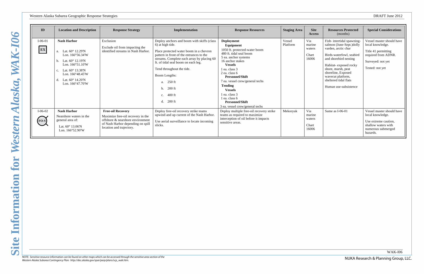
I-06-01
EX
Nash Harbor
a. Lat. 60° 12.29'N Lon. 166°56.34'W
b. Lat. 60° 12.19'N Lon. 166°51.10'W
c. Lat. 60° 13.38'N Lon. 166°48.45'W
d. Lat. 60° 14.20'N Lon. 166°47.70'W
Exclusion
Exclude oil from impacting the identified streams in Nash Harbor.
Deploy anchors and boom with skiffs (class 6) at high tide.
Place protected water boom in a chevron pattern in front of the entrances to the streams. Complete each array by placing 60 ft. of tidal seal boom on each leg.
Tend throughout the tide.
Boom Lengths:
a. 250 ft
b. 200 ft
c. 400 ft
d. 200 ft
Deployment Equipment
1050 ft. protected-water boom 480 ft. tidal seal boom 5 ea. anchor systems 16 anchor stakes
Vessels 1 ea. class 3 2 ea. class 6
Personnel/Shift 7 ea. vessel crew/general techs Tending
Vessels 1 ea. class 3 1 ea. class 6
Personnel/Shift 3 ea. vessel crew/general techs
Vessel Platform
Via marine waters
Chart 16006
Fish- intertidal spawning-salmon (June-Sept.)dolly varden, arctic char
Birds-waterfowl, seabird and shorebird nesting
Habitat- exposed rocky shore, marsh, peat shoreline, Exposed wavecut platform, sheltered tidal flats
Human use-subsistence
Vessel master should have local knowledge.
Title 41 permitting required from ADNR.
Surveyed: not yet
Tested: not yet
I-06-02
FO-S
Nash Harbor
Nearshore waters in the general area of:
Lat. 60° 13.06'N Lon. 166°52.90'W
Free-oil Recovery
Maximize free-oil recovery in the offshore & nearshore environment of Nash Harbor depending on spill location and trajectory.
Deploy free-oil recovery strike teams upwind and up current of the Nash Harbor.
Use aerial surveillance to locate incoming slicks.
Deploy multiple free-oil recovery strike teams as required to maximize interception of oil before it impacts sensitive areas.
Mekoryuk Via marine waters
Chart 16006
Same as I-06-01 Vessel master should have local knowledge.
Use extreme caution, shallow waters with numerous submerged hazards.
This is not intended for navigational use.
Geo
gra
ph
ic R
esp
on
se S
trate
gie
s fo
rW
est
ern
Ala
ska S
ubare
a, Is
lan
d Z
on
e
NUKA Research & Planning Group, LLC.June 26, 2012
Lege
ndMap
Aerial photography of this area is unavailable at this time, but may be included as it becomes available.
An example of the Free-oil Recovery Tactic. Actual deployment should be adjusted for local conditions.
An example of the Passive Recovery Tactic. Actual deployment should be adjusted for local conditions.
An example of the Diversion Booming Tactic. Actual deployment should be adjusted for local conditions.
V-Boom Configuration
Tow Vessel with containment boom
Towed Recovery Device or Vessel
Moderate Current
Shoreside Recovery
Skimmer
Snare or Sorbent Boom
Passive Recovery
Scale
2 nm2 mi.
2,000 yds.
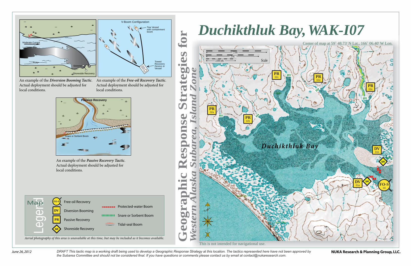
Duchikthluk Bay
FO-S03
01bDV
01aDV
02ePR
02dPR02c
PR
02bPR
02aPR
SR
SR
Duchikthluk Bay, WAK-I07Center of map at 59˚ 48.73' N Lat., 166˚ 06.40' W Lon.
Free-oil Recovery
Diversion Booming
Passive Recovery
Shoreside Recovery
DV
SR
PR
FO-S
Protected-water Boom
Snare or Sorbent Boom
Tidal-seal Boom
NUKA Research & Planning Group, LLC.NOTE: Sensitive resource information can be found on other maps which can be accessed through the sensitive area section of the Western Alaska Subarea Contingency Plan: http://dec.alaska.gov/spar/perp/plans/scp_wak.htm.
Site
Inf
orm
atio
n fo
r W
este
rn A
lask
a, W
AK
-I07
Western Alaska Subarea Geographic Response Strategies DRAFT June 2012
WAK-I07
ID Location and Description Response Strategy Implementation Response Resources Staging Area
Site Access Resources Protected (months)
Special Considerations
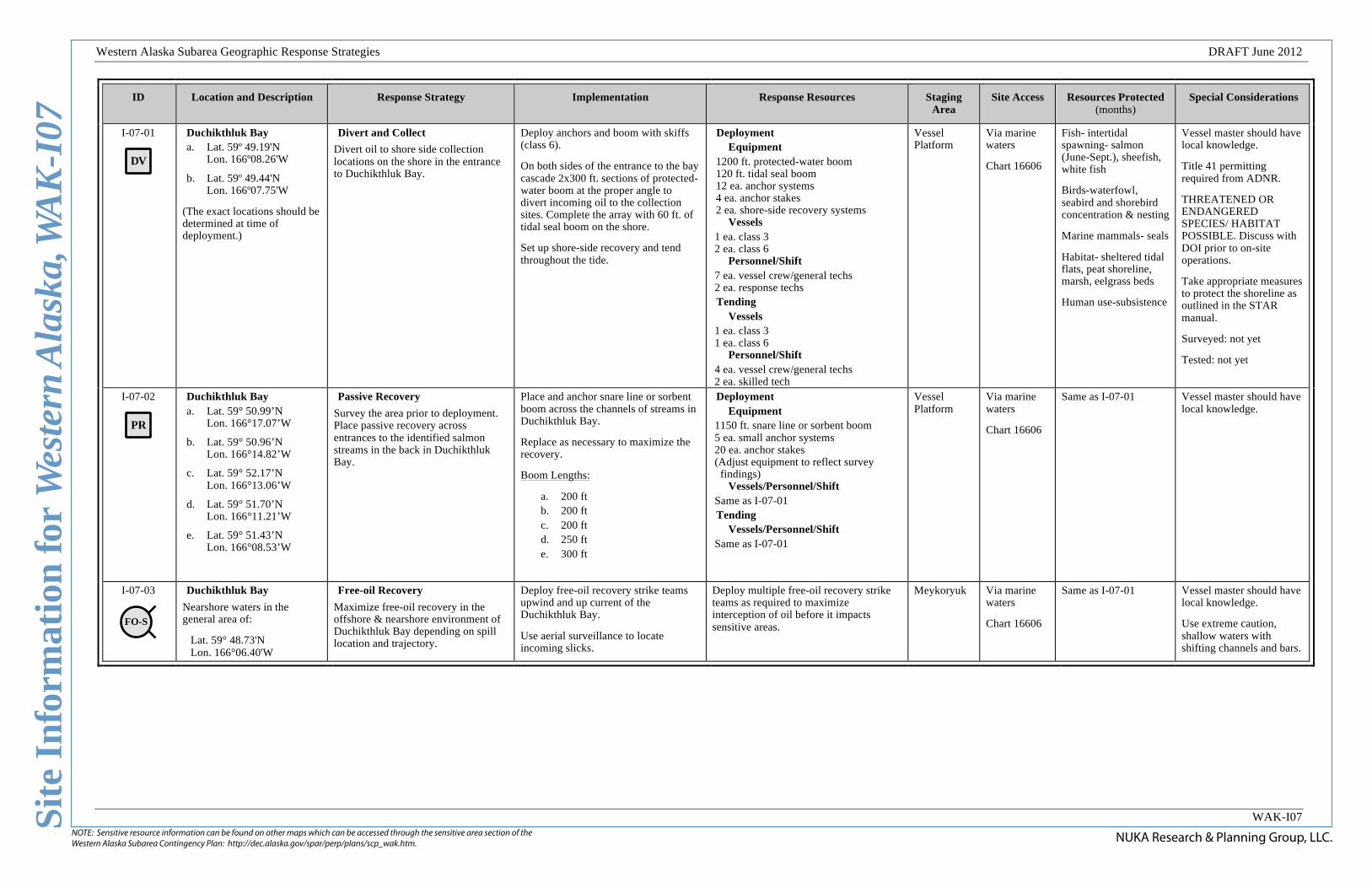
I-07-01
DV
Duchikthluk Bay a. Lat. 59º 49.19'N
Lon. 166º08.26'W
b. Lat. 59º 49.44'N Lon. 166º07.75'W
(The exact locations should be determined at time of deployment.)
Divert and Collect
Divert oil to shore side collection locations on the shore in the entrance to Duchikthluk Bay.
Deploy anchors and boom with skiffs (class 6).
On both sides of the entrance to the bay cascade 2x300 ft. sections of protected-water boom at the proper angle to divert incoming oil to the collection sites. Complete the array with 60 ft. of tidal seal boom on the shore.
Set up shore-side recovery and tend throughout the tide.
Deployment Equipment
1200 ft. protected-water boom 120 ft. tidal seal boom 12 ea. anchor systems 4 ea. anchor stakes 2 ea. shore-side recovery systems
Vessels 1 ea. class 3 2 ea. class 6
Personnel/Shift 7 ea. vessel crew/general techs 2 ea. response techs Tending
Vessels 1 ea. class 3 1 ea. class 6
Personnel/Shift 4 ea. vessel crew/general techs 2 ea. skilled tech
Vessel Platform
Via marine waters
Chart 16606
Fish- intertidal spawning- salmon (June-Sept.), sheefish, white fish
Birds-waterfowl, seabird and shorebird concentration & nesting
Marine mammals- seals
Habitat- sheltered tidal flats, peat shoreline, marsh, eelgrass beds
Human use-subsistence
Vessel master should have local knowledge.
Title 41 permitting required from ADNR.
THREATENED OR ENDANGERED SPECIES/ HABITAT POSSIBLE. Discuss with DOI prior to on-site operations.
Take appropriate measures to protect the shoreline as outlined in the STAR manual.
Surveyed: not yet
Tested: not yet
I-07-02
PR
Duchikthluk Bay a. Lat. 59° 50.99’N
Lon. 166°17.07’W
b. Lat. 59° 50.96’N Lon. 166°14.82’W
c. Lat. 59° 52.17’N Lon. 166°13.06’W
d. Lat. 59° 51.70’N Lon. 166°11.21’W
e. Lat. 59° 51.43’N Lon. 166°08.53’W
Passive Recovery
Survey the area prior to deployment. Place passive recovery across entrances to the identified salmon streams in the back in Duchikthluk Bay.
Place and anchor snare line or sorbent boom across the channels of streams in Duchikthluk Bay.
Replace as necessary to maximize the recovery.
Boom Lengths:
a. 200 ft b. 200 ft c. 200 ft d. 250 ft e. 300 ft
Deployment Equipment
1150 ft. snare line or sorbent boom 5 ea. small anchor systems 20 ea. anchor stakes (Adjust equipment to reflect survey
findings) Vessels/Personnel/Shift
Same as I-07-01 Tending
Vessels/Personnel/Shift Same as I-07-01
Vessel Platform
Via marine waters
Chart 16606
Same as I-07-01 Vessel master should have local knowledge.
I-07-03
FO-S
Duchikthluk Bay
Nearshore waters in the general area of:
Lat. 59° 48.73'N Lon. 166°06.40'W
Free-oil Recovery
Maximize free-oil recovery in the offshore & nearshore environment of Duchikthluk Bay depending on spill location and trajectory.
Deploy free-oil recovery strike teams upwind and up current of the Duchikthluk Bay.
Use aerial surveillance to locate incoming slicks.
Deploy multiple free-oil recovery strike teams as required to maximize interception of oil before it impacts sensitive areas.
Meykoryuk Via marine waters
Chart 16606
Same as I-07-01 Vessel master should have local knowledge.
Use extreme caution, shallow waters with shifting channels and bars.
This is not intended for navigational use.
Geo
gra
ph
ic R
esp
on
se S
trate
gie
s fo
rW
est
ern
Ala
ska S
ubare
a, Is
lan
d Z
on
e
NUKA Research & Planning Group, LLC.June 26, 2012
Lege
ndMap
Aerial photography of this area is unavailable at this time, but may be included as it becomes available.
An example of the Free-oil Recovery Tactic. Actual deployment should be adjusted for local conditions.
An example of the Passive Recovery Tactic. Actual deployment should be adjusted for local conditions.
Snare or Sorbent Boom
Passive Recovery
V-Boom Configuration
Tow Vessel with containment boom
Towed Recovery Device or Vessel
Scale
1 nm1 mi.
1,000 yds.
Nunarriugarmiut Lagoon
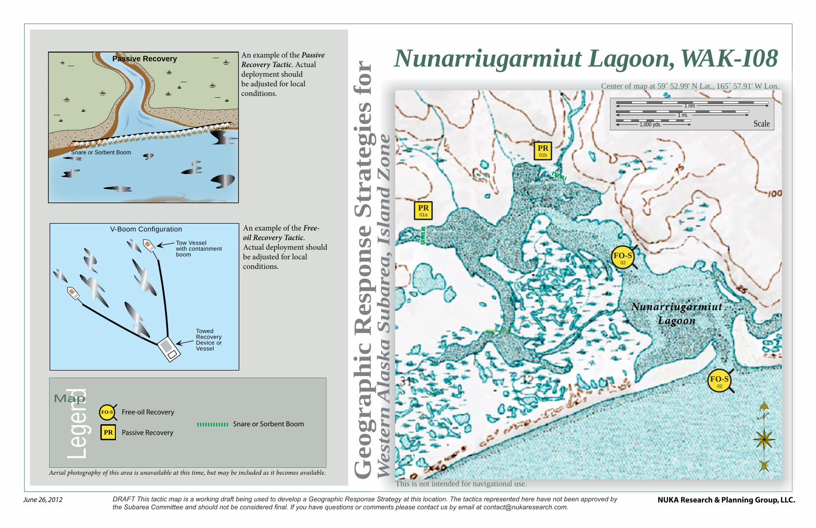
FO-S02
FO-S02
01aPR
01bPR
Nunarriugarmiut Lagoon, WAK-I08Center of map at 59˚ 52.99' N Lat., 165˚ 57.91' W Lon.
Free-oil Recovery
Passive Recovery
FO-S
Snare or Sorbent BoomPR
NUKA Research & Planning Group, LLC.NOTE: Sensitive resource information can be found on other maps which can be accessed through the sensitive area section of the Western Alaska Subarea Contingency Plan: http://dec.alaska.gov/spar/perp/plans/scp_wak.htm.
Site
Inf
orm
atio
n fo
r W
este
rn A
lask
a, W
AK
-I08
Western Alaska Subarea Geographic Response Strategies DRAFT June 2012
WAK-I08
ID Location and Description Response Strategy Implementation Response Resources Staging Area
Site Access Resources Protected (months)
Special Considerations
I-08-01
Nunarriugarmiut Lagoon a. Lat. 59° 53.41’N
Lon.165°00.98'W
b. Lat. 59° 53.81’N Lon.165°59.27'W
Passive Recovery
Survey the area prior to deployment. Place passive recovery across entrances to the identified salmon streams in the back in Nunarriugarmiut Lagoon.
Place and anchor snare line or sorbent boom across the channels of streams in Nunarriugarmiut Lagoon.
Replace as necessary to maximize the recovery.
Boom Lengths:
a. 500 ft
b. 700 ft
Deployment Equipment
1200 ft. snare line or sorbent boom 7 ea. anchor systems
Vessels 1 ea. class 3 1 ea. class 6
Personnel/Shift 5 ea. vessel crew/general techs Tending
Vessels 1 ea. class 3 1 ea. class 6
Personnel/Shift 3 ea. vessel crew/general techs
Vessel Platform
Via marine waters
Chart 16006
Fish- intertidal spawning-salmon (June-Sept.), arctic char
Birds-waterfowl, seabird and shorebird nesting concentrations
Habitat- marsh, peat shoreline, sheltered tidal flats, eelgrass beds
Human use-subsistence
Vessel master should have local knowledge.
Title 41 permitting required from ADNR.
THREATENED OR ENDANGERED SPECIES/ HABITAT POSSIBLE. Discuss with DOI prior to on-site operations.
Surveyed: not yet
Tested: not yet
I-08-02
FO-S
Nunarriugarmiut Lagoon
Nearshore waters in the general area of:
Lat. 59° 52.99'N Lon. 165°57.91'W
Free-oil Recovery
Maximize free-oil recovery in the offshore & nearshore environment of Nunarriugarmiut Lagoon depending on spill location and trajectory.
Deploy free-oil recovery strike teams upwind and up current of the Nunarriugarmiut Lagoon.
Use aerial surveillance to locate incoming slicks.
Deploy multiple free-oil recovery strike teams as required to maximize interception of oil before it impacts sensitive areas.
Mekoryuk Via marine waters
Chart 16006
Same as I-08-02 Vessel master should have local knowledge.
Use extreme caution, shallow waters with shifting channels and bars.
This is not intended for navigational use.
Geo
gra
ph
ic R
esp
on
se S
trate
gie
s fo
rW
est
ern
Ala
ska S
ubare
a, Is
lan
d Z
on
e
NUKA Research & Planning Group, LLC.June 26, 2012
Lege
ndMap
Aerial photography of this area is unavailable at this time, but may be included as it becomes available.
An example of the Free-oil Recovery Tactic. Actual deployment should be adjusted for local conditions.
An example of the Exclusion Booming Tactic. Actual deployment should be adjusted for local conditions.
Possible Recovery Point
Tidal-seal Boom
Tidal-seal Boom
INLET
V-Boom Configuration
Tow Vessel with containment boom
Towed Recovery Device or Vessel
Scale
2 nm2 mi.
2,000 yds.
02b
Kaliksneethnook River
FO-S02
FO-S02
01aEX
01bEX
01cEX
Kaliksneethnook River Area, WAK-I09Center of map at 60˚ 08.52' N Lat., 165˚ 39.38' W Lon.
Free-oil Recovery
Exclusion Booming
FO-S
EX
Protected-water Boom
Tidal-seal Boom
NUKA Research & Planning Group, LLC.NOTE: Sensitive resource information can be found on other maps which can be accessed through the sensitive area section of the Western Alaska Subarea Contingency Plan: http://dec.alaska.gov/spar/perp/plans/scp_wak.htm.
Site
Inf
orm
atio
n fo
r W
este
rn A
lask
a, W
AK
-I09
Western Alaska Subarea Geographic Response Strategies DRAFT June 2012
WAK-I09
ID Location and Description Response Strategy Implementation Response Resources Staging Area
Site Access Resources Protected (months)
Special Considerations
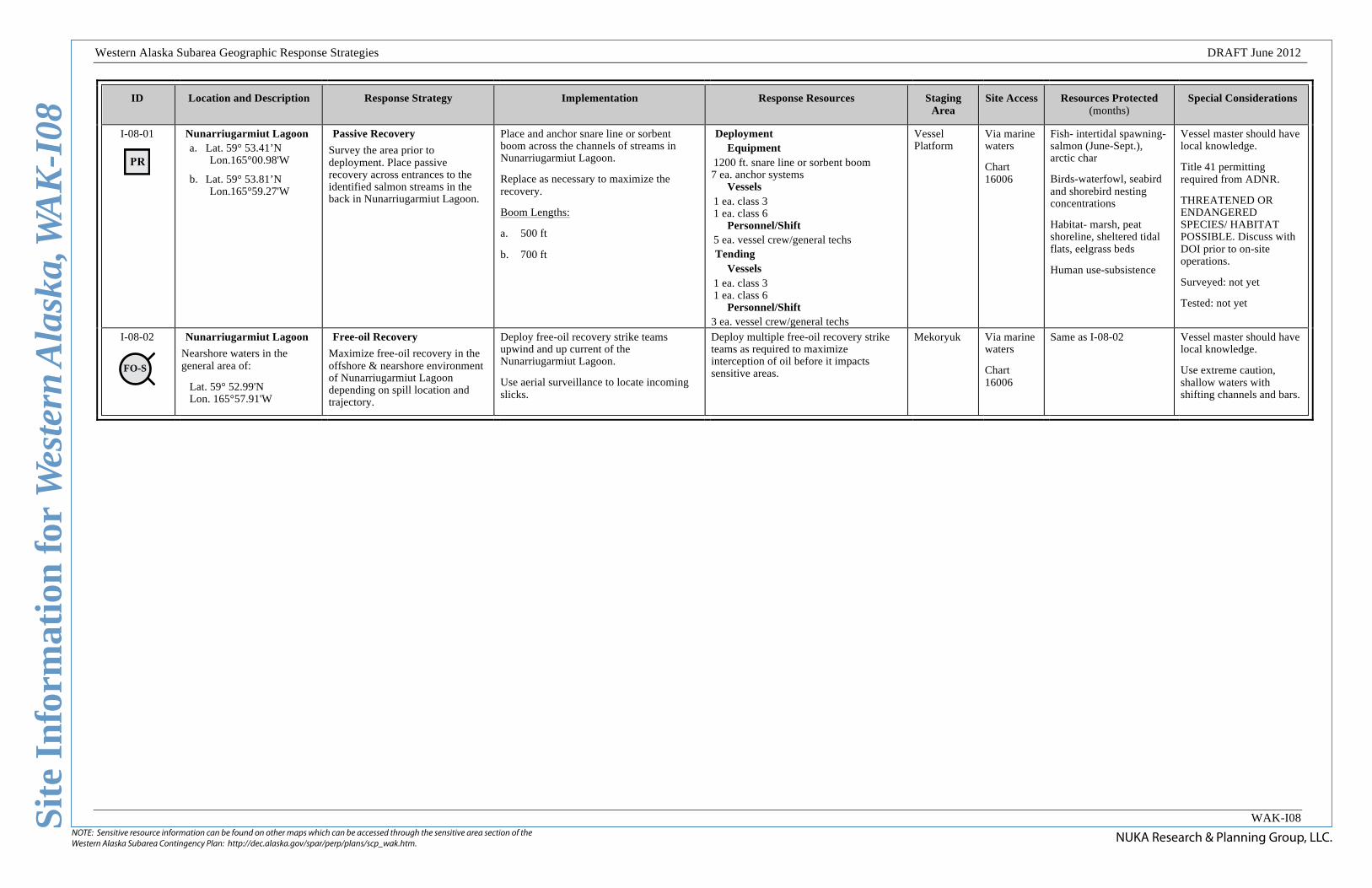
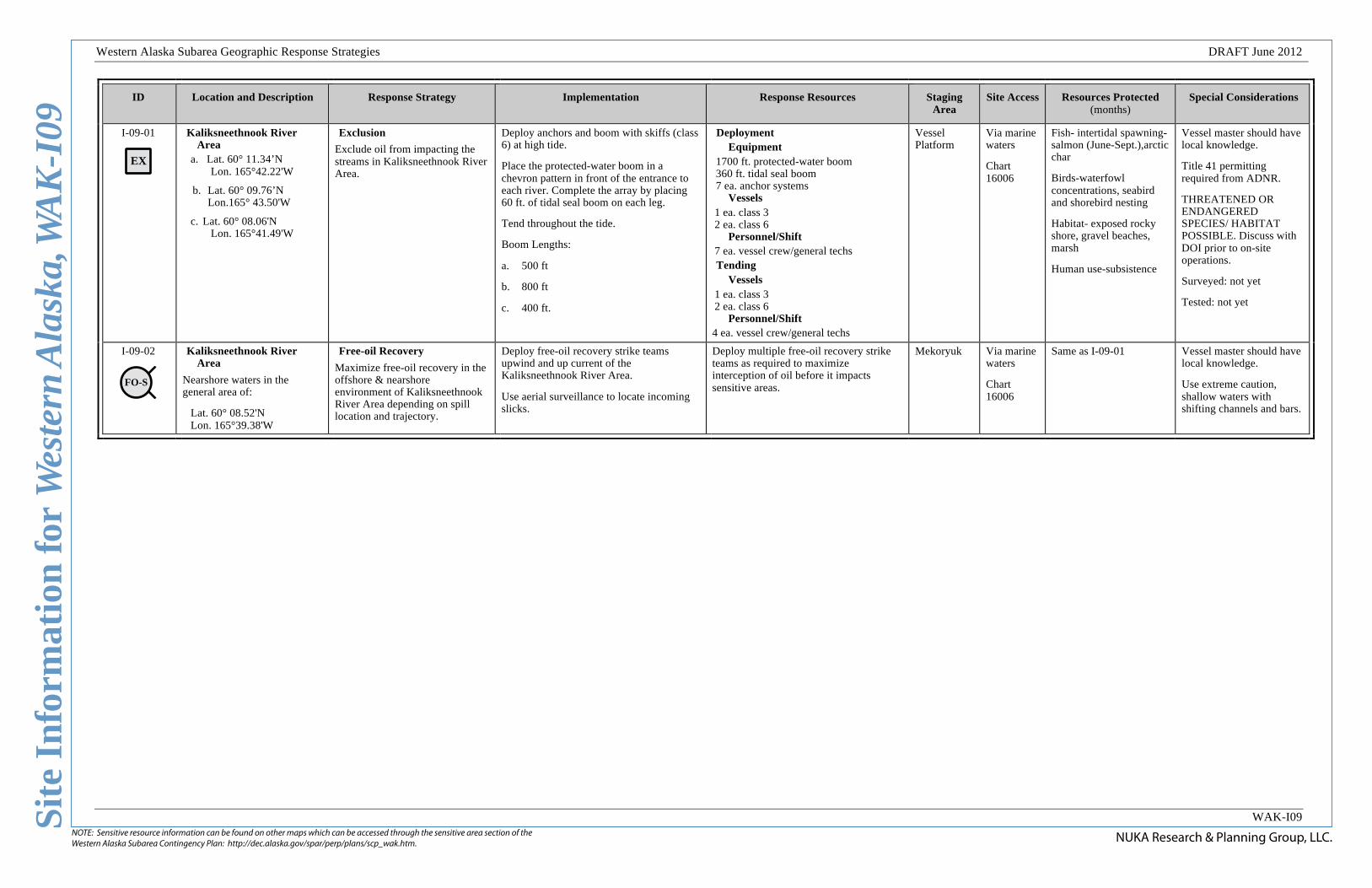
I-09-01
EX
Kaliksneethnook River Area
a. Lat. 60° 11.34’N Lon. 165°42.22'W
b. Lat. 60° 09.76’N Lon.165° 43.50'W
c. Lat. 60° 08.06'N Lon. 165°41.49'W
Exclusion
Exclude oil from impacting the streams in Kaliksneethnook River Area.
Deploy anchors and boom with skiffs (class 6) at high tide.
Place the protected-water boom in a chevron pattern in front of the entrance to each river. Complete the array by placing 60 ft. of tidal seal boom on each leg.
Tend throughout the tide.
Boom Lengths:
a. 500 ft
b. 800 ft
c. 400 ft.
Deployment Equipment
1700 ft. protected-water boom 360 ft. tidal seal boom 7 ea. anchor systems
Vessels 1 ea. class 3 2 ea. class 6
Personnel/Shift 7 ea. vessel crew/general techs Tending
Vessels 1 ea. class 3 2 ea. class 6
Personnel/Shift 4 ea. vessel crew/general techs
Vessel Platform
Via marine waters
Chart 16006
Fish- intertidal spawning-salmon (June-Sept.),arctic char
Birds-waterfowl concentrations, seabird and shorebird nesting
Habitat- exposed rocky shore, gravel beaches, marsh
Human use-subsistence
Vessel master should have local knowledge.
Title 41 permitting required from ADNR.
THREATENED OR ENDANGERED SPECIES/ HABITAT POSSIBLE. Discuss with DOI prior to on-site operations.
Surveyed: not yet
Tested: not yet
I-09-02
FO-S
Kaliksneethnook River Area
Nearshore waters in the general area of:
Lat. 60° 08.52'N Lon. 165°39.38'W
Free-oil Recovery
Maximize free-oil recovery in the offshore & nearshore environment of Kaliksneethnook River Area depending on spill location and trajectory.
Deploy free-oil recovery strike teams upwind and up current of the Kaliksneethnook River Area.
Use aerial surveillance to locate incoming slicks.
Deploy multiple free-oil recovery strike teams as required to maximize interception of oil before it impacts sensitive areas.
Mekoryuk Via marine waters
Chart 16006
Same as I-09-01 Vessel master should have local knowledge.
Use extreme caution, shallow waters with shifting channels and bars.
This is not intended for navigational use.
Geo
gra
ph
ic R
esp
on
se S
trate
gie
s fo
rW
est
ern
Ala
ska S
ubare
a, Is
lan
d Z
on
e
NUKA Research & Planning Group, LLC.June 26, 2012
Lege
ndMap
Aerial photography of this area is unavailable at this time, but may be included as it becomes available.
An example of the Free-oil Recovery Tactic. Actual deployment should be adjusted for local conditions.
An example of the Exclusion Booming Tactic. Actual deployment should be adjusted for local conditions.
Possible Recovery Point
Tidal-seal Boom
Tidal-seal Boom
INLET
V-Boom Configuration
Tow Vessel with containment boom
Towed Recovery Device or Vessel
Scale
2 nm2 mi.
2,000 yds.
Kow
eejo
onga
k Ri
ver
Vakeekalik Creek FO-S
02
FO-S02
01aEX
01bEX
01cEX
01dEX
01eEX
Koweejoongak River/Vakeekalik Creek Area, WAK-I10
Center of map at 60˚ 19.68' N Lat., 165˚ 56.19' W Lon.
Free-oil Recovery
Exclusion Booming
FO-S
EX
Protected-water Boom
NUKA Research & Planning Group, LLC.NOTE: Sensitive resource information can be found on other maps which can be accessed through the sensitive area section of the Western Alaska Subarea Contingency Plan: http://dec.alaska.gov/spar/perp/plans/scp_wak.htm.
Site
Inf
orm
atio
n fo
r W
este
rn A
lask
a, W
AK
-I10
Western Alaska Subarea Geographic Response Strategies DRAFT June 2012
WAK-I10
ID Location and Description Response Strategy Implementation Response Resources Staging Area
Site Access Resources Protected (months)
Special Considerations
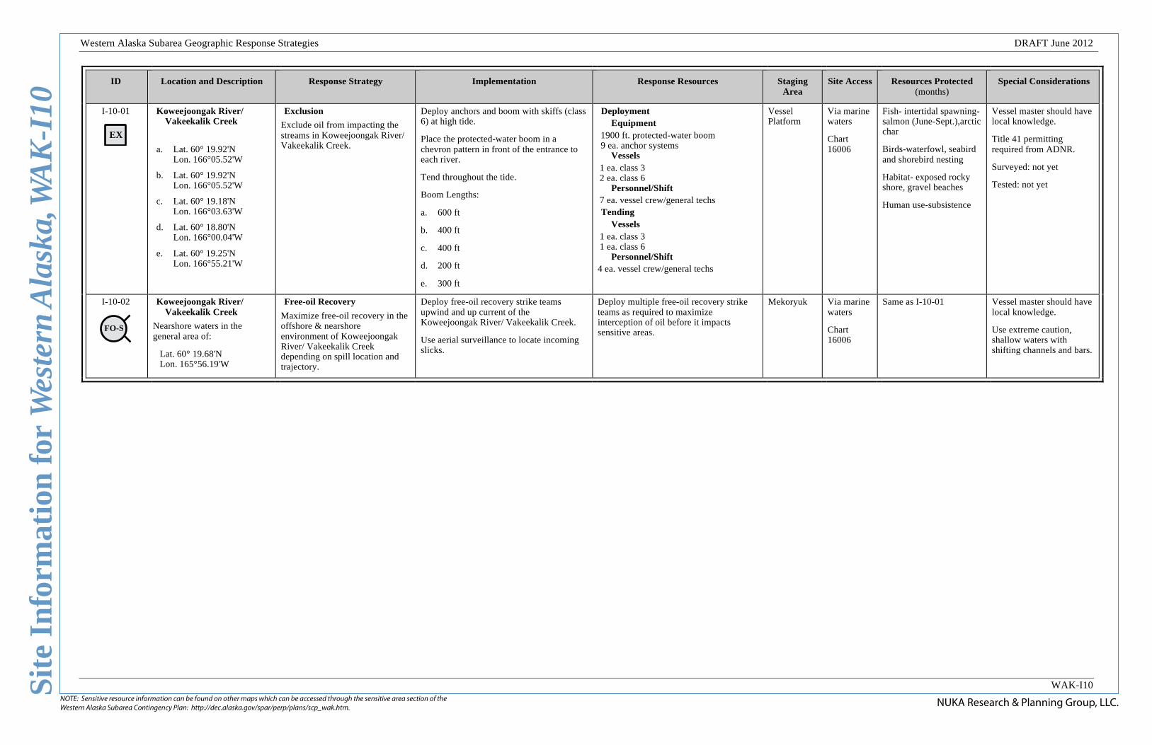
I-10-01
EX
Koweejoongak River/ Vakeekalik Creek
a. Lat. 60° 19.92'N Lon. 166°05.52'W
b. Lat. 60° 19.92'N Lon. 166°05.52'W
c. Lat. 60° 19.18'N Lon. 166°03.63'W
d. Lat. 60° 18.80'N Lon. 166°00.04'W
e. Lat. 60° 19.25'N Lon. 166°55.21'W
Exclusion
Exclude oil from impacting the streams in Koweejoongak River/ Vakeekalik Creek.
Deploy anchors and boom with skiffs (class 6) at high tide.
Place the protected-water boom in a chevron pattern in front of the entrance to each river.
Tend throughout the tide.
Boom Lengths:
a. 600 ft
b. 400 ft
c. 400 ft
d. 200 ft
e. 300 ft
Deployment Equipment
1900 ft. protected-water boom 9 ea. anchor systems
Vessels 1 ea. class 3 2 ea. class 6
Personnel/Shift 7 ea. vessel crew/general techs Tending
Vessels 1 ea. class 3 1 ea. class 6
Personnel/Shift 4 ea. vessel crew/general techs
Vessel Platform
Via marine waters
Chart 16006
Fish- intertidal spawning-salmon (June-Sept.),arctic char
Birds-waterfowl, seabird and shorebird nesting
Habitat- exposed rocky shore, gravel beaches
Human use-subsistence
Vessel master should have local knowledge.
Title 41 permitting required from ADNR.
Surveyed: not yet
Tested: not yet
I-10-02
FO-S
Koweejoongak River/ Vakeekalik Creek
Nearshore waters in the general area of:
Lat. 60° 19.68'N Lon. 165°56.19'W
Free-oil Recovery
Maximize free-oil recovery in the offshore & nearshore environment of Koweejoongak River/ Vakeekalik Creek depending on spill location and trajectory.
Deploy free-oil recovery strike teams upwind and up current of the Koweejoongak River/ Vakeekalik Creek.
Use aerial surveillance to locate incoming slicks.
Deploy multiple free-oil recovery strike teams as required to maximize interception of oil before it impacts sensitive areas.
Mekoryuk Via marine waters
Chart 16006
Same as I-10-01 Vessel master should have local knowledge.
Use extreme caution, shallow waters with shifting channels and bars.