powell butte highway/neff road intersection · powell butte highway/neff road intersection interim...
TRANSCRIPT
POWELL BUTTE HIGHWAY/NEFF ROAD INTERSECTION Interim Report: Existing Conditions, Needs, and Alternatives Review
Date: December 30, 2013 Project #: 13963.0
To: Chris Doty PE and George Kolb, Deschutes County
From: Joe Bessman PE, Casey Bergh PE, Hermanus Steyn PE, and Brett Korporaal
PROJECT PURPOSE
County staff identified the need for safety improvements at the Powell Butte Highway intersection
with Neff Road to address an increasing number of crashes. County staff have previously
implemented low-cost treatments to improve visibility and driver awareness, and identified this
intersection as a high priority location both in the County Transportation System Plan and in the
Capital Improvement Plan. The rural area, high-speed approaches, and angle crash type contributes
to the severity of crashes.
The Deschutes County Transportation System Plan has previously identified this intersection as a
future single-lane rural roundabout based on the roadway types and safety issues that were
identified. The purpose of this analysis is to further explore a range of potential improvement options
(to include low-cost interim treatments) and better identify right-of-way needs and construction costs
for a final recommended alternative.
This Interim Technical Memorandum provides information on the existing traffic conditions. This
includes a review of historical safety, operations, and field observations. Based on the issues
identified, this memorandum identifies key project needs, also identifies potential improvement
alternatives to address this need. This memorandum provides a qualitative screening of the potential
improvement options, and presents a recommendation that the County continue to refine the
roundabout concept.
BACKGROUND
The Powell Butte Highway provides a connection from US 20 to OR 126 serving a mix of commuters
(between Bend and Prineville), rural residential property owners, commercial traffic (rural farms and
the Bend Municipal Airport), and tourists (Brasada Ranch and Pronghorn). This section of the Powell
Butte Highway is under the jurisdiction of Deschutes County, and has a posted speed of 55 miles per
hour.
Neff Road (west of Powell Butte Highway) serves as a connection to the east side of Bend, connecting
to St. Charles hospital and ultimately to 3rd Street (Business 97). Neff Road becomes Alfalfa Market
Powell Butte Highway and Neff Road Intersection Review Project #: 13963 December 30, 2013 Page 2
Kittelson & Associates, Inc. Bend, Oregon
Road on the east side of the Powell Butte Highway, connecting to rural communities, farms, and the
Prineville Reservoir boat launch (seasonal).
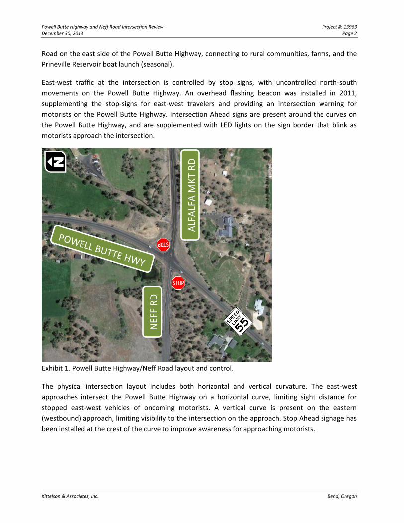
East-west traffic at the intersection is controlled by stop signs, with uncontrolled north-south
movements on the Powell Butte Highway. An overhead flashing beacon was installed in 2011,
supplementing the stop-signs for east-west travelers and providing an intersection warning for
motorists on the Powell Butte Highway. Intersection Ahead signs are present around the curves on
the Powell Butte Highway, and are supplemented with LED lights on the sign border that blink as
motorists approach the intersection.
Exhibit 1. Powell Butte Highway/Neff Road layout and control.
The physical intersection layout includes both horizontal and vertical curvature. The east-west
approaches intersect the Powell Butte Highway on a horizontal curve, limiting sight distance for
stopped east-west vehicles of oncoming motorists. A vertical curve is present on the eastern
(westbound) approach, limiting visibility to the intersection on the approach. Stop Ahead signage has
been installed at the crest of the curve to improve awareness for approaching motorists.
NEF
F R
D
ALF
ALF
A M
KT
RD
Powell Butte Highway and Neff Road Intersection Review Project #: 13963 December 30, 2013 Page 3
Kittelson & Associates, Inc. Bend, Oregon
EXISTING CONDITIONS
KAI conducted field reviews, evaluated historic crash data to identify trends, collected traffic count
information and speed data, and conducted intersection operations analysis at the Powell Butte
Highway/Neff Road-Alfalfa Market Road intersection. The existing conditions analysis is intended to
inform the overall intersection needs and support the selection of treatment alternatives.
Data Collection
Information was collected around the intersection to better understand the traffic flows and
characteristics. Turning movement counts, average daily traffic volumes, vehicle speed, and vehicle
classification data was obtained during the final week of October and the first week of November
2013.
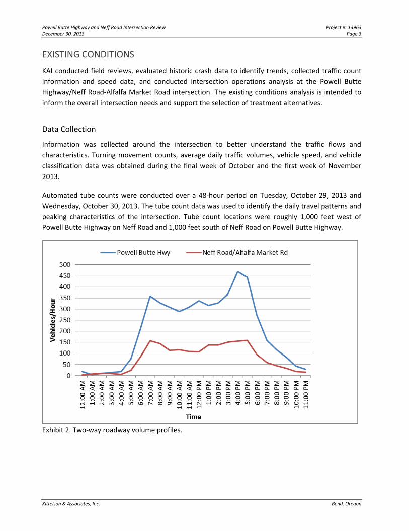
Automated tube counts were conducted over a 48-hour period on Tuesday, October 29, 2013 and
Wednesday, October 30, 2013. The tube count data was used to identify the daily travel patterns and
peaking characteristics of the intersection. Tube count locations were roughly 1,000 feet west of
Powell Butte Highway on Neff Road and 1,000 feet south of Neff Road on Powell Butte Highway.
Exhibit 2. Two-way roadway volume profiles.
Powell Butte Highway and Neff Road Intersection Review Project #: 13963 December 30, 2013 Page 4
Kittelson & Associates, Inc. Bend, Oregon
As illustrated in Exhibit 2, the volume profile indicates that traffic flows peak twice per day (during the
morning and evening commute periods), and traffic on the Powell Butte Highway is two to three
times higher than Neff Road.
Vehicle classification data was obtained from the tube counts to identify the fleet mix passing through
the intersection. Vehicles are classified from the tube counts based on the number and spacing of
tires and axles. A simplified summary of the classification data is provided in Table 1.
Table 1. Vehicle Classification Data
Roadway Class 1
(Motorcycles)
Classes 2, 3, and 4
(Passenger cars and buses)
Classes 5, 6, and 7
(Delivery Trucks)
Class 8+ (Tractor Trailers) Not Classed
Powell Butte Hwy 0.4% 83.8% 11.5% 2.8% 1.5%
Neff Road 0.1% 88.0% 9.3% 1.9% 0.7%
As shown, the fleet mix is largely comprised of passenger cars and delivery trucks. Only about 2 to 3
percent of the vehicles using the Powell Butte Highway and Neff Road are tractor trailers.
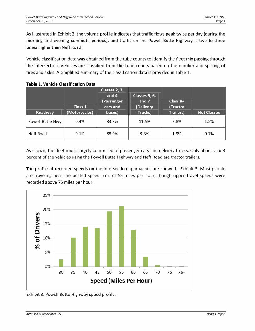
The profile of recorded speeds on the intersection approaches are shown in Exhibit 3. Most people
are traveling near the posted speed limit of 55 miles per hour, though upper travel speeds were
recorded above 76 miles per hour.
Exhibit 3. Powell Butte Highway speed profile.
Powell Butte Highway and Neff Road Intersection Review Project #: 13963 December 30, 2013 Page 5
Kittelson & Associates, Inc. Bend, Oregon
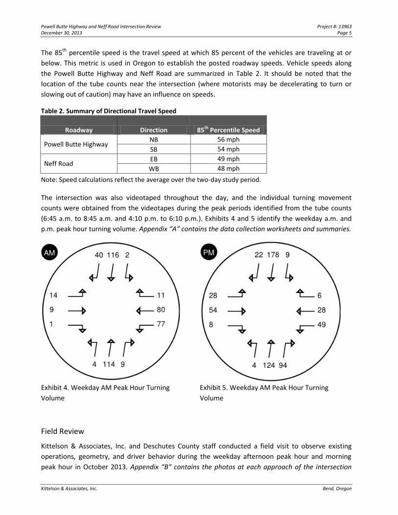
The 85th percentile speed is the travel speed at which 85 percent of the vehicles are traveling at or
below. This metric is used in Oregon to establish the posted roadway speeds. Vehicle speeds along
the Powell Butte Highway and Neff Road are summarized in Table 2. It should be noted that the
location of the tube counts near the intersection (where motorists may be decelerating to turn or
slowing out of caution) may have an influence on speeds.
Table 2. Summary of Directional Travel Speed
Roadway Direction 85th Percentile Speed
Powell Butte Highway NB 56 mph
SB 54 mph
Neff Road EB 49 mph
WB 48 mph
Note: Speed calculations reflect the average over the two-day study period.
The intersection was also videotaped throughout the day, and the individual turning movement
counts were obtained from the videotapes during the peak periods identified from the tube counts
(6:45 a.m. to 8:45 a.m. and 4:10 p.m. to 6:10 p.m.). Exhibits 4 and 5 identify the weekday a.m. and
p.m. peak hour turning volume. Appendix “A” contains the data collection worksheets and summaries.
Exhibit 4. Weekday AM Peak Hour Turning
Volume
Exhibit 5. Weekday AM Peak Hour Turning
Volume
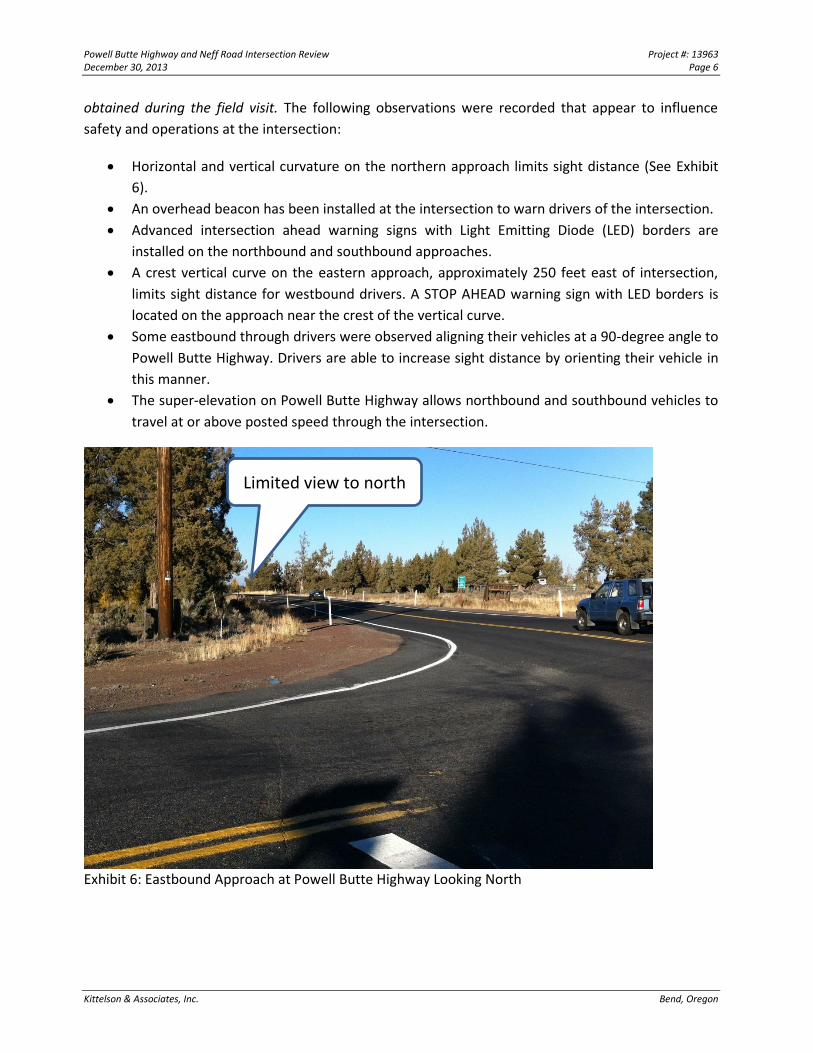
Field Review
Kittelson & Associates, Inc. and Deschutes County staff conducted a field visit to observe existing
operations, geometry, and driver behavior during the weekday afternoon peak hour and morning
peak hour in October 2013. Appendix “B” contains the photos at each approach of the intersection
Powell Butte Highway and Neff Road Intersection Review Project #: 13963 December 30, 2013 Page 6
Kittelson & Associates, Inc. Bend, Oregon
obtained during the field visit. The following observations were recorded that appear to influence
safety and operations at the intersection:
Horizontal and vertical curvature on the northern approach limits sight distance (See Exhibit
6).
An overhead beacon has been installed at the intersection to warn drivers of the intersection.
Advanced intersection ahead warning signs with Light Emitting Diode (LED) borders are
installed on the northbound and southbound approaches.
A crest vertical curve on the eastern approach, approximately 250 feet east of intersection,
limits sight distance for westbound drivers. A STOP AHEAD warning sign with LED borders is
located on the approach near the crest of the vertical curve.
Some eastbound through drivers were observed aligning their vehicles at a 90-degree angle to
Powell Butte Highway. Drivers are able to increase sight distance by orienting their vehicle in
this manner.
The super-elevation on Powell Butte Highway allows northbound and southbound vehicles to
travel at or above posted speed through the intersection.
Exhibit 6: Eastbound Approach at Powell Butte Highway Looking North
Limited view to north
Powell Butte Highway and Neff Road Intersection Review Project #: 13963 December 30, 2013 Page 7
Kittelson & Associates, Inc. Bend, Oregon
Sight Distance Review
A Policy on Geometric Design of Highways and Streets, 6th Edition, published by the American
Association of State Highway Transportation Officials (AASHTO), provides guidance on minimum sight
distance. A comparison of the AASHTO-computed intersection sight distance (ISD), AASHTO stopping
sight distance (SSD), and available sight distance for vehicles on the stop-controlled eastbound and
westbound approaches is summarized in Table 3. The values in the table are based on the posted
speed.
Table 3. AASHTO Intersection Sight Distance Review
Vehicle Movement
Design Speed for Passenger
Vehicle
AASHTO Stopping
Sight Distance1
AASHTO Intersection
Sight Distance2
Available Intersection
Sight Distance Adequate?
Eastbound Left-Turn
55 mph 495 ft
610 ft 600 ft No
Eastbound Right-Turn/Crossing
530 ft 550 ft Marginal
Westbound Left-Turn
610 ft 650 ft Marginal
Westbound Right-turn/Crossing
530 ft 630 ft Yes
Northbound Left-turn
445 ft 560 ft Yes
Southbound left-turn
445 ft 600 ft Yes
1 Based on AASHTO (6th Edition) Table 3-1, Stopping Sight Distance on Level Roadways. 2 Based on AASHTO (6th Edition) Table 9-6, Table 9-8, and Table 9-14.
As indicated in Table 3, available sight distance to the north exceeds the AASHTO-computed ISD by
approximately 20 feet for the eastbound right-turn/crossing movement. Available sight distance to
the south for the eastbound left-turn is 10-feet less than the AASHTO-computed ISD. When a vehicle
on Powell Butte Highway exceeds the posted speed, or a truck is turning or crossing at the
intersection, the available sight distance will not be adequate.
AASHTO-computed SSD is provided for all movements, indicating a vehicle on the uncontrolled
approach could stop if they see a vehicle turning or crossing in front of them at least 495 feet in
advance of the intersection. This assumes that drivers with the right-of-way adequately perceive the
conflict and begin braking within the two-second period considered typical.
Powell Butte Highway and Neff Road Intersection Review Project #: 13963 December 30, 2013 Page 8
Kittelson & Associates, Inc. Bend, Oregon
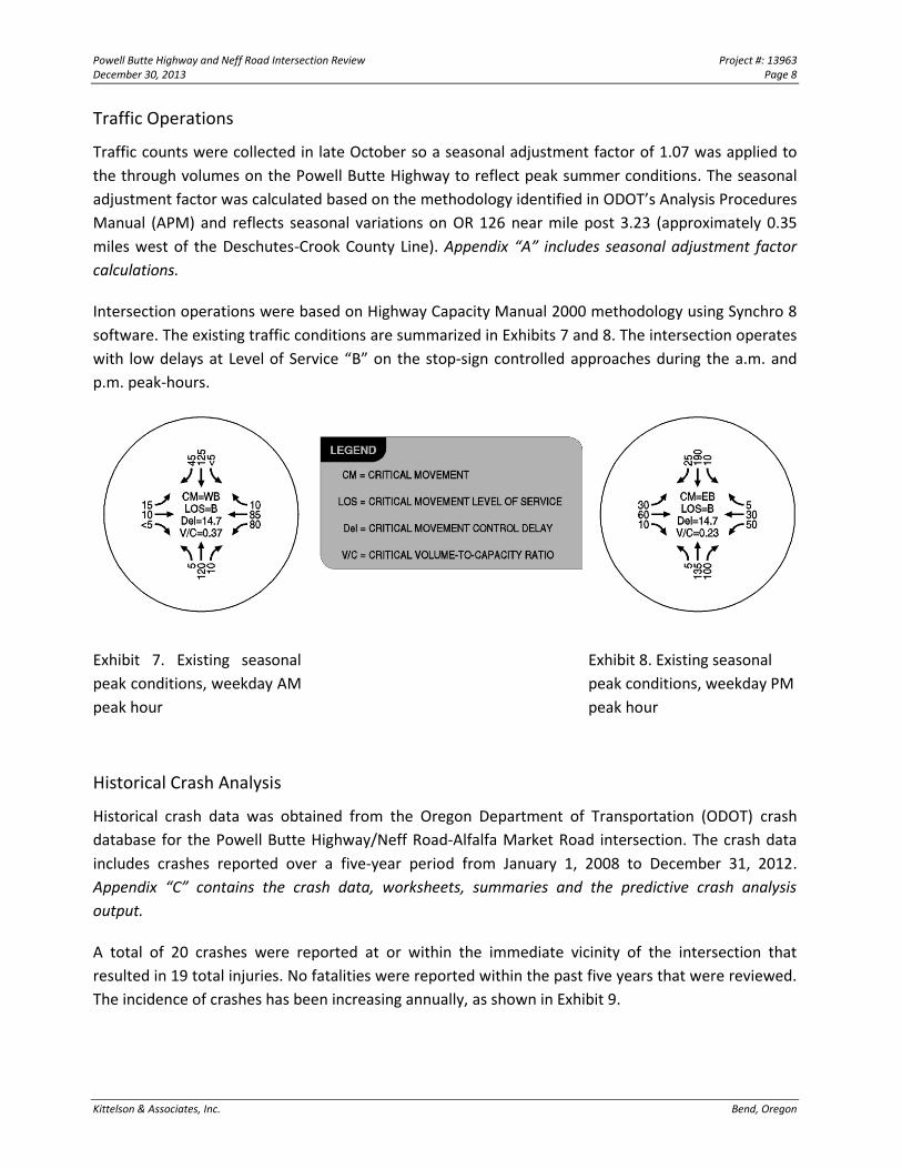
Traffic Operations
Traffic counts were collected in late October so a seasonal adjustment factor of 1.07 was applied to
the through volumes on the Powell Butte Highway to reflect peak summer conditions. The seasonal
adjustment factor was calculated based on the methodology identified in ODOT’s Analysis Procedures
Manual (APM) and reflects seasonal variations on OR 126 near mile post 3.23 (approximately 0.35
miles west of the Deschutes-Crook County Line). Appendix “A” includes seasonal adjustment factor
calculations.
Intersection operations were based on Highway Capacity Manual 2000 methodology using Synchro 8
software. The existing traffic conditions are summarized in Exhibits 7 and 8. The intersection operates
with low delays at Level of Service “B” on the stop-sign controlled approaches during the a.m. and
p.m. peak-hours.
Exhibit 7. Existing seasonal
peak conditions, weekday AM
peak hour
Exhibit 8. Existing seasonal
peak conditions, weekday PM
peak hour
Historical Crash Analysis
Historical crash data was obtained from the Oregon Department of Transportation (ODOT) crash
database for the Powell Butte Highway/Neff Road-Alfalfa Market Road intersection. The crash data
includes crashes reported over a five-year period from January 1, 2008 to December 31, 2012.
Appendix “C” contains the crash data, worksheets, summaries and the predictive crash analysis
output.
A total of 20 crashes were reported at or within the immediate vicinity of the intersection that
resulted in 19 total injuries. No fatalities were reported within the past five years that were reviewed.
The incidence of crashes has been increasing annually, as shown in Exhibit 9.
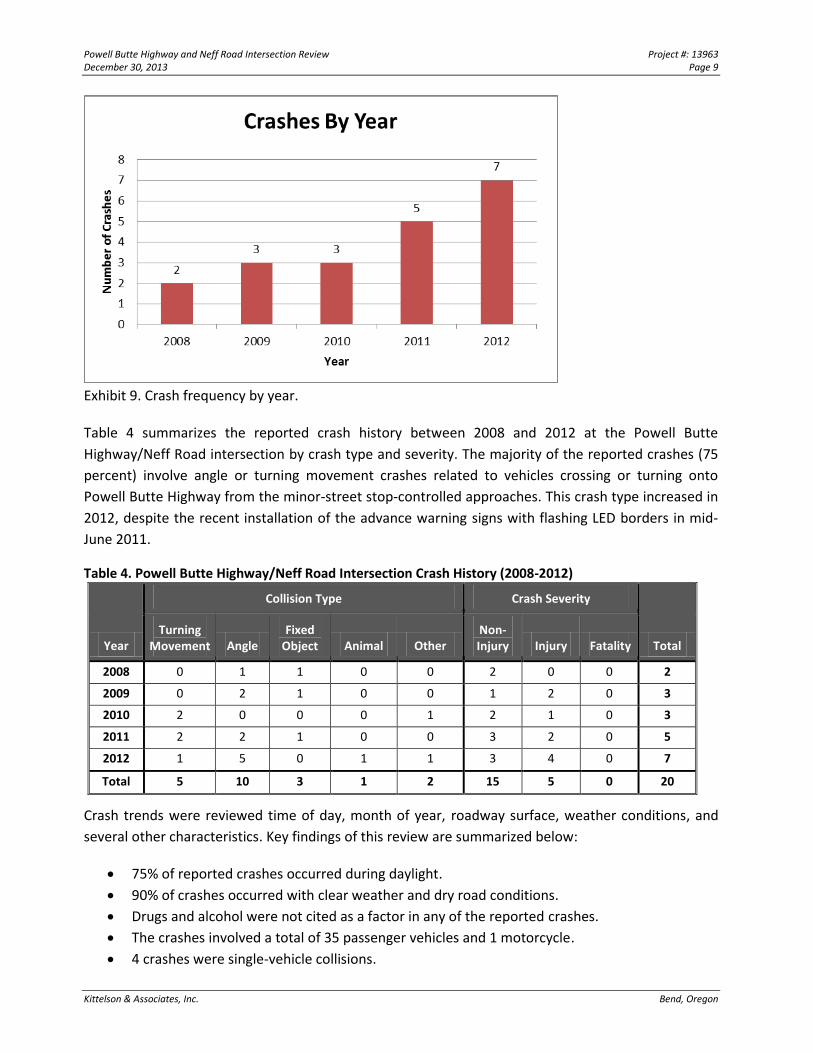
Powell Butte Highway and Neff Road Intersection Review Project #: 13963 December 30, 2013 Page 9
Kittelson & Associates, Inc. Bend, Oregon
Exhibit 9. Crash frequency by year.
Table 4 summarizes the reported crash history between 2008 and 2012 at the Powell Butte
Highway/Neff Road intersection by crash type and severity. The majority of the reported crashes (75
percent) involve angle or turning movement crashes related to vehicles crossing or turning onto
Powell Butte Highway from the minor-street stop-controlled approaches. This crash type increased in
2012, despite the recent installation of the advance warning signs with flashing LED borders in mid-
June 2011.
Table 4. Powell Butte Highway/Neff Road Intersection Crash History (2008-2012)
Year
Collision Type Crash Severity
Total Turning
Movement Angle Fixed
Object Animal Other Non-Injury Injury Fatality
2008 0 1 1 0 0 2 0 0 2
2009 0 2 1 0 0 1 2 0 3
2010 2 0 0 0 1 2 1 0 3
2011 2 2 1 0 0 3 2 0 5
2012 1 5 0 1 1 3 4 0 7
Total 5 10 3 1 2 15 5 0 20
Crash trends were reviewed time of day, month of year, roadway surface, weather conditions, and
several other characteristics. Key findings of this review are summarized below:
75% of reported crashes occurred during daylight.
90% of crashes occurred with clear weather and dry road conditions.
Drugs and alcohol were not cited as a factor in any of the reported crashes.
The crashes involved a total of 35 passenger vehicles and 1 motorcycle.
4 crashes were single-vehicle collisions.
Powell Butte Highway and Neff Road Intersection Review Project #: 13963 December 30, 2013 Page 10
Kittelson & Associates, Inc. Bend, Oregon
All 36 involved drivers had a valid license, and 30 were within 25 miles of their residence.
Teenagers were at fault in all 5 collisions they were involved in.
Beyond these trends, crash records state the crash causes were largely attributed to failure to yield
right-of-way or failure to stop (cited in 14 of the 20 crashes). Excessive speed was cited as a
contributing factor in only two of the crashes.
Prior to 2008, a fatal crash occurred at the study intersection, but data was not available to review
crash details.
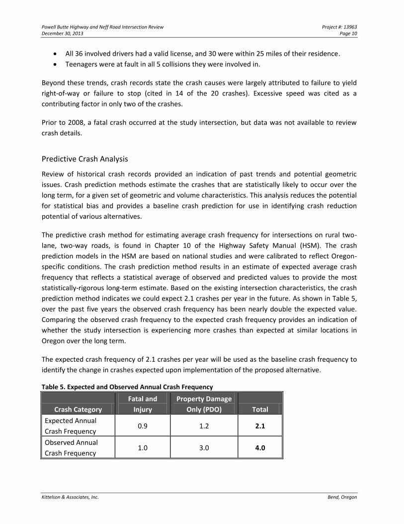
Predictive Crash Analysis
Review of historical crash records provided an indication of past trends and potential geometric
issues. Crash prediction methods estimate the crashes that are statistically likely to occur over the
long term, for a given set of geometric and volume characteristics. This analysis reduces the potential
for statistical bias and provides a baseline crash prediction for use in identifying crash reduction
potential of various alternatives.
The predictive crash method for estimating average crash frequency for intersections on rural two-
lane, two-way roads, is found in Chapter 10 of the Highway Safety Manual (HSM). The crash
prediction models in the HSM are based on national studies and were calibrated to reflect Oregon-
specific conditions. The crash prediction method results in an estimate of expected average crash
frequency that reflects a statistical average of observed and predicted values to provide the most
statistically-rigorous long-term estimate. Based on the existing intersection characteristics, the crash
prediction method indicates we could expect 2.1 crashes per year in the future. As shown in Table 5,
over the past five years the observed crash frequency has been nearly double the expected value.
Comparing the observed crash frequency to the expected crash frequency provides an indication of
whether the study intersection is experiencing more crashes than expected at similar locations in
Oregon over the long term.
The expected crash frequency of 2.1 crashes per year will be used as the baseline crash frequency to
identify the change in crashes expected upon implementation of the proposed alternative.
Table 5. Expected and Observed Annual Crash Frequency
Crash Category
Fatal and
Injury
Property Damage
Only (PDO) Total
Expected Annual
Crash Frequency 0.9 1.2 2.1
Observed Annual
Crash Frequency 1.0 3.0 4.0
Powell Butte Highway and Neff Road Intersection Review Project #: 13963 December 30, 2013 Page 11
Kittelson & Associates, Inc. Bend, Oregon
Summary of Intersection Needs
Based on this review of the intersection, improvements to the Powell Butte Highway intersection with
Neff Road should be focused primarily on safety. Improvement alternatives should consider changes
to the intersection geometry that improve driver awareness and visibility of oncoming vehicles, and
that can reduce both the number and severity of crashes.
INTERSECTION ALTERNATIVES
Based on the identified intersection needs, four intersection improvement alternatives were
developed. These improvements considered how the existing intersection control could be retained
with improved geometrics, or other types of control that would improve safety while still meeting the
long-term capacity needs. The following section summarizes the development and preliminary
evaluations of these alternatives based on future operations, safety, right-of-way impacts, and
construction costs.
Conceptual Design Development
Four intersection concepts were developed to reduce angle and turning crashes reported over the
study period and increase sight distance. Appendix “D” contains the conceptual designs for each of
the intersection alternatives. The concepts include various traffic control alternatives that consider
signalization, stop-control, or construction of a roundabout. Each of these alternatives would require
extensive treatments along the intersection approaches to further alert drivers of the intersection.
These approach treatments could consider cross-sectional changes, improvements to sight distance,
illumination, advance signing and striping, and a variety of treatments to increase driver awareness
and manage approach speeds. These treatments would extend approximately 500 or 600 feet from
the intersection to allow motorists on the Powell Butte Highway to react to vehicles entering or
exiting the highway.
For this preliminary evaluation the concepts were developed in pencil sketch format over scaled
aerial imagery. These concepts represent reasonable dimensions and general right-of-way impacts to
appropriately assess the magnitude of impact from the layout. This high-level analysis provides a cost-
effective method of assessing treatment feasibility.
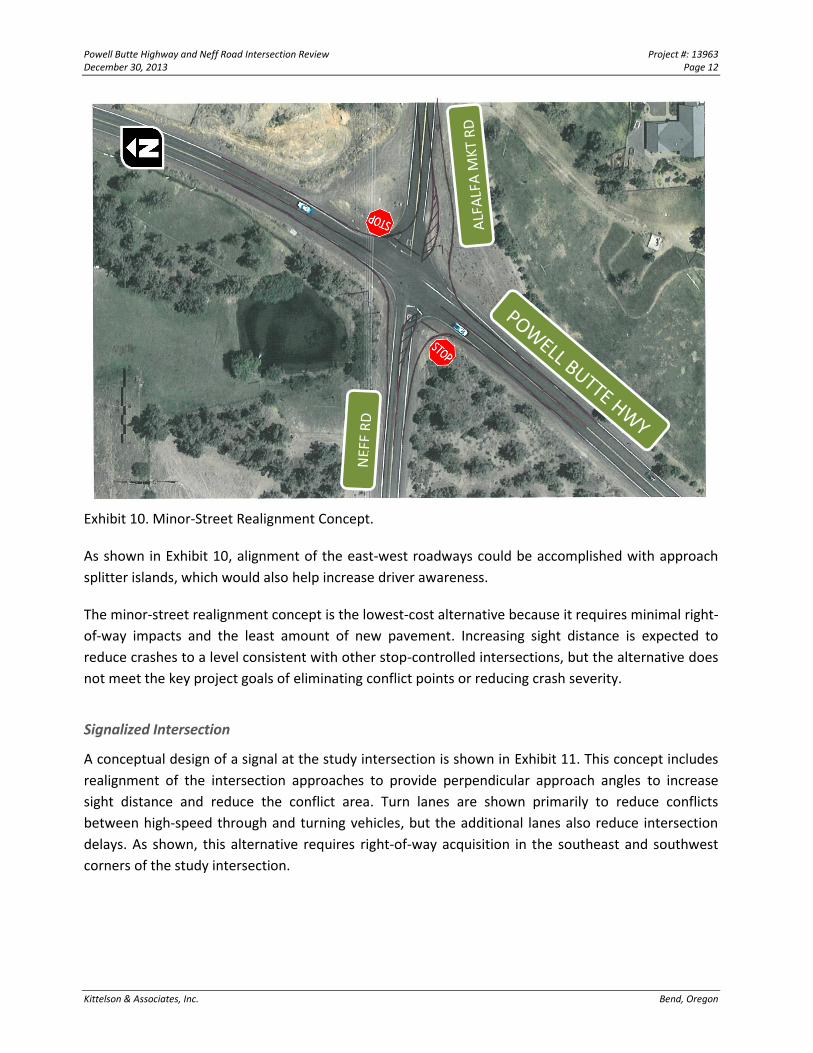
Minor-Street Realignment with Two-way Stop Control
Exhibit 10 illustrates the Realignment concept. Realignment of the Neff and Alfalfa Market
approaches to reduce the skew angle in combination with clearing vegetation will increase sight
distance and maintain free-flow movements for traffic on the Powell Butte Highway.
Powell Butte Highway and Neff Road Intersection Review Project #: 13963 December 30, 2013 Page 12
Kittelson & Associates, Inc. Bend, Oregon
Exhibit 10. Minor-Street Realignment Concept.
As shown in Exhibit 10, alignment of the east-west roadways could be accomplished with approach
splitter islands, which would also help increase driver awareness.
The minor-street realignment concept is the lowest-cost alternative because it requires minimal right-
of-way impacts and the least amount of new pavement. Increasing sight distance is expected to
reduce crashes to a level consistent with other stop-controlled intersections, but the alternative does
not meet the key project goals of eliminating conflict points or reducing crash severity.
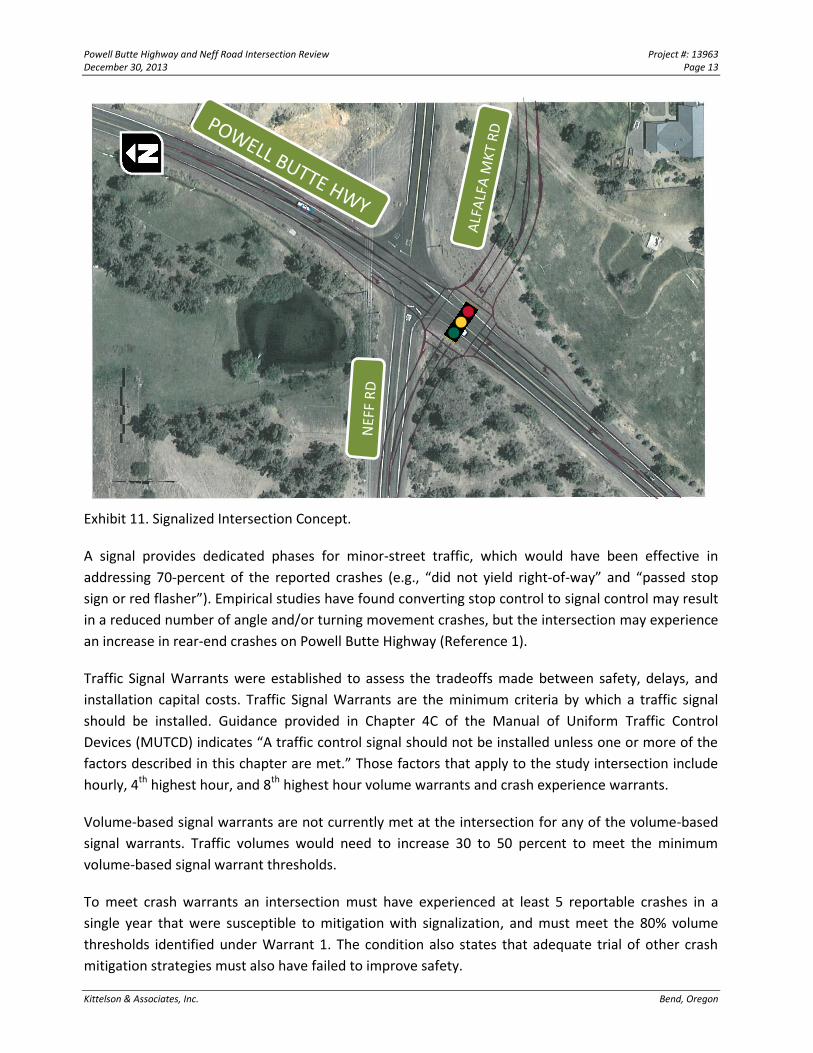
Signalized Intersection
A conceptual design of a signal at the study intersection is shown in Exhibit 11. This concept includes
realignment of the intersection approaches to provide perpendicular approach angles to increase
sight distance and reduce the conflict area. Turn lanes are shown primarily to reduce conflicts
between high-speed through and turning vehicles, but the additional lanes also reduce intersection
delays. As shown, this alternative requires right-of-way acquisition in the southeast and southwest
corners of the study intersection.
Powell Butte Highway and Neff Road Intersection Review Project #: 13963 December 30, 2013 Page 13
Kittelson & Associates, Inc. Bend, Oregon
Exhibit 11. Signalized Intersection Concept.
A signal provides dedicated phases for minor-street traffic, which would have been effective in
addressing 70-percent of the reported crashes (e.g., “did not yield right-of-way” and “passed stop
sign or red flasher”). Empirical studies have found converting stop control to signal control may result
in a reduced number of angle and/or turning movement crashes, but the intersection may experience
an increase in rear-end crashes on Powell Butte Highway (Reference 1).
Traffic Signal Warrants were established to assess the tradeoffs made between safety, delays, and
installation capital costs. Traffic Signal Warrants are the minimum criteria by which a traffic signal
should be installed. Guidance provided in Chapter 4C of the Manual of Uniform Traffic Control
Devices (MUTCD) indicates “A traffic control signal should not be installed unless one or more of the
factors described in this chapter are met.” Those factors that apply to the study intersection include
hourly, 4th highest hour, and 8th highest hour volume warrants and crash experience warrants.
Volume-based signal warrants are not currently met at the intersection for any of the volume-based
signal warrants. Traffic volumes would need to increase 30 to 50 percent to meet the minimum
volume-based signal warrant thresholds.
To meet crash warrants an intersection must have experienced at least 5 reportable crashes in a
single year that were susceptible to mitigation with signalization, and must meet the 80% volume
thresholds identified under Warrant 1. The condition also states that adequate trial of other crash
mitigation strategies must also have failed to improve safety.
Powell Butte Highway and Neff Road Intersection Review Project #: 13963 December 30, 2013 Page 14
Kittelson & Associates, Inc. Bend, Oregon
To date, the County has incorporated advanced warning signs with LED borders and previously
installed an overhead flashing beacon. Despite these measures, the crashes have continued to
increase annually. There has been five reported crashes in a 12-month period susceptible to
mitigation with a traffic signal, but the 80% traffic volume thresholds are not met. As such, minimum
thresholds for the volume and crash experience signal warrants are not currently met, and are
unlikely to be met for several years.
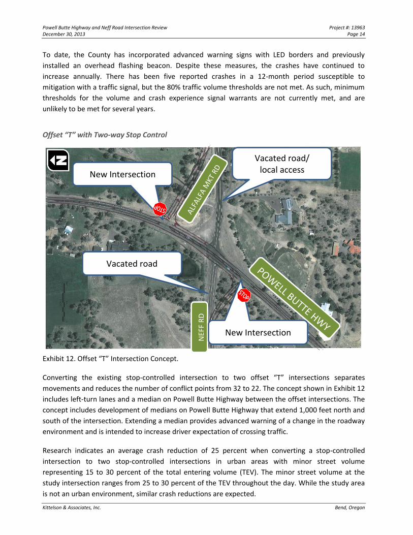
Offset “T” with Two-way Stop Control
Exhibit 12. Offset “T” Intersection Concept.
Converting the existing stop-controlled intersection to two offset “T” intersections separates
movements and reduces the number of conflict points from 32 to 22. The concept shown in Exhibit 12
includes left-turn lanes and a median on Powell Butte Highway between the offset intersections. The
concept includes development of medians on Powell Butte Highway that extend 1,000 feet north and
south of the intersection. Extending a median provides advanced warning of a change in the roadway
environment and is intended to increase driver expectation of crossing traffic.
Research indicates an average crash reduction of 25 percent when converting a stop-controlled
intersection to two stop-controlled intersections in urban areas with minor street volume
representing 15 to 30 percent of the total entering volume (TEV). The minor street volume at the
study intersection ranges from 25 to 30 percent of the TEV throughout the day. While the study area
is not an urban environment, similar crash reductions are expected.
Vacated road/ local access
Vacated road
NEF
F R
D
New Intersection
New Intersection
Powell Butte Highway and Neff Road Intersection Review Project #: 13963 December 30, 2013 Page 15
Kittelson & Associates, Inc. Bend, Oregon
The concept in Exhibit 12 includes an offset of 500 feet between the offset T-intersections, consistent
with County design practice. Options to reduce this offset distance may be possible to minimize right-
of-way impacts. While construction costs and ROW acquisition will be more costly than realigning the
minor-street approaches, the safety and operational benefits are expected to be greater. However,
while this concept could reduce the frequency of crashes, it is unlikely that it would reduce the
severity of the crashes that occur.
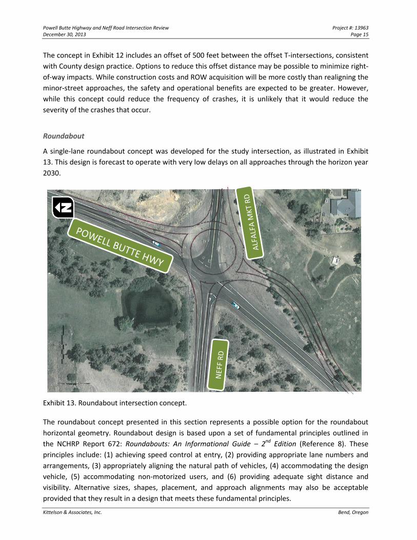
Roundabout
A single-lane roundabout concept was developed for the study intersection, as illustrated in Exhibit
13. This design is forecast to operate with very low delays on all approaches through the horizon year
2030.
Exhibit 13. Roundabout intersection concept.
The roundabout concept presented in this section represents a possible option for the roundabout
horizontal geometry. Roundabout design is based upon a set of fundamental principles outlined in
the NCHRP Report 672: Roundabouts: An Informational Guide – 2nd Edition (Reference 8). These
principles include: (1) achieving speed control at entry, (2) providing appropriate lane numbers and
arrangements, (3) appropriately aligning the natural path of vehicles, (4) accommodating the design
vehicle, (5) accommodating non-motorized users, and (6) providing adequate sight distance and
visibility. Alternative sizes, shapes, placement, and approach alignments may also be acceptable
provided that they result in a design that meets these fundamental principles.
Powell Butte Highway and Neff Road Intersection Review Project #: 13963 December 30, 2013 Page 16
Kittelson & Associates, Inc. Bend, Oregon
To lessen right-of-way and irrigation pond impacts in the NW quadrant, the center of the roundabout
is shown shifted to the south and east. The roundabout could be centered to the south and west to
reduce property impacts in the SE quadrant and the irrigation pond. The inscribed circle diameter, as
shown, is 160 feet. The diameter will need to be optimized to reduce right-of-way impacts while
providing for truck traffic.
The roundabout maintains all turning movements while minimizing the number of conflict points. The
reduction in speeds on the approaches and removal of higher-severity head-on and angle crashes also
reduces the crash severity. Therefore, it is expected to provide the greatest safety benefits relative to
other alternatives. The construction cost of a roundabout will vary based on the diameter of the
roundabout and the extent of the approach treatments, and is expected to be similar in costs to the
offset “T” intersections.
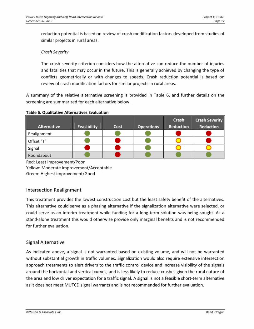
QUALITATIVE ALTERNATIVES EVALUATION
The identified alternatives were screened based on their ability to address the project needs and
overall feasibility. A summary of the screening criteria is shown below.
Feasibility
This criterion considers whether the alternative is appropriate in the setting (such as in
meeting applicable installation requirements such as signal warrants), and whether the
alternative can be constructed without impacting significant utilities, homes, or land features.
Cost
Refined cost estimates have not been prepared for any of the alternatives as part of the
qualitative screening, and costs are based only on the relative overall cost to construct the
alternative considering right-of-way, pavement, and hardware.
Operations
Traffic operations considers whether the alternative can adequately serve the forecast year
2030 design traffic based on Deschutes County level of service thresholds. Operations were
assessed for each alternative during the critical weekday a.m. and p.m. peak hour to inform
this initial screening. Appendix “E” contains the traffic operation output for each of the future
alternative scenarios.
Crash Reduction
A key project need is to reduce the total number of annual crashes that occur at the
intersection, without regard to the severity. This criterion is intended to address the
escalating crash experience identified through review of the reported crash history. Crash
Powell Butte Highway and Neff Road Intersection Review Project #: 13963 December 30, 2013 Page 17
Kittelson & Associates, Inc. Bend, Oregon
reduction potential is based on review of crash modification factors developed from studies of
similar projects in rural areas.
Crash Severity
The crash severity criterion considers how the alternative can reduce the number of injuries
and fatalities that may occur in the future. This is generally achieved by changing the type of
conflicts geometrically or with changes to speeds. Crash reduction potential is based on
review of crash modification factors for similar projects in rural areas.
A summary of the relative alternative screening is provided in Table 6, and further details on the
screening are summarized for each alternative below.
Table 6. Qualitative Alternatives Evaluation
Alternative Feasibility Cost Operations
Crash
Reduction
Crash Severity
Reduction
Realignment
Offset “T”
Signal
Roundabout
Red: Least improvement/Poor Yellow: Moderate improvement/Acceptable Green: Highest improvement/Good
Intersection Realignment
This treatment provides the lowest construction cost but the least safety benefit of the alternatives.
This alternative could serve as a phasing alternative if the signalization alternative were selected, or
could serve as an interim treatment while funding for a long-term solution was being sought. As a
stand-alone treatment this would otherwise provide only marginal benefits and is not recommended
for further evaluation.
Signal Alternative
As indicated above, a signal is not warranted based on existing volume, and will not be warranted
without substantial growth in traffic volumes. Signalization would also require extensive intersection
approach treatments to alert drivers to the traffic control device and increase visibility of the signals
around the horizontal and vertical curves, and is less likely to reduce crashes given the rural nature of
the area and low driver expectation for a traffic signal. A signal is not a feasible short-term alternative
as it does not meet MUTCD signal warrants and is not recommended for further evaluation.
Powell Butte Highway and Neff Road Intersection Review Project #: 13963 December 30, 2013 Page 18
Kittelson & Associates, Inc. Bend, Oregon
Offset “T” with Two-way Stop Control
Maintaining stop control while reconfiguring the intersection into two offset “T” intersections is
expected to reduce crashes by reducing conflict points, increasing sight distance, and providing left-
turn lanes on Powell Butte Highway approaches. The disadvantage of this option is that the crashes
that do occur are likely to be higher-severity angle crashes.
While construction costs will be high due to the new pavement and right-of-way impacts, the
potential crash reduction is also high and free-flow is maintained for traffic on the Powell Butte
Highway. Without higher levels of traffic control (such as a roundabout or traffic signal) this
alternative would operate very low delays through the horizon period. As costs are likely to be similar
to the roundabout with lower reductions in crash frequency and severity this alternative is not
recommended for further evaluation.
Roundabout Alternative
The roundabout is expected to have the greatest crash reduction potential of the alternatives based
on empirical studies conducted in rural high-speed environments. The roundabout reduces the
number of conflict points, changes the conflict type to lower-severity sideswipe collisions, and further
reduces crash severity by reducing speeds at the conflict points. Roundabout construction costs,
right-of-way impacts, and operations will be of a similar magnitude to the Offset “T” alternative.
NEXT STEPS
Please review this interim memorandum at provide us with any comments or questions on our
interim findings and recommendations. As the roundabout is the only alternative we would
recommend the County continue to pursue, next steps would include further details on the
intersection approach treatments, design vehicle details, review of right-of-way, and expected
construction costs. This information will be amended to this interim report, forming the final report
for this evaluation.
APPENDICES
Appendix A: Data Collection Worksheets
Appendix B: Photo Records of Intersection
Appendix C: Intersection Crash Records and Summaries
Appendix D: Alternatives Concepts
Appendix E: Operational Analysis Worksheets