policies to permits: applying the state slr guidance to bcdc
TRANSCRIPT

FromPoliciestoPermits: ApplyingtheStateSeaLevelRiseGuidancetoBCDC’sPolicies, RegulaBons, andPermits.
PoliciestoPermits:ApplyingtheStateSLR GuidancetoBCDC 1
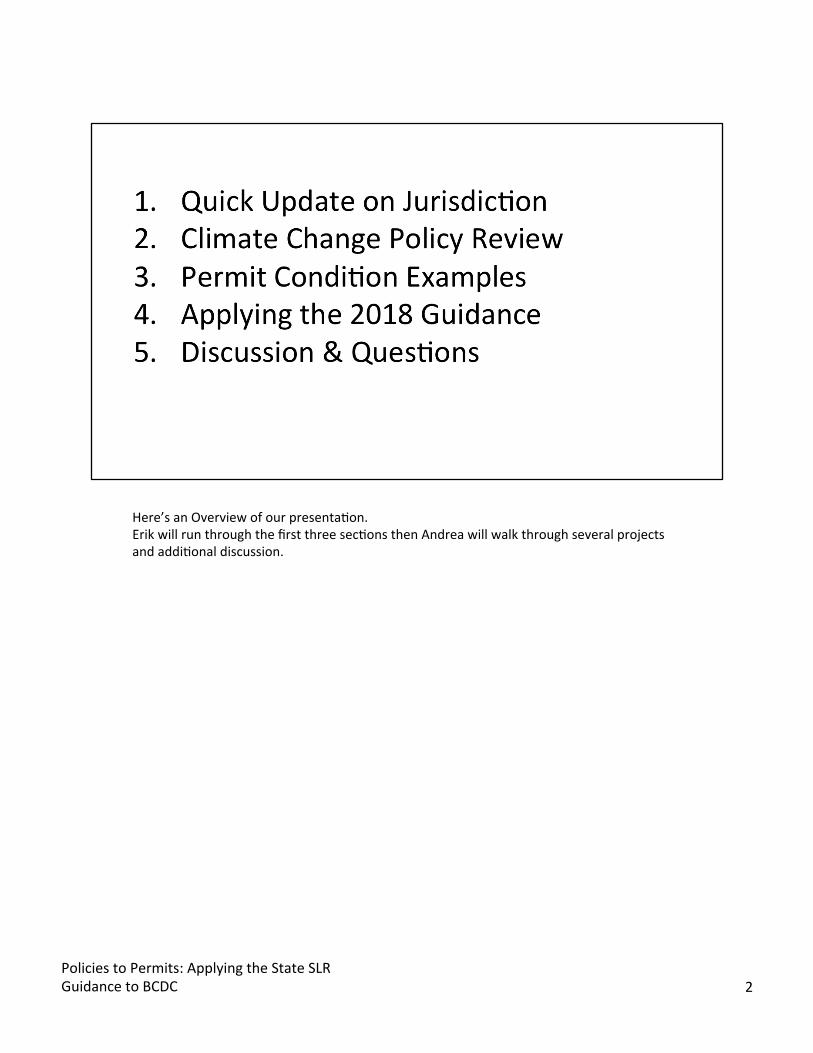
Here’s an Overview of our presentaBon. Erik will run through the first three secBons then Andrea will walk through several projects and addiBonal discussion.
Policies to Permits: Applying the State SLR Guidance to BCDC 2
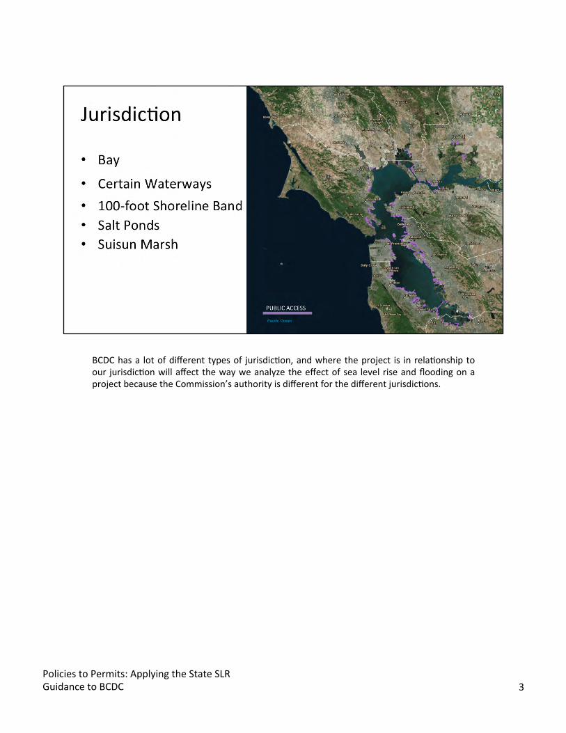
BCDC has a lot of different types of jurisdicBon, and where the project is in relaBonship to our jurisdicBon will affect the way we analyze the effect of sea level rise and flooding on a project because the Commission’s authority is different for the different jurisdicBons.
Policies to Permits: Applying the State SLR Guidance to BCDC 3
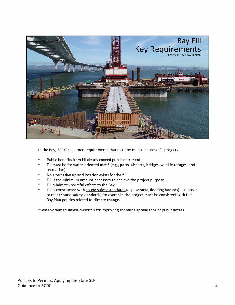
In the Bay, BCDC has broad requirements that must be met to approve fill projects.
• Public benefits from fill clearly exceed public detriment • Fill must be for water-oriented uses* (e.g., ports, airports, bridges, wildlife refuges, and
recreaBon) • No alternaBve upland locaBon exists for the fill • Fill is the minimum amount necessary to achieve the project purpose • Fill minimizes harmful effects to the Bay • Fill is constructed with sound safety standards (e.g., seismic, flooding hazards) – In order
to meet sound safety standards, for example, the project must be consistent with the Bay Plan policies related to climate change.
*Water-oriented unless minor fill for improving shoreline appearance or public access
Policies to Permits: Applying the State SLR Guidance to BCDC 4

BCDC’s authority is much more limited in the 100-foot shoreline band. The only reason BCDC can deny a project in the 100-foot shoreline band is if the development fails to provide Maximum Feasible Public Access consistent with the project.
EXTRA NOTES Priority Use Areas are areas set aside by the San Francisco Bay Plan for certain water-oriented uses, such as a public park near Crissy Field and the Presidio, or for a port uses, such as the dry-dock at Pier 70. No general land-use authority – except in a Priority Use Area.
Policies to Permits: Applying the State SLR Guidance to BCDC 5

The climate change policies were adopted to the Bay Plan in 2011. We’ll take a couple minutes to elaborate on a few of these policies.
POLICY 2: Larger Shoreline Projects need a risk assessment conducted by a qualified engineer Larger shoreline project not defined, BCDC makes an assessment on a case-by-case basis. Risk Assessments should:
o Use current 100-year base flood elevaBon that includes a “best esBmate of future sea level rise”
o Use “best scienBfic data” for mid-century and end of century sea level rise projecBons. (We consider the best scienBfic data to be the State Guidance).
o Include current and planned flood protecBon o Depict all types of flooding, degrees of uncertainty, consequences of defense
failure, and risks to habitat from proposed flood protecBon devices
Policies to Permits: Applying the State SLR Guidance to BCDC 6
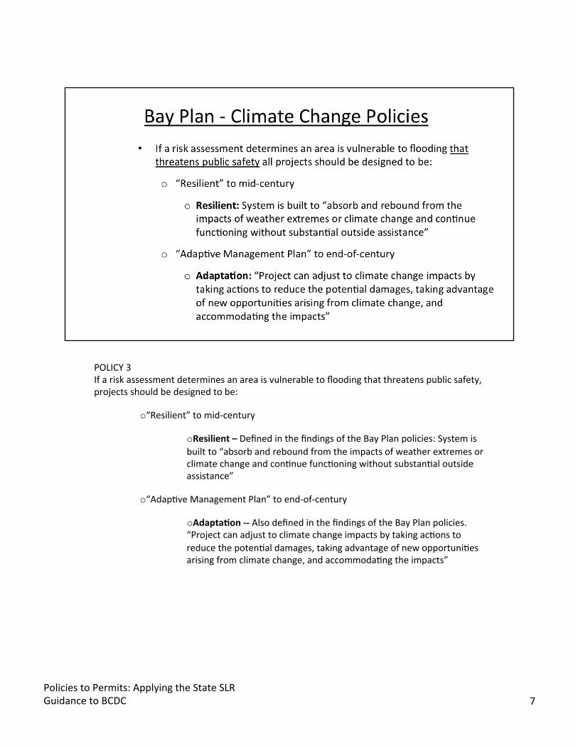
POLICY 3 If a risk assessment determines an area is vulnerable to flooding that threatens public safety, projects should be designed to be:
o“Resilient” to mid-century
oResilient – Defined in the findings of the Bay Plan policies: System is built to “absorb and rebound from the impacts of weather extremes or climate change and conBnue funcBoning without substanBal outside assistance”
o“AdapBve Management Plan” to end-of-century
oAdapta5on -- Also defined in the findings of the Bay Plan policies. “Project can adjust to climate change impacts by taking acBons to reduce the potenBal damages, taking advantage of new opportuniBes arising from climate change, and accommodaBng the impacts”
Policies to Permits: Applying the State SLR Guidance to BCDC 7

As part of the 2011 climate change update, BCDC adopted Public Access policies related to sea level rise and flooding from storms. Public Access Policies Also worth noBng is that “whenever public access is provided as a condiBon of development, the access should be permanently guaranteed. Public access must be located, designed and managed to avoid flood impacts Any public access provided as a condiBon of development within the shoreline band should:
o Either remain viable in the event of future sea level rise or flooding o Or equivalent access consistent with the project should be provided nearby
o How we apply these policies will depend on the Commission’s underlying authority. For a larger Bay fill project, all of these policies could apply and BCDC could ensure the resiliency of the enBre project in the Bay. For a project in the shoreline band, however, BCDC is limited to ensuring that the public access is viable in the event of future sea level rise and storms. For example, if you had a residenBal development project in the Shoreline band, you could not deny a project on the basis that the development buildings would flood. Rather, BCDC would look to the public access and evaluate whether the project failed to achieve maximum feasible public access because the public access was not viable to flood risks or was not safe because of the risks of flooding as defined in the policies here.
o To determine if the public access is “Viable” we look to Climate Change policy 3. Viable means the project is resilient to mid-century and adaptable if the underlying
Policies to Permits: Applying the State SLR Guidance to BCDC 8
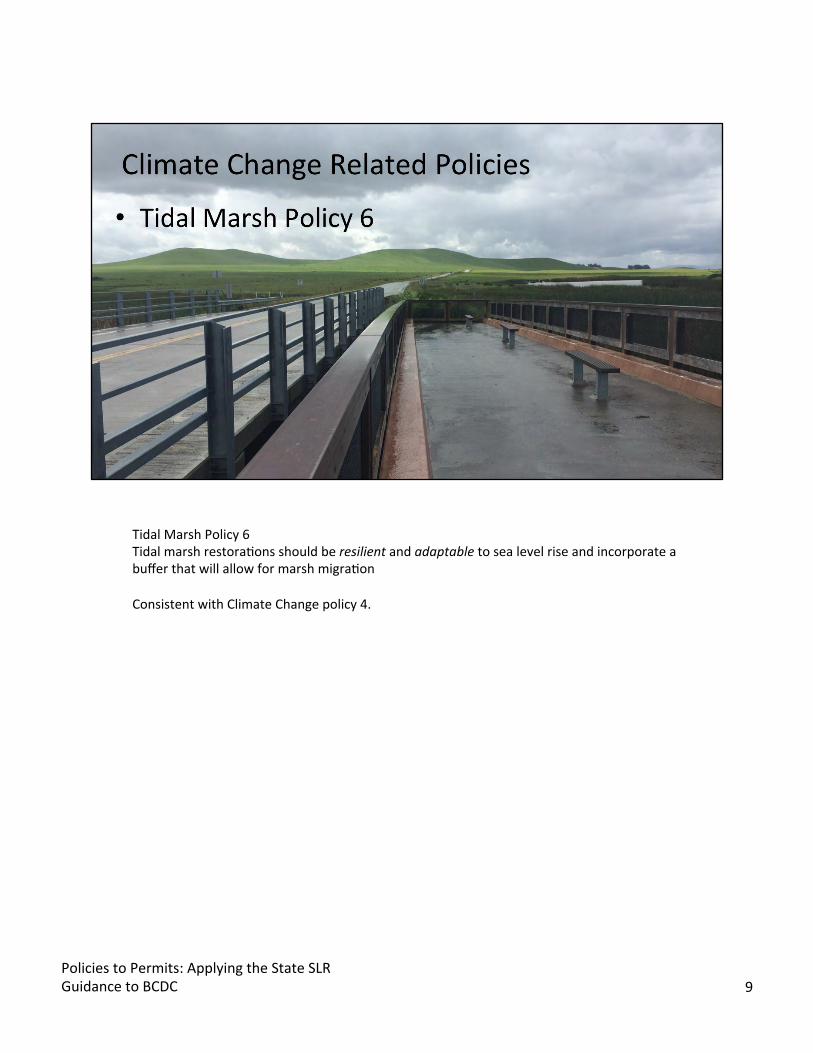
Tidal Marsh Policy 6 Tidal marsh restoraBons should be resilient and adaptable to sea level rise and incorporate a buffer that will allow for marsh migraBon
Consistent with Climate Change policy 4.
Policies to Permits: Applying the State SLR Guidance to BCDC 9
Shoreline ProtecBon Policy 1 Shoreline protecBon should be integrated with current or planned adjacent shoreline protecBon
Safety of Fills Policy 4 New projects on fill or near the shoreline should be set back or built so the bojom floor is above the 100-year flood elevaBon that takes future sea level rise into account
Obviously, this photograph isn’t showing those things.
Policies to Permits: Applying the State SLR Guidance to BCDC 10
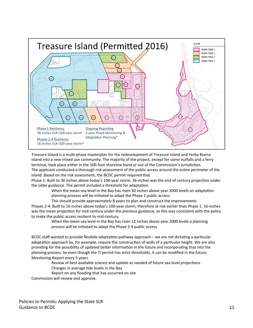
Treasure Island is a mulB-phase masterplan for the redevelopment of Treasure Island and Yerba Buena Island into a new mixed use community. The majority of the project, except for some oukalls and a ferry terminal, took place either in the 100-foot shoreline band or out of the Commission’s jurisdicBon. The applicant conducted a thorough risk assessment of the public access around the enBre perimeter of the island. Based on the risk assessment, the BCDC permit required that Phase 1: Built to 36 inches above today’s 100-year storm. 36-inches was the end of century projecBon under the older guidance. The permit included a threshold for adaptaBon.
When the mean sea level in the Bay has risen 30 inches above year 2000 levels an adaptaBon planning process will be iniBated to adapt the Phase 1 public access. This should provide approximately 8 years to plan and construct the improvements
Phases 2-4: Built to 16 inches above today’s 100-year storm, therefore at risk earlier than Phase 1. 16-inches was the mean projecBon for mid-century under the previous guidance, so this was consistent with the policy to make the public access resilient to mid-century.
When the mean sea level in the Bay has risen 12 inches above year 2000 levels a planning process will be iniBated to adapt the Phase 2-4 public access.
BCDC staff wanted to provide flexibile adaptaBon pathway approach – we are not dictaBng a parBcular adaptaBon approach by, for example, require the construcBon of walls of a parBcular height. We are also providing for the possibility of updated bejer informaBon in the future and incorporaBng that into the planning process. So even though the TI permit has strict thresholds, it can be modified in the future. Monitoring Report every 5 years
Review of best available science and update as needed of future sea level projecBons Changes in average Bde levels in the Bay Report on any flooding that has occurred on site
Commission will review and approve.
Policies to Permits: Applying the State SLR Guidance to BCDC 11
TreasureIsland is an island, so its in a unique circumstance in that it doesn’t have to worry about linking up adaptaBon approaches to neighbors. It also has a tax base that can fund ongoing monitoring. The issue with creaBng a specific threshold for adaptaBon – 16-inches above 2000 mean sea level and you start planning as in the TI example – is that you can’t just go out to a site on a given day and say, “ today is the day that sea levels have reached the threshold” this is because water levels are measured on an epoch – over 20 years, or else do sophisBcated modelling. You need to be rouBnely incorporaBng new data into your process. Not every community has the resources or the ability to do this.
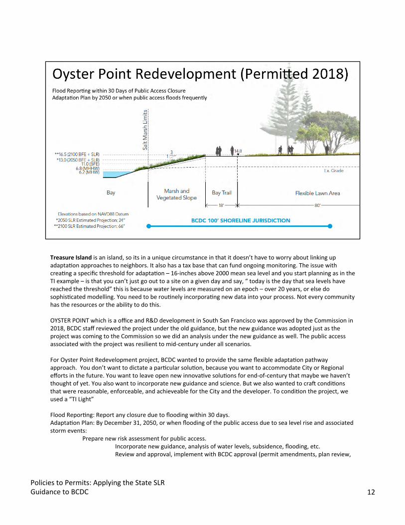
OYSTER POINT which is a office and R&D development in South San Francisco was approved by the Commission in 2018, BCDC staff reviewed the project under the old guidance, but the new guidance was adopted just as the project was coming to the Commission so we did an analysis under the new guidance as well. The public access associated with the project was resilient to mid-century under all scenarios.
For Oyster Point Redevelopment project, BCDC wanted to provide the same flexible adaptaBon pathway approach. You don’t want to dictate a parBcular soluBon, because you want to accommodate City or Regional efforts in the future. You want to leave open new innovaBve soluBons for end-of-century that maybe we haven’t thought of yet. You also want to incorporate new guidance and science. But we also wanted to cran condiBons that were reasonable, enforceable, and achieveable for the City and the developer. To condiBon the project, we used a “TI Light”
Flood ReporBng: Report any closure due to flooding within 30 days. AdaptaBon Plan: By December 31, 2050, or when flooding of the public access due to sea level rise and associated storm events:
Prepare new risk assessment for public access. Incorporate new guidance, analysis of water levels, subsidence, flooding, etc. Review and approval, implement with BCDC approval (permit amendments, plan review,
Policies to Permits: Applying the State SLR Guidance to BCDC 12
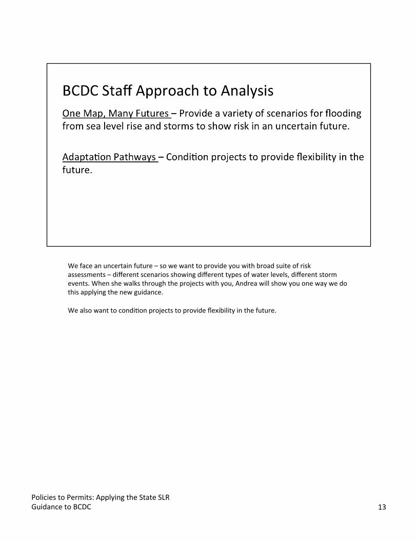
We face an uncertain future – so we want to provide you with broad suite of risk assessments – different scenarios showing different types of water levels, different storm events. When she walks through the projects with you, Andrea will show you one way we do this applying the new guidance.
We also want to condiBon projects to provide flexibility in the future.
Policies to Permits: Applying the State SLR Guidance to BCDC 13

Next we will walk through four examples that represent a significant amount of the projects we permit (outside of dredging!) Tidal Habitat RestoraBon, Shoreline ProtecBon, and Shoreline Development The updated guidance provides categories for risk aversion and guidance on how to evaluate the risk taking into consideraBon potenBal impacts and adapBve capacity. The updated guidance also provides a high and low emissions scenario for projected water levels.
Policies to Permits: Applying the State SLR Guidance to BCDC 14
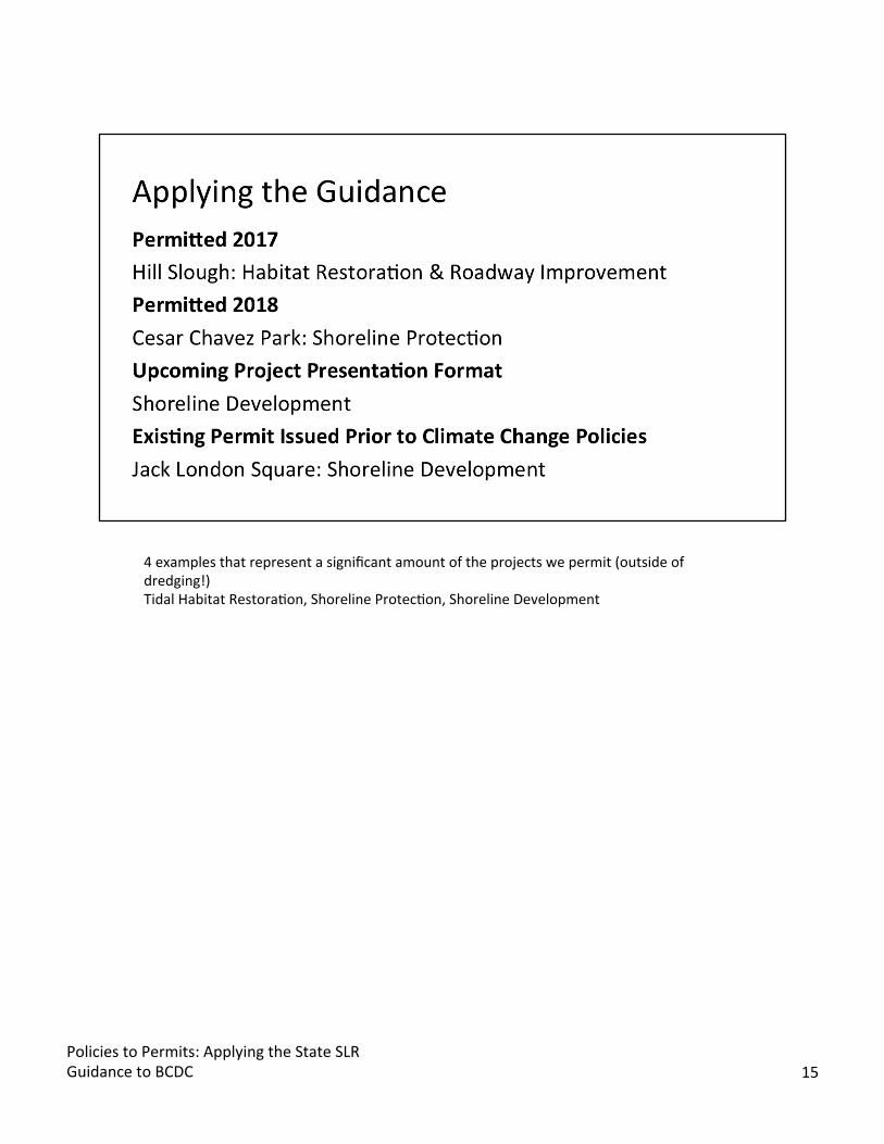
4 examples that represent a significant amount of the projects we permit (outside of dredging!) Tidal Habitat RestoraBon, Shoreline ProtecBon, Shoreline Development
Policies to Permits: Applying the State SLR Guidance to BCDC 15

We will use the following assessment steps to walk you through four example projects. As a reminder, these projects need to meet the criteria of Climate Change Policies that require a risk assessment for larger shoreline projects that must be resilient to mid-century and adaptable to end of century if the project life extends beyond mid-century.
Jenn showed already presented these steps so I’ll just reference them here and then show you how we’ve applied them through the examples. Text below provides a brief summary of OPC Guidance, similar to what Jenn presented.
STEP ONE: idenBfy the nearest Bde gauge The OPC guidance has one Bde gauge for the SF Bay Area, but we are fortunate to have a 900 point Bdal datum study conducted by AECOM in 2016 as part of the ART Bay Area program which provides a much more specific understanding of the Bdes in the region. So We use these Bdal datum points to idenBfy the closest gauge. STEP TWO: evaluate project lifespan For project lifespan definiBon, we onen rely on the project proponents to provide this informaBon, but a good definiBon of project lifespan is onen longer than the life of a structure or a porBon of a project. We want to know if the project is going to be in place at mid-century and end of century. If not expected to last through the end of century then we analyze to the end of the project life beyond mid-century. STEP THREE: Once we know Bde gauge locaBon and life span, we us the OPC sea level rise table to idenBfy a range of SLR projecBons. STEP FOUR: We evaluate the potenBal impacts and adapBve capacity across a range of sea level rise projecBons and emissions scenarios. And in STEP FIVE: We select a sea level rise projecBon based on risk tolerance that is consistent with our laws and policies on
Policies to Permits: Applying the State SLRGuidance to BCDC 16
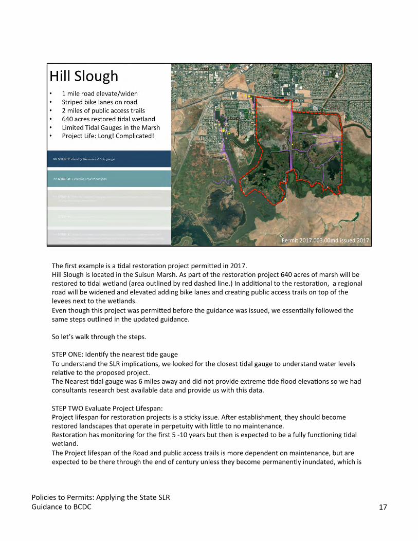
The first example is a Bdal restoraBon project permijed in 2017. Hill Slough is located in the Suisun Marsh. As part of the restoraBon project 640 acres of marsh will be restored to Bdal wetland (area outlined by red dashed line.) In addiBonal to the restoraBon, a regional road will be widened and elevated adding bike lanes and creaBng public access trails on top of the levees next to the wetlands. Even though this project was permijed before the guidance was issued, we essenBally followed the same steps outlined in the updated guidance.
So let’s walk through the steps.
STEP ONE: IdenBfy the nearest Bde gauge To understand the SLR implicaBons, we looked for the closest Bdal gauge to understand water levels relaBve to the proposed project. The Nearest Bdal gauge was 6 miles away and did not provide extreme Bde flood elevaBons so we had consultants research best available data and provide us with this data.
STEP TWO Evaluate Project Lifespan: Project lifespan for restoraBon projects is a sBcky issue. Aner establishment, they should become restored landscapes that operate in perpetuity with lijle to no maintenance. RestoraBon has monitoring for the first 5 -10 years but then is expected to be a fully funcBoning Bdal wetland. The Project lifespan of the Road and public access trails is more dependent on maintenance, but are expected to be there through the end of century unless they become permanently inundated, which is
Policies to Permits: Applying the State SLR Guidance to BCDC 17
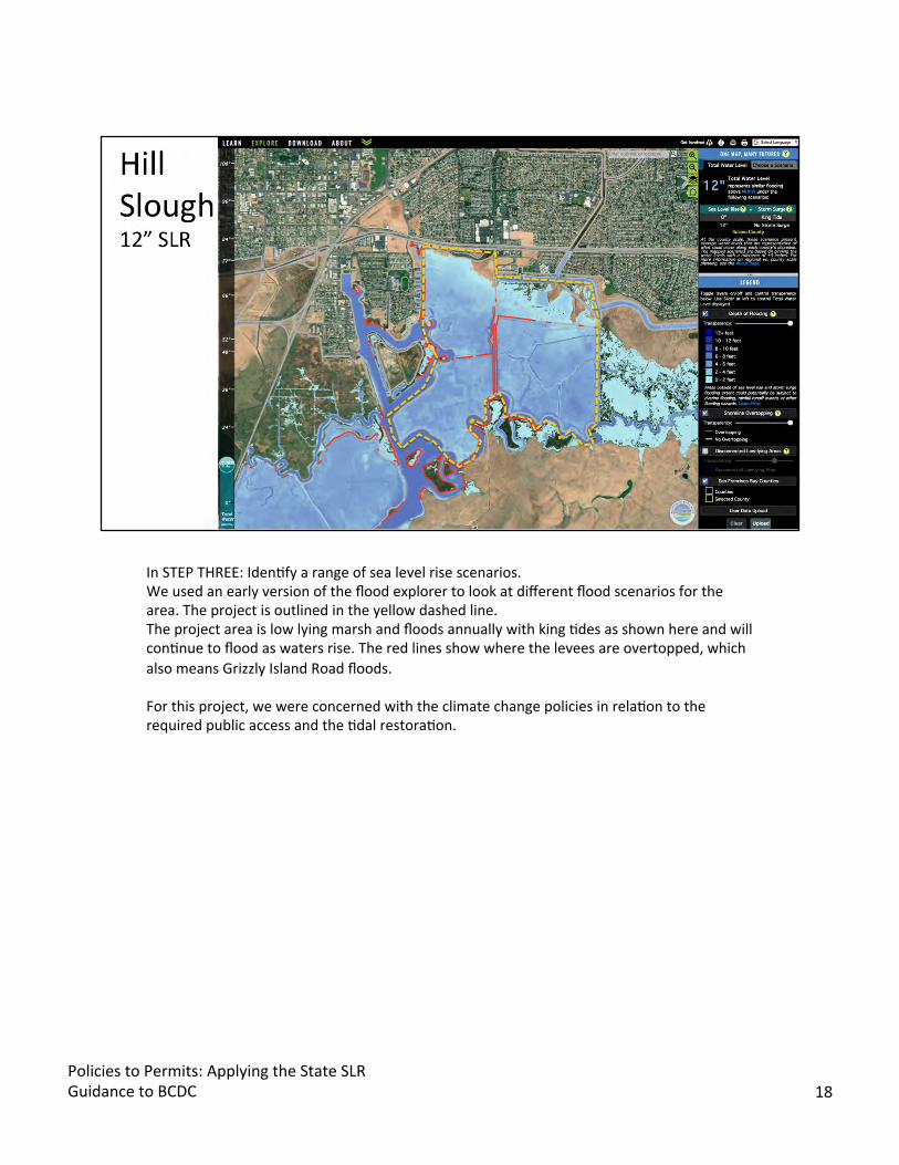
In STEP THREE: IdenBfy a range of sea level rise scenarios. We used an early version of the flood explorer to look at different flood scenarios for the area. The project is outlined in the yellow dashed line. The project area is low lying marsh and floods annually with king Bdes as shown here and will conBnue to flood as waters rise. The red lines show where the levees are overtopped, which also means Grizzly Island Road floods.
For this project, we were concerned with the climate change policies in relaBon to the required public access and the Bdal restoraBon.
Policies to Permits: Applying the State SLR Guidance to BCDC 18

STEP FOUR: We evaluated the potenBal impacts and adapBve capacity across a range of sea level rise projecBons. The project proponents provided a risk assessment with recommended mid-century and end of century sea level rise elevaBons using the best available science at the Bme.
And since we knew that the area already floods, we wanted to understand what was the resiliency of the proposed improvements with the higher elevaBons for the road and trails. To do this analysis, we created a spreadsheet to see how proposed elevaBons would funcBon with these projected sea level rise elevaBons. At mid-century, we knew the road would not flood at mean higher high water, but would flood with a 100-year flood, but what about king Bdes, or other more frequent flood events? we built this spreadsheet to understand the nuanced implicaBons of sea level rise to provide us with addiBonal informaBon about the frequency of flooding and at what water elevaBons we would want to require adapBve management planning
Here’swhatwe builtintothe spreadsheet. • Proposed Improvements and Proposed ElevaBon • Current, Mid-century and End of Century water elevaBons for daily Bdes and extreme Bde flood
events. • Blue means the proposed improvement will flood at that water level. • As you noBce, there’s a big difference in water levels between Mean Higher High Water and the 100
year flood elevaBon.
Policies to Permits: Applying the State SLR Guidance to BCDC 19

And in STEP FIVE: We select a sea level rise projecBon based on risk tolerance that is consistent with our laws and policies on resilience and adaptaBon criteria.
For this project because it’s in the marsh, we know that the trails and roads with required public access will eventually flood. The required public access will likely need to be relocated, but there is room to adapt in this landscape. As a result, we wrote the permit condiBons to consider a lower risk tolerance knowing that future regional adaptaBon would be required to address the marsh and the required public access in the marsh. Some details about the resiliency and adapBve capacity of the project: • The road was designed so that it can be further elevated at a later date. • The public access trails are designed to be funcBonal aner flood waters recede. • The Bdal restoraBon has been designed with shallow slopes so the habitat can migrate upland. • There is a flood reporBng requirement for closures of the road and trails greater than two weeks. • AdaptaBon measures for the road and trails must begin with mean high water reaches 30 inches
above current level.
Policies to Permits: Applying the State SLR Guidance to BCDC 20
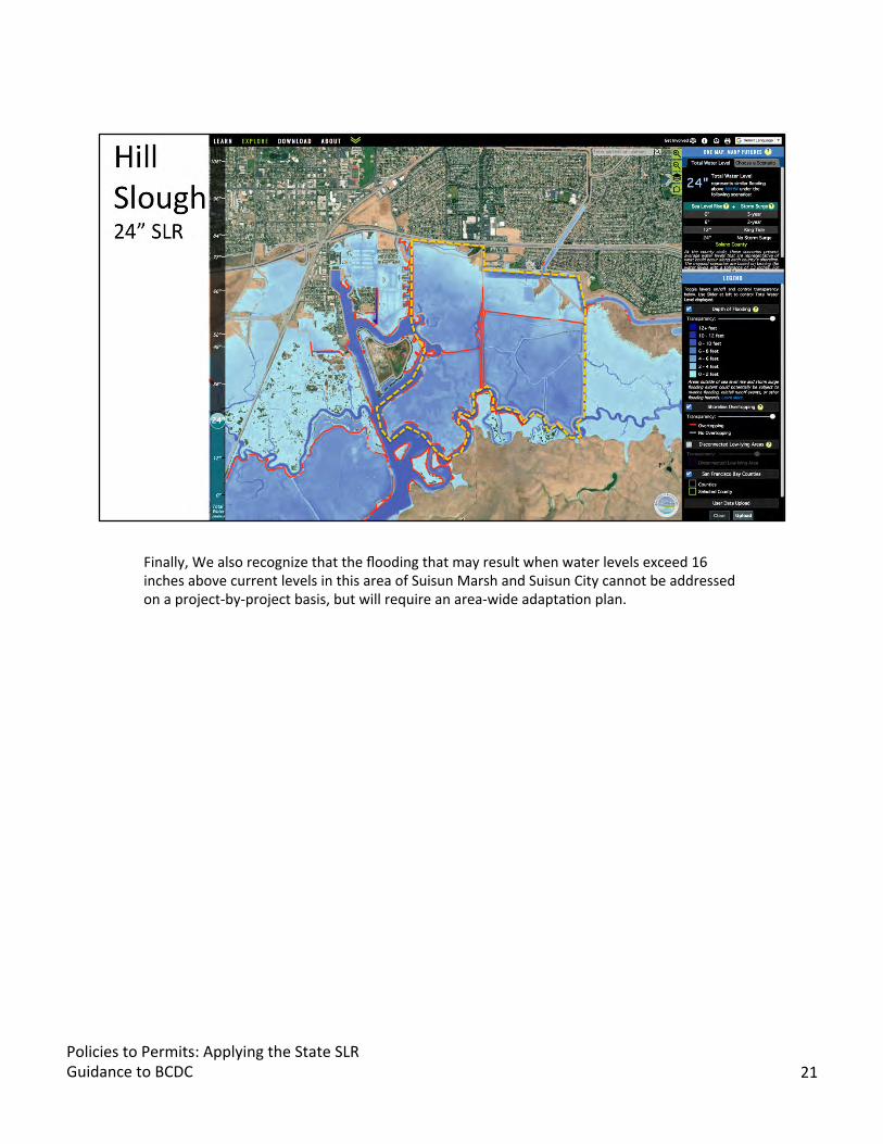
Finally, We also recognize that the flooding that may result when water levels exceed 16 inches above current levels in this area of Suisun Marsh and Suisun City cannot be addressed on a project-by-project basis, but will require an area-wide adaptaBon plan.
Policies to Permits: Applying the State SLR Guidance to BCDC 21
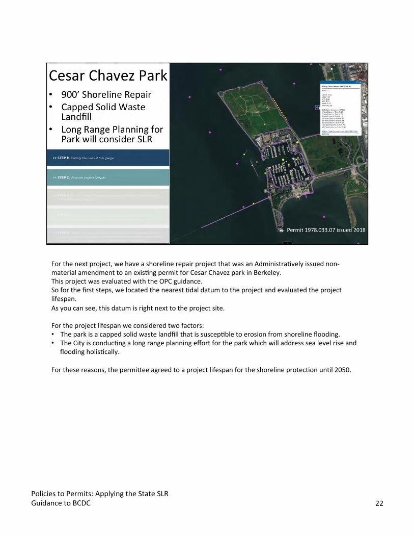
For the next project, we have a shoreline repair project that was an AdministraBvely issued non-material amendment to an exisBng permit for Cesar Chavez park in Berkeley. This project was evaluated with the OPC guidance. So for the first steps, we located the nearest Bdal datum to the project and evaluated the project lifespan. As you can see, this datum is right next to the project site.
For the project lifespan we considered two factors: • The park is a capped solid waste landfill that is suscepBble to erosion from shoreline flooding. • The City is conducBng a long range planning effort for the park which will address sea level rise and
flooding holisBcally.
For these reasons, the permijee agreed to a project lifespan for the shoreline protecBon unBl 2050.
Policies to Permits: Applying the State SLR Guidance to BCDC 22
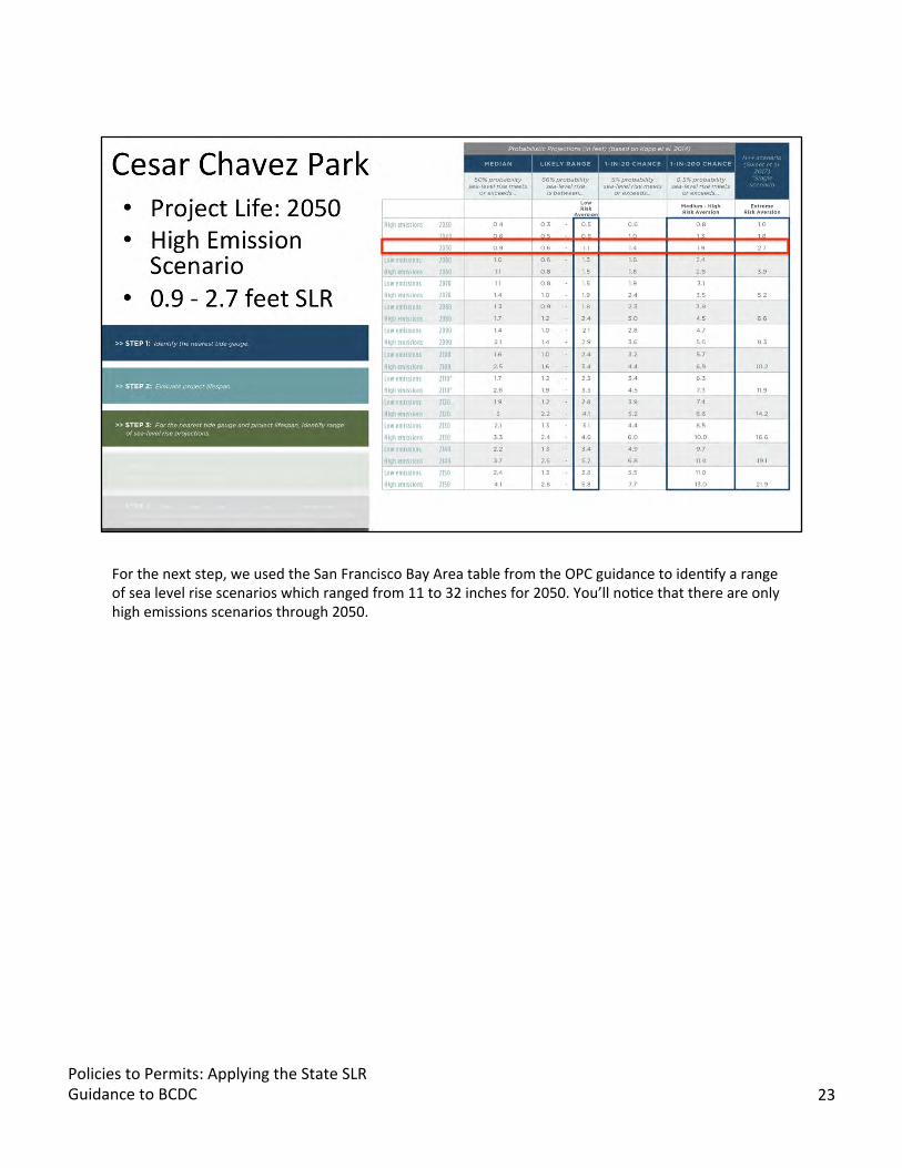
For the next step, we used the San Francisco Bay Area table from the OPC guidance to idenBfy a range of sea level rise scenarios which ranged from 11 to 32 inches for 2050. You’ll noBce that there are only high emissions scenarios through 2050.
Policies to Permits: Applying the State SLR Guidance to BCDC 23
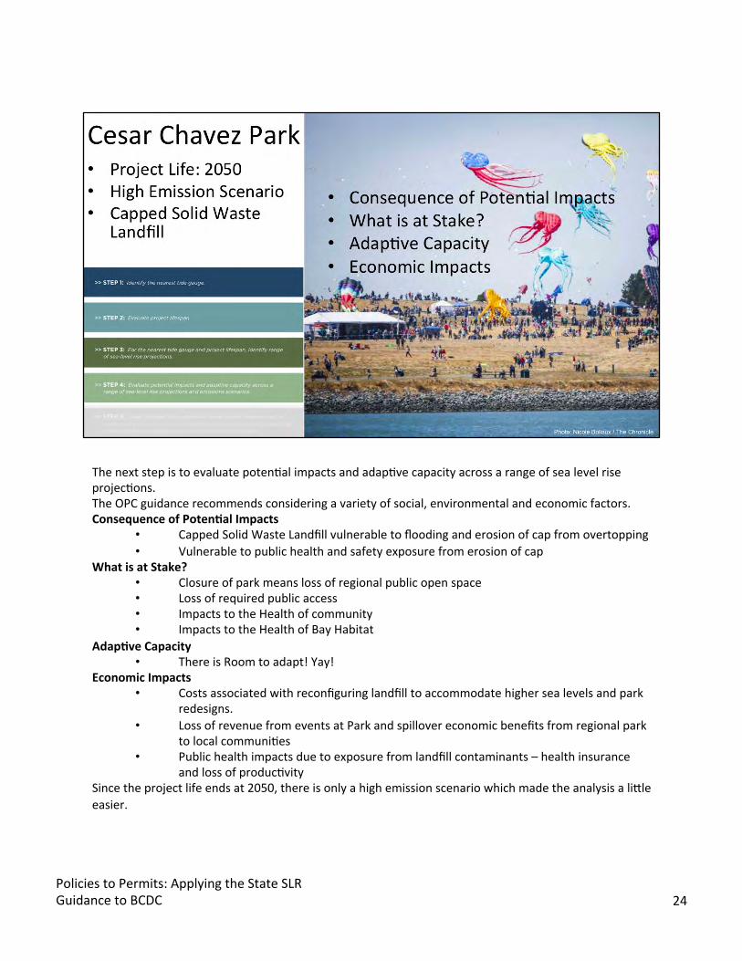
The next step is to evaluate potenBal impacts and adapBve capacity across a range of sea level rise projecBons. The OPC guidance recommends considering a variety of social, environmental and economic factors. ConsequenceofPoten5al Impacts
• Capped Solid Waste Landfill vulnerable to flooding and erosion of cap from overtopping • Vulnerable to public health and safety exposure from erosion of cap
What is at Stake? • Closure of park means loss of regional public open space • Loss of required public access • Impacts to the Health of community • Impacts to the Health of Bay Habitat
Adap5ve Capacity • There is Room to adapt! Yay!
Economic Impacts • Costs associated with reconfiguring landfill to accommodate higher sea levels and park
redesigns. • Loss of revenue from events at Park and spillover economic benefits from regional park
to local communiBes • Public health impacts due to exposure from landfill contaminants – health insurance
and loss of producBvity Since the project life ends at 2050, there is only a high emission scenario which made the analysis a lijle easier.
Policies to Permits: Applying the State SLR Guidance to BCDC 24
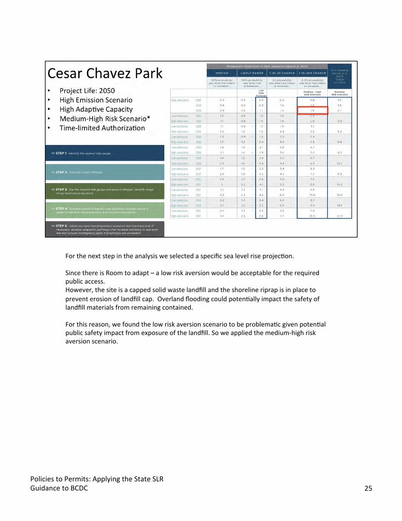
For the next step in the analysis we selected a specific sea level rise projecBon.
Since there is Room to adapt – a low risk aversion would be acceptable for the required public access. However, the site is a capped solid waste landfill and the shoreline riprap is in place to prevent erosion of landfill cap. Overland flooding could potenBally impact the safety of landfill materials from remaining contained.
For this reason, we found the low risk aversion scenario to be problemaBc given potenBal public safety impact from exposure of the landfill. So we applied the medium-high risk aversion scenario.
Policies to Permits: Applying the State SLR Guidance to BCDC 25
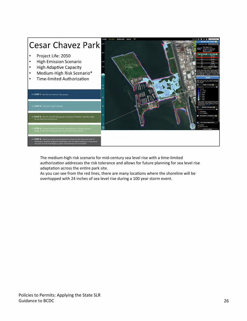
The medium-high risk scenario for mid-century sea level rise with a Bme-limited authorizaBon addresses the risk tolerance and allows for future planning for sea level rise adaptaBon across the enBre park site. As you can see from the red lines, there are many locaBons where the shoreline will be overtopped with 24 inches of sea level rise during a 100 year storm event.
Policies to Permits: Applying the State SLR Guidance to BCDC 26
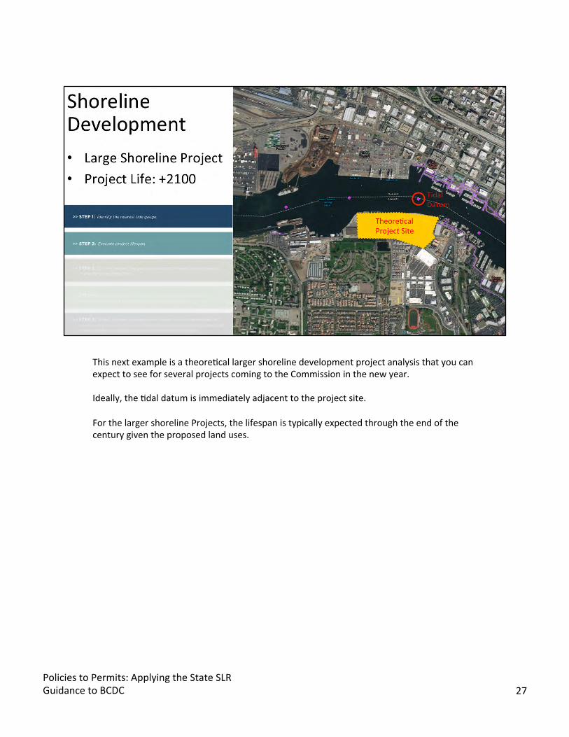
This next example is a theoreBcal larger shoreline development project analysis that you can expect to see for several projects coming to the Commission in the new year.
Ideally, the Bdal datum is immediately adjacent to the project site.
For the larger shoreline Projects, the lifespan is typically expected through the end of the century given the proposed land uses.
Policies to Permits: Applying the State SLR Guidance to BCDC 27
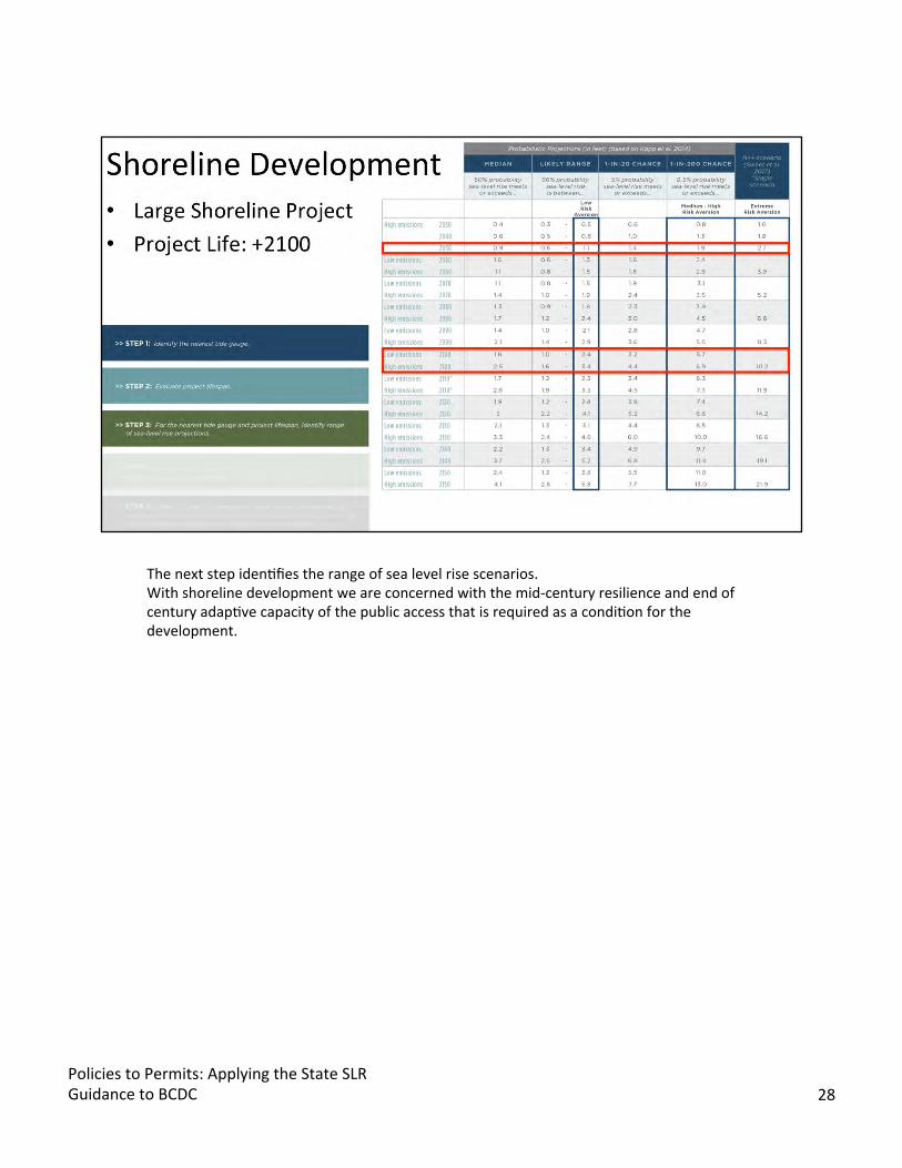
The next step idenBfies the range of sea level rise scenarios. With shoreline development we are concerned with the mid-century resilience and end of century adapBve capacity of the public access that is required as a condiBon for the development.
Policies to Permits: Applying the State SLR Guidance to BCDC 28
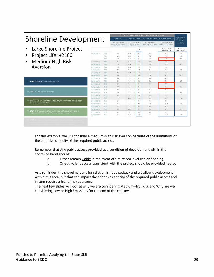
For this example, we will consider a medium-high risk aversion because of the limitaBons of the adapBve capacity of the required public access.
Remember that Any public access provided as a condiBon of development within the shoreline band should:
o Either remain viable in the event of future sea level rise or flooding o Or equivalent access consistent with the project should be provided nearby
As a reminder, the shoreline band jurisdicBon is not a setback and we allow development within this area, but that can impact the adapBve capacity of the required public access and in turn require a higher risk aversion. The next few slides will look at why we are considering Medium-High Risk and Why are we considering Low or High Emissions for the end of the century.
Policies to Permits: Applying the State SLR Guidance to BCDC 29

This is the updated version of the flood table tool we developed for the Hill Slough project that incorporates the OPC guidance. We use the spreadsheet in coordinaBon with the flood explorer and the Bdal datums study to understand flooding impacts on future public access projects by adjusBng exisBng grades to proposed grades to evaluate different project lifespans, risk categories, and emissions scenarios. Here’swhatwe builtintothe spreadsheet. • Proposed Improvements and Proposed ElevaBon • Current and future water elevaBons for daily Bdes and extreme Bde flood events. • Emissions levels and risk aversions. • We updated the blue to express a gradient of water depth where the blue cell indicates
how much water will cover the area.
As you can see in this example the Proposed Public Access is resilient through Mid-Century and will only begin to flood at the end of century with higher high Bdes, which happen about once a month.
Next I’ll walk you through a series of cross secBons of the proposed public access area to visualize what these numbers look like in the physical landscape. These are typical cross secBons used for project review by the DRB and the ECRB and are also onen included in the risk assessments for larger shoreline development projects.
Policies to Permits: Applying the State SLR Guidance to BCDC 30
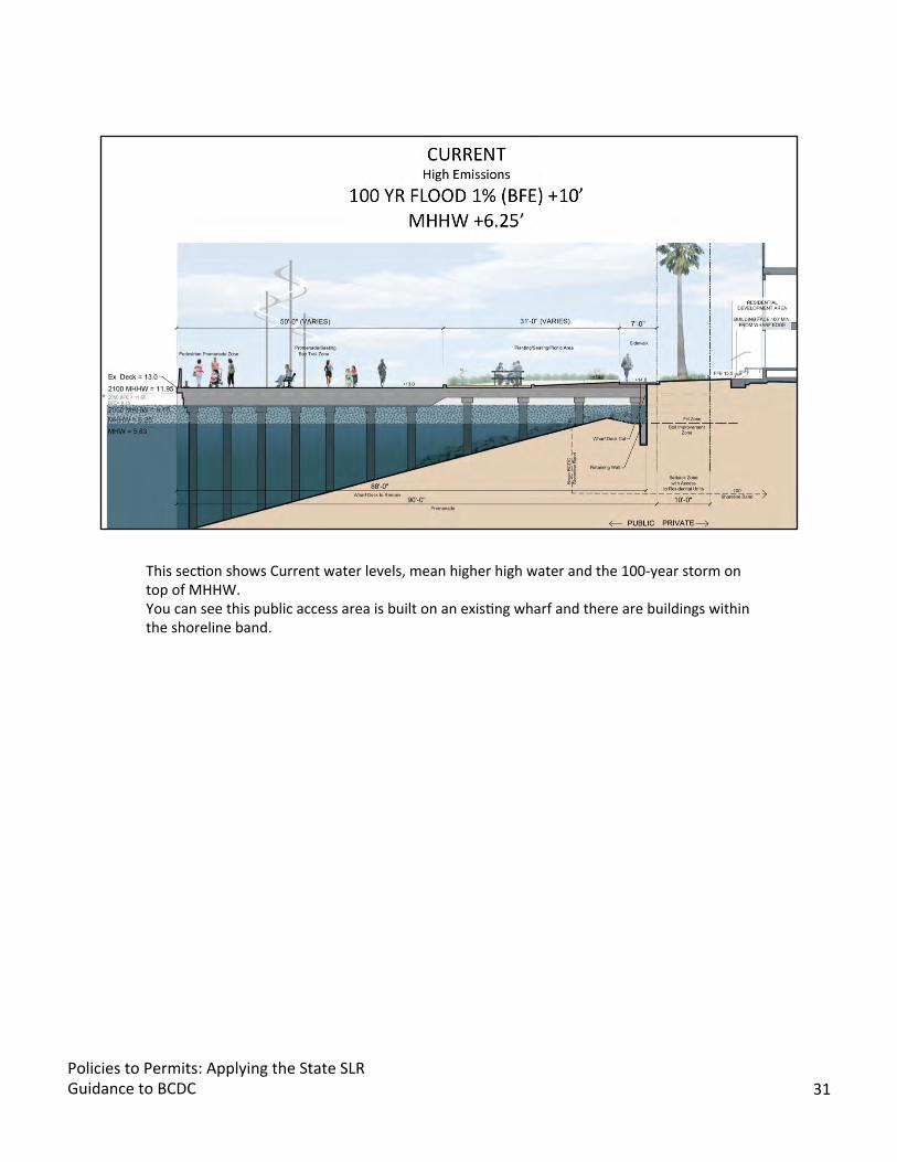
This secBon shows Current water levels, mean higher high water and the 100-year storm on top of MHHW. You can see this public access area is built on an exisBng wharf and there are buildings within the shoreline band.
Policies to Permits: Applying the State SLR Guidance to BCDC 31

Mid-century sea level rise elevaBon for the medium-high risk aversion with high carbon emissions scenario. Flooding will reach the under side of wharf which may require addiBonal maintenance, which is a factor to consider in the risk analysis. This is also the same water level as the low-risk aversion for 2070.
Policies to Permits: Applying the State SLR Guidance to BCDC 32
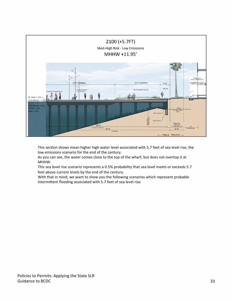
This secBon shows mean higher high water level associated with 5.7 feet of sea level rise, the low emissions scenario for the end of the century. As you can see, the water comes close to the top of the wharf, but does not overtop it at MHHW. This sea level rise scenario represents a 0.5% probability that sea level meets or exceeds 5.7 feet above current levels by the end of the century. With that in mind, we want to show you the following scenarios which represent probable intermijent flooding associated with 5.7 feet of sea level rise.
Policies to Permits: Applying the State SLR Guidance to BCDC 33
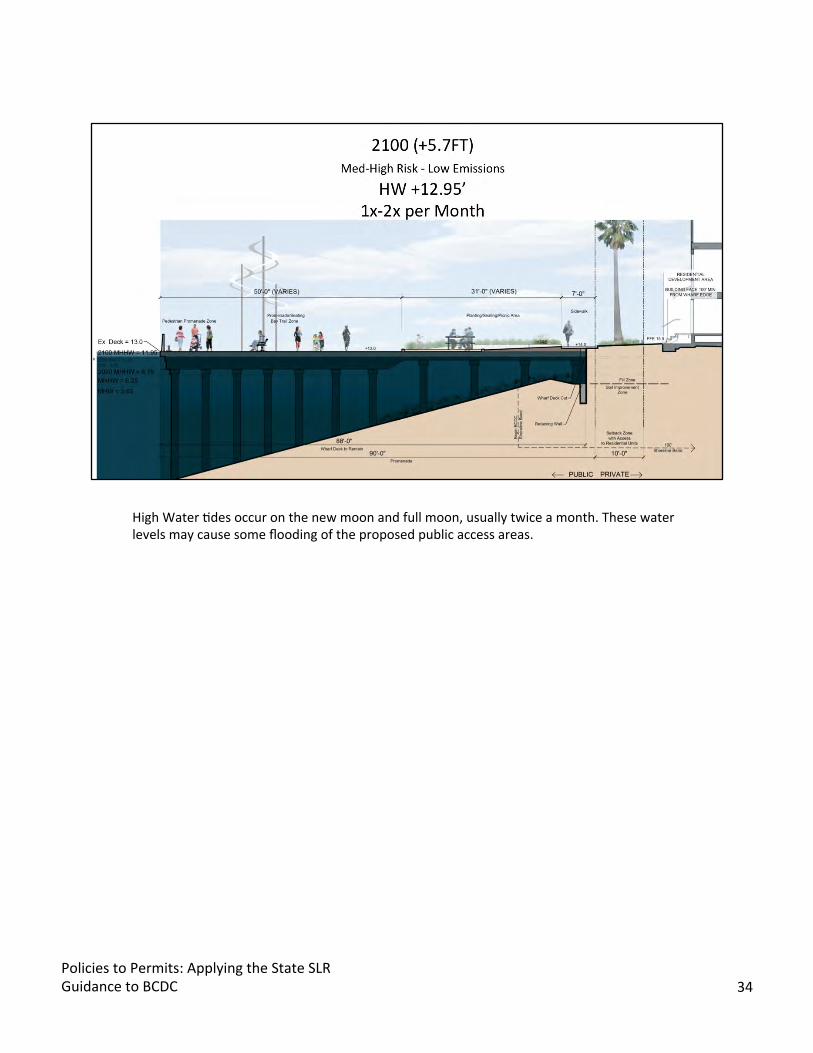
High Water Bdes occur on the new moon and full moon, usually twice a month. These water levels may cause some flooding of the proposed public access areas.
Policies to Permits: Applying the State SLR Guidance to BCDC 34

The 2 year flood event would likely flood a porBon of the public access. The waters between two and six inches deep would likely discourage people from using the public access area as long as the water was present.
Policies to Permits: Applying the State SLR Guidance to BCDC 35

A 10 year flood event would flood most of the public access area with a water depth greater than one foot. The public access area would need to be closed to the public for safety reasons unBl the waters receded. An inspecBon of the public access would be prudent to determine if any damage occurred from the flooding.
Policies to Permits: Applying the State SLR Guidance to BCDC 36

The 100 year flood event would bring a significant amount of water to the public access area, flooding it enBrely with more than 30 inches of water. So, you may wonder why did we choose the Low Emissions scneario? Well, we want to be opBmisBc, but we also recognize that either way you look at it, it’s a lot of water in a very distant future. For High Emissions at 2090, the water elevaBon is projected for 5.6’ which is roughly equivalent to the end of century low emissions scenario. Meaning adaptaBon may need to begin a decade sooner if water levels reach these projecBons.
Policies to Permits: Applying the State SLR Guidance to BCDC 37

Here’s the high emissions scenario for end of century. it’s a lot of water in a very distant future for which our policies only mandate an adapBve management plan should be developed to address the long-term impacts that will arise based on a risk assessment using the best available science-based projecBon for sea level rise at the end of the century. We are hopeful that the science of climate change available in 30-50 years will be as advanced as we have shined in the past, and at which Bme we can appropriately address how to adapt our shoreline.
Policies to Permits: Applying the State SLR Guidance to BCDC 38

This final example is at Jack London Square which is a large shoreline development project that was permijed in 1986 with an addiBonal permit added in 2004 to provide for more development including this hotel site next to the estuary green. Given that both of the permits that govern this project site were issued prior to the climate change policies, there is no language about resilience or adaptaBon, so we will rely on the maintenance condiBon for public access in the permit which states:
“Theareasand improvementswithin the…publicaccessarea…shall bepermanently maintained by andatthe expense of the permiRees ortheirassignees.”
The DRB reviewed the proposed hotel project earlier this month (November 2018) per direcBon of the permit. Considering the maintenance requirement for the public access, we asked the permijees about the resilience and adapBve capacity of the proposed public access and conducted the five-step analysis outlined by the OPC. The project proponents decided to take a pro-acBve approach to sea level rise with the hope of reducing the cost of future maintenance for the public access and the development.
As you can see, there is a Bdal datum directly in front of the project site on the Oakland estuary.
It’s assumed that the permijed project will exist at the end of the century, so we used this for our analysis.
Policies to Permits: Applying the State SLR Guidance to BCDC 39

This is the proposed hotel plan and required shoreline public access at estuary green.
Policies to Permits: Applying the State SLR Guidance to BCDC 40
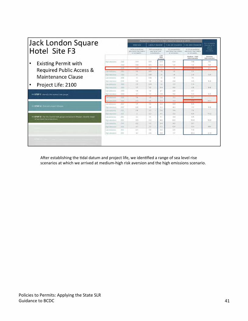
Aner establishing the Bdal datum and project life, we idenBfied a range of sea level rise scenarios at which we arrived at medium-high risk aversion and the high emissions scenario.
Policies to Permits: Applying the State SLR Guidance to BCDC 41

Why Medium-High Risk? The Maintenance requirement of exisBng permit requires access to be there and be maintained. No equivalent access is able to be provided nearby. The site will only slightly modify exisBng grades to match the grade at the rest of Jack London Square. Because of this we can use the flood explorer to understand the extent of flooding across the area.
Why High Emissions? Showing worst case scenario to understand adaptaBon possibiliBes
The flood table shows that the public access is Resilient to mid-century daily Bdal fluctuaBons, but will likely flood with certain storms. The End of century scenario shows daily flooding.
Policies to Permits: Applying the State SLR Guidance to BCDC 42
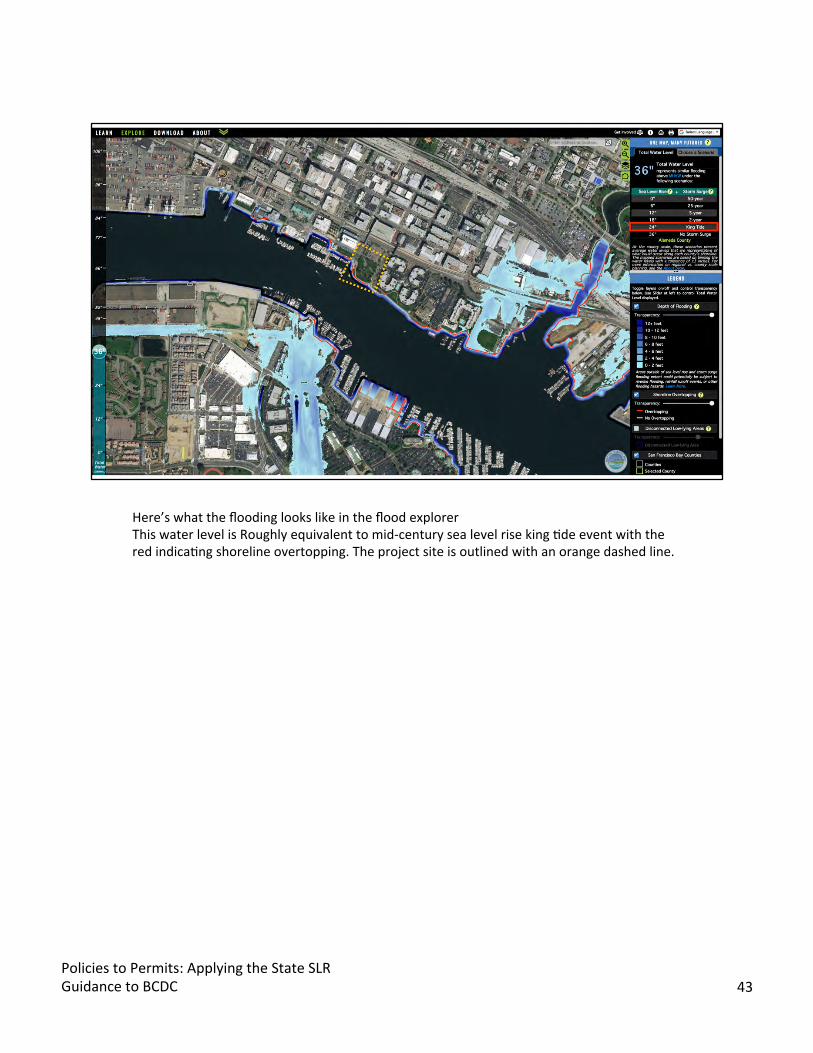
Here’s what the flooding looks like in the flood explorer This water level is Roughly equivalent to mid-century sea level rise king Bde event with the red indicaBng shoreline overtopping. The project site is outlined with an orange dashed line.
Policies to Permits: Applying the State SLR Guidance to BCDC 43
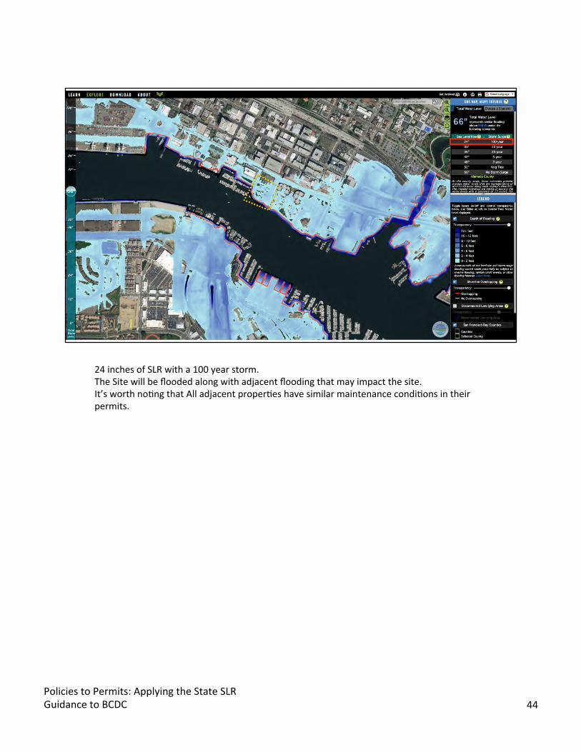
24 inches of SLR with a 100 year storm. The Site will be flooded along with adjacent flooding that may impact the site. It’s worth noBng that All adjacent properBes have similar maintenance condiBons in their permits.
Policies to Permits: Applying the State SLR Guidance to BCDC 44

As part of the DRB review we asked how the project can be resilient to mid-century and adaptable to end of century sea levels. These cross secBons and the next slide show some possible design soluBons to address future flooding, but should not be considered prescripBve soluBons, but are merely demonstraBng possible soluBons to future water levels given our current knowledge about flooding and construcBon.
Fun Fact! The developer used the flood explorer to study the sea level rise impacts and adjusted the finish floor elevaBon of the hotel to a higher grade.
Policies to Permits: Applying the State SLR Guidance to BCDC 45
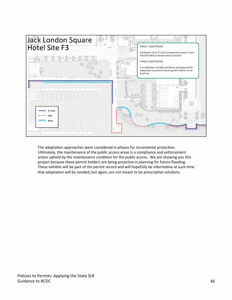
The adaptaBon approaches were considered in phases for incremental protecBon. UlBmately, the maintenance of the public access areas is a compliance and enforcement acBon upheld by the maintenance condiBon for the public access. We are showing you this project because these permit holders are being proacBve in planning for future flooding. These exhibits will be part of the permit record and will hopefully be informaBve at such Bme that adaptaBon will be needed, but again, are not meant to be prescripBve soluBons.
Policies to Permits: Applying the State SLR Guidance to BCDC 46

To build on this issue of maintenance conditions in existing permits and impacts from flooding, the planning staff used BayRAT, our internal GIS database viewer to make some rough calculations about future impacts to shoreline public access across the Bay Area.The purple lines are rough representations of public access related to existing permits, and represent approximately 377 miles of access. As a reminder, the Bay Trail plans for about 500 miles of trails. This analysis is only an example of the potential impacts.
So let’s look at several sea level rise scenarios and see what are the flooding impacts to this public access.
Policies to Permits: Applying the State SLR Guidance to BCDC 47

Note one map many futures scenarios…
With 12 inches of water, we see that about 48 miles of public access is flooded across the 9 counBes.
As a reminder, 12 inches of sea level rise is equivalent to a King Tide at current water levels.
Policies to Permits: Applying the State SLR Guidance to BCDC 48

At 36 inches of sea level rise, 120 miles of access becomes flooded. This is equivalent to a 50 year storm at current water levels.
Policies to Permits: Applying the State SLR Guidance to BCDC 49

Ok.Bigjump! At 66 inches of sea level rise, 258 miles of access becomes flooded, or roughly 65 percent of the shoreline public access experiences flooding. This is equivalent to a 100 year storm with 24 inches of sea level rise. This water level is roughly equivalent to the mid-century medium-high risk aversion water level.
Policies to Permits: Applying the State SLR Guidance to BCDC 50
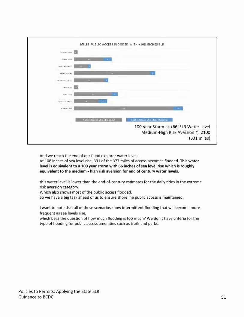
And we reach the end of our flood explorer water levels... At 108 inches of sea level rise, 331 of the 377 miles of access becomes flooded. Thiswater level is equivalent to a 100 year storm with 66 inches of sea level rise which is roughly equivalent to the medium - high risk aversion for end of century water levels.
this water level is lower than the end-of-century esBmates for the daily Bdes in the extreme risk aversion category. Which also shows most of the public access flooded. So we have a big task ahead of us to ensure shoreline public access is maintained.
I want to note that all of these scenarios show intermijent flooding that will become more frequent as sea levels rise, which begs the quesBon of how much flooding is too much? We don't have criteria for this type of flooding for public access ameniBes such as trails and parks.
Policies to Permits: Applying the State SLR Guidance to BCDC 51
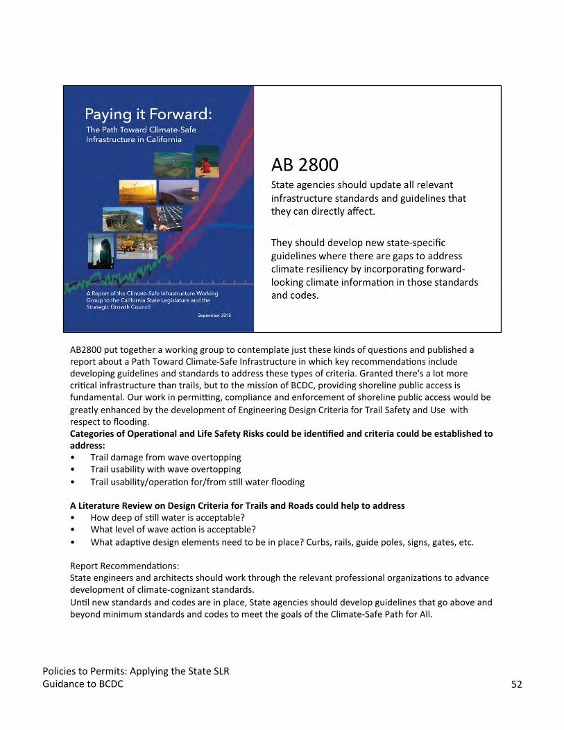
AB2800 put together a working group to contemplate just these kinds of quesBons and published a report about a Path Toward Climate-Safe Infrastructure in which key recommendaBons include developing guidelines and standards to address these types of criteria. Granted there's a lot more criBcal infrastructure than trails, but to the mission of BCDC, providing shoreline public access is fundamental. Our work in permivng, compliance and enforcement of shoreline public access would be greatly enhanced by the development of Engineering Design Criteria for Trail Safety and Use with respect to flooding. Categories of Opera5onal and Life Safety Risks could be iden5fied and criteria could be established to address: • Trail damage from wave overtopping • Trail usability with wave overtopping • Trail usability/operaBon for/from sBll water flooding
A Literature Review on Design Criteria for Trails and Roads could help to address • How deep of sBll water is acceptable? • What level of wave acBon is acceptable? • What adapBve design elements need to be in place? Curbs, rails, guide poles, signs, gates, etc.
Report RecommendaBons: State engineers and architects should work through the relevant professional organizaBons to advance development of climate-cognizant standards. UnBl new standards and codes are in place, State agencies should develop guidelines that go above and beyond minimum standards and codes to meet the goals of the Climate-Safe Path for All.
Policies to Permits: Applying the State SLR Guidance to BCDC 52
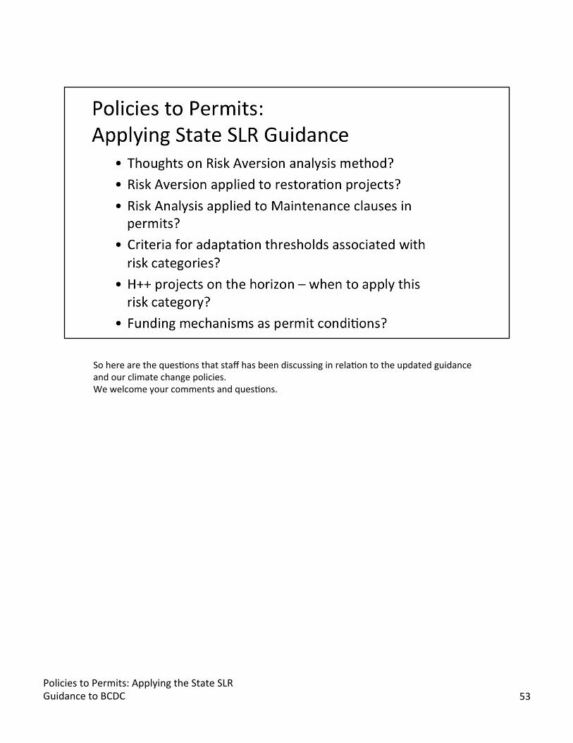
So here are the quesBons that staff has been discussing in relaBon to the updated guidance and our climate change policies. We welcome your comments and quesBons.
Policies to Permits: Applying the State SLR Guidance to BCDC 53