planning and environment act panel report · planning and environment act 1987 ... 4.4 conclusion...
TRANSCRIPT
Planning and Environment Act 1987
Panel Report Whitehorse Planning Scheme
Amendment C110
Tally Ho Activity Centre
5 September 2014
Planning and Environment Act 1987
Panel Report pursuant to Section 25 of the Act
Whitehorse Planning Scheme Amendment C110
Tally Ho Activity Centre
Con Tsotsoros, Chair
Whitehorse Planning Scheme Amendment C110 Panel Report 5 September 2014
Contents
Page
1 Introduction ............................................................................................................... iv 1.1 Amendment Summary ............................................................................................ iv 1.2 Panel Process ............................................................................................................ v
Executive Summary and Recommendations ......................................................................... i
2 The Proposal ............................................................................................................... 1 2.1 The Amendment ...................................................................................................... 1 2.2 Council’s post exhibition changes ........................................................................... 1 2.3 Background to the proposal .................................................................................... 2 2.4 The subject land and surrounds .............................................................................. 2 2.5 Tally Ho Activity Centre ........................................................................................... 4 2.6 Issues dealt with in this report ................................................................................ 4
3 Strategic Planning Context .......................................................................................... 6 3.1 Policy framework ..................................................................................................... 6 3.2 Zones and Overlays ................................................................................................. 9 3.3 Plan Melbourne ..................................................................................................... 10 3.4 Other planning strategies and guidelines ............................................................. 10 3.5 Other relevant amendments ................................................................................. 11 3.6 Ministerial Directions and Planning Practice Notes .............................................. 12 3.7 Strategic Justification ............................................................................................ 13
4 Council’s Approach ................................................................................................... 14 4.1 Strategic implementation ...................................................................................... 14 4.2 2007 UDF and Clause 22.08................................................................................... 15 4.3 Provisions implementation ................................................................................... 16 4.4 Conclusion ............................................................................................................. 17
5 Tally Ho Activity Centre Area .................................................................................... 18 5.1 The issue ................................................................................................................ 18 5.2 Evidence and submissions ..................................................................................... 18 5.3 Discussion .............................................................................................................. 19 5.4 Conclusion ............................................................................................................. 20 5.5 Recommendations ................................................................................................ 21
6 Schedule 9 to the Design and Development Overlay ................................................. 22 6.1 Building height ....................................................................................................... 22 6.2 Building setbacks ................................................................................................... 25 6.3 Precinct interface .................................................................................................. 27 6.4 Recommendations ................................................................................................ 29
7 Schedule 5 to the Development Plan Overlay ........................................................... 30 7.1 The issue ................................................................................................................ 30 7.2 Evidence and submissions ..................................................................................... 30 7.3 Discussion and conclusions ................................................................................... 32 7.4 Recommendations ................................................................................................ 34
Whitehorse Planning Scheme Amendment C110 Panel Report 5 September 2014
8 Other issues .............................................................................................................. 36 8.1 Traffic and parking ................................................................................................. 36 8.2 Clause 22.08 .......................................................................................................... 38
Appendix A Document list
Appendix B Bazem Pty Ltd proposed changes to DPO5
Appendix C Panel preferred DDO5
List of Tables
Page
Table 1 Tally Ho Activity Centre precincts and areas ........................................................... 4
Table 2 How Amendment C160 affects land in the Tally Ho Activity Centre .................... 12
List of Figures
Page
Figure 1 Subject land ‐ Tally Ho Activity Centre .................................................................... 3
Figure 2 Hierarchy of residential zones ............................................................................... 13
Figure 3 Examples of low density residential areas in the Tally Ho Activity Centre .................................................................................................................... 19
Whitehorse Planning Scheme Amendment C110 Panel Report 5 September 2014
List of Abbreviations
2007 UDF Tally Ho Activity Centre Urban Design Framework, 2007
2013 Guidelines Tally Ho Major Activity Centre Urban Design and Landscape Guidelines ‐ Draft Report, March 2013
DDO Design and Development Overlay
DPO Development Plan Overlay
DTPLI Department of Transport , Planning and Local Infrastructure
Forest Ridge 104‐168 Hawthorn Road, Forest Hill; otherwise referred to as the Global TV Studios Site or the Former Channel 10 Television Studios
LPPF Local Planning Policy Framework
MAC Major Activity Centre
MSS Municipal Strategic Statement
PPN78 Planning Practice Note 78: Applying the Residential Zones
SPPF State Planning Policy Framework
VPP Victoria Planning Provisions
Whitehorse Planning Scheme Amendment C110 Panel Report 5 September 2014
1 Introduction
1.1 Amendment Summary
The Amendment Whitehorse Planning Scheme Amendment C110
Common Name Tally Ho Activity Centre
Subject land The Amendment applies to land within the Tally Ho Major Activity Centre as shown in Figure 1
Purpose of Amendment To implement the recommendations of the Tally Ho Major Activity Centre Urban Design Framework 2007
Planning Authority and Proponent
Whitehorse City Council
Authorisation The Department of Transport, Planning and Local Infrastructure under delegation from the Minister for Planning provided written notification that Council could prepare the Amendment without authorisation in accordance with section 8A(7) of the Planning and Environment Act 1987.
Exhibition The Amendment was publicly exhibited from 13 March to 14 April 2014 as follows:
1,200 letters to surrounding property owners and occupiers Notice published in the Government Gazette
Notice published in the Whitehorse Leader on 12, 17, 24 and 31 March 2014
Whitehorse Planning Scheme Amendment C110 Panel Report 5 September 2014
1.2 Panel Process
The Panel Con Tsotsoros
Appointment The Panel was appointed under delegation from the Minister for Planning on 3 July 2014
Panel request At its meeting of 23 June 2014, Council resolved to refer the submissions to a Panel
Directions Hearing Held at Planning Panels Victoria, 1 Spring Street, Melbourne on 29 July 2014. Con Tsotsoros made the following declarations:
1 Mr Drum of 10 Consulting, representing Bazem Pty Ltd, was formerly employed with the Statutory Systems unit in the Department of Planning and Community Development between June 2009 and December 2010. I was the Assistant Director of that unit. Mr Drum and I have had no formal association since.
2 Ms Julie Reid of Whitehorse City Council and I are board members of the Victorian Planning and Environmental Law Association (VPELA). I do not have an association with Ms Reid outside of VPELA.
Panel Hearing Held at Planning Panels Victoria on 12 and 13 August 2014
Site Inspections On 5 and 21 August 2014, the Panel undertook unaccompanied inspections of the subject land and surrounds
Submissions Six submissions were received from:
1 Department of Environment and Primary Industries
2 Bazem Pty Ltd
3 Bibelston Pty Ltd
4 Kador Group Holdings Pty Ltd
5 Mr Stephen Gillanders
6 Mrs Tamara Habres
Appearances Whitehorse City Council represented by Ms Pamela Neivandt and calling evidence from:
‐ Mr Craig Czarny of Hansen Partnership on urban design
Bibelston Pty Ltd represented by Ms Emma Peppler, Barrister and calling evidence from:
‐ Mr Mark Sheppard of David Lock Associates on urban design
Bazem Pty Ltd represented by Mr Rob Milner of 10 Consulting Group
Date of this Report 5 September 2014
Whitehorse Planning Scheme Amendment C110 Panel Report 5 September 2014
Page i
Executive Summary and Recommendations
(i) Summary
Whitehorse City Council (Council) has undertaken comprehensive strategic work since adopting the Tally Ho Activity Centre Urban Design Framework (the 2007 UDF).
Council’s approach was to implement the 2007 UDF before preparing the more detailed Tally Ho Major Activity Centre Urban Design and Landscape Guidelines ‐ Draft Report, March 2013 (the 2013 Guidelines) that help implement the framework. Tally Ho Activity Centre has considerable potential because of its scale, numerous vacant and underused properties and location to major arterial roads, public transport and Eastlink. It is therefore important that any development framework for this centre is implemented effectively to capture its full potential.
Having considered all submissions, the Panel believes that the series of implementation decisions following the 2007 UDF has resulted in issues. These include introducing an ‘interim’ Clause 22.08, not formally reviewing the effectiveness of the 2007 UDF and interim clause earlier in the process, and separating issues relating to the Tally Ho Activity Centre across numerous amendments.
One of the most fundamental issues to be resolved is whether the entire study area in the 2007 UDF and 2013 Guidelines should have been translated into the ultimate Tally Ho Activity Centre. Forest Ridge, otherwise known as the former Channel 10 Studios is geographically separated from other precincts by a low density residential area identified by Council as an ‘Established Garden Suburban Area’. There are other lower density residential areas scattered throughout the Tally Ho Activity Centre but the 2007 UDF and 2013 Guidelines do not identify their role or provide a strategic plan to effectively integrate them with other parts of the activity centre. A separate amendment proposes to rezone land within the activity centre to the Neighbourhood Residential Zone.
The Panel would recommend abandoning the Amendment if the low density residential areas and Forest Ridge remain in the Tally Ho Activity Centre. The Panel would have taken a different view if there was a strategy to transform and integrate them with precincts in the activity centre.
Council supported a planning scheme amendment for the Crossways Baptist Church land in the Tally Ho Activity Centre. This land adjoins other activity centre precincts and has a smaller land area to Forest Ridge. Forest Ridge has more justification to warrant its own planning response.
‘Road testing’ the application of different sets of requirements to sites with two interfaces would help determine their degree of clarity before introducing the relevant provisions into the planning scheme.
Work undertaken by Council to date is necessary for, what the Panel considers to be, the actual Tally Ho Activity Centre. Removing inappropriate areas and clarifying aspects of the proposed provisions can resolve issues raised by submitters and allow the 2007 UDF and 2013 Guidelines to be implemented in a more focussed and effective manner.
Whitehorse Planning Scheme Amendment C110 Panel Report 5 September 2014
Page ii
All submissions were considered when preparing this report. This report includes:
Conclusions: The Panel’s response to an issue that does not recommend changing the exhibited Amendment.
Recommendations: The Panel’s response to an issue that recommends changes to the exhibited Amendment.
(ii) Recommendation
Based on the reasons set out in this Report, the Panel recommends Whitehorse Planning Scheme Amendment C110 be adopted as exhibited subject to the following recommendations:
1. Modify the Tally Ho Activity Centre area to exclude land: a) North of Precinct 6, west of Springvale Road, south of Hawthorn Road and
east of Mahoneys Road b) North of the Mixed Use Zone on Burwood Highway, west of Mahoneys Road,
south of Burwood Heights Primary School and east of the linear reserve. c) The residential area surrounding the Burvale Hotel proposed to be rezoned
Neighbourhood Residential Zone.
2. In response to modifying the Tally Ho Activity Centre area, make consequential changes to Clause 22.08, Schedule 9 to the Design and Development Overlay and Schedule 5 to the Development Plan Overlay.
3. Amend Schedule 9 to the Design and Development Overlay to: a) Specify a preferred maximum building height for each sub‐precinct that is no
less than the height of an existing building within that sub‐precinct. b) Revise the preferred maximum building height for 315‐319 Burwood Highway
to 20 metres. c) Remove setbacks from the western and northern boundaries of 315‐319
Burwood Highway. d) Add ‘Development on sites which fall within two precincts should meet the
guidelines for both precincts.’ in the lead‐in paragraph to Clause 3.
4. Update the Tally Ho Major Activity Centre Urban Development Framework and Tally Ho Major Activity Centre Urban Design and Landscape Guidelines to:
a) Align with changes recommended for Schedule 9 to the Design and Development Overlay.
b) Replace all references ‘then it is necessary for development to comply with both guidelines’ in relation to sites with more than one interface with ‘then development should meet both guidelines.
5. Amend Schedule 5 to the Development Plan Overlay, as shown in Appendix C, to: a) Replace the title of the schedule with ‘104‐168 Hawthorn Road, Forest Hill’. b) Remove references to the Tally Ho Major Activity Centre Urban Design
Guidelines and Landscape Guidelines. c) Replace the relevant provision in Clause 3 with ‘A development plan should
show or provide for the following, to the satisfaction of the responsible authority:’
d) Add ‘A development plan may be prepared in stages’ in Clause 3 (Requirements for development plan).
Whitehorse Planning Scheme Amendment C110 Panel Report 5 September 2014
Page iii
e) Replace the relevant provision in Clause 3 under Buildings and works with ‘Location of public open spaces’.
f) Delete ‘Indicative external materials, finishes and colours of all buildings and works, including screening measures to protect the amenity and privacy of adjoining residential buildings’ in Clause 3 under Buildings and works.
g) Delete ‘New buildings reflecting the scale and proportion of existing identified heritage buildings.’ in Clause 3 under Buildings and works.
h) Delete ‘Building heights that are generally consistent with the Tally Ho Major Activity Centre Urban Design Framework 2007.’ in Clause 3 under Buildings and works.
i) Allow buildings of four to six storeys to be considered within the central portion of the site and exempt the relevant provision from land fronting Springvale Road or land adjacent to public open space.
j) Replace the relevant provision with ‘Buildings that front Hawthorn Road design and sited to provide residential appearance and setback and support the landscape profile of this road with buildings addressing the street frontage and respectful of the neighbourhood character.’ in Clause 3 under Buildings and works.
k) Delete ‘Setbacks along Hawthorn Road to comply with the Tally Ho Major Activity Centre Urban Design and Landscape Guidelines, 2013’ in Clause 3 under Buildings and works.
l) Delete ‘A heritage assessment of existing buildings and recommendations for the protection, restoration and interpretation of any identified significant heritage features.’ in Clause 3 under Heritage.
m) Delete ‘The location of all open space areas including public open space.’ in Clause 3 under Landscaping.
n) Replace the relevant provision in Clause 3 under Landscaping with ‘Provision of landscape areas at the site’s edges, particularly along any interface with existing residential land.’
o) Create a new provision at the end of Schedule 5 to include: ‘X.X Transitional provisions Clause 43.04 does not apply to any application for permit to subdivide land, construct a building or construct or carry out works made before the approval date of Amendment C110.’
6. Amend Clause 22.08, to replace any reference to ‘Major Activity Centre’ with ‘Activity Centre’.
Whitehorse Planning Scheme Amendment C110 Panel Report 5 September 2014
Page 1 of 45
2 The Proposal
2.1 The Amendment
The Amendment proposes to implement the Tally Ho Major Activity Centre Urban Design Framework 2007 (2007 UDF) by recognising adopted guidelines that support the framework; introducing provisions consistent with both documents; and by making the interim Tally Ho Activity Centre policy permanent.
Specifically, the Amendment proposes to:
Modify Clause 21.05 Environment to include adoption of the Tally Ho Major Activity Centre Urban Design and Landscape Guidelines 2013 (2013 Guidelines) as a strategy for achieving objectives of the clause.
Modify Clause 21.06 Housing to include application of a Development Plan Overlay to the Global Television Studios at 104‐168 Hawthorn Road, Forest Hill and the introduction of a Design and Development Overlay to parts of the Tally Ho Activity Centre.
Modify Clause 21.07 Economic Development to refer to the introduction of design and development provisions to the Tally Ho Activity Centre.
Modify Clause 22.06 Activity Centres to refer to the Tally Ho Activity Centre and to reference the Tally Ho Major Activity Centre Urban Design Framework 2007.
Modify Clause 22.08 Tally Ho Activity Centre to make this clause a permanent local policy and reflect the inclusion of detailed design, built form and landscape provisions for the Tally Ho Activity Centre in a new schedule to the Design and Development Overlay (DDO).
Introduce a new Schedule 9 to the DDO (DDO9) and applying it to parts of the Tally Ho Activity Centre, including four precincts, to guide the future form of development within the Centre.
Introduce a new Schedule 5 to the Development Plan Overlay (DPO5) to the Global Television Studio site at 104‐168 Hawthorn Road Forest Hill.
Reference the 2007 UDF in Clause 21.05 (Environment), Clause 21.06 (Housing), Clause 21.07 (Economic Development), Clause 22.06 (Activity Centres) and Clause 22.08 (Tally Ho Activity Centre).
Reference the Tally Ho Urban Design and Landscape Guidelines 2013 in Clause 21.05 (Environment), Clause 21.06 (Housing), Clause 21.07 (Economic Development), Clause 22.06 (Activity Centres), and Clause 22.08 (Tally Ho Activity Centre).
The Amendment proposes to reinstate the City of Whitehorse Responsible Gambling Policy 2011 as a reference document in Clause 21.07 which was deleted due to an administrative error. There was no submission on Clause 21.07 so it is not discussed further in this report.
2.2 Council’s post exhibition changes
At the hearing, Council sought the following changes to the exhibited Amendment:
In Clause 22.08, delete the word ‘Major’ from references to the Tally Ho Major Activity Centre.
Whitehorse Planning Scheme Amendment C110 Panel Report 5 September 2014
Page 2 of 45
In DDO5, delete ‘Global TV Studios Site’ but have a reference to ‘(Former Channel 10 Television Studios)’.
These changes align with Mr Czarny’s advice in his statement of evidence.
2.3 Background to the proposal
August 2006 Clause 22.08 (Tally Ho Business Precinct) was introduced by Amendment C50 Part 1. Amendment C50 Part 1 replaced the entire Local Planning Policy Framework.
16 April 2007 Council adopted the 2007 UDF.
23 July 2009 A new interim Clause 22.08 was introduced by Amendment C102. The clause had an expiry date of 31 January 2010.
29 January 2010 Clause 22.08 expiry date was extended to 31 January 2011 through Amendment C124.
24 February 2011 Clause 22.08 expiry date was extended to 31 January 2013 through Amendment C109.
21 March 2013 Clause 22.08 expiry date was extended to 31 January 2014 through Amendment C151.
October 2013 Council endorsed the 2013 Guidelines to be exhibited as part of Amendment C110 and to be included as a reference document in the planning scheme.
3 October 2013 Schedule 4 to the Development Plan Overlay was applied to the Crossway Baptist Church land (located in the Tally Ho Activity Centre) through Amendment C123.
20 March 2014 Clause 22.08 expiry date was extended to 31 January 2015 through Amendment C156.
28 April 2014 Amendment C160 (which affects a considerable proportion of land in the Tally Ho Activity Centre) was adopted by Council.
2.4 The subject land and surrounds
The Amendment applies to the Tally Ho Activity Centre, most of which is located west of the intersection of Burwood Highway and Springvale Road in Burwood East, as shown in Figure 1. The Tally Ho Activity Centre is located approximately 19 kilometres from Melbourne’s Central City Area.
The Amendment did not include a map defining the extent of land affected by the Amendment so the Panel asked Council to provide one. Council responded that the study area used in Figure 1 of the 2013 Guidelines defines land affected by the Amendment. The study area boundary is shown as a black outline in Figure 1 of this report.
Whitehorse Planning Scheme Amendment C110 Panel Report 5 September 2014
Page 3 of 45
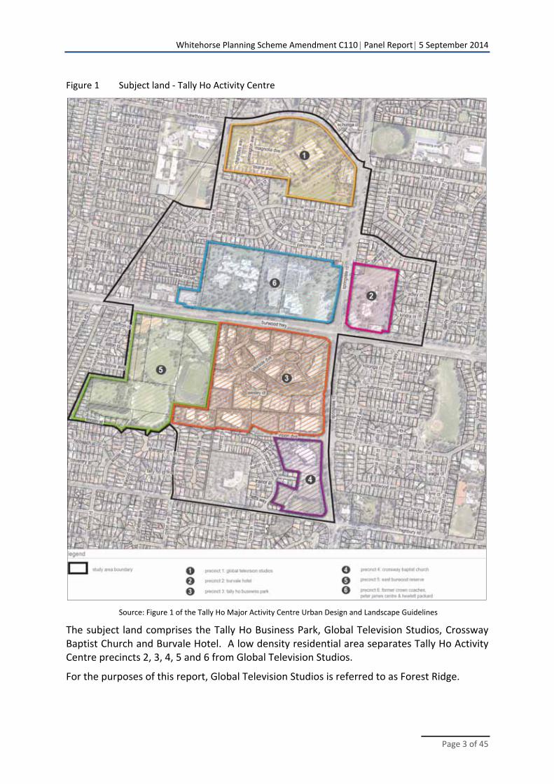
Figure 1 Subject land ‐ Tally Ho Activity Centre
Source: Figure 1 of the Tally Ho Major Activity Centre Urban Design and Landscape Guidelines
The subject land comprises the Tally Ho Business Park, Global Television Studios, Crossway Baptist Church and Burvale Hotel. A low density residential area separates Tally Ho Activity Centre precincts 2, 3, 4, 5 and 6 from Global Television Studios.
For the purposes of this report, Global Television Studios is referred to as Forest Ridge.
Whitehorse Planning Scheme Amendment C110 Panel Report 5 September 2014
Page 4 of 45
The subject land is accessible by:
Tram (Route 75) from Melbourne Central City Area
Bus (Routes 732) from Box Hill and Upper Ferntree Gully train stations and Box Hill activity centre and Knox City shopping centre
Smart Bus (Route 902) from Nunawading train station to the north and Glen Waverley train station to the south.
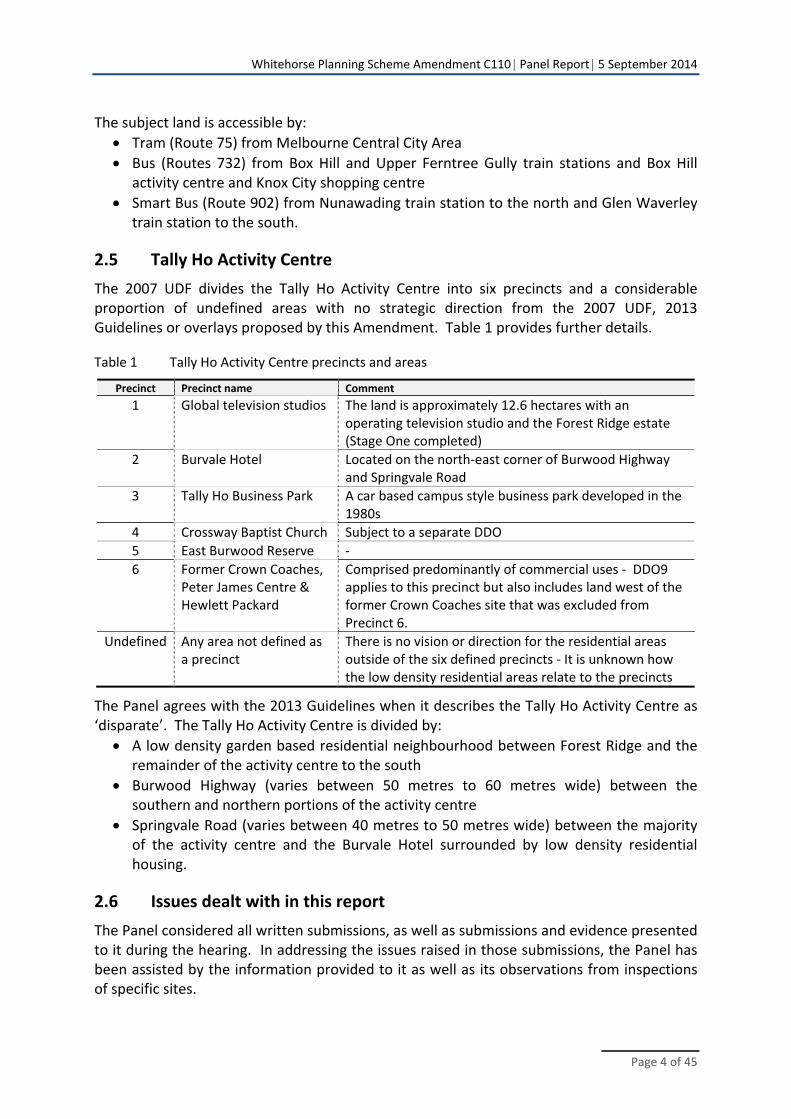
2.5 Tally Ho Activity Centre
The 2007 UDF divides the Tally Ho Activity Centre into six precincts and a considerable proportion of undefined areas with no strategic direction from the 2007 UDF, 2013 Guidelines or overlays proposed by this Amendment. Table 1 provides further details.
Table 1 Tally Ho Activity Centre precincts and areas
Precinct Precinct name Comment
1 Global television studios The land is approximately 12.6 hectares with an operating television studio and the Forest Ridge estate (Stage One completed)
2 Burvale Hotel Located on the north‐east corner of Burwood Highway and Springvale Road
3 Tally Ho Business Park A car based campus style business park developed in the 1980s
4 Crossway Baptist Church Subject to a separate DDO
5 East Burwood Reserve ‐
6 Former Crown Coaches, Peter James Centre & Hewlett Packard
Comprised predominantly of commercial uses ‐ DDO9 applies to this precinct but also includes land west of the former Crown Coaches site that was excluded from Precinct 6.
Undefined Any area not defined as a precinct
There is no vision or direction for the residential areas outside of the six defined precincts ‐ It is unknown how the low density residential areas relate to the precincts
The Panel agrees with the 2013 Guidelines when it describes the Tally Ho Activity Centre as ‘disparate’. The Tally Ho Activity Centre is divided by:
A low density garden based residential neighbourhood between Forest Ridge and the remainder of the activity centre to the south
Burwood Highway (varies between 50 metres to 60 metres wide) between the southern and northern portions of the activity centre
Springvale Road (varies between 40 metres to 50 metres wide) between the majority of the activity centre and the Burvale Hotel surrounded by low density residential housing.
2.6 Issues dealt with in this report
The Panel considered all written submissions, as well as submissions and evidence presented to it during the hearing. In addressing the issues raised in those submissions, the Panel has been assisted by the information provided to it as well as its observations from inspections of specific sites.
Whitehorse Planning Scheme Amendment C110 Panel Report 5 September 2014
Page 5 of 45
This report deals with the issues under the following headings:
Strategic planning context
Council’s approach
Tally Ho Activity Centre area
Schedule 9 to the Design and Development Overlay
Schedule 5 to the Development Plan Overlay
Other issues.
Whitehorse Planning Scheme Amendment C110 Panel Report 5 September 2014
Page 6 of 45
3 Strategic Planning Context
Council provided a response to the Strategic Assessment Guidelines as part of the Explanatory Report. The Panel has reviewed the policy context of the Amendment and made a brief appraisal of the relevant zone and overlay provisions and other relevant planning strategies.
3.1 Policy framework
3.1.1 State Planning Policy Framework
Council submitted that the Amendment is supported by the following policy objectives in the SPPF:
11.01 ‐ Activity centres
To build up activity centres as a focus for high‐quality development, activity and living for the whole community by developing a network of activity centres.
To encourage the concentration of major retail, residential, commercial, administrative, entertainment and cultural developments into activity centres which provide a variety of land uses and are highly accessible to the community.
11.02 ‐ Urban growth
To ensure a sufficient supply of land is available for residential, commercial, retail, industrial, recreational, institutional and other community uses.
To locate urban growth close to transport corridors and services and provide efficient and effective infrastructure to create benefits for sustainability while protecting primary production. Major sources of raw materials and valued environmental areas.
To facilitate the orderly growth of urban areas.
15.01 ‐ Urban environment
To create urban environments that are safe, functional and provide good quality environments with a sense of place and cultural identity.
To achieve architectural and urban design outcomes that contribute positively to local urban character and enhance the public realm while minimising detrimental impact on neighbouring properties.
15.02 ‐ Sustainable development
To encourage land use development that is consistent with the efficient use of energy and the minimisation of greenhouse emission.
16.01 ‐ Residential development
To promote a housing market that meets community needs.
Whitehorse Planning Scheme Amendment C110 Panel Report 5 September 2014
Page 7 of 45
To promote new housing in or close to activity centres and employment corridors and at other strategic redevelopment sites that offer good access to services and transport.
To identify strategic redevelopment sites for large residential development in metropolitan Melbourne.
To provide for a range of housing types to meet increasingly diverse needs.
To deliver more affordable housing closer to jobs, transport and services.
17.01 ‐ Commercial
To encourage development which meet the communities’ needs for retail, entertainment, office and other commercial services and provides net community benefit in relation to accessibility, efficient infrastructure use and the aggregation and sustainability of commercial facilities.
3.1.2 Local Planning Policy Framework
Council submitted that the Amendment supports the following local planning objectives:
(i) Municipal Strategic Statement
21.05 ‐ Environment
Clause 21.05 seeks to:
Protect and enhance areas with special natural, environmental, cultural or historic significance for the future enjoyment of the community.
Facilitate environmental protection and improvements to known assets including water, flora, fauna and biodiversity assets.
Develop main thoroughfares as attractive boulevards with improved advertising signage, landscaping and building design.
Protect and enhance air and water quality.
Reduce automobile dependency and encourage sustainable transport use.
Reduce energy and water consumption.
21.06 ‐ Housing
Clause 21.06 seeks to:
Maintain and enhance the character of the City’s residential areas and ensure that non‐residential uses are appropriately managed.
Provide for a wide range of housing types to meet the changing needs of the population.
Ensure that higher density housing is directed to specific areas, including activity centres, with excellent public transport and shopping access and is integrated with existing residential areas in a form consistent with the character of neighbourhoods.
Whitehorse Planning Scheme Amendment C110 Panel Report 5 September 2014
Page 8 of 45
21.07 ‐ Economic development
Clause 21.07 seeks, among an exhaustive list of objectives, to:
Maintain the City’s position as the second largest provider of office space outside St.Kilda Road and the Melbourne CAA.
Facilitate continued investment in high quality office space placed in attractive settings with extensive landscaping and car parking following the completion of development in the Box Hill and Tally Ho commercial precincts.
Create and manage sensitive interfaces between our key industrial precincts and adjoining residential areas and facilitate high quality, attractive development that is environmentally sustainable and enhances the appearance of the area.
Facilitate the redevelopment of key sites in association with the community.
Ensure Activity Centre development encourages a more effective use of public transport and cycling modes of transport.
Facilitate the continued enhancement of the Forest Hill Chase and Tally Ho Major Activity Centres through Structure Plans or Urban Design Framework Plans.
(ii) Local policies
22.06 ‐ Activity Centres
Clause 22.06 seeks to:
Ensure that land use and development in activity centres reinforce, and are appropriate to, the role of the centre.
Ensure that each centre responds to the needs of the community.
Ensure that new retail floorspace reflects retail demand and considers the impact on the retail hierarchy and the planned role and function of other activity centres.
Maintain and enhance the role of activity centres as a community focus.
Improve the appearance and amenity of all activity centres.
22.08 ‐ Tally Ho Activity Centre
Clause 22.08 seeks to:
Encourage economic development based on new generation commerce and knowledge.
Facilitate growth and development to meet current and future needs whilst maintaining amenity and liveability.
Increase the mix of uses in existing and new developments.
Create a sustainable urban environment.
Discourage use of private motor vehicles by improving the extent and quality of bicycle and pedestrian networks and enhancing public transport infrastructure.
Reduce at‐grade car parking.
Ensure community facilities can meet the current and future needs of the local population.
Whitehorse Planning Scheme Amendment C110 Panel Report 5 September 2014
Page 9 of 45
Enhance the quality and extent of landscaping.
3.2 Zones and Overlays
A common purpose to all zones and overlays is:
To implement the State Planning Policy Framework and the Local Planning Policy Framework, including the Municipal Strategic Statement and local planning policies.
3.2.1 Zones
The subject land comprises the Commercial 1 Zone, General Residential Zone and Mixed Use Zone.
(i) Commercial 1 Zone
The purposes of the Commercial 1 Zone are:
To create vibrant mixed use commercial centres for retail, office, business, entertainment and community uses.
To provide for residential uses at densities complementary to the role and scale of the commercial centre.
(ii) General Residential Zone
The purposes of the General Residential Zone are:
To encourage development that respects the neighbourhood character of the area.
To implement neighbourhood character policy and adopted neighbourhood character guidelines.
To provide a diversity of housing types and moderate housing growth in locations offering good access to services and transport.
To allow educational, recreational, religious, community and a limited range of other nonresidential uses to serve local community needs in appropriate locations.
(iii) Mixed Use Zone
The purposes of the Mixed Use Zone are:
To provide for a range of residential, commercial, industrial and other uses which complement the mixed‐use function of the locality.
To provide for housing at higher densities.
To encourage development that responds to the existing or preferred neighbourhood character of the area.
Whitehorse Planning Scheme Amendment C110 Panel Report 5 September 2014
Page 10 of 45
To facilitate the use, development and redevelopment of land in accordance with the objectives specified in a schedule to this zone.
3.2.2 Overlays
The Amendment proposes to introduce DDO9 and DPO5. DDO9:
Includes properties west of the former Crown Coaches site that are excluded from Precinct 6 of the 2007 UDF.
Excludes the Crossway Baptist Church land at 2‐18 and 27‐29 Vision Drive and 709 Highbury Road, Burwood East because it was subject to Schedule 4 to the Development Plan Overlay, introduced by Amendment C123. The church land forms most of Precinct 4 and a small portion of Precinct 3.
3.3 Plan Melbourne
Plan Melbourne, Melbourne’s metropolitan planning strategy, was introduced into the SPPF in July 2014. Plan Melbourne divides Melbourne into subregions and identifies Burwood East‐Tally Ho as an existing activity centre in the Eastern Subregion. Plan Melbourne anticipates that this region will accommodate between 150,000 and 200,000 more residents and between 75,000 to 100,000 new jobs by 2031.
Principal and major activity centres are now referred to as activity centres. The Tally Ho Activity Centre therefore now has the same hierarchical status as a principal activity centre. An activity centre is defined as a suburban centre that provides a focus for services, employment, housing, transport and social interaction.
3.4 Other planning strategies and guidelines
(i) Tally Ho Major Activity Centre Urban Design Framework 2007
The 2007 UDF provides physical interpretations of local visions and strategies. It focuses on managing change and setting new directions for integrated development of the urban environment over 15 years.
Section 4 states:
The views of the Tally Ho community, both residential and business, have been integral to the development of the Framework. The community has provided important information related to its issues, needs and aspirations for the area in the future.
The 2007 UDF provides objectives and strategies for each of the following themes:
Identity and knowledge - Economic sustainability - Built form and density
Sustainability - Environmental sustainability - Transport and car parking
Whitehorse Planning Scheme Amendment C110 Panel Report 5 September 2014
Page 11 of 45
Vitality - Open space, connectivity & linkages - Streetscapes and landscapes - Land use and zoning
Community
The 2007 UDF has a general strategy for the entire area and specific objectives and strategies for land known as:
Global Television Studios
Burvale Hotel
Tally Ho Business Park
Crossway Baptist Church
East Burwood Reserve
Crown Coaches, Peter James Centre and Hewlett Packard.
A strategy for implementing built form and density is:
Provide appropriate planning and design guidelines for:
the development of key sites including principles that address building envelopes, height, articulation and interfaces
streetscape interfaces between key sites
landscaping in the public and private realm.
A land use and zoning objective is:
Identify amendments to the Whitehorse Planning Scheme that will facilitate implementation of the vision and objectives of the Tally Ho UDF.
The 2007 UDF is referred to in the Whitehorse Planning Scheme at Clause 22.08 and Schedule 4 to the DPO.
(ii) Tally Ho Urban Design and Landscape Guidelines 2013
The Tally Ho Urban Design and Landscape Guidelines 2013 (2013 Guidelines) acknowledges the 2007 UDF, including its objectives.
3.5 Other relevant amendments
(i) Amendment C123
Amendment C123 applied Schedule 4 to the DPO to the Crossway Baptist Church land (located in the Tally Ho Activity Centre). The overlay requires a development plan for any expansion to align with the 2007 UDF.
(ii) Amendment C157
Amendment C157 seeks to apply heritage provisions to 29 heritage places throughout the municipality, including Forest Ridge (104‐168 Hawthorn Road) and Burvale Hotel/Motel (385 Burwood Highway). Amendment C157 was not exhibited at the time of the hearing.
Whitehorse Planning Scheme Amendment C110 Panel Report 5 September 2014
Page 12 of 45
(iii) Amendment C160
The amendment applies to all land currently within the Residential 1 Zone and to 60 Neighbourhood Activity Centres (NACs) in the City of Whitehorse.
In summary, the following changes are proposed for a considerable proportion of land within the Tally Ho Activity Centre:
Table 2 How Amendment C160 affects land in the Tally Ho Activity Centre
Land within the Tally Ho Activity Centre Rezone to:
Forest Ridge Schedule 2 to the Residential Growth Zone (Substantial Change B) that includes a mandatory 13.5 metre maximum height.
All residential areas between Forest Ridge and Burwood Highway west of Springvale Road
Schedule 1 to the General Residential Zone (Established Garden Suburban Areas)
Residential areas east of Springvale Road and north of Burwood Highway
Schedule 5 to the Neighbourhood Residential Zone (Traditional Garden Suburban Areas)
Small south‐west portion of Precinct 3 Schedule 1 to the General Residential Zone (Established Garden Suburban Areas)
At the time of the Amendment C110 hearing, Council sought approval from the Minister for Planning for Amendment C160 without formal exhibition and without an independent review of issues raised by Tally Ho Activity Centre property owners.
3.6 Ministerial Directions and Planning Practice Notes
Council submitted that the Amendment complies with the requirements of the following Ministerial Directions:
Ministerial Direction No 9 – Metropolitan Planning Strategy
Ministerial Direction No 11 ‐ Strategic Assessment of Amendments
Ministerial Direction on the Form and Content of Planning Schemes
Ministerial Direction No 15 ‐ The Planning Scheme Amendment Process
Council submitted that the following Planning Practice Notes were relevant to the Amendment:
Planning Practice Note No 23 Applying the Incorporated Plan and Development Plan Overlay, January 2003
Planning Practice Note No 60 Height and Setback Controls for Activity Centres, April 2010.
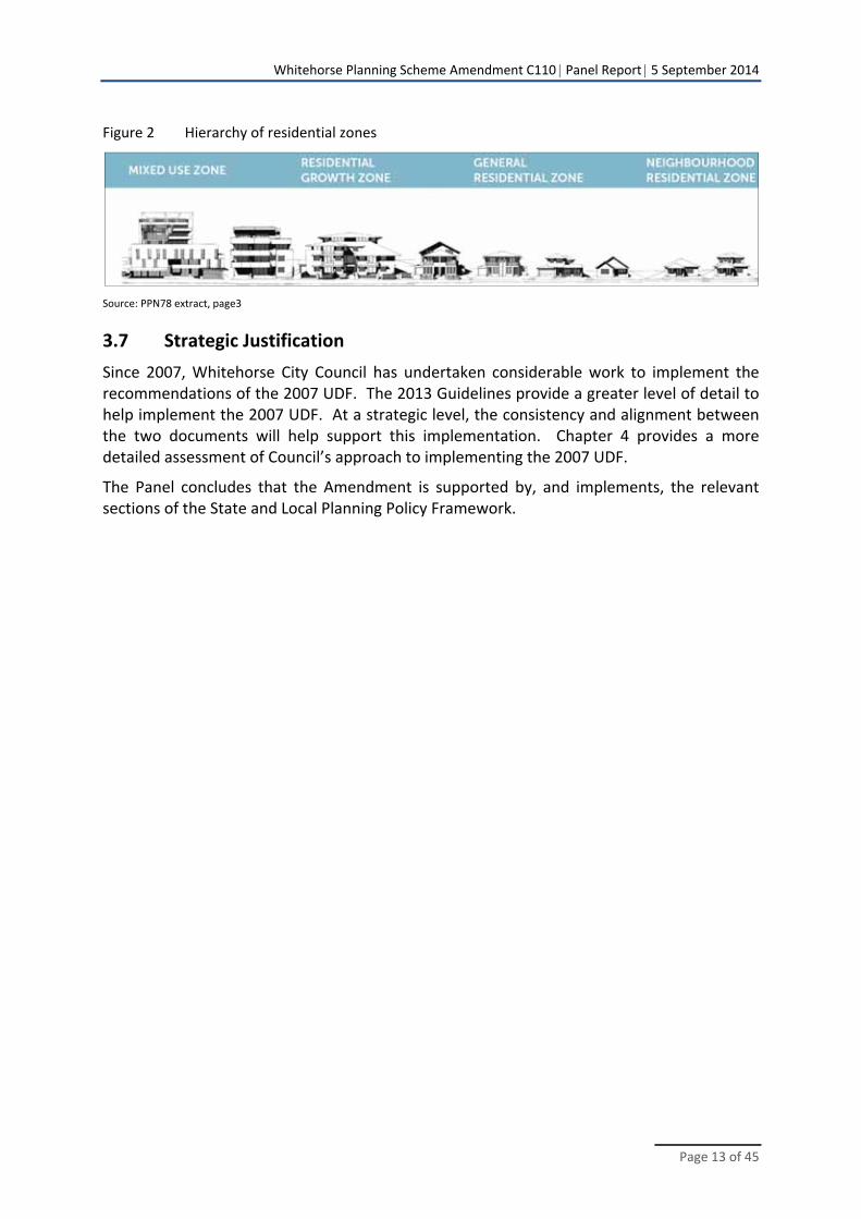
The Panel adds that Planning Practice Note No 78 Applying the Residential Zones, July 2013 (PPN78) is relevant to the Amendment. PPN78 is referred to in Plan Melbourne and sets out a hierarchy of residential zones as shown in Figure 2.
Whitehorse Planning Scheme Amendment C110 Panel Report 5 September 2014
Page 13 of 45
Figure 2 Hierarchy of residential zones
Source: PPN78 extract, page3
3.7 Strategic Justification
Since 2007, Whitehorse City Council has undertaken considerable work to implement the recommendations of the 2007 UDF. The 2013 Guidelines provide a greater level of detail to help implement the 2007 UDF. At a strategic level, the consistency and alignment between the two documents will help support this implementation. Chapter 4 provides a more detailed assessment of Council’s approach to implementing the 2007 UDF.
The Panel concludes that the Amendment is supported by, and implements, the relevant sections of the State and Local Planning Policy Framework.
Whitehorse Planning Scheme Amendment C110 Panel Report 5 September 2014
Page 14 of 45
4 Council’s Approach
4.1 Strategic implementation
Council submitted that the exhibited Amendment is consistent with 2007 UDF which set out the objectives for the Tally Ho Activity Centre for the next 15 years. The 2007 UDF applies ‘campus’ style built form objectives to reflect the 1980s Tally Ho Business Park across land within the Tally Ho Activity Centre. Consistent with one of the 19 design objectives for DDO9, the Panel interprets ‘campus style’ as development within a generous landscape setting.
A strategy to implement the built form and density objectives of the 2007 UDF is:
Provide appropriate planning and design guidelines for
the development of key sites including principles that address building envelopes, height, articulation and interfaces
streetscape interfaces between key sites landscaping in the public and private realm.
In 2013, Council engaged Hansen Partnership to prepare planning and design guidelines. At the hearing, Mr Czarny stated that the 2013 Guidelines were necessary because the ‘interim’ Clause 22.08 did not have adequate detail to guide development and public works over time. He added that Hansen Partnership did not review the 2007 UDF and was not in a position to express whether this document had sound strategic justification. Therefore there was no review of:
The relevance or practicality of the preferred built form in the UDF
The suitability of land included in the Tally Ho Activity Centre.
The Guidelines specify:
These Urban Design and Landscape Guidelines have been prepared to assist in realisation of the Tally Ho UDF. The intention of these guidelines is not to replace or supersede the framework, rather to provide detail as to ultimate built form and landscape outcomes.
The 2013 Guidelines introduced setbacks that were not part of the 2007 UDF.
Council submitted that it prepared the Amendment to align with the 2007 UDF and subsequent 2013 Guidelines. At the hearing, Council reiterated that the 2013 Guidelines and provisions in DDO9 and DPO5 are intended to be flexible to allow variation from the preferred built form provisions. Mr Czarny agreed with Council’s view that the guidelines were a preferred ‘default’ position in the absence of a more detailed understanding of site specific conditions. Council can vary the default position once these conditions are identified and assessed.
Whitehorse Planning Scheme Amendment C110 Panel Report 5 September 2014
Page 15 of 45
4.2 2007 UDF and Clause 22.08
In 2009, Council introduced Clause 22.08 as an ‘interim’ policy which references the 2007 UDF. In support of the 2007 UDF, Council submitted:
The UDF has been consistently applied by Council and remains relevant. It has successfully guided development over the last 7 years and is expected to continue being relevant into the future due to its flexibility to allow variations when justified.
At the hearing, Mr Czarny stated that the Tally Ho Activity Centre warrants its own policy at Clause 22.08 because it is distinctive from other activity centres. Submissions were more concerned with how interim Clause 22.08 was introduced to give effect to the 2007 UDF. Ms Peppler questioned the process for introducing the 2007 UDF and submitted at the hearing:
a) The UDF was created in 2007, which is now 7 years ago. Notably, the UDF states that it intends to guide development for 15 years. Therefore, half of its lifespan has already passed.
b) The UDF has not been explained, independently reviewed or assessed by a Panel or by an expert on behalf of Council. Clause 22.08 was brought in as an interim control.
c) The rationale of the UDF has not been reassessed by the Council or the Council’s consultants in preparing the Guidelines, or this Amendment.
(i) Discussion
Ms Peppler raises valid concerns. Clause 22.08 was introduced as an ‘interim’ policy (i.e. with an expiry date) under section 20(4) of the Planning and Environment Act 1987 through Amendment C102 without exhibition or an independent panel. The C102 Explanatory Report offers no explanation as to why Clause 22.08 had to be fast tracked as an interim policy. The Panel questions whether Clause 22.08 could ever be considered an interim clause when there was a willingness to keep extending its existence for five years. Other than an expiry date, there is generally no difference between an interim and permanent policy. A review of the 2007 UDF would have informed whether policies in Clause 22.08 needed to be revised before making the clause permanent.
The Panel agrees that the 2007 UDF has guided development over seven years but this does not automatically make it successful. Applicants have had no choice but to respond to the framework since it was referenced in Clause 22.08 in 2009. Amendment C102 offered the ideal timing to independently assess the 2007 UDF before referencing it in the planning scheme. In the absence of this assessment, the process leading to Amendment C110 was the next available opportunity to review the 2007 UDF.
The Panel acknowledges that Amendment C110 has provided an opportunity to express views about the provisions proposed to implement the 2007 UDF.
Whitehorse Planning Scheme Amendment C110 Panel Report 5 September 2014
Page 16 of 45
4.3 Provisions implementation
(i) The issue
Amendment C110 proposes to introduce DDO9 and DPO5; both refer to the 2007 UDF and 2013 Guidelines.
Council has opted to introduce planning provisions that support the Tally Ho Activity Centre through four separate amendments; C110, C123, C160 and C157. A description of each amendment is provided at Chapter 3.5.
In relation to Amendment C160, the Panel notes:
The Neighbourhood Residential Zone is proposed in part of the Tally Ho Activity Centre
Amendment C110 proposes a discretionary height of 13.5 metres for the Global Television site while Amendment C160 proposes a mandatory height of 13.5 metres.
The issue is whether Council’s approach to implementing activity centre related provisions addresses issues fully and fairly.
(ii) Submissions
At the hearing, Mr Milner submitted that, as a consequence of splitting land use issues across numerous amendments, the exhibited DDO5 does not fully or fairly address the development plan issues presented by the site. Bazem Pty Ltd (Bazem) added (document 7):
Neither the Tally Ho Major Activity Centre Urban Design Framework 2007 or the Tally Ho Major Activity Centre Urban Design and Landscape Guidelines Draft Report 2013, which form the basis of Amendment C110 and DPO5, have been prepared with regard to the two most recent metropolitan strategies.
As a consequence, there has not been proper regard to activity centre policy and the strategic implications of housing growth and potential role of the site.
Bazem sought to revise the Amendment to exclude DDO5 because it had extensive shortcomings in relation to its land.
(iii) Discussion
While highlighting issues related to its site, Base’s submission raised issues that have implications across other parts of the Tally Ho Activity Centre. Council’s approach to split issues across numerous amendments has effectively ruled out the ability for the Panel to assess the suitability of activity centre zoning provisions as a complete package.
There are three examples that highlight the importance of assessing activity centre provisions in one integrated amendment.
Example 1 ‐ C160 proposes the Neighbourhood Residential Zone within the activity centre
PPN78 specifies that the Neighbourhood Residential Zone is not to be applied on land “Identified in Activities Area structure plan / policy”. The Neighbourhood Residential Zone includes a purpose to “limit opportunities for increased residential development” whereas an activity centre encourages and expects such growth. The proposed zone directly impacts
Whitehorse Planning Scheme Amendment C110 Panel Report 5 September 2014
Page 17 of 45
Amendment C110 but the Panel cannot pursue this further because it is subject to a separate amendment.
Example 2 ‐ C160 proposes mandatory heights on Forest Ridge
The mandatory height proposed by Amendment C160 conflicts with Council’s approach to implement ‘flexible’ provisions through Amendment C110. If Forest Ridge is considered part of the Tally Ho Activity Centre, then the Panel agrees that justification for mandatory heights should form part of Amendment C110. The proposed provisions directly impact Amendment C110 but the Panel cannot pursue this further because it is subject to a separate amendment. The Panel is therefore unable to determine what makes Forest Ridge so special to warrant mandatory maximum height controls1 instead of assessing building heights on the site’s own merits.
Example 3 ‐ C157 proposes heritage provisions on Forest Ridge
Heritage matters can influence the extent of building height, setbacks and other built form considerations; all matters that are generally included in a Development Plan Overlay. However, heritage matters related to Forest Ridge are proposed by Amendment C157.
The absence of a formal review of the 2007 UDF and Clause 22.08 combined with splitting activity centre planning matters across numerous amendments may be inadvertently masking issues that would have been identified through a more integrated process.
The proposed heritage provisions directly impact Amendment C110 but the Panel cannot pursue this further because it is subject to a separate amendment.
Chapter 5 discusses the appropriateness of including certain areas, including Forest Ridge, in the Tally Ho Activity Centre.
4.4 Conclusion
The Panel is generally satisfied that the broad principles that underpin Amendment C110 are consistent with the 2007 UDF and 2013 Guidelines, subject to the following concerns with Council’s approach:
The 2007 UDF and Clause 22.08 would have benefitted from an independent assessment of their effectiveness in achieving preferred built form outcomes and relevance against Plan Melbourne and revised SPPF. In the absence of this assessment, the Panel notes that each submitter had an opportunity to express their views about the exhibited provisions associated with the 2007 UDF.
Separating provisions related to the Tally Ho Activity Centre across numerous amendments has limited the ability for integrated activity centre planning.
Including low density residential areas that serve no function to the overall activity centre or is proposed to be zoned Neighbourhood Residential Zone will result in confusion and conflicts.
These issues are discussed further throughout this report.
1 Planning Practice No 59: The role of mandatory provisions in planning schemes, September 2010
Whitehorse Planning Scheme Amendment C110 Panel Report 5 September 2014
Page 18 of 45
5 Tally Ho Activity Centre Area
5.1 The issue
Some submissions raised issues that directly or indirectly related to their land being included in the Tally Ho Activity Centre. Submission 3 and 4 were concerned with the implications of their low density residential area being included in an activity centre. Bazem sought a new amendment for Forest Ridge with a zone normally associated with an activity centre such as the Activity Centre Zone or Mixed Use Zone.
The issue is whether the 2007 UDF and 2013 Guidelines can be effectively implemented in, what is referred to as, the study area in both documents.
5.2 Evidence and submissions
Council submitted at the hearing that:
The UDF defines the Tally Ho Activity Centre as including key community and commercial landholdings, in an area extending 800m along Springvale Rd and Burwood Highway (UDF p.1).
The UDF study area was defined as extending beyond these key landholdings to include the residential areas between Hawthorn Road to the north and Highbury Road to the south (UDF p.1). The study area is shown on p.2 of the UDF.
A local resident (submission 4) submitted:
I have lived in Pickford Street Burwood East for 21 years. Due to Council drawing a line on a map, my residential area has been classified as part of the Tally Ho Major Activity Centre.
Another local resident (submission 3) had a similar view and submitted:
I am very worried that this amendment will see me living next to a high rise and congestion from cars. Why do you have to include our estate in this amendment? Clearly it is a housing estate and not commercial like Tally Ho or a vacant area like HP and the old Global studios site.
Bazem submitted:
The subject site is ideal to accommodate medium and higher density residential development as well as a mixture of other uses complementary to the balance of the Tally Ho MAC.
Accordingly, as a minimum it is requested that the subject site be:
Excluded from Schedule 2 to the RGZ;
Not subjected to a mandatory building height;
Removed from the Garden Suburban – Precinct 6; and
That the preferred character of the subject site be resolved through the Tally Ho Major Activity Centre Urban Design and Landscape Guidelines 2013.
Whitehorse Planning Scheme Amendment C110 Panel Report 5 September 2014
Page 19 of 45
Furthermore, it is requested that the residential zoning of the subject site be re‐examined and consideration be given to apply either the Activity Centre Zone (ACZ) or Mixed Use Zone (MUZ).
5.3 Discussion
(i) Low density residential areas
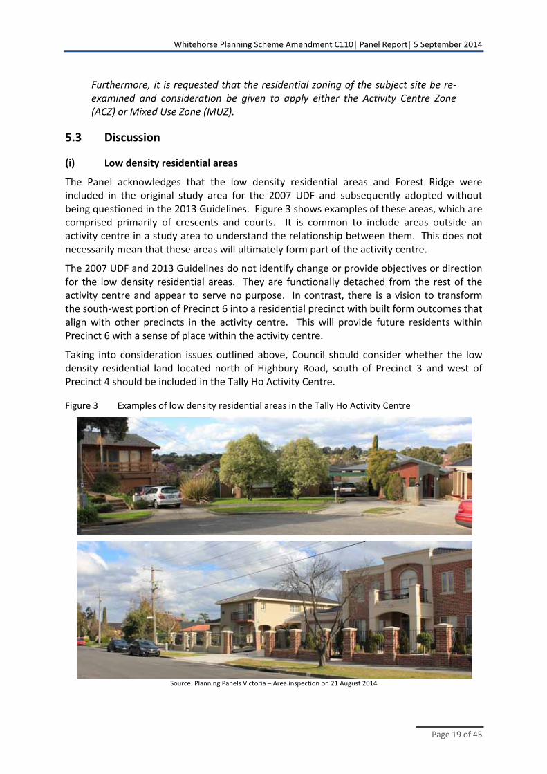
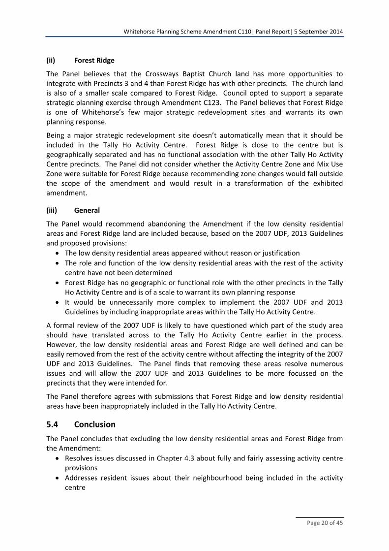
The Panel acknowledges that the low density residential areas and Forest Ridge were included in the original study area for the 2007 UDF and subsequently adopted without being questioned in the 2013 Guidelines. Figure 3 shows examples of these areas, which are comprised primarily of crescents and courts. It is common to include areas outside an activity centre in a study area to understand the relationship between them. This does not necessarily mean that these areas will ultimately form part of the activity centre.
The 2007 UDF and 2013 Guidelines do not identify change or provide objectives or direction for the low density residential areas. They are functionally detached from the rest of the activity centre and appear to serve no purpose. In contrast, there is a vision to transform the south‐west portion of Precinct 6 into a residential precinct with built form outcomes that align with other precincts in the activity centre. This will provide future residents within Precinct 6 with a sense of place within the activity centre.
Taking into consideration issues outlined above, Council should consider whether the low density residential land located north of Highbury Road, south of Precinct 3 and west of Precinct 4 should be included in the Tally Ho Activity Centre.
Figure 3 Examples of low density residential areas in the Tally Ho Activity Centre
Source: Planning Panels Victoria – Area inspection on 21 August 2014
Whitehorse Planning Scheme Amendment C110 Panel Report 5 September 2014
Page 20 of 45
(ii) Forest Ridge
The Panel believes that the Crossways Baptist Church land has more opportunities to integrate with Precincts 3 and 4 than Forest Ridge has with other precincts. The church land is also of a smaller scale compared to Forest Ridge. Council opted to support a separate strategic planning exercise through Amendment C123. The Panel believes that Forest Ridge is one of Whitehorse’s few major strategic redevelopment sites and warrants its own planning response.
Being a major strategic redevelopment site doesn’t automatically mean that it should be included in the Tally Ho Activity Centre. Forest Ridge is close to the centre but is geographically separated and has no functional association with the other Tally Ho Activity Centre precincts. The Panel did not consider whether the Activity Centre Zone and Mix Use Zone were suitable for Forest Ridge because recommending zone changes would fall outside the scope of the amendment and would result in a transformation of the exhibited amendment.
(iii) General
The Panel would recommend abandoning the Amendment if the low density residential areas and Forest Ridge land are included because, based on the 2007 UDF, 2013 Guidelines and proposed provisions:
The low density residential areas appeared without reason or justification
The role and function of the low density residential areas with the rest of the activity centre have not been determined
Forest Ridge has no geographic or functional role with the other precincts in the Tally Ho Activity Centre and is of a scale to warrant its own planning response
It would be unnecessarily more complex to implement the 2007 UDF and 2013 Guidelines by including inappropriate areas within the Tally Ho Activity Centre.
A formal review of the 2007 UDF is likely to have questioned which part of the study area should have translated across to the Tally Ho Activity Centre earlier in the process. However, the low density residential areas and Forest Ridge are well defined and can be easily removed from the rest of the activity centre without affecting the integrity of the 2007 UDF and 2013 Guidelines. The Panel finds that removing these areas resolve numerous issues and will allow the 2007 UDF and 2013 Guidelines to be more focussed on the precincts that they were intended for.
The Panel therefore agrees with submissions that Forest Ridge and low density residential areas have been inappropriately included in the Tally Ho Activity Centre.
5.4 Conclusion
The Panel concludes that excluding the low density residential areas and Forest Ridge from the Amendment:
Resolves issues discussed in Chapter 4.3 about fully and fairly assessing activity centre provisions
Addresses resident issues about their neighbourhood being included in the activity centre
Whitehorse Planning Scheme Amendment C110 Panel Report 5 September 2014
Page 21 of 45
Provides the 2007 UDF and 2013 Guidelines with a more focussed response to, what the Panel considers to be, the extent of the Tally Ho Activity Centre
Provides Tally Ho Activity Centre with a more legible boundary.
5.5 Recommendations
The Panel recommends:
1. Modify the Tally Ho Activity Centre area to exclude land: a) North of Precinct 6, west of Springvale Road, south of Hawthorn Road and
east of Mahoneys Road b) North of the Mixed Use Zone on Burwood Highway, west of Mahoneys
Road, south of Burwood Heights Primary School and east of the linear reserve.
c) The residential area surrounding the Burvale Hotel proposed to be rezoned Neighbourhood Residential Zone.
2. In response to modifying the Tally Ho Activity Centre area, make consequential changes to Clause 22.08, Schedule 9 to the Design and Development Overlay and Schedule 5 to the Development Plan Overlay.
Whitehorse Planning Scheme Amendment C110 Panel Report 5 September 2014
Page 22 of 45
6 Schedule 9 to the Design and Development Overlay
6.1 Building height
(i) The issue
Schedule 9 to the Design and Development Overlay (DDO9) specifies that buildings and works should not exceed the preferred maximum building height specified in Table 1. Table 1 divides the overlay into five sub‐precincts and applies different building heights in each precinct, as shown in Map 1 of DDO9.
Specifically, DDO9 states:
An application to exceed the preferred maximum building height must demonstrate how the development will continue to achieve the Design Objectives and Built Form Outcomes of this schedule and any local planning policy requirements.
The issue is whether the preferred maximum building heights are appropriate when considering existing building heights and Council’s preferred height expressed through a planning permit.
(ii) Evidence and submissions
Mr Czarny stated in his evidence:
The heights as outlined in the UDF are generally consistent with those in the proposed DDO, however any fragmented building height designations have been grouped into consistent precincts to avoid complexity. I do not consider that this represents any kind of flaw or discrepancy given existing and preferred scale. Furthermore, both the Design Guidelines and the proposed DDO regime clearly state that the height and setback requirements are preferred and not mandatory.
Kador Group Holdings (Kador) (submission 2) submitted that in Precinct C of DDO9, the building height of 11.5 metres for sites interfacing public open space conflicted with the 8 metre building height in section 2.3 of the Tally Ho MAC Guidelines. Kador added that the existing Lakeside Drive building would breach the preferred maximum building height of 8 metres.
Bibelston Pty Ltd (Bibelston) (submission 5) submitted that a permit application to develop a six storey residential building on a 6,000 square metre property on the corner of Burwood Highway and Mahoneys Road was supported by Whitehorse City Council. Bibelston added that the proposal in the current permit application would not be able to meet the preferred maximum building height of 10 metres proposed for sub precinct iv in DDO9.
Bibelston sought to change the preferred building height for 315‐319 Burwood Highway from 10 metres to 30 metres. It acknowledged that Council agreed to a 20 metre proposal on its land. Under cross‐examination, Mr Czarny said that 20 metres should be the starting
Whitehorse Planning Scheme Amendment C110 Panel Report 5 September 2014
Page 23 of 45
point for discussion about building height on this land because that height has been assessed through a permit process.
In his evidence, Mr Sheppard did not support the 10 metre preferred maximum building height because:
The subject site is located within a higher‐order activity centre, where policy seeks urban consolidation and greater density.
Burwood Highway is a broad boulevard that warrants taller buildings in order to relate to its broader scale.
The large size of the site enables it to contain the impacts of height away from sensitive interfaces.
The location of the site on a prominent corner warrants taller form to act as an urban marker.
The 2 storey medium density residential dwellings immediately abutting the subject site to the north are outside the activity centre and rise to a height of approximately 8 metres, which is only marginally lower than the proposed 10 metre maximum height within the activity centre.
The housing immediately abutting the site ‘turns its back’ on the site, limiting its sensitivity to built form impacts.
The proposed Preferred Maximum Building Height ignores the recent and previous planning permissions for the site which provide for buildings of approximately 20‐22 metres in height.
Mr Sheppard added:
[36] I consider that a discretionary maximum height of 30m (which would allow buildings of 8 to 10 storeys in height) would be appropriate in this location. This represents a building height to street width ratio of 1:2. Although this exceeds the prevailing tree canopy height, I consider that the urban consolidation imperatives outweigh this character aspiration.
[37] Whilst I support the need for buildings to step down to respond to residential land at the edge of the MAC, I do not see a need for buildings to step down at the Burwood Highway interface. This is a 60m wide road that can comfortably absorb substantial height without being visually overwhelmed.
(iii) Discussion and conclusion
The building heights specified in the DDO9 are preferred heights and can be increased if a permit application demonstrates how the development will achieve certain outcomes and requirements. The Panel interprets this as:
There is no maximum building height if it can be demonstrated that the specified outcomes and requirements can be achieved.
The preferred maximum building height will be implemented as the actual maximum building height where Council believes the specified outcomes and requirements cannot be achieved.
Whitehorse Planning Scheme Amendment C110 Panel Report 5 September 2014
Page 24 of 45
The Panel agrees that this approach allows flexibility where the built form outcome does not compromise the integrity of the 2007 UDF and 2013 Guidelines. The Panel supports grouping fragmented 2007 UDF building heights in DDO9 to avoid complexity and acknowledges that the provisions can be varied under certain circumstances.
However, issues can arise when specified preferred maximum building heights are either lower than some existing buildings or lower than heights agreed to by Council in a planning permit, such as at 315‐319 Burwood Highway.
Existing buildings
The Panel understands that heights are set on a precinct and interface basis, however, this contradiction is likely to send confusing messages about what Council is seeking. Expressing preferred heights lower than some of the existing buildings could be interpreted that those existing buildings should not have been constructed to that height. This means that Council would prefer any future proposal to replace one of these buildings to be at a lower height if it doesn’t meet certain outcomes and requirements.
This is unlikely to be the case when considering Council’s submission and Mr Czarny’s evidence.
315‐319 Burwood Highway
In its submission to the Panel, Council referred to Plan Melbourne: Melbourne’s metropolitan strategy which is incorporated into the SPPF. Plan Melbourne refers to PPN78. As shown in Figure 3, PPN78 summarises each zone in hierarchical order; ranging from the Mixed Use Zone through to the Neighbourhood Residential Zone. The Residential Growth Zone, the next zone in the hierarchy after the Mixed Use Zone, has a default discretionary height, or say ‘preferred’ height’ of 13.5 metres. The Panel questions how Council could prefer a building height of 10 metres on a highway within a major activity centre when compared to the Residential Growth Zone.
The 2007 UDF was prepared before Plan Melbourne, the new residential zones and associated amendments to the SPPF. The Panel reiterates that Council did not review the 2007 UDF to determine whether preferred building heights were still relevant and appropriate.
There is no greater expression of preference than a height specified in a permit. Council agreed to a 20 metre building at 315‐319 Burwood Highway within precinct iv which has a preferred maximum building height of 10 metres. This resulted in Bibelston questioning whether there is “any utility in imposing a 3 storey “direction” onto a site?” in its submission at the hearing. The Panel believes that there is value in specifying a preferred building height because it can minimise the gap on expectations between parties and minimise delays with a permit application process. It also communicates that any height beyond the specified height will need special attention because meeting the objectives and requirements in the 2007 UDF and 2013 Guidelines will be more challenging.
However, the Panel questions the value of a preferred building height if Council agrees to double that height. At the hearing Council used this scenario to demonstrate the flexibility of the proposed provisions. The Panel believes there is a difference between flexibility and
Whitehorse Planning Scheme Amendment C110 Panel Report 5 September 2014
Page 25 of 45
simply disregarding a planning provision. Ensuring that the preferred maximum building height reflects current aspirations creates that point of difference.
The Panel agrees with Mr Sheppard that 315‐319 Burwood Highway has numerous attributes to warrant built form taller than 10 metres and agrees with Mr Czarny that a 20 metre maximum building height should be the starting point because it has been assessed through a permit process. The Panel does not support applying a preferred maximum building height of 30 metres. A building height exceeding 20 metres should be assessed through a planning permit process to ensure that it meets the expected outcomes and requirements.
General
The Panel does not make recommendations regarding building heights for other sites because the purpose of the Amendment is to implement the recommendations of the 2007 UDF. Modifying building heights beyond addressing anomalies with existing buildings and identified preferences may:
Compromise the ability to implement the 2007 UDF
Impact other parts of the 2007 UDF and provisions proposed by the Amendment.
Council may wish to reconsider the preferred maximum building heights for land west of 315‐319 Burwood Highway following its support for a 20 metre building on the Bibelston land.
(iv) Conclusion
Fundamental issues such building heights could have been addressed earlier in the process if Council opted to review the 2007 UDF as the first stage of preparing the 2013 Guidelines. The Panel concludes that DDO9 should be amended to align with existing building heights and current identified Council preferences. Although not a formal recommendation, the Panel recommends that the 2007 UDF be reviewed, and any changes subsequently included in the 2013 Guidelines, to ensure that the preferred heights are still relevant and that they align with realistic benchmarks. This review should occur in a separate process so that Amendment C110 is implemented without delay.
The Panel’s recommendations to increase building heights in certain instances should not be interpreted as an open invitation to exceed the revised preferred heights because any such proposal still needs to meet numerous outcomes and requirements.
6.2 Building setbacks
(i) The issue
The 2007 UDF did not include building setbacks; these were introduced in the 2013 Guidelines.
DDO9 divides the overlay into the following three interfaces, as shown in Map 2 of DDO9:
Precinct A: Main Road Interface
Precinct B: Internal Road Interface
Precinct C: Residential and Open Space Interface.
Whitehorse Planning Scheme Amendment C110 Panel Report 5 September 2014
Page 26 of 45
Table 2 specifies the preferred building setbacks and preferred built form outcomes for each of these precincts.
The issue is whether the building setbacks are onerous and whether the intended built form outcomes can be achieved through reduced setbacks.
(ii) Evidence and Submissions
Kador submitted:
The requirement for 10m setbacks from all boundaries is unnecessarily onerous on the basis that it is possible to meet the Built Form Outcomes with significantly lesser setbacks.
In his evidence, Mr Sheppard supported widening the pedestrian realm along Burwood Highway but not to the extent proposed by DDO9. He believed that a 6 metre setback that includes the 3 metre verge in front of the site is adequate to achieve this outcome. Mr Sheppard added that the recent permit approval at 315‐319 Burwood Highway demonstrated that a development could be designed to achieve zero setback along the western and northern boundaries. Mr Sheppard noted that the residential development to the north turned its back to this site. He recommended:
Reducing the front setback from 5 metres to 3 metres
Deleting the 10 metre setbacks for the northern and western boundaries.
Mr Czarny agreed that a 10 metre setback was not required for the northern boundary of 315‐319 Burwood Highway.
(iii) Discussion and conclusion
The Panel acknowledges that DDO9 and the 2013 Guidelines allow Council to assess reduced setbacks through a permit process.
In relation to 315‐319 Burwood Highway, when considering the extent of highway frontage, the Panel concludes that reducing the preferred setback for one part of a precinct is likely to impact other precincts along Burwood Highway. The Panel concludes that the preferred 5 metre setback should remain in DDO9. The Panel agrees with Mr Sheppard that the 10 metre setback on the northern and western boundaries of 315‐319 Burwood Highway should be deleted because plans for the recent permit show that no setbacks are required.
Although not a formal recommendation, the Panel recommends that any review of the 2007 UDF and 2013 Guidelines question whether setbacks as wide as 10 metres are necessary because:
The Panel accepts expert evidence that a campus style activity centre can still be achieved with reduced setbacks
Excessive setbacks would result in valuable activity centre land being left unnecessarily undeveloped.
Whitehorse Planning Scheme Amendment C110 Panel Report 5 September 2014
Page 27 of 45
6.3 Precinct interface
(i) The issue
The 2013 Guidelines include site specific design guidelines for each of the following interfaces:
Main road interface
Internal road interface
Residential and public open space interface.
Where a site is subject to two interfaces, the guidelines require compliance with both. For example the Main road interface states:
Where sites occupy an Internal Road address with an interface to a Main Road, Residential or Public Open Space Interface, then it is necessary for development to comply with both guidelines.
Properties along Burwood Highway, west of Mahoneys Road, have both a Main Road interface and Residential and public open space interface. The preferred building height for each interface is 20 metres and 14 metres respectively.
Submissions and Mr Czarny’s evidence believed that the provisions which apply different sets of requirements to a site with dual interfaces were ambiguous. The issue is whether the precinct interface guidelines and DDO9 provisions are clear enough to be implemented to these sites.
(ii) Evidence and submissions
In supporting the approach for sites with dual interfaces, Council submitted:
It is appropriate that urban design and building form on these sites be treated differently to building form on sites with only one interface. Sites with an interface to open space and housing are particularly important for maintaining the amenity of these areas.
Council added:
However the Urban Design Guidelines are simply ‘guidelines for development’. They are not mandatory controls. They are flexible enough to take account of the differences between sites.
Council believed that the 2013 Guidelines clarify how the dual interface guidelines operate but offered a new provision to DDO9 if the Panel felt that the point should be reinforced:
In the proposed DDO, the lead‐in paragraph to clause 3 ‘Precinct specific requirements’, the following words could be added ‐ ‘Development on sites which fall within two precincts will be required to meet the guidelines for both precincts.’ (This suggested wording is not shown in Appendix 4 because Council feels the existing wording is adequate.)
In the draft Guidelines at the end of the second paragraph on page 22 (introduction for Site specific Design Guidelines), the following words could be added:
Whitehorse Planning Scheme Amendment C110 Panel Report 5 September 2014
Page 28 of 45
‘Development on sites which fall within two precincts will be required to meet the guidelines for both precincts.’
Mr Czarny, for Council, stated in his evidence:
I note that the specific guidelines in relation to the grading land within rear setbacks of the sites with a main road interface (The Guidelines document, page 26, 2.1.6 rear setback, guideline b) has not been translated into the proposed DDO. I believe that this direction is worthy of inclusion.
I note that the proposed DDO lacks clarity in the application of height and setback requirements for sites which have the unusual circumstance of dual interface and address.
Mr Czarny concluded that further clarity is needed for applying design requirements for sites with dual typographical interfaces.
Bibelston and Kador agreed that the dual interface guidelines lacked clarity and provided examples. In relation to 8 Lakeside Drive, Kador submitted:
Part of the reason for this is that the Built Form Outcomes for Precinct C are drafted, as if to apply to a whole parcel of land rather than a single interface.
Kador added:
The Preferred Built Form Outcomes expressed in Table 1 for Residential and Public Open Space Interface suggests a maximum parapet height of 11.5m for sits with public open space interface. However the Site Specific Design Guidelines at section 2.3 of the Tally Ho Major Activity Centre Urban Design and Landscape Guidelines indicates an 8m high parapet at open space interfaces.
In response to this confusion, Kador sought:
To remove the site from Precinct C because it believes that this designation is misleading. The site would therefore only have to respond to one set of requirements.
OR
Clarity as to whether the 8 metre or 11.5 metre height should be applied.
(iii) Discussion and conclusion
The Panel believes that applying two sets of different design requirements to sites with dual interfaces is complex but can be applied if the approach is clear and practical. Council’s submission focussed on justifying the approach rather than demonstrating how it operates.
Taking into account issues raised in submissions and at the hearing, the Panel asked Council to step it through how two sets of different design requirements could be applied to a site with dual interfaces. In its closing submission, Council did not demonstrate how the requirements would work in this circumstance. Instead, Council responded that the DDO9 requirements were drafted to make it possible to apply requirements relevant to both precincts. Council added that they are general guidelines that can be varied.
The Panel believes that clarity is needed in DDO9 about the dual interface requirements and notes that Council’s suggested wording aligns with the 2013 Guidelines. Council’s suggested
Whitehorse Planning Scheme Amendment C110 Panel Report 5 September 2014
Page 29 of 45
new provision and the 2013 Guidelines use the words ‘require’ and ‘comply’. This terminology conflicts with the following introductory statement in the 2013 Guidelines:
These guidelines are not intended to be restrictive or absolute parameters. As ‘guidelines’ they seek to provide directions for both designers and Council officers in relation to development applications and/ or public realm works.
The Panel does not support this terminology for DDO9 and the 2013 Guidelines because they conflict with the intent of the guidelines and will result in further confusion. Any reference to dual interface requirements should replace the words ‘require’ and ‘comply’ with ‘should’ so that they can operate as intended.
Although not a formal recommendation, the Panel recommends that Council ‘road test’ the dual interface requirements with stakeholders and make refinements, if any, to the provisions to make them clearer before they are introduced.
6.4 Recommendations
The Panel recommends:
3. Amend Schedule 9 to the Design and Development Overlay to: a) Specify a preferred maximum building height for each sub‐precinct that is no
less than the height of an existing building within that sub‐precinct. b) Revise the preferred maximum building height for 315‐319 Burwood
Highway to 20 metres. c) Remove setbacks from the western and northern boundaries of 315‐319
Burwood Highway. d) Add ‘Development on sites which fall within two precincts should meet the
guidelines for both precincts.’ in the lead‐in paragraph to Clause 3.
4. Update the Tally Ho Major Activity Centre Urban Development Framework and Tally Ho Major Activity Centre Urban Design and Landscape Guidelines to:
a) Align with changes recommended for Schedule 9 to the Design and Development Overlay.
b) Replace all references ‘then it is necessary for development to comply with both guidelines’ in relation to sites with more than one interface with ‘then development should meet both guidelines.
Whitehorse Planning Scheme Amendment C110 Panel Report 5 September 2014
Page 30 of 45
7 Schedule 5 to the Development Plan Overlay
7.1 The issue
As stated in Chapter 5, the Panel believes that Forest Ridge, within the context of the 2007 UDF and 2013 Guidelines:
Serves no function for the actual Tally Ho Activity Centre
Is geographically separated from activity centre precincts by a low density residential neighbourhood, and
Is of a scale to warrant its own planning response.
The issues are whether:
A Development Plan Overlay is a suitable planning response for Forest Ridge
The provisions proposed by DPO5 are suitable to form the basis for the DPO.
7.2 Evidence and submissions
Under cross‐examination, Mr Czarny stated that Forest Ridge, being 12 hectares, warranted a development plan to ensure that future development was generally in accordance with that plan.
During its submission at the hearing, Council stated that it was prepared to change the title of DPO5 to remove reference to ‘Global TV Studio Site’ but include a reference to ‘Former Channel 10 Television Studios’.
At the hearing, Bazem suggested 22 changes (document 7) to the proposed DPO5 to address issues raised in their submission. These changes are included at Appendix B of this report. Changes resolved between Council and Bazem at the hearing are detailed in Chapter 7.2.1.
7.2.1 Resolved changes
After some discussion between parties, Council agreed to the following changes (numbers refer to changes in Appendix B):
Change 4: Add: ‘A development plan may be prepared in stages.’ in Clause 3 (Requirements for development plan)
Change 6: Replace ‘Location of all open space areas’ with ‘Location of public open spaces.’ in Clause 3 under Buildings and works
Change 12: Replace the relevant provision with: ‘Buildings that front Hawthorn Road design and sited to provide residential appearance and setback and support the landscape profile of this road with buildings addressing the street frontage and respectful of the neighbourhood character.’ in Clause 3 under Buildings and works.
Change 18: Replace: ‘The location of all open space areas including public open space.’ with ‘Provision of landscape areas at the site’s edges, particularly along any interface with existing residential land.’ in Clause 3 under Landscaping.
Whitehorse Planning Scheme Amendment C110 Panel Report 5 September 2014
Page 31 of 45
Change 22: Add: ‘X.X Transitional provisions Clause 43.04 does not apply to any application for permit to subdivide land, construct a building or construct or carry out works made before the approval date of Amendment C110.’ at the end of DPO5.
7.2.2 Heritage
Bazem suggested deleting:
‘New buildings reflecting the scale and proportion of existing identified heritage buildings’ (Change 9).
‘A heritage assessment of existing buildings and recommendations for the protection, restoration and interpretation of any identified significant heritage features.’ in Clause 3 under Heritage (Change 16).
Bazem (document 7) described this requirement as unjustified and unnecessary because there is no identified heritage building at Forest Ridge. Council disagreed and submitted:
In 2008 the former Channel 10 studio building was identified by Heritage Alliance as having ‘potential’ State heritage significance.
...
The building’s heritage status has now also been identified in Council’s 2012 Heritage Review and Council has resolved to include it as a heritage place as part of amendment C157, (due to start exhibition on 21 August 2014.)
Council justified including references to heritage in a DPO by submitting:
It was deliberately worded so that if the studio buildings were identified as having heritage status, this would be considered when preparing a development plan. The wording does not say the buildings have heritage merit, but it does say that any identified heritage places should be considered.
7.2.3 Mandatory provisions
DPO5 specifies that “A development plan must show or provide for the following, to the satisfaction of the responsible authority:”
Bazem submitted that the word ‘must’ would effectively make the four storey requirement for the central portion of the site a mandatory maximum building height. Bazem opposed mandatory requirements for the development plan and submitted:
50. Practice Note 60 strongly advocates for the application of discretionary controls combined with clear design objectives as the preferred form of height and setback controls. Furthermore, Practice Note 60 states that:
“Mandatory height and setback controls (i.e. controls that cannot be exceeded under any circumstances) will only be considered in exceptional circumstances.”
Whitehorse Planning Scheme Amendment C110 Panel Report 5 September 2014
Page 32 of 45
51. Practice Note 60 identifies that exceptional circumstances might include sensitive coastal environments; significant landscape precincts; significant heritage places and sites of recognised State significance.
Mr Czarny described the use of the word ‘must’ as a “misleading translation” of the 2013 Guidelines. To address this issue, he recommended replacing the word ‘must’ with ‘should’. Bazem’s submission to the Panel agreed with this change. Under cross‐examination, Mr Czarny stated that any mandatory building height for Forest Ridge was not reflective of his advice to Council.
7.2.4 Other provisions
As shown in Appendix B, Bazem sought to:
Delete ‘Indicative external materials, finishes and colours of all buildings and works, including screening measures to protect the amenity and privacy of adjoining residential buildings.’ in Clause 3 under Buildings and works (Change 7).
Delete ‘The stages in which the land is to be developed, including landscaping.’ in Clause 3 under Buildings and works (Change 8).
Allow medium density housing of up to 6 storeys in the central portion of the site and exempt Springvale Road frontage or land adjacent to public open space from the relevant provision (Change 11).
Delete ‘The location of all open space areas including public open space’ in Clause 3 under Landscaping (Change 17). Council wanted to retain this provision but Bazem submitted that it duplicated the same requirement under Buildings and works.
Replace ‘Retention of existing vegetation where possible’ with ‘Integrate some existing vegetation as part of the overall landscape plan’ under Landscape (Change 19). Council responded that the words ‘where possible’ meant that not all vegetation was required to be retained.
Council did not agree to changes 7, 8, 11, 17 and 19.
7.3 Discussion and conclusions
The provisions in DPO5 reference the 2013 Guidelines and the 2007 UDF. However, as outlined in Chapter 5, the Panel has recommended removing the low density residential areas and Forest Ridge from the Tally Ho Activity Centre so that the 2007 UDF can be implemented more effectively. The Panel considers that this will have no impact on any other precinct in the Tally Ho Activity Centre. Recommendations in this chapter are made on this basis.
Although the Panel believes that it is not appropriate to apply the 2007 UDF and 2013 Guidelines to Forest Ridge, it considers that a Development Planning Overlay is a suitable planning response for the site. The Panel is conscious that Stage One of this estate is virtually complete and planning for the next stage should proceed without delay. DPO5 should therefore proceed subject to changes including removing any reference to the 2007 UDF and 2013 Guidelines.
Whitehorse Planning Scheme Amendment C110 Panel Report 5 September 2014
Page 33 of 45
The Panel agrees to changes 4, 6, 12, 18 and 22 resolved by Council and Bazem. The Panel commends both parties for its positive approach and willingness to negotiate on these matters.
The Panel agrees with Mr Czarny’s recommendation to replace the word ‘must’ with ‘should’ in relation to development plan requirements. Mandating these requirements would conflict with Council’s objective for flexible provisions and associated guidelines.
The Panel agrees with changes 5, 7, 11, 17 and 19 because:
Requiring detailed information about AHD levels for a conceptual development plan is unnecessary. For context, the Panel reviewed approximately 30 random DPOs and found that none of them required heights to AHD level.
Detailed requirements related to materials, finishes and colours of all buildings are best addressed at the permit stage. Stage One of this estate demonstrates that a consistent approach to materials, finishes and colours can be achieved through a permit process.
Building heights are drafted as mandatory provisions because a development plan ‘must’ show or provide them. The 2013 Guidelines intended these heights to be preferred. Council has not justified why Forest Ridge warrants mandatory building heights.
The public open space requirement under Landscape duplicates the requirement under Buildings and works.
There was no information or evidence to confirm that all existing vegetation was of a quality worth retaining. Retaining existing vegetation may also limit opportunities to create a higher quality landscape. However, the Panel sees value in integrating some of the existing vegetation into the overall landscape plan.
The Panel does not agree with Change 8 because it is reasonable for Council to assess whether known development stages reflect orderly planning.
Heritage
The Panel agrees that the heritage related requirements are unjustified. The Panel reaches this conclusion on due process and not on whether there is merit for heritage protection on existing buildings at Forest Ridge.
Amendment C157, which had not been exhibited at the time of the hearing, will determine whether an existing building at Forest Ridge warrants heritage protection through the planning scheme. The Panel does not agree with Council’s justification for including heritage related requirements in DPO5 because:
If an existing building has been identified for its heritage value through the planning scheme, it is likely to have been independently assessed before applying the appropriate heritage provisions such as the Heritage Overlay. A Heritage Overlay can operate independently without assistance from another provision. This makes the heritage related provisions in DPO5 unnecessary.
If existing buildings have been formally adopted but yet to be legally identified, there is an available process for interim heritage protection.
Whitehorse Planning Scheme Amendment C110 Panel Report 5 September 2014
Page 34 of 45
The Panel could not find any reference to these buildings being of ‘potential state heritage significance’ in the extracts provided by Council but this is not relevant to Amendment C110 for reasons outlined above.
As heritage issues are subject to a separate amendment process, the Panel does not consider it further as part of Amendment C110.
7.4 Recommendations
The Panel recommends:
5. Amend Schedule 5 to the Development Plan Overlay, as shown in Appendix C, to: a) Replace the title of the schedule with ‘104‐168 Hawthorn Road, Forest Hill’. b) Remove references to the Tally Ho Major Activity Centre Urban Design
Guidelines and Landscape Guidelines. c) Replace the relevant provision in Clause 3 with ‘A development plan should
show or provide for the following, to the satisfaction of the responsible authority:’
d) Add ‘A development plan may be prepared in stages’ in Clause 3 (Requirements for development plan).
e) Replace the relevant provision in Clause 3 under Buildings and works with ‘Location of public open spaces’.
f) Delete ‘Indicative external materials, finishes and colours of all buildings and works, including screening measures to protect the amenity and privacy of adjoining residential buildings’ in Clause 3 under Buildings and works.
g) Delete ‘New buildings reflecting the scale and proportion of existing identified heritage buildings.’ in Clause 3 under Buildings and works.
h) Delete ‘Building heights that are generally consistent with the Tally Ho Major Activity Centre Urban Design Framework 2007.’ in Clause 3 under Buildings and works.
i) Allow buildings of four to six storeys to be considered within the central portion of the site and exempt the relevant provision from land fronting Springvale Road or land adjacent to public open space.
j) Replace the relevant provision with ‘Buildings that front Hawthorn Road design and sited to provide residential appearance and setback and support the landscape profile of this road with buildings addressing the street frontage and respectful of the neighbourhood character.’ in Clause 3 under Buildings and works.
k) Delete ‘Setbacks along Hawthorn Road to comply with the Tally Ho Major Activity Centre Urban Design and Landscape Guidelines, 2013’ in Clause 3 under Buildings and works.
l) Delete ‘A heritage assessment of existing buildings and recommendations for the protection, restoration and interpretation of any identified significant heritage features.’ in Clause 3 under Heritage.
m) Delete ‘The location of all open space areas including public open space.’ in Clause 3 under Landscaping.
Whitehorse Planning Scheme Amendment C110 Panel Report 5 September 2014
Page 35 of 45
n) Replace the relevant provision in Clause 3 under Landscaping with ‘Provision of landscape areas at the site’s edges, particularly along any interface with existing residential land.’
o) Create a new provision at the end of Schedule 5 to include: ‘X.X Transitional provisions Clause 43.04 does not apply to any application for permit to subdivide land, construct a building or construct or carry out works made before the approval date of Amendment C110.’
Whitehorse Planning Scheme Amendment C110 Panel Report 5 September 2014
Page 36 of 45
8 Other issues
8.1 Traffic and parking
(i) The issue
On behalf of Council, Traffix Group prepared an access and parking assessment report in January 2005 to look at short to medium term access and parking requirements that support the Urban Design Framework. A supplementary report was prepared by Traffix Group in September 2006.
Both reports anticipate an increase in traffic volumes and parking demand and recommend the following potential transport improvements:
a) Minor improvements within the study area to improve access to public transport facilities.
b) Bicycle trail on the Melbourne Water pipe track with potential to integrate the trail into an overall network within the Precinct.
c) New signalised access arrangement at Springvale Road to service the significant increase in traffic from future development of the Hewlett Packard/Agilent Technologies site and Burvale Hotel site.
d) Review the operation of the existing access arrangement at Springvale Road for sites referred to at (c) as part of any future development.
e) Signalisation of the intersection of Vision Drive and Springvale Road to control the significant increase in peak hour traffic resulting from a 282 space carpark at 27‐29 Vision Drive.
f) Incorporate pedestrian facilities into the design of any future signalised intersection, particularly the locations identified at (d) and (e) above.
g) There is limited opportunity to improve pedestrian amenity at the Mahoneys Road/Burwood Highway intersection as guidelines set out in VicRoads Traffic Engineering Manual, Volume 1 are not met. Measures may be required or considered complimentary for future development in the area.
Mr Gillanders (submissions 3) and Ms Habres (submission 4) reside in a low density residential area within the Tally Ho Activity Centre, located between precincts identified in the 2007 UDF. The issue is whether traffic and parking generated by future development allowable by the 2007 UDF will adequately address impacts on surrounding streets within these low density residential areas.
(ii) Submissions
Council acknowledged that parts of Tally Ho Activity Centre have traffic and parking problems and submitted:
However the purpose of amendment C110 is to:
Translate the Urban Design and Landscape Guidelines into the planning scheme
Make Clause 22.08 (Tally Ho Activity Centre) permanent and
Whitehorse Planning Scheme Amendment C110 Panel Report 5 September 2014
Page 37 of 45
Make the Guidelines and UDF permanent Reference Documents in the planning scheme.
The purpose of the amendment does not include revision of car parking requirements. The amendment is concerned with urban design issues. It will not exacerbate existing parking problems.
Mr Gillanders and Ms Habres were concerned with traffic and parking issues. Mr Gillanders was concerned about the congestion that would be generated from intensified development.
Ms Habres questioned the accuracy of traffic volume figures in the 2007 UDF that were collected in September 2000 and why updated figures were included.
Ms Habres submitted that the car parking assessment included in Volume 2 of the Tally Ho Urban Design Framework excluded the northern side of the Burwood Highway. There is residential land use in this part of the activity centre.
(iii) Discussion and conclusion
The Panel agrees with Council that Amendment C110 seeks to implement the 2007 UDF and therefore does not change traffic and parking impacts.
As outlined in Chapter 4, Council introduced Clause 22.08, which gave effect to the 2007 UDF, through Amendment C102 without formal exhibition or an opportunity for residents to be heard independently. The Panel therefore understands that this is the first independent process that residents have had to voice their concerns about the impact of the 2007 UDF and 2013 Guidelines.
Council acknowledged existing traffic and parking problems within parts of Tally Ho Activity Centre but did not respond to the currency of the traffic assessments.
The Panel believes that the 2006 traffic assessments maintain their currency because many of the potential transport improvements will be triggered by developments as they occur over time. The Panel concludes that this is a suitable approach for addressing traffic and parking issues generated by the future development of Tally Ho Activity Centre, as envisaged by the 2007 UDF. Existing traffic and parking conditions should be addressed through a separate process because Amendment C110 is not expected to address issues generated outside of the 2007 UDF.
Having made its conclusion, the Panel requested on 2 September 2014 that Council clarify whether it believed that the 2006 traffic engineering assessments were still applicable to the Tally Ho Activity Centre.
Council responded on 3 September 2014:
Council’s traffic dept have advised that although traffic counts would have increased, there has been no significant change to existing traffic control measures and the general principles of the study remain the same.
Whitehorse Planning Scheme Amendment C110 Panel Report 5 September 2014
Page 38 of 45
8.2 Clause 22.08
As outlined in Chapter 2.2, Council resolved to delete the word ‘Major’ from the title of Clause 22.08 following exhibition. The Panel agrees with this change because it aligns with terminology in Plan Melbourne.
(i) Recommendations
The Panel recommends:
6. Amend Clause 22.08, to replace any reference to ‘Major Activity Centre’ with ‘Activity Centre’.
Whitehorse Planning Scheme Amendment C110 Panel Report 5 September 2014
Page 39 of 45
Appendix A Document list
Document No.
Description Presented by
1 Submission Council
2 Statement of urban design and landscape evidence, August 2014 Mr C Czarny
3 Clause 22.08 and Schedule 5 to the Development Plan Overlay (Post‐Exhibition version)
Council
4 Submission on behalf of Bibelston Pty Ltd Ms E Peppler
5 Urban design expert evidence A4 Mr M Sheppard
6 Urban design expert evidence A3 Mr M Sheppard
7a Submission on behalf of Bazem Pty Ltd Mr R Milner
7b 104‐168 Hawthorn Road, Forest Hill ‐ Masterplan report Mr R Milner
8 104‐168 Hawthorn Road, Forest Hill ‐ Images Mr R Milner
9 104‐168 Hawthorn Road, Forest Hill ‐ Aerial Mr R Milner
10 Amendment C123 Explanatory Report Mr R Milner
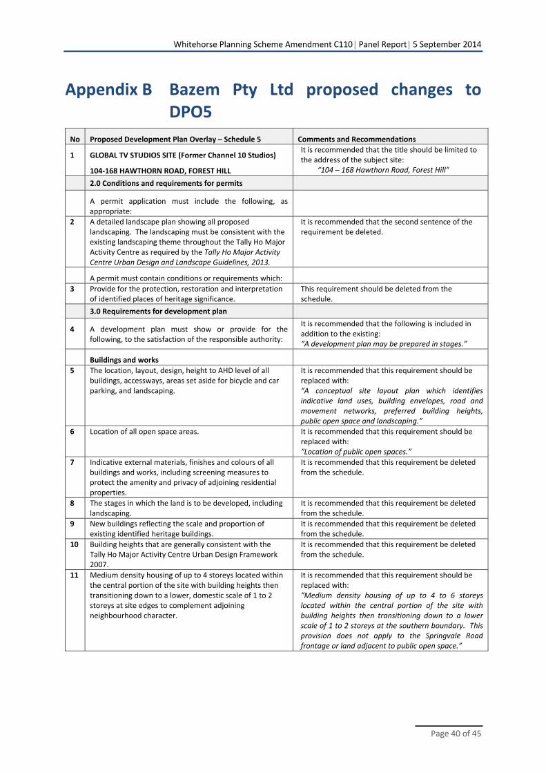
Whitehorse Planning Scheme Amendment C110 Panel Report 5 September 2014
Page 40 of 45
Appendix B Bazem Pty Ltd proposed changes to DPO5
No Proposed Development Plan Overlay – Schedule 5 Comments and Recommendations
1 GLOBAL TV STUDIOS SITE (Former Channel 10 Studios)
104‐168 HAWTHORN ROAD, FOREST HILL
It is recommended that the title should be limited to the address of the subject site:
“104 – 168 Hawthorn Road, Forest Hill”
2.0 Conditions and requirements for permits
A permit application must include the following, as appropriate:
2 A detailed landscape plan showing all proposed landscaping. The landscaping must be consistent with the existing landscaping theme throughout the Tally Ho Major Activity Centre as required by the Tally Ho Major Activity Centre Urban Design and Landscape Guidelines, 2013.
It is recommended that the second sentence of the requirement be deleted.
A permit must contain conditions or requirements which:
3 Provide for the protection, restoration and interpretation of identified places of heritage significance.
This requirement should be deleted from the schedule.
3.0 Requirements for development plan
4 A development plan must show or provide for the following, to the satisfaction of the responsible authority:
It is recommended that the following is included in addition to the existing: “A development plan may be prepared in stages.”
Buildings and works
5 The location, layout, design, height to AHD level of all buildings, accessways, areas set aside for bicycle and car parking, and landscaping.
It is recommended that this requirement should be replaced with: “A conceptual site layout plan which identifies indicative land uses, building envelopes, road and movement networks, preferred building heights, public open space and landscaping.”
6 Location of all open space areas. It is recommended that this requirement should be replaced with: “Location of public open spaces.”
7 Indicative external materials, finishes and colours of all buildings and works, including screening measures to protect the amenity and privacy of adjoining residential properties.
It is recommended that this requirement be deleted from the schedule.
8 The stages in which the land is to be developed, including landscaping.
It is recommended that this requirement be deleted from the schedule.
9 New buildings reflecting the scale and proportion of existing identified heritage buildings.
It is recommended that this requirement be deleted from the schedule.
10 Building heights that are generally consistent with the Tally Ho Major Activity Centre Urban Design Framework 2007.
It is recommended that this requirement be deleted from the schedule.
11 Medium density housing of up to 4 storeys located within the central portion of the site with building heights then transitioning down to a lower, domestic scale of 1 to 2 storeys at site edges to complement adjoining neighbourhood character.
It is recommended that this requirement should be replaced with: “Medium density housing of up to 4 to 6 storeys located within the central portion of the site with building heights then transitioning down to a lower scale of 1 to 2 storeys at the southern boundary. This provision does not apply to the Springvale Road frontage or land adjacent to public open space.”
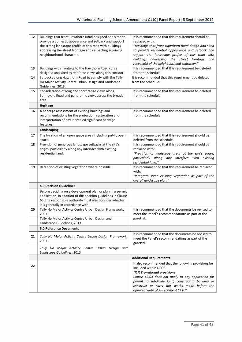
Whitehorse Planning Scheme Amendment C110 Panel Report 5 September 2014
Page 41 of 45
12 Buildings that front Hawthorn Road designed and sited to provide a domestic appearance and setback and support the strong landscape profile of this road with buildings addressing the street frontage and respecting adjoining neighbourhood character.
It is recommended that this requirement should be replaced with: “Buildings that front Hawthorn Road design and sited to provide residential appearance and setback and support the landscape profile of this road with buildings addressing the street frontage and respectful of the neighbourhood character.”
13 Buildings with frontage to the Hawthorn Road curve designed and sited to reinforce views along this corridor.
It is recommended that this requirement be deleted from the schedule.
14 Setbacks along Hawthorn Road to comply with the Tally Ho Major Activity Centre Urban Design and Landscape Guidelines, 2013.
It is recommended that this requirement be deleted from the schedule.
15 Consideration of long and short range views along Springvale Road and panoramic views across the broader area.
It is recommended that this requirement be deleted from the schedule.
Heritage
16 A heritage assessment of existing buildings and recommendations for the protection, restoration and interpretation of any identified significant heritage features.
It is recommended that this requirement be deleted from the schedule.
Landscaping
17 The location of all open space areas including public open space.
It is recommended that this requirement should be deleted from the schedule.
18 Provision of generous landscape setbacks at the site’s edges, particularly along any interface with existing residential land.
It is recommended that this requirement should be replaced with: “Provision of landscape areas at the site’s edges, particularly along any interface with existing residential land.”
19 Retention of existing vegetation where possible. It is recommended that this requirement be replaced with: “Integrate some existing vegetation as part of the overall landscape plan.”
4.0 Decision Guidelines
Before deciding on a development plan or planning permit application, in addition to the decision guidelines in Clause 65, the responsible authority must also consider whether it is generally in accordance with:
20 Tally Ho Major Activity Centre Urban Design Framework, 2007
It is recommended that the documents be revised to meet the Panel’s recommendations as part of the gazettal. Tally Ho Major Activity Centre Urban Design and
Landscape Guidelines, 2013
5.0 Reference Documents
21 Tally Ho Major Activity Centre Urban Design Framework, 2007
It is recommended that the documents be revised to meet the Panel’s recommendations as part of the gazettal.
Tally Ho Major Activity Centre Urban Design and Landscape Guidelines, 2013
Additional Requirements
22 It also recommended that the following provisions be included within DPO5: “X.X Transitional provisions Clause 43.04 does not apply to any application for permit to subdivide land, construct a building or construct or carry out works made before the approval date of Amendment C110”

Whitehorse Planning Scheme Amendment C110 Panel Report 5 September 2014
Page 42 of 45
Appendix C Panel preferred DDO5
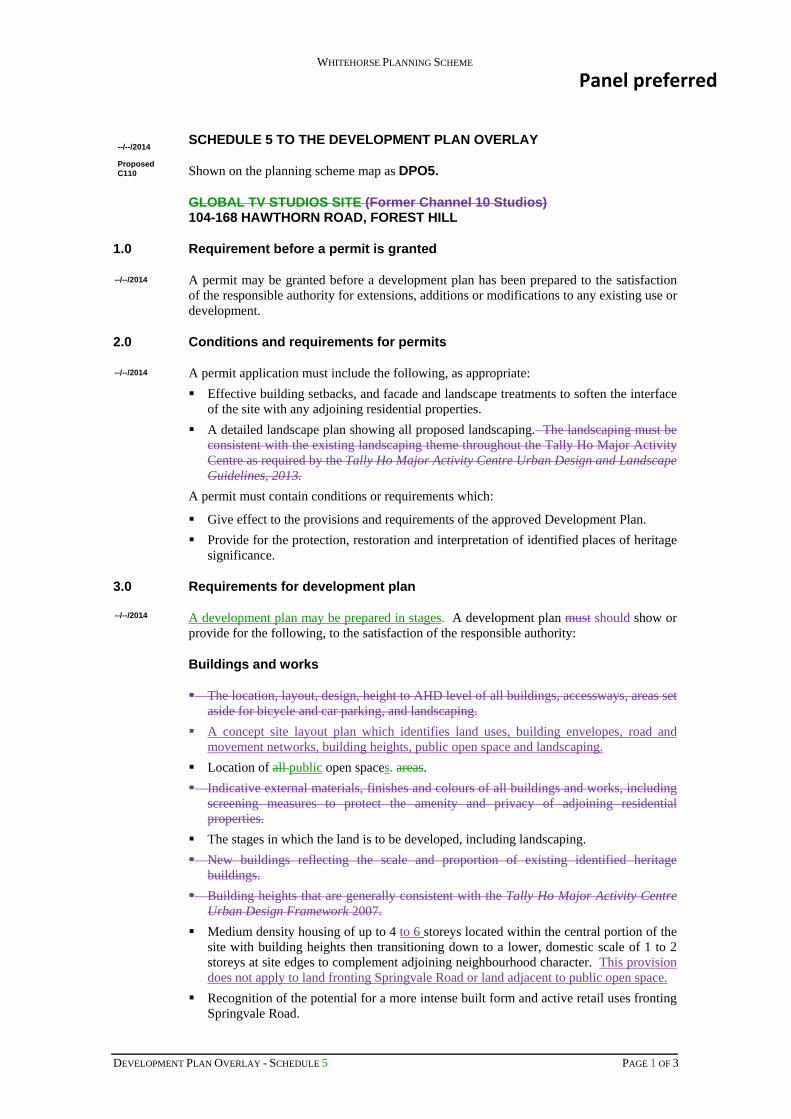
WHITEHORSE PLANNING SCHEME
DEVELOPMENT PLAN OVERLAY - SCHEDULE 5 PAGE 1 OF 3
SCHEDULE 5 TO THE DEVELOPMENT PLAN OVERLAY
Shown on the planning scheme map as DPO5.
GLOBAL TV STUDIOS SITE (Former Channel 10 Studios) 104-168 HAWTHORN ROAD, FOREST HILL
1.0 Requirement before a permit is granted
A permit may be granted before a development plan has been prepared to the satisfaction of the responsible authority for extensions, additions or modifications to any existing use or development.
2.0 Conditions and requirements for permits
A permit application must include the following, as appropriate:
Effective building setbacks, and facade and landscape treatments to soften the interface of the site with any adjoining residential properties.
A detailed landscape plan showing all proposed landscaping. The landscaping must be consistent with the existing landscaping theme throughout the Tally Ho Major Activity Centre as required by the Tally Ho Major Activity Centre Urban Design and Landscape Guidelines, 2013.
A permit must contain conditions or requirements which:
Give effect to the provisions and requirements of the approved Development Plan.
Provide for the protection, restoration and interpretation of identified places of heritage significance.
3.0 Requirements for development plan
A development plan may be prepared in stages. A development plan must should show or provide for the following, to the satisfaction of the responsible authority:
Buildings and works
The location, layout, design, height to AHD level of all buildings, accessways, areas set aside for bicycle and car parking, and landscaping.
A concept site layout plan which identifies land uses, building envelopes, road and movement networks, building heights, public open space and landscaping.
Location of all public open spaces. areas.
Indicative external materials, finishes and colours of all buildings and works, including screening measures to protect the amenity and privacy of adjoining residential properties.
The stages in which the land is to be developed, including landscaping.
New buildings reflecting the scale and proportion of existing identified heritage buildings.
Building heights that are generally consistent with the Tally Ho Major Activity Centre Urban Design Framework 2007.
Medium density housing of up to 4 to 6 storeys located within the central portion of the site with building heights then transitioning down to a lower, domestic scale of 1 to 2 storeys at site edges to complement adjoining neighbourhood character. This provision does not apply to land fronting Springvale Road or land adjacent to public open space.
Recognition of the potential for a more intense built form and active retail uses fronting Springvale Road.
--/--/2014
Proposed C110
--/--/2014
--/--/2014
--/--/2014
Panel preferred
WHITEHORSE PLANNING SCHEME
DEVELOPMENT PLAN OVERLAY - SCHEDULE 5 PAGE 2 OF 3
Buildings that front Hawthorn Road designed and sited to provide a domestic residential appearance and setback and support the strong landscape profile of this road with buildings addressing the street frontage and respecting the adjoining neighbourhood character.
Buildings with frontage to the Hawthorn Road curve designed and sited to reinforce views along this corridor.
Setbacks along Hawthorn Road to comply with the Tally Ho Major Activity Centre Urban Design and Landscape Guidelines, 2013.
Consideration of long and short range views along Springvale Road and panoramic views across the broader area.
Heritage
A heritage assessment of existing buildings and recommendations for the protection, restoration and interpretation of any identified significant heritage features.
Traffic and transport
A detailed traffic assessment and traffic management plan addressing the impact of the development on the arterial and local road network, including any mitigation works required on the road network and associated funding responsibilities. The plan must show integration between existing and proposed roads, bicycle and pedestrian networks and integration with the public transport network.
A permeable network of streets and public spaces to support safe, convenient and amenable vehicular, pedestrian and cycling movement.
Landscaping
The location of all open space areas including public open space.
Provision of generous landscape setbacks areas at the site’s edges, particularly along any interface with existing residential land.
Retention of existing vegetation where possible.
Environmentally Sustainable Development
Proposed design and building techniques that are consistent with environmentally sustainable development (ESD) principles.
Display of development plan
Before deciding whether to approve a development plan or a substantial amendment to an approved development plan, the responsible authority must first display the plan for public comment for a period of at least 14 days and must take account of any comments received in response to display of the plan.
4.0 Decision Guidelines
Before deciding on a development plan or planning permit application, in addition to the decision guidelines in Clause 65, the responsible authority must also consider whether it is generally in accordance with:
Tally Ho Major Activity Centre Urban Design Framework, 2007
Tally Ho Major Activity Centre Urban Design and Landscape Guideines, 2013
5.0 Reference Documents
Tally Ho Major Activity Centre Urban Design Framework, 2007
WHITEHORSE PLANNING SCHEME
DEVELOPMENT PLAN OVERLAY - SCHEDULE 5 PAGE 3 OF 3
Tally Ho Major Activity Centre Urban Design and Landscape Guidelines, 2013
4.0 Transitional provisions
Clause 43.04 does not apply to any application for permit to subdivide land, construct a building or construct or carry out works made before the approval date of Amendment C110.
Panel notes:
Green text: Resolved between Council and Bazem Pty Ltd
Purple text: Panel changes
Strikethrough: Delete content
Underlined coloured text: New content