pilot: cambridge historical commission building filesarcmap geocoding process is flexible regarding...
TRANSCRIPT

Pilot:
Cambridge Historical CommissionBuilding Files
Digitize > Catalog > Expose > Explore > Preserve
December 18, 2017 cultivating spatial intelligence®

cultivating spatial intelligence®www.pbcGIS.com
Cambridge Building Files Collection:
Digitize, Catalog, Expose, Explore, and Preserve
The Cambridge Historical Commission conducted a building survey in the
early 1970s. A photo was taken and a survey form completed for each of
the 16,000 buildings in the city. Each form was placed in a manila folder
in a file cabinet. Over the years additional information was placed into
these folders as additional research was conducted on particular
buildings as part of the commission’s official business or as other
information turned up in newspaper articles or a variety of other
documents which have been contributed or gathered by CHC staff. By
now the Building Files collection occupies 16 four-drawer file cabinets.
Each manilla folder is titled with a range of addresses.
This project, initiated by Charles Sullivan, Director of the Cambridge
Historical Commission, and Emily Gonzalez, CHC Archivist, is intended to
• Develop a workflow for scanning and cataloging the documents
• Create a searchable catalog for the items
• Work with Cambridge GIS to incorporate building files which will allow
the documents to be linked with other documents about buildings and
for exploring the documents on historic maps.
In addition to accomplishing these practical capabilities, the project is
oriented by several concerns related to long-term information
stewardship:
Assure that digital resources and associated documentation are secure
against mishaps, natural disasters and natural decay.
Assure that resources and associated metadata are always interoperable
between a variety of standards-based repository tools.
Provide a means of entering and preserving new information, including
artifacts that are born digital.
Look forward to providing a platform for linking information form the
Building Files collection to web-based applications and scholarship,
including applications such as the Massachusetts Cultural Resource
Information System.
Participants:Charles Sullivan, Director, Cambridge Historical Commission
Emily Gonzalez, Cambridge Historical Commission Archivist
Meta Partenheimer, Sarah Burks, Cambridge Historical Commission
Jeff Amero, and Katherine Grillo Cambridge GIS
Peter Stott, Massachusetts Cultrual Resouces Information System
Paul Cote, pbcGIS.com
cultivating spatial intelligence®www.pbcGIS.com
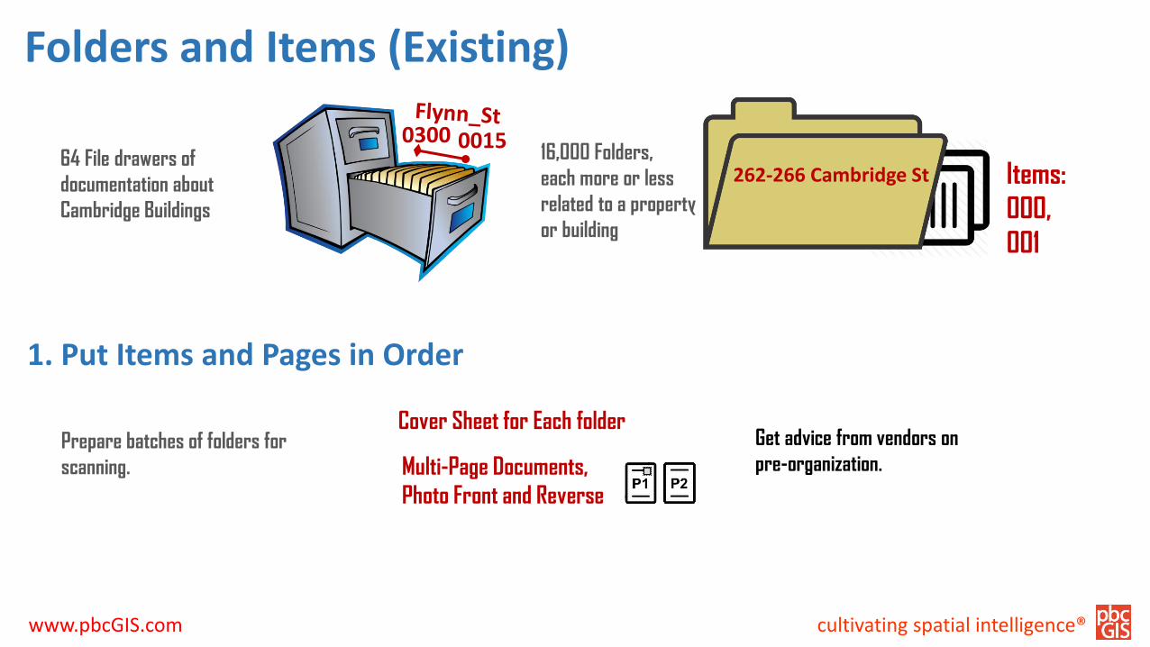
0300 0015
262-266 Cambridge St
Folders and Items (Existing)
Items:
000,
001
Multi-Page Documents,
Photo Front and Reverse
64 File drawers of
documentation about
Cambridge Buildings
16,000 Folders,
each more or less
related to a property
or building
Cover Sheet for Each folderGet advice from vendors on
pre-organization.Prepare batches of folders for
scanning.
1. Put Items and Pages in Order

cultivating spatial intelligence®www.pbcGIS.com
Scanning Workflow & Naming Scheme (ideas)
ScanID = 264-266_Cambridge_St_001p001-AI.tif
• OB: Official Business
• CS: Contact Sheet
• PL: Plan
• LT: Letter
• UC: Unclassified
• HS: Historic Building Survey
• AI: Architectural Inventory Form
• RF: Research Form
• PE: Exterior View
• PI: Interior Detail
• AM: Article or Monograph
• RN: Research Notes
Rough Sort of Item Types:
Categories could be applied by
quick visual inspection during,
or after? scanning process.
Rough Sort of Item Types:
May also be accomplished in a
QA process as batches of scans
are checked and uploaded to
Omeka

cultivating spatial intelligence®www.pbcGIS.com
Exterior View
Inventory Form
Interior Detail
Research Notes
Tools for Post-Scanning Rough Sort
Drag and Drop Item Type
Assignment.
Open Folder with Large Tiles
View
Visually select files of a
particular type.
Select many, then drag and
drop onto the appropriate Type
Changer tool
Shift-Click 2 Select 1.
Shift-Click 3 Drag and DropOn naming tool

cultivating spatial intelligence®www.pbcGIS.com
Geocode Addresses and Supplement Master Address List (Using & Extending Cambridge Master Address file)
ArcMap Geocoding Process is
flexible regarding spelling.
Addresses not matched are
added to table of Historical
address points.
Future geocoding is made using
a union of the official address
points and the CHC Historical
Address Points
Result is a dictionary of all CHC
Addresses with:
• Latitude
• Longitude,
• Map-Lot
• Building_ID
A script creates a table of all
addresses suitable for
geocoding in ArcMap

cultivating spatial intelligence®www.pbcGIS.com
Data Round-Up Scripts
Use the item-type dictionary to
apply meaningful titles and
keywords
Use the Address Points
dictionary to look up the
coordinates, building-ID and
Map-Lot.
Write a comma-delimted table
formatted for the Omeka CSV
import tool
Future version could:
• Embed the metadata and
coordinates into the image
files themselves.
• Import the collection into
any content management
system that permits
systematic import.
For each image file in the scans
folder:

cultivating spatial intelligence®www.pbcGIS.com
Import Images and Rough Metadata On-Line Repository (Omeka)
Images and CSV File are
uploaded to a cloud server
which also has Omeka Installed.
The Omeka Import CSV + Plugin
is used to import the images
and to create a simple catalog
record for each..

cultivating spatial intelligence®www.pbcGIS.com
Omeka Tour: What is Omeka?
Omeka is a free and open-source project of
the Roy Rosenzweig Center for History and New
Media, George Mason University.
www.Omeka.org
Huge community of users and contributors,
coders and consultants
Engagement with serious library and cultural
preservation projects like Digital Commonwealth
and Public Library of America

cultivating spatial intelligence®www.pbcGIS.com
Omeka as a Framework for Attaching Knowledge to Digital Resources
Omeka data base is organized
as a hierarchy:
Collection = Building Files
Folder
Items are folder contents, can
be multi-paged.
Try search by Map
Try searching by “Title Contains
‘Form’”
Try searching by “Title Contains
‘Form’”
Try searching by “Title Contains
‘Form’”
Search
Visit:
http://40.71.90.46/omeka

cultivating spatial intelligence®www.pbcGIS.com
Play with Public Omeka Site
Visit:
http://40.71.90.46/omeka
Click “Map” on the left-hand
sidebar to explore items on the
map.
This Omeka site is bare-bones
for the pilot, but can be made
fancier with some free plug-ins
see the Cleveland Historical
site.
Different levels of access can
be established for groups of
users.
I’ll create “Researcher”
accounts for each of you. After
some training, Admin role can
be assigned.

cultivating spatial intelligence®www.pbcGIS.com
Play with Pilot Web GIS Application
Click on a folder to reveal a URL
to an Omeka page showing a
thumbnail and title for each
item from the slected folder.
Folders are displayed with a tag
showing the number of items.
This is a very basic GIS web-app
that demonstrates how the
Building Files items can be
explored through GIS. There
are many other possibilities.
Elements of the same CSV file
used to create Items and
Collections in the Omeka
repository are used to put
folders on a web-map from
1890.

cultivating spatial intelligence®www.pbcGIS.com
Omeka Tour: Super-User Tasks
Control look, feel and Branding
of site using pre-fab “Themes”
Install Plug-Ins:
• Import CSV Plugin
• Library of Congress and Ghetty
Vocabularies
• PDF Viewer / Export Plugin
• Neatline / Time Plugin
• CurateScape Plugin – make site like
ClevelandHistorical.org
Add and Manage Users

cultivating spatial intelligence®www.pbcGIS.com
Omeka Tour: Admin User Tasks
Create new Items
Edit Metadata and Location Info
for Items
Create New Item Types
Create new metadata fields and
controlled lists (MACRIS-ID)
Inspect and Edit Tags Globally
Upload Files (associate them
with Items)
More Omeka Documentation

cultivating spatial intelligence®www.pbcGIS.com
Omeka Tour: Create exhibits that use items into ordered, annotated presentations.
Omeka Documentation for
Exhibit Builder
cultivating spatial intelligence®www.pbcGIS.com
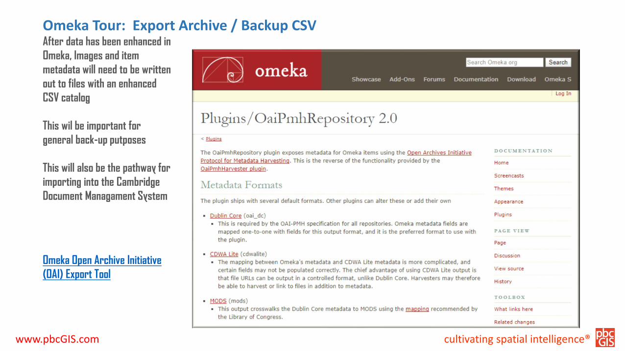
Omeka Tour: Export Archive / Backup CSV
Omeka Open Archive Initiative
(OAI) Export Tool
After data has been enhanced in
Omeka, Images and item
metadata will need to be written
out to files with an enhanced
CSV catalog
This wil be important for
general back-up putposes
This will also be the pathway for
importing into the Cambridge
Document Managament System

cultivating spatial intelligence®www.pbcGIS.com
Omeka Tour: Export Selected Items and Metadata
HistoryPIN Upload Tool
Contribute Selected Items
to Digital Commonwealth

cultivating spatial intelligence®www.pbcGIS.com
These references provide some background on how to organize a digitizing project.
• Digital Public Library of AmericaDigital Reformatting and File Managementhttp://dp.la/info/about/projects/public-library-partnerships/digital-reformatting-and-file-management/
• National Archives:Technical Guidelines for Digitizing Archival Materials for Electronic Access: Creation of Production Master Files – Raster Imageshttps://www.archives.gov/files/preservation/technical/guidelines.pdf
• Smithsonian InstitutionDigitizing Collectionshttps://siarchives.si.edu/what-we-do/digital-curation/digitizing-collections
Resources