physical hydrology and the effects of … · physical hydrology and the effects of forest...
TRANSCRIPT

AUGUST JOURNAL OF THE AMERICAN WATER RESOURCES ASSOCIATION
AMERICAN WATER RESOURCES ASSOCIATION
PHYSICAL HYDROLOGY AND THE EFFECTS OF FOREST HARVESTING IN THE PACIFIC NORTHWEST: A REVIEW1
R. Dan Moore and S.M. Wondzell2
ABSTRACT: The Pacific Northwest encompasses a range of hydro- logic regimes that can be broadly characterized as either coastal (where rain and rain on snow are dominant) or interior (where snowmelt is dominant). Forest harvesting generally increases the fraction of precipitation that is available to become streamflow, increases rates of snowmelt, and modifies the runoff pathways by which water flows to the stream channel. Harvesting may poten- tially decrease the magnitude of hyporheic exchange flow through increases in fine sediment and clogging of bed materials and through changes in channel morphology, although the ecological consequences of these changes are unclear. In small headwater catchments, forest harvesting generally increases annual runoff and peak flows and reduces the severity of low flows, but exceptions have been observed for each effect. Low flows appear to be more sensitive to transpiration from vegetation in the riparian zone than in the rest of the catchment. Although it appears that harvesting increased only the more frequent, geomorphically benign peak flows in several studies, in others the treatment effect increased with return period. Recovery to pre-harvest conditions appeared to occur within about 10 to 20 years in some coastal catchments but may take many decades in mountainous, snow dominated catch- ments. (KEY TERMS: streamflow; forest harvesting; headwater; peak flow; low flow; water yield; small catchment; Pacific Northwest.)
Moore, R. Dan and S.M. Wondzell, 2005. Physical Hydrology and the Effects of Forest Harvesting in the Pacific Northwest: A Review. Journal of the American Water Resources Association (JAWRA) 41 (4):763-784.
INTRODUCTION
The flows of water through a catchment influence a broad range of processes, including soil erosion, bio- geochemical cycling, and in-channel sediment trans- port. Forestry operations such as harvesting and road
construction can have a significant impact on hydrolo- gy at the site, hillslope, and catchment scales. There is ongoing, vigorous debate surrounding these influ- ences, and they need to be considered in relation to managing forest harvesting in small catchments (Jones and Grant, 1996; Thomas and Megahan, 1998; Beschta et al., 2000). In terms of aquatic habitat, the key concerns relate to changes in summer low flows (Hicks et al., 1991) and in peak flows and their effects on channel stability and sediment transport.
This paper reviews hydrologic processes relevant to watershed and riparian management around small stream channels, with a specific focus on forestry influences in the Pacific Northwest of North America. The literature on the hydrologic impacts of forestry is vast. To keep the task manageable, the review is focused as much as possible on streams with catch- ment areas less than 100 ha or less than 2 to 3 m wide within the Pacific Northwest (PNW) region, broadly defined to include northern California, Ore- gon, Washington, Idaho, all of British Columbia, and southeast Alaska. However, studies from outside the PNW region were referenced in cases for which they provided useful insights that were not available from local studies.
Many of the management concerns and related research can be considered at a range of scales from site to catchment, and many of the relevant processes may vary with geographic context. For example, processes that may be important in a low elevation, rainfall dominated coastal site may not be critical in a high elevation, snowmelt dominated interior location.
lPaper No. 04065 of the Journal of the American Water Resources Association (JAWRA) (Copyright O 2005). Discussions are open until February 1,2006.
zRespectively, Associate Professor, Department of Geography and Department of Forest Resources Management, 1984 West Mall, Universi- ty of British Columbia, Vancouver, B.C., Canada V6T 122; and Ecologist, Pacific Northwest Research Station, Olympia Forestry Sciences Laboratory, 3625 93rd. Avenue S.W., Olympia, Washington 98501 (E-MailIMoore: [email protected]).
JOURNAL OF THE AMERICAN WATER RESOURCES ASSOCIATION 763 JAWRA

,MOORE AND WONDZELL
These broader issues were considered in the review generate annual peak flows in the interior plateau of wherever possible. British Columbia (Moore, 1991). High mountain areas
with meater snow accumulation tend to have a longer freshet period with a later peak flow. Low flows tend to occur- between late summer and winter except for
HYDROLOGIC REGIMES IN THE some catchments in the interior mountains of British PACIFIC NORTHWEST Columbia with significant glacier cover, where glacial
melt maintains flow during late summer. The Pacific Northwest encompasses a variety of cli-
matic and physiographic settings, giving rise to a range of hydrologic regimes (Ziemer and Lisle, 1998; Eaton et al., 2002). A broad distinction may be made between coastal regimes (dominated by rain and rain on snow) and interior regimes (dominated by snowmelt). The coastal region includes those parts of Oregon and Washington west of the crest of the Cas- cade Range, and the coastal mountains and ranges of British Columbia and southeastern Alaska. The inte- rior region includes eastern Oregon and Washington, Idaho, and the interior mountains and plateaus of British Columbia.
Climates of the coastal region are moderated by their maritime exposure, leading to a greater propor- tion of winter precipitation falling as rain, especially at lower elevations. The coastal region is also charac- terized by high precipitation and high unit stream discharges. Winter rain and rain-on-snow events gen- erate most peak flows in coastal catchments that pre- dominantly lie below the seasonal snow line (Harr, 1981; Grant, 1997). The importance of peak flows gen- erated by spring-summer snowmelt increases with the proportion of catchment area lying above the sea- sonal snow line. However, rain-on-snow events can occur in most catchments, from low to high elevations in the coastal region, and even throughout the interi- or region (Moore, 1991; Wondzell and King, 2003). In coastal catchments, annual low flows tend to occur in
Runoff generation depends on the geological con- text, in addition to climatic conditions. In plateau catchments of interior British Columbia, lakes and wetlands likely attenuate streamflow response to both individual events and t h e seasonal snowmelt, although no research appears to have examined this process quantitatively. Differences in the permeability of underlying bedrock can lead to dramatically differ- ent runoff responses as well. Volcanic parent materi- als of the western Oregon Cascades are relatively impermeable so that little regional ground water recharge occurs, leading to well-developed stream net- works and high drainage densities (Grant, 1997; Tague and Grant, 2004). In contrast, the recent vol- canic bedrock of the high Oregon Cascades is highly permeable, leading to low drainage densities and, in some cases, poorly developed stream networks. Per- meable bedrock can attenuate streamflow responses to seasonal patterns in precipitation and snowmelt and support higher baseflows through late summer and early fall. Further, lower drainage densities lead to slower movement of water from uplands into the stream network and thus to lower unit area peak flows for a given return interval (Grant, 1997). In areas of permeable or fractured bedrock, water may leave some headwater catchments as subsurface flow and thus not show up as streamflow, while other streams may have their flow augmented by inputs of ground water from adjacent catchments.
late summer or early autumn, prior to the onset of the autumn-winter storm period. There are notable exceptions to these however. In catchments with more than a small percentage of glacial cover, FOREST INFLUENCES AT THE STAND SCALE
high flows occasionally occur in late summer during periods of high glacial melt, sometimes augmented by Rainfall Interception late summer rain events (Moore, 1991). Also, in the high mountains of the Cascades and throughout the central and eastern portions of British Columbia's Coast Mountains, annual low flows can occur in win- ter, when most of the precipitation falls as snow.
In the interior region, winters are colder due to the continental climatic regime and higher basal eleva- tion. Snow normally accumulates throughout the win- ter except in lower elevation areas of the Columbia and Fraser River basins in eastern Oregon, Washing- ton, and British Columbia. Annual peak flows pre- dominantly occur during snowmelt in spring or early summer. However, summer rainstorms occasionally
Most rain falling onto a canopy will be intercepted by foliage, and some of that amount will be lost to the atmosphere by evaporation. The remainder will reach the ground primarily as throughfall, with a smaller amount becoming stemflow (Rothacher, 1963; Spittle- house, 1998). Nearly all rain from small storms may be intercepted and lost, particularly from the dense canopies of old-growth forests, but the fiaction of rain- fall lost to evaporation decreases as storms increase in magnitude and intensity (Rothacher, 1963; Spittle- house, 1998). At rain dominated sites, interception
JAWRA 764 JOURNAL OF THE AMERICAN WATER RESOURCES ASSOCIATION

PHYSICAL HYDROLOGY AND THE EFFECTS OF FOREST HARVESTING IN THE PACIFIC NORTHWEST: A REVIEW
loss is greater in summer than winter (Rothacher, 1963). Interception by a forest canopy not only reduces the total amount of water reaching the ground surface but also reduces peak throughfall intensities (Keim and Skaugset, 2003). On an annual or seasonal basis, interception loss from conifer forests in the Pacific Northwest generally represents about 10 to 30 percent of total rainfall, depending on canopy characteristics and climatic conditions (e.g., Rothacher, 1963; Sollins et al., 1980; Beaudry and Sagar, 1995; Spittlehouse, 1998; Link et al., 2004). Conversely, fog or clouds can be intercepted by trees, condense onto the canopy, and then drip to the forest floor. Fog and cloud drip may significantly augment precipitation in coastal catchments and in some high mountain catchments, and forest harvesting may actually reduce streamflow (Harr, 1982, 1983). In addition to effects on interception loss, removal of forests can reduce transpiration. As a consequence, soil moisture can remain higher through the summer growing season for several years after forest harvest (Adams et al., 1991), potentially leading to increased streamflow and ground water recharge.
Snow Accumulation and Melt
Snow accumulation tends to be higher in openings than under forest canopies, with cut blocks typically accumulating about 30 percent to 50 percent more snow, although differences of over 100 percent have been recorded (Toews and Gluns, 1986; Troendle and King, 1987; Storck et al., 2002; Winkler et al., 2005). Differences in ground snow accumulation between forest and openings can be particularly marked in the transient snow zone in coastal sites (Beaudry and Golding, 1983; Berris and Harr, 1987). The cause of increased snow accumulation in openings is an impor- tant consideration for purposes of process-based mod- eling. Studies in the relatively dry interior climate of Colorado indicate that most of the increased accumu- lation in openings occurs during storms and that redistribution of intercepted snow between storms is not a dominant process (e.g., Wheeler, 1987). Further, comparisons of snow accumulation under forest cover with that in clearings at both the plot and catchment scales indicate that the increased accumulation in openings is at least partially if not dominantly due to a decrease in interception loss rather than preferen- tial deposition (Troendle and Meiman, 1984; Troendle and King, 1985; Troendle and Meiman, 1986; Wheel- er, 1987). On the other hand, cut blocks in the North Fork of Deadhorse Creek, Colorado, accumulated more snow than in the forest, while the peak snow accumulation averaged over the catchment did not change following harvesting (Troendle and King,
1987). The authors hypothesized that early ablation in south-facing openings may have offset the decrease in interception loss from the canopy. At a maritime study site in Oregon, Storck et al. (2002) found that seasonal losses by sublimation of intercepted snow were approximately 100 mm, compared to total win- ter precipitation of approximately 2 m (water equiva- lent). The bulk of intercepted snow reached the ground either as melt drip (70 percent) or by mass sliding (30 percent).
Removal of the forest canopy exposes the snow sur- face to greater incident solar radiation as well as to higher wind speeds, which can increase sensible and latent heat inputs (Berris and Harr, 1987; Adams et al., 1998). As a result, snowmelt rates are typically 30 percent to over 100 percent higher in the open (e.g., Toews and Gluns, 1986; Berris and Harr, 1987; Win- Mer et al., 2005). During the spring melt period, high snowrnelt rates tend to occur during periods of clear, settled weather, governed more by the energy from solar radiation than by the contributions of sensible and latent heat (e.g., USACE, 1956). In contrast, solar radiation is low during mid-winter rain-on-snow events so that melt rates are typically governed by sensible heat transfer from the relatively warm air, condensation of water vapor onto the snowpack, and in some cases by the sensible heat of rainfall (Beaudry and Golding, 1983; Berris and Harr, 1987; Marks et al., 1998). Under these conditions, snowmelt may significantly augment rainfall, increasing the magnitude of flood peaks (Harr, 1981, 1986). Snow held in the forest canopy usually melts faster than snow on the ground - either under the canopy or in a cut block - due to its greater wind exposure (Berris and Harr, 1987). However, if there is a significant snowpack on the ground, compared to the amount of snow held in the canopy, the effect of canopy melt is unlikely to be an important influence on peak flow response except for lower magnitude events because the ground level snowpack will dominate snowmelt response during higher magnitude storms (Harr, 1986).
Hydrologic Recovery
Hydrologic recovery refers to the decreasing impact of forest practices through time as a result of vegeta- tion regrowth. Its rate and trajectory depend upon the rate of regrowth and the suite of species occupying the site. Few studies appear to have tracked hydrolog- ic recovery at the site or stand scale. Adams et al. (1991) found that post-harvest increases in soil mois- ture content in the Oregon Cascades declined through time, and five years after logging, soil moisture stor- age a t a logged site was 2 cm less than in a forested
JOURNAL OF THE AMERICAN WATER RESOURCES ASSOCIATION 765 JAWRA

MOORE AND WONDZELL
site. The authors attributed the declining surplus and shift to a slight deficit to the rapid increase in plant growth, primarily by species including fireweed, vine maple, and snowbrush. Troendle and King (1985) found that the change in peak snowpack water equiv- alent due to harvesting in a Colorado catchment exhibited a weak negative trend with time (R2 = 0.1; p = 0.1), and only a "minor* degree of recovery had occurred 28 years after harvesting.
Some studies examined hydrologic differences among stands of different ages and used a space-for- time substitution to infer rates of hydrologic recovery. Hudson (2000) developed nonlinear recovery curves for snow accumulation and ablation rates (using tree height as a predictor variable) a t a site in south coastal British Columbia. Both accumulation and ablation recovered relatively rapidly, with 75 percent recovery associated with a tree height of 8 m. Winkler et al. (2005) found that mature spruce-fir forests in the interior of British Columbia had 20 to 30 percent less snow than in a clear-cut, while a 15-year-old juve- nile pine stand had 14 percent less. The melt rate in a mature forest was 40 percent that in a clear-cut, while melt rates in a juvenile pine stand were 80 to 90 per- cent of the clear-cut rate. Melt began earlier in the juvenile stands and the clear-cut than in the mature forest. Working in Montana, Hardy and Hansen- Bristow (1990) used snow survey data from stands of different ages to derive nonlinear relations for both ablation rate and accumulation as functions of canopy cover. Although the relations reported by both Hudson (2000) and Hardy and Hansen-Bristow (1990) were highly statistically significant, they exhibited sub- stantial scatter.
ST0R;MFLOW GENERATION
Infiltration and Generation of Overland Flow
Undisturbed forest soils in the Pacific Northwest normally have sufficiently high hydraulic conductivities that infiltration capacities are rarely exceeded by rainfall and/or snowmelt intensities, thus minimizing production of infiltration excess (or Horto- nian) overland flow (Cheng, 1988; Wondzell and King, 2003). Infiltration into the mineral soil is aided by the presence of vertical macropores fed by water flowing through the overlying organic horizons (de Vries and Chow, 1978). Loss of litter and organic soil layers change water storage properties and the rate at which water is delivered to the mineral soil. deVries and Chow (1978) found that removal of the organic hori- zons a t an experimental soil plot (to simulate soil
disturbance by logging) apparently diminished infil- tration via macropores. Rain splash, especially on recently disturbed soils, can detach fines that can clog soil pores.
At many sites, harvesting is conducted with skid- ders, tractors, or other ground-based equipment, which can cause compaction of the soil surface and to depths of 30 cm or more (Froehlich et al., 1985; Cullen et al., 1991), resulting in decreased hydraulic conduc- tivity and soil infiltration capacity (Startsev and McNabb, 2000). However, even following such distur- bance, soil infiltration capacities may remain high enough to prohibit generation of infiltration-excess overland flow (Cheng et al., 1975). In contrast, exca- vated trails and constructed haul roads typically have compact surfaces with low permeability and can gen- erate infiltration excess overland flow in even moder- a t e rainstorms (Luce and Cundy, 1994). The significance of infiltration excess overland flow from compacted soil and roads depends on how much of the catchment area is disturbed, as well as whether the skid trails and roads direct water to the natural drainage network. For example, at the Coyote Creek catchments in the Oregon Cascades, yarding and slash removal caused similar amounts (12 to13 per- cent) of soil compaction in catchments subject to har- vesting by clear-cutting (CC3) and shelterwood cutting (CC1) (Harr et al., 1979). However, much of the overland flow from tractor compacted soil in CC3 infiltrated before reaching a stream (Harr et al., 1979, p. 16), possibly explaining (a t least in part) the greater change in peak flows reported for CC1.
Hydrophobicity and reduced infiltration capacity can occur in situations in which mineral soil grains become coated with organic compounds. Many soils are naturally hydrophobic when dry, as has been doc- umented for soils under interior ponderosa and lodge- pole pine (Benavides-Solorio and MacDonald, 2001; Huffman et al., 2001) and under subalpine forests at sites across southern British Columbia (Barrett and Slaymaker, 1989). Huffman et al. (2001) found that hydrophobicity was no longer apparent once moisture contents exceeded 12 percent to 25 percent. Forest fires may induce hydrophobicity by producing volatile organic gases that condense on mineral soil grains in cooler layers below the surface (Letey, 2001). These layers may persist for long periods in dry forest types (Dyrness, 1976), impeding infiltration and helping produce Hortonian overland flow, as has been docu- mented, for example, in South Africa (Scott, 1993) and the Colorado Front Range (Huffman et al., 2001). Henderson and Golding (1983), working in south coastal British Columbia, and McNabb et al. (1989), working in southwestern Oregon, found a higher ten- dency to water repellency in soils in clear-cut areas subjected to slashburning than in unburned clear-cuts
JAWRA 766 JOURNAL OF THE AMERICAN WATER RESOURCES ASSOCIATION

PHYSICAL HYDROLOGY AND THE EFFECTS OF FOREST HARVESTING IN THE PACIFIC NORTHWEST: A REVIEW
or old growth. McNabb et al. (1989) showed that infil- tration rates recovered quickly after burning, and Henderson and Golding (1983) reported little evidence for widespread overland flow at the hillslope scale that could be attributed to fire induced repellency, although erosion was observed on one steep slope that had been slash burned two years earlier.
Saturation excess overland flow occurs when the water table rises to the soil surface, so that direct pre- cipitation onto these saturated zones and return flow discharging from the subsurface move downslope as surface flow (Hewlett and Hibbert, 1967; Troendle, 1985; McGlynn, 2005). Few studies have examined saturation overland flow in the Pacific Northwest. Harr (1977) calculated that direct precipitation onto the channel and near stream saturated zones con- tributed only 2 to 4 percent of total storm quickflow in Watershed HJAlO in the Oregon Cascades, likely due to the high soil conductivities and the steep, slightly convex slopes - conditions that are not conducive to the development of saturated soils. This result is con- sistent with results from other steepland areas where saturated source areas were limited to narrow ripari- an corridors and were important for runoff generation only during drier periods, when most rain falling onto the hillslopes was retained to recharge soil moisture (e.g., Sidle et al., 2000, 2001). Saturation excess over- land flow is likely to be more important in rolling topography typical of the interior plateaus of British Columbia, although its importance in those settings has not been quantified.
Subsurface Stormflow
While it is generally acknowledged that subsurface stormflow is a dominant process in undisturbed forested catchments, there remain significant uncer- tainties regarding the mechanisms by which water flows downslope (McDonnell, 2003). Many studies have shown that where soils are shallow and the underlying till or bedrock is relatively impermeable, stormwater dominantly flows downslope through a saturated layer perched above the soil-till or soil- bedrock contact (Chamberlin, 1972; Megahan, 1972; Hetherington, 1982; Anderson et al., 1997), promoted by high effective saturated hydraulic conductivities, typically ranging from 10-4 to 10-3 m/s (Megahan and Clayton, 1983; Cheng, 1988; Hutchinson and Moore, 2000; Kim et al., 2004). These shallow saturated layers can respond relatively rapidly (i.e., within min- utes to a few hours) to stormwater inputs (Chamber- lin, 1972; Pierson, 1980; Sidle, 1984; Jackson and Cundy, 1992; Fannin et al., 2000). Rapid response can occur via percolation through vertical macropores (Chamberlin, 1972; de Vries and Chow, 1978) and in
some cases by transmission of pressure waves through the vadose zone, which can propagate more rapidly through the soil profile than the actual veloci- ty of infiltrating water (Torres et al., 1998; Torres, 2002). Depending on the local geology, water exchanges may occur between the saturated soil layer and the underlying bedrock. Studies at Coos Bay in the Oregon Coast Range demonstrated that a signifi- cant amount of water can infiltrate from the soil into fractures in the underlying sedimentary bedrock, then re-emerge into the soil some distance downslope (Anderson et al., 1997; Montgomery and Dietrich, 2002).
Forest operations can influence subsurface storm- flow in several ways. Decreased interception loss would increase the amount of water infiltrating the soil, leading to higher water table levels during storms (Dhaka1 and Sidle, 2004). Logging related soil disturbance can also potentially influence subsurface stormflow through the closure of the entrances to ver- tical macropores, which would slow the percolation of water through the soil (de Vries and Chow, 1978). In addition, depending on the depth of soil compaction by skidders or other heavy, ground-based machinery, lateral hydraulic conductivity could be reduced by closing of preferential flow paths, possibly leading to slower downslope flow and decreased stormflow. How- ever, no published research appears to have examined effects of compaction on lateral subsurface flow.
The influence of logging roads on catchment hydrology is a major focus of concern and debate (Luce and Wemple, 2001). Logging roads can intercept shallow subsurface flow and lead it via ditches and culverts more rapidly to the stream network, poten- tially leading to increased peak flows (Jones and Grant, 1996; Wemple and Jones, 2003). The signifi- cance of flow interception by roads depends on the fraction of subsurface flow intercepted as well as the proportion of intercepted flow conveyed directly to the stream network. The fraction of subsurface flow inter- cepted depends on soil depth, the "tightness" of the bedrock underlying the soil, the depth of the road cut/ditch surface, and the permeability of the material comprising the road bed. Essentially all of the net rainfall input to a hillslope segment in south coastal British Columbia was intercepted at a road cut where soils averaged 1 m in depth and were underlain by a compacted basal till (Hutchinson and Moore, 2000). In contrast, subsurface flow intercepted at a road cut during snowmelt in the Idaho batholith was about 30 to 40 percent of the total upslope water input, sug- gesting that more than half of the melt water flowed downslope below the road cut, through the bedrock (Megahan, 1972).
Wemple et al. (1996) identified two pathways link- ing the road network to stream channels: roadside
JOURNAL OF THE AMERICAN WATER RESOURCES ASSOCIATION 767 JAWRA

MOORE AND WONDZELL
ditches draining directly to streams, and roadside study in Sweden suggests that soil frost can influence ditches draining to culverts that feed water into catchment scale streamflow generation during the incised gullies. In other cases, ditch flow may be early stages of spring melt in cases where subfreezing diverted back onto the slope below a road by a conditions persist into the melt period (Laudon et al., drainage relief culvert, where it will reinfiltrate and 2004). flow downslope as subsurface flow. In the latter situa- tion, the road may not increase the rate of transmis- sion of water to the stream channel, but rather act to ChannelRouting redistribute subsurface flow laterally across the slope.
Influence of Antecedent Soil Moisture and Soil Frost
Antecedent moisture status can exert a strong con- trol on runoff response to rain or snowmelt. Under dry antecedent conditions, much of the rain and/or melt water inputs may be stored in the soil and not contribute to streamflow (e.g., Perkins, 1997; Sidle et al., 2000). The reduction of transpiration following harvest ing h a s often been cited a s a cause of enhanced stormflow production through the associat- ed increase in soil moisture during the summer grow- ing season and early autumn (e.g., Harr et al., 1975; Ziemer, 1981).
Soils in interior regions of the Pacific Northwest may freeze during winter, particularly if freezing con- ditions occur prior to significant snow accumulation. The occurrence and depth of soil frost are negatively associated with snow depth and thus with the factors that increase snow accumulation. For example, a study in Montana found that the depth of frost pene- tration was greater under forest than in clear-cuts and decreased with elevation (Saul and Potts, 1986). Similarly, a study in northern Sweden found that frost penetrated more deeply in shelterwood cuts than in a clear-cut (Lofienius et al., 2003). Studies in Que- bec and Sweden have demonstrated that the occur- rence of soil frost can vary dramatically within a catchment due to variations in soil properties, and from year to year, depending on weather conditions during the freezing period (Proulx and Stein, 1997; Nyberg et al., 2001).
Although some research has examined the hydro- logic effects of frozen soil in rangeland and agricultur- al catchments in the Pacific Northwest (e.g., Wilcox et al., 1991; Schillinger and Wilkins, 1997), no studies appear to have examined these phenomena in forest- ed catchments in the PNW. Studies in Europe and eastern Canada show that freezing of water within soil pores can reduce the soil's infiltrability, thus pro- moting the generation of infiltration excess overland flow (Stadler et al., 1996; Proulx and Stein, 1997) and that overland flow can also occur where a relatively impermeable ice layer forms at the base of the snow- pack (Price and Hendrie, 1983). The evidence for a catchment scale effect of soil frost is limited, but a
Forest operations can influence channel character- istics either directly (e.g., by removal of wood or load- ing of slash into the stream) or indirectly (via logging related debris flows). Several authors have suggested changes in channel routing as a potential driver of changes to peak flows. For example, Cheng et al. (1975) suggested that increased channel roughness due to debris loading within the stream could have contributed to the increase in time to peak they observed in south coastal British Columbia. Converse- ly, Jones and Grant (1996) and Thomas and Megahan (1998) suggested that smoothing of the channel a t HJA3 by road related debris flows could have con- tributed to peak flow magnitude by decreasing travel time in the channel. However, no studies appear to have examined these influences quantitatively.
HYDROLOGY OF THE RIPARIAN ZONE
Much process-based research into small watershed hydrology has focused on the factors controlling hills- lope runoff and the sources of stormflow. Within this context, the riparian zone has been conceptualized as a zone of transmission of ground water and hillslope water to the stream channel, as well as a deflector of precipitation and snowmelt when the riparian water table rises to the ground surface (Hewlett and Hib- bert, 1967; Troendle, 1985; Burns et al., 2001; McDon- nell, 2003; Buttle et al., 2004). However, between storms, and even during small storms with dry antecedent conditions, subsurface inputs from adja- cent hillslopes are often minimal (Sidle et al., 2000; McGlynn and McDonnell, 2003). At these times, two- way exchanges of water between the stream and the riparian aquifer, or hyporheic exchange, can become important.
The morphology of the valley floor and stream channel are primary controls on the flow of water through riparian aquifers (Harvey and Bencala, 1993; Wroblicky et al., 1998; Kasahara and Wondzell, 2003; Wondzell, 2005). In steep, constrained headwater streams, valleys filled with coarse alluvium support shallow aquifers that slope steeply down valley with flow paths that parallel stream channels (Kasahara
JAWRA 768 JOURNAL OF THE AMERICAN WATER RESOURCES ASSOCIATION

PHYSICAL HYDROLOGY AND THE EFFECTS OF FOREST HARVESTING IN THE PACIFIC NORTHWEST: A REVIEW
and Wondzell, 2003). In these streams, most exchange flows between the stream and the aquifer are con- trolled by boulder caused or log caused steps in the longitudinal gradient (Kasahara and Wondzell, 2003; Anderson et al., 2005), and the volume of sediment stored above these steps determines the extent of the hyporheic zone. Downwelling stream water seeps into the streambed upstream of steps and returns to the stream channel below steps, where it upwells through the streambed (Harvey and Bencala, 1993; Moore et al., 2005). The steps in the longitudinal profile of the channel structure the flow net so that hyporheic exchange follows a nested series of flow paths between distinct zones of aquifer recharge (down- welling) and aquifer discharge (upwelling) (Gooseff et al., 2005).
Few hyporheic studies have focused on uncon- strained headwater streams in the Pacific Northwest. Consequently, the knowledge of hyporheic hydrology draws largely upon studies of larger, unconstrained streams. These studies have shown that subsurface flow paths can be complex in stream reaches with rel- atively wide and flat floodplains. In these reaches, exchange flows occur through meander bends and island bars, with stream water flowing into the bars through the streambed and bank on the upstream side, and returning to the stream channel on the downstream side (Vervier and Naiman, 1992; Kasa- hara and Wondzell, 2003). Exchange flows across gravel bars also support upwelling of stream water into floodplain springbrooks where abandoned chan- nels are incised below the water table (Wondzell and Swanson, 1996a, 1999). Pool riffle sequences create downwelling zones above riffles and upwelling zones below riffles (Harvey and Bencala, 1993; Kasahara and Wondzell, 2003; Anderson et al., 2005). Where these channel morphologic features are present in unconstrained headwater streams, it is expected they would result in patterns of hyporheic flow similar to those observed in studies of larger streams.
Transpiration by vegetation in the riparian zone may extract phreatic water from the riparian aquifer, producing a diurnal decrease in streamflow, followed by recovery at night (Dunford and Fletcher, 1947; Hewlett, 1982, p. 97; Bond et al., 2002). Studies con- ducted in Australia and South Africa demonstrated that riparian vegetation is a more liberal user of water than vegetation in other parts of a catchment (Bren, 1997; Scott, 1999). During extended periods of low flow, sections of small streams dry up wherever stream discharge is insufficient to both maintain con- tinuous surface flow and satisfy water losses through the bed and banks. Stream drying may occur fre- quently in the headmost portions of the channel net- work, interrupting connectivity. For example, Story et al. (2003) found that dewatering of an intermediate
segment of stream channel effectively decoupled a lower reach from the warming effects of harvesting and road construction on an upper reach of a small stream in the central interior of British Columbia. The broader biogeochemical and ecological implica- tions of changing connectivity along the length of the stream do not appear to have been examined in forest streams.
Harvesting in the riparian zone can have a signifi- cant influence on riparian zone hydrology through its effect on transpiration and water table drawdown, potentially dampening die1 fluctuations in discharge and increasing low flows (Dunford and Fletcher, 1947). These effects should decrease over time as riparian forests regrow. However, changes in species composition during forest succession can further impact low flow discharge. For example, in the Oregon Cascades, a change in riparian vegetation from conifers to deciduous species following clear-cut log- ging apparently resulted in increased transpiration and reduced dry weather streamflow (Hicks et al., 1991). No previous studies appear to have examined the influence of riparian buffers on riparian hydrolo- gy, but the results of the studies cited above suggest that conifer dominated riparian buffers might reduce the likelihood that forest harvest and post-harvest compositional changes will influence low flow dis- charge.
Forestry related changes in channel morphology could substantially influence stream-aquifer interac- tions. Forest harvesting can reduce large wood recruitment rates to, and abundance in, streams, pro- ducing changes in channel morphology (Keller and Swanson, 1979; Bisson et al., 1987; Andrus et al., 1988; Carlson et al., 1990; Hartman and Scrivener, 1990; Woodsmith and Buffington, 1996; Benda et al., 2002). Forest harvest and related activities may also increase fine sediment delivery to channels (Beschta, 1978; Hartman et al., 1996), and intrusion of fines into streambed sediment has been shown to restrict hyporheic exchange (e.g., Schalchli, 1992; Packman and MacKay, 2003). Forestry related changes in sedi- ment supply, including episodic inputs of sediment in large storms and flood events, can lead to simplifica- tion of stream channels (Lisle, 1982; Lyons and Beschta, 1983; Ryan and Grant, 1991; Dose and Roper, 1994). Wondzell and Swanson (1999) demon- strated that channel incision and simplification of channel morphology during large floods can substan- tially lower water tables and reduce exchange flows of water between the stream and the riparian aquifer. Also, debris flows can scour channels to bedrock, eliminating the opportunity for hyporheic exchange (Johnson, 2004). Decreased abundance of large wood within the channel, decreased long term recruitment of large wood, and increased sediment inputs are all
JOURNAL OF THE AMERICAN WATER RESOURCES ASSOCIATION 769 JAWRA

MOORE AND WONDZELL
associated with long term loss of pool volume, loss of pool step sequences, and simplification of stream channels.
Neither the effect of forest harvest nor the effect of riparian buffers on hyporheic exchange flows has been directly studied in headwater mountain streams. However, because channel morphology strongly con- trols hyporheic exchange, it is reasonable to expect that management activities that lead to losses in channel complexity would reduce interactions between the stream and the riparian aquifer, whereas efforts to minimize management impacts on channels, such as the retention of riparian buffers, would help preserve stream-aquifer interactions. The broader ecological implications of decreased stream-aquifer interactions are difficult to predict given the current state of knowledge. However, previous research sug- gests that they could lead to reduced nutrient cycling
to quantifying the effects of forest operations on streamflow is a paired catchment experiment, which includes at least one untreated control and both pre- and post-harvest data (Hewlett, 1982). Tables 1 through 4 summarize results from a number of paired catchment experiments within or relevant to the PNW region. The success of paired catchment experi- ments depends on how similar the control and treat- ment catchments are in terms of geology, soils, topography, and vegetation. A major problem in gen- eralizing the results is that the treatment effect will depend on the details of the forest operations, catch- ment characteristics, the sequence of weather events recorded in the pre-treatment and post-treatment periods (especially the occurrence of rare, high magni- tude events), and vegetation regrowth. A practical challenge is tha t conducting such experiments requires significant long term commitment of funds
and therefore reductions in stream productivity and effort. (Wondzell and Swanson, 199613). There could also be An alternative to paired catchment experiments is implications for stream temperature dynamics (Story to use existing operational streamflow data. Retro- et al., 2003; Johnson, 2004; Moore et al., 2005). spective studies involve an after-the-fact pairing of
unlogged catchments with logged catchments for which some pre-logging data exist (e.g., Cheng, 1989; McFarlane, 2001). These should yield valid results if
FOREST HARVESTING EFFECTS the catchments are adjacent and are well matched in AT THE CATCHMENT SCALE terms of topography and vegetation. A related
approach is to conduct a chronosequence analysis in Research Approaches &ich trends in streamflow in a suite of watersheds
with different management histories are correlated
Although many of the hydrologic effects of forest with changes in land use andlor climatic variables. These studies can also involve after-the-fact pairing to operations are reasonably well understood at the site
or stand scale in general terms, it is difficult to make help separate the effects of land use change from
quantitative predictions of the effects at the catch- climatic variability (e.g., Bowling et al., 2000). How-
ment scale. The most statistically rigorous approach ever, these studies are generally less powerful than
TABLE 1. Summary of Paired Catchment Studies: Key for Treatment and Forest Type Codes.
Key for Treatment Types Key for Forest Types
Road density (kmfkrn2)
Road coverage (% catchment area)
Skid road coverage (% of catchment area)
Clear-cut (% of catchment area)
Patch-cut (% of catchment area)
Shelterwood-cut (x % of catchment aredy % of basal area)
Variable retention (x% of canopy removed)
Tractor yarded over x% of catchment area
Cable yarded over x% of catchment area
Broadcast burned over x% of catchment area
Tractor piled and burned over x% of catchment area cable piled and burned over x% of catchment area
Cutblock
ESSF
LP
A1
MC
GF
DF
WH x-y
SG
Engelmann spruce-subalpine fir
Lodgepole pine
Alder
Mixed conifer
Grand fir
Douglas-fir
Western hemlock (age range from x to y in years)
Second growth
- -
JAWRA 770 JOURNAL OF THE AMERICAN WATER RESOURCES ASSOCIATION

PHYSICAL HYDROLOGY AND THE EFFECTS OF FOREST HARVESTING IN THE PACIFIC NORTHWEST: A REVIEW
TABLE 2. Summary of Paired Catchment Studies Conducted in the Oregon Cascades.
Change Change Mean in Peak in Peak
Change Flows Flows Elevation in (original (Jones,
Area Range Forest Treatment Annual analysis) 2000)* Catchment (ha) (m) Type Type Yield (percent) (percent) References
HJAl - --
96 441-1013 DF, WH CC-100; 300-500 CY-100;
BB-100
101 490-1070 DF, WH PC-25; 300-500 CY-25;
BB-25; R-6; RD-2.7
410 mm 23** 25 Rothacher, 1973; Harr 1983; Harr, 1986); Hicks et al., 1991; Jones and Grant, 1996; Thomas and Megahan, 1998; Beschta et al., 2000
160 mm 17** 16 Rothacher, 1973; Harr, 1983; Hicks et al., 1991; Jones and Grant, 1996; Thomas and Megahan, 1998; Beschta et al., 2000
380 mm nsc 16 Harr et al., 1982; Harr, 1983 (30%)
200 mm nsc 27 Harr et al., 1982; Harr, 1983 (22%)
HJAlO 10.2 433-664 DF, WH CC, CY-100 190 mm -36 -8 Harr and McCorison, 1979; 300-500 (snow peaks) Harr, 1983,1986
1 (rain peaks)
FC1 59 ca DF, WH PC-25; nsc nsc 13 Harr, 1980,1983 840-1010 300-500 CY-25;
R; BB-25
FC3 71 ca DF, WH PC-25; nsc nsc 13 Harr, 1980,1983 840-950 300-500 CY-19;
TY-6
CC1 69.2 750-1065 DF, MC SC-100150; 60 mm 32 10 Harr et al., 1979; Harr, 1983 100-300 TY-100; (8%)
R-1.6
CC2 68.4 750-1065 DF, MC PC-30; 90 mm 13 36 Harr et al., 1979; Harr, 1983 100-300 CY-16; (14%)
TY-14; CPB-16; TPB-14
CC3 49.8 730-930 DF, MC CC-100; 290 mm 42 26 Harr et al., 1979; Harr, 1983 100-300 CY-77; (43%)
TY-23 CPB-77 TPB-23
--
"Events with return periods greater than 1 year (Table 6 in Jones, 2000). **Values from Thomas and Megahan (1998) for first five years post-harvest, corresponding to return period of just under two years.
***Broadcast burned "only on lower half of watershed." Notes: HJA = H.J. Andrews Experimental Forest, CC = Coyote Creek, FC = Fox Creek (Bull Run); nr = not reported; nsc = no significant
change.
JOURNAL OF THE AMERICAN WATER RESOURCES ASSOCIATION 771 JAWRA

MOORE AND WONDZELL
TABLE 3. Summary of Paired Catchment Studies in the Oregon Coast Range and South Coastal British Columbia.
Mean Change Change
Elevation in in Peak Study Area Range Forest Treatment Annual Flows
Location Catchment (ha) (m) Type Type Yield (percent) References
Alsea Watershed Oregon Coast Range
Needle 70.8 135-485 Branch
nsc (roads) Harr e t al., 1975; Harris, 20 (roads+ 1977; Harr, 1983 harvest)
Deer Creek 304 135-485 A, DF 120 PC-25; nsc BB-8 R-4
nsc (roads) Harr e t al., 1975; Harris, nsc (roads+ 1977; Harr, 1983 harvest)
nsc (roads) Harr e t al., 1975 nsc (roads+ harvest)
Deer Creek 55.8 135-485 (2)
Deer Creek 40.5 135-485 (3)
18 (roads) Harr et al., 1975 44 (roads+ harvest)
nsc Harr e t al., 1975 Deer Creek 15.8 135-485 (4)
UBC Malcolm Knapp Research Forest, B.C.
Watershed 1 23.1 145-455 -22 Cheng e t al., 1975 WH, WRC, CC-71; nr DF (SG) TY-71;
SR-20
Carnation Creek, Vancouver Island, B.C.
Subbasin H 12 152-305 CWH CC-90; 360 mm BB-35 (14%) R-6.5
20 Hetherington, 1982
Flume Creek, B.C.
CWH VR-82 nr 194 Hudson, 2001
CWH SC-51 nr canopy Removed
123 Hudson, 2001
paired catchment designs. In addition, small catch- examined catchments on the order of 5 km2 and larg- ments are poorly represented within the Water Sur- er (e.g., Bowling and Lettenmaier, 2001; Lamarche vey of Canada and U.S. Geological Survey networks, and Lettenmaier, 2001; Whitaker et al., 2002; Thyer thus minimizing the potential availability of data for e t al., 2004; Beckers and Alila, 2004), at least two retrospective analyses relevant to small streams. have focused on smaller catchments (Tague and Band,
A third approach is to use computer simulation 2001; Waichler et al., 2005). models. In the Pacific Northwest, the Distributed Hydrology-Soil-Vegetation Model (DHSVM; Wigmosta et al., 1994) and the Regional Hydro-Ecological Sirnu- Synchronization of Processes at the Catchment Scale lation System (RHESSys) (Tague and Band, 2001) have been applied to this purpose. These models can An important issue in understanding the hydrolog- account for exchanges within the canopy and ic effects of forestry operations at the catchment scale soil column as well as lateral flow within the soil, is synchronization of processes. F~~ example, in some including the effects of the road network on flow rout- situations the acceleration of snowmelt in Clear- ing. A approach is attractive in that alterna- cuts as to forests (e.g., Toews and GIuns, tive treatments can be applied to the same catchment 1986; Winkler et al., 2005) could desynchronize (e.g.9 'ague and Band, 2001; Whitaker et al.9 2002). snowmelt over a catchment and reduce peak flows. Although many model studies of forestry effects have
JAW RA 772 JOURNAL OF THE AMERICAN WATER RESOURCES ASSOCIATION

PHYSICAL HYDROLOGY AND THE EFFECTS OF FOREST HARVESTING IN THE PACIFIC NORTHWEST: A REVIEW
TABLE 4. Summary of Paired Catchment Studies in Snow Dominated Small Catchments.
Mean Change in Change
Elevation Annual or in Peak Study Area Range Forest Treatment Seasonal Flows
Location Catchment (ha) (m) Type Type Yield (percent) References
wagon Wheel B Gap, Colorado
50 Bates and Henry, 1928; ( m a . daily) Van Haveren, 1988
Colorado Fool Creek 289 2,900-3,500 ESSF 250-350
23 Alexander et al., 1985; Troendle and King, 1985
East Side Rocky Cabin Creek Mountains, Alberta
212 1,730-2,750 ESSF; Al; LP
CC-21 nsc in 6 CB
nr Swanson et al., 1986
Rocky Mountains, Deadhorse Colorado Creek
270 2,880-3,536 ESSF; LP
CC-10; nsc R-3.4
nsc Troendle and King, 1987
Rocky Mountains, Deadhorse Colorado Subbasin
North Fork
CC-36 60 mm (12x5H circular openings); R-3.1
50 Troendle and King, 1987
North-Central Horse Creek 148 ca 1,314- GF Idaho Subbasin 8 1,725
nsc King and Tennyson, 1984 R-3.7; nsc RD-2.82
Horse Creek 65.2 ca 1,314- GF Subbasin 10 1,725
R-2.6; nsc RD-2.11
nsc King and Tennyson, 1984
Horse Creek 83.8 ca 1,314- GF Subbasin 12 1,725
(nsc) King and Tennyson, 1984; (rnax. inst.) King, 1989
34 (rnax. daily)
Horse Creek 62.3 ca 1,314- GF Subbasin 14 1,725
35 King and Tennyson, 1984; (rnax. inst.) King, 1989
50 (rnax. daily)
Horse Creek 28.3 ca 1,314- GF Subbasin 16 1,725
36 King and Tennyson, 1984; (rnax. inst.) King, 1989
74 (rnax. daily)
Horse Creek 86.2 ca 1,314- GF Subbasin 18 1,725
34 King and Tennyson, 1984; (rnax. inst.) King, 1989
87 (rnax. daily)
On the other hand, par t ia l clear-cutting could demonstrated the effects on peak flows of desynchro- synchronize snowmelt over a catchment in some nizing and resynchronizing snowmelt following two situations and increase peak flows. For example, logging passes in a Minnesota peatland catchment. clear-cutting of north facing slopes or high elevation King and Tennyson (1984) suggested that subsur- areas could advance the timing of melt from those face flow interception by logging roads and ditches areas and synchronize it with melt on forested south may desynchronize inputs from those parts of the facing or lower elevation slopes. Verry et al. (1983) catchment drained by the road network and the rest
JOURNAL OF THE AMERICAN WATER RESOURCES ASSOCIATION 773 JAWRA
MOORE AND WONDZELL
of the catchment, but this effect has not been verified by field-based process studies. Conversely, Jones et al. (2000) suggested that roads could serve to better synchronize runoff and thereby increase the magni- tude of peak flows. This issue clearly requires more detailed study.
Effects of Forest Management on Annual Water Yield
Reductions in forest cover generally increase annu- al water yield (Bosch and Hewlett, 1982; Trimble et al., 1987; Stednick, 1996), and there has been some attention to the potential for using forest manage- ment to augment water supply in the Pacific North- west (Harr, 1983). Although water yield is not a critical variable in relation to the habitat conditions in small streams (Hicks et al., 1991), it is reviewed here in the interests of completeness. Tables 2 to 4 present the average change in water yield over the immediate post-harvest period to minimize potential confounding by hydrologic recovery. Where the post- harvest period was 10 years or less, the whole period was used in the average; for longer term studies, the changes were averaged for just the first five years.
In rain dominated catchments, clear-cutting and patch-cutting increased yields by up to 6 mm for each percentage of basin harvested, while selective cutting increased yields by up to about 3 mm for each per- centage of basal area removed (Tables 2 to 4). Water yield decreased slightly following patch-cutting in two basins in the northern Oregon Cascades (Fox Creek 1 and 3), although the pre-logging and post-logging regression relations were not significantly different at a 5 percent significance level (Harr, 1980). This anomalous change in water yield likely resulted from a decrease in fog drip (Harr, 1982). Where seasonal
variations in water yield increases were studied, most of the increased yield occurred in the wet autumn- winter period (Harr, 1983; Keppeler and Ziemer, 1990).
Hydrologic recovery through time varied among studies, though not all had sufficiently long records to detect a recovery trend. At HJA1, the magnitude of the increased water yields decreased over several years but finally stabilized some 25 percent higher than expected, while annual yields for the 25 percent patch-cut HJA3 remained elevated for more than 20 years following harvesting (Hicks et al., 1991). At the Coyote Creek catchments in the southern Oregon Cascades, effects of clear-cutting appeared to decline over the five-year post-harvest period (Harr et al., 1979). An exponential model fitted to the data sug- gested that the effect would decrease by about 60 per- cent over the first 10 years and by 95 percent after 30 years.
Water yield increases have also been documented following harvesting in snow dominated catchments, ranging from 0.25 mm to over 3 mm per percentage of basin harvested (Van Haveren, 1988; King, 1989). At Fraser Experimental Forest, Colorado, water yield from Fool Creek averaged 40 percent higher than the long term expected flow and 45 percent higher for the first five years, even though the catchment averaged snowpack water equivalent increased by only 9 per- cent (Troendle and King, 1985). This disproportionate increase in water yield relative to snowpack likely resulted from the combined effect of increased snow accumulation and decreased transpiration (and thus soil moisture deficits) within the clearings. There was a weak negative trend to the water yield increases, suggesting that full recovery would require 80 years. At the Horse Creek catchments in Idaho, annual yields increased by about 3.6 mm per percentage of
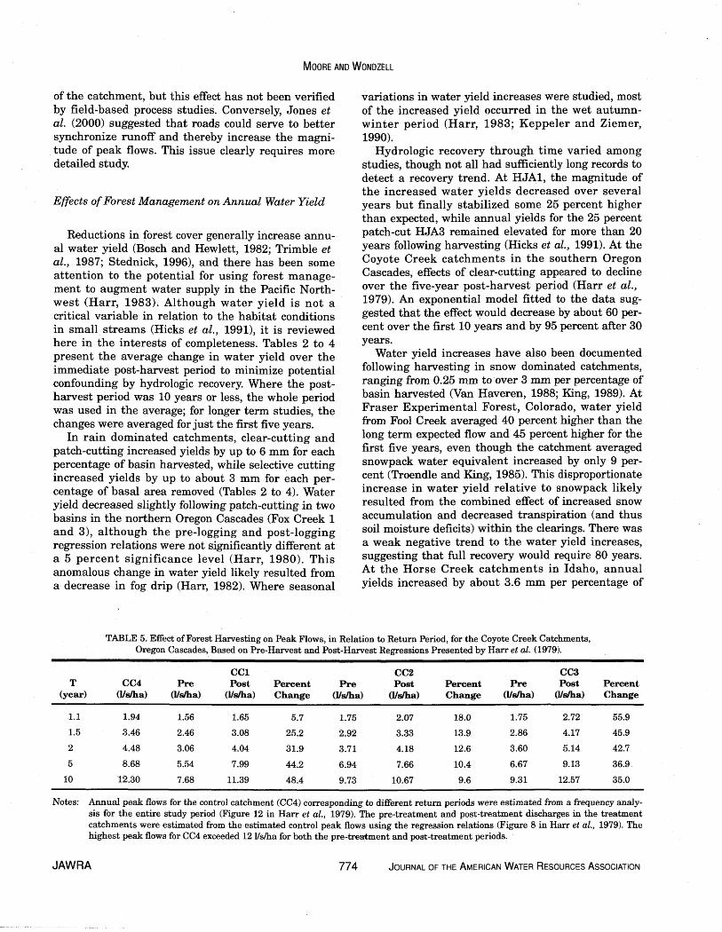
TABLE 5. Effect of Forest Harvesting on Peak Flows, in Relation to Return Period, for the Coyote Creek Catchments, Oregon Cascades, Based on Pre-Harvest and Post-Harvest Regressions Presented by Harr et al. (1979).
CC1 CC2 CC3 T CC4 Pre Post Percent Pre Post Percent Pre Post Percent
(year) (lldha) (Ydha) (Ysha) Change (Usha) (Ysha) Change (Usha) (Ydha) Change
-
Notes: Annual peak flows for the control catchment (CC4) corresponding to different return periods were estimated from a frequency analy- sis for the entire study period (Figure 12 in Harr et al., 1979). The pre-treatment and post-treatment discharges in the treatment catchments were estimated from the estimated control peak flows using the regression relations (Figure 8 in Harr et al., 1979). The highest peak flows for CC4 exceeded 12 Vsha for both the pre-treatment and post-treatment periods.
JAWRA 774 JOURNAL OF THE AMERICAN WATER RESOURCES ASSOCIATION

PHYSICAL HYDROLOGY AND THE EFFECTS OF FOREST HARVESTING IN THE PACIFIC NORTHWEST: A REVIEW
catchment cleared when averaged over all catchments (King, 1989). Small increases in yield were reported at Cabin Creek (Swanson et al., 1986) and Deadhorse Creek (Troendle and King, 1987) but were not statis- tically significant, likely due to low statistical power arising from a combination of small effect size associ- ated with low harvesting rates and small post-harvest sample size.
The effect of roads alone on water yield has been little studied because harvesting usually occurred either a t the same time as, or immediately following, road building. At the Horse Creek catchments in Idaho, water yield changes for road only treatments for two catchments were not statistically significant, but the test had low power due to the small sample sizes. Application of RHESSys to the HJA3 catchment suggested that slopes below roads are "starved" of water, leading to slightly lower evapotranspiration and higher water yields (Tague and Band, 2001).
Effects of Forest Management on Low Flows
Although many studies examined the effects of har- vesting on low flows, quantitative comparison is diffi- cult due to the use of different low flow metrics. These have included the number of low flow days each year (the number of days that daily discharge was less than some arbitrary threshold, which varied among studies), water yield during August (typically a period of low flows), and the total flow for months when the discharge from the control catchment was below an arbitrary threshold.
The majority of rain dominated catchments had less extreme low flows for at least the first few years after harvest, based on studies in northern California, the Oregon Cascades and Coast Range, and Vancou- ver Island (Harris, 1977; Harr et al., 1982; Hethering- ton, 1982; Keppeler and Ziemer, 1990; Hicks et al., 1991). The exception occurred at the Bull Run water- shed in the northern Oregon Cascades, where patch- cutting 25 percent of the catchment area significantly increased the annual number of low flow days for Fox Creek 1 and 3; that is, dry weather flows decreased following harvesting, possibly caused by a reduction in fog drip (Harr, 1982).
Increased August water yields in HJA3 persisted for 16 years following patch-cutting but then appeared to return to predicted pre-logging levels (Hicks et al . , 1991). In contrast, August yields in HJAl were higher than expected for the first eight years after logging, but then dropped below expected yields and remained low for the next 18 years. Hicks et a l . (1991) hypothesized that differences between watersheds in post-harvest summer low
flows resulted from changes in the composition of riparian vegetation interacting with differences in valley floor morphology. Catchment HJAl has a rela- tively wide valley floor that was colonized by hard- woods including red alder, a species believed to have higher stomata1 conductance, and thus higher tran- spiration, than conifers. This enhanced transpiration from the riparian zone would reduce streamflow. Catchment HJA3, on the other hand, has a narrower valley floor, which was scoured by debris flows, leav- ing little soil for regeneration of deciduous vegetation. Moore et al. (2004) confirmed that evapotranspiration from alders was higher than from conifers in Catch- ment HJAl but also showed that the sapwood basal area was greater in young forests than in the corre- sponding old growth forest stand. Further, their results showed that evapotranspiration was higher in young conifers than in old growth trees. All of these factors likely contributed to the reduced low flow dis- charge observed by Hicks et al. (1991).
At the Alsea Watershed Study, minimum late sum- mer (August-September) flows were slightly higher than expected for the first five years after logging at Needle Branch, then slightly below expected for the next three years, while low flows at Flynn Creek were lower than expected for all eight post-logging years (Harris, 1977). However, these effects did not appear to be statistically significant. At Carnation Creek, minimum summer daily flows from subbasin H increased an average of 78 percent for the first two years post-harvest but showed no change for the third post-harvest year (Hetherington, 1982). At South Fork Caspar Creek in northern California, summer flow volume increased and the number of low flow days decreased, but this effect persisted for only about five to ten years (Keppeler and Ziemer, 1990). In fact, there was some indication that the treatment effect on summer flows had reversed about ten years afier harvest, such that flows were lower than expected for pre-harvest conditions.
Low flow response to forestry operations appears to have been less studied in snow dominated catch- ments, possibly due to difficulty in accurately measur- ing winter flows due to ice formation in channels and on weirs. At Wagon Wheel Gap, Colorado, 100 percent clear-cutting increased baseflow recession flows by 17 percent but had no statistically significant effect on 30-day low flows (Van Haveren, 1988). At Cabin Creek, Alberta, clear-cutting 20 percent of the catch- ment area increased flows in August, September, and October by 10 to 15 percent, but the changes were not statistically significant (Swanson et al., 1986).
Roads may influence low flows in small, headwater catchments by diverting subsurface flow laterally across hillslopes, particularly where the streams are weakly incised. The net effect would be an increase
JOURNAL OF THE AMERICAN WATER RESOURCES ASSOCIATION 775 JAWRA

in flows in some streams a t the expense of others. rain only events were excluded and which included However, this effect does not appear to have been only the larger events. Peak flows increased for events documented by field measurements. with substantial antecedent ground snowpack, where-
as events with a smaller snowpack often showed a
Effects of Forest Management on Peak Flows
Tables 2 to 4 summarize the magnitude of harvest- ing effects on peak flows. Values reported are the average increase over all storms studied or the effect size calculated for the mean peak flow for the control catchment during the post-harvest period. Table 2 also includes results of a reanalysis by Jones (2000) for catchments in the Oregon Cascades. Studies of rain and rain-on-snow dominated catchments ana- lyzed peak flows from multiple storms in each year, often stratifying by event type or magnitude (e.g., Jones, 2000). Studies of snow dominated catchments analyzed annual peak flows.
Peak flows increased following forest harvesting in most studies in coastal catchments, with increases ranging from 13 percent to over 40 percent based on the original analyses (Tables 2 to 4). Peak flow change does not appear to be related in any simple way to the percentage of basin area cut or basal area removed. For example, 100 percent clear-cutting generated increased peak flows in HJAl and CC3, but no statis- tically significant change was observed in HJA 6. In contrast to the dominant trend, Cheng et al. (1975) found a 22 percent decrease in peak flows and a sev- eral hour delay in time-to-peak following harvesting in south coastal British Columbia. In that study, skid roads covered 20 percent of the catchment area, and about another 30 percent of the catchment experi- enced soil disturbance. One hypothesis to explain this result is that extensive soil disturbance could have diminished the functioning of soil macropores, result- ing in slower delivery of water to the channel. This case is an interesting contrast to CC1 a t Coyote Creek, where relatively extensive soil disturbance increased the delivery of overland flow to the stream and was associated with increased peak flows (Harr et al., 1979).
The case of HJAlO highlights the effects of rain-on- snow processes. Harr and McCorison (1979) found that peak flows from rain-on-snow events were 36 percent less than expected in the harvested basin, with an average delay of 12 hours compared to the control. The amount of snow stored in the forest canopy a t the s t a r t of the rain-on-snow events appeared to explain these results. Canopy snow would have greater exposure to sensible and latent heat exchanges and thus melt more rapidly than snow on the ground in the clear-cut. Harr (1986) examined a longer series of post-treatment events from which
decrease. Hudson (2001) similarly found highly vari- able peak flow responses that could be related to the role of transient snow cover in two catchments in southern British Columbia. In Hudson's (2001) study, the mean treatment effect increased with the percent- age of canopy removal.
Jones (2000) reanalyzed the peak flow data for the western Cascades experiments, taking advantage of the longer post-treatment datasets available for some catchments, and applied analysis of variance (ANOVA) rather than the more typical regression and analysis of covariance approach. The advantage in using ANOVA is that it allows for a better subdivision of the events by generating process. At the H.J. Andrews catchments, winter rain-on-snow peak flows increased by 25 to 31 percent in four of five catch- ments, while peak flows caused by rain and mixed events did not change significantly. Although the reanalysis for the large events (return periods > 1 year) yielded similar results to the original analyses in some cases (e.g., HJA1, HJA3), in others i t pro- duced quite different results (Table 2).
Lewis et al. (2001) did not provide separate esti- mates of treatment effects for the 10 subcatchments they studied within North Fork Caspar Creek. Instead, they applied linear models that incorporated all catchments in one analysis. They found that maxi- mum peak flow increases were about 300 percent, but most were less than 100 percent. The size of the treat- ment effect increased with the fraction of basin cut and was negatively correlated with antecedent wet- ness, tending to be greatest in early autumn. The mean percentage increase in peak flow decreased with storm size. Variables related to the extent of compacted areas such as roads and skid trails were not statistically significant, although less than 7 per- cent of the catchments were covered by roads and landings. For a storm event with a two-year return period, peak flows increased on average by 27 percent in 100 percent clear-cut catchments.
Peak flows increased following harvesting in the snow dominated catchments for cases where more than 20 percent of the catchment was harvested. However, the responses are highly variable, and there is no clear correlation between the fraction of canopy removed and peak flow change. For example, peak flows increased by about 20 percent to almost 90 per- cent for catchments subject to harvesting of 20 per- cent to 40 percent of the catchment area (Troendle and King, 1985, 1987; King, 1989), while 100 percent clear-cutting produced a change of 50 percent (Van Haveren, 1988).
JAWRA 776 JOURNAL OF THE AMERICAN WATER RESOURCES ASSOCIATION

PHYSICAL HYDROLOGY AND THE EFFECTS OF FOREST HARVESTING IN THE PACIFIC NORTHWEST: A REVIEW
Effects of road construction did not appear to have a significant effect on peak flows in most of the cases that included a road only treatment (Harr et al., 1975; Ziemer, 1981; King and Tennyson, 1984; Jones, 2000). One exception was the Deer Creek 3 catchment in the Alsea Watershed Study, where peak flows increased by 18 percent after road construction had affected 12 percent of the area (Harr et al., 1975).
Estimates of post-treatment recovery rates varied among studies. Thomas and Megahan (1998) found that treatment effects decreased through time, per- sisting for more than 20 years on the clear-cut HJAl catchment but for only 10 years on the patch-cut and roaded HJA3 catchment. The slower recovery of HJAl was likely due to the slower regeneration of conifers, compared to HJA3 (Jones and Grant, 1996). For the Cascades basins, Jones (2000) reported recovery times of a t least 10 years in all cases where there was a sig- nificant treatment effect and at least 30 years in two cases (HJA1 and HJA3). Lewis et al. (2001) found that recovery to pre-harvest conditions proceeded a t a rate of approximately 8 percent per year. At the snow dom- inated Fool Creek, there was no clear evidence for peak flow recovery over a 28-year post-treatment period.
Changes in Peak Flows in Relation to Event Magnitude
The significance of increased peak flows in terms of channel morphology, stream ecology, and implications for structural design may be greatest for infrequent, high magnitude events. In coastal catchments, the magnitude of peak flow increases declined with increasing event magnitude in most cases, with the greatest increases typically associated with autumn rain events on relatively dry catchments (Rothacher, 1973; Harr et al., 1975; Ziemer, 1981; Lewis et al., 2001). These autumn events produced peak flows up to 300 percent greater than predicted for no treat- ment conditions but still resulted in small peak flows with little hydraulic consequence (Ziemer, 1981). In a snow dominated catchment, Troendle and King (1985) found that the absolute peak flow increase was posi- tively correlated with April 1 snowpack water equiva- lent and would presumably be positively correlated with the magnitude of peak flows during snowmelt. However, they did not examine how relative (percent- age) increases changed with event magnitude.
Thomas and Megahan (1998) and Beschta et al. (2000) appear to have conducted the only analyses that explicitly related changes in peak flow response to return period. Such relations would be valuable in assessing the broader significance of harvesting effects on peak flows. Of the other papers reviewed
here, only two (Harr et al., 1979; Troendle and King, 1985) provided enough information for such an analy- sis to be attempted after the fact. For the case of Fool Creek (Troendle and King, 1985), the relative change in annual peak flow as a result of treatment was plot- ted against the estimated return period for the corre- sponding peak flow in the control catchment (Figure 1). Return periods were estimated from ranked peak flows for the control catchment (East St. Louis Creek) during the post-treatment period, using the equation T = (n+l)/r, where n is sample size and r is rank. The mean increase was 45 percent for events with T less than two years, 25 percent for events with T between two and five years, and 10 percent for events with T exceeding five years.
Figure 1. Analysis of Fool Creek Post-Logging Peak Flow Data. Data were extracted from Table 2 in Troendle and King (1985). Return periods were estimated from ranked
peak flows for the control catchment (East St. Louis Creek) during the post-treatment period, using the equation
T = (n+l)/r, where n = sample size and r = rank.
For the case of Coyote Creek (Harr et al., 1979), the pre-harvest and post-harvest regression relations can be used to estimate the treatment effect as a hnction of return period (computed for the control catchment peak flows). As shown in Table 5, peak flows tended to decrease with return period in the clear-cut catch- ment, CC3, but these effects remained sizable for even the largest events reported (T = 10 years). Treat- ment effects actually increased with event magnitude in the shelterwood-cut catchment, CC1, for events ranging from T = 1.1 year to T = 10 years.
JOURNAL OF THE AMERICAN WATER RESOURCES ASSOCIATION 777 JAWRA

MOORE AND WONDZELL
For the Horse Creek subbasins in Idaho, the pre- logging and post-logging regression lines converged at higher flows for two of the subbasins, indicating that the treatment effect decreased with event magnitude (King, 1989). For the other two, the regression lines diverged, and for one of them, the regression lines indicate an increasing treatment effect with event magnitude. There was no obvious association between catchment or treatment characteristics and the diver- gence or convergence of the regression lines.
period. In interior catchments, harvesting h a s increased snowmelt fed peak flows by up to almost 90 percent, even for cutting of only 20 percent to 30 per- cent of the catchment area. Although the relative magnitude of the harvesting effect diminished with return period in four cases (three in Idaho and one in Colorado), the effect increased with return period at one catchment in Idaho, based on a comparison of pre- and post-harvest regressions.
One difficulty in assessing the effect of forest har- vesting on major channel disturbing events (e.g., peak flows with return periods of 50 years or more) is that few large storm events have been sampled in experi-
DISCUSSION AND CONCLUSIONS mental studies, in part due to the relatively short periods of pre-treatment and post-treatment monitor-
Summary of Forest Harvesting Effects on Streamflow ing and the rarity of high magnitude events. The abil- ity to draw generalizations regarding the effect of
Hydrologic effects of forest harvesting and logging roads at the site, stand, or hillslope scale are reason- ably well understood at a qualitative level. However, a lack of appropriate tools and concepts has limited the ability to make quantitative extrapolations to catch- ment scale response, particularly in relation to the effects of roads. Physically-based models like DHSVM and RHESSys have great promise as tools for under- standing and predicting catchment scale hydrologic response, but require further testing and development (Waichler et al., 2005).
Consistent with studies from around the world, annual water yields generally increased following for- est harvesting in the Pacific Northwest, although water yields decreased slightly in two cases where fog drip was a significant hydrologic input. Low flows tended to become less extreme or not change after log- ging in coastal basins, although they became more extreme in the two cases where fog drip was impor- tant. However, increases in low flows appeared to be transient in many cases, typically persisting for only five to ten years, with some evidence of a shift to more extreme low flows in two cases. Three studies, one in the PNW, indicate that low flows are more sensitive to transpiration fiom riparian vegetation than from veg- etation in the rest of the catchment. Few studies reported the effect of harvesting on low flows in snowmelt dominated catchments. Few studies have had a sufficiently long post-harvest period to document the effects of regenerating stands in mid- rotation to late rotation on low flows.
The effects of forest harvest on peak flows in coastal catchments appeared to diminish with both time since harvest and event magnitude in most cases. However, comparison of the pre-harvest and post-harvest regressions for Coyote Creek Catchment CC1 suggests that peak flows increased with return
forest harvest on peak flows is further confounded by the great range in response that can be observed, depending-on the nature of the events generating peak flows (e.g., rain versus rain-on-snow versus spring melt), catchment characteristics, details of the road and harvesting systems, and the time since harvesting. Separating effects of road building from forest harvest is particularly difficult because, in most studies, road building and harvesting occurred either simultaneously or in close succession.
Another limitation to the ability to extrapolate results from existing studies is the rather narrow range of geographic conditions represented. For exam- ple, it is unclear to what extent the results of paired catchment studies in Colorado may apply to other snowmelt dominated environments, such as the cold- er, subboreal zone of British Columbia's central interi- or, where numerous lakes and wetlands and glacial deposits play an important role in runoff generation during snowmelt. In addition, many of the studies applied treatments (e.g., road construction methods, broadcast burning) that are no longer in common use. It is unclear how newer silvicultural systems such as variable retention (e.g., Beese et al., 2003) will com- pare in terms of their hydrologic impact.
An important issue is the practical significance of peak flow increases. For example, are increases in peak flows for relatively frequent events of signifi- cance in terms of channel morphology or aquatic ecol- ogy for headwater streams? Is it the change in peak flows that is important, or the change in the duration of flows exceeding some threshold? In at least two studies (Troendle and Olsen, 1993; Lewis et al., 2001), post-harvest increases in sediment yield were attributed to harvest induced flow increases, suggest- ing that the hydrologic changes can be practically and not just statistically significant.
JAWRA 778 JOURNAL OF THE AMERICAN WATER RESOURCES ASSOCIATION

PHYSICAL HYDROLOGY AND THE EFFECTS OF FOREST HARVESTING IN THE PACIFIC NORTHWEST: A REVIEW
Recommendations for Further Research
Further research should continue to focus on site scale and hillslope scale processes such as snow inter- ception and subsurface flow, with the aim of improv- ing their representations in distributed models. The role of water exchanges between soil and bedrock, and their influence on streamflow response to forest har- vesting, is an area particularly requiring further attention. The role of soil frost, while perhaps impor- tant only in high elevation and/or high latitude sites, deserves some attention.
It would be valuable to reexamine past experimen- tal studies using fresh analytical techniques that can extract more information than those previously applied. Jones and Post (2004) have made progress in this respect, but there is likely more knowledge to be gained from further analyses. In addition, attempts should be made to apply distributed models to exist- ing experimental catchments with a specific focus on diagnosing the causes of the wide range of observed responses.
There has been ongoing debate about the most appropriate methods for processing and analyzing the results of experimental studies (Thomas and Mega- han, 1998; Beschta et al., 2000; Jones and Grant, 2001). Although different methods have generated similar results in some cases, in others the interpreta- tion of effect size is substantially different, as is the interpretation of the rate of recovery. Conclusive reso- lution of the most appropriate statistical technique may not be possible, but an interesting exercise would be to use a distributed model such as DHSVM or RHESSys to simulate a paired catchment experiment. In such an exercise, the treatment effect can be unam- biguously identified by running the model with and without the treatment applied. Different data pro- cessing and analytical approaches could be applied to the simulated results for the control and treatment catchments to estimate the treatment effect, which could then be compared to the "true" treatment effects.
As Thomas and Megahan (1998) advocated, future studies should integrate catchment scale experiments with field studies of internal catchment processes and physically based modeling. Such studies would pro- vide a firmer basis for explaining the nature of the treatment effect in specific cases and would also pro- vide a rigorous test of a model's ability to predict the effects of different forest practices. New experiments should be designed to take advantage of advances in instrumentation and analytical techniques. For exam- ple, the nested design used by Lewis et al. (2001), cou- pled with their use of maximum likelihood estimation for model fitting, allowed for more powerful and
detailed testing of hypotheses than the traditional paired catchment approach employing standard regression and analysis of covariance. Future research should also integrate studies of hydrology, geomorphology, and ecology so that the broader signif- icance of hydrologic changes and their interactions can be established.
ACKNOWLEDGMENTS
Production of this manuscript was supported by funding from Forest Renewal British Columbia and editorial assistance by C. Blurton. Comments by J. Jones, D. Wilford, and two anonymous reviewers helped impr6ve the focus and clarity of the paper. Howev- er, any errors and omissions remain the sole responsibility of the authors.
LITERATURE CITED
Adams, P.W., A.L. Flint, and R.L. Fredriksen, 199 1. Long-Term Pat- terns in Soil Moisture and Revegetation After a Clearcut of a Douglas-Fir Forest in Oregon. Forest Ecology and Management 41:249-263.
Adams, R.S., D.L. Spittlehouse, and R.D. Wikler, 1998. The Snow Melt Energy Balance of a Clearcut, Forest and Juvenile Pine Stand. In: Proceedings 23rd Conference on Agricultural and For- est Meteorology. American Meteorological Society, Boston, Mas- sachusetts, pp. 54-57.
Anderson, J.K., S.M. Wondzell, M.N. Gooseff, and R. Haggerty, 2005. Patterns in Stream Longitudinal Profiles and Implications for Hyporheic Exchange Flow a t the H.J. Andrews Experimental Forest, Oregon, USA. Hydrological Processes, doi: 10.1002hyp. 5791.
Anderson, S.P., W.E. Dietrich, D.R. Montgomery, R. Torres, M.E. Conrad, and K. Loague, 1997. Subsurface Flow Paths in a Steep, Unchanneled Catchment. Water Resources Research 33:2637- 2653.
Andrus, C.W., D.A. Long, and H.A. Froehlich, 1988. Woody Debris and Its Contribution to Pool Formation in a Coastal Stream 50 years ARer Logging. Canadian Journal of Fisheries and Aquatic Science 45:2080-2086.
Barrett, G. and 0. Slaymaker, 1989. Identification, Characteriza- tion, and Hydrological Implications of Water Repellency in Mountain Soils, Southern British Columbia. Catena 16:477-489.
Bates, C.G. and A.J. Henry, 1928. Forest and Streamflow Experi- ment a t Wagon Wheel Gap, Colorado. Monthly Weather Review Supplement 30, U.S. Weather Bureau, Washington, D.C.
Beaudry, P. and D.L. Golding, 1983. Snowmelt During Rain on Snow in Coastal British Columbia. In: Proceedings of the 51st Annual Meeting of the Western Snow Conference. Colorado State University, Fort Collins, Colorado, pp. 55-66.
Beaudry, P.G. and R.M. Sagar, 1995. The Water Balance of a Coastal Cedar Hemlock Ecosystem. In: Mountain Hydrology: Peaks and Valleys in Research and Application, B.T. Guy and J. Bernard (Editors). Canadian Water Resources Association, Cambridge, Ontario, Canada, pp. 3-16.
Beckers, J. and Y. Alila, 2004. A Model of Rapid Preferential Hills- lope Runoff Contributions to Peak Flow Generation in a Tem- perate Rain Forest Watershed. Water Resources Research 40: doi: 10.1029/2003WR002582,2004.
JOURNAL OF THE AMERICAN WATER RESOURCES ASSOCIATION 779 JAWRA

MOORE AND WONDZELL
Beese, W.J., B.G. Dunsworth, K. Zielke and B. Bancroft, 2003. Maintaining Attributes of Old-Growth Forests in Coastal B.C. Through Variable Retention. Forestry Chronicle 79570-578.
Benavides-Solorio, J. and L.H. MacDonald, 2001. Post-Fire Runoff and Erosion From Simulated Rainfall on Small Plots, Colorado Front Range. Hydrological Processes 15:2931-2952.
Benda, L.E., P. Bigelow, and T.M. Worsley, 2002. Recruitment of Wood to Streams in Old-Growth and Second-Growth Redwood Forests, Northern California, U.S.A. Canadian Journal of Forest Research 32:1460-1477.
Berris, S.N. and R.D. Harr, 1987. Comparative Snow Accumulation and Melt During Rainfall in Forested and Clear-Cut Plots in the Western Cascades of Oregon. Water Resources Research 23:135- 142.
Beschta, R.L., 1978. Long-Term Patterns of Sediment Production Following Road Construction and Logging in the Oregon Coast Range. Water Resources Research 14:1011-1016.
Beschta, R.L., M.R. Pyles, A.E. Skaugset, and C.G. Surfleet, 2000. Peakflow Responses to Forest Practices in the Western Cascades of Oregon, USA. Journal of Hydrology 233:102-120.
Bisson, P.A., R.E. Bilby, M.D. Bryant, C.A. Dolloff, G.B. Grette, R.A. House, M.L. Murphy, K.V. Koski, and J.R. Sedell, 1987. Large Woody Debris in Forested Streams in the Pacific Northwest: Past, Present , and Future . In: Streamside Management: Forestry and Fishery Interactions, E.O. Salo and T.W. Cundy (Editors). Contribution Number 57, Ins t i tu t e of Fores t Resources, University of Washington, Seattle, Washington, pp. 143-190.
Bond, B.J., J.A. Jones, G. Moore, N. ~hi l l i*s , D. Post and J.J. McDonnell, 2002. The Zone of Vegetation Influence on Baseflow Revealed by Die1 Patterns of Streamflow and Vegetation Water Use in a Headwater Basin. Hydrological Processes 16:1671- 1677.
Bosch, J.M. and J.D. Hewle?, 1982. A Review of Catchment Experi- ments to Determine the Effect of Vegetation Changes on Water Yield and Evapotranspiration. Journal of Hydrology 553-23.
Bowling, L.C. and D.P. Lettenmaier, 2001. Evaluation of the Effects of Forest Roads on Flood Flows in a Mountainous Maritime Environment. In: Land Use and Watersheds: Human Influence on Hydrology and Geomorphology in Urban and Forest Areas, M. Wigmosta and S. Burges (Editors). American Geophysical Union, Washington, D.C., pp. 145-164.
Bowling, L.C., P. Storck and D.P. Lettenmaier, 2000. Hydrologic Effects of Logging in Western Washington, United States. Water Resources Research 36:3223-3240.
Bren, L.J., 1997. Effects of Slope Vegetation Removal on the Diur- nal Variations of a Small Mountain Stream. Water Resources Research 33:321-331.
Burns, D.A., J.J. McDonnell, R.P. Hooper, N.E. Peters, J. Freer, C. Kendall, and K. Beven, 2001, Quantifying Contributions to Storm Runoff Through End-Member Mixing Analysis and Hydrologic Measurements a t the Panola Mountain Research Watershed (Georgia, USA). Hydrological Processes 15:1903- 1924.
Buttle, J.M., P.J. Dillon and G.R. Eerkes. 2004. Hydrologic Coupling of Slopes, Riparian Zones and Streams: An Example From the Canadian Shield. Journal of Hydrology 287:161-177.
Carlson, J.Y., C.W. Andrus, and H.A. Froelich, 1990. Woody Debris, Channel Features, and Macroinvertebrates of Streams With Logged and Undisturbed Riparian Timber in Northeastern Ore- gon, USA. Canadian Journal of Fisheries and Aquatic Sciences 47:1103-1111.
Chamberlin, T.W., 1972. Interflow in the Mountainous Forest Soils of Coastal British Columbia. In: Mountain Geomorphology, H.O. Slaymaker and H.J. McPherson (Editors). Tantalus Research, Vancouver, B.C., Canada, pp. 121-127.
Cheng, J.D., 1988. Subsurface Storm Flows in the Highly Perme- able Forested Watersheds of Southwestern British Columbia. Journal of Contaminant Hydrology 3: 171-191.
Cheng, J.D., 1989. Streamflow Changes After Clear-Cut Logging of a Pine Beetle-Infested Watershed in Southern British Columbia, Canada. Water Resource Research 25:449-456.
Cheng, J.D., T.A. Black, J. deVries, R.P. Willington, and B.C. Good- ell, 1975. The Evaluation of Initial Changes in Peak Streamflow Following Logging of a Watershed on the West Coast of Canada. IAHS-AISH Publ. NO. 117, pp. 475-486.
Cullen, S.J., C. Montagne, and H. Ferguson, 1991. Timber Harvest Trafficking and Soil Compaction in Western Montana. Soil Sci- ence Society of America Journal 55:1416-1421.
de Vries, J.J. and T.L. Chow, 1978. Hydrologic Behavior of a Forest- ed Mountain Soil in Coastal British Columbia. Water Resources Research 14:935-942.
Dhakal, A.S. and R.C. Sidle, 2004. Pore Water Pressure Assessment in a Forest Watershed: Simulations and Distributed Field Mea- surements Related to Forest Practices. Water Resources Research 40 (2): Art. No. W02405 FEB 18 2004.
Dose, J.J. and B.B. Roper, 1994. Long-Term Changes in Low-Flow Channel Widths Within the South Umpqua Watershed, Oregon. Water Resources Bulletin 30:993-1000.
Dunford, E.G. and P.W. Fletcher, 1947. Effect of Removal of Stream- Bank Vegetation Upon Water Yield. EOS: Transactions of the American Geophysical Union 28:105-110.
Dyrness, C.T., 1976. Effect of Wildfire on Soil Wettability in the High Cascades of Oregon. Research Paper USDA Forest Service, Pacific Northwest Forest and Range Experiment Station, PNW- 202, Portland Oregon.
Eaton, B., M. Church, and D. Ham, 2002. Scaling and Regionaliza- tion of Flood Flows in British Columbia, Canada. Hydrological Processes 16:3245-3263.
Fannin, R.J., J. Jaakkola, J.M.T. Wilkinson, and E.D. Hetherington, 2000. Hydrologic Response of Soils to Precipitation a t Carnation Creek, British Columbia, Canada. Water Resources Research 36:1481-1494.
Froehlich, H.A., D.W.R. Miles, and R.W. Robbins, 1985. Soil Bulk Density Recovery on Compacted Skid Trails in Central Idaho. Soil Science Society of America Journal 49:1015-1017.
Gooseff M.N., J.K. Anderson, S.M. Wondzell, J. LaNier, and R. Hag- gerty, 2005. A Modeling Study of Hyporheic Exchange Pattern and the Sequence, Size, and Spacing of Stream Bedforms in Mountain Stream Networks. Hydrological Processes (published online April 19,2005) doi: 10.1002/hyp.5790.
Grant, G.E., 1997. A Geomorphic Basis for Interpreting the Hydro- logic Behavior of Large River Basins. In: River Quality: Dynarn- ics and Restoration, A. Laenen and D. A. Dunnette (Editors). CRC Press, Inc., Boca Raton, Florida, pp. 105-116.
Hardy, J.P. and J. Hansen-Bristow, 1990. Temporal Accumulation and Ablation Patterns of the Seasonal Snowpack in Forests Rep- resenting Varying Stages of Growth. Proceedings of the 58th Western Snow Conference, Sacramento, California. Colorado State University, Fort Collins, Colorado, pp. 23-34.
Harr, R.D., 1976. Hydrology of Small Forest Streams in Western Oregon. USDA Forest Service, Pacific Northwest Research Sta- tion, General Technical Report PNW-GTR-55, Portland, Oregon.
Harr, R.D., 1977. Water Flux in Soil and Subsoil on a Steep Forest- ed Slope. Journal of Hydrology 33:37-58.
Harr, R.D., 1980. Streamflow After Patch Logging in Small Drainages Within the Bull Run Municipal Watershed Oregon. Research Paper PNW-268, USDA Forest Service Pacific North- west Forest and Range Experiment Station, Portland, Oregon, 16 PP.
Harr, R.D., 1981. Some Characteristics and Consequences of Snowmelt During Rainfall i n Western Oregon. Journal of Hydrology 53:277-304.
JAWRA

PHYSICAL HYDROLOGY AND THE EFFECTS OF FOREST HARVESTING IN THE PACIFIC NORTHWEST: A REVIEW
Harr, R.D., 1982. Fog Drip in the Bull Run Municipal Watershed, Oregon. Water Resources Bulletin 18:785-789.
Harr, R.D., 1983. Potential for Augmenting Water Yield Through Forest Practices in Western Washington and Western Oregon. Water Resources Bulletin 19:383-392.
Harr, R.D., 1986. Effects of Clearcutting on Rain-On-Snow Runoff i n Western Oregon: A New Look a t Old Studies. Water Resources Research 22:1095-1100.
Harr, R.D., R.L. Fredriksen, and J. Rothacher, 1979. Changes in Streamflow Following Timber Harvest in Southwestern Oregon. USDA, Forest Service, Pacific Northwest Forest and Range Experiment Station, Research Paper PNW-249, Portland, Ore- gon.
Harr, R.D., W.C. Harper, J.T. Krygier, and F.S. Hsieh, 1975. Changes in Storm Hydrographs After Road Building and Clear- Cutting in the Oregon Coast Range. Water Resources Research 11:436-444.
Harr, R.D., A. Levno, and R. Mersereau, 1982. Streamflow Changes After Logging 130-Year-Old Douglas Fir in Two Small Water- sheds. Water Resources Research 18:637-644.
Harr, R.D. and F.M. McCorison, 1979. Initial Effects of Clearcut Logging on Size and Timing of Peak Flows in a Small Watershed in Western Oregon. Water Resources Research 15:90-94.
Harris, D.D., 1977. Hydrologic Changes After Logging in Two Small Oregon Coastal Watersheds. Water-Supply Paper 2037, U.S. Geological Survey, Washington, D.C., 31 pp.
Hartman, G.F. and J.C. Scrivener, 1990. Impacts of Forestry Prac- tices on a Coastal Stream Ecosystem, Carnation Creek, British Columbia. Canadian Bulletin of Fisheries and Aquatic Sciences 223, Department of Fisheries and Oceans, Ottowa, Ontario, Canada, 148 pp.
Hartman, G.F., J.C. Scrivener, and M.J. Miles, 1996. Impacts of Logging in Carnation Creek, a High-Energy Coastal Stream in British Columbia, and Their Implication for Restoring Fish Habitat. Canadian Journal of Fisheries and Aquatic Sciences 53 (Suppl. 1):237-25 1.
Harvey, J.W. and K.E. Bencala, 1993. The Effect of Streambed Topography on Surface-Subsurface Water Exchange in Moun- tain Catchments. Water Resources Research 29:89-98.
Henderson, G.S. and D.L. Golding, 1983. The Effect of Slashburn- ing on the Water Repellency of Forest Soils a t Vancouver, British Columbia, Canada. Canadian Journal of Forest Research 13:353-355.
Hetherington, E.D., 1982. A First Look a t Logging Effects on the Hydrologic Regime of Carnation Creek Experimental Water- shed. In: Proceedings of the Carnation Creek Workshop: A 10- Year Review, G. Hartman (Editor). Pacific Biological Station, Nanaimo, British Columbia, Canada, pp. 45-62.
Hewlett, J.D., 1982. Forests and Floods in Light of Recent Investi- gation. Canadian Hydrology Symposium 82, Associate Commit- tee on Hydrology, Ottowa, Ontario, Canada, pp. 543-559.
Hewlett, J.D. and A.R. Hibbert, 1967. Factors Affecting t h e Response of Small Watersheds to Precipitation in Humid Areas. In: Forest Hydrology, W.E. Sopper and H.W. Lull (Editors). Perg- amon, New York, New York, pp. 275-290.
Hicks, B.J., R.L. Beschta, and R.D. Harr, 1991. Long-Term Changes in Streamflow Following Logging in Western Oregon and Associ- ated Fisheries Implications. Water Resources Bulletin 27:217- 226.
Hudson, R.O., 2000. Snowpack Recovery in Regenerating Coastal British Columbia Clearcuts. Canadian Journal of Forest Research 30:548-556.
Hudson, R.O., 2001. Roberts Creek Study Forest: Preliminary Effects of Partial Harvesting on Peak Streamflow in Two S6 Creeks. B.C. Forest Service, Vancouver Forest Region, Forest Research Extension Note EN-007 (March 2001), Nanaimo, British Columbia, Canada.
Huffman, E.L., L.H. MacDonald, and J.D. Stednick, 2001. Strength and Persistence of Fire-Induced Soil Hydrophobicity Under Pon- derosa and Lodgepole Pine, Colorado Front Range. Hydrological Processes 15:2877-2892.
Hutchinson, D.G. and R.D. Moore, 2000. Throughflow Variability on a Forested Hillslope Underlain by Compacted Glacial Till. Hydrological Processes 14175 1-1766.
Jackson, C.R. and T.W. Cundy, 1992. A Model of Transient, Topo- graphically Driven, Sa tu ra ted Subsurface Flow. Water Resources Research 28: 1417-1427.
Johnson, S.L. 2004. Factors Influencing Stream Temperatures in Small Streams: Substrate Effects and a Shading Experiment. Canadian Journal of Fisheries and Aquatic Sciences 61:913-923.
Jones, J.A., 2000. Hydrologic Processes and Peak Discharge Response to Forest Removal, Regrowth, and Roads in 10 Small Experimental Basins, Western Cascades, Oregon. Water Resources Research 36:2621-2642.
Jones, J.A. and G.E. Grant, 1996. Peak Flow Responses to Clear- Cutting and Roads in Small and Large Basins, Western Cas- cades, Oregon. Water Resources Research 32:959-974.
Jones, J.A. and G.E. Grant , 2001. Comment on "Peak Flow Responses to Clear-Cutting and Roads in Small and Large Basins, Western Cascades, Oregon: A Second Opinion." Water Resources Research 37:175-178.
Jones, J.A. and D.A. Post, 2004. Seasonal and Successional Stream- flow Response to Forest Cutting and Regrowth in the Northwest and Eastern United States. Water Resources Research 40: W05203, doi:10.1029/2003WR002952.
Jones, J.A., F.J. Swanson, B.C. Wemple, and K.U. Snyder, 2000. Effects of Roads on Hydrology, Geomorphology, and Disturbance Patches in Stream Networks. Conservation Biology 14:76-85.
Kasahara, T. and S.M. Wondzell, 2003. Geomorphic Controls on Hyporheic Exchange Flow in Mountain Streams. Water Resources Research 39(1):1005, doi:lO. 1029/2002WR001386.
Keim, R.F. and A.E. Skaugset, 2003. Modelling Effects of Forest Canopies on Slope Stability. Hydrological Processes 17:1457- 1467.
Keller, E.D. and F.J. Swanson, 1979. Effects of Large Organic Mate- rial on Channel Form and Fluvial Process. Earth Surface Pro- cesses and Landforms 4:361-380.
Keppeler, E.T. and R.R. Ziemer, 1990. Logging Effects on Stream- flow: Water Yield and Summer Low Flows a t Caspar Creek in Northwestern California. Water Resources Research 26(7): 1669- 1679.
Kim, H.J., R.C. Sidle, R.D. Moore, and R. Hudson, 2004. Through- flow Variability During Snowmelt in a Forested Mountain Catchment, Coastal British Columbia, Canada. Hydrological Processes 18:1219-1236.
King, J.G., 1989. Streamflow Responses to Road Building and Har- vesting: A Comparison With the Equivalent Clearcut Area Pro- cedure. U.S. Research Paper INT-401. Depar tment of Agriculture Forest Service, Intermountain Research Station, Ogden, Utah, 13 pp.
King, J.G. and L.C. Tennyson, 1984. Alteration of Streamflow Char- acteristics Following Road Construction in North Central Idaho. Water Resources Research 20:1159-1163.
Lamarche, J.L. and D.P. Lettenmaier, 2001. Effects of Forest Roads on Flood Flows in the Deschutes River, Washington. Earth Sur- face Processes and Landforms 26:115-134.
Laudon, H., J. Seibert, S. Kohler and K. Bishop, 2004. Hydrological Flow Paths During Snowmelt: Congruence Between Hydromet- ric Measurements and Oxygen 18 in Meltwater, Soil Water and Runoff. Water Resources Research 40: W03102, doi:10.1029/ 2003WR002455,2004.
Letey, J., 2001. Causes and Consequences of Fire-Induced Soil Water Repellency. Hydrological Processes 15:2867-2875.
JOURNAL OF THE AMERICAN WATER RESOURCES ASSOCIATION 78 1 JAWRA
MOORE AND WONDZELL
Lewis, J., S.R. Mori, E.T. Keppeler, and R.R. Ziemer, 2001. Impacts of Logging on Storm Peak Flows, Flow Volumes and Suspended Sediment Loads in Casper Creek, California. In: Land Use and Watersheds: Human Influence on Hydrology and Geomorpholo- gy in Urban and Forest Areas, M.S. Wigmosta and S.J. Burges (Editors). American Geophysical Union. Washington D.C., pp. 85-126.
Link, T.E., M. Unsworth, and D. Marks, 2004. The Dynamics of Rainfall Interception by a Seasonal Temperate Rainforest. Agri- cultural and Forest Meteorology 124:171-191.
Lisle, T.E., 1982. Effects of Aggradation and Degradation on Riffle- Pool Morphology in Natural Gravel Channels, Northwestern California. Water Resources Research 18:1643-1651.
Lohenius, M.O., M. Kluge, and T. Lundmark, 2003. Snow and Soil Frost Depth in Two Types of Shelterwood and a Clear-cut Area. Scandinavian Journal of Forest Research 18:54-63.
Luce, C.H. and T.W. Cundy, 1994. Parameter Identification for a Runoff Model for Forest Roads. Water Resources Research 30: 1057-1069.
Luce, C.H. and B.C. Wemple, 2001. Introduction to Special Issue on Hydrologic and Geomorphic Effects of Forest Roads. Earth Sur- face Processes Landforms 26: 11 1-1 13.
Lyons, J.K. and R.L. Beschta, 1983. Land Use, Floods, and Channel Changes: Upper Middle Fork Willamette River, Oregon (1936- 1980). Water Resources Research 19:463-471.
Marks, D., J. Kimball, D. Tingey and T. Link, 1998. The Sensitivity of Snowmelt Processes to Climate Conditions and Forest Cover During Rain-on-Snow: A Case Study of the 1996 Pacific North- west Flood. Hydrological Processes 12:1569-1587.
McDonnell, J.J. 2003. Where Does the Water Go When I t Rains? Moving Beyond the Variable Source Area Concept of Rainfall- Runoff Response. Hydrological Processes 17:1869-1875.
McFarlane, B.E., 2001. Retrospective Analysis of the Effects of Har- vesting on Peak Flow in Southeastern British Columbia. In: Watershed Assessment in the Southern Interior of British Columbia: Workshop Proceedings (Penticton), D.A.A. Toews and S. Chatwin (Editors). Working Paper No. 57, British Columbia Ministry of Forests, Research Branch, Victoria, Brit ish Columbia, Canada, pp. 81-93.
McGlynn, B.L., 2005. The Role of Riparian Zones in Steep Moun- tain Watersheds. In: V. Huber, H. Bugmann, and M. Reasoner (Editors). Global Change and Mountain Regions: Advances in Global Change Research, Kluwer Academic Publ. Dordrecht, Netherlands.
McGlynn, B.L. and J.J. McDonnell, 2003. Quantifying the Relative Contributions of Riparian and Hillslope Zones to Catchment Runoff and Composition. Water Resources Research 39(11): 1310, doi: 10.102912003WR002091.
McNabb, D.H., F. Gaweda, and H.A. Froehlich, 1989. Infiltration, Water Repellency, and Soil Moisture Content After Broadcast Burning a Forest Site in Southwest Oregon. Journal of Soil Water Conservation 44:87-90.
Megahan, W.F., 1972. Subsurface Flow Interception by a Logging Road in Mountains of Central Idaho. National Symposium on Watersheds in Transition, American Water Resources Associa- tion and Colorado State University, Urbana, Illinois, pp. 350- 356.
Megahan, W.F. and J.L. Clayton, 1983. Tracing Subsurface Flow on Roadcuts on Steep, Forested Slopes. Soil Science Society of America Journal 47: 1063-1067.
Montgomery, D.R. and W.E. Dietrich, 2002. Runoff Generation in a Steep, Soil-Mantled Landscape. Water Resources Research 38: 1168, doi:l0.1029/2001WRO00822,2002.
Moore, R.D., 1991. Hydrology and Water Supply in the Fraser River Basin. In: Water in Sustainable Development: Exploring Our Common Future in the Fraser River Basin, A.H.J. Dorcey and
J.R. Griggs (Editors). Westwater Research Centre, The Universi- ty of British Columbia, Vancouver, British Columbia, Canada, pp. 21-40.
Moore, G.W., B.J. Bond, J.A. Jones, N. Phillips, and F.C. Meinzer, 2004. Structural and Compositional Controls on Transpiration Between 40- and 450-Year-Old Riparian Forests in Western Ore- gon, USA. Tree Physiology 24:481-491.
Moore, R.D., P. Sutherland, T. Gomi, and A. Dhakal, 2005. Thermal Regime of a Headwater Stream Within a Clear-Cut, Coastal British Columbia, Canada. Hydrological Processes. (published online April 19,2005), doi: 10.1002/hyp.5733.
Nyberg, L., M. Staehli, P.-E. Mellander, and K.H. Bishop, 2001. Soil Frost Effects on Soil Water and Runoff Dynamics Along a Boreal Forest Transect: 1. Field Investigations. Hydrological Processes 15: 909-926.
Packman, A.I. and J.S. MacKay, 2003. Interplay of Stream-Subsur- face Exchange, Clay Particle Deposition, and Streambed Evolu- tion. Water Resources Research 39 (4): ESG 4-1 to 4-9. doi:lO. 1029/2002WR001432,2003.
Perkins, R.M., 1997. Climatic and Physiographic Controls on Peak Flow Generation in the Western Cascades, Oregon. Ph.D. Dis- sertation, Oregon State University, Corvallis Oregon, 190 pp.
Pierson, T.C., 1980. Piezometric Response to Rainstorms in Forest- ed Hillslope Drainage Depressions. Journal of Hydrology (N.Z.) 19:l-10.
Price, A.G. and L.K. Hendrie, 1983. Water Motion in a Deciduous Forest During Snowmelt. Journal of Hydrology 64:339-356.
Proulx, S. and J. Stein, 1997. Classification of Meteorological Con- ditions to Assess the Potential for Concrete Frost Formation in Boreal Forest Floors. Canadian Journal of Forest Research 27:953-958.
Rothacher, J., 1963. Net Precipitation Under a Douglas-Fir Forest. Forest Science 9: 423-429.
Rothacher, J., 1973. Does Harvest in West Slope Douglas-Fir Increase Peak Flow in Small Forest Streams? U.S. Forest Ser- vice Research Paper PNW-163, Portland, Oregon, 13 pp.
Ryan, S.E. and G.E. Grant, 1991. Downstream Effects of Timber Harvesting on Channel Morphology in Elk River Basin, Oregon. Journal of Environmental Quality 20:60-72.
Saul, L.A. and D.F. Potts, 1986. Spatial and Temporal Variability in Forest Soil Frost Development in Western Montana. Proceed- ings of the 54th Annual Meeting of the Western Snow Confer- ence (Phoenix, Arizona), Colorado State University, Fort Collins, Colorado, pp. 165-167.
Schalchli, U., 1992. The Clogging of Coarse Gravel River Beds by Fine Sediment. Hydrobiologia 235/236:189-197.
Schillinger, W.F. and D.E. Wilkins, 1997. Deep Ripping Fall-Planted Wheat ARer Fallow to Improve Infiltration and Reduce Erosion. Journal of Soil Water Conservation 52:198-202.
Scott, D.F., 1993. The Hydrological Effects of Fire in South African Mountain Catchments. Journal of Hydrology 150:409-432.
Scott, D.F., 1999. Managing Riparian Zone Vegetation to Sustain Streamflow: Results of Paired Catchment Experiments in South Africa. Canadian Journal of Forest Research 29: 1149- 1157.
Sidle, R.C., 1984. Shallow Ground Water Fluctuations in Unstable Hillslopes of Coastal Alaska. Zeits. Gletscher. Glazialgeol. 20:79- 95.
Sidle, R.C., S. Noguchi, Y. Tsuboyama, and K. Laursen, 2001. A Conceptual Model of Preferential Flow Systems in Forested Hill- slopes: Evidence of Self-organization. Hydrological Processes 15:1675-1692.
Sidle, R.C., Y. Tsuboyama, S. Noguchi, I. Hosoda, M. Fujieda, and T. Shimizu, 2000. Storm flow Generation in Steep Forested Headwaters: A Linked Hydrogeomorphic Paradigm. Hydrologi- cal Processes 14: 369-385.
JAWRA 782 JOURNAL OF THE AMERICAN WATER RESOURCES ASSOCIATION

PHYSICAL HYDROLOGY AND THE EFFECTS OF FOREST HARVESTING IN THE PACIFIC NORTHWEST: A REVIEW
Sollins, P., C.C. Grier, F.M. McCorison, K. Cromack Jr., R. Fogel, and R.L. Fredriksen, 1980. The Internal Element Cycles of an Old-Growth Douglas-Fir Ecosystem in Western Oregon. Ecologi- cal Monographs 50:261-285.
Spittlehouse, D.L., 1998. Rainfall Interception in Young and Mature Conifer Forests in British Columbia. In: Proc. 23rd Con- ference on Agricultural and Forest Meteorology (Albuquerque, New Mexico). American Meteorological Society, Boston, Mas- sachusetts, pp. 17 1-174.
Stadler, D., M. Brundl, H. Wunderli, A. Auckenthaler and H. Fluh- ler, 1996. Measurement of Frost-Induced Snowmelt Runoff in a Forest Soil. Hydrological Processes 10:1293-1304.
Startsev, A.D. and D.H. McNabb, 2000. Effects of Skidding on For- est Soil Infiltration in West-Central Alberta. Canadian Journal of Soil Science 80:617-624.
Stednick, J.D. 1996. Monitoring the Effects of Timber Harvest on Annual Water Yield. Journal of Hydrology 176:79-95.
Storck, P., D.P. Lettenmaier, and S.M. Bolton, 2002. Measurement of Snow Interception and Canopy Effects on Snow Accumulation and Melt in a Mountainous Maritime Climate, Oregon, United Sta tes . Water Resources Research 38: 1223, doi: 10.10291 2002WR001281,2002.
Story, A., R.D. Moore, and J.S. Macdonald, 2003. Stream Tempera- tures in Two Shaded Reaches Below Cutblocks and Logging Roads: Downstream Cooling Linked to Subsurface Hydrology. Canadian Journal of Forest Research 33:1383-1396.
Swanson, R.H., D.L. Golding, R.L. Rothwell, and P.Y. Bernier, 1986. Hydrologic Effects of Clear-Cutting a t Marmot Creek and Streeter Watersheds, Alberta. Northern Forestry Centre Infor- mation Report NOR-X-278, Canadian Forestry Service, Edmon- ton, Alberta, Canada, 27 pp.
Tague, C. and L. Band, 2001. Simulating the Impact of Road Con- struction and Forest Harvesting on Hydrologic Response. Earth Surface Processes and Landforms 26:135-151.
Tague, C. and G.E. Grant, 2004. A Geological Framework for Inter- preting the Low-Flow Regimes of Cascade Streams, Willamette River Basin, Oregon. Water Resources Research 40, W04303, doi:lO. 102912003WR002629,2004.
Thomas, R.B. and W.F. Megahan, 1998. Peak Flow Responses to Clear-Cutting and Roads in Small and Large Basins, Western Cascades, Oregon: A Second Opinion. Water Resources Research 34:3393-3403.
Thyer, M., J. Beckers, D. Spittlehouse, Y. Alila and R. Winkler, 2004. Diagnosing a Distributed Hydrologic Model for Two High- Elevation Forested Catchments Based on Detailed Stand- and Basin-Scale Data. Water Resources Research 40, doi:10.1029/ 2003WR002414,2004.
Toews, D.A.A. and D.R. Gluns, 1986. Snow Accumulation and Abla- tion on Adjacent Forested and Clearcut Sites in Southeastern British Columbia. In: Proceedings of the Western Snow Confer- ence, (Phoenix, Arizona), Colorado Sta te University, Fort Collins, Colorado, pp. 101-1 11.
Torres, R., 2002. A Threshold Condition for Soil-Water Transport. Hydrological Processes 16: 2703-2706.
Torres, R., W.E. Dietrich, D.R. Montgomery, S.P. Anderson, and K. Loague, 1998. Unsaturated Zone Processes and the Hydrolog- ic Response of a Steep, Unchanneled Catchment. Water Resources Research 34:1865-1879.
Trimble, S.W., F.H. Weirich, and B.L. Hoag, 1987. Reforestation and the Reduction of Water Yield on the Southern Piedmont Since Circa 1940. Water Resources Research 23: 425-437.
Troendle, C.A. 1985. Variable Source Area Models. In: Hydrological Forecasting, M.G. Anderson and T.P. Burt (Editors). John Wiley and Sons, New York, New York, pp. 347-403.
Troendle, C.A. and R.M. King, 1985. The Effect of Timber Harvest on the Fool Creek Watershed, 30 Years Later. Water Resources Research 21:1915-1922.
Troendle, C.A. and R.M. King, 1987. The Effect of Partial and Clearcutting on Streamflow a t Deadhorse Creek, Colorado. Journal of Hydrology 90:145-157.
Troendle, C.A. and J.R. Meiman, 1984. Options for Harvesting Tim- ber to Control Snowpack Accumulation. Proceedings of the 52nd Western Snow Conference (Sun Valley, Idaho), Colorado State University, Fort Collins, Colorado, pp. 86-97.
Troendle, C.A. and J.R. Meiman, 1986. The Effect of Patch Clear- Cutting on the Water Balance of a Subalpine Forest Slope. Pro- ceedings of the 54th Western Snow Conference (Phoenix, Arizona), Colorado State University, Fort Collins, Colorado, pp. 93-100.
Troendle, C.A. and W.K. Olsen, 1993. Potential Effects of Timber Harvest and Water Management on Streamflow Dynamics and Sediment Transport. In: Sustainable Ecological Systems Pro- ceedings. USDA Forest Service, Rocky Mountain Forest and Range Experiment Station GTR RM-247, Fort Collins, Colorado, pp. 34-41.
USACE (U.S. Army Corps of Engineers), 1956. Snow Hydrology. North Pacific Division, Portland, Oregon.
Van Haveren, B.P., 1988. A Reevaluation of the Wagon Wheel Gap Forest Watershed Experiment. Forest Science 34:208-214.
Verry, E.S., J.R. Lewis, and K.N. Brooks, 1983. Aspen Clearcutting Increases Snowmelt and Storm Flow Peaks in North Central Minnesota. Water Resources Bulletin 1959-67.
Vervier, P. and R.J. Naiman, 1992. Spatial and Temporal Fluctua- tions of Dissolved Organic Carbon in Subsurface Flow of the Stillaguamish River, (Washington, USA). Archiv fur Hydrobiolo- gie 123:(4)401-412.
Waichler, S.R., B.C. Wemple, and M.S. Wigmosta, 2005. Simulation of Water Balance and Forest Treatment Effects a t the H.J. Andrews Experimental Forest. Hydrological Processes, doi: 10.1002/hyp.5841.
Wemple, B.C. and J.A. Jones, 2003. Runoff Production on Forest Roads in a Steep, Mountain Catchment. Water Resources Research 39(8):1220, doi: 10.102912002WR001744.
Wemple, B.C., J.A. Jones, and G.E. Grant, 1996. Channel Network Extension by Logging Roads in Two Basins, Western Cascades, Oregon. Water Resources Bulletin 32:1195-1207.
Wheeler, K. 1987. Interception and Redistribution of Snow in a Subalpine Forest on a Storm-by-Storm Basis. Proceedings of the 55th Annual Western Snow Conference (Vancouver, B.C.), Col- orado State University, Fort Collins, Colorado, pp. 78-87.
Whitaker, A., Y. Alila, J. Beckers, and D. Toews, 2002. Evaluating Peak Flow Sensitivity to Clear-Cutting in Different Elevation Bands of a Snowmelt-Dominated Mountainous Catchment. Water Resources Research 38: 1172, doi: 10.1029/2001WR0005 14.
Wigmosta, M.S., L.W. Vail, and D.P. Lettenmaier, 1994. A Distribut- . ed Hydrology-Vegetation Model for Complex Terrain. Water Resources Research 30: 1665-1679.
Wilcox, B.P., M.S. Seyfhed, K.R. Cooley, and C.L. Hanson, 1991. Runoff Characteristics of Sagebrush Rangelands - Modeling Implications. Journal of Soil Water Conservation 46:153-158.
Winkler, R.D., D.L. Spittlehouse, and D.L. Golding, 2005. Measured Differences in Snow Accumulation and Melt Among Clear-Cut, Juvenile, and Mature Forests in Southern British Columbia. Hydrological Processes 19:5 1-62.
Wondzell, S.M., 2005. Effect of Morphology and Discharge on Hyporheic Exchange Flows in Two Small Streams in the Cas- cade Mountains of Oregon, USA. Hydrological Processes.
Wondzell, S.M. and J.G. King, 2003. Postfire Erosional Processes in the Pacific Northwest and Rocky Mountain Regions. Forest Ecol- ogy and Management 178:75-87.
Wondzell, S.M. and F.J. Swanson, 1996a. Seasonal and Storm Dynamics of the Hyporheic Zone of a 4th-Order Mountain Stream. I: Hydrologic Processes. Journal of the North American Benthological Society 15: 1- 19.
JOURNAL OF THE AMERICAN WATER RESOURCES ASSOCIATION 783 JAWRA

Wondzell, S.M. and F.J. Swanson, 1996b. Seasonal and Storm Dynamics of the Hyporheic Zone of a 4th-Order Mountain Stream. 11: Nitrogen Cycling. Journal of the North American Benthological Society 15:20-34.
Wondzell, S.M. and F.J. Swanson, 1999. Floods, Channel Change, and the Hyporheic Zone. Water Resources Research 35:555-567.
Woodsmith, R.D. and J.M. Buffington, 1996. Multivariate Analysis of Forest Streams: Implications for Assessment of Land Use Impacts on Channel Condition. Earth Surface Processes and Landforms 21:377-393.
Wroblicky, G.J., M.E. Campana, H.M. Valett, and C.N. Dahm, 1998. Seasonal Variation in Surface-Subsurface Water Exchange and Lateral Hyporheic Area of Two Stream-Aquifer Systems. Water Resources Research 34:317-328.
Ziemer, R.R., 1981. Storm Flow Response to Road Building and Partial Cutting in Small Streams of Northern California. Water Resources Research 17:907-917.
Ziemer, R.R. and T.E. Lisle, 1998. Hydrology. In: River Ecology and Management: Lessons from the Pacific Coastal Ecoregion, R.J. Naiman and R.E. Bilby (Editors). Springer-Verlag, New York, New York, pp. 43-68.
JAWRA