physical and biological zonation in the southern ocean
TRANSCRIPT

Deep-Sea Research, Vol. 29, No. IA, pp. 1 to 15, 1982. 0198-0149/82/010001-15 $03.00/0 Printed in Great Britain. Pergamon Press Ltd.
Physical and biological zonation in the Southern Ocean
G . E. R. DEACON*
(Received 3 April 1981; accepted 18 June 1981 ;final revision received 29 June 1981)
Abstract---One of the most rewarding and approachable aims for research in the Antarctic circumpolar ocean is to further our understanding of ways in which circulation may influence the distributions of the marine plants and animals. The water-mass boundaries are apparently related to the winds, though meridional gradients in density due to heat and water exchanges may be critical. A brief review of some biogeograpbical findings, based only on what the author has picked up from his biological colleagues, seems to suggest some promising beginnings.
INTRODUCTION
THE prospect of further understanding of the living resources of the Antarctic Ocean is a challenge to physicists as well as biologists, and this paper is an attempt to add to the consideration of outstanding problems suggested by GORDON, TAYLOR and GEORGI (1977), HEDCPETH (1970), Bf~ et al. (1969) and others. It is not very detailed, but it might spread some ideas among those who cannot see all the literature. To keep it reasonably short, it has to assume some knowledge of the geography and water circulation.
The rise in surface temperature outwards from the continent towards the north is not uniform; there are several sharp transition zones, as well as the break between the continental shelf and deep water. These also appear as discontinuities in the phytoplankton and zooplankton distributions. There are also significant questions about the effect of the pack ice, which covers a very large area in winter. Most of the circumpolar ocean is influenced by west winds, but east winds predominate near the continental margin.
The Antarctic divergence
This is the transition region between the east and west winds. To locate its average position, mean monthly atmospheric pressures at sea level, tabulated at 5-degree grid points by TALJAARD, VAN LOON, CRUTCHER and JENNE (1969), were averaged over the year, and the southward and northward Ekman surface drifts, to the left of the east and west wind drifts, were calculated by the method of KOOPMAN (1953). They agree well with the diagrams of GORDON et al. (1977) and TAYLOR, GORDON and MOLINELLI (1978) based on four seasonal calculations of vector mean wind speed at the same grid points used by JENNE, CRUTCHER, VAN LOON and TALJAARD (1971).
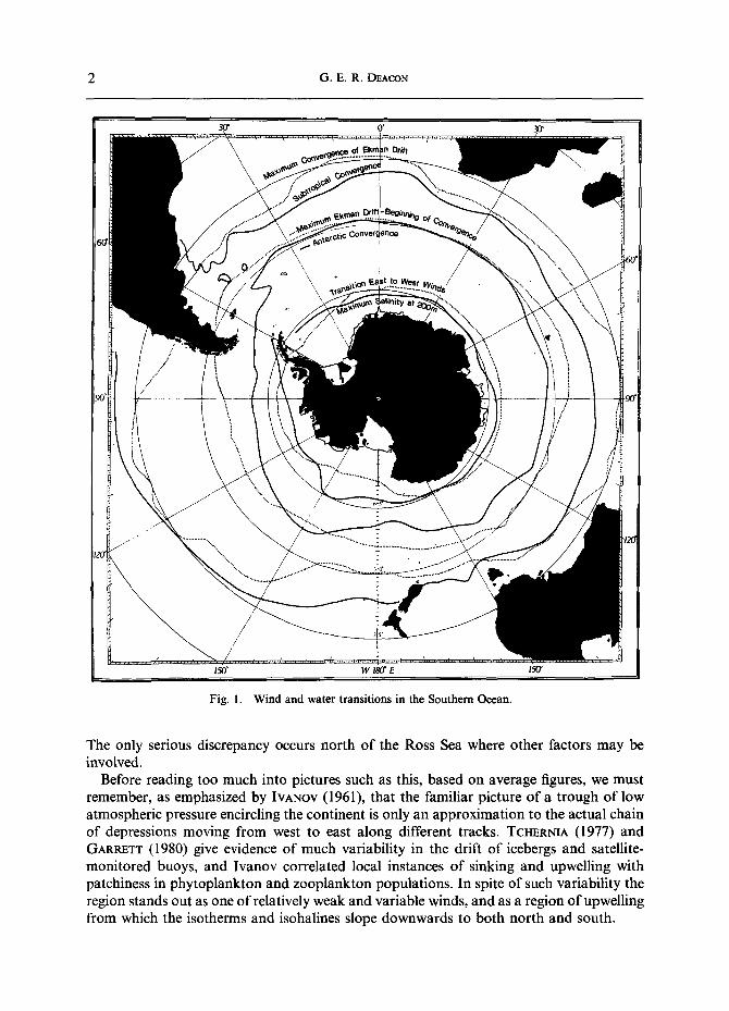
The dotted line nearest the continent in Fig. 1 shows the location of the average wind boundary. It happens in 68 to 69°S in the Weddell Sea, in 62 to 63°S where the continent extends farther north in the Indian Ocean sector, and in 70 to 71°S north of the Ross Sea, It should be accompanied by evidence of upwelling, and the full line close by shows the circumpolar salinity maximum at 200 m plotted by GORDON, MOLINELLI and BAKER (1978).
* Institute of Oceanographic Sciences, Brook Road, Wormley, Godalming, Surrey GU8 5UB, England.
Crown Copyright 1982. 1
2 G.E.R. DEACON
• r 07 ~.
Fig. 1. Wind and water transitions in the Southern Ocean.
The only serious discrepancy occurs north of the Ross Sea where other factors may be involved.
Before reading too much into pictures such as this, based on average figures, we must remember, as emphasized by IVANOV (1961), that the familiar picture of a trough of low atmospheric pressure encircling the continent is only an approximation to the actual chain of depressions moving from west to east along different tracks. TCHERNIA (1977) and GARRETT (1980) give evidence of much variability in the drift of icebergs and satellite- monitored buoys, and Ivanov correlated local instances of sinking and upwelling with patchiness in phytoplankton and zooplankton populations. In spite of such variability the region stands out as one of relatively weak and variable winds, and as a region of upwelling from which the isotherms and isohalines slope downwards to both north and south.
Physical and biological zonation in the Southern Ocean 3
KOOPMANN (1953) points out that although the winds change direction the calculated divergence of surface drift is weaker there than it is some 5 degrees farther north, where the atmospheric pressure gradients are steeper. He was able to find some confirmation of upwelling in 55°S between 0 and 30°E, and in 65°S between 180 and 130°W, particularly from surface enrichment of silica, but no such indication elsewhere. Even in the two sectors where there is this apparent confirmation the low temperatures, high salinities, and high silicate concentrations may be partly, at least, explained by eastward flow from the Weddell and Ross seas (DEACON, 1979).
The clearer indications of upwelling near the wind boundary might suggest that geostrophic upwelling between the east and west drifts may be more effective than Ekman divergence. It is also a zone where the surface layer is thin--part of a general shallowing towards the south as well as upwelling--and its relatively sharp vertical gradients are likely to make upwelling more apparent. It may also be possible that the thicker layer of Antarctic surface water farther north may allow some adjustment for increased surface transport without so much upwelling. Closely spaced bathythermograph observations show that the gradual, regular, deepening of the isotherms, isohalines, and characteristic temperature minimum, which is fairly typical of the region north of the wind boundary, becomes less regular and more variable towards the north, where there is increasing evidence of meanders and eddies.
The Antarctic convergence
The second dotted line in Fig. 1 shows the calculated position of the strongest average west wind and maximum northward Ekman drift, and the full line near it is the Antarctic convergence. Although the closely spaced observations and satellite imagery available today emphasize its variability, they are relatively minor variations about what, in the middle of such a wide ocean, must be regarded as a remarkably predictable frontal zone where cold Antarctic water slips below and mixes with warmer water (KoRT, 1967). At the surface it is marked by steepening of the meridional gradients of temperature, silicate, and other nutrients, by transitions in phytoplankton and zooplankton, and by a noticeable difference in climate. There is much eddying and interleaving of cold and warm water (GORDON, GEORGI and TAYLOR, 1977; GEOR6I, 1978; JOYCE, ZENK and TOOLE, 1978), but the sustained presence of a weak temperature minimum below the warmer water north of the front is a clear indication of continued sinking.
The position of the convergence in Fig. l is based on the finding by DEACON (1933, p. 192) and MACKINTOSH (1946, p. 180) that the surface discontinuity generally occurs close to the latitude where the temperature minimum characteristic of the Antarctic water dips below 200 m on its relatively steep descent below the warmer water. Temperature profiles farther south are clearly marked by a temperature minimum at 100 to 150 m between warmer, less saline, surface water and warmer, more saline, deep water. Profiles farther north are just as clearly marked by warmer, generally well-mixed, water extending well below 200 m. There is generally little difficulty in identifying where the temperature minimum sinks below 200 m, especially where it happens relatively far north, where the density layers slope steeply. Where it happens farther south, the density layers generally slope less steeply and there is more variability. There is also greater variability, and more difficulty in interpolating between contra-indicating data, near the S-shaped bend of the convergence in the Scotia Sea.
The early studies (DEACON, 1933; MACKINTOSH, 1946) recognized some irregularity and

4 G.E .R. DEACON
variability in the position of the front; they realized that it was a sharp transition rather than a barrier, but concentrated on the broad significance of such a predictable feature in the middle of the ocean. The closely spaced observations of today add much essential detail. LEGECKIS (1977) gives a striking picture of the meandering front in the Drake Passage based on thermal infrared images. GORDON'S (1967) Eltanin sections sometimes show a thin layer of subantarctic water carrying the surface discontinuity 2 or 3 degrees south of the more stable subsurface front. He found less evidence of Antarctic water advancing northwards, but JOYCE and PATTERSON (1977) followed a large northward meander, pinched off to form an eddy some 60 to 80 km in diameter, in which deep as well as surface water seemed to be involved.
Some idea of the probability of finding the surface discontinuity near the position charted from subsurface data has been obtained by comparing it with 200 'crossings' based by MACKINTOSH (1946) and HOUTMAN (1964) on surface recordings and routine surface sampling. Half the crossings fall within 1 degree of the line in Fig. 1, and 909/0 within 2 degrees.
Many authors, including KOOPMANN (1953), WEXLER (1959), WYRTKI (1960), OSTAPOFF (1962), CREASE (1964), and TAYLOR et al. (1978) noted that the convergence occurs near the latitude of strongest west winds, and it is reasonable to suppose that this is where the slope of the density layers (an important factor in determining the latitude of the convergence) is steepest. Figure 1 suggests that the wind and water boundaries are close together where the convergence is relatively far north, as in the Atlantic sector, and farther apart where it is far south, as in the Australian and east Pacific sectors.
Although the circumpolar current must be primarily wind driven, its course must also depend on other factors. Many authors give instances of the effects of bottom topography, and KAMENKOVICH (1962) and others outline possible mechanisms. For example, DEACON (1937) attributed the northward advance of the convergence near the middle of the Pacific sector to the influence of the Pacific Antarctic ridge; KORT (1962) related changes in direction to topographical features; GORDON (1972) correlated north-south shifts with the topography south of Australia, and GORDON et al. (1978) find a number of parallels between dynamic topography and bottom contours. The S-shaped bend of the convergence in the Scotia Sea seems likely to be due to the northern arm of the Scotia ridge.
The effects of heating, cooling, and water exchanges on the density distribution and the path of the current are not so readily apparent, but STOMMEL (1980) shows how they may determine the latitude in which the main volume of water sinks to form the Antarctic Intermediate current, which is a closely related problem. S'rOMMEL (1957) and others have pointed out the difficulty of considering the circumpolar current as mainly zonal, since the coefficients of viscosity needed to maintain overall equilibrium with the wind would be much greater than those generally accepted. It is more likely that equilibrium is partly maintained by meridional flow such as the sharp northward trend of the current after it rounds Cape Horn, and a balance between northward flow at the surface and southward flow of deep water. This seems to require that the current should be strongest where the Ekman drift is divergent, and there is a tendency for the water boundary to be well south of the wind maximum, especially where it has to round Cape Horn.
The polar front (Antarctic convergence) as plotted by TAYLOR et al. (1978) lies a little closer to the west wind maximum, but they define it as the latitude where sinking Antarctic surface water produces a circumpolar belt of minimum salinity at 200 m, and this generally occurs a degree or two north of the surface discontinuity where the temperature minimum

Physical and biological zonation in the Southern Ocean 5
sinks. Both criteria are admissible, though the low-salinity water and its movements are likely to be more influenced by mixing north of the frontal region. It is a questionable feature in the Drake Passage and Scotia Sea (OSTAPOFF, 1962).
Further progress must take account of the modern conception of the circumpolar current as varying bands of strong and weak flow (]'qOWLIN, WHITWORTH and PILLSBURY, 1977; BRYDEN and PILLSBURY, 1977; SAVCHENKO, EMERY and VLADIMIROV, 1978). It seems likely that the Antarctic convergence--the water boundary--must be a narrower feature than the wind and current maximum, even when account is taken of its variability (CHARNOCK, 1964; CREASE, 1964).
The subtropical convergence
The northernmost full line in Fig. 1 shows the position of the subtropical convergence, a sharp transition between subantarctic water and warmer, more saline water partly derived from strong southward currents. It is generally marked by a surface-temperature discontinuity of 4 or 5°C and a salinity difference of 0.5 x 10 -3. A particularly sharp crossing was noticed in 41°S southeast of Cape Town by the Meteor: the convergence was visible from a distance as a line of water disturbance, and the surface temperature rose 5.6°C in 1 mile and 9.1°C in 5 to 6 miles (Wf~ST, 1926). The dotted line close by in Fig. 1 shows where the calculated Ekman drift, decreasing rapidly to the north, is most convergent. The position of the water boundary is again based on the data contained in a 1974 NODC (National Oceanographic Data Center) tape, and it is plotted where the surface salinity rises above 34.9 x 10⁻³, usually within a sharp rise from approximately 34.6 to 35.1 x 10 -3. The data compiled over many years, and including observations in different seasons, usually allow it to be located to within 1 or 2 degrees of latitude, though there has to be some interpolation between differing as well as scattered observations, and there are scarcely sufficient observations to fix its position in the middle of the Atlantic, Indian, and Pacific sectors. There are special conditions south of the Brazil, Agulhas, and East Australian currents where patches of warm water separate off from the main currents. South of the Brazil current, for example, the main boundary between subtropical and subantarctic waters occurs near 42 to 43°S but the historical data show that patches of the more saline water have reached 47 to 48°S. There is also much irregularity at the boundary with the Falkland current between the Brazil current and Patagonia.
The full and dotted lines are sufficiently close together to indicate some association between the water boundary and the maximum convergence of Ekman drift, but it seems difficult to draw further conclusions. They are closest together south of the Brazil, Agulhas, and East Australian currents, though this is where a mean line is drawn between observations ranging over 2 or 3 degrees of latitude. In the east Atlantic and Indian oceans the water boundary lies south of the decrease in west wind, but in the western Pacific Ocean well north of it. There seems to be something special about the region east of New Zealand: the climatic data show that the west winds are much weaker there than in other sectors.
The change from west to east winds takes place some 5 to 10 degrees farther north. SCHUMACHER (1949), studying the South Atlantic Ocean, locates it in 30 to 35°S, and although the meridional pressure gradients are weaker there than they are farther south, downward extension of warm water to unusually great depths suggests strong downwelling. There seems to be some analogy with the Antarctic divergence, where there seems to be more upwelling associated with the change of wind direction than with the stronger gradients farther north. Schumacher agreed with an earlier suggestion by
6 G.E.R. DEACON
B6HNECKE (1936) that the name subtropical convergence ought to be kept for the wind boundary in 30 to 35°S, and subtropical boundary for the water transition farther south. KOOPMANN (1953) used these terms. The horizontal and vertical water movements near the subtropical boundary, now generally referred to as the convergence, are not well known, but HEATH (1976), summarizing his own and earlier observations, finds a well-mixed layer some 50 m deep north of the front from which southward, subsurface flow maintains a subsurface layer marked by an intermediate salinity maximum, extending some half-way across the subantarctic zone at a depth of 100 to 300m. He questioned the relative importance of diffusion and advection in maintaining the subsurface high salinity.
A subantarctic front ?
B6HNECKE'S (1936) careful evaluation of mean monthly surface temperature of 1- degree squares showed regional steepening of the temperature gradient approximately halfway across the subantarctic zone south of the Brazil and Agulhas currents, though not in the intervening longitudes. He suggested the name west-wind-drift front or secondary polar front for the two fragments. DEACON (1945) suggested that the observed discontinuity occurred between the stratified northern half of the zone, where the subsurface high-salinity tongue is a recognizable feature, and the southern half, where the water is well mixed, often to more than 500 m. The data are still scarcely adequate to test this idea in detail, but they seem to agree with recent studies south of Australia and New Zealand. BURLING (1961) found a surface-temperature discontinuity, which he called the Australasian subantarctic front, bordering highly-saline subsurface water. ZILLMAN (1970), using surface-temperature observations made on 43 crossings to and from Antarctic bases, found a persistent discontinuity in much the same position; it averaged 3.6°C in 150 km, which was steeper than the gradients he found at the Antarctic and subtropical convergences. Examination of the Discovery and William Scoresby thermographs shows the expected steepening of gradient south of the Brazil and Agulhas currents and south of Australia, but in other sectors it is not clear, or too near the subtropical convergence to be distinguished from it.
Ice cover
The overall effects of the great winter advance and summer retreat of pack ice may soon be better known as much new information becomes available from satellite observations. The ice retards summer warming and must have considerable effects on the plankton. It covers 60~ of the ocean south of the Antarctic convergence at the end of winter and only about 12~ at the end of summer. MACKINTOSH and HERDMAN (1940) and MACKINTOSH (1972) showed that the pack ice generally has a well-defined though irregular and variable northern boundary, reaching to within a few degrees of the Antarctic convergence in the western Scotia Sea, and more generally to within 5 to 10 degrees. Satellite observations show that the northern limit varies only a few degrees from year to year, the variations tending to be less where the continent extends farther north, and rather more near the broad southward embayments of the Weddell and Ross seas, where the currents as well as the greater supply of ice have a big effect. ACKLEY (1981) shows how the current from the Weddell Sea, carrying ice across the Atlantic sector, advances the date of maximum cover from August in 20°W to October in 10°E and possibly even later in 30°E. The seasonal variation, like the annual variation, seems to be least in the Indian Ocean sector where the continent extends relatively far north. Statistical analysis of four years of satellite data

Physical and biological zonation in the Southern Ocean 7
(RAYNER and HOWARTH, 1979) showed that the total ice cover reached a maximum on 10 to 15 September and fell to a minimum on 15 to 20 February, the increase lasting 150 days and the decrease 120.
Early observations from Antarctic bases showed that there are sometimes strips of open water close to the coast even in winter, and in the Weddell and Ross seas open water generally appears early in summer between an outer zone of ice drifting eastward and an inner zone, close to the land, drifting westward.
There is still some uncertainty about the density of the ice cover--proportion of ice to open water--within the northern limits. The probable range in winter seems to be 65 to 85~o o (ACKLEY and KELIHER, 1976; ZWALLY and GLOERSEN, 1977; ACKLEY, 1981), but there are areas of denser cover, depending on the changing wind patterns, and some coastal strips and larger offshore areas tending to be free of ice. The most remarkable is an irregular, variable area some 1400 km long and 400 km wide close to the antarctic divergence between 10°E and 25°W (GORDON, 1978) and close to an area of particularly high salinity (> 34.70 x 10 -3) at 200 m shown by GORDON, MOLINELLI and BAKER (1978, Fig. 6). Upwelling may play a significant part in weakening and reducing the ice cover, and for this reason, as well as the divergence of Ekman drift, there may be other weak-ice areas along the divergence.
The Weddell-Scotia front
The boundary region between cold water flowing from the Weddell Sea and somewhat warmer water reaching the Scotia Sea through the Drake Passage is a recognizable feature within the Atlantic sector of the Antarctic zone. Several investigators have traced it across the Scotia Sea by its effect on the temperature and nutrient distributions (DEACON, 1979). GORDON (1967) called it the Weddell-Scotia Confluence. PATTERSON and SIEVERS (1980) have made a detailed study of all the data available. It trends east and north across the Scotia Sea, northwards along the South Sandwich Island group, and then makes a loop to the northwest off the northeast coast of South Georgia, before continuing eastward across the Atlantic Ocean. It has a marked effect on the temperature distribution and ice cover, and has an important effect on the distribution of krill, the main food of the whales. Its influence near South Georgia maintained one of the principal whaling grounds.
The continental shelf
In the ocean outside the shelf there are three characteristic component layers, Antarctic surface water, warm deep water (circumpolar deep water), and Antarctic bottom water. On the shelf the water is more uniform. There are only a few places where the warm, deep water from outside reaches onto the shelf. CARMACK'S (1977) analysis of temperature and salinity observations in the Antarctic zone shows considerable differences between the shelf and oceanic domains.
The shelf is approximately twice as deep as other continental shelves except that of Greenland--the other large ice cap. Sounding profiles generally show a rise from ocean soundings to less than 500 m on an outer sill, and then a deepening into shelf depressions (sometimes as deep as 1000 m) before rising again to the land. There are exceptions: HERDMAN (1948) shows an abrupt rise from 1000 m to the land in 3°E and there is practically no shelf. More generally the width ranges from 30 to 200 km though it widens to 300 km in the Bellingshausen, Amundsen, and Davis seas, and to 600 and 1100 km in the Weddell and Ross seas. Some of the shelf basins continue below the continental ice shelves.

8 G.E.R. DEACON
The southward Ekman flow in the east wind region can be expected to maintain convergence near the continent, and the near-surface isotherms and isohalines generally slope downwards to the south. Icebergs drifting westwards tend to follow the coast for long distances before breaking out to the north (TcI-mRNIA, 1977), and except for occasional open leads the summer remnants of pack ice seem to hug the coast. GORDON and TCHERNIA (1972) give clear pictures of the temperature and salinity distributions on the shelf north of Ad61ie Land; the surface water is warmed to a little above its freezing point and also diluted; the deeper water, especially in the shelf basins, retains the near-freezing temperature and higher salinity typical of winter; there must be some water circulation on the shelf generally southwards at the surface and northwards at the bottom, and the pictures show the cooling effect of overflowing shelf water on the warm, deep water outside.
The exceptional places where warm, deep water reaches southward on to the shelf, raising its bottom temperature above 0°C, are from the western side of the Antarctic Peninsula to the Bellingshausen Sea, where the unusually high temperature of the deep water may indicate strong southward flow; at the heads of canyons reaching up the slope north of the Ross Sea; in 30 to 40°E where, again, the deep water seems warmer than usual, and in 30 to 40°W where a deep channel runs across the shelf. Round the rest of the continent it is rare to find deep-water temperatures above 0°C in soundings less than 1000 m. FOSTER and CARMACK (1976) show modified deep water, cooled below 0°C, reaching on to the shelf in 29 and 40°W.
The lowest shelf salinities are found west of the Antarctic Peninsula and south of the Bellingshausen Sea, where the warm, deep water may increase ice melting. The highest are found in the Ross and Weddell seas where freezing is most extensive. Much of the bottom water in the southwest corner of the Ross Sea has a salinity greater than 34.8 x 10⁻³, and some greater than 34.9 x 10⁻³. In one of the shelf basins off the coast of Victoria Land 35.21 x 10 -3 was recorded by the Glacier in 1958. There is also much cold, dense water on the Weddell Sea shelf, but with salinities rather less than those of the Ross Sea, probably because there are more active water exchanges between the shelf and the deep water outside.
NOWLIN et al. (1977), SIEVERS and EMERY (1978), and WHITWORTH (1980), working in the Drake Passage used a step-like rise in the warm, deep layer and other evidence of frontal conditions near the South Shetland Islands to suggest 'continental zone' as a useful subdivision, but Whitworth shows the boundary almost coinciding with the edge of the shelf, and for the whole of the circumpolar ocean it might be sufficient to use the shelf itself as the subdivision. Other authors refer to the east-wind-drift region. MARR (1962) and MACKINTOSH (1972), for example, emphasize its importance, and that of its continuations in the Weddell Sea current and other offshoots, to the distribution of krill. As indicated above it has some special features and is a very promising region for closer observations.
BIOGEOGRAPHY
The Antarctic convergence
Marine biologists have often remarked on the biogeographical significance of the Antarctic convergence. TATE REGAN (1914), examining the fishes of Scott's last expedition, found them subdivided in three zones, Antarctic, subantarctic, and south temperate, with the 6 and 12°C surface isotherms as approximate boundaries. NORMAN (1938), working on

Physical and biological zonation in the Southern Ocean 9
the Discovery collections, confirmed this distribution and pointed out that the 6 and 12°C isotherms correspond closely to the Antarctic and subtropical convergences. DAVID (1955) found that Sagitta gazellae has two distinguishable races separated by the Antarctic convergence, the northern, subantarctic population maturing at a shorter length than the Antarctic population. BAKER (1965) found that eight of the 15 species of Euphausia taken along the 90°E meridian live mainly in one zone or another. ASDREWS (1966) showed that Calanoides acutus lives mainly south of the convergence, with only a limited extension into the deeper levels of the subantarctic zone. SHEPPARD (1933) found two distinct Isopod faunas, one on each side of the convergence. HASTINGS (1942) found the non-abyssal Polyzoa sharply divided by the convergence, the great majority being found on one side or the other, but not on both. More examples from pelagic Nemerteans, Ostracods, and Amphipods are given by B~. et al. (1969). MACKINTOSH (1960), writing of the zooplankton in general, found that nearly every species, at least in the surface layer, occupies a characteristic circumpolar zone; although the convergence is not necessarily a boundary to many species, there are many contrasts, and where a species extends through both zones there are likely to be recognizable, probably subspecific, differences, as David found with Sagitta gazellae.
There is also evidence of species being more abundant or less abundant close to the convergence, possibly because of special conditions prevailing there. DAVID (1955) found poor catches of Sagitta gazellae near the convergence contrasting with richer catches north and south of it, and K A ~ (1966) found a low-concentration belt of Parathemisto near the convergence. Euphausia triacantha are, in contrast, most abundant there, the numbers decreasing rapidly on both sides (BAKER, 1965).
Phytoplankton zonation is discussed by HART (1934), who found a number of species typical of each of the Antarctic, subantarctic, and subtropical zones. He noted that Rhizosolenia curvata is a valid indicator of subantarctic water when it is carried southward above Antarctic water; it can survive for a time by vegetative growth, but rarity of large individuals, such as result from normal growth, indicates that it could not survive for long in the changing environment.
Bottom sediments also differ across the convergence. EARLASD (1933) commented on the great difference in the foraminiferal content of the bottom faunas near the Falkland Islands and South Georgia. In ocean depths the south-to-north transition from mainly siliceous ooze to calcareous ooze occurs just north of the Antarctic convergence, and interbedding of the two types is used to study changes in paleoclimate. There are recent studies by CXESlELSKI and others in Vol. 28 of the initial reports of the Deep-Sea Drilling Project. HERDMAN (1948) attributed difficulties in hearing echo soundings close to the convergence to an accumulation of soft ooze, and an anomalously thick layer of acoustically transparent ooze just south of the convergence was reported from the Glomar Challenger (Initial Reports 28, pp. 49-51).
The subantarctic front
The fragments of subantarctic front and Australasian front as recognized by BfHNECKE (1936) and BURLING (1961) seem also to have biogeographical significance, some plankton species occurring mainly in the warmer, stratified, northern half of the subantarctic zone and others in the well-mixed water of the southern half. BAKER (1959) found the southern region to be the normal habitat of Euphausia triacantha and ANDREWS (1966) found the same for Calanoides acutus. JOHN (1936) and BAKER (1965) found

10 G.E.R. DEACON
Euphausia vellentini to be restricted to the coolest belt, while other Euphausia species seem to be restricted to the warmer half.
The subtropical convergence A similar list of biogeographical separations, one or two of them already mentioned,
could no doubt be compiled for the subtropical convergence. MACKINTOSH (1960), summarizing the pattern of distribution of Antarctic and subantarctic fauna, notes that even greater contrasts may be found across the subtropical convergence, which seems to mark the southern limit of many warm-water species.
The continental shelf Circulation of water on and off the continental shelf appears to influence the distribution
of the plankton species. MARR (1962, pp. 123--124, 201--204) in a study of the Ross Sea found that although Euphausia superba is abundant in the deep water outside the sea, only a few larvae and early stages were taken on the shelf. In contrast, Euphausia crystallorophias is found almost entirely on the shelf. FEVOLDEN (1980) found a less sharp separation on the shelf south of the Weddell Sea, possibly because of more active interchange between the shelf and deep water, but E. superba was dominated by E. crystallorophias in soundings less than 300 m.
Ice cover Many authors have supposed ice cover to be a determining factor in the distribution of
Euphausia superba, but MARR (1962), after summarizing the Discovery observations and earlier work, maintains that it is not a causal relationship, appearing only when the areas in which the krill occur lie far enough south to be frozen over, or in the path of cold currents that carry ice as well as krill from higher latitudes. HA~a" (1942) concluded that ice had a beneficial 'neritic' influence on phytoplankton growth, pointing out that abundant growth followed the uncovering of the water as soon as the ice melted. Recent work suggests that the 'neritic' effect may not be the addition of trace elements from the land or ice, but the addition of fresh water, which increases the stability of the upper part of the water column, increasing its resistance to wind stirring and lessening the downward dispersion of the phytoplankton to depths where there is too little sunlight to maintain reproduction and growth. Although the lower part of the ice itself provides a stable medium, with sufficient light to support diatom growth, shown by strong discolouration of the ice, it is not till the sea is fully opened to sunlight that the great outburst takes place. Below dense pack ice, the water is generally crystal clear, indicating scarcity of phytoplankton, but BUNt (1968) found it present below thick ice in McMurdo Sound, and ANDRIASItEV (1968) found a number of animal species using the lower layer of Antarctic fast ice as a refuge and feeding ground. A review by EL-SAYED (1971) emphasizes the need for further study, but he agrees with Bunt that ice microflora may prove to be a major factor in determining the annual production.
The Weddell-Scotia front Several authors have commented on zoogeographical differences between the current
from the Weddell Sea and that reaching the southern part of the Scotia Sea through the Drake Passage. MARR (1962) contrasts the abundance of Euphausia superba in the Weddell Sea current with its relative scarcity in the west wind drift. FoxTON (1956) found other

Physical and biological zonation in the Southern Ocean 11
plankton species more abundant in the warmer water. OMMANNEY (1936) found Rhincalanus gigaa much more abundant in the warmer water.
Circumpolarity BAKER (1954) shows that most of the plankton species have circumpolar distributions,
and comments that although subspecific differences might be expected over such great distances, none had been observed. More recent studies show two probable exceptions. FOXTON (1961) had to conclude that Salpa gerlachei occurs only in the high latitudes of the Pacific Ocean sector, and MCGINNIS (1974) found a subantarctic lantern fish to be restricted to the Pacific Ocean.
Other species are non-uniform in their circumpolar distributions. Euphausia superba, though circumpolar in the east wind drift, varies greatly in abundance from sector to sector in the west wind drift, where its distribution seems to depend very much on northward outflow from the east wind drift (MARR, 1962). It is found as far as 50°S in the outflow from the Weddell Sea, but only south of 65°S in the east central Pacific sector where there is less indication of northward flow. FOXTON (1971) found that the cold-water salp Ihlea racovitzai had a very similar distribution.
Bottom living organisms in near-coastal waters seem to show more isolation (HEDGPETH, 1969; B~ et al., 1969; KNOX and LOWRY, 1977) though some of the apparent isolation might be lessened by wider detailed study.
CLIMATE
After commenting on the significance of the Antarctic convergence as a biogeographical feature, JOHN (1934) wrote "But we, whether sailors or scientists, know and will remember the convergence best in another way: as the line to the north of which we felt one day, at the right season, after months in the Antarctic, genial air again and soft rain like English rain in the spring. I can remember a number of those days vividly. It was like passing at one step from winter into spring. In the southernmost lands in the sub-Antarctic, the islands about Cape Horn, the earth smells as earth should smell and as it never does in the Antarctic. It is no doubt the north-easterly course of the convergence between the longitudes of Cape Horn and South Georgia, so that the former is left far to the north and the latter to the south, that accounts for the vast difference in the climates of two islands which are in precisely the same latitude and only 1000 miles apart. The lower slopes of Staten Island are clothed with beech trees with so rich an undergrowth that it is difficult to push through. Darwin compared the richness of the region to that of a tropical forest. South Georgia, the other island, is a true Antarctic land. The snow-line of South Georgia is lower than the treeline of Tierra del Fuego."
SCHOTT (1902, pp. 134-135) commented on the rapid fall of temperature from the Cape Horn region to South Georgia, and again to Bouvet Island, some 1800 km farther east in the same latitude. He concluded that Bouvet Island must be influenced by a direct flow from the polar region, as we now see it to be more influenced than South Georgia by the cold water from the Weddell Sea.
NOMENCLATURE
Discovery scientists (including the author), writing home in the early 1930's about the sharp transition from Antarctic to subantarctic water, used the name Meinardus line after

12 G.E.R. DEACON
SCHOTT (1926, p. 241) or Oceanic Polar Front after WOST (1928) and DEFANT (1928), but the Discovery Committee, guided by the Hydrographer of the Navy and his assistant D. J. MATTHEWS, a leading oceanographer of those days, recommended the name Subantarctic convergence. Those concerned mainly with its significance as a biogeographical feature, and not with the wider implications of the name Polar Front, accepted this name though they used 'Antarctic' instead of 'Subantarctic' to emphasize the continuity of physical and biological characteristics between it and the continent. There was also some difficulty in identifying it with Wiist and Defant's Polar Front, which at the time was linked with the boundary between the Brazil current and the west wind drift.
WYRTKI (1960), questioning the precise nature of water movements near the convergence and pointing out that most of the sinking--to form the Antarctic Intermediate current-- takes place farther north, took exception to the term convergence, but he seemed to place too much weight on WEXLER'S (1959) questionable interpretation of irregularities in the temperature distribution revealed by the early bathythermograph observations, just south of the convergence, as evidence that upwelling was the main feature. The surface discontinuity can, however, only be explained by the convergence of water movements, and the continuing weak temperature minimum as the Antarctic water slips below and mixes with the warmer subantarctic water as evidence that sinking begins there.
Subsequent authors, recognizing the variability of the front, adopted the name Polar Front Zone (GORDON, 1971). This name has since been extended by Gordon and others to refer to the whole of the well-mixed, southern half of the subantarctic zone, within northern limits, which, though often not well-defined, must parallel Bfhnecke's fragments of secondary polar front and Burling's Australasian or subantarctic front, while Polar Front is again used for the southern limit, the Antarctic convergence. One of the most recent authors (TOOl.E, 1980, p. 22) uses it for a narrow zone 50 to 100 km wide. It might still be reasonable to keep the name Polar Front, with all its implications, for the northern boundary of the region where both Antarctic and subantarctic water sink to form the Antarctic Intermediate current--an idea that can be traced in the earliest writings of Wrist and Defant--while keeping 'Antarctic convergence' for the discontinuity that marks the beginning of the sinking of the Antarctic water and the significant changes in plankton distribution.
There is less question about the name subtropical convergence in spite of the well- justified reminder by B6hnecke and Schumacher, already mentioned, that there seems to be more sinking near the wind boundary farther north. Their suggestion that the 'convergence' should be named 'boundary' is reasonable, though its closeness to the maximum Ekman convergence and the sharpness of the discontinuity indicate that convergence does take place. Biogeographers, particularly those working in the cold upwelling water off southwest Africa, prefer the name South Temperate to subtropical, but there is a belt of warmer water farther offshore: flying fish can be seen well south of Africa.
There can be little doubt that cooperative physical and biological studies have special promise in the circumpolar ocean. The occupation of characteristic circumpolar zones by different plankton species may well be determined by features in the water circulation rather than small differences in temperature and salinity. The accessibility of suitable feeding grounds, as well as conditions favourable to reproduction made possible by some kind of closed or partly closed circulation, seem to be things to look for.
It has often been said that marine physicists and biologists working together will learn something from each other. It seems likely to be very true in the circumpolar ocean;
Physical and biological zonation in the Southern Ocean 13
c o l l a b o r a t i o n m a y a lso s impl i fy the t e r m i n o l o g y . Spec ia l i s t s h a v e t o s tudy a n d c a t e g o r i z e
al l t he deta i l , b u t in c o l l a b o r a t i o n the n e e d to r e a c h a m e a s u r e o f a g r e e m e n t e n c o u r a g e s
s imp le r t e r m i n o l o g y .
REFERENCES
ACKLEY S. F. and T. E. KELIHER (1976) Antarctic sea ice dynamics and its possible climatic effects. Aidjex Bulletin, 33, 53-76.
ACKLEY S. F. (1981) A review of sea-ice/weather relationships in the Southern Hemisphere. Presented at the I.U.G.G. session on Sea Level, Ice Sheets and Climatic Change, Canberra, 1979.
ANDREWS K. J. H. (1966) The distribution and life history of Calanoides acutus (Giesbrecht). Discovery Reports, 34, 117-162.
ANDRIASSEV A. P. (1968) The problem of the life community associated with the Antarctic fast ice. Symposium on Antarctic Oceanography Scientific Committee for Antarctic Research (S.C.A.R.). Scott Polar Research Institute, pp. 147-155.
BAKER A. DE C. (1954) The circumpolar continuity of Antarctic plankton species. Discovery Reports, 27, 201-218. BAKER A. DE C. (1959) The distribution and life history of Euphausia triacantha, Holt and Tattersall. Discovery
Reports, 29, 309-340. BAKER A. DE C. (1965) The latitudinal distribution of Euphausia species in the surface water of the Indian Ocean.
Discovery Reports, 33, 309-334. Bg A. et al. (1969) Distribution of selected groups of marine invertebrates in waters south of 35°S latitude.
Folio 11, Antarctic Map Folio Series, pp. 1-44, plates 1-22, American Geographical Society. BtHNECKE G. (1936) Temperatur, Salzgehalt und Dichte an der Oberflache des Atlantischen Ozeans. Meteor
Reports, 5, 1-249. BRYDEN H. L. and R. D. PILLSBURY (1977) Variability of deep flow in the Drake Passage from year-long current
measurements. Journal of Physical Oceanography, 7, 803-810. BUNT J. S. (1968) Microalgae of the Antarctic pack ice. Symposium on Antarctic Oceanography, Scientific
Committee for Antarctic Research (S.C.A.R.). Scott Polar Research Institute, pp. 198-218. BURLING R. W. (1961) Hydrology of circumpolar waters south of New Zealand. New Zealand Department of
Scientific and Industrial Research Bulletin, 143, 1-66. CARMACK E. C. (1977) Water characteristics of the Southern Ocean south of the Polar Front. In: A voyage of
discovery, Pergamon Press, pp. 15-41. CHAgNOCK H. (1964) Energy transfer by the atmosphere and Southern Ocean. Proceedings of the Royal Society,
A281, 6-14. CREASE J. (1964) The Antarctic circumpolar current and convergence. Proceedings of the Royal Society, A281,
14-21. DAvm P. M. (1955) The distribution of Sagitta gazellae, Ritter-Zahoney. Discovery Reports, 27, 235-278. DEACON G. E. R. (1933) A general account of the hydrology of South Atlantic Ocean. Discovery Reports, 7,
171-238. DEACON G. E. R. (1937) The hydrology of the Southern Ocean. Discovery Reports, 15, 1-124. DEACON G. E. R. (1945) Water circulation and surface boundaries in the oceans. Quarterly Journal of the Royal
Meterological Society, 71, 11-25. DEACON G. E. R. (1979) The Weddell Gyre. Deep-Sea Research, 26, 981-995. DEFA~T A. (1928) Die systematische Erforschung des Weltmeeres. Zeitschrift der Gesellschaft fur Erdkunde zu
Beriln, Jubil~ums-Sonderband, pp. 459-505. DISCOWRY COMMITTEE (1931) Minutes of the Scientific Subcommittee 4 and 6 March 1931. Scott Polar Research
Institute. EARLAND A. (1933) Foraminifera, Part II, South Georgia. Discovery Reports, 7, 27-138. EL-SAYED S. Z. (1971) Biological aspects of the pack-ice ecosystem. Symposium on Antarctic ice and water
masses, Scientific Committee on Antarctic Research (S.C.A.R.), Tokyo, pp. 35-54. FEVOLOEN S. E. (1980) KriU off Bouvetoya and in the southern WeddeU Sea, with a description of larval stages of
Euphasia crystallorophias. Sarsia, 65, 149-162. FOSTER T. D. and E. C. CAgMACK (1976) Frontal zone mixing and Antarctic Bottom Water formation in the
southern Weddell Sea. Deep-Sea Research, 23, 301-307. FOXTON P. (1956) The distribution of the standing crop of zooplankton in the Southern Ocean. Discovery Reports,
28, 191-236. FOXTON P. (1961) Salpafusiformis Cuvier and related species. Discovery Reports, 32, 1-32. FOXTON P. (1971) On Ihlea magallanica (Apstein) (Tunicata: Salpidae) and Ihlea racovitzai (Van Beneden).
Discovery Reports, 35, 179-198. GARRETT J. (1980) FGGE drifting buoy systems, summaries of individual buoy histories. World Meteorological
Organization, pp. 1-811.

14 G . E . R . DEACON
GEORtl D. T. (1978) Fine structure in the Antarctic Polar Front Zone: its characteristics and possible relationship to internal waves. Journal of Geophysical Research, 83, 4579-4588.
GORDON A. L. (1967) Structure of Antarctic waters between 20°W and 170°W. American Geographical Society, Antarctic Map Folio Series, Folio 6, pp. 1-10, 14 plates.
GORDON A. L. (1971) Antarctic Polar Front Zone. Antarctic Oceanology, Antarctic Research Series 15, American Geophysical Union, pp. 205-221.
GORDON A. L. (1972) On the interaction of the Antarctic circumpolar current and the Macquarie Ridge. Antarctic Oceanology II, Antarctic Research Series 19, American Geophysical Union, pp. 71-78.
GORDON A. L. and P. TCHEXmA (1972) Waters of the continental margin off Adtlie coast, Antarctica. Antarctic Oceanology II, Antarctic Research Series 19, American Geophysical Union, pp. 59-69.
GORDON A. L. (1978) Deep Antarctic convection west of Maud Rise. Journal of Physical Oceanography, 8, 600-612.
GORDON A. L., D. T. GF.ORGI and H. W. TAYLOR (1977) Antarctic Polar Front Zone in the Western Scotia Sea. Journal of Physical Oceanography, 7, 309-328.
GORDON A. L., E. MOLI~mLLI and T. BAKER (1978) Large-scale dynamic topography of the Southern Ocean. Journal of Geophysical Research, 87, 3023-3032.
GORDON A. L., H. W. TAYLOR and D. T. GEoxGI (1977) Antarctic oceanographic zonation. In: Polar oceans, M. J. DUNBAR, editor, pp. 45-76.
HART T. J. (1934) On the phytoplankton of the south-west Atlantic and the Bellingshausen Sea, 1929-31. Discovery Reports, 8, 1-268.
HART T. J. (1942) Phytoplankton periodicity in Antarctic surface waters. Discovery Reports, 21, 261-356. H^STrNt~S A. B. (1942) Polyzoa (Bryozoa). Discovery Reports, 22, 301-510. HEATH R. A. (1976) Models of the diffusive-advective balance at the Subtropical Convergence. Deep-Sea
Research, 23, 1153-1164. H~Ix;vE~ J. W. (1969) Introduction to Antarctic zoogeography. Folio 11, Antarctic Map Folio Series,
American Geographical Society, pp. 1-9 in B6 et al. 1969. H~tx~vE~ J. W. (1970) Marine biogeography of the Antarctic Regions. In: Antarctic ecology, Voi. 1, M. W.
Hotax~A~, editor, pp. 97-104. HERD~L~N H. F. P. (1948) Soundings taken during the Discovery investigations, 1932-39. Discovery Reports, 25,
39-106. HOUTMAN Th. J. (1964) Surface temperature gradients at the Antarctic Convergence. New Zealand Journal of
Geology and Geophysics, 7, 245-270. IVANOV Yu. A. (1961) Frontal zones in Antarctic waters. Okeanologicheskiye Issledovaniya, 3, 30-51. JEN~n~ R. L., H. L. CRUTCHFa~, H. VAN LOON and J. J. TALam~a~ (1971) Climate of the upper air oftbe Southern
Hemisphere, 3. National Center for Atmospheric Research, Boulder, Colorado. JOI~N D. D. (1934) The second Antarctic commission of the R.R.S. Discovery II. The Geographical Journal, 83,
381-398. JOHN D. D. (1936) The southern species of the genus Euphausia, Discovery Reports, 14~ 193-324. JoYce T. M. and S. L. PATTERSON (1977) Cyclonic ring formation in the Drake Passage. Nature, 265, 131-133. JOYCE T. M., W. 71~NK and J. M. TOOLE (1978) The anatomy of the Antarctic Polar Front in the Drake Passage.
Journal of Geophysical Research, 83, 6093-6113. KAMENKOVICH V. M. (1962) The influence of bottom relief on the Antarctic circumpolar current. Trudy Instituta
Okeanologii, 56, 241-293. KANE J. E. (1966) The distribution ofParathemisto gaudichaudi (Gu~r) with observations on its life history in the
0 ° to 20°E sector of the Southern Ocean. Discovery Reports, 34, 163-198. KNOX G. A. and J. K. LowRy (1977) A comparison between the benthos of the Southern Ocean and the North
Polar Ocean with special reference to the Amphipoda and the Polychaeta. In: Polar oceans, M. J. DUNBAR, editor, pp. 423-457.
KOOPMANN G. (1953) Entstehung and Verbreitung von Divergenzen in der oberfl~ichennahen Wasserbewegung der antarktischen Gewr~sser. Deutsche hydrographische Zeitschrift, Erg~nzungsheft, 2, 1-38.
KORT V. G. (1962) The Antarctic Ocean. Scientific American, 207, 113-128. KORT V. G. (1967) Frnntogenesis in the Southern Ocean. Information Bulletin Soviet Antarctic Expedition, 65,
500-505. L~OECKIS R. (1977) Oceanic Polar Front in the Drake Passage---Satellite observations during 1976. Deep-Sea
Research, 24, 701-704. MACKINTOSH N. A. and H. F. P. HERDMAN (1940) Distribution oftbe pack ice in the Southern Ocean. Discovery
Reports, 19, 285-296. MACKINTOSH N. A. (1946) The Antarctic Convergence and the distribution of surface temperatures in Antarctic
waters. Discovery Reports, 23, 177-212. MACKINTOSH N. A. (1960) The pattern of distribution of the Antarctic fauna. Proceedings of the Royal Society,
B153, 624-631. MACKINTOSH N. A. (1972) Life cycle of Antarctic krill in relation to ice and water conditions. Discovery Reports,
36, 1-94.

Physical and biological zonation in the Southern Ocean 15
MARR J. W. S. (1962) The natural history and geography of the Antarctic krill (Euphausia superba Dana). Discovery Reports, 32, 33-464.
McGrNNIS R. F. (1974) Counterclockwise circulation in the Pacific Subantarctic sector of the Southern Ocean. Science, 186, 736-738.
NORMAN J. R. (1938) Coast fishes, Part III, The Antarctic zone. Discovery Reports, 18, 1-104. NOWLIN W. D., T. WHITWORTH and R. D. PILLSBURY (1977) Structure and transport of the Antarctic
Circumpolar Current at Drake Passage from short-term measurements. Journal of Physical Oceanography, 7, 788-802.
OMMANNEY F. D. (1936) Rhincalanus gigas (Brady), a copepod of the southern macroplankton. Discovery Reports, 13, 277-384.
OST^POFF F. (1962) On the frictionally induced transverse circulation of the Antarctic circumpolar current. Deutsche Hydrographische Zeitschrift, 15, 103-113.
PATTERSON S. L. and H. A. SIEVEP, S (1980) The Weddell-Scotia confluence. Journal of Physical Oceanography, 10, 1584-1610.
RAYNER J. N. and D. A. HOWARTH (1979) Antarctic Sea ice, 1972-75. Geographical Review, 69, 202-223. SAVCHENKO V. G., W. J. E~RY and O. A. VLADIMmOV (1978) A cyclonic eddy in the Antarctic Circumpolar
Current south of Australia. Journal of Physical Oceanography, 8, 825-837. SCHOTT G. (1902) Ozenographie and maritime Meteorologie. Wissenschafiliche Ergebnisse der Deutschen Tiefsee
Expedition aufdem Dampfer Valdivia, 1898-1899, 1, 1-404. SCHOTT G. (1926) Geographie des Atlantischen Ozeans. Hamburg, 368 pp. SCHUMACHER A. (1949) Ober das subtropische Konvergenzgebiet im Sudatlantischen Ozean. Festschrift zum 70
Geburtstag des Dr Ludwig Mecking, Geographiscben Institut der Universit~it, Hamburg, pp. 41-48. SHEPPARD E. M. (1933) Isopod crnstacea. Discovery Reports, 7, 253-362. SmwP, s H. A. and W. J. EMERY (1978) Variability of the Antarctic Polar Frontal Zone in Drake Passage--
Summer 1976/77. Journal of Geophysical Research, 83, 3010-3022. STOMMEL H. (1957) A survey of ocean current theory. Deep-Sea Research, 4, 149-184. STOMMEL H. (1980) How the ratio of meridional flux of fresh water to flux of heat fixes the latitude where low-
salinity intermediate water sinks. Tellus, 32, 562-566. T^[JAARD J. J., H. VAN LOON, H. L. CRUTCI~R and R. L. JENNE (1969) Climate of the upper air of the Southern
Hemisphere. 1. National Center for Atmospheric Research, Boulder, Colorado. T^TE REGAN C. (1914) British Antarctic (Terra Nova) Expedition 1910, fishes. Terra Nova Reports Zoology, 1,
125-156. TAYLOR H. W., A. L. GORDON and E. MOLn~LLI (1978) Climatic characteristics of the Antarctic Polar Front
Zone. Journal of Geophysical Research, 83, 4572-4578. TCI~RNL~ P. (1977) Etude de la derive antarctique Est-Ouest au moyen d'Icebergs suivis par le satellite Eole. In:
Polar oceans, M. J. DUNBAR, editor, pp. 107-120. TOOLE J. M. (1980) Wintertime convection and frontal interleaving in the Southern Ocean. Doctoral Dissertation,
Woods Hole Oceanographic Institution, WHOI Ref. 80-25, 325 pp. WEX~R H. (1959) The Antarctic Convergence---or Divergence? In: The atmosphere and the sea in motion, Rossby
Memorial Volume. The Rockefeller Institute Press, in association with the Oxford University Press, pp. 106-130.
WHrrWORTH T. (1980) Zonation and geostrophic flow of the Antarctic Circumpolar Current at Drake Passage. Deep-Sea Research, 27, 497-507.
W0ST G. (1926) Zweiter Bericht fiber die ozeanographischen Untersuchungen. Zeitschrift der Gesellschafi fi~r Erdkunde, 5-6, 209-274.
W0ST G. (1928) Der Ursprnng der Atlantischen Tiefenw~isser. Zeitschrift der Gesellschafi fiir Erdkunde, Jubilaunis-Sonderband, pp. 506-534.
WYRTKI K. (1960) The Antarctic Convergence and Divergence. Nature, 187, 581-582. ZILLMANN J. W. (1970) Sea surface temperature gradients south of Australia. Australian Meteorological
Magazine, 18, 22-30. ZWALLY H. J. and P. GLOEP.SEN (1977) Passive microwave images of the polar regions and research applications.
Polar Record, 18, 431-450.