peridotites in the western gneiss region, møre and romsdal ... · tectono-stratigraphic setting,...
TRANSCRIPT

Geological Survey of NorwayN-7441 Trondheim, NorwayTel.: 47 73 90 40 00 Telefax 47 73 92 16 20 REPORT
Report no.: 2003.057 ISSN 0800-3416 Grading: Open Title:
Tectono-stratigraphic Setting, Structure and Petrology of HP and UHP Metamorphic Rocks and Garnet Peridotites in the Western Gneiss Region, Møre and Romsdal, Norway
Authors: Peter Robinson, Michael P. Terry, Tony Carswell, Herman van Roermund, Thomas E. Krogh, David Root, Robert D. Tucker and Arne Solli
Client: NGU
County: Møre og Romsdal
Commune:
Map-sheet name (M=1:250.000) Map-sheet no. and -name (M=1:50.000)
Deposit name and grid-reference: Number of pages: 142 Price (NOK): 250 Map enclosures:
Fieldwork carried out: Date of report:15.06.03
Project no.: 2957.04
Person responsible:
Summary: This report is a guidebook for a five day excursion in connection with the Alice Wain Memorial West
Norway Eclogite Field Symposium held in Selje from June 21st-28th, 2003. The Western Gneiss Region provides some of the largest, most comprehensive, and accessible exposures of eclogites and eclogite-facies rocks and garnet peridotites in the world. Perhaps more important for some, it lies in the heart of a great Paleozoic thrust orogen, the late Silurian - early Devonian Scandian orogen, where there is opportunity for using the sciences of tectono-stratigraphy and geochronology as keys to determine the evolutionary history of how these rocks attained their special petrology at great depth and then were preserved and exhumed to the locations of their present exposure. Much of the tectono-stratigraphic framework is preserved in far-traveled thrust sheets in the foreland of the orogen in western Sweden and southern Norway, and these regions need to be visited to gain a full appreciation of the scale and diversity of tectonically assembledunits. On the first day of the excursion, the entire group will travel together from Selje to Lepsøya or Midsund, stopping to investigate eclogites and related rocks of the Ulsteinvik Region. Thereafter, excursion participants, divided into two groups, will visit localities at Nordøyane, the Brattvåg Peninsula, Fjørtoft, and Midsund.
Keywords: Eclogite Garnet peridotite Gabbro
Structural geology Petrology


ALICE WAIN MEMORIALWEST NORWAY ECLOGITE FIELD SYMPOSIUM,
SELJE, NORWAY
Guidebook for Post-meeting Field Excursion June 28-July 3, 2003
Tectono-stratigraphic Setting, Structure and Petrology
of HP and UHP Metamorphic Rocks
and Garnet Peridotites in the Western Gneiss Region,
Møre og Romsdal, Norway
Peter Robinson1,2, Michael P. Terry3, Tony Carswell4and Herman van Roermund5, Leaders,
with contributions byThomas E. Krogh6, David Root7, R. D. Tucker8, and Arne Solli1
1 Norges Geologiske Undersøkelse, N-7491 Trondheim, Norway;2 University of Massachusetts, Amherst, Massachusetts, USA;
3Bayerisches Geoinstitut, Universität Bayreuth, D-95440 Bayreuth, Germany 4Department of Geography, University of Sheffield, Brookhill, Sheffield S3 7HF, UK 5Faculty of Earth Sciences, Utrecht University, P. O. Box 80.021, 3508 TA, Utrecht,
Netherlands6Department of Mineralogy, Royal Ontario Museum, Toronto, Ontario, Canada
7Department of Geological Sciences, University of California at Santa Barbara, Santa Barbara, California, U. S. A.
8Department of Earth and Planetary Sciences, Washington University, St. Louis, Missouri, U. S. A.


3
INTRODUCTION
by Peter Robinson and Mike Terry
Participants in the Post-meeting Excursion, if not already familiar with the Western Gneiss Region, will have come in contact with some if its essentials during the Conference and excursions at Selje, or on the Pre-Meeting Excursion. The Region provides some of the largest, most comprehensive, and accessible exposures of eclogites and eclogite-facies rocks and garnet peridotites in the world. Perhaps more important for some, it lies in the heart of a great Paleozoic thrust orogen (see summary by Roberts, 2003), the late Silurian - early Devonian Scandian orogen, where there is opportunity for using the sciences of tectono-stratigraphy and geochronology as keys to determine the evolutionary history of how these rocks attained their special petrology at great depth and then were preserved and exhumed to the locations of their present exposure. Much of the tectonostratigraphic framework is preserved in far-traveled thrust sheets in the foreland of the orogen in western Sweden and southern Norway, and these regions need to be visited to gain a full appreciation of the scale and diversity of tectonically assembled units. Evidence is also preserved in western Norway in giant extensional allochthons of rocks from closer to the frontal regions later transported away from the foreland, and commonly containing the remnants of Devonian continental clastic basins deposited in extensional environments. Some of these locations were visited on the Pre-meeting Excursion. The Post-Meeting Excursion is concentrated in the coastal part of Møre og Romsdal northeastward from Selje and is focused on three major topics.
Tectono-stratigraphy and deformation. Considerable effort has been expended and marked success has been achieved in the last 25 years in tracing many of the tectono-stratigraphic thrust nappe units from the foreland region into deep synclines in the hinterland where the units either contain eclogites or are adjacent to basement rocks containing eclogites (Gee 1980, Krill 1981, 1985, Tucker 1986, Robinson, 1995a,b,c). One result of such tracing was to discover extreme tectonic thinning of nappe units from hundreds and thousands of meters in the foreland to tens of meters or even single meters in the hinterland. A second result was to find major differences in preserved evidence for earlier metamorphic grade all located in structures with the same pervasive late tectonic overprint. Additionally, the synclinal belts of nappe rocks provide key marker horizons for attempting to understand the geometry of deformation, which is less possible in massive basement. The present result of these studies is to show how truly complex the deformation has been, so that we still have only a rudimentary knowledge of the geometry of cross sections over longer distances and only a general notion of the sequence of mechanical and thermal events by which the present package was assembled.
Metastability and strain partitioning. The scale and abundance of exposure of HP and UHP metamorphic rocks, including some that appear to have reached diamond conditions, commonly allows 1) examination of the nature of protoliths before high-pressure metamorphism, 2) variable preservation of peak-metamorphic assemblages and pseudomorphs to perform thermobarometry and geochronology, locally in rocks with preserved high-pressure structural features, and 3) the strong development of retrograde metamorphic features in most rocks leading to a common late metamorphic-tectonic overprint in high- to low-amphibolite facies. The essential phenomena that make these observations possible are metastability and strain partitioning. Metastability in rock volumes protected from later fluids and deformation permits observations of early features, in some examples even almost perfectly preserved igneous protoliths, as well as early features of metamorphism. Strain partitioning protects earlier rocks and structural features from destruction during later deformation. Together metastability and strain partitioning allow observations of a sequence, though perhaps an incomplete one, and timing, of metamorphic and tectonic events experienced by these rocks, that one can then attempt to place in the context of the evolution of the entire orogen.
Interpretation of garnet peridotites. A feature of the Western Gneiss Region is the widespread occurrence of ultramafic rocks, particularly garnet peridotites physically associated

4
with Proterozoic basement, and commonly but not exclusively associated with regions of HP and UHP metamorphism. Some of these masses, the so called Fe-Ti peridotites are no more than ultramafic cumulate segments of Proterozoic layered mafic intrusions subjected to HP Scandian metamorphism. The remainder of these masses, the Mg-Cr type garnet peridotites, are fragments of mantle. Available Sm-Nd geochronology on a number of these bodies shows that they were already garnet peridotite in the mid-Proterozoic and probably part of the subcontinental lithosphere of Fennoscandia at that time, and were never heated sufficiently during the Scandian metamorphism to entirely destroy the mineralogical record of their Proterozoic history. Other parts of these masses appear to have undergone Scandian neocrystallization to give them a new garnet peridotite assemblage and a tectonic fabric closely related to that in adjacent crustal rocks. The occurrence of microdiamond in one sample from Fjørtoft has been interpreted to indicate that the neocrystallization may have taken place under diamond conditions, though some features may favor Proterozoic diamond genesis in the deep mantle before emplacement into the subcontinental lithosphere. We relate these exposures of Proterozoic mantle lithosphere to two tectonic processes: A) Extensive extensional thinning, cooling, and uplift of continental crust and mantle during stretching associated with the initiation of Iapetus Ocean in the later Proterozoic. In some of the cover nappes this extension was accompanied by the intrusion of suites of diabase dikes, and one or two occurrences of eclogite masses within garnet peridotites may be examples of such dikes (see Conference Field Trip to Almklovdalen). B) Scandian thrust imbrication of Fennoscandian crust and locally the underlying mantle lithosphere into an extensive series of thrust nappes within the basement in which fragments and locally larger slabs of mantle were brought up along the soles of major basement thrusts and emplaced above other basement before or during Scandian HP and UHP metamorphism. Logically such a process would dictate that the bodies would occur along lithologic contacts between basement types, and this has been suggested by Terry in his mapping in Nordøyane. The process would also logically dictate that contacts of the bodies would be of two types, "primary" Proterozoic contacts and Scandian tectonic contacts, but the distinction between these two would be exceedingly difficult to make after intense Scandian metamorphic recrystallization. Many of the features of the garnet peridotites are introduced below in a dedicated article by Carswell and van Roermund.
GENERAL FEATURES OF THE WESTERN GNEISS REGION
The Western Gneiss Region is the second largest exposure of Precambrian rocks in Norway, but understandably, has been less studied from a Precambrian point of view than other areas, because of the moderate to intense Scandian tectonic-metamorphic overprint. There are, nevertheless, superb exposures of variably reconstituted Proterozoic rocks and modern radiometric ages pointing toward the details of Proterozoic history. The northern part of the region is dominated by granitic-tonalitic gneisses in the age range 1686-1657 Ma. These rocks have the same age as part of the Transcandinavian Granite-Porphyry Belt, but are geochemically different from it. In addition, there are extensive areas of deformed rapakivi granite best dated at 1508 Ma and well preserved gabbros, some dated at 1462, 1463, and 1252 Ma. Southwest of a line approximately from Ålesund to Dombås there is increased evidence of middle Proterozoic igneous activity, mainly in the form of granites in the range 1000-942 Ma, and, close to Sognefjord, limited evidence of middle Proterozoic deformation and medium-grade metamorphism. The autochthonous to para-authochthonous basement is overlain locally by autochthonous cover and by a variety of far-traveled Scandian thrust sheets. One of these, the Jotun Nappe, is exposed over an area 25% as large as the whole Western Gneiss Region, and internally shows only rare evidence of Scandian overprinting. It contains 1694 Ma syenites to monzonites, 1252 Ma gabbros and pyroxene granulites, and zircon and titanite evidence of a Sveco-norwegian amphibolite-facies overprint at 909 Ma as well as ~900 Ma granites. Other nappes derived from ancient Baltica northwest of the present exposure of the Western Gneiss Region contain Proterozoic rocks ranging from 1640 and 1190 Ma rapakivi granites to Late Proterozoic continental rift-facies sandstones cut by late Proterozoic diabase dikes. To develop a clear picture of late Proterozoic Baltica, it will be

5
ultimately necessary to interpret the events in these various thrust segments and to place them back in their original locations before Scandian thrusting.
PROTEROZOIC BASEMENT IN THE WESTERN GNEISS REGION
Proterozoic Supracrustal Rocks Extensive previous studies have suggested the widespread occurrence of Early to Middle
Proterozoic supracrustal rocks in the Western Gneiss Region (c. f. Carswell and Harvey, 1985; Bryhni, 1989), and this still may be the case. However, in a number of areas of detailed study, rocks previously so assigned can be proved or implied to be supracrustal rocks within complex infolds of thrust nappes (Tucker, 1986; Krill, 1987; Robinson, 1995a, 1997; Tveten et al., 1998a,b: Terry 2000). This implication may be applied successfully in particular to a variety feldspathic quartzites extending from Trollheimen through Møre og Romsdal to the Sunnfjord region. However, Øyvind Skår (2000) has demonstrated a much older derivation for some quartzites in the western part of Sognfjord. Obviously the widespread intrusive igneous rocks must have been intruded into something, but it will be challenging to demonstrate which rocks are supracrustal rocks in the basement and which are rocks in nappes. These comments about supracrustal rocks do not apply to late Proterozoic sequences, which are a key part of the sedimentary history of the Baltic margin that was later enveloped in the Caledonides. Proterozoic Mantle
This topic is mentioned in the Introduction and in a separate article by Carswell and van Roermund given below. Typical Basement Granitoids (1686-1650 Ma)
To the extent of coverage of reliable radiometric ages, the most widespread gneisses in the Western Gneiss Region in the area of the trip are derived from tonalitic to granitic intrusions in the age range 1686-1650 (Tucker et al., 1990; Austreim et al., 2003). This falls within the time span of the Transcandinavian igneous belt, but the rocks are geochemically distinct from it (Roland Gorbatchev, personal communication 1997).. Though dominantly highly deformed amphibolite-facies gneisses, there are locations where the amount of strain is low and simple igneous textures are preserved (Austreim et al., 2003). Augen Orthogneiss (±1500 Ma)
This rock, in its least deformed state, is a generally granulated rapakivi granite, and is widespread in parts of the Western Gneiss Region, where it has been most extensively studied near Molde and the islands of Midsund by Carswell and Harvey (1985). They obtained a Rb-Sr whole rock isochron for these rocks of 1506±22 Ma, and the same rock has yielded a U-Pb zircon age of 1508 Ma (Tucker et al., 1990). A similar porphyritic mangerite at Flatraket (see Conference Field Trip) has yielded a U-Pb zircon age believed to indicate the time of igneous crystallization at 1520±10 Ma (Lappin et al., 1979).Gabbros (±1450, ±1200 )
Gabbros are widespread in the Western Gneiss Region. Limited radiometric dating indicates they they span a significant age range in two groups. The best dated gabbros are at Selsnes west of Trondheim where baddeleyite has yielded an age of 1462±2 Ma (Tucker et al., 1990), at Haram where zircon has given 1466 ±2 Ma (Krogh, this guidebook), at Hustad where an undeformed diabase dike cutting an undeformed 1654 ±1 igneous complex has given 1251 ± 3 Ma (Austreim et al., 2003), and at Flem where zircon has given 1252 ±4 Ma. (Krogh, this guidebook).Sveco-norwegian Granites (1000-900 Ma) Beginning along a line approximately from Dombås to Ålesund the Western Gneiss Region contains a variety of fine-grained to porphyritic biotite granites which have been well dated by the U-Pb zircon method (Tucker et al., 1990, Schärer, 1980) in the range 1000 to 900 Ma. Interestingly these do not seem to be associated with significant deformation. They very closely resemble other late Sveco-Norwegian granites in south Norway, but there they are superimposed on rocks with a strong record of Sveco-norwegian deformation and metamorphism which seems to be lacking in the Western Gneiss Region.

6
PROTEROZOIC BASEMENT ROCKS IN THRUST SHEETS
Risberget Nappe of the Middle Allochthon (1650-1642 Ma, 1190-1180 Ma)Until recently the rapakivi granites of the Risberget Nappe were believed to be about 1500
Ma, based on the Rb-Sr isochron of Krill (1983) from Oppdal and the similarity of the rocks to the augen orthogneiss of the Western Gneiss Region discussed above. In 1995 Handke at al., completed U-Pb zircon ages on 9 different localities over a wide geographic area and came up with two different age groups. R.D. Tucker (personal communication 2002) believes these two groups have significantly different geochemistry. Five localities yielded ages of 1650-1642 Ma, just slightly younger than ages of typical basement granitoids, and four yielded surprising ages of 1190-1180 Ma, just older than a cross-cutting pegmatite dated by Krill by the Rb-Sr method at 1163± 80 Ma. Thus the thrusting of this nappe seems to have sampled a section of Baltica not quite like the part now exposed in the Western Gneiss Region basement itself. Jotun Nappe
The Jotun Nappe lies outside the area of the Post-Meeting Trip, but is believed by many to be in the same tectono-stratigraphic position as the Risberget Nappe in the Middle Allochthon. The monzonitic-anorthositic-mafic complex of the Jotun Nappe is not thoroughly dated. The most important dates are U-Pb zircon and titanite ages from Schärer (1980), 1694± 20 Ma for crystallization of a syenitic to monzonitic magma, 1252+28-25 Ma for intrusion of gabbros which subsequently developed garnet coronas, and 909±16 Ma for an upper greenschist facies - lower amphibolite-facies dynamothermal metamorphism. The anorthosite is very calcic, a common feature of Archean anorthosites (Ashwal, 1993), but this anorthosite is generally considered to be Proterozoic.
EVIDENCE FOR EARLY TO MIDDLE PROTEROZOIC METAMORPHISM
Clear evidence for the age or ages of Proterozoic metamorphism in the Western Gneiss Region is lacking despite widespread evidence for an early granulite-facies event, both in the western part of the Western Gneiss Region and in the Jotun Nappe. Tucker et al. (1990) make the point that there is no evidence for disturbance of the granitoid basement rocks between their age of crystallization and the age of Scandian recrystallization. In the northern part of the Western Gneiss Region a case can be made for granulite-facies overprinting following eclogite-facies crystallization and before amphibolitization (Jamtveit, 1987, Day 2, this Guidebook), but in the vicinity of the Flatraket granulite body, Krabbendam and Wain (1997 and 1997 guidebook) emphatically argue that the granulite-facies assemblages are earlier than the eclogite-facies overprint.
TECTONO-STRATIGRAPHY OF CALEDONIDE NAPPES
Understanding of the Scandinavian Caledonides is based on 1) the identification and mapping of a complex sequence of tectono-stratigraphic units and 2) the recognition that these represent rocks generated in a wide variety of settings (Roberts, 2003) that were later assembled in a major continental collision during which shortening and thrust translation over distances of 100's of kilometers was characteristic. For the non-specialist the array of units and unit names is challenging (Gee and Sturt, 1985) and the details of correlation is beyond the scope of this introduction. We have adopted a general and simplified sequence of units understood both in local terms and in terms of orogen-wide correlations. These thrust units must be conceptually distinguished from the extensional allochthons mapped in the vicinity of Devonian clastic basins south of Nordfjord (see Pre-Meeting Guidebook) though similar rock types may occur in both. Para-autochthonous Fennoscandian basement
The lowest tectono-stratigraphic unit exposed in the field trip area is the Baltica basement (see above), a segment of the former Fennoscandian craton dominated by Proterozoic granitoid

7
intrusive rocks in the age range 1686-1650 Ma (Tucker et al., 1990) that were locally intruded by rapakivi granites dated in one location at Molde at 1508 (Tucker et al., 1990) and by still younger gabbros dated at Selsnes at 1462± 2 Ma (Tucker et al., 1990), at Haram at 1466 Ma (Krogh this guidebook), at Hustad at 1251 Ma (Austreim et al., 2003) and at Flem at 1252 Ma (Krogh, this guidebook).. The extent and intensity of Proterozoic metamorphism of these rocks is poorly understood, but there is limited evidence that some rocks may have reached pyroxene-granulite facies. The area is south of well recognized Sveco-fennian deformation and contains the outermost influences of the Sveco-norwegian orogenic belt first indicated by occurrences of 1000-900 Ma granites (Tucker et al., 1990).
The extent and intensity of metamorphic overprinting of Baltica basement during the Scandian continental collision is part of the subject of this field trip. Generally there is evidence of an early Scandian overprint ranging in intensity from low amphibolite facies to eclogite facies followed by a general late Scandian granulite- to amphibolite-facies overprint. The best recent understanding is that the Baltica basement in Møre og Romsdal, although providing the basement for emplacement of the sequence of far-traveled thrust nappes, is not truly autochthonous with respect to the Fennoscandian shield exposed in front of the Scandian orogen in Sweden and southern Norway. Evidence for this comes in two main forms. In the part of the Western Gneiss Region exposed in Trollheimen (see Fig. 1.1), maps clearly delineate two levels of basement, each capped by a quasi-continuous layer of variably deformed late Proterozoic quartzite and pebble conglomerate. The upper level of basement forms a vast and highly folded thrust sheet emplaced above the lower level of basement and its para-autochthonous cover (Nilsen and Wolff, 1989). Robinson (1997) has deduced a similar situation within the anticlinal culmination centered on Rekdalshesten about 20km southwest of Molde (see Fig. 3.3) and there are other indications of probable segmentation of Baltica basement within the northern part of the Western Gneiss Region. The second form of evidence is in the deep seismic profile from Trøndelag across the orogen to the Baltic shield in Sweden (Huric, et al., 1988; Palm et al., 1991) showing that the Baltica basement exposed in various tectonic windows near the Norwegian-Swedish border lies above a major shallowly dipping reflector that appears to correspond to the autochthon exposed at the front of the orogen.Supracrustal rocks in Para-autochthon and Lower Allochthon
Above the Early to Middle Proterozoic Fennoscandian basement in various parts of the region are vestiges of a very thin autochthonous sedimentary cover sequence, usually consisting of probable late Proterozoic quartzites and conglomerates, and overlying pelites representing metamorphosed Cambrian alum shale. Within the field trip area, these units of the para-autochthon and Lower Allochthon are too thin to show, and in many parts of the area they are entirely absent or recognized with difficulty, and usually not distinguishable from each other. They are, however, reported locally, for example in the previously mentioned quartzites of Trollheimen, and in the Øyangen Formation (Tucker, 1986) of quartzite and overlying mica schist in an area west of Orkanger. In the unmetamorphosed lowest thrust allochthon in Sweden, these are overlain by a thicker sequence, which includes Baltica basement, late Proterozoic sandstones, a limestone-shale sequence of Cambrian-Ordovician age, and a thin Silurian sequence of sandstone and limestone grading upward into turbidites that may range into lowest Devonian. Middle Allochthon
Above the autochthonous cover and Lower Allochthon, and commonly in direct contact or close contact with Baltica basement, are the rocks of the Middle Allochthon. The lowest recognized unit is the Risberget Augen Gneiss Nappe correlated with the Tännäs Augen Gneiss Nappe in Sweden and its proposed correlative Jotun Nappe further south. The Risberget Nappe is dominated by variously deformed middle Proterozoic rapakivi granites with various associated gabbros, anorthosites, and other granitoid rocks. Earlier assigned an age of 1500 Ma (Krill, 1983a), new concordant zircon ages (Handke et al., 1995) indicate that these distinctive rapakivi granites fall into two age groups, 1659-1642 Ma at 5 localities, and 1190-1180 Ma at 4 localities.Although of two different ages, neither age group corresponds to known 1500 Ma igneous ages of recognized augen gneisses derived from rapakivi granites in the immediately underlying

8
Fennoscandian basement. The other key part of the Middle Allochthon consists of feldspathic quartzites derived from late Proterozoic feldspathic sandstones, interlayered with amphibolites derived from later Proterozoic diabase dikes. This unit termed the Särv Nappe in Sweden is variously known in Norway as the Sætra, Songa, and Leksdal Nappes. A few areas of feldspathic gneisses, intricately interlayered with amphibolites, might be Baltica basement to the Särv Nappe heavily intruded by the same late Proterozoic dike swarm (see Stops 2-8, 6-1 and 6-2). Near the front of the Caledonides in Sweden, the late Proterozoic sandstones of the Särv Nappe are as much as 2 km thick. By contrast, in parts of the Western Gneiss Region, the equivalent quartzite-amphibolite sequence of the Sætra Nappe has been mapped where it is from 10 m (Robinson, 1995c) to as thin as 1m (Terry and Robinson, 1996; Terry 2000). Upper Allochthon
In Sweden the Upper Allochthon has traditionally been mapped as two major units, the lower Seve Nappe, characteristically containing medium- to high-grade metamorphic rocks, and the upper Köli Nappes containing medium- to low-grade metamorphic rocks, locally with Ordovician fossils. The traditional equivalent names in Norway have been the Skjøtingen and Støren = Meråker Nappes respectively. In the central part of the Caledonian sequence the high grade Gula Nappe has been regarded as a separate nappe between the Støren=Köli and Skjøtingen=Seve, but we regard the Gula Nappe as an equivalent of Seve. Tectonically, the rocks of the Seve and Gula Nappes have been considered as the outboard assemblage of the Baltica continental margin, and to have been subjected to high-grade, even locally high P metamorphism in pre-Scandian and/or early Scandian time. The Köli and Støren = Meråker Nappes are considered to have a largely exotic origin as Late Cambrian - Earliest Ordovician ophiolite sequences and Ordovician volcanic-arc sequences and their unconformable Late Ordovician to possibly Early Silurian cover from Iapetus Ocean. Ordovician fossil affinities in the Støren Nappe suggest deposition proximal to Laurentia, and possibly even that the strata were thrust or obducted onto Laurentia in the Ordovician Taconian orogeny, and then later transferred onto the Baltic margin in the Scandian collision. This argument seems particularly compelling for the strata exposed on Smøla (see Fig. 1.1) where Arenig-Llanvirn sedimentary rocks were deformed and weakly metamorphosed before intrusion of the Late Ordovician - earliest Silurian Smøla-Hitra batholith (Gautneb and Roberts, 1989; Roberts, 2003). For co-eval fossiliferous strata further southeast in the Støren proper Roberts (2003) argues for mixed provenances of Laurentian, peri-insular, and Baltica aspect, and suggests that pre-Arenigobduction of 493-482 Ma supra-subduction zone ophiolite and related blueschist metamorphism took place upon the Gula Complex representing an inferred microcontinental fragment rifted off Baltica.
In detailed subdivision of the Seve equivalents in the Trollheimen region of Norway, Krill (1987) identified a lower Surna Nappe characterized by higher grade metamorphism and abundant intrusions of Trondhjemite and pegmatite, and an upper Blåhø Nappe, usually slightly less metamorphosed and lacking such intrusions. Robinson (1995c) did not attempt to carry this distinction in his correlation within the Moldefjord region and adapted the composite term Blåhø-Surna Nappe, but for the Ålesund and Ulsteinvik 1/250,000 sheets Tveten et al. (1998a,b) simplified this to Blåhø Nappe which is also used in this guidebook.
Within the northern part of the Western Gneiss Region, it has been most practical to map two nappes. The lower nappe is characterized by medium- to high-grade mica schists, commonly with garnet±kyanite±sillimanite, and with variably distributed granitoid intrusions and pegmatites, by abundant coarse amphibolites, commonly with garnet and pyroxenes, and by fairly common layers of coarse-grained marble. Near Orkanger (Solli and Robinson, 1997, Tucker et al., submitted) two pegmatites cross-cutting an early metamorphic-deformation fabric have yielded U-Pb ages of 430 and 422.7 Ma suggesting that the intense metamorphism in this nappe may be partly pre-Scandian. The upper nappe is dominated by low- to medium-grade metamorphosed volcanic and related intrusive rocks including ophiolite fragments, by metamorphosed volcano-sedimentary sequences, and by metamorphosed black shale. An additional component of this nappe, recognized earlier (Tucker, 1988; Gautneb and Roberts, 1989) but receiving special emphasis recently (Robinson et al., 1996, 1997; Tucker et al. 1997a and submitted), is a variety of middle to late Ordovician

9
medium- to coarse-grained calc-alkaline intrusive igneous rocks in the age range 485 to 442 Ma that were contemporary with the extrusion of the arc volcanics. A common distinction between the lower and upper nappes is that the lower one contains medium- to high-grade rocks with coarse garnet, whereas the upper one contains low- to medium-grade rocks with no more than 2-3mm garnets if any at all. For this guidebook we have used the name Blåhø for the lower nappe and the name Støren for the upper nappe. Uppermost Allochthon
In Nordland and Troms, middle and north Norway, the Støren Nappe and equivalents are overlain by the Helgeland and other nappes of the Uppermost Allochthon. These consist predominantly of metamorphosed Late Proterozoic stratified rocks, supposedly derived from the Laurentian margin of Iapetus, particularly aluminous schists and marbles, intruded by a variety of Ordovician granitoid rocks similar in character and age range to the intrusions in the Støren Nappe. A study of the marbles at Fauske, Nordland (Roberts et al., 2002; Roberts, 2003) has provided new evidence for a Laurentian origin in the form remnants of a southeast-facing Cambrian carbonate bank and Ordovician northwest-directed thrusts akin to features of the Taconian orogen of eastern Laurentia. Reconnaissance (Tucker et al., submitted) suggests that the rocks exposed on the northern part of Hitra and on Frøya north of Trondheim (Fig. 1.1) should be assigned to the Helgeland Nappe. Immediately south of this is a narrow belt of strongly layered pink granitoid gneisses and amphibolites closely resembling the Fennoscandian basement of the Western Gneiss Region. Both this basement and the adjacent Helgeland Nappe rocks are dominated by steep linear fabrics and lack the dominant sub-horizontal extensional linear fabrics characteristic of adjacent parts of the Western Gneiss Region. For this reason, we suspect that these rocks may be on the upper side of the Høybakken extensional detachment associated with outcrop of the Hitra Devonian basin, and have been extensionally transported from an original location far to the northeast.
LATE OROGENIC CLASTIC SEDIMENTS
At the top of the section are the moderately deformed and slightly metamorphosed conglomerates, sandstones, shales and rare limestones of the Devonian Old Red Sandstone basins. They are on Smøla, Hitra, and Ørlandet and small islands near Trondheim, and in four basins in west Norway, from N to S Hornelen , Håsteinen, Kvamshesten, and Solund (see Guidebook of Pre-Meeting Trip).According to Seranne (1992) and in agreement with studies of other Devonian basins in W. Norway (Andersen and Jamtveit, 1990; Andersen, 1993), these strata lie on the upper plates of major top-to-W extensional detachment faults that carried both the Devonian strata and their immediately underlying igneous-metamorphic substrate for many kilometers SW or W from their original sites of deposition. The rocks unconformably beneath the basins have escaped much of the deformation characteristic of the Western Gneiss Region and appear to belong to parts of the Caledonides normally exposed far to the east and also commonly rather low in the regional nappe stratigraphy. Early Devonian pollen found at Tristein islet, north of Trondheim (Allen, 1976) provide the best fossil age for some of this sedimentation which is late Emsian (Tucker et al., 1997b) in the time interval 403 to 394 Ma. Ar-Ar study of detrital K-feldspar from nearby Asenøya, suggests Givettian deposition (372 Ma) there (Eide et al., 2003).
TECTONIC IMAGE OF SCANDIAN DEFORMATION AND METAMORPHISM
The great variation in the extent and nature of deformation and metamorphism of various protoliths is one of the main themes of the field trip. The partitioning of strain was extreme, and the access of fluids to the rocks was extremely variable. Even though rocks commonly went through more than one Scandian deformation, some parts were protected from major effects. This limited the extent to which rocks could reach their equilibrium assemblages, and, where secondary hydrous phases did not form, it limited the amount of ductile strain. Nevertheless, the extent of amphibolite-facies re-equilibration is remarkable considering the water-poor igneous and older metamorphic protoliths, and the sources for the introduced fluids are a subject for speculation.

10
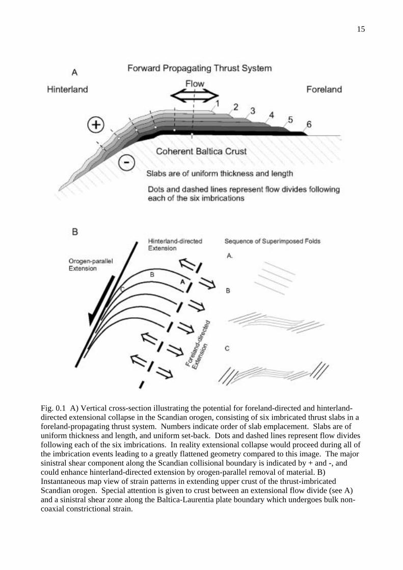
Engvik et al., (2000) have pointed out the complimentary relationship between mafic rocks, which lose H2O upon the breakdown of amphibole under high pressures, and gneisses which lose biotite plus K-feldspar to phengite by hydration, with these two processes reversed during unloading.However, the volume of mafic rock overall in the Western Gneiss Region is not close to balancing the volume of granitoids. The speed of subduction and uplift were critical to preservation, both of old protoliths and high-pressure and ultra-high-pressure assemblages. This could be most effectively accomplished by the imbrication of basement slabs which moved forward onto cooler Baltica basement, while at the same time being juxtaposed with cooled higher-level nappes moving away from the craton on extensional faults (Fig. 0.1).
Terry et al. (2000a) developed a working tectonic model for an upper UHP plate and a lower HP plate in the northern segment of Nordøyane. This was based on 1) geothermobarometry of the UHP kyanite eclogite of northern Fjørtoft and more normal HP eclogites of the northern structural segment of Nordøyane, 2) on U-Th-Pb ages on monazites included in garnet from the microdiamond-bearing gneiss at Fjørtoft and on conventional U-Pb ages on zircon from Ulsteinvik eclogite and partially eclogitized gabbro as Selsnes, and 3) on a "normal" foreland-stepping sequence of thrust imbrication. The UHP eclogite gave 820°C, 39 kbar and the HP eclogites gave 780°C, 18 kbar. The monazite included in garnet gave a time of inclusion of 408±6 Ma by electron probe (adjusted to 407±2 Ma) and 415±7 Ma for a smaller number of ion probe measurements. The age of eclogite metamorphism in the HP lower plate was inferred from the age of 402±2 Ma. from the Ulsteinvik eclogite, 401±2 Ma for zircon overgrowths on baddeleyite in the partially eclogitized gabbro at Selsnes and a Nd-Sm age of 400±16 Ma from an eclogite at Flemsøya. Using this data, it was inferred that the monazite was included in the growing garnet of the microdiamond-bearing schist at a minimum age of 407 Ma preceding the peak of UHP metamorphism at a depth of ~125.2 km. The UHP plate was then exhumed during thrusting to 65.6 km and emplaced over the HP plate at ~401 Ma, giving a maximum time for this thrusting of 6 m.y. and a vertical exhumation rate of 10.9 mm/yr. The above timing of this thrusting is now questionable because of Tom Krogh's new precise U-Pb age of 412 Ma on metamorphic zircon in eclogite of the Flem Gabbro of the lower plate. Preservation of a similar thrust scenario might still be possible if the ion probe age of 415 for the monazite in garnet were proved more acceptable than the electron microprobe age and would produce a tentative exhumation rate of 21.9 mm/yr. An alternative interpretation might be formulated by noting that coesite inclusions have been identified in the original zircon used to determine the age from the Ulsteinvik eclogite with indicates that UHP metamorphism occurred at 402±2 Ma (Carswell et al. 2003). Detailed study of the chemical zoning in the garnet from the micro-diamond-bearing gneiss, combined with the petrographic and TEM studies of Robinson et al. (2003) and Langenhorst et al. (2003) indicates that the included monazite dated by Terry et al. (2000a) grew on the prograde path and was probably entrapped at amphibolite-facies conditions in the range 415-407 Ma. Combining all these results allows insight into both burial and exhumation rates for the microdiamond-bearing rock at Fjørtoft.
Titanites in mid-Proterozoic basement gneisses were studied in detail by Tucker et al., (1987, 1990 and submitted) and Tucker and Krogh (1988) and show variable degrees of recrystallization from the igneous protolith age of around 1657 Ma toward the time when Scandian lead loss was terminated. The remarkable feature is not that there are variable degrees of lead loss from recrystallization or resetting, but that all samples, regardless of degree of lead loss, fall on the same chord at 395±2 Ma, implying cooling over a very broad region in a very short period of time. This age is in remarkable agreement with Tom Krogh's four new U-Pb zircon ages on extensional pegmatites at 395.6, 395.6, 395 and 394.5 as well as the electron microprobe age of 394.8 Ma on re-equilibrated monazite in the microdiamond-bearing kyanite-garnet gneiss on Fjørtoft (Terry et al., 2000a). Field relations make it very clear that the pegmatites were emplaced contemporaneously with the development of late subhorizontal stretching fabrics believed to have formed during constrictional strain accompany sinistral transtension (Terry, 2000; Terry and Robinson, 2003b).

11
Ordovician intrusive rocks of the Støren Nappe, locally only 600 m from completely recrystallized basement, show little or no resetting of their Ordovician igneous titanite, implying a major early extensional detachment between this nappe and basement (Robinson et al., 1996, 1997; Tucker at al., 1997a and submitted) which may have been the causative event in the widespread cooling of titanite. These data, combined with the U-Pb dating of new metamorphic zircon in eclogites at 415, 414, 412, 410 and 402±2 Ma imply that many of these rocks may have been subducted and cooled below 600°C in a period of 7-20 m.y. The new time-scale data based on dating of tuffs in fossiliferous sections (Tucker et al., 1997b) indicates that the Devonian began about 418 Ma, and thus that most of these Scandian events took place in Early Devonian rather than Silurian time. It further shows that part of the deep-seated tectonics and metamorphism was actually contemporaneous with "post-orogenic" clastic sedimentation when fossiliferous late Emsian strata were deposited in the interval 403 to 394 Ma. This is further supported by an age of 401±1 Ma from pegmatites that are oriented normal to the late transtensional stretching direction near Hustad (Austrheim et al. 2003). These transtensional structures appear to be intimately linked to the formation the Emsian clastic sedimentary basins (Terry and Robinson, 2003b; Robinson et al., 2003a) and are indistinguishable from the age of UHP metamorphism of the Ulsteinvik eclogite.
OCCURRENCE AND INTERPRETATION OF GARNET PERIDOTITE BODIES IN THE WESTERN GNEISS REGION
by Tony Carswell and Herman van Roermund
Occurrences of peridotite bodies of metre to kilometre-scale dimensions are a conspicuous feature of the Western Gneiss Region (Fig. 0.2). Chlorite-amphibole peridotites are the most common and only a few bodies contain the pyropic garnet–olivine assemblage that is diagnostic of the stabilisation of HP/UHP eclogite-facies assemblages. Nonetheless petrographic features, including the observed retrograde transitions from granoblastic garnet-bearing peridotite into foliated chlorite-amphibole peridotite within certain bodies, suggest that at least some of the designated chlorite peridotites in Figure 0.2 may have originally contained pyropic garnets.
The garnetiferous peridotite bodies exposed on the islands of Otrøy, Flemsøy and Fjørtoft, that will be visited during this field excursion, are especially noteworthy for evidences of the early stability of megacrystic mineral assemblages that included, subsequently-exsolved, high P/T enstatites and majoritic garnets.
Carswell et al (1983) drew attention to the existence of two fundamentally different chemical types of garnet-bearing peridotite bodies in the WGR. The Fe-Ti type garnet peridotites were interpreted to have had a prograde origin from the ultramafic portions of layered low pressure crustal intrusive bodies during Caledonian subduction-related HPM/UHPM. The Eiksunddal eclogite complex on Hareidland with its subordinate garnet peridotite layers, well documented by Jamtveit (1987), is an excellent example of the Fe-Ti garnet peridotite type. Jamtveit et al (1991) were unable to obtain a meaningful Sm-Nd age for a garnet peridotite sample from the Eiksunddal complex, due to isotopic disequilibrium between the garnet, clinopyroxene and whole rock. However, they did obtain a Scandian metamorphic age of 412+/-12 Ma for coexisting garnet and clinopyroxene from a well-foliated eclogite sample from the same complex.
By contrast, the Mg-Cr type garnet peridotites display characteristic upper mantle mineral and whole rock chemistries (Carswell, 1968) and isotopic ratios (Brueckner, 1977) consistent with derivation from mostly highly depleted sub-continental lithospheric mantle. Medaris (1984), Carswell (1986) and Medaris & Carswell (1990) have documented the complex, multi-stage, metamorphic evolution experienced by these particular peridotite bodies. Carswell (1986) and Medaris & Carswell (1990) concluded that the earliest assemblage contained high temperature pyroxenes that, on the basis of scarce petrographic evidence, probably coexisted with spinel rather than with the oldest generation garnet.

12
Sm-Nd dating of garnet+clinopyroxene+whole rock in samples of Mg-Cr type garnet peridotite and associated olivine-free garnet pyroxenites by Mearns (1986) and Jamtveit et al (1991) has shown the earliest garnet-bearing assemblages in these mantle-derived peridotite bodies to be of mid-Proterozoic age and consequently to have been stabilised in the sub-continental mantle long before the Scandian, subduction-related, HPM/UHPM event experienced by the WGR.
An even more surprising discovery has been the recognition by van Roermund et al (1998, 2000, 2001) of pyroxene exsolution lamellae in megacrysts of the earliest garnet generation in samples from the Mg-Cr type peridotite bodies outcropping on Otrøy. This feature has been taken to indicate that these garnets originally contained a significant majorite component. van Roermund et al (2000) used their deduced initial composition of this super-silicic majoritic garnet to estimate minimum pressures, at high temperature, of 6-6.5 GPa - interpreted (see also Drury et al, 2001) to indicate derivation within a rising mantle diapir originating from depths of at least 185 km. Similar garnet microstructures were discovered by Terry et al (1999) on Fjørtoft and Flemsøy (Fig. 0.2), and exsolved pyroxene from garnet porphyroclasts has now been reported from all major rock types within the garnet peridotite bodies, including garnet websterites and garnet clinopyroxenites (Spengler et al, 2002).
Further petrographic observations and Sm-Nd isotopic data (Brueckner et al, 2002; van Roermund et al, 2002) on an occurrence of megacrystic garnets, with possible majoritic garnet microstructures, within a small peridotite body at Bardane on the island of Fjørtoft (Fig. 0.2), have confirmed that these early garnets formed during the Gothian orogeny at around 1600-1700 Ma and moreover coexisted with high-temperature megacrystic aluminous pyroxenes. According to these authors, the earliest recognisable assemblage in the Mg-Cr type peridotite bodies at Bardane on Fjørtoft and at Ugelvik on Otrøy formed at conditions of ca. 3.0-4.5 GPa and 1300-1500oC in the mid-Proterozoic. Accordingly, the metamorphic evolution of these peridotites as indicated by Carswell (1986) and Medaris & Carswell (1990) must be modified to eliminate the previous indication that the oldest assemblage formed at high-temperature but relatively low-pressure, with aluminous spinel rather than garnet coexisting with the aluminous pyroxenes.
A revised, multi-stage metamorphic evolution for these Mg-Cr type peridotite bodies, that indicates instead the early stability of a majoritic garnet formed at UHP conditions deep in the mantle, is presented in Figure 0.3. Full details of the Proterozoic history and location of these peridotite bodies remain somewhat conjectural given the scarcity of preservation of stage 1 assemblages due to widespread overprinting by much later Palaeozoic /Caledonian assemblages. It seems likely that the stage 1 high P/T majoritic garnet-bearing assemblages were mostly re-crystallised and re-equilibrated to stage 2 assemblages, with more normal Cr-pyrope garnets, as these rocks were uplifted (perhaps within a rising mantle diapir) and cooled to the ambient Proterozoic geotherm.
The mantle-derived, Mg-Cr type, garnet-bearing peridotite bodies in the WGR have been widely interpreted (e.g. Medaris & Carswell, 1990; Krogh & Carswell, 1995) to have been tectonically emplaced into the continental crust during the Scandian plate collision. More recently Brueckner (1998) and Brueckner & Medaris (2000) presented new dynamic models for crust-mantle interaction in major continental plate collision zones and emphasised that different locations and timings are possible for the tectonic emplacement of the mantle peridotites into the crustal slab either during subduction or subsequent exhumation.
A further dramatic new discovery with an important bearing on this issue and on the P-T-t evolutionary history experienced by these peridotites has been the discovery of microdiamonds within the Bardane peridotite occurrence on Fjørtoft (van Roermund et al, 2002). Rather surprisingly these microdiamonds apparently did not form in association with the UHP majoritic garnet during the mid-Proterozoic. Instead combined petrographic, geochemical and isotopic data (Brueckner et al, 2002; van Roermund et al, 2002) provide strong pointers to the microdiamonds having formed in response to an influx of crustal-derived fluids attendant on Scandian-aged deformation and the recrystallisation of the oldest generation Proterozoic assemblage with its megacrystic majoritic garnets and aluminous pyroxenes.

13
To date preserved microdiamonds have only been discovered armoured within Cr-spinel grains that are in turn enclosed within later generation garnet that forms a corona network around deformed sub-grains of the original orthopyroxene megacrysts (van Roermund et al, 2002). Further ‘secondary’ generation garnet occurring as rational exsolution lamellae within the deformed orthopyroxene megacrysts is seen both at Bardane and in the comparable deformed and partly-recrystallised megacrystal orthopyroxenite lenses at Ugelvik on Otrøy (Carswell, 1973). It is difficult to extract an unquestionably pure separate of this later generation garnet. Accordingly, the rather equivocal Sm-Nd ages of 518+/-78 Ma (Brueckner et al, 2002) and of ca. 561 Ma (Jamtveit et al, 1991) obtained for the exsolved garnet+clinopyroxene assemblages at Bardane and Ugelvik, respectively, are probably “mixed” ages but nonetheless signal the strong influence of Caledonian recrystallisation and isotopic re-equilibration. This latter interpretation is further supported by the Sm-Nd age of 437+/-58 Ma obtained for garnet+clinopyroxene+whole rock by Jamtveit et al (1991) from a thoroughly recrystallised, granoblastic textured, garnet pyroxenite sample from the Raudhaugene peridotite body on Otrøy.
The deduction that the microdiamond-bearing assemblage within the Bardane peridotite body was probably stabilised at P-T conditions of around 3.4-4.1 GPa and 840-900oC (Brueckner et al, 2002: van Roermund et al, 2002) during the subduction-related Scandian-aged UHPM requires that this peridotite body must have been emplaced into the enclosing slab of continental crust either before or during its transient deep subduction. This conclusion is consistent with the nearby occurrence of a coesite-bearing kyanite-phengite eclogite within the host quartzo-feldspathic gneisses (Terry et al, 2000) and also of microdiamond-bearing garnet-kyanite-biotite-rutile-quartz gneisses that outcrop essentially along strike on the north coast of Fjørtoft (Dobrzhinetskaya et al, 1993, 1995).
This surprising new interpretation, that mantle-derived garnet-bearing peridotite bodies of the Mg-Cr type (similarly to the contrasting Fe-Ti type) also experienced Scandian, subduction-related, HP/UHP metamorphism, is further supported by certain previously published but largely overlooked observations in other garnet-bearing peridotite bodies of the Mg-Cr type elsewhere within the WGR.
Griffin & Qvale (1985) documented the fact that Fe-rich eclogite lenses within the Mg-Cr type peridotite body at Raudkleivane in Almklovdalen contain garnets that show strong prograde compositional zoning and also contain ferropargasite inclusions in grain cores. This signals that this peridotite body must have been entrained into the subducting crustal slab and hence experienced a Scandian prograde metamorphic evolution from amphibolite- to eclogite-facies. Secondly, petrographic evidence has been recorded both in the peridotite body at Lien in Almklovdalen (Griffin & Heier, 1973) and in the Sandvika body on Gurskøy (Carswell et al, 1983) for the growth of new garnet in the outer parts of kelyphites composed of secondary aluminous pyroxenes and spinel around older garnet porphyroclasts. Griffin & Heier (1973) concluded that the apparent reversal of the kelyphite-forming reaction garnet + olivine Æ orthopyroxene + clinopyroxene + spinel was probably attributable to post-decompressional cooling but in view of other observations it is perhaps more appropriate now to attribute it to a later, post-kelyphite, prograde subduction-related HPM/UHPM event.
Accordingly, the P-T evolution of the WGR garnet peridotites shown in Figure 0.3 incorporates the possibility of the existence of two separate granulite-facies kelyphite-forming events with the older one placed between the pyropic garnet-bearing stages 2 and 4. It is conceivable that the older kelyphite-forming event occurred during the Sveconorwegian (ca. 1000-1100 Ma) orogeny, based on Sm-Nd systematics of zoned garnets from the Almklovdalen and Sandvika peridotite bodies (Brueckner et al, 1996).
The long time-interval between stages 2 and 4 creates uncertainly over exactly where these mantle-derived peridotite bodies resided. They conceivably may have already been emplaced into the Proterozoic continental crust. However, it is considered more likely that they resided in the uppermost sub-continental lithospheric mantle and were not incorporated into the crust until the deep subduction of the WGR during the Caledonian plate collision. It is anticipated that detailed electron microscopy studies of the complexly zoned replacement kelyphites that occur around the

14
Proterozoic garnets (as illustrated for example in Fig. 0.4) will help answer such remaining questions concerning these intriguing rocks.
PRACTICAL NOTES FOR PARTICIPANTS
Because of the large turnout for this excursion and the limited overnight accommodations in the trip area, this trip is being run in two groups, A and B, each with its own set of vehicles. Both groups will depart together from the Selje Hotel on Saturday morning, June 28 and travel together during Day 1. They will only part company in the late afternoon, when Group A will travel by ferry to Lepsøya and three nights at Lepsøya Misjonsenter, and Group B will travel by ferry to Dryna and three nights at Midsund. During the day on Tuesday July 1 the two groups will switch places, so that Group A will spend the last two nights at Midsund, and Group B the last two nights at Lepsøya. The guidebook has been arranged in the order of days experienced by Group A; for Group B the arrangement is exactly reversed. The four leaders will switch around so that all stops are well covered: Terry and Robinson for Nordøyane, Robinson for Brattvåg, Terry for Fjørtoft, and Carswell and van Roermund for Midsund.
Group A: Group B: Sunday June 29 Day 2 - Nordøyane Sunday June 29 Day 5 - Midsund Monday June 30 Day 3 - Brattvåg Peninsula Monday June 30 Day 4 - Fjørtoft Tuesday July 1 Day 4 - Fjørtoft Tuesday July 1 Day 3 - Brattvåg Peninsula Wednesday July 2 Day 5 - Midsund Wednesday July 2 Day 2 - Nordøyane
On Thursday July 3 Day 6 the Groups will move toward Trondheim with various scenic options and potential stops. Persons who plan to fly out of Ålesund should be assigned to Group B. They can take a fast boat direct to Ålesund from Lepsøya at 0700 on the morning of July 3. Persons who fly out of Molde will find the connection from Midsund easy and should be assigned to Group A, though Group B is not impossible if the flight is in early afternoon. Persons flying out of Trondheim are urged to plan on overnight there and get a morning flight on July 4, although one vehicle from Group A could perhaps arrive in time for an evening flight on July 3.
Cost of 4700 NOK. includes guidebook, all transportation including ferries, overnight accommodation and bedding for five nights, and all meals (excluding alcoholic beverages). Many stops are near the road, but others involve walks up to 1 km on boggy or rocky ground. Expected weather can be anything from hot sunshine to strong wind with horizontal rain. Waterproof boots, rain suit, and pack to carry them are highly recommended. Large wave-washed exposures can be enjoyed even in very bad weather. Unfortunately, due to the large turnout and rigid schedule, we cannot adjust daily objectives to fit the weather, and will be going in all conditions. In late June the sun is only below the horizon for a few hours, and this may permit evening viewing of outcrops under favorable weather conditions. In addition to the rocks, this trip will cover some spectacular fjord and mountain scenery in areas outside the usual tourist routes.
Except for the first and last days the distances traveled are not long, but participants will still have to acquire a certain degree of self-discipline to gain full benefit from the experience and see the important stops. A further degree of discipline is imposed by the schedule of ferries, which must be conformed to. These include 3 ferries on Day 1, 2 ferries on each of Days 2 and 3, 3 ferries on Day 4, and as many as 3 ferries on Day 6. Therefore, when leaders indicate that it is time to leave a stop, the intention is serious and your welfare is involved. In return the ferries do supply an opportunity for informal refreshments and abundant public toilets which should not be missed. The ferry fares of all participants and vehicles will be paid by the leaders. During ferry trips it is always possible to climb to a sun deck for further enjoyment of scenery and geology, or, if you like, descend to the "salong" in the bowels of the ship to rest from it, as is the custom of many Norwegians.
15
Fig. 0.1 A) Vertical cross-section illustrating the potential for foreland-directed and hinterland-directed extensional collapse in the Scandian orogen, consisting of six imbricated thrust slabs in a foreland-propagating thrust system. Numbers indicate order of slab emplacement. Slabs are of uniform thickness and length, and uniform set-back. Dots and dashed lines represent flow divides following each of the six imbrications. In reality extensional collapse would proceed during all of the imbrication events leading to a greatly flattened geometry compared to this image. The majorsinistral shear component along the Scandian collisional boundary is indicated by + and -, and could enhance hinterland-directed extension by orogen-parallel removal of material. B) Instantaneous map view of strain patterns in extending upper crust of the thrust-imbricatedScandian orogen. Special attention is given to crust between an extensional flow divide (see A) and a sinistral shear zone along the Baltica-Laurentia plate boundary which undergoes bulk non-coaxial constrictional strain.

16
Fig. 0.2 Map of the principal occurrences of garnet-bearing and chlorite-bearing (garnet-absent) peridotite bodies within the Western Gneiss Region.
Fig. 0.3 Revised outline for the multi-stage metamorphic evolution of the mantle-derived, Mg-Cr type, garnet-bearing peridotite bodies in the Western Gneiss Region.

17
Fig. 0.4 Backscattered electron image of the garnet recrystallisation and breakdown microstructurein a sample of garnet peridotite from Ugelvik on Otrøy. This image illustrates the existence of two garnet generations as well as the formation of a retrograde garnet replacement corona. The garnet (GT) in the central part of the image is an early high-Cr type (2.5-3.5 wt.% Cr2O3) and towards the top right has been replaced by characteristic Opx-Cpx-Sp symplectite that coarsens outwards towards a coarser grained granoblastic corona of secondary orthopyroxene, clinopyroxene and spinel, developed adjacent to the matrix olivine. Towards the bottom left the high-Cr garnet displays deformation–induced recrystallisation to a second generation of Cr-poorer garnet (< 1 wt.% Cr2O3) with associated Cr-spinel and some discrete associated grains of orthopyroxene and clinopyroxene. Note also the bifurcating late fracture filled by serpentine.

18

19
Day 1: SELJE TO LEPSØYA OR MIDSUNDECLOGITES AND RELATED ROCKS OF THE ULSTEINVIK REGION
Saturday June 28 for Groups A and B
Compiled by Peter Robinsonwith contributions by David Root, Tony Carswell and Bob Tucker
General Route: The trip will leave Selje Hotel about 8:15 Saturday. The day will begin with a drive from Selje east over the pass to Åheim as on previous days, from Sogn og Fjordane province back to Møre og Romsdal for the last time. At Åheim we will join Route 61 and travel north to the turn off for Fiskå and the spectacularly preserved anorthosite at Stop 1-1. We will then proceed north to a ferry at Koparneset at 10:30 or 11:00 (Note Saturday schedule). From Koparneset we take the ferry to Årvik and drive across Gurskøya and Hareidlandet with stops en route. We may visit marble and amphibolite in probable Blåhø Nappe at Larsnes (Stop 1-2). At Osneset in Ulsteinvik we hope to sample the coesite eclogite (Stop 1-3) and have a few minutes for late morning shopping. We retrace our route a short distance to Dragsund and from there take a side trip on a spur road toward Fosnavåg and Runde to examine two eclogites studied in detail by David Root, one with polycrystalline quartz after coesite (Stops 1-4, 1-5). Back at Dragsund we will examine nodular sillimanite gneiss (Stop 1-6) before proceeding to the ferry at Hareid. The ferry from Hareid goes to Sulasundet from which we drive through mostly wooded country to Brattvåg. Here the trip will separate into two groups each equipped with four vehicles.
Group A will travel west to Skjeltne and a ferry to Lepsøya bringing us to the village of Kjerstad and its location for the first three nights at the Lepsøya Misjonsenter. On Tuesday July 1 Group A will travel from Lepsøya via a field day on Fjørtoft to Dryna and on to Midsund for the last two nights.
Group B will take the ferry from Brattvåg to Dryna and drive a short distance to its location near Midsund for the first three nights. On Tuesday Group B will travel from Midsund to Dryna and ferry to Brattvåg and a field day on Brattvåg Peninsula. It will travel west to Skjeltne and a ferry to Lepsøya to the village of Kjerstad and its location for the last two nights at the Lepsøya Misjonsenter.
Ferry Koparneset to Årvik: 10:30 - 10:45 or 11:00-11:15. Ferry Hareid to Sulesund: 14, 14:30, 15, 15:30, 16, 16:30 (25 minute crossing) Ferry Skjeltene to Lepsøya: 16:15-16:50 (long way); 17:15-17:50 (long way) or 19:15-19:30. Ferry Brattvåg to Dryna: 15:00-15:20, 17:40-18:00, 20:30-20:50.
INTRODUCTION TO DAY 1
The prime purpose of Day 1 is to travel along the coast from Selje in Sogn og Fjordane to the Ålesund region in Møre og Romsdal through an area where there have been fewer detailed petrologic and structural studies, though still some of great importance. The Ulsteinvik area on Hareidlandet contains Norway's largest eclogite body, studied by Mysen and Heier (1972). A zircon separate from this rock with inclusions of omphacite was dated by Krogh et al. (1974), yielding a U-Pb age of 402±20 Ma, the first firm indication of a middle Paleozoic age of eclogite metamorphism in the Western Gneiss Region. More modern techniques were applied to the same zircon separate by R. D. Tucker, yielding a more precise age of 402±2 Ma (Lutro et al., 1997; Carswell et al., 2003). The same zircon separate was then provided to D. A. Carswell (Carswell et al., 2003) who was able to identify three grains of included coesite by Raman spectroscopy. Presently these are the northernmost known occurrences of coesite in Fennoscandia and provide an important link between coesite-bearing rocks in the Nordfjord region and coesite pseudomorph and microdiamond occurrences on Nordøyane.
The Eiksunddal eclogite on the steep and wooded southeast side of Hareidlandet was first noted by Eskola (1921). Schmitt (1963) identified the eclogites and associated olivine-bearing

20
ultramafic rocks as belonging to a metamorphosed Proterozoic layered intrusion exposed at the hinge of a giant recumbent fold. He provided wet chemical analyses of several mineral separates, and added strong arguments for the "in situ" eclogite hypothesis, noting eclogite mineralogy in a wide variety of mafic rock types in the same region. Jamtveit (1987) expanded on Schmitt's work with thermobarometry and Sm-Nd geochronology, reporting a garnet–clinopyroxene Sm–Nd age of 412±12 Ma (Jamtveit et al., 1991).
While precise assessment of peak metamorphic conditions is hindered by widespread breakdown of omphacite and phengite, retrogression through sillimanite-stable conditions has been documented in several locations. Garnet granulite conditions of 750–800ºC and 9–13 kb were determined from omphacite breakdown products (clinopyroxene and plagioclase) and garnet in eclogites at Rødskar on Gurskøy (Dunn and Medaris, 1989). Retrogression and fracture fill assemblages in kyanite–zoisite eclogites on Furøya were studied by Straume (1997) and Straume and Austrheim (1999), who obtained estimates for granulite-facies retrogression of 800ºC and 8 kb from zoisite breakdown, and 700–800ºC and 8–12 kb from garnet and orthopyroxene. Similar conditions were observed in pelitic rocks tentatively correlated with the Blåhø Nappe on Remøyholmen (Root, submitted).
Most recently David Root has studied the rocks on the islands west of Hareidlandet, seeking to expand a tectonostratigraphic context from areas further east, performing thermobarometry and geochronology on eclogites and allochthonous pelites, and identifying several occurrences of quartz pseudomorphs after coesite.
FIELD LOG FOR DAY 1
From Selje Hotel drive south through village of Selje then east over the pass and around end of the fjord to junction with Route 61 at Åheim. Turn left (north) at Åheim bypassing the turn off for Almklovdalen and continue north on Route 61. After about 18 km, turn left (northwest) off Route 61 toward Fiskå. In 0.8 km turn left toward Åram, then in 0.5 km left toward Fiskå. Travel west through village to factory on peninsula. Depending on conditions, either park and walk through factory grounds, or drive about 0.2 km to quarry and shoreline outcrops on seaward end.
STOP 1-1: (30 minutes) Gabbroic anorthosite with coarse ophitic texture, Fiskåholmen.A coarse to pegmatitic rock with grains in rare cases up to 50 cm. The plagioclase has a
composition of An40-50. It also contains black orthopyroxene and titaniferous magnetite. The orthopyroxene has exsolved garnet and garnets are also seen in coronas around the magnetite. Preserved igneous textures indicate that this rock is an intrusion which was metamorphosed in the granulite facies and to only a small extent is retrograded in the amphibolite facies. The other anorthosites found in the WGR are retrograded fine-grained rocks. This shows little or no effects of the eclogite-facies metamorphism that influenced the surroundings.
From Stop 1-1 retrace route through Fiskå Village and back to junction with Route 61. Turn left and drive across pass to Syvdsfjorden. At junction turn left (north), staying on Route 61 toward Koparneset, and reach Koparneset after an additional 6.6 km (driving time Fiskå to Koparneset about 16 minutes). Near the ferry there are outcrops of basement gneiss, with typical E-W trending folds and evidence of partial melting. Take ferry to Årvik.
Drive off ferry at Årvik on Gurskøya and turn left on Route 61. From here it is 42 km to Hareid. After 1.7 km turn off left for Breivik Kalkverk and after 0.5 km park by lower quarry and crusher.
STOP 1-2: (10 minutes) Amphibolite with coarse pure marble.Spectacular horizontal lineation in what is probably part of the Blåhø Nappe in a synclinal
fold. (See Fig. 1.2).

21

22

23
Fig. 1.2 – Geologic map showing locations of Stops 1-1 through 1-6 on Day 1. Copied from1/250,000 map Ulsteinvik by Tveten et al. (1998b).

24

25
Leave Stop 1-2. Return to Route 61 and turn left (west). There is a road cut in amphibolite with horizontal lineation. Beyond this there are several cuts of Blåhø rusty rocks, marbles, amphibolites, then basement around bend. After 2.8 km pass Larsnes Harbor with laminated felsic-mafic gneisses probably in basement. After another 0.5 km there is a sharp turn right up hill on Route 61 toward Hareid. Up onto the mountain there are stringy migmatites and the top of the pass is reached in 2.7 km. After an additional 2.7 km we are at sea level at Gurskebotn. Here there is a turn off to the left and 1-2 minutes walking along a bike path brings one to small exposures of garnet peridotite and hornblende migmatitic gneiss. Continue straight on Route 61 to T junction with Route 654. Turn sharp right at T junction staying on Route 61 and crossing Dragsund bridge.
About 7.2 km from the Dragsund bridge there is a traffic circle and exit left for Ulsteinvik. Take this exit and proceed north through Ulsteinvik center on the main road (there may be time for brief shopping late Saturday morning) to a turn off for the huge factory at Osneset (see Fig. 1.3). In the past there have been blasted outcrops in the northern edge of the eclogite and natural outcrops of rusty mica schist on the shore to the north. Commonly there have also been piles of blasted eclogite lying around this complex industrial site, but we will have to take our chances.
STOP 1-3: (20 minutes) Ulsteinvik eclogite. (See Figs. 1.2, 1.3, 1.4) Layered eclogite, partly with hornblende. Elsewhere little hornblende but typical Ca-pyroxene - plagioclase symplectite.
The following information, except the last paragraph, is modified slightly from Mørk and Krogh (1987). The Ulsteinvik eclogite body forms a sheet about 6x4km in area (Fig 1.3), but only ca 300m thick, folded in an E-W synform running through Ulsteinvik (Grønlie et al. 1972). It is internally layered, and locally shows clearly transgressive contacts to the country rocks, without the obvious tectonization common around smaller bodies. The chemical composition is transitional alkali olivine basalt - olivine tholeiite, but may have been modified by alkali loss during dehydration/metamorphism (Mysen and Heier, 1972, Griffin and Garman, in prep.). Detailed petrographic data are given by Mysen (1971, 1972). The metamorphic peak was estimated at ca. 800°C, 18 Kb by Griffin et al. (1985). The pelitic gneisses around the north limb of the body contain relict high-P granulite facies assemblages (gnt+omph+bio+plag+qtz) compatible with these conditions (Mysen and Heier 1972).
The surrounding dioritic gneisses have yielded a Rb-Sr whole-rock 'scatterchrone' date of 1646±70 with IR = 0.708 (Mysen and Heier 1972). The minerals of the eclogite give a Sm-Nd age of 423±30 Ma (Griffin and Brueckner 1980) and zircons from the eclogite provided by Mysen gave U-Pb ages of 401±20 Ma. (Krogh et al. 1974). R. D. Tucker (see Lutro et al. 1997, Carswell et al. 2003, and Fig. 1.4) re-analyzed part of this zircon population yielding a more precise age of 402±2 Ma, that overlaps with the previously determined age. The 87Sr/86Sr of the eclogite clinopyroxenes is relatively high (0.706), suggesting some contamination with crustal material prior to eclogite metamorphism.
The outcrop (road cut on Route 61) shows 0.5-1 meter layers of cpx-rich eclogite alternating with garnet-rich gnt-rich eclogite. The chemical variation is explained by Mysen and Heier (1972) as a low-P (< 8 kbar) sorting of olivine, clinopyroxene and plagioclase. The eclogite is retrograded extensively to amphibolite along late pegmatitic veins. Large inclusions of felsic gneisses have diffuse borders, suggesting partial assimilation, and retrograde granulite-facies mineral assemblages (gnt + opx +plag + qtz, gnt + ky + cpx + plag + qtz). Schlieren of quartz ± rutile ± kyanite ± omph ± gnt suggests the presence of a fluid phase during metamorphism. Small patchy pegmatites with garnet and hbl have apparently formed at relatively high P (<12 Kb) as a part of the metamorphic episode (Green and Mysen 1972). Later pegmatites, clearly cross-cutting the eclogite and gneiss, are accompanied by extensive amphibolitization.
Three grains of coesite were identified together with other eclogite facies minerals using laser micro-raman spectroscopy within the same dated metamorphic zircons separated from this body (Carswell et al. 2003). This is the first reported identification of preserved coesite from this

26
part of the northwestern Western Gneiss Region and supports continuity of ultra-high-pressure metamorphism between the documented coesite occurrences on Stadlandet to the south and the microdiamond and coesite pseudomorph localities on Fjørtoft in Nordøyane to the north (see Day 4, this guidebook). This discovery of coesite and the 402 Ma formation age add to a growing number of mid-late Early Devonian ages showing that the ultra-high-pressure metamorphism in this part of west Norway occurred relatively late in the Caledonian orogenic cycle.
From Stop 1-3 retrace route through Ulsteinvik and onto Route 61. Turn right (southeast) on Route 61 and retrace route about 8 km to T junction with Route 654 toward Fosnavåg, Stay straight (west) on Route 654 toward Fosnavåg. After 7.9 km make a sharp right turn continuing on Route 654 toward Fosnavåg and after a further 0.4 km begin crossing a series of bridges and causeways 2.2 km long connecting Gurskøya and Leinøya, crossing the islands of Nautøya, Jonsholmen and Blankholmen and ending on southeast Leinøya. After a further 6.8 km make a sharp left turn continuing on 654 toward Fosnavåg. In 1.2 km there is a sharp right turn at an intersection with a sign (probably for Runde), in another 0.2 km the road turns sharply left, and in 0.4 km there is a sharp right turn continuing on the main road to Runde. After another 3.4 km the road turns left toward the causeway to Remøyholmen, which contains a sequence of allochthonous rocks including schists and marbles with likely correlation to the Blåhø Nappe. In 0.5 km cross one-lane bridge to Remøya and after 0.4 km turn left at T intersection toward Runde. At 1.2 km enter Saevik tunnel which is 1 km long. 0.9 km beyond end of tunnel make a right turn onto a downhill dirt road and into a parking area to the left.
Stop 1-4. (15 minutes) Mg-rich eclogite with late, low P/T veins, Remøy Several eclogite boudins lie within a short walk of the parking area. The largest, 5 m in
diameter, is heterogeneous in composition. Garnet, clinopyroxene, amphibole, and rutile are variably accompanied by quartz, orthopyroxene, epidote and biotite. Local dm-scale segregation of clinopyroxene-rich layers and garnet- and quartz-rich layers is observed. An Mg-rich, orthopyroxene-bearing sample contains subequal proportions of garnet (Mg# 60), clinopyroxene (Mg# 79), and orthopyroxene (Mg# 81), with lesser edenite (Mg# 85) and rutile. Inclusion-rich, xenoblastic garnet, 0.5–3 cm in size, has flat zoning (Pyr 53, Alm 36, Sp 1.4, Gr 10), and contains 0.2 wt.% Cr2O3. Clinopyroxene is properly sodian augite (0.2 cpfu Na), up to 2 cm in size, and contains aligned rods of SiO2. Orthopyroxene is 1–2 cm in size, and contains <0.01 Ca and 0.05 Al cpfu (6 Oxygen). Conditions of equilibration of grain cores are estimated at 25 kb and 825 ºC, using a combination of garnet–clinopyroxene thermometry and Al-in-orthopyroxene barometry. Low P/T reequilibration is demonstrated by a vein at the margin of the boudin, consisting of intergrown sillimanite, muscovite (Si Ò 3.1 cpfu; Mg# 55), biotite (Mg# 81) and plagioclase (An 37–59). Another quartz-biotite-muscovite-garnet-K feldspar (?) vein in the boudin neck yielded a weighted mean muscovite 40Ar/39Ar age of 377.6 ± 1.1 Ma (compare with monazite in mylonite Stop 4-3)..
A finer-grained, 2-meter eclogite pod nearby contains garnet, clinopyroxene, quartz, epidote and biotite + feldspar pseudomorphs after phengite. Titanite is abundant and forms rims on rutile. Preliminary SIMS on zircon from this sample yields a range of Caledonian spot ages from 430-370 Ma. A 405-395 Ma cluster of ages is inferred to represent peak conditions, while the older ages likely represent incomplete recrystallization of inherited zircon. The youngest ages indicate either variable Pb loss or minor zircon growth during late-stage exhumation.
Turn left out of Stop 1-3 parking area and turn right on main road. In less than 0.2 km begin 1.4 km bridge/causeway to Runde. Outcrops alongside the causeway contain retrogressed UHP eclogite. At end of causeway on Runde turn right onto main road. In 1 km come to end of a row of boathouses on the right. Vehicles will pull off on the right side of the road. Stop 1-4 is between the road and the shore of Rundesundet, 15 m north of the last boathouse.

27
Fig. 1.3 – Geological map of the Ulsteinvik area, after Mysen and Heier (1972).
Fig. 1.4 – Concordia diagram showing zircon U-Pb isotopic ratios and metamorphic crystallization age for the Ulsteinvik eclogite by R.D. Tucker (see Lutro et al., 1997; Carswell et al., 2003; Tucker et al., submitted). Three grains of included coesite were identified by Raman spectroscopy in the same zircon separate.

28

29
Fig. 1.5 – Geological map showing Stops on Days 2 – 5 and part of Day 6. Copied from 1/250,000 map Ålesund by Tveten et al. (1998a).

30

31
STOP 1-5: (15 minutes) Layered and lineated UHP eclogite, Runde A tabular, 100m layered eclogite crops out in granitic and granodioritic gneisses, locally
mylonitic, on SE Runde. Its mineralogy consists of garnet, clinopyroxene, quartz, and biotite, with late pleochroic amphibole, and a relatively high abundance of rutile, ilmenite, apatite, zircon, and allanite. Cm-scale layering is produced by segregation of garnet- and quartz-rich layers and clinopyroxene- and biotite-rich layers. Within the latter, preferred orientation of clinopyroxene produces a shallowly NE-plunging lineation. Garnet (Mg# 41) is 2–5 mm in size, with nearly flat zoning and core composition of Pyr 34, Alm 49, Sp 1, Gr 16. Inclusions are mostly confined to cores of larger grains. Numerous polycrystalline quartz inclusions after coesite occur in garnet from this sample. Mg# 75 clinopyroxene, up to 2 cm, is transitional between omphacite and sodian augite (0.25 cpfu Na), and contains abundant oriented SiO2 rods, especially in cores. Assuming a pressure of 28 kb, just above the quartz/coesite equilibrium, a peak temperature of 725 ºC is estimated from garnet and clinopyroxene core compositions. Coronae between garnet and quartz consist of a 25 µm inner layer of plagioclase (An 28–36) against garnet, and a 15 µm outer layer of Mg# 67 anthophyllite/cummingtonite plus magnetite, against quartz.
Turning around after Stop 1-5 will probably involve driving 1 km farther to Geita from which it is a drive of 31.3 km back to the junction with Route 61. From the junction with Route 61 proceed straight and then immediately left (north) off Route 61 on a road toward Dragsund factory. This road swings back to left to a road cut and small quarry on the right about 1.1 km from Route 61 junction. The outcrops lie between an industrial site to the south and private homes to the north along the old road to Fosnavåg (road relocations in this area in recent years).
STOP 1-6: (15 minutes) Sillimanite-feldspar gneiss, Dragsund. (See Fig. 1.2) Quartz-biotite-feldspar gneiss with big quartz-sillimanite nodules. Examine top of outcrop
where nodules stand out on weathering surface. In addition to the nodular sillimanite gneiss, a retrograded eclogite lens is found and a thin-layered gneiss. Rocks like these, including the country rocks of the Eiksunddal eclogite, were mapped extensively in the region by Harrison Schmitt (unpublished data at NGU and personal communication to Robinson, 1960). The sillimanite is probably after kyanite, and may be typical of a granulite-facies cooling path that has been identified in this district (Jamtveit, 1987). The origin of the nodules is a world-class problem with diverse opinions. Such rocks occur in a major mapped unit in the Western Gneiss Region (Tveten et al., 1998a,b), in the Bamble area of south Norway, on Baffin Island, in Saskatchewan, in the Adirondacks, and in altered Ordovician rhyolitic and dacitic volcanics in Massachusetts (Robinson 1963).. Is the protolith intrusive, volcanic, or sedimentary? Were the nodules already present in a protolith, or are they strictly the result of a metamorphic or igneous process?
Turn around and return to Route 61. Turn left (northeast) on Route 61 toward Hareid and cross Dragsund bridge. After 8.2 km on Route 61 come to traffic circle with exit for Ulsteinvik. Stay on Route 61 passing a road cut (dangerous for geologists) in Ulsteinvik eclogite and travel over a mountain pass to the waiting line for Sulasund ferry at the waterfront in Hareid. This is approximately 11 km from the Ulsteinvik exit.
After a 25-minute ferry ride, drive off at Sulasundet and continue on Route 61. For geologic background and stop locations beyond here see Fig. 1.5. At 9 km from the ferry reach a junction for Bergen and Route E39 (formerly Route 1). Stay straight on E39 toward Ålesund.After an additional 4.3 km there is a junction for Magerholm. Stay left toward Ålesund on E39 passing through a traffic circle at Spljelkavik. Once beyond the traffic circle there is junction where the main road heads west toward Ålesund, but Route E39 turns sharp right toward Trondheim.
Follow E39 eastward away from Ålesund for 14.2 km to junction with Route 661. Turn left toward Brattvåg. After 2.1 km cross twin bridges which are one way, and in 0.8 km reach another junction and bear left on 661 toward Vatne and Brattvåg. At 3 km farther pass junction to Vigra, staying straight on 661. At 4 km farther, reach a T junction and turn left (west) onto

32
Route 659 toward Brattvåg. The route runs west on the south side of Brattvåg Peninsula, gradually climbing to a tunnel which pierces the ridge. allowing access to Brattvåg on the west side of a N-S trending harbor. From the T junction it is 13.2 km to the center of Brattvåg and possibilities for groceries and beer if time permits. From here it is about 12 minutes drive to Skjeltene ferry terminal for Lepsøya (Group A), and about 2 minutes drive to Brattvåg ferry terminal for Dryna (Group B). Drive north 1.6 km from center of Brattvåg to turn off for ferry terminal (and another 0.7 km to ferry). For Skjeltene travel another 10 km north and west on Route 659 from this junction, making a sharp right turn to enter the waiting line. When entering the ferry specify that you wish to disembark at Kjerstad (= "sharesta", the official stop is Løvsøya but no one pays any attention to that).
Group A disembark from ferry at Kjerstad. Take 2nd right off the terminal road and proceed, initially on a raised beach, 2.6 km north to Lepsøy Misjonsenter (Prestegård) on the right. Unload baggage and select sleeping location for the next three nights in one of five bunk rooms in the main building or one of three in the small cabin by the shore (consumption of strong drink is discouraged in the main building but permitted here). Dinner will be ready soon after arrival. One of your jobs is to select one bottom sheet, one quilt cover, one quilt, one pillow case and one pillow and prepare your own bed. There are three showers available, two upstairs in the main building and one in the cabin. In case of fine weather after dinner, one of four stops on Lepsøya may be visited (see Day 2), taking advantage of daylight (and even sun?) until ~ 23:00.
Group B disembarks from ferry at Dryna and proceeds by road to accommodations in Midsund.

33
Day 2: GEOLOGY OF HARAMSØYA, FLEMSØYA, AND LEPSØYA
Sunday June 29 for Group A, Wednesday July 2 for Group B
by Mike Terry and Peter Robinson with contributions by Tom Krogh
General Route: From Lepsøya we go by ferry to Haramsøya which is connected by bridge to Ullaholmen and Flemsøya. The ferry schedule is fairly convenient without complex connections and will allow 8-11 hours on these islands. However, the outcrops are large and intriguing, and time will pass quickly. We will visit the Proterozoic Haram Gabbro (Stop 2-1) with superbly preserved primary igneous features and early Scandian eclogite-facies shear zones, the late Scandian Åkre Mylonite Zone (Stop 2-2), Ullaholmen (Stop 2-3) with its late Scandian subhorizontal tubular folds superimposed on earlier fabrics, the Flem olivine gabbro (Stop 2-4) intruding Mid-Proterozoic rapakivi granite and conversion of the gabbro to eclogite now well dated at 412 Ma, the Kvalvika garnet peridotite / pyroxenite (Stop 2-5) with early Scandian subduction fabric, Ulla Gneiss and augen gneiss (Stop 2-6) on northern Flemsøya with eclogite facies tubular folds, and the Nogva UHP kyanite-zoisite eclogite (Stop 2-7) with retrograde sapphirine. There are four stops back on Lepsøya which can be done either on a fine evening or on another morning while awaiting a ferry. These include pavement exposures near Hellevik lighthouse (Stop 2-8), northern Lepsøya, showing infolded Sætra and Blåhø Nappes in "Sausage Rock" basement, a coarse hornblende eclogite (Stop 2-9) on an islet within walking distance of the Misjonsenter now well dated at 414 Ma, kyanite-bearing migmatitic schists (Stop 2-10) of the infolded Blåhø Nappe and eclogites in adjacent basement of southwest Lepsøya, and a quarry in garnet corona gabbro (Stop 2-11) at Lauvsundholmen, southern Lepsøya.
Ferry Lepsøya to Haramsøya: Sunday 8:50-9:10, Weekdays 8:00-8:15 or 9:00-9:15 (This will allow 7:00 A.M. breakfast. This ferry is rarely crowded so all vehicles can be taken. However all vehicles must be backed onto the ferry, also on the return trip)
Ferry Haramsøya to Lepsøya: Sunday 17:20-17:35 or 18:35-18:50, Weekdays 17:35-17:50, or 20:35-20:50. (There is also a ferry by the long route 18:50-19:30 but not on Wednesday.)
INTRODUCTION TO GEOLOGY OF NORDØYANE
Day 3 will be devoted entirely to three of the Nordøyane (literally THE NORTH ISLANDS) Haramsøya, Flemsøya, and Lepsøya (Fig. 3.1, 2.1) studied in detail by Terry (2000). The context of Nordøyane is best understood after viewing the rocks of the Moldefjord syncline near Brattvåg, but scheduling for Group A will require Day 2 outcrops to be viewed before Day 3. Nordøyane are the westernmost exposures of the belt of basement rocks with high-pressure high-temperature eclogites that lies to the north of the Moldefjord and Surnadal synclines with their exposures of low amphibolite-grade rocks. Fjørtoft is the site of recent reports of crustal microdiamonds (Dobrzhinetskaya et al., 1995) in a narrow belt we believe can be assigned to the Blåhø Nappe and is the subject of Day 4.
Terry has divided the geology of Nordøyane into three segments (Fig. 2.1), southern, central and northern, based on the character of basement and nappe units in each. The southern belt (seen on Stops 2-9, 2-10 and 2-11) is dominated by granitoid Proterozoic basement gneiss with abundant boudins of eclogite and bodies of garnet-corona gabbro. Within this there are five narrow belts of mica-garnet±kyanite schist and garnet amphibolite that are interpreted as early isoclinal infolds of the Blåhø Nappe. Although eclogites have not been surely identified in this Blåhø on Lepsøya, eclogite has been found in a correlative synclinal belt on nearby Vigra. The belts of Blåhø provide markers that outline the late subhorizontal open folds superimposed on the early isoclines and also isoclinal refolds. These consist of an open anticline located in southwest Lepsøya (Fig. 2.2a) and a broad syncline centered on Goaldet, the high peak of Lepsøya, which is well displayed in views from Haramsøya or the ferry to Haramsøya. Asymmetric shear fabrics in the southern belt give a consistent top-to-west shear sense along the lineation that is parallel to these late folds, and is thus much like the features observed in

34
ductile fabrics beneath the Devonian basins south of Nordfjord (Pre-meeting Field Trip) and below the Høybakken detachment north of Trondheim (see Fig. 1.1)..
The central belt is dominated by two basement types, granitoid gneiss and gray granitoid gneiss with amphibolites interpreted as deformed mafic dikes (Stop 2-8; for more about this see Stops 6-1 and 6-2). There is also a zone of relatively undeformed diorite with hornblende coronas and only minor garnet coronas. Throughout there is no evidence that these rocks ever went through eclogite-facies metamorphism, though that cannot be proved. The central belt also contains three extremely narrow isoclinal synclines dominated by mica-garnet±kyanite schists and garnet amphibolites of the Blåhø Nappe. The north limb of one of these synclines, at the basement-Blåhø contact, shows a consistent layer about 1 m thick of interbedded quartzite and amphibolite that is assigned to the Sætra Nappe (Stop 2-8). Commonly at the Blåhø-Sætra contact there a few centimeters of marble and calc-silicate rock, a common feature at this contact as may be seen at Stops 2-7, 2-8 and 6-1. On Haramsøya limited outcrop of the central belt suggests it may be in a tight anticline so that gneiss of the southern belt lies to the north of it, close to the Haram Gabbro (Fig. 2.2a). The apparent metamorphic discontinuity between the southern and central belts must be an early feature because the contact shows no obvious fault features and is also complexly folded. Like the southern belt, the central belt is dominated by late Scandian features involving longitudinal extension, lateral constriction, and top-west shear, probably in a field of sinistral transtension (Terry and Robinson, 2003b).
The northern belt is dominated by the Ulla Gneiss, a complex granitoid to tonalitic gneiss with very abundant boudins of eclogite and retrograded eclogite, which we affectionately call the "dog's breakfast" (Stops 2-3, 2-6). Subordinate rock types include augen orthogneiss (see Stop 6-4), garnet corona gabbro (Stops 2-1 and 2-4), garnet peridotite and garnet pyroxenite (Stops 2-5, 4-2), and two belts of garnet and biotite gneiss and garnet amphibolite with eclogite, that we tentatively assign to the Blåhø Nappe, on the north coast of Fjørtoft (Stops 4-1, 4-3, 4-4, 4-6, 4-7) and on eastern Flemsøya (Stop 2-7), the latter poorly exposed. All of these rocks are arrayed in a large late subhorizontal anticline (Fig. 2.2b) with a steep southern limb and gentler undulating northern limb. Preliminary mapping of the ultramafic rocks (not shown in Fig. 2.1, but see Fig. 2.2a) suggest they may be aligned along ancient shear zones and may separate different slabs of basement that were brought into tectonic contact with sub-continental mantle within the subduction zone, before being ejected by later thrusting. Like the southern and central belts, the northern belt is also dominated by late subhorizontal lineation and top-west shear fabrics, including subhorizontal tubular folds (Stop 2-3), however, it also preserves a variety of early transverse folds and lineations (Stops 2-1, 2-4), even vertical tubular folds (Stop 2-6), which we interpret as remnants of fabrics produced under eclogite-facies conditions during the subduction process. These fabrics are widely preserved in Ulla Gneiss, even where it is dominated by later subhorizontal folds and lineation (Terry, 2000; Terry and Robinson, in revision). It also appears in the "diamond-bearing" kyanite-garnet gneiss on Fjørtoft (Stops 4-5, 4-7) and in some of the garnet peridotites (Stop 2-5). It is best displayed in and near the Haram Gabbro (Stop 2-1) (Terry and Robinson, 1996, and in revision). where early shearing has produced an essentially vertical lineation in mylonitic gneissic gabbro and fine-grained mylonite produced either from gabbro or from granitic gneiss. The gradual conversion of gabbro toward eclogite in the fine-grained gabbro mylonite implies this shearing was taking place under eclogite-facies conditions. Sense of shear observed in thin sections cut perpendicular to foliation and parallel to lineation indicate north-side-up consistent with formation during northwestward subduction of Baltica. The boundary between the northern and central/southern belts is unequivocally a zone of late subhorizontal sinistral shear with the development of about 100 meters of fine-grained mylonite including small boudins of eclogite. This Åkre mylonite (Stop 2-2), is superbly exposed in road cuts near the peak of Haramsøya, but obscures the original nature of this important tectonic contact.

35

36

37

38

39
FIELD TRIP LOG FOR DAY 2
Drive onto ferry for Haramsøya. Leave ferry at Haramsøya in village of Austnes. Turn left for Haram on main road. At Haramneset take driveways to outermost house and park. Ask owner permission to visit coastal outcrops.
STOP 2-1: (1 hour 45 minutes) Haram GabbroStructural setting and petrography. The Haram Gabbro (Fig. 2.1) lies in the northern belt
dominated by Ulla Gneiss very close to the bounding late Scandian Åkre mylonite zone with its low amphibolite-facies mineralogy, subhorizontal lineation, and sinistral shear features. It lies on the steep south limb of a major subhorizontal late anticline. The gabbro (Fig. 2.3) appears to be surrounded by zones of fine-grained eclogite-facies mylonite consisting mainly of gabbroic protolith, but also smaller amounts of granitoid country rock. The eclogite-facies mylonite zones also cut through parts of the gabbro (Fig. 2.4). Even though very fine grained, the eclogite-facies mylonite still contains relics of original igneous orthopyroxene, plagioclase and ilmenite in a matrix of omphacite (~ Jd 14), plagioclase (with kyanite inclusions), garnet (Pyr 22.6, Alm 45.5, Gr 30.4, Sp 1.3, FM 0.669), quartz, and minor rutile. The best estimate of P-T conditions for the mineral assemblage in the mylonite is 780°C and 18 kbar kbar (Terry et al., 2000b).
Mylonites and their fabric development. The unusual feature of the eclogite-facies mylonite (Fig. 2.4) is that it contains a vertical or near vertical foliation, a steep lineation, and indicators of north-side-up shear concordant to compositional layering/foliation in the surrounding gneisses (Terry and Robinson, 1996, 1997, 1998b, and in revision; Terry 2000). When the foliation is rotated back to a subhorizontal position to cancel the effects of later folding, this gives a top-southeast sense of shear which could be compatible with fabrics produced during northwestward subduction of Baltica crust. Within the gabbro adjacent to the eclogite-facies mylonite and in some broader zones there are zones of mylonitic gabbro gneiss with the same kind of early shear features that are interpreted as segments of major high strain zones similar to those interpreted to have juxtaposed HP and UHP rocks.
Study of microstructures and textures using composition maps, orientation contrast imaging, and electron backscatter diffraction by Terry and Heidelbach (2003 and submitted) in weakly deformed, lineated, and mylonitized samples indicate the following: 1) Garnet growth occurred during prograde metamorphism. 2) Both products and reactants involved in reactions forming garnet coronas show evidence for deformation in the form of a lattice-preferred orientation (LPO) and/or preferred grain-shape orientation (Fig. 2.5 A, B, C, D) . This indicates that at least part of the garnet grew during deformation. 3). The weakly deformed sample shows classic corona structures and the systematic increase in grain size is interpreted to result from original diffusion-controlled growth (Fig. 2.5A). 4). The coarser inequigranular regions adjacent to plagioclase layers on the outside and retrograde plagioclase on the interior are interpreted to have resulted from surface area reduction during retrograde diffusion (Fig. 2.5 B). 5) Garnet layers in deformed samples show bimodal grain size (Fig. 2.5 C, D) that records continuous garnet growth during and after high-strain deformation. The combination of microstructures seen in the fine-grained part of garnet layers and the general lack of a lattice- preferred orientation indicate that grain-boundary sliding was the dominant deformation mechanism in garnet.The coarse-grained part of the garnet layers (Fig. 2.5 C, D) and the Ca-poor plagioclase grew after high-strain deformation (Fig. 2.5 D). Preservation of these fine early deformational features is thought to be related to little access of fluids during any later stages of deformation, and contrasts greatly with regions next to late pegmatite dikes where any of the mafic rock types in the complex may be converted completely to amphibolite.
Primary igneous features. The superb coastal exposures allow the original gabbro to be divided into three primary types (Fig. 2.3): Coarse-grained mafic gabbro, anorthositic gabbro, and cumulate-layered gabbro. These distinctions have not been successfully carried to the areas of smaller inland outcrops. The coarse-grained mafic gabbro occurs along the north margin of the complex and contacts with adjacent gabbros are mylonite zones. Of all the igneous types, this seems to have been most susceptible to deformation and formation of mylonitic gneiss with subvertical lineation. The

40
anorthositic gabbro seems to have been least influenced by deformation and it is also host to the most spectacular gabbro pegmatites. Its contact with the cumulate-layered gabbro is locally primary. The cumulate layered gabbro contains sharp "inch-scale layering" of pyroxenes and plagioclase, which can be interpreted to indicate that the original top of the complex was to the south. From the overall aspect of the map, it seems likely that an unknown portion of the original complex may have been removed by early shearing. The fact that the total mass is so large gives some confidence that the early shear fabrics are in their approximately original orientation except for late folding, unlike the early fabrics in small eclogite boudins which commonly show highly diverse orientations (see Stop 2-3).
Mylonitic gneisses and mylonites of northern shore. From the house walk west into the pasture and then north and northeast across a fence to north-facing coastal exposures. The first rock that you will see approaching the coast is coarse mylonitic gabbro gneiss with striking steeply plunging lineation. The fine-grained smooth outcrops near the waterline (we expect to be there at low tide) are fine-grained gabbro mylonite with a minor amount of felsic mylonite. These appear to form a carapace all along the north coast of Haramneset. Travel east a short distance (much slippery rock) to a location with unusual overhanging gabbro and a gully where one can walk south a short distance. Here one can see several shear zones, small gabbro pegmatites in various stages of deformation, and a zone of cumulate-layered gabbro. In the area of the gully there is a series of moderately south- dipping discontinuous shear zones that show a north-side-down shear sense. This opposite sense of shear is seen in a shear zone that juxtaposed the cumulate layered gabbro against gabbro. To the east of the north end of the gully there is a zone of mylonitic gneiss where there is extensive development of garnet and green omphacitic pyroxene. North-side-up shear sense has been observed in hand specimen here. Follow coast west observing mylonite where possible, passing first small headland on the shore side, to north side of last headland of coarse-grained mafic gabbro. Here one can observe the contact between eclogite-facies mylonite and gabbro and a curious mylonite zone that curves into the main mass of the gabbro. In this one can seen original garnet-rich eclogite and secondary amphibolite related to later fractures.
Mafic, anorthositic, cumulate-layered and pegmatitic gabbros, northwestern points. Cross over headland of coarse mafic gabbro (several routes possible) to southwest edge of coarse gabbro where it grades into coarse mylonitic gneiss with steep rodding and then into fine-grained mylonite. Across the gully is a large exposure of anorthositic gabbro. From here the contrast between the two gabbros is striking. Walk west across anorthositIc gabbro to an area where there appears to be a relict diabase dike and then climb onto the top surface of the headland northwest of the small automatic lighthouse. Here a pavement exposure shows spectacular zoned gabbro pegmatite pods with crystals of plagioclase, pyroxenes, and magnetite 10-20 cm long. Zircon separated from one of these pegmatites by Tom Krogh gave a U-Pb age of 1466 ±2 Ma (see below) The only sign of the regional eclogite and amphibolite-facies metamorphisms are tiny garnet coronas between mafic minerals and plagioclase. In the broad gully north of the pegmatites is an eclogite-facies mylonite zone (not shown on Fig. 2.3) and then the contact with cumulate layered gabbro.
Cumulate-layered gabbro, late pegmatite, and mylonite, southwest coast. After observing the layering walk southeast toward the lighthouse over quite rough ground to a large west-facing wall with a great display of inch-scale layering. Beyond this descend steeply down toward the waterline (big boulders nearby). Here is a special example of a late pegmatite cutting through the inch-scale layered gabbro with complete transformation to amphibolite, perfectly preserving the layering but none of the original mineralogy. U-Pb isotope measurements by Tom Krogh on zircons separated from this pegmatite indicate an age of 390±2 Ma (3 of 5 points, 60% probability of fit). Near here are outcrops and lose pieces where primary igneous layering is very photogenic. From here proceed southeast through a boulder field with many outcrops. These show the approximate contact between gabbro and gabbro-mylonite and examples of granitic mylonitic gneiss and one bit of calc-silicate rock with steep mylonite lineation. Tom Krogh has obtained a U-Pb age on zircon fractions from the granitic gneiss mylonite of 1663 + 3 Ma, a typical igneous protolith age of many tonalitic basement gneisses in the region (Tucker et al., 1990). In this example, neither the eclogite-facies mylonitization nor the later

41

42

43
Fig. 2.4 Images of mylonitized Haram Gabbro. Evidence for deformation of some products and reactants can be seen in thin section (A, B) and in composition maps (C, D) from inset area of B, with the highest concentrations indicated by white/yellow and the lowest by black/blue. Ilmenite was deformed into layers and partially replaced by rutile (A) and plagioclase shows a strong grain-shape preferred orientation (A). Orthopyroxene is commonly deformed into layers and replaced by omphacite (Jd 18 -32). The original igneous pyroxene can occur as porphyroclasts (4 mm long) that show annealed fractures and replacement by omphacite (B, C, D). Plagioclase-rich layers show a strong grain-shape preferred orientation (A, B, C, D). Adjacent to garnet layers the plagioclase typically shows a decrease in Ca that suggests prograde growth zoning (D). Orthopyroxene porphyroclasts form sigma structures (B) and plagioclase layers (A, D) have an oblique foliation.Both indicate a N-side-up sense of shear as shown by the black arrows. The large rutile grain that is 0.05 mm long (A) has tails of plagioclase that define a delta structure that is consistent with the samesense of shear.

44

45
Fig. 2.5 - Orientation contrast images of garnet in corona textures outside of the shear zone (A, B) and in mylonitized gabbro (C, D). D is a Ca composition map of garnet layers from the lineated gabbro (C). Scale bars are 10 µm in A, B, and C and 200 µm in D.

46

47
amphibolite-facies metamorphism seems to have affected the zircons. Among the boulders are boudins of eclogite probably derived from outside the gabbro. Walk back northeast over raised beach gravels to house and vehicles.
Igneous age of the gabbro and comparisons with Flem Gabbro. According to Mørk (Mørk and Krogh, 1987) the chemical composition and the Sm-Nd isotopic composition distinguish the normally plagioclase-rich Haram gabbro from the more extensively studied Flem olivine gabbro (Stop 2-4). Sm-Nd dating of relict augite + orthopyroxene + 2 whole rocks gives an age of 926±70 Ma (Mørk and Mearns, 1986). However, Tom Krogh (Krogh et al., 2003) has obtained a U-Pb age on zircon from a gabbro pegmatite of 1466 ±2 (4 points, 14% probability of fit) which is very close to the 1463 Ma age of the Selsnes Gabbro (Tucker et al. 1990) and may suggest metamorphic contamination of the Sm-Nd mineral fractions. Mork's report that metamorphic reactions involve only formation of garnet-hornblende coronas is not borne out by the present study, although the production of complete eclogite has not been observed, as it has at Flem (Stop 2-4). It is speculated that the driving force for corona development and transformation to eclogite is much stronger in the olivine-rich bulk composition at Flem than in the marginally quartz-bearing gabbro at Haram.
Leave Stop 2-1 and return toward Austnes. Back about 1 km in village of Åkre turn sharp left (west) on gravel road through fields leading to one-way Bomveg (toll road) over the mountains of Haramsøya. Pay toll by sign at base of steep slope and proceed southward up steep road to crest of ridge. On the left of the road are several artificial exposures of basement rocks and synclinal belts of Blåhø Nappe rocks of the central segment. In one exposure Blåhø mica schist contains a conspicuous bed of pink marble. At crest of ridge road turns sharply north and up a series of switchbacks blasted in the Åkre Mylonite. Park vehicles at a switchback on edge of west-facing cliff, with spectacular view of Lepsøya and overlooking the Misjonsenter. Walk up and down the road to outcrops of mylonite.
STOP 2-2: (30 minutes) Åkre Mylonite The youngest major ductile structure of Nordøyane is the Åkre mylonite, which separates the northern and central structural segments of crust and is best exposed on Haramsøya (Fig. 2.1). This is a lower amphibolite-facies mylonite zone that cuts both eclogite-facies structures and amphibolite-facies structures and pegmatites formed earlier than the mylonite. The Ulla Gneiss is strongly mylonitized and contains fragments of partially amphibolitized eclogite. The steeply dipping mylonite zone shows well developed shear indicators that include asymmetric tails on porphyroclasts and shear bands that are consistent with sinistral shearing. Equal area projections of poles to foliations and lineations within the mylonite zone show considerable scatter, but the pattern is consistent with a steep north-dipping tabular zone that contains a subhorizontal lineation and strikes east-west. The Åkre mylonite is also exposed on the east coast of Flemsøya and shows the same complex deformation. The zone strikes N70°E based on the exposures on both islands.
Continue up toll road to grass lands on the highest part of Haramsøya. Cross toward northern end of island, then east down very steep section with exposures of Ulla Gneiss to main paved road in village of Ulla. Proceed north through Ulla and east across Ulla Bridge. At east end of Ulla Bridge turn sharp left onto rough causeway to Ullaholmen. Drive to field at the high point of the island.From there, walk through fields to prominent rocks on west coast.
STOP 2-3: (1 hour) Tubular and complex folding in Ulla Gneiss, Ullaholmen.Introduction. This is a world-class exposure illustrating structural features related both to
overprinting and progressive deformation that occurred during exhumation of HP and UHP rocks. While it is tempting to apologize to the hard core petrologist, it is important to emphasize that production and exhumation are thermal-mechanical processes. There is an amazing number of photogenic and important structural features and we will try to guide the participants to the best of these. Some of these are the locations on the prominent knob numbered 1-8 on Figure 2.6.
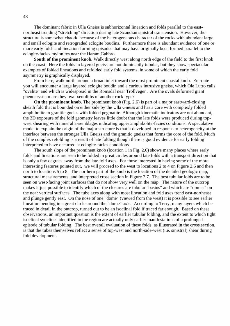
48
The dominant fabric in Ulla Gneiss is subhorizontal lineation and folds parallel to the east-northeast trending "stretching" direction during late Scandian sinistral transtension. However, the structure is somewhat chaotic because of the heterogeneous character of the rocks with abundant large and small eclogite and retrograded eclogite boudins. Furthermore there is abundant evidence of one or more early fold- and lineation-forming episodes that may have originally been formed parallel to the eclogite-facies mylonites near the Haram Gabbro.
South of the prominent knob. Walk directly west along north edge of the field to the first knob on the coast. Here the folds in layered gneiss are not dominantly tubular, but they show spectacular examples of folded lineations and refolded early fold systems, in some of which the early fold asymmetry is graphically displayed.
From here, walk north around a broad inlet toward the most prominent coastal knob. En route you will encounter a large layered eclogite boudin and a curious intrusive gneiss, which Ole Lutro calls "ovalite" and which is widespread in the Romsdal near Trollvegen. Are the ovals deformed giant phenocrysts or are they oval xenoliths of another rock type?
On the prominent knob. The prominent knob (Fig. 2.6) is part of a major eastward-closing sheath fold that is bounded on either side by the Ulla Gneiss and has a core with complexly folded amphibolite to granitic gneiss with folded pegmatite. Although kinematic indicators are not abundant, the 3D exposure of the fold geometry leaves little doubt that the late folds were produced during top-west shearing with mineral assemblages indicating upper amphibolite-facies conditions. A speculative model to explain the origin of the major structure is that it developed in response to heterogeneity at the interface between the stronger Ulla Gneiss and the granitic gneiss that forms the core of the fold. Much of the complex refolding is a result of late folding though there is good evidence for early folding interpreted to have occurred at eclogite-facies conditions.
The south slope of the prominent knob (location 1 in Fig. 2.6) shows many places where early folds and lineations are seen to be folded in great circles around late folds with a transport direction that is only a few degrees away from the late fold axes. For those interested in having some of the more interesting features pointed out, we will proceed to the west to locations 2 to 4 on Figure 2.6 and thennorth to locations 5 to 8. The northern part of the knob is the location of the detailed geologic map, structural measurements, and interpreted cross section in Figure 2.7. The best tubular folds are to be seen on west-facing joint surfaces that do not show very well on the map. The nature of the outcrop makes it just possible to identify which of the closures are tubular "basins" and which are "domes" on the near vertical surfaces. The tube axes along with most lineation and fold axes trend east-northeast and plunge gently east. On the nose of one "dome" (viewed from the west) it is possible to see earlier lineation bending in a great circle around the "dome" axis. According to Terry, many layers which he traced in detail in the outcrop, turned out to be an isoclinal fold if traced far enough. Based on these observations, an important question is the extent of earlier tubular folding, and the extent to which tight isoclinal synclines identified in the region are actually only earlier manifestations of a prolonged episode of tubular folding. The best overall evaluation of these folds, as illustrated in the cross section, is that the tubes themselves reflect a sense of top-west and north-side-west (i.e. sinistral) shear during fold development.

49
Fig. 2.6 Generalized geologic map for Stop 2-3 on Ullaholmen. Locations 1-8 are areas of interest.Box is the location of Fig. 2.7.

50

51

52

53
Fig. 2.7 Detailed geologic map, cross section and equal area diagrams for part of the pavementexposure (see Fig. 2.6) at Stop 2-3 on Ullaholmen.

54

55
Northern point of Ullaholmen. Persons with an additional half hour may wish to examine the large coastal exposures of complexly deformed augen-orthogneiss on the north point of Ullaholmen 250 m away. After the stop walk back to the field over boggy ground.
Leave Stop 2-3 and Ullaholmen. Turn left (east) onto main causeway to Flemsøya. At T junction at end of causeway turn left (north) toward Flem. Follow narrow road around NW corner of Flemsøya, and along north coast to small parking area at Sandvik sand beach.
STOP 2-4: (1 hour) Flem (Sandvikhaugane) Gabbro. Stops 2-4 and 2-5 within a short walk of the beach at Sandvik were both described by Mai Britt Mørk (Mørk and Krogh, 1987), and a study of the gabbro was part of her Ph. D. thesis at Oslo University (Mørk, 1985; Mork, 1986, Mork and Mearns, 1986).
Eastern end of gabbro. Walk left (northwest) beyond the beach toward the point at Sandvikhaugene. At the east end of the big outcrop at low tide the original igneous intrusive contact of the gabbro with the augen orthogneiss can be seen, as well as a steep subduction related (?) linear fabric in the augen gneiss. Rare sugary textured granitic veins locally with coarse garnet and tourmaline in the gabbro may be backveins that went through eclogite-facies conditions. These contrast with coarse cross-cutting late pegmatite dikes that came in late in the Scandian exhumation and usually caused extensive amphibolitization in adjacent gabbro or eclogite. Walk northwest from the contact about 75 m to the northeast-facing point where the full transition from layered gabbro to eclogite can be examined in clean outcrop.
Gabbro transformation to eclogite. According to Mørk (Mørk and Krogh, 1987) the gabbro is a layered olivine gabbro with relict igneous mineralogy including olivine, plagioclase, augite, ilmenite and biotite. It shows all stages of transformation to an eclogite consisting of garnet, omphacite, biotite, amphibole and ilmenite. Three stages of transformation are recognized in the field: 1) Massive corona gabbro dominated by relict igneous mineralogy and cumulate textures. 2) Transitional gabbro-eclogite with relict igneous textures and some relict minerals but with garnet and omphacite clearly visible in the field. 3) Completely eclogitized gabbro, either with pseudomorphic igneous textures or as recrystallized and foliated eclogites. Pseudomorphic replacements involve formation of garnet and orthopyroxene coronas between plagioclase and olivine, replacement of igneous plagioclase by more sodic plagioclase with thin spinel needles, increase of Na content of intercumulus augite and exsolution of an opaque phase. With increasing degree of reaction omphacite forms both by continuous reactions with the original augite and by nucleation within olivine and transient orthopyroxene, while garnet always seems to replace plagioclase. (For element images of this transition stage see Figure 2.8) As modal % of pyroxene climbs from about 15% in the gabbro to about 40% in the eclogite, the composition changes from Acmite 14 Jadeite 0 to around Acmite 10 Jadeite 25-30, and the garnet composition from pyrope 29 to 42-45, almandine nearly constant at 44-48, grossular 27 to 8, and spessartine 1.2 to 0.8. With increasing degree of reaction the transient phases disappear and garnet becomes more homogeneous with lower Ca and slightly higher Mg/Fe than in the corona stage. It appears that complete eclogitization and mineral-chemical as well as isotopic homogenization are enhanced by factors like oxidation, fluid availability, and deformation, while the transient stages reflect restricted element exchange between the mafic and felsic original domains (Mørk, 1985; Mørk and Mearns, 1986).
Geochronologic data on eclogite. A sample of this contorted totally eclogitized north margin of the Flem Gabbro provided only a small amount of small rounded zircons to Tom Krogh. In fact, zircons were so scarce that two separate collecting efforts in 1997 and 1998 were required. Data for two concordant analyses gave a mean 207/206 age of 412 (411,412 Ma) and a mean 206/238 age of 409 Ma (408, 410 Ma). The age of 412 Ma on metamorphic zircon from the Flem eclogite represents the most precise metamorphic age yet determined for northern Nordøyane (Krogh et al., 2003). This new age is about 10 m.y. older than the 401 Ma age based on Ulsteinvik eclogite at 402±2 Ma and on the 400±16 Ma Sm-Nd mineral age of Mørk and Mearns (1986) on the Flem eclogite, assumed by Terry et al. (2000a) for the "Lower Plate of Nordøyane" in their exhumation model for Fjørtoft.

56
Gabbro pegmatite and granite pegmatite. Plagioclase-rich pegmatite dikes within the gabbro about 75 meters more to the west containing plagioclase, augite, orthopyroxene, and ilmenite have developed coronas with garnet and amphibole between plagioclase and pyroxene. A late Scandian pegmatite dike has introduced aquaeous fluid that produced bordering zones of hornblende-rich amphibolite about 0.5 m thick after either gabbro or eclogite.
Geochronologic data on gabbro. The gabbro is interpreted to have intruded into the augen orthogneiss (see above). Whole-rocks and relict igneous augite give a Sm-Nd isochron of 1289±48 Ma (Mørk and Mearns, 1986). This was interpreted as the age of the intrusion and similar to the age of other olivine gabbros from the Western Gneiss Region (Mearns, 1984). (By a strange quirk of fate this was also Robinson's field locality 1289 in July 1993!) Tom Krogh has recently reported a preliminary U-Pb age on zircon from the gabbro of 1252+/- 4 Ma (3 points, 54% probability of fit - refinement in progress).
STOP 2-5: (20 minutes) Kvalvika garnet-peridotiteDepending on tide and sand conditions walk east along the beach from the parking space or along
the road about 150 meters to a peculiar hollow in the gneissic rocks. This is eroded in a body of yellow-brown-weathering garnet peridotite with thin folded layers of garnet websterite consisting of garnet, Cr diopside, enstatite and rutile. The body is surrounded by typical Ulla Gneiss that was completely eclogitized near the contact with the peridotite. Most omphacite has been retrogressed to fine symplectite. In summer 1993 and 1996 the body was 90% covered by sand, whereas in spring 1997 storms had excavated most of the sand leaving about 90% exposure of ultramafic rock. The folds in garnet websterite are steeply plunging and probably parallel to an early lineation seen in a dunite layer near the margin of the body. This lineation has the same orientation as the relic lineation in the eclogitized Ulla Gneiss that is in contact with the unite. This implies: 1) Emplacement of the peridotite occurred during or prior to the formation of the eclogite-facies lineation. 2) Emplacement of the peridotite occurred at or before 412 Ma on the basis that the eclogitization of the Ulla Gneiss and the Flem Gabbro were synchronous.
These same structural relationships can also be inferred for the large peridotite exposed at Skulen and regional study in the Ulla Gneiss indicates that this lineation was formed originally during top-SE shearing that is consistent with thrusting. However, these outcrops have yielded no information on the mode of emplacement of the body against the adjacent Ulla Gneiss, but may upon closer study.
Leave Stop 2-5 and drive back (west) toward the northwestern point of Flemsøya southwest of Kjellholmen. Just before a narrow pass at a high point of the road turn right (north) into a large parking space associated with a bedrock excavation.
STOP 2-6: (40 minutes) Eclogite-facies structural features in Ulla Gneiss and augen orthogneiss. From parking space walk northwest and down to sea level where there is huge exposure in a hollow of variably deformed augen orthogneiss with pegmatite intrusions. On a ridge to the northeast of the hollow there are three rafts of eclogite described by Mørk with hybrid boudin-neck pegmatites. One of these pegmatites studied by Tom Krogh contained abundant cored grains (Krogh et al., 2003). Data for 4 tips from these yield data that are 1.3, 1.5, 2.3 and 3.2 % discordant with a mean 207/206 age of 397 Ma. The two most concordant analyses are the youngest and hence are least likely to contain older growth components. These have a mean 207/206 age of 395 Ma (394, 395 Ma) remarkably consistent with ages from other pegmatites in the region as well as with the mean lower intercept chord of titanite ages reported by Tucker et al., 1990. One of the eclogite rafts at this location appears to have been the source of the Sm-Nd mineral isochron of 400 ±16 Ma reported by Mørk and Mearns (1986).

57
Fig. 2.8 - Electron probe scanned element images of transitional olivine corona gabbro from Flem,Stop 2-4, for Mg (A), Mn (B), Ca (C) and Na (D).. Color scheme relates directly to elementabundance from abundant (white or red) to scarce or absent (violet or black. Relict igneous as well as metamorphic minerals are preserved in this stage as studied by Mørk (1985). The dominant feature in the center is a former igneous olivine, now completely replaced by orthopyroxene, rimmed by clinopyroxene and finally by garnet against matrix plagioclase. Mg (A) is richest in orthopyroxene (red) then in zoned clinopyroxene which is most magnesian (green) toward orthopyroxene and less magnesian outward, then in zoned garnet which is most magnesian (dark blue) toward clinopyroxene and less magnesian (violet) outward. The high-Mg phase (yellow) on the garnet-clinopyroxene boundary is not identified. Mn (B) is present in garnet, also detectable in orthopyroxene. Ca (C) is most abundant at the inner edge of clinopyroxene (white), decreasing irregularly outward (reds and yellows). It is also present in garnet where it is lowest (blue) against clinopyroxene and increasing outward (green-yellow red) against plagioclase (violet), and absent (black) in orthopyroxene and orthoclase in upper left. Na (D) is most abundant in plagioclase (red), shows strong zoning in clinopyroxene from low (violet) through intermediate (blue, green) to high (yellow, red) against garnet, shows a small amount (blue, violet) in orthoclase, and is absent in garnet and orthopyroxene (black). The figure illustrates the reality of mineral growth in a chemical potential gradient produced by disequilibrium between olivine and plagioclase, with production of jadeite-bearing clinopyroxene.

58

59
Walk northwest then west to steeper coast where there is an awkward ridge at the top of a sea cliff. A sharp projection at the east end of the sea cliff contains a steeply north-plunging tubular fold in well layered Ulla Gneiss (Fig. 2.9). This can be reached by careful scrambling, but can be viewed and photographed very well from the cliff top. The fold is outlined by an eclogite layer that contains an omphacite stretching lineation parallel to the tube axis. Like the subhorizontal tubular folds at Ullaholmen (Stop 2-3), this steep fold indicates deformation under constrictional strain conditions but during subduction at a much earlier time in the total strain history.
Return to parking place and rejoin road, turning right (west). Cross the small pass where there is a small outcrop of brown-weathering peridotite, and continue southwest to junction near causeway.Pass the junction and drive south toward Longva. Bear left at Longva and follow inland road around south end of Flemsøya to Nogva. Find parking beside a bus garage at Longva. Walk east down private driveway to small wharf and then north along shore to outcrop.
STOP 2-7: (25 minutes) Nogva kyanite-zoisite eclogite with rare polycrystalline quartz pseudomorphs after coesite and retrograde sapphirine and corundum.
Structural setting. The rocks exposed at and near Nogva are not easily mapped, but at present are interpreted to belong to a high-level UHP thrust sheet similar to the Blåhø rocks on the northeastern part of Fjørtoft. These rocks are folded across the crest of the large late anticline that dominates the northern structural segment of Nordøyane (Fig. 2.2). Here, we are only a few hundred meters north of the Åkre Mylonite Zone which is well exposed in a small harbor on the east coast of Flemsøya.
Petrography and petrology. There are two moderately large eclogite boudins in this coastal outcrop studied by Terry et al. (2000b and in progress). They have compositional layering that is truncated by the boudin margins, and also mineral lineation that is transverse to the normal northeast trend. There are two dominant kinds of layers. The first are striking bright orange garnet-rich layers with very fresh omphacite partially replaced by fine plagioclase+pyroxene symplectite. According to Tony Carswell, personal communication 1996, such a color usually denotes a high Ca content in garnet, in this case Pyr 32.7, Alm 36.7, Gr 30.1, Sp 0.5. The other layers are lighter colored and dominated by plagioclase-pyroxene symplectite after omphacite and lesser garnet. However, in different places they contain abundant quartz, zoisite, plagioclase (as a replacement of zoisite), hornblende, biotite, rutile, biotite+feldspar symplectite after phengite (?), and kyanite. At one point there is a boudin neck zone containing crystals of zoisite up to about 8 cm long. Commonly surrounding kyanite or replacing it completely are symplectites involving calcic plagioclase and one or two of the phases sapphirine (a very pale green variety), corundum, or spinel.
Textural and rimming relationships suggest a variety of reactions indicative of decompression under relatively high temperature conditions. Locally secondary calcic pyroxene is concentrated as a rim between quartz and pyroxene-plagioclase symplectite. The latter as well as garnet is commonly replaced partially by hornblende, but some samples have no hornblende. Large zoisite grains may contain plagioclase or zoisite-plagioclase symplectite and may be a partial result of the reaction quartz + kyanite + zoisite = anorthite. The symplectic rims on kyanite denote decompression reactions between kyanite and omphacite producing calcic plagioclase plus one or more of the aluminous phases sapphirine, corundum and spinel, dependent on the local Fe/Mg ratio. Although we have not found any completely fresh kyanite eclogite in this outcrop, a boudin on nearby Fjørtoft (Stop 5-1) contains a completely fresh core, with no symplectite and with only traces of secondary plagioclase, showing all mutual contacts among the phases garnet, omphacite, zoisite, kyanite, quartz, hornblende, pale brown biotite and rutile. A garnet-kyanite-omphacite-coesite assemblage can be reconstructed easily from inclusions in the garnet-rich part of the present outcrop, and geothermobarometry indicates 820°C, 30-36 kbar, slightly lower P than indicated for the assemblage studied at Fjørtoft, but well within UHP conditions. When phase compositions are plotted together with those from Fjørtoft eclogite (Figure 4.4), the omphacite from here is much richer in jadeite component (Jd 41), the grossular content of garnet is similar (Gr 30), but both omphacite and garnet have a much higher ratio of Fe/(Fe+Mg).

60
Overall these relations suggest equilibration under fairly similar conditions but here in a rock with a lower original anorthite content and higher Fe/(Fe+Mg) ratio.
Walk back to vehicles at bus garage. Drive back on coast road around south end of Flemsøya and through Longva to junction for causeway. Turn left (west) onto causeway and over bridge to Haramsøya. Proceed south on main road through village of Austnes to ferry terminal. Back onto ferry for Løvsøya (Kjerstad).
Leave ferry at Løvsøya (Kjerstad). Turn right on main road above ferry pier toward Hellevik. Pass by Lepsøya Misjonsenter, our overnight location. Continue for 2.6 km drive over plateau and down steep switchbacks to Hellevik. Park in small parking place before driveway to the big lighthouse (now privately owned).
STOP 2-8: (45 minutes) Isoclinal infolds of Blåhø and Sætra Nappes in "sausage rock" basement.Central segment of Nordøyane. The pavement exposure at Hellevik gives a superb taste of the
geology of the central belt of Nordøyane (Figs. 2.2a, 2.10). The basement here is gray gneiss with amphibolite boudins interpreted as mafic dikes ("gray sausage rock"). The dominant cover nappe unit is the Blåhø Nappe dominated by mica schist and garnet amphibolite which occurs in three isoclinal synclinal belts on northern Lepsøya, of which we will see the northern two. The southern schist belt is in direct contact with eclogite-bearing basement of the southern belt (see Stop 2-9). At the north margin of the northern Blåhø belt there is a layer of Sætra quartzite and amphibolite about 1 m thick, which has been traced all along the north end of Lepsøya to Bryggja. There it is exposed on west-facing cliffs in the core of a large south-closing recumbent refold, itself refolded by upright folds (Figs. 2.2a, 2.11). Lineations and major and minor fold axes, shown by domains in Fig. 2.10, trend ENE and are subhorizontal, consistent with other constrictional strain features associated with late transtensional deformation in the region, such as the tubular folds at Stop 2-3. Is it possible that the pattern of major refolded folds in Figure 2.11 is no more than a manifestation of a prolonged episode of tubular folding? Guided tour. From the parking place walk east down a grassy path to the edge of the pavement. The first rock is kyanite-bearing schist in the middle belt of Blåhø. Walk north between large boulders a short distance to a high spot. This rusty schist consists of quartz, biotite, plagioclase, garnet, pleochroic gray gedrite and sulfides. It is considered to be a metamorphosed hydrothermally altered basalt (see Stop 6-1). Walk a few meters north to contact between amphibolite and very narrow belt of basement, here usefully termed "shredded sausage rock". This belt and this rock extends all the way across the north end of Lepsøya (southern belt with blue color in Figure 2.10) and forms the bulbous core of the big recumbent fold illustrated in Figure 2.11. To the north the basement is in contact with the northern Blåhø belt. About half way across this schist-amphibolite belt there is an isoclinal infold of quartzite and amphibolite that we believe is a tight infold of the Sætra Nappe. There is a 10 cm bed of marble along the south contact, as is common elsewhere in the region (see Stops 3-7, 3-8 and 6-1). At the north edge of the Blåhø belt there is about 1m of folded quartzite-amphibolite and then more "shredded sausage rock". A dip slope in this quartzite forms the south wall of the low bluff on which the small lighthouse is located. Traverse northwestward through the zone of shredded sausage rock to more substantial sausage rock. Here one gets the idea that the mafic layers may be dikes though the evidence is much weaker than in an outcrop on Otrøy (see Stop 6-2). If one walks south on the west side of the small lighthouse there is a pavement exposure in the middle of an area of pools and grass where one can see the Sætra overlying basement in a series of late east-plunging open folds. Here the Sætra has a bed of glassy quartzite 40 cm thick. From this point one may walk direct to the parking place in boggy ground or retrace the route around the point.

61
Fig. 2.9 Detailed map (A) in the area near a well preserved eclogite-facies fold on the northwest coast of Flemsøya B) Photograph of the eastern closure of the early fold where dark layers represent maficcompositions that locally preserve eclogite-facies assemblages. C) Cross section C-C' showing the geometry of the eclogite-facies fold being folded by late amphibolite-facies structures. Equal area projections (D, E, F, and G) show poles to foliations and lineations from west to east across the early fold structure with locations shown in A. See text for discussion.

62

63
Fig. 2.10 - Detailed geologic map of the northern part of Lepsøya from Terry (2000) showing the locations of Stops 2-8 and 2-9 as well as the Lepsøy Prestegård.

64

65

66

67
Fig. 2.12 Photomicrograph of the amphibole eclogite at Stop 2-9 in cross-polarized light containing the metamorphic zircons dated by Tom Krogh. The presence of a well equilibrated amphiboleeclogite shows that rocks of the southern segment of Nordøyane could not have been to UHP conditions and that there was Scandian imbrication of the crust on Nordøyane. Differences in bulk composition could, however, explain the differences in the assemblages between normal HP eclogites in the northern and southern segments.

68

69
Leave Stop 2-8 and return toward Kjerstad. Turn left at Misjonsenter and either stop for overnight or continue around sharp left corner and along coastal road to closest parking for Stop 2-9. This stop may also be reached by walking from the Misjonsenter.
STOP 2-9: (30 minutes) Hornblende eclogite of southern segment basement north from Sæt. This eclogite, in part very fresh, forms nearly all of an islet that is easily reached at low tide (Fig.
2.10). It contains the equilibrium assemblage omphacite-garnet-biotite-hornblende-quartz-rutile (Fig. 2.12). It is representative of eclogites found in the northernmost belt of Mid-Proterozoic basement on Lepsøya, which is in direct contact with Blåhø rocks of the southernmost of three belts in the central segment. Neither basement rocks nor Blåhø rocks of the central belt (Stop 2-8) contain evidence of eclogite-facies metamorphism. On this basis an early extensional fault has been postulated along the contact between the central and southern segments.
A sample of eclogite with very fresh coarse omphacite collected by Tom Krogh from this islet provided a small yield of small rounded zircon grains (Krogh et al., 2003). Data for two concordant fractions of these gave a mean 207/206 age of 414 Ma (414 and 413 ma) and a mean 206/238 age of 412 ma (412 and 412 Ma.) The age of 414 Ma is the only precise eclogite metamorphic age from the southern segment of Nordøyane and only barely older than the eclogite at Flem in the northern segment (412 Ma). It is also important to note that hornblende is not stable in either HP or UHP eclogites from the northern segment of Nordøyane, which indicates that the southern segment of crust also had a different metamorphic history although the ages are indistinguishable.
Return along coast to Misjonsenter. From Misjonsenter travel south to ferry junction in Kjerstad. Stay straight at junction and follow main road toward village of Rønstad until reaching the entrance to a large quarry on right on the southwest coast of the island. Climb down over rubble pile to broad coastal exposures.
STOP 2-10: (45 minutes) Isoclinal infolds of Blåhø kyanite-garnet migmatite and amphibolite, eclogite-bearing basement , southwest Lepsøya.
Southern segment of Nordøyane. The extensive low exposures on this part of the coast are typical of the geology of the southern segment of Nordøyane as well as the adjacent northern part of Vigra. In this vicinity there are four isoclinal infolds of Blåhø rocks enclosed in eclogite-bearing basement. Although eclogites have not been found in the Blåhø rocks of Lepsøya, they are known at one location on northern Vigra. On southwestern Lepsøya five narrow Blåhø belts are deformed across a broad east-plunging late anticline (Fig. 2.2a). From the core of the anticline upward these may be numbered 1, 2, 3, 4,5. This stop will be mainly concerned with belts 2 and 3 on the northern limb of the anticline.
Southeast across basement and Blåhø belt 2. The outcrops just below the rubble pile are granitoid basement gneisses dipping north between Blåho belts 2 and 3. On outcrop surfaces facing south and parallel to the late extensional lineation there are many top-west shear shear indicators, including asymmetric tails on feldspar porphyryoclasts and tail arrangements indicating counterclockwise porphyroclast rotation.
Walk southeast (down structural section) along the coast. The contact between basement and the underlying Blåhø of belt 2 is subtle. The first Blåhø rocks are not very distinctive amphibolites, locally with garnet. Associated with these are hornblende gneisses, typically with unusual orange- colored garnets. Beneath these rocks are coarse-grained kyanite-garnet schists containing coarse-grained kyanite-bearing leucosomes. The leucosomes appear significantly less deformed than the matrix that contains features related to late top-west or left-lateral shear. There is the possibility that these rocks contain an early migmatization recognized elsewhere the Blåhø Nappe or that the migmatization occurred during decompression across the muscovite and/or biotite melting reaction(s) associated with late shearing. These hypotheses are currently being tested by the application of monazite geochronology. Below the kyanite schists are additional amphibolites and then basement gneisses

70
between belts 1 and 2. It is possible in a few minutes to walk to the Blåhø rocks of belt 1 in the core of the anticline, but the exposure is not impressive.
Northwest to Blåhø belt 3. Walk back (northwest) to starting point and continue northwest to contact region at the southern edge of belt 3, where basement eclogite occurs just below the contact. The overlying Blåhø rocks are dominated by amphibolite, but kyanite schists have been found. Walk back to coast road and vehicles in the quarry.
Drive back southeast, keeping to roads that stay closest to the coast to junction where branch road extends south toward Lauvsundholmen. Cross the very narrow causeway south to Lauvsundholmen. Turn left (east) at south end of causeway, then in a short distance right (south) up a steep rough road to quarry at the top of the island.
STOP 2-11: (10 minutes) Garnet corona gabbro quarry at Lauvsundholmen.The very fresh garnet corona gabbro exposed in this quarry appears to occupy the entire island of
Lauvsundholmen, and is also exposed on Litle Lauka and Hestøya. The gabbro lies structurally above the Blåhø belt 5 as described for Stop 2-10 and illustrated in Figure 2.2a. Much of the rock retains primary igneous features of an orthopyroxene-clinopyroxene gabbro, but also contains abundant garnet coronas between plagioclase and mafic minerals, and development of secondary Na-enriched Ca-pyroxenes (Jd 12). The coronas are commonly most abundant in close proximity to grains of ilmenite and magnetite, indicating the importance of Fe in promotion of garnet growth. Locally on the shore there are shear zones formed under high-T conditions in which the gabbro is mylonitic gneiss dominated by ribbons of garnet, Ca-pyroxene, plagioclase and oxides. The omphacitic pyroxene is not characteristic of an early granulite-faces metamorphism and might agree well with the hornblende-eclogite facies conditions observed in eclogites of the southern segment (see Stop 2-9). This idea is currently being tested by application of quantitative geothermobarometry.
Leave quarry and cross causeway to Lepsøya. Stay straight (right) at junction and proceed to road to ferry terminal. Either turn right to ferry, or continue on coast road back to Misjonsenter.

71
Day 3: STRUCTURAL-METAMORPHIC RELATIONSHIPS BETWEEN CALEDONIDE NAPPES AND FENNOSCANDIAN BASEMENTON THE MAINLAND NEAR BRATTVÅG
Monday June 30 for Group A, Tuesday July 1 for Group B
by Peter Robinson with contribution by Bob Tucker
General Route: The day will begin with a morning ferry ride from Lepsøya or Dryna to the mainland (Fig. 1.4, 3.1). The trip log begins at the junction for Brattvåg Ferry Terminal. From Brattvåg we drive south and then east through Vatne and over a low mountain pass to Fikksdal in Vestnes Kommune. From Fikksdal we drive northwest and west along the south shore of Moldefjord back to Vatne, with four stops at Dragneset, Øygaardsneset, and on the east shore of Vatnefjord.From Vatne we return toward Brattvåg, but turn right at the junction to Helland at the bottom of the hill beyond the tunnel, and proceed to the coast east of Brattvåg for five stops. After these stops, the route is retraced to Brattvåg, and the trip log includes three additional stops a short distance west of the Brattvåg Ferry Terminal if time permits. At the end of the day we will take the ferry to Lepsøya via Skjeltene.
Ferry Lepsøya to Skjeltene: Monday 7:20-7:40, 8:00-8:40 (long way); 9:50-10:10Ferry Dryna to Brattvåg: Tuesday 7:30-7:50, 8:15-8:35 Ferry Skjeltene to Lepsøya: Monday, Tuesday 18:15-18:30, 19:15-19:30
INTRODUCTION TO DAY 3
The day will be devoted to the features of Caledonide nappes on the south limb of the Moldefjord syncline and in the Helleneset syncline, and their structural and metamorphic relations with the underlying Proterozoic basement. The introduction to the nappes in this part of the Scandian hinterland provides a necessary background to understanding the evolution of the more basement-dominated areas further north to be studied on Days 2, 4, 5 and 6.
Tectono-stratigraphic Units: Moldefjord and Helleneset Synclines near Brattvåg
A sequence of seven tectono-stratigraphic units was identified that corresponds very closely with units in Trollheimen and elsewhere in the central Caledonides, although some of the units observed elsewhere are absent. This geology is summarized in detail in Robinson (1995c), though tectonic implications of the structural features were poorly understood at the time.
Baltica basement. This basement consists of strongly deformed gneisses, gabbros, eclogites, amphibolites, and trace amounts of supracrustal rocks, derived from Proterozoic intrusions with very minor amounts of host rock. Locally gabbro boudins preserve primary igneous textures. The basement is locally separated into lower basement and upper basement by Åmotsdal Quartzite. By analogy with Trollheimen, the quartzite is probably unconformable on the lower basement and is overthrust by the upper basement. As in Trollheimen, eclogite is found in upper basement (Stop 3-5), but not in lower basement.
Åmotsdal Quartzite. Feldspathic quartzites, locally hematitic and locally with feldspathic pebbles, exposed in an anticline in Vatnefjord and to the east (Stop 3-3). Locally up to 100 m thick, the quartzite has been mapped in areas where it is only 1 m thick (Robinson, 1997).
Risberget Nappe. This thrust nappe consists of augen gneiss and amphibolite that represent deformed middle Proterozoic rapakivi granite with subordinate gabbro, intruded by mafic dikes (Stops 3-2, 3-4, 3-5, 3-6, 3-7, 3-11). Near Brattvåg the Risberget Nappe contains a distinctive mappable unit of amphibolite derived from gabbro (Stops 3-5, 3-6, 3-7, 3-11) in which thin dikes of rapakivi granite have been recognized. In a boudin near Skår the rapakivi granite is preserved in a totally undeformed state with large orthoclase phenocrysts rimmed by plagioclase (Stop 3-6). Recognition of the Risberget Nappe is more difficult in the Moldefjord and Surnadal synclines than

72

73
in eastern Trollheimen. In eastern Trollheimen the Risberget Nappe is consistently separated from upper basement by Åmotsdal Quartzite and other autochthonous or para-autochthonous supracrustal rocks that are absent in these western areas. Augen gneiss of generally similar character is a major component of the Baltica basement, especially to the north of the Moldefjord (Carswell & Harvey
1985) (see Stop 6-4) where it has yielded a U-Pb zircon age of 1508 Ma (Tucker et al., 1990), similar to the Rb-Sr whole rock age obtained by Krill at Oppdal and to the U-Pb zircon age obtained on the
porphyritic mangerite at Flatraket (Lappin et al., 1979). In practice the basement augen gneiss is usually fine grained and the microcline phenocrysts are flattened and polycrystalline as a result of
relatively homogeneous deformation, whereas the typical gneiss of the Risberget Nappe contains large coarsely crystalline phenocrysts in a micaceous matrix interspersed with zones of obviously mylonitic
character. A recent development comes from the U-Pb zircon dating of augen gneisses in the Risberget and Tännäs Augen Gneiss Nappes (Handke at al., 1995) at nine different locations in
Norway. Of these 5 yielded ages of 1650-1642 Ma., four yielded surprising ages of 1190-1180 Ma. including the rocks exposed at Skår (Stop 3-7) and Oppdal and none yielded the "expected" age of
1500 Ma. The best argument that the Risberget unit is a nappe comes from its great lateral continuity and consistent stratigraphic position across the orogen from these areas to the Tännäs Augen Gneiss Nappe in Sweden (Krill and Röshoff 1981). The new ages lend further support to this interpretation.
Sætra Nappe. This nappe is characterized by strongly laminated pure to feldspathic biotite quartzite and amphibolite, locally garnetiferous, and locally eclogitic (Stops 3-1, 3-4, 3-5, 3-6, 3-7, 3-11, 2-8.. These rocks represent metamorphosed sandstone cut by diabase dikes corresponding to the Särv Nappe near the front of the orogen in Sweden. Though locally discontinuous, this key unit occurs throughout the belt, but is commonly no more than 10 meters thick. It is also present on northern Lepsøya (Stop 2-8) where it is about 1m thick. Near Brattvåg, the unit, especially its lower part, contains boudins of zoisite±phengite eclogite up to 10 m thick, and prograde growth zoning in garnet (Stops 3-4, 3-5, 3-6, 3-7) . Outcrop relationships demonstrate that the eclogite-facies metamorphism took place before the dike rocks where deformed into very thin amphibolites. In general aspect, these rocks are quite similar to metamorphosed sandstones with diabase dikes metamorphosed to eclogite at Grapesvare, in the Seve Nappe of Arctic Sweden. At that location the eclogite metamorphism has been dated at 505 Ma (Mørk et al., 1988; Essex at al., 1997), opening the question as to whether these eclogites are also pre-Scandian. Unfortunately no attempt has yet been made to do geochronology.
Blåhø Nappe. This nappe consists of porphyroblastic garnet-mica-feldspar schist, pyroxene-biotite schist, coarse gneissic garnet and pyroxene amphibolite, diopside calc-silicate rock, and pegmatite; interpreted as highly metamorphosed shales and volcanics (Stops 3-1, 3-4, 3-7, 3-8, 3-9, 3-10, 3-11, 2-7, 2-8, 2-10, 4-3, 4-4, 4-5, 4-6, 6-1). In the upper part of the Blåhø Nappe there is a bed of impure marble and calcareous schist about 6m thick separated from the Støren contact by 15m or less of mica-garnet schist (Stop 3-7). The position of marble near or at the top of the Blåhø Nappe is critical to several fold interpretations in the area west of Brattvåg. Commonly there are also thin impure marbles or calcareous impure quartzites at or near the base (Stop 3-1, 3-8). In its best preserved portions, this nappe shows evidence of early high-temperature metamorphism with extensive development of migmatites unlike anything in the other nappes (Stop 3-8). In this respect it corresponds to part of the Seve Nappe in Sweden. Migmatitic features are particularly well shown in the lower part of the Blåhø Nappe, where there is a lesser amount of retrograde hydration. R. D. Tucker has obtained U-Pb zircon ages from two pegmatites in similar rocks near Orkanger that cut an older metamorphic fabric but are themselves deformed in the late stages. These have yielded ages of 430 and 422.7 Ma, considerably older than pegmatites in adjacent basement (Solli and Robinson 1997, Tucker et al., submitted).
Støren Nappe. This is composed of strongly laminated, fine-grained epidote amphibolite derived from metamorphosed basaltic volcanics, minor felsic schist derived from felsic volcanics with thin interbeds of fine-grained garnet-biotite-muscovite-tourmaline schist, and subordinate biotite-garnet-tourmaline schist representing intercalated sediments (Stops 3-8, 3-9, 3-10. Major layers of very coarse amphibolite and hornblendite, locally with relict cumulate textures, are metamorphosed massive to layered gabbro (Stop 3-9). There is also a lens of talc-anthophyllite-carbonate schist.

74
These mafic and ultramafic rocks may be dismembered fragments of ophiolite such as those found in the Støren Nappe near Trondheim.
General Structure
The tectono-stratigraphic units are exposed in two tight to isoclinal synclines overturned to the north-northwest, with subhorizontal axes. The major Moldefjord syncline (Fig. 3.1) has been traced for 70 km and the narrower Helleneset syncline has been traced for 25 km. The structure east of Molde is a syncline, not fault controlled. This is shown by well exposed overturned north-facing sequences on Bolsøya and other islands near Molde, and on Grønnes Peninsula, and by less well exposed right-side-up south-facing sequences on the north side of Grønnes Peninsula and in the Fannefjord Tunnel. The west-plunging synclinal hinge is mapped on the Grønnes Peninsula near Kortgarden. Near Brattvåg, on the south limb (Fig. 3.6), there are three tightly folded north-facing sequences separated by two fine-grained mylonite zones. Parts of the south limb are well exposed east of Brattvåg near Vatnefjord (Fig. 3.3), near Rekdal (Fig. 3.3), and on Tautra. The Helleneset syncline (Figs. 3.3, 3.6) south of the Moldefjord syncline has been traced from west of Brattvåg to southeast of Rekdal. Its limbs and axial surface have been refolded about late open folds with horizontal or gently south-dipping axial surfaces (Fig. 3.5). Between these synclines (Fig. 3.3) is a complex anticline outlined by a thick unit of Åmotsdal feldspathic quartzite separating layers of lower and upper basement near Vatnefjorden and in mountains to the east (Robinson, 1997).
Sequence of Structural Development
Although various nappes probably contain older structural features, the earliest recognizable event was the progressive development and emplacement of thrust nappes for several hundred km onto the Baltica margin in the early part of the Scandian orogeny. We believe (Robinson et al., 1996, 1997; Tucker at al., 1997a, and submitted) that this carried rocks of the Storen Nappe far onto the then cool Baltica foreland, while contemporaneously there was subduction of the Baltica margin with its heating and high pressure metamorphism, locally to eclogite facies, producing early transverse top-to-SE shear fabrics (see Stop 2-1), new metamorphic zircon variously at 415, 412, 410, 402 and 401 Ma, and progressive Pb loss in Proterozoic igneous titanite. The middle part of theScandian involved basement imbrication at deep levels, with contemporaneous extensional collapse at higher levels. Features of the middle Scandian included the following: Thrust imbrication of the subducted heated basement slab or slabs onto cooler basement toward the foreland. We suggest this accounts for the repetition of basements separated by quartzite in Trollheimen and in the Rekdalshesten anticline, where eclogite is found only in the upper basement. Contemporaneously there was backsliding and extensional emplacement of the cool high level nappes against the cooling basement. Cooling of the basement slab or slabs from above and below abruptly terminated the short period of Pb loss in basement titanite at 395±2 Ma, while titanites in overlying Ordovician igneous rocks of the Støren Nappe were never warm enough to be reset. This first extensional collapse was the main event that brought deep metamorphic rocks relatively close to the surface. The lateScandian was characterized by further extensional deformation in a field of sinistral transtension.Early in the late Scandian there was development of northeast-trending ductile folds and stretching lineations within the previously thrust and extensionally juxtaposed package. During this deformation subhorizontal layers developed top-west shear features, whereas steep to overturned layers developed predominantly sinistral shear features that pervade the region. The later part of the late Scandian brought ductilely deformed rocks into contact with more brittle rocks from higher level rocks associated with Devonian sandstone basins deposited earlier in the period 403-394 Ma.
Note in the above scenario that we show no place for the eclogite-facies metamorphism of the Sætra Nappe near Brattvåg, nor for the early high-T metamorphism of the Blåhø Nappe. This is partly because we do not know the ages of these metamorphisms. The eclogites in the Sætra Nappe bear a very close resemblance to eclogites in the Seve Nappe of Arctic Sweden (Andréasson et al., 1985), also in late Proterozoic sandstone, what were metamorphosed at about 500 Ma, (Mørk et al.,

75
1988) in an uncertain setting. The high grade metamorphism and deformation of the Blåhø nappes seems to have begun earlier but terminated at about the same time as intrusion of pegmatites dated at 430 and 422.7 Ma near Orkanger (Tucker et al., 1997a and submitted). These events might be ascribed to subduction of rocks on the Baltica margin that came earlier than the subduction of the presently exposed basement.
How do the details of the geology near Brattvåg and on Nordøyane fit into this picture? We suggest that most of the contacts between nappes and between nappes and basement are original thrust contacts on which there has been a major amount of extensional backsliding and thinning during the middle Scandian. Once these contacts had been developed they were folded, first into a series of tight to recumbent anticlines and synclines, and then in a series of more open folds with northeast-trending axes, strong lineation, and sinistral and top-west shear features. At this point it is not easy to tell whether the earliest isoclinal folds were produced during late stages of the first extensional collapse or early stages of the sinistral transtension (note features at Stop 2-3). This ductile transtension gradually evolved into a more focused and more brittle deformation which produced the major sinistral mylonite zones, including those at Brattvåg and at Åkre on Nordøyane. It seems likely that these were forming at the same time as the extensional emplacement of the earlier deposited Devonian basins.
FIELD TRIP LOG FOR DAY 3
The logistics of the actual field trip require Group A to begin the day by taking the ferry from Lepsøya to Skjeltene and then driving on Route 659 to Brattvåg. Group B, on a different day, will take the ferry from Dryna to Brattvåg. The trip log begins where the road from Brattvåg Ferry Terminal intersects the main road.
From Brattvåg Terminal junction proceed south on Route 659 through center of Brattvåg and along west side of fjord. Near inner end of fjord note turn off left for Helland. Stay straight, climb hill, and pass through tunnel to south slope of ridge with extensive view to Sunnmøre Alps. Descend westward down mountain side nearly to sea level. At junction where Route 659 terminates against Route 661 that comes north from Ålesund and continues east toward Vatne,. stay straight (east) on Route 661 toward Vatne. After crossing bridge to center of Vatne stay straight (east) away from the fjord and Route 661 with bends to the south on mountain pass road to Fikksdal . The pass, above timberline, is reached after about 15 minutes of driving, and there is a view of the narrow peak, Mellen. Descend northwest to Fikksdal back near the shore, and turn left (toward Rekdal) on the coast road (again Route 661) which trends northwest (Fig. 3.2). After some kilometers the road turns moderately steeply upward toward the west before a road cut. Do not go around the bend but descend to right for 100 meters on a farm road to farm yard with walking access to the coast at Dragneset. Ask permission to park and pass through fields. Descend northeast through field as quickly as possible to north-facing shore. Walk east along shore to outcrops.
STOP 3-1: (30 minutes) Dragneset. Blåhø Nappe and Sætra Nappe, Moldefjord Syncline. The first rocks encountered are porphyroclastic garnet-biotite schists and garnet amphibolites
typical of the Blåhø Nappe with subhorizontal lineation and sinistral tails on porphyroclasts. Exercise care because rocks are slippery. The third or fourth large outcrop contains a buff weathering calcareous quartzose schist with a pronounced cleavage oblique to the principal foliation. If interpreted as an S-C relationship, dextral shear would be implied. However, close examination and thin sections show that the oblique cleavages are extensional shear bands completely consistent with sinistral shear.
Beyond the last schist outcrop there is a narrow covered interval and then the first outcrops of quartz-rich quartzite and amphibolite typical of the top few meters of the Sætra Nappe. Beyond this around the corner is a pavement showing a lower part of the nappe with more biotite and feldspar in the quartzites, and with some parts consisting of more than 80% amphibolite. The amphibolite pods

76
are varied and include some with scarce garnet, and others with plagioclase grains that are probably relict phenocrysts. Despite deliberate search, no eclogites have been found.
Return to vehicles at farm by the same route. Turn sharp right (northwest) and pass road cut in Sætra Nappe on left. Continue west over low hills and past farms to village of Rekdal. Just offshore from the boat harbor is a large rock which is composed of Støren amphibolite. From the mountains above, this rock has the shape of a shrimp (reke) giving the village its name, meaning "Shrimp Valley". The steep mountain, over 700 m high, southwest of the village contains the core of a huge anticline formed mainly of basement rocks, but outlined by a layer of late Proterozoic Åmotsdal Quartzite (see Stop 3-3). At the anticline crest the quartzite is over 100 m thick, but thins to as little as 1m on the south limb. Directly above Stop 3-2, on the north face, the quartzite in the core emerges as a local structural window. The steep mountain is named Rekdalshesten which translates to "the horse of shrimp valley". From the village a side road ascends Rekdal, passing a local soccer stadium along which there are outcrops of the Risberget augen gneiss and the underlying basement to the south. This was the training ground of Kjetild Rekdal, who scored for Norway in the World Cup in USA and is still active in European soccer. Continue west several kilometers from Rekdal to a region where the road enters a pine forest and begins descent.. As road descends westward there is a rough dirt track descending steeply right toward the shore to a cultural monument. Park on the main road and walk down gravel road past ruined buildings to the gravel beach. The ruined buildings are what is left of a prison camp during 1940-1945 where prisoners were kept to work on a giant gun platform, the ruins of which can be seen on the mountain to the southeast. Local Norwegians say that the German commandant was kinder to his charges, mostly Russian and Yugoslavian, than was common in such camps. Walk north along the beach to the obvious outcrop and climb over to best part on the north side.
STOP 3-2: (20 minutes) Øygaardsneset. Augen gneiss of Risberget Nappe. This exposure (see Fig. 3.2) shows pink-weathering augen gneiss of the Risberget Nappe with
typical strong subhorizontal stretching lineation and very weak steep foliation produced by constrictional strain during transtension associated with late Scandian exhumation. On the north side of the outcrop are adjacent horizontal and vertical surfaces. The horizontal surface shows both the lineation and sinistral shear tails around orthoclase porphyroclasts. On the vertical surface the rock gives an initial impression of being a little deformed porphyry and the foliation is detected with difficulty. Also on the northern side of the outcrop are some deformed mafic layers showing subhorizontal folds in foliation, one or two of which may be tubular. Look up to exposures high on Rekdalshesten described earlier.
Walk back to vehicles by the same route. Drive west, passing signed boundary between Vestnes and Haram Kommunes. After several kilometers road turns left (south) around the west side of the mountain and into a long loop around the very shallow Vestrefjord. Some of the steep outcrops on the mountains on either side of Vestrefjord are composed of Åmotsdal Quartzite and steeply dipping nappe rocks in the Helleneset syncline. The road eventually comes back to the Moldefjord coast west of Vestrefjord and into the area of Figure 3.3 near Ørsnes. From here there is an excellent view of the islands of Vatnefjord, Tennøya, Medøya and Lauvøya, and Baraldsnes beyond (see Stop 3-5). The thick zone of Sætra Nappe on the north side of Tennøya is where Robinson first discovered eclogite pods in August 1990. Also at the extreme north edge of Tennøya this Sætra is separated by mylonite from narrow exposures of Risberget and

77

78

79
basement that are the only known exposures belonging to the north limb of the Moldefjord Syncline west of Fannefjord Tunnel (Robinson 1995c). Follow road south a short distance along west shore of Vatnefjord to parking space on right near blasted exposure of feldspathic quartzite on left.
STOP 3-3: (10 minutes) Åmotsdal Quartzite, north limb of Rekdalshesten anticline. This is the only easily accessible outcrop of the quartzite which outlines the core of the
Reksdalshesten anticline (Figure 3.3). Here it is in a section about 100 m thick on the north limb. Unlike the fine-grained Sætra biotite quartzites, this contains quartz and feldspar fragments that were probably fine pebbles. The dominant mica is muscovite and small flakes of hematite are present, suggesting the protolith was a red sandstone and conglomerate. The basement overlying this quartzite, in probable thrust relationship, contains rare eclogites as seen at Stop 3-5, but none are known in the basement augen gneiss below. In addition, lenses of unusual hornblendite occur in this lower basement and the overlying quartzite, and may be interpreted as altered late Proterozoic alkaline mafic dikes.
Continue south along east side of Vatnefjord. Eventually there a is point on the road where two farms stand on high ground to the west (right) of the road and there are mailboxes also on the right. Just beyond the mail boxes is the steep access road to Helleneset Harbor and the main road turns left up a hill. Park as carefully as possible near the mail boxes. From the mail boxes walk directly up a private driveway toward the front door of the nearest house (beautiful stone construction) and ask permission. Walk west across field behind house (taking care with crops) to reach farm road and track that descends to shoreline on south side of outer point of Helleneset. Once on shore outcrop walk west a short distance (don't look because you will be confused) to distinctive outcrop of Risberget augen gneiss where the group will gather..
STOP 3-4: (45 minutes) Helleneset syncline showing Risberget, Sætra and Blåhø Nappes The stop begins on a pavement exposure of familiar augen gneiss of the Risberget Nappe which
lies on the north limb of the Helleneset syncline. Asymmetric tails on feldspar porphyroclasts indicate sinistral shear. Walking northward and slightly back toward the way we came, we cross grain-size reduced feldspathic rocks with rare vestiges of orthoclase porphyroclasts, that are interpreted as mylonitized equivalents of part of the Risberget Nappe. Eventually we reach superficially similar looking but more quartz-rich rocks with amphibolite layers and in the next meter or two these become even more quartz-rich. At the base of this thin unit, assigned to the Sætra Nappe, is a pod of fine-grained eclogite. Along strike from this at the southwest tip of Lauvøya there is an eclogite pod at least 5 meters across, where the rest of the nappe is only 1-2 meters thick!!! Here the quartz-rich quartzites give way to rusty-weathering garnet schist and garnet amphibolites of the Blåhø Nappe that forms the center of the Helleneset syncline. This laminated schist and amphibolite is beautifully exposed on a slanting surface just beyond where our trail emerged on the shore. At one point a few meters east from the small Sætra eclogite pod, one can stand with one foot on the top of the Risberget Nappe and one on the bottom of the Blåhø Nappe, with the Sætra just fitting between.
From the eclogite pod walk west through a bouldery area toward the outer point to a very clean photogenic waterline exposure showing the entire Sætra Nappe. Several amphibolite layers are broken into boudins with interesting shear features. One group can be interpreted as tipped "bookshelf style" in sinistral shear, or alternatively as tipped on extensional shear bands in dextral shear. "Experts" have given "definite" and totally conflicting opinions on this. A few other outcrops in the Helleneset Syncline are among the very rare places in the region where evidence of dextral shear has been found.
Re-enter trail and return to vehicles by the same route. Continue south along Vatnefjord to village of Vatne. Bear right there (still on Route 661), go west across river and reach T junction with Route 659. Stay straight (west) toward Brattvåg on Route 659. Pass through tunnel and descend nearly to sea level to junction for Helland. Turn right at junction (there is a small roadside quarry to

80
right) and drive north along east side of Brattvåg inlet. Continue through village of Helland (see Fig. 3..6). Pass around corner and continue east (road narrows but pavement continues) to historic village of Skår (see Fig. 3.3). Continue east from Skår across barren land past isolated building left from World War II to entrance to private driveway to Baraldnes. Park here without blocking driveway (it may be difficult with several vehicles).
STOP 3-5: (45 minutes) Traverse from Baltica basement with eclogite across Risberget and Sætra Nappes to Blåhø Nappe, south limb of Moldefjord syncline.
Walk northeast on Baraldnes Road then right (east) to prominent mound 75m east of road. Pavement exposures of biotite eclogite with 4 cm omphacite porphyroblasts, now mostly plagioclase - Ca-pyroxene symplectite. This eclogite also contains hornblende-plagioclase partially replacing garnet, and abundant plates of phengite rimmed by a coarse intergrowth of biotite and feldspar, the classic dehydration product of phengite. No probe analyses yet completed.
Walk north to road and farther northeast observing typical stripy gneiss of Baltica basement with thin amphibolite layers, eventually reaching sharp contact with base of Risberget augen gneiss.Contact with basement is perfectly exposed on southeast side of road. Leave road and walk west across pavement exposures of Risberget augen gneiss to contact with gabbro/amphibolite, observing abundant west plunging folds that are sympathetic to the Baraldnes syncline. Cross grassy area near west fence of Baraldnes farm with exposures of Risberget amphibolite and turn northwest toward crest of highest ridge. Observe upper augen gneiss member of Risberget Nappe just below ridge crest, then strongly sheared feldspathic gneiss in contact with interlayered impure quartzite-amphibolite-eclogite of the Sætra Nappe. At ridge crest are two eclogite boudins. Peeled off area displays folds in quartzite that apparently nucleated on walls of mafic dikes, now eclogite. Just west of crest are outcrops of Blåhø mica schist and amphibolite that lies close to the hinge of the Baraldsnes syncline. To the northeast at sea level it is possible to see large outcrops of the Risberget Nappe, particularly the gabbro/amphibolite member, on the northeast limb of the Baraldsnes syncline.
The eclogites found in the Sætra Nappe, as well as one found in the Risberget Nappe, have the following characteristics (Robinson and Panish, 1994). (1) All of the former omphacite is now a fine-grained reaction symplectite of pyroxene plus sodic plagioclase An9-17 produced by unloading. The most sodic pyroxene in the symplectites, clearly modified from the original omphacite has the composition indicating a minimum 15% jadeite component (2) Chemical zoning in the eclogite garnets shows high Mn cores and low Mn rims suggesting prograde eclogite-facies growth zoning with only minimal retrograde resorption. This is also demonstrated by abundant hornblende and zoisite inclusions in garnet, whereas relict omphacite occurs only in the matrix. Garnets in several samples show complex growth zoning with an abrupt increase in grossular content from Gr 17 Py 18 Sp 3 Alm 61 to Gr 31 Py 15 Sp 2 Alm 52 all with progressively decreasing spessartine and increasing ratio of Mg/(Mg+Fe). Preserved prograde growth zoning suggests these cover eclogites probably never reached the temperatures of 750°C and expected high diffusion rates reported for basement eclogites north of Moldefjord, including Nordøyane (Krogh, 1980; Griffin and Carswell, 1985; Mørk, 1986), a fact to be included in any tectonic reconstruction. 3) These eclogites contain relict coarse phengite with Si=3.25 comparable to phengites in eclogites from elsewhere in Norway. Phengite is always rimmed by biotite, even where included in garnet. Detailed study of a garnet-phengite contact zone shows the biotite formed by an important fluid-conservative reaction: garnet + phengite = biotite + more anorthitic plagioclase, that can be calibrated for quantitative estimates of pressure. A critical problem in reconstructing the tectonic evolution of these eclogites and their enclosing rocks is to learn their age, but that will not be easy.
Return to vehicles by the same route. Drive west back toward Brattvåg. After 0.9 km park on gravel patch to left. This is just short of the first trees. The parking may be very tight. Cross into field on right and walk northwest to pavement exposures.
STOP 3-6: (20 minutes) Pavement outcrops of Rapakivi granite, augen gneiss.

81
Traverse begins in the gabbro/amphibolite member of the Risberget Nappe and proceeds north into strongly sheared augen gneiss of the upper member the same as in the outcrop at Skår (Fig. 3.3). The outcrop exposes 63.8 meters of this upper augen gneiss as compared to the total thickness of 15 m at Skår, as well as 7.6 m of the overlying Sætra Nappe with eclogite boudins. Follow foliation northwest and then walk southwest onto large red pavement. Within these exposures there is a lens, 24.3 m thick, of completely undeformed rapakivi granite with round pale red-brown orthoclase phenocrysts with preserved internal igneous zoning and with plagioclase mantles. Such a preservation in granitoid rocks is unusual across the Caledonides in the Risberget and Tännäs Nappes generally (Krill and Röshoff 1981), and is particularly surprising for this region where there have been many intense deformations. Although the rapakivi granite is undeformed, it is metamorphosed, with fine-grained matrix garnet, clinopyroxene and biotite. In thin section, the white "wiborgite" rims are composed of twinned plagioclase crammed with fine white needles that may be zoisite. Detailed petrographic examination of this rock will require electron microscopy. Does the matrix assemblage reflect an old granulite facies metamorphism as implied at Flatraket (see Selje Guidebook) or a partial eclogite-facies overprint reflected within the adjacent Sætra Nappe?
Observe the extreme strain gradient with evidence of sinistral shear at the north edge of the granite boudin. You may also wish to walk to the north edge of the outcrops to see retrograded eclogite boudins in the lower part of the Sætra Nappe.
Return to vehicles by the same route. Continue west to parking space in view of inlet and point at Skår. There is very tight parking on both sides. Do not block driveways.
STOP 3-7: (40 minutes) Outcrop at Verpholmen, Skår. Upper part of the Risberget Nappe, the entire Sætra Nappe, and base of the Blåhø Nappe in continuous exposure.
The beach outcrop in the bay at Skår, lies in the lower part of the Risberget augen gneiss just north of the poorly exposed basement contact (Figure 3.3). The outcrop surface is eroded perpendicular to steep foliation and parallel to subhorizontal mineral lineation, and shows asymmetric tails on rounded relict orthoclase phenocrysts indicating sinistral shear parallel to the lineation. Thin and less common thick amphibolite layers are interpreted as deformed metamorphosed diabase dikes, possibly like those in the Sætra Nappe. In the high mountain valley directly east of Skår, a single boudin of fine-grained eclogite has been found on the south limb of the Helleneset syncline similar to the eclogites in the Sætra Nappe.
The southern part of the main outcrop consists of 44m of massive amphibolite, interpreted as metamorphosed gabbro, part of a continuous layer that was seen previously at Stops 3-5 and 3-6. This is succeeded northward by an additional 15m of Risberget rocks of which 10m near the base is rather massive phenocryst-rich augen gneiss in boudins in which the shear-elongated phenocrysts show strongly developed steep foliation and a lineation plunging 15° west.. This is the layer from which Handke et al. (1995) obtained a U-Pb zircon age indicative of igneous crystallization at 1190.3±2.8 Ma (Fig. 3.4). The upper 5m is fine-grained mylonitic gneiss with a variable abundance of relict phenocrysts and thin dark streaks that may represent mylonitized mafic dikes. North of the Risberget is 9-10m of the Sætra Nappe, of which the lower 7.5m is metamorphosed feldspathic sandstone with minor amphibolite and with typical subhorizontal folds. This lower part of the Sætra Nappe is typically more feldspathic than the upper part and is typically the host for retrograded eclogite boudins, two of which are exposed here, less than 1m north of the Risberget contact. The upper 1.5m of the Sætra is cleaner, more quartz-rich metamorphosed sandstone with more abundant amphibolite laminae near the base of the Blåhø Nappe. The base of the Blåhø Nappe against the Sætra consists of garnet-mica schist and amphibolite, some in boudins. Exactly on the contact in an eroded groove is 5-15 cm of calcite marble and diopside calc-silicate that commonly occurs in this position. A second calcareous layer is a thin, pitted, impure marble north of amphibolite boudins about 1.5 m above the contact.

82
Fig. 3.4 Concordia diagram showing zircon U-Pb isotopic ratios and igneous crystallization age determined for augen gneiss in the upper part of the Risberget Nappe exposed in the outcrop at Skår (Stop 3-7) by R. D. Tucker.
Fig. 3.5 Field sketch made at the outcrop at Skår looking at the northeast facing cliff above Skåradalen. This shows the complete Helleneset syncline, a deep isoclinal infold of cover nappes into basement. The Blåhø Nappe along the axial surface is flanked by the Risberget Nappe. Elsewhere, as at Stop 3-4, a very thin Sætra Nappe is present between. The axial surface of the syncline is refolded about sub-horizontal axes and axial surfaces. Dots indicate locations that could be reached for structural measurements at the top of steep talus below the cliff.

83
Walk a short distance north to a "nest" of late steeply plunging sinistral folds that deform earlier subhorizontal folds and lineations. This exposure "freezes" a moment in the continuous process of fold development in a regime of extreme sinistral transtension. From the outer end of the point at Skår under good lighting conditions view the cliff of Skåradalen (Fig. 3.5) with its exposure of the refolded Helleneset Syncline. Return to vehicles by walking back around the point.
Leave Stop 3-7 and drive west toward Helland. After 3.8 km there is a big curve where the direction of the road changes from westward to southward. 0.6 km beyond curve there is a junction with mail boxes. Turn very sharp right by mail boxes and drive north on east coast of Brattvåg inlet. After 0.7 km there is a parking lot for a public beach. From beach walk south over outcrops of Blåhø Nappe to low pavement outcrop of Sætra Nappe.
STOP 3-8: (30 minutes) Helland Traverse: Sætra, Blåhø and Støren Nappes and southern ultramylonite belt.
The strata in the northern part of Figure 3.6 belong to the main steep to northward overturned south limb of the Moldefjord syncline, divided into three repeated sequences by two zones of ultramylonite formed during sinistral shearing. The sequences are complicated by local subhorizontal folds that are en échelon to the mylonite zones and truncated by them. The southern sequence contains all units from basement up to Støren, including the marble-bearing upper part of the Blåhø Nappe. The narrow middle sequence between the mylonites consists only of Sætra, Blåhø-Surna, and Støren. The northern sequence begins with sheared gabbro in the middle of the Risberget Nappe (see Stop 3-11) and extends well up into the Støren Nappe. In this traverse we will begin with a pavement exposure of the Sætra Nappe and walk across the Blåhø and Støren Nappes to the southern ultramylonite belt.
From the parking lot walk south along the coast to pavement exposure of Sætra Nappe consisting of laminated quartzite and amphibolite. The quartz-rich quartzite is typical of the uppermost meter of the Sætra nappe close to the Blåhø-Surna contact. A thin layer of marble is exposed at the north edge of the outcrop and is typical of the contact region between the Sætra and Blåhø nappes.
Walk back north past public beach to large exposures on peninsula. These are Blåhø mica-garnet schist and amphibolite with pegmatitic layers produced by intrusion and/or partial melting. This is typical of the lower part of this nappe where there is abundant shearing, but less late metamorphic reconstitution than close to the Støren Nappe.
Continue north along steep rock slope to complex contact with epidote amphibolites of the Støren Nappe. The last exposed parts of the Blåhø Nappe consist of mica schist and marble. The complexity of this folded contact zone is illustrated by the following measured section beginning with the first marble in the continuous outcrop from the peninsula: marble 1.8m, garnet schist 4.5 m, low-grade amphibolite 6m, schist 0.9m, marble with wild folds 2.4m, mica schist 4.5m, impure marble 1.5m, low-grade amphibolite 10.6m, garnet schist 3.6m and then low-grade amphibolite 7.6m to end of outcrop. The islet to the northwest appears to be all low-grade amphibolite of the Støren Nappe.
There is a gap in the outcrop of about 100 meters. Then walk east through industrial area with an artificial exposure of the full 27 m width of the southern belt of ultramylonite. Ultramylonite protoliths are impossible to determine without thin sections. Rock south of the ultramylonite is low grade amphibolite. The rock to the north appears to be retrograded Blåhø mica schist and impure marble for about 5 m, then also low grade amphibolite.
From this point walk south along industrial road back toward cars. At road junction walk northeast to another large man-made exposure showing Støren amphibolite to the south in contact with ultramylonite to the north with folds in mylonitic foliation. Elsewhere mylonites show tubular folds.

84
Fig. 3.6 Geologic map of the south limb of the Moldefjord syncline near Brattvåg, and the narrow Helleneset syncline to the south from Robinson (1995c), showing locations of Stops 3-8, 3-9, 3-10, 3-11, and 3-12. In the northern part of the map there are three north-facing tectono-stratigraphic sequences separated by zones of mylonite. Contacts: solid = accurately located (Sætra contacts are solid by graphical necessity), dashed = approximately located, dash-dot = location inferred.

85
Drivers will pick up participants at this mylonite outcrop for the drive to Stop 3-9. Drive north on very narrow road. Stop near east end of jetty and find parking. Walk short distance east along north-facing coast.
STOP 3-9: (20 minutes) Layered cumulate gabbro and epidote amphibolite of the Støren Nappe north of ultramylonite belts.
The lower part of the Støren Nappe near Brattvåg (Fig. 3-6) is dominated by fine-grained hornblende-epidote amphibolites, and these are overlain by mappable units of massive to layered hornblende gabbros locally with what appears to be relict cumulate layering. At one point 200 m east of Stop 3-9 there is a 1 m-thick layer of green amphibole that is probably a metamorphosed pyroxenite cumulate layer in the gabbro. These features suggest the possibility that these gabbros represent sheared fragments of an ophiolite like the Løkken and Vassfjell units of the Støren Nappe near Trondheim (Grenne 1989a, 1989b). They also closely resemble in character and setting the gabbro slices studied by Boyd (1983) near Narvik, which he considers, on lithic and geochemical grounds, to be sheared fragments of the Lyngen Ophiolite. At Myrakaia (west edge of Fig. 3.6) within Støren amphibolites there is a narrow and poorly exposed lens of talc-anthophyllite-carbonate rock that would agree with the ophiolite hypothesis. North of the gabbro on the coasts north of Helland and Sunnaland there is an extremely narrow belt of garnet-mica schist. In coastal exposures northwest of Sunnaland this narrow belt contains garnets up to 3 cm in diameter, relict migmatite features, and calcareous schists, all suggesting that this is a very thin tectonic slice of Blåhø rocks. A similar very thin slice of Blåhø rocks has been mapped on Bolsøya and on Tautra.
From parking at end of jetty walk east across boulders to pavement exposure of layered but strongly sheared metamorphosed gabbro. Northeast beyond this is typical Støren epidote amphibolite, commonly with minor calcite. The extreme northernmost outcrops, accessible mainly at low tide, contain the narrow belt of garnet-mica schist interpreted as an early thrust slice of Blåhø rocks.
Reverse direction with difficulty and drive south to main road and turn right. After 5.6 km reach junction with Route 659. Turn sharp right toward Brattvåg. Pass through Brattvåg and past the junction for Brattvåg Ferry Terminal. After a long road cut in Risberget augen gneiss, the highway road bears left (west) through more road cuts in a by-pass of the coastal road. Stay on by-pass to next paved exit where old coast road joins up. Turn very sharp right and return east along old coast road. After a short distance there is ample roadside parking just west of a walking access road north to houses and the beach (muddy) near Stops 3-10 and 3-11. Just near access road on the right (south) of old coast road is outcrop at base of telephone pole containing a layer of ultramylonite.
Walk north on access road and past cottage to muddy beach with stone wall. Walk north along beach and across pasture to outer coast, noting rusty Blåhø outcrops with pitted weathered layer to east.Stop on wave-washed outcrop on outer coast.
STOP 3-10: (20 minutes) Tectonic contact between Blåhø and Støren Nappes at Sunnaland. The gray to white rock with vertical foliation exposed on the coast is a strongly mylonitized
rock of felsic volcanic composition that constitutes of lowest rock in the Storen Nappe in this vicinity. To the south it is in contact with a mylonitic garnet schist of the underlying Blåhø Nappe. A few meters to the north at the water line it is overlain by fine-grained amphibolite of the Støren Nappe. Walk west along the white rock to a "nest" of complex folds that refold older folds. The later folds are of diverse orientation, but all indicate a pattern of sinistral shear. The folds appear frozen in a process by which axial orientations were being progressively deformed toward parallelism with a subhorizontal transport direction during late amphibolite-facies exhumation. A few meters to the east where bedding is very well developed, one can observed brown layers of very fine-grained garnet-tourmaline schist that seems to be typical of some of the very few garnet-bearing rocks contained in the Støren Nappe in this vicinity and the tourmaline may have a volcanic exhalative origin. Along the northern contact of these felsic rocks and the overlying amphibolites there are several layers containing ultra-fine-grained garnet and finely divided magnetite that may have a similar origin.

86
With continued walking to the east the coast bends south slightly and one passes onto Blåhø rocks. In the central part of a broad depression the schist layer with pitted weathering is well exposed and proves to be highly calcareous, one of a group of persistent calcareous horizons near the top of the Blåhø Nappe in this vicinity. Walk north a few meters onto projecting shore rocks to the northernmost prominent exposure of well layered Blåhø schist. The south face of the outcrop shows the typical strong subhorizontal stretching lineation. The top of the outcrop shows countless small sinistral folds in foliation with steep axes, another example of folds forming during late deformation that have not been rotated into parallelism with the subhorizontal transport direction.
When finished with Stop 3-10 walk all the way back along the outcrop and then south to the south end of the muddy beach, From here walk the grassy and muddy shore west to the first shore outcrop.
STOP 3-11: (20 minutes) The Final Exam - Sunnaland. The sequence of rocks exposed here is unique in the Brattvåg region because it contains the
lower part of the north-facing tectono-stratigraphic sequence on the south limb of the Moldefjord syncline, but in an isolated repeated position on the north side of the Brattvåg mylonite zones. Coming after a long day of "training" on these rock units, it has served, since the visit of Simon Cuthbert in 1993, as the "Final Exam" (he passed!).
The first coastal exposures are of highly convoluted schist and amphibolite of the Blåhø Nappe. At the highest point of the outcrop the mica schist with sub-horizontal lineation contains canted muscovite plates in an S-C fabric indicative of sinistral shear (the famous "fish flash" can be observed on oriented hand specimens under favorable lighting conditions). Immediately south of this one can identify both pure and impure quartzite with amphibolite of the Sætra Nappe, and then highly sheared augen gneiss and mylonitic gneiss of the Risberget Nappe. The southernmost outcrops in this extremely attenuated sequence are massive amphibolites assigned to the metamorphosed gabbro middle member of the Risberget Nappe.
Following Stop 3-11 walk back north along the grassy muddy shore to access road and back up slope to paved road and vehicles. Drive east about 500 m. En route pass a road cut in mylonite on the right. Here a tubular fold in mylonitic foliation was collected. Careful diamond saw work allowed it to be shown that the tubular fold was produced during sinistral shear. Park opposite a driveway to a house that leads backward to the right (southwest). The owner has cleared an outcrop for a rock garden at the top of the driveway.
STOP 3-12: (10 minutes) Brattvåg mylonite zone. The mylonite and mylonitic gneiss at this outcrop consists of intricately interleaved and
interfolded augen gneiss and metamorphosed gabbro of the Risberget Nappe. It is illustrated in a photograph in Robinson (1995c), but the outcrop has become somewhat overgrown since then. In the top of the outcrop sinistral tails around feldspar porphyroclasts can be seen. In the east face of the outcrop a series of subhorizontal folds in mylonitic foliation was measured, and it can be shown that some of these folds are refolding the axial surfaces of earlier folds, all with the same subhorizontal orientation.. These results imply large and repeated constrictional strains, during which early folds, already parallel to the transport direction, were refolded, and the later folds were also rotated into this position.
Following Stop 3-12 or earlier, if needed, turn around and head west to junction with Route 659.Proceed west on Route 659 (8-9 minutes driving time) to Skjeltene ferry terminal and waiting line for ferry to Kjerstad, preferably at 18:15, and overnight at Lepsøya Misjonsenter. Group B should notice Group A notes for the end of Day 1.

87
Day 4: GEOLOGY AND PETROLOGY OF FJØRTOFT
Tuesday July 1 for Group A, Monday June 30 for Group B
by Mike Terry and Peter Robinsonwith contributions by Tom Krogh and Falko Langenhorst
General Route of Group A: Lepsøya-Brattvåg-Fjortoft-Brattvåg-Dryna-Midsund with 7 hours 10 min. on Fjørtoft The following ferry schedule must be adhered to. Ferry Lepsøya-Skjeltene: 7:20-7:40; 8:00-8:40 (long way).(This requires very early breakfast.
Ferry is taken by many "commuters" on Lepsøya, so some of our vehicles will be left at Skjeltene the day before, and participants will be "ferried" 1 km from the Misjonsenter to the wharf.)..
Ferry Brattvåg-Fjørtoft: 7:55 -8:35, 8:50-10:10 via Dryna, Myklebust. (Ferry is expensive.Several vehicles will be left for the day at Brattvåg terminal, and participants will be "ferried" the short distances on Fjørtoft.)
Ferry Fjørtoft-Brattvåg-Dryna: 15:45-16:20-16:25-16:45 (7:10, 5:35 on Fjørtoft), 18:25-19:05-19:05-19:25 (10:10, 8:15 on Fjørtoft) (Fjørtoft ferry terminal is a 5-minute drive and 15-minute walk from the last stop. At Brattvåg drivers put vehicles left at terminal onto ferry for Dryna.)
General Route of Group B: Midsund-Dryna-Myklebust-Fjørtoft-Brattvåg-Dryna-Midsund with 8 hours 15 minutes on Fjortoft. Ferry Dryna-Myklebust-Fjørtoft: 9:15-9:55-10:10 via Myklebust. (Ferry is expensive.
Several vehicles will be left for the day at Dryna terminal, and participants will be "ferried" the short distances on Fjørtoft.)
Ferry Fjørtoft-Brattvåg-Dryna: 15:45-16:20-16:25-16:45 (5:35 on Fjørtoft) 18:25-19:05-19:05-19:25 (8:15 on Fjørtoft)
INTRODUCTION TO GEOLOGY OF FJØRTOFT
In the early 1980's the geology of Fjørtoft was investigated by W. L. Griffin (personal communication 2002) and the general results of this study were incorporated in the regional Brattvåg 1/50,000 map by Mørk (1989), showing an unusual belt of kyanite gneisses on the northeast coast. A small lens of fine-grained garnet peridotite was sampled by Carswell and a Paleozoic Sm-Nd mineral isochron was reported (Jamtveit et al. 1991). In 1992 Are Korneliussen examined and sampled the kyanite-garnet gneiss as a possible source for abrasives. Shortly after, Larissa Dobrzhinetskaya was visiting NGU at Trondheim in connection with work on Kola Peninsula, and investigating a possible micodiamond locality there. She suggested trying the same techniques on several of the garnet-rich samples collected by Korneliussen. These were shipped to an instutute in Moscow specializing in finding diamonds by a total digestion process, and positive results emerged for several samples (Dobrzhinetskaya et al., 1993). However, fears of laboratory contamination caused Dobrzhinetskaya to repeat the experiments in her own laboratory in Moscow, again with positive results, and the same doubts caused NGU to repeat the experiments in Norway, again with positive results. Furthermore, the characteristics of these microdiamonds including Raman spectra (Dobrzhinetskaya et al., 1995) indicated characteristics unlike other known microdiamonds and unlike plausible contaminants. Larsen at al.(1998) made a study of the mineralogy of these rocks and reported the occurrence of unusual nitrogen-rich fluid inclusions.
Robinson (1995a,c) was tracing Caledonide thrust sheets distributed in the Moldefjord and Helleneset synclines from the vicinity of Molde westward to Brattvåg and first ventured onto Nordøyane in 1992. He visited Fjørtoft in 1993 in company with Dobrzhinetskaya and Elizabeth Eide and was immediately struck by the unusual transverse linear fabrics as contrasted to the dominant approximately orogen-parallel lineation in the region. Also in that year, researching the map of Mørk, he became convinced that various rock belts on Nordøyane and the islands of

88
Midsund, including the belt on northeastern Fjørtoft, were representative of the Blåhø Nappe (Seve Nappe regionally) and locally the Sætra Nappe (Särv Nappe regionally) and were not part of the Mid-Proterozoic basement (Robinson 1995a). From these experiences he recommended a Ph. D. project to Terry involving detailed stratigraphic, structural and petrologic mapping on central Nordøyane beginning 1995 (Terry 2000) and including the mapping of Fjørtoft in 1996 (Figure 4.1). During this mapping Terry discovered the coarse kyanite-eclogite pod on the point northeast of Fjørtoftvika (Stop 4-1), the garnet peridotite / garnet websterite lens at Bardane (Stop 4-2), and the kyanite-garnet mylonite on the point northeast of Helvika (Stop 4-3). He also borrowed the polished probe section left over from the specimen from Vågholmen (Stop 4-4) from which the NGU personnel had recovered microdiamond in their last experiment. Each of these localities will be visited on the field trip and the results discussed.
The bulk of Fjørtoft, or at least those areas where there is outcrop, is dominated by Ulla Gneiss and granitoid gneiss with abundant eclogite pods belonging to the Mid-Proterozoic basement. Although the petrology has been less studied in detail, these basement rocks appear to have had a very similar history to the Mid-Proterozoic basement gneisses with enclosed gabbros, eclogites, and ultramafic rocks on adjacent northern Flemsøya and northern Haramsøya (see Figure 2.1). Here the predominance of evidence suggests that these rocks were subjected only to normal eclogite-facies conditions at 700-750C and ~20 kbar (see Day 2). In contrast, the rocks exposed on the northeastern margin of Fjørtoft are a highly varied section including coarse-grained kyanite-garnet gneisses, garnet-biotite gneisses, amphibolites and pyroxene-bearing equivalents, eclogites and ultramafic rocks. This highly varied assemblage, commonly migmatitic, is typical of rocks assigned to the Blåhø Nappe in the main Moldefjord syncline (see Day 3) as well as elsewhere on Nordøyane (Day 2) and the islands of Midsund (Day 6).
Based on the occurrence of microdiamond in the kyanite-garnet gneiss and on the thermobarometry of the kyanite eclogite pod near Fjortoftvika indicating diamond conditions, we proposed a different and much deeper history for these Blåhø rocks, and that they were separated by a major Scandian thrust along which some 60 km of vertical movement took place (Terry et al. 2000b,c,d,e). For the kyanite eclogite pod this may seem puzzling, because it is in direct contact, except for a young pegmatite, with ordinary granitoid gneiss and metamorphosed gabbro indistinguishable from the predominant Mid-Proterozoic rocks of southern and western Fjørtoft.Our hypothesis therefore requires a major thrust to lie within this outcrop. Two other features do support our hypothesis. The first is that other coarse kyanite eclogites on Nordøyane are located only in or at the contact of mapped belts of Blåhø rocks. The second evidence lies in the geochronology of the kyanite-garnet gneiss (Terry et al. 2000a, d, e; 2002). This rock contains a host of monazite grains that we interpret as detrital with metamorphic overgrowths. The detrital grains lie within the range 1050 to 550 Ma. None lie within the age range of formation of the underlying Mid-Proterozoic granitoid rocks dominantly 1680-1500 Ma. This data implies an allochthonous source for the detrital monazite, consistent with a more outboard part of Fennoscandia, and hence probably a major thrust between these rocks and the directly underlying basement. Near the western end of the belt of Blåhø rocks and on its north side (Stop 4-3) there is an exposure of highly strained basement gneisses with retrograded eclogite layers exposed in direct contact with the Blåhø rocks. Very close to the contact is a small lens of better preserved eclogite with fine-grained garnet overgrowths on quartz ribbons, that may have been an eclogite-facies mylonite. We suggest that this outcrop contains the vestiges of this proposed major Scandian thrust zone.
Fjørtoft also displays important features of later amphibolite-facies exhumation history. Contoured equal area projections of poles to foliations (Figure 4.1A) indicate two clusters corresponding to a steep north-dipping foliation trending east-west and a vertical foliation trending N76E. This type of clustering persists throughout Fjørtoft and careful structural analysis allowed construction of form lines superimposed on the geology of the island (Figure 4.1). The form lines illustrate relationships among the different foliation sets. Early WNW-trending foliation is crosscut progressively by younger near east-west trending foliations and even younger near vertical foliations trending N65E (Figure 4.1B). It is not surprising that lineations also indicate similar

89
Fig. 4.1 Detailed maps of Fjørtoft showing the locations of all field trip stops (after Terry and Robinson, in press). a) Map of the entire island showing major rock units and form lines of foliations (dashed lines) locally shown crossing rock units. Form lines were interpreted fromstructural data at measurement stations indicated. Closely spaced form lines represent myloniticzones where grain-size reduction occurred in response to shearing. Equal area projections show: A) Contours of poles to foliations, B) Contours of poles to foliations in mylonitic zones, C) Contours of lineations in mylonitic zones, and D) Contours of fold axes in mylonitic zones. E) Comparison ofpoles to foliations in the Ulla Gneiss and tectonic cover that preserve evidence for the eclogite-facies lineation (open circles), Ulla Gneiss and tectonic cover that preserve no evidence for the eclogite-facies lineation (solid filled circles), and late mylonitic zones (squares). Great circles 1, 2, 3 show the orientations of foliation based on a cylindrical best fit for each of these groups of poles to foliation in the comparison. Large arrow indicates the changing strikes of these planes with time. b) Detailed map of the northeast part of the island showing distribution of rock types in the Blåhø Nappe of the Upper Plate and basement gneisses of the Lower Plate and the locations of all field trip stops except 4.2.

90

91
trends to foliations because lineations typically lie in the foliation planes (Figure 4.1C). Contoured equal area projections of fold axes in mylonitic zones also show clusters that range from WNW to about 065° (Figure 4.1D). We interpret these relationships to represent a progressive change in orientation of structural features from WNW to ENE during decompression through amphibolite-facies conditions. To test this interpretation further, we compared poles to mylonitic foliations in the Ulla Gneiss and tectonic cover that preserve evidence for the eclogite-facies lineation, Ulla Gneiss and tectonic cover that preserve no evidence for the eclogite-facies lineation, and late mylonitic zones (Figure 4.1E). These results indicate a change in the orientation from WNW the NE, which is consistent with our interpretation.
A direct fall-out from Terry's mapping of the granitoid gneisses of northwestern Fjørtoft was discovery of the pod of garnet peridotite with lenses of garnet websterite (Terry and Robinson, 1998c; Terry et al., 1999) recently shown to contain microdiamonds (van Roermund et al., 2002). The background and interpretation of this important locality is covered under Stop 4-2.
FIELD TRIP LOG ON FJØRTOFT
From Fjørtoft Ferry Terminal drive southeast straight ahead a few hundred meters to junction with main coastal loop road of the island. Turn right (northwest) on coastal road. In few hundred meters pass junction with road that runs northeast to Nytun on the north side of Fjørtoft Harbor.Continue northwest and then west on coast loop road to driveway leading to farm directly west of Fjørtoftvika. Proceed to vicinity of farm buildings and obtain permission for parking.
Stop 4-1: (1 hour 30 minutes) Kyanite eclogite pod locality 1066 on point northeast from Fjørtoftvika.
From farm buildings walk northwest along northeast edge of fields to the coast taking care with electric fences and staying to the edge of fields to avoid trampling crops.
At the coast, after fence crossing, walk north along west-facing coast, over outcrops of granitic to dioritic gneiss typical of Mid-Proterozoic basement rocks of most of the island. One large pod of dioritic gneiss contains relict omphacite. At the northwest promontory look northeast to the protruding eclogite pod of Stop 4-1 on the north-facing coast.
Outcrop features. The internal zoning and external setting of the eclogite pod are illustrated in Fig. 4.2. The preserved eclogite and secondary amphibolite pod extends about 5m E-W and 8 m N-S. The pod rests in a synclinal basin outlined by the foliation and layering in granitoid gneiss, and it is mere chance that the entire protruding pod was not carried away completely by glacial action. A "tail" of amphibolite embedded in gneiss extends about 3 m from the NW corner and 4 m from the SE corner of the main mass. The synclinal shape is best shown to the west of the pod. To the east, the pod is intruded by a coarse granitoid sill that appears to have formed in an extensional zone adjacent to the pod and dips westward beneath it. Near the water line about 10 m north of the north margin of the pod there is a very different pod consisting of weakly to moderately foliated and lineated metamorphosed gabbro with some garnet coronas. This rock shows no evidence of having been through the same eclogite-facies conditions as pod 1066, and we concluded that the tectonic boundary separating Upper Plate and Lower Plate rocks lies within this outcrop.
Petrography. The sequence of retrograde features on the periphery of the pod is very well exposed. The dominant rock in the center of the pod, in an area 5 m E-W and 4-5m N-S, consists of slightly retrograded kyanite-zoisite-biotite eclogite with irregular garnet porphyroblasts about 1 cm in diameter. Rare vertical garnet-rich layers trend N-S, and there are many veins of coarse zoisite with or without kyanite. In this eclogite, plagioclase-diopside symplectite has replaced omphacite partially, a very fine sapphirine-plagioclase symplectite has replaced kyanite partially, and there are dark blue-green hornblende rims on garnet. In the center of this larger area, there is a small ~1m2 area of the freshest kyanite-zoisite-biotite eclogite from which sample 1066b was collected. This contains relatively minor symplectite and very minor hornblende.

92
On the outer north and south margins of the pod there are successive layers of progressively altered eclogite as follows: Kyanite-zoisite eclogite 0.3-1 m wide with hornblende partially replacing plagioclase-diopside symplectite and partially replacing garnet. An amphibolite 0.3-1 m wide with hornblende-plagioclase symplectite after omphacite, sapphirine ± corundum ± spinel-plagioclase symplectite around kyanite, and hornblende pseudomorphs after garnet. An outer layer of foliated amphibolite with hornblende, plagioclase, clinozoisite, green biotite, and phengite with white prisms of relict zoisite.
Mineral relationships. Minerals intrpreted to have been present at ultra-high pressures in sample 1066b include garnet, omphacite, phengite, zoisite, kyanite, coesite and rutile (Fig. 4.3a). Garnet, typically Pyr48 Alm 20 Gro 31 Spe 0.6, contains inclusions of omphacite, kyanite, phengite, zoisite, and polycrystalline quartz after coesite (Fig. 4.3b,c). Omphacite inclusions are homogeneous and have a composition Jd 16.5 with Fe/(Fe+Mg) = 0.03. Matrix grains of omphacite (Jd 18.5) contain abundant rods of about half quartz and half amphibole (Fig. 4.3a) which are interpreted as breakdown products of a high pressure vacancy pyroxene with a significant water content (Terry and Robinson, 2001; Terry et al., 2003). Reintegration of analyses of the host pyroxene and included quartz and hornblende indicates an original vacancy-OH-bearing composition as follows:
(V0.057 Na0.121Ca0.793Fe2+0.028Mg0.004) (Al0.208Ti0.002Cr0.001Fe3+0.047Mg0.741) (Al0.058Si1.942) O5.969(OH)0.031
IR spectra of clear areas in the pyroxene indicate the presence of structurally bound water. Studies of this and several other samples of omphacite with quartz-hornblende rods in kyanite-quartz eclogites indicate an approximately 50/50 coupled relationship between calculated vacancies and OH content. Zoisite in the matrix is commonly poikiloblastic and surrounds anhedral omphacite. Both omphacite and zoisite show a preferred grain-shape orientation and define a north-northwest-trending lineation. Locally the included coesite pseudomorphs are anhedral with rims of omphacite (Fig. 4.3b). Rare grains of phengite (Si = 3.5, XFe=.15) occur as inclusions in garnet or in omphacite included in garnet, however, none is present in the matrix. Biotite is present in the matrix and as inclusions in garnet and is explained by the reaction: garnet + phengite = biotite + quartzThis fluid-conservative reaction is likely responsible for the poor preservation of phengite in this and other rocks from HP and UHP terranes. Even phengite inclusions in garnet are unlikely to survive if the rock is subject to strong deformation that occurred at high T during exhumation. Phengite inclusions can only be preserved when garnet acts as a perfect pressure vessel to prevent the pure volume expansion of this reaction.
A striking feature of this rock compared to many other eclogites is the high pyrope and grossular contents of garnet, the low jadeite content and low Fe ratio of the omphacite, and the abundances of quartz, zoisite and kyanite. A most likely protolith for this eclogite was a magmatically primitive igneous cumulate rock dominated by Ca-plagioclase and Mg-rich pyroxene. The abundant quartz, zoisite, and kyanite are a direct result of Ca-plagioclase breakdown.
Chemographic relationships. A convenient portrayal of the phase assemblage in the system NCFMASH is achieved by combining Fe and Mg and projecting phase compositions from Si (coesite) and Al (kyanite) onto the base Na - Ca - FeMg (Fig. 4.4a). In this portrayal, stable parts of the garnet solid solution series run across the base, whereas the solid solution diopside - jadeite runs from the middle of the base to the top apex. In this assemblage with zoisite, the coexisting garnet (Gro 31) is the most calcic stable garnet, and the pyroxene (Jd 16.5), lies at the low-jadeite end of the pyroxene solid solution. In Figure 4.4b a further projection is made from the Ca apex to allow portrayal of phases with variable Fe/Mg ratios. This shows that garnet in 1066b has a very low XFe, and the omphacite with low jadeite content has a still more magnesian composition. By contrast with sample 1066b, the bulk composition of sample 1294a collected at Nogva (Stop 2-7) is more sodic and more Fe-rich than sample 1066b, though still from a plagioclase-rich protolith. In the kyanite projection of Figure 4.4a, which ignores Fe/Mg ratios, sample 1294a contains the less

93
Fig. 4.2 Detailed outcrop sketch showing details of the kyanite eclogite pod at Stop 4-1. A short distance to the north across strike and at the water line is a lens of slightly foliated and lineated gabbro with modest development of garnet coronas which is fairly typical of preservation of primary features in the basement rocks of northern Flemsøya and Haramsøya, where there is only evidence of HP eclogite-facies conditions.

94

95
Fig. 4.3 Photomicrographs of features in the kyanite eclogites at Stop 4-1 (a, b, c, Fjørtoft 1066b) and Stop 2-7 (d, Nogva 1294a) from Terry et al., (2000b). a) Typical assemblage showing garnet with quartz and omphacite inclusions.(top), omphacite with exsolved rods of quartz and hornblende (center right) and zoisite (bottom). b) Inclusions in garnet including polycrystalline quartz, omphacite and kyanite. c) Close up view of polycrystalline quartz inclusions in garnet that are interpreted as pseudomorphous after tabular coesite. Note how quartz is "injected" into cracks in garnet at edge of the pseudomorph. d) Kyanite surrounded by polycrystalline quartz inside garnet in garnet-rich eclogite.

96
Fig. 4.4 Chemographic plots of UHP assemblages from kyanite eclogites at Stop 4-1 (Fjørtoft 1066b) and Stop 2-7 (Nogva 1294a) highlighting major compositional differences among phases in these two rocks (From Terry et al., 2000b). a) Shows phases in the system NCFMASH projected from coesite and kyanite onto the plane Na-Ca-Fe+Mg. Sample 1066b contains the projected three-phase assemblage omphacite-garnet-zoisite. Sample 1294a has only the two-phase assemblageomphacite-garnet. b) The same omphacite-garnet tie lines plotted in an expanded diagram on which projection from Ca allows separate portrayal of Mg and Fe. In this view omphacite-garnettie lines are compatible with the possibility of equilibration under similar conditions. The tie lines illustrate the different bulk compositions of these two samples. c) Phase relations with coesite and kyanite projected into the tetrahedron Ca-Na-Fe-Mg.(see text).

97
Fig. 4.5 P-T diagrams illustrating estimated P-T conditions for sample 1066b, and P-T deformationhistory for the northern segment of Nordøyane. a) Estimate of P-T conditions for kyanite-zoisite eclogite 1066b based on the clinopyroxene-garnet exchange thermobarometer of Ravna (2000) and two calibrated net transfer reactions (Terry et al., 2000b). 1 and 2 refer to 1st and 2nd clinopyroxenes in an analytical table. b) P-T-time deformation histories for the UHP Upper Plate (path 1) and the HP Lower Plate (path 2) of northern Nordøyane (Terry et al., 2000a). Various P-T estimates (Terry et al., 2000b) are indicated by shaded and dashed boxes. EMP = Electron microprobe chemical age. IP = SHRIMP II age. Further constraints provided by the new U-Pb zircon age on the eclogite at Flem in the Lower Plate (Krogh et al., 2003 and this Guidebook) are not shown.

98
calcic two-phase assemblage omphacite-garnet. True relationships for kyanite-saturated samples are better shown in projection in Figure 4.4b and in the three-dimensional sketch in Figure 4.4c. These show that a more Fe-rich garnet with similar grossular content in 1294a coexists with a more sodic pyroxene. Figure 4.4c shows a triangular "tunnel" of zoisite-pyroxene-garnet tie planes of which 1066 is one. The upper edge of this "tunnel" provides a minimum jadeite limit for the pyroxene field. Its front edge provides a maximum grossular limit for the garnet field which necessarily increases in grossular with increasing Fe/Mg ratio. In front of the tunnel lies a large volume filled with two-phase tie lines between the pyroxene and garnet planes and. sample 1294 contains such a tie line.
P-T conditions. Figure 4.5A contains our favored P-T interpretation of conditions of formation for sample 1066b (see Terry et al., 2000b for discussion) involving three calibrated reactions:(1) Clinopyroxene - Garnet Fe/Mg exchange (Ravna 2000). (2) 3Diopside + 2Kyanite = Pyrope + Grossular + 2 Coesite (3) 6 Diopside + 3 Muscovite = Pyrope + 2 Grossular + 3 CeladoniteThe resulting conditions are estimated at 820°C and 34-39 kbar.
Geochronologic data. Tom Krogh has provided the following U-Pb results from a sample of the extension-related pegmatite (Krogh et al, 2003). Datable material has not been obtained from the kyanite eclogite. Five single-grain fractions of brown zircons yield a discordia line with points 0.6, 0.6, 1.4, 1.5 and 7.7 % discordant (unabraided grain) that define an age of 394.5 +/- 2 (83 % probability of fit) and a lower intercept near zero. Data for 4 colourless grains of a type commonly overgrown by brown zircon are 1.4 to 5.5 % discordant but using the known zero intercept, project to single or composite ages of 399, 401, 405 and 412 Ma as if they grew over an interval preceeding the final major growth stage.
P-T-time evolution. Figure 4.5B (Terry et al., 2000a) illustrates the integrated P-T-time history for the Upper and Lower Plates of northern Nordøyane based on geothermobarometry of the Upper Plate at this stop, geothermobarometry of the Lower Plate at Haram (Stop 2-1) and Flem (Stop 2-4), and geochronology from various locations including this stop and Stops 4-3 and 4-4. In this interpretation a UHP Upper Plate, considered to have crystallized at a depth of 125 km, was thrust onto a Lower Plate contemporaneous with its subduction and recrystallization at 60 km, and after this the Upper and Lower Plates were exhumed together. The combined geochronology (see summary for Stop 4-4) suggests that, at a maximum, the time from deep subduction in eclogite facies to extensional melting in the upper amphibolite facies was from 415 Ma to 395 Ma, though lower temperature ductile deformation may have continued as late as 375 Ma.
When finished at the outcrop retrace route back to parking near farm. Exit driveway and turn right (west) on the coast loop road. Pass through Fjørtoft Village. Where main road bears left (southwest) go straight (west) on dead-end road toward west end of Fjørtoft, continuing until road becomes unusable for automobiles and find parking without blocking the road.
Stop 4-2: (1 hour 30 minutes) Garnet websterite and garnet peridotite at Bardane.
From the road walk north through boggy ground and trees to north coast and then west. This coast is dominated by medium-sized slippery boulders, some lined up in walls, and patches of mud and decaying sea weed. If there is no wind, there may be clouds of "midges" making pauses in the walking very unpleasant. Outcrops are scarce and consist of basement granitoid gneiss. Walk for about 30 minutes until reaching the outcrop of garnet peridotite with a small pod of garnet websterite which lies close to the edge of vegetation.
History of discovery. The Bardane (West Fjørtoft) garnet peridotite / garnet websterite pod was discovered by Terry during mapping in 1996, and a sample and location were given to Tony Carswell for cooperative research. Terry and Robinson (1998c, Terry et al., 1999) reported

99
pyroxene exsolution lamellae in garnet of this and the Skulen body, indicating former presence of ~1% of majorite component, and pressure of ~35 kbar. van Roermund and Drury (1998) and van Roermund et al. (2000) reported similar features in garnet at Ugelvik and by integrating the composition of garnet and marginally exsolved pyroxene grains, calculated original ~3.6-4% majorite indicative of crystallization at 65-60 kbar. Applying Carswell's bulk analysis of giant exsolved orthopyroxene from Ugelvik (see Day 5) and our two analyses from Bardane to the experimental-theoretical grid of Tibor Gasparik (Terry et al., 1999), we concluded that these pyroxenes crystallized in a mantle plume, 1490°C, 34 kbar for Ugelvik , and 1450°C, 23 kbar and 1400°C, 25 kbar for Bardane. Carswell and Brueckner visited the West Fjørtoft locality in 2000, removing a large loose block of the coarse garnet websterite for preservation at the Oslo Museum, and again with van Roermund in 2001. Unfortunately, the discovery of microdiamond inclusions in spinel from this locality (van Roermund et al., 2002) and related petrologic and geochemical arguments (Brueckner et al. 2002) were not disclosed to us either by the authors or the journal editors, until the papers were in press, though Brueckner did inform us of his Sm/Nd and Sr isotopic results. Below we summarize the interpretation of the microdiamond occurrence by these authors and then an alternative that we believe deserves consideration.
Occurrence of microdiamonds. The microdiamonds occur with magnesite, dolomite and other minerals in multiphase solid inclusions inside spinels only where the spinels are included within garnet of the "corona assemblage", considered to be a product of exsolution of original high-Al orthopyroxene to low-Al orthopyroxene, garnet and Ca-pyroxene. Multiphase inclusions also occur in high-Al orthopyroxene or along garnet or Ca-pyroxene exsolution lamellae, but here are mainly magnesite, dolomite, phlogopite and graphite. The authors decided that the inclusions within spinel formed during or after the "corona assemblage", hence later than crystallization of coarse orthopyroxene, and necessarily later than majoritic garnet crystallized at depth in the plume. Using garnet, coarse orthopyroxene, Ca-pyroxene and olivine of the "M1" assemblage, Brueckner et al. gave conditions, 1300-1500°C, 30-45 kbar, "well outside the diamond stability field" indicating "that the microdiamonds are not part of the M1 assemblage". While correct for the coarse orthopyroxene, van Roermund's reconstructed majorite garnet at 65-60 kbar, if applicable to Fjørtoft, places it well inside diamond stability at 1500°C. Brueckner at al. gave 840-900°C, 34-41 kbar for the "corona assemblage", "consistent with diamond formation" although extending 1 kbar or less into diamond stability. Reported spinels (Cr* = Cr/(Cr+Al) are 75 in matrix, 55 in the "corona assemblage" with outward zoning from 45 to 55, none compatible with diamond conditions in lherzolite.
Ages of recrystallization and evidence for crustal contamination. Brueckner at al. presented Sm-Nd mineral-whole data reflecting on the age of garnet formation, both at Bardane and at Ugelvik. Based on analyses of coarse "M1" garnets, a mid-Proterozoic age ~1600 Ma was obtained at both locations, consistent with the interpretation that these rocks, like others dated in the Western Gneiss Region, were part of the Fennoscandian lithosphere, not later heated signficantly above 850°C which would have destroyed the isotopic composition of garnet (Terry and Robinson 1999, Brueckner 1999). The "M2 corona assemblage" yielded 670-520 Ma with large uncertainty, indicating either a pre-Scandian event, or retension of relict M1 garnet in separates. Despite the uncertainties, the results demonstrate garnet crystallization in at least two events about 1 b.y. apart. Trace-element and isotope analyses of Bardane/Ugelvik Ca-pyroxenes show Bardane relatively contaminated by elements and 87Sr associated with crust, as well as C.This evidence and the textural distribution of inclusions and phlogopite caused these authors to postulate contamination by fluids in a subduction zone after the mantle plume assemblage, to conclude that the Bardane microdiamonds formed during the Paleozoic M2 recrystallization "under the same conditions as microdiamonds in the host gneiss", and to indicate the Fjørtoft garnet-kyanite-graphite gneiss as a suitable contaminant.
Surroundings of the Bardane lens. The Bardane lens is surrounded by Ulla Gneiss/granitic gneiss with HP eclogites. This unit, as explored more thoroughly on Haramsøy-Flemsøy (Day 2), appears to contain only HP eclogites formed at ~20 kbar, separated by a major tectonic contact from the Blåhø Nappe, including microdiamond-bearing kyanite-garnet-graphite gneiss (Stops 4-4,

100
4-6) and kyanite eclogite with coesite pseudomorphs formed at 36-39 kbar (Stop 4-2). Thus, the enclosing gneiss appears free of UHP assemblages and is an unlikely source of carbon contamination, whereas the overlying tectonic unit on northeast Fjørtoft fits both criteria.
Problem of the spinel host. "Coronas" result from diffusion reactions, cf. garnet + olivine = orthopyroxene + Ca-pyroxene + spinel. Spinel is a chemically unexpected product of normal exsolution of aluminous orthopyroxene to garnet + Ca-pyroxene + low-Al orthopyroxene, and, inside garnet exsolution veins in giant orthopyroxene, is unlikely to have formed by reaction between garnet and olivine of the surrounding peridotite. An alternative to explore would be that the spinels were inclusions in growing high-T mantle plume pyroxenes and had already grown by an earlier mantle reaction. However, the spinel compositions are not suggestive of a high-pressure origin, and lead us to consider a third alternative possibility. Suppose the spinels are reaction products of grains and rods of high-pressure olivine included in the growing aluminous orthopyroxene of the rising plume. Upon cooling the abundant high-temperature aluminous pyroxene would react with the small amounts of included olivine to produce less aluminous orthopyroxene plus aluminous spinel completely replacing the olivine. This reaction could have proceeded in parallel with the true exsolution of garnet and Ca-pyroxene from the orthopyroxene host and could explain the co-location of spinel and garnet in the "corona assemblage" and also as parallel plates within the orthopyroxene host.
The diamond inclusions in spinels are associated with dolomite and magnesite, likely high-P phases in carbonated peridotite. The spinels (or olivines) would be unexpected as inclusions in majoritic garnets, which were resorbing, not growing, in the rising plume. Garnet growth could resume only during cooling from plume conditions or in a Scandian eclogite overprint, providing a medium for preservation of the spinels. The low Cr content of the included spinels, and their outward zoning from Cr-poorer to Cr-richer, is a problem for spinel growth in a plume, but equally for Scandian recrystallization in the diamond field. The possibility of late re-equilibration of spinel chemistry or spinel replacement of former olivine needs to be explored.
Evidence favoring Proterozoic contamination in the deep mantle. If the diamond-spinel-bearing "corona assemblage" were formed by marginal crustal and carbon contamination during Scandian subduction, then contamination should be preserved in late minerals, not in the "M1" majoritic garnets or phases exsolved directly from high-T orthopyroxene. Mineral data from Bardane, and from a former majoritic garnet and symplectite at Skulen, throw light on this question (Fig. 4.6). In terms of the ratios Cr / (Cr+Al+Fe3+), Mg/(Mg+Fe2+), and Fe3+/(Al+Cr+2Ti+Fe3+)(Fig. 4.6A, B, C), all garnets and spinels from Bardane and from Skulen group separately with no overlap, with Bardane higher in Cr and lower in Fe3+.
In each data set in Fig. 4.6A, the most magnesian garnet compositions are those containing pyroxene needles indicating a former majorite component. The trend toward more Fe-rich composition, is partly due to marginal resorption in favor of pyroxene. In the Skulen sample the more extreme iron trend is involved with a marginal reaction with olivine to produce pyroxene and spinel. The low Cr trend in the Fjørtoft garnet array (see also C) occurs in an exsolution vein in orthopyroxene, where the center of the vein is Cr-poorer and Cr-enrichment occurred with garnet growth against the enclosing pyroxene. In the Skulen sample there are analyses from two large zoned spinels, partially enveloped in symplectite, each becoming richer in Mg and poorer in Cr outward, and a similar trend of decreasing Cr and increasing Mg is also shown by fine symplectite spinels. In Fjørtoft there are four very similar analyses of Cr-rich matrix spinel and two much lower Cr analyses associated with garnet "exsolution" veins in orthopyroxene.
Because of good stoichiometry and high content of R3+ ions in spinel, calculation of ferric iron ratios can be considered fairly reliable (Figure 4.6B). In Skulen the most primitive Cr-rich spinel is also the most ferric, and subsequent reactions, including symplectite formation, caused a decrease in the ferric and Cr ratios with large increase in Al. This trend is continued in the spinel from a foliated and fully recrystallized granular garnet pyroxenite on the wall of the Skulen body, which shows low Cr and no Fe3+. By contrast all of the primitive Cr-rich Fjørtoft spinels show extremely low ferric ratios, as would be expected for a rock containing elemental carbon and the "exsolution" spinels derived from inside the large orthopyroxenes are only marginally higher.

101

102
The separation between garnet groups in A is shown greatly enlarged in Figure 4.6C and with different parameters. Reliability of ferric estimates in garnet is perhaps slightly lower than in spinels, due to variability in Si. In both samples, the most ferric end of the garnet trends is contained in cores with evidence of former majorite component, and apparent "reduction" outward is partly a result of resorption in favor of pyroxene. The previously described Cr trend in the garnet vein in orthopyroxene (lowest Cr in the center) is shown better than in A.
Stoichiometric estimates of ferric ratio in pyroxenes shown in Figure 4.6D are highly sensitive to analytical variability, and some analytical results, generally from low Si were allowed to yield negative ferric ratios. Nevertheless, despite some overlap, the Fjortoft pyroxenes, especially the Ca pyroxenes and including two XRF analyses of the bulk compositions of giant orthopyroxenes, are generally lower in Fe3+ than Skulen. In summary, these minerals from the Fjørtoft body appear more reduced than those from Skulen, whatever their position in the rock, implying that carbon introduction took place before late mineral equilibration, probably in the deep mantle.
We evaluated the compositions of orthopyroxenes and related Ca pyroxenes (Figs. 4.6 E, F), including large external grains, those with garnet veins in giant orthopyroxene and very thin lamellae in giant orthopyroxene. Analyses were evaluated in terms of the components (Mg, Fe) Si206 - Ca(Mg,Fe) Si206 - (Na, K) R3+Si206 where Na* =X(Na+K) R3+Si206 should be an indicator for crustal contamination which would raise 87Sr. All of the orthopyroxenes plot essentially on the Enstatite-Ferrosilite end member except for the two bulk giant orthopyroxenes which plot near 95%. The Ca pyroxenes are in two distinct groups (Fig. 4.6E), those from Skulen with a consistently low value of Na* of 0.01-0.04 and those from Fjørtoft with a consistently much higher value of 0.14-0.18 (mostly 0.16-0.18). This consistent and restricted sodic composition of the Fjortoft Ca pyroxenes, whether in coarse high-temperature grains or in fine lamellae, probably reflects a similar degree of crustal contamination, and that the contamination took place before rather than after M1 crystallization. Despite this consistency, the fine Ca-pyroxene lamellae (Fig. 4.6E) contain a lower enstatite component than coarser patches, consistent with lower T exsolution.
Alternative microdiamond genesis in a Proterozoic mantle plume. The available geochemical data suggests to us that the mantle source of the garnet websterite at Bardane received crustal and C contamination before involvement in a Mid-Proterozoic plume. The former majoritic garnets suggest that some minerals crystallized under diamond conditions as the plume rose toward the surface and microdiamonds may have crystallized in equilibrium with dolomite and/or magnesite before the plume reached conditions of coarse orthopyroxene crystallization at 1400-1450C, ~25kbar . Compositions and genesis of the enclosing spinels are puzzling for any diamond genesis hypothesis, suggesting need for re-evaluation of appropriate phase relations, but they are unlikely to have formed by simple orthopyroxene exsolution and could have formed by replacing former olivine inclusions. The microdiamonds in Bardane garnet-websterite and in the kyanite-garnet gneiss on northeast Fjørtoft were probably produced by two widely separated Mid-Proterozoic and early Devonian events. Their occurrence on one island is not quite an accident, because an environment involving deep subduction and crustal imbrication in the Paleozoic on a continental margin already extended in late Proterozoic is one where Mid-Proterozoic continental mantle lithosphere is more likely to become exposed in physical juxtaposition against Mid-Proterozoic continental crust.
Return to the road by an identical route. Drive east back to main coastal loop road and bear left back to Fjortoft Village and past the farm of Stop 4.1. Turn into driveway to rock excavation on the left and park, leaving open access to farm road.

103
Stop 4-3: (1 hour) Kyanite-garnet gneiss mylonite, rocks of Blåhø Nappe and northern sheared contact with Mid-Proterozoic basement on point northeast of Helvika
En route to the main outcrop. Walk north down farm road toward coast, being careful with crops in fields. At beach at Helvika note small exposures of corona gabbro, a common feature in Mid-Proteroizoic basement of the northern segment of Nordøyane. Bear right to exposures on steep slope on right of inlet. These rocks, including garnet amphibolites, garnet biotite gneisses, calc-silicate rocks, rare marbles, and retrograded ultramafic rocks (locally with cross-fibre anthophyllite veins) constitute the westernmost large exposures of the Blåhø Nappe. The basal contact against basement is lost in vegetation here. At low tide it is possible to scramble northward easily along the bottom of the outcrop, at high tide it may be necessary to travel along the top of the slope. The mylonite exposure is at the northwest corner where coastline turns toward the east.
Petrography of mylonite. The kyanite-garnet mylonite, sample 929, contains garnet, biotite, kyanite, sillimanite, plagioclase, K-feldspar, quartz, muscovite, calcite, rutile and monazite. In most respects this sample is similar to the microdiamond-bearing rock to be seen at Stop 4-4, except that it has undergone severe grain-size reduction during subhorizontal left-lateral shearing and shows a variety of kinematic indicators that include S-C fabrics, shear-bands, and asymmetric strain shadows. Garnet occurs as porphyryoclasts that are elongate parallel to the foliation and have experienced substantial reduction in size by resorption, fracturing and dismemberment during shearing (Fig. 4.7a). Garnet contains abundant inclusions of kyanite, quartz, biotite, and plagioclase that are coarser-grained than the matrix. In some cases, these inclusions define an early fabric. Kyanite in the matrix also occurs as fish-shaped porphyryoclasts that are partially or completely replaced by sillimanite (Fig. 4.7a and b). Rare biotite inclusions are interpreted to have been phengite at UHP conditions. The matrix is composed of very fine-grained biotite, sillimanite, and quartz that locally define S-C fabrics and shear-bands that contain elongate monazite grains that allow the timing of top-west shearing to be determined. Rare calcite and very coarse-grained muscovite typically occur in strain shadows. Unlike finer-grained biotite, quartz, and K-feldspar that also occur in strain shadows, muscovite does not typically show the strong preferred grain shape orientation and may post-date the mylonitization during left-lateral shearing.
Monazite geochronology. Detailed chemical mapping and age determinations were carried out by electron probe on two monazite grains from this sample (Williams et al., 1999; Terry et al., 2000a, d). These are illustrated in Figure 4.8. The grain illustrated in Figure 4.8a, b, c lies along the contact between a garnet porphyroclast and the fine-grained biotite-rich mylonite matrix. This grain illustrates considerable variation in Th and Y content Fig. 4.8a,b), nevertheless the age determinations carried out on the southwestern part of the grain yield ages ~395 Ma, very close to a general time of amphibolite-facies recrystallization and crystallization of extensional pegmatites, which definitively took place before mylonitization. The northeastern part of the grain is at the tip of a crack in the adjacent garnet where there has been local fluid-mediated Mg-depletion and Fe-enrichment during garnet resorption. Adjacent to this apparently fluid-bearing crack the monazite has been recrystallized to give a consistently younger age of ~376 Ma. interpreted to have occurred during fluid infiltration in the latest stage of top-west shearing.
Evidence for very late top-west shearing is shown by the alignment of monazite in the shear fabric as shown in Figure 4.8d and e.. Composition maps of Th (Fig. 4.8d), U, and Pb, indicate only a small change in composition that is confirmed by spot analyses that show a uniform age of 378 ± 6.2 Ma. The composition map of Y (Fig. 4.8e) indicates a dramatic increase at the rim and the distribution of the high-Y rim shows a slight asymmetry that is compatible with left-lateral shearing. This suggests that we are precisely determining a time that left lateral shear was active, and the high Y tips suggest it may also have been a time of garnet resorption. It is very tempting to think that this shearing was synchronous with the development of sillimanite rims on the asymmetric kyanite porphyroclasts, but it seems doubtful that the rocks remained in high-amphibolite conditions this late. An alternative interpretation is that monazite reworking took place at much lower temperature during crystallization of late calcite and muscovite.

104
Fig. 4.7 Photomicrographs of kyanite-garnet mylonite sample 929 from Stop 4-3 on Fjørtoft.Sections show horizontal surfaces parallel to subhorizontal lineation and perpendicular toapproximately E-W foliation a) Garnet and kyanite porphyroclasts with sinistral tails. b) Kyanite porphyroclast that was partially replaced by sillimanite during left-lateral shearing.

105
Fig. 4.8 Electron microprobe element maps of kyanite-garnet mylonite sample 929 at Stop 4-3. a) Th map of monazite on side of large garnet porphyroclast. Sides of the grain near garnet in upper left and lower right are variable in Th composition but give a consistent 394 Ma age. The low Th part of the grain against the crack in garnet (see b) gives a much younger age of 376 Ma. b) Mg map of same monazite grain and surroundings. Mg-rich matrix grains to lower left are biotite as is the bright grain against garnet center right. Garnet (to right and top) shows little Mg variation except near crack in upper right where Mg is depleted. c) Y map. Regions with uniformly lowest Y include two Th domains with 394 Ma ages and a low Th domain with 376 Ma ages. Regions with highest Y at some edges and in apparent annealed fractures in the southwest part are interpreted as evidence for growth of 376 Ma monazite (see e). The southwestern zone of intermediate Y content has not been measured for age. d) and e) Th and Y maps for a monaziteporphyroclast showing typical shear sense. Note Y-enriched rim, possibly due to garnet resorption.

106

107
Additional outcrops. After study of the mylonite, walk east along the coastal platform to the contact region between Blåhø garnet-biotite gneisses and highly strained Mid-Proterozoic basement with mm- to cm-thick retrograded eclogite layers, locally with chaotic folding. At one point close to the contact is a 30-cm-thick pod of eclogite. Fine-grained garnet overgrowths on quartz ribbons indicate this may have been an early eclogite-facies mylonite prior to overprinting at amphibolite facies conditions. We postulate that the intense deformation in this zone is unrelated to the kyanite-garnet mylonite, but is probably related to the eclogite-facies thrust zone that developed as the UHP rocks of the Blåhø Nappe were transported over normal eclogite-facies basement rocks.
After examining these outcrops retrace route back to the vehicles. Continue east on coastal loop road to junction with paved road to north side of Fjørtoft harbor at Nytun. Drive east past many buildings and onto jetty leading to Vågholmen. Park by factory and large blasted outcrop in locations that will not block access.
Stop 4-4: (1 hour 15 minutes) Kyanite-garnet gneiss at Vågholmen microdiamond locality.
Nature of outcrop. The outcrop at Vågholmen consists of a blasted outcrop on the west side adjacent to the road and a large natural outcrop on the eastern seaward end. The southern part of this island consists of coarse well layered kyanite-garnet-graphite gneiss and the northern part mainly of less aluminous garnet-biotite gneiss. Both rock types are assigned to the Blåhø Nappe and are metamorphosed sedimentary rocks. Our best information is that the microdiamond sample processed by NGU and studied by us (Sample UHP1) by microprobe and ion probe was taken from the southern part of the blasted exposure. During our last visit in July 2001 an extensive area near the southern end of the blasted exposure had been cleaned and prepared for additional blasting. On this surface we found exceptionally beautiful material including garnet up to 5 cm in diameter, pale blue kyanite prisms up to 10-15 cm long, and some layers apparently lacking secondary biotite. The discussion that follows relates to results obtained from the NGU thin section (sample UHP1) and subsequent studies at Bayreuth (locality 1281).
Petrography and structural relations. The phases present in sample UHP1 include kyanite, garnet, biotite, K-feldspar, plagioclase, quartz, rutile, monazite and zircon (Fig. 4.9a and b). They represent a retrograde assemblage relative to the probable assemblage stable in the rock under original UHP conditions, which we estimate may have consisted of kyanite, garnet, phengite, jadeite, and rutile. Coarse-grained garnet porphyryoblasts locally show surroundng asymmetric shear fabrics probably related to early top-southeast shearing. Garnet, showing a strong increase in Ca from core to rim (Fig. 4.9a), has rutile exsolution lamellae in the outer Ca-rich zone (Langenhorst et al., 2003) and contains inclusions of kyanite, plagioclase, quartz, zircon, rutile and monazite. Coarse-grained monazites (up to 150 microns) included in garnet provide an opportunity to determine a maximum age for garnet growth in this sample. Biotite and orthoclase are interpreted to have formed from the breakdown of phengite during exhumation. Kyanite, which occurs in the matrix and as inclusions in garnet, defines a well developed stretching lineation. This sample was not oriented in the field, however, mapping and structural analysis of the outcrops indicate that the stretching lineation defined by kyanite can be correlated to early top-southeast eclogite-facies shear fabrics recognized in the region. (Terry and Robinson, 1998b and in revision; Terry 2000).
Question of microdiamonds and other inclusions. A decade ago microdiamonds were discovered in the kyanite-garnet-graphite gneiss as well as several other rocks on this part of Fjørtoft, using a total rock digestion process (Dobrzhinetskaya et al., 1993, 1995). More recently the island was remapped and geothermobarometry on the kyanite eclogite at Stop 4-1, containing polycrystalline pseudomorphs of coesite, yielded T = 820°C and P= 34-39 kbar, on the edge of the diamond stability field. Still more recently van Roermund et al., identified microdiamond in-situ in the garnet websterite at Bardane (Stop 4-2). Nevertheless there has been no record of microdiamonds in situ in a mineral host in the kyanite-garnet gneiss. Robinson et al. (2003) used the special rock polishing techniques employed at Bayreuth to test a number of specimens for the occurrence of microdiamonds. This permits location of microdiamonds over relative large areas on

108
specially polished surfaces. At the same time attention was focused on some samples with garnets up to 5 cm in diameter, in the hopes that these would contain mineralogical relics from the UHP conditions under which these rocks were presumed to have equilibrated, despite a strong amphibolite-facies metamorphic overprint. Unfortunately they could not obtain additional material from the samples digested earlier, though some of the new samples do come from the same outcrop.
Despite careful work on 6-8 polished surfaces, covering both large garnets and fine-grained matrix, no traces of microdiamonds were found. Transmitted- and reflected-light examination of polished thin sections, including both large and small garnets, and qualitative SEM analyses, showed the following: 1) Numerous monocrystalline quartz grains inside garnet, but no recognizable polycrystlline quartz aggregates after coesite as found in the nearby kyanite eclogite; 2) Abundant inclusions of graphite plates; 3) Inclusions of colorless mica (still to be analyzed), commonly associated with kyanite and coarse rutile; 4) Fine colorless, low birefringent needles, suspected as jadeite, are kyanite; 5) Rounded high-relief, high-birefringent inclusions with white internal reflections suspected as titanite are Nb-rich rutile. This is distinct from coarse polycrystalline rutile as inclusions in garnet and in matrix, and monocrystalline rutile rods apparently exsolved from outer parts of garnet (Langenhorst et al., 2003).
Accepting the correctness of the earlier reports of scarce microdiamond in these outcrops, we now would interpret the large garnets as having grown and included monocrystalline quartz, graphite, kyanite, white mica, and rutile in an amphibolite-facies prograde path well before reaching UHP conditions. Garnet zoning in the polished thin section remaining from the microdiamond-bearing sample (Fig. 4c) shows an increase in Fe/(Fe+Mg) from core (0.65) to rim (0.77) that is consistent with diffusional exchange with biotite during cooling. The grossular (Xgr) content is flat in the cores (0.025) and increases toward the rims (0.10). This is interpreted as prograde growth zoning preserved as a result of slow diffusion of calcium. An unusual and still unexplained feature is the higher Na content of the grossular-poor core as contrasted with the higher grossular rim. There is a slight decrease in grossular at extreme rims (0.055) that reflects slight diffusional modification of the profile during retrograde metamorphism. This information can be combined with the U-Th-Pb ages of monazite in this rock (see also below). 407 Ma is the maximum age when monazite was included in garnet at the point where Xgr begins to increase, and 395 Ma was the time of partial retrograde equilibration at about 700°C, 11kbar. If correct, then the postulated UHP mineralogy would have appeared late and in the matrix where most susceptible to later amphibolite-facies retrograding. We are currently examining the pattern of chemical zoning in the garnets with respect to the distribution of the three types of rutile, to learn more about metamorphic evolution (Langenhorst et al., 2003).
In-situ monazite dating. In situ U-Th-Pb dating of monazite in sample UHP1 was carried out both on the ion probe at the Geological Survey of Canada and on the electron probe at the University of Massachusetts (Terry et al., 2000a). Ion probe analyses of monazites included in garnet and in the matrix, although partially destructive, allowed excellent preservation of the grains for additional microprobe work. The results of the SHRIMP II analysis of both included and matrix monazites show two major clusters at ~ 1050 and 415 Ma. A few grains show intermediate ages near 500 Ma, 750 Ma, and 970 Ma. Some of these ages appear to be tectonically significant while others can be attributed to mixing by analysis of age domain boundaries. Analysis of the population of young ages (< 440 Ma) from included and matrix monazite grains yields two distinguishable ages. From seven young analyses from included monazite grains we selected the six most concordant 206Pb/238U apparent ages that yield a weighted mean age of 415.0 ± 6.8 Ma. Analyses from matrix grains show two discrete populations based on 208Pb/232Th apparent ages. The six most concordant of these ages yield a weighted mean 208Pb/232Pb age of 398 ± 6.0 Ma. Older ages (~420 Ma) in this group are similar to the ages of included grains, indicating that older age domains are also preserved in the matrix grains.

109
Fig. 4.9 Element maps and garnet composition profile from kyanite-garnet gneiss sample UHP 1 from Stop 4-4 on Fjørtoft. a) and b) Electron microprobe element maps of Ca and Mg showing a porphyroblast of garnet, with arrows showing the locations of included monazite grains umg1 and umg 2. The large garnet shows progressive increase in Ca and slight decrease in Mg from core to rim; the small garnet shows even stronger Ca enrichment in the rim. The Ca map shows matrixplagioclase, the Mg map shows matrix and inclusion biotite. The matrix also contains abundant potassium feldspar. c) Composition profile across the garnet in the location shown in a).

110

111
Fig. 4.10 Electron microprobe data from monazite umg1 included in garnet from sample UHP1. a) Composition map of Th with the locations of SHRIMP II analyses indicated by white dots. This map distinguishes a compositionally diverse Mid-Proterozoic interior, which is probably detrital, from a more homogeneous Paleozoic metamorphic overgrowth. White line indicates location of traverse illustrated in c). b) Histogram of Th content for 81 electron microprobe spot analyses fromthe rim of grain umg1 indicating two separate chemical domains. c) Electron microprobe traverse across the rim of grain umg1 illustrating domains with different contents of Th, U, and Pb, and calculated ages. d) Normal distributions calculated from the mean age and one standard error of the mean (σ). Data are from the two populations of monazite analyzes with differing Th contents, partly from the traverse illustrated in c, and partly from other areas in grain umg 1. Reported errors in age are 2σe.

112

113
Electron-microprobe ages were determined from analyses of monazite grains in sample UHP1 (and 929 at Stop 4-3) to enhance our understanding of the SHRIMP II ages. Monazite grain umg1 was thought to have only two age domains (see Fig. 4a, b, c and d in Williams et al. 1999) that included a rim of 405 Ma with a core of 1050 Ma. In this study, the rim of grain umg1 (Fig. 4.10a) was used as an internal standard, so that it was subjected to very extensive microprobe analysis. This rim shows two chemically distinct domains, a more Th-rich inner domain, and an outer domain about 5000 ppm lower in Th (Fig. 4.10b). A traverse extending from the older core to the rim illustrates the 3 age domains in the grain (Fig. 4.10c). The two domains recognized in the rim are barely distinguishable at 2 sigma and yield ages of 408.0 ± 5.6 and 397.5 ± 4.4 Ma (Fig. 4.10d). These two chemical ages are not statistically distinguishable from the two younger ages of 415 ± 6.8 and 398 ± 6.0 Ma determined by the SHRIMP II. Thus, the chemical ages reported here appear to be quite accurate and can be compared directly to ages determined by other techniques.
Approximately 200 analyses in 18 intra- or intercrystalline domains in samples 929 and UHP1 yielded three discrete populations of young ages at 408, 395, and 375 Ma (Figure 4.11). Weighted mean ages from these three populations yield ages with 2 sigma c errors of 407.0 ± 2.1, 394.8 ± 2.3, and 374.6 ± 2.7 Ma, imply that there were multiple monazite growth events that can be correlated to the tectonic-metamorphic history of the region as summarized in Figure 4.5b given above, as well as in the introduction.
Interpretation of monazite ages. In monazite grain umg1 included in garnet, the truncation of the pattern of internal chemical zoning at the contact between 1050 Ma monazite core and the Paleozoic rim (Fig. 4.10a) implies that the core is detrital. This is in agreement with general understanding in the region that the black shale protolith was probably Neo-Proterozoic or younger.It also indicates the ability of detrital monazite to survive intense dynamothermal metamorphism in some circumstances. The rim in this grain has two distinct ages that can be related to the mean ages of 407.0 ± 2.1 and 394.8 ± 2.3 Ma. The chemical age of 407.0 ± 2.1 Ma is interpreted to be a maximum age for growth of the enclosing garnet in sample UHP1. The youngest chemical age in the rim of the included grain umg1 is identical to the age determined for the matrix grains and both are part of the 394.8 ± 2.3 Ma age domain. This observation suggests that there was communication between the included grain and the matrix. Careful examination shows that this young domain in grain umg1 occurs in irregular patches around the older rim domain. This younger domain is interpreted to be a result of fracturing of the garnet and infiltration of fluid that caused dissolution and new growth of monazite 12 Ma after garnet growth. This is supported by the identification of secondary fluid inclusions that occur along annealed fractures in garnet from sample UHP1 (Larsen et al., 1998). Evidence for this process was also observed in sample 929 (see Stop 4-3).
Added evidence for a thrust between Upper and Lower Plates. The geochronologic data provide an added line of evidence favoring a tectonic contact between the Upper and Lower Plates on northern Nordøyane. The chemical ages of ca 1055 Ma for monazite cores in sample UHP1, first reported in Williams et al. (1999), have been confirmed with SHRIMP II and additional chemical ages in this study. The absence of yttrium in monazite age domains related to Scandian orogensis from sample UHP1 implies a detrital origin for older (1055 Ma) yttrium-bearing domains. Such ages are not recognized in the ca 1680-1500 Ma basement (Tucker et al. 1990) included in the Lower Plate, implying a remote source for detritus here in the Blåhø Nappe. These results provide compelling evidence for a tectonic break, but it is possible that this break is pre-Scandian. Presently, there is no strong support for this alternative interpretation.
Drive or walk back west along jetty from Vågholmen to the smaller island on the northern side and go to exposure at the west end of this island.
Stop 4-5: (30 minutes) Mixed rocks of Blåhø Nappe on small island.
The first rock encountered traveling north on this small island is a coarse retrograded kyanite-zoisite eclogite. Unlike the kyanite eclogite at Stop 4-1, this seems to lack quartz and also lacks quartz-hornblende lamellae in the relatively fresh omphacite. There is abundant secondary

114
hornblende, especially surrounding the large garnets. Relict kyanite is present but scarce and its former abundance is indicated by abundant fine-grained symplectite dominated by anorthite and very pale green to bluish sapphirine. We believe this sapphirine is what is seen with hand lens on the outcrop as minute dark blue patches. There is also relict zoisite, locally much replaced by plagioclase + clinozoisite symplectite.
North of this mafic layer is relatively uninteresting garnet biotite gneiss, locally with diopside calc-silicate layers, and containing two pods of unusual extremely weathered garnet-quartz-sulfide rock of uncertain derivation. At the extreme north end of the outcrop there are exposures of the kyanite-garnet gneiss as at Stops 4-4 and 4-6.
Return to jetty and continue west by vehicle or by walking to small parking space on north side where jetty meets the main island at Nytun.
Stop 4-6: (45 minutes) Kyanite-garnet gneiss with transverse fabrics, Nytun.
This stop will be concentrated on the coastal outcrops north and west of the parking space, on the freshly blasted rubble and large blocks at the parking space, and on one outcrop south of the road. It is locality 1279 in studies of inclusions by Robinson et al. (2003). This location is the best place to see the steep early transverse linear fabric, very rarely preserved in rocks of the Blåhø Nappe, which we associate with thrusting under eclogite-facies conditions. This contrasts with the dominant subhorizontal northeast-trending stretching lineation associated with extensional deformation, including development of mylonites as at Stop 4-3.
Following this stop drive or walk a short distance west to road junction area where there is a pavement outcrop of kyanite-garnet gneiss on the north side and a 30 cm high ridge of yellow-brown weathering fine-grained garnet-peridotite in a grassy area on the south side.
Stop 4-7: (15 minutes) Fine-grained garnet peridotite, Nytun.
The garnet peridotite is extremely fine-grained and garnet can be identified in it only by close attention with the hand lens. The sample is described in detail by Jamtveit et al., 1991, and from it they obtained a Sm-Nd garnet-whole rock isochron of 518 ±78 Ma. Owing to the fine grain size, it seemed likely that this age could be interpreted as a time of a metamorphic re-equilibration, and this cannot be entirely ruled out. For example, in the Seve Nappe (Blåhø equivalent) of the Swedish Arctic Caledonides there is a well documented age of eclogite formation ~500 Ma (Mørk et al., 1988; Essex et al., 1997). An alternative interpretation is that even these very small garnets contain small relict cores still retaining Mid-Proterozoic isotopic compositions.
Drive or walk west from Stop 4-7 to junction with main coastal loop. Turn left (south) and travel to junction with road to ferry wharf. Turn left (west) and proceed to ferry which leaves at 15:45.At the Fjørtoft wharf the waiting line is on the left, not the right as in most other places. Check ferry schedule at the top for the remaining trip to Midsund.
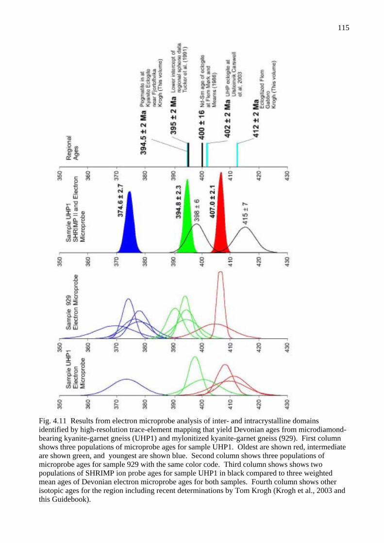
115
Fig. 4.11 Results from electron microprobe analysis of inter- and intracrystalline domainsidentified by high-resolution trace-element mapping that yield Devonian ages from microdiamond-bearing kyanite-garnet gneiss (UHP1) and mylonitized kyanite-garnet gneiss (929). First columnshows three populations of microprobe ages for sample UHP1. Oldest are shown red, intermediateare shown green, and youngest are shown blue. Second column shows three populations of microprobe ages for sample 929 with the same color code. Third column shows shows two populations of SHRIMP ion probe ages for sample UHP1 in black compared to three weighted mean ages of Devonian electron microprobe ages for both samples. Fourth column shows other isotopic ages for the region including recent determinations by Tom Krogh (Krogh et al., 2003 and this Guidebook).

116

117
DAY 5: OTRØY: THE UGELVIK AND RAUDHAUGENE GARNET PERIDOTITE BODIES AND “COUNTRY-ROCK” ORTHOPYROXENE-BEARING ECLOGITE LENSES
AT RAKNESTANGEN AND MAGERØYSUNDET
by Tony Carswell and Herman van Roermund with additional notes on STOP 5-13 by Peter Robinson
From Midsund take Route 668 around the northern side of Otrøy towards Solholmen ferry and Molde. On reaching the small village of Ugelvik, after about 3 km, park the vehicles in the church car park to the right of the road. Cross the main road and take the small side road towards the harbour until reaching the small harbour quarry in the very obvious, yellow-brown weathering, peridotite body.
STOPS 5-1 to 5-7: See Figure 5.1 for stop locations reached by walking from Stop 5-1.
STOP 5-1: Ugelvik Harbour QuarryThis locality displays NE-dipping, layered and foliated garnet peridotite that is typical of much
of the two large peridotite bodies exposed in this part of Otrøy. The layering is defined both by the variable garnet content and by discrete garnet pyroxenite layers that are mostly >1cm thick. However, as well seen on the top surfaces of the outcrops on the southern side of this small quarry, some garnet pyroxenite layers are sheared out to only mm thickness, sometimes literally to only single crystal thickness. These surface garnet pyroxenite smears display an obvious mineral orientation lineation that plunges 30-40o to the N.
Scattered larger purple red, Cr-pyrope, garnets in the peridotite here are up to 2 cm size but are heavily fractured. They not uncommonly contain inclusions of bright green Cr-diopside, less commonly also of orthopyroxene and olivine. Garnets commonly show the initiation of a replacement corona of kelyphite (a fine-grained intergrowth of secondary pyroxenes and Cr-spinel). Later stage secondary dark green amphibole and pale purple-grey Cr chlorite are conspicuous on a set of S-dipping fracture surfaces, whereas a later set of near-vertical joint surfaces is lined with serpentine.
Garnet peridotite in this quarry passes to the NE into garnet-free dunite, as can be seen in the blocks up above the quarry close to the outcrop of the spectacular exsolved garnet pyroxenite lens within the garnet peridotite that was first reported by Carswell (1973). (Please note that field excursion participants will be escorted in small groups to see and photograph but not sample this lens, during which time other participants should keep well away from the back face of the quarry for fear of falling dislodged rocks).
It is considered that this remarkably fresh garnet pyroxenite probably occupies a deformation-sculptured, lensoid pod of roughly 90 x 60 x 30 cm dimensions with its long axis plunging ca. 30oNand its short axis perpendicular to the NE-dipping foliation in the adjacent peridotite.
Carswell (1973) recognised this garnet pyroxenite pod to comprise mostly deformed sub-grains of original, high-temperature, megacrystic orthopyroxene that has exsolved extensively both clinopyroxene and garnet. Whilst much of the exsolved clinopyroxene forms rational lamellae //(100) in the host orthopyroxene, most of the exsolved garnet occupies a vein network along the orthopyroxene sub-grain boundaries. Carswell (1973) considered that some scarce larger garnet grains (up to 5mm size) within the pod might not be of exsolution origin and surmised that the original orthopyroxene (with ca. 4 wt.% Al2O3 and 2 wt.% CaO) may have crystallised on the peridotite solidus together with primary garnet and olivine at ca. 1500-1600oC and 3.5-4.0 GPa. More recent samples extracted from this pod have confirmed that the coarse deformed and exsolved orthopyroxenite part grades within the confines of this lensoid pod into a garnet peridotite with increasing content of olivine that contains primary garnet grains of up to 1cm size.
van Roermund et al (2000) have recognised that megacrysts of the earliest garnet in the Ugelvik peridotite body show evidence of pyroxene exsolution and accordingly had an original majoritic composition. The volume percentage of exsolved pyroxene from garnet was calculated

118
from back-scattered electron micrographs in conjunction with image-analysing software. Results indicated a maximum of 1 vol. % for intra-crystalline pyroxene exsolution and 3.6 vol. % for inter-crystalline pyroxene exsolution, indicating 3.6-4.0 vol.% in total and corresponding at high T to pressures of 6.0-6.5 GPa. However, such pressures and such a garnet composition are hard to reconcile with coexistence with an orthopyroxene with ca. 4 wt.% Al2O3 and 2 wt.% CaO. Given the uncertainties that should be attached to the composition estimates for the primary garnet and orthopyroxene, depending on whether or not all inter-crystalline grains are aggregated together with intra-crystalline exsolution products in determining the original compositions, a possible reconciliation could be the original coexistence of a majoritic garnet with ca. 1% pyroxene component with orthopyroxene that had about 3-4 wt.% Al2O3 and 2 wt.% CaO at conditions of ca. 1350-1500°C and 3.5-4.5 GPa.
By analogy with the old ages obtained for the earliest garnet-bearing clast assemblages in other orogenic bodies in the WGR, it is considered likely the early megacrystal assemblage in the Ugelvik peridotite body formed within a Proterozoic mantle diapir whereas the exsolved and recrystallised assemblages within the same bodies formed during extensive Caledonian tectonic reworking at conditions of ca. 750-850oC and 3.5-4.0 GPa (Jamtveit et al, 1991, Brueckner et al, 2002).
STOP 5-2: Ugelvik Harbour Eastern Shoreline- opposite pleasure boat jettyHere at the rope anchorage, there is a ca. 4.5m length exposure of garnet websterite that forms
the core of a near horizontal axis fold within the garnet peridotite. Further tight isoclinal folds in the adjacent peridotite plunge ca. 10o to 340o. This garnet websterite, in common with that forming rather more conspicuous layers within the Raudhaugene peridotite body, has a distinctly porphyroclastic texture. Garnet clasts of up to 3-5 mm size, may display fine-scale pyroxene lamellae in cores, show recrystallisation to smaller neoblasts at margins and are set in a recrystallised granoblastic matrix of fine-grained (0.1-0.3 mm) clino- and orthopyroxene. There is also some conspicuous growth of late amphibole grains of darker green colour than the clinopyroxene.
STOP 5-3: Ugelvik Harbour Eastern Shoreline- opposite outer harbour wall Outcrops here, ca. 130 meters N of the last locality and close to the end of the rough road to
the shore, display peridotite with conspicuously large (1-5 cm) garnets. Most are heavily fractured and hence weathered out as hollows in the rock. They also show breakdown to clots of Cr-chlorite along steep SW-dipping joint surfaces.
STOP 5-4: Ugelvik Eastern ShorelineHere, about 150 meters further north along this shoreline, are more outcrops of peridotite
containing some conspicuously large garnets. The largest is of ca. 12 x 6 cm dimensions but is highly fractured and only exposed at low tide. Nearby peridotite contains other garnets of 3-6 cm size including one reasonably solid garnet megacryst of 6 x 4 cm dimensions.
STOP 5-5: Ugelvik Eastern Shoreline- on peridotite point into the bayHere, on the point just a few meters N of the last locality, there is a sheared out distinctly
porphyroclastic and sugary textured garnet pyroxenite layer (1-3 cm thick) with a strong mineral orientation lineation that plunges shallowly to the N. It is enclosed within peridotite with mostly small garnets that passes just to the N into a garnet-free dunite.
STOP 5-6: Ugelvik Eastern Shoreline- northernmost peridotite outcropHere there is a conspicuous, sheared out, porphyroclastic textured, garnet websterite layer with
some distinctly garnet-rich internal layers. Such near-monomineralic layering, as also seen in certain other garnet pyroxenite occurrences within the Ugelvik and Raudhaugene peridotite bodies, may signify that such predominantly fine-grained garnet pyroxenites may be the product of shear deformation, tectonic attenuation and re-crystallisation of original megacrystic garnet plus

119
pyroxenes concentrations within these peridotites, as seen for example in the coarse garnet-bearing orthopyroxene lens at the Ugelvik harbour quarry locality. Interestingly, this particular garnet websterite occurrence is enclosed within peridotite that not only contains scattered large garnets but also some sizeable clasts of early orthopyroxenes. The extent of deformation-induced recrystallisation and of late-stage serpentinisation means that it is hard to find relict early coarse-grained olivines. Nonetheless it is considered likely that a megacrystic garnet + orthopyroxene + clinopyroxene + olivine assemblage was originally widespread within these peridotite bodies. Such a deduction, together with microstructural observations within the dominant peridotites of garnet clasts with recrystallised trails of new finer-grained garnet and of the predominance of layering-parallel mosaic-porphyroclastic and mylonitic microfabrics, signify that the overall very conspicuous mineralogical layering within these peridotite bodies is essentially the product of shear deformation that was initiated under eclogite-facies conditions but continued during exhumation under amphibolite-facies conditions.
STOP 5-7: Ugelvik – Rødberg ByggmarkedThe owner of this builders merchant warehouse (Harry Rødberg) has excavated some
remarkable large Cr-pyrope garnet megacrysts from the underlying peridotite during the preparation of foundations for the adjacent new house. With special permission some specimen samples may be examined and photographed on the garden wall to the house. These solid garnet megacryst fragments, with dimensions up to 9 x 8 x 6 cm, are said to have been extracted from a layer of coarse garnet about 2 meters long. Importantly some samples demonstrate the coexistence of this early megacrystic garnet with olivine, clinopyroxene and orthopyroxene and that the latter locally displays evidence of internal exsolution of later garnet and clinopyroxene, so confirming the important deductions made for the exsolved megacrystal orthopyroxenite pod in the Ugelvik harbour quarry.
Return to the vehicles parked just off Route 668. Turn right onto Route 668 and drive northeast about 1 km passing the turn off for the road to Magerøya. Just past the small fire station turn left along a small track and park in the small disused peridotite quarry.
STOPS 5-8 to 5-11: See Figure 5.2 for locations within the easterly peridotite body at Raudhaugene that are reached by walking from the small quarry .
STOP 5-8: Raudhaugene peridotite body – folded garnet pyroxenite layers This locality is in outcrops that are roughly 50 meters to the NW and above the quarry. Here
some excellent tightly folded garnet pyroxenite layers are displayed that show tight cuspate closures in the pyroxenite in comparison with more rounded closures in the adjacent peridotite. This rather surprisingly suggests that the more garnet- and pyroxene-rich layers were mechanically weaker than the enclosing peridotite. Is this a grain-size effect, with the finer grain size of the garnet pyroxenite resulting in it being mechanically weaker than the enclosing coarse-grained peridotite?Alternatively, does it signify deformation at very high temperatures when garnet may perhaps become mechanically weaker than olivine?
Another interesting feature is that these fold structures have much steeper plunges than seen in the Ugelvik peridotite body and also in the dominant folds and lineations seen in the gneisses adjacent to the peridotite bodies.
STOP 5-9: Raudhaugene peridotite body – on K2 peridotite “peak" Walk northwestwards from the last locality on to the highest peridotite outcrop, the so-called
K2 peak. Here there are excellent outcrops of peridotite with quite large Cr-pyrope garnets available to sample. There are also further obvious folds and some distinct garnet pyroxenite layers.
STOP 5-10: Raudhaugene peridotite body – darker, more Fe-rich, peridotites

120
Just to the N of K2 there are distinctive outcrops of a darker weathering, more Fe-rich, peridotite, containing dark green/black garnets, that is interlayered with the more usual paler-weathering peridotite containing the usual purple-coloured garnets. Whereas the latter garnets (including the megacrystic majoritic garnets) customarily contain about 4-6 wt.% CaO and 2-4 wt.% Cr2O3, as is typical of garnets equilibrated with lherzolite assemblages (see Fig.11 in van Roermund et al, 2001), the dark green/black garnets mostly have much higher contents of both CaO (as high as 12 wt%) and Cr2O3 (up to almost 7 wt.%) probably indicative of the fact that they equilibrated as part of an orthopyroxene-free wehrlite assemblage.
Whilst proto-mylonitic, mosaic-porphyroclastic textures are widespread throughout the Ugelvik and Raudhaugene peridotite bodies (most conspicuously in the garnet pyroxenite layers), in places this darker-weathering peridotite displays an extreme ultra-mylonitic fabric in which the larger dark green garnets are smeared out into stringers of recrystallised, lower Cr, garnet coexisting with Cr-spinel.
STOP 5-11: Raudhaugene peridotite body – multiple garnet pyroxenite layersThe peridotite in the most northwesterly oucrops in this body, about 80 meters to the WNW of
the last locality, displays numerous garnet pyroxenite layers up to 8 cm in width. Some layers are essentially of bimineralic garnet clinopyroxenite whereas others are of garnet websterite although the orthopyroxene has often suffered extensive secondary hydration. The garnet pyroxenite layers typically have markedly porphyroclastic textures and contain garnet clasts that commonly contain lamellae of both clinopyroxene and finer-scale rutile.
Some of the conspicuous garnet pyroxenite layers within the Raudhaugene body show an Fe-enrichment trend relative to the enclosing peridotites and thus may represent the crystallisation products of more evolved magmatic melts. However, others lack Fe-enrichment trends and may show internal near-monomineralic layering, and thus seem best interpreted as the shear deformation products of original localised concentrations of the primary garnets and pyroxenes present in these peridotite bodies. Such garnet pyroxenite layers are thus most likely to be of tectono-metamorphic origin and to correspond to the extensively recrystallised products of original concentrations of megacrystic garnet and pyroxenes, as suggested in the interpretation of the garnet websterite occurrence at Stop 5-6 in the Ugelvik peridotite body.
The conspicuous garnet pyroxenite layers within the serpentine-veined peridotite at this locality can be followed along strike within further peridotite outcrops to the east.
Depending on time and interests, the group may decide to visit exposures of quartzo-feldspathic, amphibolite-facies gneisses in outcrops along the northern margin of this peridotite body. Here it can be seen that the strong sub-mylonitic foliation in these gneisses is effectively concordant with any obvious mineral orientation fabric in the immediately adjacent peridotites and with the orientation of the tectonically thinned and attenuated garnet pyroxenite layers with their conspicuous porphyroclastic fabrics. Although the youngest penetrative fabrics within the peridotite bodies still commonly retain clasts of earlier eclogite-facies minerals (most notably of garnets) they nonetheless deform and streak out the granulite-facies kelyphitic and amphibolite-facies coronitic breakdown assemblages from earlier garnet and accordingly as in the adjacent gneisses are associated with the growth of an amphibolite-facies assemblage. Hence indications are that the peridotite bodies and their enclosing gneisses were deformed together during the latest, amphibolite-facies, penetrative deformation. It is also worth noting that the outcrops of the Raudhaugene peridotite body extend inland to the SW of the marine inlet/lake of Innafor Straumen, thereby almost providing a visible link in poorly exposed boggy ground with the eastern extension of the Ugelvik peridotite body. It is thus quite feasible that the two peridotite bodies are actually linked at depth and that together they form a tight synformal structure with a westerly plunge.
The party should then cut back south across the higher peridotite outcrops to join a track on the other side of the Raudhaugene body and then return to the vehicles parked in the quarry. At this point a further short detour can, time permitting, be made to examine a large roadside cutting about 200 meters back towards Ugelvik. This exposes a ca. 45-meter-wide “country-rock” eclogite body that has been extensively retrograded and recrystallised into what is now primarily a garnet granulite

121
with extensive growth of secondary plagioclase and augitic clinopyroxene. However, the original eclogitic character of this large mafic body is indicated by preserved inclusions of omphacitic clinopyroxene within some of the larger garnet grains.
Leave the small quarry and return to Route 668. Turn left and then in about 300 meters left again off the main road and along the minor road running north to Raknes and Raknestangen. After about 3 km turn right at the Raknestangen “crossroads” and drive northeastwards for about 750 meters to park at the end of the road at Båtnesbukta just to the south of Kjelsvika.
STOP 5-12: Outcrops of “country-rock” eclogites and Fe-Ti type garnet peridotite along the Kjelsvika-Raknestangen shore section on northern Otrøy.
From the car park follow the shoreline outcrops northwards around the small headland of Båtneset to the southern side of Kjelsvika bay. On this headland note the spectacular shear zone with platy mylonitic quartzo-feldspathic gneisses -partly eroded out by the sea. Proceeding westwards there are numerous variably-sized and variably-preserved eclogite pods along this well-exposed shore section enclosed in strongly foliated migmatitic gneisses. Most eclogite pods have been heavily retrograded to garnet granulite or even further to amphibolite. However, some pods preserve relicts of early eclogite-facies layering that in some instances can be seen to be discordant and oblique to the external amphibolite-facies wrapping fabric. One eclogite pod of ca. 1.5 x 2.5 meters dimensions preserves good omphacite in patches and also contains minor orthopyroxene and phlogopitic mica.
Proceed around the back of Kjelsvika beach and follow a suitable route across the Kjelsvikhammaren headland on to the most northerly shoreline exposures at Raknestangen.
Here there are several large mafic pods enclosed in the strongly foliated amphibolite-facies quartzo-feldspathic gneisses. These pods preserve patches of eclogite but have commonly been extensively retrograded to a plagioclase-bearing garnet granulite. To the west of the small bay of Stokkvika and on the eastern side of the next, unnamed, small coastal inlet there is a distinctive layered, mostly brown weathering, garnet and clinopyroxene-bearing mafic pod of ca. 4 x 8 meters dimensions. The brown-coloured layers contain abundant orthopyroxene and also in some instances minor olivine. This is the locality of the Raknestangen garnet peridotite sample first documented by Carswell et al (1983). This mafic pod accordingly displays an interlayering of garnet peridotite, garnet websterite and bimineralic eclogite. The pod is heavily retrograded to amphibolite at its margins as well as along networks of cross-cutting veins along which there has clearly been late ingress of hydrous fluids. Carswell et al (1983) characterised this type of garnet peridotite, like that in the larger layered eclogite-garnet peridotite body at Eiksunddal on Hareidland (mentioned but not visited in the Day 1 itinerary), as being of crustal derivation Fe-Ti type in contrast with the mantle-derived Mg-Cr type garnet peridotites, as occur in the Ugelvik and Raudhaugene bodies. Orthopyroxenes in samples of both garnet peridotites and orthopyroxene-bearing eclogites from this Raknestangen pod have Al2O3 contents that vary from as low as 0.49 wt% (mostly individual point analyses are in the 0.5-0.7 wt% range) in grain cores to as high as 2.5 wt% (more commonly in the 1-2 wt% range) for grain margins. Recalculated P-T estimates for the grain core assemblages, now recognised as mostly likely to be representative of the Pmax assemblages, mostly yield values that are consistent (or nearly consistent) with coesite stability and best temperature estimates are mostly in the 750-800oC range. Sample U125 of the Fe-Ti-type garnet peridotite at Raknestangen in fact yields a pressure of ca. 3.2 GPa, well within the coesite stability field, at a best temperature estimate of ca. 750oC, if the lowest measured Al2O3 content for orthopyroxene grain cores is used. On this basis we conclude that it is likely that the ‘country-rock’ eclogites at least in this northern part of Otrøy formed at pressures within the coesite stability field as also on the island of Fjørtoft further out to the west. However, to date no confirmed discoveries of relict coesite or even of convincing poly-crystalline quartz pseudomorphs after coesite have been observed in samples of the innumerable pods of eclogite sampled on the islands of Otrøy and Midøy. We take the reason for

122
this to be the high temperatures maintained during the early stages of the exhumation of these eclogites as shown by their widespread observed overprinting by granulite-facies assemblages.
Return to the parked vehicles using a suitable route inland of Kjelsvika beach. Retrace the vehicle route back through Raknes hamlet to the main Route 668. Turn right back towards Ugelvik but just before that village turn right along the side road to Magerøya. Drive north on this narrow Magerøya road for several kilometers until reaching a large quarry on the right, which is at the south end of the causeway to Magerøya.
STOP 5-13: Pod of coarse orthopyroxene eclogite in basement augen gneiss at Magerøysundet quarry.
This small eclogite pod consists of very coarse omphacite, garnet, orthopyroxene and phlogopitic-mica, enclosed in granitoid gneiss, and, similarly to several other orthopyroxene eclogites in the region, lacks a free silica phase (Carswell et al, 1985). The quarry also contains blasted fragments of other eclogite variants.
Electron microprobe data for a sample of this orthopyroxene eclogite are provided in a 2003 MSc thesis by D.F. Wiggers de Vries, University of Utrecht, Netherlands. Her data show that the Al2O3 contents in the cores of orthopyroxene grains are low (0.73 wt. % or slightly higher) and are, as with the Raknestangen samples, consistent with pressures within the coesite stability field. Al2O3contents at orthopyroxene grain margins are again distinctly higher at 1-1.5 wt.%.
For persons interested in structural geology walk back (south) about 100 meters to the high road cut on the east of the road and a coastal exposure west of the road. In these two places one can see evidence of early fold systems and related lineations deformed about a subhorizontal transport direction associated with late Scandian top-west shear deformation. In the road cut it can be seen that the transport direction lies at a very low angle to the older fold and lineation direction. In the coastal outcrop there is a large south-facing foliation surface where one can see early lineation that has been folded by nearly 180 degrees by deformation within the foliation plane.
Return south to the main Route 668 and then turn right and drive the ca. 3 km back to Midsund.

123
Fig. 5.1 Detailed map of western part of Ugelvik peridotite body with key to Stops 5-1 through 5-7.

124
Fig. 5.2 Detailed map of Raudhaugene peridotite body with key to Stops 5-8 through 5-11.

125
Day 6 : GEOLOGY FROM NORDØYANE-MIDSUND TO TRONDHEIM
Thursday July 3 for Groups A and B
by Peter Robinson, Tom Krogh and Tony Carswell
General Route: Those in Group B flying from Ålesund airport on this day will take the fast boat from Lepsøya at 7:00 A. M. and will not be involved further in Day 6. From Lepsøya to the Molde area there are two routes 6a) and 6b) for Group B. Group A will travel part of route 6a) to the vicinity of Molde where participants may be left off at Molde airport. From Molde vicinity there are two routes to Trondheim, 6c) and 6d). The combination of routes 6a) and 6c) is emphasized and provides the most geology and new geochronology as well as the scenic "Atlantic Highway". Route 6d) is an alternative that provides more tunnels and more mountain and fiord scenery. Different vehicles could go on different routes depending on needs.
6a) Ferry Lepsøya to Skjeltene: 7:20-7:40, 8:00-8:40 (this ferry will require telephoning ahead to Brattvåg because driving time and gap between ferries is exactly 10 minutes!) .
6a) Ferry Brattvåg to Dryna: 8:50-9:15, 9:35-9:55. Non-stop driving time Dryna to Solholmen is 35 minutes. With all of Stops 6-1 to 6-4, the stop time is 80 minutes and driving time is 44 minutes giving a total of 2:04. This requires careful planning to arrive at Solholmen terminal on time. Stop 6-5 is at Solholmen ferry terminal and requires 10 minutes or less..
6a) Ferry Solholmen to Mordalsvågen: 9:45-10:00, 10:45-11:00, 11:15-11:30, 11:45-12:00.Driving time from Mordalsvågen to Årø Airport is about 30 minutes.
6b) Ferry Lepsøya to Skjeltene: 7:20-7:40, 8:00-8:40, 9:50-10:10. Driving time Skjeltene to Vestnes is about 1:15
6b) Ferry Vestnes to Molde: 10:00-10:35, 10:30-11:05, 11:00-11:35, 11:30-12:05. This is a classic ferry ride with great views of islands and mountains south of Molde. Driving time Molde ferry terminal to Årø Airport is about 15 minutes.
6c) Ferry Kanestraum to Halsa: (20 minute crossing): 13:00, 13:30, 14:00, 14:30: 15:10, 15:30, 16:00, 16:30, 17:00, 17:30, 18:00, 18:30.
6d) Ferry Rykkjem to Kvanne: (10 minute crossing) 13:15, 14:15, 14:45, 15:15, 15:45, 16:15, 16:45, 17:15, 17:45.
FIELD TRIP LOG FOR ROUTE 6a - LEPSØYA-DRYNA-SOLHOLMEN
Route 6a is concerned with tectono-stratigraphic, structural, and metamorphic features on the islands of Midsund Kommune not covered on Day 5. There will be two stops in eclogite-free basement and Blåhø Nappe rocks along the south coast, and three stops in eclogite-bearing rocks in the central and northern parts not visited on Day 5. Assuming arrival at Dryna ferry terminal at 9:15 (see schedule above) and normal travel (44 min.) and stop time (80 min.) on Midsund, trip should arrive on mainland at Mordalsvågen not later than 12:00. For stop locations see Figs. 1.5, 3.1.
Carswell was attracted to the Islands of Midsund by the occurrence of garnet perioditite at Ugelvik, and he, students and associates conducted extensive studies of these and the surrounding gneisses and included eclogites (Carswell 1973, 1986; Carswell and Griffin, 1985; Carswell et al., 1983, 1985). The gneisses were generally subdivided into paragneisses of presumed sedimentary and volcanic derivation and orthogneisses including ordinary granitoid gneisses and augen orthogneisses believed to be derived from rapakivi granites, for which a protolith age of about 1500 Ma was obtained (Carswell and Harvey, 1985; Tucker et al., 1990). All of these rocks with the exception of eclogites possibly derived from diabase dikes, were considered part of the mid-Proterozoic Fennoscandian basement. Robinson, based on his interpretation of the tectonostratigraphy of the Moldefjord syncline (1995c) began to suspect that extensive tracts of the paragneisses of Midsund were similar if not identical to rocks of the Blåhø Nappe, representing remanents of infolded Caledonide nappes preserved in tight synclinal infolds. This interpretation

126
was supported by scarce remanents of the underlying Sætra Nappe on Lepsøya (Stop 2-8) and on Midsund by very common occurrences of thin marble, calcsilicate and minor quartzite at contacts between Blåhø rocks and Proterozoic basement (Robinson 1995a). This concept is the basis for a current wave of remapping on the islands of Midsund and Aukra Kommunes (island of Gossa), unfortunately slowed by the necessity for very fine weather to trace units across the mountains of Midsund.
The many infolds of Blåhø rocks occur in the southern and middle parts of Midsund, whereas the northern part, which hosts the Ugelvik and Raudhaugene garnet peridotites, seems to consist entirely of Proterozoic basement. Along the southern coasts, in a region of abundant mafic rocks, there is no evidence for the presence or former presence of eclogites either in the Blåhø rocks or adjacent basement, thus indicating a close parallel with the central structural segment of Nordøyane (Stop 2-8). By contrast, in the middle and northern parts of Midsund eclogites are abundant in the basement, and there is at least one occurrence of eclogite in Blåhø rocks in the middle part. Thus, the middle part of Midsund has a metamorphic parallel with the southern structural segment of Nordøyane and its extension into northern Vigra (Stop 2-10). At present we have no clear image of the overall geometric and metamorphic evolution that brought the three structural segments of Nordøyane or the southern, middle, and northern parts of Nordøyane into their present positions.Obtaining a geometric understanding will not be easy, in part because extensive parts of critical contacts are either underwater around the islands, or in thick forests inland. What we do understand is that all parts were subjected to the same constrictional strain under top-west and sinistral shear during exhumation through upper to lower amphibolite-facies conditions.
Depart Lepsøya Misjonsenter for Kjerstad ferry terminal. Drive onto ferry for Skjeltene. Leave ferry at Skjeltene. Turn left on Route 659 toward Brattvåg. After 11.9 km on Route 659
turn left (north) for Brattvåg ferry terminal (to Dryna). Depending on available time,.en route, we may visit Stop 2-11, 2-12, or 2-13 or study rocks of the Blåho Nappe and Risberget Nappe at the terminal. Drive onto ferry for Dryna.
Drive off ferry at Dryna and proceed east along main road. Turn out at bend within sight of small bridge to Midøya for STOP 6-1. Walk back short distance to coastal exposure on southeast side of road.
STOP 6-1: (15 minutes) Contact of Blåhø Nappe and "Sausage Rock" Basement."Sausage rock" (Norwegian= pølsestein) is an informally named rock unit that dominates the
south coasts of Dryna, Midøya and western Otrøy. Fairly similar rock is also known in the central segment of Nordøyane (Stop 2-8). It consists of thinly laminated, highly foliated granitoid gneiss with thick and thin highly boudinaged layers of even-grained, locally porphyritic hornblende amphibolite. Because of the very high ductility contrast between enclosing gneiss and amphibolite, the amphibolite deformed into complex sausage shapes parallel to the late Scandian extensional lineation. When viewed in vertical outcrops cut normal to the lineation, the pattern is commonly chaotic, and contrasts sharply with the "straight" fabric observed in adjacent belts of schist and amphibolite of the Blåhø Nappe. When viewed on horizontal surfaces perpendicular to foliation and parallel to lineation, the boudins commonly show "bookshelf" style boudinage indicating late sinistral shear. There is abundant evidence that the mafic layers were invaded locally by late felsic melts presumably derived from the felsic matrix.
The purpose of this stop is to examine contact relations on both sides of a narrow belt of sausage rock that extends the entire length of Dryna. The first coastal exposure shows the south contact of this belt with mica schist and amphibolite assigned to the Blåhø Nappe. The contact zone, 1 m thick, is characterized by a thin bed of marble and diopside calc-silicate and also feldspathic schist zones that are unusually quartz-rich. The majority of well exposed contract zones on Midsund contain such marble and calc-silicate layers. The rusty-weathering schist several meters into the Blåhø Nappe is rich in gedrite, suggesting it is likely to be a metamorphosed hydrothermally altered mafic volcanic rock. Gedrite rocks have been found in similar locations on Otrøy as well as on Lepsøya (see Stop 3-8).

127
After observing this exposure walk north on the road past vehicles to another pavement of sausage rock which also lies on the coast just before the bus stop. From the pavement walk along the west side of a knob close to the road to a small northwest-facing outcrop at the water line which is beyond the bus stop. Here there is a thin layer of marble and calc-silicate which is on the north contact of the belt of sausage rock. The marble occurs in a steep groove on the facing cliff of Middøya about 50m away, showing that there is no appreciable horizontal fault offset in the narrow gut between the islands.
Drivers will pick up participants near the bus stop.
Leave Stop 6-1. Cross Dryna-Middøya bridge. Large road cut showing pegmatites in Blåhø mica schist / amphibolite. From the western part of Middøya there is a view ahead of huge cliffs which are mostly biotite schist and amphibolite of the Blåhø Nappe with pegmatite. There appear to be a few thin layers of basement gneiss. There is a view to left of Drynasund lighthouse resting on gabbro with eclogite-facies shear zones (Griffin and Råheim, 1973).
Reach junction after 1.5 km on Middøya and turn left toward Midsund. Travel beneath the large cliffs on the right. On the coast south of here the mica schist contains kyanite, amphibolite contains garnet-clinopyroxene-rutile assemblages with hornblende-plagioclase pseudomorphs after garnet, and there is minor eclogite. Beyond the cliffs there is a view of Litle Digerneset to southwest. Here, Griffin and Carswell (1985) found eclogite-facies assemblages in both mafic rocks and in original igneous "back veins" of melted country rock. Dominant pink rocks are augen orthogneiss of Carswell and Harvey (1985) dated at 1506 ±22 Ma by whole rock Rb-Sr, and more recently at 1508 by Tucker et al. (1990) using U-Pb zircon.
Note stone wall on left with sign "Riksgrense". This was the E-W international border between Sweden to the north and Denmark/Norway to the south between 1658 and 1660. The next junction is the turn off to Vølen. Stay on 668 at north corner of Middøya and follow south toward Midsund. At next junction for Ramsvik turn left toward Midsund. Cross bridge to Otrøy.
Major junction on steep corner in Midsund. Turn sharp right toward Heggdal and Stop 6-2. At big curve in road note cuts in Blåhø mica schist and cross-cutting but strongly deformed Scandian pegmatites. Pass a sharp bend near the southwest corner of Otrøy and proceed a short distance east along the south coast. Pull over at large parking place on right with broad view. Climb down through rocks, including Blåhø mica schist and pegmatite and heather to coast and walk west a short distance on continuous outcrop.
STOP 6-2: (35 minutes) "Sausage rock" basement gneiss intruded by mafic dikes, now amphibolite.
The purpose of this stop is to show some very fine contact relations in a coastal pavement between strongly foliated pink basement gneiss and amphibolite. The outcrops give convincing evidence that the amphibolites are dikes cutting a previously highly deformed gneiss. The dikes may be the same as those intruding the quartzites of the Sætra Nappe, and, if so, are Late Proterozoic. It is hoped to test this hypothesis with major- and trace-element analyses of dike samples. If correct then the basement may be that of the Sætra Nappe itself and not directly related to the adjacent basement of the Western Gneiss Region. The dikes clearly truncate a strong deformational and metamorphic fabric, the age of which is quite uncertain, but presumably mid- to early Proterozoic. The scarcity, but not total absence of garnets in these dikes suggests, but does not prove, that they never went through eclogite facies, unlike the amphibolites of the Sætra Nappe on the south shore of the fjord (see Stops 3-4, 3-5, 3-6, 3-7) as well as the basement to the north. In fact, no bonafide eclogites have been identified in any unit on the south coast of Midsund, although very fresh eclogites are well known only 1-2 km to the north (see Stops 6-3, 5-11, 5-12 and 6-5).
Leave Stop 6-2. Return toward Midsund. At junction with Route 668 stay straight (north and east) on 668. Note sign for Midsund Bruk after 1.2 km. Turn left and drive to factory on coast for Stop 6-3. Park in front of factory office and walk to south facing artificial exposure on north side of factory.

128
STOP 6-3: (10 minutes) Very fresh eclogite within big heavily amphibolitized body.This represents a very easy opportunity to collect very fresh eclogite in which the omphacite
shows very minor but spectacular plagioclase symplectite and little or no secondary amphibole, provided zones of secondary hydration are avoided. The occurrence illustrates the apparent sharp difference in metamorphism between the south and north coasts of Midsund.
Five zircon fractions of small rounded zircons obtained from a very fresh sample from this outcrop by Tom Krogh define a short line projecting down to 401 and up to 704 +/- 144, but the highest point has a 206/238 age of only 420 Ma. The downward projection is NOT reliable, given the short line and possible discordance. The youngest 207/2066 age is 409 +/- 2, 1 % discordant, hence this could be a minimum age for the eclogite metamorphism..
Leave Stop 6-3 and return toward Route 668. Turn left back onto Route 668, resuming trip toward Solhomen.. After 2.7 km pass the left turn to Ugelvik Quarry which may be seen to the left and which is described under Stop 5-1. Continue east toward Solholmen Ferry and Stops 6-4 and 6-5. After about 14 km road bends around northeast corner of Otrøy and south toward Solholmen. About 1.9 km further, park on right opposite factory road entrance. Examine road cut on right. Time-permitting, a larger blasted exposure can be reached by driving down the factory road to sea level.
STOP 6-4: (10 minutes) Augen orthogneiss. This rock and its highly deformed equivalents, which dominate the exposure on northern
Midsund and part of the Molde peninsula, was studied extensively by Carswell and Harvey (1985). It is interpreted as an early mid-Proterozoic rapakivi granite that can be followed through progressive deformation and recrystallization until it can scarcely be differentiated from other more normal basement gneisses. Carswell and Harvey obtained a Rb-Sr whole rock isochron for these rocks of 1506±22 Ma., and more recently the same rock at Fanghol across Julneset, within sight of this stop, has yielded a U-Pb zircon age of 1508 Ma (Tucker et al., 1990) similar to the U-Pb zircon age obtained on the porphyritic mangerite at Flatraket (see Field Trips at Selje). In practice this basement augen gneiss is usually fine grained and the microcline phenocrysts are flattened and polycrystalline as a result of relatively homogeneous deformation, (Carswell and Harvey, 1985). Within this small road cut it is possible to see nearly every phase of progressive deformation of this porphyritic rock until the phenocrysts are no longer recognizable.
After Stop 6-4 continue south 1.6 km to Solholmen Ferry Terminal. If schedule permits, examine relict eclogite exposed on shore behind no-parking sign on north side of terminal.
STOP 6-5: (15 minutes) Coarse orthopyroxene eclogite with thick amphibolite rim. Most of this eclogite, surrounded by augen orthogneiss, was destroyed during construction of
the ferry terminal, but a small remanent remains. Carswell et al. (1985) completed detailed mineral analyses on this rock and Cuthbert and Carswell (1990) list estimated conditions of formation at 760°C and 18-20 kbar. Several other small eclogites occur several hundred meters south of the ferry terminal, but no eclogites have been found by Robinson anywhere on the south coast of Otrøy and one gabbro shows only very slight garnet coronas. The implication is that there is a major metamorphic break running the length of the islands of Midsund.
On the next point to the north is a narrow belt of amphibolite, schist, calc-silicate and one 20 cm layer buff weathering pure marble. This is interpreted as an infold of the Blåhø Nappe. The same belt is exposed at Mordalvågen ferry terminal and the same buff marble appears in a road cut about 1 km to the east.
After Stop 6-5, drive onto ferry from Solholmen to Mordalvågen. Driving time from Mordalsvågen to Årø Airport is about 30 minutes mainly because it is necessary to pass through the city of Molde. Continuance information is given for routes 6c) and 6d) from Mordalsvågen.
129
FIELD TRIP LOG FOR ROUTE 6b - LEPSØYA-VESTNES-MOLDE
There are no geologic stops on Route 6b. It represents an alternative to Route 6a in case connections between the ferries Lepsøya- Skjeltene and Brattvåg-Dryna are missed in the morning and there is urgent need to get to Molde for air connections.
Depart Lepsøya Misjonsenter for Kjerstad ferry terminal. Drive onto ferry for Skjeltene. Leave ferry at Skjeltene. Turn left on Route 659 toward Brattvåg. After 11.9 km on Route 659
pass entrance for Brattvåg ferry terminal (to Dryna). Depending on available time en route, we may visit Stop 2-11, 2-12, or 2-13 or study rocks of the Blåho Nappe and Risberget Nappe at the terminal. Otherwise continue south through Brattvåg and through mountain tunnel to Vatne junction as described for Day 3. At Vatne junction turn south on Route 661 for 7 km and then take a very sharp left turn toward Skudje. Follow through Skudje and short tunnel beyond, which leads east to junction with Route E39. Follow Route E39 east through Sjoholt and over a mountain pass above timber line to west shore of Tresfjord and then north to Vestnes and ferry terminal. Driving time from Skjeltene is about 1 hour 15 minutes, but waiting lines at Vestnes ferry terminal can be long.
Drive off ferry at Molde and head east out of the city on E39. Driving time from Molde Terminal to Årø Airport is about 15 minutes (see Route 6d for details around Molde)..
FIELD TRIP LOG FOR ROUTE 6c - MORDALSVÅGEN-AVERØYA-TRONDHEIM
There are three significant geologic stops on route 6c, including two with new zircon geochronology by Tom Krogh. The route travels to the north side of Molde Peninsula, through the village of Eide, and over the scenic Atlantic Highway built on a series of islands beside the stormy Hustadvika to Averøya. After viewing the Averøya eclogite and intruding pegmatite and their geochronology (Stops 6-6 and 6-7), we return to Eide and then drive due east along the shore to join Route 39 at Gjemnes and its major suspension bridge. From the bridge we travel east across a chain of large islands, stopping at a major highway exposure of boudinaged eclogite with dated extensional pegmatites (Stop 6-8) at the east end of a large floating bridge. From there we go direct to the Ferry Kanestraum-Halsa. From Halsa it is about 2 1/2 hours of driving to Trondheim, first along a fiord, then over mountains to Orkanger, and finally along another coast road to Trondheim. Assuming arrival at Mordalsvågen at 12:00, the tour to Averøya including Stops 6-6 and 6-7 and on to Gjemnes Bridge is estimated at 2:30, and from there to Kanestraum including Stop 6-8 an additional 37 minutes in plenty of time for the 15:30 ferry. This schedule should bring the group to Trondheim at 18:30-19:00.
If arriving on the mainland at Mordalsvågen ferry terminal, note large road cuts of garnet-biotite schist and amphibolite of Blåhø Nappe on right. After driving 1.4 km east from the terminal (note thin marble on right) turn left (north) on Route 662 toward Hollingsholmen ferry terminal. This highway brings one past the augen orthogneiss outcrop dated by Tucker et al. (1990). Do not turn off for the ferry but continue northeast and then east, eventually joining the main road north from Molde at Malmfjorden. If arriving at Molde by ferry from Vestnes turn east along Route E39 toward Arø airport. Near the airport turn sharp left (north) up main road to Elnesvågen which runs through the mountain ridge in a toll tunnel and join the route from Mordalsvågen at Malmfjorden. Drive north through Malmfjorden for several km to a traffic circle. At the circle take the exit for Eide (do not continue toward Elnesvågen). Follow this route east through open country with views on the left to the Tverrfjell Range composed of retrograded eclogite, mica schist and marble and containing the Trollkjyrka caves. There is also a view of the giant marble quarry at Nås. From Eide follow the main coast road north through Visnes, with its huge marble quarry, and Lyngset, with road cuts in eclogite, to the north coast and the Atlantic Highway. Drive east over bridges, causeways, and islands of the Atlantic Highway until reaching the big wooded island of Averøya. At major T junction on Averøya turn

130
west toward the western end of the island. On a ridge crest in open country as the road bends toward the southwest, drive into a prominent roadside quarry close on the left of the highway.
STOP 6-6 (20 minutes) Layered eclogite in the interior of the Averøya body. The Averøya eclogite, although still not mapped in detail, appears to be about 6 km long and
about 3 km wide. Here and in many places the prominent layering is sub-horizontal. The layers alternate between garnet-, pyroxene- and quartz-rich. In thin section the pyroxenes contain abundant oriented rods either of plagioclase or quartz. Garnets in quartz-rich layers contain coronas that appear to consist of plagioclase and orthopyroxene. Pseudomorphs of coesite have not been identified. Within this large pervasively eclogitized mass there appear to be no textural relicts suggesting the body was once a gabbro. A mafic volcanic protolith seems more likely, and a uniform water content could explain the uniform eclogitization.
Turn left out of quarry and continue southwest then south onto another low ridge. Turn sharp right and drive down hill to old Tuvik ferry wharf.
STOP 6-7 (20 minutes) Coarse pegmatite at contact between Averoya eclogite body and country rock gneisses on the shore.
The pegmatite is exposed in the cut on the right next to the shore and the country rock is exposed at the shore. Pegmatite samples were collected by Arne Råheim on a formal eclogite field trip in 1987 when the party was waiting to take the ferry from Tuvik to the mainland. This ferry has been closed since construction of the Atlantic Highway. A coarse variety of eclogite with garnets up to 1 cm was sampled by Tom Krogh in 1997 (TK97-20) 30 meters north from the pegmatite and 2m up a 3m-high wall. Small 3x8cm pods of probable hornblende and plagioclase occur below the sample site. The resulting U-Pb zircon ages are reported here (and in a Conference Abstract) for the first time. The locality is so-far unique in the Western Gneiss Region, because it is the only location where precise U-Pb zircon ages have been obtained both on eclogite and on a late extensional pegmatite in the same outcrop.
The eclogite is unique in having two stages of metamorphic zircon growth (Fig. 6.1). Three concordant fractions of the older, small rounded grains have a mean 207/206 age of 418 Ma (413,420,422 Ma) and a mean 206/238 age of 415±2 Ma (415, 415 ,415 Ma), and probably formed during initial eclogitization. Tips from two large euhedral grains have a mean 207/206 age of 410 Ma (408, 411 Ma ) with 206/238 ages of 410 and 411 Ma that may date the late growth of hornblende and plagioclase. The precise mean 206/238 age is the best for the eclogitization because none of the five analyses here exhibit discordance and the 207/206 age has a large 2 sigma error of +/- 5 Ma.
The post-eclogite pegmatite (Fig. 6.2) gave 5 concordant analyses with 3 giving a mean 207/206 age of 395.9 and a mean 206/238 age of 395.2 ±1 Ma. These concordant analyses were only obtained after abundant U-rich inclusions in the low U host zircon were successfully avoided using an etch technique. Ten earlier analyses were contaminated to varying degrees by 1500-1600 m.y. inheritance projecting toward a lower intercept of 402 ±1 Ma..
Return by same route across the Atlantic Highway to the village of Eide. Just beyond the center of Eide turn left on highway which leads south across a stream and then west along the south shore of the fiord toward Gjemnes and junction with Route E39. Junction with E39 is at west end of large suspension bridge connecting with Bergsøya. At the east end of the bridge pay toll and then take the exit for Trondheim (do not take tunnel to Kristiansund!). Drive several kilometers on new fast road to the west end of Bergsøya and across the next channel on a floating bridge.At east end of floating bridge turn right into rest area and park by closed kiosk. Walk east with care along the highway into a giant road cut. Total driving/stop time from Gjemnes Bridge to Kanestraum Ferry is 37 minutes including 15 minutes at Stop 6-8.

131
Fig. 6.1 Concordia diagram showing results of U-Pb isotopic measurements on zircons fromAverøya eclogite at Stop 6-7.
Fig. 6.2 Concordia diagram showing results of U-Pb isotopic measurements on zircons fromextensional pegmatite in eclogite at Stop 6-7.

132
STOP 6-8: (15 minutes) Foliated granitic gneiss with a "train wreck" of eclogite boudins. The north wall of the cut shows layered eclogite mainly in section. On the south wall there
are huge foliation surfaces showing the "porpoising" effect of boudinage on the sub-horizontal extensional lineation. Small pegmatites are well developed at some of the boudin neck lines. One of these was collected by Tom Krogh and zircons separated (Sample TK97-15, Figure 6.3). They gave a mean 207/206 age of 395.6 (5 points 0.2, 0.2, 0.9, 1.1, and 0.9 % discordant) identical to the post-eclogite pegmatite at Averøya 26 km to the west. By combining this and the Averøya data, an interval of 14 million years between final zircon growth in Averøya eclogite (410 Ma) and extension-related ductile flow (395.5 Ma) is defined, with first eclogitization at Averøya at least 5 million years earlier.
Leave Stop 6-8 and continue toward Kanestraum. After 5.6 km cross curved Straumsund Bridge and 0.9 km further turn sharp left on E39 toward Trondheim. Kanestraum ferry terminal and kiosk (Excellent polser!!) is 8.6 km further. When appropriate drive onto ferry for Halsa.
Drive off ferry at Halsa. Standard driving time from Halsa to Trondheim is 2.5 hours all on Route E39 except the final 19 km on E6.. There will be two intermediate stops of 10 minutes each. At T-junction in Betna 7.2 km from Halsa turn left toward Trondheim. There is a 10-minute rest stop on Valsøya 18 km further and 1.3 km beyond we cross the curved Valsøy bridge. Beyond this in 13.4 km is the Fylkke boundary of Sør Trondelag on a steep north-facing coast, and a further 12 km brings us to Vinjeora at the end of the fiord. Two km beyond Vinjeora there is a junction with yield sign where a right turn should be made on E39 toward Trondheim. After a further 2.7 km and after crossing a major stream there is a gravel driveway before a white outcrop on the left.
STOP 6-9: (10 minutes) Songa (=Sætra) Nappe of Tucker (1986).This outcrop lies in the extreme southwest part of the Snillfjord 1/50,000 map sheet (Tucker,
preliminary map). It consists of very feldspathic layered quartz-mica gneiss. Is this a metamorphosed sedimentary unit such as a late Proterozoic feldspathic sandstone or is it a foliated igneous rock? The first choice is ultimately favored by most observers, though the rock has only a remote resemblance to the feldspathic quartzites of the Sætra Nappe near Brattvåg.
Leave Stop 6-9 and continue toward Trondheim crossing over a major pass just at timberline. In 40.6 km come to junction at Fannrem with yield sign and very bad visibility. Stay on E39.Drive past Orkanger and east along coast of Trondheimsfjord to its end at Øysand near the mouth of the Gaula River. Oysand was once planned to be the German capital of northern Norway, and is also the location of the quarry from which soapstone was taken to build Trondheim cathedral.. The Klett traffic circle is 4 km east from Øysand where E39 meets E6 for the final 19 km run into Trondheim where participants will be delivered to hotels.
FIELD TRIP LOG FOR ROUTE 6d - MOLDE-SUNNDALSØRA-TRONDHEIM
This route goes east and then southeast from Molde to Eidsvåg then south along the east shore of Sunndalsfjord to its head at Sunndalsøra in the northern geological reaches of Trollheimen . There are many tunnels along the route before and after Sunndalsøra with its huge aluminum smelter and mountains up to 1900 meters with cliffs falling direct to sea level. The route then runs north to Rykkjem where there is a short ferry ride across another fiord to Kvanne. Beyond Kvanne the route follows the deep Surnadal syncline of nappes northwest to Orkdal and then down the river to Orkanger and another shore section to Trondheim. There are possible stops to see a natural outcrop of the structurally inverted ophiolite-hosted Løkken sulfide deposit and weakly metamorphosed pillow lavas associated with it. Driving time from Molde to Trondheim is approximately 4:30.

133
Fig. 6.3 Concordia diagram showing results of U-Pb isotopic measurments on zircons fromextensional pegmatite at Stop 6-8.

134
If arriving on the mainland at Mordalsvågen ferry terminal after 1.4 km turn right (south and then east) toward Molde on Route 662. After 7.6 km turn left onto Molde bypass toward Sunndalsøra. In another 1.4 km join Route E39 on road from Molde ferry terminal, and 0.4 km further stay right on E39. If arriving by ferry from Vestnes turn east out of the terminal and then turn east on Route E39. Follow E39 east along Fannefjord past Årø Airport until E39 turns northeast toward Botnfjordsøra and Kristiansund. Go straight toward Eidsvåg and Sunndalsøra.Following is a complex kaleidoscope of mountain and fiord scenery, eventually leading deeply inland along Sunndalfjord. At Oksendal there is a new deep sea-level tunnel under the mountains, or the old road may be followed to get a spectacular fiord view near a microwave repeater at the high point. At Sunndalsøra turn left by the aluminum plant toward Rykkjem and ferry to Kvanne, which can be reached from Molde in slightly less than 2 hours. While on the ferry to Kvanne (15 minutes) you can see the tail of the Surnadal syncline of Caledonide nappes which has been recumbently folded toward the northwest.
The driving time from Kvanne to Trondheim is about 2.5 hours. After a brief ridge crossing, the route follows the Surna valley near the axis of the syncline to Rindal and then over a pass into South Trondelag Fylkke and the Orkla River valley. A short detour can be made to Løkken to see a natural outcrop of the structurally inverted ophiolite-hosted Løkken strata-bound sulfide deposit and weakly metamorphosed earliest Ordovician pillow lavas associated with it. This deposit was mined continuously for 300 years. A separate map will be furnished to locate these exposures, which cannot be easily described in words. The route follows down the Orkla River to rejoin Route E39 at Fannrem and then toward Orkanger on the coast. Drive past Orkanger and east along coast of Trondheimsfjord to its end at Øysand near the mouth of the Gaula River. Øysand was once planned to be the German capital of northern Norway, and is also the location of the quarry from which soapstone was taken to build Trondheim cathedral.. The Klett traffic circle is 4 km east from Øysand where E39 meets E6 for the final 19 km run over a short hill into Trondheim where participants will be delivered to hotels.

135
REFERENCES
Allen, K. C.,1976, Devonian spores from outer Trondelag. Norsk Geologisk Tidsskrift, 56, 437-448.
Andersen, T. B., 1993, The role of extensional tectonics in the Caledonides of south Norway: Discussion. Journal of Structural Geology, 15, 1379-1380.
Andersen, T. B. and Jamtveit, Bjørn, 1990, Uplift of deep crust during orogenic extensional collapse: A model based on field studies in the Sogn-Sunnfjord region, W. Norway. Tectonics, 9, 1097-1111.
Andréasson, P.-G., Gee, D. G., and Sukotji, S., 1985, Seve eclogites in the Norrbotten Caledonides, Sweden. In: Gee, D. G. and Sturt, B. A., Editors, The Caledonide Orogen - Scandinavia and Related Areas, p. 887-902. John Wiley, London.
Ashwal, L. D., 1993, Anorthosites. Springer-Verlag Berlin Heidelberg, 422pp. Austreim, Håkon, Corfu, Fernando, Bryhni, Inge, and Andersen, T. B.., 2003, The Proterozoic
Hustad complex: a low strain enclave with a key to the history of the Western Gneiss Region of Norway. Precambrian Research 120, 149-175.
Boyd, R. 1983: The Lillevik dyke complex, Narvik: Geochemical and tectonic implications of a probable ophiolite fragment in the Caledonides of the Ofoten region, North Norway. Norsk Geologisk Tidsskrift, 63, 39-55.
Brueckner, H.K., 1977. A crustal origin for eclogites and a mantle origin for garnet peridotites: strontium isotopic evidence from clinopyroxenes. Contributions to Mineralogy and Petrology, 60, 1-15.
Brueckner, H.K., 1998, Sinking intrusion model for the emplacement of garnet-bearing peridotites into continent collision orogens. Geology, 26, 631-634.
Brueckner, H.K., 1999, Sinking intrusion model for the emplacement of garnet-bearing peridotites into continent collision orogens: Reply. Geology, 27, 478.
Brueckner, H.K., and Medaris, G., 2000. A general model for the intrusion and evolution of “mantle” garnet peridotites in high pressure and ultrahigh-pressure metamorphic terranes. Journal of Metamorphic Geology, 18, 123–133.
Brueckner, H.K., Blusztajn, J. and Bakun-Czubarow, N., 1996. Trace element and Sm-Nd ‘age’ zoning in garnets from peridotites of the Caledonian and Variscan Mountains and tectonic implications. Journal of Metamorphic Geology 14, 61-73.
Brueckner, H.K., Carswell, D.A., and Griffin, W.L., 2002. Paleozoic diamonds within a Proterozoic peridotite lens in UHP gneisses of the Norwegian Caledonides. Earth and Planetary Science Letters, 203; 805-816
Bryhni, I. 1989: Status of the supracrustal rocks in the Western Gneiss Region, S Norway. in Gayer R.A. (ed.) The Caledonide Geology of Scandinavia, p. 221-228, Graham & Trotham.
Carswell, D.A., 1968. Possible primary upper mantle peridotite in Norwegian basal gneiss. Lithos, 1, 322-355.
Carswell, D.A., 1973. Garnet pyroxenite lens within Ugelvik layered garnet peridotite. Earth Planetary Science Letters, 20, 347–352.
Carswell, D.A., 1986. The metamorphic evolution of Mg-Cr type Norwegian garnet peridotites. Lithos, 19, 279–297.
Carswell, D. A. and Harvey, M. A., 1985, The intrusive history and tectonometamorphic evolution of the Basal Gneiss Complex in the Moldefjord area, west Norway. In: Gee, D. G. and Sturt, B. A., Editors, The Caledonide Orogen - Scandinavia and Related Areas, p. 843-858. Wiley, Chichester.
Carswell, D.A., Harvey, M.A. and Al-Samman, A., 1983. The petrogenesis of contrasting Fe-Ti and Mg-Cr garnet peridotite types in the high grade gneiss complex of western Norway. Bulletin of Mineralogy, 106, 727-750.
Carswell, D. A., Krogh, E. J., and Griffin, W. L., 1985, Norwegian orthopyroxene eclogites: calculated equilibrium conditions and petrogenetic implications. In: Gee, D. G. and Sturt, B.

136
A., Editors, The Caledonide Orogen - Scandinavia and Related Areas, p. 823-841. Wiley, Chichester.
Carswell, D. A., Tucker. R. D., O'Brien, P. J., amd Krogh, T. E., 2003, Coesite micro-inclusions and the U/Pb age of zircons from the Hareidland Eclogite in the Western Gneiss Region of Norway. Lithos, 67, 181-190.
Cuthbert, S. J. and Carswell, D. A., 1990, Formation and exhumation of medium-temperature eclogites in the Scandinavian Caledonides. In Carswell, D. A., Editor, Eclogite Facies Rocks,Blackie, Glasgow, p. 180-203.
Dobrzhinetskaya, L. F., 1993, Diamantførende gneiser på Fjørtoft i den vestlige gneisregionen, Møre og Romsdal. Unpublished NGU rapport 93.149, 10 pages. Norges geologiske undersøkelse.
Dobrzhinetskaya, L. F, Posukhova, T., Tronnes, R., Korneliussen, A., and Sturt, B., 1993,.A microdiamond from eclogite gneiss area of Norway. 4th International Eclogite Conference, Cosenza, Italy. Terra Nova Abstract Suppl.ement 5, 9.
Dobrzhinetskaya, L. F., Eide, E. A., Larsen, R. B., Sturt, B. A., Trønnes, R. G., Smith, D. C., Taylor, W. R., and Posukhova, T. V., 1995, Microdiamond in high-grade metamorphic rocks of the Western Gneiss Region, Norway. Geology, 23, 597-600.
Drury, M.R., van Roermund, H.L.M., Carswell, D.A., De Smet, J.H., Van den Berg, A.P., and Vlaar, N.J., 2001. Emplacement of deep upper-mantle rocks into cratonic lithosphere by convection and diapiric upwelling. Journal of Petrology, 42, 131–140.
Dunn, S. R., and Medaris, L. G., Jr., 1989, Retrograded eclogites in the Western Gneiss Region, Norway and thermal evolution of a portion of the Scandinavian Caledonides. Lithos 22, 229-245.
Eide, E. A., Haabesland, N. E., Osmundsen, P. T., Kendrick, M. A., Andersen, T. B., and Roberts, D., 2003, 40Ar/39Ar geochronology and indirect dating of continental sedimentary rocks: Late Devonian-Early Carboniferous 'Old Red Sandstone' discovered in outer Trøndelag (abs). Abstracts and Proceedings of the Geological Society of Norway, no. 1, 21.
Engvik, A. K., Austreim, H. and Andersen, T. B., 2000, Structural, mineralogical and petrophysical effects on deep crustal rocks of fluid-limited polymetamorphism, Western Gneiss Region, Norway. Journal of Geological Society (London), 157, 121-134.
Essex, R. M., and Gromet, L. P., 1996, Constraints on the timing of Caledonide thrust stack emplacement from U-Pb metamorphic ages of basement gneiss, Nasafjallet window (66.5 N, 15.5 E), Scandinavian Caledonides. Geological Society of America Abstracts with Programs, 28, 501.
Essex, R. M., Gromet, L. P., Andréasson, P-G., and Albrecht, L., 1997, Early Ordovician U-Pb metamorphic ages of the eclogite-bearing Seve Nappes, northern Scandinavian Caledonides. Journal of Metamorphic Geology 15, 665-676.
Gautneb, H. and Roberts, D., 1989, Geology and petrochemistry of the Smøla-Hitra batholith, Central Norway. Norges GeologiskeUndersøkelse Bulletin, 416, 1-24.
Gee,D.G.and Sturt, B.A.(eds) The Caledonide Orogen-Scandinavia and Related Areas. John Wiley & Sons, Chichester.
Green, D. H. and Mysen, B. O., 1972, Genetic relationship between eclogite and hornblende + plagioclase pegmatite in western Norway. Lithos, 5, 147-161.
Grenne, T., 1989a, Magmatic evolution of the Løkken SSZ ophiolite, Norwegian Caledonides: Relationships between anomalous lavas and high level intrusions. Geological Journal, 24, 251-274.
Grenne, T., 1989b, The feeder-zone to the Løkken ophiolite-hosted massive sulfide deposit and related mineralization in the central Norwegian Caledonides. Economic Geology, 84, 2173-2195.
Griffin, W. L. and Brueckner, H. K., 1980, Caledonian Sm-Nd ages and crustal origin for Norwegian eclogites. Nature, 285, 319-321.

137
Griffin, W.L. and Carswell, D.A. , 1985, In-situ metamorphism of Norwegian eclogites: an example.In: D.G. Gee and B.A. Sturt (Eds.) The Caledonide Orogen-Scandinavia and related areas. Wiley, Chichester. pp. 813-822.
Griffin, W.L. and Heier, K.S., 1973. Petrological implications of some corona structures. Lithos, 6, 315-335.
Griffin, W.L. and Qvale, H., 1985. Superferrian eclogites and the crustal origin of garnet peridotites, Almklovdalen, Norway. In: Gee, D.G.& Sturt, B.A.(eds) The Caledonide Orogen-Scandinavia and Related Areas. John Wiley & Sons. pp.803-812.
Griffin, W. L. and Råheim, A. , 1973, Convergent metamorphism of eclogites and dolerites, Kristiansund area, Norway. Lithos, 6, 21-40.
Griffin, W. L., Austreim, H., Brastad, K., Brynhi, I., Krill, A. G., Krogh, E. J., Mørk, M. B. E., Qvale, H., and Tørudbakken, B., 1985, High-pressure metamorphsim in the Scandinavian Caledonides. In Gee, D. G. and Sturt, B. A., Editors, The Caledonide Orogen - Scandinavia and Related Areas, p. 783-801, John Wiley, London.
Grønlie, G., Mysen, B. O., and Bech, O. M., 1972, Gravity investigation of the Hareidlandet eclogite, western Norway. Norsk Geologisk Tidsskrift, 52, 305--311.
Handke, M. J., Tucker, R. D., and Robinson, Peter, 1995, Contrasting U-Pb Ages for the Risberget Augen Gneiss in the Norwegian Caledonides: Getting to the Root of the Problem. Geological Society of America Abstracts with Programs, 27 p. A-226.
Huric, C.A., Palm, P., Dyrelius, D., Kristoffersen, Y., Wolff, F.C. and Roberts, D. 1988, Activation of Precambrian basement in the Scandinavian Caledonides: View from seismic reflection data. Norges Geologiske Undersøkelse, Special Publication 3, 66-69.
Jamtveit, B., 1987. Metamorphic evolution of the Eiksunddal eclogite complex, western Norway, and some tectonic implications. Contributions to. Mineralogy and Petrology, 95, 82-99.
Jamtveit, B., Carswell, D.A., and Mearns, E.W., 1991. Chronology of the high-pressure metamorphism of Norwegian garnet peridotites/pyroxenites. Journal of Metamorphic Geology, 9, 125–139.
Koistinen, T., Stephens, M.B., Bogatchev, V., Nordgulen, Ø., Wennerström, M., and Korhonen, J., 2001, Geological map of the Fennoscandian shield, Scale 1:2000000. Geological Surveys of Finland, Norway and Sweden and the North-West Department of Natural Resources of Russia.
Krabbendam, M. and Wain, A., 1997, Late-orogenic structures, differential retrogression and structural position of ultrahigh-pressure rocks from the Nordfjord-Stadlandet area of the Western Gneiss Region. Norges Geologiske Undersøkelse Bulletin, 432, 127-139.
Krill. A. G., 1983, Rb-Sr study of rapakivi granite and augen gneiss of the Risberget Nappe, Oppdal, Norway. Norges Geologiske Undersøkelse Bulletin, 380, 51-65.
Krill, A. G., 1987: Berggrunnskart STANGVIK 1420 4, 1:50,000, foreløpig utgave, Norges geologiske undersøkelse.
Krill, A. G., and Röshoff, Kennert, 1981, Basement-cover relationships in the central Scandinavian Caledonides, Excursion B-5, Uppsala Caledonide Symposium.
Krogh, E.J., 1980, Compatible P-T conditions for eclogites and surrounding gneisses in the Kristiansund area, western Norway. Contributions to. Mineralogy and Petrology 75, 387-393.
Krogh, E.J. and Carswell, D.A., 1995. HP and UHP eclogites and garnet peridotites in the Scandinavian Caledonides. In: Coleman R.G. & Wang, X (eds.) Ultrahigh Pressure Metamorphism, Cambridge Univ. Press, pp. 244-298.
Krogh, T. E., Mysen, B.O., and Davies, G. L. 1974, A Paleozoic age for the primary minerals of a Norwegian eclogite. Annual Report Geophysical Laboratory, Carnegie Institution of Washington, 73, 575-576.
Krogh, Tom, Robinson, Peter , and Terry, M. P., 2003, Precise U-Pb zircon ages define 18 and 19 m.y. subduction to uplift intervals in the Averøya-Nordøyane area, Western Gneiss Region. Abstract, Alice Wain Memorial West Norway Eclogite Field Symposium, Selje, Norway.
Langenhorst, Falko, Terry, M. P., and Robinson, Peter, 2003, Microstructure of rutile inclusions in garnet of kyanite-garnet gneiss from Fjørtoft, Western Norway: hints concerning metamorphic
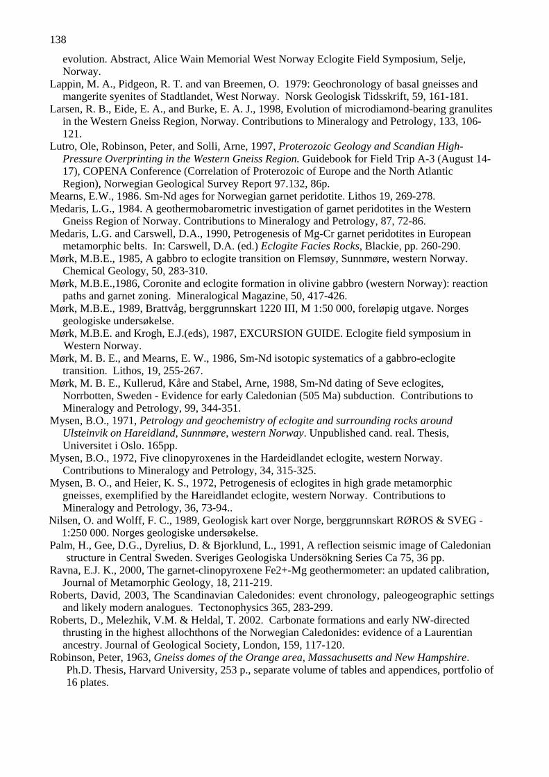
138
evolution. Abstract, Alice Wain Memorial West Norway Eclogite Field Symposium, Selje, Norway.
Lappin, M. A., Pidgeon, R. T. and van Breemen, O. 1979: Geochronology of basal gneisses and mangerite syenites of Stadtlandet, West Norway. Norsk Geologisk Tidsskrift, 59, 161-181.
Larsen, R. B., Eide, E. A., and Burke, E. A. J., 1998, Evolution of microdiamond-bearing granulites in the Western Gneiss Region, Norway. Contributions to Mineralogy and Petrology, 133, 106-121.
Lutro, Ole, Robinson, Peter, and Solli, Arne, 1997, Proterozoic Geology and Scandian High-Pressure Overprinting in the Western Gneiss Region. Guidebook for Field Trip A-3 (August 14-17), COPENA Conference (Correlation of Proterozoic of Europe and the North Atlantic Region), Norwegian Geological Survey Report 97.132, 86p.
Mearns, E.W., 1986. Sm-Nd ages for Norwegian garnet peridotite. Lithos 19, 269-278. Medaris, L.G., 1984. A geothermobarometric investigation of garnet peridotites in the Western
Gneiss Region of Norway. Contributions to Mineralogy and Petrology, 87, 72-86. Medaris, L.G. and Carswell, D.A., 1990, Petrogenesis of Mg-Cr garnet peridotites in European
metamorphic belts. In: Carswell, D.A. (ed.) Eclogite Facies Rocks, Blackie, pp. 260-290.Mørk, M.B.E., 1985, A gabbro to eclogite transition on Flemsøy, Sunnmøre, western Norway.
Chemical Geology, 50, 283-310. Mørk, M.B.E.,1986, Coronite and eclogite formation in olivine gabbro (western Norway): reaction
paths and garnet zoning. Mineralogical Magazine, 50, 417-426. Mørk, M.B.E., 1989, Brattvåg, berggrunnskart 1220 III, M 1:50 000, foreløpig utgave. Norges
geologiske undersøkelse. Mørk, M.B.E. and Krogh, E.J.(eds), 1987, EXCURSION GUIDE. Eclogite field symposium in
Western Norway. Mørk, M. B. E., and Mearns, E. W., 1986, Sm-Nd isotopic systematics of a gabbro-eclogite
transition. Lithos, 19, 255-267. Mørk, M. B. E., Kullerud, Kåre and Stabel, Arne, 1988, Sm-Nd dating of Seve eclogites,
Norrbotten, Sweden - Evidence for early Caledonian (505 Ma) subduction. Contributions to Mineralogy and Petrology, 99, 344-351.
Mysen, B.O., 1971, Petrology and geochemistry of eclogite and surrounding rocks around Ulsteinvik on Hareidland, Sunnmøre, western Norway. Unpublished cand. real. Thesis, Universitet i Oslo. 165pp.
Mysen, B.O., 1972, Five clinopyroxenes in the Hardeidlandet eclogite, western Norway. Contributions to Mineralogy and Petrology, 34, 315-325.
Mysen, B. O., and Heier, K. S., 1972, Petrogenesis of eclogites in high grade metamorphic gneisses, exemplified by the Hareidlandet eclogite, western Norway. Contributions to Mineralogy and Petrology, 36, 73-94..
Nilsen, O. and Wolff, F. C., 1989, Geologisk kart over Norge, berggrunnskart RØROS & SVEG - 1:250 000. Norges geologiske undersøkelse.
Palm, H., Gee, D.G., Dyrelius, D. & Bjorklund, L., 1991, A reflection seismic image of Caledonian structure in Central Sweden. Sveriges Geologiska Undersökning Series Ca 75, 36 pp.
Ravna, E.J. K., 2000, The garnet-clinopyroxene Fe2+-Mg geothermometer: an updated calibration, Journal of Metamorphic Geology, 18, 211-219.
Roberts, David, 2003, The Scandinavian Caledonides: event chronology, paleogeographic settings and likely modern analogues. Tectonophysics 365, 283-299.
Roberts, D., Melezhik, V.M. & Heldal, T. 2002. Carbonate formations and early NW-directed thrusting in the highest allochthons of the Norwegian Caledonides: evidence of a Laurentian ancestry. Journal of Geological Society, London, 159, 117-120.
Robinson, Peter, 1963, Gneiss domes of the Orange area, Massachusetts and New Hampshire.Ph.D. Thesis, Harvard University, 253 p., separate volume of tables and appendices, portfolio of 16 plates.

139
Robinson, Peter, 1995a, Evidence for Caledonide thrust nappes in the high-grade eclogite-facies area northwest of Moldefjord syncline, Western Gneiss Region. Geonytt 1-95 (Abstracts for Norwegian Winter Meeting, Trondheim), 61.
Robinson, Peter, 1995b, Tectono-stratigraphy in the Western Gneiss Region, Norway: A key to processes in the Scandian collision. Terranova, 7, Abstract Supplement 1 (EUG Meeting in Strasbourg), 115-116.
Robinson, Peter, 1995c, Extension of Trollheimen tectono-stratigraphic sequence in deep synclines near Molde and Brattvåg, Western Gneiss Region, Southern Norway. Norsk Geologisk Tidsskrift, 75, 181-198.
Robinson, Peter, 1997, Quartzite of Reksdalshesten, Moldefjorden, Western Gneiss Region: Another parallel with the tectonostratigraphy of Trollheimen (extended abstract). Norges GeologiskeUndersøkelse Bulletin 933, 15-16.
Robinson, Peter and Panish, P. T. 1994, Trapping a prograde eclogite-facies P-T path in deformed diabase dikes of the Sætra and Risberget Nappes adjacent to high-grade eclogite facies Baltic basement, western gneiss region, Norway (abstract). EOS, 75, 185.
Robinson, Peter and Terry, M. P., 1998, Evolution of amphibolite-facies structural features during transition from convergence to extensional collapse, Western Gneiss Region, Norway ("Transpressional exhumation of high-pressure metamorphic rocks"). Extended Abstract, Ultra-high-pressure Workshop at Stanford University, December 1998, 5p.
Robinson, Peter and Terry, M. P., 2001, Kinematics of HP and UHP metamorphism in the Western Gneiss Region, Møre og Romsdal, Norway. Journal of Conference Abstracts (Abstract EUG XI, 2001 Strasbourg) 6, 348.
Robinson, Peter, and Terry, M. P., 2002, Subduction and exhumation in the Western Gneiss Region: Attempting to rationalize pressure, temperature, time, tectonics and "post-orogenic" sedimentation. Norges geologiske foreningen, March 6, 2002.
Robinson, Peter, Tucker, R. D., Solli, Arne, Gee, D. G., and Thorsnes, Terje, 1996, Relationships between thrusting and extension in the Scandian hinterland, Norway: Interpretation based on a new tectono-stratigraphic compilation and new U-Pb ages on igneous zircon and metamorphic sphene. Geological Society of America Abstracts with Programs, 28, A501.
Robinson, Peter, Tucker, R. D., Solli, Arne, Gee, D. G., Thorsnes, Terje, and Terry, M.P., 1997, Re-interpretation of the Støren Nappe, Outer Trondheimsfjord, Norway: bearing on relationships between thrusting and extensional exhumation in the Scandian hinterland. Terra Nova, 9, Abstract Supplement no. 1, 330.
Robinson, P., Langenhorst, F. and Terry, M. P., 2002, UHP metamorphism of a kyanite-garnet gneiss from Fjørtoft, Western Norway. Annual Report, Bayerisches Forschungsinstitut für Experimentelle Geochemie und Geophysik, Universität Bayreuth, p.60.
Robinson, Peter, Terry, Michael P., Tucker, Robert D., and Solli, Arne, 2003a, Tectono-stratigraphic and geochronologic keys to the kinematics of HP and UHP metamorphism in the Western Gneiss Region, Møre og Romsdal and Trondelag, Norway. Abstract, Alice Wain Memorial West Norway Eclogite Field Symposium, Selje, Norway.
Robinson, Peter, Langenhorst, Falko, and Terry, Michael P., 2003b, Interpretation of inclusions in kyanite-garnet gneiss: Fjørtoft, Western Norway. Abstract, Alice Wain Memorial West Norway Eclogite Field Symposium, Selje, Norway.
Schärer, U. 1980: U-Pb and Rb-Sr dating of a polymetamorphic nappe terrain: the Caledonian Jotun Nappe, southern Norway. Earth and Planetary Science Letters 49, 205-218.
Schmitt, H. H., 1963, Petrology of the Eiksunddal eclogite, Møre og Romsdal, Norway. Ph.D. Thesis, Harvard University.
Seranne, Michel, 1992, Late Paleozoic kinematics of the Møre-Trøndelag Fault Zone and adjacent areas, central Norway. Norsk Geologisk Tidsskrift, 72, 141-158.
Skår, Øyvind, 2000, Field relations and geochemical evolution of the Gothian rocks in the Kvamsøy area, southern Western Gneiss Complex, Norway. Norges Geologiske Undersøkelse Bulletin 437, 5-23.

140
Solli, Arne and Robinson, Peter, 1997, Proterozoic and Scandian Geology of the Outer Trondheimsfjord Region. Guidebook for Field Trip B-1 (August 20), COPENA Conference, Norwegian Geological Survey Report 97.133, 21p.
Spengler, D., van Roermund, H.L.M. and Drury, M.R., 2002. Microstructural evidence for early majoritic garnet and late Ti-clinohumite in mantle-pyroxenites from Raudhaugene, Western Gneiss Region, Norway. Abstract Vol. to 4th Intern. Workshop on Orogenic Lherzolites and Mantle Processes, Samani, Hokkaido, Japan. 150-151.
Straume, A. K., 1997, Retrograde metamorfose av eklogitter fra Haddal-Ulsteinvik, Sunnmøre.Unpublished Ph. D. Thesis, University of Oslo.
Straume, A. K. and Austrheim, Håkon, 1999, Importance of fracturing during retro-metamorphsim of eclogites. Journal of Metamorphic Geology 17, 637-652.
Terry, M. P., 2000, Structural and thermal evolution of Baltica basement and infolded cover nappes on Nordøyane and their bearing on mechanisms for production and exhumation of high-pressure rocks, Western Gneiss Region, Norway, University of Massachusetts, Ph.D. Dissertation, 198 pp.
Terry, M. P. and Heidelbach, Florian, 2003, Microstructures and textures in eclogite-facies shear zones and deformation mechanisms in garnet, Haramsøya, Norway. Journal of Conference Abstracts (Abstract EUG XII, 2003 Nice).
Terry, M. P., and Robinson, Peter, 1996, Caledonian structural fabrics related to subduction of continental crust, Western Gneiss Region, Norway. Geological Society of America Abstracts with Programs, 28, A501.
Terry, M. P., and Robinson, Peter, 1997, Geometry of structural features in lower crust: implications for mechanisms related to subduction and exhumation of high-pressure rocks, Scandinavian Caledonides. Geological Society of America Abstracts with Programs, 29, p.
Terry, M. P. and Robinson, Peter, 1998a, Evolution of amphibolite-facies structural features, Western Gneiss Region, Norway, during the transition from convergence to extensional collapse in the Scandinavian Caledonides. Geological Society of America Abstracts with Programs, 30, A-192 ( GSA Annual Meeting, Toronto, Canada)
Terry, M. P. and Robinson, Peter, 1998b Eclogite-facies structural features and their bearing on mechanisms for production and exhumation of high-pressure rocks, Western Gneiss Region, Norway, including the microdiamond-bearing gneiss at Fjørtoft. Extended Abstract, International Workshop on Ultra-High-pressure Metamorphism and Exhumation, p. 74-78, Stanford University, December 1998.
Terry, M. P., and Robinson, Peter, 1998c, Evidence for majoritic garnet in two peridotite bodies, Western Gneiss Region, Norway: Proposed exhumation history from 250 km. Post-deadline Abstract for Poster, International Workshop on Ultra-High-pressure Metamorphism and Exhumation, Stanford University, December 1998.
Terry, M. P., and Robinson, Peter, 1999, COMMENT Sinking intrusion model for the emplacement of garnet-bearing peridotites into continent collision orogens. Geology, 27, 477-478.
Terry, M. P. and Robinson, Peter, 2000, Linkages between metamorphism and deformation during exhumation of HP and UHP metamorphic rocks, Western Gneiss Region, Norway. Geological Society of America Abstracts with Programs, 32, A-32.
Terry, M.P., and Robinson, Peter, 2001, Evidence for supersilicic pyroxene in an UHP kyanite eclogite, Western Gneiss Region, Norway. Eleventh Annual Goldshmidt Conference, LPI Contribution Number 1088, Abstract 3842..
Terry, M. P., and Robinson, Peter, 2003a, Boundary conditions of deformation related to the production and exhumation of HP and UHP rocks in the hinterland of the Scandinavian Caledonides, Western Gneiss Region, Norway. Abstract, Alice Wain Memorial West Norway Eclogite Field Symposium, Selje, Norway.
Terry, M. P. and Robinson, Peter, 2003b, Evolution of amphibolite-facies structural features and boundary conditions for deformation during exhumation of HP and UHP rocks, Nordøyane, Western Gneiss Region, Norway. Tectonics, in press..

141
Terry, M. P. and Robinson, Peter, in revision, Eclogite-facies structural features and their bearing on mechanisms for production and exhumation of high-pressure rocks, Western Gneiss Region, Norway. Tectonics.
Terry, M. P., Robinson, Peter, Carswell, D. A., and Gasparik, Tibor, 1999a, Evidence for a Proterozoic mantle plume and a thermotectonic model for exhumation of garnet peridotites, Western Gneiss Region, Norway. EOS, 80 Abstract Supplement, S359-360.
Terry, M. P., Robinson, Peter, and Ravna, E. K, 1999b, Evidence for Scandian coesite/diamond conditions in kyanite eclogite at Fjørtoft, Western Gneiss Region, Norway. EOS, 80 Abstract Supplement, S363.
Terry, M.P., Robinson, P. Hamilton, M.A. and Jercinovic, M.J., 2000a, Monazite geochronology of UHP and HP metamorphism, deformation and exhumation, Nordøyane, Western Gneiss Region, Norway. American Mineralogist 85, 1651-1664.
Terry, M.P., Robinson, P. and Ravna, E.J.K., 2000b, Kyanite eclogite thermobarometry and evidence for thrusting of UHP over HP metamorphic rocks, Nordøyane, Western Gneiss Region, Norway. American Mineralogist 85, 1637-1650.
Terry, M. P., Robinson, Peter, and Ravna, E. J. K., 2000c, Eclogite thermobarometry and identification of UHP and HP terranes bounded by an early Scandian thrust, Nordøyane, Western Gneiss Region, Norway, Geonytt, Nr. 1, 2000, p.169-170. (Abstracts 24th Nordic Winter Meeting, Trondheim, Norway)
Terry, M. P., Robinson, Peter, Hamilton, M. A., Williams, M. L., and Jercinovic, M. J., 2000d, Monazite Th-U-Pb geochronology and metamorphic/ tectonic history of microdiamond-bearing gneiss at Fjørtoft, Western Gneiss Region, Norway, Geonytt, Nr. 1, 2000, 170. (Abstracts 24th Nordic Winter Meeting, Trondheim, Norway)
Terry, M. P.; Robinson, Peter; Ravna, E. J. Krogh; Hamilton, M. A., Williams, M. L., and Jercinovic, M. J., 2000e, Thermobarometry of kyanite eclogite and monazite chronology of microdiamond-bearing gneiss: A UHP/HP thrust boundary and timing of deformation and exhumation, Western Gneiss Region, Norway.. Keynote Address: Abstracts Volume, Annual Meeting, Metamorphic Studies Group, Mineralogical Society, London, March 24, 2000.
Terry M.P., Robinson, P., and Hamilton, M.A, 2002, U-Th-Pb monazite geochronology in kyanite gneisses, Nordøyane, Norway: implications concerning thrusting, extension and age of outboard basement in pre-Scandian Baltica. Geological Society of America, Abstracts with Programs 34, (Symposium on Monazite Geochronology, Annual Meeting, Northeastern Section, Springfield, Massachusetts).
Terry, M. P., Bromiley, G. D., Robinson, P. and Heidelbach, F., 2003, Determination of equilibrium water content and composition of omphacitic pyroxene in a UHP kyanite-eclogite, Western Norway. Journal of Conference Abstracts (Abstract EUG XII, 2003 Nice).
Tucker, R. D., 1986, Geology of the Hemnefjord-Orkanger area, south-central Norway. Norges Geologiske Undersøkelse Bulletin, 404, 1-24.
Tucker, R. D., 1988, Contrasting crustal segments in the central Norwegian Caledonides: evidence from U-Pb dating of accessory minerals. Geological Association of Canada Program with Abstracts, A127.
Tucker, R.D. and Krogh, T.E., 1988, Geochronological investigation on the Ingdal granite gneiss and discordant pegmatites from the Western Gneiss Region, Norway. Norsk Geologisk Tidsskrift 68, 201-210.
Tucker, R.D., Råheim.A., Krogh, T.E., and Corfu, F., 1987, Uranium-lead zircon and titanite ages from the northern portion of the Western Gneiss Region, south-central Norway. Earth and Planetary Science Letters, 81, 203-211.
Tucker, R.D., Krogh, T.E., and Råheim, Arne, 1990, Proterozoic evolution and age-province boundaries in the central part of the Western Gneiss Region, Norway: Results of U-Pb dating of accessory minerals from Trondheimsfjord to Geiranger, in Gower, C.F., Ryan, B., and Rivers, T., editors, Middle Proterozoic Geology of the Southern Margin of Proto Laurentia-Baltica: Geological Association of Canada Special Paper 38, 149-173.

142
Tucker, R. D., Robinson; Peter, Solli, Arne, Gee, D. G.; and Thorsnes, Terje, 1997a, A re-interpretation of the Støren Nappe in the outer Trondheimsfjord region: its bearing on relationships between thrusting and extensional exhumation in the Scandian hinterland. Geonytt, 24, 94.
Tucker, R. D., Ver Straeten, C., Bradley, D. C., Harris, A. G., and Ebert, J., 1997b, Chronometric revision of the Devonian time-scale based on new U-Pb zircon ages from New York State, the central Appalachians, and New Brunswick, Canada. Geological Society of America Abstract with Programs, 29, A116.
Tucker, R. D., Robinson, Peter, Gee, D. G. , Thorsnes, Terje , Krogh, T. E. , Nordgulen, Øysteinand Bickford, M. E., submitted, Thrusting and extension in the Scandian hinterland, Norway: New U-Pb ages and tectonostratigraphic evidence. American Journal of Science
Tveten, E., Lutro, O. and Torsnes, T., 1998a, Geologisk kart over Noreg, berggrunnskart ÅLESUND M 1:250 000, Noregs geologiske undersøking.
Tveten, E., Lutro, O. & Torsnes, T., 1998b, Geologisk kart over Noreg, berggrunnskart ULSTEINVIK M 1:250 000 Noregs geologiske undersøking
Koistinen, T., Stephens, M.B., Bogatchev, V., Nordgulen, Ø., Wennerström, M., and Korhonen, J. (2001) Geological map of the Fennoscandian shield, Scale 1:2000000. Geological Surveys of Finland, Norway and Sweden and the North-West Department of Natural Resources of Russia.
van Roermund, H.L.M., and Drury, M.R., 1998. Ultrahigh pressure (P>6 GPa) garnet peridotites in western Norway: Exhumation of mantle rocks from >185 km depth: Terra Nova, 10, 295–301.
van Roermund, H. L. M., Drury, M. R., Barnhoorn, A., and De Ronde, A., 2000, Supersilicic garnet microstructures from an orogenic garnet peridotite, evidence for an ultradeep (> 6 GPa) origin. Journal of Metamorphic Geology, 18, 135-147.
van Roermund, H.L.M., Drury, M.R., Barnhoorn, A., and De Ronde, A., 2001. Relict majoritic garnet microstructures from ultra-deep orogenic peridotites in western Norway. J. Petrol., 42, 117–130.
van Roermund, H.L.M., Carswell, D.A., Drury, M.R. and Heyboer, T.C., 2002. Microdiamonds in a megacrystic garnet websterite pod from Bardane on the island of Fjørtoft, western Norway: Evidence for diamond formation in mantle rocks during deep continental subduction. Geology, 30, 959-962.
Williams, Michael L., Jercinovic, Michael. J., and Terry, Michael P., 1999, Age mapping and dating of monazite on the electron microprobe: Deconvoluting multistage tectonic histories. Geology, 27, 1023-1026.