2. description of the proposed project - nra. description of the proposed project ... has been...
TRANSCRIPT
N2 Wild Coast Toll Road between East London and Durban: Environmental Impact Assessment Report
2. DESCRIPTION OF THE PROPOSED PROJECT
The proposal for the N2 Wild Coast Toll Road project is to design, construct, finance, operate
and maintain this new limited-access toll road facility for a 30 year concession period, as per
the Concession Contract. This road project is proposed to extend over a total distance of
approximately 550 km from the Gonubie Interchange, near East London (Eastern Cape) to the
Isipingo Interchange south of Durban (KwaZulu-Natal).
The key components of the proposed project include:
• the upgrading of existing road sections (of the N2 and R61) included within the project;
• new road construction within an identified greenfields corridor;
• the upgrading and/or construction of new road interchanges and intersections; and
• the construction of associated structures (such as toll plazas and bridges).
This proposed project aims to provide a limited-access, high-speed national route, which
optimises road-user safety through:
• the upgrading and/or construction of the proposed route to a design speed of 100 –
120 km/h for the majority of its length, with the speed decreasing to 60 km/h in limited
sections only;
• the provision of a dual-carriageway road and/or climbing lanes where required in order to
maintain travel speed and adequate service levels;
• the implementation and maintenance of appropriate fencing of the road reserve along the
entire length of the route (in terms of the Concession Contract requirements);
• the consolidation and formalisation of accesses onto the proposed toll road in order to
ensure road-user safety (in terms of sight distances and provision of traffic turning lanes);
• the eradication of illegal access along the proposed route;
• the rehabilitation and overall improvement of the road surface along existing sections of
the route (e.g. skid resistance);
• the implementation and maintenance of appropriate road signage, road furniture and
roadside emergency facilities; and
• the provision of a well-maintained shoulder along the length of the proposed route.
A detailed description of the proposed project along the length of the route is provided in the
sections below.
Description of the Proposed Project Sep-02 11
N2 Wild Coast Toll Road between East London and Durban: Environmental Impact Assessment Report
2.1. Proposed Route Alignment
The proposed alignment of the N2 Wild Coast Toll Road has been determined over a period
of more than 20 years. The determination of a preferred alignment has, over time, taken
cognisance of aspects considered to be limiting constraints to both the environment
(biophysical and social) and the project (e.g. economics, technical feasibility, etc).
The proposed route alignment will connect major centres, including East London,
Butterworth, Idutywa, Umtata, Ndwalane, Lusikisiki, Port Edward, Port Shepstone and
Durban, and will be an approximate 85 km shorter than the existing N2 via Mount Frere,
Kokstad and Harding. Approximately 80% of this proposed route utilises existing road
alignments (i.e. sections of the existing N2 and R61 routes). This will affect the following
sections of road:
• East London to Umtata – utilising the existing N2 alignment
• Umtata to Ndwalane – utilising the existing R61 alignment
• Ntafufu River to Lusikisiki – utilising the existing R61 alignment
• Mtamvuna River to Southbroom – utilising the existing R61 alignment
• Southbroom to Hibberdene – utilising the existing N2 Oribi Toll Road
• Hibberdene to Durban – utilising the existing N2 alignment
The greenfields corridor extends between Ndwalane and Ntafufu River, and Lusikisiki and
Mtamvuna River, and has been identified as a preferred corridor from environmental,
technical, social and economic perspectives. Within this greenfields corridor, a preferred
alignment (refer to Figure 2.1 overleaf) has been identified through pragmatic interfacing
between the environmental team and the technical design team, and focussing on the synergy
between the two processes. A number of alternatives were identified and investigated at areas
of environmental sensitivity identified within the greenfields corridor during the ESS. These
are discussed in Chapters 9 and 11 of this report.
Description of the Proposed Project Sep-02 12

N2 Wild Coast Toll Road between East London and Durban: Environmental Impact Assessment Report
Figure 2.1: The proposed N2 Wild Coast Toll Road between the Gonubie Interchange (Eastern Cape) and the Isipingo Interchange (KwaZulu-Natal),
showing the preferred alignment within the greenfields corridor between Ndwalane and the Mtamvuna River
Description of the Proposed Project Sep-02 13
N2 Wild Coast Toll Road between East London and Durban: Environmental Impact Assessment Report
2.2. Brief Description of the Affected Environment
The proposed route alignment between East London (in the Eastern Cape) and Durban (in
KwaZulu-Natal) is particularly diverse and varied, mainly due to the range of geological
formations and complex topography it traverses. The route passes through regions of
different histories and land use patterns, and is also varied in terms of the social environment
associated with the areas through which it passes, ranging from larger towns (e.g. East
London and Umtata) in the south, through rural and subsistence communities in the former-
Transkei, to formal and urbanised communities characteristic of the South Coast of KwaZulu-
Natal, ending in the industrial and urban centre of Durban South.
From East London, the route follows an inland alignment along an undulating plateau to
Umtata. This section of the route is bisected by several river systems, and is characterised by
the Kei Cuttings in the vicinity of the Great Kei River. The key communities located along
this section of the proposed route include the urban communities of larger towns such as East
London and Umtata, the peri-urban communities of the larger secondary and regional towns
such as Butterworth, and the rural communities of towns such as Komga and Idutywa. The
route then traverses the dissected landform characteristic of the area between Umtata and
Ndwalane (approximately 10 km west of Port St Johns on the coast). Many small rural
villages, reliant on subsistence farming, straddle the existing R61. At Ndwalane, a new route
alignment is proposed inland of the Port St Johns area. This route provides a new route via
Ntafufu to Lusikisiki. A second greenfields section is proposed to extend from the end of the
concrete road in the vicinity of Lusikisiki to the Mtamvuna River on the Eastern Cape-
KwaZulu-Natal border.
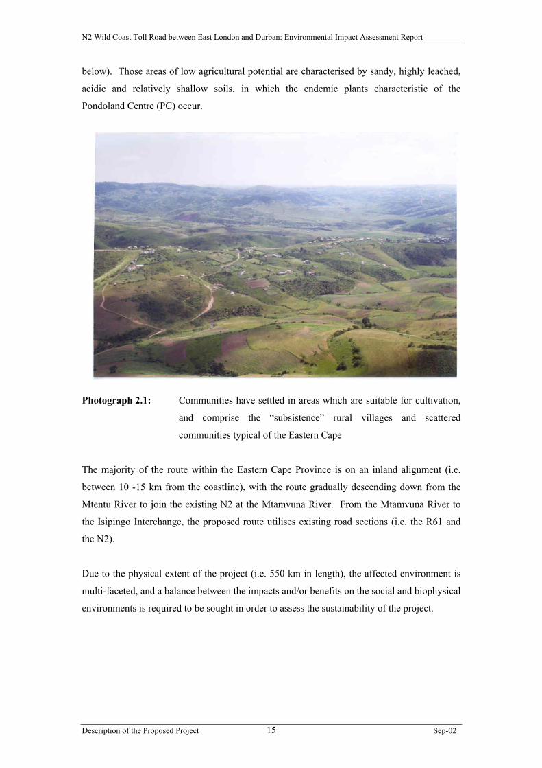
The larger part of this greenfields section of the road follows the inner-most (inland)
boundary of the Msikaba Formation, lying inland of the small escarpment parallel to the
coastline, in the vicinity of the Msikaba River. The significance of the geology in this area is
the distribution of plants in this region, as the endemic plants characteristic of the Pondoland
Centre are confined to the Msikaba Formation. The area is characterised by a more
undulating landscape (albeit dissected by deep river gorges), the occurrence of rocky outcrops
and soils of low agricultural potential (typically suitable only for grazing or wilderness by
virtue of the steep slopes and shallow stony soils). The only large tracts of arable soil occur
north-east of the Msikaba River mainly between the Msikaba and Mtentu Rivers in the Tracor
lands, as well as between the Mtentu and Mnyameni rivers. Within these areas, communities
have settled in areas which are suitable for cultivation, and comprise the “subsistence” rural
villages and scattered communities typical of the Eastern Cape (refer to Photograph 2.1
Description of the Proposed Project Sep-02 14
N2 Wild Coast Toll Road between East London and Durban: Environmental Impact Assessment Report
below). Those areas of low agricultural potential are characterised by sandy, highly leached,
acidic and relatively shallow soils, in which the endemic plants characteristic of the
Pondoland Centre (PC) occur.
Photograph 2.1: Communities have settled in areas which are suitable for cultivation,
and comprise the “subsistence” rural villages and scattered
communities typical of the Eastern Cape
The majority of the route within the Eastern Cape Province is on an inland alignment (i.e.
between 10 -15 km from the coastline), with the route gradually descending down from the
Mtentu River to join the existing N2 at the Mtamvuna River. From the Mtamvuna River to
the Isipingo Interchange, the proposed route utilises existing road sections (i.e. the R61 and
the N2).
Due to the physical extent of the project (i.e. 550 km in length), the affected environment is
multi-faceted, and a balance between the impacts and/or benefits on the social and biophysical
environments is required to be sought in order to assess the sustainability of the project.
Description of the Proposed Project Sep-02 15
N2 Wild Coast Toll Road between East London and Durban: Environmental Impact Assessment Report
2.3. Proposed Construction Activities
2.3.1. Pavement (road) Construction
Portions of the existing road sections of the N2 and R61 that have been included as part of the
project are considered to currently be in a condition which is below National Road standards
(in terms of the South African Road Safety Manual, 1999). These sections, therefore, require
maintenance and/or upgrading in order to adhere to stipulated safety criteria. Some issues of
concern on these particular routes include:
• the need for new and upgraded infrastructure, intersections and interchanges to
accommodate future traffic growth;
• traffic congestion on a daily basis on certain sections;
• poor road-user and pedestrian safety;
• occurrence of distressed road pavements and lack of maintenance; and
• control of informal road accesses.
Therefore, preliminary investigations for the length of the route have identified the need for
the following general construction activities:
• the construction of new highway sections where no existing infrastructure exists;
• the repair of existing road surfaces where conditions are unsafe (e.g. where potholes have
developed);
• the addition of a lane in each direction where traffic congestion is known to be a
problem;
• the addition of “climbing” lanes for short distances up steep grades to allow faster
vehicles passing opportunities;
• the upgrading of intersections, interchanges and turning lanes where road-user and
community safety is currently a concern; and
• the installation of roadside SOS emergency facilities.
The following rehabilitation and construction activities are proposed for the existing and new
road sections included in the N2 Wild Coast Toll Road project:
Description of the Proposed Project Sep-02 16
N2 Wild Coast Toll Road between East London and Durban: Environmental Impact Assessment Report
• Gonubie Interchange to Great Kei River (existing N2)
The existing N2 is generally in a poor to fair condition, and requires rehabilitation and
upgrade in order to maintain the required national road standard. This section of existing
road (approximately 58 km in length) will be rehabilitated and upgraded, where required
(e.g. the addition of “climbing” lanes for short distances up steep grades to allow faster
vehicles passing opportunities, the repair of existing road surfaces where conditions are
unsafe, and improvements to intersections and interchanges at various points along the
route) to improve sight distance and road-user safety. All initial construction works
along this section of the route will be undertaken within the existing road reserve, except
at the proposed Komga Interchange.
• Great Kei River to Ngobozi (existing N2)
This section of the route via the Kei Cuttings (approximately 16 km in length) has been
recently reconstructed. The need for additional safety improvements will be
investigated, where necessary. All initial construction works along this section of the
route will generally be undertaken within the existing road reserve.
• Ngobozi to Umtata (existing N2)
This section of the existing N2 (approximately 130 km in length) is generally in a poor to
fair condition, and requires rehabilitation and upgrade in order to maintain the required
national road standard. The existing two-lane road has sections of sub-standard
horizontal and vertical alignment which will be investigated for upgrading in order to
improve road-user safety (e.g. the addition of “climbing” lanes for short distances up
steep grades to allow faster vehicles passing opportunities, the repair of existing road
surfaces where conditions are unsafe, and improvements to intersections and
interchanges at various access points along the route). In addition, safety improvements
are required for pedestrians. All initial construction works along this section of the route
will be undertaken within the existing road reserve, except at the proposed interchanges.
The existing road between Ndabakazi and Butterworth, Butterworth and the Msobomvu
intersection, and Viedgesville and the Umtata central business district (CBD) will be
upgraded to a four-lane undivided road during the 30-year concession period.
The possibility of constructing ring roads (bypasses) at Butterworth and Idutywa during
the 30-year concession period will be investigated, but is not part of the initial
construction works (i.e. to be constructed within the first 3 – 5 years of the concession
Description of the Proposed Project Sep-02 17

N2 Wild Coast Toll Road between East London and Durban: Environmental Impact Assessment Report
period). Until these ring roads are constructed, the concessionaire will be responsible for
the maintenance and safety of the road through the town which is to form part of the N2
Wild Coast Toll Road project.
• Umtata to Ndwalane (existing R61)
This section of approximately 80 km traverses rugged and geotechnically unstable
terrain. This existing road will require repair, widening of the road surface, and
upgrading in places (e.g. widening the road, the addition of “climbing” lanes, the repair
of existing road surfaces where conditions are unsafe, and improvements to intersections
and interchanges at various points along the route) for improved road-user safety and
riding quality. All initial construction works along this section of the route will be
undertaken within the existing road reserve, except at the proposed interchanges and
between Umtata and Ngqeleni turnoff.
The construction of a ring road (bypass) on the south eastern side of the town of Umtata
during the concession period will be investigated, but is not part of the initial
construction works. Until this ring road is constructed, the concessionaire will be
responsible for the maintenance and safety of the road through the town which is to form
part of the N2 Wild Coast Toll Road project.
The section of the route between the Umtata CBD and the Ngqeleni Intersection
(approximately 6 km in length) will be upgraded to a four-lane, dual carriageway road.
After the Ngqeleni Intersection, the R61 via the Tutor Ndamase Pass is in a poor to fair
condition.
• Ndwalane to Ntafufu River (new road)
This section of approximately 16,5 km will require the construction of a section of new
road to national road standards. This new road is to provide a more direct route for N2
through-traffic, as well as an improved design speed in comparison with the existing R61
between these two points.
• Ntafufu River to Lusikisiki (existing R61)
This section of approximately 18 km will be upgraded and rehabilitated to improve the
design speed and safety of this section. Where necessary and feasible, “climbing” lanes
will be added and the road cross-section widened. All initial construction works along
this section of the route will generally be undertaken within the existing road reserve.
Description of the Proposed Project Sep-02 18
N2 Wild Coast Toll Road between East London and Durban: Environmental Impact Assessment Report
• Lusikisiki to Mtamvuna River (new road)
The approximate 6,5 km section of concrete road to the east of Lusikisiki (up to the
Magwa intersection) will be upgraded to a dual carriageway. From the Magwa
Intersection, the remaining section of approximately 71 km will require the construction
of a new section of road to national road standards. The new road will require the
crossing of the Msikaba, Mtentu, Mnyameni, Mpahlane and Mzamba river gorges, as
well as undulating high-lying areas between these major river valleys. The proposed
route joins with the R61 approximately 2 km south of the Mtamvuna River, in the
vicinity of the Wild Coast Sun Casino. This short section of the R61 will be rehabilitated
and/or improved, as required.
• Mtamvuna River to Southbroom Interchange (existing R61)
This section of approximately 22 km is considered to currently be in a fair condition.
However, this section of road is characterised by frequent access points which currently
serve a number of coastal resorts and the more rural areas of KwaZulu-Natal. It is
envisaged that pavement rehabilitation measures will be required, together with
upgrading (e.g. the addition of “climbing” lanes, the repair of existing road surfaces
where conditions are unsafe, and improvements to intersections and the provision of
interchange(s) at various places along the route) to optimise road-user safety. All initial
construction works along this section of the route will generally be undertaken within the
existing road reserve.
• Southbroom to Winklespruit (existing N2)
This section of approximately 109 km is proposed to utilise the existing government
operated South Coast Toll Road. This existing road is considered to currently be in a fair
condition. It is envisaged that rehabilitation and upgrading of the road surface will be
undertaken, where necessary. All initial construction works along this section of the
route will generally be undertaken within the existing road reserve.
• Winklespruit to Isipingo Interchange (existing N2)
This section of approximately 15 km is proposed to utilise the existing N2 south coast
road. This section of the existing N2 will be rehabilitated and upgraded, and will include
the addition of a lane in both directions between Amanzimtoti and the Isipingo
Interchange to alleviate current and anticipated future traffic congestion, as well as
access improvements at some points within the section. All initial construction works
Description of the Proposed Project Sep-02 19
N2 Wild Coast Toll Road between East London and Durban: Environmental Impact Assessment Report
along this section of the route will generally be undertaken within the existing road
reserve.
2.3.2. Bridge Crossings
Major bridge crossings are required at five deeply incised gorges, namely the Msikaba,
Mtentu, Mnyameni, Mpahlane and Mzamba Rivers. Issues of concern regarding these
crossings include:
• the rugged nature of the local topography;
• the sensitivity of the natural environment to disturbance, including the riparian
vegetation, river banks and watercourses;
• distance between river gorge banks between which the bridges are to be constructed;
• technical feasibility of the crossing points and overall bridge design; and
• financial constraints.
Due to the rugged topography and the constraints this terrain presents, as well as the
potentially ecologically sensitive systems associated with these river systems, technically
feasible crossings of these rivers were identified and assessed. These crossings are considered
in detail in Chapter 11.
2.3.3. Ring Roads
Butterworth, Idutywa and Umtata were earmarked for the possible construction of ring roads
to avoid the need for the national road to pass through the built-up areas and towns. In terms
of the high standards expected by road-users along the toll road, passing through these towns
is not considered desirable in the long-term as it would require the reduction in speed due to
traffic within the centre of towns and large numbers of pedestrians.
• Umtata Ring Road:
This ring road would potentially follow the existing road reserve identified by the
Umtata Municipality, which joins the R61 east of Umtata near the Corana River bridge.
• Butterworth Ring Road:
This ring road is proposed to commence approximately 3,5 km south of Butterworth,
bypass the town, and rejoin the existing N2 approximately 11,8 km north of Butterworth.
Description of the Proposed Project Sep-02 20
N2 Wild Coast Toll Road between East London and Durban: Environmental Impact Assessment Report
• Idutywa Ring Road:
The ring road is proposed to commence approximately 1,1 km south of Idutywa, pass
east of the town, and rejoin the existing N2 approximately 1,6 km north of Idutywa.
From responses received during the Environmental Scoping Phase of the project, the
construction of these ring roads will not form part of the initial construction works, and are
therefore not assessed within this EIA. Should these ring roads be planned to be constructed
in the future when the level of service required necessitates their construction, these will be
required to be assessed at this time.
2.3.4. Interchanges, Intersections and Accesses
Several grade separated interchanges are proposed to be constructed along the route. These
include, inter alia:
• Komga – King Williamstown intersection;
• Ndabakazi intersection;
• Ngqeleni intersection; and
• Port Edward Intersection.
The need for further interchanges may arise, and these will be investigated and subsequently
constructed during the concession period when the level of service required necessitates their
construction. These are not included in the initial construction works.
District road intersections are to be upgraded along the entire route in order to improve
overall road safety. The provision of turning lanes will facilitate through-traffic flow, and
improve road-user safety.
Village and informal accesses are to be improved, consolidated and formalised, with a
minimum spacing of approximately 1 km between these intersections. Fencing, cattle grids,
underpasses, overpasses, sidewalks and frontage roads will be constructed, where required, in
order to improve safety and provide grade separated facilities across the route.
Description of the Proposed Project Sep-02 21
N2 Wild Coast Toll Road between East London and Durban: Environmental Impact Assessment Report
2.3.5. Toll Plazas
Economic and technical feasibility studies have been undertaken to determine the number and
most appropriate locations of toll plazas. Toll tariff details are not available during this
planning stage of the project. The planned location of the seven mainline toll plazas are as
follows (refer to Figure 2.2):
• in the area of the Kei River crossing, just outside Ngobozi, referred to as Ngobozi Plaza;
• the Bashee Bridge region, close to the Candu River, referred to as Candu Plaza;
• in the vicinity of Ntlaza Mission, near the Tutor Ndamase Pass, referred to as the Tutor
Ndamase Plaza;
• between Lusikisiki and Mtamvuna, north of the Mtentu river crossing, referred to as
Mtentu Plaza;
• the existing Oribi toll plazas between Izotsha and Umtentweni;
• in the Park Rynie area, just north of the interchange, referred to as Park Rynie Plaza; and
• between the Moss Kolnick and Isipingo interchanges, referred to as Isipingo Plaza.
Ramp plazas are planned as follows:
• the existing Izotsha ramp plazas on the southern ramps of the Shelly Beach Interchange;
• the existing Oribi ramp plazas on the northern and southern ramps of the Marburg
Interchange;
• the existing Umtentweni ramp plazas on the northern ramps of the Umtentweni
Interchange;
• the southern ramps of the Sezela Interchange;
• the southern ramps of the Park Rynie Interchange;
• the northern ramps of the Scottburgh Interchange;
• The southern ramps of the Adams Road Interchange;
• The southern ramps of the Moss Kolnick Interchange; and
• The southern ramps of the Joyner Road Interchange.
All toll plaza positions are provisional within the proposed areas at this point in time and will
be finalised through the results of this EIA process and the Intent-to-Toll process.
The principle of tolling, including the viability of operating the route as a toll road in order to
finance the project, will be addressed in terms of the South African National Roads Agency
Description of the Proposed Project Sep-02 22
N2 Wild Coast Toll Road between East London and Durban: Environmental Impact Assessment Report
Limited and National Roads Act (No 7 of 1998). Further opportunity for input on tolling will
be provided to the public by SANRAL under this legislation within their Intent-to-Toll
Process, which is to be held at a later date (refer to Appendix A).
• Technical Factors Considered in the Determination of Toll Plaza Positions
The toll plaza positions are critical to the financial viability of the project. The location
of toll plazas is also dependent on a number of other factors, including:
∗ Locations must be such that adequate sight distance in both directions exists at the
mainline plaza. Plazas should preferably be located on straight sections of roads,
with a sight distance of 300 m in both directions.
∗ Positioning of a mainline plaza on a steep gradient is to be avoided as this creates
problems for heavy vehicles in particular (i.e. downhill stopping and pulling off
uphill from the plaza), and exacerbates impacts associated with noise and safety.
∗ As far as possible, locations should not be directly adjacent to settlements or
homesteads, in order to avoid unnecessary impacts in terms of noise, lighting, etc.
∗ As far as possible, access to power, water and telephone services, as well as suitable
proximity to towns providing other important services (employee accommodation,
bank, post office, etc.) should be sought.
∗ Sufficient area must be available adjacent to the road side for widening of the road
at the mainline plaza, and for accommodation of a control building which monitors
the activities at the toll plaza.
∗ Favourable ground conditions pertaining to foundation bearing capacity and subsoil
drainage are required.
∗ Ease of construction of a temporary road deviation at plaza sites on existing roads,
while plaza construction takes place.
All of the above criteria were used together with financial factors in defining the most
equitable toll strategy capable of realising the revenue required to cover the project costs.
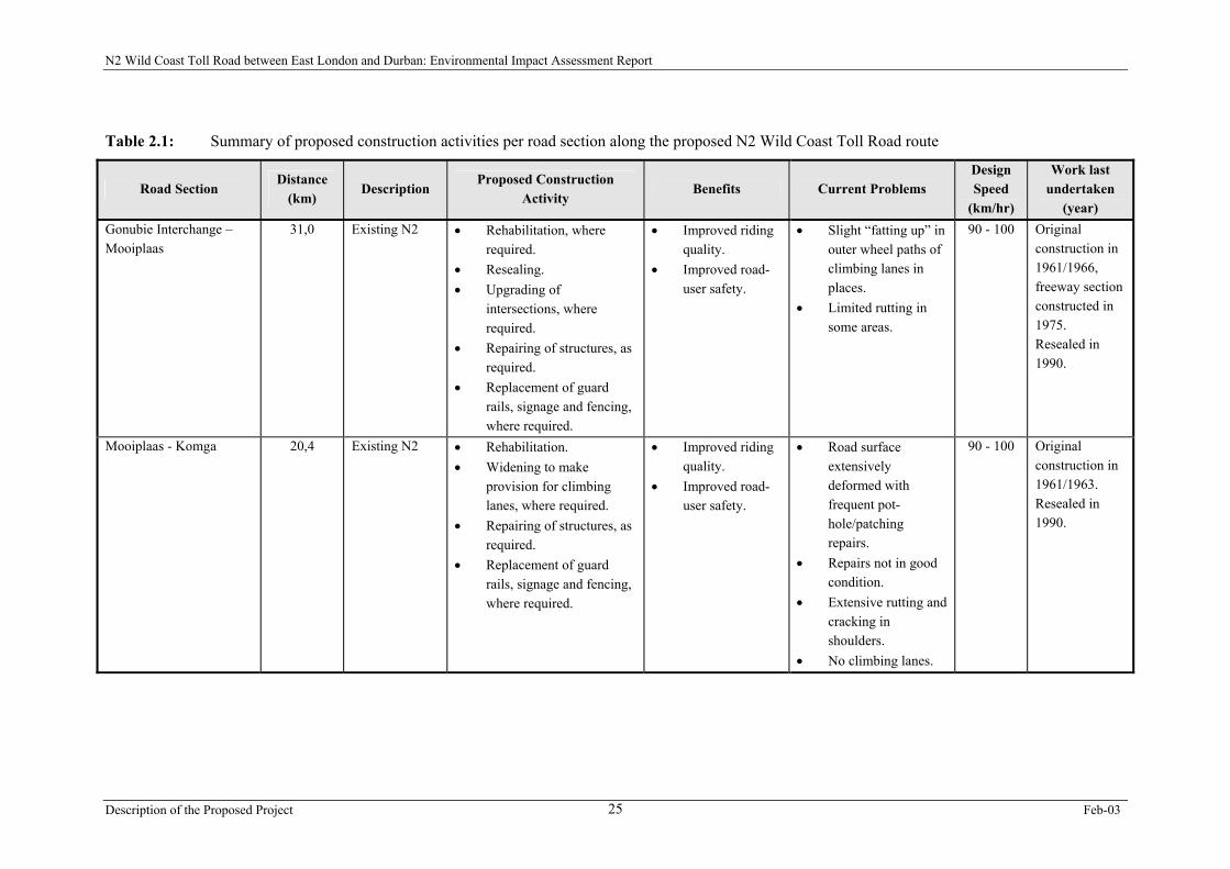
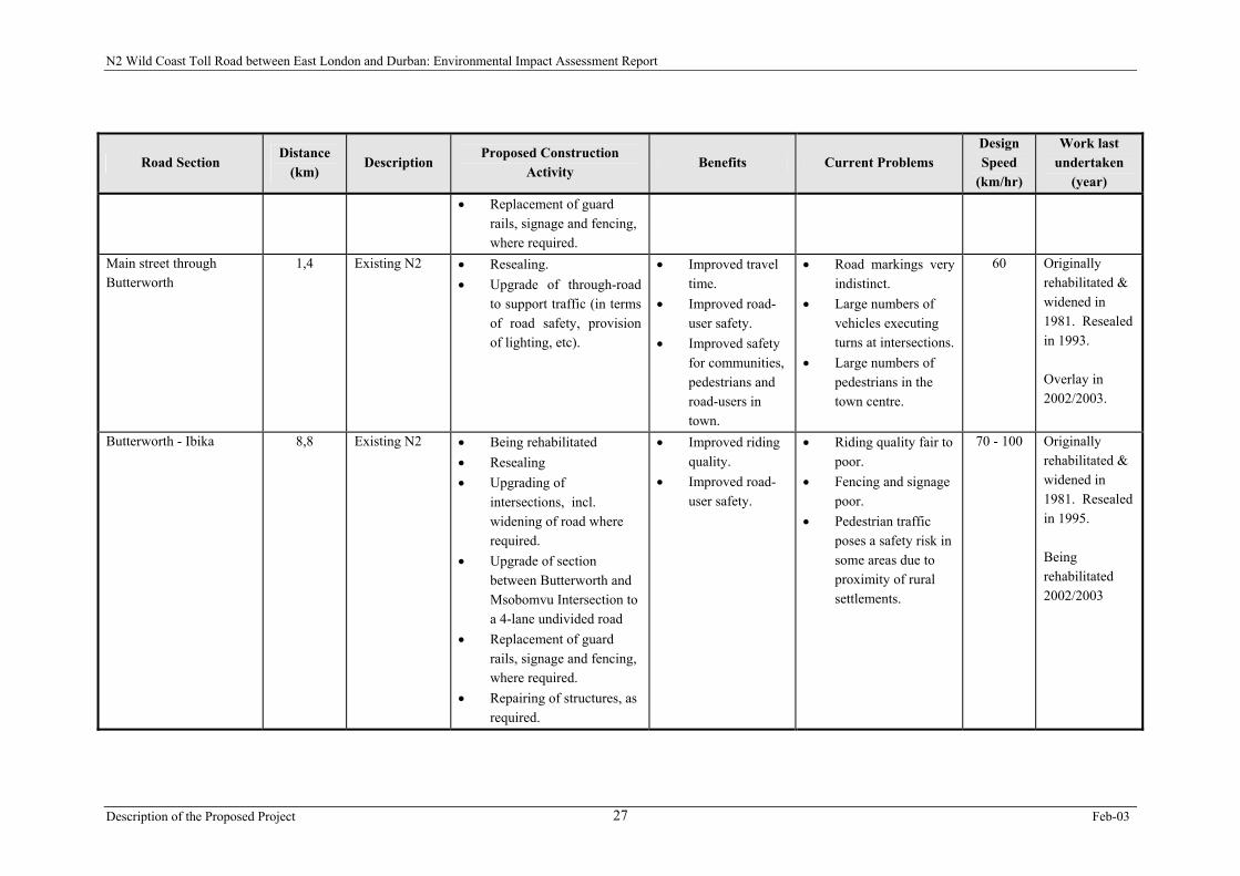
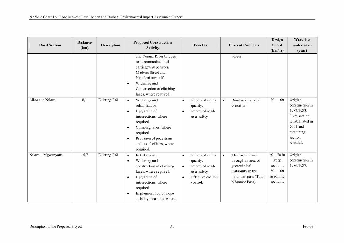
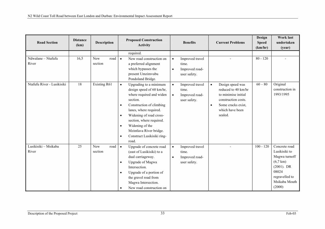
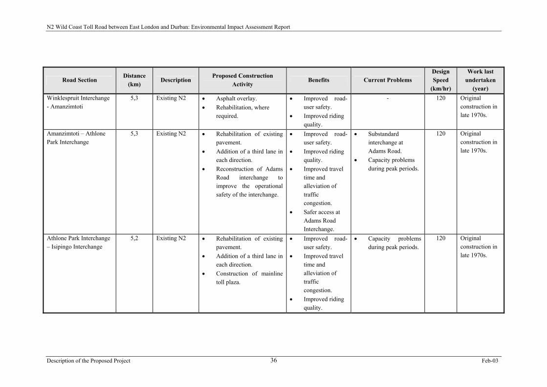
2.3.6. Summary
A summary of the proposed construction activities per a detailed division of road sections is
provided in Table 2.1. This table provides information in terms of current problems
associated with the project road sections, as well as proposed benefits and new design speeds
which will be achieved.
Description of the Proposed Project Sep-02 23

N2 Wild Coast Toll Road between East London and Durban: Environmental Impact Assessment Report
Figure 2.2: Proposed areas for the location of toll plazas along the N2 Wild Coast Toll Road route
Description of the Proposed Project Sep-02 24
N2 Wild Coast Toll Road between East London and Durban: Environmental Impact Assessment Report
Table 2.1: Summary of proposed construction activities per road section along the proposed N2 Wild Coast Toll Road route
Road Section Distance
(km) Description
Proposed Construction Activity
Benefits Current Problems Design Speed
(km/hr)
Work last undertaken
(year) Gonubie Interchange – Mooiplaas
31,0 Existing N2 • Rehabilitation, where required.
• Resealing. • Upgrading of
intersections, where required.
• Repairing of structures, as required.
• Replacement of guard rails, signage and fencing, where required.
• Improved riding quality.
• Improved road-user safety.
• Slight “fatting up” in outer wheel paths of climbing lanes in places.
• Limited rutting in some areas.
90 - 100 Original construction in 1961/1966, freeway section constructed in 1975. Resealed in 1990.
Mooiplaas - Komga 20,4 Existing N2 • Rehabilitation. • Widening to make
provision for climbing lanes, where required.
• Repairing of structures, as required.
• Replacement of guard rails, signage and fencing, where required.
• Improved riding quality.
• Improved road-user safety.
• Road surface extensively deformed with frequent pot-hole/patching repairs.
• Repairs not in good condition.
• Extensive rutting and cracking in shoulders.
• No climbing lanes.
90 - 100 Original construction in 1961/1963. Resealed in 1990.
Description of the Proposed Project Feb-03 25

N2 Wild Coast Toll Road between East London and Durban: Environmental Impact Assessment Report
Road Section Distance
(km) Description
Proposed Construction Activity
Benefits Current Problems Design Speed
(km/hr)
Work last undertaken
(year) Komga – Great Kei River 10,5 Existing N2 • Resealing.
• Upgrading of intersections, where required.
• Construction of Komga Interchange.
• Repairing of structures, as required.
• Improved riding quality.
• Improved road-user safety.
• Limited rutting and cracking in some areas.
60 - 80 Original construction in 1980. Resealed in 1990.
Great Kei River - Ngobozi
16,0 Existing N2 • Improve safety features, particularly in Kei Cuttings section.
• Construction of mainline toll plaza at Ngobozi.
• Improved road-user safety.
- 60 - 70 Original construction in 1950 – 1952. Full length reconstruction completed 2002.
Ngobozi - Butterworth 18,2 Existing N2 • Rehabilitation, of whole section
• Upgrading of the Ndabakaze Intersection.
• Upgrade of section between Ndabakaze and Butterworth to 4-lane undivided road.
• Provision of pedestrian walkways and guard rails, where required.
• Improved riding quality.
• Improved road-user safety.
• Pedestrian traffic poses a safety risk in some areas due to proximity of rural settlements.
• Conditions at Ndabakaze Intersection are very dangerous due to turning traffic and pedestrians.
70 - 100 Original construction in 1950 – 1952. Resealed in 1981 & 1995. Being rehabilitated 2002/2003
Description of the Proposed Project Feb-03 26
N2 Wild Coast Toll Road between East London and Durban: Environmental Impact Assessment Report
Road Section Distance
(km) Description
Proposed Construction Activity
Benefits Current Problems Design Speed
(km/hr)
Work last undertaken
(year) • Replacement of guard
rails, signage and fencing, where required.
Main street through Butterworth
1,4 Existing N2 • Resealing. • Upgrade of through-road
to support traffic (in terms of road safety, provision of lighting, etc).
• Improved travel time.
• Improved road-user safety.
• Improved safety for communities, pedestrians and road-users in town.
• Road markings very indistinct.
• Large numbers of vehicles executing turns at intersections.
• Large numbers of pedestrians in the town centre.
60 Originallyrehabilitated & widened in 1981. Resealed in 1993. Overlay in 2002/2003.
Butterworth - Ibika 8,8 Existing N2 • Being rehabilitated • Resealing • Upgrading of
intersections, incl. widening of road where required.
• Upgrade of section between Butterworth and Msobomvu Intersection to a 4-lane undivided road
• Replacement of guard rails, signage and fencing, where required.
• Repairing of structures, as required.
• Improved riding quality.
• Improved road-user safety.
• Riding quality fair to poor.
• Fencing and signage poor.
• Pedestrian traffic poses a safety risk in some areas due to proximity of rural settlements.
70 - 100 Originally rehabilitated & widened in 1981. Resealed in 1995. Being rehabilitated 2002/2003
Description of the Proposed Project Feb-03 27
N2 Wild Coast Toll Road between East London and Durban: Environmental Impact Assessment Report
Road Section Distance
(km) Description
Proposed Construction Activity
Benefits Current Problems Design Speed
(km/hr)
Work last undertaken
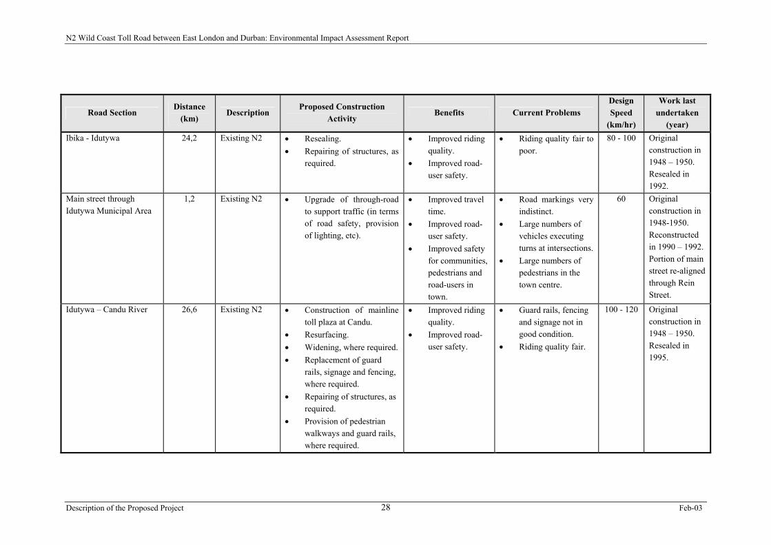
(year) Ibika - Idutywa 24,2 Existing N2 • Resealing.
• Repairing of structures, as required.
• Improved riding quality.
• Improved road-user safety.
• Riding quality fair to poor.
80 - 100 Original construction in 1948 – 1950. Resealed in 1992.
Main street through Idutywa Municipal Area
1,2 Existing N2 • Upgrade of through-road to support traffic (in terms of road safety, provision of lighting, etc).
• Improved travel time.
• Improved road-user safety.
• Improved safety for communities, pedestrians and road-users in town.
• Road markings very indistinct.
• Large numbers of vehicles executing turns at intersections.
• Large numbers of pedestrians in the town centre.
60 Originalconstruction in 1948-1950. Reconstructed in 1990 – 1992. Portion of main street re-aligned through Rein Street.
Idutywa – Candu River 26,6 Existing N2 • Construction of mainline toll plaza at Candu.
• Resurfacing. • Widening, where required. • Replacement of guard
rails, signage and fencing, where required.
• Repairing of structures, as required.
• Provision of pedestrian walkways and guard rails, where required.
• Improved riding quality.
• Improved road-user safety.
• Guard rails, fencing and signage not in good condition.
• Riding quality fair.
100 - 120 Original construction in 1948 – 1950. Resealed in 1995.
Description of the Proposed Project Feb-03 28
N2 Wild Coast Toll Road between East London and Durban: Environmental Impact Assessment Report
Road Section Distance
(km) Description
Proposed Construction Activity
Benefits Current Problems Design Speed
(km/hr)
Work last undertaken
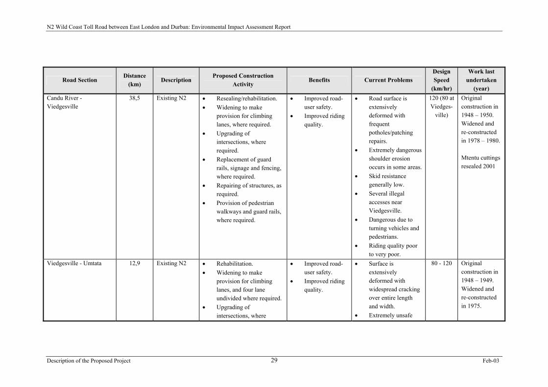
(year) Candu River - Viedgesville
38,5 Existing N2 • Resealing/rehabilitation. • Widening to make
provision for climbing lanes, where required.
• Upgrading of intersections, where required.
• Replacement of guard rails, signage and fencing, where required.
• Repairing of structures, as required.
• Provision of pedestrian walkways and guard rails, where required.
• Improved road-user safety.
• Improved riding quality.
• Road surface is extensively deformed with frequent potholes/patching repairs.
• Extremely dangerous shoulder erosion occurs in some areas.
• Skid resistance generally low.
• Several illegal accesses near Viedgesville.
• Dangerous due to turning vehicles and pedestrians.
• Riding quality poor to very poor.
120 (80 at Viedges-
ville)
Original construction in 1948 – 1950. Widened and re-constructed in 1978 – 1980. Mtentu cuttings resealed 2001
Viedgesville - Umtata 12,9 Existing N2 • Rehabilitation. • Widening to make
provision for climbing lanes, and four lane undivided where required.
• Upgrading of intersections, where
• Improved road-user safety.
• Improved riding quality.
• Surface is extensively deformed with widespread cracking over entire length and width.
• Extremely unsafe
80 - 120 Original construction in 1948 – 1949. Widened and re-constructed in 1975.
Description of the Proposed Project Feb-03 29
N2 Wild Coast Toll Road between East London and Durban: Environmental Impact Assessment Report
Road Section Distance
(km) Description
Proposed Construction Activity
Benefits Current Problems Design Speed
(km/hr)
Work last undertaken
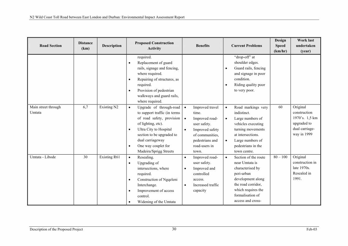
(year) required.
• Replacement of guard rails, signage and fencing, where required.
• Repairing of structures, as required.
• Provision of pedestrian walkways and guard rails, where required.
“drop-off” at shoulder edges.
• Guard rails, fencing and signage in poor condition.
• Riding quality poor to very poor.
Main street through Umtata
6,7 Existing N2 • Upgrade of through-road to support traffic (in terms of road safety, provision of lighting, etc).
• Ultra City to Hospital section to be upgraded to dual carriageway
• One way couplet for Madeira/Sprigg Streets
• Improved travel time.
• Improved road-user safety.
• Improved safety of communities, pedestrians and road-users in town.
• Road markings very indistinct.
• Large numbers of vehicles executing turning movements at intersections.
• Large numbers of pedestrians in the town centre.
60 Originalconstruction 1970’s. 1,5 km upgraded to dual carriage-way in 1999
Umtata - Libode 30 Existing R61 • Resealing. • Upgrading of
intersections, where required.
• Construction of Ngqeleni Interchange.
• Improvement of access control.
• Widening of the Umtata
• Improved road-user safety.
• Improved and controlled access.
• Increased traffic capacity
• Section of the route near Umtata is characterised by peri-urban development along the road corridor, which requires the formalisation of access and cross-
80 – 100 Original construction in late 1970s. Resealed in 1991.
Description of the Proposed Project Feb-03 30
N2 Wild Coast Toll Road between East London and Durban: Environmental Impact Assessment Report
Road Section Distance
(km) Description
Proposed Construction Activity
Benefits Current Problems Design Speed
(km/hr)
Work last undertaken
(year) and Corana River bridges to accommodate dual carriageway between Madeira Street and Ngqeleni turn-off.
• Widening and Construction of climbing lanes, where required.
access.
Libode to Ntlaza 8,1 Existing R61 • Widening and rehabilitation.
• Upgrading of intersections, where required.
• Climbing lanes, where required.
• Provision of pedestrian and taxi facilities, where required.
• Improved riding quality.
• Improved road-user safety.
• Road in very poor condition.
70 – 100 Original construction in 1982/1983. 3 km section rehabilitated in 2001 and remaining section resealed.
Ntlaza – Mgwenyana 15,7 Existing R61 • Initial reseal. • Widening and
construction of climbing lanes, where required.
• Upgrading of intersections, where required.
• Implementation of slope stability measures, where
• Improved riding quality.
• Improved road-user safety.
• Effective erosion control.
• The route passes through an area of geotechnical instability in the mountain pass (Tutor Ndamase Pass).
60 – 70 in steep
sections. 80 – 100 in rolling sections.
Original construction in 1986/1987.
Description of the Proposed Project Feb-03 31

N2 Wild Coast Toll Road between East London and Durban: Environmental Impact Assessment Report
Road Section Distance
(km) Description
Proposed Construction Activity
Benefits Current Problems Design Speed
(km/hr)
Work last undertaken
(year) required.
• Construction of mainline toll plaza.
Mgwenyana - Tombo 16,2 Existing R61 • Surface rehabilitation and widening of section.
• Addition of climbing lanes, where required.
• Upgrading of intersections, where required.
• Construction of retaining walls at unstable cuttings.
• Implementation of slope stability measures, where required.
• Improved riding quality.
• Improved road-user safety.
• Effective erosion control.
• Large surfacing failures and embankment settlements have occurred, which have been repaired.
70 Originalconstruction in 1983 and 1986. Repair to fill failure in 2001.
Tombo - Ndwalane 9,5 Existing R61 • Reseal. • Widening, where required. • Bridge widening at
Umgazi River. • Provision of pedestrian
and taxi facilities, where required.
• Upgrading of intersections, where required.
• Implementation of slope stability measures, where
• Improved road-user safety.
• Effective erosion control.
• Culvert failure near Ndwalane in 2001
70 Originalconstruction in 1989/1990.
Description of the Proposed Project Feb-03 32
N2 Wild Coast Toll Road between East London and Durban: Environmental Impact Assessment Report
Road Section Distance
(km) Description
Proposed Construction Activity
Benefits Current Problems Design Speed
(km/hr)
Work last undertaken
(year) required.
Ndwalane – Ntafufu River
16,5 New roadsection
• New road construction on a preferred alignment which bypasses the present Umzimvubu Pondoland Bridge.
• Improved travel time.
• Improved road-user safety.
- 80 - 120 -
Ntafufu River - Lusikisiki 18 Existing R61 • Upgrading to a minimum design speed of 60 km/hr, where required and widen section.
• Construction of climbing lanes, where required.
• Widening of road cross-section, where required.
• Widening of the Mzintlava River bridge.
• Construct Lusikisiki ring-road.
• Improved travel time.
• Improved road-user safety.
• Design speed was reduced to 40 km/hr to minimise initial construction costs.
• Some cracks exist, which have been sealed.
60 – 80 Original construction in 1993/1995
Lusikisiki – Msikaba River
25 New roadsection
• Upgrade of concrete road (east of Lusikisiki) to a dual carriageway.
• Upgrade of Magwa Intersection.
• Upgrade of a portion of the gravel road from Magwa Intersection.
• New road construction on
• Improved travel time.
• Improved road-user safety.
- 100 - 120 Concrete road Lusikisiki to Magwa turnoff (6,7 km) (2001). DR 08024 regravelled to Msikaba Mouth (2000)
Description of the Proposed Project Feb-03 33

N2 Wild Coast Toll Road between East London and Durban: Environmental Impact Assessment Report
Road Section Distance
(km) Description
Proposed Construction Activity
Benefits Current Problems Design Speed
(km/hr)
Work last undertaken
(year) a preferred alignment.
• High level bridge crossing over Msikaba River.
Msikaba River – Mtentu River
22 New roadsection
• New road construction on a preferred alignment.
• High level bridge crossing over Mtentu River.
• Improved travel time.
• Improved road-user safety.
- 120 -
Mtentu River – Mtamvuna River
33 New roadsection
• New road construction on a preferred alignment to join R61 road 2 km from Mtamvuna River bridge.
• Construction of high level bridge structures across the Mnyameni, Mpahlane and Mzamba rivers.
• Maintenance and rehabilitation of the existing Mtamvuna River bridge and widen 2 km of exiting R61.
• Improved travel time.
• Improved road-user safety.
- 120 and80 (2 km of R61)
Last 2 km on R61 constructed 1989.
Mtamvuna River – Southbroom
22 Existing R61 • Rehabilitation of the existing pavement.
• Upgrading of sub-standard intersections.
• Construction of Port Edward Interchange.
• Construction of additional
• Improved road-user safety.
• Improved access control.
• Improved travel time.
• Characterised by frequent access points which currently serve a number of coastal resorts and the more rural areas of
80-100 Originalconstruction in the early 1980s.
Description of the Proposed Project Feb-03 34

N2 Wild Coast Toll Road between East London and Durban: Environmental Impact Assessment Report
Road Section Distance
(km) Description
Proposed Construction Activity
Benefits Current Problems Design Speed
(km/hr)
Work last undertaken
(year) climbing lanes, where required.
• Improvement of intersection layout, where required.
• Consolidation of access points.
KwaZulu-Natal.
Southbroom – Marburg Interchange
22 Existing N20 • Rehabilitation of the existing pavement during the concession period.
• Improved road-user safety.
• Access via interchanges at a number of locations.
120 Originalconstruction in early 1990s.
Marburg Interchange – St Faiths Interchange
6 Existing N2 • Rehabilitation of the existing pavement during the concession period.
• Improved road-user safety.
- 120 Originalconstruction in early 1990s.
St Faiths Interchange – Umhlungwa Interchange (Hibberdene)
21 Existing N2 • None, since a new road has recently been constructed over this section.
- - 120 Originalconstruction in early 1990s.
Umhlungwa Interchange (Hibberdene) – Park Rynie Interchange
31,7 Existing N2 • Resurfacing. • Rehabilitation, where
required. • Construction of mainline
toll plaza.
• Improved road-user safety.
• Improved riding quality.
- 120 Originalconstruction in mid-1970s to 1980s.
Park Rynie Interchange – Winklespruit Interchange
29,0 Existing N2 • Resurfacing. • Improved road-user safety.
• Improved riding quality.
- 120 Originalconstruction completed in 1987.
Description of the Proposed Project Feb-03 35
N2 Wild Coast Toll Road between East London and Durban: Environmental Impact Assessment Report
Road Section Distance
(km) Description
Proposed Construction Activity
Benefits Current Problems Design Speed
(km/hr)
Work last undertaken
(year) Winklespruit Interchange - Amanzimtoti
5,3 Existing N2 • Asphalt overlay. • Rehabilitation, where
required.
• Improved road-user safety.
• Improved riding quality.
- 120 Originalconstruction in late 1970s.
Amanzimtoti – Athlone Park Interchange
5,3 Existing N2 • Rehabilitation of existing pavement.
• Addition of a third lane in each direction.
• Reconstruction of Adams Road interchange to improve the operational safety of the interchange.
• Improved road-user safety.
• Improved riding quality.
• Improved travel time and alleviation of traffic congestion.
• Safer access at Adams Road Interchange.
• Substandard interchange at Adams Road.
• Capacity problems during peak periods.
120 Originalconstruction in late 1970s.
Athlone Park Interchange – Isipingo Interchange
5,2 Existing N2 • Rehabilitation of existing pavement.
• Addition of a third lane in each direction.
• Construction of mainline toll plaza.
• Improved road-user safety.
• Improved travel time and alleviation of traffic congestion.
• Improved riding quality.
• Capacity problems during peak periods.
120 Originalconstruction in late 1970s.
Description of the Proposed Project Feb-03 36