part 1 - east hampshireeasthants.moderngov.co.uk/documents/s6132/ehdc part 1 section 1... · part 1...
TRANSCRIPT
PART 1
EAST HAMPSHIRE DISTRICT COUNCIL
PLANNING COMMITTEEREPORT OF THE HEAD OF PLANNING
Applications to be determined by theCouncil as the Local Planning Authority
PS.473/201628 July 2016
SECTION 1 – SCHEDULE OF APPLICATION RECOMMENDATIONS
Item No.: 01The information, recommendations and advice contained in this report are correct as at the date of preparation, which is more than one week in advance of the Committee meeting. Because of the time constraints some reports may have been prepared in advance of the final date given for consultee responses or neighbour comments. Any changes or necessary updates to the report will be made orally at the Committee meeting.
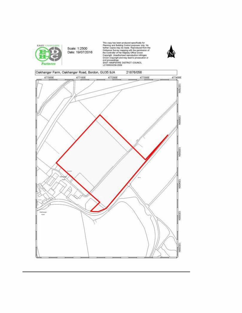
PROPOSAL Outline Application - Residential development comprising of 16 dwellings (12 affordable rent/Shared Ownership homes and 4 market price homes), with garages and parking, construction of a lake, landscaping and new vehicular access to Oakhanger Road (Amended description/plans 20.05.16)
LOCATION: Oakhanger Farm, Oakhanger Road, Bordon, GU35 9JAREFERENCE 21876/056 PARISH: SelborneAPPLICANT: Purple Beaver LimitedCONSULTATION EXPIRY :
11 July 2016
APPLICATION EXPIRY : 27 May 2016COUNCILLOR(S): Cllr D AshcroftSUMMARY RECOMMENDATION: OUTLINE PERMISSION
This application is included on the agenda as it has been submitted by a District Councillor.
The Monitoring Officer confirms that this proposal has been dealt with in accordance with the Council’s procedures for handling planning proposals submitted by or on behalf of Council Members and Staff.
Site and Development
The site
The application site totals 4.57 hectares in size and comprises open pasture used for grazing and hay making. It lies on the north side of Oakhanger Road, to the south of Oakhanger Village, and approximately 2 miles from Bordon and 10 miles from Alton.
The site is within the countryside (outside of any Settlement Policy Boundary) and lies approximately 200m from the South Downs National Park boundary.
The site adjoins the Oakhanger Farm site to the east, which itself comprises a number of former agricultural buildings which have been converted over time to light industrial units, creating a small business park with access from Oakhanger Road. There is a separate complex of Grade II Listed buildings on the western side of the business park, including the main farmhouse, which are accessed via a separate entrance. To the north and west are more agricultural fields and to the south is Oakhanger Road.
The site is bounded by low rise wooden post and rail fencing with an area of intermittent hedging to the south of the site. There are groups of Oak trees within the site, however, there are no trees protected by Tree Preservation Order (TPO) within or adjoining the site.
Ground levels within the site are generally even with a small drop in levels of approximately 5m from the northern part of the site down to the southern part.
The site is subject to the following designations/constraints:
In close proximity to the Wealden Heaths Phase II Special Protection Area (SPA)
In close proximity to the Shortheath Common Special Area of Conservation (SAC),
Opposite a Site of Important Nature Conservation (SINC)
Within the Broxhead & Kingsley Commons SSSI 2km Buffer Zone and within the Broxhead & Kingsley Commons SSSI Impact Risk Zone
Within an Area of Medium Contamination Risk
Within a Major Groundwater Vulnerability Zone
Within a Mineral Safeguarding Area.
Located within ‘Oaksafe 1’, ‘Oaksafe 2’, and ‘Oaksafe 3’ areas, which restrict the maximum height of new development within them.
Development
This is an outline application in respect of the development of the site to provide 16 dwellings with associated access from Oakhanger Road, parking, landscaping, and new lake. This application considers only the access in detail; with all other matters (appearance, landscaping, layout, and scale) reserved for future consideration.
The lake is intended as an amenity and drainage feature, however, is also proposed to be for use by a local Angling Society.
Two Suitable Alternative Natural Green Spaces (SANGS) are proposed to be located adjacent to the new entrance for the site. These would be for use by residents of the development.
Although only access has been put forward for full consideration, the application is supported by indicative details in respect of landscaping and layout. The proposed dwelling mix is:
12 affordable rented/shared ownership homes respectively comprising:
6 x 1 bed bungalow (A.R)6 x 2 bed bungalow (A.R)2 x 2 bed bungalow (S.O)1 x 2/3 bed bungalow (S.O)
Each dwelling would include 2 parking spaces.
4 market homes (of which 3 would be self-build) comprising:
2 x 3/4 bed dwellings2 x 4/5 bed dwellings
Each dwelling would include a double garage.
The application is supported by the following drawings/reports:
Design, Access and Planning Statement - Amended (Received 20.05.16)Environmental Desk Study and Preliminary Risk AssessmentFlood Risk AssessmentTree ReportStatement of Community Involvement
Archaeology Desk Based AssessmentEcological AppraisalSupplementary Ecology Letter from Vesper Conservation & Ecology Limited (Received 31.05.16)Landscape and Visual Impact AppraisalHighways Report (Received 20.05.16)Habitat Regulations Assessment and Information for Appropriate Assessment (Received 20.05.16)EH/483/IE/001b - Location plan - Amended (Received 07.07.16)Illustrative Proposed Site Layout - (Received 23.06.16)Illustrative Proposed Site Layout SANG Plan 1 - (Received 23.06.16)Illustrative Proposed Site Layout SANG Plan 2 - (Received 23.06.16)EH/483/IE/003a - Proposed vehicular access - Amended (Received 20.05.16)Topographical Survey A1 SheetTopographical Survey AO Sheet 1 of 3 Topographical Survey AO Sheet 2 of 3 Topographical Survey AO Sheet 3 of 3
Relevant Planning History
There is no planning history in respect of the site however, there is extensive planning history for various developments within the adjoining Oakhanger Farm Business Park.
Development Plan Policies and Proposals
East Hampshire District Local Plan: Joint Core Strategy (2014)
CP1 - Presumption in favour of sustainable development CP2 - Spatial StrategyCP10 - Spatial strategy for housingCP11 - Housing tenure, type and mixCP14 - Affordable housing for rural communitiesCP16 - Protection and provision of social infrastructureCP18 - Provision of open space, sport and recreation and built facilitiesCP19 - Development in the countrysideCP20 - LandscapeCP21 - BiodiversityCP24 - Sustainable constructionCP25 - Flood RiskCP26 - Water resources/ water qualityCP27 - PollutionCP28 - Green InfrastructureCP29 - DesignCP30 - Historic EnvironmentCP31 - TransportCP32 - Infrastructure

East Hampshire District Local Plan: Second Review (2006)
P7 - Contaminated LandHE17 - Archaeological & Ancient MonumentsT3 - Pedestrians and CyclistsHC2 - Provision of facilities and services with new DevelopmentH14 - Other Housing Outside Settlement Policy Boundaries
Planning Policy Constraints and Guidance
National Planning Policy Framework (NPPF)
The NPPF was published in March 2012 and came into force with immediate effect. At the heart of it is a presumption in favour of sustainable development. It states that the development plan is the starting point for consideration of planning applications, and planning applications must be determined in accordance with it, unless material considerations indicate otherwise.
In this instance the following sections of the NPPF are considered to be particularly relevant to the consideration of the development;
Core planning principles: Paragraph 17: Good amenity for all.
Section 4 – Promoting sustainable transport.Section 6 – Delivering a wide choice of high quality homes.Section 7 – Requiring good design.Section 8 – Promoting healthy communities.Section 10 – Meeting the challenge of climate change, flooding and coastal change.Section 11 – Conserving and enhancing the natural environment.Section 12 – Conserving and enhancing the historic environment.
The NPPF states that housing applications should be considered in the context of the presumption in favour of sustainable development. Relevant policies for the supply of housing should not be considered up-to-date if the local planning authority cannot demonstrate a five-year supply of deliverable housing sites (paragraph 49).
The Council is able to demonstrate a five year supply of deliverable housing sites thus the housing policies of the Plan are up to date.
National Planning Practice Guidance (NPPG)
Department of Communities and Local Government (DCLG) Technical Housing Standards
Consultations and Town/Parish Council comments
Environment Agency – No objection.

Natural England – No objection. Natural England is now satisfied that the revised layout and mitigation proposed in the further information addresses their concerns and that there will be mitigation put in place to address the impacts onto the SPA. Subject to these mitigation proposals being secured through a legal agreement Natural England withdraws its objection.
EHDC Planning Policy – No objection. The proposal has been amended to include 70% affordable homes and 30% market housing. This market housing is intended to fulfill a requirement for new self-build/custom-build dwellings.
Specifically, the revised proposal now appears capable of meeting criteria a), c) and f) of Policy CP14.
With regard to criterion a): the applicant rightly points out that the East Hampshire SHMA (2013) identifies a large outstanding requirement for new affordable housing (i.e. affordable rent and intermediate shared ownership/shared equity housing) to meet housing need. This supports the development of additional affordable housing (i.e. beyond what is currently planned and permitted) to address the affordable housing requirement. It should be noted that the planned provision of 10,060 new dwellings (Policy CP10) is a minimum requirement.
With regard to criterion c): the overall need for new affordable housing (per the SHMA) exceeds the projected supply of this form housing across the district, taking account of local plan allocations. Nevertheless, it should be noted that criterion c) implies that the need being addressed should relate to a nearby settlement and so it is not sufficient to rely on district-wide information to ensure conformity with this aspect of CP14. In addition, it is expected that when reviewing compliance or otherwise with criterion c), the comments of EHDC's housing service on local need are taken into account and that any known supply (planning permissions and/or allocations) relevant to the same settlement(s) is considered.
The fact that policy CP19 asserts a policy of general restraint towards development in the countryside and that EHDC has more than a five-year supply of housing land entails that decisions should be made in accordance with the more stringent proviso of CP14: that the need being addressed should be a localised need; rather than the general view that the Council should endorse any opportunity to boost the supply of new affordable housing. This is in accordance with the NPPF and its presumption in favour of sustainable development (paragraph 14, NPPF)
With regard to criterion f: the proposed affordable housing is now capable of being made available as affordable housing in perpetuity (this did not appear to be the case for starter homes)
With regard to the proposed 70% affordable housing/30% market housing split: it remains for the applicant to demonstrate that this is in accordance with Policy CP14. The site should provide 100% affordable housing unless exceptional circumstances can be proven. In this instance, the applicant has identified that the 30% market housing would be for self-build or custom-build housing and I note that self/custom builders have already been identified. The fact that this proposal would therefore enable the Council to discharge its duty to provide self-build accommodation where there is a clear demand may be important here.
EHDC Recycling and Refuse – No objection subject to an indemnity from the residents or managing agent being obtained in respect of wear and tear to any roads from refuse collection and concerns regarding the layout and surface of the access road being suitable for the refuse vehicles being addressed at detailed design stage.
EHDC Drainage Consultant – No objection subject to conditions in respect of foul and surface water drainage being attached to any approval. In addition, a specific condition requiring details of proposed fishing lake, including levels and overflow details is required to demonstrate that this will not increase flood risk to the development or elsewhere. A detailed maintenance management plan for all on-site drainage features including the fishing lake is also required.
EHDC Environmental Health (Contaminated Land) – No objection subject to conditions being attached to any approval in respect of the requirement for a Phased site investigation, excluding a desktop study, the validation of any required remedial works, and unsuspected contamination found on site
EHDC Environmental Health (Pollution) – No objection subject to a condition being attached to any approval requiring a Construction Environmental Management Plan to be submitted to the LPA for approval prior to development commencement.
EHDC Landscape Officer – Objection. There remains concern regarding proposed intrusion of development into the countryside. The revised layout is more acceptable on the western side where more buffer planting is proposed on the western boundary and alongside the lake, however the proposed housing on the eastern side of the site would have a negative visual impact on the Whitehill to Liphook Farmland and Heath Mosaic landscape character area. A management plan would be required for the proposed lake.
EHDC Arboricultural Officer – Objection. As the proposal does not appear to have altered around the veteran trees on the site. What appears to be a very simple adjustment needs to be made to the highway that runs to the north east so as to move it further away from the tree at the north eastern end of the row and a condition applied to any consent.
EHDC Housing Officer – No objection. This proposed mix of smaller dwellings, including many one beds, is appropriate to the housing needs of Oakhanger and the wider Selborne Parish. The tenure split recognises the priority for rented homes, but makes an allowance for those local people who may wish to purchase a dwelling on a shared ownership basis. The number, size and tenure of the affordable housing are acceptable.
The applicant has chosen bungalows as the type of dwelling to form the affordable element. Bungalows, as long as they remain for general needs, offer good quality accommodation suitable for adaption should mobility needs change over time.
Some concerns are raised in relation to the proposed lake and any service charge costs.
EHDC Conservation Officer – No objection. HCC Archaeology – No objection subject to conditions being attached to any approval.
HCC Highways – No objection subject to conditions being attached to any approval in respect of details of the construction of the access, provision of parking, details of bin and cycle stores, and a S278 agreement in respect of the installation of the proposed bell mouth entrance.
HCC Flood Water Management– No objection.
HCC Ecologist – No objection however requests that conditions be attached to any approval in respect of a Construction Environmental Management Plan being submitted to the LPA for approval and which should include all measures to protect, maintain and enhance ecological value, and in respect of the ecological l mitigation recommended in the submitted ecological report being secured.
HCC Education – No comments received.
Police Liaison Officer – No objection however makes recommendations in terms of safety and crime prevention.
Thames Water – No objection.
South East Water – No objection however request further information in respect of a hydrogeological risk assessment for this planning application to ensure that all risks to surface and groundwater quality have been adequately assessed and mitigated for as well as confirmation from the applicant that there is no intention to abstract or impinge upon groundwater level, flow or yield.
Southern Electric – No comments received.
Southern Gas Networks – No objection however advises that there should be no mechanical excavations taking place above or within 0.5m of a low/medium pressure system or above or within 3.0m of an intermediate pressure system.
Selborne Parish Council – Object.
Comment Date: 10 March 2016
The application is not justified in terms of Planning Policy, as follows:
1. It is a speculative development (i.e. it is not included in the local development plan) and would lead to unplanned and unsustainable growth of the village and as such should be resisted.
2. The site is in a countryside location. Oakhanger has no Settlement Policy Boundary, due to its lack of sustainability in terms of facilities, services, shops and transport links. The proposal conflicts with JCS Policy CP14 because that policy requires that 'the (adjacent) settlement provides a range of local services and facilities, or has accessibility to larger settlements nearby which provide a wider range of services and facilities?
People have to travel some distance by car to Bordon or Alton to reach schools, shopping, medical facilities and so on.
The area to be developed is not modest in scale and does not relate well to the settlement of Oakhanger;
The proposal does not provide dwellings that would be available as affordable housing for rent for local people in perpetuity;
Because Oakhanger is a settlement without a SPB, any proposal on a site such as this one should be for 100% affordable housing. No exceptional circumstances are offered in justification of the proposal for low-cost housing and 30% market housing instead;
The application therefore fails to comply with the requirements of Policy CP14.
3. The proposal is contrary to JCS Policy CP10
4. The proposal is contrary to Policy CP19 in that the proposed development does not 'have a genuine and proven need for a countryside location, such as that necessary for farming, forestry, or other rural enterprises (see Policy CP6).?
5. The application is not legitimately justified as a departure from the local Development Plan in line with the requirements of S.38(6) of the Planning & Compulsory Purchase Act 2004.
6. The NPPF paragraphs cited in defence of the proposal suggest that the application should instead be resisted, e.g. Paragraph 14 of the NPPF requires that planning applications be judged against the adopted Local Development Plan.
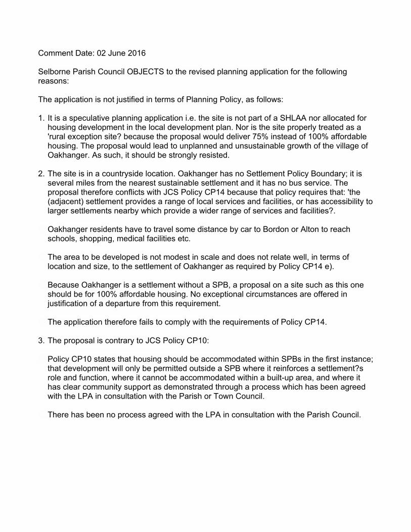
Comment Date: 02 June 2016
Selborne Parish Council OBJECTS to the revised planning application for the following reasons:
The application is not justified in terms of Planning Policy, as follows:
1. It is a speculative planning application i.e. the site is not part of a SHLAA nor allocated for housing development in the local development plan. Nor is the site properly treated as a 'rural exception site? because the proposal would deliver 75% instead of 100% affordable housing. The proposal would lead to unplanned and unsustainable growth of the village of Oakhanger. As such, it should be strongly resisted.
2. The site is in a countryside location. Oakhanger has no Settlement Policy Boundary; it is several miles from the nearest sustainable settlement and it has no bus service. The proposal therefore conflicts with JCS Policy CP14 because that policy requires that: 'the (adjacent) settlement provides a range of local services and facilities, or has accessibility to larger settlements nearby which provide a wider range of services and facilities?.
Oakhanger residents have to travel some distance by car to Bordon or Alton to reach schools, shopping, medical facilities etc.
The area to be developed is not modest in scale and does not relate well, in terms of location and size, to the settlement of Oakhanger as required by Policy CP14 e).
Because Oakhanger is a settlement without a SPB, a proposal on a site such as this one should be for 100% affordable housing. No exceptional circumstances are offered in justification of a departure from this requirement.
The application therefore fails to comply with the requirements of Policy CP14.
3. The proposal is contrary to JCS Policy CP10:
Policy CP10 states that housing should be accommodated within SPBs in the first instance; that development will only be permitted outside a SPB where it reinforces a settlement?s role and function, where it cannot be accommodated within a built-up area, and where it has clear community support as demonstrated through a process which has been agreed with the LPA in consultation with the Parish or Town Council.
There has been no process agreed with the LPA in consultation with the Parish Council.
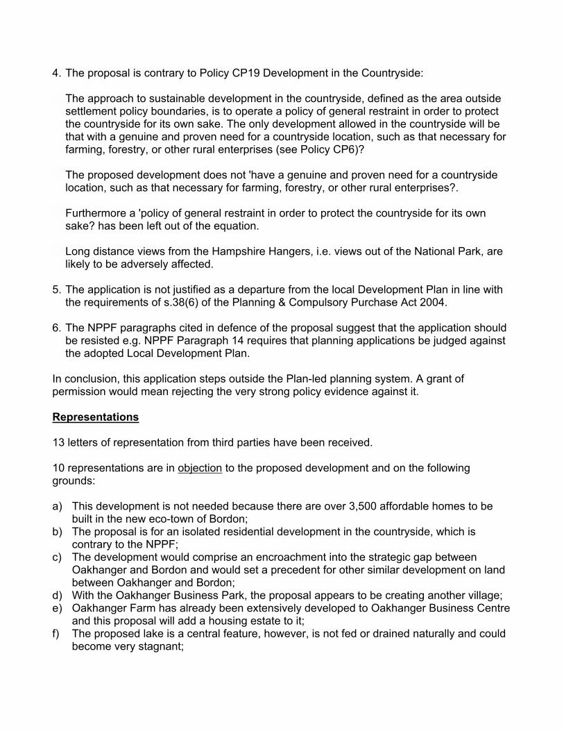
4. The proposal is contrary to Policy CP19 Development in the Countryside:
The approach to sustainable development in the countryside, defined as the area outside settlement policy boundaries, is to operate a policy of general restraint in order to protect the countryside for its own sake. The only development allowed in the countryside will be that with a genuine and proven need for a countryside location, such as that necessary for farming, forestry, or other rural enterprises (see Policy CP6)?
The proposed development does not 'have a genuine and proven need for a countryside location, such as that necessary for farming, forestry, or other rural enterprises?.
Furthermore a 'policy of general restraint in order to protect the countryside for its own sake? has been left out of the equation.
Long distance views from the Hampshire Hangers, i.e. views out of the National Park, are likely to be adversely affected.
5. The application is not justified as a departure from the local Development Plan in line with the requirements of s.38(6) of the Planning & Compulsory Purchase Act 2004.
6. The NPPF paragraphs cited in defence of the proposal suggest that the application should be resisted e.g. NPPF Paragraph 14 requires that planning applications be judged against the adopted Local Development Plan.
In conclusion, this application steps outside the Plan-led planning system. A grant of permission would mean rejecting the very strong policy evidence against it.
Representations
13 letters of representation from third parties have been received.
10 representations are in objection to the proposed development and on the following grounds:
a) This development is not needed because there are over 3,500 affordable homes to be built in the new eco-town of Bordon;
b) The proposal is for an isolated residential development in the countryside, which is contrary to the NPPF;
c) The development would comprise an encroachment into the strategic gap between Oakhanger and Bordon and would set a precedent for other similar development on land between Oakhanger and Bordon;
d) With the Oakhanger Business Park, the proposal appears to be creating another village;e) Oakhanger Farm has already been extensively developed to Oakhanger Business Centre
and this proposal will add a housing estate to it;f) The proposed lake is a central feature, however, is not fed or drained naturally and could
become very stagnant;

g) There is a mosquito problem in the village and the lake would exacerbate this;h) The proposed lake would not be safe for children unless a very high fence is proposed;i) Impact of the development on the rural and countryside character of the area;j) The site is not well connected by foot to the public house or village hall and footpaths
from the village to the Oakhanger Business Park are not of a good standard or lit;k) There is no public transport through the village; l) Impact of additional traffic from this development and the Whitehill & Bordon
development;m) Oakhanger road is used as a “rat run” to Alton and this development will make this worse;n) Concern regarding construction traffic;o) Local schools are full;p) No local shops;q) Lack of infrastructure in the area e.g. no reliable internet access;r) There may be contamination in the soil;s) The site is within a Groundwater Protection Zone and there may be contamination of
water sources from the development;t) The proposal makes reference to access to nearby military land for recreation, however,
this is restricted; and u) The development will harm the nearby SSSI;
2 letters of representation are in support of the proposed development on the following grounds:
a) There is a real need in Oakhanger for young people to have the chance to own their own property;
b) With the eco-town and new roads being built this is a prime area to build new properties;c) It would be beneficial if the proposal could include retirement and rental properties for
older people who have lived and worked in this area most of their life; d) The development is not going to affect the village, contrary to what objectors have stated;e) There is nothing to offer in Oakhanger so people will go to Bordon for services;f) The Oakhanger Business Park buildings are of a good design and it is expected that the
design of the proposed dwellings would be as good; andg) Concern regarding development creep towards Bordon and the joining of the two
communities, with the consequential loss of Oakhanger’s unique character and identity.
1 letter of representation makes the following comments in respect of the proposed development:
a) This application can be supported providing it is the last expansion at the Oakhanger Farm.
Determining Issues
1. Development plan and principle of development2. Deliverability3. Design and appearance4. Standard of accommodation to be provided5. Impact on neighbouring amenity6. Impact on trees7. Impact on the landscape and character of the area8. Impact on ecology 9. Access, movement, and highway issues10. Impact on drainage, flood risk and foul water11. Sustainability12. Archaeology13. Environmental Health14. East Hants District Council CIL15. Social Infrastructure and developer contributions
Planning Considerations
1. Development plan and principle of development
As required by section 38(6) of the Planning and Compulsory Purchase Act 2004, applications must be determined in line with the adopted development plan for the area, unless material considerations apply. The development plan for EHDC comprises the 'saved' policies of the EHDC Local Plan: Second Review (2006), the policies set out in the Local Plan: Joint Core Strategy (JCS) (2014), and the Local Plan: Housing and Employment Allocations (2016). Material considerations in respect of national planning policy are the NPPF, the recently published National Planning Policy Guidance, and DCLG Technical Standards.
The District is able to show that it has a robust 5 year supply of deliverable housing sites using either the ‘Liverpool’ methodology or the ‘Sedgefield’ methodology. Recent appeal decisions have also concurred that the 5 year housing land supply is robust and that use of the ‘Liverpool’ methodology is appropriate, thus the housing policies of the Plan are considered to be up to date.
The site lies outside of a village with no Settlement Policy Boundary (SPB). The adopted Allocations Plan does not include the site as an allocation of the plan and the site has not been included within the Council’s Strategic Housing Land Allocations Assessment (SHLAA) 2014. It should be noted however that the SHLAA does not decide where housing should be located or decide what specific sites should be allocated. This is done through the Local Plan process. The SHLAA provides a strategic assessment of a site’s sustainability credentials. It provides a pool of sites which have the potential to be developed for housing because they are technically suitable available for development and, therefore, achievable in the plan period.
Whilst the site adjoins a light industrial/commercial site, the site is greenfield land and in falling outside of any SPB, is regarded as countryside for the purposes of applying the strategic approach to development set out in the JCS and saved Local Plan policies. In particular, that of policies CP1, CP2, CP10, CP14, CP19, and H14 respectively.
These policies operate a policy of general restraint in order to protect the countryside and seek to focus development in more sustainable locations. These policies are consistent with the NPPF, including its core principles which note that Planning should recognise the intrinsic character and beauty of the countryside. A proposal, if it harms the character and appearance of the countryside, would conflict with these policies and mean that the development would not amount to Sustainable Development as referred to in the NPPF.
Policy CP1 of the JCS applies to development within the Settlement Policy Boundary (SPB), where there is a presumption in favour of development.
Policy CP2 identifies a sustainable hierarchy of SPBs and sets out five levels of sustainable settlements (rated level ‘1-5’, with ‘1’ being market towns and the most sustainable locations for new development and ‘5’ being rural villages/hamlets and the least sustainable locations due to their often limited services). The site lies within the parish of Selborne and adjacent to the settlement of Oakhanger, which has no SPB and is categorised as having the lowest sustainability level of location.
Since the site lies outside of any SPB and is, therefore, within a countryside location, it should be assessed against JCS policies CP14 and CP19, and saved policy H14 which only permit residential development subject to certain exception criteria.
The proposed development, within the countryside, would not comply with the exception criteria contained within policy CP19 since it would not be providing accommodation with a genuine and proven need for a countryside location, such as that necessary for farming, forestry, or other rural enterprises, and would not comply with the exception criteria contained within saved policy H14 since the dwellings would not be essential to house a full-time worker in agriculture, forestry or other enterprise who must live on the site rather than in a nearby settlement. That is not to say however, that occupants of the dwellings would not be agricultural or forestry workers.
Rural Exception Sites
The NPPF defines rural exception sites as:
‘Small sites used for affordable housing in perpetuity where sites would not normally be used for housing. Rural exception sites seek to address the needs of the local community by accommodating households who are either current residents or have an existing family or employment connection. Small numbers of market homes may be allowed at the local authority’s discretion, for example where essential to enable the delivery of affordable units without grant funding.’
Para. 54 of the NPPF states:
‘In rural areas, exercising the duty to cooperate with neighbouring authorities, local planning authorities should be responsive to local circumstances and plan housing development to reflect local needs, particularly for affordable housing, including through rural exception sites where appropriate. Local planning authorities should in particular consider whether allowing some market housing would facilitate the provision of significant additional affordable housing to meet local needs.’
The development would provide 12 affordable rent/shared ownership dwellings, which seeks to address a need for such accommodation within the local community. 4 market dwellings are proposed and, of these, 3 would be self-build. This constitutes a 75/25% split between intermediate and market units. As such, the scheme would fall to be considered against the exception criteria within policy CP14 of the JCS. These criteria require:
a) it provides affordable housing for local people who are unable to obtain accommodation on the open market;
b) there is a proven local affordable housing need;c) the need cannot be met within the settlement to which that need relates;d) the settlement provides a range of local services and facilities, or has accessibility to larger
settlements nearby which provide a wider range of services and facilities;e) the site is modest in scale and relates well, in terms of location and in size, to the existing
settlement;f) it provides dwellings which will be available as affordable housing for local people in
perpetuity
The justification text attached to policy CP14 also advises that at the smaller settlements without a settlement policy boundary (such as Oakhanger), policy CP14 provides for exceptions to normal policy in order to bring forward affordable housing where a need is proven. The justification text advises that it is unlikely that allowing some market housing on sites brought forward through this exception element of this policy would facilitate the provision of significant additional affordable housing to meet local needs however, there may be circumstances where an element of market housing could bring forward a site which would otherwise not be possible, for example where there are unusually high development costs. In this instance, the market housing would include 3 self-build dwellings and 1 market dwelling which the applicant is seeking to justify on the basis that it would assist in cross-subsidising the 12 affordable dwellings.
The Council’s Senior Housing Development Officer has confirmed a need for affordable rented/shared ownership accommodation within Oakhanger and this has informed the proposed 75/25% rented/affordable sale tenure split of the affordable units.
The intermediate housing need of eligible applicants registered with ‘Hampshire Home Choice’ with a local connection to Oakhanger and Selborne (Selborne Parish) is as follows:
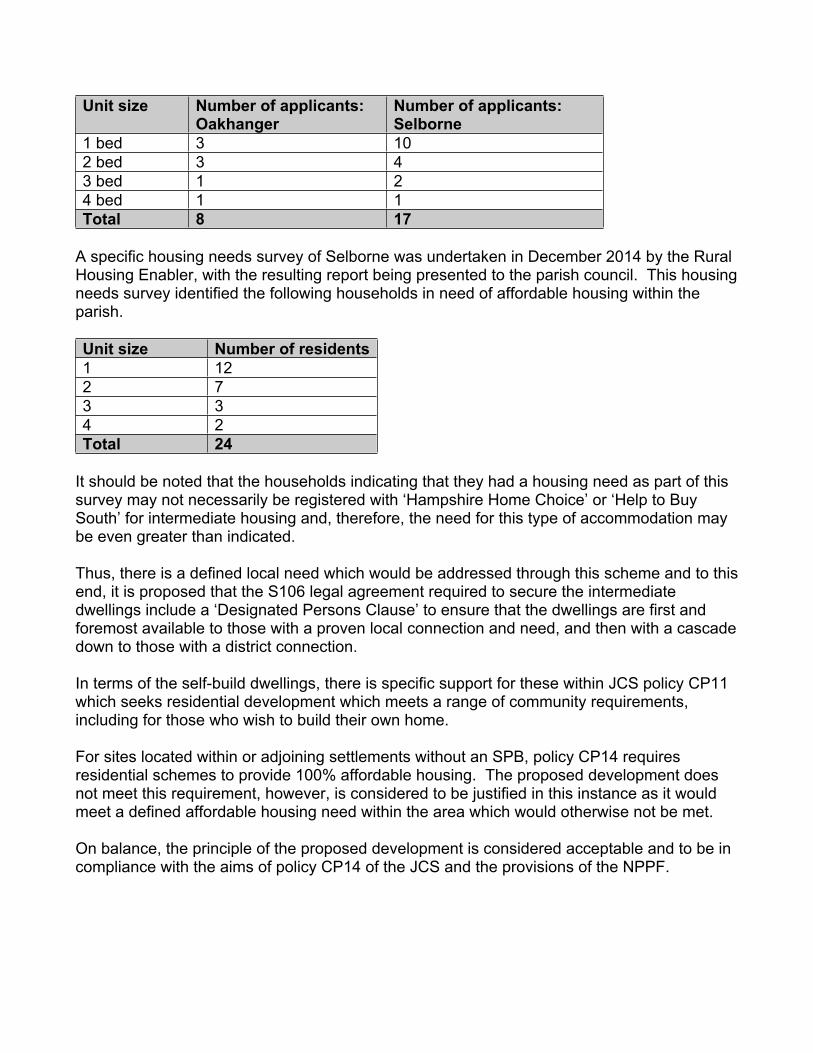
Unit size Number of applicants: Oakhanger
Number of applicants: Selborne
1 bed 3 102 bed 3 43 bed 1 24 bed 1 1Total 8 17
A specific housing needs survey of Selborne was undertaken in December 2014 by the Rural Housing Enabler, with the resulting report being presented to the parish council. This housing needs survey identified the following households in need of affordable housing within the parish.
Unit size Number of residents1 122 73 34 2Total 24
It should be noted that the households indicating that they had a housing need as part of this survey may not necessarily be registered with ‘Hampshire Home Choice’ or ‘Help to Buy South’ for intermediate housing and, therefore, the need for this type of accommodation may be even greater than indicated.
Thus, there is a defined local need which would be addressed through this scheme and to this end, it is proposed that the S106 legal agreement required to secure the intermediate dwellings include a ‘Designated Persons Clause’ to ensure that the dwellings are first and foremost available to those with a proven local connection and need, and then with a cascade down to those with a district connection.
In terms of the self-build dwellings, there is specific support for these within JCS policy CP11 which seeks residential development which meets a range of community requirements, including for those who wish to build their own home.
For sites located within or adjoining settlements without an SPB, policy CP14 requires residential schemes to provide 100% affordable housing. The proposed development does not meet this requirement, however, is considered to be justified in this instance as it would meet a defined affordable housing need within the area which would otherwise not be met.
On balance, the principle of the proposed development is considered acceptable and to be in compliance with the aims of policy CP14 of the JCS and the provisions of the NPPF.
2. Deliverability
Whilst the NPPF requires an LPA to maintain a five year supply of housing sites (plus an additional buffer) it clarifies that:
“To be considered deliverable, sites should be available now, offer a suitable location for development now, and be achievable with a realistic prospect that housing will be delivered on the site within five years and in particular that development of the site is viable. Sites with planning permission should be considered deliverable until permission expires, unless there is clear evidence that schemes will not be implemented within five years, for example they will not be viable, there is no longer a demand for the type of units or sites have long term phasing plans.”
The application is submitted in outline format only but, notwithstanding this, there are not believed to be any significant grounds for concluding that the site could not be developed within a short time period if permission were granted.
3. Design and appearance
Policy CP29 of the JCS seeks to ensure that development proposals are of exemplary standard of design and architecture, with a high quality external appearance that respect an area's particular characteristics. It requires that developments are sympathetic to their setting in terms of scale, height and massing, and their relationship to adjoining buildings, spaces around buildings, and that development should make a positive contribution to the overall appearance of the area.
Para. 56 of the NPPF states:
‘The Government attaches great importance to the design of the built environment. Good design is a key aspect of sustainable development, is indivisible from good planning, and should contribute positively to making places better for people.’
Para. 58 states that Planning policies and decisions should aim to ensure that developments:
●● will function well and add to the overall quality of the area, not just for the short term but over the lifetime of the development;
●● establish a strong sense of place, using streetscapes and buildings to create attractive and comfortable places to live, work and visit;
●● optimise the potential of the site to accommodate development, create and sustain an appropriate mix of uses (including incorporation of green and other public space as part of developments) and support local facilities and transport networks;
●● respond to local character and history, and reflect the identity of local surroundings and materials, while not preventing or discouraging appropriate innovation;
●● create safe and accessible environments where crime and disorder, and the fear of crime, do not undermine quality of life or community cohesion; and
●● are visually attractive as a result of good architecture and appropriate landscaping.
The application is in outline format with only access put forward for detailed consideration at this stage; however, indicative details have been submitted showing the proposed layout of the site. A single access would be created from Oakhanger Road, broadly centrally within the site, which would then split into an access to serve the affordable dwellings to western side of the site and the market dwellings to the eastern side. A lake would be located in the north-eastern section of the site and would directly adjoin the rear curtilages of the market dwellings. The lake would be separated from the affordable dwellings by a landscape buffer of trees and planting. The lake is proposed as an amenity and drainage feature and also to be used by a local angling society.
The submitted illustrative layout plan also indicates areas of hard and soft landscaping in addition to two SANGS. The indicative landscaping and SANGS are considered acceptable in principle, with details to be finalised at reserved matters stage in the event of an approval of this outline application.
There is predominately low rise and low density development within the surrounding area and whilst the detailed design, scale, and layout of the dwellings would be determined at reserved matters stage, regard would be had of the prevailing character of the area and the specially designated areas which the site adjoins.
Officers are not satisfied with the indicative layout at present due to the orientation of affordable dwellings relative to the lake and parking and also the siting and footprint of the garages for the market dwellings. These issues can, however, be addressed at the detailed design stage within any subsequent reserved matters application.
At 3.5 dwellings per hectare, the proposal is considered to result in a low density development and with significant opportunities to soften and enhance the appearance of the site.
The submitted illustrative master plan and accompanying documents have demonstrated that the proposed development is of a scale and density which could be satisfactorily accommodated on the site to be in keeping with the character of the area subject to agreeing details of the layout etc through reserved matters. As such, the development is in compliance with policy CP29 of the JCS and the provisions of the NPPF.
4. Standard of accommodation to be provided
The application is at outline stage however indicative details have been submitted showing that the dwellings would comprise a mixture of 1, 2, 3, 4+ bedroom dwellings and, therefore, likely to be used as family accommodation.
The DCLG Technical Standards would be applied to any residential development and these contain minimum gross internal areas (G.I.As) for proposed residential dwellings in addition to other minimum standards to ensure that any new development provides a suitable standard of accommodation for future occupiers. The affordable dwellings may also be subject to further standards imposed by any Registered Provider seeking to acquire the units.
The detailed site layout would be finalised at reserved matters stage in the event of any approval of outline permission, however the illustrative master plan shows that it would be possible to provide dwellings with a good level of defensible and private amenity space and the development as a whole would not be cramped.
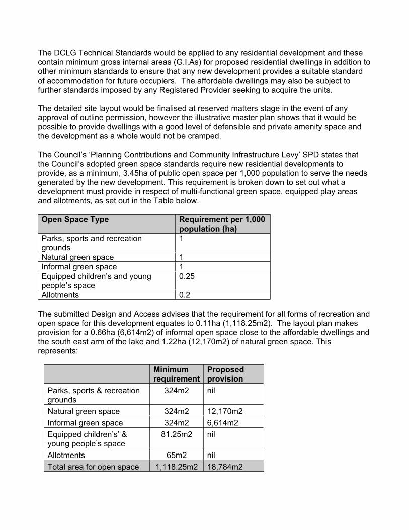
The Council’s ‘Planning Contributions and Community Infrastructure Levy’ SPD states that the Council’s adopted green space standards require new residential developments to provide, as a minimum, 3.45ha of public open space per 1,000 population to serve the needs generated by the new development. This requirement is broken down to set out what a development must provide in respect of multi-functional green space, equipped play areas and allotments, as set out in the Table below.
Open Space Type Requirement per 1,000 population (ha)
Parks, sports and recreation grounds
1
Natural green space 1Informal green space 1Equipped children’s and young people’s space
0.25
Allotments 0.2
The submitted Design and Access advises that the requirement for all forms of recreation and open space for this development equates to 0.11ha (1,118.25m2). The layout plan makes provision for a 0.66ha (6,614m2) of informal open space close to the affordable dwellings and the south east arm of the lake and 1.22ha (12,170m2) of natural green space. This represents:
Minimum requirement
Proposed provision
Parks, sports & recreation grounds
324m2 nil
Natural green space 324m2 12,170m2Informal green space 324m2 6,614m2Equipped children’s’ & young people’s space
81.25m2 nil
Allotments 65m2 nilTotal area for open space 1,118.25m2 18,784m2
A specific children’s play area, allotments, and formal sports facilities are not provided. However, given that only 16 dwellings are proposed, that each dwelling would include its own private amenity space, and the level of open space to be provided within the development as a whole, it is not considered that this would be unacceptable in this instance. The contributions towards off-site provision of social and community infrastructure, such as this, form part of the Community Infrastructure Levy (CIL).
The intermediate dwellings would be located the closest to Oakhanger Farm commercial units, however, it is considered that, based on the illustrative master plan for the site, they would be located sufficiently away from these units (approximately 40-55m) so as provide a suitable standard of accommodation for future occupiers and that the dwellings would not in turn prejudice the operation of these units. There are no heavy industrial or noise intensive uses within the Oakhanger Business Park site and the Council’s Environmental Health (Pollution) Officer has not raised any objection to the development on pollution/amenity grounds.
The lake is not intended to be for use by occupants of the intermediate units and it is considered that these properties would be located sufficiently away from the lake (approximately 40m) such that occupiers would not be unduly affected by the use of the lake by occupants of the market dwellings or Angling Society. A Lake Management and Maintenance Plan is recommended be secured through a S106 legal agreement and this would include restrictions on the hours of use of the lake, numbers of users of the lake, and the type/s of activity. It is also proposed to provide vegetative and tree planting as a buffer between the affordable dwellings and the lake for amenity reasons, and to address any potential safety concerns which may be raised by a future Registered Provider.
The Council’s Senior Housing Development Officer has identified a need for wheelchair accessible housing and housing which could be wheelchair adaptable in the future if required. As such, any S106 securing the affordable dwellings would include a provision requiring 3 of the affordable rented units to be fully wheelchair accessible and adaptable. This too is inline with policy CP11 which seeks to achieve residential development that meets a range of community requirements.
5. Impact on neighbour amenity
Policy CP27 of the JCS requires that developments do not have an unacceptable impact on the amenity of the occupiers of neighbouring properties through loss of privacy or excessive overshadowing.
The application is in outline format, however, an indicative site layout has been provided.
There are no residential dwellings in the immediate vicinity of the site or located close enough to the site that are considered would be unduly impacted by a residential redevelopment of the site in terms of noise, outlook, privacy, or daylight/sunlight. As previously mentioned, the Council’s Environmental Health Officer has raised no objection in terms of the relationship of the development with occupiers of the adjacent commercial estate.
From the indicative details submitted, the proposal would be compliant with JCS policy CP27 and the provisions of the NPPF.
6. Impact on trees
JCS policy CP19 states that the countryside (areas outside of SPBs) needs to be protected for the sake of its intrinsic character and beauty, the diversity and qualities of its landscapes, heritage and wildlife, the wealth of its natural resources and to ensure it may be enjoyed by all.
JCS policy CP20 states that the special characteristics of the district’s natural environment will be conserved and enhanced. New development will be required to, amongst other things, protect and enhance natural and historic features which contribute to the distinctive character of the districts landscape, such as trees, woodlands, hedgerows, soils, rivers, river corridors, ditches, ponds, ancient sunken lanes, ancient tracks, rural buildings, and open areas.
None of the existing trees within the site are proposed to be removed. The site does not include any Tree Preservation Orders (TPOs) and is not located within a conservation area however there are some Oak trees identified as being of amenity value and worthy of retention to the southern part of the site. The Council’s Arboricultural Officer has raised an objection to the development on the basis that the proposed access would impinge a tree of amenity value however advises that this could easily be overcome through a small readjustment of the access. This could be dealt with at detailed reserved matters stage in the event of any approval of outline consent.
Should this application be approved, appropriate conditions are recommended be attached requiring details the submission of an Arboricultural Method Statement and Tree Protection Plan for approval by the LPA.
The development is considered to comply with the aims of policies CP19 and CP20.
7. Impact on landscape and character of the area
One of the core planning principles within the NPPF is that Planning should ‘take account of the different role and character of different areas, and this includes recognising the intrinsic character and beauty of the countryside and supporting thriving rural communities within it’(paragraph 17).
JCS policy CP19 states that the countryside (areas outside of SPBs) needs to be protected for the sake of its intrinsic character and beauty, the diversity and qualities of its landscapes, heritage and wildlife, the wealth of its natural resources and to ensure it may be enjoyed by all.
JCS policy CP20 states that the special characteristics of the district’s natural environment will be conserved and enhanced and that development will be required to contribute to this through design, landscaping, and ecology.
The EHDC Landscape Officer initially raised an objection to the proposed development due to the negative impact on the Whitehill to Liphook Farmland and Heath Mosaic landscape character area, which is characterised by 'small to medium fields of pasture, paddock and rough grazing, with a framework of ancient woodlands and wood pasture’ where 'a tranquil, natural character is retained away from built up areas and busy roads’.
Following the submission of an amended illustrative layout, the EHDC Landscape Officer has confirmed that they consider that the layout is more acceptable on the western side where more buffer planting is proposed on the western boundary and alongside the lake, however the proposed housing on the eastern side of the site would have a negative visual impact on the Whitehill to Liphook Farmland and Heath Mosaic landscape character area. They also advise that a management plan would be required for the lake.
The density and general positioning of dwellings are considered acceptable and since this is an outline application, the detailed design and layout issues and house types would be fully considered at a reserved matters stage in order to address any landscape based concerns. The proposal, taken on its own merits, is not considered would result in an overly high density and would provide opportunities to soften and enhance the appearance of the site.
As such, the proposal is considered to comply with the aims of JCS policies CP20 and CP29, and the provisions of the NPPF.
8. Impact on ecology
JCS policy CP21 states that development proposals must maintain, enhance and protect the District’s biodiversity and its surrounding environment.
JCS policy CP22 states that development will be expected to, among other requirements:
- maintain, enhance and protect district wide biodiversity, in particular the nature conservation designations (see Map 2).
- ensure wildlife enhancements are incorporated into the design to achieve a net gain in biodiversity by designing in wildlife and by ensuring that any adverse impacts are avoided where possible or, if unavoidable, they are appropriately mitigated for, with compensatory measures only used as a last resort.
- protect and, where appropriate, strengthen populations of protected species;
The HCC Ecologist advises that the revised submitted Ecological Appraisal has adequately considered ecology within and adjoining the site and there are no objections subject to the ecological mitigation recommended in the Appraisal being secured through a condition attached to any approval.
The HCC Ecologist also advises that it is essential that a pre-commencement Construction Environment Management Plan (CEMP) is also secured by condition and should include all measures to protect, maintain and enhance ecological value. The lake is considered to be a prime opportunity to provide significant ecological benefit to the site e.g. by providing fish-free areas with native aquatic vegetation.
Natural England initially raised an objection to the proposed development on the basis of the potential adverse effect on the integrity on the nearby SACs and Wealden Heaths SPA due to additional recreational pressures as a result of the new dwellings. Further information was submitted by the applicant addressing these concerns through the proposed creation of two SANGS within the site for the use of occupants of the development. Natural England subsequently withdrew their objection subject to the SANGS being secured through a legal agreement.
In light of the above, the development is considered to comply with policies CP21 and CP22.
9. Access, movement and highway issues
JCS policy CP31 states that new development should be located and designed to reduce the need to travel and development that is likely to generate a significant number of additional vehicular movements will normally be expected to be located near existing centres and supportive infrastructure. Development proposals will include a range of mitigating measures and, where appropriate, will be required to meet the specific criteria set out within the policy.
Access to the development would be through a single new access to be created from Oakhanger Road leading to an internal access road serving the development, with the indicative layout showing that parking for each dwelling to be in compliance with adopted parking standards which require 1 space per 1 bed dwelling, 2 spaces per 2-3 bedroom dwelling and 3 spaces for 4+ bed dwelling.
Hampshire County Council, as the Local Highway Authority (HA) raises no objection to the proposed development subject to conditions being attached any approval in respect of: details of the construction of the access being submitted to the LPA for approval prior to development commencing, the approved parking being completed and made available prior to occupation of the development, and details of bin and cycle stores being submitted to the LPA for approval prior to development commencing, and the completion of a S278 agreement in respect of the installation of the bell mouth entrance onto Oakhanger Road.
A permissive path is proposed to connect the development to a public footpath to the northeast and provide residents with access on foot to the village, its public house, village hall to the north, and to the common land at The Warren and The Slab to the southeast. A permissive path is also proposed for residents to walk to the Oakhanger Farm Business Park. Residents using those permissive and public footpaths would not then need to walk on the roadside.

As such the proposed development is complies with the aims of policy CP31, saved policies T2 and T3 of the East Hampshire District Local Plan: Second Review (2006), and the NPPF.
10. Impact on drainage, flood risk and foul water
The submitted Flood Risk Assessment (FRA) advises that the application site lies within Flood Zone 1 (low probability of flooding). This comprises land assessed as having a less than 1 in 1000 annual probability of flooding in any year. Given the significant increase in non-porous surfacing which would result from the proposed development, the scheme has the potential to dramatically affect surface water run-off rates and which could impact upon flood risk elsewhere.
JCS policy CP25 states that development, including the access, should be safe without increasing flooding elsewhere, and where possible, will reduce flood risk overall and that all development will be required to ensure that there is no net increase in surface water run off.
Priority will be given to incorporating SUDs (Sustainable Drainage Systems) to manage surface water drainage, unless it can be demonstrated that SUDs are not appropriate. Where SUDs are provided, arrangements must be put in place for their whole life management and maintenance.
JCS policy CP26 states that development will be required to protect the quality and quantity of water, and make efficient use of water.
The EHDC Drainage Consultant has not raised any objections to the proposed development subject to conditions in respect of foul and surface water drainage measures, prevention of surface water draining to the highway, and that any hard surfaces are either made of porous materials or provisions included to direct surface water to drain elsewhere within the site being attached to any approval. In addition, a maintenance management plan is requested be provided for all on-site drainage features including the fishing lake, and it is intended that this would be secured through a S106 agreement attached to any approval.
The HCC Flood and Water Management has advised that they do not object to the development as the applicant has demonstrated that the lake would be able to adequately cope with additional volumes of surface water.
The Environment Agency and Thames Water have not raised any objections to the development
South East Water has requested further information in respect of a hydrogeological risk assessment including robust pollution protection measures and consideration of drainage design and ground disturbance to minimise potential impacts on ground water quality and reduction in the availability of groundwater resources. This is to ensure adequate measures and precautions necessary to avoid deterioration in the quality of groundwater below the site. This further information can be secured through a condition attached to any approval.

In light of the above, it is considered that subject to the appropriate conditions being attached to any approval, the development could be achieved in such a way that it would not result in increased surface water flooding in/around the site and that groundwater would not be affected by potential contaminants from the construction and operation of the development, in accordance with aims of policies CP25 and CP26 of the JCS.
11. Sustainability
Under JCS policy CP24, new residential development would normally need to meet Code 4 of the Code for Sustainable Homes, plus an additional 10% in the way of energy consumption / efficiency savings or equivalent. However on the 27th March 2015 the Government withdrew the Code for Sustainable Homes aside from the management of legacy cases.
As such, the Code for Sustainable Homes has been replaced by new national technical standards which comprise new additional optional Building Regulations regarding water and access as well as a new national space standard (this is in addition to the existing mandatory Building Regulations). These additional options (which are comparable with the requirements for the former Code for Sustainable Homes Level 4) can be required by a planning permission.
A Sustainability Statement has not been submitted however the requirement for the incorporation of measures that provide energy savings of no less than 10% above Building Regulations in force at the time the development is to be constructed can be secured by way of planning condition to ensure the development meets the requirements of Policy CP24.
12. Heritage assets
JCS policy CP30 states that development proposals must conserve, and where possible, enhance the historic environment.
The site does not lie within or adjoining a conservation area and the only Listed Buildings in proximity to the site are a group on the western side of the Oakhanger Farm Business Park.
S72 of the Planning (Listed Buildings and Conservation Areas) Act (1990) states that with respect to any buildings or other land in a conservation area, special attention shall be paid to the desirability of preserving or enhancing the character or appearance of that area.
Para.132 of the NPPF states that when considering the impact of a proposed development on the significance of a designated heritage asset, great weight should be given to the asset’s conservation. The more important the asset, the greater the weight should be. Significance can be harmed or lost through alteration or destruction of the heritage asset or development within its setting.
The Council’s Conservation Officer has raised no objection to the development on heritage grounds.
The HCC Archaeologist raises no objection to the development subject to conditions being attached to any approval in respect of the implementation of a programme of archaeological assessment in accordance with a Written Scheme of Investigation that has been submitted to and approved by the LPA, the implementation of a programme of archaeological mitigation of impact, and a report being produced in accordance with an approved programme including where appropriate post-excavation assessment, specialist analysis and reports, publication and public engagement.
As such, the proposal accords with policy CP30 of the JCS.
13. Environmental Health
The EHDC Environmental Health Officers have raised no objections on contamination or pollution grounds subject to relevant conditions being attached to any approval
14. East Hants District Council CIL (EHDC CIL)
JCS policy CP32 states that where the provision or improvement of infrastructure is necessary to meet community or environmental needs associated with new development or to mitigate the impact of development on the environment, the payment of financial contributions will be required through planning obligations and/or the Community Infrastructure Levy (CIL) to ensure that all such development makes an appropriate and reasonable contribution to the costs of provision.
EHDC CIL was adopted on the 8th April 2016. This enables the Council to raise, and pool, contributions from developers to help fund additional infrastructure required to support new development including roads, schools, green spaces and community facilities. EHDC CIL replaces Section 106 agreements as the principal means by which pooled developer contributions towards providing the necessary infrastructure are collected except for contributions towards affordable housing, and Community Project Worker etc, as set out in the adopted ‘Planning Contributions and Community Infrastructure Levy’ Supplementary Planning Document, which provides further details on the Council’s CIL Charging Schedule and other developer contributions. If approved, the development would be CIL liable.
15. Social Infrastructure and Developer Contributions
JCS policy CP32 states that where the provision or improvement of infrastructure is necessary to meet community or environmental needs associated with new development or to mitigate the impact of development on the environment, the payment of financial contributions will be required through planning obligations and/or the Community Infrastructure Levy (CIL) to ensure that all such development makes an appropriate and reasonable contribution to the costs of provision.
Planning obligations, enforced through Section 106 (S106) legal agreement (Town and Country Planning Act 1990 (as amended)), assist in mitigating the impact of potentially unacceptable development to make it acceptable in planning terms however they should only be used where it is not possible to address unacceptable impacts through a planning condition. Planning obligations should also only be sought where they meet all of the following tests within Regulation 122(2) of the Community Infrastructure Levy regulations 2010:
● Necessary to make the development acceptable in planning terms;● Directly related to the development; and● Fairly and reasonably related in scale and kind to the development.
A section 278 (S278) agreement (Highways Act 1980 (as amended)) is a legally binding document between the Local Highway Authority and the developer to ensure that the work to be carried out on the highway is completed to the standards and satisfaction of the Local Highway Authority.
Since the application proposes the provision of 16 additional residential units, in order for thedevelopment to be acceptable in planning terms, a S106 legal agreement would be required to secure the following:
1. Provision of 12 affordable dwellings, with associated occupation and tenure restrictions2. 3 of the 12 affordable dwellings to be wheelchair accessible and capable of adaptation for
wheelchair use3. Agreement of a Management and Maintenance Plan in respect of the proposed lake and
its associated surface water drainage features, it’s use by anglers and associated parking, and which also confirms that any Registered Provider taking on the affordable dwellings would not be liable to any maintenance or other costs in respect of the lake and/or works/structures associated with it
4. S278 agreement in respect of the construction of the bell mouth entrance serving the site.5. Details and the provision of, two SANGS as shown on the illustrative layout plan, and
public access to the SANGS6. S106 administration and monitoring fee
The applicant has indicated a willingness to enter a necessary agreement with applicable heads of terms, and so the proposal accords with policies CP11, CP14, CP18, CP31 and CP32 of the Joint Core Strategy.
Response to Parish/Town Council Comments
Selborne Parish Council objects to the proposed development and on the grounds of the development being contrary to policy and resulting in a negative precedent for other similar development, the unsustainable location of the site, and the density of the scheme and impact on the surrounding landscape character.
These issues have been covered in the foregoing report.
Conclusion
The NPPF advocates a presumption in favour of sustainable development. Any adverse impacts of the proposal would need to significantly and demonstrably outweigh the benefits.
The site lies adjoining a village with no Settlement Policy Boundary thus is in a countryside location, and where there is a presumption against new residential development other than in exceptional circumstances. Critically, the Council can demonstrate a five year housing land supply (using both ‘Liverpool’ and ‘Sedgefield’ methodologies) and therefore the housing policies of the Development Plan are considered to be up to date. The site is not included in the most recent SHLAA or the adopted Allocations Plan and subsequently there is no overriding justification for the development unless exceptional circumstances apply.
In this instance, the development is considered, on balance, to comply with the policy exception criteria of policy CP14. It is a rural exception site where housing would not normally be permitted and where, as per the justification text for policy CP14, a small element of market homes are proposed in order to bring forward the affordable units. There is a defined need for intermediate housing within the parishes of Oakhanger and Selborne for residents with a local connection and this development would directly address this need. The development would also address a need for wheelchair accessible/adaptable accommodation and self-build opportunities, in line with policy CP11 which supports residential developments to meet a range of community requirements.
On other matters, subject to the relevant conditions and S106 legal agreement, the application has demonstrated that the development could be achieved in such a way that would conserve and enhance the character of the area, that it would not result in a detrimental impact on protected species and the SPA, that it would not result in a detrimental impact on the amenities of the occupiers of adjoining and surrounding properties by way of the density, scale, and siting of the development, and that it would not result in a detrimental impact on foul and surface water drainage, or on highway/pedestrian considerations.
The development also makes provision for the relevant financial and other infrastructure requirements should any application be approved.
In light of the above, the principle of development is, on balance, accepted on this site and that the development would be sustainable having regard to the provisions of the NPPF and relevant policies of the Development Plan.
RECOMMENDATION That the Solicitor to the Council be authorised to draw up a S106 Agreement and provided that by 16 September 2016 all parties enter into the S106 Agreement with the Council to secure:

1. Provision of 12 affordable dwellings, with associated occupation and tenure restrictions2. 3 of the 12 affordable dwellings to be wheelchair accessible and capable of adaptation for
wheelchair use3. Agreement of a Management and Maintenance Plan in respect of the proposed lake and
its associated surface water drainage features, it’s use by Anglers and associated parking, and which also confirms that any Registered Provider taking on the affordable dwellings would not be liable to any maintenance or other costs in respect of the lake and/or works/structures associated with it
4. S278 agreement in respect of the construction of the bell mouth entrance serving the site.5. Details and the provision of, two SANGS as shown on the illustrative layout plan6. S106 administration and monitoring fee
in accordance with policies CP14, CP20, CP31, and CP32 of the Joint Core Strategy, then the Head of Planning be authorised to grant Outline Permission, subject to the following conditions.
If the agreement is not completed within this timescale, then the application shall be referred back to Committee for determination, unless the Head of Planning, in consultation with the Portfolio Holder for Planning, authorises further time extension(s) for the completion of the legal agreement. 1 Applications for the approval of the matters referred to herein shall be
made within a period of three years from the date of this permission. The development to which the permission relates shall be begun not later than whichever is the later of the following dates:-(i) three years from the date of this permission; or(ii) two years from the final approval of the said reserved matters, or, in the case of approval on different dates, the final approval of the last such matter to be approved.Reason - To comply with the provisions of Section 92(2) of the Town and Country Planning Act, 1990.
2 No development shall start on site until plans and particulars showing details relating to access, appearance, landscaping, layout, and scale of the development shall be submitted to, and approved by the Planning Authority. These details shall comprise the 'reserved matters' and shall be submitted within the time constraints referred to in Condition 1 above before any development is commenced. Reason - To comply with Article 5 of the Town and Country Planning (Development Management Procedure) (England) Order 2015 (or any Order revoking and re-enacting that Order).
3 No development shall start on site until a Construction Method and Environmental Management Plan has been submitted to and approved in writing by the Planning Authority, which shall include:
A programme of and phasing of demolition (if any) and construction work; The provision of long term facilities for contractor parking;
The arrangements for deliveries associated with all construction works;
Methods and phasing of construction works; Access and egress for plant and machinery; Protection of pedestrian routes during construction; Location of temporary site buildings, compounds, construction
material, and plant storage areas; Provision for storage, recycling, collection, and disposal of rubbish
from the development during construction period; and Re-use of on site material and spoil arising from any site clearance
or demolition work. Loading and unloading of plant and materials The erection and maintenance of security hoarding including
decorative displays and facilities for public viewing, where appropriate
Wheel washing facilities Measures to control the emission of dust and dirt during
construction Measures to control noise and vibration during construction Measures to protect, maintain, and enhance ecological value within
the siteDemolition and construction work shall only take place in accordance with the approved method statement.
Reason - To ensure the safety of pedestrians and vehicles, the amenities of the surrounding area, and to protect, maintain, and enhance the ecological value of the site and in order that the Local Planning Authority can properly consider the effect of the works on the amenity of the locality. It is considered necessary for this to be a pre-commencement condition as these details relate to the construction of the development and thus go to the heart of the planning permission.
4 No development shall commence on site until plans of the site showing details of the existing and proposed ground levels, proposed finished floor levels, levels of any paths, drives, garages and parking areas and the proposed completed height of the development and any retaining walls have been submitted to, and approved in writing by, the Local Planning Authority. The details shall clearly identify the relationship of the proposed ground levels and proposed completed height with adjacent buildings. The development thereafter shall be carried out in accordance with the approved details.Reason - To ensure that a satisfactory relationship results between the new development and adjacent buildings and public areas. It is considered necessary for this to be a pre-commencement condition as these details relate to the construction of the development and thus go to the heart of the planning permission.
5 No development shall commence on site until a scheme has been submitted to, and agreed in writing by, the Local Planning Authority to demonstrate that the built development hereby permitted incorporates measures that provide energy savings of no less than 10% above Building Regulations in force at the time the development is to be constructed.
Before any part of the development is first occupied a verification report and completion certificate shall be submitted in writing to the Local Planning Authority confirming that the built development hereby permitted has been constructed in accordance with the approved scheme. The developer shall nominate a competent person for the purpose of assessing and providing the above required report and certificate to confirm that the completed works incorporate such measures as to provide the required energy savings.
The energy saving works set out in the above report shall thereafter be maintained so that the required energy saving is sustained at the certified level for the lifetime of the development.
Reason - To ensure that the development incorporates necessary mitigation and adaptation measures with regard to climate change. It is considered necessary for this to be a pre-commencement condition as these details relate to the construction of the development and thus go to the heart of the planning permission.
6 No development shall commence on site until details of a scheme for foul and surface water drainage has been submitted to, and approved in writing by, the Local Planning Authority. Such details should include provision for all surface water drainage from parking areas and areas of hardstanding to prevent surface water from discharging onto the highway and should be based on site investigation and percolation tests. The development shall be carried out in accordance with the approved details before any part of the development is first occupied and shall be retained thereafter.Reason - To ensure adequate provision for drainage. It is considered necessary for this to be a pre-commencement condition as such details need to be taken into account in the construction of the development and thus go to the heart of the planning permission.
Note: The applicant is requested to contact the Council's Drainage Consultant as soon as possible to discuss the details required for the discharge of the above condition.
7 The proposed hard surface/s shall either be made of porous materials or provision shall be made to direct run-off water from the hard surface/s to a permeable or porous surface within the site. Reason - To ensure adequate provision for surface water drainage and avoid discharge of water onto the public highway.
8 The development hereby permitted shall not be brought into use until the area(s) shown on the approved plan for the parking of vehicles for a dwelling (including garages and those areas marked out on the plan as being unallocated) shall have been made available, surfaced and marked out. The parking area(s) shall then be permanently retained for that dwelling and reserved for that purpose at all times.Reason - To make provision for off-street parking for the purpose of highway safety.
9 No part of the development hereby approved shall be occupied until details for the on site provision of bin & cycle storage facilities have been submitted to and approved in writing by the Local Planning Authority. A dwelling shall not be occupied until the bin and cycle storage has been constructed in accordance with the approved details and thereafter retained and kept available.Reason - To ensure the adequate provision of on site facilities.

10 That no development shall take place until the applicant has secured the implementation of a programme of archaeological assessment in accordance with a Written Scheme of Investigation that has been submitted to and approved by the Planning Authority. The assessment should take the form of trial trenching within the footprint of the lake and the footprints of the proposed new houses and along the route of the proposed new access road. Trial trenching should be a mixture of machine excavated trenches to search for archaeological features and hand excavated trial pits to test for deposits containing Mesolithic flints.Reason - To assess the extent, nature and date of any archaeological deposits that might be present and the impact of the development upon these heritage assets.
11 That no development shall take place until the applicant has secured the implementation of a programme of archaeological mitigation of impact, based on the results of the trial trenching, in accordance with a Written Scheme of Investigation that has been submitted to and approved by the Planning Authority.Reason - To mitigate the effect of the works associated with the development upon any heritage assets and to ensure that information regarding these heritage assets is preserved by record for future generations.
12 Following completion of archaeological fieldwork a report will be produced in accordance with an approved programme including where appropriate post-excavation assessment, specialist analysis and reports, publication and public engagement.Reason - To contribute to our knowledge and understanding of our past by ensuring that opportunities are taken to capture evidence from the historic environment and to make this publicly available.
13 No development shall commence until the following details have been submitted to and approved in writing by the Planning Authority:-(a) a scheme outlining a site investigation and risk assessments designed to assess the nature and extent of any contamination on the site. (b) a written report of the findings which includes, a description of the extent, scale and nature of contamination, an assessment of all potential risks to known receptors, an update of the conceptual site model (devised in the desktop study), identification of all pollutant linkages and unless otherwise agreed in writing by the Local Planning Authority and identified as unnecessary in the written report, an appraisal of remediation options and proposal of the preferred option(s) identified as appropriate for the type of contamination found on site.and (unless otherwise first agreed in writing by the Planning Authority)
(c) a detailed remediation scheme designed to bring the site to a condition suitable for the intended use by removing unacceptable risks to human health, buildings and other property and the natural and historical environment. The scheme should include all works to be undertaken, proposed remediation objectives and remediation criteria, timetable of works, site management procedures and a verification plan outlining details of the data to be collected in order to demonstrate the completion of the remediation works and any arrangements for the continued monitoring of identified pollutant linkages.The above reports should be completed by a competent person, as stipulated in the National Planning Policy Framework, Annex 2, and site works should be undertaken in accordance with DEFRA and the Environment Agency’s ‘Model Procedures for the Management of Land Contamination, CLR 11’ and BS10175:2011 Investigation of potentially contaminated sites – Code of practice.Reason - To ensure that risks from land contamination to the future users of the land and neighbouring land are minimised, together with those to controlled waters, property and ecological systems, and to ensure that the development can be carried out safely without unacceptable risks to workers, neighbours and other offsite receptors. It is considered necessary for this to be a pre-commencement condition as these details need to be agreed prior to the construction of the development and thus go to the heart of the planning permission.
14 Before any part of the development is first occupied or brought into use (unless otherwise first agreed in writing by the Local Planning Authority) a verification report demonstrating the effectiveness of the remediation works carried out and a completion certificate confirming that the approved remediation scheme has been implemented in full shall both have been submitted to and approved in writing by the Local Planning Authority. The verification report and completion certificate shall be submitted in accordance with the approved scheme and undertaken by a competent person in accordance with DEFRA and the Environment Agency’s ‘Model Procedures for the Management of Land Contamination, CLR 11’.Reason - To ensure that risks from land contamination to the future users of the land and neighbouring land are minimised, together with those to controlled waters, property and ecological systems, and to ensure that the development can be carried out safely without unacceptable risks to workers, neighbours and other offsite receptors.
15 All development shall be stopped immediately in the event that contamination not previously identified is found to be present on the development site and details of the contamination shall be reported immediately in writing to the Local Planning Authority.
Development shall not re-start on site until the following details have been submitted to and approved in writing by the Local Planning Authority:-(a) a scheme outlining a site investigation and risk assessments designed to assess the nature and extent of any contamination on the site. (b) a written report of the findings which includes, a description of the extent, scale and nature of contamination, an assessment of all potential risks to known receptors, an update of the conceptual site model (devised in the desktop study), identification of all pollutant linkages and unless otherwise agreed in writing by the Local Planning Authority and identified as unnecessary in the written report, an appraisal of remediation options and proposal of the preferred option(s) identified as appropriate for the type of contamination found on site and (unless otherwise first agreed in writing by the Local Planning Authority)(c) a detailed remediation scheme designed to bring the site to a condition suitable for the intended use by removing unacceptable risks to human health, buildings and other property and the natural and historical environment. The scheme should include all works to be undertaken, proposed remediation objectives and remediation criteria, timetable of works, site management procedures and a verification plan outlining details of the data to be collected in order to demonstrate the completion of the remediation works and any arrangements for the continued monitoring of identified pollutant linkages;
and before any part of the development is occupied or used (unless otherwise first agreed in writing by the Local Planning Authority) a verification report demonstrating the effectiveness of the remediation works carried out and a completion certificate confirming that the approved remediation scheme has been implemented in full shall both have been submitted to and approved in writing by the Local Planning Authority.
The above site works, details and certification submitted shall be in accordance with the approved scheme and undertaken by a competent person in accordance with DEFRA and the Environment Agency’s ‘Model Procedures for the Management of Land Contamination, CLR 11’.Reason - To ensure that risks from land contamination to the future users of the land and neighbouring land are minimised, together with those to controlled waters, property and ecological systems, and to ensure that the development can be carried out safely without unacceptable risks to workers, neighbours and other offsite receptors.
16 Development shall proceed in accordance with the ecological mitigation measures detailed within the Ecological Appraisal (Vesper Conservation & Ecology Limited, May 2016) unless otherwise agreed in writing by the Local Planning Authority. Reason: to protect biodiversity in accordance with the Conservation Regulations 2010, Wildlife & Countryside Act 1981, the NERC Act (2006), NPPF and with Policy CP21 of the East Hampshire District Local Plan: Joint Core Strategy. Reason - To protect, maintain, and enhance the ecological value of the site.
17 No development shall take place until details have been submitted to, and approved in writing by, the Local Planning Authority in respect of:
1. The approved lake, including levels and overflow details, to demonstrate that the lake will not increase flood risk to the development or elsewhere.
2. A detailed maintenance management plan for all on-site drainage features including the approved lake.
Reason - To ensure satisfactory means of surface water drainage and to reduce the risk of flooding. It is considered necessary for this to be a pre-commencement condition as such details need to be taken into account in the construction of the development and thus go to the heart of the development.
18 No development shall take place until details have been submitted to, and approved in writing by, the LPA in respect of a hydrogeological risk assessment including robust pollution protection measures and consideration of drainage design and ground disturbance to minimise potential impacts on ground water quality and reduction in the availability of groundwater resources.Reason - To ensure adequate measures and precautions necessary to avoid deterioration in the quality of groundwater below the site. It is considered necessary for this to be a pre-commencement condition as such details need to be taken into account in the construction of the development and thus go to the heart of the development.
19 No development [including demolition] pursuant to this consent shall commence until an Arboricultural Method Statement and Tree Protection Plan, drafted in accordance with the recommendations and guidance set out in BS 5837:2012 has been submitted to and approved in writing by the Local Planning Authority and the approved details have been installed. The details and measures as approved shall be retained and maintained, until the completion of all site operations.
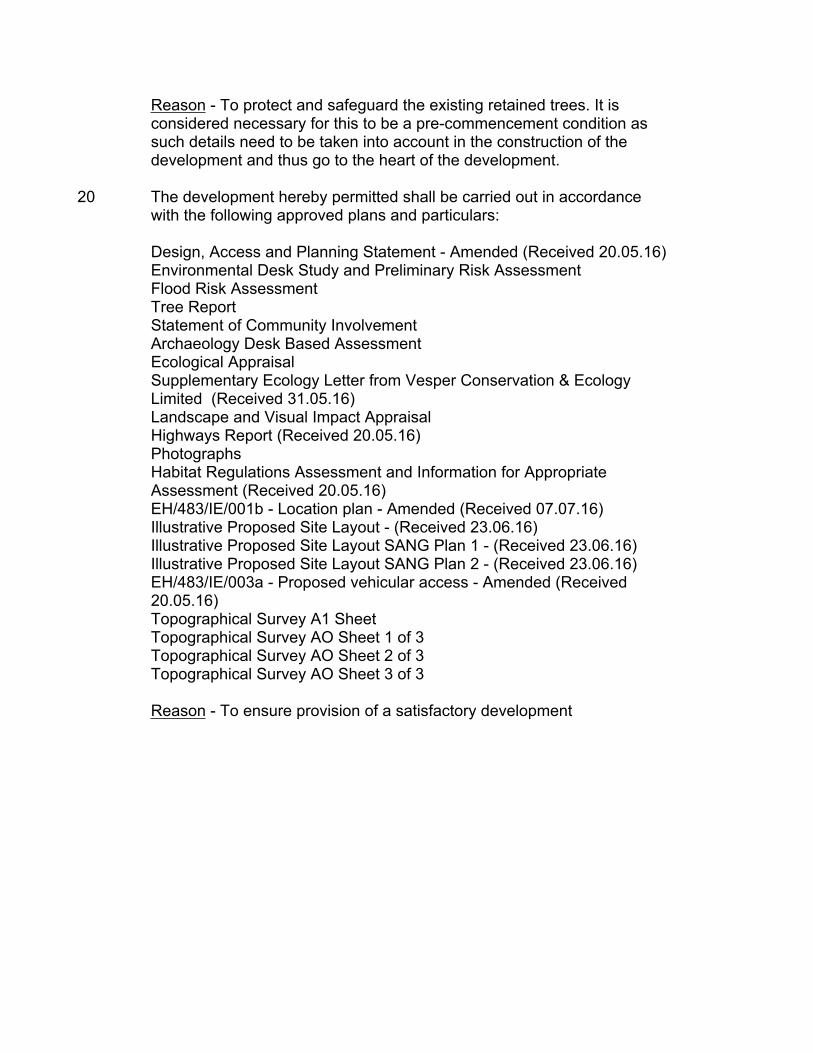
Reason - To protect and safeguard the existing retained trees. It is considered necessary for this to be a pre-commencement condition as such details need to be taken into account in the construction of the development and thus go to the heart of the development.
20 The development hereby permitted shall be carried out in accordance with the following approved plans and particulars:
Design, Access and Planning Statement - Amended (Received 20.05.16)Environmental Desk Study and Preliminary Risk AssessmentFlood Risk AssessmentTree ReportStatement of Community InvolvementArchaeology Desk Based AssessmentEcological AppraisalSupplementary Ecology Letter from Vesper Conservation & Ecology Limited (Received 31.05.16)Landscape and Visual Impact AppraisalHighways Report (Received 20.05.16)PhotographsHabitat Regulations Assessment and Information for Appropriate Assessment (Received 20.05.16)EH/483/IE/001b - Location plan - Amended (Received 07.07.16)Illustrative Proposed Site Layout - (Received 23.06.16)Illustrative Proposed Site Layout SANG Plan 1 - (Received 23.06.16)Illustrative Proposed Site Layout SANG Plan 2 - (Received 23.06.16)EH/483/IE/003a - Proposed vehicular access - Amended (Received 20.05.16)Topographical Survey A1 SheetTopographical Survey AO Sheet 1 of 3 Topographical Survey AO Sheet 2 of 3 Topographical Survey AO Sheet 3 of 3
Reason - To ensure provision of a satisfactory development

Informative Notes to Applicant:
1 With regard to surface water drainage it is the responsibility of a developer to make proper provision for drainage to ground, water courses or a suitable sewer. In respect of surface water it is recommended that the applicant should ensure that storm flows are attenuated or regulated into the receiving public network through on or off site storage. When it is proposed to connect to a combined public sewer, the site drainage should be separate and combined at the final manhole nearest the boundary. Connections are not permitted for the removal of groundwater. Where the developer proposes to discharge to a public sewer, prior approval from Thames Water Developer Services will be required. They can be contacted on 0800 009 3921. Reason - to ensure that the surface water discharge from the site shall not be detrimental to the existing sewerage system.
2 A Groundwater Risk Management Permit from Thames Water will be required for discharging groundwater into a public sewer. Any discharge made without a permit is deemed illegal and may result in prosecution under the provisions of the Water Industry Act 1991. We would expect the developer to demonstrate what measures he will undertake to minimise groundwater discharges into the public sewer. Permit enquiries should be directed to Thames Water’s Risk Management Team by telephoning 02035779483 or by emailing [email protected]. Application forms should be completed on line via www.thameswater.co.uk/wastewaterquality.”
3 The applicant’s attention is drawn to the comments made by relevant utilities infrastructure providers in respect of the development and to ensure the development will not impact on relevant utilities.
4 The applicant is advised that the development the subject of this outline consent is liable to the East Hampshire District CIL Charging Schedule which became a material planning consideration on 8th April 2016. On approval of the last reserved matter arising from this outline consent, this development will be liable to pay the Council’s CIL upon commencement of development. For further information, please see the CIL pages online, here:http://www.easthants.gov.uk/planning-policy/developers-contributions-%E2%80%93-community-infrastructure-levy-cil-and-s106
5 In accordance with paragraphs 186 and 187 of the NPPF East Hampshire District Council (EHDC) takes a positive and proactive approach and works with applicants/agents on development proposals in a manner focused on solutions by:
offering a pre-application advice service,
updating applications/agents of any issues that may arise in the processing of their application and where possible suggesting solutions, and,
by adhering to the requirements of the Planning Charter.
In this instance the applicant: was provided with pre-application advice
the applicant was updated of any issues after the initial site visit
CASE OFFICER: Ms Sabah Halli 01730 234229———————————————————————————————————————
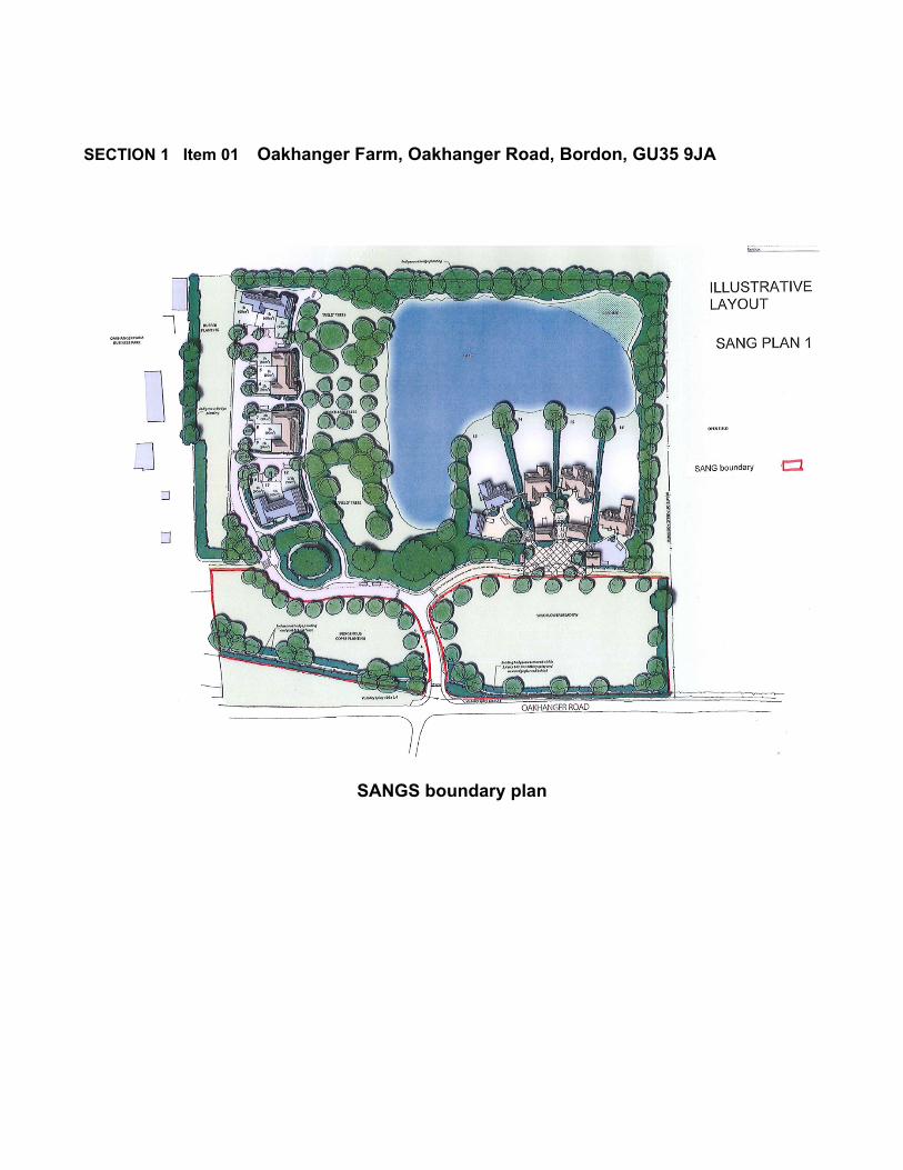
SECTION 1 Item 01 Oakhanger Farm, Oakhanger Road, Bordon, GU35 9JA
SANGS boundary plan