parametric land cover and land-use classifications as tools for environmental change detection
TRANSCRIPT
Agriculture, Ecosystems and Environment 91 (2002) 89–100
Parametric land cover and land-use classifications astools for environmental change detection
Louisa J.M. Jansen∗, Antonio Di GregorioGCP/RAF/287/ITA Africover—Eastern Africa Module, c/o FAO Representation Kenya, P.O. Box 30470, Nairobi, Kenya
Received 2 September 1999; received in revised form 7 June 2001; accepted 13 June 2001
Abstract
Systematic description of the environment for detection of environmental changes and the human-related causes and re-sponses is essential in land cover and land-use change studies. The combined use of land cover and land-use data allowsdetection of where certain changes occur, what type of change, as well as how the land is changing. Existing systems forclassification of land cover or land-use are limited in the storage of the number of classes and are often internally inconsistent.Therefore, FAO developed the land cover classification system (LCCS), a comprehensive parametric classification based uponsystematic description of classes using a set of independent quantifiable diagnostic criteria. With this approach land coverchange detection becomes possible at the level of conversion of a class, whereas modification within a certain class typebecomes immediately identifiable by a difference in classifier, or through the use of additional classifiers as is shown in aseries of examples illustrating the application of the approach to primarily vegetated areas. The development of a similar clas-sification approach for land-use is in progress. The proposed approach combines function, grouping all land used for a similareconomic purpose, with activity, grouping all land undergoing a certain process resulting in a homogeneous type of products.The preliminary concepts have been tested in two applications that have shown that the system can be used as a bridgingsystem that will ensure compatibility with, and bridge, existing systems. Furthermore, by providing (part of) the diagnosticcriteria the system contributes to providing a uniform basis for environmental change detection and these criteria contribute,in turn, to standardisation. Land cover boundaries do not necessarily coincide with land-uses and the land cover/land-userelation needs more study to understand its complexity.© 2002 Elsevier Science B.V. All rights reserved.
Keywords:Land cover; Land-use; Classification; Change detection; Global change
1. Introduction
The understanding of the interactions betweenland cover and land-use in their spatial and tempo-ral appearances is fundamental to comprehension ofland-use and land cover change. Land cover is anexpression of human activities and, as such, changes
∗ Corresponding author. Present address. Free lance consultant.Tel./fax: +39-065757719.E-mail address:[email protected] (L.J.M. Jansen).
with changes in land-use and management. Hence,land cover may form a reference base for applicationsincluding forest and rangeland monitoring, productionof statistics for planning and investment, biodiver-sity, climate change and desertification control (DiGregorio and Jansen, 1998). Detection of changes inthe environment and the human-related causes andresponses may be used to predict changes and projectfuture trajectories. Land-use and land cover change isa multi-disciplinary subject where bio-physicists andsocio-economists meet one another. It is important
0167-8809/02/$ – see front matter © 2002 Elsevier Science B.V. All rights reserved.PII: S0167-8809(01)00243-2
90 L.J.M. Jansen, A.D. Gregorio / Agriculture, Ecosystems and Environment 91 (2002) 89–100
that an integrated approach is taken with multiplepartners involved to come to a widely accepted refer-ence base for land-use and land cover classification.
Classification is defined as “the ordering orarrangement of objects into groups or sets on thebasis of relationships. These relationships can be basedupon observable or inferred properties” (Sokal, 1974).It is important to note that classification is an abs-traction as it depicts a representation of the reality(Di Gregorio and Jansen, 2000).
With the combination of land cover and land-usechange detection will provide the location of occur-ring changes and type of change, as well as the man-ner in which the land is changing. Change detectionis of course related to the time of observation, thetime span, the means and methods of observation. Thescope of this paper is the concept of change detectionand the contribution parametric classification systemscan make by providing (part of) the diagnostic crite-ria. With the standardisation of the diagnostic criteria,such a classification system would provide a uniformbasis for change detection.
2. Land cover change detection
Land cover change detection has to recognise thatchanges take two forms.
1. Conversion from one land cover category to an-other, e.g. from forest to grassland.
2. Modification within one category, e.g. from rainfedcultivated area to irrigated cultivated area.
These two forms of change have implications for themethodology used to describe and classify land cover.Conversion implies an evident change, whereas mod-ifications are much less apparent. The latter requiresa greater level of detail to be accommodated.
The broader and fewer the categories used to des-cribe land cover, the fewer the instances of conver-sion from one to another. If land cover classes areas broad as “Forest and Woodland” and “PermanentMeadows and Pastures” as in the FAO ProductionYearbook (FAO, 1990–1995), then forest fragmenta-tion and changes in species cover composition dueto overgrazing, e.g. bush encroachment will not reg-ister as conversion. Conversion is reasonably welldocumented in change studies as in the FAO Forest
Resources Assessment (FAO, 1996). If conversiontotals alone are used to measure change, it may occurthat apparently no land cover change appeared at all(Meyer and Turner, 1992).
Broad categories cannot be used to measure anytype of modification. If stands of single species (mono-cultures) replace stands of multiple species, the cate-gory “Arable Land” in the FAO Production Yearbook(FAO, 1990–1995) will not allow registration of sucha change. Contrary to conversion, modification is notas well studied and at the global scale, often ignored.The ecological consequences; however, are as impor-tant in the case of conversion as in the case of mod-ification. The subtle changes of modification do notalways result in degraded ecosystems (Turner et al.,1995); it is a result of evolutional aspects. The increasein planting densities on cropped land is an example ofmodification that does not lead per se to degradation.Intensification of cultivation may lead to a longer pe-riod in which crops cover the land, however this willbe highly localised and difficult to observe.
Classifications are not just limited to an analysisof the current situation but classification results canbe instrumental in understanding and changing exist-ing circumstances. The current interest in global andregional land cover and land-use change (e.g. FAO’sAfricover Project, Forest Resources Assessment andIGBP-IHDP land-use cover change project) requiresa set of tools that will enable meaningful compar-isons. Classification systems can be tools for changedetection when they offer the capability to describeclasses through a set of well-defined independent di-agnostic criteria (classifiers), which allow building upthese classes, rather than being based upon the tradi-tional system using descriptive class names withoutexplicitly mentioning the criteria used. The classifiersshould be independent from the land in order to anal-yse changes related to either the bio-physical features,i.e. land cover, or to the human use of the land, i.e.land-use, or both.
3. Existing classifications
Traditional classification systems dealing with landcover and/or land-use (Danserau, 1961; Fosberg,1961; Trochain, 1961; Eiten, 1968; UNESCO, 1973;Mueller-Dombois and Ellenberg, 1974; Anderson
L.J.M. Jansen, A.D. Gregorio / Agriculture, Ecosystems and Environment 91 (2002) 89–100 91
et al., 1976; Kuechler and Zonneveld, 1988; ECE-UN,1989; UNEP/FAO, 1994; CEC, 1995; Duhamel, 1995;Thompson, 1996) are limited in their capacity ofstorage of classes and often do not contain the wholevariety of occurring land covers or land-uses. Somedescribe (semi)natural vegetation in great detail whileaccommodating cultivated areas in a single class orvice versa. More important, they are based uponthe approach of class names and class descriptionsthat do not consistently use a set of criteria to makeclass distinctions (Jansen and Di Gregorio, 1998a).Furthermore, the criteria used are often not inher-ent characteristics but describe the environmentalsetting of the land cover and land-use, respectively.The distinction between land cover and land-use isnot always appreciated or adhered to in the abovementioned classifications.
The above is demonstrated using the Corine LandCover (CEC, 1995) and ECE-UN, standard interna-tional classification of land-use (1989) as examples.
3.1. Inconsistent application of land cover orland-use criteria
The application of land-use criteria in a land covernomenclature, or land cover criteria in a land-useclassification, results in a system that fails to makea clear distinction between land cover and land-use. In Corine the classes “1.2.1. Industrial or Com-mercial Zones”, “1.4.2. Sports and Leisure Facilities”and “2.3.1. Pastures” each contain a set of differentland cover types for a specific land-use. In the ECE-UN, a land-use classification, the distinction betweenthe classes “2.1. Land under Coniferous Forest” and“2.2. Land under Non-Coniferous Forest” is basedupon land cover.
3.2. Inconsistent use of criteria at same level ofclassification
The inconsistent use of criteria at the same levelwithin one major class. In Corine, “2.1. ArableLand” is subdivided at the third level into “2.1.1.Non-irrigated Arable Land” and “2.1.2. PermanentlyIrrigated Land” using the practice of irrigation as cri-terion, whereas “2.1.3. Rice Fields” is distinguishedfrom the crop species. It is not explained, why thecriterion to distinguish the latter has the same weight
as irrigation. In the ECE-UN, the “5. Dry Open LandWith Special Vegetation Cover” class is further sub-divided into “5.1. Heathland”, “5.2. Dry Tundra” and“Mountainous Grassland” using criteria related to thevegetation type, vegetation type plus absence of water,and vegetation type plus landform. It is not explainedwhy two of the three classes are distinguished usingadditional criteria to vegetation type.
3.3. Use of different criteria between classes
The use of different criteria between related ma-jor classes. In Corine, “3.1. Forests” are distin-guished at the third level based upon the criteriaof leaf type, whereas the related class “3.2. Scruband/or Herbaceous Associations” only uses the samecriterion for distinction of “3.2.3. SclerophyllousVegetation”. The other third level classes use theirstate (“3.2.1. Natural Grasslands” and “3.2.4. Transi-tional Woodland-Scrub”) or vegetation types (“3.2.2.Moors and Heathland”) as criterion. One may won-der why these criteria are introduced at this level.The same occurs in ECE-UN where “1. AgriculturalLand” is further subdivided using criteria related tocropping and the period during which the crops coverthe land, whereas “2. Forest and Other Wooded Land”are subdivided at the third level according to ma-jor function. A user may question why the functioncriterion was not applied to agriculture.
3.4. Use of non-inherent characteristics
The use of characteristics that are not inherent toland cover: “5.2. Marine Waters” is subdivided at thethird level into “5.2.1. Coastal Lagoons” and “5.2.2.Estuaries” using geomorphologic criteria. The sameoccurs in the ECE-UN where “7.2. Tidal waters” aresubdivided into “7.2.1. Coastal Lagoons” and “7.2.2.Estuaries”. In both classifications, it is not explainedwhy exogenous criteria are introduced for further di-vision of water.
Although the underlying reasons for making thesubdivisions based upon different criteria, described inthe previous paragraphs, may be valid, they show thatcriteria do not always have the same weight in makingdistinctions. Such decisions are usually not well doc-umented in the accompanying reports of the classifi-cations. It will be difficult for any user to trace back
92 L.J.M. Jansen, A.D. Gregorio / Agriculture, Ecosystems and Environment 91 (2002) 89–100
the origins of these unsystematic descriptions and tore-interpret the class descriptions and criteria used inthe absence of sufficient documentation. This hampersharmonisation of classification results, as these inter-pretations are likely to differ between persons withinone country and between countries. The actual clas-sifications make an insufficient contribution to datastandardisation and harmonisation. Efforts to increasestandardisation and harmonisation do not necessar-ily lead to loss of pragmatic decisions on the choiceof criteria as the focus should be on the logical andfunctional consistent application of a set of inherentcriteria that are clearly separated from non-inherentcriteria.
4. Criteria for change detection andclassification systems
Change detection should be established on a soundbase. Preferably, this base should use a common ref-erence system established upon objective measurableand replicable criteria. At present, data collection andcompilation is often accomplished for one single pur-pose, thereby limiting the use of the products to thosethat have a similar aim. Data collection is, however,time consuming and expensive.
The existing classifications are limited in the num-ber of classes thereby restricting the possibilities forchange detection. Elements used at a high level ofaggregation are few, thus, only this set of diagnos-tic elements can be considered for monitoring. Aparametric, or classifier, approach can be a tool forchange detection because it describes classes througha set of independent quantifiable diagnostic criteria,rather than being based upon descriptive class names.The individual classifiers provide, consequently, theelements for monitoring change. Those classifiersshould be selected on the basis of objective measure-ment and only the number of classifiers in the systemwould limit the elements to be monitored. At the sametime they would be standardised parameters con-tributing to harmonisation of criteria used for changedetection.
The compilation of data sets has been greatly fa-cilitated by geographical information systems (GIS)owing to the minimum aggregation and maximumflexibility. However, the ease with which data sets are
compiled did not contribute to being useful to a widerpublic and to a more diverse range of applications. Todate, most databases still take a sectoral approach. Inorder to facilitate exchange of available data and topermit a comprehensive assessment of land cover andland-use change on a uniform basis, data should beconverted to a common basis that allows correlationand comparison. The different applications may di-verge from this common reference base and add morespecific purpose-related criteria.
A parametric, or classifier, approach makes thecriteria for classification more explicit than any tradi-tional system, as well as the consistent application ofselected criteria. The set of diagnostic criteria shouldbe limited to those identifying a certain object anddistinguishing it from other objects, but additionalcriteria may be used to add more detail to the descrip-tion of the object or even describe the environmentalsetting of the class. The latter type of attribute shouldbe clearly distinguishable from those that describeinherent characteristics. The use of explicit criteriawill enhance comparison of change statistics by pro-viding the set of parameters that may be analysedand monitored. These parameters can be measured byfield observation, census and/or statistical methods.
Criteria that are linked to the means or scale ofobservation should never be included in a classificationsystem as it is by definition independent of tools (e.g.spectral reflectance characteristics are related to thesatellite instrument and the pixel size will determinewhat features can be detected).
A further requirement of a classification system isthe applicability at various scales, from global, re-gional, national to local, i.e. being accommodated byhaving different levels of aggregation in the system.At each level the set of criteria applied will be dif-ferent and criteria used at higher levels should not berepeated at lower levels. Original data should alwaysbe maintained to allow full desegregation, return fromboundaries to gradients and, if necessary, reclassifica-tion of the original data for other purposes.
By increasing the number of classes in a systemto be able to accommodate any land cover occurringanywhere in the world, the problem of determinationof clear class boundary definitions arises, as they willbe based on very slight differences. The wrong, ordifferent, designation of the same land cover featureto different classes will affect the standardisation
L.J.M. Jansen, A.D. Gregorio / Agriculture, Ecosystems and Environment 91 (2002) 89–100 93
process, a principal objective of classification. Theattempt to harmonise classification results will fail ifthe diagnostic criteria are not determined in a clear,meaningful and unambiguous manner (e.g. the mean-ing of a classifier may change with the type of en-vironment). Therefore, strict and unambiguous classboundaries are a prerequisite. Furthermore, classesshould be as neutral as possible in the description ofa land cover feature in order to answer the needs of awide variety of end-users.
5. Land cover classification system
5.1. Conceptual approach
The set of diagnostic criteria for the parametric clas-sification approach followed in the land cover classi-fication system (LCCS) developed by FAO is basedupon examination of criteria commonly used in exist-ing classifications that identify and describe land coverin an impartial, measurable and quantitative manner(FAO, 1997; Di Gregorio and Jansen, 1998 and 2000;Jansen and Di Gregorio, 1998a).
The developed approach to classification aims at alogical and functional hierarchical arrangement of theclassifiers, thereby accommodating different levels ofinformation, starting with broad-level classes whichallow further systematic subdivision into more detailedsubclasses. At each level the defined classes are mu-tually exclusive. Criteria used at one level of the clas-sification are not to be repeated at other levels. Theincrease of detail in the description of a class is linkedto the increase in the number of classifiers used. Inother words, the more classifiers are added, the moredetailed the class. The class boundary is then definedeither by the different number of classifiers, or by thepresence of one or more different types of classifiers.Emphasis is not given to the derived class name, thetraditional method, but to the set of classifiers used todefine this land cover class.
Many current classification systems are not suitablefor mapping and subsequently monitoring purposes.In the developed parametric approach, the use of di-agnostic criteria and their hierarchical arrangement toform a land cover class, are a function of geographicalaccuracy. The arrangement of classifiers will assureat the highest levels of the classification, i.e. the
most aggregated levels, a high degree of geographicalaccuracy.
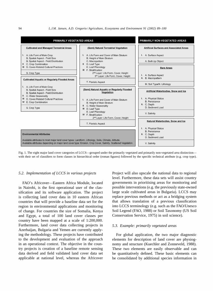
Land cover should describe the whole observablebio-physical environment and is, thus, dealing witha heterogeneous set of classes. Evidently, a forest isdefined with a set of classifiers different from thoseto describe snow-covered areas. Therefore, the defini-tion of classes by classifiers is not using the same setof classifiers for description of every class because itwould be impractical. In the new approach, the classi-fiers are tailored to each of the eight major land coverfeatures identified (Fig. 1).
According to the general concept of an a priori clas-sification, it is fundamental to the system that all com-binations of the classifiers are accommodated in thesystem independent of scale and tools used to identifyobjects (e.g. human eye, statistics, aerial photographsor satellite remote sensing). By tailoring the set ofclassifiers to the land cover feature, appropriate com-binations of sets of pre-defined classifiers can be madewithout the likelihood of impractical combinations ofclassifiers. Two distinct land cover features having thesame set of classifiers may differ in the hierarchicalarrangement of these classifiers in order to ensure ahigh geographical accuracy.
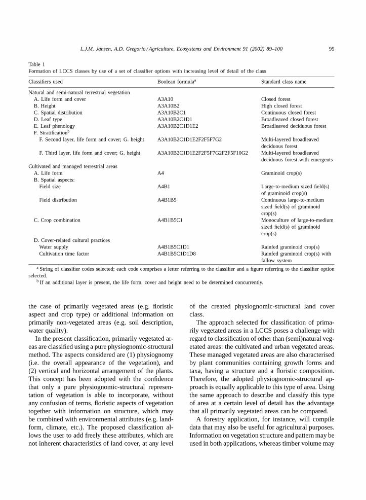
Having all pre-defined classes included in thesystem is the intrinsic rigidity of this type of clas-sification. However, it is the most effective way toproduce standardisation of classification results be-tween user-communities. The disadvantage is that inorder to be able to describe any land cover occurringanywhere in the world in a consistent way, a hugenumber of pre-defined classes are needed and thatusers should describe a specific land cover featurein a similar way. This led to the development of theapplication software that assists users in determina-tion of classifiers in a stepwise selection procedurethat aggregates classifiers to derive the land coverclass. Two examples of this procedure are shown inTable 1.
Correlation with other existing classifications be-comes a matter of translating the existing classes backinto the classifiers of the system. Comparison of indi-vidual classes, as well as the used classifiers formingthis class, becomes feasible. However, to be able totranslate existing classes, documentation is needed onthe criteria used. Individual class names are insuffi-cient for any meaningful translation.
94 L.J.M. Jansen, A.D. Gregorio / Agriculture, Ecosystems and Environment 91 (2002) 89–100
Fig. 1. The eight major land cover categories of LCCS—grouped under the primarily vegetated and primarily non-vegetated area distinction—with their set of classifiers to form classes in hierarchical order (roman figures) followed by the specific technical attribute (e.g. crop type).
5.2. Implementation of LCCS in various projects
FAO’s Africover—Eastern Africa Module, locatedin Nairobi, is the first operational user of the clas-sification and its software application. The projectis collecting land cover data in 10 eastern Africancountries that will provide a baseline data set for theregion in environmental applications and monitoringof change. For countries the size of Somalia, Kenyaand Egypt, a total of 100 land cover classes percountry have been mapped at a scale of 1:200,000.Furthermore, land cover data collecting projects inAzerbaijan, Bulgaria and Yemen are currently apply-ing the methodology. These projects have contributedto the development and evaluation of the approachin an operational context. The objective in the coun-try projects is creation of a baseline remote sensingdata derived and field validated land cover data setapplicable at national level, whereas the Africover
Project will also upscale the national data to regionallevel. Furthermore, these data sets will assist countrygovernments in prioritising areas for monitoring andpossible interventions (e.g. the previously state-ownedlarge scale cultivated areas in Bulgaria). LCCS mayreplace previous methods or act as a bridging systemthat allows translation of a previous classificationinto LCCS terminology (e.g. such as the FAO/UnescoSoil Legend (FAO, 1988) or Soil Taxonomy (US SoilConservation Service, 1975) in soil science).
5.3. Example: primarily vegetated areas
For global application, the two major diagnosticelements for description of land cover are physiog-nomy and structure (Kuechler and Zonneveld, 1988).These two elements are easily observable and canbe quantitatively defined. These basic elements canbe consolidated by additional species information in
L.J.M. Jansen, A.D. Gregorio / Agriculture, Ecosystems and Environment 91 (2002) 89–100 95
Table 1Formation of LCCS classes by use of a set of classifier options with increasing level of detail of the class
Classifiers used Boolean formulaa Standard class name
Natural and semi-natural terrestrial vegetationA. Life form and cover A3A10 Closed forestB. Height A3A10B2 High closed forestC. Spatial distribution A3A10B2C1 Continuous closed forestD. Leaf type A3A10B2C1D1 Broadleaved closed forestE. Leaf phenology A3A10B2C1D1E2 Broadleaved deciduous forestF. Stratificationb
F. Second layer, life form and cover; G. height A3A10B2C1D1E2F2F5F7G2 Multi-layered broadleaveddeciduous forest
F. Third layer, life form and cover; G. height A3A10B2C1D1E2F2F5F7G2F2F5F10G2 Multi-layered broadleaveddeciduous forest with emergents
Cultivated and managed terrestrial areasA. Life form A4 Graminoid crop(s)B. Spatial aspects:
Field size A4B1 Large-to-medium sized field(s)of graminoid crop(s)
Field distribution A4B1B5 Continuous large-to-mediumsized field(s) of graminoidcrop(s)
C. Crop combination A4B1B5C1 Monoculture of large-to-mediumsized field(s) of graminoidcrop(s)
D. Cover-related cultural practicesWater supply A4B1B5C1D1 Rainfed graminoid crop(s)Cultivation time factor A4B1B5C1D1D8 Rainfed graminoid crop(s) with
fallow systema String of classifier codes selected; each code comprises a letter referring to the classifier and a figure referring to the classifier option
selected.b If an additional layer is present, the life form, cover and height need to be determined concurrently.
the case of primarily vegetated areas (e.g. floristicaspect and crop type) or additional information onprimarily non-vegetated areas (e.g. soil description,water quality).
In the present classification, primarily vegetated ar-eas are classified using a pure physiognomic-structuralmethod. The aspects considered are (1) physiognomy(i.e. the overall appearance of the vegetation), and(2) vertical and horizontal arrangement of the plants.This concept has been adopted with the confidencethat only a pure physiognomic-structural represen-tation of vegetation is able to incorporate, withoutany confusion of terms, floristic aspects of vegetationtogether with information on structure, which maybe combined with environmental attributes (e.g. land-form, climate, etc.). The proposed classification al-lows the user to add freely these attributes, which arenot inherent characteristics of land cover, at any level
of the created physiognomic-structural land coverclass.
The approach selected for classification of prima-rily vegetated areas in a LCCS poses a challenge withregard to classification of other than (semi)natural veg-etated areas: the cultivated and urban vegetated areas.These managed vegetated areas are also characterisedby plant communities containing growth forms andtaxa, having a structure and a floristic composition.Therefore, the adopted physiognomic-structural ap-proach is equally applicable to this type of area. Usingthe same approach to describe and classify this typeof area at a certain level of detail has the advantagethat all primarily vegetated areas can be compared.
A forestry application, for instance, will compiledata that may also be useful for agricultural purposes.Information on vegetation structure and pattern may beused in both applications, whereas timber volume may
96 L.J.M. Jansen, A.D. Gregorio / Agriculture, Ecosystems and Environment 91 (2002) 89–100
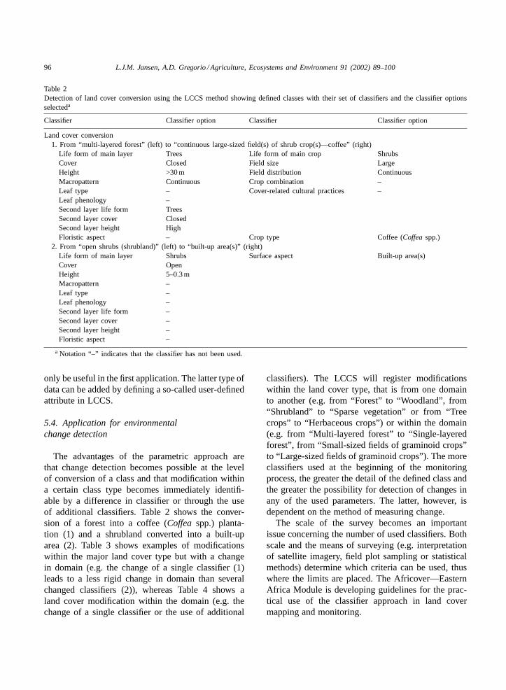
Table 2Detection of land cover conversion using the LCCS method showing defined classes with their set of classifiers and the classifier optionsselecteda
Classifier Classifier option Classifier Classifier option
Land cover conversion1. From “multi-layered forest” (left) to “continuous large-sized field(s) of shrub crop(s)—coffee” (right)
Life form of main layer Trees Life form of main crop ShrubsCover Closed Field size LargeHeight >30 m Field distribution ContinuousMacropattern Continuous Crop combination –Leaf type – Cover-related cultural practices –Leaf phenology –Second layer life form TreesSecond layer cover ClosedSecond layer height HighFloristic aspect – Crop type Coffee (Coffeaspp.)
2. From “open shrubs (shrubland)” (left) to “built-up area(s)” (right)Life form of main layer Shrubs Surface aspect Built-up area(s)Cover OpenHeight 5–0.3 mMacropattern –Leaf type –Leaf phenology –Second layer life form –Second layer cover –Second layer height –Floristic aspect –
a Notation “–” indicates that the classifier has not been used.
only be useful in the first application. The latter type ofdata can be added by defining a so-called user-definedattribute in LCCS.
5.4. Application for environmentalchange detection
The advantages of the parametric approach arethat change detection becomes possible at the levelof conversion of a class and that modification withina certain class type becomes immediately identifi-able by a difference in classifier or through the useof additional classifiers. Table 2 shows the conver-sion of a forest into a coffee (Coffea spp.) planta-tion (1) and a shrubland converted into a built-uparea (2). Table 3 shows examples of modificationswithin the major land cover type but with a changein domain (e.g. the change of a single classifier (1)leads to a less rigid change in domain than severalchanged classifiers (2)), whereas Table 4 shows aland cover modification within the domain (e.g. thechange of a single classifier or the use of additional
classifiers). The LCCS will register modificationswithin the land cover type, that is from one domainto another (e.g. from “Forest” to “Woodland”, from“Shrubland” to “Sparse vegetation” or from “Treecrops” to “Herbaceous crops”) or within the domain(e.g. from “Multi-layered forest” to “Single-layeredforest”, from “Small-sized fields of graminoid crops”to “Large-sized fields of graminoid crops”). The moreclassifiers used at the beginning of the monitoringprocess, the greater the detail of the defined class andthe greater the possibility for detection of changes inany of the used parameters. The latter, however, isdependent on the method of measuring change.
The scale of the survey becomes an importantissue concerning the number of used classifiers. Bothscale and the means of surveying (e.g. interpretationof satellite imagery, field plot sampling or statisticalmethods) determine which criteria can be used, thuswhere the limits are placed. The Africover—EasternAfrica Module is developing guidelines for the prac-tical use of the classifier approach in land covermapping and monitoring.
L.J.M. Jansen, A.D. Gregorio / Agriculture, Ecosystems and Environment 91 (2002) 89–100 97
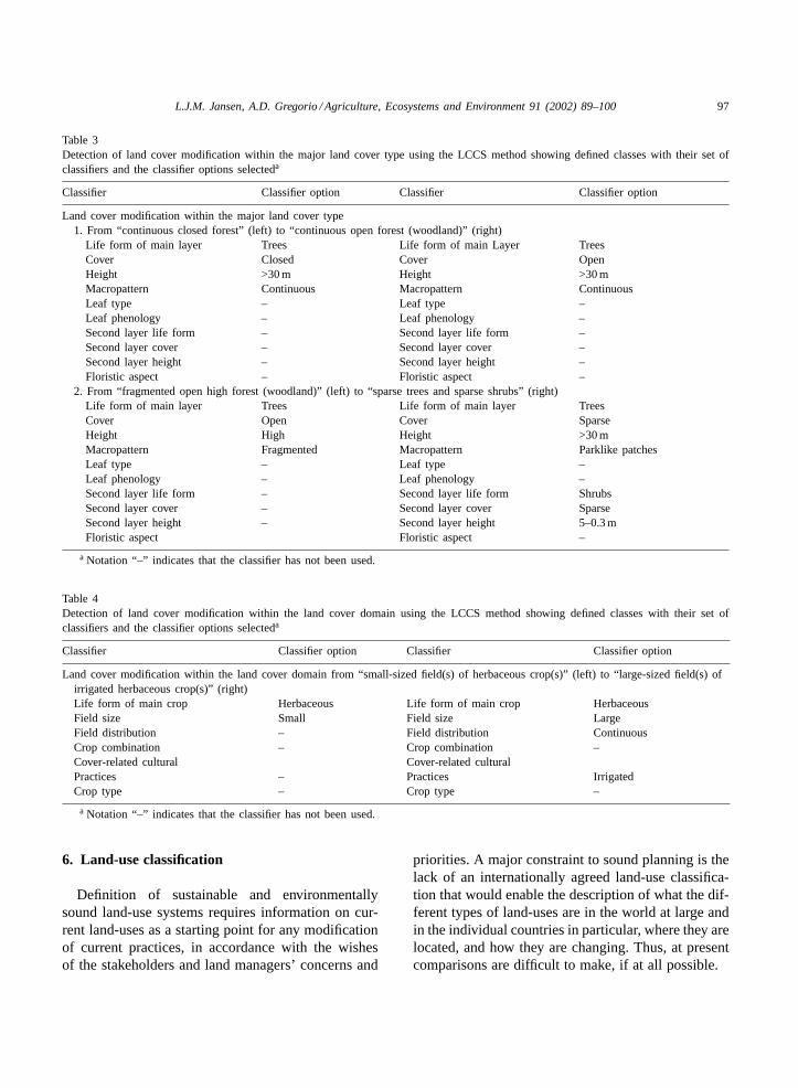
Table 3Detection of land cover modification within the major land cover type using the LCCS method showing defined classes with their set ofclassifiers and the classifier options selecteda
Classifier Classifier option Classifier Classifier option
Land cover modification within the major land cover type1. From “continuous closed forest” (left) to “continuous open forest (woodland)” (right)
Life form of main layer Trees Life form of main Layer TreesCover Closed Cover OpenHeight >30 m Height >30 mMacropattern Continuous Macropattern ContinuousLeaf type – Leaf type –Leaf phenology – Leaf phenology –Second layer life form – Second layer life form –Second layer cover – Second layer cover –Second layer height – Second layer height –Floristic aspect – Floristic aspect –
2. From “fragmented open high forest (woodland)” (left) to “sparse trees and sparse shrubs” (right)Life form of main layer Trees Life form of main layer TreesCover Open Cover SparseHeight High Height >30 mMacropattern Fragmented Macropattern Parklike patchesLeaf type – Leaf type –Leaf phenology – Leaf phenology –Second layer life form – Second layer life form ShrubsSecond layer cover – Second layer cover SparseSecond layer height – Second layer height 5–0.3 mFloristic aspect Floristic aspect –
a Notation “–” indicates that the classifier has not been used.
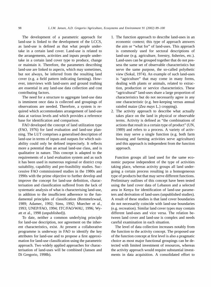
Table 4Detection of land cover modification within the land cover domain using the LCCS method showing defined classes with their set ofclassifiers and the classifier options selecteda
Classifier Classifier option Classifier Classifier option
Land cover modification within the land cover domain from “small-sized field(s) of herbaceous crop(s)” (left) to “large-sized field(s) ofirrigated herbaceous crop(s)” (right)Life form of main crop Herbaceous Life form of main crop HerbaceousField size Small Field size LargeField distribution – Field distribution ContinuousCrop combination – Crop combination –Cover-related cultural Cover-related culturalPractices – Practices IrrigatedCrop type – Crop type –
a Notation “–” indicates that the classifier has not been used.
6. Land-use classification
Definition of sustainable and environmentallysound land-use systems requires information on cur-rent land-uses as a starting point for any modificationof current practices, in accordance with the wishesof the stakeholders and land managers’ concerns and
priorities. A major constraint to sound planning is thelack of an internationally agreed land-use classifica-tion that would enable the description of what the dif-ferent types of land-uses are in the world at large andin the individual countries in particular, where they arelocated, and how they are changing. Thus, at presentcomparisons are difficult to make, if at all possible.
98 L.J.M. Jansen, A.D. Gregorio / Agriculture, Ecosystems and Environment 91 (2002) 89–100
The development of a parametric approach forland-use is linked to the development of the LCCS,as land-use is defined as that what people under-take in a certain land cover. Land-use is related tothe arrangements, activities and inputs people under-take in a certain land cover type to produce, changeor maintain it. Therefore, the parameters describingland-use are linked to aspects, which may sometimes,but not always, be inferred from the resulting landcover (e.g. a field pattern indicating farming). How-ever, interviews with land-users and ground truthingare essential in any land-use data collection and costcontributing factors.
The need for a structure to aggregate land-use datais imminent once data is collected and groupings ofobservations are needed. Therefore, a system is re-quired which accommodates arrangement of land-usedata at various levels and which provides a referencebase for identification and comparison.
FAO developed the concept of land utilization type(FAO, 1976) for land evaluation and land-use plan-ning. The LUT comprises a generalised description ofland-use in terms of inputs and outputs for which suit-ability could only be defined imprecisely. It reflectsmore a potential than an actual land-use class, and isqualitative in nature. This concept is adapted to therequirements of a land evaluation system and as suchit has been used in numerous regional or district cropsuitability, capability and pre-feasibility studies. Suc-cessive FAO commissioned studies in the 1980s and1990s with the prime objective to further develop andimprove the concept for land-use definition, charac-terisation and classification suffered from the lack ofsystematic analysis of what is characterising land-use,in addition to the insufficient adherence to the fun-damental principles of classification (Remmelzwaal,1989; Adamec, 1992; Sims, 1992; Muecher et al.,1993; UNEP/FAO, 1994; ITC/FAO/WAU, 1996; Wy-att et al., 1998 (unpublished)).
To date, neither a common underlying principlefor land-use description, nor agreement on the inher-ent characteristics, exist. At present a collaborativeprogramme is underway in FAO to identify the keyattributes for land-use and to propose a first approxi-mation for land-use classification using the parametricapproach. Two widely applied approaches for charac-terisation of land-uses will be combined (Jansen andDi Gregorio, 1998b).
1. The function approach to describe land-uses in aneconomic context; this type of approach answersthe aim or “what for” of land-uses. This approachis commonly used for sectoral descriptions ofland-use (e.g. agriculture, forestry, fisheries, etc.).Land-uses can be grouped together that do not pos-sess the same set of observable characteristics butserve the same purpose, the so-called polytheticview (Sokal, 1974). An example of such land-usesis “agriculture” that may come in many forms,dealing with plants or animals, related to extrac-tion, production or service characteristics. These“agricultural” land-uses share a large proportion ofcharacteristics but do not necessarily agree in anyone characteristic (e.g. bee-keeping versus annualrainfed maize (Zea maysL.) cropping).
2. The activity approach to describe what actuallytakes place on the land in physical or observableterms. Activity is defined as “the combinations ofactions that result in a certain type of product” (UN,1989) and refers to a process. A variety of activ-ities may serve a single function (e.g. both farmhousing and farming activities serve agriculture)and this approach is independent from the functionapproach.
Function groups all land used for the same eco-nomic purpose independent of the type of activitiestaking place, whereas activity groups all land under-going a certain process resulting in a homogeneoustype of products but that may serve different functions.Preliminary outlines of this concept have been testedusing the land cover data of Lebanon and a selectedarea in Kenya for identification of land-use parame-ters and derivation of land-uses (unpublished studies).A result of these studies is that land cover boundariesdo not necessarily coincide with land-use boundaries(e.g. recreation). Similar land cover types may containdifferent land-uses and vice versa. The relation be-tween land cover and land-use is complex and needscareful examination in each situation.
The level of data collection increases notably fromthe function to the activity concept. The proposed useof the function concept at first level is also a pragmaticchoice as most major functional groupings can be de-tected with limited investment of resources, whereasthe activity approach would require substantial invest-ments in data acquisition. A consolidated effort to
L.J.M. Jansen, A.D. Gregorio / Agriculture, Ecosystems and Environment 91 (2002) 89–100 99
catalyse the further development of a comprehensiveland-use classification system is necessary.
7. Conclusions
Environmental change detection is a multi-disciplinary subject and it is important that an in-tegrated approach is taken with several partnersinvolved to agree upon a widely accepted referencebase for land-use and land cover classification. Theparametric approach of the LCCS has proven to bepragmatic and serves a variety of users in their needs.The independent diagnostic criteria, the classifiers,standardise the description of classes in a systematicway. In turn, these criteria can be verified individuallyduring the field sampling and they can be analyticallyused in change studies. The parametric land coverclassification developed contributes to standardisationof the systematic description of land cover classesand the diagnostic criteria provide a uniform basis fordetection of land cover changes.
The proposed concept for future database devel-opment using standardised classifications as a refer-ence base will facilitate comparison and correlation.The Africover—Eastern Africa Module is preparingland cover data sets on a uniform basis that will be-come available to users for a range of applications(www.africover.org).
The parametric approach allows detection ofchanges related to land cover conversion, as well asthe more difficult detectable land cover modifications,based upon the diagnostic criteria used in the LCCS.Comparison of classes is possible at two levels: (1)the individual classes and (2) the used classifiers.However, monitoring land cover changes alone is notsufficient; it needs to be linked to land-use in orderto improve our understanding of why certain changesoccurred, as well as analyse land cover/land-usetrends. A conceptual approach for land-use classi-fication is proposed that combines function, whichgroups all land used for the same economic purposeindependent of the type of activities taking place, withactivity, which groups all land undergoing a certainprocess resulting in a homogeneous type of productsbut that may serve different functions. This approachwas successfully tested in two case studies but morework is required on definition of the diagnostic cri-
teria in order to develop a reference base, as well asunderstanding the complexity of land cover/land-userelations.
Acknowledgements
The authors would like to thank Ms. LesleyTench-Mattioni for editing of the text.
References
Adamec, J., 1992. Land-Use Classification Study. First draft.Internal Working Paper. FAO, Rome.
Anderson, J.R., Hardy, E.E., Roach, J.T., Witmer, R.E., 1976.A land use and land cover classification system for use withremote sensor data. US Geological Survey Professional Paper964. USGS, Washington, DC.
CEC, 1995. CORINE—Guide Technique. Commission of theEuropean Communities, Brussels.
Danserau, P., 1961. Essai de représentation cartographique deséléments structuraux de la végétation. In: Gaussen, H. (Ed.),Méthodes de la cartographie de la végétation, Proceedings of the97th International Colloquium, Centre National de la RechercheScientifique, Toulouse, 1960.
Di Gregorio, A., Jansen, L.J.M., 1998. A new concept for a landcover classification system. The Land 2 (1), 55–65.
Di Gregorio, A., Jansen, L.J.M., 2000. Land Cover ClassificationSystem: Classification Concepts And User Manual, FAO, Rome.
Duhamel, C., 1995. Programme télédétection et statistique.Cadre de travail statistique utilisation des sols. Draft.Eurostat/CESD-Communautaire, Luxembourg.
ECE-UN, 1989. Proposed ECE standard international classificationof land use. Economic Commission for Europe of the UnitedNations, Geneva.
Eiten, G., 1968. Vegetation forms. A classification of stands ofvegetation based on structure, growth form of the components,and vegetative periodicity. Boletim do Instituto de Botanica No.4., San Paulo.
FAO, 1976. A Framework for Land Evaluation. FAO Soils BulletinNo. 32. FAO, Rome.
FAO-UNESCO Soil Map of the World. Revised legend. FAO/UNESCO/ISRIC World Soil Resources Reports No. 60(Reprinted 1990).
FAO, 1990–1995. FAO Production Yearbook, Vols. 44–49, FAOStatistics Series Nos. 99, 104, 112, 117, 125 and 130, FAO,Rome.
FAO, 1996. Forest Resources Assessment 1990. Survey of tropicalforest cover and study of change processes. FAO Forestry PaperNo. 130. FAO, Rome.
FAO, 1997. Africover Land Cover Classification, FAO, Rome.Fosberg, F.R., 1961. A classification of vegetation for general
purposes. Trop. Ecol. 2, 1–28.
100 L.J.M. Jansen, A.D. Gregorio / Agriculture, Ecosystems and Environment 91 (2002) 89–100
ITC/FAO/WAU, 1996. The Land Use Database, A knowledge-Based Software Program For Structured Storage And RetrievalOf User-Defined Land Use Data Sets, Draft version, January1996.
Jansen, L.J.M., Di Gregorio, A., 1998a. Problems of currentland cover classifications: development of a new approach. In:Proceedings of the EC Eurostat Seminar On Land Cover AndLand Use Information Systems For European Policy Needs,21–23 January 1998, Luxembourg.
Jansen, L.J.M., Di Gregorio, A., 1998b. Land-use and land covercharacterisation and classification: the need for baseline datasets to assess future planning. In: Proceedings of the IGBP-DISand IGBP/IHDP-LUCC Data Gathering And CompilationWorkshop, 18–20 November 1998, Institute for Cartography ofCatalonia, Barcelona, Spain.
Kuechler, A.W., Zonneveld, I.S. (Eds.), 1988. Vegetation Mapping.Handbook of Vegetation Science, Vol. 10. Kluwer AcademicPublishers, Dordrecht, MA.
Meyer, W.B., Turner, B.L., 1992. Human population growth andglobal land-use/cover change. Ann. Rev. Ecol. Syst. 23, 39–61.
Muecher, S., Stomph, T.-J., Fresco, L.O., 1993. Proposal for aglobal land use classification. FAO/ITC/WAU Internal Report,Wageningen.
Mueller-Dombois, D., Ellenberg, H., 1974. Aims and Methods ofVegetation Ecology. Wiley, New York.
Remmelzwaal, A., 1989. Classification of Land and Land Use.First Approach, Internal Working Paper. FAO, Rome.
Sims, D., 1992. Description and Classification of Land use Types.FAO Informal Discussion Paper.
Sokal, R., 1974. Classification purposes principles progressprospects. Science 185 (4157), 1115–1123.
Thompson, M., 1996. A standard land cover classification forremote-sensing applications in South Africa. S. Afr. J. Sci. 92,34–42.
Trochain, J.L., 1961. Représentation cartographique des typesde végétation intertropicaux africains. In: Gaussen, H. (Ed.),Méthodes de la Cartographie de la Végétation. In: Proceedingsof the 97th International Colloquium, Centre National de laRecherche Scientifique. Toulouse, 1960, pp. 87–102.
Turner, B.L., Skole, D., Sanderson, S., Fischer, G., Fresco,L.O., Leemans, R., 1995. Land-use and land coverchange science research plan. IGBP Global ChangeReport No.35/Human Dimensions Programme Report No.7. International Geosphere–Biosphere Programme/HumanDimensions of Environmental Change Programme, Stockholmand Geneva.
UN, 1989. International Standard Classification Of All EconomicActivities (ISIC), 3rd Edition. United Nations StatisticsDivision, Statistical Classifications Section, New York.
UNEP/FAO, 1994. Report of the UNEP/FAO Expert Meeting onHarmonizing Land Cover and Land use Classifications. Geneva,23–25 November 1993. GEMS Report Series No. 25, Nairobi.
UNESCO, 1973. International Classification and Mapping ofVegetation. UNESCO, Paris.
US Soil Conservation Service, 1975. Soil Taxonomy, by theSoil Survey Staff. USDA Agriculture Handbook No. 436.Washington, DC.
Wyatt, B.K., Billington, C., De Bie, K., De Leeuw, J.,Greatorex-Davies, N., Luxmoore, R., 1998. Guidelines forLand Use And Land Cover Description And Classification.ITE/WCMC/ITC/UNEP/FAO Internal Working Document,(unpublished).