oulton - leeds conservation area appraisal... · oulton is a place of special character and...
TRANSCRIPT

Oulton is a place of special character and historic interest.
This appraisal and management plan sets out the features that contribute to its
distinctiveness and identifies opportunities for its protection and enhancement
Approved as a material consideration in the determination of planning decisions - 17 May 2010
Oulton C O N S E R V A T I O N A R E A A P P R A I S A L A N D M A N A G E M E N T P L A N

2
Summary Summary of special interest Oulton conservation area includes Oulton Hall and Park, a Registered Park and Garden, and the historic core of the village to the east.
Oulton has been shaped by a long and interesting history with evidence for agricultural settlement in the area since the late Iron Age. The village is closely linked with the Calverley family who have been the major landholders since the Norman conquest. In the 19th century they developed Oulton Hall and commissioned Humphrey Repton to landscape the Park.
Oulton developed as an agricultural village with associated industries of domestic production of woollen and linen cloth, a dyehouse, a cornmill and a number of tanneries.
Today’s village is shaped by its historic rural, ‘estate-village’ character coupled with the modern-day infill development and location at the junction of two of the area’s principal link roads.
Key characteristics:
• Oulton retains a distinctive sense of place despite the blurring of boundaries with Woodlesford and Rothwell.
• The varied pattern of building reflects the organic development of the village.
• The village has an excellent group of high status 16th and 17th century houses of stone, timber-framed and handmade brick construction.
• Boundary treatments are important to the streetscape. Sandstone walls are common.
• Oulton is a green village and mature trees, hedges and gardens are important elements of its special character. The Repton and Nesfield designed Registered Park and Garden at Oulton Park is particularly significant.
S u m m a r y o f i s s u e s a n d opportunities The protection and enhancement of the special character of the conservation area depends on the posit ive conservation management of the village. In addition to the existing national statutory legislation and local planning policy controls the following opportunities for protection and enhancement have been identified:
• Ensure future change respects and strengthens Oulton’s distinctive sense of place.
• R e s i s t i n a p p r o p r i a t e i n f i l l development and loss of garden settings.
• Ensure new development responds sensitively and creatively to the historic environment including alterations and extensions.
• Respect the character of historic buildings by maintaining and sympathetically repairing surviving historic features. The replacement of inappropriate fixtures, fittings and adaptations is encouraged.
• Retain historic boundary treatments and ensure new boundary treatments preserve and enhance the special character of the area.
• Ensure that advertisements preserve and enhance the special character of the area.
• Ensure that future public realm and traffic management measures respect and enhance the special character of the conservation area.
• Protect the important contribution trees make to the special character of the conservation area.
• Encourage the ongoing protection and enhancement of the significant heritage asset of Oulton Hall and Park.
• Development should have regard to the archaeological record and where necessary include an element of archaeological investigation and mitigation.
• Promote and celebrate the special architectural and historic interest of the conservation area.
• Ensure that the setting of the conservation area is considered as a material consideration within the planning process.
Oulton retains its village identity
Oulton Hall was saved from dereliction for conversion to a hotel and the Park is now a golf course
St John the Evangelist Church is the principal landmark building of the village

3
Extent of the conservation area Oulton was first designated as a conservation area in 1975. In 1987 it was extended to include Oulton Hall and Park. In 2010 as part of the appraisal process the boundary was reviewed and the following modifications were made:
• A rationalisation along Rothwell Lane transferring a small area of Springhead Park to Rothwel l Conservation Area.
• A rationalisation at Leventhorpe Way to remove part of a modern cul-de-sac development on the site of a former barn and agricultural buildings related to Manor Farmhouse.
• An extension to include a good group of buildings at a key gateway to the village; including the Oulton Institute, Oulton Methodist Church and the war memorial.
• A rationalisation at Greenland Farm to retain the converted historic farm buildings but remove the recent residential development.
• A rationalisation to remove recent residential infill development at Farrer Lane.
• Extension to include the full extent of the Registered Park and Garden at Oulton Hall.
These boundary changes were made to ensure that the conservation area best represents and protects the special architectural and historic interest of the village.
In addition to the boundary modifications, it was recommended that a separate conservation area be designated to recognise and protect the special architectural and historic interest of Woodlesford. This work is programmed for 2010/11.
At the time of writing a Neighbourhood Design Statement is currently being produced by the local community for the Oulton and Woodlesford area to inform future development.
Existing conservation area boundary - designated 2010 Former extent 1987 Rothwell Conservation Area 2010 Area formerly part of Oulton Conservation Area now part of Rothwell Conservation Area
Important gateway to the village proposed for inclusion in the revised conservation area (Area C)
Extent of the conservation area
This
m
ap
is
repr
oduc
ed
from
O
rdna
nce
Surv
ey
mat
eria
l w
ith t
he p
erm
issi
on o
f O
rdna
nce
Surv
ey
on
beha
lf of
th
e Co
ntro
ller
of
Her
M
ajes
ty’s
Stat
iona
ry
Off
ice
©
Cro
wn
copy
righ
t.
U
naut
horis
ed r
epro
duct
ion
infr
inge
s Cr
own
copy
-rig
ht
an
d m
ay
lead
to
pr
osec
utio
n or
ci
vil
proc
eedi
ngs.
(10
0019
567)
201
0
4
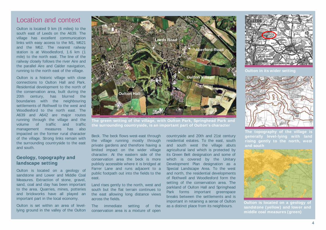
Location and context Oulton is located 9 km (6 miles) to the south east of Leeds on the A639. The village has excellent communication links with easy access to the M1, M621 and the M62. The nearest railway station is at Woodlesford, 1.6 km (1 mile) to the north east. The line of the railway closely follows the river Aire and the parallel Aire and Calder navigation, running to the north east of the village.
Oulton is a historic village with close connections to Oulton Hall and Park. Residential development to the north of the conservation area, built during the 20th century, has blurred the boundaries with the neighbouring settlements of Rothwell to the west and Woodlesford to the north east. The A639 and A642 are major routes running through the village and the volume of traffic and traffic management measures has also impacted on the former rural character of the village. Strong links remain with the surrounding countryside to the east and south.
Geology, topography and landscape setting Oulton is located on a geology of sandstone and Lower and Middle Coal Measures. Extraction of stone, gravel, sand, coal and clay has been important to the area. Quarries, mines, potteries and brickworks have all played an important part in the local economy.
Oulton is set within an area of level-lying ground in the valley of the Oulton
Beck. The beck flows west-east through the village running mostly through private gardens and therefore having a limited impact on the wider village character. At the eastern side of the conservation area the beck is more publicly accessible where it is bridged at Farrer Lane and runs adjacent to a public footpath out into the fields to the east.
Land rises gently to the north, west and south but the flat terrain continues to the east allowing long distance views across the fields.
The immediate setting of the conservation area is a mixture of open
countryside and 20th and 21st century residential estates. To the east, south and south west the village abuts agricultural land which is protected by its Green Belt designation and some of which is covered by the Unitary Development Plan designation as a Special Landscape Area. To the west and north, the residential developments of Rothwell and Woodlesford form the setting of the conservation area. The parkland of Oulton Hall and Springhead Park forms important greenspace breaks between the settlements and is important in retaining a sense of Oulton as a distinct place from its neighbours.
Oulton in its wider setting
The topography of the village is generally level-lying with land rising gently to the north, west and south
Oulton is located on a geology of sandstone (yellow) and lower and middle coal measures (green)
The green setting of the village, with Oulton Park, Springhead Park and the surrounding countryside, is an important part of Oulton’s character
Oulton Hall
Leeds Road
Aberford Road
Oulton Village
5
Historic development Early activity
Evidence of prehistoric activity in the area comes from the discovery of a possible cremation burial of Bronze Age date (c2000 - 800 BC). An accessory cup together with a number of coarse ware pottery sherds that may represent the remains of a cinerary urn were found in a gravel pit in Oulton Park in 1873.
To the east of the conservation area cropmarks of a late Iron Age - Romano-British landscape are visible on aerial photographs. An enclosure, field boundaries and trackways have been interpreted and probably represent the remains of a mixed farming landscape thought to date to around 400 BC - AD 600.
Further Roman activity in the area is implied by the chance discovery of three coins; one of Diocletian (AD 284-305), one of Maximianus (AD 286-310) and one of Constans (AD 337-350).
Medieval Oulton
Oulton is not specifically mentioned in the Domesday Book of 1086 as, at this time, it formed part of the important manor of Rothwell. The name ‘Oulton’ is probably derived from the Old English ‘Ald’ and ‘tun’ meaning ‘old farmstead’ and is likely to indicate the nature of the Anglo-Saxon settlement and agricultural origins of the village.
The Calverley family were granted land in the Oulton area as a reward for their
military services during the conquest and became the main landowners in Oulton.
Medieval field boundaries are visible as earthworks on aerial photographs towards the north of the conservation area. There are also areas of medieval and post-medieval ridge and furrow visible as earthworks and cropmarks within and around the conservation area.
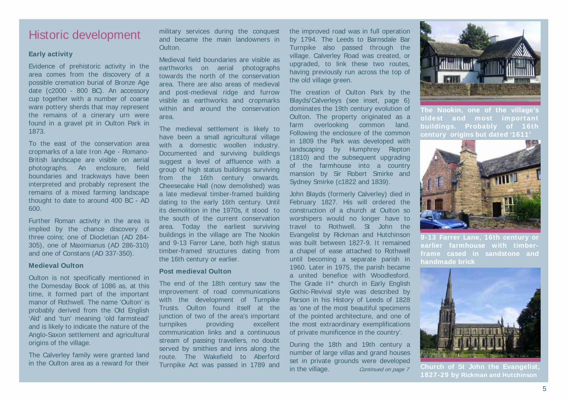
The medieval settlement is likely to have been a small agricultural village with a domestic woollen industry. Documented and surviving buildings suggest a level of affluence with a group of high status buildings surviving from the 16th century onwards. Cheesecake Hall (now demolished) was a late medieval timber-framed building dating to the early 16th century. Until its demolition in the 1970s, it stood to the south of the current conservation area. Today the earliest surviving buildings in the village are The Nookin and 9-13 Farrer Lane, both high status timber-framed structures dating from the 16th century or earlier.
Post medieval Oulton
The end of the 18th century saw the improvement of road communications with the development of Turnpike Trusts. Oulton found itself at the junction of two of the area’s important turnpikes providing excellent communication links and a continuous stream of passing travellers, no doubt served by smithies and inns along the route. The Wakefield to Aberford Turnpike Act was passed in 1789 and
the improved road was in full operation by 1794. The Leeds to Barnsdale Bar Turnpike also passed through the village. Calverley Road was created, or upgraded, to link these two routes, having previously run across the top of the old village green.
The creation of Oulton Park by the Blayds/Calverleys (see inset, page 6) dominates the 19th century evolution of Oulton. The property originated as a farm overlooking common land. Following the enclosure of the common in 1809 the Park was developed with landscaping by Humphrey Repton (1810) and the subsequent upgrading of the farmhouse into a country mansion by Sir Robert Smirke and Sydney Smirke (c1822 and 1839).
John Blayds (formerly Calverley) died in February 1827. His will ordered the construction of a church at Oulton so worshipers would no longer have to travel to Rothwell. St John the Evangelist by Rickman and Hutchinson was built between 1827-9. It remained a chapel of ease attached to Rothwell until becoming a separate parish in 1960. Later in 1975, the parish became a united benefice with Woodlesford. The Grade II* church in Early English Gothic-Revival style was described by Parson in his History of Leeds of 1828 as ’one of the most beautiful specimens of the pointed architecture, and one of the most extraordinary exemplifications of private munificence in the country’.
During the 18th and 19th century a number of large villas and grand houses set in private grounds were developed in the village. Continued on page 7
The Nookin, one of the village’s oldest and most important buildings. Probably of 16th century origins but dated ‘1611’
9-13 Farrer Lane, 16th century or earlier farmhouse with timber-frame cased in sandstone and handmade brick
Church of St John the Evangelist, 1827-29 by Rickman and Hutchinson
6
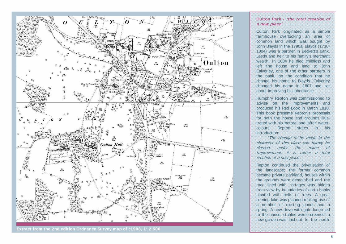
Oulton Park - ‘the total creation of a new place’
Oulton Park originated as a simple farmhouse overlooking an area of common land which was bought by John Blayds in the 1790s. Blayds (1730-1804) was a partner in Beckett’s Bank, Leeds and heir to his family’s merchant wealth. In 1804 he died childless and left the house and land to John Calverley, one of the other partners in the bank, on the condition that he change his name to Blayds. Calverley changed his name in 1807 and set about improving his inheritance.
Humphry Repton was commissioned to advise on the improvements and produced his Red Book in March 1810. This book presents Repton’s proposals for both the house and grounds illus-trated with his ‘before’ and ’after’ water-colours. Repton states in his introduction: ‘The change to be made in the character of this place can hardly be classed under the name of Improvement, it is rather a total creation of a new place’.
Repton continued the privatisation of the landscape; the former common became private parkland, houses within the grounds were demolished and the road lined with cottages was hidden from view by boundaries of earth banks planted with belts of trees. A great curving lake was planned making use of a number of existing ponds and a spring. A new drive with gate lodge led to the house, stables were screened, a new garden was laid out to the north
Extract from the 2nd edition Ordnance Survey map of c1908, 1: 2,500

7
and the house itself was to be classicised and extended.
In practice Repton’s proposals were only partially realised; only the upper part of the proposed lake was dug and his plans for the house were not carried out.
Sir Robert Smirke was commissioned c1822 to upgrade and extend the 18th century farmhouse. He retained the five-bay, two-storey core of the building extending at either end to provide a library and a drawing room. He followed Repton’s suggestion and added external classical features to the main facade.
Following John Calverley’s death in 1827 his successor continued the improvements. The replacement of the stables in 1837 allowed the further extension of the house to the south. This phase of remodelling in 1839 was undertaken by Sydney Smirke, Sir Robert’s younger brother.
In 1850 the building was seriously damaged by a major fire and Perkin and Backhouse architects of Leeds were commissioned to undertake its rebuilding. The east front retained the remains of the 18th century farmhouse but the rest of the house was totally remodelled. An entrance to the north and offices to the west required a new drive with lodges and gates designed by W A Nesfield in 1851-2. A new parterre was laid out along the south front.
Oulton Hall was no longer a country villa retreat but instead a grand country mansion. By 1854 the park had been extended to some four times the size of the Repton landscape.
In 1852 John Blayds resumed the Calverley name. His son Edmund succeeded in 1868 and continued to develop the house and grounds adding an additional storey to the service wing in 1875 designed by Perkin and Son and a new range to the north front in 1888-1891 designed by Chorley and Connon.
The Calverley family moved to Canada around 1930 and the house was requisitioned for military use during the war later becoming a hospital before falling out of use. Proposals for use as a high security prison led to the establishment of the Oulton Society in 1971 and the Hall and Park were subsequently bought by the West Riding Police in 1972. Shortly after this sale the property fell prey to vandalism and dereliction. In 1974 the Hall was acquired by West Yorkshire County Council but by 1979 consideration was given to applying for listed building consent to demolish rather than repair the building. In the face of public outcry this proposal was abandoned and in 1984 Leeds City Council took on responsibility for the Hall and Park with the hope of securing a new owner. During the 1990s the house was restored by DeVere’s for use as a hotel and the park was developed as a golf course with a new clubhouse to the north west of the Hall.
Elements of the Repton and Nesfield landscape survive and the Park is a Grade II Registered Park and Garden. The Park is currently on the English Heritage ’Heritage at Risk’ register (see Management Plan for further details).
Continued from page 5
Springwell Cottage, 3 and 4 Aberford Road is a fine villa dating to the 1830s and Oulton House, Aberford Road is a grander country house of the late 18th century. Its extensive grounds originally extended to Farrer Lane to the east and backed onto development on St John’s Street to the south.
The village developed an ‘estate-village’ character with the majority of the properties and land leased from the Calverley estate. The economy remained largely agricultural with rhubarb being the speciality of the area. A number of associated industries also had an impact on the development of the village.
The domestic cloth industry continued in Oulton until the industrial revolution and the rise of the mills in the neighbouring area. Woollen and linen cloth was produced for sale at market in Leeds. Village records list clothiers and weavers amongst residents. The northern end of Farrer Lane was historically known as Dye House Lane and today the name survives at Dye House Bridge recalling the site of a dye house noted in the 17th century diaries of Ralph Thoresby.
Further east along the beck stood Oulton Corn Mill just past the Elms. This mill is shown on the 1st edition Ordnance Survey (OS) 6” map of 1851, but was gone by the 1892 1st edition 25” map.
A number of tanneries also operated from the village. The 1851 6” map shows Oulton Green Tannery on the site
Oulton Hall, north front entrance by Perkin and Backhouse 1851-4
The landscaped park includes elements of the Repton design
The boundary treatments are the public face of the Park

8
of The Grove and Grove Cottages off the Leeds-Wakefield Road. Another tannery is shown on the site of The Woodlands, off Farrer Lane.
Quarrying of sandstone, sand and gravels was also a significant element of the local economy and is recalled in the names of the village pubs ‘The Old..’ and ’The New Mason’s Arms’. Earthwork remains of one quarry to the north of the conservation area can be seen at Quarry Hill. Others have been filled and the land reclaimed. The main quarries were located to the north east at Woodlesford and the development associated with them, including the back-to-back and through-terraced housing for the workforce took place here rather than within the village core. Woodlesford boasted excellent communication links with the opening of the Aire and Calder canal in 1704 and the coming of the railway, rejected by Rothwell, in 1838. These developments stimulated significant 18th and 19th century industrialisation in the area including paper mills, potteries, brickworks and brewery.
With the rising population of the area, the services on offer in the village were developed. Places of worship, education, self improvement and shops were built.
The Wesleyan Methodist Church, Calverley Road was built in 1826 although the village has an earlier non-conformist heritage with 18th century references to Quakers and the presence of a Quaker burial ground in Oulton Park. The last interment here was in 1820.
The Church of England National School on Calverley Road was built in 1860 and extended in 1877 and 1903 all at the expense of the Calverley’s. A map of 1818 shows that it replaced an earlier school in existence on the site at this date. The school closed in 1966 and the building is now in commercial and residential use.
The Oulton Institute was originally a single storey building completed in 1894 on land donated by the Calverleys. It was to be ‘for the benefit of men and youths, to be used as a reading and writing room’. Later in 1896/7 the Hall and caretaker’s house were donated by the Calverleys in memory of their son Harold, hence the nickname ‘Harold Hall’. The upper storey was added to the front in 1912 paid for by private subscription.
20th and 21st century Oulton
In 1901 Water Haigh Pit was sunk to the north east of the conservation area and coal mining became the predominant industry of the area. The local population rose but again, as with the quarries, new development largely took place to the north east of the village. This development resulted in the joining together of Woodlesford and Oulton but had little impact on the rural character of the estate village.
In 1924 the Calverley Estate offered their holdings for sale to sitting tenants and further land sales during the 20th century made land available for development. The conservation area has absorbed a significant amount of late 20th and 21st century residential infill development.
Oulton House, late 18th century residence later altered in 1881 set in large grounds now subdivided
The Wesleyan Methodist Chapel, 1826, Calverley Road. The upper part of the central bell tower was lost in a fire in the 1960s but could be reinstated
Church of England National School of 1860, extended 1877 and 1903, closed 1966. The building was threatened with demolition in the 1970s but intervention by the Oulton Society ensured its survival
The Oulton Institute began as a single storey building in 1894 with the upper storey added in 1912
Oulton continues to evolve. There has been a substantial amount of 20th and 21st century residential infill development, such as here at Woodland Park
Springwell Cottage, ashlar villa of the 1830s with attached greenhouse

9
Character Analysis: Spatial Analysis Settlement form
• The settlement form of the conservation area is split between the landscaped park of Oulton Hall to the west of Leeds Road and the village centre to the east.
• Oulton Park is a dominant feature of the conservation area covering c110ha. The parkland is currently defined by its use as a golf course. Boundary-belt tree plantations, boundary walls and gateways strongly enclose the parkland and set it apart from the village. The busy Leeds Road further emphasises this separation. St John’s church, although separate from the Park, shares the same character, set within the greenspace of the large churchyard with its mature trees.
• In contrast to the Park, the village has a fine grain and continues to be shaped by the historic road layout. Located at the junction of two of the area’s principal roads; the Leeds Road (A639) and the Wakefield-Aberford Road (A642), these routes form a dominant triangle in the settlement form, cutting through the village with heavy and constant traffic levels that contrast with the rural, village character of the historic built environment. The secondary roads of the village, including the distinctive oval formed by St John’s
Street and the curving line of Farrer Lane, have a very different, secluded and quiet character.
• Oulton has a generally level-lying topography creating an open character and allowing long distance views within the streetscape and out to the surrounding countryside.
• Land rises gently to the north, helping to define the distinction between Oulton and Woodlesford. The boundaries between the two settlements have become blurred during the 20th century with development now physically joining them. However, their different origins and evolution are reflected in the strongly distinct characters they retain today.
• Oulton has a number of gateway areas that provide a sense of arrival to the village, contribute to the strong sense of place and help
define it as a distinct place from the adjoining settlements:
- the area of the war memorial to the north east
- the roundabout at the junction of Leeds Road, Rothwell Lane and Calverly Road to the west
and, - the junction of Aberford Road and
Leeds Road to the south
• Oulton Beck runs west-east through the village but makes little impact in the street scene as it runs predominantly through private gardens.
• The organic development of the of the village has resulted in a mixed pattern of building. Large residences, institutional and religious buildings in sizeable plots are intermixed with cottage rows in finely grained plots. Buildings generally face the street but have a varied build line with some fronting
onto the pavement edge and others set back behind garden plots. Irregular clustered ‘Yards’ and more ordered ’Square’ developments are set back from the road. Bentley Square, Willow Square and St John’s Yard, for example, are made up of densely packed buildings forming inward looking groups. Along the west end of Farrer Lane a group of buildings are set gable-end to the road.
• The conservation area has absorbed a relatively large amount of infill development. The private grounds of the large houses have been systematically developed during the late 20th and early 21st centuries. Infill has taken the form of individual plot and cul-de-sac developments.
Building siting varies including buildings at Farrer Lane set gable-end onto the street frontage
The roundabout at the junction of Leeds Road, Rothwell Lane and Calverley Road forms the western gateway to the village
I r r e g u la r , c l u s t er e d y a rd developments, such as St John’s Yard are features of Oulton’s distinctive settlement form

10
Key views and landmarks
• St John’s Church is the principal landmark of the village. Views to the soaring spire set amongst the parkland trees are a feature throughout the conservation area and its surroundings. The view to the church along St John’s Street is particularly good.
• The black and white timber-framed property known as the Nookin is a landmark structure on the Leeds Road.
• Other local landmark buildings include the institutional structures such as the Oulton Institute, chapels and the former school. The gateways into Oulton Park also form minor focal points.
• The north eastern gateway to the village includes the landmark of the War Memorial. The group of early 20th century brick buildings on Fleet Lane directly address the memorial area and strengthen the sense of place. Views into the village along Aberford Road announce arrival into Oulton.
• Streetscape views are contained by the flat topography and the enclosure of the varied built environment, strong boundary treatments and trees.
• Views out to the surrounding countryside are important to the east side of the conservation area. The flat topography is a feature of the long distance views.
This
map
is
repr
oduc
ed f
rom
Ord
nanc
e Su
rvey
mat
eria
l w
ith
the
perm
issi
on o
f O
rdna
nce
Surv
ey o
n be
half
of t
he C
ontr
olle
r of
H
er
Maj
esty
’s
Stat
iona
ry
Off
ice
©
Crow
n co
pyrig
ht.
Una
utho
rised
rep
rodu
ctio
n in
frin
ges
Crow
n co
pyrig
ht
and
may
le
ad t
o pr
osec
utio
n or
civ
il pr
ocee
ding
s. (
1000
1956
7) 2
010
Spatial analysis:
Principal roads Key landmarks
Secondary roads Key views and panoramas
Oulton Beck Parkland - Oulton Park, St John’s Church, Home Farm
Gateway
St John’s Church is the village’s principal landmark. Its spire is visible for miles around
Views along the Aberford Road announce the arrival into Oulton with the local landmark of the Portland stone War Memorial

11
Built environment Architectural characteristics
• Oulton’s bui lt environment is dominated by rural vernacular residential and agricultural buildings with a notable group of high status residences and an exceptional group of 16th and 17th century buildings.
• There are 14 entries for listed buildings of ‘special architectural and h i s to r i c in te res t ’ w i th in the conservation area. A number of these refer to more than one property and the entries may also include curtilage structures and boundary treatments. St John’s church and the Nookin are listed Grade II* denoting their particular importance and ‘more than special interest’. The remainder are Grade II listed structures.
• In addition, there are many unlisted properties that make a positive contribution to the character of the village.
Materials
• Local sandstone is the predominant building material in the village. It is used in a variety of ways depending on the status and age of the building including coursed rubble, squared and faced masonry and fine ashlar. Some masonry has distinctive tooling and there is a mixture of cleaned and blackened stonework.
• The earliest surviving buildings provide evidence of a timber-framed
This map is reproduced from Ordnance Survey material with the permission of Ordnance Survey on behalf of the Controller of Her Majesty’s Stationary Office © Crown copyright. Unauthorised reproduction infringes Crown copyright and may lead to prosecution or civil proceedings. (100019567) 2010
Listed building Positive building Positive feature Registered Park and Garden Proposed conservation area boundary
Positive Buildings
Unlisted structures that make a positive contribution to the character of the conservation area are shaded green. The contribution may be in one or more of the following ways: • Landmark buildings
• Buildings that provide evidence of the area’s history and development
• Buildings of architectural merit
• Buildings with local historical associations
• Buildings which exemplify local vernacular styles
• Groups of buildings which together make a positive contribution to the streetscape.
There should be a presumption in favour of the retention of positive buildings in all but exceptional circumstances.
12
tradition in the area. In some examp les the t imber - f ramed construction is obvious such as the ‘post and panel’ construction of The Nookin. In other buildings, such as 9, 9A, 11 & 13 Farrer Lane, the timber frame has been encased behind external stone or brick walls or stucco surfaces.
• Early handmade brown brick is used in the village, such as at 9, 9A, 11 & 13 Farrer Lane. This is an early, high status use of brick and the mottled, porous, irregular texture of the material has a very different character to the later more uniform 19th and 20th century red brick which is present, but relatively uncommon, in the village.
• There are some historic rough cast and stuccoed surface treatments predominantly painted in white or neutral tones.
• Stone slate is the traditional roofing material of the village with Welsh slate replacing it during the 19th century.
Important architectural groups
Oulton Hall and Oulton Park buildings
• The classically detailed sandstone mansion features a north front with Ionic porch and three bays of tripartite window groupings. The tall ridge chimneys to the hipped roof dominate the roofscape. The house is largely of 19th century date (see historic development section for building history sequence) and was
substantially restored in the 1990s by DeVere Hotels following decades of vandalism, neglect and dereliction.
• The boundary treatment of the Park includes a number of important gateways, a lodge, walls and railings. The main gateway is in the north boundary at Rothwell Lane and features an impressive entrance with stone gate piers and attached flanking walls. The earlier main entrance in the eastern boundary off the Leeds Road retains a gateway and lodge. The Palladian stone bridge over the Beck to the north of the churchyard is an important parkland feature.
• Rickman and Hutchinson’s Grade II* listed Church of St John the Evangelist is a remarkable Early English style church built between 1827-29. The dramatic spire is a landmark for miles around. The churchyard includes attractive ironwork gates with ornate stone piers. Allen writing in 1831 rated it as ‘one of the most chaste and elegant churches of pointed architecture to be met with in the Kingdom’ and Pevsner called it externally one of Rickman’s most successful ecclesiastical buildings.
16th and 17th century buildings
• The village has a notable group of surviving 16th and 17th century timber-framed and stone buildings. These buildings represent high status residences and farmhouses.
• The Grade II* timber-framed building known as The Nookin, meaning ’corner of’, is a remarkable survival
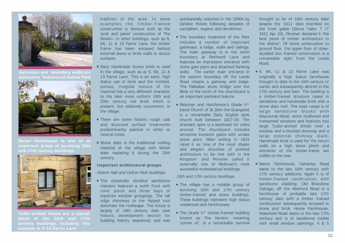
thought to be of 16th century date despite the ‘1611’ date inscribed on the front gable (Edrus Tailor T IT 1611 Apr 10). Pevsner declared it ‘the best piece of timber architecture in the district’. Of stone construction to ground floor, the upper floor of close-studded box framed construction is a remarkable sight from the Leeds Road.
• 9, 9A, 11 & 13 Farrer Lane was originally a high status farmhouse thought to date to the 16th century or earlier and subsequently altered in the 17th century and later. The building is a timber-framed structure cased in sandstone and handmade brick with a stone slate roof. The main range is of la rge sandstone b locks wi th dripcourse detail, stone mullioned and transomed windows and features two large Tudor-arched lintels over a window and a blocked doorway and a large external chimney stack. Handmade brick is used for the return walls on a high stone plinth and elements of the timber-frame are visible to the rear.
• Manor Farmhouse, Calverley Road dates to the late 16th century with 17th century additions. Again it is of timber-framed construction with sandstone cladding. Old Briardene Cottage, off the Aberford Road is a farmhouse of probable late 17th century date with a timber framed construction subsequently encased in stone and brick. Home Farmhouse, Wakefield Road dates to the late 17th century and is of sandstone rubble with small window openings. 4 & 5
Gateways and boundary walls are distinctive features of Oulton Park
Manor Farmhouse is one of an important group of surviving 16th and 17th century buildings
Tudor-arched lintels are a typical detail of the 16th and 17th century buildings, including this example at 9-13 Farrer Lane

13
Bentley Square is a 17th century or earlier farmhouse of stone with roughcast render. The western end was originally a byre with dovecote. Holly Cottage, 3 & 5 Calverley Road originated as a farmhouse of probable later 17th century date. Ivy Cottage, 16 Calverley Road was originally two dwellings with the dates 1699 and 1688 inscribed over doorways.
• These properties are all of unique designs and have been extended and altered through the centuries. Common details include stone mullioned windows, dripmould detail, stone coping and kneelers to the gable ends of stone slate roofs, prominent, large chimney stacks and
the use of Tudor arches to doorway openings and stone fireplaces.
18th and 19th century prestigious residences
• The village has a number of large, prestigious 18th and 19th century residences including Oulton House, Beech Grove, The Woodlands, The Elms, the former parsonage and Greenland Farm.
• Oulton House of late 18th century date altered in 1881 is perhaps the most impressive of the group. Executed in a mixture of handmade brick and sandstone with late 19th century polychrome br ick i ts symmetrical façade with classical
details faces south away from the road. It was originally set in extensive private grounds which have now been subdivided and developed.
• The former Parsonage in contrast is of Tudor-revival style in sandstone. Springwell Cottage, 3 Aberford Road dates from the 1830s and is more Italiante villa than cottage in architectural style with a three bay symmetrical façade with Tuscan porch and sash windows in fine sandstone ashlar under a hipped roof. The attached greenhouse / conservatory is included in its grade II listing.
• A more modest 18th century residence survives at 9 Manor Lane. This plainly detailed, squared and faced sandstone building features simple sandstone voussoirs to door and window openings.
Chapels, institutional and commercial buildings
• The village has a small number of chapels, institutional and commercial buildings of the 19th and early 20th century date. These structures display more detailed architectural styles in contrast to the plainer vernacular form of the majority of the village’s buildings. The former Wesleyan Chapel of 1826 on Calverley Road is Romanesque in style. The upper portion of its bell tower was destroyed by fire in the 1960s. The former Church of England Primary School of 1877 is of a Jacobean style with its distinctive bellcote, stone mullioned windows under drip moulds and
The patina of age, richness of texture, quality of materials and surviving historic detail such as at the 17th century Ivy Cottage, Calverley Road are essential elements of the conservation area. Date stone reads ‘HC 1699’
Home Farmhouse, Wakefield Road dates to the late 17th century
Plainly detailed 18th century stone house with sandstone voussoirs to window and door lintels, 9 Manor Lane
Tudor revival parsonage of early 19th century date
14
Tudor-arched outer doorway. The Free United Methodist Chapel (now Oulton Methodist Church), Aberford Road is a more plainly detailed gable-end chapel featur ing s imple Romanesque round arched windows with keystone details. The Oulton Institute is more unusual in the village being of red brick with stone dressings and of a larger scale than many of the other buildings in the village. In character it belongs more with the late 19th and early 20th century development related to the quarries and mines to the north east of the village.
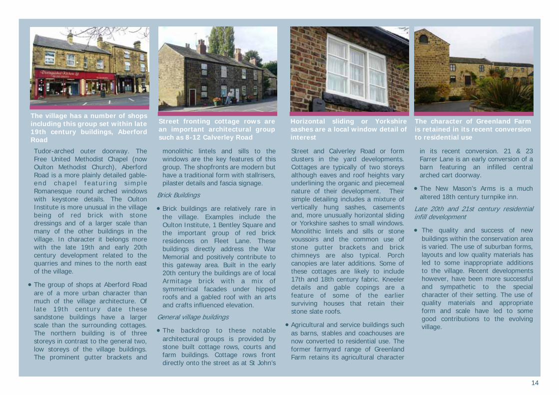
• The group of shops at Aberford Road are of a more urban character than much of the village architecture. Of late 19th century date these sandstone buildings have a larger scale than the surrounding cottages. The northern building is of three storeys in contrast to the general two, low storeys of the village buildings. The prominent gutter brackets and
monolithic lintels and sills to the windows are the key features of this group. The shopfronts are modern but have a traditional form with stallrisers, pilaster details and fascia signage.
Brick Buildings
• Brick buildings are relatively rare in the village. Examples include the Oulton Institute, 1 Bentley Square and the important group of red brick residences on Fleet Lane. These buildings directly address the War Memorial and positively contribute to this gateway area. Built in the early 20th century the buildings are of local Armitage brick with a mix of symmetrical facades under hipped roofs and a gabled roof with an arts and crafts influenced elevation.
General village buildings
• The backdrop to these notable architectural groups is provided by stone built cottage rows, courts and farm buildings. Cottage rows front directly onto the street as at St John’s
Street and Calverley Road or form clusters in the yard developments. Cottages are typically of two storeys although eaves and roof heights vary underlining the organic and piecemeal nature of their development. Their simple detailing includes a mixture of vertically hung sashes, casements and, more unusually horizontal sliding or Yorkshire sashes to small windows. Monolithic lintels and sills or stone voussoirs and the common use of stone gutter brackets and brick chimneys are also typical. Porch canopies are later additions. Some of these cottages are likely to include 17th and 18th century fabric. Kneeler details and gable copings are a feature of some of the earlier surviving houses that retain their stone slate roofs.
• Agricultural and service buildings such as barns, stables and coachouses are now converted to residential use. The former farmyard range of Greenland Farm retains its agricultural character
in its recent conversion. 21 & 23 Farrer Lane is an early conversion of a barn featuring an infilled central arched cart doorway.
• The New Mason’s Arms is a much altered 18th century turnpike inn.
Late 20th and 21st century residential infill development
• The quality and success of new buildings within the conservation area is varied. The use of suburban forms, layouts and low quality materials has led to some inappropriate additions to the village. Recent developments however, have been more successful and sympathetic to the special character of their setting. The use of quality materials and appropriate form and scale have led to some good contributions to the evolving village.
The village has a number of shops including this group set within late 19th century buildings, Aberford Road
Street fronting cottage rows are an important architectural group such as 8-12 Calverley Road
Horizontal sliding or Yorkshire sashes are a local window detail of interest
The character of Greenland Farm is retained in its recent conversion to residential use

15
Streetscape Historic streetscape features contribute to Oulton’s special character.
• Boundary treatments are important throughout the village defining public and private spaces. The majority of boundaries are formed by mid-height sandstone walls often teamed with hedges or boundary planting. Unusually high historic boundary walls are a feature of the northern end of Farrer Lane. Here a high sandstone wall abuts a red brick wall with sweeping stone copings. These walls were originally associated with Oulton House prior to the subdivision and development of its large grounds. The brick wall originally formed part of its walled kitchen garden. Elsewhere the use of timber fencing, without the softening effect of boundary planting, gives a sparse and barren appearance to the streetscape at odds with the special character of the area.
• Some historic railings survive, such as at Leeds Road. There is also evidence of lost railings to some boundary treatments, such as at Oulton Methodist Church, Aberford Road.
• The boundary treatment of Oulton Park is a particularly significant feature in the conservation area and forms the public face of Oulton Hall. The boundary is varied including impressive gateways, lodges, ornate railings, lengths of stone walling and dense boundary belt planting.
However, in places the appearance of the Park is let down by the use of poor quality cast concrete boundary treatments sometimes in a poor state of repair.
• Cast iron street signs add historic interest and quality of detail to the village and should be retained and maintained.
• The Oulton Society, working with Leeds City Council and Groundwork, have initiated a number of public realm projects including the successful renovation of the War Memorial area and the construction of the ‘Oulton’ signs at the entrances to the village.
• There are a number of informal public spaces in the village that include contemporary street furniture. The War Memorial pocket park includes benches and litter bin facilities and the verge area by the former Methodist chapel on Calverley Road has a litter bin, boundary treatment to prevent parking on the verge and attractive planters by the active ‘In Bloom’ group.
• Perhaps inevitably given the scale and busyness of the roads, traffic and traffic management measures dominate the village in places and jar with its special character. The principal roads passing through the village can act like barriers for pedestrians, splitting streets in two.
Mid-height stone walls with trees or hedges are common boundary treatments
Some historic railings survive, such as here at Leeds Road
Historic street signs are a positive feature and should be retained and maintained
Boundary treatments make a positive contribution to the special character of the village. The unusually high stone and brick walls at Farrer Lane were originally the boundary wall and walled kitchen garden of Oulton House

16
Greenscape Oulton is a very green conservation area - Oulton Park, mature trees, gardens and views to the surrounding countryside all contribute to its special character.
• Oulton Park is now dominated by its use as a golf course. However, this ornamental landscape retains important elements of the 1810 Repton design and the 1851-2 Nesfield adaptations. Its importance is recognised in its Grade II Registered Park and Garden status. Terraces, ponds, lakes, path circuits, views, woodland and boundary planting are all important features of the gardens and parkland. Notably some of Repton’s boundary mound plantings survive - banks of earth retained by stone walls and planted with trees to disguise the Park boundary and mask the road and cottages beyond.
• The parkland trees make a significant contribution to the character of the conservation area. Important views to the church spire are framed by the surrounding canopy. Ornamental trees within the churchyard include an avenue of yews aligned with the north porch.
• Trees are also significant within the village core adding a lushness and sense of permanence to village scenes. Mature trees from former gardens have been retained within areas of 20th and 21st century infill
development. Their scale and obvious age helps to ‘bed down’ the newly developed properties and link them with their setting.
• Other garden elements have been retained within the infill development. For example, at 41 Farrer Lane the former heated cavity wall of the kitchen garden of Oulton House survives.
• The tree-lined course of the Beck runs through private gardens for most of its length in the conservation area but is publicly visible at Dye House Bridge. Here its leated form and weir recalls its historic use by the Dye House and Corn Mill. Downstream of the bridge the Beck reverts to a more natural character with lush bank-side vegetation.
• Gardens form an important part of Oulton’s special character and are crucial in the setting of many of the significant buildings of the village. The loss of gardens for hard-standing for parking has negatively impacted on a number of important buildings and the conservation area as a whole.
• Hedges form important boundary treatments in some places, for example 3-7 Aberford Road.
• The pocket park around the War Memorial is part of an important gateway to the village. Its attractive bedding displays provides a valued public amenity.
• The active ‘In Bloom’ group enhance the conservation area with seasonal displays throughout the village. The use of wooden-butt planters is appropriate to the character of the village.
• The trees and parkland of Springhead Park in Rothwell Conservation Area blend well with Oulton Park and views to the countryside setting of the village to the south and east help to retain a sense of the village’s historic rural character.
• The award winning hanging basket display of the Three Horse Shoes is a notable feature of the village and a highlight on the A639.
Oulton is a green village. The mature trees of the parkland and village gardens make a significant contribution to its special character
The churchyard is an important green space
Gardens provide an important setting to many of the historic buildings

17
Management Plan: Opportunities for management and enhancement There are a number of features and issues that currently detract from the special character of Oulton. Addressing these issues offers the opportunity to enhance the conservation area, while positive conservation management measures will ensure the ongoing protection of the area’s special character.
Retaining and strengthening Oulton’s distinctive sense of place
Despite the blurring of the boundaries with neighbouring places, Oulton retains a strong sense of identity. Even with the impact of the busy roads and considerable modern infill it retains a sense of its former rural, estate-village character. This sense of place should be retained and strengthened.
Enhancements to the key gateway areas of the village have the potential to strengthen this sense of place, as achieved by the ‘Oulton’ signage at the War Memorial gateway. Potential future improvements in this area could include improved boundary treatments to the forecourt of the Old Mason’s Arms to help reinstate a better sense of enclosure.
Views and easy access to the greenbelt protected open countryside to the south
and east of the village are important to this rural character and should be maintained.
The relationship between the village and Oulton Hall is also crucial to its special character.
It is important that future change within the conservation area respects this former rural character and does not suburbanise the village.
Action: Ensure future change respects and strengthens Oulton’s distinctive sense of place.
Resistance to inappropriate infill development and loss of garden setting
Oulton has absorbed a significant amount of infill development and pressure for further garden subdivision continues to be a potential threat to the special character of the conservation area. Where permitted, future infill should respect the scale, massing and proportion of its surroundings. Spaces between structures are as important to the character of the village as its
buildings. Failure to respond sensitively to the surrounding historic setting can result in developments that have a detrimental effect on the character and appearance of the conservation area.
The loss of gardens, soft landscaping and trees, often for hard-standing for car parking, has had a negative impact on the conservation area and should be resisted in future change. The barren setting of a number of important buildings could be enhanced through soft landscaping improvements.
Action: Resist inappropriate infill development and loss of garden settings.
Sensitive new development in the conservation area
To be successful, any future development within the conservation area needs to be mindful of the character of the village, while being distinctly of its time and addressing contemporary issues such as sustainability. Poorly designed and detailed pastiche development can be as eroding to special character as
development that shows no regard for its setting. New buildings need to respond to their setting in terms of urban design - eg layout, density and spatial separation, and architectural design - eg scale, form, quality of materials and building methods.
Action: New development must respond sensitively and creatively to the historic environment i nc lu d ing a l te ra t i on s and extensions.
Successful new development in historic areas will: • Relate well to the geography and history
of the place and the lie of the land • Sit happily in the pattern of existing
development • Respect important views • Respect the scale of neighbouring
buildings • Use materials and building methods
which are as high in quality as those used in existing buildings
• Create new views and juxtapositions which add to the variety and texture of their setting.
Cabe and English Heritage, 2001, ‘Building in Context: New development in historic areas’
Placename marker at a key gateway strengthens Oulton’s sense of place
Improved boundary treatments to the Old Mason’s forecourt could enhance the conservation area
Infill development should respect its historic setting as achieved here (left) at Briardene
18
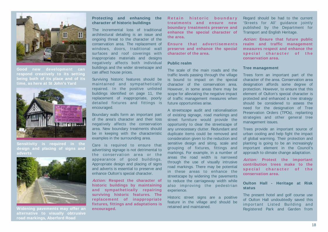
Protecting and enhancing the character of historic buildings
The incremental loss of traditional architectural detailing is an issue and ongoing threat to the character of the conservation area. The replacement of windows, doors, traditional wall surfaces and roof coverings with inappropriate materials and designs negatively affects both individual buildings and the wider streetscape and can affect house prices.
Surviving historic features should be maintained and sympathetical ly repaired. In the positive unlisted buildings identified on page 11, the replacement of inappropriate, poorly detailed fixtures and fittings is encouraged.
Boundary walls form an important part of the area’s character and their loss negatively affects the conservation area. New boundary treatments should be in keeping with the characteristic examples in the surrounding area.
Care is required to ensure that advertising signage is not detrimental to the conservat ion area or the appearance of good bui ldings. Appropriate design and placing of signs and adverts is essential to preserve and enhance Oulton’s special character.
Action: Respect the character of historic buildings by maintaining and sympathetically repairing surviving historic features. The replacement of inappropriate fixtures, fittings and adaptations is encouraged.
R e t a i n h i s t o r i c b o u n d a r y treatments and ensure new boundary treatments preserve and enhance the special character of the area.
Ensure that advertisements preserve and enhance the special character of the area.
Public realm
The scale of the main roads and the traffic levels passing through the village is bound to impact on the special character of the conservation area. However, in some areas there may be scope for alleviating the negative impact of traffic management measures when future opportunities arise.
A streetscape audit and rationalisation of existing signage, road markings and street furniture would provide the opportunity to clear the streetscape of any unnecessary clutter. Redundant and duplicate items could be removed and consideration given to the reduction and sensitive design and siting, scale and grouping of fixtures, fittings and markings. For example, in a number of areas the road width is narrowed through the use of visually intrusive road markings. There may be potential in these areas to enhance the streetscape by widening the pavements to reduce the carriageway width while a lso improving the pedestr ian experience.
Historic street signs are a positive feature in the village and should be retained and maintained.
Regard should be had to the current ‘Streets for All’ guidance jointly published by the Department for Transport and English Heritage.
Action: Ensure that future public realm and traffic management measures respect and enhance the spec ia l characte r o f the conservation area.
Tree management
Trees form an important part of the character of the area. Conservation area designation affords some degree of protection. However, to ensure that this element of Oulton’s special character is protected and enhanced a tree strategy should be considered to assess the need for the designation of Tree Preservation Orders (TPOs), replanting strategies and other general tree management issues.
Trees provide an important source of urban cooling and help fight the impact of global warming. Their protection and planting is going to be an increasingly important element in the Council’s approach to climate change adaptation.
Action: Protect the important contribution trees make to the spec ia l characte r o f the conservation area.
Oulton Hall - Heritage at Risk status
The present hotel and golf course use of Oulton Hall undoubtedly saved this important L is ted Bui ld ing and Registered Park and Garden from
Good new development can respond creatively to its setting being both of its place and of its time, as here at St John’s Yard
Widening pavements may offer an alternative to visually obtrusive road markings, Aberford Road
Sensitivity is required in the design and placing of signs and adverts
19
dereliction. However, the Park is currently on the English Heritage ‘Heritage at Risk’ list of 2009. Its vulnerability is assessed as ‘low’ and its condition as ‘generally satisfactory’ but ‘significant localised problems’ are noted as is the dominance of the golf course and associated new development. Addressing these localised issues and securing the removal of the Park from the Heritage at Risk list is a priority in the proactive management of the conservation area.
A detailed audit or Conservation Management Plan of the Hall and Park could form a useful management tool for the current owners. An assessment of the heritage significance and sensitivity of surviving landscape and architectural elements could underpin an informed approach to the day-to-day management of the complex.
As opportun i t ies ar ise, future improvements to some areas of the Park boundary would also be an enhancement to the area. In particular the removal of the inappropriate cast concrete boundary panels and general upkeep and maintenance of historic elements of the boundary wall are encouraged.
Action: Encourage the ongoing protection and enhancement of the significant heritage asset of Oulton Hall and Park.
Protect archaeological remains
Archaeological deposits and building archaeology have the potential to
provide further evidence of Oulton’s origins, development and evolution.
The building archaeology of the outstanding group of 16th and 17th century surviving buildings is of particular interest. There is also potential for garden archaeology within Oulton Park to yield further information about its development. Archaeological remains of the historic industrial activity of the village are also of interest including the sites of the tanneries, dye house and corn mill.
Development that may disturb archaeological deposits and building archaeology may require an element of archaeological investigation in order to ensure preservation of archaeological evidence in situ or by record.
Action: Development should have regard to the archaeological record and where necessary include an e lement of archaeological investigation and mitigation.
Celebrate and promote historic Oulton
Oulton’s history and surviving historic environment can be used as a positive asset for the village today. There are opportunities to celebrate, promote and make this special character and historic interest more accessible. Oulton’s heritage can be used to positively promote the village for residents and visitors alike.
The Oulton Society and the ’In Bloom’ group are active organisations working to protect and enhance the village. The
Oulton Society has produced a village trail featuring many of the significant historic buildings of the village.
There is scope to build on this ongoing achievement. For example, there is potential for an enhancement project at St John’s churchyard. A heritage trail of the churchyard could open up the stories of those buried here and encourage appreciat ion of the monuments. The historic area of the churchyard could be managed as an important greenspace within the village with a regime to encourage wildlife and biodiversity while also ensuring the repair and accessibi l ity of the monuments.
Action: Promote and celebrate the special architectural and historic interest of the conservation area.
Setting of the conservation area
It is important that development around the conservation area does not spoil its setting. Views towards and away from a conservation area can be spoilt by inappropriately placed buildings or groups of buildings, at key locations. Appropriate design and materials should stil l be used when considering deve lopment ad jacen t to the conservat ion area, as wel l as consideration given to the impact it may have on views towards and away from the conservation area.
Action: Ensure that the setting of the conservation area is considered as a material consideration within the planning process.
Historic Associations
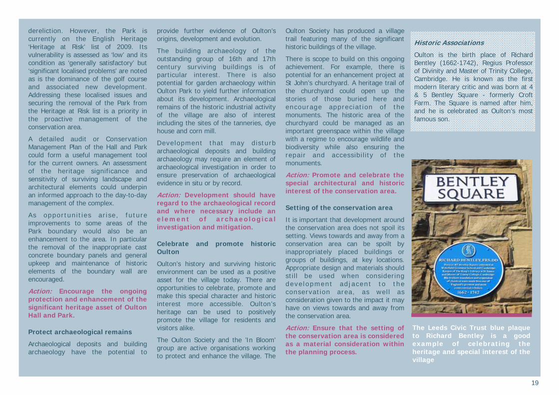
Oulton is the birth place of Richard Bentley (1662-1742), Regius Professor of Divinity and Master of Trinity College, Cambridge. He is known as the first modern literary critic and was born at 4 & 5 Bentley Square - formerly Croft Farm. The Square is named after him, and he is celebrated as Oulton’s most famous son.
The Leeds Civic Trust blue plaque to Richard Bentley is a good example of celebrating the heritage and special interest of the village

20
References Published sources
Batty J, 1877, The history of Rothwell, facsimile reprint 1986 Almar Books, Kirkstall
Brown A, 1987, Rothwell in the 900 years after Domesday, Rothwell Advertiser Press Ltd, Rothwell
Brown A, 1994, Rothwell and District in p i c tu res pas t , S t ephen Ward Photography, Rothwell
Bulmer S and Brown A, 1999, Around Rothwell, Tempus Publishing Ltd, Stroud
Bulmer S and Wright E, 2004, Around Rothwell Volume II, Tempus Publishing Ltd, Stroud
English Heritage, Parks and Gardens Register entry for Oulton Hall
Leach P & Pevsner N, 2009, The Buildings of England: Yorkshire West Riding, Yale University Press, London
Mercer Rev GH, 1948, Notes for a history of Oulton, vols I-III
Oulton Society, undated document, Oulton Village Guide
Rothwell and District Historical Society, 2000, Rothwell District Then and Now, RDHS Press, Rothwell
Royal Commission on the Historical Monuments of England & West Yorkshire Metropolitan County Council, 1986, Rural Houses of West Yorkshire 1400-1830, Her Majesty’s Stationery Office, London
Sheeran G, 1990, Landscape gardens in West Yorkshire, Wakefield Historical Publications, Wakefield, pp 115-119
Worsley G, 1987, Oulton Hall, West Yorkshire, in Country Life, September 17th, pp146-149
Policy and strategy documents Cabe and English Heritage, 2001, Building in context
Department of Culture, Media and Sport, 2007, Heritage Protection for the 21st century
Department for Communities and Local Government, 2010, Planning Policy Statement 5: Planning for the Historic Environement
Department for Communities and Local Government, English Heritage and the Department for Culture, Media and Sport, 2010, PPS5 Planning for the Historic Environment: Historic Environment Planning Practice Guide
English Heritage, February 2006 (a), Guidance on conservation area appraisals
English Heritage, February 2006 (b), Guidance on the management of conservation areas
Government Office for Yorkshire and the Humber, 2008, The Yorkshire and Humber Plan. Regional Spatial Strategy to 2026
Land Use Consultants, 1994, Leeds Landscape Assessment.
Leeds City Council, 2006, Leeds Unitary Development Plan (Review 2006), Vol 1:Written Statement, Vol 2: Appendices
Map sources
1850 – Ordnance Survey 1:10, 000 1892 – Ordnance Survey 1: 2,500 1893 – Ordnance Survey 1:10, 000 1908 – Ordnance Survey 1: 2,500 1938 – Ordnance Survey 1:10, 000 1956 – Ordnance Survey 1:10, 000
Internet sources
Access to archives - www.a2a.org.uk
English Heritage Images of England, listed building photographs and descriptions - www.imagesofengland.org.uk
Historic Ordnance Survey maps -www.old-maps.co.uk
Leeds City Council online historic photograph archive - www.leodis.net
Secret Leeds - www.secretleeds.com
Sources of further information Central Library (Local & Family History Section), The Headrow, Leeds LS1. Tel 0113 247 8290 email: [email protected] website: www.leeds.gov.uk/library
Leeds Civic Trust, Leeds Heritage & Design Centre, 17-19 Wharf Street, Leeds LS2 7EQ Tel: 0113 243 9594 Email: off [email protected] website: www.leedscivictrust.org.uk
Victorian Society (West Yorkshire Group), Claremont, 23 Clarendon Road Leeds LS2 9NZ (postal address only)
West Yorkshire Archaeology Service, Newstead Road, Wakefield WF1 2DE T e l 0 1 9 2 4 3 0 6 8 1 0 e m a i l : w y s m r @ w y j s . o r g . u k w e b s i t e : www.arch.wyjs.org.uk
West Yorkshire Archive Service, Chapeltown Road, Sheepscar, Leeds LS7 3AP. Tel 0113 214 5814 email: [email protected] website: www.archives.wyjs.org.uk
Acknowledgements The preparation of this report was made possible through funding by the South (Outer) Local Area Committee of Leeds City Council. The Well-Being Fund grant was awarded by the local Ward Members through the South (Outer) Area Committee.
West Yorkshire Archive Service and West Yorkshire Archaeological Advisory Service provided information and assistance during the production of the appraisal.
Local guidance during the preparation of the appraisal was provided by the local Ward Members and the Oulton Society and Rothwell and District Historical Society.
Copyright The maps are based on Ordnance Survey material with the permission of the Ordnance Survey on behalf of the Controller of Her Majesty’s Stationery Office © Crown copyright. Unauthorised reproduction infringes Crown copyright and may lead to prosecution and/or civil proceedings. The map data, derived from Ordnance Survey mapping, included within this publication is provided by Leeds City Council under licence from the Ordnance Survey in order to fulfil its public function to publicise local public services. Leeds City Council Licence No. (100019567) 2010. © Leeds City Council 2010

21
What is a conservation area?
A conservation area is ‘an area of special architectural or historic interest the character or appearance of which it is desirable to preserve or enhance’.
Section 69 of the Planning (Listed Buidlings and Conservation Areas) Act 1990.
What does conservation area status mean?
Conservation area status provides the opportunity to promote the protection and enhancement of the special character of the defined area. Designation confers a general control over development that could damage the area’s character. The details are complex but can be summarised as:
• Most demolition requires permission and will be resisted if the building makes a positive contribution to the area.
• Some minor works to houses is no longer "permitted development" and will require planning permission. Examples are rear dormer windows, external cladding and most satellite dishes on front elevations.
• Advertisement controls are tighter • Most work to trees has to be notified
to the Council who has six weeks in which to decide to impose restrictions.
• Generally, higher standards of design apply for new buildings and alterations to existing ones.
Change is inev i tab le in most conservation areas and it is not the intention of the designation to prevent the continued evolution of places. The challenge within conservation areas is to manage change in a way that maintains, reinforces and enhances the special qualities of the area. What is the purpose of this appraisal?
This appraisal provides the basis for making informed, sustainable decisions in the positive management, protection and enhancement of the conservation area.
It provides a clear understanding of the special interest of Oulton by:
• assessing how the settlement has developed
• analysing its present day character and
• ident i fy ing opportuni t ies for enhancement
This appraisal follows the current guidance set out by English Heritage in the 2006 publication ‘Guidance on conservation area appraisals’.
The appraisal is not intended to be comprehensive and the omission of any particular building, feature or space should not be taken to imply that it is of no interest.
Planning policy context
This appraisal should be read in conjunction with the wider national,
regional and local planning policy and guidance. Relevant documents include:
• Planning (Listed Buildings and Conservation Areas) Act 1990
• Planning Policy Statement 5: Planning for the Historic Environment and the supporting Practice Guide
• The Yorkshire and Humber Plan (The Regional Spatial Strategy) May 2008, particularly Policy ENV9 Historic Environment
• Leeds C i ty Counc i l , Un i tary Development Plan Review 2006, particularly Chapter 5 Environment and Appendices A3 Building Design, Conservation and Landscape Design and A4 Archaeological Policies
• L e e d s C i t y C o u n c i l , L o c a l Development Framework, emerging framework that will ultimately replace the Unitary Development Plan.
Community involvement and adoption
A draft version of this appraisal went through a public consultation period. A six week consultation period ran from 25 January to 5 March 2010 and included: • Pre-public consultation meetings and
discussion with ward members, the Oulton Society and Rothwell and District Historical Society.
• A six week exhibition at the Oulton Institute, with handout information leaflets and access to paper copies of the appraisal.
• Public meetings at the Institute comprised an informal ‘drop-in’ session on Tuesday 9 February from 3-6pm and a presentation and Q&A session on Wednesday 10 February 7.30-8.30pm.
• Ident i f i ed s takeho lders and interested parties were directly notified.
• The appraisal and relevant response forms were available on the Council’s website.
• The consultation was advertised with posters in the village, local press coverage and a leaflet drop to all residences affected by the proposed changes to the conservation area boundary.
All consultation responses were evaluated and the appraisal was amended where appropriate. The Open Panel report to the Planning Board sets out the comments received and the actions taken as a result. This appraisal was formally adopted following approval at the Planning Board meeting of 19 April 2010 and became operational as non statutory planning guidance from 17 May 2010. It is a material consideration in the planning process.
This document is available to view and download on the Council’s website - www.leeds.gov.uk/conservation
Published in May 2010 by the Sustainable Development Unit, Leeds City Council, The Leonardo Building, 2 Rossington Street, Leeds LS2 8HD Tel 0113 222 44 09 email: [email protected] website www.leeds.gov.uk/conservation