orogenic structure of the eastern alps, europe, from transalp deep seismic reflection profiling
TRANSCRIPT

www.elsevier.com/locate/tecto
Tectonophysics 388
Orogenic structure of the Eastern Alps, Europe, from TRANSALP
deep seismic reflection profiling
Ewald Lqschena,*, Bernd Lammererb, Helmut Gebrandea, Karl Millahnc,
Rinaldo Nicolichd, TRANSALP Working Group1
aDepartment fur Geo-, und Umweltwissenschaften, Universitat Munchen, Sektion Geophysik, Theresienstrasse 41, D-80333 Munchen, GermanybSektion Geologie, Theresienstrasse 41, D-80333 Munchen, Germany
cMontanuniversitat Leoben, Institut fur Geophysik, Franz-Josef-Strasse 18, A-8700 Leoben, AustriadUniversita di Trieste, Dipartimento di Ingegneria Civile, Via Valerio 10, I-34127 Trieste, Italy
Received 14 October 2003; received in revised form 31 January 2004; accepted 13 June 2004
Abstract
The TRANSALP Group, comprising of partner institutions from Italy, Austria and Germany, acquired data on a 340 km long
deep seismic reflection line crossing the Eastern Alps between Munich and Venice. Although the field work was split into four
campaigns, between fall 1998 and summer 2001, the project gathered for the first time a continuous profile across the Alps
using consistent field acquisition and data processing parameters. These sections span the orogen itself, at its broadest width, as
well as the two adjacent basins. Vibroseis and explosion data, complementary in their depth penetration and resolution
characteristics, were obtained along with wide-angle and teleseismic data. The profile shows a bi-vergent asymmetric structure
of the crust beneath the Alpine axis which reaches a maximum thickness of 55 km, and 80–100 km long transcrustal ramps, the
southward dipping dSub-Tauern-RampT and the northward-dipping dSub-Dolomites-RampT. Strongly reflective patterns of theseramps can be traced towards the north to the Inn Valley and towards the south to the Valsugana thrust belt, both of which show
enhanced seismicity in the brittle upper crust. The seismic sections do not reveal any direct evidence for the presence of the
Periadriatic Fault system, the presumed equivalent to the Insubric Line in the Western Alps. According to our new evolutionary
model, the Sub-Tauern-Ramp is linked at depth with remnants of the subducted Penninic Ocean. The dcrocodileT-type model
describes an upper/lower crustal decoupling and wedging of both the European and the Adriatic–African continents.
D 2004 Elsevier B.V. All rights reserved.
Keywords: Alpine orogeny; Seismic reflection profiling; Crustal structure; Eastern Alps
0040-1951/$ - s
doi:10.1016/j.tec
* Correspon
E-mail addr1 Universiti
(2004) 85–102
ee front matter D 2004 Elsevier B.V. All rights reserved.
to.2004.07.024
ding author. Tel./fax: +49 89 2180 4201/4205.
ess: [email protected] (E. Lqschen).es of Munich, Leoben, Salzburg, Bologna, Trieste, Milan, Rome, Zurich, GFZ Potsdam, ENI-AGIP Milan.

E. Luschen et al. / Tectonophysics 388 (2004) 85–10286
1. Introduction
When seismic research in the Alps started in the
mid-1970s, using the refraction technique, the first
information on crustal thickness and its average
velocity structure was provided showing some asym-
metry in a north–south direction and a crustal root at
about 50–55 km depth (Miller et al., 1977; Scarascia
and Cassinis, 1997). The northern and southern
Molasse basins, including the corresponding thrust
belts at the orogenic front, were the targets for seismic
and drilling exploration for hydrocarbons in the 1970s
and 1980s (Wessely and Liebl, 1996). However, the
internal structure of the orogen remained widely
unknown. This changed dramatically, when seismic
reflection profiling, as used in oil and gas exploration,
came into use in the Western Alps (Roure et al.,
1990). Considerable progress in our understanding of
the Alps evolved from national research programmes
during the 1980s and early 1990s conducted by the
Swiss NFP20, the Italian CROP and the French
ECORS programmes (Roure et al., 1990) in the
Western Alps. These were partly integrated into the
pan-European initiative of the N–S European Geo-
traverse (Blundell et al., 1992). The results gave rise
to the idea of dindenterT-tectonics to describe the
complex interactions of the European and the Adri-
atic–African continental plates during their collision,
which started approximately 50 Ma ago, after the
closure and subduction of the Penninic ocean beneath
the Adriatic plate (Pfiffner et al., 1997; Pfiffner, 1992;
Blundell et al., 1992). This stimulated models for the
Eastern Alps, although, as seen in geological and
tectonic maps (Fig. 1), their surface structures are
significantly different from those of the Western Alps.
The lack of seismic data in the Eastern Alps, as
compared to the Western Alps, was the motivation to
create the TRANSALP project, which conducted its
field operations between 1998 and 2001 by partner
institutions from Germany, Austria and Italy
(TRANSALP Working Group, 2001, 2002). Similar
Fig. 1. Location map showing the TRANSALP transect in the Eastern Alp
national programmes NFP20 (Switzerland), ECORS (France) and CROP (I
simplified from European Geotraverse EGT (Blundell et al., 1992).
3=Austroalpine units including Northern Calcareous Alps, 4=Souther
(paleogene). The topographic map on the right shows the TRANSALP ma
sectors acquired between 1998 and 2001 are marked by different colours.
undershooting deployments.
research programmes crossing whole mountain ranges
in Europe were conducted in the Alpine-age Pyrenees
(ECORS Pyrenees Team, 1988) and in the Variscan-
age Ural mountains (Berzin et al., 1996), which might
serve for comparison. One of the main advantages of
the new profile is its length of about 340 km and the
use of consistent acquisition and processing parame-
ters, enabling application of modern imaging techni-
ques. This is the first seismic line to traverse the
complete orogen at its broadest width, where max-
imum tectonic compression in the central part (Tauern
Window) is reported (Lammerer and Weger, 1998)
and part of the adjacent foreland basins. Earlier
programs in the Western Alps produced only short
and laterally displaced sections. The design of the
TRANSALP experiment was highly complex. Vibro-
seis near-vertical seismic profiling formed the core of
the field data acquisition, complemented by explosive
near-vertical seismic profiling, cross-line recording
for three-dimensional control, active-source tomogra-
phy or wide-angle recording of Vibroseis and explo-
sive sources by a stationary array for velocity control
and passive tomography by another 9- to 11-month
stationary array for seismological/lithospheric studies.
2. Geological setting
The Eastern Alps are composed of a thin-skinned
orogenic wedge, mostly of Adriatic origin to the
north, a thick-skinned wedge to the south and an
uplifted part of European basement and cover together
with oceanic rocks in the center, the Tauern window.
Its uplift re-deformed the Alpine edifice in Neogene
time and led to lateral eastward extrusion of blocks
between conjugate strike-slip faults in the nappe stack
(Ratschbacher et al., 1991; Frisch et al., 1998) and to
ductile stretching in the Tauern Window (Lammerer
and Weger, 1998).
The TRANSALP transect crosses (from north to
south) the flexural foreland basin of the Molasse at its
s. Previously completed seismic profiling in the Western Alps by the
taly) are shown for comparison on the left-hand side. Tectonic map is
1=Helvetic units, 2=Penninic units including Tauern Window,
n Alps including Dolomite mountains, 5=Periadriatic intrusions
in line, together with 7 cross-lines (Q1–Q7 from north to south). The
Gaps at the Inn Valley and at the Tauern mountains are closed using

E. Luschen et al. / Tectonophysics 388 (2004) 85–102 87
E. Luschen et al. / Tectonophysics 388 (2004) 85–10288
widest and a narrow folded part, which was overthrust
by its own Mesozoic substrata units (Helvetic
nappes), and rootless oceanic sediments of the
Rhenodanubian Flysch nappes. To the south, the
Austroalpine nappes are represented in the northern
part by the Northern Calcareous Alps (NCA), which
were sheared off from their basement and folded
already in Cretaceous time. Two subunits are exposed,
the thin Allg7u nappe along the northern margin and
the thick Lechtal nappe, which comprises most of the
section north of the Inn valley (e.g. Linzer et al., 1995;
Mandl, 2000; Auer and Eisbacher, 2003). The weakly
metamorphic Paleozoic basement to the NCA
stretches between the Inn valley and the Tauern
mountains, consisting of phyllites, quartzphyllites
and minor volcanic and intrusive rocks. The Tauern
window consists of imbricated and tightly folded
Hercynian granitic sills and Paleozoic and Precam-
brian paragneisses and amphibolites of European
origin in an overall east–west elongated dome
structure with a steep southern limb (Lammerer and
Weger, 1998; references therein). Steeply dipping
foliation also occurs in the Austroalpine basement
gneisses of the Adriatic plate further south until the
prominent right-lateral Periadriatic fault, the presumed
equivalent to the Insubric line in the Western Alps.
From here to the south, the Dolomite mountains are
crossed, mostly within or close to its quartzphyllite
basement, which crops out in its southernmost
position at the Agordo–Valsugana thrust. Further to
the south, several minor thrusts give rise to the
Tertiary Belluno basin and flexures, before the
Mesozoic rocks plunge under the clastic sediments
of the Venetian plain (Castellarin and Cantelli, 2000).
3. Subprojects and seismic data acquisition
The Vibroseis survey was designed to mainly
achieve a high resolution and depth penetration for
the upper and middle crust (compare table in
TRANSALP Working Group, 2002). A vibratorpoint
spacing of 100 m with four heavy vibrators, a sweep
signal of 10–48 Hz and 28 s length, a geophone group
spacing 50 m, and a spread length of 18 km in split
spread configuration with 360 recording channels
resulted in nominal 90-fold common midpoint cover-
age. Data were eightfold diversity-stacked and uncor-
related as well as field-correlated stored on magnetic
tape. Field-correlation resulted in 20 s long records.
Except for the northernmost approximately 60 km
of the transect within the Bavarian Molasse, the
Vibroseis survey was accompanied by explosive
seismic recording using shotpoints of 90 kg charge
in three 30 m deep boreholes and 5 km nominal
spacing. The explosive seismic survey was designed
to provide low-fold, but high-energy signals from the
deeper parts of the crust. Shots were fired when the
Vibroseis rolling spread arrived at both the north and
south off-end configuration, including the spare
spread with up to 1145 channels. In this manner, both
Vibroseis and explosive data production were running
simultaneously using the same recording unit. A daily
progress of up to 5 km in Vibroseis production
included recording of about two to four explosive
shots. In areas where high-impedance rocks are
exposed at the surface, such as the NCA, Vibroseis
penetration was relatively low. The explosives pro-
vided a valuable and economic seismic source for
imaging at greater depth. Previously this procedure
had been successful in the Western Alps (Pfiffner et
al., 1997) and in the Ural Mountains (Berzin et al.,
1996). It turned out to be particularly successful in the
Eastern Alps in the presence of noisy recording
conditions along highly populated and noise-contami-
nated north–south running valleys.
Seven receiver cross-lines (Q1–Q7; Fig. 6), each
approximately 20 km long, recorded off-end explo-
sive shotpoints and also passively recorded the
Vibroseis and explosive sources of the main line
between adjacent cross-line/main-line tiepoints in
order to provide three-dimensional control. All these
measurements were performed by contractor compa-
nies. The cross-line recording spreads were directly
connected to the main-line spread at the tiepoints or
were operated by additional recording systems in
slave mode connected to the main line via radio link.
While the main-line operations were rolling south-
ward, two cross-lines at any time were recording
passively. The cross-lines were mainly designed for
low-fold 3-D prestack depth migration along the
entire transect. The subsurface coverage of the
cross-lines was continuous, at least at greater depth,
and their receiver lines were much less noisy than
parts of the main line. Thus, alternative north–south
sections could be constructed. Additionally, comple-

E. Luschen et al. / Tectonophysics 388 (2004) 85–102 89
mentary information in terms of seismic anisotropy
could be obtained. Passive cross-line recording
proved particularly useful and furthermore the addi-
tional costs were relatively low.
The whole survey was divided into three cam-
paigns due to financial constraints. The northernmost
120 km, between Freising (Bavaria) and the Inn
Valley (Austria), including cross-lines Q1 and Q2,
were completed in autumn 1998. The southernmost 50
km between Belluno and Treviso (Italy), including
cross-line Q7, were completed in winter 1998/1999
(using slightly different source parameters of 10–62
Hz sweep frequencies). These two sectors used an
asymmetric split spread configuration in order to
account for the prevailing structural dip. The central
sector of 170 km length between the Inn Valley and
Belluno used a symmetric split spread configuration,
including the cross-lines Q2 (repeated), Q3, Q4, Q5
and Q6, and was completed in autumn 1999. For the
tie-points at the Inn Valley and near Belluno over-
lapping source and receiver configurations were
deployed in order to assure a continuous survey.
The field crew handled more than 1100 receiver
channels simultaneously, sometimes up to 1500,
distributed on the main line, on cross-lines and
temporarily on both sides of the main Alpine crest.
The transect utilized predominantly north–south strik-
ing valleys, and only one major pass was crossed in
winter conditions, the Falzarego Pass in the Dolomite
mountains in Italy with heights of about 2200 m. The
receiver line was often deployed in highly populated
and noise-contaminated valleys, for example, in the
Ziller Valley in Austria and in the Valle di Tures in
Italy, thus providing difficult recording conditions.
The Vibroseis technique proved to be less sensitive to
noisy conditions than the explosive technique, mainly
because of vertical stacking using the diversity stack
and correlation algorithm. For permit reasons, both
datasets had to be recorded at daytimes, partly at late
hours. The explosive technique was superior in
regions with high-impedance rocks at the surface as
mentioned above. Permit difficulties required many of
the 5-km-spaced, 90-kg-shotpoints to be displaced by
several kilometers and partially subdivided into
several shots with smaller charges. Despite subdivid-
ing into several sectors, the whole survey was
continuous due to overlapping deployments, apart
from a 2-km-receiver gap in the Inn Valley and a 6-
km-gap at the main Alpine crest. These gaps were
filled by undershooting deployments. At the Alpine
crest this was achieved by a second recording spread
on the opposite side of the gap, operated in slave
mode by radio link, while the vibrators were rolling
from north to south. Synchronising all the operations
described above required extensive radio link through
several relay stations.
Owing to noise problems in the Valle di Tures
between S. Giovanni and Brunico and some bad shots
in this area, this sector did not illuminate the deeper
crust very well with the explosive technique. This was
the motivation for additional explosive measurements
in this sector in July/August 2001. A stationary 20-
km-long receiver spread was used at the eastern flank
of the valley in an almost completely noise-free
environment to record four shotpoints. Thus, these
final measurements were highly successful in record-
ing deep crustal reflections.
The seismic reflection profiling, consisting of
Vibroseis and explosive measurements and cross-line
recording, was also complemented by passive record-
ing using a stationary, three-component network along
the traverse. This array recorded all seismic sources in
wide-angle configuration for velocity control. Another
stationary three-component network recorded local
and teleseismic earthquake events continuously over 9
months in 1998/1999 and 2 months in 1999 for
lithospheric tomography (TRANSALP Working
Group, 2001).
4. Data processing and seismic sections
The Vibroseis data were processed using a conven-
tional common-midpoint (CMP) processing scheme,
complemented by non-conventional schemes, such as
dip-moveout (DMO) processing and pre-stack depth
migration with subsequent stacking (TRANSALP
Working Group, 2001, 2002). The conventional
CMP technique proved to be very robust despite the
presence of several strongly dipping and even cross-
dip reflection patterns. Thus, many different versions
of Vibroseis stacked and migrated sections in terms of
processing schemes, parameters and plotting scales
(1:50,000 to 1:200,000) have been produced, all
having their specific advantages for interpretation.
By iterative improvement of the processing parame-

E. Luschen et al. / Tectonophysics 388 (2004) 85–10290
ters crooked geometry and strongly varying recording
conditions could be accounted for. Amplitude scaling
was achieved by geometrical spreading correction,
optional automatic gain control (400 ms AGC) and
trace equalisation. Static corrections included eleva-
tion statics, velocity statics, based on tomographic
inversion of the first breaks, and subsequent residual
statics. The velocity model required for depth and
time migration was obtained from various sources. In
the layered Molasse basins stacking velocities were
used. In the central part results of tomographic
inversion of the first arrivals of Vibroseis and
explosive data recorded by the near-vertical spreads
and by the wide-aperture stationary network (obser-
vations up to 80 km offset) yielded a velocity model
for the upper 15 km. A macro-velocity model from
older, but still compatible deep seismic refraction
measurements (Miller et al., 1977) completed the
model for greater depths.
For the explosive seismic data, a separate process-
ing path was chosen. Because of the large shotpoint
interval of 5 km, and the low one- to twofold
coverage, some bad shots were omitted and the
highest quality traces were selected to form a single-
fold section, which was then normal-moveout cor-
rected and (poststack) time- and depth-migrated using
velocity models from the Vibroseis survey. After the
additional experiment in 2001, these data were
integrated into the complete explosive dataset.
Compiled stacked and migrated Vibroseis and
explosives data are compared in their complete
length (Fig. 2). The Vibroseis sections are about
300 km long after the CMP-binning of the crooked-
line geometry of the original length of 340 km. The
Vibroseis sections start in the north about 90 km
north of the Alpine front, whereas the explosive
sections start directly at the Alpine front. As
expected, the Vibroseis sections are superior in
resolution in the upper and middle crust, but show
deficits in the lower crust due to a lack of signal
energy (e.g. Steer et al., 1996). The explosive
sections fill these gaps (except a short sector
beneath the Ziller Valley, due to bad shots between
km 110 and 130), as they have been designed to
Fig. 2. Compilation of final sections of conventional CMP-processing at
surface mapping; Vibroseis stack and depth-migrated section; dynamite s
scale without any vertical exaggeration.
have greater imaging capabilities mainly in the
lower crust. Well-known difficulties in the migra-
tion of deep-crustal events require a synoptic view
on stack (zero-offset time), time and depth-migrated
sections. Incoherent reflection events, particularly at
greater depths, tend to create migration-dsmilesTbecause of their truncated character. Nevertheless,
both migration techniques were reasonably success-
ful, as demonstrated by the predominant criss-cross
reflection pattern at km 175–200 in the Vibroseis
stack section. After depth migration and similarly
after time migration with both methods, the
elements focus well and migrate to their plausible
positions and produce a bi-vergent pattern at km
150–220. However, care has to be taken on lower
crustal reflective spots and sectors (e.g. at km 130–
140 and about 16 s in the Vibroseis section). The
effects of smiles are inherent of the migration
principles, generally for deeper crustal targets in 2-
D seismic surveys. This is a drawback, particularly
for the low-fold explosive survey, which exhibits a
much less coherent image at all depths. Ray-
theoretical and Fresnel-zone principles as well as
a retrospective examination of unprocessed field
records help to distinguish real and spurious
signals.
The northernmost and southernmost parts of the
300 km long Vibroseis section display the stratified
Molasse basins, with the Tertiary base in the Bavarian
Molasse the most prominent reflection. Several
former hydrocarbon exploration targets can be clearly
recognised at antithetic normal faults. These faults
originated in an extensional upper crustal regime due
to the downbending of the whole crust.
At km 70 (Fig. 2), the transition from the unfolded
Molasse sediments (maximum 6 km depth) to the
folded Molasse sediments into the Northern Calca-
reous Alps (maximum 10–11 km depth) can be seen.
The NCA were formed from Triassic–Jurassic shelf
sediments of the former Adriatic–African continental
margin that have been upthrusted onto the European
basement. The sudden displacement by 4–5 km of the
Tertiary base and several onlap structures beneath the
Alpine front were not detected by previous industrial
full length. From top to bottom: simplified geological section from
tack and time-migrated section. All sections are shown at the same

E. Luschen et al. / Tectonophysics 388 (2004) 85–102 91

Fig. 3. Vibroseis stack section along line-km 175–200, showing
upper part of the giant bi-vergent pattern south of the Periadriatic
Lineament.
Fig. 4. Vibroseis depth-migrated section at km 150–222 corre-
sponding to the stack section in Fig. 3. Note that the south-dipping
events have been migrated about 20 km to the north. The position of
the Periadriatic Lineament is marked according to geologic–tectonic
maps. Possible dip directions marked by the arrows are discussed in
the text.
E. Luschen et al. / Tectonophysics 388 (2004) 85–10292
drilling and seismic exploration in this area. This
could be an indication of a pre-Alpine, Mesozoic
graben structure, filled by Mesozoic sediments, or
normal faulting due to the additional load of the NCA
during their thrusting onto the former European
crustal basement. As expected, the folded Molasse
and the Flysch zones are characterised by a chaotic
signature, whereas the structure of the NCA seems to
be well defined with their south-dipping overturned
folds and nappes. At about 9–10 km depth the
Northern Calcareous Alps and their substrata are
bounded by a basal, almost horizontal, reflection
pattern above a relatively transparent upper crystalline
crust. This pattern may be caused by the Mesozoic
European sediments possibly including tectonic slip
surfaces, which were active during upthrusting of the
NCA.
Proceeding further south, at km 110, a prominent
south-dipping reflection pattern outcropping at the
southern flank of the Inn Valley is visible. This is in
contrast to pre-existing models where north-dipping
structures were expected (Roeder, 1989). The seismic
data can be interpreted as a thrust fault system along
which the NCA were overthrusted by their former
basement, the Greywacke Zone. Hereafter we inter-
pret this structure as the outcrop of one possible
branch of the dSub-Tauern-RampT, which can be
traced by similar reflective patterns, almost conti-
nuously towards greater depth (see further discussion
below). Beneath the Inn Valley the subhorizontal
basal reflection pattern of the NCA is again vertically
displaced by about 5 km. As a result, this pattern can
be traced subhorizontally from the Alpine front to the
Tauern Window and includes two almost vertical
displacements.
South of km 170, part of a giant bi-vergent pattern,
which is distributed throughout the crust at the Alpine
axis, is shown in Figs. 3 and 4. A criss-cross pattern in
the zero-offset stack section (Fig. 3) migrates laterally
over nearly 20 km to the opposite dip direction of the
individual elements. This sector contains one of the
most critical questions, particularly regarding the
subsurface structures of the Tauern Window and the
Periadriatic Lineament. A very pronounced pattern of
subparallel south-dipping reflections is visible as part
of the bi-vergent pattern close to the centre of the
Alps. Projected to the surface, these reflections may
be linked with structures of the Tauern Window. The
Periadriatic Lineament cannot be clearly identified.
The northward-dipping arrow marks its position
according to previous models (e.g. Castellarin and
Cantelli, 2000). One might conclude that this linea-
ment terminates all of the pronounced reflections at
their northern end but is itself almost non-reflective.
In that case, this fault would end at depth at the dSub-Tauern-RampT, which is continuous, as shown below,

E. Luschen et al. / Tectonophysics 388 (2004) 85–102 93
located at depths somewhat greater than those
displayed in the sections of Figs. 3 and 4. In the
search for any direct reflection of a possible north-
dipping structure (e.g. by using pre-stack migration
and inspecting original pre-stack shot gathers, or by
using the passive cross-line data), no indications of
any reflective character were found, although the
acquisition and processing parameters with their
relatively large illumination aperture would allow
for it. In a similar situation in the Bohemian Massif,
Harjes et al. (1997) have shown that a steeply dipping,
several hundred meter thick fault system with low
velocities in a crystalline environment could be well
imaged by the seismic survey, even at greater depth.
If, on the other hand, one assumes that the Periadriatic
Fault system is seismically reflective, there is no other
choice than to trace it according to the southward-
dipping arrow in Fig. 4. In this case, it is obvious that
corresponding reflections are not particularly prom-
inent in comparison with the surrounding fabric. This
implies that the Periadriatic Lineament is not a first-
order structure on a N–S section and its role may have
been over-estimated in previous mountain-building
models.
One of the elements of major importance in the
TRANSALP transect is the dSub-Tauern-RampT (Fig.
Fig. 5. Vibroseis stack section between the Inn Valley (left) and the Dolom
km-long part of this section was the target for an additional explosive exp
5). The ramp between the Inn Valley and the
Dolomites is outlined over 90 km by a dotted line
on the section. Just north of the Periadriatic Linea-
ment, a 20-km-long section has been repeatedly
measured by an additional explosive experiment in
2001, as mentioned above. The resulting stack section
of this experiment demonstrates that at midcrustal
levels the south-dipping pattern, part of the dSub-Tauern-RampT, is a very dominant feature. This
pattern is characterised by an almost 2 s TWT, or
about a 6-km-thick layered sequence, which can be
traced from the surface at the Inn Valley to a depth of
more than 30 km beneath the bi-vergent structure.
Several individual elements are discernible to even
greater depths. Above this pattern, within the 20-km-
long complementary explosive sector (Fig. 5), there is
a relatively transparent zone, also visible on the left
side of Fig. 4. This confirms the existence of this
zone, since there were doubts about it in the Vibroseis
section because of the noisy recording conditions in
the Valle di Tures, which could have obscured the
reflections, and the abrupt north termination of the
criss-cross reflection pattern further south. The com-
plementary section also shows that lower crustal
reflections of the European crust actually terminate
and disappear in this orogenic root zone.
ites (right) emphasising the dSub-Tauern-RampT (dotted line). A 20-
eriment shot in 2001, shown overlain as a stack section.

E. Luschen et al. / Tectonophysics 388 (2004) 85–10294
The cross-line recordings were subjected to a
variety of different processing experiments. Owing
to space requirements, not all the experiments
according to all available subsurface coverage shown
in Fig. 6 can be presented. Fig. 6 describes a
conventional processing approach, applied to the
cross-line Q4 (south of Tauern Window). North–south
running binning lines with a bin width of 5 km have
been used to select the traces and to construct CMP
stack sections, according to processing steps adopted
from the main line. These sections, if mounted
together, provide an alternative stack section, com-
Fig. 6. Left: Schematic example of the layout of one particular cross-line
subsurface coverage (same layout applies for all other cross-lines). Right: C
line, using recordings of cross-line Q4. The subsurface coverage is approxi
Fig. 5. Note the predominance of the midcrustal reflection pattern dipping
plementary to the main-line stack section of an almost
identical subsurface coverage. The dominant reflec-
tion pattern on the north–south section obtained from
cross-line Q4 corresponds again to the south-dipping
dSub-Tauern-RampT, which is even more pronounced
than on the main line and can actually be regarded as
the most dominant feature in the Alpine crust. The
section of Q4 is in an almost identical location to the
complementary explosive section gathered in 2001
(Fig. 5). It is even more evident in the section of Q4
that the zone above the ramp is actually void of
significant reflections. Experiments with varying
(Q5), with all sources recorded on this line and the corresponding
onventional stack section after CMP-processing along N–S binning
mately identical with the additional explosive experiment of 2001 in
to the south, interpreted as part of the dSub-Tauern-RampT.

E. Luschen et al. / Tectonophysics 388 (2004) 85–102 95
azimuths of the binning line and corresponding
stacking have shown that the dominant dip direction
is south and north, respectively. With these examples,
we can show that passive cross-line recordings are a
very useful and economic way to provide further
constraints for two-dimensional deep crustal reflection
surveying.
The cross-line recordings also allow observations
which depend on the azimuth between the source
and the receiver. Fig. 7 shows azimuthal variations
of the P-wave velocity. Average velocities calcu-
lated by the distance between sources and receivers
and by the corresponding traveltime of the P-wave
first arrival are plotted against distance and azi-
muth. Although some scatter is visible because of
near-surface and topography effects, a clear rela-
tionship of velocities with azimuth and offset is
discernible. As expected, the velocities increase
with offset according to the increasing depth of
these diving waves, until they remain constant at
greater offset. This behaviour is also known from
numerous velocity measurements in the laboratory,
Fig. 7. Seismic anisotropy determined by the direct arrivals of P-waves a
offset, azimuth colour-coded. Right: Average velocity versus azimuth, off
when the confining pressure of the rock samples is
increased simulating greater depth by closing cracks
and microcracks. Additionally, velocities for waves
propagating in east–west direction (azimuth 908 and
2708) are systematically more than 10% higher than
velocities of waves travelling in north–south direc-
tion (azimuth 0 and 1808). This anisotropy is
compatible with microfabric observations made in
and around the Tauern Window (Lammerer and
Weger, 1998), which show an east–west elongation
of the rock texture caused by N–S compression and
E–W stretching. A similar observation has been
made by studying the azimuthal variations of cross-
line Q3 at the northern rim of the Tauern Window.
In this cross-line, S-wave splitting has been
observed in shot gathers recorded in east–west
direction, further direct proof of seismic anisotropy.
None of the other cross-lines exhibit such an
azimuthal variation of velocities. This is clear
evidence of intrinsic rock anisotropy due to tectonic
paleostrain constrained to the Tauern Window and
its surroundings.
t cross-line Q4. Left: Average velocity (distance/traveltime) versus
set colour-coded.

E. Luschen et al. / Tectonophysics 388 (2004) 85–10296
5. Interpretation and discussion
In the debate of the role of compression (Western
Alps, e.g. Pfiffner et al., 1997) versus lateral extrusion
tectonics (Eastern Alps, e.g. Selverstone, 1988;
Ratschbacher et al., 1991; Frisch et al., 1998), a
two-dimensional crustal section, as obtained from the
north–south oriented TRANSALP project, has its
inherent limitations. However, we have presented
three key observations which clearly emphasise
compression tectonics in terms of thrusting and
wedging as the dominant processes during mountain
building of the Eastern Alps. Compression tectonics
require much more stress than extension and extrusion
tectonics, and hence have the potential to produce
stronger seismic events. The key observations are the
following:
(1) Bi-vergent structure at whole crustal scale
beneath the Alpine axis. This bi-vergent pattern
is characterised by some asymmetry and culmi-
nates in a relatively narrow zone above the
crustal root zone. The more prominent south-
ward dipping reflections (Fig. 4) are grouped
subparallelly like a huge stack of stratified
medium, but show limited lateral extension.
One gets the impression that the most dramatic
events occurred here, close to the Alpine axis. If
projected to the surface, these reflections may be
linked to steeply southward dipping structures of
the Tauern Window. A direct link, particularly of
the most pronounced deeper structures, is not
possible. They seem to terminate along a steeply
northward-dipping line originating close to the
Periadriatic Lineament. Petrophysical data from
surface samples are available from Mazzoli et al.
(2002), who concluded that interfaces between
amphibolites and other rocks could provide
sufficient impedance contrasts to produce seis-
mic reflections. However, such sample-derived
characteristics are too sparse and do not take into
account other properties necessary to produce
reflections, such as some lateral continuity or
interferences by thin-layering. Instead, we prefer
to interpret the seismic reflections as a conse-
quence of physical alteration or weakening of
the rocks rather due to compositional effects.
This interpretation is justified by general expe-
rience obtained from deep seismic research
during the last few decades that the most
prominent seismic reflections are frequently
caused by fracture and fault zones (e.g. Harjes
et al., 1997). Therefore, we interpret the sub-
parallel reflections of the bi-vergent pattern as
fracture and slip surfaces within a deforming
crustal wedge. Fracturing produces thin low-
interval-velocity zones. This is presumably the
cause of the inverse polarity of strong reflections
observed at about 6 s traveltime in unprocessed
seismograms (Fig. 8). The subvertical sequence
of these reflections could be explained by the
contrast increasing effect of the intrusion of
fluids migrating from dewatering sediments
trapped at greater depth (e.g. ANCORP Working
Group, 1999) after the closure of the Penninic
Ocean.
A competing interpretation attributes the south-
dipping subparallel reflections to the Permian
evolution of the pre-Alpine Adriatic crust.
Underplating mafic lenses or sills may be found
at deeper parts of extended continental crust.
Reflectivity could be caused by mafic rocks
which interfinger with crustal restites. Sinigoj et
al. (1995) suggested that the deeper crust of the
Ivrea Zone was affected by magmatic under-
plating. An analogue model could be applied to
the Dolomites to explain the heat needed to
generate Permian granites and porphyrites.
(2) Transcrustal ramp-like structures (Figs. 5 and 6).
The bi-vergent pattern mentioned above appears
to be bounded at depth by a predominant, about
1–2 s (approximately 3–6 km) thick, reflection
pattern that originates at the Inn Valley. This
pattern dips to the south at an angle of about 308and is nearly 100 km long. It is particularly
strong and dominant just beneath the Tauern
Window. From there southward to greater depth,
the seismic signals of the presumed ramp change
to more widely distributed single individual
reflections dipping southward, which are visible
in the Alpine root zone. Shear surfaces within
this band are considered to be responsible for the
seismic impedance contrasts within the upper
part of the ramp, possibly due to rock anisotropy
caused by the elongated microfabric of the rocks
involved and by cataclastic deformation within
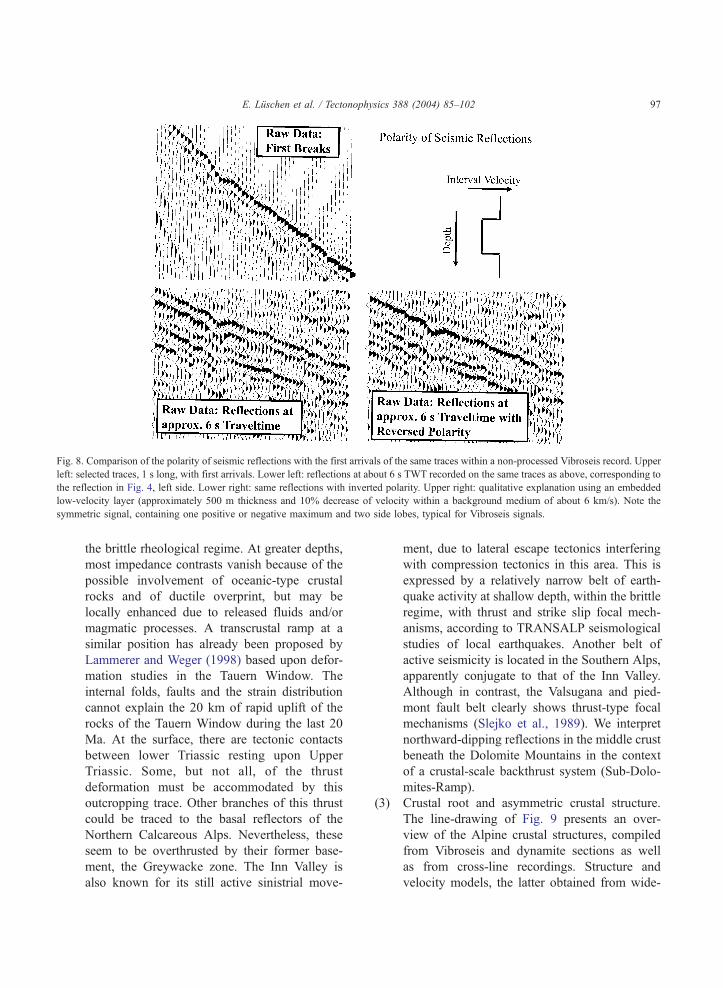
Fig. 8. Comparison of the polarity of seismic reflections with the first arrivals of the same traces within a non-processed Vibroseis record. Upper
left: selected traces, 1 s long, with first arrivals. Lower left: reflections at about 6 s TWT recorded on the same traces as above, corresponding to
the reflection in Fig. 4, left side. Lower right: same reflections with inverted polarity. Upper right: qualitative explanation using an embedded
low-velocity layer (approximately 500 m thickness and 10% decrease of velocity within a background medium of about 6 km/s). Note the
symmetric signal, containing one positive or negative maximum and two side lobes, typical for Vibroseis signals.
E. Luschen et al. / Tectonophysics 388 (2004) 85–102 97
the brittle rheological regime. At greater depths,
most impedance contrasts vanish because of the
possible involvement of oceanic-type crustal
rocks and of ductile overprint, but may be
locally enhanced due to released fluids and/or
magmatic processes. A transcrustal ramp at a
similar position has already been proposed by
Lammerer and Weger (1998) based upon defor-
mation studies in the Tauern Window. The
internal folds, faults and the strain distribution
cannot explain the 20 km of rapid uplift of the
rocks of the Tauern Window during the last 20
Ma. At the surface, there are tectonic contacts
between lower Triassic resting upon Upper
Triassic. Some, but not all, of the thrust
deformation must be accommodated by this
outcropping trace. Other branches of this thrust
could be traced to the basal reflectors of the
Northern Calcareous Alps. Nevertheless, these
seem to be overthrusted by their former base-
ment, the Greywacke zone. The Inn Valley is
also known for its still active sinistrial move-
ment, due to lateral escape tectonics interfering
with compression tectonics in this area. This is
expressed by a relatively narrow belt of earth-
quake activity at shallow depth, within the brittle
regime, with thrust and strike slip focal mech-
anisms, according to TRANSALP seismological
studies of local earthquakes. Another belt of
active seismicity is located in the Southern Alps,
apparently conjugate to that of the Inn Valley.
Although in contrast, the Valsugana and pied-
mont fault belt clearly shows thrust-type focal
mechanisms (Slejko et al., 1989). We interpret
northward-dipping reflections in the middle crust
beneath the Dolomite Mountains in the context
of a crustal-scale backthrust system (Sub-Dolo-
mites-Ramp).
(3) Crustal root and asymmetric crustal structure.
The line-drawing of Fig. 9 presents an over-
view of the Alpine crustal structures, compiled
from Vibroseis and dynamite sections as well
as from cross-line recordings. Structure and
velocity models, the latter obtained from wide-

E. Luschen et al. / Tectonophysics 388 (2004) 85–10298

Fig. 10. Cartoon of two alternative structure and evolutional models. See discussion in the text and in TRANSALP Working Group (2002).
E. Luschen et al. / Tectonophysics 388 (2004) 85–102 99
angle tomography (Bleibinhaus, 2003), exhibit
a remarkable asymmetry. The non-sedimentary
part of the European crust is continuously
downbending and almost transparent, except a
thin highly reflective layered lower crust. The
Adriatic–African crust, including the Tauern
Window as the hanging wall of the dSub-Tauern-RampT, is reflective at all levels. Its
lower crust is more than twice as thick as that
of the European crust. The middle–lower
Adriatic–African crust reveals two distinct,
almost subparallel, patterns of seismic reflec-
tions. This 25 km (or doubled?) thickness of
the lower crust is confirmed by corresponding
velocity peaks determined by previous seismic
refraction profiling and seems to be restricted
to the Southern Dolomites (Scarascia and
Fig. 9. Compilation of Bouguer anomaly of gravity (on top), simplified ge
and dynamite seismic sections as well as from alternative cross-line N–S se
tomography (from Bleibinhaus, 2003). Dotted line corresponds to the pre
Tauern Window has been upthrusted.
Cassinis, 1997). Receiver Functions as
obtained from the seismological studies
(TRANSALP Working Group, 2002; Kum-
merow, 2003) confirm the general crustal
configuration. The crustal root zone at 55–60
km depth (at line-km 160–170) lacks reflec-
tivity. This has been confirmed by the addi-
tional explosive experiment in 2001, which
was characterised by an extremely high signal-
to-noise ratio at the corresponding recording
times of 15–20 s. Vosteen et al. (2003)
estimated temperatures of about 800 8C at
55 km depth in the Alpine root zone from
steady-state forward and inverse simulation of
the conductive heat transport. This implies at
least partial anatexis in the deepest parts of the
European crust and offers an explanation for
ological section and manual line drawing, compiled from Vibroseis
ctions (middle), and seismic velocity model after wide-angle seismic
sumed dSub-Tauern-RampT, a tectonic shear zone along which the

E. Luschen et al. / Tectonophysics 388 (2004) 85–102100
the seismic transparency in that depth range.
The dSub-Tauern-RampT seems to separate two
different crustal domains. The velocity struc-
ture is asymmetric too; the European middle
and lower crust are characterised by signifi-
cantly lower velocities than the Adriatic–
African crust (Fig. 9). The crustal root, as
seen in the structure and velocity model, is
shifted to the south by about 50 km, with
respect to the main topographic crest and the
Bouguer anomaly of the gravity. The Bouguer
anomaly shows a well-pronounced, long wave-
length minimum of about �160 mGal just at
the Tauern Window and the main Alpine crest
with relatively smooth slopes towards the
foreland basins. This is remarkably different
from the Western Alps, where a strong local
maximum within the regional minimum corre-
lates with exhumed upper-mantle rocks at the
Ivrea Zone. A fit of the density model
(Ebbing, 2002) with the observed gravity can
Fig. 11. Restoring model A (bcrocodile modelQ). Sections A and B are at
length. Notice that the lower Adriatic–African crust is stacked during col
be achieved, if lower density is introduced into
the middle and lower European crust, consistent
with the velocity model. These asymmetries
indicate there is still a subduction polarity
towards the south, and that the dSub-Tauern-RampT may be regarded as the upward continu-
ation of the former subduction shear zone. Recent
high-resolution lithospheric tomography during
the TRANSALP campaign (Lippitsch, 2002)
shows an anomalous high-velocity, nearly 200
km long slab which dips towards southeast in the
Western Alps and plunges steeply in the Eastern
Alps lacking a clear polarity.
In a previous paper by the TRANSALP Working
Group (2002), two alternative models explaining the
general features of the transect have been proposed:
the dcrocodile modelT and the dlateral extrusion
modelT (Fig. 10). Both models are characterised by
the dominant role of transcrustal ramps and inter-
wedging at midcrustal levels. The dcrocodile modelT
shown at same scale. Section C is at different scale because of its
lision.

E. Luschen et al. / Tectonophysics 388 (2004) 85–102 101
better explains the main mountain-building pro-
cesses, with respect to crustal thickness, producing
a mountain root, and the general seismic fabric
along the transect. Lateral extrusion, e.g. at the Inn
Valley fault in the north and the Periadriatic Linea-
ment in the south, is not excluded in the model, but
we consider it to be restricted to the nappe
complexes in the orogenic lid. The dlateral extrusionmodelT on the other hand focuses on the escape
deformation of the Tauern Window and attributes a
major importance to the Periadriatic Lineament (and
relating faults with dominant strike slip mechanism)
which dips to the north according to dip information
obtained at the surface. Laubscher (1971) and
Schmid et al. (1989) reported dextral offset of 300
km along the Periadriatic Lineament. In this model,
the evolution of the thick Adriatic lower crust is
attributed to Permian pre-Alpine magmatic under-
plating (Dal Piaz, 1993). Fig. 11 shows an attempt
to restore one of the above mentioned structure
models. It concentrates on the two-dimensional
behaviour and clearly demonstrates that there is no
obvious contradiction to this assumption. Addition-
ally, it explains the increased lower crustal thickness
on the Adriatic–African side by tectonic erosion
during subduction and subsequent stacking during
Alpine compression.
With the TRANSALP sections, we have contrib-
uted new and complete images of the Alpine structure.
The bi-vergent structure and the transcrustal ramps
are, in particular, more pronounced than in any section
from the Western Alps (Pfiffner et al., 1997).
Although we now possess a great wealth of seismic
sections for the whole Alpine chain, it is debatable
whether we are fully able to understand the Alpine
evolution in all three dimensions. We feel that this
cannot be solved by the integration of our new dataset
into existing models, but also requires the re-assess-
ment and reinterpretation of the older datasets.
Acknowledgements
The TRANSALP programme is jointly financed by
the Bundesministerium fqr Bildung und Forschung
(BMBF, Bonn), the Bundesministerium fqr Wissen-
schaft und Verkehr (BMWV, Vienna), the Consiglio
Nazionale delle Ricerche (CNR, Rome) and the
company ENI-AGIP (Milan). The TRANSALP group
comprises partners from universities of Munich,
Leoben, Bologna, Salzburg, Milan, Rome, Trieste
and Zurich and from GFZ Potsdam and company
ENI-AGIP. We thank our contractors, THOR Geo-
physikalische Prospektion, Kiel, Germany, DMT,
Essen, Germany, JOANNEUM Research, Leoben,
Austria, GEOITALIA, Milan, Italy and GEOTEC,
Campobasso, Italy, for their excellent and enthusiastic
work in difficult terrain and under difficult logistical
conditions, even during winter. We appreciate admin-
istrative services provided by the GFZ Potsdam. The
instruments for passive and active tomography were
provided by the Geophysical Instrument Pool of the
GFZ Potsdam and by the Universities of Munich,
Zqrich, Potsdam and Genoa. The seismic programme is
accompanied by other interdisciplinary research proj-
ects funded and coordinated by the Deutsche For-
schungsgemeinschaft (DFG), Osterreichischer Fonds
zur Ffrderung der wissenschaftlichen Forschung and
the Consiglio Nazionale delle Ricerche (CNR). We
thank Alex Nichols for his corrections of the manu-
script as well as the editor Fred Davey and the
reviewers for helpful comments and corrections.
References
ANCORP Working Group, 1999. Seismic reflection image
revealing offset of Andean subduction-zone earthquake loca-
tions into oceanic mantle. Nature 397, 341–344.
Auer, M., Eisbacher, G.H., 2003. Deep structure and kinematics of
the Northern Calcareous Alps (TRANSALP Profile). Int. J.
Earth Sci. 92, 210–227.
Berzin, R., Oncken, O., Knapp, J.H., Perez-Estaun, A., Hismatulin,
T., Yunusov, N., Lipilin, A., 1996. Orogenic evolution of the
Ural Mountains: results from an integrated seismic experiment.
Nature 274, 220–221.
Bleibinhaus, F., 2003. Entwicklung einer simultanen refraktions-
und reflexionsseismischen 3D-Laufzeittomographie mit Anwen-
dung auf tiefenseismische TRANSALP-Weitwinkeldaten aus
den Ostalpen. PhD thesis. University of Munich.
Blundell, D., Freeman, R., Mueller, St. (Eds.), 1992. A Continent
Revealed—The European Geotraverse. Cambridge Univ. Press,
Cambridge.
Castellarin, A., Cantelli, L., 2000. Neo-Alpine evolution of the
Southern Eastern Alps. J. Geodyn. 30, 251–274.
Dal Piaz, G.V., 1993. Evolution of Austro-Alpine and Upper
Pennidic basement in the northwestern Alps from Variscan
convergence to Post-Variscan extension. In: von Raumer, J.F.,
Neubauer, F. (Eds.), Pre-Mesozoic Geology in the Alps.
Springer Verlag, pp. 328–343.

E. Luschen et al. / Tectonophysics 388 (2004) 85–102102
Ebbing, J., 2002. 3-D Dichteverteilung und isostatisches Verhalten
der Lithosph7re in den Ostalpen. PhD thesis. Freie Universit7tBerlin.
ECORS Pyrenees Team, 1988. The ECORS deep reflection seismic
survey across the Pyrenees. Nature 311, 508–511.
Frisch, W., Kuhlemann, J., Dunkl, I., Brqgel, A., 1998.
Palinspastic reconstruction and topographic evolution of the
Eastern Alps during late Tertiary tectonic extrusion. Tectono-
physics 297, 1–15.
Harjes, H.-P., Bram, K., Dqrbaum, H.-J., Gebrande, H.,
Hirschmann, G., Janik, M., Klfckner, M., Lqschen, E.,
Rabbel, W., Simon, M., Thomas, R., Tormann, J., Wenzel,
F., 1997. Origin and nature of crustal reflections: results from
integrated seismic measurements at the KTB superdeep
drilling site. J. Geophys. Res. 102, 18267–18288.
Kummerow, J., 2003. Strukturuntersuchungen in den Ostalpen
anhand des teleseismischen TRANSALP-Datensatzes. PhD
thesis. Freie Universit7t Berlin.Lammerer, B., Weger, M., 1998. Footwall uplift in an orogenic
wedge: the Tauern window in the Eastern Alps of Europe.
Tectonophysics 285, 213–230.
Laubscher, H.P., 1971. Large-scale kinematics of the western Alps
and the northern Apennines and its palinspastic implications.
Am. J. Sci. 271, 193–226.
Linzer, H.-G., Ratschbacher, L., Frisch, W., 1995. Transpressional
collision structures in the upper crust; the fold-thrust belt of the
Northern Calcareous Alps. In: Neubauer, F., Ebner, F., Wall-
brecher, E. (Eds.), Tectonics of the Alpine–Carpathian–Panno-
nian Region. Tectonophysics, vol. 242, pp. 41–61.
Lippitsch, R., 2002. Lithosphere and upper mantle P-wave velocity
structure beneath the Alps by high-resolution teleseismic
tomography. PhD thesis. ETH Zqrich.Mandl, G., 2000. The Alpine sector of the Tethyan shelf—
examples of Triassic to Jurassic sedimentation and deforma-
tion from the Northern Calcareous Alps. Mitt. Osterr. Geol.
Ges. 82, 61–77.
Mazzoli, C., Sassi, R., Burlini, L., 2002. Experimental study of the
seismic properties of the Eastern Alps (Italy) along the Aurina–
Tures–Badia Valleys transect. Tectonophysics 354, 179–194.
Miller, H., Gebrande, H., Schmedes, E., 1977. Ein verbessertes
Strukturmodell fqr die Ostalpen, abgeleitet aus refraktionsseis-
mischen Daten unter Berqcksichtigung des Alpen-L7ngsprofils.Geol. Rundsch. 66, 289–308.
Pfiffner, A., 1992. Alpine orogeny. In: Blundell, D., Freeman, R.,
Mueller, St. (Eds.), A Continent Revealed—The European
Geotraverse. Cambridge Univ. Press, Cambridge, pp. 180–190.
Pfiffner, O.A., Lehner, P., Heitzmann, P., Mueller, St., Steck, A.
(Eds.), 1997. Results of NRP20-Deep Structure of the Alps.
Birkh7user Verlag, Basel.Ratschbacher, L., Frisch, W., Linzer, H.-G., Merle, O., 1991. Lateral
extrusion in the Eastern Alps. Tectonics 10, 257–271.
Roeder, D., 1989. South Alpine thrusting and trans-Alpine
convergence. In: Coward, M.P., Dietrich, D., Park, R.G.
(Eds.), Alpine Tectonics, Spec. Publ. - Geol. Soc. Lond., vol.
45, pp. 211–227.
Roure, F., Heitzmann, P., Polino, R. (Eds.), 1990. Deep structure of
the Alps. Mem. Soc. Geol. Fr., Paris, 156; Mem. Soc. Geol.
Suisse, Zqrich, 1; Vol. Spec. Soc. Geol. It., Roma, 1. 367 pp.
Scarascia, S., Cassinis, R., 1997. Crustal structures in the central-
eastern Alpine sector: a revision of the available DSS data.
Tectonophysics 271, 157–188.
Schmid, S.M., Aebli, H.R., Heller, F., Zingg, A., 1989. The role of
the Periadriatic Line in the tectonic evolution of the Alps. In:
Coward, M.P., Dietrich, D., Park, R.G. (Eds.), Alpine Tectonics,
Spec. Publ. - Geol. Soc. Lond., vol. 45, pp. 153–171.
Selverstone, J., 1988. Evidence for east–west crustal extension in
the Eastern Alps. Tectonics 7, 87–105.
Sinigoj, S., Quick, J.E., Mayer, A., Demarchi, G., 1995. Density
controlled assimilation of underplated crust, Ivrea zone, Italy.
Earth Planet. Sci. Lett. 129, 183–191.
Slejko, D., Carulli, G.B., Nicolich, R., Rebez, A., Zanferrari, A.,
Cavallin, A., Doglioni, C., Carraro, F., Castaldini, D., Iliceto,
V., Semenza, E., Zanolla, C., 1989. Seismotectonics of the
eastern Southern Alps: a review. Boll. Geofis. Teor. Appl. 31,
109–136.
Steer, D.N., Brown, L.D., Knapp, J.H., Baird, D.J., 1996.
Comparison of explosive and Vibroseis source energy pene-
tration during COCORP deep seismic reflection profiling in the
Williston Basin. Geophysics 61, 211–221.
TRANSALP Working Group, 2001. European orogenic processes
research transects the Eastern Alps. EOS Trans, AGU 82, 453
and 460–461.
TRANSALP Working Group, 2002. First deep seismic images of
the Eastern Alps reveal giant crustal wedges and transcrustal
ramps. Geophys. Res. Lett. 29, doi:10.1029/2002GL014911.
Vosteen, H.-D., Rath, V., Clauser, C., Lammerer, B., 2003. The
thermal regime of the Eastern Alps from inversion analyses
along the TRANSALP profile. Phys. Chem. Earth 28, 393–405.
Wessely, G., Liebl, W. (Eds.), 1996. Oil and Gas in Alpidic
Thrustbelts and Basins of Central and Eastern Europe, EAGE
Spec. Publ. vol. 5. Geological Society, London.