oracle map builder hints and tips · 2011-05-11 · oracle map builder hints and tips oracle fusion...
TRANSCRIPT

ORACLE MAP BUILDER HINTS AND TIPSDan Abugov, NAVTEQ
July, 2010

Oracle Map Builder Hints and Tips
Table of Contents
Table of Contents ................................
Disclaimer ................................................................
Introduction ................................................................
Overview of Oracle’s Location Technologies
Oracle Fusion Middleware MapViewer
Oracle Map Builder................................
Map Metadata ................................
Software and Content for this White Paper
Data Content Setup ................................
Starting Oracle Map Builder ................................
Connect to an Oracle Database ................................
Map Builder Screen Layout ................................
Map Creation in Map Builder ................................
Styles in Map Builder ................................
Text Styles ................................................................
Line Styles ................................................................
Advanced Styles................................
Themes in Map Builder ................................
Creating a Theme ................................
Create an Advanced Style and Associate it with
Maps in Map Builder ................................
Map Creation Hints ................................
Creating a Map ................................
Other Hints and Tips ................................
For More Information ................................
2 © 2010
Table of Contents
............................................................................................................................
................................................................................................
................................................................................................
Overview of Oracle’s Location Technologies ................................................................
Oracle Fusion Middleware MapViewer ..........................................................................................
.........................................................................................................................
................................................................................................................................
Software and Content for this White Paper ................................................................
.........................................................................................................................
................................................................................................
................................................................................................
................................................................................................
................................................................................................
................................................................................................
................................................................................................
................................................................................................
............................................................................................................................
................................................................................................
..........................................................................................................................
Create an Advanced Style and Associate it with a Theme in Map Builder ................................
................................................................................................
.......................................................................................................................
..............................................................................................................................
................................................................................................
................................................................................................
© 2010 NAVTEQ All Rights Reserved
............................ 2
....................................... 3
..................................... 4
................................................ 5
.......................... 6
......................... 7
................................. 7
.................................................... 9
......................... 9
......................................... 10
..................................... 11
.......................................... 11
....................................... 12
................................................... 13
.................................... 16
.................................... 17
............................ 19
................................................ 23
.......................... 23
.................................. 28
.................................................... 35
....................... 35
.............................. 37
..................................................... 41
................................................... 43

Oracle Map Builder Hints and Tips
Disclaimer This content is provided "as-is" and without warranties of any kind, either express or not limited to, the implied warranties of merchantability, fitness for a particular purpose, satisfactory quality and non-infringement. NAVTEQ does not warrant that the content is errorwarrant or make any representations regarding the quality, correctness, accuracy, or reliability of the content. You should therefore verify any information contained in the content before acting on it.
To the furthest extent permitted by law, under no circumstances, includinegligence, shall NAVTEQ be liable for any damages, including, without limitation, direct, special, indirect, punitive, consequential, exemplary and/or incidental damages that result from any content, even if NAVTEQ or an authorised representative has been advised of the possibility of such damages.
Do you have comments regarding this White Paper? If so, please send them to [email protected]
3 © 2010
is" and without warranties of any kind, either express or implied, including, but not limited to, the implied warranties of merchantability, fitness for a particular purpose, satisfactory quality
infringement. NAVTEQ does not warrant that the content is error-free and NAVTEQ does not epresentations regarding the quality, correctness, accuracy, or reliability of the
content. You should therefore verify any information contained in the content before acting on it.
To the furthest extent permitted by law, under no circumstances, including without limitationnegligence, shall NAVTEQ be liable for any damages, including, without limitation, direct, special, indirect, punitive, consequential, exemplary and/or incidental damages that result from any content, even if
horised representative has been advised of the possibility of such damages.
Do you have comments regarding this White Paper? If so, please send them to [email protected]
© 2010 NAVTEQ All Rights Reserved
implied, including, but not limited to, the implied warranties of merchantability, fitness for a particular purpose, satisfactory quality
free and NAVTEQ does not epresentations regarding the quality, correctness, accuracy, or reliability of the
content. You should therefore verify any information contained in the content before acting on it.
ng without limitation NAVTEQ's negligence, shall NAVTEQ be liable for any damages, including, without limitation, direct, special, indirect, punitive, consequential, exemplary and/or incidental damages that result from any content, even if
horised representative has been advised of the possibility of such damages.
Do you have comments regarding this White Paper? If so, please send them to [email protected]

Oracle Map Builder Hints and Tips
Introduction Increasingly, Oracle applications are being shipped with Business Intelligence road map includes the ability to integrate mapping and drillcomponent. Oracle Communications, Oracle Utilities, Oracle Transportation Management, and Oracle Field Service all have mapping components. For applications development, Oracle JDeveloper has a GeoMap component for including maps in applications. Similarly, Java script can also be used for delivering interactive mapping components to users.
This paper will briefly discuss the technologies included in Oracle that are used for mapping. Then the paper will focus on the Map Builder component of Oracle Fusion Middleware, showing in a stepfashion how users can create their own maps. Using a layerfor creating maps, building them layer by layer to get the rich mseldom seen but valuable features for making maps look good and perform well.
4 © 2010
Increasingly, Oracle applications are being shipped with built-in mapping capabilities. Of note, the Oracle Business Intelligence road map includes the ability to integrate mapping and drill-down analysis as a BI component. Oracle Communications, Oracle Utilities, Oracle Transportation Management, and Oracle
ield Service all have mapping components. For applications development, Oracle JDeveloper has a GeoMap component for including maps in applications. Similarly, Java script can also be used for delivering interactive mapping components to users.
r will briefly discuss the technologies included in Oracle that are used for mapping. Then the paper will focus on the Map Builder component of Oracle Fusion Middleware, showing in a stepfashion how users can create their own maps. Using a layering approach, attendees will see best practices for creating maps, building them layer by layer to get the rich maps end users expect. This paperseldom seen but valuable features for making maps look good and perform well.
© 2010 NAVTEQ All Rights Reserved
in mapping capabilities. Of note, the Oracle down analysis as a BI
component. Oracle Communications, Oracle Utilities, Oracle Transportation Management, and Oracle ield Service all have mapping components. For applications development, Oracle JDeveloper has a
GeoMap component for including maps in applications. Similarly, Java script can also be used for
r will briefly discuss the technologies included in Oracle that are used for mapping. Then the paper will focus on the Map Builder component of Oracle Fusion Middleware, showing in a step-by-step
ing approach, attendees will see best practices aps end users expect. This paper includes

Oracle Map Builder Hints and Tips
Overview of Oracle’s Location Technologies
Oracle databases (Express, Personal, Standard and Enterprise Editions) all include builtcapabilities for location data. We define location data as coordinates that represent the location of a feature surface of the Earth. Using stored location information from an Oracle database we have the ability to show features on a map as well as analyze features based on interactions and proximity to other features. This feature of the Oracle database is called Oracle Locator.
Every Oracle Application Server (including the WebLogic Application server) includes the ability to render maps for display in a wide variety of web-based applications. The map rendering component of the application server is called Oracle Fusion Middleware MapViewer.
Putting mapping aside momentarily, the builtanalyze information geographically, allowing us to answer questions such as:
How many hotels are within two miles of a proposed conference
How many of my customers have average household income of greater than $67,000?
What is the closest ATM to my current location?
In addition to mapping and the abovementioned analysis capabilities, Oracle Spatial is an option with Oracle Enterprise Edition. Oracle Spatial includes advanced capabilities beyond the basic capabilities shown above. Oracle Spatial includes functionality such as Geocoding, Routing, Image Storage and retrieval, Network Analysis, Topology, Web Services, and a lot more.
If this paper is the first you have heard of Oracle’s Location technologies, please see the Introduction to Mapping and Location Analysis in Oracle white paper
5 © 2010
s Location Technologies
Oracle databases (Express, Personal, Standard and Enterprise Editions) all include built-in storage, index, and query define location data as coordinates that represent the location of a feature
surface of the Earth. Using stored location information from an Oracle database we have the ability to show features on a map as well as analyze features based on interactions and proximity to other features. This feature of the
called Oracle Locator.
Every Oracle Application Server (including the WebLogic Application server) includes the ability to render maps for based applications. The map rendering component of the application server is
led Oracle Fusion Middleware MapViewer.
Putting mapping aside momentarily, the built-in location capabilities in all Oracle databases include the ability to analyze information geographically, allowing us to answer questions such as:
in two miles of a proposed conference location?
How many of my customers have average household income of greater than $67,000?
What is the closest ATM to my current location?
In addition to mapping and the abovementioned analysis capabilities, Oracle Spatial is an option with Oracle Enterprise Edition. Oracle Spatial includes advanced capabilities beyond the basic capabilities shown above. Oracle
y such as Geocoding, Routing, Image Storage and retrieval, Network Analysis, Topology,
If this paper is the first you have heard of Oracle’s Location technologies, please see the Introduction to Mapping and s in Oracle white paper at navteq.com/enterpriseamericas.
© 2010 NAVTEQ All Rights Reserved
in storage, index, and query define location data as coordinates that represent the location of a feature on the
surface of the Earth. Using stored location information from an Oracle database we have the ability to show features on a map as well as analyze features based on interactions and proximity to other features. This feature of the
Every Oracle Application Server (including the WebLogic Application server) includes the ability to render maps for based applications. The map rendering component of the application server is
in location capabilities in all Oracle databases include the ability to
In addition to mapping and the abovementioned analysis capabilities, Oracle Spatial is an option with Oracle Enterprise Edition. Oracle Spatial includes advanced capabilities beyond the basic capabilities shown above. Oracle
y such as Geocoding, Routing, Image Storage and retrieval, Network Analysis, Topology,
If this paper is the first you have heard of Oracle’s Location technologies, please see the Introduction to Mapping and
Oracle Map Builder Hints and Tips
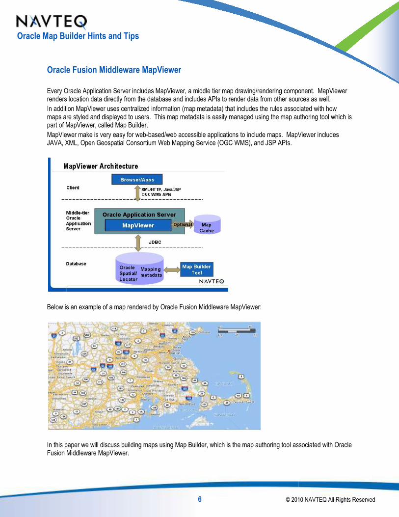
Oracle Fusion Middleware MapViewer
Every Oracle Application Server includes MapViewer, a middle tier map drawing/rendering component. MapViewer renders location data directly from the database and includes APIs to render data from other sources as well.
In addition MapViewer uses centralized information (map metadata) that includes the rules associated with how maps are styled and displayed to users. This map metadata is easily managed using the map authoring tool which is part of MapViewer, called Map Builder.
MapViewer make is very easy for web-based/web accessible applications to include maps. MapViewer includes JAVA, XML, Open Geospatial Consortium Web Mapping Service (OGC WMS), and JSP APIs.
Below is an example of a map rendered by Oracle Fusion Middleware MapViewer:
In this paper we will discuss building maps using Map Builder, which is the map authoring tool associated with Oracle Fusion Middleware MapViewer.
6 © 2010
Oracle Fusion Middleware MapViewer
Every Oracle Application Server includes MapViewer, a middle tier map drawing/rendering component. MapViewer renders location data directly from the database and includes APIs to render data from other sources as well.
ized information (map metadata) that includes the rules associated with how maps are styled and displayed to users. This map metadata is easily managed using the map authoring tool which is
based/web accessible applications to include maps. MapViewer includes JAVA, XML, Open Geospatial Consortium Web Mapping Service (OGC WMS), and JSP APIs.
Below is an example of a map rendered by Oracle Fusion Middleware MapViewer:
n this paper we will discuss building maps using Map Builder, which is the map authoring tool associated with Oracle
© 2010 NAVTEQ All Rights Reserved
Every Oracle Application Server includes MapViewer, a middle tier map drawing/rendering component. MapViewer renders location data directly from the database and includes APIs to render data from other sources as well.
ized information (map metadata) that includes the rules associated with how maps are styled and displayed to users. This map metadata is easily managed using the map authoring tool which is
based/web accessible applications to include maps. MapViewer includes
n this paper we will discuss building maps using Map Builder, which is the map authoring tool associated with Oracle

Oracle Map Builder Hints and Tips
Oracle Map Builder
Every instance of the Oracle Application Server includes Oracle Fusion Middleware standard map rendering component. In order to show maps in MapViewer, Oracle users need data to display, and map metadata to describe how to display it. Oracle Map Builder is the Oracle map authoring tool that is used to create the map metadata.
Map Metadata
Oracle map metadata has three important components:
Styles
Styles control fill color, border color, line thickness, line style, transparency, and many other aspects of how features will be rendered in MapViewer. In addition, text styles control the font, size, color, bold, and many other aspects of how text is rendered on the map.
Styles are stored as XML in view USER_SDO_STYLES
Themes
A theme associates features in a table with a style. For instance, park features
A text label column can also be associated with a theme. The label column has its own style (size, font, color, and other attributes).
Themes are stored as XML in view USER_SDO_THEMES
Maps
A map includes one or (nearly always) more themes. A map defines which themes are displayed at which zoom levels, and provides the directions to MapViewer for the display of rich maps.
Maps are stored as XML in the view USER_SDO_MAPS
7 © 2010
Every instance of the Oracle Application Server includes Oracle Fusion Middleware MapViewer, which is Oracle’s standard map rendering component. In order to show maps in MapViewer, Oracle users need data to display, and map metadata to describe how to display it. Oracle Map Builder is the Oracle map authoring tool that is used to
Oracle map metadata has three important components:
Styles control fill color, border color, line thickness, line style, transparency, and many other aspects of how features ddition, text styles control the font, size, color, bold, and many other aspects of
USER_SDO_STYLES.
A theme associates features in a table with a style. For instance, park features should be rendered in green.
A text label column can also be associated with a theme. The label column has its own style (size, font, color, and
USER_SDO_THEMES.
s) more themes. A map defines which themes are displayed at which zoom levels, and provides the directions to MapViewer for the display of rich maps.
USER_SDO_MAPS.
© 2010 NAVTEQ All Rights Reserved
MapViewer, which is Oracle’s standard map rendering component. In order to show maps in MapViewer, Oracle users need data to display, and map metadata to describe how to display it. Oracle Map Builder is the Oracle map authoring tool that is used to
Styles control fill color, border color, line thickness, line style, transparency, and many other aspects of how features ddition, text styles control the font, size, color, bold, and many other aspects of
should be rendered in green.
A text label column can also be associated with a theme. The label column has its own style (size, font, color, and
s) more themes. A map defines which themes are displayed at which zoom

Oracle Map Builder Hints and Tips
Oracle Map Builder creates and manages XML metadata other things) through the use of a simple, easy
Compare this GUI:
With this text:
Oracle Map Builder removes the need to understand the XML structure of Styles, Themes, and Maps through the use of its simple, easy-to-use interface.
8 © 2010
Oracle Map Builder creates and manages XML metadata associated with styles, themes, and maps (plus a lot of other things) through the use of a simple, easy-to-use GUI.
Compare this GUI:
emoves the need to understand the XML structure of Styles, Themes, and Maps through the use
© 2010 NAVTEQ All Rights Reserved
associated with styles, themes, and maps (plus a lot of
emoves the need to understand the XML structure of Styles, Themes, and Maps through the use

Oracle Map Builder Hints and Tips
Software and Content for this White Paper
This paper shows use of Oracle Map Builder Version 11.
Data Content Setup
This White Paper shows the use of NAVTEQ map content in Oracle. The data used in this presentation is available at NAVTEQ Network for Developers ( www.nn4d.com). To download the data:
Got to www.nn4d.com
Mouse over "BUILD" and click on Sample Data on the left of the drop down menu
Register if you haven't registered, or log in
Select the "Yes, I want to download sample data clips." radio button
Click "Continue"
Scroll to "Oracle Delivery Format (ODF) Data..."
Click the Download link
After downloading, follow the included instructions for loading and setting up the data.
9 © 2010
Software and Content for this White Paper
This paper shows use of Oracle Map Builder Version 11.1.1.0.0, which is available from Oracle.
This White Paper shows the use of NAVTEQ map content in Oracle. The data used in this presentation is available at NAVTEQ Network for Developers ( www.nn4d.com). To download the data:
"BUILD" and click on Sample Data on the left of the drop down menu
Register if you haven't registered, or log in
Select the "Yes, I want to download sample data clips." radio button
Scroll to "Oracle Delivery Format (ODF) Data..."
After downloading, follow the included instructions for loading and setting up the data.
© 2010 NAVTEQ All Rights Reserved
This White Paper shows the use of NAVTEQ map content in Oracle. The data used in this presentation is available

Oracle Map Builder Hints and Tips
The sample data is the same data that is used by many Oracle Applications. All of the Oracle applications that require map content use NAVTEQ data. A list of application that require NAVTEQ data and/or that can integrate NAVTEQ content includes:
Oracle eLocation Services http://elocation.oracle.com/elocation/ajax/
Oracle E-Business Suite Field Service Advanced Scheduler
Oracle Utilities Mobile Workforce Management
Oracle Communications Unified Inventory Management
Oracle Site Hub
Oracle Content Management Suite
Oracle Discoverer
Oracle Business Intelligence Enterprise Edition (OBIEE)
Oracle Retail
Oracle Transportation Management
Also note that many other applications easily integrate with NAVTEQ content using Oracle Location Technologies.
Starting Oracle Map Builder
If you use Oracle Map Builder frequently, put a startup icon on your desktop so you can simply double click to start
Map Builder . The shortcut associated with the icon is (on windows, assuming the mapbuilder.jar is in c:\oracle):
c:
cd \oracle
java -jar -Xmx256M mapbuilder.jar
-Xmx256M: Allows Map Builder to use up to 256 MB of memory, which is enough memory for very rich map development.
-noconnect: Use if you tend to use a lot of different accounts for map development. The debehavior logs in to all previously loaded connections and loads all map metadata for all users
-cache 64M: Map Builder will use up to 64 MB for a geometry cache. The geometry cache speeds rendering by reusing “unpickled” geometries
10 © 2010
The sample data is the same data that is used by many Oracle Applications. All of the Oracle applications that data. A list of application that require NAVTEQ data and/or that can integrate
Oracle eLocation Services http://elocation.oracle.com/elocation/ajax/
Business Suite Field Service Advanced Scheduler
Mobile Workforce Management
Oracle Communications Unified Inventory Management
Oracle Content Management Suite
Oracle Business Intelligence Enterprise Edition (OBIEE)
Oracle Transportation Management
te that many other applications easily integrate with NAVTEQ content using Oracle Location Technologies.
If you use Oracle Map Builder frequently, put a startup icon on your desktop so you can simply double click to start
. The shortcut associated with the icon is (on windows, assuming the mapbuilder.jar is in
Xmx256M mapbuilder.jar -noconnect -cache 64M
: Allows Map Builder to use up to 256 MB of memory, which is enough memory for very rich map
: Use if you tend to use a lot of different accounts for map development. The default Map Builder behavior logs in to all previously loaded connections and loads all map metadata for all users
: Map Builder will use up to 64 MB for a geometry cache. The geometry cache speeds rendering by
© 2010 NAVTEQ All Rights Reserved
The sample data is the same data that is used by many Oracle Applications. All of the Oracle applications that data. A list of application that require NAVTEQ data and/or that can integrate
te that many other applications easily integrate with NAVTEQ content using Oracle Location Technologies.
If you use Oracle Map Builder frequently, put a startup icon on your desktop so you can simply double click to start
. The shortcut associated with the icon is (on windows, assuming the mapbuilder.jar is in
: Allows Map Builder to use up to 256 MB of memory, which is enough memory for very rich map
fault Map Builder
: Map Builder will use up to 64 MB for a geometry cache. The geometry cache speeds rendering by

Oracle Map Builder Hints and Tips
Connect to an Oracle Database
After startup, you need to connect to a database to read existing map metadata, and/or to store new map metadata
Click Connection, choose Load/Add/Remove
Click Add
Enter the connection information, then click OK
Map Builder Screen Layout
The Map Builder interface is below. Most interactions for building maps are through the Navigation Panel and the display/edit panel.
11 © 2010
After startup, you need to connect to a database to read existing map metadata, and/or to store new map metadata
Click Connection, choose Load/Add/Remove
Enter the connection information, then click OK
The Map Builder interface is below. Most interactions for building maps are through the Navigation Panel and the
Menu Bar
Navigation Panel
Display/Edit Panel
Message Panel
© 2010 NAVTEQ All Rights Reserved
After startup, you need to connect to a database to read existing map metadata, and/or to store new map metadata
The Map Builder interface is below. Most interactions for building maps are through the Navigation Panel and the

Oracle Map Builder Hints and Tips
Map Creation in Map Builder
To create a map using Oracle Map Builder:
Create styles that will define how features will look on the map
Create themes, which associate features with the style you have created
Create a map, which is a set of
12 © 2010
To create a map using Oracle Map Builder:
Create styles that will define how features will look on the map
Create themes, which associate features with the style you have created
Create a map, which is a set of themes and instructions for when to turn themes on and off
© 2010 NAVTEQ All Rights Reserved
themes and instructions for when to turn themes on and off

Oracle Map Builder Hints and Tips
Styles in Map Builder
Styles define how objects will look on the map. When you create a style, it is not associated with a feature. A style is simply a description about how something will
The following describes styles:
13 © 2010
Styles define how objects will look on the map. When you create a style, it is not associated with a feature. A style is simply a description about how something will look when it is drawn if it is associated with that style.
© 2010 NAVTEQ All Rights Reserved
Styles define how objects will look on the map. When you create a style, it is not associated with a feature. A style is look when it is drawn if it is associated with that style.

Oracle Map Builder Hints and Tips
Organizing your information in Map Builder is very important. Rich maps require a lot of information to define them. Fortunately there are some standards that,
Naming convention for styles will help you keep track of how your data is rendering. Later we will see that themes associate features with styles. When looking at a theme definition in Map Builder,theme, if you have used these naming conventions your work will be easier.
Prefix the style name with a standard character:
Areas A.NAME
Colors C.NAME
Lines L.NAME
Markers M.NAME
Texts T.NAME
Advanced V.NAME
Richly developed maps can require hundreds of styles, useful at different zoom levels. Additional naming conventions are crucial to map maintenance. There are different schools of thought regarding naming conventions, most of which include a combination of one or more of the following:
Naming by zoom level
Naming by size
Naming by scale
My favorites use a descriptive term followed by size and/or zoom level. Due to the constant updating and changing of scales to get the exact look for my maps, I haBelow, some Advanced styles (V.) are n
14 © 2010
Organizing your information in Map Builder is very important. Rich maps require a lot of information to define them. Fortunately there are some standards that, when followed, make management of map metadata easier.
Naming convention for styles will help you keep track of how your data is rendering. Later we will see that themes associate features with styles. When looking at a theme definition in Map Builder, or when assigning a style to a theme, if you have used these naming conventions your work will be easier.
the style name with a standard character:
Richly developed maps can require hundreds of styles, useful at different zoom levels. Additional naming conventions are crucial to map maintenance. There are different schools of thought regarding naming conventions,
tion of one or more of the following:
My favorites use a descriptive term followed by size and/or zoom level. Due to the constant updating and changing of scales to get the exact look for my maps, I have found using scale in the name requires too much maintenance.
are named based on zoom level (_Snn):
© 2010 NAVTEQ All Rights Reserved
Organizing your information in Map Builder is very important. Rich maps require a lot of information to define them. when followed, make management of map metadata easier.
Naming convention for styles will help you keep track of how your data is rendering. Later we will see that themes or when assigning a style to a
Richly developed maps can require hundreds of styles, useful at different zoom levels. Additional naming conventions are crucial to map maintenance. There are different schools of thought regarding naming conventions,
My favorites use a descriptive term followed by size and/or zoom level. Due to the constant updating and changing ve found using scale in the name requires too much maintenance.

Oracle Map Builder Hints and Tips
Below some line styles (L.) are named based on size (in this case, the width of the line in pixelswhether the line is transparent, e.g. TRANS):
15 © 2010
are named based on size (in this case, the width of the line in pixels, e,g, 4PX, and whether the line is transparent, e.g. TRANS):
© 2010 NAVTEQ All Rights Reserved
, e,g, 4PX, and
Oracle Map Builder Hints and Tips
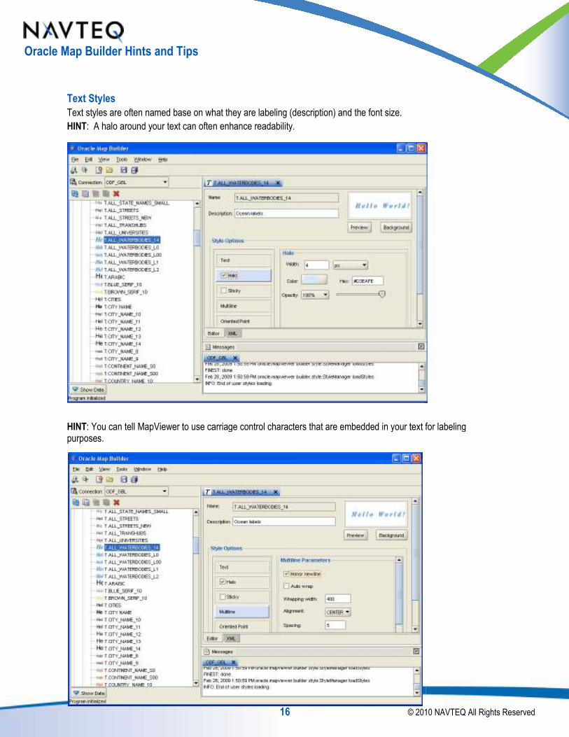
Text Styles
Text styles are often named base on what they are labeling (description) and the font size.
HINT: A halo around your text can often enhance readability.
HINT: You can tell MapViewer to use carriage control characters that are embedded in your text for labeling purposes.
16 © 2010
Text styles are often named base on what they are labeling (description) and the font size.
: A halo around your text can often enhance readability.
can tell MapViewer to use carriage control characters that are embedded in your text for labeling
© 2010 NAVTEQ All Rights Reserved
can tell MapViewer to use carriage control characters that are embedded in your text for labeling

Oracle Map Builder Hints and Tips
You can include carriage control characters in the column that will be used for the label. Here is example SQL that includes character spacing and carriage control to make text render nicely on a map:
insert into POI_OCEAN values
(sdo_geometry(2001,8307,sdo_point_type(
' N o r t h'||chr(10)||'A t l a n t i c'||chr(10)||' O c e a n');
When the style is associated with location information and a label, the label will render in the map like this:
Line Styles
HINT: When rendering line styles, often using Cased line styles makes lines look smooth and professional:
Cased:
17 © 2010
You can include carriage control characters in the column that will be used for the label. Here is example SQL that racter spacing and carriage control to make text render nicely on a map:
insert into POI_OCEAN values
(sdo_geometry(2001,8307,sdo_point_type(-57, 36, NULL),null,null),
' N o r t h'||chr(10)||'A t l a n t i c'||chr(10)||' O c e a n');
is associated with location information and a label, the label will render in the map like this:
: When rendering line styles, often using Cased line styles makes lines look smooth and professional:
Not Cased:
© 2010 NAVTEQ All Rights Reserved
You can include carriage control characters in the column that will be used for the label. Here is example SQL that
57, 36, NULL),null,null),
' N o r t h'||chr(10)||'A t l a n t i c'||chr(10)||' O c e a n');
is associated with location information and a label, the label will render in the map like this:
: When rendering line styles, often using Cased line styles makes lines look smooth and professional:
Oracle Map Builder Hints and Tips
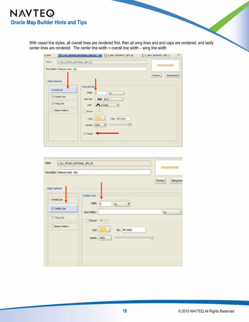
With cased line styles, all overall lines are rendered first, then all wing lines and end caps are rendered, and lastly center lines are rendered. The center line width = overall line width
18 © 2010
With cased line styles, all overall lines are rendered first, then all wing lines and end caps are rendered, and lastly center line width = overall line width – wing line width
© 2010 NAVTEQ All Rights Reserved
With cased line styles, all overall lines are rendered first, then all wing lines and end caps are rendered, and lastly

Oracle Map Builder Hints and Tips
Advanced Styles
Advanced styles give you a very powerful way expressing information beyond simply drawing data on a map. Advanced styles allow you to impart information at a glance by defining styling rules based on the contents of one or more stored values associated with a feature.
Average Household Income Hurricane Risk
The demographic and risk data used above are courtesy of Primus Geographics, Inc.
HINT: Use the Advanced Style Wizard to create advanced styles and associate them with a table.
To use the Advanced Style Wizard, click Show Data, Style, then use Equal Ranged Bucket Style
19 © 2010
Advanced styles give you a very powerful way expressing information beyond simply drawing data on a map. to impart information at a glance by defining styling rules based on the contents of one or
more stored values associated with a feature.
Average Household Income Hurricane Risk
mographic and risk data used above are courtesy of Primus Geographics, Inc. http://www.navmart.com
: Use the Advanced Style Wizard to create advanced styles and associate them with a table.
To use the Advanced Style Wizard, click Show Data, navigate to the table, right click and choose Create Advanced Style, then use Equal Ranged Bucket Style
© 2010 NAVTEQ All Rights Reserved
Advanced styles give you a very powerful way expressing information beyond simply drawing data on a map. to impart information at a glance by defining styling rules based on the contents of one or
http://www.navmart.com
: Use the Advanced Style Wizard to create advanced styles and associate them with a table.
navigate to the table, right click and choose Create Advanced

Oracle Map Builder Hints and Tips
Now, name your advanced style (v.name), choose the column on which to base the style, and the number of buckets (color gradations). Next, assign the color associated with each bucket
In the next step, the wizard allows you to build a theme (associate the style with the table) by clicking Create Predefined Theme. Choose a name, click Next, then
20 © 2010
ame your advanced style (v.name), choose the column on which to base the style, and the number of buckets Next, assign the color associated with each bucket.
he wizard allows you to build a theme (associate the style with the table) by clicking Create lick Next, then Finish, and you have a theme ready to include in your map
© 2010 NAVTEQ All Rights Reserved
ame your advanced style (v.name), choose the column on which to base the style, and the number of buckets
he wizard allows you to build a theme (associate the style with the table) by clicking Create Finish, and you have a theme ready to include in your map.

Oracle Map Builder Hints and Tips
HINT: You can create an advanced style that is based on values of multiple columns in a table by using a character string of the concatenated columns Use collection bucket style, with values asconcatenated data.
When the theme is created, use the concatenated columns in the Columns list
The concatenated columns above are:
functional_class|| route_type||
21 © 2010
: You can create an advanced style that is based on values of multiple columns in a table by a character string of the concatenated columns Use collection bucket style, with values associated with the
is created, use the concatenated columns in the Columns list:
route_type|| iso_country_code|| length(trim(route_number))
© 2010 NAVTEQ All Rights Reserved
: You can create an advanced style that is based on values of multiple columns in a table by defining the style sociated with the
iso_country_code|| length(trim(route_number))

Oracle Map Builder Hints and Tips
HINT: In an advanced style, you can have differentstyle.
HINT: If your advanced style includes label information, in the theme definition use the advanced style for both Render and Label styles.
22 © 2010
In an advanced style, you can have different drawing and marker styles for each element in the advanced
advanced style includes label information, in the theme definition use the advanced style for both
© 2010 NAVTEQ All Rights Reserved
marker styles for each element in the advanced
advanced style includes label information, in the theme definition use the advanced style for both

Oracle Map Builder Hints and Tips
NAVTEQ uses the previous three features:
Concatenated values in advanced styles
Different marker styles in an advanced style
Assigning the label to the advanced style
NAVTEQ supports over 78 countries (today)
Different highways may be styled differently
Each country has own highway markers
May be many levels of highway markers (National, US, State)
These features make it possible to create a single maintainable map
Themes in Map Builder
To create a theme in Map Builder, assign style information to features for rendering location datapatterns are assigned to area features. more are assigned to linear features. Markers are assigned to point features, and can also be assigned for labeling purposes (such as highway markers). Text styles are assigned for labeling purposeswhen the feature drawing style is dependent on one or more values in the table
Location data in a table + rendering style = Theme
Creating a Theme
To create a theme from scratch, right click the type of theme (Geometry Theme), then click Create Geometry Theme. Next, name the theme, chose a table and an associated geometry column
23 © 2010
NAVTEQ uses the previous three features:
Concatenated values in advanced styles
styles in an advanced style
Assigning the label to the advanced style
countries (today)
Different highways may be styled differently
Each country has own highway markers
May be many levels of highway markers (National, US, State)
These features make it possible to create a single maintainable map supporting world-wide highways.
ssign style information to features for rendering location data. Line styles which include attributes such as color, thickness, wing line, and Markers are assigned to point features, and can also be assigned for labeling Text styles are assigned for labeling purposes. Advanced styles are assigned
when the feature drawing style is dependent on one or more values in the table.
Location data in a table + rendering style = Theme
from scratch, right click the type of theme (Geometry Theme), then click Create Geometry Theme. Next, name the theme, chose a table and an associated geometry column.
© 2010 NAVTEQ All Rights Reserved
wide highways.
. Color or fill such as color, thickness, wing line, and
Markers are assigned to point features, and can also be assigned for labeling Advanced styles are assigned
from scratch, right click the type of theme (Geometry Theme), then click Create Geometry Theme.

Oracle Map Builder Hints and Tips
Choose a color style from the colors style pickeryou assign an Advanced style, in the lower box choose the column whose value defines the style
Check the Label Style check box if you want to label this theme, choose the column with the label text.
3
24 © 2010
Choose a color style from the colors style picker (given the theme we are creating is based on an area feature). you assign an Advanced style, in the lower box choose the column whose value defines the style
Check the Label Style check box if you want to label this theme, and then choose the text style. Click Attributes to
1
© 2010 NAVTEQ All Rights Reserved
(given the theme we are creating is based on an area feature). If you assign an Advanced style, in the lower box choose the column whose value defines the style.
Click Attributes to
2
4

Oracle Map Builder Hints and Tips
Most often there will be no Query Conditioncanals), but not bays:
When we are done creating a theme we can preview it:
25 © 2010
Most often there will be no Query Condition. In this case there is; we choose fresh water features (lakes, rivers,
a theme we can preview it:
© 2010 NAVTEQ All Rights Reserved
we choose fresh water features (lakes, rivers,

Oracle Map Builder Hints and Tips
HINT: We can use Oracle SQL functions to define how our labels will look on the map
character of each word in the label uppercased, use the NLS_INITCAP function
style, then click edit. Next, add the NLS_INITCAP function around NAME
Now the preview shows the label in the desired format:
3
4
1
2
26 © 2010
: We can use Oracle SQL functions to define how our labels will look on the map. To force labels to have the first
character of each word in the label uppercased, use the NLS_INITCAP function. To do this, click Editor, Styling Rules, select the
add the NLS_INITCAP function around NAME.
Now the preview shows the label in the desired format:
© 2010 NAVTEQ All Rights Reserved
. To force labels to have the first
lick Editor, Styling Rules, select the
5

Oracle Map Builder Hints and Tips
HINT: You can label a theme without having a visual representation of it. For area features use a transparent style with no fill or stroke, then assign that style for rendering
Note the use of complicated Query Condition above, and the NLS_UPPER function applied to
HINT: In some instances, it may improve performance to alter the fetch size. Server, fetches data from the database via JDBCthe network between the database and the application server is slow or restricted, and there is a lot of data fetched in a theme (many hundreds or thousands), this can be
27 © 2010
: You can label a theme without having a visual representation of it. For area features use a transparent style ssign that style for rendering.
Note the use of complicated Query Condition above, and the NLS_UPPER function applied to the
, it may improve performance to alter the fetch size. MapViewer, deployed in an Application Server, fetches data from the database via JDBC. MapViewer’s default fetch size from the database is 100 rows. the network between the database and the application server is slow or restricted, and there is a lot of data fetched in a theme (many hundreds or thousands), this can be increased.
© 2010 NAVTEQ All Rights Reserved
: You can label a theme without having a visual representation of it. For area features use a transparent style
the Label Column.
MapViewer, deployed in an Application e from the database is 100 rows. If
the network between the database and the application server is slow or restricted, and there is a lot of data fetched in

Oracle Map Builder Hints and Tips
Create an Advanced Style and Associate it with a T
Let’s look at the block groups table:
SQL> desc block_group
Name
----------------------------------------
ID
BGP_ID
FIPSST
FIPSCO
FIPSSTCO
TRACT_ID
ST_ABRV
CO_NAME
ST_NAME
BGP_LABEL
GEOMETRY
TOTAL_POP
POP_MALE
…
POP_FEMALE
…
POP_GE25
POP_MALE_GE25
POP_FEMALE_GE25
…
HOUSEHOLD
MED_HOUSEHOLD_INCOME …
We can thematically style our layer based on many of the attributes. L(MED_HOUSEHOLD_INCOME).
If we want to style the block group boundaries using represent the same number of block groups, wof the colors (or buckets) by using the follo
28 © 2010
Create an Advanced Style and Associate it with a Theme in Map Builder
----------------------------------------
based on many of the attributes. Let’s choose median household income
to style the block group boundaries using 5 different colors based on income, and we want each color to represent the same number of block groups, we can determine the minimum and maximum income of the colors (or buckets) by using the following SQL:
© 2010 NAVTEQ All Rights Reserved
s choose median household income
d on income, and we want each color to income values for each

Oracle Map Builder Hints and Tips
select
bucket,
min(MED_HOUSEHOLD_INCOME
max(MED_HOUSEHOLD_INCOME
count(*)
from ( select MED_HOUSEHOLD_INCOMEMED_HOUSEHOLD_INCOME) bucket
from block_group
group by bucket
order by bucket;
BUCKET MIN_BUCKET_VALUE MAX_BUCKET_VALUE COUNT(*)
------ ----------------
1 0 45112 115
2 45167 56343 115
3 56400 65147 115
4 65227 77287 115
5 77550 200001 115
Note ntile(5) is what calculated the values for each of the 5 buckets.
Now let’s go to Map Builder and create the Advanced Style by right clicking on
29 © 2010
MED_HOUSEHOLD_INCOME) min_bucket_value,
MED_HOUSEHOLD_INCOME) max_bucket_value,
MED_HOUSEHOLD_INCOME, ntile(5) over (order by ) bucket
)
BUCKET MIN_BUCKET_VALUE MAX_BUCKET_VALUE COUNT(*)
---------------- ----------
1 0 45112 115
2 45167 56343 115
3 56400 65147 115
4 65227 77287 115
5 77550 200001 115
Note ntile(5) is what calculated the values for each of the 5 buckets.
r and create the Advanced Style by right clicking on Advanced Style and choosing create:
© 2010 NAVTEQ All Rights Reserved
) over (order by
Advanced Style and choosing create:

Oracle Map Builder Hints and Tips
Next, choose a variable ranged bucket style (we choose variable ranged bucket because we want to provide the values to be used for each bucket, rather than let Orac
Now we name the Style, and we add 4 more rows by clicking on the green plus sign 4 times
30 © 2010
Next, choose a variable ranged bucket style (we choose variable ranged bucket because we want to provide the values to be used for each bucket, rather than let Oracle calculate the values.
Now we name the Style, and we add 4 more rows by clicking on the green plus sign 4 times
© 2010 NAVTEQ All Rights Reserved
Next, choose a variable ranged bucket style (we choose variable ranged bucket because we want to provide the

Oracle Map Builder Hints and Tips
Next, for each of the five rows, highlight the row then click the pencil to edit (next to the + sign). Here is an example of the first bucket values:
After filling in all values the style that will be associated with the theme looks like this:
31 © 2010
for each of the five rows, highlight the row then click the pencil to edit (next to the + sign). Here is an example
After filling in all values the style that will be associated with the theme looks like this:
© 2010 NAVTEQ All Rights Reserved
for each of the five rows, highlight the row then click the pencil to edit (next to the + sign). Here is an example

Oracle Map Builder Hints and Tips
Now that we have the Advanced Style, we can assign the Block Group table to the style to create the themethis, right click Themes, then choose Create Geometry Theme:
Name the theme and assign BLOCK_GROUP table:
32 © 2010
Now that we have the Advanced Style, we can assign the Block Group table to the style to create the themeThemes, then choose Create Geometry Theme:
Name the theme and assign BLOCK_GROUP table:
© 2010 NAVTEQ All Rights Reserved
Now that we have the Advanced Style, we can assign the Block Group table to the style to create the theme. To do

Oracle Map Builder Hints and Tips
Choose Advanced Style then pick the style we created above:
Assign the median household income value as the value to use for the advanced style:
33 © 2010
Choose Advanced Style then pick the style we created above:
Assign the median household income value as the value to use for the advanced style:
© 2010 NAVTEQ All Rights Reserved

Oracle Map Builder Hints and Tips
Choose a label style:
Click Next, then Next again and finally Finish. Then we can preview the layer:
34 © 2010
Click Next, then Next again and finally Finish. Then we can preview the layer:
© 2010 NAVTEQ All Rights Reserved

Oracle Map Builder Hints and Tips
Maps in Map Builder
A map is a collection on one or more themes
When associating a theme with a map, Oracle Map Builder givealready been discussed. The author can:
Define the order in which themes render
Define the map scale at which themes are turned on and off
Define the map scale at which labels for a theme are turned on
Allow MapViewer to simplify data when rendering
Force labels to always appear
Eliminate duplicate labels
Stop insignificant features from being fetched from the database
…and much more
Map Creation Hints
When creating map, this order for drawing
Render polygon data first
Country boundaries, oceans, parks
Render linear features next
Roads, railways, rivers, cartographic lines
Then render point features
35 © 2010
A map is a collection on one or more themes.
When associating a theme with a map, Oracle Map Builder gives the map author a lot of flexibility beyond what has already been discussed. The author can:
Define the order in which themes render
Define the map scale at which themes are turned on and off
Define the map scale at which labels for a theme are turned on and off
Allow MapViewer to simplify data when rendering
Force labels to always appear
Stop insignificant features from being fetched from the database
When creating map, this order for drawing themes:
Country boundaries, oceans, parks
Roads, railways, rivers, cartographic lines
© 2010 NAVTEQ All Rights Reserved
the map author a lot of flexibility beyond what has

Oracle Map Builder Hints and Tips
The order in which themes are defined in Map Builder is the order
Top to bottom
NAVTEQ has a preferred feature rendering order
At this zoom scale(below)covering the entire Earth
Generalized country layers and parks provide the land features
Ocean, bay, and lake features provide the final area feature detail
A point layer provides the label locations for Oceans and Continents
36 © 2010
The order in which themes are defined in Map Builder is the order in which themes are rendered
NAVTEQ has a preferred feature rendering order. Importantly: For area features render detailed water layers last
(below), the background water layer is a simple rectangle (optimized recta
Generalized country layers and parks provide the land features
Ocean, bay, and lake features provide the final area feature detail
A point layer provides the label locations for Oceans and Continents
© 2010 NAVTEQ All Rights Reserved
in which themes are rendered
features render detailed water layers last.
layer is a simple rectangle (optimized rectangle)

Oracle Map Builder Hints and Tips
At this zoom scale (below)covering the entire earth
It renders quite fast Ocean, bay, lake, and river area features provide all the detail
Roads, then point features for city/town locations finish the
Creating a Map
To create a map, right click Base Map in the Navigation Panel on the left, and choose Create Base Mapthe map. Then add one or more themes to the map
37 © 2010
(below), the background land layer is a simple rectangle (optimized rectangle)
It renders quite fast Ocean, bay, lake, and river area features provide all the detail
Roads, then point features for city/town locations finish the map
To create a map, right click Base Map in the Navigation Panel on the left, and choose Create Base MapThen add one or more themes to the map:
© 2010 NAVTEQ All Rights Reserved
layer is a simple rectangle (optimized rectangle)
To create a map, right click Base Map in the Navigation Panel on the left, and choose Create Base Map. Next, name

Oracle Map Builder Hints and Tips
To add themes to the map, click on the to add.
Click on the theme you just added, then click the pencil (to edit). In the change scale mode from MAPVIEWER_NATIVE to RATIO. The scale is the denominator in map scale, i.e. 1/200000 is 200000 (1 inch on the screen = 200000 inches on the Earth). The minimum scale is the scale at which the theme turns on when zooming in. The maximum scale is the scale at which the theme turns off when further zooming in. The minimum scale will always be greater than maximum scale. In MapViewer, empty scales mean infinity (minimum scale) and 0 (maximum scale)
38 © 2010
click on the Editor tab, then click the plus sign to add a new row. Next, click on a theme
Click on the theme you just added, then click the pencil (to edit). In the scale section of the properties tab, change scale mode from MAPVIEWER_NATIVE to RATIO. The scale is the denominator in map scale, i.e. 1/200000 is 200000 (1 inch on the screen = 200000 inches on the Earth). The minimum scale is the scale
me turns on when zooming in. The maximum scale is the scale at which the theme turns off when further zooming in. The minimum scale will always be greater than maximum scale. In MapViewer, empty scales mean infinity (minimum scale) and 0 (maximum scale).
© 2010 NAVTEQ All Rights Reserved
Editor tab, then click the plus sign to add a new row. Next, click on a theme
scale section of the properties tab, change scale mode from MAPVIEWER_NATIVE to RATIO. The scale is the denominator in map scale, i.e. 1/200000 is 200000 (1 inch on the screen = 200000 inches on the Earth). The minimum scale is the scale
me turns on when zooming in. The maximum scale is the scale at which the theme turns off when further zooming in. The minimum scale will always be greater than maximum scale. In

Oracle Map Builder Hints and Tips
Click the general properties tab:
The definitions of the items in this screen include:Allow naked points – Points can be rendered even if the label or marker they are associated with cannot be rendered (due to label or marker conflict)Fast Geometry Unpickling
precision, seldom a problem for read applicationsForce labeling – MapViewer will always label the theme when map renderingNo repetitive labels – Ensures label will only be rendered once in a themeSimplify Shapes – MapViewer will simplify data to improve rendering speed
Fetch size – The number of rows to fetch from the database via JDBC, as discussed previouslyMinimum pixels – MapViewer asks the database not to return data that will not render over at least the given number of display pixels. This uses the index minimum
Timeout – Used for WMS/WFS Transparency – set the transparency for the theme here if desired (can also set transparency in the style definition)
39 © 2010
The definitions of the items in this screen include: Points can be rendered even if the label or marker they are associated with cannot
be rendered (due to label or marker conflict) Fast Geometry Unpickling – Uses special MapViewer code to unpickle data. Incurs very slight loss of
blem for read applications MapViewer will always label the theme when map rendering
Ensures label will only be rendered once in a theme MapViewer will simplify data to improve rendering speed
The number of rows to fetch from the database via JDBC, as discussed previouslyMapViewer asks the database not to return data that will not render over at least the given This uses the index minimum bounding rectangle, and is very powerful
set the transparency for the theme here if desired (can also set transparency in the style
© 2010 NAVTEQ All Rights Reserved
Points can be rendered even if the label or marker they are associated with cannot
Uses special MapViewer code to unpickle data. Incurs very slight loss of
The number of rows to fetch from the database via JDBC, as discussed previously MapViewer asks the database not to return data that will not render over at least the given
bounding rectangle, and is very powerful
set the transparency for the theme here if desired (can also set transparency in the style

Oracle Map Builder Hints and Tips
HINT: Use cartographic lines for land boundaries between countries pleasing map. There is no line representation where land and water meet. In the case below, the country is rendered, and the states labeled, but not drawn (see Label a Theme Without Rendering). Note thearound the country or states. The cartographic state lines appear as dashed lines between the states. The cartographic country lines appear as the smooth, light gray lines between the US and Canada and the US and Mexico.
40 © 2010
: Use cartographic lines for land boundaries between countries and states. This helps to create an aesthetically pleasing map. There is no line representation where land and water meet. In the case below, the country is rendered, and the states labeled, but not drawn (see Label a Theme Without Rendering). Note thearound the country or states. The cartographic state lines appear as dashed lines between the states. The cartographic country lines appear as the smooth, light gray lines between the US and Canada and the US and
© 2010 NAVTEQ All Rights Reserved
This helps to create an aesthetically pleasing map. There is no line representation where land and water meet. In the case below, the country is rendered, and the states labeled, but not drawn (see Label a Theme Without Rendering). Note there are no outlines around the country or states. The cartographic state lines appear as dashed lines between the states. The cartographic country lines appear as the smooth, light gray lines between the US and Canada and the US and

Oracle Map Builder Hints and Tips
Other Hints and Tips
You can copy and paste the Center X, Y, and Height/Scale in the preview window of a theme or map:
You can see all of the attributes associated with a feature by clicking the “Identify”
Right click
41 © 2010
You can copy and paste the Center X, Y, and Height/Scale in the preview window of a theme or map:
You can see all of the attributes associated with a feature by clicking the “Identify” pin:
© 2010 NAVTEQ All Rights Reserved
You can copy and paste the Center X, Y, and Height/Scale in the preview window of a theme or map:

Oracle Map Builder Hints and Tips
The options tab allows you to configure/alter Map Builder:
Background Color – allows you to change the map backgroundChange Rotation – allows you to rotate the map (degrees)Clear Cached Geometries – clears the Map Builder geometry cacheEnable AA – Anti-Aliasing Legend – allows you to size and place the legend for advanced stylesKeep themes order – Use as defined Show North arrow – Adds a North ArrowShow scale bar – Adds a scale bar
42 © 2010
The options tab allows you to configure/alter Map Builder:
allows you to change the map background allows you to rotate the map (degrees)
clears the Map Builder geometry cache
allows you to size and place the legend for advanced styles
Adds a North Arrow
© 2010 NAVTEQ All Rights Reserved

Oracle Map Builder Hints and Tips
There are a set of tools available in Map Builder:
The three most common ones are:
Import Shapefile – Imports a shapefile and optionally creates a theme on the new table
Import Metadata – Imports a previously created Map Builder export
Export Metadata – Creates a Map Builder map metadata filethemes, and maps
For More Information
For more information about the concepts or details in this paper, or to find out more about NAVTEQ data and Oracle, contact: [email protected] and mention Oracle.
43 © 2010
There are a set of tools available in Map Builder:
Imports a shapefile and optionally creates a theme on the new table
Imports a previously created Map Builder export
Creates a Map Builder map metadata file contains one or more of the set of styles,
For more information about the concepts or details in this paper, or to find out more about NAVTEQ data and Oracle, and mention Oracle.
© 2010 NAVTEQ All Rights Reserved
Imports a shapefile and optionally creates a theme on the new table
contains one or more of the set of styles,
For more information about the concepts or details in this paper, or to find out more about NAVTEQ data and Oracle,