on the orientation of early bronze age tombs in … the orientation of early bronze age ... united...
TRANSCRIPT
Mediterranean Archaeology and Archaeometry, Vol. 14, No 3, pp. 233-246 Copyright © 2014 MAA
Printed in Greece. All rights reserved.
ON THE ORIENTATION OF EARLY BRONZE AGE TOMBS IN ANCIENT MAGAN
J.A. Belmonte 1, A.C. González-García 2
1 Instituto de Astrofísica de Canarias, Vía Lactea S.N. 38200 La Laguna, Spain 2 Instituto de Ciencias del Patrimonio INCIPIT, CSIC, San Roque 2, 15704 Santiago de
Compostela, Spain
Corresponding author: Juan A. Belmonte ([email protected])
ABSTRACT
Orientation studies have recently received considerable attention in the archaeological domain as a source of information that may shed light on a number of anthropological issues such as beliefs systems or landscape and territory apprehension by past cultures. This is especially important in those cultural contexts, such as the ‘megalithic’ phenome-na, where there are no written additional sources (Hoskin, 2001; González-García and Belmonte, 2010). This is the case of the Hafit and Umm en Nar cultures that dominated the eastern corner of the Arabian Peninsula during the Chalcolithic and the Early Bronze Age (EBA, third millennium BC), in the so-called land of Magan (present day Oman and the Emirates). In a field campaign in January 2012 several ancient EBA necropolises of the region were visited and (when possible) measured in an attempt to shed some light on the orientation customs of these ancient people. This paper presents the data for about seventy monuments, and the first outcomes of the fieldwork show that certain customs were present in the data that are far from being easily understood. This is the first sys-tematic archaeoastronomical approach ever conducted in the Arabian Peninsula.
KEYWORDS: architecture, archaeoastronomy, ancient Magan, Umm en Nar, Bat, Hili
234 BELMONTE et al
© University of the Aegean, 2014, Mediterranean Archaeology & Archaeometry, 14, 3 (2014) 233-246
1. INTRODUCTION: THE COUNTRY OF MAGAN
The Arabian Peninsula has been a blank in archaeoastronomical studies for many decades, with minor exceptions (see Haw-kins and King, 1982), but without a solid work on the terrain. Only recently, exten-sive research has been conducted in its northern frontiers (Belmonte et al., 2013), showing that astronomy did play a role in the orientation of megalithic tombs of the societies of the Early Bronze Age (EBA hereafter) in the region.
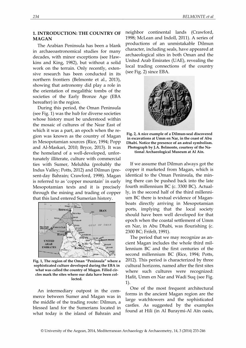
During this period, the Oman Peninsula (see Fig. 1) was the hub for diverse societies whose history must be understood within the mosaic of cultures of the Near East of which it was a part, an epoch when the re-gion was known as the country of Magan in Mesopotamian sources (Rice, 1994; Popp and Al-Maskari, 2010; Bryce, 2013). It was the homeland of a well-developed, unfor-tunately illiterate, culture with commercial ties with Sumer, Meluhha (probably the Indus Valley; Potts, 2012) and Dilmun (pre-sent-day Bahrain; Crawford, 1998). Magan is referred to as ‘copper mountain’ in early Mesopotamian texts and it is precisely through the mining and trading of copper that this land entered Sumerian history.
Fig. 1, The region of the Oman “Peninsula” where a sophisticated culture developed during the EBA in what was called the country of Magan. Filled cir-cles mark the sites where our data have been col-
lected.
An intermediary outpost in the com-
merce between Sumer and Magan was in the middle of the trading route: Dilmun, a blessed land for the Sumerians located in what today is the island of Bahrain and
neighbor continental lands (Crawford, 1998; McLean and Indoll, 2011). A series of productions of an unmistakable Dilmun character, including seals, have appeared at archaeological sites in both Oman and the United Arab Emirates (UAE), revealing the local trading connections of the country (see Fig. 2) since EBA.
Fig. 2, A nice example of a Dilmun-seal discovered in excavations at Umm en Nar, in the coast of Abu Dhabi. Notice the presence of an astral symbolism. Photograph by J.A. Belmonte, courtesy of the Na-
tional Archaeological Museum at Al Aïn.
If we assume that Dilmun always got the
copper it marketed from Magan, which is identical to the Oman Peninsula, the min-ing there can be pushed back into the late fourth millennium BC (c. 3300 BC). Actual-ly, in the second half of the third millenni-um BC there is textual evidence of Magan-boats directly arriving in Mesopotamian ports, implying that the local society should have been well developed for that epoch when the coastal settlement of Umm en Nar, in Abu Dhabi, was flourishing (c. 2300 BC; Frifelt, 1991).
The period that we may recognize as an-cient Magan includes the whole third mil-lennium BC and the first centuries of the second millennium BC (Rice, 1994; Potts, 2012). This period is characterized by three cultural horizons, named after the first sites where such cultures were recognized: Hafit, Umm en Nar and Wadi Suq (see Fig. 1).
One of the most frequent architectural forms in the ancient Magan region are the large watchtowers and the sophisticated castles. As suggested by the examples found at Hili (in Al Buraymi-Al Aïn oasis,
ON THE ORIENTATION OF EBA TOMBS IN ANCIENT MAGAN 235
© University of the Aegean, 2014, Mediterranean Archaeology & Archaeometry, 14, 3 (2014) 233-246
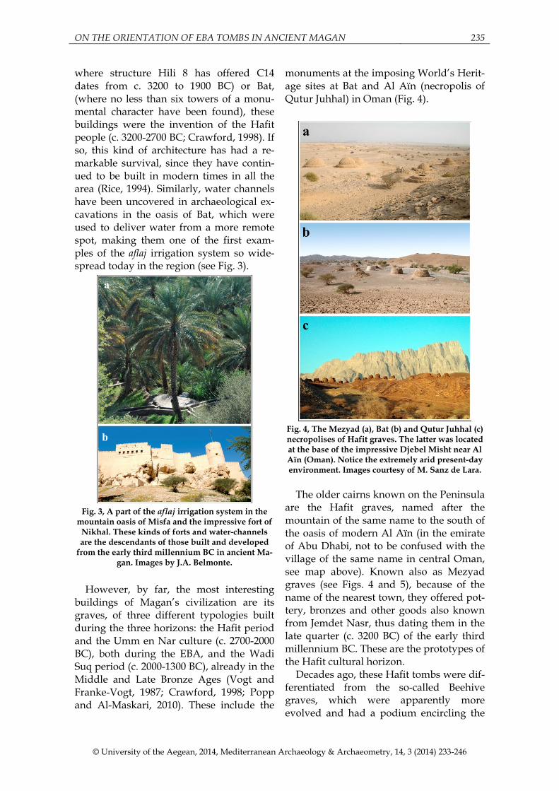
where structure Hili 8 has offered C14 dates from c. 3200 to 1900 BC) or Bat, (where no less than six towers of a monu-mental character have been found), these buildings were the invention of the Hafit people (c. 3200-2700 BC; Crawford, 1998). If so, this kind of architecture has had a re-markable survival, since they have contin-ued to be built in modern times in all the area (Rice, 1994). Similarly, water channels have been uncovered in archaeological ex-cavations in the oasis of Bat, which were used to deliver water from a more remote spot, making them one of the first exam-ples of the aflaj irrigation system so wide-spread today in the region (see Fig. 3).
Fig. 3, A part of the aflaj irrigation system in the
mountain oasis of Misfa and the impressive fort of Nikhal. These kinds of forts and water-channels are the descendants of those built and developed
from the early third millennium BC in ancient Ma-gan. Images by J.A. Belmonte.
However, by far, the most interesting
buildings of Magan’s civilization are its graves, of three different typologies built during the three horizons: the Hafit period and the Umm en Nar culture (c. 2700-2000 BC), both during the EBA, and the Wadi Suq period (c. 2000-1300 BC), already in the Middle and Late Bronze Ages (Vogt and Franke-Vogt, 1987; Crawford, 1998; Popp and Al-Maskari, 2010). These include the
monuments at the imposing World’s Herit-age sites at Bat and Al Aïn (necropolis of Qutur Juhhal) in Oman (Fig. 4).
Fig. 4, The Mezyad (a), Bat (b) and Qutur Juhhal (c) necropolises of Hafit graves. The latter was located at the base of the impressive Djebel Misht near Al Aïn (Oman). Notice the extremely arid present-day environment. Images courtesy of M. Sanz de Lara.
The older cairns known on the Peninsula
are the Hafit graves, named after the mountain of the same name to the south of the oasis of modern Al Aïn (in the emirate of Abu Dhabi, not to be confused with the village of the same name in central Oman, see map above). Known also as Mezyad graves (see Figs. 4 and 5), because of the name of the nearest town, they offered pot-tery, bronzes and other goods also known from Jemdet Nasr, thus dating them in the late quarter (c. 3200 BC) of the early third millennium BC. These are the prototypes of the Hafit cultural horizon.
Decades ago, these Hafit tombs were dif-ferentiated from the so-called Beehive graves, which were apparently more evolved and had a podium encircling the

236 BELMONTE et al
© University of the Aegean, 2014, Mediterranean Archaeology & Archaeometry, 14, 3 (2014) 233-246
whole monument, closing off the access (see, e.g., Crawford, 1998). Today both groups are interpreted as contemporary, where the Hafit type would be an unfin-ished Beehive tomb waiting for more buri-als before being sealed off with an outer ring-wall (Frifelt, 1991).
Fig. 5, A relatively well-preserved and sealed Hafit tomb at Al Khutm (a) and a semi-destroyed isolated
one at Al Aïn (b) sites in Oman. Notice that the entrance cannot be determined in the former, while the lower plinth that surrounded the tomb has part-ly been demolished in the latter. The first tombs of this kind ever excavated were a group at the bottom of Djebel Hafit (UAE), which has been “restored”. Images by J.A. Belmonte (a & b) and M. Sanz de
Lara (c).
This is beautifully illustrated in Fig. 5,
where a nicely preserved tomb in Al Khutm, close to Bat (unmeasurable, due to its state of conservation and the fact that this has impeded the location of the gate), is compared with grave H31 in Al Aïn, where, either by human action or weather-ing (the grave is in an imposing position at the foot of Djebel Misht), the front section of the lower podium has been completely destroyed. Fig. 5 also shows the somehow bizarre restoration of the group of Mezyad
tombs, where for the delight of fieldwork-ers, the gates have been “preserved” across the outer plinth of the tomb.
Fig. 6, An aerial view of Umm en Nar necropolis
showing the best preserved, excavated and restored tombs whose data have been included in this pa-per. Notice the variety of Umm en Nar grave size and typology within the site. Diagram of the au-
thors on an image courtesy of Google Maps.
Many examples of these formidable bee-
hive-shaped Hafit tombs are to be found, occasionally singly on mountain ridges but more frequently concentrated in groups or even in vast necropolises (see Fig. 4). The locations of these necropolises appear to follow ancient trade routes from the oasis of Al Aïn and Buraymi (on both sides of the UAE-Oman border) to trading station oases farther to the east in the Hajjar Mountains of Oman.
The Hafit period itself is supposed to have ended around 2700 BC when a new kind of cyclopean tomb (and an improve-ment in the quality of the goods, including pottery) developed in the area, perhaps as a result of contact with peoples from the other side of the strait of Ormuz (Potts, 2012). The town and necropolis of Umm en Nar (see Fig. 6), one of the islands of Abu Dhabi Archipelago (Frifelt, 1991; Al-Tikriti, 2011), was the first ever site to be scientifi-
ON THE ORIENTATION OF EBA TOMBS IN ANCIENT MAGAN 237
© University of the Aegean, 2014, Mediterranean Archaeology & Archaeometry, 14, 3 (2014) 233-246
cally excavated among this kind of graves. This is why the period from c. 2700 to 2000 BC is known as the Umm en Nar (hereafter UEN) cultural horizon. However, Hafit tombs presumably continued to be built alongside UEN tombs as late as the second half of the third millennium BC.
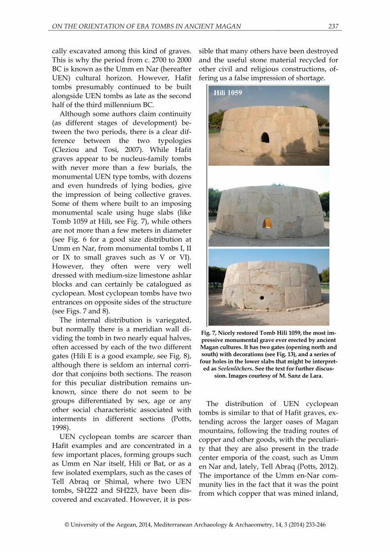
Although some authors claim continuity (as different stages of development) be-tween the two periods, there is a clear dif-ference between the two typologies (Cleziou and Tosi, 2007). While Hafit graves appear to be nucleus-family tombs with never more than a few burials, the monumental UEN type tombs, with dozens and even hundreds of lying bodies, give the impression of being collective graves. Some of them where built to an imposing monumental scale using huge slabs (like Tomb 1059 at Hili, see Fig. 7), while others are not more than a few meters in diameter (see Fig. 6 for a good size distribution at Umm en Nar, from monumental tombs I, II or IX to small graves such as V or VI). However, they often were very well dressed with medium-size limestone ashlar blocks and can certainly be catalogued as cyclopean. Most cyclopean tombs have two entrances on opposite sides of the structure (see Figs. 7 and 8).
The internal distribution is variegated, but normally there is a meridian wall di-viding the tomb in two nearly equal halves, often accessed by each of the two different gates (Hili E is a good example, see Fig. 8), although there is seldom an internal corri-dor that conjoins both sections. The reason for this peculiar distribution remains un-known, since there do not seem to be groups differentiated by sex, age or any other social characteristic associated with interments in different sections (Potts, 1998).
UEN cyclopean tombs are scarcer than Hafit examples and are concentrated in a few important places, forming groups such as Umm en Nar itself, Hili or Bat, or as a few isolated exemplars, such as the cases of Tell Abraq or Shimal, where two UEN tombs, SH222 and SH223, have been dis-covered and excavated. However, it is pos-
sible that many others have been destroyed and the useful stone material recycled for other civil and religious constructions, of-fering us a false impression of shortage.
Fig. 7, Nicely restored Tomb Hili 1059, the most im-pressive monumental grave ever erected by ancient Magan cultures. It has two gates (opening north and south) with decorations (see Fig. 13), and a series of
four holes in the lower slabs that might be interpret-ed as Seelenlöchers. See the text for further discus-
sion. Images courtesy of M. Sanz de Lara.
The distribution of UEN cyclopean
tombs is similar to that of Hafit graves, ex-tending across the larger oases of Magan mountains, following the trading routes of copper and other goods, with the peculiari-ty that they are also present in the trade center emporia of the coast, such as Umm en Nar and, lately, Tell Abraq (Potts, 2012). The importance of the Umm en-Nar com-munity lies in the fact that it was the point from which copper that was mined inland,
238 BELMONTE et al
© University of the Aegean, 2014, Mediterranean Archaeology & Archaeometry, 14, 3 (2014) 233-246
closer to the interior oases (there are only 120 Km. between Hili and Umm en Nar), was shipped via Dilmun to the cities of Sumer, the former probably being a sec-ondary partner in this game. However, Hili and Bat settlements developed well-trained oasis societies with quite sophisticated irri-gation techniques and, with their key posi-tions, became trading stations with craft activities also involving processing copper from the nearby mines.
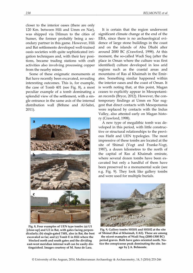
Some of these enigmatic monuments at Bat have recently been excavated, revealing interesting outcomes. This is, for example, the case of Tomb 401 (see Fig. 8), a most peculiar example of a tomb dominating a splendid view of the settlement, with a sin-gle entrance in the same axis of the internal distribution wall (Böhme and Al-Sabri, 2011).
Fig. 8, Four examples of UEN type tombs: (a) U1
[close-up] and U2 in Bat, with gates facing perpen-dicularly; (b) single-gated T401, also in Bat, the best excavated so far; and (c) Tomb E in Hili where the
blocked north and south gates and the dividing east-west meridian internal wall can be easily dis-tinguished. Images courtesy of M. Sanz de Lara.
It is certain that the region underwent
significant climate change at the end of the EBA, since there is no archaeological evi-dence of large stone buildings in the coast and on the islands of Abu Dhabi after around 2000 BC (Crawford, 1998). At this moment, the so-called Wadi Suq (after the place in Oman where the culture was first identified) culture developed in less arid regions such as the coastal areas and mountains of Ras al Khaimah in the Emir-ates. Something similar happened within the interior oases and the coast of Oman. It is worth noting that, at this point, Magan ceases to explicitly appear in Mesopotami-an records (Bryce, 2012). However, the con-temporary findings at Umm en Nar sug-gest that direct contacts with Mesopotamia were replaced by contacts with the Indus Valley, also attested early on Magan histo-ry (Crawford, 1998).
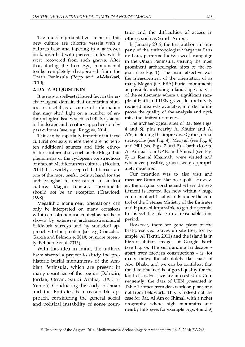
A new type of megalithic tomb was de-veloped in this period, with little construc-tive or structural relationships to the previ-ous Hafit and UEN typologies. The most impressive of these tombs are located at the site of Shimal (Vogt and Franke-Vogt, 1987), a dozen kilometres to the north of the capital of Ras al Khaimah emirate, where several dozen tombs have been ex-cavated but only a handful of them have been preserved to a monumental scale (see e.g. Fig. 9). They look like gallery tombs and were used for multiple burials.
Fig. 9, Gallery tombs SH101 and SH102 at the site
of Shimal (Ras al Khaimah, UAE). These are among the nicest examples of Wadi Suq (2000-1300 BC)
period graves. Both have gates oriented north. No-tice the conspicuous peak dominating the site. Im-
age by J.A. Belmonte.
ON THE ORIENTATION OF EBA TOMBS IN ANCIENT MAGAN 239
© University of the Aegean, 2014, Mediterranean Archaeology & Archaeometry, 14, 3 (2014) 233-246
The most representative items of this
new culture are chlorite vessels with a bulbous base and tapering to a narrower neck, inscribed with pierced circles, which were recovered from such graves. After that, during the Iron Age, monumental tombs completely disappeared from the Oman Peninsula (Popp and Al-Maskari, 2010). 2. DATA ACQUISITION
It is now a well-established fact in the ar-chaeological domain that orientation stud-ies are useful as a source of information that may shed light on a number of an-thropological issues such as beliefs systems or landscape and territory apprehension by past cultures (see, e.g., Ruggles, 2014).
This can be especially important in those cultural contexts where there are no writ-ten additional sources and little ethno-historic information, such as the Megalithic phenomena or the cyclopean constructions of ancient Mediterranean cultures (Hoskin, 2001). It is widely accepted that burials are one of the most useful tools at hand for the archaeologists to reconstruct an ancient culture. Magan funerary monuments should not be an exception (Crawford, 1998).
Megalithic monument orientations can only be interpreted on many occasions within an astronomical context as has been shown by extensive archaeoastronomical fieldwork surveys and by statistical ap-proaches to the problem (see e.g. González-García and Belmonte, 2010; or, more recent-ly, Belmonte et al. 2013).
With this idea in mind, the authors have started a project to study the pre-historic burial monuments of the Ara-bian Peninsula, which are present in many countries of the region (Bahrain, Jordan, Oman, Saudi Arabia, UAE or Yemen). Conducting the study in Oman and the Emirates is a reasonable ap-proach, considering the general social and political instability of some coun-
tries and the difficulties of access in others, such as Saudi Arabia.
In January 2012, the first author, in com-pany of the anthropologist Margarita Sanz de Lara, performed a two-week campaign in the Oman Peninsula, visiting the most prominent archaeological sites of the re-gion (see Fig. 1). The main objective was the measurement of the orientation of as many Magan (i.e. EBA) burial monuments as possible, including a landscape analysis of the settlements where a significant sam-ple of Hafit and UEN graves in a relatively reduced area was available, in order to im-prove the quality of the analysis and opti-mize the limited resources.
The archaeological sites of Bat (see Figs. 4 and 8), plus nearby Al Khutm and Al Aïn, including the impressive Qutur Juhhal necropolis (see Fig. 4), Mezyad (see Fig. 4) and Hili (see Figs. 7 and 8) – both close to Al Aïn oasis in UAE, and Shimal (see Fig. 9) in Ras al Khaimah, were visited and whenever possible, graves were appropri-ately measured.
Our intention was to also visit and measure Umm en Nar necropolis. Howev-er, the original coral island where the set-tlement is located lies now within a huge complex of artificial islands under the con-trol of the Defense Ministry of the Emirates and it proved impossible to get the permits to inspect the place in a reasonable time period.
However, there are good plans of the best-preserved graves on site (see, for ex-ample, Al Tikriti, 2011) and the island is in high-resolution images of Google Earth (see Fig. 6). The surrounding landscape – apart from modern constructions – is, for many miles, the absolutely flat coast of Abu Dhabi, and we can be confident that the data obtained is of good quality for the kind of analysis we are interested in. Con-sequently, the data of UEN presented in Table 1 comes from deskwork on plans and not from fieldwork. This is indeed not the case for Bat, Al Aïn or Shimal, with a richer orography where high mountains and nearby hills (see, for example Figs. 4 and 9)
240 BELMONTE et al
© University of the Aegean, 2014, Mediterranean Archaeology & Archaeometry, 14, 3 (2014) 233-246
are located within close sight of the vast majority of the monuments.
Fieldwork basically consisted of the in situ compilation of orientation data. The basic method of archaeoastronomy is the measurement of the orientations (azimuth and angular height, in the appropriate di-rection and sense) of the architectonic structures of a certain culture. What we measure is the azimuth of the building, tak-ing as a reference a likely important line such as the main entrance or its symmetry axis, depending on the situation and state of preservation of the structure.
Our experience has borne out that, for the vast majority of the structures we are interested in measuring, taking data with a high precision compass and clinometer should be sufficient, because the majority of the graves we are measuring are not in a perfect state of preservation and because we are dealing with the limited precision of naked-eye observations.
The error of an individual measurement should be considered of the order ±½º for both azimuth and angular height. Howev-er, the error in the azimuth could be larger due to the characteristics of Hafit and UEN tombs and their highly variable state of preservation. These data finally corrected for magnetic declination obtained from the Natural Resources Canada website, since compass alterations are not expected in the Oman Peninsula where, apart from the mineral-rich sectors, the terrain is mostly limestone (or sandstone, as is the case for Bat, Al Aïn and Shimal). The data were completed by the determination of the lati-tude and longitude of the monuments with a precision ‘Garmin eTrex 10’ GPS.
The measurements, including Umm en Nar desktop data, are presented in Table 1. The total data sample of 74 monuments (several dozens of additional tombs were visited but proved unmeasurable) consists basically of two different types of tombs: earlier (c. 3000 BC) dry-stone cairns of the Hafit type (H in Table 1) and later (c. 2500 BC) cyclopean structures of the UEN peri-od. Only Bat presents tombs of the two phases, while in Al Aïn-Al Buraymi oasis,
UEN tombs are located closer to the settle-ment at Hili, or even inside it, while Hafit graves are found in the surrounding hills. A few Wadi Suq Period (c. 1500 BC) mega-lithic tombs were also measured at Shimal (see Table 1).
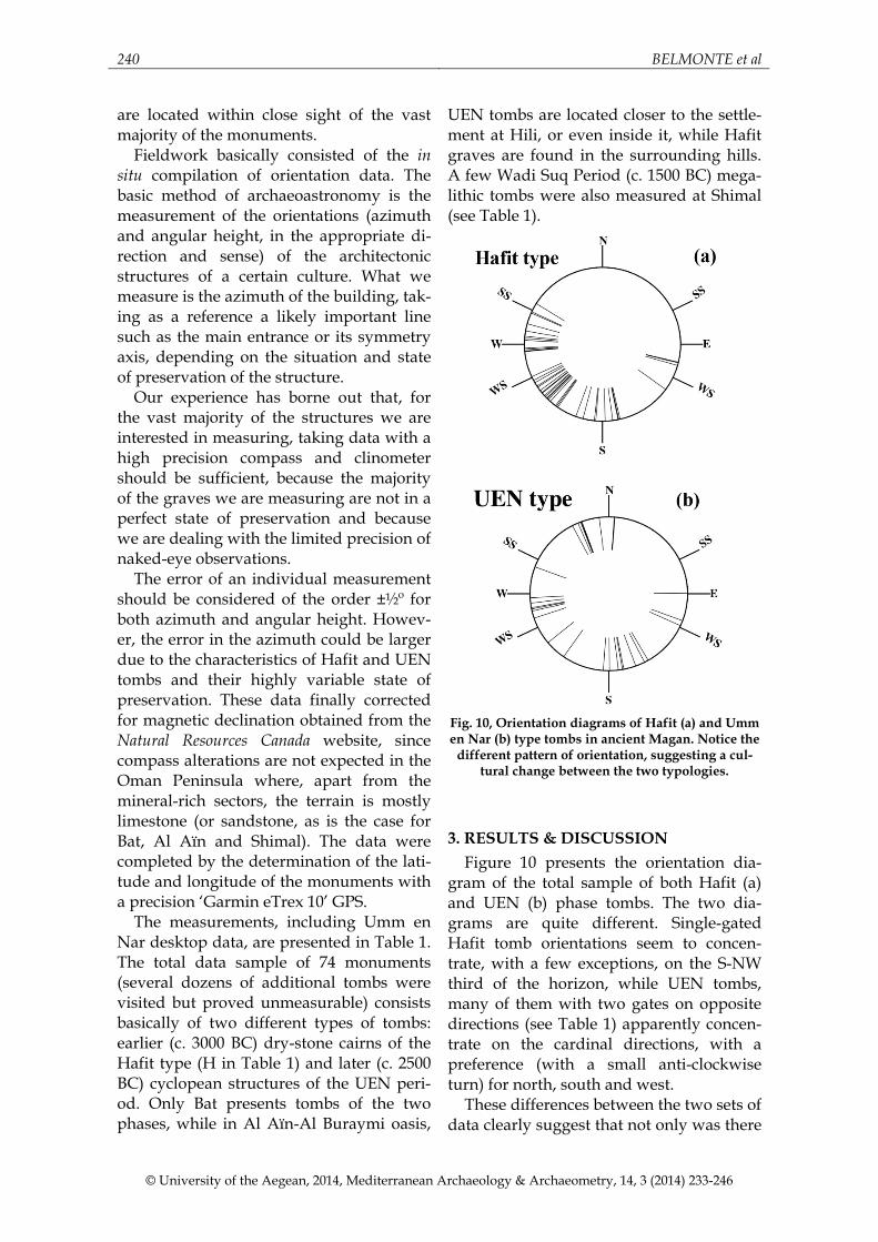
Fig. 10, Orientation diagrams of Hafit (a) and Umm en Nar (b) type tombs in ancient Magan. Notice the
different pattern of orientation, suggesting a cul-tural change between the two typologies.
3. RESULTS & DISCUSSION Figure 10 presents the orientation dia-
gram of the total sample of both Hafit (a) and UEN (b) phase tombs. The two dia-grams are quite different. Single-gated Hafit tomb orientations seem to concen-trate, with a few exceptions, on the S-NW third of the horizon, while UEN tombs, many of them with two gates on opposite directions (see Table 1) apparently concen-trate on the cardinal directions, with a preference (with a small anti-clockwise turn) for north, south and west.
These differences between the two sets of data clearly suggest that not only was there
ON THE ORIENTATION OF EBA TOMBS IN ANCIENT MAGAN 241
© University of the Aegean, 2014, Mediterranean Archaeology & Archaeometry, 14, 3 (2014) 233-246
a substantial architectural change in the design of tombs from the simpler Hafit graves to the sophisticated cyclopean UEN types, but also a change in burial customs. Since orientation is always a well-defined variable of the latter, this suggests a possi-ble cultural (perhaps religious) change or even a more significant population substi-tution, which may be attested by the shift from Hafit family based to UEN communal tombs.
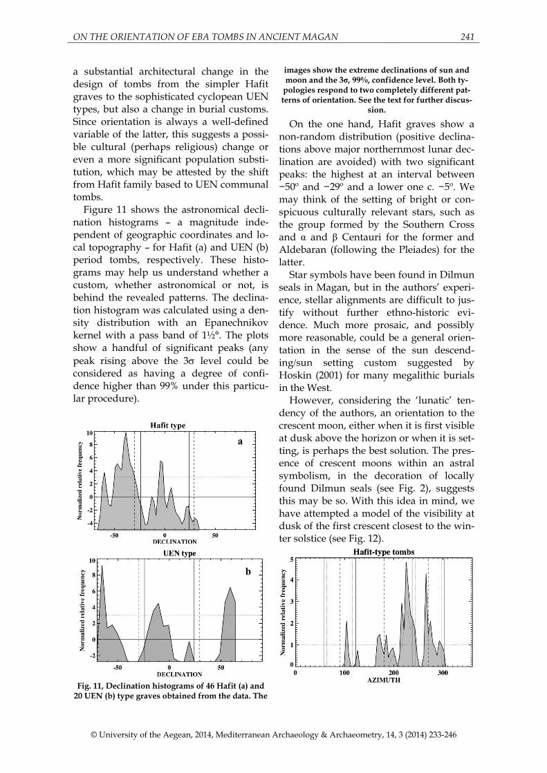
Figure 11 shows the astronomical decli-nation histograms – a magnitude inde-pendent of geographic coordinates and lo-cal topography – for Hafit (a) and UEN (b) period tombs, respectively. These histo-grams may help us understand whether a custom, whether astronomical or not, is behind the revealed patterns. The declina-tion histogram was calculated using a den-sity distribution with an Epanechnikov kernel with a pass band of 1½°. The plots show a handful of significant peaks (any peak rising above the 3σ level could be considered as having a degree of confi-dence higher than 99% under this particu-lar procedure).
Fig. 11, Declination histograms of 46 Hafit (a) and
20 UEN (b) type graves obtained from the data. The
images show the extreme declinations of sun and moon and the 3σ, 99%, confidence level. Both ty-
pologies respond to two completely different pat-terns of orientation. See the text for further discus-
sion.
On the one hand, Hafit graves show a non-random distribution (positive declina-tions above major northernmost lunar dec-lination are avoided) with two significant peaks: the highest at an interval between −50º and −29º and a lower one c. −5º. We may think of the setting of bright or con-spicuous culturally relevant stars, such as the group formed by the Southern Cross and α and β Centauri for the former and Aldebaran (following the Pleiades) for the latter.
Star symbols have been found in Dilmun seals in Magan, but in the authors’ experi-ence, stellar alignments are difficult to jus-tify without further ethno-historic evi-dence. Much more prosaic, and possibly more reasonable, could be a general orien-tation in the sense of the sun descend-ing/sun setting custom suggested by Hoskin (2001) for many megalithic burials in the West.
However, considering the ‘lunatic’ ten-dency of the authors, an orientation to the crescent moon, either when it is first visible at dusk above the horizon or when it is set-ting, is perhaps the best solution. The pres-ence of crescent moons within an astral symbolism, in the decoration of locally found Dilmun seals (see Fig. 2), suggests this may be so. With this idea in mind, we have attempted a model of the visibility at dusk of the first crescent closest to the win-ter solstice (see Fig. 12).
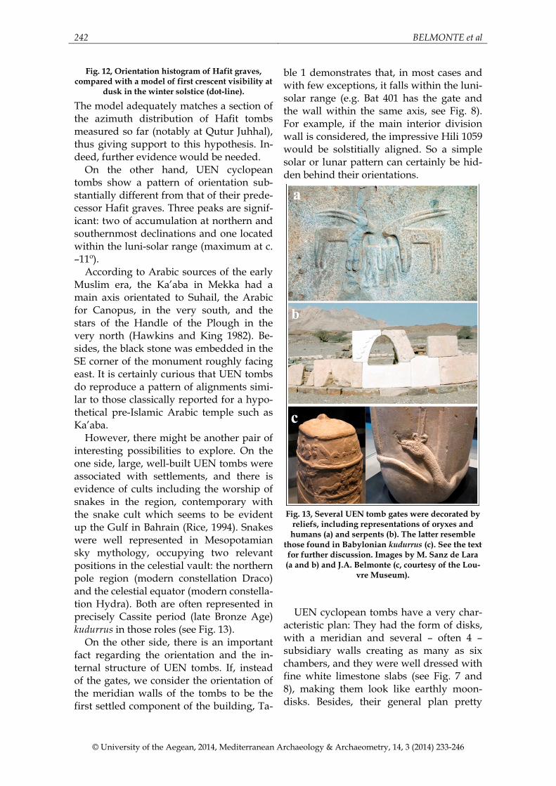
242 BELMONTE et al
© University of the Aegean, 2014, Mediterranean Archaeology & Archaeometry, 14, 3 (2014) 233-246
Fig. 12, Orientation histogram of Hafit graves, compared with a model of first crescent visibility at
dusk in the winter solstice (dot-line).
The model adequately matches a section of the azimuth distribution of Hafit tombs measured so far (notably at Qutur Juhhal), thus giving support to this hypothesis. In-deed, further evidence would be needed.
On the other hand, UEN cyclopean tombs show a pattern of orientation sub-stantially different from that of their prede-cessor Hafit graves. Three peaks are signif-icant: two of accumulation at northern and southernmost declinations and one located within the luni-solar range (maximum at c. –11º).
According to Arabic sources of the early Muslim era, the Ka’aba in Mekka had a main axis orientated to Suhail, the Arabic for Canopus, in the very south, and the stars of the Handle of the Plough in the very north (Hawkins and King 1982). Be-sides, the black stone was embedded in the SE corner of the monument roughly facing east. It is certainly curious that UEN tombs do reproduce a pattern of alignments simi-lar to those classically reported for a hypo-thetical pre-Islamic Arabic temple such as Ka’aba.
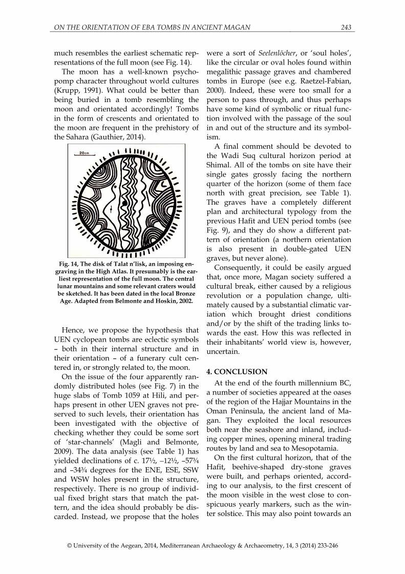
However, there might be another pair of interesting possibilities to explore. On the one side, large, well-built UEN tombs were associated with settlements, and there is evidence of cults including the worship of snakes in the region, contemporary with the snake cult which seems to be evident up the Gulf in Bahrain (Rice, 1994). Snakes were well represented in Mesopotamian sky mythology, occupying two relevant positions in the celestial vault: the northern pole region (modern constellation Draco) and the celestial equator (modern constella-tion Hydra). Both are often represented in precisely Cassite period (late Bronze Age) kudurrus in those roles (see Fig. 13).
On the other side, there is an important fact regarding the orientation and the in-ternal structure of UEN tombs. If, instead of the gates, we consider the orientation of the meridian walls of the tombs to be the first settled component of the building, Ta-
ble 1 demonstrates that, in most cases and with few exceptions, it falls within the luni-solar range (e.g. Bat 401 has the gate and the wall within the same axis, see Fig. 8). For example, if the main interior division wall is considered, the impressive Hili 1059 would be solstitially aligned. So a simple solar or lunar pattern can certainly be hid-den behind their orientations.
Fig. 13, Several UEN tomb gates were decorated by
reliefs, including representations of oryxes and humans (a) and serpents (b). The latter resemble
those found in Babylonian kudurrus (c). See the text for further discussion. Images by M. Sanz de Lara (a and b) and J.A. Belmonte (c, courtesy of the Lou-
vre Museum).
UEN cyclopean tombs have a very char-
acteristic plan: They had the form of disks, with a meridian and several – often 4 – subsidiary walls creating as many as six chambers, and they were well dressed with fine white limestone slabs (see Fig. 7 and 8), making them look like earthly moon-disks. Besides, their general plan pretty
ON THE ORIENTATION OF EBA TOMBS IN ANCIENT MAGAN 243
© University of the Aegean, 2014, Mediterranean Archaeology & Archaeometry, 14, 3 (2014) 233-246
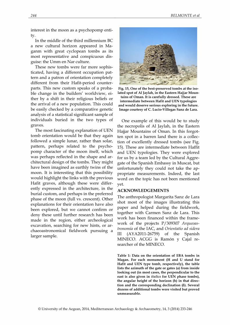
much resembles the earliest schematic rep-resentations of the full moon (see Fig. 14).
The moon has a well-known psycho-pomp character throughout world cultures (Krupp, 1991). What could be better than being buried in a tomb resembling the moon and orientated accordingly! Tombs in the form of crescents and orientated to the moon are frequent in the prehistory of the Sahara (Gauthier, 2014).
Fig. 14, The disk of Talat n’lisk, an imposing en-
graving in the High Atlas. It presumably is the ear-liest representation of the full moon. The central
lunar mountains and some relevant craters would be sketched. It has been dated in the local Bronze Age. Adapted from Belmonte and Hoskin, 2002.
Hence, we propose the hypothesis that
UEN cyclopean tombs are eclectic symbols – both in their internal structure and in their orientation – of a funerary cult cen-tered in, or strongly related to, the moon.
On the issue of the four apparently ran-domly distributed holes (see Fig. 7) in the huge slabs of Tomb 1059 at Hili, and per-haps present in other UEN graves not pre-served to such levels, their orientation has been investigated with the objective of checking whether they could be some sort of ‘star-channels’ (Magli and Belmonte, 2009). The data analysis (see Table 1) has yielded declinations of c. 17½, –12½, –57¾ and –34¾ degrees for the ENE, ESE, SSW and WSW holes present in the structure, respectively. There is no group of individ-ual fixed bright stars that match the pat-tern, and the idea should probably be dis-carded. Instead, we propose that the holes
were a sort of Seelenlöcher, or ‘soul holes’, like the circular or oval holes found within megalithic passage graves and chambered tombs in Europe (see e.g. Raetzel-Fabian, 2000). Indeed, these were too small for a person to pass through, and thus perhaps have some kind of symbolic or ritual func-tion involved with the passage of the soul in and out of the structure and its symbol-ism.
A final comment should be devoted to the Wadi Suq cultural horizon period at Shimal. All of the tombs on site have their single gates grossly facing the northern quarter of the horizon (some of them face north with great precision, see Table 1). The graves have a completely different plan and architectural typology from the previous Hafit and UEN period tombs (see Fig. 9), and they do show a different pat-tern of orientation (a northern orientation is also present in double-gated UEN graves, but never alone).
Consequently, it could be easily argued that, once more, Magan society suffered a cultural break, either caused by a religious revolution or a population change, ulti-mately caused by a substantial climatic var-iation which brought driest conditions and/or by the shift of the trading links to-wards the east. How this was reflected in their inhabitants’ world view is, however, uncertain. 4. CONCLUSION
At the end of the fourth millennium BC, a number of societies appeared at the oases of the region of the Hajjar Mountains in the Oman Peninsula, the ancient land of Ma-gan. They exploited the local resources both near the seashore and inland, includ-ing copper mines, opening mineral trading routes by land and sea to Mesopotamia.
On the first cultural horizon, that of the Hafit, beehive-shaped dry-stone graves were built, and perhaps oriented, accord-ing to our analysis, to the first crescent of the moon visible in the west close to con-spicuous yearly markers, such as the win-ter solstice. This may also point towards an
244 BELMONTE et al
© University of the Aegean, 2014, Mediterranean Archaeology & Archaeometry, 14, 3 (2014) 233-246
interest in the moon as a psychopomp enti-ty.
In the middle of the third millennium BC a new cultural horizon appeared in Ma-ganm with great cyclopean tombs as its most representative and conspicuous dis-guise: the Umm en Nar culture.
These new tombs were far more sophis-ticated, having a different occupation pat-tern and a patron of orientation completely different from their Hafit-period counter-parts. This new custom speaks of a proba-ble change in the builders’ worldview, ei-ther by a shift in their religious beliefs or the arrival of a new population. This could be easily checked by a comparative genetic analysis of a statistical significant sample of individuals buried in the two types of graves.
The most fascinating explanation of UEN tomb orientation would be that they again followed a simple lunar, rather than solar, pattern, perhaps related to the psycho-pomp character of the moon itself, which was perhaps reflected in the shape and ar-chitectural design of the tombs. They might have been imagined as earthly twins of the moon. It is interesting that this possibility would highlight the links with the previous Hafit graves, although these were differ-ently expressed in the architecture, in the burial custom, and perhaps in the preferred phase of the moon (full vs. crescent). Other explanations for their orientation have also been explored, but we cannot confirm or deny these until further research has been made in the region, either archeological excavation, searching for new hints, or ar-chaeoastronomical fieldwork pursuing a larger sample.
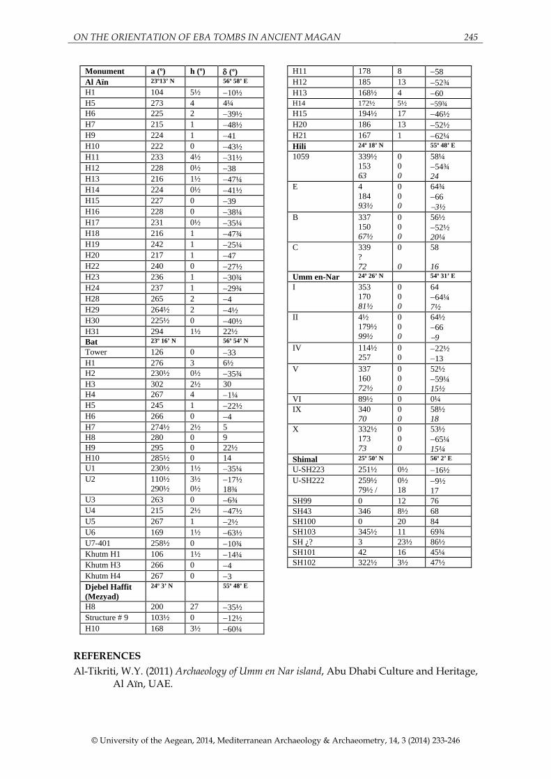
Fig. 15, One of the best-preserved tombs at the iso-lated spot of Al Jaylah, in the Eastern Hajjar Moun-
tains of Oman. It is carefully dressed. These are intermediate between Hafit and UEN typologies
and would deserve serious exploring in the future. Image courtesy of C. Lucio-Villegas Sanz de Lara.
One example of this would be to study the necropolis of Al Jaylah, in the Eastern Hajjar Mountains of Oman. In this forgot-ten spot in a barren land there is a collec-tion of excellently dressed tombs (see Fig. 15). These are intermediate between Haffit and UEN typologies. They were explored for us by a team led by the Cultural Aggre-gate of the Spanish Embassy in Muscat, but unfortunately they could not take the ap-propriate measurements. Indeed, the last word on the topic has not been mentioned yet. ACKNOWLEDGEMENTS The anthropologist Margarita Sanz de Lara shot most of the images illustrating this paper and helped during the fieldwork, together with Carmen Sanz de Lara. This work has been financed within the frame-work of the projects P/309307 Arqueoas-tronomía of the IAC, and Orientatio ad sidera III (AYA2011-26759) of the Spanish MINECO. ACGG is Ramón y Cajal re-searcher of the MINECO. Table 1: Data on the orientation of EBA tombs in Magan. For each monument (H and U stand for Hafit and UEN type tomb, respectively), the table lists the azimuth of the gate or gates (a) from inside looking out (in most cases, the perpendicular to the east is also given in italics for UEN phase tombs), the angular height of the horizon (h) in that direc-tion and the corresponding declination (δ). Several dozens of additional tombs were visited but proved unmeasurable.
ON THE ORIENTATION OF EBA TOMBS IN ANCIENT MAGAN 245
© University of the Aegean, 2014, Mediterranean Archaeology & Archaeometry, 14, 3 (2014) 233-246
Monument a (º) h (º) δ (º) Al Aïn 23º13’ N 56º 58’ E H1 104 5½ −10½ H5 273 4 4¼ H6 225 2 −39½ H7 215 1 −48½ H9 224 1 −41 H10 222 0 −43½ H11 233 4½ −31½ H12 228 0½ −38 H13 216 1½ −47¼ H14 224 0½ −41½ H15 227 0 −39 H16 228 0 −38¼ H17 231 0½ −35¼ H18 216 1 −47¾ H19 242 1 −25¼ H20 217 1 −47 H22 240 0 −27½ H23 236 1 −30¾ H24 237 1 −29¾ H28 265 2 −4 H29 264½ 2 −4½ H30 225½ 0 −40½ H31 294 1½ 22½ Bat 23º 16’ N 56º 54’ N
Tower 126 0 −33 H1 276 3 6½ H2 230½ 0½ −35¾ H3 302 2½ 30 H4 267 4 −1¼ H5 245 1 −22½ H6 266 0 −4 H7 274½ 2½ 5 H8 280 0 9 H9 295 0 22½ H10 285½ 0 14 U1 230½ 1½ −35¼ U2 110½
290½ 3½ 0½
−17½ 18¾
U3 263 0 −6¾ U4 215 2½ −47½ U5 267 1 −2½ U6 169 1½ −63½ U7-401 258½ 0 −10¾ Khutm H1 106 1½ −14¼ Khutm H3 266 0 −4 Khutm H4 267 0 −3 Djebel Haffit (Mezyad)
24º 3’ N
55º 48’ E
H8 200 27 −35½ Structure # 9 103½ 0 −12½ H10 168 3½ −60¼
H11 178 8 −58 H12 185 13 −52¾ H13 168½ 4 −60 H14 172½ 5½ −59¾ H15 194½ 17 −46½ H20 186 13 −52½ H21 167 1 −62¼ Hili 24º 18’ N 55º 48’ E
1059 339½ 153 63
0 0 0
58¼ −54¾ 24
E 4 184 93½
0 0 0
64¾ −66 −3½
B
337 150 67½
0 0 0
56½ −52½ 20¼
C 339 ? 72
0 0
58 16
Umm en-Nar 24º 26’ N 54º 31’ E
I 353 170 81½
0 0 0
64 −64¼ 7½
II 4½ 179½ 99½
0 0 0
64½ −66 −9
IV 114½ 257
0 0
−22½ −13
V 337 160 72½
0 0 0
52½ −59¼ 15½
VI 89½ 0 0¼ IX 340
70 0 0
58½ 18
X 332½ 173 73
0 0 0
53½ −65¼ 15¼
Shimal 25º 50’ N 56º 2’ E
U-SH223 251½ 0½ −16½ U-SH222 259½
79½ / 0½ 18
−9½ 17
SH99 0 12 76 SH43 346 8½ 68 SH100 0 20 84 SH103 345½ 11 69¾ SH ¿? 3 23½ 86½ SH101 42 16 45¼ SH102 322½ 3½ 47½
REFERENCES Al-Tikriti, W.Y. (2011) Archaeology of Umm en Nar island, Abu Dhabi Culture and Heritage,
Al Aïn, UAE.
246 BELMONTE et al
© University of the Aegean, 2014, Mediterranean Archaeology & Archaeometry, 14, 3 (2014) 233-246
Belmonte, J.A. and Hoskin, M. (2002) Reflejo del Cosmos: atlas de arqueoastronomía del Medi-terráneo antiguo, Equipo Sirius, Madrid, Spain.
Belmonte, J.A., González-García, A.C. and Polcaro A. (2013) On the orientation of mega-lithic monuments of the Transjordan Plateau: new clues for an astronomical in-terpretation, Journal for the History of Astronomy, vol. 64, 429-55.
Böhme, M. and Al-Sabri, B.A. (2011) Umm an-Nar burial 401 at Bat, Oman: architecture and finds, Arabian Archaelogy and Epigraphy, vol. 22, 113-54.
Bryce, T. (2013) The Routledge Handbook Of The Peoples and Places Of Ancient Western Asia: The Near East from the EBA to the Fall Of The Persian Empire, Routledge, NY, USA.
Clauziou, S. and Tosi, M. (2007) In the shadow of the ancestors. The prehistoric foundations of the early Arabian civilization of Oman, Ministry of Heritage and Culture, Muscat, Oman.
Crawford, H. (1998) Dilmun and its Gulf Neighbours, Cambridge University Press, Cam-bridge, UK.
Frifelt, L. (1991) The island of Umm an-Nar, vol. 1, Third millennium graves, Aarhus Univer-sity Press, Aarhus, Denmark.
Gauthier, Y. (2014) Pre-Islamic dry-stone monuments of the central and western Sahara. In Handbook of Archaeoastronomy, C.L. Ruggles (ed.), Springer, Heidelberg, Ger-many, in press.
González-García, A.C. and Belmonte, J.A. (2010) Statistical analysis of megalithic tombs orientations in the Iberian Peninsula and neighbouring regions, Journal for the History of Astronomy, vol. 41, 225-38.
Hawkins, G.S. and King D.A. (1982) On the orientation of the Ka’ba, Journal for the History of Astronomy, vol. 13, 102-9.
Hoskin, M. (2001) Tombs, Temples and their Orientations, New Perspectives in Mediterranean Prehistory, Ocarina Books, Bognor Regis, UK.
Krupp, E.C. (1991) Beyond the Blue Horizon, Oxford University Press, Oxford, UK. Magli, G. and Belmonte, J.A. (2009) Pyramids and stars: facts, comjectures and starry tales. In
J.A. Belmonte and M. Shaltout (eds.) In Search of Cosmic Order: Selected Essays on Egyptian Archaeoastronomy, 305-323, Supreme Council of Antiquities Press, Cairo, Egypt.
McLean, R. and Indoll, T. (2011) An Archaeological Guide to Bahrain, Archeopress, Oxford, UK.
Popp, G. and Al-Maskari, J. (2010) Oman, jewel of the Arabian Gulf, Odyssey, Hong Kong, China.
Potts, D.T. (1998) Ancient Magan. The Secrets of Tell Abraq, Trident Press Ltd., London, UK. Potts, D.T. (2012) In the Land of the Emirates. The Archaeology and the History of the UAE.
Trident Press Ltd., London, UK. Raetzel-Fabian, D. (2000) Die ersten Bauernkulturen: Jungsteinzeit in Nordhessen; Vor– und
Frühgeschichte im Hessischen Landesmuseum in Kassel, vol. 2 (2nd edition), 117–120, Kassel Staatliche Museen, Germany.
Rice, M. (1994) The Archaeology of the Arabian Gulf, Routledge, Abingdon, UK. Ruggles, C.L.N. (ed.) (2014) Handbook of Aarchaeoastronomy, Springer, Heidelberg, Germa-
ny. Vogt, B. and Franke-Vogt, U. (1987) Shimal 1985-86, Memory of Excavation, Berlin, Ger-
many.