observation operators for wind-profiler reflectivity, weather- radar dual-polarization observations,...
TRANSCRIPT

Observation operators
for wind-profiler
reflectivity, weather-
radar dual-polarization
observations, and
weather-radar
refractivity
Olivier Caumont et al.
CNRM-GAME
IODA-MED meeting
31 January 2013
2
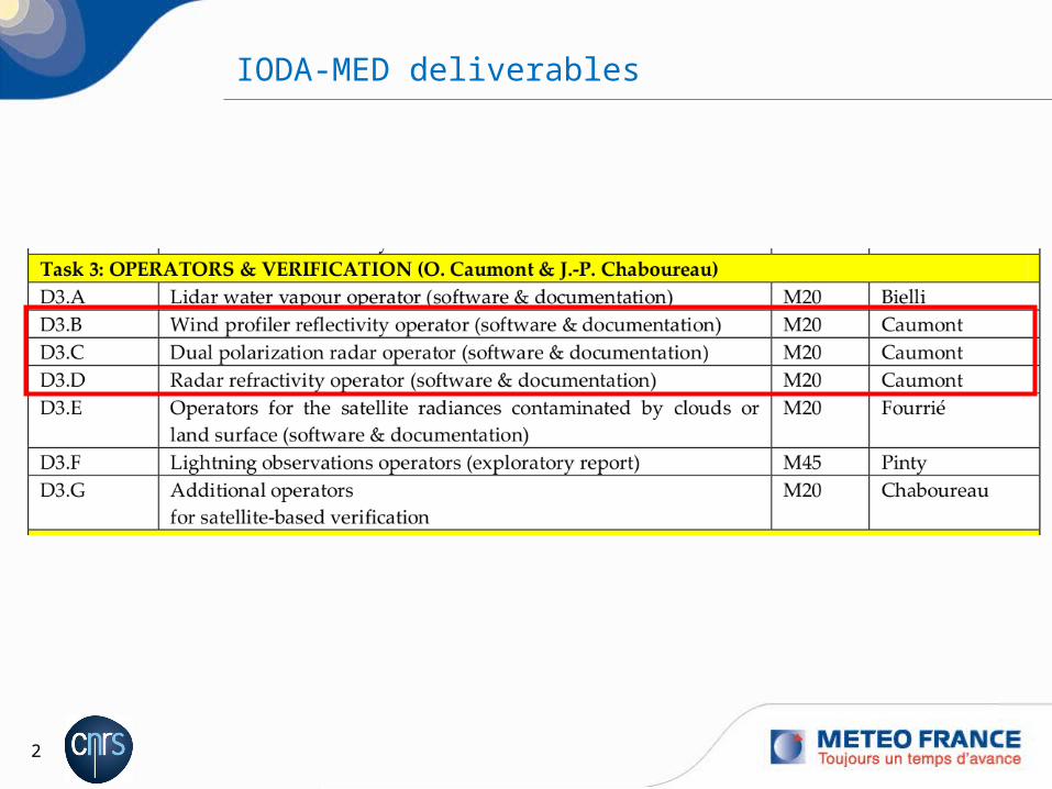
IODA-MED deliverables

3
Outline of talk
1. Reflectivity from wind profilerO. Caumont1, K. Y. Nawanti2, F. Saïd3, B. Campistron3, Y. Bezombes3, S. Derrien3, O. Bousquet1, J.-M. Donier1, T. Douffet1, O. Garrouste1, J. Van Baelen4, J.-L. Caccia5, H. Luce5
1. CNRM-GAME2. ENIT (Tunisia)3. LA/CRA4. LaMP5. LSEET
2. Weather-radar dual-polarization observations3. Weather-radar refractivity

4
Reflectivity from wind profiler
Observations = vertical profiles of: Doppler velocity (V, already assimilated) Reflectivity or Cn² (refractivity turbulence structure constant) Doppler spectrum width ( eddy dissipation rate ε)
Development of an observation operator (Stankov et al. 2003):
© S. DerrienCRA’s UHF wind profiler
23/4
23/22
3
41.2
dz
dV
L
LMC hw
n
dz
dq
Tg
N
T
q
T
pM
7800156001106.77
26
dz
dT
T
gN 2
Lw/L: ratio of the outer length scales for potential refractive index and shear (set to 4 here)
p: pressure (hPa)T: temperature (K)q: specific humidity (kg kg-1)g: acceleration of gravity (9.81 m s-2)Γ: adiabatic lapse rate (9.8 10-3 K m-1)
(Brunt-Väisälä frequency)

5
Reflectivity from wind profiler
Comparison of Cn2 from UHF profiler and radiosonde
5 to 10 % error, with large variability
Vertical profiles of mean relative error between Cn2 (dB) measured by LA’s UHF radar and simulated from radiosonde (solid, thick line), and their standard deviations (dashed lines).
Low mode
High mode
(F. Saïd)

6
a) b)
Reflectivity from wind profiler
Validation of observation operator: Boundary Layer Late Afternoon and Sunset Turbulence (BLLAST,
http://bllast.sedoo.fr/) field campaign in southwestern France (summer 2011)
CRA and CNRM-GAME UHF profilers
overall consistent; some discrepancies (black ellipses) but also some notable matching patterns (blue ellipses).
Times series of log10(Cn2) vertical profiles (a) measured by CNRM-GAME’s UHF radar in high mode and (b) simulated from Arome analyses between 15 and 28 June 2011

7
Reflectivity from wind profiler
Future work:
Study each component of the observation operator separately o Compare Arome, wind profiler, and independent measurements (RS)o For each component, determine which is the best estimate (Arome or wind
profiler)
Investigate the sensitivity of Cn2 to each of these components
If needed, use alternative formulations (other than Stankov’s)

8
Outline of talk
1. Reflectivity from wind profiler2. Weather-radar dual-polarization observations
O. Caumont1, C. Augros2, P. Tabary2, V. Ducrocq1
1. GAME2. DSO/CMR (Météo-France)
3. Weather-radar refractivity

9
Weather-radar dual-polarization data
Observations: Horizontal+vertical polarizations additional
information about hydrometeors (nature, size, shape, etc.)
Already 12 dual-pol radars (out of 26) in the French operational network (purple, blue, and green); more to come!
Widely-used technology on research radars
Complex observations need forsignificant work on observation operator
Work done: On-going development of a
versatile observation operator in Meso-NH’s post-processing

10
Weather-radar dual-polarization data
Status of observation operator in Meso-NH’s post-processing: Gridpoint observations of ZHH, ZDR, KDP (J.-P. Pinty):
o Rayleigh and Jameson scatteringo ZDR and KDP only sensitive to rain

11
Weather-radar dual-polarization data: Gridpoint observation operator
Aaaaa Bbbb
o Cccc Ddddd
Reflectivity (ZHH in dBZ)
Meso-NH simulation of 8 Oct. 2002, 21 UTCHorizontal cross sections at 2 km MSL
Differential reflectivity (ZDR in dB)
Specific differential phase shift (KDP in ° km-1)

12
Weather-radar dual-polarization data
Status of observation operator in Meso-NH’s post-processing: Gridpoint observations of ZHH, ZDR, KDP (J.-P. Pinty):
o Rayleigh and Jameson scatteringo ZDR and KDP only sensitive to rain
PPI (cones) of ZHH, ZDR, KDP, and more (C. Augros et al.):o Various scattering algorithms (Rayleigh(-for-spheroids), Mie, T-matrix)o Propagation ((differential) attenuation) and broadening effectso Move from T-matrix dynamic, burdensome scattering computations to lookup
tables to increase numerical efficiencyo Addition of ρHV

13
Rayleigh MieRayleigh spheroids
Rayleigh 6th order T-matrix
Meso-NH simulation of 8 Oct. 2002, 21 UTC
S-band radar (Nîmes)
Elevation: 2°
T=15°C everywhere
ZHH due to rain (dBZ)
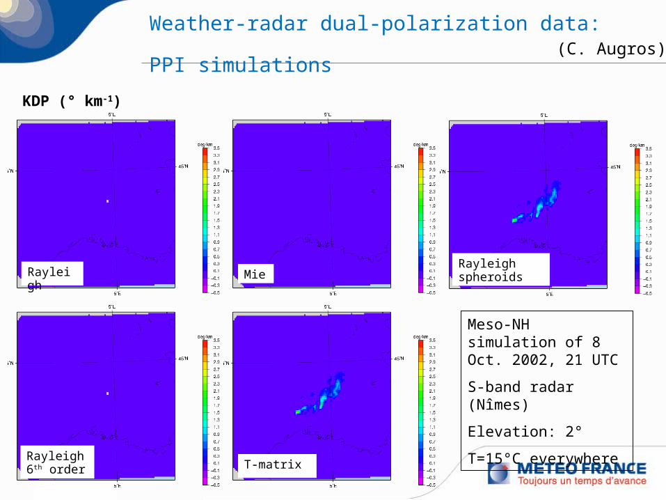
Weather-radar dual-polarization data: PPI simulations (C. Augros)

14
ZDR (dB)
Rayleigh MieRayleigh spheroids
Rayleigh 6th order T-matrix
Weather-radar dual-polarization data: PPI simulations
Meso-NH simulation of 8 Oct. 2002, 21 UTC
S-band radar (Nîmes)
Elevation: 2°
T=15°C everywhere
(C. Augros)
15
KDP
Rayleigh MieRayleigh spheroids
Rayleigh 6th order T-matrix
KDP (° km-1)
Weather-radar dual-polarization data: PPI simulations
Meso-NH simulation of 8 Oct. 2002, 21 UTC
S-band radar (Nîmes)
Elevation: 2°
T=15°C everywhere
(C. Augros)

16
Weather-radar dual-polarization data
Status of observation operator in Meso-NH’s post-processing: Gridpoint observations of ZHH, ZDR, KDP (J.-P. Pinty):
o Rayleigh and Jameson scatteringo ZDR and KDP only sensitive to rain
PPI (cones) of ZHH, ZDR, KDP, and more (C. Augros et al.):o Various scattering algorithms (Rayleigh(-for-spheroids), Mie, T-matrix)o Propagation ((differential) attenuation) and broadening effectso Move from T-matrix dynamic, burdensome scattering computations to lookup
tables to increase numerical efficiencyo Addition of ρHVo Short-term plans:
Implement scattering models for icy hydrometeors Validation for a HyMeX case Add to official Meso-NH version & Write documentation

17
Outline of talk
1. Reflectivity from wind profiler2. Weather-radar dual-polarization observations3. Weather-radar refractivity
O. Caumont1, A. Foray2, L. Besson3, J. Parent du Châtelet3, C. Boudjabi4
1. GAME2. DIRIC (Météo-France)3. DSO/CMI (Météo-France)4. LATMOS

18
Weather-radar refractivity
radarr1 r2
target #1 target #2
radarbeam
Principle: Based on radar pulse’s propagation time through the atmosphere, which depends
on the index of refraction of air (n) or refractivity (N=(n-1)∙106) Phase change between radar and target and over time (δΔφ) depends on path-
averaged refractivity change over time (δN). Initially formulated for klystron transmitters by Fabry et al. (1997) Refractivity related to pressure (p in hPa), temperature (T in K), and water vapour
partial pressure (e in hPa) through N=77.6 p/T+3.73 105 e/T²
Work done: Formulation for magnetron transmitters (Parent du Châtelet et al. 2012) Link between refractivity and atmospheric phenomena (Besson et al. 2012) Observation operator for refractivity + sensitivity study Long-term comparisons of radar observations vs. Arome Real-time production of refractivity maps during HyMeX SOP1

19
Link between N and (T,q) (Besson et al. 2012)
Mediterranean
surface rain rate refractivity
temperature relative humidity
warm
coldmoist
moist
altitude
low level
20 Oct 2008

20
Monitoring: Time evolution for Nîmes radar
N integrated over time ( ΔN) Circle corresponds to 40-km range Filtering of observations
Radar observations(PPI at 0.6°-elevation)
Arome analyses(beam height at 2 m AGL)

21
Sensitivity to beam height
Different models LVLXX: model level (~terrain-following) RAYCT: 4/3-Earth-model path of beam centre RAYGE: 4/3-Earth-model path that hits the ground (most accurate operator) AWS: AWS- vs. model-derived refractivity
Best results when beam within ~60 m AGL No significant improvement when using more accurate models
(Caumont et al. in rev. BLM)
2 m AGL
~60 m AGL
~15 m AGL
~113 m AGL

22
Long-term observation-vs.-model statistics
Good consistency between refractivity observations and model Similar spatial variability
Time series of domain-averaged observation (red) and model (green) refractivity difference since the beginning of the period. Corresponding standard deviations in blue and purple, respectively.
(Caumont et al. in rev. BLM)

23
Real-time refractivity maps during HyMeX SOP1
Fabry’s algorithm adapted to magnetrons http://sop.hymex.org/, Home>Observations>Radars>Single operational
radars>refractivity
Humide
Sec

24
Weather-radar refractivity
Future/on-going work: Improvement of the raw data quality (use of dual-polarization and higher elevations,
use of quality index) Deeper understanding of measurement physics (including role of turbulence) Use in process studies
Further reading: Besson, L., C. Boudjabi, O. Caumont, J. Parent du Châtelet, 2012: Links between
refractivity characteristics and weather phenomena measured by precipitation radar. Bound.-Lay. Meteorol., 143(1), 77–95, DOI : 10.1007/s10546-011-9656-7.
Caumont, O., A. Foray, L. Besson, J. Parent du Châtelet: An observation operator for radar refractivity change: Comparison of observations and convective-scale simulations. Bound.-Lay. Meteorol., in revision.
Parent du Châtelet, J., C. Boudjabi, L. Besson, O. Caumont, 2012: Errors caused by long-term drifts of magnetron frequencies for refractivity measurement with a radar: Theoretical formulation and initial validation. J. Atmos. Oceanic Technol., 29(10), 1428–1434, DOI: 10.1175/JTECH-D-12-00070.1.

Thank you for your attention!