notice of draft environmental assessment
TRANSCRIPT

UNITED STATES OF AMERICAFEDERAL ENERGY REGULATORY COMMISSION
Public Utility District No. 1 of Snohomish County Project No. 13948-002
NOTICE OF DRAFT ENVIRONMENTAL ASSESSMENT
(December 11, 2014)
In accordance with the National Environmental Policy Act of 1969 and the Federal Energy Regulatory Commission’s (Commission) regulations, 18 CFR Part 380, the Office of Energy Projects has reviewed the application for an original license for the proposed 6-megawatt Calligan Creek Hydroelectric Project, which would be located on Calligan Creek in King County, Washington, and has prepared an Environmental Assessment (EA) for the project. The project would not occupy any federal lands.
The EA includes staff's analysis of the potential environmental impacts of construction and operation of the project and concludes that licensing the project, with appropriate environmental measures, would not constitute a major federal action that would significantly affect the quality of the human environment. Based on a review of the comments received in response to the issuance of this EA, the Commission may issue a final EA.
A copy of the EA is available for review at the Commission in the Public Reference Room or may be viewed on the Commission’s website at http://www.ferc.govusing the “eLibrary” link. Enter the docket number excluding the last three digits in the docket number field to access documents. For assistance, contact FERC Online Support at [email protected], (866) 208-3676 (toll free), or (202) 502-8659 (TTY).
You may also register online at http://www.ferc.gov/docs-filing/esubscription.aspto be notified via email of new filings and issuances related to this or other pending projects. For assistance, contact FERC Online Support.
Any comments should be filed within 30 days from the date of this notice.
The Commission strongly encourages electronic filing. Please file commentsusing the Commission’s eFiling system at http://www.ferc.gov/docs-filing/efiling.asp.Commenters can submit brief comments up to 6,000 characters, without prior registration, using the eComment system at http://www.ferc.gov/docs-filing/ecomment.asp.
20141211-3043 FERC PDF (Unofficial) 12/11/2014

Project No. 13948-002 - 2 -
You must include your name and contact information at the end of your comments. For assistance, please contact FERC Online Support. In lieu of electronic filing, please send a paper copy to: Secretary, Federal Energy Regulatory Commission, 888 First Street, NE, Washington, D.C. 20426. The first page of any filing shouldinclude docket number P-13948-002.
For further information, contact Kelly Wolcott at (202) 502-6480.
Kimberly D. Bose, Secretary.
20141211-3043 FERC PDF (Unofficial) 12/11/2014

i
ENVIRONMENTAL ASSESSMENTFOR
ORIGINAL HYDROPOWER LICENSE
Calligan Creek Hydroelectric Project
FERC Project No. 13948-002
Washington
Federal Energy Regulatory CommissionOffice of Energy Projects
Division of Hydropower Licensing888 First Street, NE
Washington, D.C. 20426
December 2014
20141211-3043 FERC PDF (Unofficial) 12/11/2014

ii
TABLE OF CONTENTS
TABLE OF CONTENTS ........................................................................................... ……iiLIST OF FIGURES .................................................................................................... …...ivLIST OF TABLES...................................................................................................... …...ivACRONYMS AND ABBREVIATIONS................................................................... …...vi1.0 INTRODUCTION .......................................................................................... …...20
1.1 APPLICATION ................................................................................................... 201.2 PURPOSE OF ACTION AND NEED FOR POWER......................................... 21
1.2.1 Purpose of Action.......................................................................................... 211.2.2 Need for Power.............................................................................................. 22
1.3 STATUTORY AND REGULATORY REQUIREMENTS ................................ 231.3.1 Federal Power Act ......................................................................................... 231.3.2 Clean Water Act ............................................................................................ 231.3.3 Endangered Species Act................................................................................ 241.3.4 Coastal Zone Management Act ..................................................................... 251.3.5 National Historic Preservation Act ............................................................... 26
1.4 PUBLIC REVIEW AND COMMENT................................................................ 261.4.1 Scoping.......................................................................................................... 271.4.2 Interventions.................................................................................................. 271.4.3 Comments on the License Application ......................................................... 27
2.0 PROPOSED ACTION AND ALTERNATIVES........................................... …...282.1 NO-ACTION ALTERNATIVE........................................................................... 282.2 APPLICANT’S PROPOSAL............................................................................... 28
2.2.1 Proposed Project Facilities ............................................................................ 282.2.2 Project Safety ................................................................................................ 292.2.3 Proposed Project Operation........................................................................... 292.2.4 Proposed Environmental Measures............................................................... 30
2.3 STAFF ALTERNATIVE..................................................................................... 332.4 ALTERNATIVES CONSIDERED BUT ELIMINATED FROM DETAILED STUDY.......................................................................................................................... 36
3.0 ENVIRONMENTAL ANALYSIS................................................................. …...363.1 GENERAL DESCRIPTION OF THE RIVER BASIN....................................... 363.2 SCOPE OF CUMULATIVE EFFECTS ANALYSIS ......................................... 38
3.2.1 Geographic Scope ......................................................................................... 393.2.2 Temporal Scope............................................................................................. 40
3.3 PROPOSED ACTION AND ACTION ALTERNATIVES ................................ 403.3.1 Geology and Soils ......................................................................................... 403.3.2 Aquatic Resources......................................................................................... 473.3.3 Terrestrial Resources..................................................................................... 883.3.4 Threatened and Endangered Species........................................................... 1053.3.5 Recreation and Land Use ............................................................................ 1123.3.6 Cultural Resources ...................................................................................... 115
20141211-3043 FERC PDF (Unofficial) 12/11/2014

iii
3.3.7 Aesthetic Resources ................................................................................. 1183.4 NO-ACTION ALTERNATIVE......................................................................... 120
4.0 DEVELOPMENTAL ANALYSIS ................................................................ ….1204.1 POWER AND DEVELOPMENTAL BENEFITS OF THE PROJECT ........... 1214.2 COMPARISON OF ALTERNATIVES............................................................... 122
4.2.1 No-action Alternative .................................................................................. 1234.2.2 Snohomish PUD’s Proposal ........................................................................ 1234.2.3 Staff Alternative .......................................................................................... 123
4.3 COST OF ENVIRONMENTAL MEASURES ................................................. 1245.0 CONCLUSION AND RECOMMENDATIONS........................................... ….129
5.1 Comprehensive Development and Recommended Alternative...................... 1295.2 Unavoidable Adverse Effects ......................................................................... 1385.3 Fish and Wildlife Agency Recommendations ................................................ 1405.4 Consistency with Comprehensive Plans......................................................... 140
6.0 FINDING OF NO SIGNIFICANT IMPACT ................................................ ….1427.0 LITERATURE CITED................................................................................... ….1438.0 LIST OF PREPARERS .................................................................................. ….148
20141211-3043 FERC PDF (Unofficial) 12/11/2014

iv
LIST OF FIGURES
Figure 1. Location of the Calligan Creek Hydroelectric Project (Source: Snohomish PUD, 2013). ....................................................................................................................... 21Figure 2. Project configuration for the Calligan Creek Hydroelectric Project (Source: staff). .................................................................................................................................. 29Figure 3. Locations of existing and proposed hydroelectric project powerhouses in the vicinity of the Calligan Creek Project (Source: staff). ..................................................... 38Figure 4. Local geology, soils, and landslide locations in the vicinity of the proposed Calligan Creek Project (Source: Snohomish PUD, 2013, as modified by staff).............. 43Figure 5. Calligan Creek mean daily flow for the period of 1928 to 2009 (Source: Snohomish PUD, 2013)..................................................................................................... 48Figure 6. Calligan Creek flow duration curve for the period 1928-2009 (Source: Snohomish PUD, 2013)..................................................................................................... 49Figure 7. Mean daily water temperature in Calligan Creek during September 2010 (Source: Snohomish PUD, 2013). .................................................................................... 53Figure 8. Mean daily water temperature in Calligan Creek during September 2011 (Source: Snohomish PUD, 2013). .................................................................................... 54Figure 9. Mean daily water temperature in Calligan Creek during August and September 2012 (Source: Snohomish PUD, 2013). ........................................................................... 55Figure 10. Percent of maximum weighted useable area versus discharge for juvenile and adult winter habitat and summer spawning and rearing habitat for rainbow trout (Source: Snohomish PUD, 2013)..................................................................................................... 69Figure 11. Wetlands and streams in the Calligan Creek study area (Source: Snohomish PUD, 2013). ....................................................................................................................... 92
LIST OF TABLES
Table 1. The listing status and determination of effect for listed species known to occur in the project area (Source: staff). .................................................................................... 24Table 2. Calligan Creek flow exceedance table in cubic feet per second (Source: Snohomish PUD, 2013 as modified by staff). ................................................................... 49Table 3. Calligan Creek water rights from Washington Department of Ecology (Source: Washington DOE, 2014). .................................................................................................. 50Table 4. Numeric water quality criteria applicable to project waters (Source: Washington DOE, 2011; Snohomish PUD, 2013 as modified by staff). .......................... 51Table 5. Calligan Creek water quality data collected in 1989 and 1990 near the proposed diversion site (Source: Snohomish PUD, 2013)............................................................... 52Table 6. A summary of instream habitat characteristics in the proposed Calligan Creek bypassed reach (Source: CES, 1991, as modified by staff).............................................. 57Table 7. Results of trout monitoring surveys in Calligan Creek (Source: Snohomish PUD, 2013). ....................................................................................................................... 60
20141211-3043 FERC PDF (Unofficial) 12/11/2014

v
Table 8. Percent reduction in flows in the upper segment of the bypassed reach in an average water year (Source: Snohomish PUD, 2013 as modified by staff). .................... 66Table 9. Proposed ramping rates for the Calligan Creek Hydroelectric Project (Source: (Snohomish PUD, 2013).................................................................................................... 73Table 10. Pre-construction acreages for each cover type in the project boundary (Source: Snohomish PUD 2014a and staff). .................................................................................... 88Table 11. Habitats that would be permanently and temporarily affected by project construction, and the project feature that would cause the effect (Source: Snohomish PUD, 2014c, and staff). ..................................................................................................... 95Table 12. Parameters for the economic analysis of the Calligan Creek Hydroelectric Project (Source: Snohomish PUD, 2014a, as modified by staff). .................................. 122Table 13. Summary of annual cost of alternative power and annual project cost for the action alternatives for the Calligan Creek Hydroelectric Project (Source: staff)........... 123Table 14. Cost of environmental mitigation and enhancement measures considered in assessing the environmental effects of constructing and operating the proposed Calligan Creek Hydroelectric Project (Source: staff). .................................................................. 125
20141211-3043 FERC PDF (Unofficial) 12/11/2014

vi
ACRONYMS AND ABBREVIATIONS
°C degrees Celsius°F degrees FahrenheitAIR Additional Information RequestAPE area of potential effectsBE Biological EvaluationBMP best management practiceCalligan Creek Project or project Calligan Creek Hydroelectric ProjectCES Cascades Environmental ServicesCESCL Certified Erosion and Sediment Control LeadCFR Code of Federal Regulationscfs cubic feet per secondCommission Federal Energy Regulatory CommissionCWA Clean Water ActCZMA Coastal Zone Management ActDbh diameter at breast heightDO dissolved oxygenEA Environmental AssessmentESA Endangered Species ActFPA Federal Power ActFR Federal RegisterFWS United States Fish and Wildlife ServiceGIS Geographic Information SystemsGPS Global Positioning SystemHPMP Historic Properties Management PlanHTRG Hancock Timber Resource GroupIFAMP Instream Flow Adaptive Management PlanIPaC Information, Planning, and Conservation
SystemInterior United States Department of the Interiormg/L milligrams per litermsl mean sea levelMBSNF Mt. Baker-Snoqualmie National ForestMBTA Migratory Bird Treaty ActMOCA mapped owl conservation areasMW megawattMWh megawatt-hoursNational Register National Register of Historic PlacesNHPA National Historic Preservation ActNMFS National Marine Fisheries ServiceNorth Fork North Fork Snoqualmie RiverNTU Nephelometric Turbidity Units
20141211-3043 FERC PDF (Unofficial) 12/11/2014

vii
PHABSIM Physical Habitat SimulationPHS Priority Habitats and SpeciesRM River MileROW right-of-waySD1 Scoping Document 1Snohomish PUD Snohomish County Public Utility District No. 1State Weed Board Washington State Noxious Weed Control BoardSWPPP and ESCP Storm Water Pollution Prevention Plan and
Erosion Sediment Control PlanTMDL Total Maximum Daily LoadTRMP Terrestrial Resource Management PlanUSGS U.S. Geological Surveycertification water quality certificationWashington DFW Washington Department of Fish and WildlifeWashington DOE Washington Department of Ecology Washington SHPO Washington State Historic Preservation Officer
20141211-3043 FERC PDF (Unofficial) 12/11/2014

viii
EXECUTIVE SUMMARY
Proposed Action
On August 1, 2013, the Public Utility District No. 1 of Snohomish County, Washington (Snohomish PUD) filed an application for a license to construct and operate its proposed Calligan Creek Hydroelectric Project (Calligan Creek Project or project). The 6-megawatt (MW) project would be located on Calligan Creek, near the city of North Bend in King County, Washington. The project would not occupy federal land.
Project Description and Proposed Facilities
The project would consist of the following new facilities: (1) anapproximately 102-foot-long diversion structure traversing Calligan Creek consisting of:(a) a 10-foot-long cutoff wall embedded into the left channel bank, (b) a 45-foot-long, 8-foot-high triangular rockfill spillway, and (c) a 47-foot-long, 14-foot-high right wingwall; (2) a 1.04-acre-foot impoundment; (3) a 24-foot-wide, 18-foot-high, 47-foot-long intake equipped with a sluice gate, a self-cleaning trashrack, a 220-square-foot angled fish screen with 0.125-inch-wide openings, and an adjustable minimum instream flow weir; (4) an approximately 55-foot-long, concrete pool-and-weir fishway; (5) a 1.2-mile-long, 41- to 45-inch-diameter buried penstock; (6) a powerhouse containing a single 6-MWtwo-jet horizontal-shaft Pelton turbine/generator; (7) a 13-foot-wide, 135-foot-long rip-rap-lined tailrace channel with a 2-foot vertical drop and concrete apron; (8) two access roads totaling approximately 700 feet in length; (9) a 2.5-mile-long, 34.5-kilovolt buried transmission line connecting to the existing Black Creek Hydroelectric Project (FERC Project No. 6221) switching vault; and (10) appurtenant facilities. The project wouldbypass about 1.4 miles of Calligan Creek. The project would generate an average of 20,700 MWh annually.
The project would have a maximum hydraulic capacity of 88 cubic feet per second (cfs), and a minimum capacity of 5 cfs. Flows in excess of 88 cfs would pass over the spillway, and flows below 5 cfs would enter the bypassed reach through the minimum flow weir or the proposed fishway. The Calligan Creek Project would operate in run-of-river mode when inflows equal or exceed the minimum hydraulic capacity plus anyminimum instream flow release. The project is not expected to operate for about two and a half to three months during the summer when natural flows in the creek are below the minimum plant capacity plus the proposed minimum instream flows noted below.
The proposed project is described in more detail in section 2.2.1, Proposed Project Facilities.
20141211-3043 FERC PDF (Unofficial) 12/11/2014

ix
Proposed Environmental Measures
Project Design and Operation Features
Operate the project in run-of-river mode;
Release a minimum flow of 2 cfs at the diversion structure into the bypassed reach of Calligan Creek at all times when the project is operating;
Maintain a minimum flow as measured at the lower bypassed reach spring site of 15 cfs from May 15 through September 14, and 6 cfs from September 15 through May 14 when the project is operating;
Implement ramping rates of 1-2 inches per hour to protect fish and other aquatic resources from stranding downstream of the powerhouse during powerhouse start-up and shutdown;
Design and install mechanical deflectors on the Pelton turbine and provide flow continuation to avoid fish stranding during a powerhouse shutdown;
Install and operate a sluice gate in the diversion structure to pass accumulated sediment downstream once per year during the high–flow months of December or January;
Design, install, and operate a self-cleaning fish screen system using current National Marine Fisheries Service design criteria for salmonids, and develop operation and maintenance procedures to prevent fish entrainment;
Construct a pool-and-weir fishway to provide upstream fish passage at the diversion structure;
Design and install a tailrace barrier to prevent fish from entering the powerhouse tailrace channel;
Install and maintain a penstock failure detection and rapid shutdown system;
Use exterior colors for the powerhouse and fencing materials that minimize contrast with the surrounding environment;
Bury the penstock and the transmission line, and use native vegetation and natural topography to reduce the visibility of the project; and
20141211-3043 FERC PDF (Unofficial) 12/11/2014

x
Design the powerhouse to avoid noise effects beyond 50 feet of the building.
During construction
Implement the Storm Water Pollution Prevention Plan and Erosion and Sediment Control Plan (SWPPP and ESCP)1 filed on February 25, 2014, that includes implementing site-specific best management practices for controlling erosion and protecting water quality, maintaining a Certified Erosion and Sediment Control Lead onsite during construction to monitor erosion control measures, and conducting all in-water work within the Washington Department of Fish and Wildlife (Washington DFW) designated in-water work window of July 1 to September 30;
Develop a blasting plan and safety plan and file it for Commission approvalprior to construction;
Minimize road closures during construction; and
Implement an Unanticipated Discovery Plan in the event that cultural materials are discovered during construction, operation, or maintenance of the project.
During project operation
Install and maintain operational monitoring equipment2 at the diversion structure, in the lower bypassed reach, and downstream of the powerhousetailrace;
Implement the Water Quality Monitoring Plan filed with the licenseapplication that includes monitoring water quality for five years following initial project operation, and collecting and analyzing operational monitoring data for long-term compliance monitoring of minimum flows, ramping rates, and flow continuation measures;
1 Snohomish PUD filed the SWPPP and ESCP as one document with one cost
associated with both plans. We therefore consider the two plans as one environmental measure.
2 Operational monitoring equipment would include either a calibrated minimum flow weir or stream gage for calculating discharge for minimum flow compliance monitoring at the diversion, a stream gage for calculating discharge for minimum flow compliance monitoring in the lower bypassed reach, and a stream gage for determining water surface elevations for ramping rate and flow continuation monitoring downstream of the powerhouse tailrace.
20141211-3043 FERC PDF (Unofficial) 12/11/2014

xi
Implement the Plan to Monitor Spawning Habitat Near the Project Impoundment filed with the license application that includes monitoring fish spawning redds for five years following initial project operation;
Implement the Trout Monitoring Plan filed with the license application thatincludes conducting snorkel surveys during August and September for five years to document trout abundance, size, and age-class structure, and evaluating potential trout population trends tied to project operation;
Implement the Instream Flow Adaptive Management Plan filed on April 25, 2014, that includes potentially increasing minimum flows at the diversion structure by an additional 1 to 3 cfs based upon the results of trout population monitoring in the bypassed reach;
Implement the Terrestrial Resource Management Plan (TRMP) filed on February 25, 2014, that includes: revegetating areas disturbed by project construction, creating preservation areas for the long term protection of wetland and buffer habitat in the project area, managing the spread of noxious weeds, and providing rocky or woody debris piles and clumps of shrubs to protect small mammals crossing or foraging in the penstock right-of-way(ROW);
Provide public access to project land, except at the intake and powerhouse sites;
Provide Native American tribes access to project land, except at the intake and powerhouse sites, for traditional tribal uses; and
Operate exterior lighting at the powerhouse only when required to minimizeeffects of light and glare on nearby recreational use.
Alternatives Considered
This Environmental Assessment (EA) considers the following alternatives: (1) Snohomish PUD’s proposal, as outlined above; (2) Snohomish PUD’s proposal with staff modifications (staff alternative); and (3) no action, meaning the project would not be built.
20141211-3043 FERC PDF (Unofficial) 12/11/2014

xii
Staff Alternative
Under the staff alternative, the project would include Snohomish PUD’s proposed environmental measures, as outlined above, with the exception of: (1) the self-cleaning fish screen system on the penstock intake, (2) the pool-and-weir fishway, (3) the Plan to Monitor Spawning Habitat Near the Project Impoundment, (4) the Trout Monitoring Plan, and (5) the Instream Flow Adaptive Management Plan. We do not recommend these measures because their environmental benefits would not be worth their costs or they do address a project effect.
The staff alternative also includes the following modifications to Snohomish PUD’s proposal and additional measures:
Modify the Water Quality Monitoring Plan to include the following :
o documentation of run-of-river operation in annual reports (in addition to the results of water quality, minimum flow, ramping rate, and flow continuation monitoring as proposed);
o annual reports during the initial 5-year monitoring period to be filedwith the Commission in addition to providing to the agencies as proposed;
o annual reports after the initial 5-year period documenting run-of-river operation and the results of the operational monitoring measures unless Snohomish PUD files a request with the Commission to cease annual reporting and the Commission approves the request (instead of retaining operational monitoring records and providing them to the agencies at their request as proposed); and
o take immediate reasonable action to remediate any deviations from run-of-river operation, minimum flow, ramping rate, or flow continuation requirements and prepare and file an incident report with the Commission within 10 days;
Modify the TRMP to include to the following:
o use only native species and weed-free seed mixes for revegetation(instead of using either native or non-native species seed mixes, certified weed-free, as proposed);
20141211-3043 FERC PDF (Unofficial) 12/11/2014

xiii
o modify the criteria for defining revegetative failure that would trigger plant replacement to only include plants that do not survive to the end of the first, full growing-season following installation (instead of criteria that also would trigger replacement of plants that are failing, weak, or defective in manner of growth);
o modify the duration of revegetation monitoring and reporting to only include five years after the completion of all initial revegetation measures (instead of monitoring for the term of any license as proposed);
o incorporate the proposed wetland and buffer preservation areas into the project boundary; and
o file all proposed monitoring reports with the Commission (in addition to providing to the agencies as proposed);
Maintain vegetative screening at both the intake and powerhouse over the term of any license to minimize visual effects on recreational use of nearby areas, and provide photographic evidence of vegetative screening following project construction.
No Action Alternative
Under the no-action alternative, the project would not be built, environmental resources in the project area would not be affected, and the renewable energy that would be produced by the project would not be developed.
Public Involvement and Areas of Concern
Before filing its license application, Snohomish PUD conducted pre-filing consultation under the traditional licensing process. The intent of the Commission’s pre-filing process is to initiate public involvement early in the project planning process and encourage citizens, governmental entities, tribes, and other interested parties to identify and resolve issues prior to an application being formally filed with the Commission. After the application was filed, we conducted scoping to determine what issues and alternatives should be addressed. We distributed an initial scoping document to interested parties on January 24, 2014. Scoping meetings were held in North Bend, Washington, on February 26 and 27, 2014. On April 10, 2014, we requested conditions and recommendations in response to a notice that the application was ready for environmental analysis.
20141211-3043 FERC PDF (Unofficial) 12/11/2014

xiv
The primary issues associated with licensing the Calligan Creek Project are erosion control, water quality protection, revegetation, minimum flows in the project’s bypassed reach, fish passage at the diversion structure, and protection of wetlands and buffer habitat during project operation.
Staff Alternative
Geologic Resources
Project construction would require vegetation clearing and land disturbing activities during excavation and installation of the temporary cofferdams, diversion structure, penstock, powerhouse, tailrace, transmission line, and access roads. The site-specific best management practices in Snohomish PUD’s proposed SWPPP and ESCPwould minimize the potential for erosion and sedimentation of project lands and waters during construction activities.
Snohomish PUD’s proposed penstock failure detection and rapid shutdown system would immediately curtail penstock flows in the event of a penstock failure, which would protect upland and riparian areas as well as Calligan Creek from potentially large erosion and sedimentation events due to an uncontrolled flow release along the penstock alignment.
Aquatic Resources
Project construction would temporarily increase sedimentation and turbidity in Calligan Creek during the placement of cofferdams and installation of the diversion structure and intake. Snohomish PUD’s SWPPP and ESCP include provisions for a Certified Erosion and Sediment Control Lead to be onsite to observe construction activities, to monitor turbidity and pH, and to implement additional measures if thresholds identified in the plans are exceeded. The plans also propose that all in-water work would be completed during the Washington DFW designated in-water work window of July 1 to September 30 to minimize effects on fishery resources. These measures and provisions would minimize construction effects on aquatic resources.
Project operation would affect aquatic resources in Calligan Creek through decreased streamflows in the 1.4-mile-long bypassed reach. Snohomish PUD’s proposal to operate the project in a run-of-river mode would return all diverted flows to Calligan Creek and would not affect water levels or streamflows above the diversion. Below the tailrace outlet, water levels and streamflows would be unaffected during normal operation, and fluctuations during operational emergencies would be minimized by Snohomish PUD’s proposed ramping rates and flow continuation measures. Snohomish PUD’s proposed minimum flows at the diversion structure and downstream spring site,and its proposal to operate a sluicegate to ensure downstream transport of sediment and
20141211-3043 FERC PDF (Unofficial) 12/11/2014

xv
woody debris, would maintain aquatic habitat for resident trout in the bypassed reach. The proposed ramping rates and flow continuation measures would also protect fish andaquatic habitat from dewatering effects during powerhouse shutdown. Snohomish PUD’s proposal to install a tailrace barrier would further minimize dewatering effects by preventing fish from entering the tailrace channel.
Snohomish PUD’s proposals to install operational monitoring equipment andimplement its Water Quality Monitoring Plan would enable Snohomish PUD to monitor and maintain compliance with minimum flows, ramping rates, and flow continuation measures. The Water Quality Monitoring Plan would also allow Snohomish PUD to evaluate whether project operation is affecting water quality standards for temperature and turbidity during the first five years of project operation. Staff’s recommendation that Snohomish PUD modify its Water Quality Monitoring Plan, to include additional requirements to document run-of-river operation, file annual monitoring reports with the Commission, and quickly report deviations from run-of-river operation, minimum flow, ramping rate, and flow continuation requirements would enable the Commission toensure compliance with the proposed operational measures for the protection of aquatic resources.
Annual sediment sluicing activities during project operation could cause turbidity increases in Calligan Creek. Snohomish PUD’s proposal to restrict sediment flushing to once per year during the high-flow months of December or January when turbidity levels are naturally high, would allow stored sediments to quickly pass downstream and would minimize any potential adverse effects on fish and aquatic habitat.
Project operation could entrain some resident trout into the project’s penstock and
Pelton turbine. Turbine entrainment would likely result in little or no survival of any trout or other resident fish species. However, some fish may find safe downstream passage through the project’s minimum flow weir or, during high-flow periods, over the spillway when it is operating. The existing channel morphology and steep gradient of the proposed bypassed reach provides relatively poor habitat conditions with limited spawning and rearing habitat for the predominately hatchery origin trout that occur in the project area. Additionally, there is high quality spawning and rearing habitat and large numbers of spawning trout in Calligan Lake and Calligan Creek upstream of the project. Because resident trout tend to not exhibit any long range movements once they are established, and there is sufficient spawning and rearing habitat upstream of the project, there would not be substantial adverse effects on the resident trout population from operating an unscreened diversion on the project’s intake.
Any fish occurring in the 1,300-foot segment of the upper bypassed reach between the existing, natural upstream fish-passage barrier and the diversion structure would be blocked by the diversion structure from migrating upstream. When sufficient flow is available in the bypassed reach, these fish would still be able to migrate downstream to
20141211-3043 FERC PDF (Unofficial) 12/11/2014

xvi
access spawning and rearing habitat in lower Calligan Creek or the North ForkSnoqualmie River. Therefore, there would be no substantial adverse effects on the resident trout population from blocking upstream fish passage at the diversion structure.
Terrestrial Resources
Project construction activities would temporarily disturb 21.46 acres of upland and wetland habitat and permanently remove 0.85 acres of upland, wetland, and stream habitat. Implementing the measures in Snohomish PUD’s TRMP would quickly revegetate areas disturbed during construction, and protect and enhance wildlife habitat over the long term by controlling noxious weeds and creating upland and wetland preservation areas. An additional provision to use only native plant species for revegetation would increase the amount of native vegetation in the project area and enhance forage for wildlife. The additional staff-recommended modifications to the TRMP would improve the Commission’s ability to track and enforce compliance with the measures to protect and enhance terrestrial resources at the project.
Snohomish PUD’s proposed design, with a penstock that is buried along its entire length, would prevent the penstock from being a barrier to wildlife movement. Creating rocky or woody debris piles and clumps of shrubs, as part of the TRMP, would enhance wildlife habitat in the penstock ROW.
Snohomish PUD’s proposed design of the project, with a transmission line that is buried along the shoulder of an existing logging road, would limit terrestrial habitat disturbance and protect avian resources from injury or mortality due to collisions with the project’s transmission line.
Threatened and Endangered Species
Nine federally listed species (bull trout, Canada lynx, golden paintbrush, gray wolf, grizzly bear, northern spotted owl, marbled murrelet, Oregon spotted frog, and yellow-billed cuckoo) and one candidate species (whitebark pine) are listed by the United States Fish and Wildlife Service as potentially occurring within King County. In addition, critical habitat has been designated in King County for bull trout, northern spotted owl, and marbled murrelet.
Canada lynx, golden paintbrush, grizzly bear, Oregon spotted frog, yellow-billed cuckoo, and whitebark pine are not known to occur within the project vicinity and suitable habitat does not occur in the project area; therefore, the project would not affect these species. The Snoqualmie Falls, located about 12 river miles downstream of the project area, serves as a natural barrier to bull trout, and so this species does not occur in the project area. Additionally, critical habitat for bull trout, northern spotted owl, and
20141211-3043 FERC PDF (Unofficial) 12/11/2014

xvii
marbled murrelet does not occur in the project vicinity; thus, the project would not affect any designated critical habitat.
Gray wolves have not been documented in the project area and ongoing commercial logging activity on forest lands surrounding the project would likely discourage wolves from permanently residing in the immediate project vicinity. If wolf populations expand over the long term, transient use of the project area could occur. Once the project is operating, it would be remotely operated with only occasional maintenance activities at the site. These activities, such as mowing the penstock ROW,would be infrequent and short term in nature and would not likely have a significant effect on transient wolves.
The forested lands surrounding the proposed project site are harvested at a regular interval, and do not contain the mature, old growth forests that northern spotted owls or marbled murrelets require. The closest suitable habitat for spotted owls is located about 1.2 miles from the project area, while the nearest marbled murrelet occurrence is located about 3 miles away. Any blasting that may be required during construction would generate noise that could extend beyond the immediate construction area. If blasting isneeded, the maximum distance that sound from explosives could travel is one mile. Because the closest suitable habitat or occurrence for either species is between 1.2 and 3 miles from the project area, there would be a minimum of a 0.2-mile noise buffer between the maximum extent of blasting noise effects and suitable habitat. No other construction or operation activities would result in effects extending this far from the project area. Therefore, there would be no effect on either species from project construction or operation.
Recreation and Land Use
If the project is constructed and operated, existing land uses would continue as before and the Snoqualmie Forest Conservation Easement would be unaffected. Public access to the Snoqualmie Forest and project lands would continue, subject to the existing private permit system, except for the immediate areas around the intake structure and powerhouse, which would be restricted from public access due to safety and security concerns. Measures proposed to address effects on aesthetic resources would also mitigate potential visual and noise effects on recreation users. Construction and operation of the proposed project (e.g., construction noise, temporary and minimal road closures) would have only minor, short-term effects on recreation and land use.
Cultural Resources
No cultural resources eligible for or included in the National Register of Historic Places are known to exist in the project area. Therefore, the project would have no effect on any known cultural resources. Snohomish PUD’s proposal to implement its
20141211-3043 FERC PDF (Unofficial) 12/11/2014

xviii
Unanticipated Discovery Plan would protect any cultural resources discovered during project construction, operation, or maintenance. Snohomish PUD’s proposal to allow tribal access to accustomed fishing areas and other traditional use areas, except at the intake and powerhouse sites, would avoid or minimize effects on tribal access.
Aesthetic Resources
The use of native vegetation and natural topography to reduce the visibility of the project, use of exterior colors for the powerhouse and fencing materials that minimize contrast with the surrounding environment, and operation of exterior lighting at the powerhouse only when required, together with proposed design of the project with a buried penstock and transmission line, would reduce the visibility of the project.Reseeding and revegetation under the SWPPP and ESCP, and TRMP would have the added benefit of reducing the visual effects of construction. Staff’s recommendation to maintain vegetative screening at the intake and powerhouse over the term of any license would further minimize visual effects on recreational use of nearby areas. Providing photographic evidence after project construction that demonstrates the use of exterior colors to minimize contrast, and the use of vegetative screening and natural topography to reduce the visibility of the project, would ensure implementation of measures to minimize visual effects. Snohomish PUD’s proposal to design the powerhouse to avoid noise beyond 50 feet of the building would minimize effects on anglers, hunters, or others who may choose to recreate nearby.
Conclusions
Based on our analysis, we recommend licensing the project as proposed by Snohomish PUD with some staff modifications and additional measures.
In section 4.2 of the EA, we compare the total project cost of obtaining power from a likely alternative source of power in the region, for each of the alternatives identified above. Our analysis shows that during the first year of operation, under the applicant’s proposal, the project power would cost $2,166,050, or $104.64/MWh, more than the alternative cost of power. Under the staff-recommended alternative, project power would cost $2,096,210, or $101.27/MWh, more than the alternative cost of power.
We chose the staff alternative as the preferred alternative because: (1) the project would provide a dependable source of electrical energy for the region (20,700 MWhannually); (2) the 6 MW of electric capacity comes from a renewable resource that does not contribute to atmospheric pollution; and (3) the recommended environmental measures proposed by Snohomish PUD, as modified by staff, would adequately protect and enhance environmental resources affected by the project. The overall benefits of the staff alternative would be worth the cost of the proposed and recommended environmental measures.
20141211-3043 FERC PDF (Unofficial) 12/11/2014

xix
On the basis of our independent analysis, we conclude that issuing a license for the project, with the environmental measures that we recommend, would not be a major federal action significantly affecting the quality of the human environment.
20141211-3043 FERC PDF (Unofficial) 12/11/2014

20
ENVIRONMENTAL ASSESSMENT
Federal Energy Regulatory CommissionOffice of Energy Projects
Division of Hydropower LicensingWashington, D.C. 20426
Calligan Creek Hydroelectric ProjectFERC No. 13948-002 – Washington
1.0 INTRODUCTION
1.1 APPLICATION
On August 1, 2013, the Public Utility District No. 1 of Snohomish County, Washington (Snohomish PUD) filed an application for an original major license to construct and operate its proposed 6-megawatt (MW) Calligan Creek Hydroelectric Project (Calligan Creek Project or project).3
The project would be located on Calligan Creek, approximately 9 miles northeast of the city of North Bend in King County, Washington (figure 1). The proposed projectincludes the construction of a diversion structure, fishway, powerhouse, buried penstock and transmission line, tailrace channel, and access roads. The project would not occupy federal land. The project would not operate for approximately two and a half to three months during the summer because of a lack of available flows. The average annual generation of the project would be 20,700 megawatt-hours (MWh) of energy annually.
3 On February 25, 2014, Snohomish PUD filed supplemental information,
including final terrestrial resources technical reports and its proposed Terrestrial Resource Management Plan, and its proposed Stormwater Pollution Prevention Plan and Erosion and Sediment Control Plan. On April 25, 2014, Snohomish PUD filed supplemental information, including proof and receipt of Snohomish PUD’s request for 401 Water Quality Certification and its proposed Instream Flow Adaptive Management Plan. On August 15, 2014, Snohomish PUD filed more supplemental information, including updated Exhibits A, E, and F to reflect changes in its proposed fish passage design, and an addendum to its amphibian and reptile surveys and priority species evaluation report.
20141211-3043 FERC PDF (Unofficial) 12/11/2014

21
Figure 1. Location of the Calligan Creek Hydroelectric Project (Source: Snohomish PUD, 2013).
1.2 PURPOSE OF ACTION AND NEED FOR POWER
1.2.1 Purpose of Action
The purpose of the proposed Calligan Creek Project is to provide a new source of hydroelectric power. Therefore, under the provision of the Federal Power Act (FPA), the Commission must decide whether to issue a license to Snohomish PUD for the Calligan Creek Project and what conditions should be placed on any license issued. In deciding whether to issue a license for a hydroelectric project, the Commission must determine that the project will be best adapted to a comprehensive plan for improving or developing a waterway. In addition to the power and developmental purposes for which licenses are issued (such as flood control, irrigation, or water supply), the Commission must give equal consideration to the purposes of: (1) energy conservation; (2) the protection of, mitigation of damage to, and enhancement of fish and wildlife resources; (3) the protection of recreational opportunities; and (4) the preservation of other aspects of environmental quality.
20141211-3043 FERC PDF (Unofficial) 12/11/2014

22
Issuing an original license for the Calligan Creek Project would allow Snohomish PUD to generate electricity at the project for the term of the license, making electrical power from a renewable resource available to its customers.
This environmental assessment (EA) assesses the effects associated with construction and operation of the project and alternatives to the proposed project, and makes recommendations to the Commission on whether to issue a license, and if so, recommends terms and conditions to become a part of any license issued.
In this EA, we assess the environmental and economic effects of construction and operation of the project: (1) as proposed by Snohomish PUD; and (2) with our recommended measures. We also consider the effects of the no-action alternative. Important issues that are addressed include the protection of geology and soils, aquatic, terrestrial, recreation, cultural, and aesthetic resources during project construction and operation.
1.2.2 Need for Power
The Calligan Creek Project would provide hydroelectric generation to meet part of Snohomish PUD’s power requirements, resource diversity, and capacity needs. The proposed Calligan Creek Project would have an installed capacity of 6 MW and would generate approximately 20,700 MWh per year.
The North American Electric Reliability Corporation (NERC) annually forecasts electrical supply and demand nationally and regionally for a 10-year period. The Calligan Creek Project is located in the Northwest subregion of the Western Electricity Coordinating Council (WECC) region of the NERC. According to NERC’s 2013 forecast, winter peak demands and annual energy requirements for the Northwest subregion are projected to grow at rates of 0.76 percent and 0.91 percent, respectively, from 2014 through 2023 (NERC, 2013). Over the next 10 years, WECC estimates that about 39,223 MW of additional capacity will be brought on line.
We conclude that power from the Calligan Creek Project would help meet a need for power in the Northwest subregion in both the short and long term. The project would provide power that displaces generation from non-renewable sources. Displacing the operation of non-renewable facilities may avoid some power plant emissions, thus creating an environmental benefit.
20141211-3043 FERC PDF (Unofficial) 12/11/2014

23
1.3 STATUTORY AND REGULATORY REQUIREMENTS
1.3.1 Federal Power Act
A license for the Calligan Creek Project is subject to requirements under the FPA and other applicable statutes. The major regulatory and statutory requirements are described below.
1.3.1.1 Section 18 Fishway Prescriptions
Section 18 of the FPA states that the Commission is to require construction, operation, and maintenance by a licensee of such fishways as may be prescribed by the Secretaries of Commerce or the U.S. Department of the Interior (Interior).
No fishway prescriptions, or requests for reservation of authority to prescribe fishways under section 18 of the FPA, have been filed.
1.3.1.2 Section 10(j) Recommendations
Under section 10(j) of the FPA, each hydroelectric license issued by the Commission must include conditions based on recommendations provided by federal and state fish and wildlife agencies for the protection, mitigation, or enhancement of fish and wildlife resources affected by the project. The Commission is required to include these conditions unless it determines that they are inconsistent with the purposes and requirements of the FPA or other applicable law. Before rejecting or modifying an agency recommendation, the Commission is required to attempt to resolve any such inconsistency with the agency, giving due weight to the recommendations, expertise, and statutory responsibilities of such agency.
No section 10(j) recommendations were filed for the Calligan Creek Project.
1.3.2 Clean Water Act
Under section 401 of the Clean Water Act (CWA), a license applicant must obtain certification from the appropriate state pollution control agency verifying compliance with the CWA. On October 17, 2013, Snohomish PUD applied to the Washington Department of Ecology (Washington DOE) for section 401 water quality certification (certification) for the Calligan Creek Project. Snohomish PUD withdrew the application and reapplied on October 3, 2014, and Washington DOE received the application on the
20141211-3043 FERC PDF (Unofficial) 12/11/2014

24
same day. Washington DOE has not issued a final certification for the project. The certification is due by October 3, 2015.4
1.3.3 Endangered Species Act
Section 7 of the Endangered Species Act (ESA) requires federal agencies to ensure that their actions are not likely to jeopardize the continued existence of endangered or threatened species or result in the destruction or adverse modification of the critical habitat of such species.
On April 23, 2014, we requested a list of federally listed species that may occur in the project area from the FWS. The FWS did not file a response to staff’s letter, and instead requested by phone that staff access the FWS’s Information, Planning, and Conservation System (IPaC System) website to determine federally listed species that are known to occur in the project area.5 Staff accessed the IPaC System website on September 16, 2014, and identified eight federally listed species, one proposed species, one candidate species, and three critical habitat designations that have the potential to occur in King County.6 Our analysis of project impacts on threatened and endangered species is presented in section 3.3.4, Threatened and Endangered Species, and our recommendations in section 5.1, Comprehensive Development and Recommended Alternative.
Table 1 summarizes the listing status and our determination of effect for listed species that may be affected by the project or are known to occur in the county.
Table 1. The listing status and determination of effect for listed species known to occur in the project area (Source: staff).Species Status Determination of effectBull trout Threatened No effectBull trout critical habitat Designated No effectCanada lynx Threatened No effect
4 Washington DOE filed a draft certification on November 21, 2014. Many of the
draft conditions are consistent with the applicant’s proposal. The conditions included in any issued final certification will be analyzed in any license issued for the Calligan Creek project.
5 See email between Kelly Wolcott, FERC, and Environmental Conservation Online System support, FWS, filed on October 2, 2014.
6 In addition, on October 3, 2014, the FWS issued a final rule which listed the Western Distinct Population Segment of yellow-billed cuckoo (Coccyzus americanus) as threatened (79 Federal Register [FR] No. 192, pp. 59992-60038). This species had previously been identified as proposed for listing in the September 16, 2014, official species list from the IPaC.
20141211-3043 FERC PDF (Unofficial) 12/11/2014

25
Golden paintbrush Threatened No effectGray wolf Endangered No effectGrizzly bear Threatened No effectMarbled murrelet Threatened No effectMarbled murrelet critical habitat
Designated No effect
Northern spotted owl Threatened No effectNorthern spotted owl critical habitat
Designated No effect
Oregon spotted frog Threatened No effectYellow-billed cuckoo Threatened No effect
We conclude that licensing the Calligan Creek Project, as proposed with staff-recommended measures, would have no effect on the bull trout, Canada lynx, golden paintbrush, grizzly bear, Oregon spotted frog, yellow-billed cuckoo, bull trout critical habitat, northern spotted owl critical habitat, or marbled murrelet critical habitat because these species or their designated critical habitats do not occur in the project vicinity.
Licensing the project under the staff alternative would have no effect on the northern spotted owl or marbled murrelet because the maximum extent of noise effects from blasting during construction would extend a distance of 1 mile, which is a minimum of 0.2 mile from the closest suitable habitat for the spotted owl and 2 miles from the nearest occurrence of the marbled murrelet.
Licensing the project under the staff alternative would have no effect on the gray wolf because this species is not currently known to occur in the project vicinity, and should wolves expand into the area over the long term, they would not be affected by the project because ongoing commercial logging activity on forest lands surrounding the project would prevent wolves from residing in the immediate project area and any potential effects to transient individuals would be limited to minor disturbances from maintenance activities at the site.
1.3.4 Coastal Zone Management Act
Under section 307(c)(3)(A) of the Coastal Zone Management Act (CZMA), 16 United States Code [U.S.C.] §1456(3)(A), the Commission cannot issue a license for a project within or affecting a state’s coastal zone unless the state CZMA agency concurs with the license applicant’s certification of consistency with the state’s CZMA program, or the agency’s concurrence is conclusively presumed by its failure to act within 180 days of its receipt of the applicant’s certification.
On July 24, 2014, Snohomish PUD requested that Washington DOE provide an expedited review of the consistency determination for the Calligan Creek Project.
20141211-3043 FERC PDF (Unofficial) 12/11/2014

26
Washington DOE received the request on July 25, 2014, and its review is due by January 21, 2015.
1.3.5 National Historic Preservation Act
Section 106 of the National Historic Preservation Act (NHPA) requires that every federal agency “take into account” how each of its undertakings could affect historic properties. Historic properties are districts, sites, buildings, structures, traditional cultural properties, and objects significant in American history, architecture, engineering, and culture that are eligible for inclusion in the National Register of Historic Places (National Register).
On November 8, 2011, the Commission designated Snohomish PUD as a non-federal representative for the purpose of conducting section 106 consultation under the NHPA. Snohomish PUD consulted with the Washington State Historic Preservation Officer (Washington SHPO) and affected Indian tribes to locate, determine National Register eligibility, and assess potential adverse effects on historic properties associated with the proposed project. In 1991, research and archaeological surveys were conducted in association with a prior hydropower license application at Calligan Creek for a project with nearly the same configuration (FERC Project No. 8864). This work was updated in 2011, including a pedestrian survey and evaluations using test probes. No cultural resources and no historical resources eligible for listing were found. By letter dated November 2, 2011,7 the Washington SHPO concurred with Snohomish PUD that no historic resources would be affected by the project. In a letter filed March 28, 2014, the Snoqualmie Tribe commented on the geographic scope for the cumulative effectsanalysis for water quality and fisheries resources, which we discuss in section 3.2.1. The tribe provided no comments in its letter indicating the presence of any cultural resources. We conclude, therefore, that the drafting of a programmatic agreement to resolve adverse effects on historic properties will not be necessary.
1.4 PUBLIC REVIEW AND COMMENT
The Commission’s regulations (18 Code of Federal Regulations [CFR], section 4.38) require that applicants consult with appropriate resource agencies, tribes, and other entities before filing an application for a license. This consultation is the first step in complying with the Fish and Wildlife Coordination Act, ESA, the NHPA, and other federal statutes. Pre-filing consultation must be complete and documented according to the Commission’s regulations.
7 A copy of the letter can be found in Appendix A of the final license application.
20141211-3043 FERC PDF (Unofficial) 12/11/2014

27
1.4.1 Scoping
Before preparing this EA, we conducted scoping to determine what issues and alternatives should be addressed. The Commission issued a scoping document (SD1) to interested agencies and other stakeholders on January 24, 2014. It was noticed in the Federal Register on January 30, 2014. We held two scoping meetings in North Bend, one on February 26, 2014, in the evening, and the other on February 27, 2014, in the morning, to request oral comments on the project. A court reporter recorded all comments and statements made at the scoping meetings, and these are part of the Commission’s public record for the project. In addition to comments provided at the scoping meetings, the following entities provided written comments and letters of support:
Commenting Entities Date FiledWashington DEQ March 4, 2014Washington DFW March 4, 2014Susan Wilkins March 26, 2014Snoqualmie Tribe March 31, 2014
Based on comments received during the February 26 and 27, 2014, scoping meetings and written comments received during the scoping process, the Commission decided that a second scoping document was not necessary.
1.4.2 Interventions
On April 10, 2014, the Commission issued a notice that Snohomish PUD had filed an application for an original license for the Calligan Creek Project. This notice set June 9, 2014, as the deadline for filing protests and motions to intervene. In response to the notice, the following entities filed motions to intervene:
Intervenors Date Filed
Washington State Department of Fish and Wildlife April 24, 2014Black Creek Hydro, Inc. May 2, 2014
1.4.3 Comments on the License Application
A notice requesting conditions and recommendation was issued on April 10, 2014. On June 9, 2014, the U.S. Department of the Interior filed a letter stating that it had no comments. Snohomish PUD did not file reply comments.
20141211-3043 FERC PDF (Unofficial) 12/11/2014

28
2.0 PROPOSED ACTION AND ALTERNATIVES
2.1 NO-ACTION ALTERNATIVE
The no-action alternative is license denial. Under the no-action alternative, the project would not be built and environmental resources in the project area would not be affected.
2.2 APPLICANT’S PROPOSAL
2.2.1 Proposed Project Facilities
The proposed project would consist of the following new facilities: : (1) an approximately 102-foot-long diversion structure traversing Calligan Creek consisting of:(a) a 10-foot-long cutoff wall embedded into the left channel bank, (b) a 45-foot-long, 8-foot-high triangular rockfill spillway, and (c) a 47-foot-long, 14-foot-high right wingwall;8 (2) a 1.04-acre-foot impoundment; (3) a 24-foot-wide, 18-foot-high, 47-foot-long intake equipped with a sluice gate, a self-cleaning trashrack, a 220-square-foot angled fish screen with 0.125-inch-wide openings, and an adjustable minimum instream flow weir; (4) an approximately 55-foot-long concrete pool-and-weir fishway;8 (5) a 1.2-mile-long, 41- to 45-inch-diameter buried penstock; (6) a powerhouse containing a single 6-MW two-jet horizontal-shaft Pelton turbine/generator; (7) a 13-foot-wide, 135-foot-long rip-rap-lined tailrace channel with a 2-foot vertical drop and concrete apron;9 (8) two access roads totaling approximately 700 feet in length; (9) a 2.5-mile-long, 34.5-kilovolt buried transmission line connecting to the existing Black Creek Hydroelectric Project (FERC Project No. 6221) switching vault; and (10) appurtenant facilities. The project would bypass about 1.4 miles of the Calligan Creek. The project would generate an average of 20,700 MWh annually.
As shown in figure 2, the proposed project boundary encloses the diversion structure, buried penstock and transmission line, powerhouse, tailrace channel, and access roads. The proposed project boundary has a buffer of at least 25 feet on either side of the penstock, a buffer of at least 5 feet on either side of the transmission line, and polygons fully enclosing all other project features. The project would not occupy any lands of the United States.
8 Revised diversion structure and fishway design from exhibits filed August 15,
2014 (Snohomish PUD, 2014).9 Revised tailrace design from exhibits filed February 25, 2014 (Snohomish PUD,
2014d).
20141211-3043 FERC PDF (Unofficial) 12/11/2014

29
Figure 2. Project configuration for the Calligan Creek Hydroelectric Project (Source: staff).
2.2.2 Project Safety
As part of the licensing process, the Commission would review the adequacy of the proposed project facilities. Special articles would be included in any license issued, as appropriate. Commission staff would inspect the licensed project both during and after construction. Inspection during construction would concentrate on adherence to Commission-approved plans and specifications, special license articles relating to construction, and accepted engineering practices and procedures. Operational inspections would focus on the continued safety of the structures, identification of unauthorized modifications, efficiency and safety of operations, compliance with the terms of the license, and proper maintenance.
2.2.3 Proposed Project Operation
The Calligan Creek Project would have a maximum hydraulic capacity of 88 cubic feet per second (cfs), and a minimum capacity of 5 cfs. Flows outside of this range would enter the bypassed reach. The project would operate in run-of-river mode when flows equal or exceed minimum plant capacity plus minimum instream flow releases. Under a run-of-river mode of operation, all project outflows would approximate all project inflows at any point in time, such that there would be no more than a few inches
20141211-3043 FERC PDF (Unofficial) 12/11/2014

30
of fluctuation in the impoundment surface elevation.10 The project is not expected to operate for about two and a half to three months during the summer when natural flows in the creek are below the minimum plant capacity plus minimum instream flows.
2.2.4 Proposed Environmental Measures
Project Design and Operation Features
Operate the project in run-of-river mode;
Release a minimum flow of 2 cfs at the diversion structure into the bypassed reach of Calligan Creek when the project is operating;11
Maintain a minimum flow as measured at the lower bypassed reach spring site of 15 cfs from May 15 through September 14, and 6 cfs from September 15 through May 14 when the project is operating;
Implement ramping rates of 1-2 inches per hour to protect fish and other aquatic resources from stranding downstream of the powerhouse during powerhouse start-up and shutdown;
Design and install mechanical deflectors on the Pelton turbine and provide flow continuation to avoid fish stranding during a powerhouse shutdown;
Install and operate a sluice gate in the diversion structure to pass accumulated sediment downstream once per year during the high-flow months of December or January;
Design, install, and operate a self-cleaning fish screen system using current National Marine Fisheries Service (NMFS) design criteria for salmonids, and develop operation and maintenance procedures to prevent fish entrainment;
10 Project gross head is approximately 1,038 feet.11 The project would not operate when inflows at the diversion are less than 7 cfs
which represents the 5 cfs minimum hydraulic capacity needed to operate the project plus the 2 cfs minimum flow to be released into the bypassed reach at the diversion. When the project is not operating, all inflows at the diversion would be released into the bypassed reach.
20141211-3043 FERC PDF (Unofficial) 12/11/2014

31
Construct a pool-and-weir fishway to provide upstream fish passage at the diversion structure;
Design and install a tailrace barrier to prevent fish from entering the powerhouse tailrace channel;
Install and maintain a penstock failure detection and rapid shutdown system;
Use exterior colors for the powerhouse and fencing materials that minimize contrast with the surrounding environment;
Bury the penstock and the transmission line, and use native vegetation and natural topography to reduce the visibility of the project; and
Design the powerhouse to avoid noise effects beyond 50 feet of the building.
During construction
Implement the Storm Water Pollution Prevention Plan and Erosion and Sediment Control Plan (SWPPP and ESCP)12 that includes implementing site-specific best management practices for controlling erosion and protecting water quality, maintaining a Certified Erosion and Sediment Control Lead(CESCL) onsite during construction to monitor erosion control measures, and conducting all in-water work within the Washington Department of Fish and Wildlife (Washington DFW) designated in-water work window of July 1 to September 30;
Develop a blasting plan and safety plan and file it for Commission approval prior to construction;
Minimize road closures during construction; and
Implement an Unanticipated Discovery Plan in the event that cultural materials are discovered during construction, operation, or maintenance of the project.
12 Snohomish PUD filed the SWPPP and ESCP as one document with one cost
associated with both plans. We therefore consider the two plans as one environmental measure.
20141211-3043 FERC PDF (Unofficial) 12/11/2014

32
During project operation
Install and maintain operational monitoring equipment13 at the diversion structure, in the lower bypassed reach, and downstream of the powerhouse tailrace;
Implement the Water Quality Monitoring Plan that includes monitoring water quality for five years following initial project operation, and collecting and analyzing operational monitoring data for long-term compliance monitoring of minimum flows, ramping rates, and flow continuation measures;
Implement the Plan to Monitor Spawning Habitat Near the Project Impoundment that includes monitoring fish spawning redds for five years following initial project operation;
Implement the Trout Monitoring Plan that includes conducting snorkel surveys during August and September for five years to document trout abundance, size, and age-class structure, and evaluating potential trout population trends tied to project operation;
Implement the Instream Flow Adaptive Management Plan that includespotentially increasing minimum flows at the diversion structure by an additional 1 to 3 cfs based upon the results of trout population monitoring in the bypassed reach;
Implement the Terrestrial Resource Management Plan (TRMP) that includes: revegetating areas disturbed by project construction, creating preservation areas for the long term protection of wetland and buffer habitat in the project area, managing the spread of noxious weeds, and providing rocky or woody debris piles and clumps of shrubs to protect small mammals crossing or foraging in the penstock right-of-way (ROW);
Provide public access to project lands, except at the intake and powerhouse sites;
13 Operational monitoring equipment would include either a calibrated minimum
flow weir or stream gage for calculating discharge for minimum flow compliance monitoring at the diversion, a stream gage for calculating discharge for minimum flow compliance monitoring in the lower bypassed reach, and a stream gage for determining water surface elevations for ramping rate and flow continuation monitoring downstream of the powerhouse tailrace.
20141211-3043 FERC PDF (Unofficial) 12/11/2014

33
Provide Native American tribes access to project lands, except at the intake and powerhouse sites, for traditional tribal uses; and
Operate exterior lighting at the powerhouse only when required to minimize effects of light and glare on nearby recreational use.
2.3 STAFF ALTERNATIVE
Under the staff alternative, the project would include Snohomish PUD’s proposals for the following environmental measures:
Project Design and Operation Features
Operate the project in run-of-river mode;
Release a minimum flow of 2 cfs at the diversion structure into the bypassed reach of Calligan Creek when the project is operating;
Maintain a minimum flow as measured at the lower bypassed reach spring site of 15 cfs from May 15 through September 14, and 6 cfs from September 15 through May 14 when the project is operating;
Implement ramping rates of 1-2 inches per hour to protect fish and other aquatic resources from stranding downstream of the powerhouse during powerhouse start-up and shutdown;
Design and install mechanical deflectors on the Pelton turbine and provide flow continuation to avoid fish stranding during a powerhouse shutdown;
Install and operate a sluice gate in the diversion structure to pass accumulated sediment downstream once per year during the high-flow months of December or January;
Design and install a tailrace barrier to prevent fish from entering the powerhouse tailrace channel;
Install and maintain a penstock failure detection and rapid shutdown system;
Use exterior colors for the powerhouse and fencing materials that minimize contrast with the surrounding environment;
20141211-3043 FERC PDF (Unofficial) 12/11/2014
34
Bury the penstock and the transmission line, and use native vegetation and natural topography to reduce the visibility of the project; and
Design the powerhouse to avoid noise effects beyond 50 feet of the building.
During construction
Implement the SWPPP and ESCP that includes implementing site-specific best management practices for controlling erosion and protecting water quality, maintaining a CESCL onsite during construction to monitor erosion control measures, and conducting all in-water work within the Washington DFW designated in-water work window of July 1 to September 30;
Develop a blasting plan and safety plan and file it for Commission approval prior to construction;
Minimize road closures during construction; and
Implement an Unanticipated Discovery Plan in the event that cultural materials are discovered during construction, operation, or maintenance of the project.
During project operation
Install and maintain operational monitoring equipment at the diversion structure, in the lower bypassed reach, and downstream of the powerhouse tailrace;
Implement the Water Quality Monitoring Plan that includes monitoring water quality for five years following initial project operation, and collecting and analyzing operational monitoring data for long-term compliance monitoring of minimum flows, ramping rates, and flow continuation measures (as modified below);
Implement the TRMP that includes: revegetating areas disturbed by project construction, creating preservation areas for the long term protection of wetland and buffer habitat in the project area, managing the spread of noxious weeds, and providing rocky or woody debris piles and clumps of shrubs to protect small mammals crossing or foraging in the penstock right-of-way (as modified below);
Provide public access to project lands, except at the intake and powerhouse sites;
20141211-3043 FERC PDF (Unofficial) 12/11/2014

35
Provide Native American tribes access to project lands, except at the intake and powerhouse sites, for traditional tribal uses; and
Operate exterior lighting at the powerhouse only when required to minimize effects of light and glare on nearby recreational use.
Our alternative would not include Snohomish PUD’s proposals to: (1) construct and operate a self-cleaning fish screen system on the penstock intake, (2) construct and operate a pool-and-weir fishway to provide upstream fish passage at the diversion structure, (3) implement the Plan to Monitor Spawning Habitat Near the Project Impoundment, (4) implement the Trout Monitoring Plan, and (5) implement the Instream Flow Adaptive Management Plan.
In addition, staff recommends the following modifications and additional measures: (1) modify the Water Quality Monitoring Plan to include the following additional provisions: (a) include documentation of run-of-river operation in annual reports (in addition to the results of water quality, minimum flow, ramping rate, and flow continuation monitoring as proposed); (b) file annual reports during the initial 5-year monitoring period with the Commission (in addition to providing to the agencies as proposed); (c) continue to file annual reports after the initial 5-year period documenting run-of-river operation and the results of the operational monitoring measures unless Snohomish PUD files a request with the Commission to cease annual reporting and the Commission approves the request (instead of retaining operational monitoring records and providing them to the agencies at their request as proposed); and (d) take immediate reasonable action to remediate any deviations from run-of-river operation, minimum flow, ramping rate, or flow continuation requirements and prepare and file an incident report with the Commission within 10 days that describes: (i) the cause, severity, and duration of the incident; (ii) any observed or reported adverse environmental impacts resulting from the incident; (iii) operational data necessary to determine compliance; (iv) a description of any corrective measures implemented at the time of the incident and the measures implemented or proposed to ensure that similar incidents do not recur; and (v) comments or correspondence, if any, received from interested parties regarding the incident; (2) modify the TRMP to include the following additional provisions: (a) use only native species and weed-free seed mixes for revegetation (instead of using either native or non-native species seed mixes, certified weed-free, as proposed); (b) modify the criteria for defining revegetative failure that would trigger plant replacement to only include plants that do not survive to the end of the first, full growing-season following installation (instead of criteria that also would trigger replacement of plants that are failing, weak, or defective in manner of growth); (c) modify the duration of revegetation monitoring and reporting to only include five years after the completion of all initial revegetation measures (instead of monitoring for the term of any license as proposed); (d)incorporate the proposed wetland and buffer preservation areas into the project boundary;
20141211-3043 FERC PDF (Unofficial) 12/11/2014
36
and (e) file all proposed monitoring reports with the Commission (in addition to providing to the agencies as proposed); and (3) maintain vegetative screening at both the intake and powerhouse over the term of any license to minimize visual effects on recreational use of nearby areas, and provide photographic evidence of vegetative screening following project construction.
2.4 ALTERNATIVES CONSIDERED BUT ELIMINATED FROM DETAILED STUDY
We did not identify any other alternatives to Snohomish PUD’s proposal.
3.0 ENVIRONMENTAL ANALYSIS
In this section, we present: (1) a general description of the project vicinity; (2) an explanation of the scope of our cumulative effects analysis; and (3) our analysis of the proposed action and other recommended environmental measures. Sections are organized by resource area (aquatic, recreation, etc.). Under each resource area, historic and current conditions are first described. The existing condition is the baseline against which the environmental effects of the proposed action and alternatives are compared, including an assessment of the effects of proposed protection, mitigation, and enhancement measures, and any potential cumulative effects of the proposed action and alternatives. Staff conclusions and recommended measures are discussed in section 5.1, Comprehensive Development and Recommended Alternative of the EA.14
3.1 GENERAL DESCRIPTION OF THE RIVER BASIN
The Calligan Creek Project would be located on Calligan Creek within the North Fork Snoqualmie River (North Fork) sub-basin, about 9 miles northeast of the city of North Bend and 30 miles east of Seattle, Washington. The North Fork sub-basin is part of the larger Snohomish River Basin that extends over portions of both King and Snohomish Counties and drains approximately 1,780 square miles.
Calligan Creek originates in the foothills of the Cascade Mountains and drains an estimated 9.2 square miles. Calligan Creek flows for about 2.2 miles from the outlet of Calligan Lake at an elevation of 2,226 feet mean sea level to the confluence with the North Fork at river mile (RM) 8.6 at an elevation of 1,100 feet mean sea level. The North Fork flows from northeast to southwest and joins the mainstem of the Snoqualmie River near the city of North Bend and reaches Snoqualmie Falls, which has a vertical drop of about 268 feet, at RM 40.3. Downstream of Snoqualmie Falls, the Snoqualmie
14 Unless noted otherwise, the sources of our information are the license
application (Snohomish PUD, 2013), and additional information filed by Snohomish PUD (2014b, 2014c, and 2014d).
20141211-3043 FERC PDF (Unofficial) 12/11/2014

37
River flows northwesterly through a broad floodplain, joining with the Skykomish River near the City of Monroe to form the Snohomish River, which flows another 23 miles and discharges to Puget Sound at the city of Everett.
The area within and surrounding the project boundary is zoned as forestry and is managed for timber production (Bethel, 2004). The lower reach of Calligan Creek lies primarily in the western hemlock vegetative zone with a transition above 2,000 feet to the Pacific silver fir zone. The project boundary includes areas currently managed under an existing conservation easement signed in 2004 by King County and FTGA Timberlands,LLC. The conservation easement limits certain types of new development but reserved rights to allow the following activities: forest management; limited residential use; limited impact recreation use; harvesting and growing crops; raising livestock;conducting environmental research; constructing, operating, and maintaining timber processing plants; and constructing, operating, and maintaining run-of-river hydropower projects.
There are no other hydroelectric projects on Calligan Creek; however, other hydroelectric projects are located or proposed to be located on the North Fork or its tributaries downstream of the proposed Calligan Creek Project (figure 3). Snohomish PUD is proposing to construct the 6.0-megawatt Hancock Creek Hydroelectric Project (FERC No. 13994) on Hancock Creek, a tributary to the North Fork, about 2.2 milesdownstream of the confluence of Calligan Creek with the North Fork. Black Canyon Hydro LLC is proposing to construct the 25-megawatt Black Canyon Hydroelectric Project (FERC No. 14110) at RM 5.3 on the North Fork approximately 3.5 milesdownstream of the confluence of the confluence of Calligan Creek with the North Fork. The Black Creek Hydroelectric Project (FERC No. 6221) is a 3.7-megawatt run-of-riverproject on Black Creek, a tributary to the North Fork, located approximately 4 miles downstream of the confluence of Calligan Creek with the North Fork, and the 54-megawatt Snoqualmie Falls Hydroelectric Project (FERC No. 2493) is located at Snoqualmie Falls on the mainstem Snoqualmie River approximately 12 miles downstream of the confluence of Calligan Creek with the North Fork. Both the Hancock Creek Project and the Black Canyon Project are proposed to be run-of-river projects, with no water storage.
20141211-3043 FERC PDF (Unofficial) 12/11/2014

38
Figure 3. Locations of existing and proposed hydroelectric project powerhouses in the vicinity of the Calligan Creek Project (Source: staff).
Climate in the North Fork sub-basin is strongly influenced by macro topography. The Cascade Mountain Range forms a barrier to the movement of maritime continental air masses. On the western slopes of the Cascades, winters are wet and mild, whilesummers are cool and comparatively dry. Mean annual precipitation in the Snoqualmie River Basin ranges from approximately 80 inches at 1,000 feet to 130 inches at higher elevations. Seventy-five percent of yearly precipitation occurs from October through March, with much of the winter precipitation falling as snow at higher elevations. August and September are typically the driest months of the year.
3.2 SCOPE OF CUMULATIVE EFFECTS ANALYSIS
According to the Council on Environmental Quality’s regulations for implementing the National Environmental Policy Act (40 CFR, section 1508.7), a cumulative effect is the impact on the environment that results from the incremental impact of the action when added to other past, present, and reasonably foreseeable future
20141211-3043 FERC PDF (Unofficial) 12/11/2014

39
actions regardless of what agency (federal or non-federal) or person undertakes such other actions. Cumulative effects can result from individually minor but collectively significant actions taking place over time, including hydropower and other land and water development activities.
Based on our review of the license application and agency and public comments, we identified water quality and fishery resources as having the potential to be cumulatively affected by the proposed project in combination with other past, present, and future activities. These resources were selected for analysis because the construction and operation of the Calligan Creek Project in combination with other activities occurring in the watershed such as logging, road construction, residential development, other hydropower development, and recreational fishing may affect water quality and fishery resources in the North Fork sub-basin.
3.2.1 Geographic Scope
Our geographic scope of analysis for cumulatively affected resources is defined by the physical limits or boundaries of: (1) the proposed action's effect on the resources, and (2) contributing effects from other hydropower and non-hydropower activities within the North Fork sub-basin. Because the proposed action would affect the resources differently, the geographic scope for each resource may vary.
We identified the North Fork and its tributaries upstream of the North Fork’s confluence with the mainstem Snoqualmie River as our geographic scope of analysis for water quality and fisheries resources. We chose this geographic scope because the construction and operation of the project, in combination with logging activities, road construction, residential development, other hydropower development, and recreational fishing, may affect water quality and fisheries resources in the sub-basin. In a letter filed March 28, 2014, the Snoqualmie Tribe commented that the geographic scope for the cumulative effects analysis for water quality and fisheries resources should include the broader Snohomish River basin.
In regard to the Snoqualmie Tribe’s request that we expand the geographic scope for cumulative effects analysis to include the entire Snohomish River basin, our analysis of project effects on water quality and fishery resources indicates that the effects of the project on these resources would be limited to Calligan Creek and its confluence with the North Fork. Additionally, Snoqualmie Falls, located 12 miles downstream of the confluence of Calligan Creek with the North Fork, blocks all upstream migration of anadromous and other migratory fish that may migrate from other areas within the larger Snohomish River basin; therefore, the project would not affect any fish species that originate or migrate from other areas within the larger Snohomish River basin. For these reasons, we limit the geographic scope of our cumulative effects analysis to the North Fork and its tributaries.
20141211-3043 FERC PDF (Unofficial) 12/11/2014

40
In section 3.3.2, Aquatic Resources, of this EA, we discuss the site-specific as well as cumulative effects of licensing the Calligan Creek Project on water quality and fisheries resources located within this geographic scope.
3.2.2 Temporal Scope
The temporal scope of our cumulative effects analysis in the EA will include a discussion of past, present, and future actions and their effects on each resource that could be cumulatively affected. Based on the potential term of an original license, the temporal scope will look 30-50 years into the future, concentrating on the effect on the resources from reasonably foreseeable future actions. The historical discussion will, by necessity, be limited to the amount of available information for each resource. The quality and quantity of information, however, diminishes as we analyze resources further away in time from the present.
3.3 PROPOSED ACTION AND ACTION ALTERNATIVES
In this section, we discuss the effect of the project alternatives on environmental resources. For each resource, we first describe the affected environment, which is the existing condition and baseline against which we measure effects. We then discuss and analyze the site-specific and cumulative environmental issues.
Only the resources that would be affected, or about which comments have been received, are addressed in detail in this EA. Based on this, we have determined that geology and soils, aquatic, terrestrial, threatened and endangered species, recreation, cultural, and aesthetic resources may be affected by the proposed action and action alternatives. We present our recommendations in section 5.1, Comprehensive Development and Recommended Alternatives.
3.3.1 Geology and Soils
3.3.1.1 Affected Environment
Geology
Bedrock in the project area is slightly metamorphosed sedimentary rock, primarily greywacke-sandstone and argillite, and to a lesser extent phyllite and slate (figure 4). This bedrock is moderately hard, competent rock that is complexly deformed by folding and shearing. The orientation of bedding, foliation,15 and contacts between lithographic
15 Foliation is the occurrence of repetitive layering in metamorphic rock.
20141211-3043 FERC PDF (Unofficial) 12/11/2014
41
units16 are difficult to predict because of the complex bedrock deformation. However, the orientation of many of the foliations and dips near the project suggests a northeast trending fabric.17
Bedrock in the project area has many minor faults and shear zones. Rocks in such shear zones are more highly deformed, more closely jointed, and less strong than the rocks outside the shear zones.
Soils
Soils in the project area are predominantly glacial drift, alluvium,18 and colluvium.19 The glacial drift soils originated from historic glaciers and include features such as kame terraces,20 recessional outwash deposits,21 and glacial till.22 Often, these glacial sedimentary soils only thinly overlay bedrock. Alluvial deposits are also found locally underlying Calligan Creek and the North Fork in locations where the channels have not incised to reach bedrock (figure 4).
The embankment of Calligan Lake and the bench found part-way down the mountains’ western slope are characterized as kame terraces. These kame terrace soils are highly variable in depth and composition, but are generally silty sands to sandy gravels with boulders and cobbles.
The mountains’ slopes are generally covered in colluvial soils, formed from the weathering of parent material and downslope movement due to gravity. These soils consist of silt, sand, and gravel, with varying amounts of cobbles and boulders. These colluvial soils are shallow, except at the base of the slopes where soils have collected
16 A lithographic unit refers to portions of rock having similar or identical physical
characteristics.17 A geologic fabric is the spatial and geometric configuration of the elements of a
rock.18 Alluvium is soil that has been transported to its present location by water
(NRCS, 1984).19 Colluvium is soil that has been transported by gravity (NRCS, 1984).20 A kame terrace is a glacially formed flat-topped hill or mound generally
composed of sand and gravel that was deposited by meltwater in a former glacial lake valley (BSG, 2010).
21 Outwash refers to sediments carried and laid down by running water originating from a melting glacier. Outwash that is deposited and later overrun by the advancing glacier is termed advance outwash. Outwash that is not later overrun in such a manner is termed recessional outwash (Washington DOT, 2005).
22 Glacial till refers to unsorted glacial sediment that is directly deposited by the glacier (as opposed to being deposited by glacial meltwater).
20141211-3043 FERC PDF (Unofficial) 12/11/2014

42
over time due to creep.23 The colluvial soils in the project area formed because of and contribute to the continual process of soil creep. Rates for soil creep in western Washington are usually less than 0.1 inch per year.
Colluvium-capped glacial till exists at the mountains’ base. This till consists of boulders, cobbles, and gravel, in a matrix predominantly of sand and silt, with some clay.
The gentle alluvial plain between the mountains and the North Fork is characterized as recessional outwash, and is loose to medium dense, silty sand and gravel with numerous boulders and cobbles.
23 Creep refers to the slow progression of soil and rock down a slope caused by
gravity.
20141211-3043 FERC PDF (Unofficial) 12/11/2014

43
Figure 4. Local geology, soils, and landslide locations in the vicinity of the proposed Calligan Creek Project (Source: Snohomish PUD, 2013, as modified by staff).
20141211-3043 FERC PDF (Unofficial) 12/11/2014

44
Geologic Hazards
Portions of the project area have been subject to landslides. In recent history, these have been small in size, occurring on steep slopes having shallow soils underlain by bedrock. These landslides have predominantly been below logging roads, typically caused by the failure of road fill material or the shallow colluvial soils due to poor drainage and excess pore-water pressure in the road materials or at the bedrock-soil interface.
Soil erosion in the area can be a problem on granular soils which have had their cover, such as vegetation, removed. Such granular soils include the kame terrace, colluvium, and recessional outwash deposit soils. Often, the removal of the soil’s vegetative cover is the result of logging, road building, mass wasting, or streambank erosion. The greatest erosion occurs in the landslide areas and in undercut streambanks.
Seismicity is also a geologic hazard in the region, resulting from the northeastward subduction24 of the Juan de Fuca Plate beneath the North American Plate, and the strike-slip movement between the North American and the Pacific Plates. The largest earthquakes on record have ranged in magnitude from 6.5 to 7.1.
3.3.1.2 Environmental Effects
Construction Effects on Soil Resources
Snohomish PUD proposes numerous land-disturbing construction activities that could cause erosion and sedimentation of project lands and waters. These potential erosion causing activities include constructing access roads and staging areas; installing temporary cofferdams to isolate flowing waters for in-water work; removing and disposing of cofferdams; constructing the diversion structure and intake; excavating and backfilling trenches for the buried penstock and transmission line; constructing the powerhouse, switchyard, and tailrace; and stockpiling soils.
To control erosion and protect water quality during these construction activities, Snohomish PUD proposes to implement its SWPPP and ESCP. These plans include numerous site-specific Best Management Practices (BMPs) to prevent or minimizeerosion and sedimentation hazards, including: (1) building cofferdams in accordance with the Washington DFW Hydraulic Permit Approval prior to constructing the diversion structure; (2) preventing sediment from entering Calligan Creek by controlling stormwater using structural BMPs like silt fences, silt dikes, straw wattles, culvert inlet sediment traps, and check dams; (3) stabilizing and revegetating all disturbed areas; (4) clearly marking all construction limits to minimize disturbed areas; (5) establishing a
24 Subduction is the movement of one tectonic plate beneath another.
20141211-3043 FERC PDF (Unofficial) 12/11/2014

45
stone construction entrance to protect against excess soil disturbance by heavy construction equipment; (6) preventing the spill of contaminants through the use of secondary containment, drip pans, and plastic tarps; (7) adequately maintaining all BMPs; (8) designating a CESCL primarily responsible for erosion and sediment control during construction; (9) monitoring the construction site at least once a week, and within 24 hours after a discharge from the site, such as would occur after a rain event, to ensure compliance with the SWPPP and ESCP; and (10) collecting turbidity and pH samples to ensure protection of aquatic resources.
A large portion of the penstock would be installed on very steep slopes that exceed a 40 percent gradient in some areas. Soil disturbance on such steep slopes poses a substantial erosion risk. To reduce the erosion risk, Snohomish PUD proposes to install the buried penstock, where possible, along the shoulder or in the prism of an existing forestry road, Road 14A. Snohomish PUD also proposes to excavate the trench along the penstock alignment during low-precipitation periods. Trench plugs may be used to prevent backfill failure if determined necessary based upon subsurface conditions encountered during construction, and subsurface drains would be installed where necessary to prevent water accumulation in the penstock trench. Excess trench spoilswould be spread over the final penstock corridor and revegetated. Because of the shallow bedrock in much of the area, groundwater is forced to the surface in spots, resulting in numerous wetlands (see section 3.3.2.1, Aquatic Resources). The penstock would potentially be buried at grade25 in areas with a high water table because of the inherent difficulty in de-watering the penstock trench under such circumstances.
In addition to aligning the penstock along an existing forest road, Snohomish PUD also proposes to construct the buried transmission line along the prism of an existing road, North Fork County Road, to minimize the amount of soil disturbance during construction.
Our Analysis
Soils within the project area are susceptible to soil erosion and sedimentationbecause the soils are granular, they generally occur on very steep slopes, and the depth to bedrock is often very shallow. Snohomish PUD’s proposal to implement the SWPPP andESCP with site-specific BMPs would minimize the potential effects of land-disturbing construction activities on soil erosion, and sedimentation or pollution of project waters.
The SWPPP and ESCP include provisions for verifying that its BMPs are working as intended by assigning a CESCL for monitoring erosion control measures and
25 Burial at grade would entail excavating a shallow trench zero to three feet deep
that the penstock would be placed in and subsequently covered with mounded soil. This soil would be imported material.
20141211-3043 FERC PDF (Unofficial) 12/11/2014
46
periodically collecting turbidity and pH samples in Calligan Creek during construction. Turbidity samples would be collected at all construction discharge points at least once per week. Samples for pH would be collected weekly from all construction discharge points, beginning the first day that at least 1,000 cubic yards of poured or recycled concrete are used, or when any amount of engineered soil (e.g., Portland cement treated base, soil amended with cement kiln dust or fly ash) is used. The proposed monitoring andsampling would document whether unanticipated releases of soil, cement, or other construction materials are occurring as a result of construction activities. Additional information on water quality monitoring to protect aquatic resources is discussed in section 3.3.2.2.
Revegetation and reseeding would occur immediately after construction as described in the SWPPP and ESCP, and TRMP (see section 3.3.3.2, TerrestrialResources). Soils are subject to greater erosion when their vegetative cover has been removed because the presence of vegetation helps to prevent wind- and water-induced soil loss by holding soil particles in place. Snohomish PUD’s proposal to promptly revegetate or reseed disturbed soils would quickly revegetate disturbed areas and minimize the exposure of bare soils to wind and water.
While Snohomish PUD’s proposed SWPPP and ESCP, and TRMP provide a comprehensive set of measures to avoid or minimize project effects on soil erosion, sedimentation, and water pollution during construction, there would still be some temporary adverse effects on soils and water quality. Snohomish PUD’s proposals to complete construction in 17 months and design the project so the transmission line and penstock are buried within existing road corridors, to the maximum extent possible, would further reduce the potential for soil disturbance and adverse effects.
Operational Effects on Soil Resources
A penstock failure could pose a substantial threat to project area soils and the water quality of Calligan Creek, if protective measures are not in place to prevent an uncontrolled release of water to the surrounding area. To minimize the potential for a penstock rupture and uncontrolled release, Snohomish PUD proposes to bury the penstock along its entire length and install a penstock failure detection and rapid shutdown system. This system would include real time monitoring of the pressure and flow within the penstock, with an alarm system that would rapidly shut the penstock inlet valve if a potential leak is detected.
Our Analysis
The project would be located in generally steep, mountainous terrain within an actively harvested timber area that is prone to high winds and heavy rainfall during the fall, winter, and spring. Because of the climatic conditions, steep slopes, and thin soils in
20141211-3043 FERC PDF (Unofficial) 12/11/2014

47
the project vicinity, there is a potential for tree falls and landslides to occur. If a tree fall or landslide were to occur along the penstock alignment, the penstock could rupture and lead to a rapid discharge of soil and water to the surrounding environment.
Burying the penstock along its entire length, as proposed by Snohomish PUD, would minimize the potential for a tree fall or landslide to rupture the penstock. Burial would also provide additional penstock stability during earthquake-induced ground motion, potentially reducing damage to the penstock during such an event. A penstock rupture would result in an immediate uncontrolled release of a large quantity of water which would rapidly carry away soil and rock, especially for portions of the penstock crossing steep slopes. Along the portions of the penstock route where the hillside slopes toward Calligan Creek, there could be severe adverse effects on water quality and aquatic habitat if large amounts of water, soil, and rock were transported into the stream channel. Snohomish PUD’s proposed penstock failure detection and rapid shutdown system would automatically close the penstock intake in the event of a loss of penstock pressure, which would quickly curtail flow diversions and reduce the potential for a large erosion event. Should a rupture occur with the shutdown system in place, there would be only a short-term and localized discharge of water and soil at the location of the rupture until the intake valve closes and all water drains from the penstock. With this proposed protective measure, project operation would result in only a minor increase in the potential for adverse effects on soil erosion and sedimentation in the project area.
3.3.2 Aquatic Resources
3.3.2.1 Affected Environment
Water Resources
The U.S. Geological Survey (USGS) historically operated a streamflow gage on Calligan Creek at a location between the proposed diversion structure and the outlet of Calligan Lake.26 During its pre-filing studies, Snohomish PUD reestablished a gage at this location in 2011 and the gage has been operating since that time.
To extend the existing data set, Snohomish PUD developed a synthesized flow record to estimate daily average streamflows in Calligan Creek during periods of time that the gage was not operating. The analysis was conducted by correlating recorded Calligan Creek streamflows to concurrently recorded streamflows at nearby gages with similar streamflow characteristics. The other gages used in the analysis included: Hancock Creek (USGS Gage No. 12142300), the North Fork (USGS Gages Nos.
26 USGS Gage No. 12142200 was operated from 1964 to 1970. The USGS only
operated the gauge from 1964 to 1970. It was operated after by non-federal entities (e.g., Weyerhaeuser, Snohomish PUD).
20141211-3043 FERC PDF (Unofficial) 12/11/2014

48
12142000 and 12143000), and the North Fork Tolt River (USGS Gage No. 12147500). Snohomish PUD also used daily precipitation records from the weather station at Snoqualmie Falls to complete its analysis. The combination of recorded flows and synthesized flows provide an estimated daily average flow for an entire period of record from 1928 to 2009.
The mean average annual flow for the period of 1928 to 2009 was 54 cfs, ranging from 28 cfs to 91 cfs. The maximum flow was 1,012 cfs in November 1932 while minimum flows of zero cfs have occurred numerous times. The annual hydrograph in figure 5 shows that average daily flows in Calligan Creek are very low in the summer and are higher in the late fall, winter, and spring months in connection with winter storms and spring snowmelt. Figure 6 shows the annual flow duration curve for Calligan Creek based on daily average flows for the entire period of record, and table 2 provides the monthly flow exceedance.
Figure 5. Calligan Creek mean daily flow for the period of 1928 to 2009 (Source: Snohomish PUD, 2013).
20141211-3043 FERC PDF (Unofficial) 12/11/2014
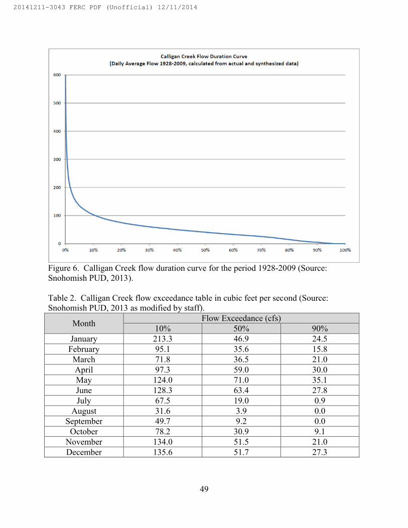
49
Figure 6. Calligan Creek flow duration curve for the period 1928-2009 (Source: Snohomish PUD, 2013).
Table 2. Calligan Creek flow exceedance table in cubic feet per second (Source: Snohomish PUD, 2013 as modified by staff).
MonthFlow Exceedance (cfs)
10% 50% 90%January 213.3 46.9 24.5February 95.1 35.6 15.8March 71.8 36.5 21.0April 97.3 59.0 30.0May 124.0 71.0 35.1June 128.3 63.4 27.8July 67.5 19.0 0.9
August 31.6 3.9 0.0September 49.7 9.2 0.0
October 78.2 30.9 9.1November 134.0 51.5 21.0December 135.6 51.7 27.3
20141211-3043 FERC PDF (Unofficial) 12/11/2014

50
The proposed bypassed reach for the Calligan Creek project is 1.4 miles (7,400 feet) long. Additional inflow from a series of springs joins Calligan Creek starting at RM 3.5 within the proposed bypassed reach.27 During the previous licensing effort, a second gage was installed below the springs approximately 5,200 feet downstream of theproposed diversion structure. It was abandoned for several years, but was reconditioned by Snohomish PUD during pre-filing to collect additional flow data. The downstream gage indicates that during times when the upper segment of Calligan Creek went dry, there was a consistent base flow of 9 to 14 cfs entering Calligan Creek year-round from the springs.
Water Rights
The Washington DOE registered three water rights permits for Calligan Creek (Table 3). Two are held by Snohomish PUD for 75 cfs and 13 cfs, with priority years of 1984 and 2009, respectively. The other water right is for FTGA Timberlands, LLC; this water right is related to Hancock Timber Resource Group’s periodic vegetation control on their commercial forest property.
Table 3. Calligan Creek water rights from Washington Department of Ecology (Source: Washington DOE, 2014).
Name of Record File Number Priority Date Quantity (cfs)Snohomish PUD S1-24496 5/3/1984 75Snohomish PUD S1-26823 5/22/2009 13FTGA Timberlands, LLC S1-28272 7/22/2005 0.2230
Water Quality
The North Fork and its associated tributaries including Calligan Creek are designated under the State of Washington water quality standards as providing multiple freshwater uses for aquatic life, recreation, water supply, and other miscellaneous use categories. Aquatic life uses include core summer salmonid habitat.28 Recreation uses include extraordinary primary contact29 recreation. Water supply uses include domestic, industrial, agricultural, and stock water uses. Other use designations include wildlife habitat, harvesting, commercial and navigation, boating, and aesthetics. Water quality standards applicable to project waters are shown in table 4.
27 The springs are located approximately 3,000 and 4,800 feet downstream of the
proposed diversion.28 The key identifying characteristics of this use are summer (i.e., June 15-
September 15) salmonid spawning or emergence, or adult holding; use as important summer rearing habitat by one or more salmonids; or foraging by adult and subadult native char. Other common characteristic aquatic life uses for waters in this category
20141211-3043 FERC PDF (Unofficial) 12/11/2014

51
Table 4. Numeric water quality criteria applicable to project waters (Source: Washington DOE, 2011; Snohomish PUD, 2013 as modified by staff).
Constituent Category Criteria
Water Temperature Core Summer Salmonid Habitat
Highest 7 day average of the daily maximum temperatures is 16°C (60.8°F)
Dissolved Oxygen Core Summer Salmonid Habitat
Lowest 1 day minimum is 9.5 mg/L
Turbidity Core Summer Salmonid Habitat
Turbidity shall not exceed:5 NTU over background when the background is 50 NTU or less; orA 10 percent increase in turbidity when the background turbidity is more than 50 NTU
Total Dissolved Gas Core Summer Salmonid Habitat
Total dissolved gas shall not exceed 110 percent of saturation at any point of sample collection
pH Core Summer Salmonid Habitat
pH shall be within the range of 6.5 and 8.5, with a human-caused variation within the above range of less than 0.2 units
Notes:°C = degrees Celsius°F = degrees Fahrenheit
include spawning outside of the summer season, rearing, and migration by salmonids(Washington DOE, 2011).
29 Extraordinary primary contact means waters providing extraordinary protection against waterborne disease or that serve as tributaries to extraordinary quality shellfish harvesting areas.
20141211-3043 FERC PDF (Unofficial) 12/11/2014

52
mg/L = milligrams per literNTU = nephelometric turbidity units
Water quality data were collected seasonally in Calligan Creek near the proposed diversion site during 1989 and 1990 as part of the previous licensing effort. Grab samples were collected to specifically measure water temperature, dissolved oxygen, and pH levels. However, the samples were also analyzed in the laboratory for other parameters. Table 5 provides the water quality data from samples collected in 1989 and 1990.
Table 5. Calligan Creek water quality data collected in 1989 and 1990 near the proposed diversion site (Source: Snohomish PUD, 2013).Parameter 6/26/1989 9/22/1989 2/15/1990 7/26/1990Water Temperature (degrees Celsius)
12.3 8.9 2.9 13.4
Dissolved Oxygen (milligrams per liter)
10.3 10.7 12.8 9.8
Conductivity 28 41 20 0.13pH 7.5 7.4 7.1 7.1Total Dissolved Solids (milligrams per liter)
79 22 12 -
Total Suspended Solids (milligrams per liter)
<1.0 <1.0 <1.0 <1.0
Nitrate/Nitrite Nitrogen (milligrams per liter)
0.144 0.202 0.188 0.245
Ortho-Phosphate (milligrams per liter)
0.001 0.004 0.002 0.005
Alkalinity (milligrams per
16 25 12 23.8
20141211-3043 FERC PDF (Unofficial) 12/11/2014

53
liter as CaCO3)Hardness (milligrams per liter as CaCO3)
14 24 17 -
Turbidity (nephelometric turbidity units)
0.38 0.06 0.25 0.13
In addition to the water quality data collected in 1989 and 1990, water temperatures in Calligan Creek were recorded in 1991, 2001, 2010, 2011, and 2012 in association with studies to determine trout spawning and emergence times, and seasonally during several trout population monitoring efforts. Temperature data collected during the period from May through October 1991 and from August through September 2001 showed that water temperatures in Calligan Creek ranged from 7 degrees Celsius (°C) (44.6 degrees Fahrenheit (°F)) to about 10°C (50°F) consistently in those years. More recent temperature data for the years 2010 through 2012 for the months of August and September are displayed below in figure 7 through figure 9. Temperature data in these years ranged from about 7°C (44°F) to about 13°C (55°F) during these months.
Figure 7. Mean daily water temperature in Calligan Creek during September 2010 (Source: Snohomish PUD, 2013).
20141211-3043 FERC PDF (Unofficial) 12/11/2014

54
Figure 8. Mean daily water temperature in Calligan Creek during September 2011 (Source: Snohomish PUD, 2013).
20141211-3043 FERC PDF (Unofficial) 12/11/2014

55
Figure 9. Mean daily water temperature in Calligan Creek during August and September 2012 (Source: Snohomish PUD, 2013).
Below we compare existing water temperatures, dissolved oxygen concentrations, pH levels, and turbidity levels for Calligan Creek to State of Washington water quality standards.
Water Temperature
Water temperatures measured in Calligan Creek in 1989, 1990, 1991, 2001, 2010, 2011, and 2012 show that daily water temperatures were consistently below 16°C (60.8°F) and therefore met the 7-day average maximum of 16°C (60.8°F) for core summer salmonid habitat criterion in all years (see figures 7 through 9 above).
Dissolved Oxygen
All dissolved oxygen measurements collected in 1989 and 1990 in Calligan Creek were above the 9.5 milligram per liter criterion for core summer salmonid spawning habitat.
20141211-3043 FERC PDF (Unofficial) 12/11/2014

56
pH
All pH measurements collected in 1989 and 1990 for Calligan Creek were within the state criterion range of 6.5 to 8.5 for core summer salmonid habitat.
Turbidity
Turbidity measurements were collected for Calligan Creek in June and September of 1989 and February and July of 1990. Measurements ranged from 0.06 to 0.38 nephelometric turbidity units (NTU), which indicates very low levels of turbidity. Because the background measurements were below 50 NTU, the water quality standard for core summer salmonid habitat that applies to Calligan Creek would require the project to not exceed 5 NTU above background levels.
Fisheries Resources
Aquatic Habitat
Calligan Creek and Calligan Lake
Calligan Creek streamflow originates as rainfall and snowmelt in the foothills of the north central Cascade Mountains. The Calligan Creek drainage can be divided into three distinct reaches: (1) the upper reach from Little Calligan Lake downstream to Calligan Lake, (2) Calligan Lake, and (3) the lower reach from the outlet of Calligan Lake downstream to the confluence with the North Fork.
The 1.2-mile-long upper reach originates at Little Calligan Lake at elevation 2,720 feet msl and falls at an average gradient of 8 percent before entering Calligan Lake at elevation 2,226 feet msl.
Calligan Lake is approximately 1.4 miles long and 0.6 miles wide, and has a surface area of 310 acres and a mean depth of 51 feet.
The lower reach originates at the outlet of Calligan Lake and extends for about 2.2 miles to the confluence with the North Fork at RM 8.6. From the lake outlet to Calligan Creek’s confluence with the North Fork, the elevation drops approximately 1,100 feet at an average slope of about 9 percent. The proposed diversion, bypassed reach, powerhouse, and tailrace would be situated within this lower reach of Calligan Creek. The proposed diversion would be located about 1,600 feet downstream of the lake outlet.
During the previous licensing effort, a number of methods were used to evaluate aquatic habitat in Calligan Creek within the proposed 1.4-mile-long bypassed reach. These methods included a thorough instream aquatic habitat survey and an evaluation of
20141211-3043 FERC PDF (Unofficial) 12/11/2014

57
aerial photos, aerial videotape, and topographic maps. Cascades Environmental Services (CES) (1992) used this information to describe aquatic habitat types in the proposed bypassed reach. A summary of the results are displayed in table 6. The survey data start from the proposed powerhouse location and move upstream to the proposed diversion site. Snohomish PUD supplemented the available habitat data with additional data from an October 2011 survey it conducted in the upper segment of the bypassed reach.
Table 6. A summary of instream habitat characteristics in the proposed Calligan Creek bypassed reach (Source: CES, 1991, as modified by staff).
Stream Segment No.
Starting Elevation (feet
msl)
Reach Length (feet)
Average Gradient Increase
(percent slope)
General Instream Habitat Characteristics
1
1,168 (proposed
powerhouse location)
475 7
Primarily cobble and boulder runs
2 1,200 581 14
Primarily low and medium gradient cascades over boulders and bedrock
3 1,280 739 43
Dominated by high gradient cascades, chutes, and falls over bedrock and boulders
4 1,600 2,482 6
A mixture of habitat types with no single habitat predominating
5 1,760 1,320 24
A steep chute filled with car-sized boulders and large logs and log jams
6 2,080 528 13
Resembles reaches 2 and 4 with a mix of low and
20141211-3043 FERC PDF (Unofficial) 12/11/2014

58
medium gradient habitat types
7 2,160 1,267 4Primarily deep runs and glides
Calligan Creek descends over a very mild slope for about 2,900 feet from the lake outlet to a point about 1,300 feet downstream of the proposed diversion site. Habitat in this 2,900-foot segment is dominated by deep runs and glides. All documented rainbow and cutthroat trout spawning activity in Calligan Creek has been observed approximately 700 feet upstream of the proposed impoundment and within 600 feet of the lake outlet. Near the proposed diversion site, Snohomish PUD observed some limited spawning gravels in pool tail outs, though no spawning activity has been documented within this area.
Both the 1980s habitat data and Snohomish PUD’s 2011 supplemental surveys found that channel gradient and aquatic habitat change drastically a short distance (about 1,300 feet) downstream of the proposed diversion site and continue for about 1.16 miles (6,125 feet) down to the proposed powerhouse location. Within this 1.16-mile section, aquatic habitat is characterized by a steep gradient averaging about 11 percent. As shown in table 6, two segments within this section of the bypassed reach had higher average gradients of 24 and 43 percent. Substrate in this 1.16-mile section is dominated by boulders and rubble,30 with the very high gradient segments containing steep chutes filled with large boulders, logs, and small waterfalls. Stream segment 5, which begins approximately 1,800 feet downstream of the diversion, contains a steep chute filled with car-sized boulders and large logs and was identified as a possible natural barrier to upstream fish migration.
As noted, additional inflow from a series of springs joins Calligan Creekapproximately 3,000 feet and 4,800 feet downstream of the proposed diversion structure.
Below the proposed powerhouse location, Calligan Creek flows over a low gradient segment for another 1,056 feet (0.2 mile) before entering the North Fork. The lowest segment of creek between the powerhouse and the North Fork was not surveyed by Snohomish PUD; however, surveys conducted by Thompson et al., (2011) reported an average gradient of about 2 percent with substrate dominated by large cobbleapproximately 9 to 12 inches in diameter.
30 In its 2011 survey Snohomish PUD characterized boulder substrate as that with
greater than 1 foot in diameter and rubble substrate as that with 6 to 12 inches in diameter (Snohomish PUD, 2012)
20141211-3043 FERC PDF (Unofficial) 12/11/2014

59
North Fork Snoqualmie River
Previous instream flow studies along selected reaches of the North Fork documented relatively low suitability of spawning habitat for resident trout (Beck and Associates, 1985; Overman, 2008). Thompson et al. (2011) stated that the confinementand lack of off-channel habitat in the Calligan segment, which includes the North Fork’s confluence with Calligan and Hancock creeks, probably limits the amount of spawning and rearing habitat for trout in this segment of the North Fork.
Fish Communities
Calligan Creek
Resident trout species found in Calligan Creek include rainbow trout, cutthroat trout, and brook trout. Other fish species known to occur in the project area include mountain whitefish, largescale sucker, longnose dace, shorthead sculpin, and mottled sculpin. Although both rainbow and cutthroat are native to the project area, it is likely that native strains have been replaced by hatchery-reared stocks. Beginning in 1934 andcontinuing until 1993, a total of 717,929 rainbow trout were stocked in Calligan Lake and its tributaries, with an average annual stocking of 22,593 individuals. Between 1934 and 1982, a total of 169,524 cutthroat trout were also stocked in Calligan Lake and its tributaries, with an average annual stocking of 12,109 individuals. Eastern brook trout are not native to the project area but were also stocked by the Washington Department of Game between 1955 and 1969 in Calligan Lake and its tributaries.
In the 1980’s under the previous licensing effort, electrofishing and snorkel surveys were conducted in Calligan Creek to document fish use and abundance near the proposed diversion and powerhouse sites. An electrofishing survey conducted in April 1986 documented 38 rainbow trout and 1 brook trout while a snorkel survey conducted in August 1986 documented 72 rainbow trout and 12 brook trout. An electrofishing survey conducted in 1989 documented 12 rainbow trout while a snorkeling survey conducted the same year documented 7 rainbow trout (CES, 1991).
In response to Washington DFW’s comments on the 1991 license application, the previous applicant prepared a Fisheries Monitoring Plan in 199231 that proposed methods for surveying trout abundance in a representative segment of the proposed bypassed reach and reporting monitoring results. Subsequent trout surveys were completed in Calligan Creek in 1992, 2001, 2010, 2011, and 2012 following protocols outlined in the 1992 Fisheries Monitoring Plan. The results of these trout surveys are presented in table 7below.
31 The 1992 Fisheries Monitoring Plan is included in Appendix A of Snohomish
PUD’s final license application.
20141211-3043 FERC PDF (Unofficial) 12/11/2014

60
Table 7. Results of trout monitoring surveys in Calligan Creek (Source: Snohomish PUD, 2013).
DateNumber of Rainbow Trout Observed by Age Class
Fry Juvenile Small Adult Adult Total9/1/1992 0 1 7 8 169/16/1992 0 2 2 3 78/3/2001 7 18 45 14 849/7/2001 0 4 7 38 499/21/2001 0 6 11 34 518/17/2010 0 0 3 4 79/17/2010 1 0 4 3 89/28/2010 0 0 5 3 88/15/2011 0 2 1 5 88/30/2011 0 0 1 3 49/16/2011 0 2 0 2 48/28/2012 0 4 7 7 189/7/2012 0 3 6 9 189/17/2012 0 2 4 12 18
The results of these fish population surveys indicate that rainbow trout is the predominant species in the bypassed reach, with cutthroat and brook trout being found only on an occasional basis. Rainbow and cutthroat trout utilizing habitat in the bypassed reach are most likely naturally reproducing populations that are periodically augmented by emigrants from lake plantings. At the outlet to Calligan Lake, spawning has historically been observed in a short reach of the creek presumably by stocks with an allacustrine32 life history (Pfeifer, 1985). Recent surveys conducted by Snohomish PUD in Calligan Creek confirmed the existence of spawning habitat near the lake outlet. Snohomish PUD surveyed for the presence of trout redds upstream of the proposed diversion site within a 1,040-foot index area beginning at the lake outlet and continuing downstream. The survey data show that all observed redds were located within 600 feet of the lake outlet, approximately 700 feet upstream of the proposed impoundment. These results were similar to the observations made by Pfeifer (1985).
While Snohomish PUD did not survey Calligan Creek downstream of the proposed powerhouse site, a comprehensive study done in 2010 in the North Fork included a fish abundance survey in the lower 1,320 feet of Calligan Creek between the proposed powerhouse site and the North Fork confluence. Surveyors found one brook trout and 10 trout that were not identified but were labeled as possible hybrids (Thompson et al., 2011). The study found that, while very low numbers of trout were found during the survey, the area sampled was too wide and deep to sample with single
32 Allacustrine fish rear in lakes and spawn in outlet tributaries of lakes.
20141211-3043 FERC PDF (Unofficial) 12/11/2014
61
pass electrofishing; therefore, accurate fish counts were not attained for relative abundance comparisons with other tributaries.
North Fork Snoqualmie River
In the comprehensive study done in the North Fork, surveyors split the North Fork into the upper North Fork, the middle North Fork, and lower North Fork and surveyed each section to characterize and compare aquatic habitat and fish abundance. Within those three sections, surveyors sampled seven different river segments, including the Calligan segment which was identified as a 5.2-mile segment within the middle North Fork that included the confluences of Calligan and Hancock Creeks (Thompson et al., 2011). During the study, surveyors counted very low numbers of trout during snorkel surveys in the Calligan segment. Thompson et al. (2011) concluded that the channel confinement and lack of off-channel habitat probably limits the amount of spawning and rearing habitat for trout in this segment of the middle North Fork.
Thompson et al (2011) found that the majority of trout in the upper North Fork and middle North Fork were of hatchery origin, which might suggest that native trout production is inherently low in these sections. The authors found weak genetic signals of native coastal cutthroat and rainbow trout in individuals sampled, but the native genetic signals were overwhelmed by hatchery genetic signals. The combination of low production and a lack of habitat diversity could have caused native populations to be more vulnerable to colonization by introduced hatchery fish (Thompson et al., 2011). In contrast, the lower North Fork, which in the study begins 2 miles downstream of the Calligan segment at the base of Black Canyon and continues another 2.7 miles downstream to the confluence with the Middle North Fork Snoqualmie River, contained a greater density of complex habitat and higher trout production than other North Fork river sections and also contained the only pure native trout encountered in the North Fork during the study.
No special status species such as bull trout or Dolly Varden have been reported in studies conducted above Snoqualmie Falls, which is approximately 12 miles downstream of the confluence of Calligan Creek and the North Fork. Prior sampling efforts conducted in the North Fork above Snoqualmie Falls included snorkel surveys specifically designed to detect the presence of bull trout and Dolly Varden and none were found (Berge and Mavros, 2001; Overman, 2008). Snoqualmie Falls acts a migratory barrier to upstream migration; anadromous fish are not found in the basin upstream of Snoqualmie Falls.
20141211-3043 FERC PDF (Unofficial) 12/11/2014

62
3.3.2.2 Environmental Effects
Construction Effects on Water Quality and Aquatic Resources
Excavation in or near the Calligan Creek stream channel would be required during construction of the diversion structure, intake, and tailrace. Construction of these facilities would cause short-term adverse effects on aquatic resources in Calligan Creek if streamflows, aquatic habitat, or water quality conditions are altered compared to existing conditions.
To protect aquatic resources during excavation for these facilities, cofferdams
would be installed and streamflows would be bypassed around the work area using culverts to isolate work areas from flowing waters. Prior to dewatering, any fish encountered at the construction sites would be salvaged using electrofishing or netting and relocated to Calligan Lake. Pumps would be used to initially dewater the isolated work areas and remove any additional water, concrete leachate, or sediment that enters the work area. Sediment-laden water would be pumped into siltation ponds or vegetated upland areas for removal of sediment. Concrete leachate from the construction site would be pumped to holding tanks and properly disposed of off-site when pH levels are higher than 8.5. Following construction, Snohomish PUD would stabilize and revegetate along streambanks and other adjacent disturbed areas as proposed in its TRMP (seesection 3.3.3, Terrestrial Resources).
To further minimize effects on aquatic habitat and water quality during
construction, Snohomish PUD proposes to implement its SWPPP and ESCP (see section 3.3.1, Geology and Soils) with site-specific BMPs to minimize localized erosion, sedimentation, and soil mass-movement. The proposed BMPs include: limiting the acreage of ground clearing; installing silt fencing and sediment traps; hydroseeding and employing bioengineering techniques to establish a vegetative cover on bare slopes and to control erosion; stockpiling unused excavation spoils and controlling them with suitable drainage, erosion, and sediment control measures; promptly replanting cleared soil as necessary; pumping sediment laden water during diversion construction to vegetated areas and siltation ponds; pumping concrete leachate to holding tanks; assigning a CESCL for construction; periodically monitoring turbidity and pH levels in affected waters during construction; and conducting all in-water work within the Washington DFW designated in-water work window of July 1 to September 30.
Our Analysis
Installation of the cofferdams and culverts to bypass flows around the in-water work areas would require disturbance of the gravel, cobble, and boulder alluvium in the bed of Calligan Creek. Once cofferdams are in place and the area is dewatered, the stream habitat would be unavailable to aquatic organisms until construction is complete.
20141211-3043 FERC PDF (Unofficial) 12/11/2014

63
Installation of the diversion structure and intake would result in a permanent reduction of about 0.01 acre of stream habitat in this section of Calligan Creek. The permanent removal would have only a minor effect on habitat availability, however, because there is ample aquatic habitat in Calligan Creek both upstream and downstream of the proposed diversion.
Electrofishing and handling fish in nets may temporarily stun or disorient fish while they are collected or transported to areas upstream for release. While exposure to currents as a result of electrofishing may injure juvenile and adult rainbow trout, mortality associated with electrofishing is generally low (Ainslie et al., 1998; Portt et al.,2006). Any minor injury or stress would be temporary and fish would quickly resume normal behaviors following their release into upstream habitat. No fish mortality is anticipated from the fish salvage activities.
As discussed in section 3.3.2.1 Affected Environment, flows typically decrease to less than 10 cfs within the proposed bypassed reach during the summer months with some years seeing this segment of Calligan Creek go completely dry. Snohomish PUD’s proposal to complete in-water work during the low flow months of July through September as proposed in the SWPPP and ESCP would minimize sedimentation and reduce the amount of aquatic habitat being isolated and dewatered within the cofferdams.
Even with Snohomish PUD’s proposed measures to minimize erosion and control stormwater, there would still be some short-term increases in turbidity during project construction that could exceed the state standard of 5 NTU over background. Short-term increases in turbidity could affect resident trout downstream of construction sites by increasing physiological stress (Redding et al., 1987) and lowering feeding success due to a reduction in reactive distance to drifting prey (Barrett et al., 1992). Elevated turbiditylevels downstream of construction sites would be temporary and normal levels should return a short time after sediments pass through and settle out in lower velocity areas downstream. If turbidity monitoring indicates that turbidity levels exceed 25 NTU, additional measures would be assessed and implemented to attempt to reduce turbidity levels. If turbidity levels exceed 250 NTU, Snohomish PUD would implement off-site treatment, infiltration, and filtration and chemical treatment within 24 hours of reaching this threshold.
In addition to elevated turbidity levels, construction activities would also increase pH levels in Calligan Creek. Concrete used during construction may cause concrete leachate to enter Calligan Creek through stormwater runoff which could result in increased pH levels. While little information is available addressing salmonid tolerance to changes in pH, effects on rainbow trout appear to show that pH levels between 5.0 and 9.0 are acceptable (Deas and Orlob, 1999). As discussed in section 3.3.2.1 Affected Environment, pH measurements collected in 1989 and 1990 showed that Calligan Creek waters were within the state criteria range of 6.5 to 8.5. Similar to our analysis of
20141211-3043 FERC PDF (Unofficial) 12/11/2014

64
turbidity, the anticipated shift in pH as a result of any stormwater runoff is expected to be short-term and pH levels are expected to return to existing levels a short time after construction is completed. Additionally, Snohomish PUD’s proposed SWPPP and ESCP would require that pH monitoring start immediately after concrete is exposed to precipitation and require additional BMPs, such as pumping all concrete leachate to holding tanks to avoid entering surface waters, if pH is 8.5 or greater. With Snohomish PUD’s protective measures, any short-term increases in pH as a result of construction would not have any long-term adverse effects on Calligan Creek.
As discussed in section 3.3.2.1 Affected Environment, available information in the project record indicates that the majority of trout spawning habitat in Calligan Creek occurs in the first 600 feet downstream of the lake outlet. Outside of this area, there is only limited available spawning habitat in the remainder of Calligan Creek. While the project’s diversion structure would create a relatively small 0.26-acre impoundment extending 260 feet upstream from the diversion structure, the upstream extent of the project’s impoundment would still be about 700 feet downstream of the area where trout redds were documented. Project construction would not affect trout spawning activity because there is no documented spawning habitat in construction areas and in-water construction would occur from July 1 to September 30, which is outside of the period where the majority of rainbow and cutthroat trout spawning occurs.33
Snohomish PUD’s proposal to assign and maintain a CESCL onsite during all construction phases would help to ensure that the proposed BMPs in its SWPPP and ESCP are implemented and maintained to protect water quality throughout construction. The CESCL would have the ability to stop work or implement additional measures as needed based on site-specific turbidity and pH monitoring in construction areas, which would enable a quick response to any water quality issues identified during construction.
Bypassed Reach Minimum Flows
During project operation, water diversions at the project intake would affect the natural flow regime in the 1.4-mile-long bypassed reach of Calligan Creek. Physical habitat availability is an important element of fish habitat and may affect the resident fish community in the bypassed reach.
33 CES (1991) reported that the majority of rainbow and cutthroat trout spawning
occurring in Calligan Creek occurs from early May to the end of June each year. Eastern brook trout are not native to the drainage basin and are found in extremely low numbers in Calligan Creek. Therefore, CES (1991) did not include brook trout in their spawning timing and fry emergence study.
20141211-3043 FERC PDF (Unofficial) 12/11/2014
65
To protect aquatic habitat and the resident fish community in the bypassed reach, Snohomish PUD proposes to:
release a minimum flow of 2 cfs at the diversion structure when the project is operating,
maintain a minimum flow of 15 cfs from May 15 through September 14 at the downstream spring site when the project is operating,34 and
maintain a minimum flow of 6 cfs from September 15 through May 14 at the downstream spring site when the project is operating.
Our Analysis
The project would operate run-of-river while providing seasonal minimum flows in the bypassed reach of Calligan Creek. All diverted water would be returned to the creek below the powerhouse. Therefore, during normal operating conditions, project operation would have no effect on flows above the diversion or below the powerhouse. According to the long-term flow record presented in section 3.3.2.1 Affected Environment, in an average water year, the project would divert all of the flow in Calligan Creek throughout the year except for periods during the summer and early fall when flows periodically fall below the 7 cfs inflow needed to operate the project and provide a proposed minimum flow of 2 cfs at the diversion.35 In those cases, the powerhouse would be shut down and all water would flow past the diversion structure into the bypassed reach.
The applicant for the 1990s licensing effort completed an instream flow study in the proposed Calligan Creek bypassed reach to aid in establishing minimum flow releases to sustain spawning, rearing, and overwintering habitat for resident rainbow trout. The study divided the proposed bypassed reach into different habitat categories, represented by differences in stream character and gradients. The instream flow study used thePhysical Habitat Simulation (PHABSIM) model to develop a relationship between aquatic habitat and flow. Habitat was calculated as weighted useable area per 1,000 feet of stream for different life stages of rainbow trout at each modeled flow. However, because much of the upper segment36 of the proposed bypassed reach beyond the first
34 The location of the downstream spring site gage for flow compliance is approximately 5,200 feet downstream of the diversion structure.
35 Because the project’s minimum hydraulic capacity is 5 cfs and Snohomish PUD proposes to maintain a 2 cfs minimum flow at the diversion, the project would not operate if inflow drops below 7 cfs at the diversion structure.
36 The upper segment of the bypassed reach is defined as the 3,000-foot segment from the proposed diversion downstream to where springs first begin to supply additional
20141211-3043 FERC PDF (Unofficial) 12/11/2014

66
1,300 feet downstream of the diversion is characterized as medium to high gradient in character including one section containing steep chutes and falls with an average gradient of 24 percent, habitat for resident trout in this upper segment was considered to be very poor; therefore, the upper segment was not included in the modeling analysis. Instead, the model was developed and applied to the lower segment of the bypassed reach downstream of the lower spring site. Because the available data for evaluating bypassed reach flows differs between the upper and lower segments, we evaluate the two segments separately.
Upper Segment of the Bypassed Reach
When Calligan Creek flows are greater than 7 cfs, the project would divert all flows and release only the proposed minimum flow of 2 cfs at the diversion. In an average water year when the project is operating, this would represent a 78 to 97 percent reduction in flows entering the upper segment of the bypassed reach depending on the month. Table 8 below shows the percent reduction in flows that are expected to occur in the upper segment based on the exceedance data for an average water year.
Table 8. Percent reduction in flows in the upper segment of the bypassed reach in an average water year (Source: Snohomish PUD, 2013 as modified by staff).
MonthPercent reduction in flow in an average
water year based on the 50 percent exceedance flow
January 95.7
February 94.4
March 94.5
April 96.6
May 97.2
June 96.8
July 89.5
August 0.0a
September 78.3
October 93.5
November 96.1
flows to Calligan Creek. The lower segment of the bypassed reach is defined as the 4,400-foot segment from the first spring site downstream to the proposed powerhouse.
20141211-3043 FERC PDF (Unofficial) 12/11/2014

67
December 96.1a No change in flow is expected in the month of August in a typical water year because the 50 percent exceedance flow in Calligan Creek is 3.9 cfs which is below the minimum hydraulic capacity flow needed for project operation.
Trout surveys conducted under the previous licensing effort documented very low numbers of rainbow trout in the upper segment of the bypassed reach. As discussed in section 3.3.2.1 Affected Environment, aquatic habitat in much of the upper segmentbeyond the first 1,300 feet downstream of the diversion is characterized as medium to high gradient in character including one section containing steep chutes and falls with an average gradient of 24 percent which provide very limited rearing habitat for resident trout. While the upper segment provides rearing habitat in the low gradient glide habitat near the diversion and in the limited pools in the high-gradient reach farther downstream, trout utilizing the high-gradient areas would most likely need to seek out additional spawning and rearing habitat farther downstream to complete their life history.
The upper segment is also known to go completely dry at times during the summer and early fall months when flows in Calligan Creek are at their lowest levels of the year. In an average water year, flows periodically go dry in the upper segment from late July through September. In a particularly dry year when flows are equal to 90 percent of the monthly exceedance flow, the upper segment would be dry for most of the three-month low flow period.
Given that the upper segment provides only limited rearing habitat for rainbow trout and because the segment typically becomes dewatered during late summer, the previous license applicant and Washington DFW staff determined that a minimum flow need only function to maintain the “stream character” of the upper segment (FERC, 1992). Therefore, Washington DFW staff and the previous license applicant conducted visual observations of the segment and determined that a 2-cfs minimum flow would be sufficient to maintain the segment’s stream character. Based on this previous assessment, Snohomish PUD proposed in its license application to provide a 2-cfs minimum flow release at the diversion.
The proposed 2-cfs minimum flow falls within the range of flows that presently occur within the months of July through August (table 2); therefore, a 2-cfs minimum flow would continue to maintain the very limited rainbow trout rearing habitat located in the segment.
20141211-3043 FERC PDF (Unofficial) 12/11/2014

68
Additional flows would enter the bypassed reach over the spillway during periods of high precipitation or snowmelt runoff when inflow exceeds 90 cfs.37 Based on the available flow record, in an average water year, this would periodically occur in the late fall, winter, and spring. In a particularly wet year when flows are equal to 10 percent of the monthly exceedance flow, flows during these months would consistently rise above 90 cfs and would equate to an additional 5 to 123 cfs entering the bypassed reach in the winter and an additional 7 to 38 cfs entering the bypassed reach in the spring. These flows would be sufficient to assist trout in the upper segment in passing downstream to access additional spawning and rearing habitat.
Lower Segment of the Bypassed Reach
Flows in the lower segment of the bypassed reach are augmented by springs approximately 3,000 and 4,800 feet downstream of the proposed diversion site. Snohomish PUD indicates in its license application that these groundwater-fed springs provide an additional 9 to 14 cfs of inflow below the lower spring site.
The 1980s instream flow study modeled flows between 10 and 90 cfs to generate weighted useable area curves for juvenile and adult habitat in the summer and winter as well as adult spawning in the summer. Habitat availability for juvenile and adult rainbow trout in the summer spawning and rearing period was directly related to increased flows. This was not the case for winter habitat, however. During the winter, maximum adult and juvenile rainbow trout habitat for all modeled flows was provided by the lowest modeled flow of 10 cfs. Based on this finding, additional analysis was conducted with a one-flow model developed by Milhous et al., (1989) to evaluate habitat-flow relationships at flows less than 10 cfs. The model results indicated that a flow of 6 cfs at the lower spring site would provide maximum winter habitat for juvenile and adult rainbow trout. The model results also indicated that 15 cfs would provide about 85 percent of maximum trout rearing habitat during the summer, which is higher than anyother flow level between 10 and 40 cfs. Figure 10 below displays the combined weighted useable area curves for both summer spawning and rearing habitat and winter habitat for juvenile and adult rainbow trout.
37 The maximum hydraulic capacity for the Calligan Creek project is 88 cfs. Thus,
in order to operate at maximum capacity and release a 2 cfs minimum flow at the diversion, flows in Calligan Creek would need to be 90 cfs or greater.
20141211-3043 FERC PDF (Unofficial) 12/11/2014

69
Figure 10. Percent of maximum weighted useable area versus discharge for juvenile and adult winter habitat and summer spawning and rearing habitat for rainbow trout (Source: Snohomish PUD, 2013).
Snohomish PUD’s proposed minimum flows at the lower spring site would therefore maximize juvenile and adult habitat during the winter and provide 85 percent of maximum trout spawning and rearing habitat during the summer in the lower segment of the bypassed reach.
Operation Effects on Water Quality
Project operation would result in the diversion of 5 to 88 cfs of flow at the diversion structure into the project’s penstock and powerhouse. Flow diversion for power generation could affect water temperatures, dissolved oxygen, and total dissolvedgas levels in Calligan Creek. Additionally, Snohomish PUD proposes to operate a sluice gate on the diversion structure to annually flush accumulated sediment and large woody debris downstream for the maintenance of aquatic habitat. Operation of the sluice gate would pass large volumes of stored sediment downstream for approximately 6 hourswhich would temporarily elevate suspended sediment and turbidity levels in Calligan Creek during that time.
To monitor operational effects on water quality and document compliance with minimum flows and ramping rates in the bypassed reach, Snohomish PUD proposes to implement its Water Quality Monitoring Plan. The plan includes provisions to monitor water temperatures and turbidity for 5 years after initial project operation. Temperature would be recorded at six different locations, including: (1) the diversion structure, (2) upper bypassed reach upstream of the spring inflow site, (3) the lower spring site in the lower bypassed reach, (4) lower bypassed reach downstream of the lower spring site, (5)
20141211-3043 FERC PDF (Unofficial) 12/11/2014

70
lower bypassed reach upstream of the powerhouse, and (6) full-flow reach of Calligan Creek downstream of the powerhouse tailrace.
The plan would require Snohomish PUD to monitor turbidity levels downstream of the diversion for a five-year period during the months of December and January when Snohomish PUD proposes to operate the sluice gate.
To provide for minimum flow and ramping rate compliance monitoring, the plan would require Snohomish PUD to measure water-surface elevations continuously at the diversion structure, the lower bypassed reach downstream of the spring site, and the powerhouse tailrace. In addition, discharge measurements would be collected over a range of flow conditions to develop site-specific stage-discharge rating curves at the diversion structure and lower bypassed reach monitoring sites. Discharge measurements would not be collected for the powerhouse tailrace site as the purpose of this site is solely to monitor water-surface elevations (i.e., stage).
The plan would require Snohomish PUD to provide annual monitoring reports to Washington DOE for the first five years once the project begins operating and file a final summary report with the Commission after completion of the fifth and final year of the program. Each monitoring period would begin on October 1 and end on September 30 of the following calendar year. The annual reports would describe the status of scheduled monitoring activities, summarize data acquisition and quality, present tables and graphs of key statistics and their trends, and discuss compliance with standards and objectives. After completion of the initial five-year reporting period, Snohomish PUD would maintain records of the discharge and water surface elevation data and provide it to the agencies upon request.
Our Analysis
Water exiting a powerhouse could cause elevated total dissolved gas levels in the tailrace if excessive aeration and plunging were to occur. Fish that come in contact with supersaturated water could suffer circulatory and neurological damage as dissolved gases that enter the fish’s bloodstream through respiration form bubbles (Weitkamp and Katz, 1980; Bouck, 1980). Aerated water plunging off steep drops into pools is the typical mechanism by which entrained air is forced into solution causing gas supersaturation.
Snohomish PUD’s proposal to construct a shallow tailrace would prevent plunging in the 135-foot-long tailrace channel. The tailrace barrier at the confluence of the tailrace channel with Calligan Creek would consist of a 2-foot vertical drop onto a concrete apron with a 5 percent gradient. This configuration would prevent plunging as flow would strike the concrete apron and continue downstream at a relatively shallow 5 percent gradient until flowing into Calligan Creek. This configuration would prevent elevated total dissolved gas levels from occurring during project operation.
20141211-3043 FERC PDF (Unofficial) 12/11/2014

71
As discussed in section 3.3.2.1 Affected Environment, available information on dissolved oxygen levels in Calligan Creek indicates that they consistently remain above the 9.5-milligram-per-liter state criterion even during the summer months under low flow conditions. In high-velocity, high-gradient streams such as Calligan Creek, water is aerated as it flows through chutes and over rocks and waterfalls. Given the channel morphology and high gradient nature of Calligan Creek, dissolved oxygen levels should remain within state standards even when flows are reduced due to project operation.
Snohomish PUD’s proposal to annually pass sediment and woody debris downstream of the diversion through a sluice gate would cause short-term increases in turbidity and suspended sediment during the annual maintenance events. However, the proposal to operate the sluice gate only when flows in Calligan Creek are at least 80 cfs would minimize the potential effects on fish and aquatic habitat because sluicing wouldoccur when background turbidity levels are naturally high, and the high flow conditions would enable the rapid transport of sediment downstream. Snohomish PUD’s proposal to also avoid operating the sluice gate during the period of June 16 through October 15 would minimize effects on spawning and emerging trout by preventing exposure to elevated turbidity and suspended sediment levels when these sensitive life stages are present in the project area. Snohomish PUD’s proposal to conduct turbidity monitoring in December and January when the sluice gate is opened and report the results to Washington DOE for the first five years after the project begins operating would provide a mechanism for evaluating changes to turbidity levels as a result of sluice gate operation. The proposed monitoring would also inform whether turbidity levels comply with State of Washington water quality standards. An additional requirement to file the proposedreports with the Commission would enable the Commission to track compliance with this proposed monitoring requirement and assess whether any changes to project operation are warranted.
Under existing conditions, water temperatures measured in Calligan Creek in the months of August and September consistently meet state water quality standards. Snohomish PUD’s proposal to reduce flows entering the bypassed reach to 2 cfs when the project is operating may increase water temperatures within the bypassed reach, particularly during the warm summer months when air temperatures are the highest and flows are at the lowest levels of the year. We note, however, that during an average water year, there would typically be insufficient flows to operate the project from mid-July through September. Though not expected, should any elevated water temperatures from project operation occur, they would be limited to the 3,000-foot segment of the bypassed reach between the proposed diversion structure and the first spring site. Downstream of the spring sites, cold groundwater inflows would quickly attenuate any elevated water temperatures.
Snohomish PUD’s proposal to monitor water temperatures in the project area and
to report the results to Washington DOE for the first five years following initial project
20141211-3043 FERC PDF (Unofficial) 12/11/2014

72
operation would provide a mechanism to evaluate any potential changes in water temperatures from project operation.
Installing and maintaining flow monitoring equipment in the upper and lower bypassed reach and powerhouse tailrace as proposed by Snohomish PUD’s Water Quality Monitoring Plan would allow Snohomish PUD to monitor and maintain a database documenting compliance with proposed minimum flows and ramping rates (discussed below) to protect aquatic resources during project operation, start-up, and shutdown. Monitoring the discharge at the downstream spring site gage would also inform whether increased flow releases are needed at the diversion structure to maintain the proposed minimum flows in the lower bypassed reach.
Snohomish PUD’s proposal to provide annual monitoring summary reports to Washington DOE for the first five years following initial project operation as well as its proposal to file a 5-year summary report after the fifth and final monitoring year with the Commission would provide a mechanism to evaluate whether any changes are needed to achieve the minimum flows and ramping rates within the initial 5-year monitoring period. In order for the Commission to be able to administer compliance with proposed minimum flows, ramping rate, and flow continuation requirements on an annual basis between initial project operation and the five year report, Commission staff would also need to review the annual reports.
Ramping Rates and Flow Continuation
Rapid changes in streamflow associated with changes in minimum flows or project start-up and shutdown could adversely affect aquatic resources in the bypassed reach and downstream of the powerhouse. Rapid down-ramping of flows has been observed in some rivers to cause stranding of fry and juvenile salmonids along sloping bars and in side-channels and stream margin areas (Hunter, 1992). Macroinvertebrates, which serve as prey for rainbow trout, have also been observed to be susceptible to stranding and desiccation as a result of rapid down-ramp rates (Kroger, 1973; Brusven et al., 1974; Gislason, 1980), although macroinvertebrates may be able to temporarily withstand dewatering events by migrating downward into the hyporheic zone38 (Gislason, 1985).
Project-induced changes in flow levels would predominately occur during powerhouse shutdowns under two different circumstances: (1) intentional planned maintenance events, and (2) unintentional emergency situations. To a lesser extent, flow changes could also occur during intentional increases or decreases in flow releases in the bypassed reach to meet minimum flow requirements. To protect aquatic resources from
38 The hyporheic zone is the substrate area under a river or stream where the
interstitial spaces are filled with water.
20141211-3043 FERC PDF (Unofficial) 12/11/2014

73
flow fluctuations during intentional and unintentional shutdowns or changes in minimum flow levels, Snohomish PUD proposes to implement the ramping rates shown in table 9.
Table 9. Proposed ramping rates for the Calligan Creek Hydroelectric Project (Source: (Snohomish PUD, 2013)Date Range Daylighta Ramping Rate Night time Ramping RateNovember 1 to June 15 2 inches/hour 2 inches/hour
June 16 to October 312 inch/hour b
1 inch/hour1 inch/hour c
a Daylight is from one hour before sunrise to one hour after sunset.b When natural instream flow in Calligan Creek at the intake site is at or above 30 cfs.c When natural instream flow in Calligan Creek at the intake site is below 30 cfs.
Unintentional shutdowns due to emergency situations at a hydropower project typically involve unit trips due to problems with the electrical transmission system (e.g., bird strike or tree-fell on a power line) or equipment malfunction within the powerhouse (e.g., overheated bearing, tripped circuit breaker). During these circumstances, powerhouse flows would need to be quickly reduced so the problem could be assessed and repaired and the powerhouse could be brought back online. Therefore, during emergency situations, Snohomish PUD proposes to provide flow continuation at its proposed ramping rates for a specified period of time that is sufficient to protect aquatic resources while also enabling it to quickly reduce powerhouse flow levels.
To provide flow continuation during unintentional shutdowns, Snohomish PUD proposes to design and install mechanical deflectors on the Pelton turbine. The mechanical deflectors would consist of deflector plates that enter the flow stream between the needle valves and turbine buckets to bypass flow around the turbine buckets while the needle valves slowly close and reduce flows at a level that is sufficient to meet the ramping rates below the powerhouse. As the needle valves slowly close, flow release equipment at the diversion structure would simultaneously open to pass more flows into the bypassed reach at a level that is also sufficient to meet the ramping rates at the diversion structure.
The flow continuation system would be operated according to the following criteria:
when inflows exceed 100 cfs, which is the average annual 10 percent exceedance flow, no ramping rates or flow continuation would be required;
20141211-3043 FERC PDF (Unofficial) 12/11/2014

74
when flows are less than 30 cfs, which is the critical flow,39 flow continuation would be maintained at the proposed ramping rates for a minimum of 24 hours; and
at all other times, a minimum of six hours of flow continuation at the proposed ramping rates would be provided.
The intent of the flow continuation measures is to enable fish and other aquatic organisms to sense the receding flows and move out of areas where they would be susceptible to stranding before powerhouse tailrace flows are completely shut off.
During powerhouse start-up following either an intentional or unintentional powerhouse shutdown, or during flow changes to increase minimum flows, Snohomish PUD would also implement its proposed ramping rates at the diversion structure and downstream of the powerhouse.
Our Analysis
Snohomish PUD’s proposed ramping rates range from one to two inches per hour, depending on season and time of day. In unregulated rivers, water stage rarely changes more than about 2 inches per hour, except during runoff events (Hunter, 1992); therefore, aquatic organisms typically are not accustomed to large stage changes occurring on a frequent basis. Because the recommended ramping rates approximate those occurringnaturally on unregulated streams, the turbidity increases that are common with stage increases would likely be at similar levels to those in unregulated systems. Based on information presented in Hunter (1992), the ramping rates listed in table 9 above are expected to protect resident trout and aquatic macroinvertebrates from stranding and subsequent mortalities associated with flow fluctuations in the bypassed reach and in Calligan Creek downstream of the powerhouse tailrace outlet.
Snohomish PUD’s proposal to install a flow continuation system on the project’s turbine would allow Snohomish PUD to implement its ramping rates at both the powerhouse and diversion weir simultaneously for a specified period of time while it transfers flow from the powerhouse tailrace to the bypassed reach during unintentional shutdowns. This would avoid rapid dewatering of Calligan Creek downstream of the powerhouse and associated adverse effects on aquatic resources.
39 The critical flow is the flow above which the risk of stranding is negligible.
Snohomish PUD developed the critical flow for Calligan Creek with resource agency input using Hunter (1992).
20141211-3043 FERC PDF (Unofficial) 12/11/2014

75
Snohomish PUD proposes to forego the flow continuation when flow is greater than 10 percent of the average annual exceedance flow to minimize potential damage to its equipment. The 10 percent average annual exceedance flow for Calligan Creek is approximately 100 cfs. Typically, flows of 100 cfs or more may occur during the late spring and early summer months due to snowmelt and in the late fall to winter months due to increased precipitation from winter storms. Under these circumstances, flows in addition to minimum flows would already be spilling over the diversion structure. According to the flow record, in a particularly wet year, average monthly flows can range from 97 to 128 cfs in the late spring and early summer and from 95 to 213 cfs in the winter. Therefore, if a shutdown event occurs during a particularly wet month when flows are above 100 cfs, we would expect that an additional 11 to 123 cfs would already be entering the bypassed reach over the spillway in addition to minimum flows at the time of the shutdown. Additional flows from springs40 located approximately 3,000 and 4,800 feet downstream of the diversion would also continue to provide flows into the lower bypassed reach during a shutdown regardless of flows released at the diversion. Flow contributions from these sources would continue to provide sufficient flowsdownstream of the tailrace in the event of a powerhouse shutdown, which should minimize adverse effects on aquatic organisms downstream of the powerhouse tailrace.
Under average flow conditions, Hunter (1992) found flow continuation for 6 hours provides adequate time for aquatic organisms to avoid stranding as flows recede. Snohomish PUD’s proposal to provide flow continuation in concert with its proposed ramping rates for 6 hours under average flow conditions would provide adequate time for resident trout to sense the receding flows and move out of areas downstream of the tailrace outlet where they would be susceptible to stranding. Therefore, while flows would be temporarily reduced downstream of the tailrace outlet when tailrace flows are shut off after 6 hours, the threat of standing would be minimized and flows would return to higher levels once the additional flows released into the bypassed reach travel the 1.4 miles to the tailrace outlet.
During low-flow periods when flows are below 30 cfs, particularly during the summer months, fish would be more susceptible to stranding and Snohomish PUD would extend flow continuation for a minimum of 24 hours at its proposed ramping rates before completely curtailing flow releases to the tailrace. This extended period should provide adequate time for resident trout and other aquatic organisms to sense the receding flows and move out of areas where they would be susceptible to stranding.
40 Snohomish PUD stated that inflow from the springs contribute approximately 9
to 14 cfs to Calligan Creek year-round.
20141211-3043 FERC PDF (Unofficial) 12/11/2014

76
In situations when flow continuation is waived, project shutdowns could cause stranding of any fish occurring within the 135-foot-long tailrace channel. As described in more detail below, Snohomish PUD’s proposal to install a tailrace barrier at the confluence of the tailrace channel with Calligan Creek would eliminate the stranding threat because it would prevent fish from entering the tailrace channel.
Tailrace Barrier
Resident trout in lower Calligan Creek could be attracted to tailrace discharge flows and enter the proposed 135-foot-long tailrace channel rather than utilizing habitat nearby.
Snohomish PUD proposes to exclude fish from entering the tailrace channel by constructing a tailrace barrier consisting of a 2-foot vertical drop onto a concrete apron with a 5-percent slope. Snohomish PUD proposes to construct the barrier at the confluence of the tailrace channel and Calligan Creek.
Our Analysis
After water passes through the Pelton turbine, it would drop about 15 vertical feet into a concrete box and discharge horizontally to the tailrace channel. Flow in the concrete box would be fast and shallow. In the event that fish migrate upstream through the tailrace channel and successfully swim upstream through the concrete box, they would be unable to move any farther into the powerhouse because there would be a 15-foot elevation change between the turbine and the concrete box. Therefore, even without the tailrace barrier, upstream migrating fish would not be subject to injury or mortality from turbine blade strike.
Nevertheless, constructing the tailrace barrier as proposed by Snohomish PUD would prevent any fish from entering or residing in the poor habitat conditions that would exist in the rip-rap-lined tailrace channel. Precluding fish from entering the tailrace channel would further minimize the threat of standing during a project shutdown because fish would not have to migrate back out into Calligan Creek before the tailrace is completely dewatered. This is particularly relevant during the high flow periods when Snohomish PUD does not propose to provide flow continuation.
Sediment and Woody Debris Transport
Project operation may affect aquatic habitat by reducing the passage of sediment and large woody debris that provides habitat for trout and macroinvertebrates within the proposed bypassed reach and in the full-flow reach of Calligan Creek downstream of the powerhouse tailrace.
20141211-3043 FERC PDF (Unofficial) 12/11/2014

77
To maintain sediment and large woody debris transport to downstream habitats, Snohomish PUD proposes to install and operate a sluice gate in the diversion structure. Snohomish PUD would conduct the sediment sluicing event by releasing water through the sluice gate for a minimum of 6 hours41 when flows at the diversion structure exceed 80 cfs. The sediment sluicing events would begin after the first year of initial project operation and continue once-per-year for every year thereafter.
Our Analysis
Both the continued downstream supply of substrate materials suitable for spawning and the movement of fine sediments out of the gravel are important to sustain the limited trout spawning and incubation habitat that exists in the Calligan Creek bypassed reach downstream of the diversion. As discussed in section 3.3.2.1 Affected Environment, Snohomish PUD did observe some a small amount of suitable spawning gravels in pool tail outs near the proposed diversion site; however, no spawning activity has been documented within this area and the closest documented trout redds were located approximately 700 feet upstream of the proposed impoundment. Although there is very limited spawning habitat in the bypassed reach, operating the sluice gate to facilitate downstream transport of sediment, including suitable spawning gravels, would ensure that any spawning gravels that reach the diversion structure would be able to pass into the bypassed reach and eventually settle out in downstream areas to maintain the limited spawning habitat that exists in the reach.
As noted in our discussion of Operation Effects on Water Quality, releasing sediment may cause a short-term increase in turbidity in the Calligan Creek bypassed reach and downstream of the powerhouse. However, given that Snohomish PUD plans to operate the sluice gate during times of the year when flows are the highest, any sediment traveling downstream would be quickly transported through the bypassed reach and settle out in low velocity areas farther downstream.
Large woody debris is an important element of fish habitat for species such as trout as it provides velocity shelter and structures to hide from predators. Snohomish PUD’s proposal to transport woody debris downstream through the sluice gate or byusing mechanical equipment would prevent debris from piling up behind the diversion structure and ensure that any large wood entering the project area is passed downstream to maintain habitat for resident trout.
41 Snohomish PUD does not provide a maximum time that the sluice gate would
remain open to flush sediments downstream.
20141211-3043 FERC PDF (Unofficial) 12/11/2014

78
Fish Entrainment and Impingement
Resident trout entering an unscreened intake at the diversion structure may be entrained into the penstock and powerhouse as they attempt to pass through the project area. Any fish entrained into the penstock would encounter the turbines at the powerhouse and be subject to injury or mortality due to pressure changes and blade strikes.
To prevent entrainment of resident fish into the intake, Snohomish PUD proposes to install a self-cleaning fish screen consistent with NMFS’s Design Criteria for Salmonids (NMFS, 2011). The fish screens would be installed upstream of the penstock entrance and all water diverted from Calligan Creek would pass through the screen before entering the penstock.
Fish may be impinged on fish screens installed on intake structures. Impingement occurs when flow velocity exceeds the swimming capability of a fish, creating contact with a screen face or bar rack. When fish become impinged they often are killed. To prevent impingement of juvenile and adult resident trout on the proposed fish screen, Snohomish PUD proposes to design the screen using the NMFS’s design criteria for juvenile salmonids, which requires approach velocities equal or less than 0.4 feet per second.
Our Analysis
Resident trout in most rivers and streams follow a predictable pattern of stream movement depending upon their life stage. During the fry stage, trout disperse from spawning areas and seek out less populated habitats, thereby distributing the population fairly evenly throughout the stream (Behnke, 1992). After their second year of life, once they have established a home range, most resident trout generally cease making any long-range movements (Behnke, 1992). In Calligan Creek, most resident trout are likely produced in the high quality spawning and rearing habitat near the lake outlet that begins about 700 feet upstream of the impoundment that would be created by the project’s diversion structure. Fry emerging from spawning redds in this location would disperse upstream into the lake and downstream into Calligan Creek. After their second year, resident trout in Calligan Creek would generally cease long-range movements unless spawning or rearing habitat was not sufficiently available which could prompt them to seek out other areas to complete their life history.
As discussed in section 3.3.2.1 Affected Environment, most young trout that emerge from the spawning gravels near the lake outlet disperse immediately upstream to rear in Calligan Lake; the remainder likely move downstream in search of suitable rearing habitat. If the project were constructed, those trout that would move downstream in Calligan Creek would encounter the diversion structure and intake. During high-flow
20141211-3043 FERC PDF (Unofficial) 12/11/2014

79
periods when flows exceed 90 cfs, the spillway would be operating and some fish may find safe downstream passage over the spillway. Conversely, during low-flow periods below 7 cfs, the powerhouse would be shut down and all flow would be diverted through the minimum flow weir, which would also provide a safe downstream passage route.
During normal operating conditions when flows are between 7 cfs and 90 cfs, all flows would be diverted into a sluiceway where a small proportion of flow would exit the sluiceway via the minimum flow weir, and the majority of flow would exit the sluicewayvia the intake box and enter the penstock and Pelton turbine. Prior to entering the intake box, some fish could possibly exit the sluiceway via the minimum flow weir and find a safe downstream passage route to the bypassed reach. Because most flow would enter the intake box during normal operating conditions, however, it is expected that most fish would also enter the intake box, pass the proposed fish screen, and exit through the pool-and-weir fishway to facilitate downstream transport to the bypassed reach.42
Fish screens designed to meet NMFS’s criteria for juvenile trout are sometimesused in hydroelectric projects to meet injury and mortality rate targets, typically ranging from 2 to 5 percent depending on the project (Nordlund, 2012). In order to meet NMFS’s criteria for the safe passage of juvenile trout, Snohomish PUD’s proposed screen would need to have a 0.125-inch screen opening width and a minimum total wetted area of approximately 220 square feet to keep approach velocities below 0.4 feet per second andeffectively screen juvenile trout. Snohomish PUD’s screen design would limit approach velocities to 0.4 foot per second which is less than the cruising swimming speed43 for salmonid fry of about 0.5 foot per second (Bell, 1990) and would enable fry, that have the poorest swimming ability of all life stages of trout, to safely pass the screen without being impinged.44 The proposed screen design is consistent with other screens that were designed for the safe passage of fry, juvenile, and adult trout, and therefore, would be expected to safely pass at least 95 percent of all life stages of resident trout that enter the intake box.
If a fish screen were not installed on the penstock intake, those fish that would enter the intake box would be entrained into the penstock and Pelton turbine. Due to their design, Pelton turbines typically cause very high fish injury or mortality rates. Čada (2001) characterized high head turbines, such as the Pelton type, as the most likely
42 Based on Snohomish PUD’s updated fish passage design, it appears as though
the proposed pool-and-weir fishway would also function as the downstream bypass for the fish screen.
43 Cruising speed is a swimming speed that a fish can sustain for a long period of time (i.e., hours) (Bell, 1990).
44 Nordlund (2008) also found that screen approach velocities of 0.4 feet per second or lower can avoid impingement of up to 100 percent of salmonid fry that encounter the screen.
20141211-3043 FERC PDF (Unofficial) 12/11/2014

80
turbine type to cause total mortality of entrained fish. This is because fish are shot out of a high-velocity jet onto the turbine blades rotating at high speeds. The high rotating speeds and tight clearances associated with the Pelton turbine would likely cause mortality rates approaching 100 percent for any fish that are entrained into the penstockand powerhouse.
Considering that most young trout fry that emerge from spawning gravels upstream of the proposed impoundment site migrate a short distance upstream to take residence in Calligan Lake and are able to complete their life history utilizing lake and stream habitat located upstream of the diversion, the benefits of providing a fish screen would be minimal to the Calligan Creek population. As noted above, passing any trout into the bypassed reach would provide little benefit to the trout because the existing channel morphology and steep gradient of the proposed bypassed reach provides relatively poor habitat conditions with limited spawning and rearing habitat. This isfurther supported by the low to moderate numbers of resident trout found in the bypassed reach, particularly during more recent surveys conducted at the trout monitoring site in the lower segment of the bypassed reach (table 7). Because resident trout tend to not exhibit any long range movements once they are established, and there is higher quality habitat upstream of the project that is sufficient for trout to complete their life history, there would be a low likelihood of substantial adverse effects on the Calligan Creek resident trout population as a whole from operating an unscreened diversion on the project’s intake.
Upstream Fish Passage
Once the proposed diversion weir and intake structure are constructed and operating, resident trout residing downstream of the diversion or that safely passdownstream through the diversion and intake structure would be blocked from migrating upstream if measures are not implemented at the diversion structure to provide upstream passage. Introducing barriers to resident trout movements in Calligan Creek may affect trout survival and reproduction if individuals are not able to access the appropriate mix of habitat types to complete their life history.
Snohomish PUD proposes to provide upstream fish passage by constructing and operating a pool-and-weir fishway that would be incorporated into the design of the diversion structure.
Our Analysis
Any trout dispersing downstream of the diversion structure could access the low-gradient glide habitat within the approximately 1,300-foot stream segment just downstream of the proposed diversion site. Downstream of this low-gradient section, however, habitat in Calligan Creek consists of an approximately 1,700-foot-long series of
20141211-3043 FERC PDF (Unofficial) 12/11/2014

81
chutes, cascades, and water falls with an average gradient ranging as high as 24 percent. Once fish disperse downstream of this area of extremely high gradient, they would not be able to migrate back upstream. Constructing a fishway to provide upstream fish passage would therefore only provide passage benefits to any resident trout occurring in this 1,300-foot-long segment between the diversion structure and the start of the high gradient reach. Considering that most of the trout fry emerging from the spawning gravels located near the lake outlet are expected to disperse upstream and would be able to complete their life history utilizing lake and stream habitat located above the diversion, the benefits of providing upstream passage for the few individuals that would disperse downstream and inhabit this 1,300-foot reach would be very minimal to the Calligan Creek trout population as a whole.
Trout Monitoring Plan
Snohomish PUD proposes to implement a Trout Monitoring Plan to monitor trout populations in the bypassed reach for a five-year period following initial project operation. The monitoring program would include annual snorkel surveys during August and September to document resident trout abundance, size, and age-class structure. The monitoring would occur in a series of pools in a 600-foot representative segment of the bypassed reach to provide an index of trout abundance. The monitoring site is near one of the instream flow study sites at RM 0.8 and includes a series of bedrock scour pools that are more accessible to surveyors than other portions of the bypassed reach. This area is in the lower portion of the bypassed reach between the two spring inflow sites. The plan states that this information would be used to evaluate potential population trends tied to project operation. The plan includes a provision for Snohomish PUD to provide annual monitoring reports to Washington DFW and file a final report with the Commission after completion of the fifth and final year of the program.
Our Analysis
The Trout Monitoring Plan would provide an annual estimate of trout abundance within a small segment of the bypassed reach. While the information gained from this monitoring effort would not provide an estimate of the total abundance of trout within the bypassed reach, it could be used by Snohomish PUD and the resource agencies to document general trends in trout abundance within this stream segment following initial project operation. Data from the monitoring effort could also be used to attempt to discern whether minimum flow releases are affecting trout abundance in the bypassed reach. We note, however, that trout populations are subject to natural variability and there are numerous other factors in addition to bypassed reach flows that could affect trout abundance in the bypassed reach. Examples of these include: harvest, disease, floods, and predation. These other factors would continue to affect fish abundance, which would make interpretation of monitoring results, as applied to minimum flow levels, extremely difficult.
20141211-3043 FERC PDF (Unofficial) 12/11/2014

82
Plan To Monitor Spawning Habitat Near The Project Impoundment
Snohomish PUD proposes to implement its “Plan To Monitor Spawning Habitat Near the Project Impoundment” filed with the license application. The plan includes provisions for Snohomish PUD to conduct annual trout spawning surveys for a period of five years in Calligan Creek between the proposed impoundment and the outlet to Calligan Lake.
The surveys would include enumerating and recording the location of trout redds as well as measuring depth, velocity, and substrate conditions. The data would be used to create detailed maps showing the extent by area, type of gravel, and suitability for spawning use. Snohomish PUD would use the maps to track changes in habitat conditions and resident trout spawning use over time in the survey reach between the project’s impoundment and Calligan Lake. Annual reports would be provided to Washington DFW and a final report would be filed with the Commission after completion of the fifth and final year of the program.
Our Analysis
As discussed in section 3.3.2.1 Affected Environment, available information in theproject record indicates that the proposed survey area located between the proposed project’s impoundment and the lake outlet is an important spawning area for resident trout in Calligan Lake and Calligan Creek. However, the only documented trout redds were located approximately 700 feet upstream of the proposed impoundment. Therefore, the proposed diversion structure and impoundment would not affect spawning habitat within the proposed survey area.
The proposed surveys would provide additional information to Snohomish PUD and the resource agencies on annual trout spawning activity near the outlet to Calligan Lake, which would likely contribute to general fishery management; however, they would not provide any direct benefit to trout as they would not provide protection or enhancement of the resource. Moreover, because the upstream extent of the project’s impoundment would be approximately 700 feet downstream of the closest documented redds in the survey area, it’s unclear how the proposed monitoring plan is related to the project.
Instream Flow Adaptive Management Plan
Snohomish PUD proposes to implement its Instream Flow Adaptive Management Plan which would require it to statistically evaluate changes in the abundance of resident trout in Calligan Creek based on the results of the proposed Trout Monitoring Plan, and potentially implement additional trout-monitoring measures over the long term. The planproposes to adjust the 2-cfs minimum flow release at the diversion structure if any of the
20141211-3043 FERC PDF (Unofficial) 12/11/2014

83
following occurs: (1) a catastrophic population decline is not followed by a population rebound within a 5-year period; (2) two catastrophic population declines occur sequentially during the first and second year of project operation; or (3) the trout population index shows a statistically significant gradual decline over a 5-year period irrespective of whether a catastrophic population decline occurs.
Each time an appropriate trigger is met, Snohomish PUD would petition the Commission to increase minimum flow releases at the diversion structure by 1 cfs up to a maximum total release of 5 cfs during the rainbow trout winter rearing period (i.e., September 15 through May 14). Snohomish PUD would maintain a 2-cfs minimum flow during the rest of year (i.e., May 15 through September 14) regardless of whether additional increases are implemented. The triggers that would lead to an increase in minimum flows at the diversion are summarized below.
Trigger 1: Initial Catastrophic Decline with no Rebound
To determine if a catastrophic population decline occurs during the first year of project operation, Snohomish PUD would use at least five years of pre-project surveys to derive a pre-project baseline population mean. The average number of fish per pool for the initial year of operation would then be compared to the average number of fish per pool observed during pre-project surveys. If the number of fish per pool decreases by 75percent or more, Snohomish PUD would indicate the population had suffered a sudden catastrophic decline. If a catastrophic population decline occurs during the first year of operation, the pre-project density of trout would serve as a standard to judge subsequent post-project surveys. Annual monitoring would continue for a maximum of 5 years until the post-project population rebounded. Snohomish PUD would define a population rebound as a mean number of fish per pool not significantly less than the pre-project population mean. If the population index does not rebound within the 5-year monitoring period, Snohomish PUD would petition the Commission to increase minimum flows at the diversion by 1 cfs from September 15 through May 14 and monitoring of population trends would continue.
Trigger 2: Two Sequential Catastrophic Declines
If consecutive catastrophic declines in the trout population occur in the first two years of project operation, Snohomish PUD would petition the Commission to increase minimum flows by 1 cfs at the diversion from September 15 through May 14 and monitoring of population trends would continue.
Trigger 3: Population Gradually Declines over a 5-Year Period
Snohomish PUD’s proposal to document statistically significant trends in the population would occur for a minimum of 3 years. If a statistically significant positive
20141211-3043 FERC PDF (Unofficial) 12/11/2014

84
trend in the trout population can be shown after 3 years of post-project monitoring and no catastrophic population declines occur, Snohomish PUD would consider the flow schedule adequate and monitoring would cease. If, after 3 years of operation, no significant positive trend in trout populations is observed, Snohomish PUD would continue population monitoring and subsequent statistical evaluation would continue up to a maximum of 5 years. After a fifth year of operation, Snohomish PUD would examine for a statistically significant negative trend and, if found, Snohomish PUD would petition the Commission to increase minimum flows at the diversion by 1 cfs from September 15 through May 14. If the instream flow schedule is increased due to a significant decline in the trout population at any point within this five-year period, the period for monitoring for statistical trends would be reset and a new five-year monitoringperiod initiated. Any subsequent declines in the population found would trigger another petition to increase minimum flows at the diversion by 1 cfs until the maximum of 5 cfs is reached. The plan does not provide for any additional increases in minimum flows beyond 5 cfs.
Our Analysis
The proposed Instream Flow Adaptive Management Plan would be used to determine if minimum flow releases at the diversion should be increased from 2 to 3, 4, or 5 cfs during the winter rearing period of September 15 through May 14. The Trout Monitoring Plan results would provide the fish survey data used to inform decisions regarding additional flow releases.
Increasing minimum flow releases at the diversion structure to 3, 4, or 5 cfs would represent a 50 to 150 percent increase in minimum flows when compared to the initial flow release of 2 cfs. The greatest habitat benefit from the additional 1 to 3 cfs of flow would be realized in the 3,000-foot segment of the bypassed reach upstream of the first spring site. However, fish habitat in this stream segment is already severely limited by channel morphology and an average gradient that reaches up to 24 percent. Given the existing poor habitat conditions, any fish residing in this reach would probably persist in relatively infrequent pool or glide habitats, which would be the only rearing habitat types likely to be enhanced by an additional 1 to 3 cfs of flow. Adding 1 to 3 cfs of flow would not likely enhance rearing within the predominant habitat types in this reach (i.e., low, medium, and high-gradient cascades; chutes over bedrock and boulders; and falls over bedrock and boulders), because these habitat types generally provide poor-quality rearing habitat for trout regardless of flow levels.
As discussed in section 3.3.2.1 Affected Environment, flows in the lower segment of the bypassed reach are augmented by accretion flow from groundwater springs approximately 3,000 and 4,800 feet downstream of the diversion. Snohomish PUD’s flow monitoring data below the lower spring site indicated that these springs contribute an additional 9 to 14 cfs of flow year-round, including during times of the year when
20141211-3043 FERC PDF (Unofficial) 12/11/2014

85
there is no flow in the upper bypassed reach segment. Therefore, instream flows below the lower spring site would already be at 11 to 16 cfs when the spring accretion flow is combined with the 2 cfs released at the diversion. Adding an additional 1 to 3 cfs of flow to the existing 11 to 16 cfs that would already be provided during this period would further increase flow levels in the lower bypassed reach. PHABSIM modeling results for the lower spring site indicated that maximum winter habitat for juvenile and adult trout was provided at a flow of 6 cfs. Therefore, any flows in excess of 6 cfs would not provide any additional habitat benefits for juvenile or adult trout during the winter.
3.3.2.3 Cumulative Effects
Water Quality
Past activities in the North Fork sub-basin, including logging, road construction, residential development, and hydropower development have affected water quality in the North Fork and its tributaries. Of particular concern are increased water temperatures in addition to sedimentation and runoff which has the potential to adversely affect aquatic habitat and fishery resources in the sub-basin. Historic timber harvest practices have reduced and eliminated large trees that provide shade in riparian areas. This has exposed some upper sub-basin waters to increased solar radiation, causing higher water temperatures during certain times of the year, particularly during the summer months(Sargeant and Svrjcek, 2008). Kaje (2009) generally characterized water quality in the North Fork as being very good, though high water temperatures remain a concern.
To address past adverse effects on water quality in the North Fork, Washington DOE has set a number of priority actions, including: protect and enhance intact riparian areas and wetlands through the use of incentives, acquisitions, restoration and enforcement of regulations; and designate water body types for water resources in forested areas to ensure proper application of forestry regulations and best practices (Stohr et al., 2011; Thompson et al., 2011).45 Planning is also underway to decommission 11 miles of roads in the North Fork sub-basin to minimize erosion and protect water quality (Stohr et al., 2011).
As discussed in our analysis of Construction Effects on Aquatic Resources, project construction would cause a temporary increase in turbidity in Calligan Creek during installation and removal of cofferdams, which would likely cause turbidity levels to temporarily exceed State of Washington standards. However, Snohomish PUD’s
45 All water bodies in the State of Washington are designated as particular land
management types by the Washington Department of Natural Resources. Water type designations were created to inform landowners and managers about water, riparian, and forestry resources and to enable protective measures against potentially deleterious land use practices.
20141211-3043 FERC PDF (Unofficial) 12/11/2014

86
proposed SWPPP and ESCP would include measures to minimize potential runoff of sediment and stormwater pollutants from entering Calligan Creek and the North Forkfarther downstream. Snohomish PUD’s proposal to maintain a CESCL on site during construction would enable frequent turbidity and pH sampling in project waters and allow for additional measures to be implemented if parameters meet certain elevated thresholdlevels.46 Additionally, Snohomish PUD’s proposal to implement its Water Quality Monitoring Plan would provide a mechanism to evaluate operational effects on water quality, including compliance with state water quality standards.
In addition to the proposed Calligan Creek Project, there is one other existing and two proposed hydroelectric projects within the geographic scope of analysis for cumulative effects. The Black Creek Hydroelectric Project (FERC No. 6221) is a 3.7-MW run-of- river project on Black Creek, a tributary to the North Fork, located approximately 4 miles downstream of the confluence of Calligan Creek and the North Fork. Snohomish PUD is proposing to construct the 6-MW Hancock Creek Hydroelectric Project (FERC No. 13994) on Hancock Creek, a tributary to the North Fork, about 2.2 miles downstream of the confluence of Calligan Creek and the North Fork (figure 3). Black Canyon Hydro LLC is proposing to construct the 25-MW Black Canyon Hydroelectric Project (FERC No. 14110) on the North Fork, approximately 3.5 miles downstream of the confluence of Calligan Creek and the North Fork. Both the Hancock Creek Project and the Black Canyon Project are proposed to be run-of-riverprojects with no water storage. Additional hydropower development in the sub-basinwould cause temporary increases in turbidity during construction and could affect streamflows and water temperatures during operation.
Current activities such as logging, road construction, residential development, and other hydropower development are expected to continue to affect water quality in the North Fork over the proposed license term. However, the priority actions identified and planned for the sub-basin, including decommissioning roads, protecting and enhancing riparian areas, and ensuring proper application of forestry regulations and best practices should all benefit water quality of the North Fork and its tributaries. The proposed Calligan Creek Project would be operated run-of-river and any potential adverse effects on water temperatures would be limited to a 3,000-foot segment of the bypassed reach. There could also be short term increases in suspended sediment and turbidity during project construction and once per year for a minimum of 6 hours during sediment sluicing. These effects could extend downstream to the confluence with the North Fork but would be limited to temporary periods during construction and once per year during
46 According to Snohomish PUD’s proposed SWPPP and ESCP, additional
measures would be implemented if pH levels are 8.5 or greater or when turbidity levels exceed thresholds of 25 NTU and 250 NTU. See section 3.3.2 Aquatic Resources formore details.
20141211-3043 FERC PDF (Unofficial) 12/11/2014

87
the winter for the remainder of the any license term. There would be no long term adverse effects on water quality in the North Fork.
Fisheries Resources
The primary fish species in the North Fork sub-basin include rainbow, coastal cutthroat, and brook trout. Of these, rainbow and coastal cutthroat trout are native to the sub-basin. All salmonids within the North Fork have a resident life history becauseSnoqualmie Falls on the mainstem Snoqualmie River blocks anadromous fish access to the North Fork.
Activities that have affected water quality in the North Fork sub-basin such as logging, road construction, residential development, and hydropower development have also affected fisheries resources. Land clearing activities such as logging, road construction, and residential development have increased erosion and sedimentation and elevated water temperatures which have degraded aquatic habitat for the native fish community.
Existing and proposed hydropower development in the North Fork sub-basin has historically affected and would continue to affect the native fish community by increasing erosion and sedimentation during construction, reducing minimum flows in regulated river reaches, impeding sediment and large woody debris transport, and fragmenting aquatic habitat by impeding or blocking upstream and downstream fish passage.
Historical fish stocking practices in the sub-basin have also adversely affected the native fish community. The stocking practices have introduced non-native species such as brook trout, reduced the genetic fitness of wild populations through genetic introgression and hybridization, introduced disease, and caused competition with native fish for food and space.
In the past, fishing pressure in the North Fork was thought to be light; however, Overman (2008) stated that there is significant and consistent recreational fishing that occurs during the months of August and September. Thompson et al (2011) stated that the human population in King County has grown significantly since the last creel survey was performed in the 1980s and expected that the amount of anglers fishing the North Fork would increase over the long term. Increased fishing pressure may affect the native fish community in the North Fork sub-basin by increasing stress, injury, and mortality from handling, hook-related injuries, and harvest.
The Calligan Creek Project would adversely affect the fisheries resources of the North Fork due to temporary increases in sedimentation and turbidity during construction and sediment sluicing activities, which would cause minor short-term effects on aquatic habitat. These temporary construction and sediment sluicing activities would not affect
20141211-3043 FERC PDF (Unofficial) 12/11/2014

88
fisheries resources over the long term. At the proposed diversion, any potential fish passage obstructions, entrainment losses, and flow reductions in the bypassed reach could cause long-term adverse effects on trout that are attempting to disperse downstream into more suitable habitats in lower Calligan Creek and the North Fork. However, theseeffects would predominately occur within the bypassed reach of Calligan Creek, which already contains very limited spawning and rearing habitat for resident trout due to its predominantly medium to high gradient habitats and the propensity for flows to run dry in the upper segment during the summer months. No adverse effects to the existing trout population in the North Fork and its other tributaries are expected.
3.3.3 Terrestrial Resources
3.3.3.1 Affected Environment
Vegetation
Most of the land surrounding the proposed project is owned by Hancock Timber Resource Group (HTRG), and is managed for commercial timber; however, Snohomish PUD owns lands included in the project boundary of the previous license issued to the Weyerhaeuser Company in the 1990s for a project at the site (FERC No. 8864). Snohomish PUD and HTRG are in the process of updating ownership so that Snohomish PUD can obtain ownership or easements to all lands within the project area. Most of the project area was logged between 1945 and 1970, and more recently in the 2000s. These commercial timber lands are managed for Douglas fir production and are activelyharvested by HTRG. Table 10 shows the acreages for each cover type in the proposed project boundary.
Table 10. Pre-construction acreages for each cover type in the project boundary (Source: Snohomish PUD 2014a and staff).
Cover Type AcresEarly Successional Conifer 8.33Open Canopy Sapling/Pole 1.75Closed Canopy Sapling/Pole 1.21Small Sawtimber 0.68Riparian Forest 2.16Wetlands 0.13Stream 0.13Total Acreage 14.39
Snohomish PUD characterizes upland commercial habitat to include the following cover types: early successional conifer, open canopy sapling/pole, closed canopy sapling/pole, and small sawtimber. The project area also contains upland habitat within wetland buffer and stream buffer zones, as defined by King County.
20141211-3043 FERC PDF (Unofficial) 12/11/2014

89
The early successional cover type is characterized by small coniferous trees, shrubs, and herbaceous vegetation. In the project area, these stands have been recentlyharvested (i.e., clearcut) and are in early regenerative stages dominated by shrubs, small conifers, and herbaceous species common to disturbed sites. Conifers are generally less than 1 inch in diameter at breast height (dbh), less than 10 feet tall, and provide no greater than 30 percent canopy cover. This stage may last for up to 10 to 15 years after timber harvest, depending on site conditions and management. In 2012, conifers in early successional stands in the project boundary were less than 5 feet tall and less than 5 years of age. The dominant conifer species in these stands include western hemlock and Douglas fir. Dominant shrub species include vine maple, salal, tall Oregon grape, salmonberry, red huckleberry, and thimbleberry. The dominant herbaceous species in these areas include sword fern, lady fern, small-flowered woodrush, foxglove, and fireweed.
The open canopy sapling/pole cover types in the project area are timber reproduction areas dominated by young conifers; they exhibit varying ages, diameters, densities, and degrees of canopy closure depending on thinning practices and timing of management activities. Vegetative cover in these areas, in general, is much higher than in early successional growth stands. Tree canopy closure is generally less than 60percent and a shrub understory is present. These forests have yet to reach the closed canopy stage, or are young stands that have been thinned. Undergrowth in thinned stands is limited by a layer of slash. Coniferous trees are between 5 and 40 feet tall. This condition usually follows early-successional forest as a result of tree height growth. Trees are generally between 5 and 40 years of age and are 1 to 12 inches dbh, depending on management and site conditions. In 2012, conifers in open canopy sapling/pole stands within the project boundary were between 5 to 30 feet tall and generally between 5 and 20 years old. The dominant conifer species are western hemlock and Douglas firs. The herbaceous and shrub layers are usually sparser and less diverse than in the early-successional stand conditions due to shading by the dominant tree layer, but vary in cover and diversity based on canopy closure. The dominant shrub species include salmonberry, thimbleberry, red elderberry, evergreen blackberry and trailing blackberry. The dominant herbaceous species include sword fern, foxglove, fireweed, and common St. Johnswort.
The closed canopy/sapling pole cover type is composed of second growth forests generally five to 40 years old with a tree canopy closure greater than 60 percent. Average pole dbh in most stands is 1 to 12 inches, with larger trees over 16 inches. Dominant tree species are Douglas fir and western hemlock, with western red cedar, red alder, and bigleaf maple being common subordinates. Canopy gaps are uncommon and small; they are generally characterized by a dense shrub layer and deciduous tree species. Within the densest stands, understory and herbaceous vegetation is sparse, except for a variety of moss species and sword fern. The dominant shrub species include red huckleberry, Alaskan blueberry, salal, dull Oregon grape, salmonberry, vine maple,
20141211-3043 FERC PDF (Unofficial) 12/11/2014

90
trailing blackberry, devil’s club, and false azalea. The dominant herbaceous species include sword fern, lady fern, deer fern, bunchberry, Siberian Miner’s lettuce, false lily of the valley, foamflower, and beadlily.
The small sawtimber cover type is characterized by trees between nine and 20 inches dbh, with larger trees exceeding 24 inches dbh. Stands are usually between 40 and 80 years old and conifers are between 50 to 100 feet tall. Understory vegetation is similar to the closed sapling/pole stage, but usually more developed. In denser areas it is still sparse, often dominated by moss and sword fern. Tree density is less than in younger stands due to mortality of suppressed trees. Canopy closure is generally uniform within the stand, ranging between 60 and 100 percent.
The riparian zone cover type includes those areas adjacent to aquatic habitats that are influenced by, or that directly influence, the aquatic ecosystem. This includes streamside wetland and upland areas where the vegetation, water tables, soils, microclimate, and wildlife are often influenced by perennial or intermittent water. It may also include a narrow strip of trees excluded from timber harvest as part of a riparian buffer. Riparian zones along streams may experience fluctuating water levels and resulting flooding, erosion, or scouring of vegetation. Vegetation characteristics in the riparian zone vary depending on a number of factors (e.g., level of inundation, light availability, soil type, degree of disturbance, etc.), which are generally associated with landscape position relative to the aquatic system. Within the project area, stream segments with lower water velocities due to relatively flat topography, such as near the outlet of Calligan Lake and near the confluence with the North Fork, exhibit broad riparian zones with wider bands of wetland vegetation lining either side of the stream. In these areas, there is often a gradual transition from the riparian zone to moist, mixed conifer-hardwood forest. Riparian vegetation throughout the project area varies from shrub-dominated to tree-dominated.
The dominant tree species in the riparian zone cover type include red alder, western red cedar, and western hemlock, with black cottonwood present in some areas. The dominant shrub species at the water’s edge include Sitka willow, Pacific ninebark, stink currant, devil’s club, and salmonberry. Common shrubs in forested areas include salmonberry, thimbleberry, red elderberry, red huckleberry, Alaskan huckleberry, early blueberry, devil's club, and vine maple. Herbaceous vegetation is lush and includes ferns and forbs such as sword fern, deer fern, lady fern, bracken fern, bunchberry, foamflower, youth-on-age, enchanter's nightshade, and large-leaved avens.
Stream segments in portions of the project area with steeper gradients, such as the majority of Calligan Creek within the proposed bypassed reach, are characterized by higher water velocities and a narrow riparian zone. In these areas, there is often a sharp transition from the riparian zone to upland forest. However, where seeps flow into streams within steep portions of the project area, they broaden the zone of riparian
20141211-3043 FERC PDF (Unofficial) 12/11/2014
91
vegetation. Seeps in the riparian zone are dominated by vine maple, devil's club, skunk cabbage, alumroot, maidenhair fern, littleleaf montia, lady fern, and a variety of moss species.
Wetlands
In addition to its surveys of cover types within the project boundary of the previous license, Snohomish PUD also conducted pre-filing wetland surveys within a 300-foot buffer area around the proposed project boundary. The survey results identifiedapproximately 27.51 acres of wetlands within the survey area (Herrera, 2012 and 2012a as cited in Snohomish PUD, 2014a). Of the 21 wetlands documented within the survey area, 11 are located on slopes, and 4 are located in topographic depressions. Three riverine wetlands (i.e., C1a, C1b and C2) are located along the margins of Calligan Creek, where they are fed by overbank flows, precipitation, and seeps from the slopes above the creek. Three other riverine wetlands (i.e., C10, R5 and R9) are associated with tributary streams. Figure 11 shows the wetlands and streams delineated in the study area.
20141211-3043 FERC PDF (Unofficial) 12/11/2014

92
Figure 11. Wetlands and streams in the Calligan Creek study area (Source: Snohomish PUD, 2013).
20141211-3043 FERC PDF (Unofficial) 12/11/2014

93
Noxious Weeds
Snohomish PUD conducted noxious weed surveys in the project area in 2011 and 2012 (Herrera, 2012 and 2012a as cited in Snohomish PUD, 2013). Noxious weeds are defined as those regulated at the state level by the Washington State Noxious Weed Control Board (State Weed Board), and classified as follows by King County:
Class A weeds include those non-native species with limited distribution in Washington State, and whose eradication is required by state law.
Class B weeds include species that are very abundant in some portions of the state, but have limited distribution or absence elsewhere in the state. Control of Class B weeds is required in areas where they are not yet widespread, as prevention of new populations is the primary management objective for this weed class designation. In areas where a Class B weed is prolific, the state authorizes the local jurisdiction, in this case King County, to determine control requirements, with the primary objective of containing existing populations and preventing spread.
Class C weeds are those species that are already widespread in Washington State, and control levels for these species is determined by local jurisdictions; local governments can either require control of Class C weeds or choose to invest resources in educating residents about noxious weeds and control.
No Regulated Class A or Class C weeds were identified in the study area. Two Regulated Class B noxious weeds, not designated by the State Weed Board for control, but selected for control in King County, were documented within 300 feet of the project footprint. One of these, tansy ragwort, was found in multiple locations in the study area. Spotted knapweed was found in only one location and was removed by hand-pulling. There are a number of other invasive species in the study area that are non-regulated Class B and C noxious weeds. Control of these weeds is not required in King County. They occur along roadways, in clearcuts, and in young forests, and include: Scotch broom, common St. Johnswort, common tansy, Himalayan blackberry, evergreen blackberry, oxeye daisy, and Canada thistle.
Wildlife
Snohomish PUD conducted surveys in the project area for bald eagles, osprey, peregrine falcon, and northern goshawks, as requested by Washington DFW. The bald eagle, osprey, and peregrine falcon surveys indicated that these species were not present in the project area (Hamer, 2014a). Furthermore, there were no cliffs to support nesting peregrine falcons, and forest conditions (with the exception of limited riparian buffers)were generally unsuitable for bald eagle and osprey nesting, indicating the likelihood of
20141211-3043 FERC PDF (Unofficial) 12/11/2014

94
these species using this area would be very low (Hamer, 2014a). No northern goshawks or goshawk sign were observed during surveys (Hamer, 2014b); however, two red-tailed hawks and several turkey vultures were detected.
Snohomish PUD also conducted a reptile and amphibian survey in the project areaat the request of Washington DFW. The study included habitat evaluations and surveys for three species classified as priority species by Washington DFW: Larch Mountain salamander, western toad, and Oregon spotted frog. Oregon spotted frog and Larch Mountain salamander were not observed during the survey. Oregon spotted frogs are discussed further in section 3.3.4, Threatened and Endangered Species. A total of nine amphibian species were documented by surveys, including six lentic species (i.e., northwestern salamander, rough-skinned newt, western toad,47 Pacific chorus frog, northern red-legged frog, and American bullfrog); two lotic species, coastal giant salamander and coastal tailed frog; and one completely terrestrial species, western red-backed salamander. A common garter snake was observed at a comparison site outside of the project footprint, but no reptiles were observed within the project area during the survey (HDR, 2014a).
Black-tailed deer are the most common big game species in western Washington. The western Cascade Mountains of Washington support a large population of black bear and this species is expected to use the project area. Roosevelt elk were not observed in the project area, but small numbers could be present during the winter.
Non-game mammals previously observed or confirmed by evidence in the project area were limited to Douglas squirrel, chipmunk, snowshoe hare, raccoon, coyote, and bobcat. Of these species, coyotes and bobcats have the largest ranges and can be expected to move in and out of the project area. A variety of small mammals (e.g.,shrews, moles, mice and voles) likely occur in the project area. Species such as northern flying squirrels and bats may forage in the project area, but are not likely to be present in large numbers because they typically use older forests that can provide nesting opportunities in tree cavities or roosting opportunities under the loose bark of snags.
Bird species previously documented in or near the project area were red-tailed hawk, turkey vulture, rufous hummingbird, belted kingfisher, hairy woodpecker, eastern kingbird, Pacific-slope flycatcher, tree swallow, American crow, common raven, gray jay, winter wren, chestnut-backed chickadee, golden-crowned kinglet, American dipper, American robin, Swainson's thrush, hermit thrush, cedar waxwing, MacGillivray's warbler, Wilson's warbler, song sparrow, dark-eyed junco, and American goldfinch. In
47 Three juvenile western toads, probably individuals that metamorphosed in 2012,
were also observed at the Wetland C10 site, suggesting that breeding occurs at C10 in some years or in a part of the wetland not surveyed (HDR, 2014a).
20141211-3043 FERC PDF (Unofficial) 12/11/2014
95
previous studies, bird species’ richness was found to be greatest in the riparian zone of Calligan Creek near Calligan Lake. The most common birds heard during surveys of forested areas were winter wren, Swainson's thrush, and hermit thrush.
Ruffed grouse and sooty grouse are two game species that are likely to occur in the project area. Both of these species are most common in mixed hardwood-conifer forests; thus, the small acreage of this cover type in the project area tends to limit the number of grouse that are present.
Special status bird species that are known to occur in the project vicinity include:the marbled murrelet, northern spotted owl, northern goshawk, and common loon. However, none of these species were observed during focused bird surveys in 1989 or 1990 or during the course of other fieldwork conducted for the Critical Areas Study in 2011 and 2012. Additionally, existing information and Snohomish PUD’s pre-filing surveys did not document any special status bird species in the proposed project boundary. Marbled murrelet and northern spotted owl are discussed in further detail in section 3.3.4, Threatened and Endangered Species.
3.3.3.2 Environmental Effects
Disturbance and Revegetation of Construction Areas
Construction of the diversion structure, powerhouse, tailrace, and access roads would result in the permanent removal of 0.83 acres of upland commercial habitat within wetland buffer and stream buffer zones,48 0.01 acres of wetland habitat, and 0.01 acres of stream habitat, for a total permanent removal of 0.85 acres of habitat. Additionally, construction of these facilities coupled with the penstock and laydown and spoil disposalareas would temporarily disturb about 21.46 acres of habitat. Table 11 identifies the acreages of each habitat type that would be temporarily or permanently affected by construction of project features.
Table 11. Habitats that would be permanently and temporarily affected by project construction, and the project feature that would cause the effect (Source: Snohomish PUD, 2014c, and staff).
Habitat Classification
Permanently Affected
Temporarily Affected
Project Feature
Wetland 0.01 0.05 Diversion structure, powerhouse tailrace (permanent)
48 As noted, habitat classified as upland commercial includes areas within stream
buffer and wetland buffer zones as well as upland habitats outside of buffer zones.
20141211-3043 FERC PDF (Unofficial) 12/11/2014

96
Penstock (temporary)
Stream 0.01 0.04 Diversion structure, powerhouse tailrace(permanent and temporary)
Upland habitat within wetland
buffer and stream buffer zones
0.83 8.33 Diversion structure, intake access road, powerhouse, powerhouse road (permanent)
Penstock, diversion structure, powerhouse (temporary)
Upland habitat outside of wetland buffer and stream
buffer zones
0 13.04 Laydown and spoildisposal areas, penstock, powerhouse, powerhouse roads, diversion structure, intake road, powerhouse tailrace (temporary)
Total 0.85 21.46
The majority of the temporary disturbance to terrestrial habitat would occur during installation of the 1.2-mile-long penstock. An open-trench method of construction would be used to install the penstock, with a ROW ranging between 50 to 231 feet wide during construction. After the penstock is installed, the trench would be backfilled and graded. The permanent penstock ROW included in the proposed project boundary would vary from 30 feet to 50 feet. Following construction, a 30-foot-wide corridor centered over the penstock along the penstock route (about 4.4 acres) would be seeded in grasses and forbs to prevent erosion. To protect and preserve the integrity of the penstock, trees and other deep-rooted vegetation would not be allowed to grow within the 30-foot corridor centered over the penstock. This would prevent damage that could be caused by tree and shrub roots, and would accommodate inspection and maintenance. This 30-foot corridor area would be allowed to revegetate with native or locally adapted, shallow-rooted shrubs, grasses, and forbs.
20141211-3043 FERC PDF (Unofficial) 12/11/2014

97
The outer edges of the permanent penstock ROW, outside of the 30-foot corridor maintained in low-growing vegetation, would be seeded to prevent erosion and would be allowed to revegetate naturally with trees and other deep-rooted vegetation.
Snohomish PUD proposes in its project design to bury the entire 2.5-mile-long transmission line along the driving lane and shoulder of an existing logging road and therefore does not anticipate vegetation loss from its construction.
Snohomish PUD proposes to implement its TRMP to protect upland and wetland habitats that would be disturbed by project construction and to minimize project effects on vegetation and wildlife. The plan was developed in consultation with the FWS, Washington DFW, King County, HTRG, Snoqualmie Tribe, and Tulalip Tribes.
According to the TRMP, the 21.46 acres that would be temporarily disturbed by project construction consist of 21.37 acres of upland commercial habitat (i.e., 8.33 acres within wetland buffer and stream buffer zones and 13.04 acres outside of buffer zones), 0.05 acres of wetland habitat, and 0.04 acres of stream habitat.
The 13.04 acres of non-buffer-zone upland commercial habitat would not be replanted with existing plant species; instead it would be reseeded with an erosion control, certified weed-free, seed mix developed by the Forest Service for restoring abandoned roads. The seed mix blend developed by the Forest Service would be the mixture preferred by Snohomish PUD; however, Snohomish PUD indicated that it may also use a seed mix that is both weed-free and consists entirely of native plants. Hydroseeding would be the preferred application method by Snohomish PUD as it would be the most efficient, but hand broadcast seeding would also be used in areas where hydroseeding equipment cannot be used.
To restore the 8.33 acres of temporarily disturbed, upland commercial habitat within wetland buffer and stream buffer zones, the soil would be returned to its approximate pre-construction horizon and replanted with red elderberry, salmonberry, and snowberry using 1-gallon size plants spaced 9-foot on center. Bare ground between plants would be reseeded using the same erosion control seed mix applied to other temporarily disturbed upland habitats.
The 0.05 acres of temporarily disturbed wetlands would be restored by returning the soil to roughly its original structure and planting shallow rooted shrub species similar to what was found within wetland areas prior to disturbance. This would include 1-gallon size salmonberry and twinberry plants planted 5-foot on center as well as sprigs of slough sedge spaced at 1.5-foot intervals. Because of the high planting density and presence of other seed sources nearby, no reseeding would occur within temporarily disturbed wetlands.
20141211-3043 FERC PDF (Unofficial) 12/11/2014

98
Snohomish PUD proposes that revegetation success would require 100 percent survival for all 1-gallon size plants and sprigs planted within buffer zones and wetlands. The 100-percent success criterion would be applied at the end of the first growing season after installation (i.e., March 15 to March 15 of the following year). For any plants installed in the fall, the growing season would begin on March 15 of the following spring. Snohomish PUD would replace any installed plants that are failing, weak, defective in manner of growth, or dead during this growing season. After five years, the restored buffer zones and wetlands would be required to support at least 80 percent of the native plants installed after construction.
Revegetation success for all other temporarily disturbed areas that are reseeded would be determined by visual evaluation, and if bare ground or invasive weeds covermore than 20 percent, maintenance activities such as reseeding, replanting, or weed control would occur. These areas would be evaluated once per year and the revegetation success standard of 80 percent coverage would be applied every year for the term of any license issued.
To report on the success of the revegetation of all temporarily disturbed upland habitats, Snohomish PUD proposes to provide reports to the FWS and Washington DFWby March 31 beginning the first complete year following license issuance and each year thereafter for the duration of any license issued. The annual monitoring reports would not be filed with the Commission; rather, a separate report would be filed with the Commission every fifth year following the completion of construction. Reports wouldsummarize activities during the intervening period and identify those planned for the next period. Monitoring data would be presented in summary form and analyzed. Problems and proposed changes in the TRMP, if any, would be discussed in the reports. Snohomish PUD would include with the Commission-filed reports any comments or recommendations received from the agencies and its responses to any disagreements.
Additional monitoring reports would be provided to document compliance with wetland replanting requirements. Snohomish PUD proposes to provide an initial compliance report to King County within 30 days after the completion of wetlandplanting. Additional annual monitoring reports would also be submitted to King County by October 31 of each year during the first 5 years following the completion of construction. These wetland reports would be included in the annual TRMP reports provided to the resource agencies and in the report filed with the Commission after the initial 5 years of revegetation monitoring.
Our Analysis
Snohomish PUD’s proposal to revegetate all 21.46 acres of areas temporarily disturbed during construction would ensure that all upland commercial habitat, including areas within and outside of buffer zones, and wetland habitats are quickly revegetated
20141211-3043 FERC PDF (Unofficial) 12/11/2014

99
following vegetation clearing. For the reseeding of all upland habitats Snohomish PUD proposes to use an erosion control seed mixture that is certified weed-free, but suggeststhat native seed mixes would also be acceptable. Seed mixes that are certified weed-free would prevent the introduction and spread of noxious weeds in the project area. However, the use of certified weed-free mixes that also consist entirely of native plant seeds would be preferable as they would promote native plant establishment within the project area. Snohomish PUD’s proposal to plant 1-gallon size native plants or sedge sprigs within wetlands and upland habitat buffer zones would facilitate a rapid reestablishment of the native plant community in these important habitat areas.
To comply with the TRMP’s requirement that it achieve 100 percent planting success for all 1-gallon size plants and sedge sprigs after the first complete growing season following installation, Snohomish PUD proposes to replace plants which were failing, weak, defective in manner of growth, or dead. It’s unclear what would constitute a determination of failing, weak, or defective in manner of growth. A determination that a plant is dead and did not survive to the end of a growing season would be a less subjective standard that would be easier to administer as a license requirement.
Snohomish PUD made a concerted effort to design the proposed project to minimize the footprint and environmental effects as much as possible. About 0.83 acre of upland habitat as well as 0.01 acre of wetland and 0.01 acre of stream habitat would be permanently occupied by the proposed diversion structure, powerhouse, tailrace, and access road. To mitigate for the permanent losses of these habitats, Snohomish PUD proposes to create wetland and buffer preservation areas (as discussed below).
Though not permanently removed, there would be a permanent modification of terrestrial habitat within the 30-foot-wide ROW along the penstock centerline where trees would be replaced with grasses and shrubs to protect the penstock and enable access for maintenance activities. The ROW would be maintained by mowing on an annual basis for the entire license term to ensure that trees and other large deep-rooted vegetation do not encroach into the 30-foot centerline and potentially disrupt maintenance activities or damage the penstock. In areas of the ROW extending outside of the 30-foot-wide area along the centerline, native trees and shrubs would be allowed to reestablish without affecting the penstock.
Snohomish PUD’s proposal to prepare and provide initial and annual revegetationmonitoring reports to the FWS and Washington DFW would enable the agencies to monitor the success of revegetation efforts in all temporarily disturbed upland and wetland habitats. However, because Snohomish PUD does not propose to file the initial or annual reports with the Commission, there would be no way for the Commission totrack compliance with the measures and ensure they are implemented on an annual basis for the protection of terrestrial resources.
20141211-3043 FERC PDF (Unofficial) 12/11/2014

100
Snohomish PUD’s proposal to continue its proposed revegetation monitoring and reporting for upland habitats over the term of any license issued would ensure that the revegetation measures are successful over the long term. Given the rapid rate at which vegetation grows in western Washington, however, reseeded and revegetated areas would likely be well established after one full growing season. Continuing to monitor until the end of the fifth growing season following installation would provide ample time to ensure revegetation success. Additional monitoring for the duration of any license issued would provide minimal additional benefits.
Wetland and Buffer Preservation Areas
In addition to provisions for restoring temporarily disturbed areas, Snohomish PUD also proposes in its TRMP to mitigate for temporary and permanent project effects on mature upland forest habitat at both the Hancock Creek (FERC No. 13994) and Calligan Creek Projects by creating a 6.59-acre preservation buffer area. The 6.59-acre preservation buffer area would be located near the Calligan Creek Project powerhouse between Wetland C10 and the North Fork. An additional 1.94 acres of buffer habitat would be preserved in an area adjacent to the 6.59-acre parcel to mitigate for permanent losses of upland habitat within buffer zones as well as temporary and permanent losses of stream habitat due to the construction of Calligan Creek Project facilities. The two parcels would provide a total preservation area of 8.53 acres of buffer habitat.
Snohomish PUD also proposes to create a preservation area for two acres ofwetlands to mitigate for temporary and permanent project effects on wetlands due to construction of the Calligan Creek Project. All of Wetland C7 (0.20 acres), C11 (0.36 acres), and R1 (1.44 acres) would be preserved. Wetland C7 is a Category II49
depressional wetland and Wetland C11 is a Category I50 depressional wetland. Wetland R1 is a Category II slope wetland located upslope and south of the proposed powerhouse.
49 Category II wetlands are classified by Washington DOE as those that are
difficult, though not impossible, to replace, and provide high levels of some functions. Examples include: estuarine wetlands smaller than one acre, or those that are disturbed and larger than one acre; interdunal wetlands; wetlands that perform functions well (Hruby, 2004).
50 Category I wetlands are classified by Washington DOE as those that: 1) represent a unique or rare wetland type, or 2) are more sensitive to disturbance than most wetlands, or 3) are relatively undisturbed and contain ecological attributes that are impossible to replace within a human lifetime, or 4) provide a high level of functions. Examples include estuarine wetlands that are relatively undisturbed and larger than one acre, bogs, Natural Heritage wetlands, mature and old-growth forested wetlands, wetlands in coastal lagoons, and wetlands that perform many functions very well (Hruby, 2004).
20141211-3043 FERC PDF (Unofficial) 12/11/2014

101
Critical area signs would be installed around the entire preservation areas. Due to the large seed source and native volunteers present in this area, no additional plantings would take place within the preservation areas. The TRMP provides no additional information on how Snohomish PUD would ensure that the preservation areas are protected from development over the long term.
Our Analysis
Under Snohomish PUD’s proposal, logging practices or other developmental activities would be prohibited in the areas designated to be preserved. Posted signs would demarcate these parcels, but no other mitigation, such as revegetation or monitoring, would occur. The areas would be left undisturbed and in their natural state. We are assuming that these parcels would be protected by Snohomish PUD either through fee-simple ownership or a conservation easement. The 2.0 acres of Category I and II wetlands that would be preserved within the wetland preservation areas provide extremely valuable habitats for a variety of native vegetation and wildlife species. Additionally, the two combined parcels of buffer habitat equaling 8.53 acres would benefit vegetation and wildlife species that use wetlands, streams, and upland habitat, and would provide a large corridor of contiguous habitat between the North Fork, the largeC10 wetland complex, and Calligan Creek. Both the wetlands and buffer areas are important habitats and the proposed preservations areas would provide a substantial benefit to the existing environment by protecting these high value habitats from commercial logging or other potential developmental activities. However, the habitatbenefits would only be realized if the preservation areas were protected from development over the long term. Snohomish PUD does not include the preservation areas within its proposed project boundary. Making these preservation areas part of the project and enclosing them in the project boundary would enable the Commission toensure protection of these resources for the term of any license.
Noxious Weeds
Construction and operation of the project has the potential to increase the risk of introducing or spreading noxious weeds that ultimately degrade wildlife habitat quality. Snohomish PUD outlines methods it would deploy to prevent the introduction and spread of noxious weeds.51 These measures include, but are not limited to:
consider weed risk factors during planning of proposed ground and habitat disturbing projects;
51 See Appendix 4 of the TRMP.
20141211-3043 FERC PDF (Unofficial) 12/11/2014

102
clarify the roles and responsibilities of all parties involved in day-to-day maintenance performed by Snohomish PUD staff;
seek to minimize ground and habitat disturbance, and removal of overstory shrubs and trees, to reduce opportunity for weed establishment, when feasible;
ensure that heavy equipment, hand tools, personal vehicles, and off-road vehicles brought onto the project for construction or maintenance projects outside of the road prism, be free of all dirt, mud, and plant parts;
ensure that all heavy equipment, including mowing equipment, excavators, trucks, personal vehicles, and off-road vehicles used in a weed-infested site be power washed to remove dirt, mud, and plant parts before leaving the area to avoid spreading the infestation;
inspect and manually clean all hand tools, small power tools, and personal gear to remove all dirt, mud, and plant parts before being transported from the site;
dispose of noxious weed plant material and weed-contaminated soils in a way that ensures that no seeds, roots, or other portions of the plant capable of reproduction, are spread;
provide contractors, survey crews, inspectors, and visitors weed awareness information and weed transport prevention techniques;
specify in all construction specifications that all seed used on site is certified free of noxious weeds; and
actively revegetate all disturbed sites, using a native seed mix; or a non-native seed mix based on non-invasive species.
Snohomish PUD proposes to treat all existing noxious weed sites that were identified during the 2011 and 2012 noxious weed inventory, as well as newly observed noxious weeds on project lands that require control. Control methods would include pulling, digging, cutting and treating with herbicides following methods recommended by the King County Noxious Weed Board or other credible sources for a particular weed species. Monitoring and treatment would occur annually during the growing season.
When necessary, and where allowed by the King County Noxious Weed Board, herbicides would be used to treat individual plants and populations, but every attempt would be made to preserve the adjacent desirable vegetation. Recurring infestations along segments of the penstock ROW and on other project lands would be treated by
20141211-3043 FERC PDF (Unofficial) 12/11/2014

103
herbicide application one or more times during the growing season, as necessary. Weed treatment locations would be noted on a map and Global Positioning System (GPS)coordinates would be recorded for the general areas where weed treatment occurs. This information would be entered into the District’s Geographic Information Systems (GIS)database.
Incidental observations of weeds on project lands would be reported by staff conducting other activities on project-specific roads, at project facilities, and on project mitigation lands. Because weed infestations are most readily eradicated when they are small, early detection would be the key to successful weed management. Incidental observations of target weed species would be reported by Snohomish PUD Biologists and other field staff, using a standard Snohomish PUD form. Weed sightings would be referred to a trained Snohomish PUD weed manager so that treatment action can be implemented as soon as possible.
Incidental observations of target weeds within the project boundary would be included in the annual reports to be provided to FWS and Washington DFW. In addition to the target weed species (i.e., spotted knapweed, tansy ragwort, Scotch broom, common St. Johnswort, common tansy, Himalayan blackberry, evergreen blackberry, oxeye daisy, and Canada thistle), any species of Class A, Class B, or King County selected noxious weeds that are reported on project lands during a given year would be identified and managed in accordance with applicable Washington State law and King County regulations. An annual update would be prepared summarizing the noxious weed treatment and monitoring activities of the previous year and any updates to the plan or its appendices. This summary and update of weed management activities would be distributed to the parties consulted in the development of the weed management component of the TRMP.
Our Analysis
Weeds are readily spread from infested to non-infested areas on the tires, tracks, or blades of heavy equipment. Trucks, off-road vehicles, and even hand tools can alsotransport weed propagules. Contaminated soil and rock fill, mulch, and seed are often responsible for new weed infestations.
The noxious weed control measures provided in Appendix 4 of the TRMP would help to reduce the risk of introducing and spreading noxious weeds in the project area. Weed management measures would include the prevention of the introduction and spread of weeds through early detection, effective treatment, education of project staff about weed issues, and proper planning and management of ground-disturbing activities. Snohomish PUD’s proposal to treat existing weed infestations would also provide an enhancement to the existing vegetation community and wildlife habitat of the project area.
20141211-3043 FERC PDF (Unofficial) 12/11/2014

104
Minimizing ground disturbance and promptly revegetating exposed soils would reduce the potential for weeds to establish in the project area. Ongoing monitoring and treatment for the duration of a license would further enhance the existing vegetation community by ensuring that resilient weed populations are controlled or eliminated.
Snohomish PUD’s proposal to prepare and provide annual monitoring reports to the agencies would enable the agencies to monitor the success of noxious weed control efforts at the project. However, Snohomish PUD does not propose to file the annual reports with the Commission. Filing the annual reports would allow the Commission to administer compliance with these proposed annual monitoring and reporting requirements, and evaluate the success of the measures.
Wildlife
In its license application, Snohomish PUD indicates that blasting may be necessary during excavation for project construction to remove bedrock and large boulders that could be present at the site. However, in its February 25, 2014 additional information request (AIR) response, it also indicates that the extent of blasting would be unknown until the initial soil layer is removed during construction and the specific locations of bedrock and boulders are identified. Therefore, Snohomish PUD proposes to develop, and submit for approval, a blasting plan and a safety plan before commencing with any blasting operations. Snohomish PUD also proposes to notify the Commission’s Portland Regional Office at least 24 hours prior to blasting.
As part of the TRMP, Snohomish PUD proposes to enhance wildlife habitat within the penstock ROW by adding rocky or woody debris piles and clumps of shrubs to provide cover for wildlife foraging in or crossing the ROW. In addition, Snohomish PUD proposes to design the powerhouse to avoid noise effects beyond 50 feet of the building and use exterior lighting only when required; these measures are discussed in further detail in section 3.3.7, Aesthetic Resources.
Our Analysis
During construction, wildlife would be temporarily disturbed and displaced by increased human activity and the operation of machinery and heavy equipment in the project area. These activities would deter wildlife from using the project area, but would be relatively short-term in nature. Snohomish PUD provided a construction schedule in the final license application, but an updated schedule was included in the SWPPP and ESCP, which was filed on February 25, 2014. According to the anticipated construction schedule in the SWPPP and ESCP, construction would last nearly two years. The most disturbance would occur within the first year and a half of construction, when clearing/grading, penstock installation, diversion structure construction, transmission line installation and interconnection, and powerhouse and tailrace construction would occur.
20141211-3043 FERC PDF (Unofficial) 12/11/2014

105
It is anticipated that any blasting, should it be required, would take place during this time and would also temporarily disturb and displace wildlife.
During operation, the project would have minor effects on wildlife, in part, because the project would be unmanned. Human presence would be limited to maintenance activities such as mowing the penstock ROW, which under the proposed TRMP, would occur annually over the term of any license issued for the project. Although the clearing of the penstock ROW would remove cover and continuous forested habitat, Snohomish PUD’s proposal to add debris piles to the ROW would provide cover for animals crossing or foraging within the ROW, thus minimizing the wildlife effects of the ROW. Snohomish PUD proposes to use an erosion control seed mixture with native or non-native locally adapted plants as part of the revegetation effort, but suggested that native seed mixes would also be acceptable. Using native seed mixes would promote native plants in the project area and provide forage for wildlife.
Snohomish PUD proposes to allow non-motorized recreational use of the penstock corridor, consistent with HTRG’s public access program. All non-motorized use and camping require a permit. Snohomish PUD states that anecdotal reporting indicates that deer hunting is popular and may increase as a result of revegetation effort in the ROW. Increased forage from the reseeding effort would attract deer and decreased cover from trees and other tall, deep-rooted vegetation being prohibited in the ROW would increase deer visibility to hunters.
Snohomish PUD’s proposal to design the transmission line so it’s buried within an existing road corridor would eliminate the potential for adverse interactions (e.g., collisions and electrocutions) between the power line and birds.
In addition, Snohomish PUD’s proposal to design the powerhouse to avoid noise effects beyond 50 feet of the building and use exterior lighting only when required would further reduce effects on wildlife. These measures are discussed further in section 3.3.7, Aesthetic Resources.
3.3.4 Threatened and Endangered Species
3.3.4.1 Affected Environment
FWS identified nine federally listed species as potentially occurring in King County: bull trout (Salvelinus confluentus), Canada lynx (Lynx canadensis), golden paintbrush (Castilleja levisecta), gray wolf (Canis lupus), grizzly bear (Ursus arctos horribilis), marbled murrelet (Brachyramphus marmoratus), northern spotted owl (Strix occidentalis caurina), Oregon spotted frog (Rana pretiosa), and yellow-billed cuckoo(Coccyzus americanus). Critical habitat is designated for bull trout, marbled murrelet,
20141211-3043 FERC PDF (Unofficial) 12/11/2014

106
and northern spotted owl in portions of King County. In addition, one candidate species, whitebark pine (Pinus albicaulis), potentially occurs in the county.
Bull Trout
Bull trout was listed as a federally threatened species on June 6, 1998. In King County, known populations of self-sustaining native char, including bull trout, occur in the Skykomish, Cedar, and White River basins. In the project vicinity, no bull trout have been detected above Snoqualmie Falls, including during snorkel surveys designed to detect their presence in the North Fork (Berge and Mavros 2001; Overman, 2008). Snoqualmie Falls, which is approximately 12 miles downstream of the confluence of Calligan Creek with the North Fork, acts as a migratory barrier to bull trout that utilize habitat downstream of the falls. Available information suggests that bull trout in the Snoqualmie River Basin only occur downstream of Snoqualmie Falls; therefore, this species would not be affected by the Calligan Creek project and we do not discuss it further.
Bull Trout Critical Habitat
On September 30, 2010, the FWS designated critical habitat for bull trout throughout its range. The closest critical habitat segment to the Calligan Creek Project occurs downstream of Snoqualmie Falls, which is approximately 12 miles downstream of the confluence of Calligan Creek and the North Fork. The segment is part of the Snohomish-Skykomish River Critical Habitat Subunit that includes the mainstem Snohomish River, the lower Snoqualmie River, the mainstem Skykomish River and its two major forks and associated tributaries accessible to bull trout (FWS, 2010b). There is no designated critical habitat for bull trout in the project area, the North Fork, or in the mainstem Snoqualmie River upstream of Snoqualmie Falls. We therefore do not discuss bull trout critical habitat further.
Canada Lynx
In the Northern Rocky Mountain/Cascade region, Canada lynx are known to occur in the 4,920 to 6,560 feet elevation class.52 This species typically occurs in high-elevation mature lodgepole, spruce, or subalpine fir forests, although lynx may forage in younger stands where snowshoe hare are abundant. The nearest core recovery areas are located in the north Cascades, about 25 miles northeast of the project area. Elevations in the project area range from about 2,200 feet at the proposed diversion structure down to 1,100 feet at the proposed powerhouse, which is a minimum of about 2,700 feet below
52 Final rule designating Canada lynx as a threatened species (65 FR No. 58, pp.
16052-16086).
20141211-3043 FERC PDF (Unofficial) 12/11/2014

107
Canada lynx suitable habitat. For these reasons, Canada lynx would not occur in the project area and we do not discuss this species further.
Golden Paintbrush
Golden paintbrush occurs in upland prairies, on generally flat grasslands, including some that are characterized by mounded topography. Low deciduous shrubs are commonly present as small to large thickets. In the absence of fire, some of the sites have been colonized by trees and shrubs, including wild rose.
The mainland population in Washington occurs in a gravelly, glacial outwash prairie. Glacial outwash prairies in western Washington are generally located in the south Puget Sound area (Stinson, 2005). Most of the extant populations are on loamy sand or sandy loam soils derived from glacial origins. At the southern end of its historic range, populations occurred on clayey alluvial soils, in association with Oregon white oak woodlands.
Historically, golden paintbrush has been reported from more than 30 sites in the Puget Trough of Washington and British Columbia, and as far south as the Willamette Valley of Oregon. Many populations have been extirpated as their habitats were converted for agricultural, residential, and commercial development. Eleven populations are currently known to exist in Washington and British Columbia. More than half of these populations occur on Whidbey Island and the San Juan Islands off the north coast of the Washington mainland, two are on Canadian islands, and one is in the Puget Trough near Olympia, Washington (FWS, 2010a).
The forested habitats in the project area would not provide suitable habitat for golden paintbrush because it is strongly associated with open grasslands. These habitats are not found in the project area and we therefore do not discuss this species further.
Gray Wolf
Gray wolves use a variety of habitat types where there are unoccupied territories with a sufficient prey base, primarily deer and elk, and isolated den sites. Wolf populations in Washington are recovering after near-extirpation, but there are no documented occurrences in the project vicinity. As of July 2012, the population of wolves in Washington was estimated at 25 to 30 animals, including seven known packs and several suspected packs and solitary individuals. The nearest pack is centered near Cle Elum, approximately 45 miles southeast of the project area, and there was one unconfirmed sighting of a collared wolf from Stevens Pass in March 2011, approximately 30 miles to the northeast.
20141211-3043 FERC PDF (Unofficial) 12/11/2014

108
Grizzly Bear
Grizzly bears use habitats ranging from low elevation wetlands and riparian areas to dense forests on steep sideslopes, to sub-alpine meadows and shrublands. Habitat use is seasonal, to a large extent, and depends on available forage resources. In the fall, grizzly bears typically select den sites at high elevations where snow will accumulate through the spring. The boundary of the nearest recovery zone generally follows the Mt. Baker-Snoqualmie National Forest (MBSNF) boundary in the project vicinity, about three miles east of the project area at its nearest point. Most grizzly bear sightings in this zone in recent years have occurred near the Canadian border, with the exception of a 2010 sighting in Skagit County, over 60 miles north of Calligan Lake. The current population in this zone is estimated to number less than 20 individuals. Because of its small population size in Washington and lack of occurrence in the project vicinity, the grizzly bear would not be affected by the proposed project and we do not discuss this species further.
Marbled Murrelet
The marbled murrelet is a seabird that nests as far as 50 miles inland from the coast in Washington. It was federally listed as a threatened species in 1992 in Washington, Oregon, and California (57 FR 45328). The marbled murrelet is typically associated with old-growth conifer forests, but nests have also been documented in younger mixed stands where deformities are used as nest platforms. The murrelet does not build a nest, instead laying a single egg in a mossy depression on a large diameterbranch or where mistletoe infection or other defects provide a suitable nest platform. Asa result of historic and recent timber harvest, there is no old-growth forest or mature forest within the project area, and little remains in the surrounding project vicinity. Intensive forest management has resulted in stands of uniform age with few defects. The nearest occurrence of marbled murrelet was over three miles to the southwest of the nearest project feature.
Marbled Murrelet Critical Habitat
FWS designated critical habitat in 1996, which includes lands in the MBSNF approximately eight miles northeast of the project area. A recent revision to the critical habitat designation (76 FR 61599) does not affect land in Washington. Because there is no designated critical habitat for marbled murrelets within 8 miles of the project, the project would not affect marbled murrelet critical habitat and we do not discuss it further.
Northern Spotted Owl
The northern spotted owl is closely associated with old-growth conifer forests that provide large trees with nest cavities, open canopies that permit flight and pursuit of prey,
20141211-3043 FERC PDF (Unofficial) 12/11/2014

109
adequate prey populations (i.e., primarily flying squirrels, red tree voles, and red-backed voles), and limited human disturbance of nest areas. As described above, intensive historic and recent timber harvest has removed all of the old-growth and mature forest in the project area and much of such forest in the surrounding project vicinity. For this reason, spotted owl surveys were not conducted in connection with the 1991 license application for the previous Calligan Creek Project No. 8864 or during post-licensing studies, including a Biological Evaluation (BE) prepared in 2002. The BE noted that extensive surveys conducted by Weyerhaeuser and others found that the center point of the nearest spotted owl habitat center lies approximately 3 miles from the nearest project feature, with the most recent spotted owl detections occurring in 1992. The edge of the 1.8-mile radius of the territory management circle around this habitat center is approximately 1.2 mile from the proposed diversion structure at its closest point. A 2012 search of the Washington DFW’s PHS database shows no new records of spotted owl detections.
Female spotted owls typically lay eggs in late March or April. Juvenile spotted owls leave the nest in late May or June but parental care continues into September (EWEB, 2014 and FWS, 2010).
Northern Spotted Owl Critical Habitat
FWS revised the designation of critical habitat in 2008 (73 FR 47325) to provide a network of mapped owl conservation areas (MOCAs) that are of sufficient size and spacing to achieve long-term recovery of the species. Designations nearest the project area are approximately eight miles to the northeast. The designation includes only federal lands, and the MOCA boundaries generally encompass National Forest Servicelands managed as Late Successional Reserves under the Northwest Forest Plan. FWSrecently proposed to revise the critical habitat designations (77 FR 14062), but the changes focus on exclusion of state and private lands, and would not likely affect critical habitat in the project vicinity. Because there is no designated critical habitat for spotted owls within 8 miles of the project, the project would not affect spotted owl critical habitat and we do not discuss it further.
Oregon Spotted Frog
Oregon spotted frog was listed as a threatened species on August 29, 2014. Oregon spotted frogs are almost always found in or near a perennial body of water that includes zones of shallow water and abundant emergent or floating aquatic plants, which the frogs use for basking and escape cover. The species prefers warm marshes that are at least 9 acres in size that can support large enough populations to persist despite high predation rates and sporadic reproductive failures (FWS, 2012). Breeding occurs in warm, vegetated shallows of open freshwater marshes and lake margins with little flow. Overwintering habitat needs are not fully understood, but it appears that adults spend the
20141211-3043 FERC PDF (Unofficial) 12/11/2014

110
winter in freeze-free seeps, springs, and channels that are hydrologically linked to breeding sites (Hayes and Pearl, 2012). Optimal Oregon spotted frog habitat has the following characteristics: (1) the presence of good breeding and overwintering sites connected by year-round water; (2) reliable water levels that maintain depth throughout the February through September period between oviposition and metamorphosis; and (3) the absence of introduced predators, especially warmwater game fish and bullfrogs (FWS, 2012).
According to the Washington State draft recovery plan, Oregon spotted frogs areknown to persist in only six Washington river drainages: Sumas River and Black Slough in Whatcom County, Samish River in Whatcom and Skagit Counties, Black River in Thurston County, Trout Lake Creek in Klickitat and Skamania Counties, and Outlet Creek at Conboy Lake and Camas Prairie in Klickitat County (Washington DFW, 2013). There is only one historical record from 1905 of Oregon spotted frogs in King County in the Seattle and Lake Washington area (Washington DFW, 2013).
Snohomish PUD surveyed the project area for reptiles and amphibians between April and August 2013, and again between April and July 2014 during the breeding season. No Oregon spotted frogs were observed during either survey (HDR, 2014 and 2014a). We therefore do not discuss this species further.
Yellow-billed Cuckoo
The Western Distinct Population Segment of yellow-billed cuckoo was listed as threatened on October 3, 2014.53 Yellow-billed cuckoo require large tracts of riparian habitat along low-gradient rivers and streams that includes willow-cottonwood or mesquite for nesting. Optimal habitat patches are generally greater than 200 acres and contain a dense canopy closure and high foliage volume of willows and cottonwoods. Yellow-billed cuckoos are insect specialists and depend on a large nutritious insect base, such as sphinx moths or katydids, but will also prey on small vertebrates such as tree frogs and lizards. FWS issued a proposed rule to designate critical habitat for the Western Distinct Population Segment of yellow-billed cuckoo on August 15, 2014. The proposed rule only proposes to designate areas where the yellow-billed cuckoo currently regularly occurs or nests. The proposed rule does not include designating critical habitat units in Washington because no breeding pairs have been documented in the state for the past 90 years and recent observations of the species have not coincided with suitable habitat and appear to be migrants (FWS, 2014).
Riparian habitats within the project area are predominately located on areas of extremely high channel-gradient that do not provide the low-gradient riparian habitats preferred by yellow-billed cuckoos. Additionally, Washington DFW’s Priority Habitats
53 See 79 FR 192 59992-60038.
20141211-3043 FERC PDF (Unofficial) 12/11/2014

111
and Species (PHS) database has no record of the yellow-billed cuckoo in the project area. For these reasons, we do not discuss this species further.54
Whitebark Pine
Whitebark pine occurs in scattered areas of the warm and dry Great Basin but it typically occurs on cold and windy high-elevation or high-latitude sites in western North America. It is a hardy conifer that tolerates poor soils, steep slopes, and windy exposures and is found at alpine tree line and subalpine elevations throughout its range. The elevational limit of the species ranges from approximately 2,950 feet at its northern limit in British Columbia up to 12,000 feet in the Sierra Nevada. In the United States, approximately 96 percent of land where the species occurs is federally owned or managed. The majority is located on U.S. Forest Service lands (approximately 81 percent, 11,609,969 acres). The bulk of the remaining acreage is located on National Park Service lands (approximately 13 percent, 1,829,547 acres). Small amounts of whitebark pine also can be found on Bureau of Land Management lands (approximately 2 percent, or 95,534 acres). The remaining 4 percent is under non-federal ownership.55
The upper elevation limit of the project area is about 2,220 feet which is 730 feet below the lowest elevation considered suitable habitat for this species. There is no suitable habitat or documented occurrence of this species within the project area; therefore, we do not discuss it further.
3.3.4.2 Environmental Effects
Of the ten species that are candidates or listed as threatened or endangered in King County, only gray wolf, northern spotted owl, and marbled murrelet would occur in the project vicinity. We address the potential effects of the project on these species below.
Our Analysis
Gray Wolf
The project area is located within historical habitat for the gray wolf; however, since their reintroduction to Washington State, none have been documented within 30 miles of the project area. Because of their current lack of occurrence in the project area, there would be no effects on this species during construction. As wolf populations
54 Yellow-billed cuckoo was not one of the priority species in the avian surveys
that Snohomish PUD conducted at the request of Washington DFW.
55 12-Month Finding on a Petition to List Pinus albicaulis as Endangered or Threatened with Critical Habitat (76 FR No. 138, pp. 42631-42654).
20141211-3043 FERC PDF (Unofficial) 12/11/2014

112
expand over the long term, however, it is possible that transient use of the project area could occur during the period of any license that may be issued for the project. Wolves would be unlikely to consistently occur at the site because of ongoing human activities on the commercial timberlands that surround the project area and because of a low abundance of large game (i.e., deer and elk) that wolves rely on for prey. Once any licensed project would be operating, it would be unmanned with only occasional maintenance activities at the site. Because there would be ongoing commercial logging activity that would likely prevent wolves from residing in the immediate project vicinity,project operation would not affect wolves over the long term.
Northern Spotted Owl and Marbled Murrelet
As we stated above, the project area is actively managed for timber and is harvested at a regular interval. Accordingly, it does not contain the mature, old growth forests that northern spotted owls or marbled murrelets require. The edge of the 1.8-mile radius of the territory management circle around the spotted owl habitat center is over a mile from the proposed diversion site at its closest point, while marbled murrelets were known to occur over 3 miles away from the proposed project. Because the closest suitable habitat or known occurrence for spotted owls and marbled murrelets is between one and 3 miles from the project, respectively, the only effect the project could have on these species would result from noise during construction activities.
As we stated previously, blasting could be required during project construction and would generate noise that could extend well beyond the immediate construction area; however, the need for blasting has not been determined at this time. If blasting were required, the maximum distance that sound could travel for two pounds or greater of explosives is one mile. Because the closest suitable habitat or known occurrence for either species is between 1.2 and 3 miles from the project area, there would be a minimum of a 0.2-mile noise buffer between the maximum extent of blasting noiseeffects and suitable habitat. No other construction or operation activities would result in effects extending this far from the project area. Therefore, there would be no noise effects on either species from project construction or operation.
3.3.5 Recreation and Land Use
3.3.5.1 Affected Environment
The proposed project would be located in the Cascade foothills in a remote area of privately owned forest land actively managed for timber production. Although roads are gated and public access is limited, dispersed recreational use is accommodated by the land owner, subject to a private permit system. Most recreational use likely occurs from late spring to early fall, due to inclement weather and snowpack over the winter months.
20141211-3043 FERC PDF (Unofficial) 12/11/2014

113
Available recreational activities in the project vicinity include fishing, hunting, wildlife viewing, hiking, horseback riding, camping, and both lake and whitewater boating. Private cabins and primitive boating access exist at Calligan Lake, approximately 1,600 feet upstream of the proposed diversion structure. Some recreational angling occurs on the lake and possibly on Calligan Creek, although access to the creek can be difficult due to rugged terrain.
Expert whitewater boaters have been attracted to a run on the North Fork approximately two miles downstream of the confluence with Calligan Creek. Some recreational angling also occurs on the North Fork. Two primitive and privately managed campgrounds are located near the river approximately three miles to the south, which are available through the permit system. No publicly developed recreation facilities are present in the project area and none are proposed.
Specific recreational use data is not available for the project area, although such use is presumed to be light in comparison to the substantial number of developed recreation sites and access facilities that are available to the public in the surrounding region.56
Much of the land within the proposed project boundary, which includes land associated with a previously licensed project at Calligan Creek, is owned by Snohomish PUD. Surrounding forest lands include the 89,400-acre Snoqualmie Forest owned by the HTRG, a private corporation. An extensive network of gated logging roads provides access to forestry activities, the proposed project, and limited recreational use.
In 2004, King County acquired a Conservation Easement on the 89,400-acre Snoqualmie Forest. The Conservation Easement protects resources, open space, recreation, and natural values of the property and restricts future development. Lands associated with the previously licensed project were under separate ownership and were not included in the Conservation Easement. The current proposal would utilize some of those lands, which were acquired by Snohomish PUD (8.8 acres), as well as other adjoining property still owned by HTRG and subject to the Conservation Easement. Snohomish PUD expects to acquire the additional property or easements needed for the project. The acquired land would remain subject to the Conservation Easement; however, the Easement includes run-of-river hydropower development as a permitted use.57
56 Refer to Table E.8-1 in Exhibit E of the license application for a list of
recreation opportunities available in the region.57 Snohomish PUD filed a copy of the Conservation Easement with the
Commission on February 25, 2014. Under “Grantor’s Reserved Rights” in Section 5 of the Easement, a list of reserved rights and permitted uses is provided, including “[T]he right to construct, operate and maintain run-of-the-river or low-head hydroelectric power
20141211-3043 FERC PDF (Unofficial) 12/11/2014

114
The nearest federal land is within the MBSNF to the east of Calligan Lake, approximately two miles from the proposed diversion structure. The MBSNF includes the Alpine Lakes Wilderness; the wilderness boundary is approximately three miles to the east and northeast.
In the late-1980s, the USDA Forest Service conducted studies that determined that the North Fork from its headwaters to the confluence with the Middle Fork Snoqualmie River (approximately 26 miles) was both eligible and suitable for designation under the Wild and Scenic Rivers Act.58 The North Fork was recognized for outstandingly remarkable values for fisheries and recreation. The 1990 MBSNF Land and Resource Management Plan recommended that the lower 12.1 miles of the North Fork, from the Wagner Bridge downstream to the confluence with the Middle Fork Snoqualmie River, be designated by Congress as a Wild and Scenic River with a Scenic classification under the Act. The Wagner Bridge is approximately three miles upstream of the confluence with Calligan Creek; thus, the recommended reach includes the confluence with Calligan Creek. However, the North Fork has not been designated by Congress for protection as a Wild and Scenic River. Further, Calligan Creek has not been designated as a Wild and Scenic River, and is not being studied for designation.
3.3.5.2 Environmental Effects
Commercial forestry activities would continue on HTRG lands during project construction and operation. The Snoqualmie Forest Conservation Easement would be generally unaffected. Access and recreational use by the public, including access to Calligan Lake, would be interrupted occasionally by construction activities, but for only brief periods and generally on weekdays when public use is relatively low. The immediate areas around the diversion structure and powerhouse would be unavailable for public use for the term of any license due to safety and security concerns. The land area involved is small.
Snohomish PUD proposes to reduce effects on recreation users by allowing public, including tribal, access to most of its land and keeping road closures to a minimum, particularly on weekends.
Visual and noise effects, which can negatively affect the recreation experience, would occur during the construction phase and possibly during project operation.
plants (which means no more than 12 megawatt capacity and no large dams and reservoirs), and their associated impoundments, pipelines, and transmission lines.”
58 Mt. Baker-Snoqualmie National Forest Land and Resource Management Plan, Appendix E and Record of Decision, June 1990.
20141211-3043 FERC PDF (Unofficial) 12/11/2014

115
Snohomish PUD proposes measures to reduce visual and noise effects (see section 3.3.7, Aesthetic Resources), which would also benefit recreation users.
Snohomish PUD does not propose any other recreational measures as part of its project.
Our Analysis
With development of the proposed project, existing land uses would continue as before and the Snoqualmie Forest Conservation Easement would be unaffected. A small amount of land subject to the Easement could potentially be transferred to Snohomish PUD as a result of the project. The land would remain subject to the easement; however, Snohomish PUD’s proposed action does not appear to be in conflict with the purposes of the easement. Public access to the Snoqualmie Forest and project lands would continue, subject to the existing private permit system, except for the immediate areas around the intake structure and powerhouse which would be restricted from public access due to safety and security concerns. The buried penstock corridor would remain available for recreational use (e.g., hunting, hiking). Road closures during construction would be temporary and would be kept to a minimum. Measures proposed to address effects on aesthetic resources would also mitigate potential visual and noise effects on recreation users (see section 3.3.7, Aesthetic Resources). Construction and operation of the proposed project would have only minor effects on recreation and land use.
3.3.6 Cultural Resources
3.3.6.1 Affected Environment
Section 106 of the National Historic Preservation Act
Section 106 of the NHPA requires the Commission to evaluate potential effects on properties listed or eligible for listing in the National Register prior to an undertaking. An undertaking means a project, activity, or program funded in whole or in part under the direct or indirect jurisdiction of a federal agency, including, among other things, processes requiring a federal permit, license, or approval. In this case, the undertaking is the proposed issuance of an original license for the project. Potential effects associated with this undertaking include project-related effects associated with construction or the day-to-day operation and maintenance of the project after issuance of an original license.
According to the Advisory Council on Historic Preservation’s (Advisory Council) regulations (36 C.F.R. section 800.16(l)(1), an historic property is defined as any prehistoric or historic district, site, building, structure, or object included in, or eligible for inclusion in, the National Register. The term includes properties of traditional religious and cultural importance to an Indian tribe and that meet the National Register
20141211-3043 FERC PDF (Unofficial) 12/11/2014

116
criteria. In this EA, we also use the term “cultural resources” for properties that have not been evaluated for eligibility for listing in the National Register. In most cases, cultural resources less than 50 years old are not considered eligible for the National Register.
Section 106 also requires that the Commission seek concurrence with the Washington SHPO on any finding involving effects or no effects on historic properties, and allow the Advisory Council an opportunity to comment on any finding of adverse effects on historic properties. If Native American properties have been identified, section 106 also requires that the Commission consult with interested Indian tribes that might attach religious or cultural significance to such properties.
Cultural Context
The project area is within the traditional territory of the Snoqualmie Tribe, who may have used the North Fork area for hunting and gathering activities at the time of Euro-American settlement in the mid to late-1800s. No village sites are known to occur in the North Fork area, including Calligan Creek. The area was visited by prospectors and loggers in the mid to late-1800s, and settlement of the upper Snoqualmie Valley, including the North Fork, accelerated following the completion of the transcontinental railroad in the 1880s. The Tulalip Tribes noted in a comment letter that fishing rights were reserved in the 1855 Treaty of Point Elliot.59
Commercial logging in the Snoqualmie River watershed intensified in the 1940s due to the war effort and it has continued to the present. The area surrounding the proposed Calligan Creek Project has been disturbed by logging and road construction for more than a century. It is currently managed primarily for timber production, although the landowner also accommodates dispersed recreation.
The Snoqualmie Tribe was federally recognized in 1999 and is now based in the city of Snoqualmie, approximately 7 miles southwest of the project area. There were approximately 650 tribal members in 2011.
No Cultural Resources or Historic Properties Identified
Snohomish PUD consulted with the Washington SHPO in 2011 and indicated that no cultural or historic resources were known to exist in the project area. This finding wasbased on consultation with the tribes and a 2011 update of archaeological surveys of the area conducted in 1991 in association with a previous hydropower license application for a similar project in the same general location (FERC Project No. 8864). Snohomish PUD states that some tribal members may have traditional cultural places in the vicinity of the project, although no specific sites have been identified by surveys or by the tribes.
59 Comment letter from the Tulalip Tribes filed on October 6, 2011.
20141211-3043 FERC PDF (Unofficial) 12/11/2014

117
Although some relics of early logging activity were found in the 1991 surveys, none were determined to be historic properties eligible for listing.
3.3.6.2 Environmental Effects
Because no cultural or historic resources have been identified, no effects on such resources are expected to occur as a result of the construction and operation of the proposed project. In a letter dated November 2, 2011, the Washington SHPO concurred with Snohomish PUD’s finding that no historic properties would be affected.60 Therefore, a programmatic agreement and associated Historic Properties Management Plan (HPMP) are not needed.
In the Tulalip Tribes’ October 6, 2011 comment letter filed with the Commission, the Tribes stated that the fishing rights reserved in the Point Elliot Treaty could be affected by the project; however, no specific effects on fishing rights, fish, or cultural resources were identified (effects on fish are evaluated in section 3.3.2, Aquatic Resources). The proposed project would not preclude tribal access to fishing in the project area. Snohomish PUD proposes to accommodate tribal access to accustomed fishing areas and other traditional use areas within the project boundary, except at the intake and powerhouse sites for safety and security reasons. Access via the gated road system would be unaffected by the project and would continue to be managed by HTRG.
If previously unidentified archeological or historic properties are discovered during project construction, operation, or maintenance, Snohomish PUD proposes to stop construction or other activity that may disturb the resource and implement its Unanticipated Discovery Plan. The Plan provides for prompt notification of the Commission, Washington SHPO, and tribes in the event of an unanticipated discovery; professional evaluation of the resource discovered; provisions for the discovery of human remains; and steps to be taken to protect the site. If resources are determined to be eligible for listing on the National Register of Historic Places, Snohomish PUD would develop a HPMP for ongoing management of the resources.
Our Analysis
Based on our independent analysis, we agree with the findings and determinations made by Snohomish PUD and the Washington SHPO that the proposed project would have no adverse effect on historic properties.
Although no historic properties are known to occur within the proposed project boundary, previously unidentified archeological or historic properties may be discovered
60 A copy of the letter can be found in Appendix A of the final license application.
20141211-3043 FERC PDF (Unofficial) 12/11/2014
118
during project construction, operation, or maintenance. If such resources are discovered, Snohomish PUD’s proposal to stop construction or other activity that may disturb the resource and implement its Unanticipated Discovery Plan would adequately address any effects on cultural resources during the term of any license issued.
Keeping road closures to a minimum during construction, and allowing tribal access to accustomed fishing areas and other traditional use areas, except at the intake and powerhouse sites, would avoid or minimize effects on tribal access.
3.3.7 Aesthetic Resources
3.3.7.1 Affected Environment
The proposed project would be located in a remote, forested mountain environment that, for the most part, is privately owned and actively managed for timber production. The landscape consists of reforested lands of varying age classes, as well as recently cutover lands with diminished foreground and middle-ground scenic values. Extensive logging roads and gravel pits further limit these values. Forests are mostly coniferous, with mixed deciduous-coniferous forest often occurring along streams and wetlands. Background views of the higher mountains of the Cascades exist from various vantage points.
Public access to the area is restricted by gates and a private permit system for recreational use which limits the ability of the public to experience any aesthetic values that might exist, such as areas of more mature forest, roadside vistas, and cascading streams, including Calligan Creek and the North Fork. Angling, hunting, or other dispersed recreational use may occur within the project area, although no specific sites have been identified.
During logging operations, harvest activity and associated traffic and equipment use are likely to dominate over natural sound, except along cascading streams where natural sound (i.e., crashing water) may be more dominant. Again, anglers and whitewater boaters along the river may be more likely to experience any introduction of new noise from hydropower development.
3.3.7.2 Environmental Effects
Some project facilities, including the powerhouse and fencing, would be visible to recreation users in the vicinity of the project. These facilities may also be visible at various points along the North Fork Road, the nearest public road to the project, nearly one mile to the west of the powerhouse. Short new access roads to the powerhouse and intake areas would also be visible.
20141211-3043 FERC PDF (Unofficial) 12/11/2014

119
The penstock and transmission line would be buried and not directly visible, although the 50-foot wide cleared corridor for the penstock would be somewhat visible as an additional linear feature among the roads and cutover areas. A 30-foot wide clearing would be maintained over time, as the extra width required for construction becomes reforested. The 2.5-mile-long transmission line would be buried under the existing road, requiring minimal disturbance to existing vegetation. Both the intake structure and bypass reach of Calligan Creek would be mostly obscured from view by dense vegetation and topography. During the construction phase, equipment and construction traffic may be visible and audible to those recreating near the proposed project.
Snohomish PUD proposes to reduce visual effects by designing the powerhouse to minimize contrast with the surrounding environment and by minimizing exterior lightingduring operation. The powerhouse would also be designed to avoid noise effects beyond 50 feet of the building. Temporary staging and stockpile areas would also be visible during the construction phase.
Our Analysis
Project facilities would generally be constructed in areas that have been disturbed by logging and road development and that lack significant scenic value. The limited visibility of the proposed project would not create a significant contrast with these existing conditions. Public access and recreational use are managed through a private permit system, which effectively limits the extent to which the Calligan Creek Project would be visible to the public.
Short new access roads to the powerhouse and intake areas would be visible, but would be designed consistent with the existing road system. Due to relatively light traffic and the distances involved, visual effects of these facilities are considered to be minor. Steep terrain and dense vegetation would also serve to obscure the visibility of project facilities. The effects of construction on views and noise levels would be minor and temporary.
Snohomish PUD’s proposal to use native vegetation and natural topography to reduce visibility of the project, use exterior colors for the powerhouse and fencing that minimize contrast with the surrounding environment, and operate exterior lighting at the powerhouse only when necessary, together with the design of the project with a buried penstock and transmission line, would reduce visual effects and help maintain the existing character of the landscape. Reseeding and revegetation under the SWPPP and ESCP, and TRMP would have the added benefit of reducing the visual effects of construction. Excessive clearing for project construction would, particularly at the intake and powerhouse sites, increase visual effects. This could be addressed by requiring that vegetative screening be maintained as much as practicable at both the intake and powerhouse sites over the term of any license issued. Providing photographic evidence
20141211-3043 FERC PDF (Unofficial) 12/11/2014

120
after project construction that demonstrates the use of exterior colors to minimize contrast, and the maintenance of vegetative screening, would also help minimize visual effects.
Designing the powerhouse to avoid noise beyond 50 feet of the building would help preserve the recreation experience for anglers, hunters, or others who may choose to recreate nearby.
3.4 NO-ACTION ALTERNATIVE
Under the no-action alternative, the Calligan Creek Project would not be constructed. There would be no changes to the physical, biological, or cultural resources of the area and electrical generation from the project would not occur. The power that would have been developed from a renewable resource would have to be replaced from nonrenewable fuels.
4.0 DEVELOPMENTAL ANALYSIS
In this section, we look at the Calligan Creek Project’s use of Calligan Creek for hydropower purposes to see what effect various environmental measures would have on the project’s costs and power generation. Under the Commission’s approach to evaluating the economics of hydropower projects, as articulated in Mead Corp.,61 the Commission compares the current project to an estimate of the cost of obtaining the same amount of energy and capacity using a likely alternative source of power for the region (cost of alternative power). In keeping with Commission policy as described in Mead Corp., our economic analysis is based on current electric power cost conditions and does not consider future escalation of fuel prices in valuing the hydropower project’s power benefits.
For each of the licensing alternatives, our analysis includes an estimate of: (1) the cost of individual measures considered in the EA for the protection, mitigation and enhancement of environmental resources affected by the project; (2) the cost of alternative power; (3) the total project cost (i.e., for construction, operation, maintenance, and environmental measures); and (4) the difference between the cost of alternative power and total project cost. If the difference between the cost of alternative power and total project cost is positive, the project produces power for less than the cost of alternative power. If the difference between the cost of alternative power and total project cost is negative, the project produces power for more than the cost of alternative
61 See Mead Corporation, Publishing Paper Division, 72 FERC ¶ 61,027 (July 13,
1995). In most cases, electricity from hydropower would displace some form of fossil-fueled generation, in which fuel cost is the largest component of the cost of electricity production.
20141211-3043 FERC PDF (Unofficial) 12/11/2014

121
power. This estimate helps to support an informed decision concerning what is in the public interest with respect to a proposed license. However, project economics is only one of many public interest factors the Commission considers in determining whether, and under what conditions, to issue a license.
4.1 POWER AND DEVELOPMENTAL BENEFITS OF THE PROJECT
Table 12 summarizes the assumptions and economic information we use in our analysis. This information was provided by Snohomish PUD in its license application. We find that the values provided by Snohomish PUD are reasonable for the purposes of our analysis. Cost items common to all alternatives would include: taxes and insurance costs, net investment (the total investment in power plant facilities remaining to be depreciated), estimated future capital investment required to maintain and extend the life of plant equipment and facilities, licensing costs, normal operation and maintenance cost, and any Commission fees.
20141211-3043 FERC PDF (Unofficial) 12/11/2014

122
Table 12. Parameters for the economic analysis of the Calligan Creek Hydroelectric Project (Source: Snohomish PUD, 2014a, as modified by staff).
Parameter ValuePeriod of analysis (years) 30Initial construction cost, $ a,b,c $22,626,620Operation and maintenance of project, $/yeara $162,260d
License application cost, $ $848,720Energy value ($/megawatt-hour) $81.10Interest rate (%)a,e 8.0Escalation rate (%) 3.0Washington State and Local Sales Tax (%) 8.6
a From Tables D.1-1 and D.4-1 of responses to deficiencies, in 2014 dollars, as modified by staff.
b State sales tax is included in the initial construction cost of the project. As a municipal special purpose district, Snohomish PUD does not pay property taxes or Federal income tax.
c Staff assumed that the cost to acquire the wetland buffer preservation areas proposed in the TRMP is a portion of the $2.2 million cost for “land and land rights” that was included in project capital costs, per Snohomish PUD’s response to additional information request filed on February 25, 2014.
d Per the phone correspondence with Scott Spahr from Snohomish PUD on October 1, 2014, the proposed annual cost of $10,000 to manage vandalism would include basic project maintenance including graffiti removal, picking up trash, and repairing defaced or broken signage. This cost was included in the annual operation and maintenance for the project.
e Calculated by staff based on the annual levelized debt service cost of $1,475,989 for 30 years, escalated to 2014 dollars.
4.2 COMPARISON OF ALTERNATIVES
Table 13 summarizes the installed capacity, annual generation, cost of alternative power, estimated total project cost, and difference between the cost of alternative power and total project cost for each of the action alternatives considered in this EA: Snohomish PUD’s proposal and the staff alternative.
20141211-3043 FERC PDF (Unofficial) 12/11/2014

123
Table 13. Summary of annual cost of alternative power and annual project cost for the action alternatives for the Calligan Creek Hydroelectric Project (Source: staff).
SnohomishPUD’s Proposal
Staff Alternative
Installed capacity (MW) 6.0 6.0Annual generation (MWh) 20,700 20,700Annual cost of alternative power $605,060 $605,060($/MWh) 29.23 29.23Annual project cost $2,771,110 $2,701,270($/MWh) 133.87 130.50Difference between the cost of alternative power and project costa
($2,166,050) ($2,096,210)
($/MWh)a (104.64) (101.27)a A number in parenthesis denotes that the difference between the cost of alternative
power and project cost is negative, thus the total project cost is greater than the cost of alternative power.
4.2.1 No-action Alternative
Under the no-action alternative, the project would not be constructed and no energy would be generated. There are no costs associated with this alternative, other than Snohomish PUD’s cost for preparing the license application.
4.2.2 Snohomish PUD’s Proposal
Snohomish PUD proposes numerous environmental measures, as presented in Table 14. Under Snohomish PUD’s proposal, the project would have an installed capacity of 6 MW, and generate an average of approximately 20,700 MWh of electricity annually. The average annual cost of alternative power would be $605,060, or $29.23/MWh. The average annual project cost would be $2,771,110, or $133.87/MWh. Overall, the project would produce power at a cost that is $2,166,050, or $104.64/MWh, more than the cost of alternative power.
4.2.3 Staff Alternative
The staff alternative includes the same development proposal as Snohomish PUDand, therefore, would have the same capacity and energy attributes. Table 14 shows the staff-recommended deletions and modifications to Snohomish PUD’s proposed environmental protection and enhancement measures, and the estimated cost of each.
Based on a total installed capacity of 6 MW and an average annual generation of 20,700 MWh, the average annual cost of alternative power would be $605,060, or
20141211-3043 FERC PDF (Unofficial) 12/11/2014

124
$29.23/MWh. The average annual project cost would be $2,701,270, or $130.50/MWh. Overall, the project would produce power at a cost that is $2,096,210, or $101.27/MWh, more than the cost of alternative power.
4.3 COST OF ENVIRONMENTAL MEASURES
Table 14 gives the cost of each of the environmental enhancement measures considered in our analysis. We convert all costs to equal annual (levelized) values over a 30-year period of analysis to give a uniform basis for comparing the benefits of a measure to its cost.
20141211-3043 FERC PDF (Unofficial) 12/11/2014

125
Table 14. Cost of environmental mitigation and enhancement measures considered in assessing the environmental effects of constructing and operating the proposed Calligan Creek Hydroelectric Project (Source: staff).
Enhancement/Mitigation Measures EntityCapital Costa
(2014$)
Annual Costa
(2014$)
LevelizedAnnual Costb
(2014$)Geology and Soils Resources1. Implement the SWPPP and ESCP, including
BMPs.Snohomish PUD,
Staff$265,230 $0 $27,550
2. Install a system for penstock failure detection and rapid shutdown.
Snohomish PUD,Staff
$0c $0 $0
Water Quality1. Implement the Water Quality Monitoring Plan. Snohomish PUD,
Staff$15,910 $1,590 $3,240
2. Additional reporting requirements to be included in the Water Quality Monitoring Plan.
Staff $0 $1,000 $1,000
Aquatic Resources1. Operate the project in a run-of-river mode. Snohomish PUD, Staff $0 $0 $02. Implement the proposed minimum flows and
ramping rates.Snohomish PUD, Staff $0c $0 $0
3. Implement the IFAMP to potentially increase minimum flows by an additional 1 to 3 cfs.
Snohomish PUD $0 $3,440 to $10,320d
$5,390e
4. Install and maintain flow monitoring equipment for minimum flows and ramping rates.
Snohomish PUD,Staff
$265,230 $0 $27,550
5. Construct a concrete pool-and-weir fishway. Snohomish PUD $212,180 $0f $22,0406. Install and maintain a fish screen. Snohomish PUD $392,530 $0f $40,7707. Construct a tailrace barrier. Snohomish PUD, Staff $21,220 $0 $2,200
20141211-3043 FERC PDF (Unofficial) 12/11/2014

126
8. Install and operate the diversion structure sluice gate for sediment transport, and restrict sediment flushing to once per year.
Snohomish PUD, Staff
$0 $1,910 $1,910
9. Install mechanical deflector plates for the turbine needle valves to provide flow continuation.
Snohomish PUD, Staff
$106,090 $0 $11,020
10. Implement the Plan to Monitor Spawning Habitat Near the Project Impoundment.
Snohomish PUD $0 $5,300 for first five
years
$880
11. Implement the Trout Monitoring Plan. Snohomish PUD $0 $10,610 for first five
years
$1,770
Terrestrial Resources1. Implement the Terrestrial Resources Management
Plan.Snohomish PUD,
Staff$42,220g $21,220 $25,600
2. Additional measures to be included in Terrestrial Resources Management Plan (using native and weed-free seed mixes, redefining vegetative failure, monitoring revegetation for only five years, filing all reports with the Commission, and including habitat preservation areas in the project boundary).
Staff $0 $0 $0
3. Bury the penstock and transmission line. Snohomish PUD, Staff
$0h $0 $0
4. Develop and implement a blasting plan and safety plan prior to construction
Snohomish PUD, Staff $4,000i $0 $420
Recreation and Land Use Resources1. Provide public access to project lands. Snohomish PUD,
Staff$0 $0 $0
2. Minimize road closures during construction Snohomish PUD, Staff $0 $0 $0Aesthetic Resources
20141211-3043 FERC PDF (Unofficial) 12/11/2014

127
1. Use exterior colors for the powerhouse and fencing materials that minimize contrast with the surrounding environment, use native vegetation and topography to reduce visibility of the project,maintain vegetative screening near the powerhouse and diversion, and operate exterior lighting at the powerhouse only when required.
Snohomish PUD,Staff
$0 $0 $0
2. Construct the powerhouse to minimize noise. Snohomish PUD, Staff $0c $0 $0Cultural Resources1. Implement the Unanticipated Discovery Plan. Snohomish PUD,
Staff$0 $210 $210
2. Provide Native American tribes access to project lands for traditional tribal uses.
Snohomish PUD,Staff
$0 $210 $210
a Unless otherwise noted, all cost estimates are from Snohomish PUD, escalated to 2014 dollars. b All capital and annual costs are converted to equal annual costs over a 30-year period to give a uniform basis for
comparing all costs.c The cost of this measure is included with the capital construction cost of the project.d Cost estimated by staff and includes the range of costs associated with lost generation from a potential increase in
minimum flows under all alternatives specified in the IFAMP. This range does not include any costs for the trout population monitoring measures. The cost for trout population monitoring measures for the first five years is included in the Trout Monitoring Plan. Any additional costs for continued trout monitoring after initial five-year period would be in addition to the costs presented herein for increased minimum flows.
e The levelized annual cost is the average of the range of costs associated with lost generation from a potential increase in minimum flows under all alternatives specified in the IFAMP. Under all alternatives specified in the IFAMP, the levelized annual cost ranged from $2,870 to $7,920.
f We assume the proposed 2-cfs minimum flow would be used to operate the fish screen bypass and the pool-and-weir fishway; therefore, there would be no additional annual costs for operation of the fish passage facilities.
g Cost provided by Snohomish PUD in the response to deficiencies filed February 25, 2014, and modified by staff per the correspondence memorandum filed by Commission staff on September 3, 2014. The capital cost for reseeding and revegetation is included in the SWPPP and ESCP, not the TRMP. We assume that the cost for obtaining fee-simple
20141211-3043 FERC PDF (Unofficial) 12/11/2014

128
ownership or conservation easements for the wetland and buffer preservation areas in the TRMP is included in theproject construction Land and Land Rights cost provided by Snohomish PUD in the February 25, 2014 filing.
h Snohomish PUD estimated a capital cost of $3,000,000 for these measures in 2012$, which is included in the project construction cost for our economic analysis.
i Cost estimated by staff.
20141211-3043 FERC PDF (Unofficial) 12/11/2014

129
5.0 CONCLUSION AND RECOMMENDATIONS
5.1 Comprehensive Development and Recommended Alternative
Sections 4(e) and 10(a)(1) of the FPA require the Commission to give equal consideration to the power development purposes and to the purposes of energy conservation; the protection, mitigation of damage to, and enhancement of fish and wildlife; the protection of recreational opportunities; and the preservation of other aspects of environmental quality. Any license issued shall be such as in the Commission’s judgment would be best adapted to a comprehensive plan for improving or developing a waterway or waterways for all beneficial public uses. This section contains the basis for, and a summary of, our recommendations for licensing the Calligan Creek Hydroelectric Project. We weigh the costs and benefits of our recommended alternatives against other proposed measures.
Based on our independent review of agency and public comments filed on this project and our review of the environmental and economic effects of the proposed project and its alternatives, we recommend the proposed action with additional staff-recommended measures as the preferred alternative. This alternative includes elements of the applicant’s proposal with some modifications and additional measures.
We recommend this alternative because: (1) issuance of an original hydropower license by the Commission would allow Snohomish PUD to operate the project as adependable source of electrical energy for its customers; (2) the 6 MW of electric energy generated from the project would come from a renewable resource that does not contribute to atmospheric pollution; (3) the public benefits of this alternative would exceed those of the no-action alternative; and (4) the recommended environmental measures would protect and enhance environmental resources affected by constructing, operating, and maintaining the project.
In the following section, we make recommendations as to which environmental measures proposed by Snohomish PUD should be included in any license issued for the project. In addition to Snohomish PUD’s proposed environmental measures, we recommend additional environmental measures be included in any license issued for the project, as described in section 5.1.2.
5.1.1 Measures Proposed by Snohomish PUD
Based on our environmental analysis of Snohomish PUD’s proposal in section 3, and the costs presented in section 4, we recommend including the following measures proposed by Snohomish PUD in any license issued for the Calligan Creek Project:
20141211-3043 FERC PDF (Unofficial) 12/11/2014

130
Project Design and Operation Features62
Operate the project in run-of-river mode;
Release a minimum flow of 2 cfs at the diversion structure into the bypassed reach of Calligan Creek when the project is operating;
Maintain a minimum flow as measured at the lower bypassed reach spring site of 15 cfs from May 15 through September 14, and 6 cfs from September 15 through May 14 when the project is operating;
Implement ramping rates of 1-2 inches per hour to protect fish and other aquatic resources from stranding downstream of the powerhouse during powerhouse start-up and shutdown;
Design and install mechanical deflectors on the Pelton turbine and provide flow continuation to avoid fish stranding during a powerhouse shutdown;
Install and operate a sluice gate in the diversion structure to pass accumulated sediment downstream once per year during the high-flow months of December or January;
Design and install a tailrace barrier to prevent fish from entering the powerhouse tailrace channel;
Install and maintain a penstock failure detection and rapid shutdown system;
Use exterior colors for the powerhouse and fencing materials that minimize contrast with the surrounding environment;
Bury the penstock and the transmission line, and use native vegetation and natural topography to reduce the visibility of the project; and
Design the powerhouse to avoid noise effects beyond 50 feet of the building.
62 While burying the penstock and transmission line and designing the powerhouse
to avoid noise effects beyond 50 feet of the building may provide some benefit to aesthetic resources, we cannot conclude that these measures are worth the costs for aesthetic benefits as identified by Snohomish PUD. However, we acknowledge that there are additional benefits to these proposed design features (e.g., minimized effects on wildlife and, in the case of burying the components, protection from potential ice damage and landslide or tree-felling injury), and have no objection to these design features.
20141211-3043 FERC PDF (Unofficial) 12/11/2014

131
During construction
Implement the SWPPP and ESCP that includes implementing site-specific best management practices for controlling erosion and protecting water quality, maintaining a CESCL onsite during construction to monitor erosion control measures, and conducting all in-water work within the Washington DFWdesignated in-water work window of July 1 to September 30;
Develop a blasting plan and safety plan and file it for Commission approval prior to construction;
Minimize road closures during construction; and
Implement an Unanticipated Discovery Plan in the event that cultural materials are discovered during construction, operation, and maintenance of the project.
During project operation
Install and maintain operational monitoring equipment at the diversion structure, in the lower bypassed reach, and downstream of the powerhouse tailrace;
Implement the Water Quality Monitoring Plan that includes monitoring water quality for five years following initial project operation, and collecting and analyzing operational monitoring data for long-term compliance monitoring of minimum flows, ramping rates, and flow continuation measures (as modified below);
Implement the TRMP that includes: revegetating areas disturbed by project construction, creating preservation areas for the long term protection of wetland and buffer habitat in the project area, managing the spread of noxious weeds, and providing rocky or woody debris piles and clumps of shrubs to protect small mammals crossing or foraging in the penstock right-of-way (as modified below);
Provide public access to project lands, except at the intake and powerhouse sites;
Provide Native American tribes access to project lands, except at the intake and powerhouse sites, for traditional tribal uses; and
20141211-3043 FERC PDF (Unofficial) 12/11/2014

132
Operate exterior lighting at the powerhouse only when required to minimize effects of light and glare on nearby recreational use.
5.1.2 Additional Measures Recommended by Staff
We recommend the measures described above, and the following modifications and additional staff-recommended measures: (1) modify the Water Quality Monitoring Plan to include the following additional provisions: (a) include documentation of run-of-river operation in annual reports (in addition to the results of water quality, minimum flow, ramping rate, and flow continuation monitoring as proposed); (b) file annual reports during the initial 5-year monitoring period with the Commission (in addition to providing to the agencies as proposed); (c) continue to file annual reports after the initial 5-year period documenting run-of-river operation and the results of the operational monitoring measures unless Snohomish PUD files a request with the Commission to cease annual reporting and the Commission approves the request (instead of retaining operational monitoring records and providing them to the agencies at their request as proposed); and (d) take immediate reasonable action to remediate any deviations from run-of-river operation, minimum flow, ramping rate, or flow continuation requirements and prepare and file an incident report with the Commission within 10 days that describes: (i) the cause, severity, and duration of the incident; (ii) any observed or reported adverse environmental impacts resulting from the incident; (iii) operational data necessary to determine compliance; (iv) a description of any corrective measures implemented at the time of the incident and the measures implemented or proposed to ensure that similar incidents do not recur; and (v) comments or correspondence, if any, received from interested parties regarding the incident; (2) modify the TRMP to include the following additional provisions: (a) use only native species and weed-free seed mixes for revegetation (instead of using either native or non-native species seed mixes, certified weed-free, as proposed); (b) modify the criteria for defining revegetative failure that would trigger plant replacement to only include plants that do not survive to the end of the first, full growing-season following installation (instead of criteria that also would trigger replacement of plants that are failing, weak, or defective in manner of growth); (c) modify the duration of revegetation monitoring and reporting to only include five years after the completion of all initial revegetation measures (instead of monitoring for the term of any license as proposed); (d) incorporate the proposed wetland and buffer preservation areas into the project boundary; and (e) file all proposed monitoring reports with the Commission (in addition to providing to the agencies as proposed); and (3) maintain vegetative screening at both the intake and powerhouse over the term of any license to minimize visual effects on recreational use of nearby areas, and provide photographic evidence of vegetative screening following project construction.
Below, we discuss the basis for our staff-recommended modifications and additional measures.
20141211-3043 FERC PDF (Unofficial) 12/11/2014

133
Water Quality Monitoring Plan
To monitor operational effects on water quality and document compliance with minimum flows, ramping rates, and flow continuation measures, Snohomish PUD proposes to implement its Water Quality Monitoring Plan. The plan includes specific requirements for monitoring temperature and turbidity for the first five years following initial project operation, and collecting and analyzing operational monitoring data (i.e., stage and discharge) for long-term compliance monitoring of minimum flow, ramping rates, and flow continuation measures for the term of any license issued. Annual monitoring reports would be provided to Washington DOE for the first five years following initial project operation, and a summary report would be filed with the Commission after the fifth and final year of the initial monitoring period. After the initial five-year monitoring period, Snohomish PUD would discontinue the water quality monitoring measures but continue collecting and analyzing operational monitoring datafor compliance purposes; however, rather than preparing and filing annual reports, Snohomish PUD would keep flow records and provide them to the agencies upon request.
In regard to documenting compliance with operational requirements, Snohomish PUD does not propose to include in its reports any documentation of compliance with its run-of-river operation measure. Documenting run-of-river operation in annual monitoring reports would protect aquatic resources because it would allow the Commission to track and enforce the approved run-of-river operation measure. Therefore, we recommend that Snohomish PUD include documentation of run-of-river operation in its annual monitoring reports.
In regard to the proposed reporting requirements during the initial 5-year monitoring period, as discussed in section 3.3.2, filing a summary report with the Commission after the fifth year of the program would not adequately protect aquatic resources because it would not allow the Commission to track and enforce the approved run-of-river operation, water quality, and flow monitoring measures on an annual basis. Therefore, we recommend that the proposed annual reports Snohomish PUD proposes to provide to Washington DOE also be filed with the Commission.
In regard to the proposed long-term operational monitoring, simply retainingmonitoring records, rather than filing them with the Commission, would not adequately provide for Commission oversight of the proposed operational measures, to ensureprotection of aquatic resources at the project. Therefore, we recommend that Snohomish PUD continue to file annual reports after the initial 5-year period documenting run-of-river operation and the results of the operational monitoring measures, unless Snohomish PUD files a request with the Commission to cease annual reporting and the Commission approves the request based upon the monitoring and compliance received to date.
20141211-3043 FERC PDF (Unofficial) 12/11/2014

134
In addition, because Snohomish PUD proposes to prepare monitoring reports on an annual basis, any deviations from run-of-river operation, minimum flow, ramping rate, and flow continuation measures that occur during the year would not be reported until the annual report is submitted. Reporting on an annual basis would not enable the Commission to ensure the adequate protection of aquatic resources in the short-term when these deviations occur. Therefore, we recommend that Snohomish PUD take immediate reasonable action to remediate any deviation from run-of-river operation, minimum flow, ramping rate, or flow continuation requirements and file a report with the Commission within 10 days that describes: (a) the cause, severity, and duration of the incident; (b) any observed or reported adverse environmental impacts resulting from the incident; (c) operational data necessary to determine compliance; (d) a description of any corrective measures implemented at the time of the incident and the measures implemented or proposed to ensure that similar incidents do not recur; and (e) comments or correspondence, if any, received from interested parties regarding the incident.
We estimate that these additional reporting measures would have a levelized annual cost of $1,000, and conclude that the benefits of protecting aquatic resources would justify the cost.
Modifications to the TRMP
Snohomish PUD proposes to implement a TRMP that includes a comprehensive set of measures for protecting and enhancing terrestrial resources in the project area. Specifically, the plan includes provisions for: revegetating and long-term monitoring of disturbed areas, preventing the introduction and spread of noxious weeds, installing debris piles to provide cover for wildlife foraging in or crossing the penstock ROW, creating preservation areas for the long term protection of upland and wetland habitatnear the project, and reporting on plan implementation to the agencies and the Commission at one-year and five-year intervals, respectively.
For revegetating disturbed areas following construction, Snohomish PUD proposes to use an erosion control seed mixture that is certified weed free and contains either native or non-native and locally adapted plants. Our analysis in section 3.3.3 suggests that revegetating disturbed areas with a seed mix that is both weed-free and consisting entirely of native plants, instead of seeds that are non-native but locally adapted, would provide an additional benefit of enhancing native vegetation and wildlife habitat in the project area. We estimate the costs of using a certified weed-free andnative seed mix would be minimal, and conclude that the benefits to terrestrial resources would be justified, and therefore recommend using the native weed-free seed mix.
Snohomish PUD proposes as part of its revegetation measures to replace any installed 1-gallon size plants or sedge sprigs that are failing, weak, defective in manner of growth, or dead following the first growing season after planting. In section 3.3.3, our
20141211-3043 FERC PDF (Unofficial) 12/11/2014
135
analysis indicates that it’s unclear what would constitute a determination of failing, weak, or defective in manner of growth. It also suggests that less subjective criteria that would be easier to administer as a license requirement would be to only require replacement of plants that are dead at the end of the first growing season after planting. We estimate that there would be no costs to modify this element of the revegetation measures and conclude the benefits of using clear and enforceable criteria for determining revegetation failure would be justified. We therefore recommend that the proposed criteria for determining revegetative failure be modified to delete the language “failing, weak, defective in manner of growth” such that the criteria would only require replacement of plants that are dead at the end of the growing season.
Snohomish PUD proposes to continue its proposed revegetation monitoring and reporting of temporarily disturbed habitat for the full term of any license issued. In section 3.3.3, our analysis indicates that vegetation in this area of western Washington would rapidly reestablish and monitoring for five years after the completion ofrevegetation measures would be a sufficient period of time to ensure that disturbed areas are fully restored. Therefore, there would be minimal additional benefits to justify monitoring for the duration of any license issued. We estimate there would be no cost to modify the revegetation monitoring and reporting period, and conclude that monitoring for five years would be sufficient and therefore recommend revising the TRMP to only require this monitoring for five years.
To mitigate for the permanent removal of habitat from project construction, Snohomish PUD proposes to preserve about 8.5 acres of upland buffer habitat and 2 acres of wetland habitat in the project area from future logging or development. To establish the preservation areas, Snohomish PUD would install signs designating the areas as critical areas and protect the lands from logging or development over the long term. In section 3.3.3, our analysis indicates that making these preservation areas part of the project and enclosing them in the project boundary would enable the Commission toensure protection of these resources for the term of any license. We therefore recommend that the preservation areas be incorporated in the project boundary.
Snohomish PUD proposes to report on the progress of implementing the revegetation and noxious weed control measures in the TRMP by providing annual reports to the agencies and filing a summary report with the Commission every five years for the duration of any license issued. As discussed in section 3.3.3, filing summaryreports with the Commission at five-year intervals would not adequately protect terrestrial resources in the short term because it would prevent the Commission from tracking and enforcing the approved TRMP measures to be implemented on an annual basis. We estimate there would be minimal costs to file the reports and conclude that the benefits of ensuring compliance with all TRMP measures would be justified. Therefore, we recommend that all TRMP reports Snohomish PUD proposes to provide to the agencies, also be filed with the Commission.
20141211-3043 FERC PDF (Unofficial) 12/11/2014

136
Vegetative Screening
Existing vegetation and topography would limit the visibility of the intake structure and powerhouse; however, Snohomish PUD does not indicate whether existing vegetation would be retained as a visual screen during project operation. Maintaining existing vegetation, as much as practicable, as a visual screen at the intake and powerhouse sites over the term of any license would reduce potential visual effects on nearby recreation users. Providing photographic evidence of vegetative screening following construction would further ensure that visual effects are kept to a minimum. We conclude that there would be no cost to implement this measure and that the benefit to recreation would be justified.
5.1.3 Measures Not Recommended
Some of the measures proposed by Snohomish PUD would not contribute to the best comprehensive use of Calligan Creek water resources, do not exhibit sufficient nexus to the project environmental effects, or would not result in benefits to non-power resources that would be worth their cost. The following discusses the basis for staff’s conclusion not to recommend such measures.
Fish Screen
To prevent fish entrainment into the penstock and powerhouse and ensure the safe passage of all life stages of resident trout at the project, Snohomish PUD proposes to construct and operate a self-cleaning fish screen that is designed according to the NMFS design criteria for salmonids. In section 3.3.2 Aquatic Resources, our analysis indicates that the proposed screen would protect at least 95 percent of all life stages of trout attempting to pass downstream of the project into the bypassed reach. However, our analysis also indicates that the trout population in the project area is resident, exhibiting only limited upstream and downstream movements beyond dispersal during the fry life stage. Additionally, because resident trout near the project’s diversion site predominately exhibit an allacustrine life history and originate from the existing high-quality spawning and rearing habitat upstream of the diversion site within the Calligan Lake outlet, most trout fry would likely disperse upstream into the lake instead of downstream toward the project site. Further, fish habitat in the bypassed reach downstream of the diversion site is of poor quality, does not support large numbers of trout, and contains natural upstream-passage barriers. For these reasons, a fish screen that provides safe downstream passage to the bypassed reach would not substantially benefit the resident trout population.Although operating an unscreened penstock intake would result in some losses of trout fry due to turbine entrainment during downstream dispersal, the losses would not adversely affect the trout population as a whole, and therefore, benefits to the resident trout population from constructing and operating a fish screen on the penstock intake would be minor. We estimate that the levelized annual cost of a fish screen would be
20141211-3043 FERC PDF (Unofficial) 12/11/2014

137
$40,770, and conclude that the minor benefits of a fish screen to the resident trout population would not be justified by the cost.
Upstream Fish Passage
Snohomish PUD proposes to provide volitional upstream fish passage at the project by constructing and operating a pool-and-weir fishway at the diversion structure. In section 3.3.2, our analysis indicates that upstream fish passage would provide minimal benefits to resident trout because it would only benefit trout occurring in the 1,300-foot segment of the upper bypassed reach between the proposed diversion site and the existing upstream passage barrier within the high gradient segment of the bypassed reach. It also found that any fish occurring in the 1,300-foot-long segment would still be able tomigrate downstream through the bypassed reach during times of the year when there is sufficient flow to enable access to additional spawning and rearing habitat in lower Calligan Creek or the North Fork. For these reasons, we conclude that the limited benefits of providing upstream fish passage for resident trout would not justify the levelized annual cost of $22,040, and we do not recommend a license requirement for upstream fish passage.
Trout Monitoring Plan
Snohomish PUD proposes to implement its Trout Monitoring Plan to monitor trout populations in the bypassed reach for a period of five years following initial project operation. The monitoring results would be used by Snohomish PUD as a basis for potentially increasing minimum flows in the bypassed reach, as described in its Instream Flow Adaptive Management Plan. In section 3.3.2, our analysis indicates that the trout monitoring data could be used by Snohomish PUD and the resource agencies to document general trends in trout abundance and to attempt to discern whether minimum flows are affecting trout abundance. However, it also indicated that trout populations are subject to natural variability and there are numerous other factors in addition to bypassed reach flows that could affect trout abundance in the bypassed reach (e.g., harvest, disease, floods, and predation). These other factors would continue to affect fish abundance, which would make interpretation of monitoring results, as applied to minimum flow levels, extremely difficult. For these reasons, we conclude the benefits of the Trout Monitoring Plan would not justify its $1,770 levelized annual cost, and we do not recommend the proposed trout monitoring.
Plan To Monitor Spawning Habitat Near The Project Impoundment
Snohomish PUD proposes to implement its Plan to Monitor Spawning Habitat Near The Project Impoundment. The plan includes provisions for Snohomish PUD to conduct annual trout spawning surveys for a period of five years in Calligan Creek between the proposed impoundment and the outlet to Calligan Lake. As discussed in
20141211-3043 FERC PDF (Unofficial) 12/11/2014

138
section 3.3.2, previous monitoring surveys documented trout redds within 600 feet of the lake outlet. The project would not affect this habitat because the upstream extent of project effects would be limited to the upstream boundary of the impoundment, which would still be at least 700 feet downstream of the location where all of the spawning activity was previously documented (i.e., within 600 feet of the lake). Therefore, the proposed monitoring measures do not have sufficient nexus to the project effects and we do not recommend that the proposed plan be included as a license requirement.
Instream Flow Adaptive Management Plan
Snohomish PUD proposes to implement its Instream Flow Adaptive Management Plan that would require Snohomish PUD to potentially increase the proposed 2-cfs minimum flow release at the diversion structure by an additional 1 to 3 cfs during the winter rearing period of September 15 to May 15, based on the initial monitoring results from its proposed Trout Monitoring Plan and additional long-term trout population monitoring.
In section 3.3.2, our analysis indicates that releasing an additional flow of 1 to 3 cfs at the diversion structure during the winter would predominately benefit trout habitat within the available pool and glide mesohabitats in the 3,000-foot segment of the upper bypassed reach between the diversion structure and the first spring site. However, these habitat features are limited within the upper bypassed reach because much of this segment contains medium to high gradient habitat including one section containing steep chutes, cascades, and falls over bedrock with an average gradient of 24 percent. Therefore, habitat in this upper segment provides very limited, poor-quality rearing habitat for resident trout regardless of the flow that would be released. The poor-quality trout habitat coupled with the fact that this segment periodically goes dry, or nearly so, in the summer limits the suitability of the trout habitat as evidenced by the fact that few trout have been documented in this portion of the proposed bypassed reach. Therefore, there would be few benefits to resident trout from releasing an additional 1 to 3 cfs of winter rearing flows. We estimate that the levelized annual costs of increasing minimum flows by an additional 1 to 3 cfs at the diversion structure from September 15 to May 15 would be between $2,870 and $7,920, and conclude the limited benefits to winter trout habitat would not justify the costs.
5.2 Unavoidable Adverse Effects
Project construction would disturb soils in the project area, resulting in temporary adverse effects on soil resources. Snohomish PUD’s proposed SWPPP and ESCP provide a comprehensive set of measures to avoid or minimize construction effects on soil erosion, sedimentation, and water pollution during construction. Designing the project so the transmission line and penstock are buried within existing road corridors, to the maximum extent possible, would minimize the disturbance of existing vegetation and
20141211-3043 FERC PDF (Unofficial) 12/11/2014

139
further reduce the potential for erosion during construction. Even with implementation of Snohomish PUD’s SWPPP and ESCP, there would still be temporary increases in sediment and turbidity levels which would cause short-term effects on aquatic biota in Calligan Creek. Installation of cofferdams to isolate in-water work areas would temporarily remove aquatic habitat within the construction area; however, Snohomish PUD’s proposal to complete in-water work during the designated in-water work window when Calligan Creek flow levels would be very low or approaching zero cfs would minimize these temporary effects.
During operation, there would be a permanent removal of about 0.01 acre of stream habitat that would be occupied by project facilities. Any trout originating upstream of the diversion structure that are entrained into the project’s penstock when passing downstream would be subject to mortality in the powerhouse. Some trout would still be able to disperse downstream through the minimum flow weir or, during high-flow periods, the spillway when it is operating. Any fish occurring in the 1,300-foot segment of the upper bypassed reach between the natural upstream fish passage barrier and the diversion structure would be blocked by the diversion structure from migrating upstream. When sufficient flow is available, these fish would still be able to migrate downstream to access spawning and rearing habitat in lower Calligan Creek or the North Fork.
Annual sediment sluicing activities during project operation could cause turbidity increases in Calligan Creek. Snohomish PUD’s proposal to restrict sediment flushing to once-per-year during the high flow season when turbidity levels are naturally high would allow stored sediments to quickly pass downstream and would minimize any potential adverse effects.
Flow reductions in the bypassed reach during most of the year would further reduce the amount of rearing habitat within the existing poor-quality trout habitat in the 3,000-foot upper bypassed reach segment between the diversion structure and the first spring inflow site. Reduced flows during project operation may also increase water temperatures during the summer in this segment of the bypassed reach. The remaining 4,400 feet of trout habitat in the lower bypassed reach would be augmented by spring inflows. The low to moderate numbers of trout found in Calligan Creek are predominately hatchery origin; therefore, there would be minimal adverse effects on native fish populations from temporary and permanent project effects.
Construction and operation of the proposed diversion structure, powerhouse, tailrace, and roads would permanently remove approximately 0.85 acres of wetland, stream, and buffer habitat. An additional 21.46 acres of upland, wetland, stream, and buffer habitat would be temporarily disturbed due to project construction. Wildlife would be disturbed and displaced during project construction, but these effects would be temporary in nature. Project operation would have minor adverse effects on wildlife due to increased noise from the powerhouse and periodic maintenance activities.
20141211-3043 FERC PDF (Unofficial) 12/11/2014

140
Construction and operation of the proposed project would result in minor visual and noise effects on recreation users in the vicinity of the project. Road access may be impeded for brief periods during construction, but this would generally occur on weekdays when public use is relatively low.
5.3 Fish and Wildlife Agency Recommendations
Under the provisions of section 10(j) of the FPA, each hydroelectric license issued by the Commission shall include conditions based on recommendations provided by the federal and state fish and wildlife agencies for the protection, mitigation, and enhancement of fish and wildlife resources affected by the project.
Section 10 (j) of the FPA states that whenever the Commission finds that any fish and wildlife agency recommendation is inconsistent with the purposes and the requirements of the FPA or other applicable law, the Commission and the agency shall attempt to resolve such inconsistency, giving due weight to the recommendations, expertise, and statutory responsibilities of the agency.
No recommendations were received by the Commission.
5.4 Consistency with Comprehensive Plans
Section 10(a)(2) of the FPA, 16 U.S.C. §803(a)(2)(A), requires the Commission to consider the extent to which a project is consistent with federal or state comprehensive plans for improving, developing, or conserving a waterway or waterways affected by the project. We reviewed 23 comprehensive plans that are applicable to the Calligan CreekHydroelectric Project, located in Washington. No inconsistencies were found. The plans include:
Forest Service. Mt. Baker-Snoqualmie National Forest land and resource management plan. Department of Agriculture, Seattle, Washington. June 1990.
Interagency Committee for Outdoor Recreation. Washington State Comprehensive Outdoor Recreation Planning Document (SCORP): 2002-2007. Olympia, Washington. October 2002.
Interagency Committee for Outdoor Recreation. Washington State trails plan: policy and action document. Tumwater, Washington. June 1991.
National Park Service. The Nationwide Rivers Inventory. Washington, D.C. 1993.
20141211-3043 FERC PDF (Unofficial) 12/11/2014

141
Northwest Power and Conservation Council. The Sixth Northwest conservation and electric power plan. Portland, Oregon. Council Document 2010-09. February 2010.
Northwest Power and Conservation Council. Protected Areas Amendments and Response to Comments. Portland, Oregon. Council Document 88-22 (September 14, 1988).
State of Washington. Statute Establishing the State Scenic River System. Chapter 79.72 RCW. Olympia, Washington 1977.
U.S. Fish and Wildlife Service. Canadian Wildlife Service. North American waterfowl management plan. Department of the Interior. Environment Canada. May 1986.
U.S. Fish and Wildlife Service. Fisheries USA: the recreational fisheries policy of the U.S. Fish and Wildlife Service. Washington, D.C
Washington Department of Ecology. Snohomish River Basin instream resources protection program. Olympia, Washington. August 28, 1979.
Washington Department of Ecology. State wetlands integration strategy. Olympia, Washington. December 1994.
Washington Department of Ecology. Application of shoreline management to hydroelectric developments. Olympia, Washington. September 1986.
Washington Department of Fisheries. Point No Point Treaty Council. U.S. Fishand Wildlife Service. Settlement agreement pursuant to the July 2, 1986,
Order of the U.S. District Court for the Western District of Washington in Case No. 9213.
Washington Department of Fisheries. Hydroelectric project assessment guidelines. Olympia, Washington. 1987.
Washington Department of Fish and Wildlife. 1997. Management recommendations for Washington’s priority habitats: Riparian. Olympia, Washington. December 1997.
Washington Department of Fish and Wildlife. 2004. Management recommendations for Washington’s priority species, Volume IV: Birds. Olympia, Washington. May 2004.
Washington Department of Fish and Wildlife. 2005. Washington’s comprehensive wildlife conservation strategy. Olympia, Washington. September 19, 2005.
20141211-3043 FERC PDF (Unofficial) 12/11/2014

142
Washington Department of Game. 1987. Strategies for Washington’s wildlife. Olympia, Washington. May 1987.
Washington Department of Natural Resources. State of Washington natural heritage plan. Olympia, Washington. 1987.
Washington Department of Natural Resources. Final habitat conservation plan. Olympia, Washington. September 1997.
Washington State Energy Office. Washington State hydropower development/resource protection plan. Olympia, Washington. December 1992.
Washington State Parks and Recreation Commission. Washington State scenic river assessment. Olympia, Washington. September 1988.
Washington State Parks and Recreation Commission. Scenic rivers program – report. Olympia, Washington. January 29, 1988.
6.0 FINDING OF NO SIGNIFICANT IMPACT
Project construction would have the following short-term effects: increase in soil erosion, sedimentation, and turbidity; temporary removal of aquatic habitat within the cofferdam areas during in-water construction; temporary removal of 21.46 acres of upland, wetland, stream, and buffer habitat; temporary disturbance to wildlife and recreational visitors due to increased human presence and noise from construction equipment and activities. Project operation would have the following long-term effects: permanent removal of 0.85 acre of primarily buffer habitat; long-term reduction in bypassed reach streamflows; permanent fish passage obstruction at the diversion structure; fish entrainment losses; and minor noise effects on wildlife and recreation from periodic maintenance activities and powerhouse operation. Our recommended environmental measures would minimize these effects.
On the basis of our independent analysis, we find that issuance of a license for the Calligan Creek Hydroelectric Project, with our recommended environmental measures, would not constitute a major federal action significantly affecting the quality of the human environment.
20141211-3043 FERC PDF (Unofficial) 12/11/2014

143
7.0 LITERATURE CITED
Ainslie, B.J, J.R. Post, and A.J. Paul. 1998. Effects of Pulsed and Continuous DC Electrofishing on Juvenile Rainbow Trout. North American Journal of Fisheries Management. 18:4, 905-918.
Barrett, J. C., G. D. Grossman, and J. Rosenfeld. 1992. Turbidity-induced changes in reactive distance of rainbow trout. Transactions of the American Fisheries Society 121:437–443.
Beck and Associates. 1985. Black Canyon/North Fork Snoqualmie River instream flow study (FERC Project No. 5387-000) for the Weyerhaeuser Company. September 1985.
Behnke, R.J. 1992. Native trout of western North America. American Fisheries Society Monograph 6. 275 pp.
Bell, M. 1990. Fisheries handbook of engineering requirements and biological criteria. U.S. Army Corps of Engineers, North Pacific Division, Portland, Oregon. 353 pp.
Berge, H.B. and B.V. Mavros. 2001. King County bull trout program: 2000 bull trout surveys. Prepared for King County Department of Natural Resources. Seattle, WA. 42pp.
Bethel, J. 2004. An overview of the geology and geomorphology of the Snoqualmie River watershed. Prepared for King County Water and Land Resources Division, Snoqualmie Watershed Team. Seattle, WA.
Bouck, G.R. 1980. Etiology of gas bubble disease. Transactions of the American Fisheries Society. 109: 703-707.
British Society for Geomorphology (BSG). 2010. Glaciofluvial Processes and Landforms. Online URL: http://bgrg.org/pages/education/alevel/coldenvirons/Lesson%2017.htm. Accessed August 13, 2014.
Brusven, M.A., C. MacPhee, and R. Biggam. 1974. Benthic insect: Effects of water fluctuations on benthic insects. pp. 67-69. In: Anatomy of a river: An evaluation of water requirements for the Hell’s Canyon Reach of the Snake River conducted March, 1973. K. Bayha and C. Koski, (eds). Pacific Northwest River Basins Commission, Vancouver, WA.
Čada, G.F. 2001. Development of advanced hydroelectric turbines to improve fish
20141211-3043 FERC PDF (Unofficial) 12/11/2014

144
passage survival. Fisheries 26:14‐23.
Cascades Environmental Services (CES). 1991. Draft fisheries and instream flow report – Calligan Creek Hydroelectric Project. Prepared for Hydro West Group, Inc. January 1991. 97pp.
Deas, M. L. and G. T. Orlob. 1999. Klamath River modeling project. Project #96−HP−01. Assessment of alternatives for flow and water quality control in the Klamath River below Iron Gate Dam. University of California Davis center for environmental and water resources engineering. Report No. 99−04.
Eugene Water & Electric Board (EWEB). 2014. Carmen-Smith Hydroelectric Project, FERC P-2242, Responses to Request for Additional Information, Biological Assessment Amendment (Public Version). Filed January 17, 2014.
FERC. 1992. Environmental Assessment for Hydropower License. Calligan Creek Hydroelectric Project. FERC Project No. 8864-007.
Gislason, J.C. 1980. Effects of flow fluctuation due to hydroelectric peaking on the benthic insects and periphyton of the Skagit River, Washington. Doctoral Dissertation. University of Washington, Seattle, WA.
HDR. 2014. Amphibian and Reptile Pre-Construction and Priority Species Evaluation: Addendum. Prepared for Public Utility District No. 1 of Snohomish County. August 2014.
-----. 2014a. Amphibian and Reptile Pre-Construction Surveys and Priority Species Evaluation Final Technical Report for the Calligan Creek Hydroelectric Project FERC No. 13948 (in Public Utility District No.1 of Snohomish County, 2014a). Prepared for Public Utility District No. 1 of Snohomish County. February 2014.
Hamer Environmental. 2014a. Bald Eagle, Osprey and Peregrine Falcon Survey Results Final Technical Report for the Hancock and Calligan Creek Hydroelectric Projects FERC No. 13994 and 13948(in Snohomish PUD 2014a). Prepared for Public Utility District No. 1 of Snohomish County. February 2014.
----. 2014b. Northern Goshawk Survey Results Final Technical Report for the Hancock and Calligan Creek Hydroelectric Projects FERC No. 13994 and 13948 (in Public Utility District No.1 of Snohomish County, 2014a). Prepared for Public Utility District No. 1 of Snohomish County. February 2014.
Hayes, M.P. and C.A. Pearl. 2012. AmphibianWeb: Information on amphibian biology and conservation. Berkeley, California. http://amphibiaweb.org/. Accessed August 21, 2012. University of California, Berkeley, Berkeley, CA.
20141211-3043 FERC PDF (Unofficial) 12/11/2014

145
Herrera (Herrera Environmental Consultants). 2012. Preliminary Critical Areas Report and Vegetation Assessment: Addendum. Calligan Creek Hydroelectric Project (in Snohomish PUD 2014a). Prepared for Snohomish County Public Utility District No. 1 by Herrera Environmental Consultants.August 12, 2012.
------. 2012a. Preliminary Critical Areas Report and Vegetation Assessment. Calligan Creek Hydroelectric Project (in Snohomish PUD 2014a). Prepared for Snohomish County Public Utility District No. 1 by Herrera Environmental Consultants. February 2, 2012.
Hruby, T. 2004. Washington State wetland rating system for western Washington –Revised. Washington State Department of Ecology Publication # 04-06-025. Available online at: https://fortress.wa.gov/ecy/publications/publications/0406025.pdf . Accessed September 9, 2014.
Hunter, M.A. 1992. Hydropower flow fluctuations and salmonids: A review of the biological effects, mechanical causes and options for mitigation. Technical Report Number 119. Washington Department of Fish and Wildlife, Olympia, Washington.
Kaje, J. 2009. Snoqualmie Watershed Water Quality Synthesis Report. King County Department of Natural Resources and Parks. January, 2009. 157pp.
Kroger, R.L. 1973. Biological effects of fluctuating water levels in the Snake River, Grand Teton National Park, Wyoming. American Midland Naturalist 89:47 481.
Milhous, R., M. Updike, and D. Snyder. 1989. PHABSIM system reference manual: version 2. Fish and Wildlife Service. FWS/OBS 89/16. Instream Flow Information Paper 26.
National Marine Fisheries Service (NMFS). 2011. Anadromous Salmonid Passage Facility Design. NMFS, Northwest Region, Portland, Oregon. 140pp.
Natural Resources Conservation Service (NRCS). 1984. Engineering Field Manual: Elementary Soil Engineering. Washington, DC.
North American Electric Reliability Corporation (NERC). 2013. 2013 Long-term reliability assessment to ensure the reliability of the bulk power system.Princeton, NJ. December 2013.
Nordlund, B. 2012. Screen and bypass design: History, purpose, and objectives of
20141211-3043 FERC PDF (Unofficial) 12/11/2014

146
screen and bypass design. Powerpoint presentation presented at the 2012 Fish Screening Oversight Committee Fish Passage Training Session in Hood River, Oregon on September 17, 2012. Slide 22. Available at: http://cfw.nwcouncil.org/committees/Meetings.cfm?CommShort=FSOC&meeting=all. Accessed September 19, 2014.
------. 2008. Designing fish screens for fish protection at water diversions. Unpublished working document. April 16, 2008. Available at: http://cfw.nwcouncil.org/committees/Meetings.cfm?CommShort=FSOC&meeting=all. Accessed September 19, 2014.
Overman, N.C. 2008. A synthesis of existing data for resident fishes in the Snoqualmie River above Snoqualmie Falls. Prepared for Puget Sound Energy as partial fulfillment of the Snoqualmie River game fish enhancement plan. License Article 413. Washington Department of Fish and Wildlife. 73 pp.
Pfeifer, R. 1985. Proposed management of the Snoqualmie River above Snoqualmie Falls. Washington Department of Game. Fishery Management Report 85-2. 184 pp.
Portt, C.B., G.A. Coker, D.L. Ming, and R.G. Randall. 2006. A review of fish sampling methods commonly used in Canadian freshwater habitats. Can. Tech. Rep. Fish. Aquat. Sci. 2604.
Public Utility District No. 1 of Snohomish County (Snohomish PUD). 2014. Calligan Creek Hydroelectric Project (FERC No. 13948): Updated Fish Passage Design. Public Utility District No. 1 of Snohomish County, Everett, WA. August 15, 2014.
----. 2014a. Hancock Creek Hydroelectric Project (FERC No. 13994) and Calligan Creek Hydroelectric Project (FERC No. 13948) –CZMA Certification of Consistency. July 24, 2014.
----. 2014b. Calligan Creek Hydroelectric Project, FERC No. 13948: Response toAdditional Information Request, and Follow-Up Items. April 25, 2014.
----. 2014c. Calligan Creek Hydroelectric Project, FERC No. 13948: Terrestrial Resources Final Reports, Terrestrial Resource Management Plan. February 25, 2014.
----. 2014d. Calligan Creek Hydroelectric Project, FERC No. 13948: Final License Application – Deficiency, Additional Information Request, Supplement. February 25, 2014.
20141211-3043 FERC PDF (Unofficial) 12/11/2014

147
-----. 2013. Calligan Creek Hydroelectric Project, FERC No. 13948, Final License Application for Major Unconstructed Project. August 1, 2013.
Redding, J. M., C. B. Schreck, and F. H. Everest. 1987. Physiological effects on coho salmon and steelhead of exposure to suspended solids. Transactions of the American Fisheries Society 116:737–744.
Sargeant, D. and R. Svrjcek. 2008. The Snoqualmie River Basin Fecal Coliform Bacteria, Dissolved Oxygen, Ammonia-Nitrogen, and pH TMDL: Water Quality Effectiveness Monitoring Report. Washington State Department of Ecology, Olympia, WA. Publication No. 08-03-005. 245pp.
Stinson, D. W. 2005. Washington State Status Report for the Mazama Pocket Gopher, Streaked Horned Lark, and Taylor’s Checkerspot. Washington Department of Fish and Wildlife, Olympia. 129+ xii pp.
Stohr, A. J. Kardouni, and R. Svrjcek. 2011. Snoqualmie River Basin Temperature Total Maximum Daily Load. Water Quality Improvement Report and Implementation Plan. Washington State Department of Ecology. 327pp.
Thompson, J.N., J.L. Whitney, and R.E. Lamb. 2011. Snoqualmie River Game FishEnhancement Plan – final report of research. Washington Department of Fish and Wildlife. Submitted to Puget Sound Energy in partial fulfillment of the Snoqualmie Falls Hydroelectric Project FERC No. 2493. 289pp.
U.S. Fish and Wildlife Service (FWS). 2014. Designation of Critical Habitat for the Western Distinct Population Segment of Yellow-billed Cuckoo. Available at:http://www.gpo.gov/fdsys/pkg/FR-2014-08-15/pdf/2014-19178.pdf. Accessed: September 10, 2014.
----. 2014a. Press Release: Service determines Wolverine does not warrant protection under Endangered Species Act. Available at: http://www.fws.gov/news/ShowNews.cfm?ID=CB5069E7-CFB9-BC06-C70E63988DF271A7. Accessed August 15, 2014.
----. 2012. Species fact sheet—Oregon spotted frog, Rana pretiosa. Oregon Fish and Wildlife Office. Pacific Region. Available at: http://www.fws.gov/oregonfwo/Species/Data/OregonSpottedFrog/default.asp. Accessed on August 21, 2012.
----. 2010. 2010 Final Biological Opinion for Continued Operation and maintenance of the Carmen-Smith Hydroelectric Project and Effects to Northern Spotted Owl, Bull Trout and Bull Trout Designated Habitat under P-2242. Filed December 14, 2010.
20141211-3043 FERC PDF (Unofficial) 12/11/2014

148
-----. 2010a. Final Recover Plan for the Prairie Species of Western Oregon andSouthwest Washington. Available online at:http://ecos.fws.gov/docs/recovery_plan/100629.pdf. Accessed: September 10, 2010.
-----. 2010b. Bull trout final critical habitat justification: Rationale for why habitat is essential, and documentation of occupancy. U.S. Fish and Wildlife Service. Idaho Fish and Wildlife Office, Boise Idaho. Pacific Region, Portland, Oregon. September 2010. 1035 pp.
Washington Department of Ecology (DOE). 2014. Water Resources Explorer. Available at: https://fortress.wa.gov/ecy/waterresources/map/WaterResourcesExplorer.aspx. Accessed August 13, 2014.
------. 2011. Water quality standards for surface waters of the state of Washington. Chapter 173-201A WAC, amended May 9, 2011. Publication no. 06-10-091. Water Quality Program, Washington DOE. Olympia, Washington. 121pp.
Washington Department of Fish and Wildlife. 2013. Draft Washington State Oregon Spotted Frog Recovery Plan. Olympia, Washington. Available online at: http://wdfw.wa.gov/publications/01505/wdfw01505.pdf. Accessed September 30, 2014.
Weitkamp, D.E. and M. Katz. 1982. A review of dissolved gas supersaturation literature. Transactions of the American Fishery Society. 109: 659-702.
8.0 LIST OF PREPARERS
Kelly Wolcott – Project Coordinator, Terrestrial Resources, Threatened and Endangered Species (Environmental Biologist; M.S., Natural Resources).
Ken Wilcox – Recreation and Land Use, Cultural, and Aesthetic Resources (OutdoorRecreation Planner, B.S. Environmental Policy and Management).
Sean O’Neill – Need for Power, Geology and Soils, and Developmental Analysis(Environmental Engineer; M.S., Civil Engineering).
Michael Tust - Aquatic Resources, Threatened and Endangered Species (Fish Biologist; M.A., Marine Affairs and Policy).
20141211-3043 FERC PDF (Unofficial) 12/11/2014

Document Content(s)
P-13948-002 Notice Red 48.DOC.........................................1-150
20141211-3043 FERC PDF (Unofficial) 12/11/2014