notice of council assessment panel meeting
TRANSCRIPT

Members – Council Assessment Panel CITY OF MARION
NOTICE OF COUNCIL ASSESSMENT PANEL MEETING
Notice is hereby given that a Council Assessment Panel Meeting will be held:
Wednesday 07 July 2021
Commencing at 6.30 p.m.
Council Chamber
Council Administration Centre
245 Sturt Road, Sturt
A copy of the Agenda for the meeting is attached. Meetings are open to the public and interested members of the community are welcome to attend. Access to the CAP Meeting is via the main entrance to the Administration building, 245 Sturt Road, Sturt.
Alex Wright ASSESSMENT MANAGER 30 June 2021 Note: The plans contained in this Agenda are subject to copyright and should not be copied without authorisation.

CITY OF MARION COUNCIL ASSESSMENT PANEL AGENDA FOR MEETING TO BE HELD ON WEDNESDAY 07 JULY 2021 COMMENCING AT 6.30PM
1. MEETING PROCEDURES
1.1 OPEN MEETING 1.2 PRESENT
1.3 APOLOGIES
1.4 IN ATTENDANCE
2. GENERAL OPERATIONS
No items listed for discussions 3. DEVELOPMENT ACT 1993 APPLICATIONS
3.1 DEVELOPMENT NO 100/2021/0178 10 GULFVIEW ROAD, SEAVIEW DOWNS SINGLE STOREY SPLIT-LEVEL DETACHED DWELLING WITH ASSOCIATED
EARTHWORKS, RETAINING WALLS AND FENCING Report Reference: CAP070721 - 3.1…………………….…………………………………..2
3.2 DEVELOPMENT NO 100/2021/0038 66 WHEATON STREET, SOUTH PLYMPTON TWO SINGLE STOREY DWELLINGS Report Reference: CAP070721 - 3.2…………………………………………..……………23
4. PDI ACT APPLICATIONS
- No Items Listed

5. APPEALS UPDATE
- Verbal update to be provided
5.1 APPEALS AGAINST PANEL DECISIONS - Verbal update to be provided
5.2 APPEALS AGAINST DELEGTED APPLICAITONS 6. POLICY OBSERVATIONS
- Verbal update to be provided 7. OTHER BUSINESS
- Annual Statistic Review Report
8. CONFIRMATION OF THE COUNCIL DEVELOPMENT ASSESSMENT PANEL MEETING
HELD ON WEDNESDAY 7TH JULY 2021
9. MEETING CLOSURE

2. GENERAL OPERATING PROCEDURES
CITY OF MARION
COUNCIL ASSESSMENT PANEL AGENDA
FOR MEETING TO BE HELD ON
WEDNESDAY 07 JULY 2021
Page 1

CAP070721
REPORT REFERENCE: CAP070721 – 3.1 CITY OF MARION COUNCIL ASSESSMENT PANEL AGENDA FOR MEETING TO BE HELD ON WEDNESDAY 7 JULY 2021
Originating Officer: Monika Matej
Development Officer - Planning
Applicant: Oakford Homes
Development Description: Single storey split-level detached dwelling with associated earthworks, retaining walls and fencing
Site Location: 10 Gulfview Road, Seaview Downs
Zone Hills Face Zone
Lodgement Date: 01/02/2021
Development Plan: Consolidated – 14 January 2021
Application Type: Non-Complying Development Plan – Hills Face Zone
Dwelling (b)(i)…the vertical distance between any point at the top of any external wall and the finished ground level immediately below that point on the wall [exceeds] three metres.
(iii) the depth of excavation and/or height of filling of land is less than 1.5m
Delegations Policy: 4.1.1 Non-complying applications – the Panel will decide to refuse the application or seek the concurrence of the State Commission Assessment Panel to approve the application, except for the following:
the decision to proceed with an assessment of a non-complying application pursuant to Regulation 17 (3)(b) of the Development Regulations 2008).
non-complying applications deemed to be minor in accordance with Regulation 17 and Schedule 9 Part 1 (3) of the Development Regulations 2008.
Categorisation 3
Not defined by the Development Plan or the Development Regulations 2008, and not considered minor in nature pursuant to Schedule 9, Part 1 – 2(g).
Referrals: Development Engineer (Internal)
Application No: 100/2021/0178
Recommendation: That Development Plan Consent be GRANTED subject to Conditions
Attachments
Attachment I: Certificate of Title Attachment II: Proposal Plan and Supporting Documentation Attachment III: Statement of Representations Attachment IV: Applicant’s Response to Representations
Page 2

CAP070721
SUBJECT LAND
The subject land is 10 Gulfview Road, Seaview Downs (Lot 246 DP 9412, CT 5308/588) and is currently vacant. The site slopes down in a northern direction with the highest point of the allotment at the road boundary. The lowest point of the land is located at the rear north-eastern aspect of the allotment. The approximate gradient of the site is 1-in-4.3
The subject land is clear of any vegetation and does not have any established vehicle access points. A street tree on Council’s verge is located forward of the south-western aspect of the allotment’s boundary. The rear/northern allotment boundary abuts a Council owned reserve, Roy Lander Reserve which contains a large open grassed area and playground and some sparse vegetation.
Figure 1 Council's Esri mapping - Subject site
Page 3

CAP070721
Figure 2 Google Streetview 10 Gulfview Road
Figure 3 Existing dwellings adjacent to subject land
Page 4

CAP070721
LOCALITY
The subject land is located in Seaview Downs in the Hills Face Zone. The locality can be generally characterised by low scale and low density residential suburban dwellings on sloping allotments.
The locality contains open space in the form of a public reserve which abuts the northern boundary of the subject allotment. A SA Water water storage tank is located in the near vicinity, on the corner of Gulfview and Fowler Street. Cityscape and ocean views are available from the subject site in a northern direction. Similar views are afforded to other dwellings located along Gulfview Road. Coastal and city views for allotments north of Gulfview Road are unobstructed by development as the northern boundaries are located adjacent to a Council reserve. The subject land and wider locality can be further viewed via this link to Google Maps.
Figure 4 Development Plan Zone Map Mar/11
Figure 5 Council's Esri mapping, Subject site and broader locality
Page 5

CAP070721
PROPOSED DEVELOPMENT
The proposal seeks Development Plan Consent to construct a single storey split-level detached dwelling with associated earthworks, retaining walls and fencing. The split level of the dwelling is designed to follow the contours of the land. The dwelling is setback 9 metres from the road boundary with the finished floor level of the split being set down lower than the street level. The Finished Floor Level is 1.92 metres below the street’s Top of Kerb. This upper level split, which faces Gulfview Road, contains the entry porch, three bedrooms, a bathroom and a double garage which also contains the laundry. The lower level split is set down 1.75 metres below the upper split. The lower level contains an open plan living/kitchen/dining area, a theatre room, the main bedroom with walk-in-robe and ensuite and a balcony which is located to the rear, incorporating a privacy screen along the eastern side.
Earthworks and side retaining walls visible from the street or adjoining properties are generally minimised by virtue of the split-level building design and the topography of the site sloping to the rear/northern boundary. As a result of the split-level design and contours of the land, earthworks primarily compromise of filling of the land with a minor amount of cut required. The amount of fill required on the land varies to a maximum height of 2.1 metres, which is located to the rear portion of the garage. Filling up to 1.2 metres in height is required at the north-eastern corner of the lower level. Some minor cut of the site is required to the south-western corner of the upper and lower level split and there is no slab under the balcony.
When the subject site is viewed from the street the proposed dwelling will sit proportionally on the land in between the established finished floor levels of the adjoining dwellings to the east and west. The retaining walls along the eastern and western allotment boundary are staggered to follow the slope of the land. The fence line and retaining walls have due regard to the surround context and scale of established development. This will be further discussed in the proceeding report.
Page 6

CAP070721
PROCEDURAL MATTERS
Classification
The subject application is a Non-Complying form of development by virtue of the Procedural Matters section of the Residential Zone, where a Dwelling is listed as a non-complying form of development, subject to exceptions. All exceptions must be met in order for a Dwelling to avoid non-complying status. The proposal does not meet all exceptions, triggering the following:
(b) the scale and design is such that:
(i) the vertical distance between any point at the top of any external wall and the finished ground level immediately below that point on the wall is less than three metres, other than gable ends of the dwelling where the distance is less than five metres.
(iii) the depth of excavation and/or height of filling of land is less than 1.5 metres.
Categorisation
The proposed non-complying development does not meet the criteria prescribed in Schedule 9, Part
1 or Part 2 of the Development Regulations 2008 to be classified as a Category 1 or 2 development.
Therefore, the proposal defaults to a Category 3 form of development, pursuant to Section 38(2) of
the Development Act 1993.
Referrals
Development Engineer (Internal): Advised that driveway and crossover grades were suitable.
Page 7

CAP070721
PUBLIC NOTIFICATION
Notification
Properties Notified 10
Representations 3 received
2 in support, 1 opposing the development (none of the representations indicated that they wish to be heard)
Representations received 1. Ms Susan Larsen-Smith – 12 Gulfview Road Seaview Downs
2. Thomas and Irene Stevenson – 11 Gulfview Road, Seaview Downs
3. Mr Ryan and Ms Yvette Benham – 8 Gulfview Road, Seaview Downs
Applicant Response A response to the notification is included within the Report attachments.
Page 8

CAP070721
ASSESSMENT
The assessment is split into three main sections:
1. Zone Considerations, which considers relevant qualitative Zone Objectives, Desired Character and Principles of Development Control;
2. Quantitative Snapshot, which details the proposal’s performance against relevant quantitative Principles of Development Control;
3. Assessment Discussion, which involves detailed discussion of pertinent matters.
Zone Considerations
Hills Face Zone
Objectives Satisfies
1 A zone in which the natural character is preserved and enhanced or re- established in order to: (a) provide a natural backdrop to the Adelaide Plain and a contrast to
the urban area (b) preserve biodiversity and restore locally indigenous vegetation and
fauna habitats close to metropolitan Adelaide (c) provide for passive recreation in an area of natural character close
to the metropolitan area (d) provide a part of the buffer area between metropolitan districts and
prevent the urban area extending into the western slopes of the Mount Lofty Ranges
(e) ensure that the community is not required to bear the cost of providing services to and within the zone.
2 A zone accommodating low intensity agricultural activities and public/private open space and one where structures are sited and designed in such a way as to: (a) preserve and enhance the natural character or assist in the re-
establishment of a natural character in the zone (b) limit the visual intrusion of development in the zone, particularly
when viewed from roads within the zone or from the Adelaide Plain (c) not create, either in themselves, or in association with other
developments, a potential demand for the provision of services at a cost to the community
(d) prevent the loss of life and property resulting from bushfires.
3 Development that contributes to the desired character of the zone.
The subject land is located in an established residential area characterised by low-rise split-level dwellings. The proposed development is in keeping with the established characteristics of the area, incorporating a single storey split-level design which limits its visual intrusion upon the landscape Achieving Objectives 1 and 2 is limited given that the proposed development is in a residential area with established services and is not looking to accommodate agricultural or recreation activities. The very nature of the development preserves the characteristics of the suburban dwellings as it is a split level design following the natural topography of the land.
The proposal is considered to contribute to the desired character – see comments below.
Desired Character Satisfies
The western slopes of the south Mount Lofty Ranges in Metropolitan Adelaide are an important natural asset to both the population of the urban area and the tourism industry. Development which is undertaken in this zone should not only preserve but should also enhance the natural character of the zone or assist in the re-establishment of a natural character. The term ‘natural character’ refers to the natural topography, native vegetation and colours, such as greens and browns of non- reflective earthen tones, normally associated with a natural landscape. Additionally, natural character refers to the open character of the land in those areas of the zone where open grazing currently predominates.
In those parts of the zone where, prior to 1975, concentrations of smaller than average allotments were created, special attention needs to be paid to the scale, design and landscaping of development because there are fewer location options for development on these allotments.
The extent of native vegetation and open grassland, the steep slopes and the difficulty of access combine to make this zone a high fire risk area. It is important that developments incorporate fire protection measures to
The statements provided in this desired character have limited relevance to the proposed development and the subject land as the established character is a suburban neighbourhood. The proposed residential use appropriately satisfies the desired character in the context of limiting the extent of earthworks with special attention to the scale of the design offering a split-level development which is sympathetic to the natural topography of the site.
Page 9

CAP070721
minimize the fire risk. While vegetation management is an important part of minimizing the fire risk, the destruction of existing native vegetation and failure to provide landscaping as to screen buildings and improve the amenity of the zone are not considered acceptable fire protection measures.
The Hills Face Zone is not a residential zone and so services provided in an urban area will not be provided in this zone. Accordingly, development should not be undertaken if it is likely, in itself or in association with other development, to create a potential demand for such services. Activities and projects by State and local agencies which are considered necessary in this zone will be located, sited, constructed and maintained to promote the objectives for the zone and complement the principles of development control relating to this zone. Tourist facilities are appropriate provided they are of a low-scale and are sited unobtrusively.
The locality is a residential area which is already provided with typical services: therefore service-related statements are not applicable.
Relevant Principles of Development Control Generally Satisfies
1 Development should not be undertaken unless it is associated with a low intensity agricultural activity, a public open space area or a private use of an open character, or is a detached single storey dwelling, including outbuildings and structures normally associated with such dwellings, on a single allotment.
The proposed development is a detached single storey dwelling with a split level design on an existing allotment and therefore satisfies the intent of PDC 1.
2 Development listed as non-complying is generally inappropriate. This application is classified as non-complying, however is considered appropriate for the reasons detailed within this report.
10 Development should not be undertaken unless it is consistent with the desired character for the zone.
As discussed above, the proposal sufficiently satisfies with the desired character given the surrounding established residential suburban context of the area.
11 Development should not be undertaken if it is likely to result in: (a) pollution of underground or surface water resources (b) over exploitation of underground or surface water resources (c) adverse impact on underground or surface water resources,
including any environmental flows required to meet the needs of the natural environment
(d) unnecessary loss or damage to native vegetation including the full range of tree, understorey and groundcover species/native grasses so as to maintain and enhance environmental values and functions, including conservation, biodiversity and habitat
(e) denudation of pastures (f) the introduction of or an increase in the number of pest plants or
vermin (g) adverse impacts from chemical spray drift, chemical runoff or
chemical residue in soils (h) the erection of structures or construction of access tracks and
parking areas in a manner which detracts from the landscape character and visual amenity of the zone
(i) increased hazard to the locality from bushfires (j) loss of amenity to adjoining land or surrounding localities from:
(i) the visual impact of buildings, structures or earthworks (ii) the intensity of activity associated with any such use, including
significant adverse impacts arising from chemical spray drift, use of audible bird or animal deterrent devices, and the use of associated vehicles and machinery.
The subject land is devoid of vegetation and a dwelling on the site will not result in adverse impacts upon water resources. There are no foreseeable issues relating to chemical contamination of the soil, runoff or spray drift. The proposed development will not increase hazard to the locality from bushfires. A driveway will be established as part of the development but will not detract from the surrounding amenity. The access point is visible from the road boundary and will follow the contours of the land down toward the dwelling. The visual impacts of the development will be minimised by way of a split-level design and minimising the necessary earthworks and excavation.
12 Development should not occur on land where the slope poses an unacceptable risk of soil movement, land slip or erosion.
Soil movement, land slip or erosion have not been identified as possible risks on the subject site.
Page 10

CAP070721
13 Buildings, including structures, should be located in unobtrusive locations, and in particular, should: (a) be located not to be visible against the skyline when viewed from
roads within the zone or from the metropolitan area particularly the Adelaide Plain
(c) be screened by existing native vegetation when viewed from roads within the zone or from the metropolitan area particularly the Adelaide Plain
(d) be located well below the ridge line (e) be located within valleys or behind spurs (f) be well set back from public roads, particularly when the allotment
is on the high side of the road (g) be sited on excavated rather than a filled site in order to reduce the
vertical profile of the building
As a result of the dwelling incorporating a split-level design, on an allotment located on the lower side of the road, its appearance is considered unobtrusive upon the streetscape The setback of the dwelling of 9 metres further alleviates the potential impact of the structure from public view. Although some fill is required on the site beneath the slab on ground, the extent of fill is minimised by the fact that a split-level is incorporated into the design. Visibility of the dwelling against the skyline is an expected occurrence for dwellings along Gulfview Road. When considered in the context of surrounding development the proposed dwelling will not have an adverse impact and will be consistent with the established streetscape. An existing street tree on Council’s verge will assist in partially screening the dwelling. No native vegetation has been proposed as part of the application.
14 Buildings, including structures should be unobtrusive and not detract from the desired natural character of the zone, and in particular: (a) buildings should be of a single storey (b) the mass of buildings should be minimised by having separate
vehicle storage areas
The proposed split level single storey dwelling is considered appropriate in the context of the immediate streetscape. The proposed vehicle storage area is a garage integrated with the dwelling.
Page 11

CAP070721
15 Buildings should have a: (a) year round water supply and a safe and efficient effluent disposal
system which will not pollute watercourses or underground water resources or be a risk to health
(b) safe, clean, tidy and unobtrusive area for the storage and disposal of refuse so that the desired natural character of the zone is not adversely affected
The subject site has a reticulated water supply and can be connected to a mains sewerage system. There is available area on the site to store Council waste bins in an unobtrusive location.
16 Driveways and access tracks should follow contours of the land to reduce their visual impact and erosion from water runoff and be surfaced with dark materials.
The proposed driveway follows the existing contours of the land.
17 Development should not in itself, or in association with other development, create a potential demand for the provision of services at a cost to the community.
Connections to existing services can be established.
20 Retaining walls should be constructed as a stepped series of low walls constructed of dark, natural coloured materials and screened by landscaping using locally indigenous plant species where possible.
Retaining walls have been proposed to the east and west sides of the dwelling. These retaining walls are stepped along these boundaries and range in height from 0.6m to 2m. The proposed landscaping will assist in screening the retaining walls from view. This element of the proposal is discussed further in the “Assessment Discussion” section of this report.
21 Fences, if required, should be sited to minimize their visual impact and should be of post and wire or other materials which can be seen through. Obtrusive gateways, particularly of brick or masonry, should not be constructed.
New side fencing has been nominated on the proposed plans. This fencing is to sit above the retaining walls and is to be 1.8m in height.
22 When solid fences are essential, particularly rear and side fences in closely divided areas within the zone, they should be of materials which are of a low light reflective nature and of dark natural colours to blend with the natural landscape and minimize any visual intrusion. Such fences should not increase the fire risk near buildings.
The proposed side fencing and retaining walls are appropriate for the land and the visual intrusion has minimal impact when considered in the context in which the walls and fences are located. The neighbouring allotment to the east contains a blank brick garage wall setback 1.13m from the side boundary. No windows are located on this neighbouring wall and the adjacent side path is utilised as a transitory space. The proposed native landscaping will also assist in minimising any potential visual intrusion.
25 Development should only be undertaken if it can be located and designed to maximize the retention of existing native vegetation and, where possible, increase the extent of locally indigenous plant species
There is no native vegetation on the subject land.
26 Locally indigenous plant species should be established to screen development, including screen slopes created as a result of excavation and/or filling of land, in such a way that the bushfire hazard is not increased. Screening mounds may also be appropriate
Proposed application includes a landscaping plan with native species. An existing well established street tree will also help screen the proposed development from the street view. The proposed dwelling is to have a finished floor level which is lower than that of the street level.
Page 12

CAP070721
The proposal is considered to satisfy the relevant Zone considerations listed above. Various other provisions listed throughout the Development Plan which are more quantitative in nature are detailed within the following Quantitative Snapshot table. The assessment is distilled into a discussion of pertinent matters within the Assessment Discussion thereafter.
Quantitative Snapshot
Existing Dimensions Site area: 747m2 Frontage width: 21.34m Site depth: 35.05m
Site coverage
No maximum
Refer to General Section, Residential
Development PDC 14
31.9% (239m2)
Satisfies
Pervious area 20% Refer to General Section, Residential Development PDC 15
49.6% (371m2) Satisfies
Front setback
Average of, or in-line with adjacent Refer to General Section, Design and appearance PDC 22
8 Gulfview=9.81m
12 Gulfview=10.38m
Aver. = 10.1m
9m to front portico 9.6m-10.9m to main face
Satisfies
Carport/garage setback
5.5m and behind or in-line with main face
Refer to General Section, Residential Development, PDC 12
9.6m to garage Satisfies
Rear setback
No minimum
Refer General Section, Design and Appearance
PDC 2
13.5m
Satisfies
Side setbacks
No minimum
Refer General Section, Design and Appearance PDC 2
1.08m west; 1.66m
Satisfies
Building height
1 storey
Refer Hills Face Zone, PDC 1, PDC 14
1 storey split level.
Max height from FFL to roof peak = 4.03m. Max height from lowest point on land to roof peak = 6.33m.
Generally Satisfies
Private open space
80m2
Refer to General Section, Residential Development, PDC 18
248m2 Satisfies
Private open space dimension
4m Refer to General Section, Residential Development, PDC 18
11.18 x 21.34m;
Balcony area = 3m x 9.6m
Satisfies
Garage width
6m or 50% of dwelling façade width (the lesser) Refer to General Section, Residential Development, PDC 12
6.37m or 34%
Satisfies
Off-street parking 3 (1 covered) Refer to General Section, Transport and Access, PDC 34
4 (2 covered) Satisfies
On-street parking 1 per 2 allotments Refer to General Section,
Transport and Access, PDC 43 1 space to front Satisfies
Criteria
Page 13

CAP070721
Assessment Discussion
The proposed dwelling satisfies many of the criteria outlined in the Development Plan for the Hills Face Zone. Detailed discussion of the elements which trigger the application into the non-complying category is necessary in order to reach an informed recommendation for the proposal. The following matters will be considered in this assessment:
Wall height (non-complying element)
Excavation and filling (non-complying element)
Fences & Retaining walls – side setbacks
Design and Appearance
Landscaping
Amenity impacts
Visibility against the skyline
Failure of garage to be a separate building
Wall height (non-complying element)
The proposed dwelling presents to the street as a modest single storey development. The topography of the land slopes down toward the northern/rear aspect of the site. The proposal complements the natural topography as a result of the split-level design. The non-complying trigger specifies that the vertical distance of wall should be limited in height. Specifically, the exception to this trigger is if ‘the top of any external wall (to) the finished ground level immediately below that point on the wall is less than three metres.’ The dwelling’s wall height exceeds 3 metres and at its highest point is 4.2 metres. The portion of wall which exceeds the 3 metres is only 2.1 metres in length and is illustrated in the images below.
Figure 6 East Elevation – Portion of wall (depicted in blue hatch) which exceeds 3m in height
Figure 7 West Elevation – Portion of wall (depicted in blue hatch) which exceeds 3m in height
Page 14
CAP070721
Principle 2 of the Hills Face Zone also states that ‘development listed as non-complying is generally inappropriate’. When considering the extent of the walls which exceed 3 metres in height, it is viewed as inconsequential in relation to the overall design which complements the slope of the land, minimising impacts upon adjoining land. These wall elements, which trigger the non-complying status are located on the east and west sides of the dwelling and are adjacent to the neighbouring dwellings’ side walls. The adjacent dwelling to the east exhibits a blank side wall and to the west the adjacent dwelling presents a two storey wall. As such, the impact of the wall heights greater than 3 metres is considered negligible in this context and the appearance of a single storey dwelling is maintained. Furthermore, the outlook of the proposed dwelling and surrounding dwellings in the locality is directed toward the northern aspect which affords cityscape and ocean views. The side walls do not impede these views and therefore are also considered appropriate. Only a minor portion of the dwelling wall exceeds 3 metres and comes as a result of the split level design, which in part, assist in minimising earthworks throughout the land which is encouraged by the Hills Face Zone. To this end, the proposal is considered to result in appropriate outcomes for the subject land. Excavation and filling (non-complying element) The non-complying trigger for excavation and filling applies if the depth or height exceeds 1.5 metres. The extent of fill required under the garage slab exceeds the 1.5 metres and reaches a maximum of 2.1 metres in the north-eastern corner of the garage. The portion of fill which triggers the non-complying status equates to 10 per cent of the total built floor area. The front façade of the dwelling has a consistent ceiling height line, however the finished floor level of the garage is slightly elevated and provides a 2.4 metre wall height, while the main portion of the dwelling has a ceiling height of 2.7 metres. This elevated floor level of the garage allows for a driveway gradient which is consistent with Council requirements. The proposed development’s finished floor level (for the upper split level) is measured 1.92 metres below the street top of kerb level. When the proposed development is viewed from the street is will be sited below the road level minimising the visual impact of the building. Although the dwelling will see an alteration to the natural land form, it is acknowledged the Zone identifies earthworks should only be undertaken in order to reduce the visual impact of buildings. The split-level design assists in achieving a built form complementary to the contours of the land and minimises the visual impact of the building; however, results in the earthworks up to 2.1 metres. This notwithstanding, it is acknowledged the land is nestled within an existing residential setting and other dwellings, such that the proposed earthworks are generally concealed within the site. The earthworks should therefore maintain the existing natural backdrop when viewed from the wider locality and plains. The earthworks are not considered to result in a loss in amenity from adjoining land or the surrounding locality as it will be contained within the development area and have limited presence when viewed from public space. This development area is largely screened as a result of the proposed built form. When considering the development in relation to the natural topography and how it is sited proportionately on the land the excess of fill is considered to be acceptable.
Page 15

CAP070721
Figure 8 Siteworks & Drainage Plan showing the extent of fill exceeding 1.5m (depicted in blue hatch)
Retaining walls and fences As a result of the excavation and fill on the site, retaining walls to the east and west allotment boundaries are required. The retaining walls are staggered and step down following the topography of the land. The height of the retaining walls range from 0.6 metres to 2 metres. The Colorbond fencing is specified as 1.8 metres high above the retaining walls. The extent of retaining walls on the site is limited to the side boundaries. The retaining walls and fence line complement and follow the contours of the land. The visibility of these walls from the street diminishes from view because the site slopes down toward the rear of the allotment. For this reason, the visual impact of the retaining walls from the street is considered to be minimal. The potential impact of the retaining walls and fence line on the neighbouring dwellings is also considered. The side elevations of the existing adjacent dwellings when viewed from the subject allotment present as a blank wall to the east and to the west as a two storey wall. The dwelling to the east is setback 1.13 metres and along this side contains a garage. The dwelling to the west is setback 1.4 metres. The retaining and fences along the side boundaries will not impact the amenity of the adjacent dwellings particularly as the retaining walls and fences will be abutting side pathways which are utilised as thoroughfares rather than primary areas of private open space or habitable room windows.
Page 16

CAP070721
Figure 9 Subject land
Design and Appearance The proposed dwelling features a variety of design elements and colours/materials and substantial glazing throughout the main façade. The Desired Character of the Hills Face Zone seeks to accommodate development of a low density, comprising a variety in architectural designs, which in my opinion, is achieved through the proposed design. The proposed dwelling features a rendered front façade with a defined entry in the form of a portico. The façade and the piers of the portico are rendered Colorbond ‘Windspray’. The garage incorporates a ‘Basalt’ coloured panel lift door. The side and rear facing walls to the north, east and west elevations are exposed Austral brick in Muscat Grey. The ‘Basalt’ Colorbond roof decking is fitted with 19 solar panels along the northern roof line. The proposed external finishes will be in keeping with the surrounding context which incorporate light and dark exposed brick walls. A light rendered front facade is evident directly adjacent the proposed dwelling site located at 9 Gulfview Road. When considered in the local context and against the desired character of the Hills Face Zone, the use of the abovementioned colours and materials is considered complementary to housing stock in the vicinity. These proposed finishes will not result in glare to neighbouring properties, drivers or cyclists. Furthermore, the proposed dwelling will be nestled into the site with the front façade located lower than the street level limiting the exposure of the dwelling to the streetscape. The proposed landscaping, as discussed below, will also assist in softening the overall appearance of the built form satisfying the Hills Face Zone’s policies of preserving the ‘natural character’ of the zone. On balance, the design and appearance of the dwellings is considered to appropriately satisfy relevant Development Plan criteria.
Page 17

CAP070721
Landscaping
Landscaping is provided along the street frontage of the building presenting to Gulfview Road. The landscaped area adjacent the road frontage will be planted with a variety of native species enhancing the appearance of the building. The front landscaping includes native plants with specified growth heights up to 7m. Various other low-medium height plantings are interspersed around the taller trees which will promote an attractive landscaped area forward of the building. Other areas are landscaped throughout the site, including the entire eastern side boundary and at the rear, along the western side boundary. A dedicated area for a vegetable patch is located in the north-western corner of the allotment. The vegetation specified along the eastern side boundary will assist in minimising the potential visual impact of the retaining walls. The inclusion of native landscaping will provide screening to the proposed building in such a way that will assist in the re-establishment of the natural character and will improve the amenity of the zone. The inclusion of native landscaping will soften the appearance of the built form and minimise the any potential visual intrusion.
Amenity impacts
The proposed development is for a single storey split-level detached dwelling located within an established residential area with similar developments in the locality. The amenity impacts are considered to be minimal and consistent with other residential developments. The proposed dwelling is located proportionally in between the finished floor levels of the adjacent dwellings. The established dwelling to the west of the subject site has a finished floor level which is 1.39 metres higher and to the east the existing dwelling is set down 1.15 metres lower. Furthermore, the proposed dwelling is to be situated lower than the street level and is to be 1.92 metres below the top of kerb level. This arrangement provides a natural transition in dwelling levels within the streetscape and complements the contours of the land.
Figure 10 Front elevation - Finished floor level in relation to street level and adjoining finished floor levels
Overshadowing, overlooking and visual impact Given the siting of the dwelling significantly below the street level and the proposed finished floor level is to be in between the established adjacent dwellings, the impacts caused upon adjoining properties will be minimal and satisfy Design and Appearance Principles 9 and 10 in relation to overshadowing. Shadow will generally be contained within the subject land and any impacts to the east/west will only occur during morning/evening hours respectively. Overlooking of adjoining properties is also expected to be minimal. The outlook to the northern aspect of the site affords views of the cityscape and to the ocean. The proposed balcony is screened along the eastern side elevation nullifying the potential for overlooking, whereas the property to the west is generally located on land which sits higher to or at an equal level to the subject land, resulting in an arrangements where potential overlooking is at a mutual level.
Page 18

CAP070721
The footprint of the proposed dwelling is approximately in line with adjacent dwellings to the east and west and will not cause unreasonable view loss or visual impacts. As discussed, the visual impact of the proposal’s perceived bulk or mass is minimised by split level design as it relates to the topography. Although excavation is preferred over fill, the impact of the retaining walls is minimised by virtue of the sloping topography down from the street level and being located adjacent to the side paths of adjacent properties. These characteristics of the proposed development satisfy the intent of the Sloping Land and Hills Face Zone provisions within the Development Plan.
Visibility against the skyline
Hills Face Zone Principle 13(a) seeks for buildings to ‘not to be visible against the skyline when viewed from roads within the zone’. The proposed development will be visible against the skyline when viewed from the road and the adjoining reserve. However, the occurrence of dwellings which are visible against the skyline is evident and common along Gulfview Road. The proposed dwelling seeks to mitigate the potential impact of the built form against the skyline by employing landscaping measures to screen the proposed dwelling and the finished floor level is also set down significantly lower than the street level. The subject allotment is the only vacant allotment along this street and when considered in the context of surrounding development the proposed dwelling will be consistent with the established streetscape.
Failure of garage to be a separate building The garage of the proposed dwelling is to be incorporated under the main roof which is contrary to the Hills Face Zone Principle 14(b) which seeks for ‘the mass of buildings (to) be minimised by having separate vehicle storage areas.’ The integrated garage is a common design feature and is not considered to be a significant issue in the context of the established dwellings in the locality.
Page 19

CAP070721
CONCLUSION
On balance, the proposed development predominantly satisfies the majority of applicable Principles of Development Control contained within the Marion Council Development Plan. The non-complying status was instigated by the wall height exceeding 3 metres for a small portion of the east and west side elevations and the fill on the site exceeded a height of 1.5 metres for only 10 per cent of the overall floor area. Throughout this report, it has been demonstrated that each of these elements result in acceptable outcomes in terms of visual impacts and minimal impact on the landscape and residential setting. The non-complying elements are not considered inappropriate for the land and locality, as the design is sympathetic to the existing contours and in the context of the adjoining levels of the land. The proposed dwelling is to be sited in between the adjoining finished floor levels and will sit proportionally to the surrounding development. When viewed from the street, the proposal will be positioned lower than the road level. The footprint of the dwelling and its aligned position to the adjoining dwellings does not threaten a loss of views or any significant overshadowing. When viewed comparably, the proposal delivers a development which considers its context and is sympathetic to surrounding dwellings in terms of height, scale and appearance, demonstrating regard to the topography of the land. For the above reasons, the proposed dwelling is considered appropriate.
As a result of the above considerations, it is my view that the proposed development is not seriously at variance to the Marion Council Development Plan, in accordance with Section 35 (2) of the Development Act 1993.
Further, the proposed development sufficiently accords with the relevant provisions of the Marion Council Development Plan, and warrants Development Plan Consent subject to the conditions.
Page 20

CAP070721
RECOMMENDATION
Having considered all relevant planning matters in relation to the subject development application:
(a) The Panel note this report and concur with the findings and reasons for the
recommendation;
(b) The Panel concur that the proposed development is not seriously at variance to the Marion Council Development Plan, in accordance with Section 35 (2) of the Development Act 1993; and
(c) That Development Plan Consent for Development Application No: 100/2021/0178 for a single storey split-level detached dwelling with associated earthworks, retaining walls and fencing at 10 Gulfview Road, Seaview Downs be GRANTED subject to the following Conditions.
CONDITIONS
1. The development granted Planning Consent shall be undertaken and completed in
accordance with the stamped plans and documentation, except where varied by conditions below (if any).
2. All car parking areas, driveways and vehicle manoeuvring areas must be constructed in
accordance with the approved plans and recognised engineering practices prior to the occupation of the premises or the use of the development herein approved and maintained in a good condition at all times.
3. Prior to the use and/or occupation of the structure(s), all stormwater from buildings and
paved areas shall be disposed of in accordance with the approved plans and details.
4. All devices/treatments proposed and nominated on the approved plans, and forming part of the Development Application, to protect the privacy of adjoining properties shall be installed and in use prior to occupation of the premises and maintained for the life of the building.
5. Landscaping shall be planted and maintained in accordance with the plans and details forming part of the development authorisation.
NOTES
1. The Local Nuisance and Litter Control Act 2016 has restrictions relating to the control of noise, dust, smoke, odours and unsightly conditions in the urban environment. Please note that conditions of this nature which unreasonably affect the amenity of neighbours may contravene the Act.
2. Before commencing any site works, a temporary vehicular access to the property for
machinery, delivery of building materials and general vehicles should be provided. In the case where no driveway invert exists, the kerb can be saw cut and removed at the intended location for the new driveway invert to provide the necessary temporary access. In addition, if a paved Council footpath exists, this should also be removed in alignment with the removed section of kerb. The applicant should also take note of other information provided regarding use of, damage to and construction on Council owned land.
3. Any existing driveway crossovers that become redundant as a result of a development must be reinstated to match the existing kerb profile along the road frontage of the property.
Page 21

CAP070721
4. All runoff and stormwater from the subject site during the construction phase must be
either contained on site or directed through a temporary sediment trap or silt fence, prior to discharge to the stormwater system (acceptable ways of controlling silt and runoff during construction can be found in the Stormwater Pollution Prevention Code of Practice issued by the Environment Protection Authority).
Measures to prevent silt and mud from vehicle tyres and machinery being transported onto the road shall be installed and maintained at all times during the construction phase of the development (a suggested measure is to install a gravelled construction exit with wash down facilities).
5. The Fences Act 1975 details certain requirements and procedures in order to remove, replace or repair boundary fencing. If you intend to remove or repair an existing boundary fence, you are obligated to give the other affected neighbours 30 days notice to comment and respond as per a "Form 2". If a fence is removed (even if only temporarily) by a neighbour without the consent of the adjoining owner, or without following the procedure under the Fences Act, you may be liable to compensate the other owner For more information, please refer to the Legal Services Commission brochure titled "Fences and the Law". Copies are available at Council's Administration Centre, or online at http://www.lawhandbook.sa.gov.au/ch31s02.php
Page 22

REPORT REFERENCE: CAP070721 – 3.2 CITY OF MARION COUNCIL ASSESSMENT PANEL AGENDA FOR MEETING TO BE HELD ON WEDNESDAY 07 JULY 2021
Originating Officer: Kai Wardle
Development Officer - Planning
Applicant: Dominion Homes Development Description: Two single storey dwellings
Site Location: 66 Wheaton Street, South Plympton
Zone & Policy Area: Residential Zone / Marion Plains Policy Area 8
Lodgement Date: 02/02/2021
Development Plan: Consolidated – 14 January 2021
Referrals: Council Arborist; Development Engineer; SA Water and Telstra (by applicant)
Delegations Policy: 4.1.2 Any ‘merit’ application that has undergone Category 2 or Category 3 public notification where at least one representor has expressed opposition to the proposed development and has expressed their desire to be heard by the Panel.
Categorisation 2
Development Plan, Residential Zone, Public Notification Table: Wall (excluding retaining wall) for residential development which exceeds a length of 8 metres and/or exceeds a height of 3 metres when measured from natural ground level where abutting a side or rear boundary (other than a common wall of semi-detached dwellings, row dwellings or residential flat buildings).
Application No: 100/2021/38
Recommendation: That Development Plan Consent be GRANTED subject to conditions
Attachments
Attachment I: Certificate of Title Attachment II: Proposal plans Attachment III: Summary of representations Attachment IV: Applicant’s responses to representations
Page 23

SUBJECT LAND The subject land is the existing residential allotment of 66 Wheaton Street (Lot 217 DP 821 CT 5713/754), which has a site area of 809 square metres. The land’s frontage width is 20.11 metres and site depth is 40.23 metres.
The land contains an original single storey dwelling, which is in visually ageing condition. The dwelling is situated in the forward half of the land, with generally open grassed yards to the front and rear. Several outbuildings are located to the rear of the dwelling. The land is flat with a very minor slope down towards the rear. Access is presently obtained via a single crossover on the eastern side of the land. A regulated Willow Myrtle street tree is located in the road verge approximately centrally to the frontage of the land. The tree has a trunk circumference of 2.12 metres and its retention is required by Council’s Arborist. No other regulated or significant trees have been identified on the subject land or adjoining properties.
Page 24
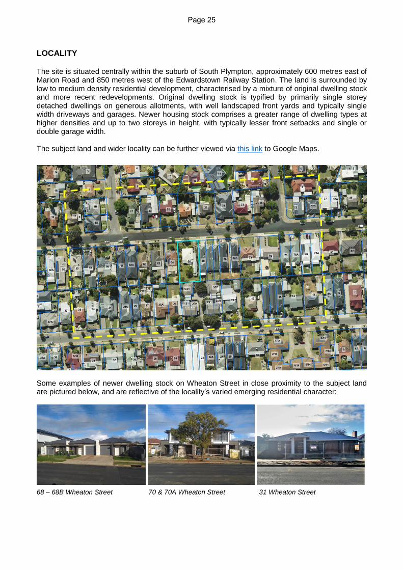
LOCALITY The site is situated centrally within the suburb of South Plympton, approximately 600 metres east of Marion Road and 850 metres west of the Edwardstown Railway Station. The land is surrounded by low to medium density residential development, characterised by a mixture of original dwelling stock and more recent redevelopments. Original dwelling stock is typified by primarily single storey detached dwellings on generous allotments, with well landscaped front yards and typically single width driveways and garages. Newer housing stock comprises a greater range of dwelling types at higher densities and up to two storeys in height, with typically lesser front setbacks and single or double garage width. The subject land and wider locality can be further viewed via this link to Google Maps.
Some examples of newer dwelling stock on Wheaton Street in close proximity to the subject land are pictured below, and are reflective of the locality’s varied emerging residential character:
68 – 68B Wheaton Street 70 & 70A Wheaton Street 31 Wheaton Street
Page 25

PROPOSED DEVELOPMENT The proposal seeks to construct two single storey dwellings, each on half of the existing allotment and facing the street. For the purposes of this assessment, the eastern dwelling is identified as Dwelling 1 and the western dwelling is identified as Dwelling 2. Each dwelling is proposed as a separate building, and so if this were proposed as part of a combined land division application, the dwellings would be described as detached dwellings. However in the absence of ‘exclusive’ sites as required by the detached dwelling definition, the dwellings are technically undefined. Each dwelling contains three bedrooms and two bathrooms. The front façade of each dwelling presents towards the street with a double garage (split into two separate, stepped single openings), a lounge room window, and a forward-facing front entry door beneath a projecting portico, set behind a landscaped front yard with tapered driveways. An open plan kitchen, living and dining area is located at the rear of each dwelling, which open onto a rear alfresco and a landscaped rear yard. The dwellings differ only in their front portion. The garage of Dwelling 1 achieves a setback from its external side boundary, whereas Dwelling 2 does not. This results in a narrower presentation to the street for Dwelling 1, apparent in the width of the front lounge room. Dwelling 1 proposes to widen the existing crossover into a double width crossover, whereas Dwelling 2 is limited by existing street infrastructure and proposes a new single width crossover. The proposed crossovers are located on the outer edges of the existing allotment and so provide a wide central verge area suitable for on-street vehicle parking, domestic waste collection, and the retention of the existing regulated street tree. The proposed landscaping schedule indicates plantings of two trees within each dwelling’s front and rear yards respectively, for a total of eight trees across the development. These are to be supported by smaller plantings to skirt boundaries and paved areas.
Page 26

PROCEDURAL MATTERS
Classification The application is listed neither as a complying nor non-complying form of development and has therefore been assessed as a ‘merit’ form of development. Categorisation The Public Notification Table of the Residential Zone assigns development which involves a
boundary wall height exceeding 3 metres from natural ground level as a Category 2 form of
development. The proposed boundary wall height of Dwelling 2’s garage measures at 3.12 metres
from natural ground level and so public notification was undertaken. A summary of the public
notification process is contained on the next page.
Referrals Coordinator Arboriculture (Internal): September 2020: Identified the street tree as a regulated Willow Myrtle (Agonis flexuosa), with a trunk circumference of 2.12 metres measured 1 metre from natural ground level. Identified the tree to be in moderate to good health and worthy of protection and retention. Recommended that driveway crossovers be placed on the outer edges of the existing allotment.
May 2021: Re-inspected the tree and determined that the previous advice still applies. Development Engineer (Internal): Confirmed that both spaces of Dwelling 2’s garage are accessible via the proposed driveway. SA Water (informal, by applicant): At the time of writing this report, SA Water are in the process of re-inspecting the site to confirm whether the fire plug marker post located directly adjacent to Dwelling 2’s proposed crossover to can be removed. SA Water initially advised that the post no longer existed, however the post currently remains as was found by a recent site inspection. SA Water have been advised of this and are currently re-inspecting the site. It is understood that fire plug marker posts are now redundant and can generally be removed, as they have been replaced by blue retroreflective raised pavement markers (RRPMs). An RRPM has been installed on the road at this location. A 2007 SA Water document[1] states that:
‘SA Water is in the process of changing from marker posts to RRPMs and associated painted road markings’;
‘After the 1st September 2007 it will no longer be necessary to install marker posts’;
‘Existing marker posts shall be left in position, but they will not be replaced if damaged or stolen’.
Given the above, it is reasonable to expect that that the fire plug marker post can be removed. At the time of writing this report, a further written response from SA Water is pending. If received it will be forwarded to the Panel prior to the meeting. [1] SA Water Technical Standard 135: Fire Hydrant Location Marking – Installation Of Blue Reflectors and Associated Painted Road Markings [viewable at this link].
Page 27

Telstra (informal, by applicant):
At the time of writing this report, Telstra are in the process of providing a written response to the applicant to confirm whether a telecommunications pit at the location of Dwelling 2’s proposed crossover can be relocated (at the applicant’s cost). The pit was only identified as a potential constraint at short notice prior to this meeting, as the pit is not identified on plans, and until recently, overgrown grass obscured the pit from view of a previous site inspection and Council’s aerial imagery.
According to the applicant, Telstra have verbally advised it is possible for the pit to be relocated subject to the applicant’s cost. At the time of writing this report, a written response from Telstra is pending. According to the applicant, Telstra’s written response is expected by the Wednesday prior to the Panel meeting. If received it will be forwarded to the Panel prior to the meeting.
Page 28

PUBLIC NOTIFICATION
Properties Notified
17
Representations 3 received
1 opposing the development and 2 in support
Representations received 1. M Gould - support 2. G Williams - support 3. I Buzila - opposed
Applicant Response Responses by the applicant are included within the Report attachments.
Page 29

ASSESSMENT The assessment is split into three main sections:
1. Zone and Policy Area Consideration, which considers relevant qualitative Zone and Policy Area Objectives, Desired Character and Principles of Development Control;
2. Quantitative Snapshot, which details the proposal’s performance against relevant quantitative Principles of Development Control;
3. Assessment Discussion, which involves detailed discussion of pertinent matters.
Zone and Policy Area Considerations
Residential Zone
Objectives Satisfies
1 An attractive residential zone comprising a range of dwelling types
including a minimum of 15 per cent affordable housing. 2 Increased dwelling densities in close proximity to centres, public and
community transport routes and public open spaces.
The proposal is considered to contribute towards an attractive residential zone. Dwelling designs are well articulated and front yards are well landscaped with tapered driveways, which assist in mitigating garage dominance. The land is not in particularly close proximity to centres, public transport or public open spaces. Nevertheless the proposed density is appropriate and exceeds the minimum desired by the Policy Area.
Relevant Principles of Development Control Satisfies
1 The following forms of development are envisaged in the zone: […]
▪ dwelling including a residential flat building 3 Vacant or underutilised land should be developed in an efficient and co-
ordinated manner to increase housing choice by providing dwellings at densities higher than, but compatible with adjoining residential development.
The proposal is an envisaged form of development. It demonstrates a higher density than original dwelling stock but which is nevertheless compatible with adjoining residential development.
Marion Plains Policy Area 8
Objectives Generally Satisfies
1 A policy area primarily comprising low scale, low to medium density
housing. 3 Development that minimises the impact of garaging of vehicles on the
character of the locality.
Proposal is the low scale, low density housing sought. The impact of garaging is not minimised, however is considered to be suitably mitigated by other factors, including: Each garage being split into two
single openings and stepped accordingly;
Tapered driveways with landscaping on both sides;
Garage setbacks being up to 2.5m
Page 30

4 Development densities that support the viability of community services and infrastructure.
5 Development that reflects good residential design principles. 6 Development that contributes to the desired character of the policy
area.
behind the building line of the eastern adjoining dwelling;
The garages being setback behind the proposed building line and projecting porch.
The proposed density shall support the viability of community services and infrastructure. The design is considered to reflect good residential design principles and contribute to the Desired Character – refer to the Assessment Discussion.
Desired Character Satisfies
This policy area encompasses established residential areas in the central and northern parts of the City of Marion (north of Seacombe Road). The character of streetscapes varies throughout the policy area depending on the era of the original housing, but the prevailing character is derived from single-storey detached dwellings, with a range of other dwelling types scattered throughout. The desired character is an attractive residential environment containing low density dwellings, but at a higher density compared to that typical of the original dwelling stock in the area. The overall character of the built form will gradually improve, while the range of dwelling types will increase to meet a variety of accommodation needs. Development should seek to promote cohesive streetscapes by incorporating designs that are sympathetic to the existing streetscape character, including complementary design features such as pitched roofs, eaves, front verandahs/porches and building materials. Buildings of up to two storeys are appropriate, provided that the additional height and bulk does not adversely impact upon the amenity of adjacent land and the locality. Buildings that present plain box-like built forms and limited detailing are generally inappropriate. Where a new building is built adjacent original dwelling stock, a lesser setback from the primary road frontage is anticipated, provided that the new building is designed to complement the existing streetscape character with regard to building design, articulation, roof form, materials and landscaping. Development will be interspersed with landscaping, particularly between the main road frontage and the building line, to enhance the appearance of buildings from the street, provide an appropriate transition between the public and private realm and reduce heat loads in summer. Low and open-style front fencing will contribute to a sense of space between buildings. Amalgamation of properties is desirable where it will facilitate appropriately designed low-to-medium density development. Development should not result in the removal of mature street trees in a road reserve that contribute positively to the landscape character of the locality.
The proposal is considered to satisfy the Desired Character. The proposal achieves the desired density, and shall contribute to an attractive residential environment. The proposed form and design are compatible with the existing and emerging streetscape character. An appropriate front setback and tapered driveways provide space for meaningful front landscaping to be established as is proposed. No front fencing is proposed. The existing mature regulated street tree shall be retained. Refer to the Assessment Discussion section of this report for further detail.
Page 31

Relevant Principles of Development Control Satisfies
1 The following forms of development are envisaged in the policy area:
▪ affordable housing ▪ dwelling ▪ supported accommodation.
2 Development should not be undertaken unless it is consistent with the desired character for the policy area.
The proposal is considered to generally satisfy all of the relevant Zone and Policy Area considerations listed above. Zone and Policy Area provisions that are more quantitative in nature have not been listed above, and are detailed within the following Quantitative Snapshot table. Pertinent matters, including the Desired Character, are discussed further within the Assessment Discussion thereafter.
Page 32

Quantitative Snapshot
Criteria Dwelling 1 Dwelling 2
Site area 350m2
Policy Area PDC 4 406m2 403m2 Satisfies
Frontage width 10m
Policy Area PDC 4 10.1m 10.02m Satisfies
Depth 20m
Policy Area PDC 4 40.23m 40.23m Satisfies
Site coverage 40%
Policy Area PDC 5 53% (215m2) 53.8% (217m2) Does Not Satisfy
Pervious area
20%
Residential Development
PDC 15 Total pervious area: 22.4% (181m2) Satisfies
Front setback
Average of adjacent (7.2m)
68 Wheaton = 5.4m
64 Wheaton = 9m
Design and Appearance PDC 22
6.97m
(portico to 6.26m)
6.97m
(portico to 6.26m) Minor Departure
Carport/garage setback
5.5m and behind or in-line with main face
Residential Development PDC 12
7.59m and 7.94m; behind main face
7.59m and 7.94m; behind main face
Satisfies
Rear setback (ground)
6m, may be reduced to 3m for <50% rear width
Residential Zone PDC 6
9.65m 9.65m Satisfies
Side setbacks (ground)
0.9m
Residential Zone PDC 6 0.96m 0.96m Satisfies
Boundary walls
8m length
Residential Zone PDC 6
Wall on non-existing internal boundary only. No wall proposed on existing external site boundary.
6.39m length Satisfies
3m height
Residential Zone PDC 6
3.12m height from NGL (2.65m from footings)
Minor Departure
1 side boundary only
Residential Development PDC 38
Walls are on both side boundaries of the dwelling site, however overall the development is only built to one external side boundary.
May Not Satisfy
Building height 2 storeys; 9m
Residential Zone PDC 6 1 storey; 5.28m 1 storey; 5.54m Satisfies
Private open space
20%
Residential Zone PDC 7 23.9% (97m2) 24.1% (97m2) Satisfies
Private open space dimension
5x5m
Residential Zone PDC 7 9.65m x 10.1m 9.65m x 10.02m Satisfies
Garage width
6m or 50% of dwelling façade width (the lesser)
Residential Development PDC 12
5.65m (62%) 5.65m (56%) Does Not Satisfy
Crossover width
3m (single)
5m (double)
Residential Development PDC 39
5m (double) 3m (single) Satisfies
Off-street parking 2 (1 covered)
Table Mar/2 4 (2 covered) 3 (2 covered) Satisfies
On-street parking 1 per 2 allotments
Land Division PDC 23 1 space to direct frontage (10.9m) N/A, but Satisfies
Page 33

Assessment Discussion Consideration and discussion of the following matters in particular are considered pertinent in reaching a recommendation for the proposal:
Desired Character
Site coverage
Garage width
Boundary-to-boundary (Dwelling 2) Desired Character Overall, the proposal is considered to satisfy the Desired Character statement of Marion Plains Policy Area 8. Due to the importance of the Desired Character in an assessment, it is considered worthy of particular attention in this assessment discussion, and so is discussed in detail below. The proposed site areas and dimensions exceed the minimums sought by Policy Area Principle 4 for detached dwellings. Likewise, the proposed density is consistent with the density sought by the Desired Character, which is ‘low’ but ‘at a higher density compared to that typical of original dwelling stock’. As such, proposing two dwellings on the subject land is fundamentally appropriate. The proposed low scale, single storey nature of the proposed dwellings is consistent with the prevailing character of single storey dwellings and promotes a cohesive streetscape. The proposed building designs are considered to be sympathetic to the original and emerging streetscape character, involving pitched roofs, eaves, a front porch and building materials of face brick with render. Each dwelling’s front façade has three steps at different setbacks and a projecting porch, and so incorporates sufficient detailing to avoid being regarded as ‘plain’ or ‘box-like’. One aspect of the proposal which is somewhat contrary to the prevailing character is proportion of garaging and habitable areas on the front façades, especially in the case of Dwelling 1. This is discussed in further detail in the ‘Garage width’ section of this discussion, and is not considered to be at strong variance to the design outcomes sought by the Desired Character. The proposed front setbacks respond to the Desired Character’s desire for new buildings to have a lesser front setback than original dwelling stock. As the proposed front setbacks are close to the average of the new and original adjoining dwellings on either side of the subject land, they remain compatible with both original and emerging dwelling stock and promote a cohesive streetscape. The front setback together with tapered driveways also provide space for meaningful front landscaping to be established as desired, including tree plantings that will assist in enhancing appearance, provide a landscaped transition, and reduce heat loads in summer. No front fencing is proposed, and the existing mature regulated street tree shall be retained. On balance the proposal is considered to satisfy the Objectives and Desired Character statement of Marion Plains Policy Area 8. Site coverage The proposed site coverage of 53% and 53.8% per dwelling exceed the maximum 40% sought by Policy Area Principle 5. This proportion of site coverage includes an under-main-roof alfresco area per dwelling. If each alfresco were to be excluded, the site coverage of the dwellings alone would measure at 49.3% and 50.1% respectively. Incorporation of an alfresco area as part of the subject application reduces the potential need for future owners/occupiers to construct a verandah in the future. The higher proportion of site coverage proposed is reasonably justified by the benefit derived
Page 34

from delivering a usable all-weather area of private open space in conjunction with the dwelling together with an ample area of private open space which remains uncovered. Residential Zone Principle 9 states that site coverage should not exceed the relevant quantitative amount unless doing so would not be contrary to other relevant criteria of the Development Plan. The proposed dwellings achieve an appropriate front setback, satisfy minimum side and rear setback criteria, and are provided with a functional area of private open space which exceeds the minimum required. The proposed dwellings are low scale and the excess in site coverage shall not adversely affect the amenity of adjoining properties. Sufficient space is provided for the domestic requirements listed under Residential Development Principle 14, including domestic storage, outdoor clothes drying, rainwater tanks, and storage of waste bins. Sufficient pervious area is provided to satisfy Residential Development Principle 15, including good areas and dimensions of soft landscaping to the front and rear of the dwellings for meaningful vegetation to be established. The only variances it could be argued that site coverage contributes towards are the garage width relative to the dwelling façades, and the boundary-to-boundary nature of Dwelling 2. In both cases, these matters are each considered to be acceptable for the reasons detailed below. Garage width Residential Development Principle 12 specifies that a garage’s frontage width should not exceed 6 metres or 50% of the associated dwelling façade (whichever is the lesser). Measured to the portico pier, the proposed garage frontage width is 5.65 metres per dwelling, which equates to 62% of the dwelling façade width for Dwelling 1 and 56% for Dwelling 2. Despite this, the proposed garages are not considered to dominate the streetscape. While the proposed development does not ‘minimise’ the impact of garaging on the character of the locality as sought by Policy Area Objective 3, it demonstrates measures to mitigate any associated visual impacts and is considered to demonstrate good residential design principles. Factors which help to mitigate the impact of the garaging include:
Each garage being split into two single openings and stepped accordingly;
Garage setbacks being up to 2.5m behind the building line of the eastern adjoining dwelling;
The garages being setback behind the proposed building line and projecting porch;
Tapered driveways to reduce the extent of paved areas forward of the building line, with landscaping on both sides;
The provision of landscaping forward of the building line including the planting of two Magnolia grandiflora trees per front yard which can reach significant growth heights.
Considered in more detail, the split in each garage breaks up the appearance of the garaging by separating the openings and stepping them at staggered setbacks. The roof form reflects this stepping and provides further articulation accordingly. Together with the garages being setback behind the building line of the associated dwelling and the eastern adjoining dwelling, these design techniques shall reduce the prominence of the garaging when viewed from the street. The driveways are also tapered, narrowing towards the front of the allotment. This reduces the extent of paved areas forward of the building line and provides opportunity for landscaping to be established directly between the central garage opening of each dwelling and the street, which may assist in softening or partially obscuring it from view. Landscaping is proposed on both sides of the proposed driveways, which shall skirt the paved areas and emphasise a landscaped character as desired by the Policy Area.
Page 35

Despite the proposed garage width, each dwelling presents desirable design elements towards the primary street, including a habitable room window to facilitate passive surveillance, a forward-facing front entry door to provide a sense of address, and a projecting portico to provide shelter and additional articulation to the front elevation. The habitable room window of Dwelling 2 is reasonably large, however it is noted that the habitable room window of Dwelling 1 is comparatively narrow. Notwithstanding this, the window is capable of facilitating passive surveillance as it presents from a room with dimensions capable of use as a small lounge room or study. The proposed window and the room it presents from are larger than the front window and room of the eastern adjoining dwelling at 68 Wheaton Street, as pictured in the photograph and elevation comparison below. Overall, the proposed garage width is not considered fatal to the merits of the application. Design techniques, siting and landscaping are considered to sufficiently reduce the appearance of garage dominance and mitigate the impacts of garaging on the character of the locality. Boundary-to-boundary (Dwelling 2) Residential Development Principle 38 states, ‘Dwellings and associated garages and/or carports should only abut one side boundary (excluding common walls associated with semi-detached, row or residential flat dwellings)’. It may be interpreted that Dwelling 2 does not satisfy this Principle by being constructed to both of its proposed side boundaries. It should be noted that this Principle excludes common walls associated with semi-detached, row or residential flat dwellings. In practice, if such a dwelling type were proposed, this would enable the construction of the building to one external side boundary of the subject land, however not the other (as shown by the example below). This understanding of the criteria has resulted in numerous semi-detached or row dwelling developments across the Council area being constructed in this way. This is evidenced by several row dwelling developments in the locality, including the one immediately east of the land at 68 Wheaton Street (as pictured below).
Interpretation of Residential Development PDC 38 as it applies to semi-detached, row or residential flat dwellings.
The Principle in practice, showing 68 – 68B Wheaton Street (the eastern adjoining development) overall abutting one external side boundary but not the other.
Page 36

Visually and functionally, the subject application proposes the same outcome. The only difference being that the central wall is not a ‘common’ or ‘party’ wall, but is two separate abutting boundary walls. If the proposal were amended to be joined by a party wall, it would satisfy this Principle. In my view, requiring the proposal to be amended in such a way would serve no material benefit and serve no functional purpose: put frankly, it would ‘achieve nothing’. It should also be noted that if one detached dwelling were proposed on the subject land, it could be constructed to one of the external side boundaries and would satisfy the Principle. The intent of the Principle is to prevent wall-to-wall development at a streetscape scale by requiring separation between separate developments. In my view, the proposed development satisfies this intent as Dwelling 1 achieves a side setback to an external side boundary of the subject land. As such, in my view the proposed boundary-to-boundary nature of Dwelling 2 is acceptable and can be supported in its current form. Minor & Inconsequential Shortfall Discussion The minor variances to the following criteria, as identified within the Quantitative Snapshot table, are considered to be justified and are discussed accordingly below:
Front setback
Boundary wall height (Dwelling 2) Front setback The proposed front setback to the building line of 6.97 metres falls marginally short of the minimum 7.2 metres desired by Design and Appearance Principle 22, being the average of the adjoining dwellings. This shortfall is minor, and in any case, responds to the Policy Area’s Desired Character which seeks for new buildings to have a lesser front setback than typical of original dwelling stock. The proposed front setback shall be compatible with the streetscape and contribute positively to its function and appearance. Boundary wall height (Dwelling 2) The proposed boundary wall of Dwelling 2 presents towards the western adjoining property at a height of 3.12 metres from natural ground level. This marginally exceeds the maximum 3 metre boundary wall height sought by Residential Zone Principle 6. It is noted the wall height is only 2.65 metres from footings, which is a typical residential single storey boundary wall height. The additional wall height is due to the height of floor level above natural ground level. Should the eastern adjoining land be developed in future, it is likely to be filled to a similar level as the subject land and if so the additional wall height above 3 metres would not be apparent in future. In the meantime, the impacts caused by the additional wall height shall not be materially different to those which would be caused by a compliant wall height, and are not considered unreasonable.
Page 37

CONCLUSION On balance, the proposal achieves the majority of applicable Principles of Development Control contained within the Marion Council Development Plan. It is fundamentally appropriate to propose two dwellings on the subject land: the proposed sites meet or exceed minimum site area, frontage width and depth criteria. The only departures of note relate to the proposed built form: specifically site coverage, garage width, and the boundary-to-boundary nature of Dwelling 2. As discussed within the body of the report, the proposed site coverage does not directly result in any unreasonable consequences. While it could be argued the site coverage contributes to the proposed garage width and boundary-to-boundary nature of Dwelling 2, these aspects are considered acceptable in their own right. Impacts of the proposed garage width on the streetscape are acceptably mitigated by design techniques and landscaping, while the habitable portions of the dwellings are each considered to present acceptably to the street. The boundary-to-boundary nature of Dwelling 2 is not considered to adversely affect the streetscape, as Dwelling 1 provides separation to an external boundary of the subject land, which prevents the overall development from being ‘boundary-to-boundary’. Essentially the same outcomes are permitted for semi-detached, row or residential flat dwellings, and examples of these are found within the locality and streetscape. As a result of the above considerations, it is my view that the proposed development is not seriously at variance to the Marion Council Development Plan, in accordance with Section 35 (2) of the Development Act 1993. Further, the proposed development sufficiently accords with the relevant provisions of the Marion Council Development Plan, and warrants Development Plan Consent subject to conditions.
Page 38

RECOMMENDATION Having considered all relevant planning matters in relation to the subject development application: (a) The Panel note this report and concur with the findings and reasons for the
recommendation; (b) The Panel concur that the proposed development is not seriously at variance to the
Marion Council Development Plan, in accordance with Section 35 (2) of the Development Act 1993; and
(c) That Development Plan Consent for Development Application No: 100/2021/38 for two
single storey dwellings at 66 Wheaton Street, South Plympton be GRANTED subject to the following conditions:
CONDITIONS 1. The development granted Development Plan Consent shall be undertaken and
completed in accordance with the stamped plans and documentation, except where varied by conditions below (if any).
2. Prior to the use and/or occupation of the structure(s), all stormwater from buildings and paved areas shall be disposed of in accordance with the approved plans and details.
3. All car parking areas, driveways and vehicle manoeuvring areas must be constructed in
accordance with the approved plans and recognised engineering practices prior to the occupation of the premises or the use of the development herein approved and maintained in a good condition at all times.
4. Any form of development on the property boundary (such as mortar joints on any face
brickwork, blueboard material or similar, render etc) shall be finished in a professional manner and to the same standard as the remainder of the subject dwelling.
5. Landscaping shall be planted and maintained in accordance with the plans and details forming part of the development authorisation.
NOTES 1. This approval does not relate to the removal of, or to any tree damaging activity to, any
regulated or significant tree (as defined under the Planning, Development and Infrastructure Act 2016) that may be located on the subject site or adjoining land. Removal or tree damaging activity may not occur unless a relevant separate Development Approval is received.
Should regulated or significant tree(s) exist, care must be taken during demolition/construction of the proposed buildings and in particular the stormwater discharge pipes to ensure no damage is done to that/those tree(s) (including their root systems) unless otherwise approved by Council. For this reason, a protective barrier should be erected at the dripline of the tree, and that barrier should be maintained for the duration of the demolition/construction. It is also recommended that you seek the advice of a qualified arborist.
Page 39

5. APPEALS UPDATE CITY OF MARION COUNCIL ASSESSMENT PANEL AGENDA FOR MEETING TO BE HELD ON WEDNESDAY 07 JULY 2021
5.1 APPEALS AGAINST PANEL DECISIONS New Appeals
DA No. Address Appeal Lodged
Recommendation Decision Current Status
On-going Appeals
DA No. Address Appeal Lodged
Recommendation Decision Current Status
5.2 APPEALS AGAINST DELEGATED APPLICATIONS
DA No. Address Appeal Lodged
Recommendation Decision Current Status
2020/534 341
Diagonal Road,
Seacombe gardens
22/3/2021 REFUSED REFUSED Conference listed for 13 August 2021
Page 40

6. POLICY OBSERVATIONS
CITY OF MARION
COUNCIL ASSESSMENT PANEL AGENDA
FOR MEETING TO BE HELD ON
WEDNESDAY 07 JULY 2021
Verbal Update Provided
Page 41

REPORT REFERENCE: Other Business CITY OF MARION COUNCIL ASSESSMENT PANEL AGENDA FOR MEETING TO BE HELD ON WEDNESDAY 7 JULY 2021
Originating Officer: Alex Wright
Team Leader - Planning
Report: Council Assessment Panel General Analysis
Report Type: General Business
Recommendation: Council Assessment Panel NOTES the report.
The Marion Council Assessment Panel was appointed as a relevant authority under Section of 82 and 83 of the Planning, Development and Infrastructure Act 2016 by Council resolution in August 2017. The Council Assessment Panel first met on 1 November 2017. This report provides members with a snapshot of the CAP operations from its inception (November 2017) until June 2021. The report includes statistical data on the following;
• The number of applications presented to the CAP and their general type
• The number of representors and applicants present
• The average length of CAP meetings
• The reason for delegation to the CAP
• Administration recommendation to CAP
• Panel Decisions, including the percentage of decisions not in line with administration recommendation
The following tables provides a summary and comparison of key indicators relating to Development Applications assessed by the Panel since inception: General Meeting Statistics
Meetings 20171 2018 2019 2020 20212
No of Meetings 2 12 10 15 5
Ave duration (hours) 3:24 1:48 1:42 1:44 1:01
Average No. Reports per meeting 7.5 4.25 3.2 2 2.4
Avg Applicants Per Meeting 5 1.5 2.5 2 1.6
Average Reps per Meeting 1.5 1.1 3.2 2 0.8
Total Site Visits 1 4 1 3 0
Total Items 15 57 32 50 12
1 From November-December 2017 2 From January to June 2021
Page 42

Generalised Types of Applications Considered by the Panel.
Meetings 2017 2018 2019 2020 2021
Residential (Dwellings/Land Divisions)
9 49 20 32 6
Residential (Additions/ancillary structures)
0 1 0 1 0
Commercial/Industrial 3 4 6 8 3
Other (School, Signage, Phone towers etc)
3 3 6 9 3
Total Items 15 57 32 50 12
It is noted the vast majority of applications presented to the Panel comprise residential forms of development, most commonly consisting of dwelling (single or multiple) and/or residential land division applications. Delegations
Meetings 2017 2018 2019 2020 2021
Non-Complying 0 2 3 6 4
Application Category 2 or 3 and subject to Representations which were against and wished to be heard.
4 17 10 17 6
Relates to demolition of a local or state heritage place 0 0 0 0 0
Undersized land division 2 3 6 4 0
Undersized land use 1 12 2 2 0
Undersized combined land use/division* 2 5 4 4 0
Total Applications assessed due to undersized nature 5 20 12 10 0
Minister declined to determine application 0 0 0 1 0
Application subject to an appeal 2 10 2 8 0
Manager determines application warrants CAP consideration
0 0 5 5 2
Application Deferred by CAP# 1 2 0 4 0
The following delegations were removed following consideration by Council in September 2018.
Application previously considered by the CAP 2 4 - - -
Signage face area exceeded 10 square metres 1 0 - - -
Reason for CAP consideration unclear 0 2 - - -
* Falls into either undersized land use and/or land division delegated clause # Application originally considered by CAP and deferred applications considered reports in their own right
The majority of applications considered by the Panel involved dwellings and/or land divisions proposing undersized site areas, closely followed by applications which were Publicly Notified and received representations against who wished to be heard. It is noted there has been an increase in non-complying applications and applications determined by the Manager to warrant consideration by the Panel.
Page 43

It is noted the Panel considered more types application types in 2020 than 2019, with a significant increase in both residential and non-residential type applications. Recommendations & Decisions Administration Recommendations
Decisions 2017 2018 2019 2020 2021 Total
Approve Application 14 51 29 48 12 154
Refuse Application 1 6 3 2 0 12
Panel Decisions
Decisions 2017 2018 2019 2020 2021 Total
Approve Application 10 34 20 35 10 109
Refuse Application 3 19 9 13 2 46
Defer Application 1 3 3 2 0 9
Decisions not in line with recommendation 5/14 14/56 9/32 15/50 2/12 45/164
Percentage of decisions not in line with recommendation
36% 25% 28% 30% 16.6% 27.4%
Application withdrawn 1 1 0 0 0 2
It is noted approximately 29% of decisions made by the Panel were not in-line with the recommendation of administration. Of those decisions; the Panel deferred 8 applications, refused 30 and approved 1.
Appeals
Of the 13 applications refused by the Panel, 6 were appealed to the Environment, Resources
and Development Court. Of those appealed;
• 5 gained approval through a compromise supported by the Panel
• 2 were withdrawn
It is worth noting no decision by the CAP has proceeded to a full appeal.
Planning, Development & Infrastructure Act 2016
The Planning, Development and Infrastructure Act 2016 was ‘switched on’ on 19 March 2021.
Under the PDI Act 2016 only applications which require Public Notification will, unless further
delegated to the Assessment Manager, require consideration by the Panel.
In general, residential development within a residentially based zone will only require consideration by the Panel in the following instances;
• The proposal either exceeds the specified building height (predominantly 9 metres in most zones)
• The proposal exceeds the height and/or length requirements for boundary development
Page 44

• A proposal within the Hills Neighbourhood Zone incorporates retaining exceeding 1.5 metres and/or proposes more than 9 cubic metres of earthworks.
It is evident, based on the Code’s current operations, the Panel will consider less residential type applications. It is anticipated however a similar volume of non-residential applications under the PDI will be considered by the Panel.
Conclusion
In summary, these statistics are provided for the panel to gain an understanding of the types
and nature of applications that are delegated to CAP for decision.
Page 45