north central wisconsin regional bicycle facilities ... central wisconsin regional bicycle...
TRANSCRIPT

North Central Wisconsin Regional Planning CommissionPrepared By:
North Central Wisconsin RegionalBicycle Facilities Network Plan
210 McClellan Street, Suite 210, Wausau, Wisconsin, 54403 (715) 849-5510, Email: [email protected], Webpage: www.ncwrpc.org
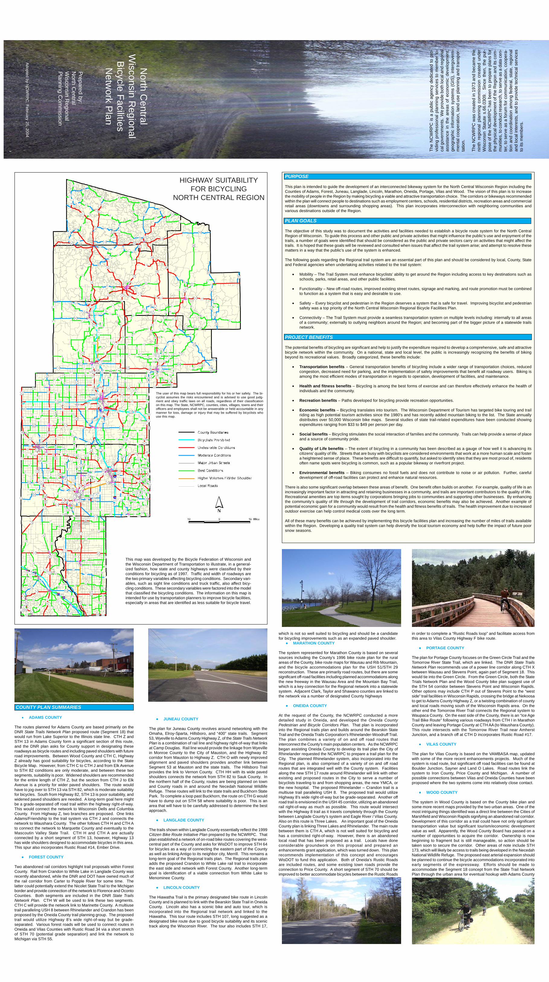
The user of this map bears full responsibility for his or her safety. Thebicyclist assumes the risks encountered and is advised to use good judg-ment and obey traffic laws on all roads, regardless of their classificationon this map. The State, NCWRPC, counties, cities, villages, towns andtheir officers and employees shall not be answerable or held account-able in any manner for loss, damage or injury that may be suffered bybicyclists who use this map.
The information on this map should be used by state and local transpor-tation planners to improve bicycle facilities, especially in areas that arecurrently less suitable for bicycle travel and experiencing growth or in-creased auto congestion. Transportation planners should also consultthe Wisconsin Department of Transportation State Bicycle Plan as wellas bicycle groups and local bicycle plans before any decisions are madethat could affect the use of a route for bicycling.
Table 1 summarizes the effect of the Regional Trails Plan by county. Overall, the plan recommendsincreasing total miles of bike route across the Region by 834 miles from 1,749 to 2,583 miles.
This Map conceptually illustrates how the planned Regionalbike trail system might fit into a larger, statewide network.
Shared Use Road-way
Paved Shoulders
Statewide TrailNetwork Concept
On-Street Bike Routes Off-Street Bike Routes On- & Off- Street Bike Routes
Existing Proposed Total Existing Proposed Total Existing Proposed Total
Adams 0 85 85 0 0 0 0 85 85
Forest 16 65 81 12 42 54 28 107 135
Juneau 0 151 151 27 17 44 27 168 195
Langlade 177 13 190 0 17 17 177 30 207
Lincoln 69 7 76 6 0 6 75 7 82
Marathon 490 10 500 28 15 43 518 25 543
Oneida 122 38 160 30 92 122 152 130 282
Portage 56 35 91 38 20 58 94 55 149
Vilas 535 4 539 31 17 48 566 21 587
Wood 106 174 280 6 32 38 112 206 318
Total 1,571 582 2,153 178 252 430 1,749 834 2,583
TABLE 1 - MILES* OF EXISTING AND PROPOSED BICYCLE ROUTES IN NORTH CENTRAL REGION
County
*The number of lane-miles will normally be approximately twice the number of on-street route miles as these routes would belocated along both sides of a street. Off-street routes would generally accommodate two-way travel.
This brochure is a summary of the NorthCentral Wisconsin Regional Bicycle Fa-cilities Network Plan report publishedseparately by the NCWRPC. Copies ofthe full text are available by contactingthe NCWRPC as indicated at the bot-tom of this page.
••••• JUNEAU COUNTY
The plan for Juneau County revolves around networking with theOmaha, Elroy-Sparta, Hillsboro, and “400” state trails. Segment53, Wyeville to Adams County Highway Z, of the State Trails NetworkPlan is a combination of rail line and highway right-of-way that linksat Camp Douglas. Rail line would provide the linkage from Wyevillein Monroe County to the City of Mauston, and the Highway 82corridor from Mauston to Highway Z. CTH O with newly improvedalignment and paved shoulders provides another link betweenSegment 53 at Mauston and the state trails. The Hillsboro Trailprovides the link to Vernon County. CTH HH with its wide pavedshoulders connects the network from STH 82 to Sauk County. Inthe northern half of the County, routes are being planned on townand County roads in and around the Necedah National WildlifeRefuge. These routes will link to the state trails and Buckhorn StatePark. To complete a loop past Buckhorn, the route on CTH G wouldhave to dump out on STH 58 where suitability is poor. This is anarea that will have to be carefully addressed to determine the bestapproach.
••••• LANGLADE COUNTY
The trails shown within Langlade County essentially reflect the 1999Citizen Bike Route Initiative Plan prepared by the NCWRPC. Thatplan established a network of on-road bike routes covering the west-central part of the County and asks for WisDOT to improve STH 64for bicycles as a way of connecting the eastern part of the Countyas well as linking Antigo to its neighbor city, Merrill. This remains along-term goal of the Regional trails plan. The Regional trails planadds the proposed Crandon to White Lake rail trail to incorporatethe east side and network with Forest County. Another long-termgoal is identification of a viable connection from White Lake toMenominee County.
••••• LINCOLN COUNTY
The Hiawatha Trail is the primary designated bike route in LincolnCounty and is planned to link with the Bearskin State Trail in OneidaCounty. Lincoln also has a scenic bike and auto tour, which isincorporated into the Regional trail network and linked to theHiawatha. This tour route includes STH 107, long suggested as adesignated bike route due to good bicycle suitability and its scenictrack along the Wisconsin River. The tour also includes STH 17,
which is not so well suited to bicycling and should be a candidatefor bicycling improvements such as an expanded paved shoulder.
••••• MARATHON COUNTY
The system represented for Marathon County is based on severalsources including the County’s 1996 bike route plan for the ruralareas of the County, bike route maps for Wausau and Rib Mountain,and the bicycle accommodations plan for the USH 51/STH 29reconstruction. These are primarily road routes, but there are somesignificant off-road facilities including planned accommodations alongthe new freeway in the Wausau Area and the Mountain Bay Trail,which is a key connection for the Regional network into a statewidesystem. Adjacent Clark, Taylor and Shawano counties are linked tothe network via a number of designated County highways
••••• ONEIDA COUNTY
At the request of the County, the NCWRPC conducted a moredetailed study in Oneida, and developed the Oneida CountyPedestrian and Bicycle Corridors Plan. That plan is incorporatedinto the Regional trails plan and builds around the Bearskin StateTrail and the Oneida Trails Corporation’s Rhinelander-Woodruff Trail.The plan combines a variety of on and off road routes thatinterconnect the County’s main population centers. As the NCWRPCbegan assisting Oneida County to develop its trail plan the City ofRhinelander requested the NCWRPC to prepare a trail plan for theCity. The planned Rhinelander system, also incorporated into theRegional plan, is also comprised of a variety of on and off roadroutes that are integrated well with the County system. Facilitiesalong the new STH 17 route around Rhinelander will link with otherexisting and proposed routes in the City to serve a number ofbicyclists traveling to and from shopping areas, the new YMCA, orthe new hospital. The proposed Rhinelander – Crandon trail is amultiuse trail paralleling USH 8. The proposed trail would utilizeHighway 8’s wide right-of-way but be grade-separated. Another offroad trail is envisioned in the USH 45 corridor, utilizing an abandonedrail right-of-way as much as possible. This route would intersectwith the Highway 8 trail as it travels completely through the Countybetween Langlade County’s system and Eagle River / Vilas County.Also on this route is Three Lakes. An important goal of the OneidaCounty plan is linking Three Lakes and Rhinelander. The main routebetween them is CTH A, which is not well suited for bicycling andhas a constricted right-of-way. However, there is an abandonedlocal road that has been proposed as a trail. Locals have doneconsiderable groundwork on this proposal and prepared anenhancements grant application, which was turned down. This planrecommends implementation of this concept and encouragesWisDOT to fund this application. Both of Oneida’s Rustic Roadsare included routes, and some existing town roads provide theconnection to Price County. A short segment of STH 70 should beimproved to better accommodate bicycles between the Rustic Roads
in order to complete a “Rustic Roads loop” and facilitate access fromthis area to Vilas County Highway F bike route.
••••• PORTAGE COUNTY
The plan for Portage County focuses on the Green Circle Trail and theTomorrow River State Trail, which are linked. The DNR State TrailsNetwork Plan recommends use of a power line corridor along CTH Xbetween Wausau and Stevens Point, again part of Segment 18. Thiswould tie into the Green Circle. From the Green Circle, both the StateTrials Network Plan and the Wood County bike plan suggest use ofthe STH 54 corridor between Stevens Point and Wisconsin Rapids.Other options may include CTH P out of Stevens Point to the “westside” trail facilities in Wisconsin Rapids, crossing the bridge at Nekoosato get to Adams County Highway Z, or a twisting combination of countyand local roads moving south of the Wisconsin Rapids area. On theother end the Tomorrow River Trail connects the Regional system toWaupaca County. On the east side of the County, there is an “Ice AgeTrail Bike Route” following various roadways from CTH I in MarathonCounty and leaving Portage County at CTH AA (to Waushara County).This route intersects with the Tomorrow River Trail near AmherstJunction, and a branch off at CTH D incorporates Rustic Road #17.
••••• VILAS COUNTY
The plan for Vilas County is based on the VAMBASA map, updatedwith some of the more recent enhancements projects. Much of thesystem is road route, but significant off road facilities can be found atBoulder Junction, Sayner and Land O Lakes. Road routes link thesystem to Iron County, Price County and Michigan. A number ofpossible connections between Vilas and Oneida Counties have beenproposed where the two systems come into relatively close contact.
••••• WOOD COUNTY
The system in Wood County is based on the County bike plan andsome more recent maps provided by the two urban areas. One of themost intriguing things identified was a direct line between the Cities ofMarshfield and Wisconsin Rapids signifying an abandoned rail corridor.Development of this corridor as a trail could have not only significanttransportation value but significant tourism/economic developmentvalue as well. Apparently, the Wood County Board has passed on anumber of opportunities to acquire the corridor. Ownership is nowbeginning to fragment but is still manageable, so action should betaken soon to secure the corridor. Other areas of note include STH173, which will likely be access to trails being developed in the NecedahNational Wildlife Refuge. The proposed east arterial expansion shouldbe planned to continue the bicycle accommodations incorporated intoearly segments of the expressway. Efforts should be made toaccommodate the Segment 18 concept from the State Trail NetworkPlan through the urban area for eventual hookup with Adams CountyHighway Z.
North C
entralW
isconsin Regional
Bicycle FacilitiesN
etwork P
lan
Prepared by:N
orth Central
Wisconsin R
egionalPlanning C
omm
ission
The
NC
WR
PC
is a
pub
lic a
genc
y de
dica
ted
to p
ro-
vidi
ng p
rofe
ssio
nal p
lann
ing
serv
ices
to m
embe
r lo-
cal g
over
nmen
ts.
We
prov
ide
both
loca
l and
regi
onal
assi
stan
ce in
the
are
as o
f ec
onom
ic d
evel
opm
ent,
geog
raph
ic in
form
atio
n sy
stem
s (G
IS),
inte
rgov
ern-
men
tal c
oope
ratio
n, la
nd u
se p
lann
ing
and
trans
por-
tatio
n.
The
NC
WR
PC
was
cre
ated
in 1
973
and
beca
me
the
nint
h re
gion
al p
lann
ing
com
mis
sion
cre
ated
und
erW
isco
nsin
Sta
tute
s.6
6.03
09.
Sin
ce t
hen,
the
pur
-po
se o
f the
NC
WR
PC
has
bee
n to
pre
pare
pla
ns fo
rth
e ph
ysic
al d
evel
opm
ent o
f the
Reg
ion
and
its c
om-
mun
ities
, to
cond
uct r
esea
rch,
to s
erve
as
a da
ta c
en-
ter,
to s
erve
as
a fo
rum
for c
omm
unic
atio
n, c
oope
ra-
tion
and
coor
dina
tion
amon
g fe
dera
l, st
ate,
regi
onal
and
loca
l int
eres
ts, a
nd to
pro
vide
tech
nica
l ser
vice
sto
its
mem
bers
.A
dopted by NC
WR
PC
, February 25, 2004
This map was developed by the Bicycle Federation of Wisconsin andthe Wisconsin Department of Transportation to illustrate, in a general-ized fashion, how state and county highways were classified by theirconditions for bicycling as of 1997. Traffic and width of roadways arethe two primary variables affecting bicycling conditions. Secondary vari-ables, such as sight line conditions and truck traffic, also affect bicy-cling conditions. These secondary variables were factored into the modelthat classified the bicycling conditions. The information on this map isintended for use by transportation planners to improve bicycle facilities,especially in areas that are identified as less suitable for bicycle travel.
HIGHWAY SUITABILITYFOR BICYCLING
NORTH CENTRAL REGION
PURPOSE
This plan is intended to guide the development of an interconnected bikeway system for the North Central Wisconsin Region including theCounties of Adams, Forest, Juneau, Langlade, Lincoln, Marathon, Oneida, Portage, Vilas and Wood. The vision of this plan is to increasethe mobility of people in the Region by making bicycling a viable and attractive transportation choice. The corridors or bikeways recommendedwithin the plan will connect people to destinations such as employment centers, schools, residential districts, recreation areas and commercialretail areas (downtowns and surrounding shopping areas). This plan incorporates interconnection with neighboring communities andvarious destinations outside of the Region.
PLAN GOALS
The objective of this study was to document the activities and facilities needed to establish a bicycle route system for the North CentralRegion of Wisconsin. To guide this process and other public and private activities that might influence the public’s use and enjoyment of thetrails, a number of goals were identified that should be considered as the public and private sectors carry on activities that might affect thetrails. It is hoped that these goals will be reviewed and consulted when issues that affect the trail system arise; and attempt to resolve thesematters in a way that the public’s use of the system is enhanced.
The following goals regarding the Regional trail system are an essential part of this plan and should be considered by local, County, Stateand Federal agencies when undertaking activities related to the trail system:
• Mobility – The Trail System must enhance bicyclists’ ability to get around the Region including access to key destinations such asschools, parks, retail areas, and other public facilities.
• Functionality – New off-road routes, improved existing street routes, signage and marking, and route promotion must be combinedto function as a system that is easy and desirable to use.
• Safety – Every bicyclist and pedestrian in the Region deserves a system that is safe for travel. Improving bicyclist and pedestriansafety was a top priority of the North Central Wisconsin Regional Bicycle Facilities Plan.
• Connectivity – The Trail System must provide a seamless transportation system on multiple levels including: internally to all areasof a community; externally to outlying neighbors around the Region; and becoming part of the bigger picture of a statewide trailsnetwork.
PROJECT BENEFITS
The potential benefits of bicycling are significant and help to justify the expenditure required to develop a comprehensive, safe and attractivebicycle network within the community. On a national, state and local level, the public is increasingly recognizing the benefits of bikingbeyond its recreational values. Broadly categorized, these benefits include:
• Transportation benefits – General transportation benefits of bicycling include a wider range of transportation choices, reducedcongestion, decreased need for parking, and the implementation of safety improvements that benefit all roadway users. Biking isamong the most efficient modes of transportation in regards to operation, development of facilities, and maintenance.
• Health and fitness benefits – Bicycling is among the best forms of exercise and can therefore effectively enhance the health ofindividuals and the community.
• Recreation benefits – Paths developed for bicycling provide recreation opportunities.
• Economic benefits – Bicycling translates into tourism. The Wisconsin Department of Tourism has targeted bike touring and trailriding as high potential tourism activities since the 1980’s and has recently added mountain biking to the list. The State annuallydistributes over 50,000 Wisconsin bike maps. Several studies of state trail-related expenditures have been conducted showingexpenditures ranging from $33 to $49 per person per day.
• Social benefits – Bicycling stimulates the social interaction of families and the community. Trails can help provide a sense of placeand a source of community pride.
• Quality of Life benefits – The extent of bicycling in a community has been described as a gauge of how well it is advancing itscitizens’ quality of life. Streets that are busy with bicyclists are considered environments that work at a more human scale and fostera heightened sense of place. These benefits are difficult to quantify, but asked to identify sites that they are most proud of, residentsoften name spots were bicycling is common, such as a popular bikeway or riverfront project.
• Environmental benefits – Biking consumes no fossil fuels and does not contribute to noise or air pollution. Further, carefuldevelopment of off-road facilities can protect and enhance natural resources.
There is also some significant overlap between these areas of benefit. One benefit often builds on another. For example, quality of life is anincreasingly important factor in attracting and retaining businesses in a community, and trails are important contributors to the quality of life.Recreational amenities are top items sought by corporations bringing jobs to communities and supporting other businesses. By enhancingthe community’s quality of life through the development of trail corridors, economic benefits may also be achieved. Another example ofpotential economic gain for a community would result from the health and fitness benefits of trails. The health improvement due to increasedoutdoor exercise can help control medical costs over the long term.
All of these many benefits can be achieved by implementing this bicycle facilities plan and increasing the number of miles of trails availablewithin the Region. Developing a quality trail system can help diversify the local tourism economy and help buffer the impact of future poorsnow seasons.
COUNTY PLAN SUMMARIES
• ADAMS COUNTY
The routes planned for Adams County are based primarily on theDNR State Trails Network Plan proposed route (Segment 18) thatwould run from Lake Superior to the Illinois state line. CTH Z andSTH 13 in Adams County form a significant section of this route,and the DNR plan asks for County support in designating theseroadways as bicycle routes and including paved shoulders with futureroad improvements. Between Wood County and CTH C, HighwayZ already has good suitability for bicycles, according to the StateBicycle Map. However, from CTH C to CTH J and from Elk Avenueto STH 82 conditions are only moderate, and between these twosegments, suitability is poor. Widened shoulders are recommendedfor the entire length of CTH Z, but the section from CTH J to ElkAvenue is a priority for wider paved shoulders. The route wouldhave to jog over to STH 13 via STH 82, which is moderate suitabilityfor bicycles. South from Highway 82, STH 13 is poor suitability, andwidened paved shoulders are needed. A long-term goal here mightbe a grade-separated off road trail within the highway right-of-way.This would connect the network to Wisconsin Dells and ColumbiaCounty. From Highway Z, two branches are proposed. One linksAdams/Friendship to the trail system via CTH J and connects thenetwork to Waushara County. The other follows CTH H and CTH Ato connect the network to Marquette County and eventually to theMascoutin Valley State Trail. CTH H and CTH A are actuallyconnected by a short segment of STH 13, however, Highway 13has wide shoulders designed to accommodate bicycles in this area.This spur also incorporates Rustic Road #14, Ember Drive.
••••• FOREST COUNTY
Two abandoned rail corridors highlight trail proposals within ForestCounty. Rail from Crandon to White Lake in Langlade County wasrecently abandoned, while the DNR and DOT have owned much ofthe rail corridor from Carter to Popple River for some time. Thelatter could potentially extend the Nicolet State Trail to the Michiganborder and provide connection of the network to Florence and OcontoCounties. Both segments are included in the DNR State TrailsNetwork Plan. CTH W will be used to link these two segments.CTH C will provide the network link to Marinette County. A multiusetrail paralleling USH 8 between Rhinelander and Crandon has beenproposed by the Oneida County trail planning group. The proposedtrail would utilize Highway 8’s wide right-of-way but be grade-separated. Various forest roads will be used to connect routes inOneida and Vilas Counties with Rustic Road 34 via a short stretchof STH 70 (potential grade separation) and link the network toMichigan via STH 55.
The user of this map bears full responsibility for his or her safety. The bi-cyclist assumes the risks encountered and is advised to use good judg-ment and obey traffic laws on all roads, regardless of their classificationon this map. The State, NCWRPC, counties, cities, villages, towns and theirofficers and employees shall not be answerable or held accountable in anymanner for loss, damage or injury that may be suffered by bicyclists whouse this map.