new jersey avenue, nw - ddot · new jersey avenue n street new york avenue h street. ... score...
TRANSCRIPT
New Jersey Avenue, NWDesign of Safety Improvements
Public MeetingJuly 25, 2012

AgendaAgenda Project Status Alternatives Analysis Alternatives Analysis Alternatives Traffic Analysis y Screening
Recommended Alternative Obtain Feedback Finalize
Project Schedule Next Steps

Project LocationProject LocationNew Jersey Avenue
New York AvenueN Street
H Street

Project StatusProject Status Multi-modal considerations
evaluated Spring 2012evaluated Spring 2012 Recommendation presented to
DDOT in May 2012 Public update tonight

AlternativesAlternatives1. Mount Vernon Triangle Study 2 DDOT 100% Review 2. DDOT 100% Review
Comments Modifications to capacityp y Increased turning radii
3. Combined or New Alternative with provisions for multi-modal opportunities

ExistingExisting

1- Mount Vernon Triangle1 Mount Vernon Triangle

2 - DDOT 100% Comment2 DDOT 100% Comment

3 - New Multi-Modal Alternative3 New Multi Modal Alternative

Data CollectionData Collection Used turning movement
counts from 2011counts from 2011 Obtained Wal Mart Traffic
Impact Study from August 2011
Applied MWCOG model to f h haccount for other growth
Developed 2022 No Build ConditionCondition

Traffic AnalysisTraffic Analysis Conducted traffic analysis
with Synchrowith Synchro Forecasted two-way
operation Evaluated crash information Evaluated multi-modal
characteristics including pedestrian, cyclist and transit activitytransit activity
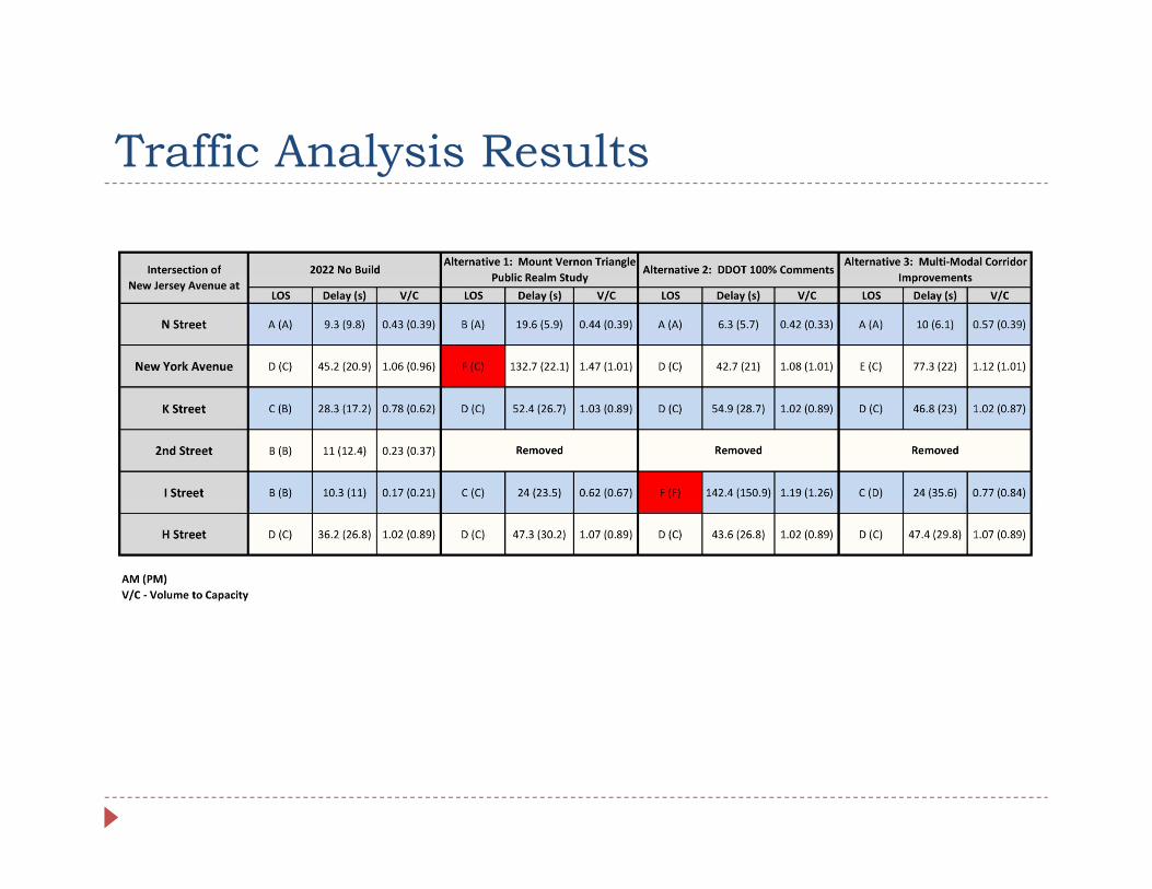
Traffic Analysis ResultsTraffic Analysis Results

Alternative ScreeningAlternative Screening Weighted scoring system of: Traffic / Safety Aspects Traffic / Safety Aspects Parking Impacts Bicycle/Pedestrian Aspectsy p Curb Impacts/Construction
CostB ifi i Beautification
Alternative 3 provides best scorescore Could impact parking Likely is the highest costy g


Recommended AlternativeRecommended Alternative On-road bicycle facility Typical 50 foot section Typical 50 foot section
throughout limit of project 3 travel lanes (11-10-11 feet)( ) 2 NB and 1 SB 2 bike lanes (10 feet) 1 parking lane (8 feet)
Increased landscapingP d d Pedestrian upgrades
No major change to traffic operationsoperations

Innovative Bike TreatmentInnovative Bike Treatment Bike lanes right side

Additional Parking OpportunitiesAdditional Parking Opportunities Floating bike lanes Provide for off peak Provide for off peak
parking Provide guidance for
cyclists and vehicles during different peaksp
Could provide 40additional parking spaces off peak

Project ScheduleProject Schedule Alternatives Analysis – May 2012 Public Update – July 2012 Public Update – July 2012 30% Submittal – August 2012 65% Submittal – October 2012 65% Submittal October 2012 90% Submittal – January 2013 100% Submittal – February 2013 100% Submittal February 2013

Next StepsNext Steps Public Input Survey Survey Geotechnical Analysis 30% Submittal 30% Submittal

Questions?Questions? Thank you for your time


Innovative Bicycle TreatmentInnovative Bicycle Treatment Bike lanes stay right at intersection; cyclists navigate like
pedestrianspedestrians


N StreetN Street Bike lanes initiate/terminate
on south leg of the on south leg of the intersection
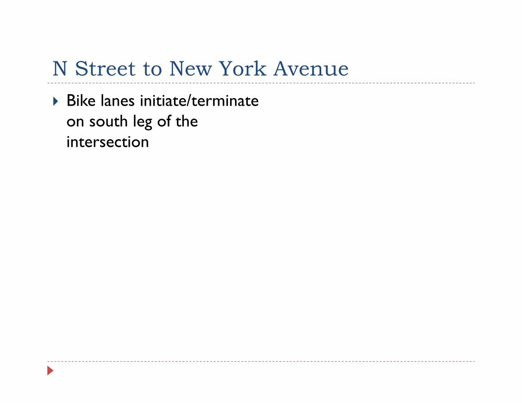
N Street to New York AvenueN Street to New York Avenue Bike lanes initiate/terminate
on south leg of the on south leg of the intersection

New York AvenueNew York Avenue Pedestrian crossings
provided on both legs of provided on both legs of NYA
Leading pedestrian interval not considered
Unique Dutch treatment id d f li ffi considered for cyclist traffic
along NJA

Dutch Bicycle TreatmentDutch Bicycle Treatment Add U Tube Video

New York Avenue to L StreetNew York Avenue to L Street Bike lanes initiate/terminate
on south leg of the on south leg of the intersection

L Street to K StreetL Street to K Street Bike lanes initiate/terminate
on south leg of the on south leg of the intersection

K StreetK Street Bike lanes initiate/terminate
on south leg of the on south leg of the intersection

H Street to I StreetH Street to I Street Bike lanes initiate/terminate
on south leg of the on south leg of the intersection

I StreetI Street Bike lanes initiate/terminate
on south leg of the on south leg of the intersection

I Street to H StreetI Street to H Street Bike lanes initiate/terminate
on south leg of the on south leg of the intersection

H StreetH Street Bike lanes initiate/terminate
on south leg of the on south leg of the intersection

Scope of WorkScope of Work Conduct a traffic analysis to
determine alternative to determine alternative to construct based on previous alternatives
Coordinate with community to achieve consensus on alternative moving forwardmoving forward
65% contract documents 100% contract documents 100% contract documents Provide construction phase
services as necessaryy

Alternatives AnalysisAlternatives Analysis1. Mount Vernon Triangle Study 2 DDOT 100% Review Comments2. DDOT 100% Review Comments3. Combined or New Alternative with
provisions for multi-modal popportunities

Final DesignFinal Design Roadway Design Erosion and Sediment Control Erosion and Sediment Control Maintenance of Traffic Traffic Signalization/Interconnect Traffic Signalization/Interconnect New York Avenue M Street (if required)( q ) K Street 2nd Street/I(Eye) Street
Signing and Pavement Marking Street Lighting

Final DesignFinal Design Horizontal/Vertical Alignment Traffic Signal Reconstruction Traffic Signal Reconstruction Maintenance of Traffic (including
cyclists & pedestrians)y p ) Signing & Pavement Marking Lightingg g Landscaping

Follow-Up InformationFollow Up Information As-built utility information at
a number of locationsa number of locations DDOT public involvement
coordination

Project OpportunitiesProject Opportunities Deliver the best project to District’s residents Realize vision of Transportation & Public Realm Study Realize vision of Transportation & Public Realm Study B/C near 2.0 at NYA/NJA alone NJA bicycle facilities would tie into planned NJA bicycle facilities would tie into planned
improvements along NYA and M Street Expanded multi-modal connections directly to growing p y g g
areas of the City Safer pedestrian crossings Replacement of aging infrastructure


Alternative 3 – Bicycle OptionsAlternative 3 Bicycle Options Options eliminated from consideration: Maintaining one-way operation and utilizing existing space for Maintaining one-way operation and utilizing existing space for
a cycle track (Based on the Kick Off meeting in January 2012)
Options considered, but eliminated from consideration: Off road trail parallel to NJA – eliminated due to landscaping
and property impacts C l t k i th iddl f NJA d d d t t iti Cycle track in the middle of NJA – dropped due to transition
requirements on either end of corridor
Specific Bicycle Traffic Control Treatments considered, but Specific Bicycle Traffic Control Treatments considered, but eliminated: Traffic signal-specific phasing at NYA/NJA

Alternative 3 – Pedestrian OptionsAlternative 3 Pedestrian Options Bulb outs considered in all areas where dedicated parking is
proposed 24/7 to minimize pedestrian crossings:proposed 24/7 to minimize pedestrian crossings: M Street in vicinity of NYA/NJA to calm traffic into
community Along NJA in front of Bible Way Temple south to L Street
Geometric revisions considered to account for Design V hi l d d t iVehicles and pedestrians Revised Eye Street design to accommodate truck traffic to
Wal Mart Median extensions at NYA considered for refuge and
additional crossings