nepalese journal 10
DESCRIPTION
It is annual publication of Survey Department of Nepal.TRANSCRIPT
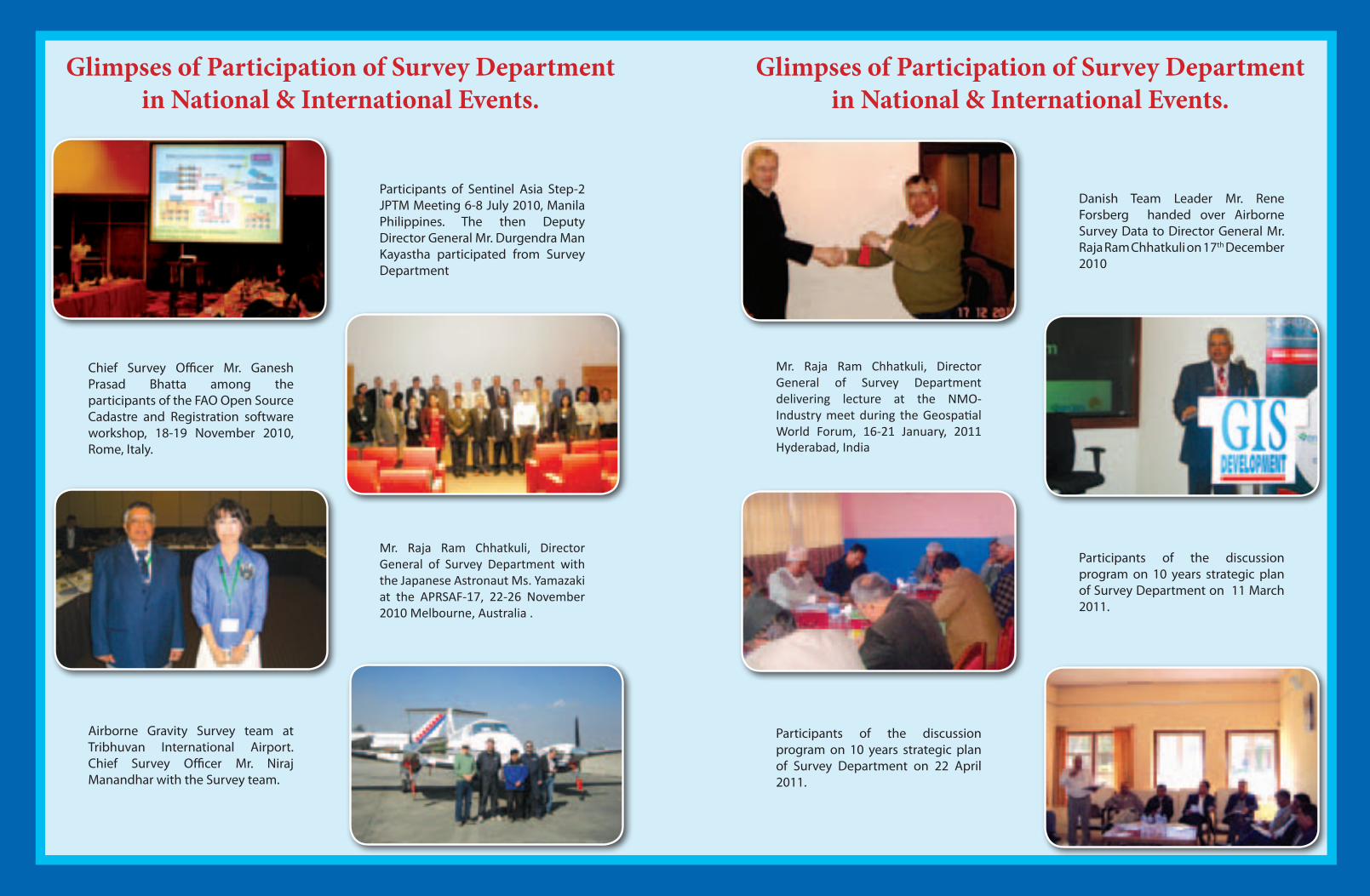
Participants of Sentinel Asia Step-2 JPTM Meeting 6-8 July 2010, Manila Philippines. The then Deputy Director General Mr. Durgendra Man Kayastha participated from Survey Department
Danish Team Leader Mr. Rene Forsberg handed over Airborne Survey Data to Director General Mr. Raja Ram Chhatkuli on 17th December 2010
Glimpses of Participation of Survey Department in National & International Events.
Glimpses of Participation of Survey Department in National & International Events.
Participants of the discussion program on 10 years strategic plan of Survey Department on 22 April 2011.
Airborne Gravity Survey team at Tribhuvan International Airport. Chief Survey Officer Mr. Niraj Manandhar with the Survey team.
Chief Survey Officer Mr. Ganesh Prasad Bhatta among the participants of the FAO Open Source Cadastre and Registration software workshop, 18-19 November 2010, Rome, Italy.
Participants of the discussion program on 10 years strategic plan of Survey Department on 11 March 2011.
Mr. Raja Ram Chhatkuli, Director General of Survey Department with the Japanese Astronaut Ms. Yamazaki at the APRSAF-17, 22-26 November 2010 Melbourne, Australia .
Mr. Raja Ram Chhatkuli, Director General of Survey Department delivering lecture at the NMO-Industry meet during the Geospatial World Forum, 16-21 January, 2011 Hyderabad, India
Nepalese Journal on Geoinformatics
Number : 10
Jestha 2068 BS
May - June 2011 AD
Annual publication of Survey Department, Government of Nepal
The Content and the ideas of the article are solely of authors.
Published by:Government of Nepal
Ministry of Land Reform and ManagementSurvey Department
Min Bhavan, KathmanduNepal
Price : Rs. 100
No. of copies : 500
Copyright reserved by Survey Department©

Jestha 2068, May-June 2011
Number 10
Nepalese Journal
on
GEoiNformatics
Product Price Maps Page 29
Publications Page 28
ControlPoints Page 29
AerialPhotographsandMapTransparencies
Page 47
Digital Data Layers Page 47
Soter Data Page 47
1 A Study on Squatter Settlements of Kathmandu Using GIS, Aerial Photography, Remote Sensing and Household Survey
By Mr. Kiran K.C. and Dr. Krishna Pahari Page 1
2 An Approach to Determine Coordinate Transformation Parameter for Nepal GPS Network
By Kalyan Gopal Shrestha Page 9
3 Impacts of Climate Change and Remote Sensing Technology in its Mitigation Options through Forest Management
By Rabindra Man Tamrakar Page 16
4 Spatial Analysis: an Assessment of the Road Accessibility
By Madhu Sudan Adhikari Page 23
5 Study of Geodetic datum of Nepal, China and Pakisthan and its transformation to World Geodetic System
Niraj Manandhar Page 30
6 Survey Department at the Cross Roads Rabin K. Sharma Page 37
Features Articles
News 2010-2011ataglance Page 14
Obituary Page 28
TheFrontCoverMr. Khim Lal Gautam, 1st Nepalese Surveyor to scale Mt. Everest waving the flag of Nepal Surveyors’ Association.
Contents
Nepal Remote Sensing and Photogrammetric SocietyPage 44
Nepal GIS SocietyPage 45
Nepal Surveyors’ Association (NESA)Page 46
Contents
EditorialPage II
Massage from Director General of Survey DepartmentPage III
Instruction and Guidelines for Authors Regarding Manuscript PreparationPage 43
Call for PapersPage 28
Participation in International EventsPage 22
Calendar of International EventsPage 36
Feelings of the first Nepali Surveyor on top of Mount EverestPage 48
Professional Organization
Page
Regular Column
Informations
Special Feature

Advisory Council
Editorial Board
Raja Ram ChhatkuliChairperson
Ganesh Prasad Bhatta Member
Suresh Man Shrestha Member
Jagat Raj PaudelEditor-in-chief
Niraj ManandharMember
Madhu Sudan Adhikari Member
Kalyan Gopal ShresthaMember
Narayan Chaudhari Member
Deepak Sharma DahalMember
II
Editorial
Survey Department under the Ministry of Land Reform & Management, Government of Nepal undertakes national surveying & mapping activities in the country. The department has a broad multi disciplinary resource base and produces a wide range of ground survey, aerial photography, photogrammetry, geo-information and cadastral map products and services in order to support multi sectoral development activities. I hope this journal would offer to share knowledge and views on such various application of geoinformatics.
All the journals published so far are available in the website of Survey Department www.dos.gov.np. We hope this provision will help the readers to access to these documents easily.
I would like to express sincere appreciation to Mr. Raja Ram Chhatkuli, the Chairperson of the Advisory Council for his valuable suggestions. Similarly, I would like to express my sincere thanks to all the authors, members of the Advisory Council, members of the Editorial Board and to all who have contributed for the publication of the journal.
June, 2011 Jagat Raj PaudelKathmandu Editor-in-chief

III
MessagefromDirectorGeneral;SurveyDepartment
It is a matter of immense pleasure to see the Editorial Board bringing out this tenth issue of our annual publication “Nepalese Journal on Geoinformatics”. In a very small way, this journal not only presents where Survey Department stands and what it is doing now but also offers a glimpse of technology development scenario in the field of Geomatics in Nepal. I hope this publication will enhance the usefulness with an inertia of continuity.
In over 53 years of its history, Survey Department has witnessed its growth from cadastral surveying unit to the National Mapping Organization(NMO) and is thriving to become the central hub of National spatial Data Infrastructure (NSDI) in Nepal. The Geospatial Information and Communication Technology (Geo-ICT), is gaining momentum and has revolutionized with expanded scope of Surveying and Mapping profession in the country. The advancement of Geo-ICT technology has been so rapid that it has become a challange to keep pace with global trend in our organization due to lack of adequate resources. However, constant efforts are being made by Survey Department for its diverse applications. In this issue, our valuable readers will find useful articles on diversified topics of Geo-ICT like Global Positioning System(GPS), use of Geographical Information System(GIS) and Remote sensing(RS) technology in analyzing climatic change, Spatial analysis & assessment in various socio-economic issues among others.
I have been especially encouraged by the diversity of the contributors, who come from within and outside of Survey Department. I, therefore, take this opportunity to express my thanks to the authors. I also express my appreciation to the esteemed readers for their continued support without which this journal would never have been published.
I take this opportunity to express our pride on behalf of all the Surveyors of Nepal, that our Surveyor colleague Mr. Khim Lal Gautam became one of the successful climbers of the Nepal Civil Servants’ Mt. Everest Expedition and stood atop Mt. Everest, the highest mountain on earth on 18th May 2011. The cover page shows Mr. Gautam on the peak with the flag of the Nepal Surveyors’ Association. I join you all to congratulate him.
Finally, I extend my thankfulness to the members of Advisory Council and the Editorial Board for their persistent effort in publishing this issue.
Jestha 2068 (June 2011) Raja Ram ChhatkuliDirector General
Survey Department

1 Nepalese Journal on Geoinformatics - 10, 2068
A Study on Squatter Settlements of Kathmandu Using GIS, Aerial Photography, Remote Sensing and
Household Survey
Kiran K.C.*, M.Sc. Dissertation Work, 2010, SchEMS, Pokhara University, Nepal (Programme Officer, NTNC, Nepal, [email protected]) and
Dr. Krishna Pahari**, Research Advisor, (National Advisor, UN-WFP, Nepal, [email protected])
KeywordsGIS, remote sensing, GPS, aerial photography, landuse change, squatter settlement, house hold survey.
AbstractThe study was done to explore various issues facing by the squat dwellers of two densely populated squatter settlements of the Kathmandu valley (Manohara and Thapathali). A series of temporal satellite imageries along with orhtophoto were analyzed and mapped focusing the food security and their livelihood conditions, sanitary and hygienic conditions and the flood hazard assessment. The study revealed that there has been a drastic landuse change in the Manohara area as compared to the Thapathali one. The squatter settlement that currently exists is found to have been in the flood plain. The household survey has disclosed that a majority of squatters who have settled in these places belong to Janajatis and they have mainly migrated from the hilly region and the surrounding districts of the Kathmandu valley. Besides, drinking water tested from both of the areas is contaminated with high concentration of Nitrate and Coliform. Hygienic conditions are also very poor as toilets lie along the river banks resulting in the depletion of the river quality and the scenic beauty of the surrounding environment. The community-based flood hazard mapping done with the GPS survey has revealed that all the settlements from both of the areas had been inundated in the month of July in 2009. In both area, people are deprived of basis amenities and they have been neglected by the concerned government authorities. Adequate research on scientific basic is an urgent need so as to draft a clear cut specific policy that can address their issues and stop environmental deterioration, destruction of beautiful green grassland and the sanitary conditions.
IntroductionUrbanization in Nepal has not been uniform throughout the country with major urban areas concentrated within the Kathmandu Valley. Historical value of national importance sites like Basantapur Durbar square, Patan Durbar square and
Bhaktapur Durbar square listed in UNESCO world heritage sites are in pitiful state and these sites along with other things having traditional values and importance like stone spouts, natural ponds have been drying. The environmental problems have been compounded due to the uncontrolled rural-urban migration and haphazard settlements within the cities which is now threatening a good quality of life. In addition, there is already a serious shortage in availability of basic amenities like fertile agricultural land, good quality of drinking water, fresh air, etc.
Social and environmental problems associated with the growing slums and squatters in the urban areas are a significant problem of national concern in developing countries like Nepal. In 1985, it was estimated that there were only 17 squatter areas in Kathmandu, but the number has gone up to 40 now. Among the 40 settlements, majority (24) are situated along the river banks of Bagmati, Manohara, Bishnumati, Dhobikhola and Tukucha. There are a total of 12,726 people (6,612 males and 6,114 females) living in 2,735 households in the 40 squatter settlements of the valley (Lumanti; February 2008). Similarly, about 2.9% of the total population of Kathmandu lives in informal squatter settlements (KMC/WB, 2001).
Study areaThe Study area comprises of two largest and densely populated squatter settlement areas inside the Kathmandu Valley i.e., Bagmati River (Thapathali squatter settlement) and Manohara River (Manohara squatter settlement near Jaributi area).
MethodologyThe analytical methods i.e. the remote sensing analysis was done with the analysis of series of temporal satellite imageries and orthophoto in order to compare and find out changes within the study area so as to map them accordingly. The spatial data used to depict land use change, squatter’s growth were as follows:
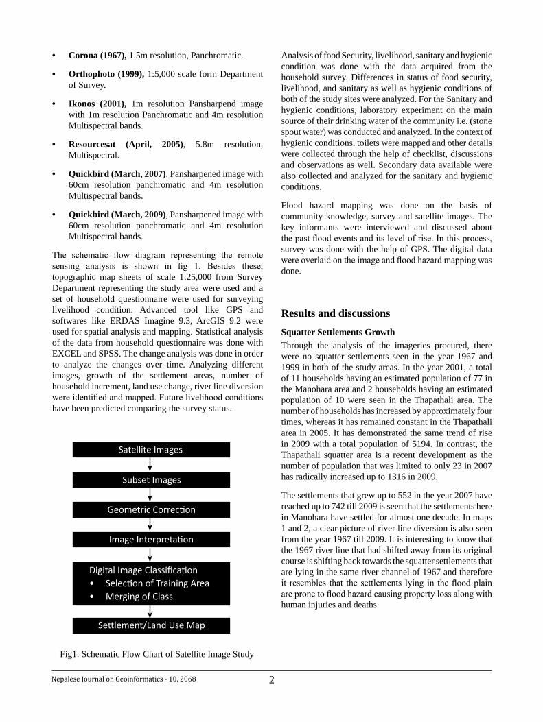
2Nepalese Journal on Geoinformatics - 10, 2068
Corona (1967),• 1.5m resolution, Panchromatic.
Orthophoto (1999),• 1:5,000 scale form Department of Survey.
Ikonos (2001),• 1m resolution Pansharpend image with 1m resolution Panchromatic and 4m resolution Multispectral bands.
Resourcesat (April, 2005)• , 5.8m resolution, Multispectral.
Quickbird (March, 2007)• , Pansharpened image with 60cm resolution panchromatic and 4m resolution Multispectral bands.
Quickbird (March, 2009)• , Pansharpened image with 60cm resolution panchromatic and 4m resolution Multispectral bands.
The schematic flow diagram representing the remote sensing analysis is shown in fig 1. Besides these, topographic map sheets of scale 1:25,000 from Survey Department representing the study area were used and a set of household questionnaire were used for surveying livelihood condition. Advanced tool like GPS and softwares like ERDAS Imagine 9.3, ArcGIS 9.2 were used for spatial analysis and mapping. Statistical analysis of the data from household questionnaire was done with EXCEL and SPSS. The change analysis was done in order to analyze the changes over time. Analyzing different images, growth of the settlement areas, number of household increment, land use change, river line diversion were identified and mapped. Future livelihood conditions have been predicted comparing the survey status.
Analysis of food Security, livelihood, sanitary and hygienic condition was done with the data acquired from the household survey. Differences in status of food security, livelihood, and sanitary as well as hygienic conditions of both of the study sites were analyzed. For the Sanitary and hygienic conditions, laboratory experiment on the main source of their drinking water of the community i.e. (stone spout water) was conducted and analyzed. In the context of hygienic conditions, toilets were mapped and other details were collected through the help of checklist, discussions and observations as well. Secondary data available were also collected and analyzed for the sanitary and hygienic conditions.
Flood hazard mapping was done on the basis of community knowledge, survey and satellite images. The key informants were interviewed and discussed about the past flood events and its level of rise. In this process, survey was done with the help of GPS. The digital data were overlaid on the image and flood hazard mapping was done.
Results and discussions
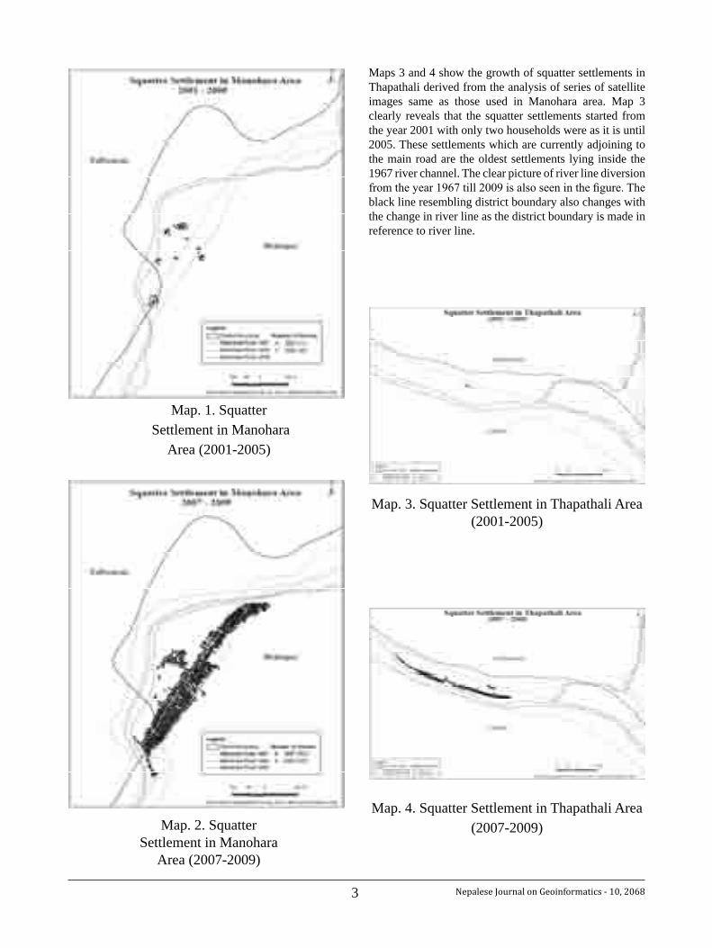
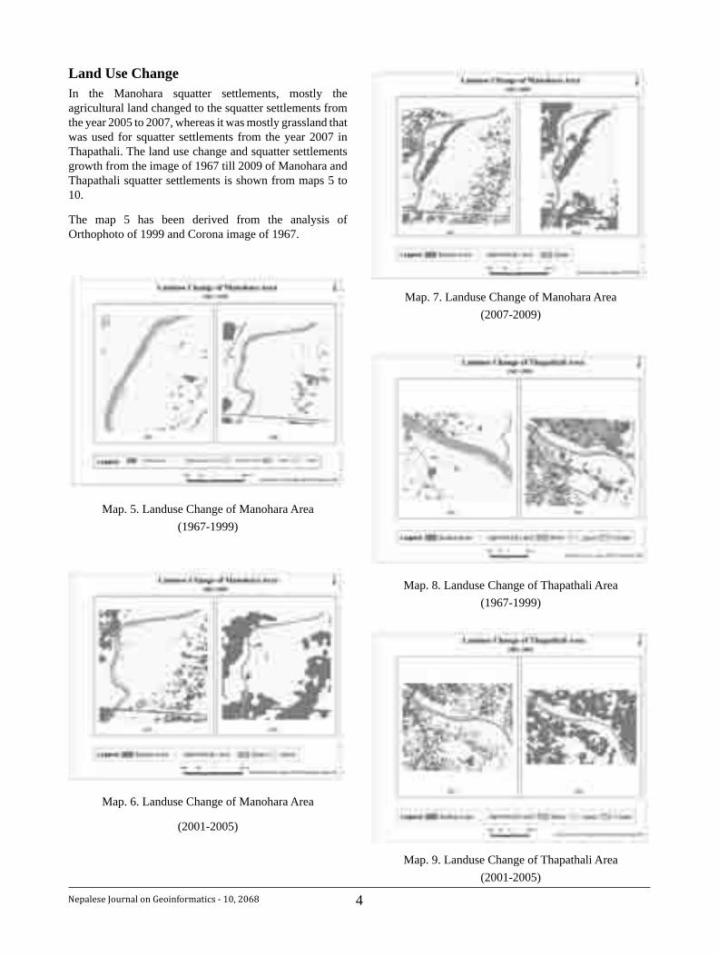
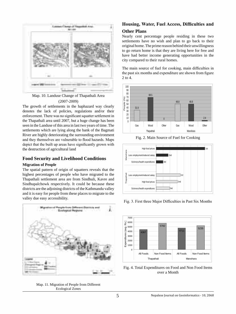
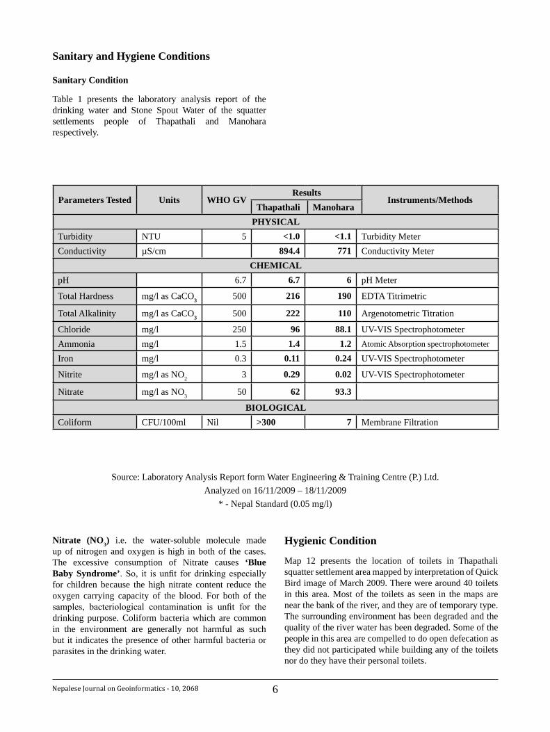
Squatter Settlements GrowthThrough the analysis of the imageries procured, there were no squatter settlements seen in the year 1967 and 1999 in both of the study areas. In the year 2001, a total of 11 households having an estimated population of 77 in the Manohara area and 2 households having an estimated population of 10 were seen in the Thapathali area. The number of households has increased by approximately four times, whereas it has remained constant in the Thapathali area in 2005. It has demonstrated the same trend of rise in 2009 with a total population of 5194. In contrast, the Thapathali squatter area is a recent development as the number of population that was limited to only 23 in 2007 has radically increased up to 1316 in 2009.
The settlements that grew up to 552 in the year 2007 have reached up to 742 till 2009 is seen that the settlements here in Manohara have settled for almost one decade. In maps 1 and 2, a clear picture of river line diversion is also seen from the year 1967 till 2009. It is interesting to know that the 1967 river line that had shifted away from its original course is shifting back towards the squatter settlements that are lying in the same river channel of 1967 and therefore it resembles that the settlements lying in the flood plain are prone to flood hazard causing property loss along with human injuries and deaths.
Digital Image ClassificationSelection of Training Area• Merging of Class•
Image Interpretation
Geometric Correction
Subset Images
Satellite Images
Settlement/Land Use Map
Fig1: Schematic Flow Chart of Satellite Image Study
3 Nepalese Journal on Geoinformatics - 10, 2068
Maps 3 and 4 show the growth of squatter settlements in Thapathali derived from the analysis of series of satellite images same as those used in Manohara area. Map 3 clearly reveals that the squatter settlements started from the year 2001 with only two households were as it is until 2005. These settlements which are currently adjoining to the main road are the oldest settlements lying inside the 1967 river channel. The clear picture of river line diversion from the year 1967 till 2009 is also seen in the figure. The black line resembling district boundary also changes with the change in river line as the district boundary is made in reference to river line.
Map. 2. SquatterSettlement in Manohara
Area (2007-2009)
Map. 1. Squatter Settlement in Manohara
Area (2001-2005)
Map. 4. Squatter Settlement in Thapathali Area (2007-2009)
Map. 3. Squatter Settlement in Thapathali Area (2001-2005)
4Nepalese Journal on Geoinformatics - 10, 2068
Land Use ChangeIn the Manohara squatter settlements, mostly the agricultural land changed to the squatter settlements from the year 2005 to 2007, whereas it was mostly grassland that was used for squatter settlements from the year 2007 in Thapathali. The land use change and squatter settlements growth from the image of 1967 till 2009 of Manohara and Thapathali squatter settlements is shown from maps 5 to 10.
The map 5 has been derived from the analysis of Orthophoto of 1999 and Corona image of 1967.
Map. 5. Landuse Change of Manohara Area (1967-1999)
Map. 6. Landuse Change of Manohara Area
(2001-2005)
Map. 7. Landuse Change of Manohara Area (2007-2009)
Map. 8. Landuse Change of Thapathali Area (1967-1999)
Map. 9. Landuse Change of Thapathali Area (2001-2005)
5 Nepalese Journal on Geoinformatics - 10, 2068
Map. 10. Landuse Change of Thapathali Area (2007-2009)
The growth of settlements in the haphazard way clearly denotes the lack of policies, regulations and/or their enforcement. There was no significant squatter settlement in the Thapathali area until 2007, but a huge change has been seen in the Landuse of this area in last two years of time. The settlements which are lying along the bank of the Bagmati River are highly deteriorating the surrounding environment and they themselves are vulnerable to flood hazards. Maps depict that the built up areas have significantly grown with the destruction of agricultural land. Food Security and Livelihood ConditionsMigration of People The spatial pattern of origin of squatters reveals that the highest percentages of people who have migrated to the Thapathali settlement area are from Sindhuli, Kavre and Sindhupalchowk respectively. It could be because these districts are the adjoining districts of the Kathmandu valley and it is easy for people from these places to migrate to the valley due easy accessibility.
Map. 11. Migration of People from Different Ecological Zones
Housing,Water,FuelAccess,DifficultiesandOther PlansNearly cent percentage people residing in these two settlements have no wish and plan to go back to their original home. The prime reason behind their unwillingness to go return home is that they are living here for free and have had better income generating opportunities in the city compared to their rural homes.
The main source of fuel for cooking, main difficulties in the past six months and expenditure are shown from figure 2 to 4.
31.5
68.5
0
48.8 48.8
2.40
102030405060708090
100
Gas Wood Other Gas Wood Other
Thapathali Manohara
People
(%
)
Fig. 2. Main Source of Fuel for Cooking
3rd
2nd
1st
3rd
2nd
1st
Sickness/health expenditures
High food prices
Loss employment/reduced salary
Sickness/health expenditures
Loss employment/reduced salary
High food prices
Th
ap
ath
ali
Ma
no
ha
ra
Fig. 3. First three Major Difficulties in Past Six Months
4367
5782
47115235
0
1000
2000
3000
4000
5000
6000
7000
All Foods Non Food Items All Foods Non Food Items
Thapathali Manohara
Exp
endi
ture
s (a
vg. R
s.)
Fig. 4. Total Expenditures on Food and Non Food Items over a Month
6Nepalese Journal on Geoinformatics - 10, 2068
Sanitary and Hygiene Conditions
Sanitary Condition
Table 1 presents the laboratory analysis report of the drinking water and Stone Spout Water of the squatter settlements people of Thapathali and Manohara respectively.
Parameters Tested Units WHO GVResults
Instruments/MethodsThapathali Manohara
PHYSICALTurbidity NTU 5 <1.0 <1.1 Turbidity MeterConductivity µS/cm 894.4 771 Conductivity Meter
CHEMICALpH 6.7 6.7 6 pH Meter
Total Hardness mg/l as CaCO3 500 216 190 EDTA Titrimetric
Total Alkalinity mg/l as CaCO3 500 222 110 Argenotometric Titration
Chloride mg/l 250 96 88.1 UV-VIS SpectrophotometerAmmonia mg/l 1.5 1.4 1.2 Atomic Absorption spectrophotometer
Iron mg/l 0.3 0.11 0.24 UV-VIS Spectrophotometer
Nitrite mg/l as NO2 3 0.29 0.02 UV-VIS Spectrophotometer
Nitrate mg/l as NO3 50 62 93.3
BIOLOGICALColiform CFU/100ml Nil >300 7 Membrane Filtration
Source: Laboratory Analysis Report form Water Engineering & Training Centre (P.) Ltd. Analyzed on 16/11/2009 – 18/11/2009
* - Nepal Standard (0.05 mg/l)
Nitrate (NO3) i.e. the water-soluble molecule made up of nitrogen and oxygen is high in both of the cases. The excessive consumption of Nitrate causes ‘Blue Baby Syndrome’. So, it is unfit for drinking especially for children because the high nitrate content reduce the oxygen carrying capacity of the blood. For both of the samples, bacteriological contamination is unfit for the drinking purpose. Coliform bacteria which are common in the environment are generally not harmful as such but it indicates the presence of other harmful bacteria or parasites in the drinking water.
Hygienic Condition
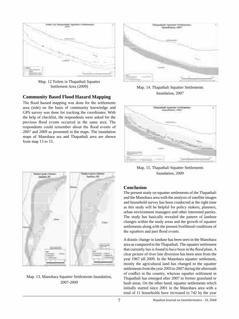
Map 12 presents the location of toilets in Thapathali squatter settlement area mapped by interpretation of Quick Bird image of March 2009. There were around 40 toilets in this area. Most of the toilets as seen in the maps are near the bank of the river, and they are of temporary type. The surrounding environment has been degraded and the quality of the river water has been degraded. Some of the people in this area are compelled to do open defecation as they did not participated while building any of the toilets nor do they have their personal toilets.
7 Nepalese Journal on Geoinformatics - 10, 2068
Map. 12 Toilets in Thapathali Squatter Settlement Area (2009)
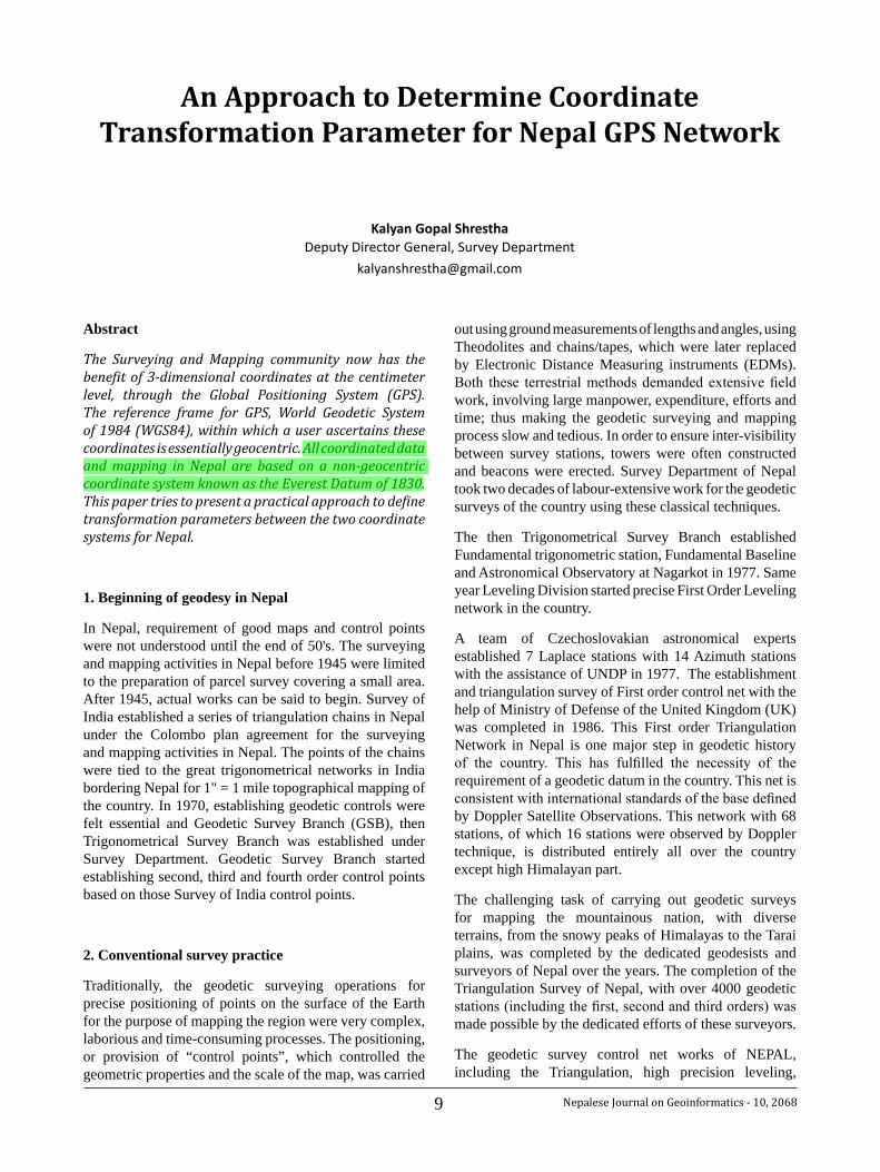
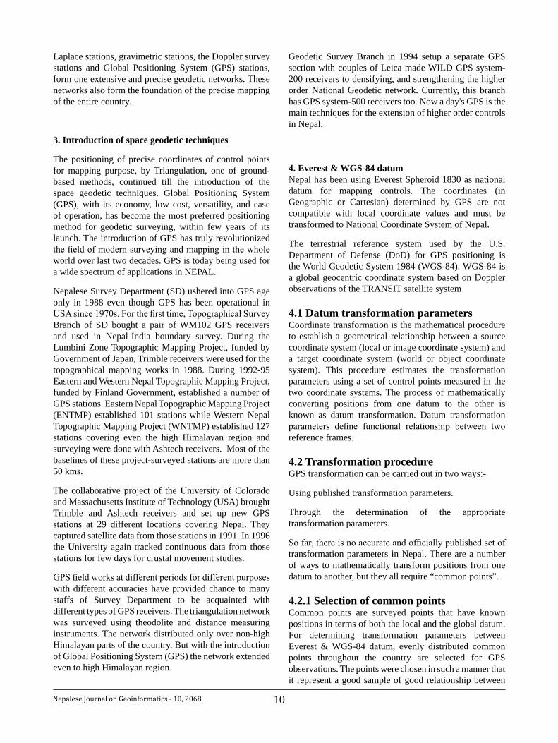
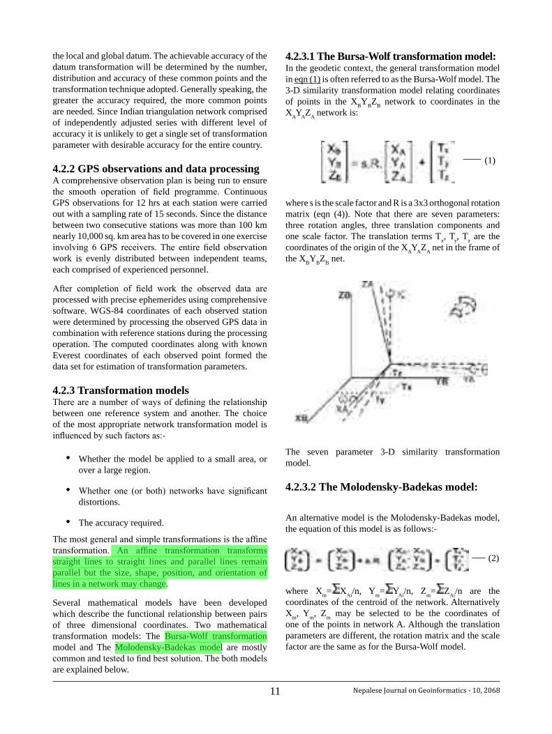
Community Based Flood Hazard MappingThe flood hazard mapping was done for the settlements area (side) on the basis of community knowledge and GPS survey was done for tracking the coordinates. With the help of checklist, the respondents were asked for the previous flood events occurred in the same area. The respondents could remember about the flood events of 2007 and 2009 as presented in the maps. The inundation maps of Manohara ara and Thapathali area are shown from map 13 to 15.
ConclusionThe present study on squatter settlements of the Thapathali and the Manohara area with the analysis of satellite images and household survey has been conducted at the right time as this study will be helpful for policy makers, planners, urban environment managers and other interested parties. The study has basically revealed the pattern of landuse changes within the study areas and the growth of squatter settlements along with the present livelihood conditions of the squatters and past flood events.
A drastic change in landuse has been seen in the Manohara area as compared to the Thapathali. The squatter settlement that currently lies is found to have been in the flood plain. A clear picture of river line diversion has been seen from the year 1967 till 2009. In the Manohara squatter settlement, mostly the agricultural land has changed to the squatter settlements from the year 2005 to 2007 during the aftermath of conflict in the country, whereas squatter settlement in Thapathali has emerged after 2007 in former grassland or bush areas. On the other hand, squatter settlements which initially started since 2001 in the Manohara area with a total of 11 households have increased to 742 by the year
Map. 13. Manohara Squatter Settlements Inundation, 2007-2009
Map. 14. Thapathali Squatter Settlements Inundation, 2007
Map. 15. Thapathali Squatter Settlements Inundation, 2009

8Nepalese Journal on Geoinformatics - 10, 2068
2009. Due to the lack of proper policies and regulations, people have kept migrating day by day and newer houses have been constructed and the settlement areas have expanded augmenting the deterioration of the surrounding environment.
The household survey in the study area has been compared with the image analyses which have also revealed the fact that the people in the Manohara area have settled for nearly one decade, whereas the people in the Thapathali area have come into existence during the past three years. Most of the people from Janajati communities mainly from the hilly region and the surrounding districts of the Kathmandu valley like Kavrepalanchok, Ramechhap and Sindhuli have migrated in these settlements. On the whole, nearly all the people residing in these two settlements have no wish and plan to go back to their original home. The prime reason behind their unwillingness to return home is that they have lived here for free and have had better income generating opportunities compared to their rural homes.
In both the study areas, the squatters have had only one source of drinking water i.e. stone spout. Although they opine that they do not have to boil the water as it is safe, the lab experiment has revealed that the water has contained high concentration of Nitrate and Coliform. Regarding the hygienic conditions of these areas, only around 40 toilets have been found in the Thapathali area most of which lie nearby the river banks and thus polluting the river. In case of the Manohara area, almost all households have had their own toilets and half of the toilets have been made of concrete as these settlements are a decade old. Almost everybody in these study area is discovered to have been throwing the household wastes directly into the river as the municipality never collects wastes from these squatter settlements.
The community-based flood hazard mapping done with the GPS survey has revealed that all the settlements from both of the areas had been inundated in the month of July in 2009. In both areas, the flood event had happened mainly due to the weak embankment and the sand mining activities going on rapidly along the river banks.
References:Chowdhury, U.I., Problems of squatter settlements 1. in Bangladesh: A case of Chittagong City. Dept of Sociology, Univ. of Chittagong, Bangladesh (http://dlisv03.media.osaka-cu.ac.jp/infolib/user_contents/kiyo/DB00000200.pdf)
FEMA, 2003. Flood Hazard Mapping. Online tutorials. 2. (http://www.fema.gov/fhm/ot_main.shtm)
Gaurin, P., Westen van, C.J. and Montoya, L. 2004. 3.
Community-based flood risk assessment using GIS for the town of San Sebstian, Guatemala. (http://www.itc.nl/library/Papers_2005/p_jrnl/vanwesten_com.pdf)
Goyle et. al. 2004 A profile of roadside Squatter 4. Settlements and their families in Jaipur City. Dept of Home Science, Univ. of Rajasthan, Jaipur 302 004, Rajasthan, India. (http://www.krepublishers.com/02-Journals/JSS/JSS-09-0-000-000-2004-Web/JSS-09-1-001-073-2004-Abst-PDF/JSS-09-1-013-018-2004-Goyale-A/JSS-09-1-013-018-2004-Goyale-A.pdf)
HMG (1992) The Constitution of Government of 5. Nepal 2047 (1990). Law Books Management Board, HMG, Babarmahal.
HMG (1996) National Shelter Policy, 1996. 6. Department of Housing and Urban Development, Babarmahal.
HMG (1997) Town Development Act, 1988. Law 7. Books Management Board, HMG, Babarmahal.
HMG (2000) Local Sef-Governance Act, 2055 (1999). 8. Law Books Management Board, HMG, Babarmahal.
Karki, T K (2004), An Assessment of Regional and 9. Urban Development Policies and Programmes of Nepal. In proc. of Planning, Valuation and the Environment FIG Working Week 2004. Athens, Greece, May 22-27, 2004.
KMC/WB (2001) City Diagnostic Report. Kathmandu 10. Metropolitan City and World Bank, Kathmandu, Nepal.
Lumanti, 2008, Status of Squatter communities along 11. Bagmati River and its tributaries in Kathmandu Valley, GTZ, GoN, Lumanti, Nepal.
NPC (2002), The Tenth Plan (2002). HMG, National 12. Planning Commission, Nepal
Paudel J.R. 2062. Study of Change in Urban Landscae. 13. Nepalese Journal on Geoinformatics 4:39-42
Shakya S. 2005. An extensive study of urban poverty 14. situation and its environmental implications in the Squatter Settlements of Kathmandu and Dharan, M.Sc. thesis, SchEMS College, PU, Shantinagar Kathmandu.
http//www.raosoft.com/Samplesize.html (assessed 15. on 02 July 2009)
9 Nepalese Journal on Geoinformatics - 10, 2068
An Approach to Determine Coordinate Transformation Parameter for Nepal GPS Network
KalyanGopalShresthaDeputy Director General, Survey Department
Abstract
The Surveying and Mapping community now has the benefit of 3-dimensional coordinates at the centimeter level, through the Global Positioning System (GPS). The reference frame for GPS, World Geodetic System of 1984 (WGS84), within which a user ascertains these coordinates is essentially geocentric. All coordinated data and mapping in Nepal are based on a non-geocentric coordinate system known as the Everest Datum of 1830. This paper tries to present a practical approach to define transformation parameters between the two coordinate systems for Nepal.
1. Beginning of geodesy in Nepal
In Nepal, requirement of good maps and control points were not understood until the end of 50's. The surveying and mapping activities in Nepal before 1945 were limited to the preparation of parcel survey covering a small area. After 1945, actual works can be said to begin. Survey of India established a series of triangulation chains in Nepal under the Colombo plan agreement for the surveying and mapping activities in Nepal. The points of the chains were tied to the great trigonometrical networks in India bordering Nepal for 1" = 1 mile topographical mapping of the country. In 1970, establishing geodetic controls were felt essential and Geodetic Survey Branch (GSB), then Trigonometrical Survey Branch was established under Survey Department. Geodetic Survey Branch started establishing second, third and fourth order control points based on those Survey of India control points.
2. Conventional survey practice
Traditionally, the geodetic surveying operations for precise positioning of points on the surface of the Earth for the purpose of mapping the region were very complex, laborious and time-consuming processes. The positioning, or provision of “control points”, which controlled the geometric properties and the scale of the map, was carried
out using ground measurements of lengths and angles, using Theodolites and chains/tapes, which were later replaced by Electronic Distance Measuring instruments (EDMs). Both these terrestrial methods demanded extensive field work, involving large manpower, expenditure, efforts and time; thus making the geodetic surveying and mapping process slow and tedious. In order to ensure inter-visibility between survey stations, towers were often constructed and beacons were erected. Survey Department of Nepal took two decades of labour-extensive work for the geodetic surveys of the country using these classical techniques.
The then Trigonometrical Survey Branch established Fundamental trigonometric station, Fundamental Baseline and Astronomical Observatory at Nagarkot in 1977. Same year Leveling Division started precise First Order Leveling network in the country.
A team of Czechoslovakian astronomical experts established 7 Laplace stations with 14 Azimuth stations with the assistance of UNDP in 1977. The establishment and triangulation survey of First order control net with the help of Ministry of Defense of the United Kingdom (UK) was completed in 1986. This First order Triangulation Network in Nepal is one major step in geodetic history of the country. This has fulfilled the necessity of the requirement of a geodetic datum in the country. This net is consistent with international standards of the base defined by Doppler Satellite Observations. This network with 68 stations, of which 16 stations were observed by Doppler technique, is distributed entirely all over the country except high Himalayan part.
The challenging task of carrying out geodetic surveys for mapping the mountainous nation, with diverse terrains, from the snowy peaks of Himalayas to the Tarai plains, was completed by the dedicated geodesists and surveyors of Nepal over the years. The completion of the Triangulation Survey of Nepal, with over 4000 geodetic stations (including the first, second and third orders) was made possible by the dedicated efforts of these surveyors.
The geodetic survey control net works of NEPAL, including the Triangulation, high precision leveling,
10Nepalese Journal on Geoinformatics - 10, 2068
Laplace stations, gravimetric stations, the Doppler survey stations and Global Positioning System (GPS) stations, form one extensive and precise geodetic networks. These networks also form the foundation of the precise mapping of the entire country.
3. Introduction of space geodetic techniques
The positioning of precise coordinates of control points for mapping purpose, by Triangulation, one of ground-based methods, continued till the introduction of the space geodetic techniques. Global Positioning System (GPS), with its economy, low cost, versatility, and ease of operation, has become the most preferred positioning method for geodetic surveying, within few years of its launch. The introduction of GPS has truly revolutionized the field of modern surveying and mapping in the whole world over last two decades. GPS is today being used for a wide spectrum of applications in NEPAL.
Nepalese Survey Department (SD) ushered into GPS age only in 1988 even though GPS has been operational in USA since 1970s. For the first time, Topographical Survey Branch of SD bought a pair of WM102 GPS receivers and used in Nepal-India boundary survey. During the Lumbini Zone Topographic Mapping Project, funded by Government of Japan, Trimble receivers were used for the topographical mapping works in 1988. During 1992-95 Eastern and Western Nepal Topographic Mapping Project, funded by Finland Government, established a number of GPS stations. Eastern Nepal Topographic Mapping Project (ENTMP) established 101 stations while Western Nepal Topographic Mapping Project (WNTMP) established 127 stations covering even the high Himalayan region and surveying were done with Ashtech receivers. Most of the baselines of these project-surveyed stations are more than 50 kms.
The collaborative project of the University of Colorado and Massachusetts Institute of Technology (USA) brought Trimble and Ashtech receivers and set up new GPS stations at 29 different locations covering Nepal. They captured satellite data from those stations in 1991. In 1996 the University again tracked continuous data from those stations for few days for crustal movement studies.
GPS field works at different periods for different purposes with different accuracies have provided chance to many staffs of Survey Department to be acquainted with different types of GPS receivers. The triangulation network was surveyed using theodolite and distance measuring instruments. The network distributed only over non-high Himalayan parts of the country. But with the introduction of Global Positioning System (GPS) the network extended even to high Himalayan region.
Geodetic Survey Branch in 1994 setup a separate GPS section with couples of Leica made WILD GPS system-200 receivers to densifying, and strengthening the higher order National Geodetic network. Currently, this branch has GPS system-500 receivers too. Now a day's GPS is the main techniques for the extension of higher order controls in Nepal.
4. Everest & WGS-84 datumNepal has been using Everest Spheroid 1830 as national datum for mapping controls. The coordinates (in Geographic or Cartesian) determined by GPS are not compatible with local coordinate values and must be transformed to National Coordinate System of Nepal.
The terrestrial reference system used by the U.S. Department of Defense (DoD) for GPS positioning is the World Geodetic System 1984 (WGS-84). WGS-84 is a global geocentric coordinate system based on Doppler observations of the TRANSIT satellite system
4.1 Datum transformation parametersCoordinate transformation is the mathematical procedure to establish a geometrical relationship between a source coordinate system (local or image coordinate system) and a target coordinate system (world or object coordinate system). This procedure estimates the transformation parameters using a set of control points measured in the two coordinate systems. The process of mathematically converting positions from one datum to the other is known as datum transformation. Datum transformation parameters define functional relationship between two reference frames.
4.2 Transformation procedureGPS transformation can be carried out in two ways:-
Using published transformation parameters.
Through the determination of the appropriate transformation parameters.
So far, there is no accurate and officially published set of transformation parameters in Nepal. There are a number of ways to mathematically transform positions from one datum to another, but they all require “common points”.
4.2.1 Selection of common pointsCommon points are surveyed points that have known positions in terms of both the local and the global datum. For determining transformation parameters between Everest & WGS-84 datum, evenly distributed common points throughout the country are selected for GPS observations. The points were chosen in such a manner that it represent a good sample of good relationship between
11 Nepalese Journal on Geoinformatics - 10, 2068
the local and global datum. The achievable accuracy of the datum transformation will be determined by the number, distribution and accuracy of these common points and the transformation technique adopted. Generally speaking, the greater the accuracy required, the more common points are needed. Since Indian triangulation network comprised of independently adjusted series with different level of accuracy it is unlikely to get a single set of transformation parameter with desirable accuracy for the entire country.
4.2.2 GPS observations and data processingA comprehensive observation plan is being run to ensure the smooth operation of field programme. Continuous GPS observations for 12 hrs at each station were carried out with a sampling rate of 15 seconds. Since the distance between two consecutive stations was more than 100 km nearly 10,000 sq. km area has to be covered in one exercise involving 6 GPS receivers. The entire field observation work is evenly distributed between independent teams, each comprised of experienced personnel.
After completion of field work the observed data are processed with precise ephemerides using comprehensive software. WGS-84 coordinates of each observed station were determined by processing the observed GPS data in combination with reference stations during the processing operation. The computed coordinates along with known Everest coordinates of each observed point formed the data set for estimation of transformation parameters.
4.2.3 Transformation modelsThere are a number of ways of defining the relationship between one reference system and another. The choice of the most appropriate network transformation model is influenced by such factors as:-
• Whether the model be applied to a small area, or over a large region.
• Whether one (or both) networks have significant distortions.
• The accuracy required.
The most general and simple transformations is the affine transformation. An affine transformation transforms straight lines to straight lines and parallel lines remain parallel but the size, shape, position, and orientation of lines in a network may change.
Several mathematical models have been developed which describe the functional relationship between pairs of three dimensional coordinates. Two mathematical transformation models: The Bursa-Wolf transformation model and The Molodensky-Badekas model are mostly common and tested to find best solution. The both models are explained below.
4.2.3.1 The Bursa-Wolf transformation model:In the geodetic context, the general transformation model in eqn (1) is often referred to as the Bursa-Wolf model. The 3-D similarity transformation model relating coordinates of points in the XBYBZB network to coordinates in the XAYAZA network is:
(1)
where s is the scale factor and R is a 3x3 orthogonal rotation matrix (eqn (4)). Note that there are seven parameters: three rotation angles, three translation components and one scale factor. The translation terms Tx, Ty, Tz are the coordinates of the origin of the XAYAZA net in the frame of the XBYBZB net.
The seven parameter 3-D similarity transformation model.
4.2.3.2 The Molodensky-Badekas model:
An alternative model is the Molodensky-Badekas model, the equation of this model is as follows:-
(2)
where Xm= XAi/n, Ym= YAi/n, Zm= ZAi/n are the coordinates of the centroid of the network. Alternatively Xm, Ym, Zm may be selected to be the coordinates of one of the points in network A. Although the translation parameters are different, the rotation matrix and the scale factor are the same as for the Bursa-Wolf model.
(1)
(2)
12Nepalese Journal on Geoinformatics - 10, 2068
The rotation matrices about the X-, Y-, and Z-axes are:
The most common combined rotation matrix is: R = Rz().Ry( ).Rx( ), leading to:
(4)
For small rotations this matrix may be approximated by:
where , , and are the rotation angles in radians about the X-, Y-, and Z-axes respectively.
The Bursa-Wolf transformation model is the most popular and effective one in most of the countries as it does not require local origin coordinates to be maintained along with the transformation parameter equation. The simplicity of the Bursa-Wolf Transformation model is another reason of applying it for our transformation.
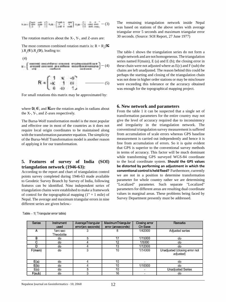
5. Features of survey of India (SOI) triangulation network (1946-63):According to the report and chart of triangulation control points survey completed during 1946-63 made available to Geodetic Survey Branch by Survey of India, following features can be identified. Nine independent series of triangulation chains were established to make a framework of control for the topographical mapping (1" = 1 mile) of Nepal. The average and maximum triangular errors in nine different series are given below.-
The remaining triangulation network inside Nepal was based on stations of the above series with average triangular error 5 seconds and maximum triangular error 30 seconds. (Source: SOI Report, 27 June 1977)
The table-1 shows the triangulation series do not form a single network and are not homogeneous. The triangulation series named F(main), E (a) and E (b); the closing error in these chain were not adjusted where as E(c) and F (sub) the chains are left unadjusted. The reason behind this could be perhaps the starting and closing of the triangulation chain was not done in higher order stations or may be misclosure were exceeding this tolerance or the accuracy obtained was enough for the topographical mapping project.
6. New network and parametersFrom the table 1 it can be suspected that a single set of transformation parameters for the entire country may not give the level of accuracy required due to inconsistency and irregularity in the triangulation network. The conventional triangulation survey measurement is suffered from accumulation of scale errors whereas GPS baseline measurement is carried out independently and hence it is free from accumulation of errors. So it is quite evident that GPS is superior to the conventional survey methods in terms of accuracy. This factor will be much dominant while transforming GPS surveyed WGS-84 coordinate to the local coordinate system. Should the GPS valuesbedistortedbyperforminganadjustmentinwhichtheconventionalcontrolisheldfixed? Furthermore, currently we are not in a position to determine transformation parameter for whole country rather we are determining "Localized" parameter. Such separate "Localized" parameters for different areas are resulting dual coordinate values in marginal areas. These problems being faced by Survey Department presently must be addressed.
(3)
(4)
(5)
13 Nepalese Journal on Geoinformatics - 10, 2068
Given the inconsistencies in the local networks a revision by way of a total readjustment is necessary. In order to derive a single set of transformation parameter for the whole country first of all various higher order networks set up at different periods by different parties should be integrated as a single network. The existing triangulation may be referred to as the old network. A new integrated control network comprising all series of existing higher order triangulation stations and different series of GPS stations has been designed and referred to as the Nepal GPS Network. Its coordinates in the WGS-84 reference frame are being determined using GPS survey.
7. ConclusionMore sophisticated techniques and more amount of GPS data are required if one wishes to get sub-meter transformation accuracy. Geodetic Branch of Survey Department has been running the programme of strengthening the Geodetic network since a couple of years and expected to be completed this year. The best co-ordinate value in WGS 84 reference system for Nagarkot station has to be fixed as a reference coordinate for the entire network solution. If we would like to establish the new geodetic network within a global reference frame, i.e., WGS84, it is necessary that the new geodetic network be tied to points within the IGS global network of points with WGS84 coordinates. Two or perhaps three would be sufficient to make the connection to the Global IGS Network. Thus derived parameters will be suited for different applications. The absence of a Geoid computed with respect to the local datum has presented some difficulties in properly analyzing the quality of the height transformations. When these transformations are to be applied in practice, geoid heights will be required. It is therefore necessary that an accurate local geoidal model be developed. Finally, the proposed Nepal GPS Network can be expected to serve as a foundation for any future national control activities, be it a revision of the existing network or a redefinition of the datum.
References:
1. Acharya P., Adiga G., Geodetic Datum of Nepal, Nepal Surveyors Society Journal, 1992 and Phuyal B.P.
2. Kalyan Gopal Shrestha Unpublished report on A Status Report on GPS Data Processing, 1998
3. Niraj Manandhar and Maheswar P. Bhattarai An overview on Time Series of Geodetic and GPS Network of Nepal, Nepalese Journal on Geoinformatics, 2002
4. S.K. Singh Coordinate transformation between Everest and WGS – 84 datum – A parametric approach, GIS development, 2002
5. Survey Department Topographical Base Map souvenir, Souvenir publication, 2002
6. Survey Department Unpublished report on first order geodetic network of Nepal 1981-1984
7. Survey Department Unpublished report on GPS survey of Eastern and Western Nepal Topographical Mapping Project 1994, 1997.
8. Tirtha B. Pradhananga Surveying and Mapping in Nepalese Context, Nepalese Journal on Geoinformatics, 2007
14Nepalese Journal on Geoinformatics - 10, 2068
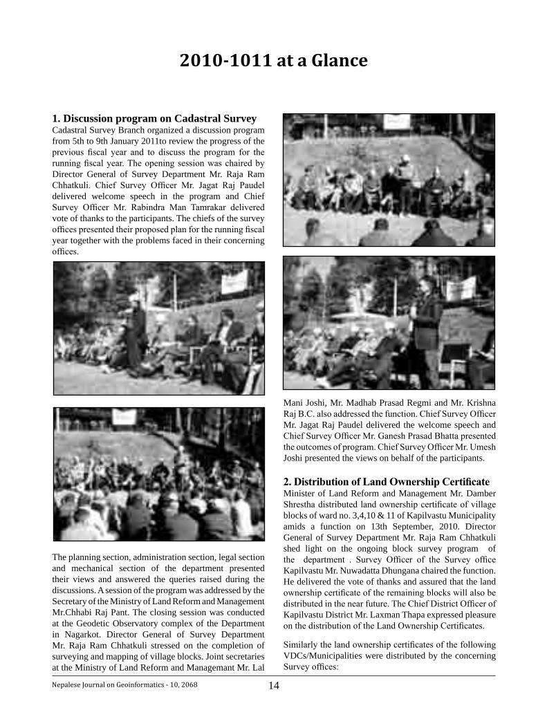
1. Discussion program on Cadastral SurveyCadastral Survey Branch organized a discussion program from 5th to 9th January 2011to review the progress of the previous fiscal year and to discuss the program for the running fiscal year. The opening session was chaired by Director General of Survey Department Mr. Raja Ram Chhatkuli. Chief Survey Officer Mr. Jagat Raj Paudel delivered welcome speech in the program and Chief Survey Officer Mr. Rabindra Man Tamrakar delivered vote of thanks to the participants. The chiefs of the survey offices presented their proposed plan for the running fiscal year together with the problems faced in their concerning offices.
The planning section, administration section, legal section and mechanical section of the department presented their views and answered the queries raised during the discussions. A session of the program was addressed by the Secretary of the Ministry of Land Reform and Management Mr.Chhabi Raj Pant. The closing session was conducted at the Geodetic Observatory complex of the Department in Nagarkot. Director General of Survey Department Mr. Raja Ram Chhatkuli stressed on the completion of surveying and mapping of village blocks. Joint secretaries at the Ministry of Land Reform and Managemant Mr. Lal
2010-1011 at a Glance
Mani Joshi, Mr. Madhab Prasad Regmi and Mr. Krishna Raj B.C. also addressed the function. Chief Survey Officer Mr. Jagat Raj Paudel delivered the welcome speech and Chief Survey Officer Mr. Ganesh Prasad Bhatta presented the outcomes of program. Chief Survey Officer Mr. Umesh Joshi presented the views on behalf of the participants.
2.DistributionofLandOwnershipCertificateMinister of Land Reform and Management Mr. Damber Shrestha distributed land ownership certificate of village blocks of ward no. 3,4,10 & 11 of Kapilvastu Municipality amids a function on 13th September, 2010. Director General of Survey Department Mr. Raja Ram Chhatkuli shed light on the ongoing block survey program of the department . Survey Officer of the Survey office Kapilvastu Mr. Nuwadatta Dhungana chaired the function. He delivered the vote of thanks and assured that the land ownership certificate of the remaining blocks will also be distributed in the near future. The Chief District Officer of Kapilvastu District Mr. Laxman Thapa expressed pleasure on the distribution of the Land Ownership Certificates.
Similarly the land ownership certificates of the following VDCs/Municipalities were distributed by the concerning Survey offices:
15 Nepalese Journal on Geoinformatics - 10, 2068
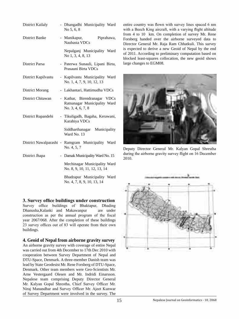
entire country was flown with survey lines spaced 6 nm with a Beech King aircraft, with a varying flight altitude from 4 to 10 km. On completion of survey Mr. Rene Forsberg handed over the airborne surveyed data to Director General Mr. Raja Ram Chhatkuli. This survey is expected to derive a new Geoid of Nepal by the end of 2011. According to preliminary computation based on blocked least-squares collocation, the new geoid shows large changes to EGM08.
Deputy Director General Mr. Kalyan Gopal Shrestha during the airborne gravity survey flight on 16 December 2010.
District Kailaly - Dhangadhi Municipality Ward No 5, 6, 8
District Banke - Manikapur, Piprahawa, Naubasta VDCs
Nepalganj Municipality Ward No 1, 3, 4, 8, 13
District Parsa - Paterwa Sunauli, Lipani Birta, Prasauni Birta VDCs
District Kapilvastu - Kapilvastu Municipality Ward No. 1, 4, 7, 9, 10, 12, 13
District Morang - Lakhantari, Hattimudha VDCs
District Chitawan - Kathar, Birendranagar VDCs Ratnanagar Municipality Ward No. 3, 4, 6, 7, 8
District Rupandehi - Tikuligadh, Bagaha, Kerawani, Karahiya VDCs
Siddharthanagar Municipality Ward No. 13
District Nawalparashi - Ramgram Municipality Ward No. 4, 5, 7
District Jhapa - Damak Municipality Ward No. 15
Mechinagar Municipality Ward No. 8, 9, 10, 11, 12, 13, 14
Bhadrapur Municipality Ward No. 4, 7, 8, 9, 10, 13, 14
3.SurveyofficebuildingsunderconstructionSurvey office buildings of Bhaktapur, Dhading Dhanusha,Kalanki and Makawanpur are under construction as per the annual program of the fiscal year 2067/068. After the completion of these buildings 23 survey offices out of 83 will operate from their own buildings.
4. Geoid of Nepal from airborne gravity surveyAn airborne gravity survey with coverage of entire Nepal was carried out from 4th December to 17th Dec 2010 with cooperation between Survey Department of Nepal and DTU-Space, Denmark. A three-member Danish team was lead by State Geodesist Mr. Rene Forsberg of DTU-Space, Denmark. Other team members were Geo-Scientists Mr. Arne Vestergaard Olesen and Mr. Indridi Einarsson. Nepalese team comprising Deputy Director General Mr. Kalyan Gopal Shrestha, Chief Survey Officer Mr. Niraj Manandhar and Survey Officer Mr. Ajeet Kunwar of Survey Department were involved in the survey. The
16Nepalese Journal on Geoinformatics - 10, 2068
KeywordsGreen House Gases (GHG), Emission, Climate Change, Remote Sensing, LiDAR
AbstractGreenhouse effect causes global warming and its main consequence is the climate change. Average global temperature is rising significantly over the period. Despite the contribution of total GHG emission by Nepal to the global community is insignificant compared to the developed countries, Nepal has already encountered several adverse effects due to the global climate change, leading to the melting of Himalayan glaciers, reduced agriculture production, loss of biodiversity and ecosystems and changes in social structure and livelihoods. Forest land use change is responsible for CO2 emissions. Forest management therefore can play a significant role in climatic change mitigation. REDD has become the key mechanism in mitigating climate change. The success of REDD mechanism however depends primarily on availability of reliable forestry data including biomass changes and forest carbon estimates. Various Remote Sensing data including optical sensor data have been used for the analysis of forest cover change and estimation of degree of deforestation and degradation. LiDAR however has been widely used in estimating forest biomass for the climate change mitigation.
1. IntroductionThe atmosphere is largely transparent to incoming short-wave (or ultraviolet) solar radiation, which is absorbed by the Earth's surface. Much of this radiation is then re-emitted as heat energy at long-wave, infrared wavelengths. Some of this energy escapes back into the space, but due to the increasing presence of Greenhouse Gases (GHG - i.e. Carbon Dioxide, Methane, Nitrous Oxides, Ozone and Chloro-fluoro Carbons) in the earth’s atmosphere, heat energy then is trapped inside. The effect of this heat
trapping due to the increasing presence of Greenhouse Gases in the atmosphere is known as greenhouse effect. This greenhouse effect causes global warming and its main consequence is the climate change.
According to the statistics, Nepal's per capita emission ranks lowest among SAARC nations at 0.11 metric tones per year. Even though Nepal contributes very low emissions it is highly vulnerable to the effects of climate change. Increase in mountain snow melt and an outburst from glacial lakes could lead to flooding with a devastating impact on the life of poor people living in both mountain and plain areas. Climate change has therefore become a priority issue in Nepal. In addition, there is a strong relationship between economic development and climate change. In order to increase the economy, the country must reduce its emissions.
Forestry sector has recently become one of the high-profile sectors in the debate on reducing emissions in developing countries. Forest land use change is responsible for CO2 emissions. Forest management therefore can play a significant role in climatic change mitigation. Forests can be a sink or source of carbon, depending on the management regimes that are implemented. Forest cover can sequester carbon through photosynthetic processes.
REDD (Reducing Emission from Deforestation and Forest Degradation) has become the key mechanism in mitigating climate change, especially in the developing countries such as Nepal. The success of REDD mechanism however depends primarily on availability of reliable forestry data including forest carbon estimates, forest cover and biomass changes in different scales, extent and time periods. Various Remote Sensing (RS) data generated from optical sensor systems and active microware systems such as RADAR (Radio Detection and Ranging) along with GIS technology have been used for the analysis of forest cover change and estimation of degree of deforestation and degradation over the period. LiDAR (Light Detection And Ranging), one of the active RS systems, however, has been widely used in estimating forest biomass for the climate change mitigation.
Impacts of Climate Change and Remote Sensing Technology in its Mitigation Options through Forest
Management
RabindraManTamrakarChief Survey OfficerSurvey Department
17 Nepalese Journal on Geoinformatics - 10, 2068
2. Trend of Emission and Global TemperatureCarbon Dioxide (CO2) is the major component which forms more than 80 percent of the total GHG. CO2 is mainly produced from burning of fossil fuels such as oil, coal and gases. Studies reveal that rapid industrialization coupled with urbanization, excessive consumption of fossil fuels, deforestations, slash & burning of forests, agricultural development etc. in the world over the past two centuries have resulted in significant increase of CO2 gas in the atmosphere. Before the rapid industrialization, the share of CO2 gas in the atmosphere was estimated to be 280 ppm (parts per million) which now has increased to 390 ppm. If this trend in rising of CO2 gas continues, the level of this gas in the atmosphere is predicted to be 800 ppm at the end of this century, which will create serious impacts on the entire earth. Concentrations of other GHG gases such as methane and nitrous oxide as well have significantly increased over the period.
Over the last few decades, studies have indicated that temperature of earth surface has been rising and this has caused changes in weather patterns, resulting in rise in sea level, melting of glaciers, floods, draught, loss in agricultural production etc. Meteorological measurement records show that a warming of 0.3-0.6 degrees Celsius in global average temperature since 1860. Moreover, the global temperature has increased by 0.74 degrees Celsius during the period of 1906 to 2005. It is also recorded that 1990s was the warmest decade of the global surface temperature since 1850. The studies further reveal that the global temperature will rise between 1.5° to 4.5° Celsius by sometime in the 21st Century. In addition, it has been suggested that warming of more than 2.5°C could reduce global food supplies and contribute to higher food prices (UNEP & UNFCCC, 2002).
3. Effects of Climate Change in NepalDespite, the contribution of total GHG emission by Nepal to the global community is insignificant (nearly 0.025% of the total global emission) compared to the developed countries such as the United States, Russia, Australia, and European communities, Nepal has already encountered several negative effects due to the global climate change. According to the National Communication Report prepared by the Government of Nepal, net emission of CO2 was about 9.7 tons and the net emission of methane was estimated to be 0.95 tons in 1994. Studies carried out by the Department of Hydrology and Meteorology, Government of Nepal reveal that average temperature in Nepal is increasing at the rate of nearly 0.06 degrees Celsius per year between the period of 1977 and 1994. Another temperature analysis from 1976 to 2005 has revealed that the average temperature in Nepal has increased by 0.597 degrees Celsius per year. The projected figures for Nepal
further show that average increase in temperatures of 1.2ºC for the year 2030, 1.7ºC for 2050 and 3.0ºC for 2100. The temperature in the Himalayan Region, on the other hand is increasing at a greater rate, which is having severe effects on the glacial lakes, which are the main source of Nepal's water resources. For example, the Rika Samba Himalayan Glacier in the Dhaulagiri region western part of Nepal is receding at a rate of 10 m per year.
People’s lives and livelihoods, especially of poor and marginalized social groups such as farmers, indigenous communities, women and children in the rural areas who are least able to cope with are most at risks and vulnerable to the disasters caused by the climate change. The study shows that Nepal is ranked fourth vulnerable country among the 170 countries from the impacts of climate change.
Several effects of climate change in Nepal have been recorded. One of the major issues is the melting of Himalayan glaciers in Nepal. International agencies such as UNEP has warned that more than 40 Himalayan glacial lakes of the country are dangerously close to bursting because of the ice melt caused by global warming. Melting of glaciers in the Himalayas will cause in seasonal variation in river flows, which will subsequently result in more floods and draughts in the country. In addition, this will effect on irrigation and drinking water supply as well as reliability of hydroelectricity. Moreover, rapid melting of glaciers even may result in Glacier Lake Outburst Floods (GLOF), which can be catastrophic to communities and infrastructure along the riversides.
Other impacts of climate change are the reduced agriculture production, loss of biodiversity, increased desertification and changes in social structure. Nepalese economy depends primarily on agriculture, contributing about 32.7 percent of GDP and employing more than 65.7 percent of the total population. Agriculture land is therefore very important to Nepalese people as it provides food, shelter, clothing and energy required for the people. Without the proper management of land, it is not possible to improve the economy of a country. Latest figures of Ministry of Agriculture and Cooperatives, Government of Nepal indicate that the country has nearly 3.1 million hectares of cultivated land, producing 8.1 million of food grains. Studies have shown that both arable land and agricultural production in Nepal have been decreasing due to the draught, floods, loss of top fertile soil, landslides etc. resulted from the impacts of climate change. In addition, arable lands primarily depend on the natural rainfall (monsoon) water for irrigation. Rainfall patterns on the other hand will be erratic due to the effects of the climate change causing to food insecurity and threat to Nepalese economy. If these trends of effects continue, Nepal will face serious food crisis in the coming years.
18Nepalese Journal on Geoinformatics - 10, 2068
Another adverse effect of climate change can be noticed in the country’s ecosystems, resulting in the loss of biodiversity. Although Nepal is small in size, nearly 0.09 percent of the earth surface, its contribution in biodiversity conservation is of global significance. High topographic variations along the north-south transect offers higher level of diversity at species, ecosystem and genetic level. It is estimated that about 118 different ecosystem types are found in this country where more than 15,000 plant species exists in the wild. In addition, more than 700 species of the total identified plant species are found to be of medicinal importance. Impacts of climate change will slowly alter the existing ecosystems resulting in the extinct of valuable plant species in the future.
Likewise, negative effects of climate change can also be noticed in livestock production. Major concerned in livestock production are the feed, reproduction, livestock health and management. As described above, climate change can cause the draught, floods and loss in agricultural production, which in turn can reduce the required amount of animal fodders such as palatable grasses and feeds from agricultural products. This will lead to the poor animal health and reproduction capacity.
Finally, human health as well can be seriously affected by the climate change in Nepal although it is difficult to perceive the impacts. The growing risk of Malaria, Kalazar and Japanese Encephalitis is considered as the potential impacts of climate change on human health as warmer temperature may create favorable conditions for more vectors and germs spread such as mosquitoes. Specifically, subtropical and warm temperate regions of Nepal would be more vulnerable due to Malaria, Japanese Encephalitis and Kalazar. Moreover, with the warming of higher altitudes, it has been predicted that there may be an increased spread of lower altitude disease vectors such as mosquitoes and consequent spread of these diseases.
4. Forest Degradation and Emissions Forest degradation and deforestation is reported to contribute more than 17 percent of global GHG emissions, most of which come from developing countries. Nepal is a land locked country located between China in the north and India in the south covering 147,181 km2 surface areas. The current forest cover in the country is 5.8 million ha. The country can be divided into five major physiographical regions-Terai, Siwaliks, Middle Mountains, High Mountains and the Himalayas. Out of the total area about 39.6 percent area is officially declared as forests, including the areas under shrublands, which include shrubs as well as trees of less than 10 % crown coverage occupy almost 10.6% of the total country area.
Studies on carbon estimation from different physiographical regions of the country reveal that a substantial amount of carbon stocks has been currently hold in the forests. If
these forests could be managed properly, additional CO2 gas can be captured and stored in the forests. However, increasing demands of forest products and services have exerted tremendous pressure on the forest resources. The studies show that the forest cover in Nepal which was about 60 percent in 1950’s has reduced to 39.6 percent in 1990’s. Most of the deforestation and degradation of forests has occurred in the Terai region, the southern portion of the country lying with the Indian border. Studies have further shown that Nepal has lost nearly 570,000 hectares of natural forests in 27 years between 1964 and 1991, most of which were converted into the agricultural land. Moreover, the studies reveal that the overall deforestation rate in Nepal is currently 1.7%, which is well above the Asian average (1%) and the global average (1.3%).
There are several factors attributable to the depletion of forest coverage in Nepal. The most common factors that affect forestry land use change in Nepal include:
Demographic variables such as population pressure • and its growth rateRural/urban distribution• Higher dependence on forest resources• Poverty• Shifting cultivations• Migrations of people from hills to the forested plain • areas.Forest Encroachments• Uncontrolled grazing on the forested lands • Smuggling of timber, fuelwood and fodders • Resettlement Programmes in the Terai Region• Use of fuelwood for cooking and heating•
5. Mitigation Options through Forest Management Reduced Emissions from Deforestation and Degradation (REDD) is assumed to be the cheapest means of mitigating carbon emission in the world. Thus, conserving and enhancing forests in the country might result in the reduction of the emissions as well as in the enhancement of the country’s economy.
In December 2007, the 13th Conference of Parties (COP) of United Nations Framework Convention on Climate Change (UNFCCC) has approved REDD as the key policy instrument in mitigating climate change. The REDD device will be applicable specifically to the developing countries like Nepal as the policy will be able to provide incentives to reducing emissions from deforestation and forest degradation. The World Bank (WB) has established Forest Carbon Partnership Facility (FCPF) to support developing countries in their efforts to build capacity for
19 Nepalese Journal on Geoinformatics - 10, 2068
REDD at the country level. The purpose of the facility is to assist developing countries to be ready for REDD by 2012.
6. Remote Sensing Data for Forest ManagementAirborne and spaceborne Remote Sensing (RS) data generated from various optical sensor systems and active microware systems such as RADAR along with GIS technology have been widely used for the preparation of forest inventory and analytical study of forest cover change over the period as well as for estimation of degree of deforestation and degradation. LiDAR data, however, have been extensively used in estimating forest biomass for the climate change mitigation in many parts of the world. It is simply because of the fact that the LiDAR systems are cost-effective, versatile, operationally flexible and robust sampling tools for forest management (Lim, et al, 2010).
Airborne RS data such as aerial photography were initially used for forest mapping and preparation of forest inventory before the availability of commercial satellite images. In Nepal for the last few decades, remote sensing techniques specifically aerial photogrammetry was extensively used in the forestry sector. First systematic Forest Research Survey was conducted in the period of 1963-67 using black and white aerial photographs taken in 1963/64. This Research Survey however was limited to the Terai and Hill regions of the country, generating data/inventory mainly of commercial forests.
In 1986, Land Resources Mapping Project (LRMP, 1986) has prepared Land Utilization maps at 1:50,000 scale of the entire Nepal, using 1978/79 aerial photographs with extensive ground verifications. These data have provided an opportunity to estimate forest biomass and prepare basic forest inventory of the country. LRMP data has also placed specific emphasis on forests, shrublands, agriculture, and grassland resources. Forest units have been further classified into various components including forest cover types, species associations, crown density coverage, and maturity classes. LRMP information as well was used for the preparation for the Master Plan of the Forestry Sector of Nepal in 1989.
Although National Remote Sensing Centre under the Ministry of Forest and Soil Conversation was established in the early 1980s in order to develop the forest inventory of the nation, National Forest Inventory was only prepared in the year of 1994 using remote sensing data such as 1990 Landsat images and available aerial photographs with the field measurements collected during the period of 1990-1999.
Likewise, in 2000 forest cover mapping of the entire Nepal was carried out using the Indian Remote Sensing
(IRS) data of the year 1999/2000 in collaboration of Japan Forest Technical Association Information System Development Project.
Moreover, Survey Department, Government of Nepal, has prepared Topographic maps of the entire nation in 2001. One of the major components of these maps is the land cover information which is very useful for the estimation of forest biomass for the climate change study. Topographic maps at the scale of 1 : 25, 000 were prepared for the Terai and the Mid Hill Regions of Nepal and are based on aerial photographs taken in 1992 and 1996 with extensive ground truthings. Topographical maps at the scale of 1 : 50, 000 dated 1996-97 on the other hand are available for High Mountain and Himalayan Regions of Nepal. Moreover, digital data of these topographic map series are as well available from this department. These databases were created in 2002 using ARC/INFO GIS software programmes by a project under the Survey Department with the financial assistance from the Finish Government. These databases are valuable tools for the preparation of national forest inventory as well as for the estimation of forest biomass using GIS technology.
In 2009, the global forest mapping was completed by FAO Global Land Cover Network using 2000 Landsat images. One of the major objectives of mapping was to acquire the information on the forest cover extent.
In 2010, Forest Resource Assessment (FRA) Nepal project has started to provide National Forest Inventory of Nepal, in collaboration with Government of Finland for a period of five years (2010-2014). This project is conducted under the Ministry of Forests and Soil Conservation (MFSC) and the Department of Forest Research and Survey is the implementing agency. Major objectives of this project is to generate national level baseline data of status of present forest cover, growing stock, wood and non-wood products, forests in the protected areas, tree resources outside the forest, biological diversity, biomass above the ground and soil carbon. High resolution satellite images (up to 0.5 m. resolution) along with LiDAR technology are used to obtain the information. This project will provide necessary forest resource databases for REDD programmes using high resolution satellite images. Moreover, since LiDAR technology is being used, the project as well will be providing three-dimensional information regarding forest structures that are required for biomass calculations for the climate change mitigation study.
Although LiDAR technology was introduced in Nepal only in 2010 for obtaining information on forest structure, its application specifically for estimation of forest canopy height and biomass estimation is extensively used long before in many parts of the world. One of the main reasons of using this technology is its capabilities of recording the time-varying return signals that provide tree structural
20Nepalese Journal on Geoinformatics - 10, 2068
information including tree heights and ground surface height (Zang, et al, 2008). It is because LiDAR can penetrate through the top layer of forest canopy, providing the information on the under storey layers. Studies also have shown that direct estimates of crown height from LiDAR technology to be as accurate as the field data measurement. Moreover, LiDAR data resolve the major problems associated with optical data that is incapable of distinguishing over storey from the under storey vegetation cover. This then lead to confusion between layers, resulting in the overestimation of crown coverage (Tickle, et al, 2001). Another advantage of using LiDAR technology is that its systems are based on active remote systems which simply use pulses of laser light. This then provides opportunity to capture biophysical data even at night.
Despite LiDAR data have significant advantages over the optical data, especially for the estimation of forest structure and biomass, further research works on LiDAR intensity and impacts caused by sensor angle, surface roughness or type, or atmospheric conditions need to be carried out.
7. ConclusionsGreenhouse effect causes global warming and its main consequence is the climate change. Despite, the contribution of total GHG emission by Nepal to the global community is insignificant compared to the developed countries, Nepal has already encountered several negative effects due to the global climate change, leading to the melting of Himalayan glaciers, reduced agriculture production, loss of biodiversity and ecosystems, increased desertification, floods, livestock production and changes in social structure and livelihoods. Forest degradation and deforestation have contributed significant amount of global GHG emissions. There is a high risk of releasing CO2 gas, originally stored in forest biomass, from the forests into the environment due to forest degradation and deforestation. If necessary measures are not taken to protect these forests then it would have serious impacts on the entire livelihoods of all communities of the nation. Therefore, role of forests which plays both as a source and sinks is crucial in the overall global climate change. Sustainable forest management is obligatory in order to mitigate the impacts of climate change in Nepal. UNFCCC has approved REDD as the key policy instrument in mitigating climate change and it will be applicable specifically to the developing countries like Nepal. Remote Sensing data including LiDAR data are useful for the preparation of forest inventory as well as for the estimation of forest biomass which are essential for implementating and monitoring of REDD programmes for climate change mitigation in Nepal.
References:
Clean Energy Nepal , 2002. Clean Energy Nepal’s 1. Fact Sheet #2. Kathmandu, Nepal.
Dahal, N. 2006. Implications of Climate Change in 2. Nepal: Some Observations and Opportunities. Paper Presented at 23rd Warden Seminar, November 2006 held in Pokhara, Nepal.
Department of Hydrology and Meteorology, 2007. 3. Climatological & Agrometereological Records of Nepal 2007, Department of Hydrology and Meteorology, Ministry of Environment, Science and Technology, government of Nepal.
DFRS, 1999. Forest Resources of Nepal (1987-1998). 4. Department of Forest Research and Survey, Ministry of Forest and Soil Conservation, Kathmandu, Nepal.
DFRS, 2009. Banko Jankari, Vol. 19, No. 2. Department 5. of Forest Research and Survey, Ministry of Soil and Conversation, Government of Nepal.
DFRS, 2010. Forest Resource Assessment (FRA) Nepal 6. Project, Department of Forest Research and Survey, Ministry of Soil and Conversation, Government of Nepal.
FAO, 2006. Global Forest Resources Assessment 2005. 7. Progress towards Sustainable Forest Management; FAO Forestry Paper 147: Food and Agriculture Organization of the United Nations, Rome, Italy.
Jackson, W.J., R.M. Tamrakar, S. Hunt, K.R. Shepherd, 8. 1998. "Land Use Changes in Two Middle Hills District of Nepal" in Mountain Research and Development [1998:18 (3):193-212].
Kanel, K. R. et al. 2009. Assessment of Land Use, 9. Forest Policy and Governance. A report submitted to REDD-Forestry and Climate Change Cell, MFSC by NFA, Kathmandu, Nepal.
Karim, Z, R.M. Tamrakar, 1993. "Application of GIS 10. for Shivapuri Watershed Project" in Remote Sensing Applications to the Planning and Management of Environment, Natural Resources and Physical Infrastructure. UNSAP/CDG/eas/ICIMOD, Kathmandu, Nepal.
Kienholz, H., H. Halfner, G. Schneider and R.M. 11. Tamrakar, 1983. "Mountain Hazard Mapping in Nepal's Middle Mountains" in Mountain Research and Development [1983:3(3):195-220].
Lefsky, M. A., W.B. Cohen, G.G. Parker and D.J. 12. Harding. 2002. Lidar Remote Sensing for Ecosystem Studies, Bioscience Vol.52, No.1 19-30.
21 Nepalese Journal on Geoinformatics - 10, 2068
Lim, S, J.C. Trinder, R. Turner, 2010. Full Waveform 13. Lidar Remote Sensing for Forest Inventory in New South Wales, Australia. School of Surveying and Spatial Information Systems, UNSW, Sydney, NSW 2052, Australia.
LRMP, 1986. Land Resources Mapping 14. Project, Economic Report, Government of Nepal & Government of Canada. 55 pp.
Malla, G., 2008. Climate Change and its impact on 15. Nepalese Agriculture. The Journal of Agriculture and Environment. Vol 9. Kathmandu, Nepal.
MFSC, 2008. Forest Carbon Partnership Facility 16. Readiness Plan Idea Note (R-PIN) Nepal.
Ministry of Forest and Soil Conservation, 1988. 17. Master Plan for Forestry Sector, Nepal. Ministry of Forest and Soil Conservation, Kathmandu.
MoEST and UNDP, 2008. National Adaptation of 18. Programme of Action to Climate
Change Project Document. Ministry of Environment, 19. Science and Technology & United National Development Program.
Pandey, B. R. 2002. Potential of Using Clean Energy 20. in Transport Sector, Paper presented at Seminar on Air Quality Management of Kathmandu Valley: Challenges & Opportunities, Ministry of Population and Environment, Kathmandu, Nepal.
Pokhrel, A. P., 2002. Temperature and Precipitation 21. Trend and Its Impact in Nepal, Paper presented on First Preparatory meeting on Eighth Conference of Parties, COP 8, organized by IUCN Nepal.
Regmi, B. R and A. Adhikari. 2007. Climate Risk and 22. Vulnerability in Nepal. Country Case Study. Human Development Report 2007/2008 Fighting Climate Change: Human Solidarity in a divided world. Human Development Report Office Occasional Paper, UNDP.
Shrestha, A.M, 2010. “Preparing for climate change: 23. an evaluative framework for prioritizing adaptation measures in Nepal,” in Botanica Orientalis – Journal of Plant Science (2010) 7: 35-42.
Tamrakar, R.M., 2000. "Management Options 24. for Environmental Protection in Nepal" in Environmental Special Issue 2000. Gurans Nepal, Kathmandu, Nepal.
Tamrakar, R.M., 1999. "Environmental Imbalance 25. is Increasing Specially in the Middle Mountains and Terai Regions" in Environmental Special Issue.
Society of Environment Journalist – Nepal (SEJ-Nepal), Kathmandu, Nepal.
Tickle, P.K., C. Witte, A. Lee, R.M. Lucas, K. Jones and 26. J. Austin, 2002. Use of Airborne Scanning Lidar and Large Scale Photography within a Strategic Forest Inventory and Monitoring Framework. Bureau of Rural Sciences and Cooperative Research Centre for Greenhouse Accounting, Kingston, Australia.
UNEP & UNFCCC, 2002. Climate Change Information 27. Kit. Sheet 10. United Nation Environment Programme and United Nation Framework Convention on Climate Change. WFP, 2009.
UNFCCC, 2002. Annotated Guidelines for the 28. Preparation of National Adaptation Programmes of Action. Least Developed Countries Expert Group.
WFP, 2009. The Cost of Coping. A collision of crises and 29. the impact of Sustained Food Security Deterioration in Nepal. United Nations World Food Progarmme. Nepal Food Security Monitoring System.
Wigley, T.M.L. and S.C.B. Raper. 1993. "Future 30. Changes in Global-Mean Temperature and Sea Level," in Climate and Sea Level Change: Observations, Projections and Implications, R.A. Warrick, E. Barrow, and T.M.L. Wigley (eds.), pp.111-133. Cambridge University Press, Cambridge, 424pp.
Zhang, Z., W. Ni , A. Fu , Z. Guo , Guoqing Sun , and 31. D. Wang , 2008. “Estimation of Forest Structural Parameters from LiDAR and SAR data,” in The International Archives of the Photogrammetry, Remote Sensing and Spatial Information Sciences. Vol. XXXVII. Part B8. Beijing 2008.

22Nepalese Journal on Geoinformatics - 10, 2068
• Durgendra Man Kayastha, The then Deputy Director General Sentinel Asia Step-2 JPTM Meeting 6-8 July 2010 Manila, Philippines
• Professional Education Shanti Basnet , Survey Officer Dilli Raj Bhandari, Survey Officer 1 year from September 2010 ITC the Netherlands
• Raja Ram Chhatkuli, Director General 17th Asia Pacific Regional Space Agency Forum (APRSAF-17) 22-26 November 2010 Melbourne, Australia
• Ganesh Prasad Bhatta, Chief Survey Officer Study trip to National Land Survey of Finland 15-16 November 2010 Finland
• Ganesh Prasad Bhatta, Chief Survey Officer OSCAR workshop 18-19 November 2010 F.A.O., Italy
• Raja Ram Chhatkuli, Director General Geospatial World Forum 16-21 January, 2011 Hyderabad, India
Participation in the International Events by the
Officials of Survey Department
23 Nepalese Journal on Geoinformatics - 10, 2068
Spatial Analysis:
an Assessment of the Road Accessibility
MadhuSudanAdhikariPresident
Nepal Surveyors Association (NESA)
IntroductionSpatial analysis is the process of manipulating spatial information to extract new information and meaning from the original geospatial data. Spatial analysis is usually carried out with a Geographic Information System (GIS) because GIS software provides spatial analysis tools for calculating feature statistics and carrying out geo-processing activities like data interpolation and many more. Each user will have different things they are interested in depending on the kind of work they do. Understanding the spatial distribution of data from phenomena that occur in space comprise today a great challenge to the illumination of central questions in many areas of knowledge, be it in health, in environment, in cartography, in geography, in geology, in agronomy, among many others. In hydrology, users will likely emphasize the importance of terrain analysis and hydrological modeling (modeling the movement of water over and in the earth). In wildlife management, users are interested in analytical functions dealing with wildlife point locations and their relationship to the environment. In transportation management, users are interested in the analysis of the accessibility of the people to the road or the transportation network. All of these problems are part of spatial analysis of geo-spatial data. The emphasis of Spatial Analysis is to measure properties and relationships, taking into account the spatial localization of the phenomenon under study in a direct way i.e. to incorporate space into the analysis to be made.
Basic concepts in spatial analysis Spatial Dependency PrincipleSpatial Dependency is a key concept on understanding and analyzing a spatial phenomenon. Waldo Tobler, a pioneer geographer of the University of California, explains this spatial dependency of the geographic phenomenon by his first law of geography, which states that “everything is related to everything else, but near things are more related than distant things”. Noel Cressie also explains the nature of the spatial dependency and states, “the spatial
dependency is present in every direction and gets weaker the more the dispersion in the data localization increases”. It will be contextual to present the few lines of the poem “The Mistress of Version” by Francis Thomson that present the spatial dependency of all the things in the universe:
All the things by a mortal power near or farHiddenly to each other linked areThat thou canst not stir a flowerWithout the troubling of a star
All the phenomena and occurrences that are happening around us whether they are natural or social, present a relationship among themselves that depends on the distance from each other. This is what we call spatial dependency principle. This principle simply implies that if we find pollution on a spot in a lake it is very probable that places close to this sample spot are also polluted, such pollution decreases with distance, and beyond a certain radius no pollution will be found.
Spatial Autocorrelation PrincipleThe quantification of the spatial dependency is done by Spatial Autocorrelation Principle i.e. computational expression of the concept of spatial dependence is the spatial autocorrelation. This term comes from the statistical concept of correlation, used to measure the relationship between two random variables. The prefix “auto” indicates that the measurement of the correlation is done with the same random variable, measured in different places in space. We can use different indicators to measure the spatial autocorrelation, all of them based on the same idea: verifying how the spatial dependency varies by comparing the values of a sample and their neighbors’. The autocorrelation indicators are a special case of a crossed products statistics like
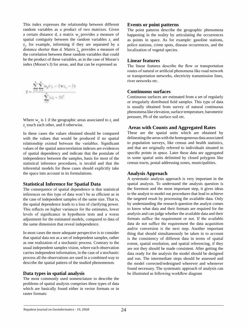
24Nepalese Journal on Geoinformatics - 10, 2068
This index expresses the relationship between different random variables as a product of two matrixes. Given a certain distance d, a matrix wij provides a measure of spatial contiguity between the random variables zi and zj, for example, informing if they are separated by a distance shorter than d. Matrix ξij provides a measure of the correlation between these random variables that could be the product of these variables, as in the case of Moran’s index (Moran’s I) for areas, and that can be expressed as
Where wij is 1 if the geographic areas associated to zi and zj touch each other, and 0 otherwise.
In these cases the values obtained should be compared with the values that would be produced if no spatial relationship existed between the variables. Significant values of the spatial autocorrelation indexes are evidences of spatial dependency and indicate that the postulate of independence between the samples, basis for most of the statistical inference procedures, is invalid and that the inferential models for these cases should explicitly take the space into account in its formulations.
Statistical Inference for Spatial Data The consequence of spatial dependence is that statistical inferences on this type of data won’t be as efficient as in the case of independent samples of the same size. That is, the spatial dependence leads to a loss of clarifying power. This reflects on higher variances for the estimates, lower levels of significance in hypothesis tests and a worse adjustment for the estimated models, compared to data of the same dimension that reveal independence.
In most cases the more adequate perspective is to consider that spatial data not as a set of independent samples, rather as one realization of a stochastic process. Contrary to the usual independent samples vision, where each observation carries independent information, in the case of a stochastic process all the observations are used in a combined way to describe the spatial pattern of the studied phenomenon.
Data types in spatial analysis The most commonly used nomenclature to describe the problems of spatial analysis comprises three types of data which are basically found either in vector formats or in raster formats:
Events or point patterns The point patterns describe the geographic phenomena happening in the reality by articulating the occurrences as points in space. As for example: gasoline stations, police stations, crime spots, disease occurrences, and the localization of vegetal species.
Linear features The linear features describe the flow or transportation routes of natural or artificial phenomena like road network or transportation networks, electricity transmission lines, river networks etc.
Continuous surfaces Continuous surfaces are estimated from a set of regularly or irregularly distributed field samples. This type of data is usually obtained from survey of natural continuous phenomena like elevation, surface temperature, barometric pressure, Ph of the surface soil etc.
Areas with Counts and Aggregated Rates These are the spatial units which are obtained by delineating the areas with the homogeneous data associated to population surveys, like census and health statistics, and that are originally referred to individuals situated in specific points in space. Later these data are aggregated in some spatial units delimited by closed polygons like census tracts, postal addressing zones, municipalities.
Analysis Approach A systematic analysis approach is very important in the spatial analysis. To understand the analysis question is the foremost and the most important step, it gives ideas to the analyst to model out procedures that lead to achieve the targeted result by processing the available data. Only by understanding the research question the analyst comes to know what data and their formats are required for the analysis and can judge whether the available data and their formats suffice the requirement or not. If the available data do not suffice the requirement the data acquisition and/or conversion is the next step. Another important thing that should simultaneously be taken in to account is the consistency of different data in terms of spatial extent, spatial resolution, and spatial referencing, if they are not they should be made consistent. After getting the data ready for the analysis the model should be designed and run. The intermediate steps should be assessed and the model corrected/redesigned wherever and whenever found necessary. The systematic approach of analysis can be illustrated as following workflow diagram

25 Nepalese Journal on Geoinformatics - 10, 2068
Assess outputs intermediate results
Final Result
Check consistency
Correctredesign
the model
Transform/reproject/resample
Not expected result
State Analysis Question
Data ready to use
Design and run the model
Identify the Required Data
Not Consistent
Get Data
Expected result
Consistent
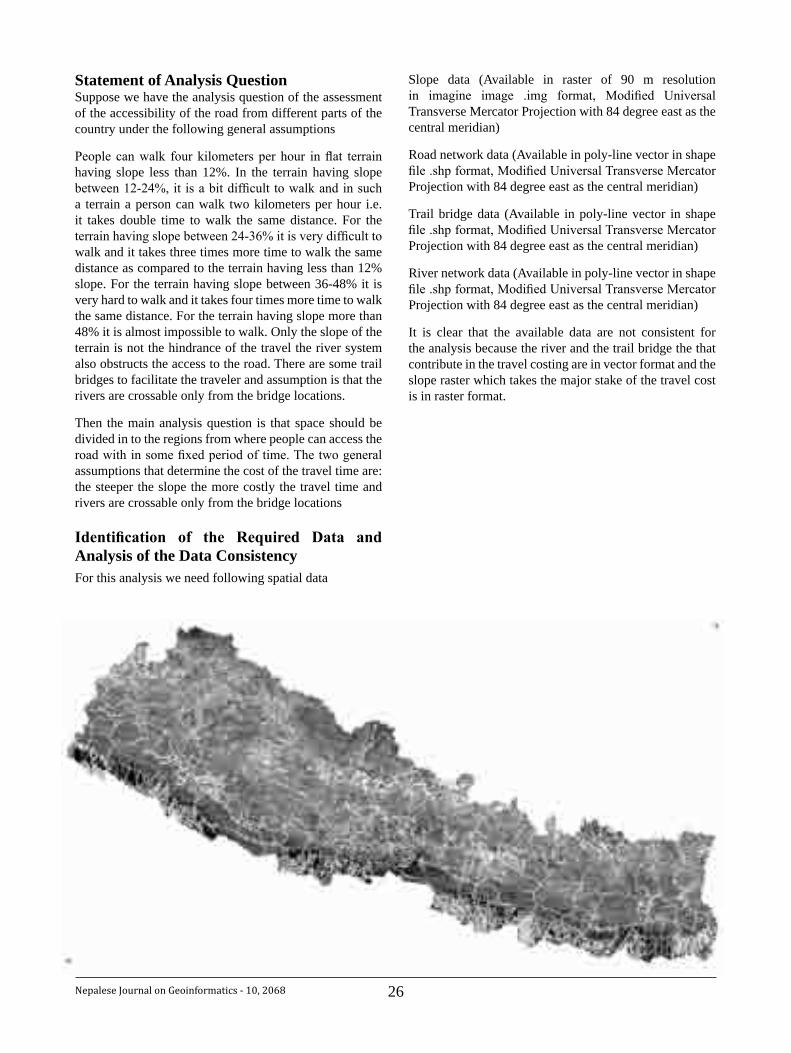
26Nepalese Journal on Geoinformatics - 10, 2068
Statement of Analysis QuestionSuppose we have the analysis question of the assessment of the accessibility of the road from different parts of the country under the following general assumptions
People can walk four kilometers per hour in flat terrain having slope less than 12%. In the terrain having slope between 12-24%, it is a bit difficult to walk and in such a terrain a person can walk two kilometers per hour i.e. it takes double time to walk the same distance. For the terrain having slope between 24-36% it is very difficult to walk and it takes three times more time to walk the same distance as compared to the terrain having less than 12% slope. For the terrain having slope between 36-48% it is very hard to walk and it takes four times more time to walk the same distance. For the terrain having slope more than 48% it is almost impossible to walk. Only the slope of the terrain is not the hindrance of the travel the river system also obstructs the access to the road. There are some trail bridges to facilitate the traveler and assumption is that the rivers are crossable only from the bridge locations.
Then the main analysis question is that space should be divided in to the regions from where people can access the road with in some fixed period of time. The two general assumptions that determine the cost of the travel time are: the steeper the slope the more costly the travel time and rivers are crossable only from the bridge locations
Identification of the Required Data andAnalysis of the Data ConsistencyFor this analysis we need following spatial data
Slope data (Available in raster of 90 m resolution in imagine image .img format, Modified Universal Transverse Mercator Projection with 84 degree east as the central meridian)
Road network data (Available in poly-line vector in shape file .shp format, Modified Universal Transverse Mercator Projection with 84 degree east as the central meridian)
Trail bridge data (Available in poly-line vector in shape file .shp format, Modified Universal Transverse Mercator Projection with 84 degree east as the central meridian)
River network data (Available in poly-line vector in shape file .shp format, Modified Universal Transverse Mercator Projection with 84 degree east as the central meridian)
It is clear that the available data are not consistent for the analysis because the river and the trail bridge the that contribute in the travel costing are in vector format and the slope raster which takes the major stake of the travel cost is in raster format.
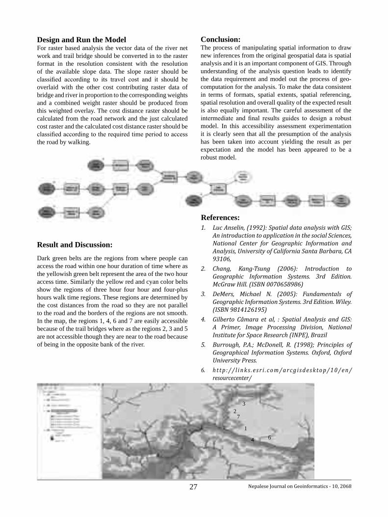
27 Nepalese Journal on Geoinformatics - 10, 2068
6
7
32
1
4
Design and Run the ModelFor raster based analysis the vector data of the river net work and trail bridge should be converted in to the raster format in the resolution consistent with the resolution of the available slope data. The slope raster should be classified according to its travel cost and it should be overlaid with the other cost contributing raster data of bridge and river in proportion to the corresponding weights and a combined weight raster should be produced from this weighted overlay. The cost distance raster should be calculated from the road network and the just calculated cost raster and the calculated cost distance raster should be classified according to the required time period to access the road by walking.
Result and Discussion:
Dark green belts are the regions from where people can access the road within one hour duration of time where as the yellowish green belt represent the area of the two hour access time. Similarly the yellow red and cyan color belts show the regions of three hour four hour and four-plus hours walk time regions. These regions are determined by the cost distances from the road so they are not parallel to the road and the borders of the regions are not smooth. In the map, the regions 1, 4, 6 and 7 are easily accessible because of the trail bridges where as the regions 2, 3 and 5 are not accessible though they are near to the road because of being in the opposite bank of the river.
Conclusion:The process of manipulating spatial information to draw new inferences from the original geospatial data is spatial analysis and it is an important component of GIS. Through understanding of the analysis question leads to identify the data requirement and model out the process of geo-computation for the analysis. To make the data consistent in terms of formats, spatial extents, spatial referencing, spatial resolution and overall quality of the expected result is also equally important. The careful assessment of the intermediate and final results guides to design a robust model. In this accessibility assessment experimentation it is clearly seen that all the presumption of the analysis has been taken into account yielding the result as per expectation and the model has been appeared to be a robust model.
References:Luc Anselin, (1992): Spatial data analysis with GIS; 1. An introduction to application in the social Sciences, National Center for Geographic Information and Analysis, University of California Santa Barbara, CA 93106,
Chang, Kang-Tsung (2006): Introduction to 2. Geographic Information Systems. 3rd Edition. McGraw Hill. (ISBN 0070658986)
DeMers, Michael N. (2005): Fundamentals of 3. Geographic Information Systems. 3rd Edition. Wiley. (ISBN 9814126195)
Gilberto Câmara et al, : Spatial Analysis and GIS: 4. A Primer, Image Processing Division, National Institute for Space Research (INPE), Brazil
Burrough, P.A.; McDonell, R. (1998); Principles of 5. Geographical Information Systems. Oxford, Oxford University Press.
h t t p : / / l i n k s . e s r i . c o m / a r c g i s d e s k t o p / 1 0 / e n /6. resourcecenter/
28Nepalese Journal on Geoinformatics - 10, 2068
ObituaryAll the officials of Survey Department pray to the Almighty for eternal peace to the departed soul of the following officials of the department and remembered them for their contribution towards the achievement of the goal of the department.
1. Late Mr. Dawa Kshiring Lama - Surveyor
2. Late Mr. Bijuli Prasad Chaudhari - Amin
3. Late Mr. Ram Nath Mandal - Helper
4. Late Mr. Lal Bahadur Darlami - Helper
Price of some of the publications of Survey Department1. List of Geographical Names volume I to V - NRs 600/- for each volume.
2. Nepalese Journal on Geoinformatices - NRs. 100/-
3. The Population and Socio-economic Atlas of Nepal (Hard Copy) NRs. 2,500 (In Nepal), € 200 (Out side Nepal)
4. The Population and Socio-economic Atlas of Nepal (CD Version) NRs. 250/-
Call for papersThe Editorial Board requests for Papers / articles related with Geoinformatics
for the publication in the eleventh issue of the Nepalese Journal on Geoinformatics. Last date for submission of the article is March 31, 2012
For more information, please contactJagat Raj Paudel, Editor-in-Chief
or
Deepak Sharma Dahal, Member, Editorial BoardTopographical Survey Branch
Survey DepartmentP.O. Box 9435, Kathmandu, Nepal
Tel: +977-1-46 22 729, +977-1-46 22 463Fax: +977-1-46 22 957, +977-1-46 22 216
Email: [email protected]: www.dos.gov.np
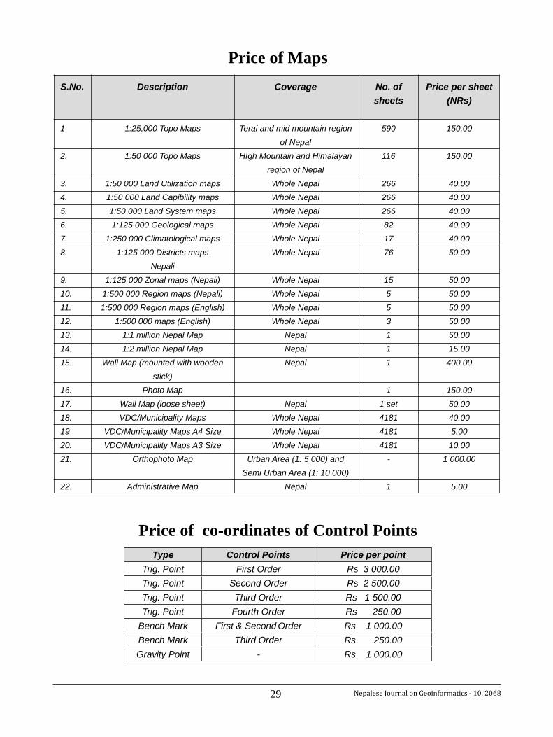
29 Nepalese Journal on Geoinformatics - 10, 2068Nepalese Journal on Geoinformatics - 8, 2066 20
Price of Maps S.No. Description Coverage No. of Price per sheet sheets (NRs)
1 1:25,000 Topo Maps Terai and mid mountain region 590 150.00 of Nepal 2. 1:50 000 Topo Maps HIgh Mountain and Himalayan 116 150.00 region of Nepal 3. 1:50 000 Land Utilization maps Whole Nepal 266 40.00 4. 1:50 000 Land Capibility maps Whole Nepal 266 40.00 5. 1:50 000 Land System maps Whole Nepal 266 40.00 6. 1:125 000 Geological maps Whole Nepal 82 40.00 7. 1:250 000 Climatological maps Whole Nepal 17 40.00 8. 1:125 000 Districts maps Whole Nepal 76 50.00 Nepali 9. 1:125 000 Zonal maps (Nepali) Whole Nepal 15 50.00 10. 1:500 000 Region maps (Nepali) Whole Nepal 5 50.00 11. 1:500 000 Region maps (English) Whole Nepal 5 50.00 12. 1:500 000 maps (English) Whole Nepal 3 50.00 13. 1:1 million Nepal Map Nepal 1 50.00 14. 1:2 million Nepal Map Nepal 1 15.00 15. Wall Map (mounted with wooden Nepal 1 400.00 stick) 16. Photo Map 1 150.00 17. Wall Map (loose sheet) Nepal 1 set 50.00 18. VDC/Municipality Maps Whole Nepal 4181 40.00 19 VDC/Municipality Maps A4 Size Whole Nepal 4181 5.00 20. VDC/Municipality Maps A3 Size Whole Nepal 4181 10.00 21. Orthophoto Map Urban Area (1: 5 000) and - 1 000.00 Semi Urban Area (1: 10 000) 22. Administrative Map Nepal 1 5.00
Price of co-ordinates of Control PointsType Control Points Price per point
Trig. Point First Order Rs 3 000.00Trig. Point Second Order Rs 2 500.00Trig. Point Third Order Rs 1 500.00Trig. Point Fourth Order Rs 250.00
Bench Mark First & Second Order Rs 1 000.00Bench Mark Third Order Rs 250.00Gravity Point - Rs 1 000.00
30Nepalese Journal on Geoinformatics - 10, 2068
Abstract:
There are many government, non-government and International organizations dealing in compilation of database or electronic maps with data from different sources often becomes necessary to transform from one coordinate system to another in order to work within a single unifying framework.
The significance of the study of the coordinate system of China, Pakistan, Nepal will benefit many researchers working in various disciplines and using geographic information system a part of their research. The use of remotely sensed data for environmental studies, disaster related matters and many more has widely been in use due to the availability of high resolution satellite images but it requires to have a relationship between the satellite images and ground location called geo-referencing. To establish this relationship the understating of the coordinate system is needed and also integrating to the national grid of the particular country if required then further knowledge of the parameters of datum chosen by the particular country will be a must. This paper illustrates some findings of the coordinate system of this region.
Introduction:The national and regional surveying and mapping works are all based on one single framework of geodetic control which is considered as a primary network of the country. The importance of the geodetic frame work for the country is beyond justification and is applied in almost
all development works of the country such as defense, satellite lunching, missiles projecting etc, construction of major infrastructures of the country (dams, roads, sewerage system, irrigation, hydropower stations etc).
The development of the Geographic Information System since last two decades has exemplified its importance and widened its application in many more sectors such as in the study of environmental change, disaster management, and creating the digital database in developing an information system.
The concept of the position defined by co-ordinate system is the most essential part in the process of map-making and to the performance of the spatial search and analysis of geographic information. In order to plot the geographical feature on the map it is necessary to define the position of points on the features with respect to a common frame of reference or the co-ordinate system in other words.
In the other hand all the observations and measurements for accurate mapping are carried out on the physical surface of the earth where as computations and representation of the earth surface into paper in the form of map requires mathematical figure of the earth. In other words there has to have some relationship between the mathematical earth (ellipsoid) and the physical earth (geoid). In the geodetic terms we need to define best fitting ellipsoid and geoid. The best fitting ellipsoid is that particular ellipsoid which best fits the spread of the earth surface of a particular country. Therefore there are different ellipsoids of different country and hence different countries have different origin and different datum defined by certain parameters.
The positions on the earth’s surface are normally defined in two systems Cartesian and the Geographic co-ordinate system. In the Cartesian co-ordinate system positions are defined by their perpendicular distances from the set of fixed axes. Different values are specified for these axes in different countries.
The geographical coordinates constitute degrees of latitude and longitude. This is a form of spherical polar coordinate system in which two angles are measured with respect to
Study of Geodetic datum of Nepal, China and Pakisthan and its transformation to World Geodetic
System
NirajManandharChief Survey Officer, Survey Department, Geodetic Survey Branch
31 Nepalese Journal on Geoinformatics - 10, 2068
the planes through the center of the ellipsoid representing the shape of the earth.
The latitude and longitude refer to the position in 3D space and for the cartographic works it is necessary to transform them in 2D map grid system. Such transformation is called projection. The projection refers to the transformation of the earth’s surface either directly to a plane or to a cylindrical or a conical surface which having been conceptually warped around the earth which then form a flat surface when unrolled.
The choice of projection in a particular country is usually governed by a desire to minimize the distortion to best possible extent. Therefore it is important to appreciate the process of map projection and the way in which they introduce internal changes in scale and give rise to these distortions.
As a consequence due to the adoption of variety of map projection there are different map-grid co-ordinate systems in use among them some of which are unique to a particular mapping organization of the country.
Aims and Objective of the study: Study the different datum position parameters adopted by different countries, Nepal, Pakistan and China in particular.
Find out the parameters used in the datum transformations between the adopted datum into internationally accepted World Geodetic System 1984 (WGS 84).
Geodetic Datum:The primary or the first order network is defined by means of well defined three-dimensional reference system of co-ordinates related to the earth fixed reference system. Such a reference system is defined by the dimension of the reference ellipsoid in terms of five parameters such as semi-major axis ‘a’ and flattening ‘f’ and its position represented by regional X, Y, Z or ϕ, λ, h system specifying the orientation with respect to the global Xg, Yg, Zg system, hence with respect to earth or geoid.
Usually the centre of the ellipsoid does not coincide with the earth's centre of mass but that axes are made parallel to the earth's axis of rotation with a pre assumption that global Xg, Yg, Zg rectangular co-ordinate system, has the origin which lies on the earth's centre of mass and a Z axis coinciding with the mean rotating axis of the earth, X - axis passing through the mean of the Greenwich meridian. The Y - axis as defined by the plane which is perpendicular to X and Z - axis (Torge, 1991, pl 38).
Determination of the parameters of such a reference datum defined by shape, size, and orientation of ellipsoid of revolution in other words the three dimensional co-ordinate system requires the high precision surface and spatial measurements. This work requires highly trained and skilled manpower.
WGS-84 Co-ordinate System:The WGS-84 (World Geodetic System – 1984) is a Conventional Terrestrial System (CTS), realized by modifying the Navy Navigational Satellite System (NNSS), or TRANSIT, Doppler Reference Frame in origin and scale and rotating it to bring its reference meridian into coincidence with the Bureau International de l’Heure (BIH) – defined Zero meridian.
The origin of WGS-84 system is the centre of mass of the earth. Its Z-axis lies along the direction of Conventional Terrestrial Pole (CTP) for polar motion and the X-axis lies along inter-section of the WGS-84 Reference meridian plane and the plane of CTP Equator. The Y-axis of this system completes a right-handed, Earth-Centered, Earth-Fixed (ECEF) orthogonal co-ordinates system, measured in the plane of CTP Equator 90o degree East of X-axis.
The origin and orientation of co-ordinates axis in WGS-84 have been defined by the X,Y,Z co-ordinates established under the control of the 5 GPS monitoring stations located at Hawaii, Colorado Springs, Ascension, Diego Garcia and Kwajalein.
The WGS-84 is an earth-fixed global reference frame, including an earth model and is defined by a set of primary and secondary parameters. The primary parameters are as follows:
Semi-major axis (a) 6378137 mFlattening (f) 1/298.257223563Angular velocity (ω) 7.292115 X 10(-5) (Radian
per second)Geocentric gravitational Constant (GM) 398600.5 Km3s-2
(Mass of the earth’s atmosphere included) -484.16685 X 10⁻⁶
Normalized 2nd degree zonal harmonic coefficient
of the gravitational constant
Nepal Datum:Geodetic Survey Branch (GSB) was aware of the requirement of National Geodetic datum defined by the network of points of first order controls. With the
32Nepalese Journal on Geoinformatics - 10, 2068
agreement between the government of Nepal and the United Kingdom’s Directorate of Military Survey, Ministry of Defense (MODUK) established the first order geodetic control net in the country. The task was completed in 1986.
TheDatumwasdefinedasinabove:References ellipsoid: Everest (1830)Semi-major axis (a) 6 377 276.345 mFlattening (f) 1/300.8017 and (e2 = 0.00663784663)
With the Geodetic Origin Station 12/57 Nagarkot defined as
Latitude (ϕg) = 270 41’ 31”.04 N Longitude (λg) = 850 31’ 20”.23 E meridian (ξ) = -37".03 Prime Vertical = -21".57
and assuming the geoid height (N) = 0 meter
The deflections quoted are derived from an astronomic position observed by Czechoslovak Geodetic Institute.
The Nepal datum represents a rigorous reference system. The net in properly oriented to the conventional origin (CIO) and the scale of the net is consistent with the international standards of length defined by the Doppler satellite observation.
As stated in the Report submitted by MODUK, the geographical co-ordinates of first order points are of high standard and hence fulfill the requirement of a rigorous Geodetic datum in Nepal.
Pakistan Datum:The Everest Ellipsoid has been in use in several countries of Indian Sub-continent for the mapping activities. Named after Sir George Everest the ellipsoid was derived in 1830 and since then it has been used as a basis for all types of control surveys. Sir George Everest paid careful attention to the measurement of bases and astronomical latitude and longitude were measured through out the arc of the meridian especially at Kalianpur in Madhya Pradesh.
Dimensions of the Everest ellipsoid and its orientation at origin were carried out one by one at a number of times. Semi-major axis (a), flattening (f) and north-south component of deflection of vertical (Meridonal)
was defined by Everest in 1840 where as East-West (prime vertical) component was defined by Walker in 1878. Though Everest ellipsoid has been the best fitting mathematical surface for India and adjacent countries but it cannot be extended too far from the origin and hence it application are rather limited. Therefore this ellipsoid has been marginally modified by the different countries of the Indian sub-continent.
The ellipsoidal parameter adopted by Pakistan are slightly different from Everest ellipsoid 1830.
The ellipsoidal parameters adopted by Pakistan are as follows:
Ellipsoid : Everest PakistanSemi-major axis (a): 6377309.613 mFlattening (f) : 1/300.8017 (source: NIMA
8350.2 4th July 1977)
The values of the datum origin of Pakistan were not found during the literature review. The great triangulation chain of India was extended to Pakistan at the time of Sir Geogre Everest. therefore possibly Kalianpur could be the datum origin.
Chinese Datum: During the literature review it was found that Central Bureau of Land Survey of China
( CBLS) established the Nanking Datum of 1935 where:
Φ0 = 320 04’ 19.7445” North,
Λ0 = 1180 50’ 18.5354” East of Greenwich.
The ellipsoid of reference is the International (also called the Hayford 1909 and the Madrid 1924) where:
Semi-major axis (a) 6,378,388 meters, and
Flattening 1/f 297
A Gauss-Kruger Transverse Mercator Grid is defined at the Datum origin. The scale factor at origin (m0 = 1.0); the False Easting and the False Northing = zero.
It is also found that the Current Grid Systems attributed to the People’s Republic of China find their roots in the Russian (USSR) origins of assistance. For instance, the Russia Belts for China are identical with the UTM specification with the exceptions or variations that the scale factor at origin is unity rather than 0.9996.
33 Nepalese Journal on Geoinformatics - 10, 2068
The ellipsoid of reference is the Krassovsky 1940 where:
Semi major axis (a) 6,378,245 m, and Flattening (1/f) 298.3.
A variation on this is known as the three degrees Belts, and the location of the Central Meridians are simply a (half) scalar of the six degrees belts.
Datum Transformation parameters:WGS-84 coordinate system is being adopted universally as the standard form of Geographical Coordinate Representation System. World wide development in the GPS and GIS system and its international adoption has created an environment in developing a common base of reference in exchanging the geographic data. This system came into existence only towards the end of 20th Century. Prior to that local coordinate system were in use. Thus most of the maps, records and data are available in local systems of the particular country. The coordinates, maps and records related to land are considered of very important property of the nation from the defense point of view therefore these information are kept secret by the nation and its national policy. The precise transformations parameters of the country are not made available to users still today.
In India, Pakistan and China still the topographical maps based on particular datum of the country is not freely available to the users. They are kept secret from the defense point of view. In this context this study has limitations to acquire such information.
With the increasing exchange of geographic information locally and globally positions defining the location need to be available in terms of both locally adopted datum and global datum. The process of mathematical conversion of the positions from one system to another is called datum transformation.
Transformation models:Several mathematical models have been developed which describe the functional relationship between pairs of three dimensional coordinates. The two most commonly used mathematical models to transform positions between the reference systems are
Bursa-Wolf (Bursa, 1962, Wolf, 1963) and Molodensky (Molodensky et.al., 1962)
These are the standard models due to their extensive use around the world over a number of years. The only difference between these two methods is Molodensky uses local origin about which the transformation is performed
where as Bursa-Wolf method uses reference system origin. It has been shown that both methods gives the identical results provided full statistical information (variance and covariance of parameters and positions) is carried out through the transformation process (Harvey, 1996). In most cases Bursa-Wolf method is preferred as it does not require local origin coordinates to be maintained along with the transformation parameter equation.
BURSA-Wolf transformation model:The Bursa-Wolf method assumes a similarity three dimensioned relationship between two consistent sets of Cartesian coordinate through seven parameters:
three translations (∆X, ∆Y, ∆Z) • three rotations around X, Y, Z axis respectively (ε,ψ, ω)• a scale change (∆L)•
If U, V and W represent the Cartesian components of a station in reference frame 1 say Everest and X, Y, Z represent the Cartesian component of same stations in reference frame number 2 say WGS-84, the transformation can be expressed as:
WVU
RLZYX
ZYX
)1( ∆++∆∆∆
= (1)
where R represents a 3 x 3 rotation matrix and defined a
R = R1 (ε) R2 (ψ) R3 (ω)
If all three angles are small the above rotation matrix can be written in its simplified form by setting sine of an angle equal to the angle itself, cosine of the angle equal to 1 and the product of sines equal to zero.
Thus after simplification the above matrix will appear as
R =
11
1
εψεω
ω
−−
Ψ− (2)
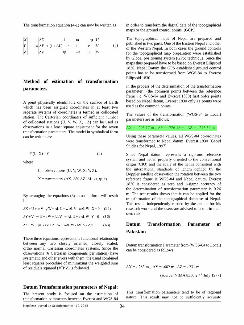
34Nepalese Journal on Geoinformatics - 10, 2068
The transformation equation (4-1) can now be written as
Method of estimation of transformation parameters
A point physically identifiable on the surface of Earth which has been assigned coordinates in at least two separate systems of coordinates is termed as collocated station. The Cartesian coordinates of sufficient number of collocated stations (U, V, W, X, , Z) can be used as observations in a least square adjustment for the seven transformation parameters. The model in symbolical form can be written as:
F (L, X) = 0 (4)
where
L = observations (U, V, W, X, Y, Z).
X = parameters (∆X, ∆Y, ∆Z, ∆L, ω, ψ, ε)
By arranging the equations (3) into this form will result in
∆X + U + w V - y W + ∆L U + w ∆L V - ψ∆L W - X = 0 (3-1)
∆Y + V - w U + e W + ∆L V - w ∆L U + e ∆L W - Y = 0 (3-2)
∆Z + W + ψU - εV + ∆L W + ψ∆L W - ε∆L V - Z = 0 (3-3)
These three equations represent the functional relationship between any two closely oriented, closely scaled, ortho normal Cartesian coordinates systems. Since the observations (6 Cartesian components per station) have systematic and other errors with them, the usual combined least squares procedure of minimizing the weighted sum of residuals squared (VTPV) is followed.
Datum Transformation parameters of Nepal:The present study is focused on the estimation of transformation parameters between Everest and WGS-84
in order to transform the digital data of the topographical maps or the ground control points (GCP).
The topographical maps of Nepal are prepared and published in two parts. One of the Eastern Nepal and other of the Western Nepal. In both cases the ground controls for the topographical map preparation were established by Global positioning system (GPS) technique. Since the maps thus prepared have to be based on Everest Ellipsoid 1830, Nepal Datum the GPS established ground control points has to be transformed from WGS-84 to Everest Ellipsoid 1830.
In the process of the determination of the transformation parameter (the common points between the reference frame i.e. WGS-84 and Everest 1830) first order points based on Nepal datum, Everest 1830 only 11 points were used as the common points.
The values of the transformation (WGS-84 to Local) parameters are as follows:
ΔX = - 293.17 m , ΔY = -726.18 m , ΔZ = - 245.36 m
Using these parameter values, all WGS-84 co-ordinates were transformed to Nepal datum, Everest 1830 (Geoid Studies for Nepal, 1997)
Since Nepal datum represents a rigorous reference system and net in properly oriented to the conventional origin (CIO) and the scale of the net is consistent with the international standards of length defined by the Doppler satellite observation the rotation between the two reference frame ie WGS-84 and Nepal datum, Everest 1830 is considered as zero and 1-sigma accuracy of the determination of transformation parameter is 0.26 m. The test results shows that it can be applied for the transformation of the topographical database of Nepal. This test is independently carried by the author for his research work and the users are advised to use it in their own risk.
Datum Transformation Parameter of Pakistan:
Datum transformation Parameter from (WGS-84 to Local) can be considered as follows:
ΔX = - 283 m , ΔY = -682 m , ΔZ = - 231 m
(source: NIMA 8350.2 4th July 1977)
This transformation parameters tend to be of regional nature. This result may not be sufficiently accurate
WVU
LZYX
ZYX
11
1)1(
εψεωψω
−−
−∆++
∆∆∆
= (3)
35 Nepalese Journal on Geoinformatics - 10, 2068
for transforming the topographic database and in the transformation of geodetic ground control points although its accuracy is specified +/-1m in X, Y and Z coordinates.
More accurate transformation parameters can be acquired by further communication with National Mapping Organization of Pakistan.
Datum transformation parameter of China:During the author’s visit to National Geomatics Center of China, Beijing; with the personal communication with the officials of the Geomatics Center new coordinates and elevations of the geodetic controls are based on internationally applied WGS–84, ITRF 2000 ( International Terrestrial Reference Frame 2000 ), the geoid model derived from EGM 96 ( Earth Gravity Model 96 ) Elevation Datum, and the Gauss–Krueger projection by 6 degree zone.
The most of the topograchical data base of China is now available in WGS-84 system however the transformation parameters between two system is not made available to the users. Therefore due to the availability of the data in WGS-84 the methods of conversion can be skipped while using the data base based on WGS-84.
Discussion:In order to work with data from different sources all data must be transformed into one standard coordinate system. This can be either geographical coordinate or the rectangular co-ordinates system of the base data. Since for the mapping purposes Cartesian co-ordinates becomes necessary. Therefore the best approach would be to transform all data into WGS-84 system. Then the data can be superimposed with each other using different GIS related software.
Therefore Cartesian coordinates shoud be converted to Geographical coordinates i.e Latitude, Longitude and Height. Then by using the appropriate transformation parameters, it is converted into Geographical coordinates in WGS-84 system and these coordinates is then further transformed into rectangular coordinates in WGS-84 in case of the topographical data base of Nepal.
Similarly Cartesian co-ordinates based on Local Coordinate System (LCC) is transformed into Geographical coordinates. Then the transformed geographical co-ordinates is converted into WGS-84 geographical. It is further transformed into the rectangular coordinates in WGS-84. So that both data bases of two different countries based on different projections can be brought into a common platform.
References:
Geodesy, G. Bomford 31. rd Edition.
Military Engineering Vol. XIII- Part VI, Survey 2. Computations 1978.
Manandhar, N. (1997) Study Report on 3. Geodetic Datums, Transformation between the Reference System and Height Datum in Nepal, Survey Department, Geodetic Survey Branch (Unpublished).
Manandhar, N. (1997) The Geoid Studies in 4. Nepal, M.Sc thesis, University of New South Wales, Australia.
R.R. Chhatkuli, S.M. Shrestha, N. Manandhar (2003), 5. Transformation of Datum and Projection of Spatial data in GIS Application in the context of NGII in Nepal. National Convention and FEISCA Regional Meet.
Report of Ground Control Survey, Eastern 6. Nepal Topographical Mapping Project, Survey Department.
Final Report of Ground Control Surveys, Vol.I, Vol.7. II, Vol.III Western Nepal Topographical Mapping Project, Survey Department.

36Nepalese Journal on Geoinformatics - 10, 2068
ISPRS Council Meeting1-3 May 2011Antalya, TurkeyE: [email protected]: www.isprs2011.org
FIG Working group & XXXIV General Assembly18-22 May 2001Marrakech, MoroccoE: [email protected]: www.fig.net/events/events2011.htm
18th Meeting of ISCGM25 June 2011Winchester, U.K.E: [email protected]: www.iscgm.org
2011 Cambridge Conference26 June- 1 July 2011 Southampton, U.K.W: www.cambridgeconference.com
17th PCGIAP Meeting19-22 July 2011, MongoliaE: [email protected]: www.pcgiap.org
The 7th International symposium on digital earth (ISDE 7)23-25 August 2011 Perth AustraliaE: [email protected]: www.isde7.net/
32nd Asian Conference on Remote Sensing (ACRS 2011)7 October 2011Taipei, TaiwanE:[email protected] W: www.a-a-r-s.org/acrs
Map Asia 201117-19 October 2011Jakarta, IndonesiaE: [email protected]: www.mapasia.org
United Nation Forum on Global Geospatial Information Management25-28 October 2011 Seoul. Republic of KoreaW: www.ggim.un.org
GEO-VIII16-17 November, 2011Istanbul, TurkeyW: www.earthobservation.org
2nd International workshop on 3D Cadastre16-18 November 2011The NetherlandsE: P.J.M. Van [email protected]: www.3dcadastre2011.nl/
18th APRSAF6-9 December 2011SingaporeE: [email protected]: www.aprsaf.orgvienna.org
13th GSDI Association World Conference13-17 May 2012Quebec City, CanadaW: www.gsdi.org
Calendar of International Events
37 Nepalese Journal on Geoinformatics - 10, 2068
Survey Department at the Cross Roads
RabinK.SharmaPresident
Nepal Remote Sensing and Photogrammetric Societye-mail: [email protected]
IntroductionSurvey Department was formally established in Jestha 2014 BS so the department celebrated its golden jubilee anniversary in 2064 BS with various programmes. During this period, the department had used the technology from sight rule to satellite based technologies and prepared major basic data and information for example, cadastral information including cadastral plans, coordinates of control points of geodetic network, topographical base maps, et cetera. One of the surprising achievements of the department is the open policy of dissemination of topographical base maps of Nepal even at the scale of 1: 25 000, accordingly, the maps are available to all the national and international map users. Because in some of the Asian countries, the topographical base maps are not open to all users.
Realizing the importance of Geospatial Information (GI), Survey Department in cooperation with European Union established National Geographic Information Infrastructure Programme for facilitating the availablity of spatial data and to access to the users and providers from different sectors for example governmental organizations, commercial sectors, academia and non-governmental organizations. At present, the programme is providing services to the GI community namely metadata clearinghouse facilities.
Survey Department is recognized as a National Mapping Organization (NMO) in national as well as in international community and the department supported the policy of globalization. So the department is affiliated with number of international professional organizations as their member. Being a member of the organizations, some of the responsibilities of the member organization are to participate in the events of these organizations and to organize some of the events of the organizations. The department succeeded to participate in the events as long as the resources permit but only a few international events had been able to organize in the past. For example, the department had organized the events First SAARC Technical Meeting on Cartography of SAARC Networking Arrangement on Cartography (SNAC) in 1995 and the 23rd
Asian Conference on Remote Sensing (ACRS) of Asian Association on Remote Sensing (AARS) in 2002. These events have contributed to wider exposer of the activities of survey department in the international arena. Therefore, it is advisable that the department should organize more events of such kinds in the future aswell.
Based on these backgrounds, it can be observed that the department is now at the cross roads. So in order to go further, the department should plan the activities with new innovations for addressing the challenges and issues that are in the path of its development. Hence this paper tried to review its achievements from different perspectives, identify challenges and issues of survey profession within the department and recommend the actions to be taken to resolve them. Furthermore, each recommendation need detail study to prepare plan and implement for resolving the issue.
Review of the Technological AchievementsSurvey Department succeeded to cross its major milestones mainly due to availability of financial and technical support from the donor countries and agencies and some of the other technological achievements are obtained through the investment of the resources from the government of Nepal itself. The major achievements so far made are briefly reviewed as follows:
Cadastral Surveying: Initially, cadastral survey was the only mandate for Survey Department when it was established. Basically, it was meant to prepare records of land ownership, classify the land parcel and determine its area for raising revenue. In 1964 AD, systematic cadastral surveying was started to support the Land Reform Programme announced by the Government of Nepal. The cadastral survey of the entire country was completed in 1997 AD. But still some of the dense areas named village blocks and government and public lands lying beyond the cultivated land are left behind the survey.
During the first round of cadastral survey, 38 districts were surveyed with local base as control and the maps thus prepared are termed as island maps whereas
38Nepalese Journal on Geoinformatics - 10, 2068
remaining 37 districts were surveyed based on the national control network. Therefore, in 1994 AD, considering the incompleteness and networking reasons, cadastral resurveying was once again initiated in 13 districts of the country. Due to high transition of land parcels and considerable amount of land fragmentation in Kathmandu and Kaski districts, these two districts got priority to resurvey for keeping the land records and maps updated. The progress, so far, recorded that Kanchanpur district is the only district where the resurvey was completed.
Laplace Stations and Azimuth Stations: During the period of 1976-1977, a team of astronomical experts from Government of Czechoslovakia with the assistance from UNDP established seven Laplace stations and fourteen azimuth stations for the study of deflection of vertical. These Laplace stations are used as fundamental geodetic stations for establishment of higher order geodetic network.
Geodetic Network: In 1980-1984, a team from British army, financially supported by Government of United Kingdom established fourteen Doppler stations and sixty nine geodetic control points of First Order covering the area from east to west and from Tarai to high hill areas. These control points are used to extend the geodetic network of lower order control points for the consequent surveys.
Land Resource Mapping: Under the cooperation of Government of Canada, Canadian International Development Agency (CIDA) supported to prepare land resources mapping of the country. The basis of the maps were the 1:50 000 topographic maps enlarged from existing one inch to a mile and the recently taken aerial photographs at the scale of 1:50 000. The coverage of the aerial photography was the area of Nepal below 15,000 feet altitude. The final products of the programme were aerial photographs covering the area mentioned above; Land Capability maps, Land System maps and Land Utilization maps at the scale of 1:50 000; Geological maps at the scale of 1: 125 000; Climatological maps at the scale of 1:250 000 and the corresponding reports.
Research Activity: From 1990-1993, Survey Department in collaboration with University of Colorado and Massachusetts Institute of Technology of United States of America conducted a research activity for the measurement of the Earth mass movement by establishment of GPS control points and tracking stations. Accordingly, 22 GPS points and 6 tracking stations were established and recorded the data continuously for the research period. Survey Department gave continuity for recording data at Nagarkot only after the termination of the project. But due to lack of proper human resources and related software, data processing could not be done.
Topographical Base Maps: In 50’s, under the Colombo Plan of Government of India, Survey of India prepared
and published one inch to a mile topographical base maps. In 1990 AD, Government of Nepal realized that the base maps were outdated and it was decided to compile a fresh topographical base maps. Accordingly, the new series of topographical base maps of the country were prepared in three phases. In the first phase, under the cooperation of Government of Japan, Japan International Cooperation Agency (JICA) prepared topographical base maps at the scale of 1:25 000 for Lumbini Zone only. In the second phase, under the cooperation of Government of Finland, Finnish International Development Agency (FINNIDA) supported to prepare topographical base maps at the scale of 1:25 000 for Tarai and middle mountains and 1:50 000 for high hills and Himalayan regions of Eastern and Central Development Regions of Nepal. In the last phase, the process was continued with the similar fashion as in the second phase to complete the rest of the areas of Nepal. The major products of the projects are the aerial photographs covering entire areas of Nepal at the scale of 1:50 000 and the topographical base maps at the scales mentioned above.
Leveling Network: Geodetic Survey has established precise leveling network along the major highways of Nepal based on the precise bench marks provided by Survey of India to Survey Department whose datum is the mean sea level adopted by Survey of India.
National Spatial Data Infrastructure Development: In the development of National Spatial Data Infrastructure, FINNIDA of Government of Finland and DANIDA of Government of Denmark supported the department from 1996-2001 for the preparation of enumeration maps of Municipalities and Village Development Committees for population census of 2001. Then, FINNIDA continued their support for the preparation of digital orthophoto of urban and semi-urban areas of Nepal till 2002 AD. With this project, the department established the digital database of topographical maps which is one of the milestones of the department. Then based on this database, Survey Department prepared the database at the resolution of smaller scale of 1:100 000 and in process to prepare the database in even smaller scale resolution.
Then from 2002-2005, European Commission supported the department for providing Geographic Information Infrastructure services to the user community. The major achievements were on demand census and topographic information access via internet, publication of population and socio-economic atlas, metadata clearinghouse services and technical infrastructure for Geographic Information services.
Participation in International Forum: In the present context of globalization, Survey Department is following the footsteps of international forum for its exposure by affiliation with some of the international professional
organizations like, Permanent Committee on GIS Infrastructure for Asia and the Pacific (PCGIAP), SAARC Networking Arrangement on Cartography (SNAC), International Steering Committee for Global Mapping (ISCGM), Asian Association on Remote Sensing (AARS), Asia Pacific Regional Space Agency Forum (APRSAF), International Federation of Surveyors (FIG), Group on Earth Observations (GEO), Sentinel Asia Joint Project Team (SA JPT) and Global Spatial Data Infrastructure Association (GSDIA). The staff of the department frequently participated in the activities of these organizations and the staff, in general, presented the paper either in a form of country report or to share some of their innovations and technological approaches of the field, in the events.
Border Maps: Survey Department is supporting to prepare Nepal-India and Nepal-China border maps in favour of Ministry of Foreign Affairs from the very beginning of the projects. As per the international norms of border between two nations, the strip maps of both areas are prepared jointly with their corresponding counterparts Survey of India and National Surveying and Mapping of China respectively. The maps were prepared in digital environment and the establishment of digital database of the border maps is in progress using GIS technology. After completion of the delineation of border line on the maps, the protocols of the maps will be prepared with the corresponding governments.
Geoid Model: In 2010, Government of Denmark supported to carryout Airborne Gravity survey for determination of geoid model. At this stage, data acquisition has been completed and data processing is in progress. So after the determination of geoid model, difference between the geoid and ellipsoid of any points in the country can be computed so that the ellipsoidal height can be converted to orthometric elevation for practical uses.
Infrastructure DevelopmentInfrastructure development in Survey Department can be summarized as follows:
Technical Assistance: When the support programme from UNDP was in progress, there were foreign expert services and United Nations Volunteers services for supervising activities of different disciplines of surveying and mapping as a technical assistance. Furthermore, under Japanese International Cooperation Agency (JICA), some Japanese Overseas Cooperation Volunteers (JOCV) services were made available. Under these assistance programmes, the experts and volunteers prepared some instructional manuals and trained some of the technicians in the corresponding disciplines of surveying and mapping.
Physical Infrastructure: Some of the physical infrastructure developments are as follows:
• Building: Survey Department has its own building in a complex at Kathmandu. As the department has eighty three survey offices spreading all over the districts but only twenty offices has its own building and the rest of the offices in the district are established in rented houses.
• Equipment: From 1972-1985, United Nations Development Programme (UNDP) supported for strengthening Geodetic Survey and Topographical Survey by supplying major surveying equipment such as Theodolites, Stereo Plotters, Rectifier, Reproduction Camera, Printing Press, et cetera.
In 2008 AD, Government of Japan assisted to provide hundred Total Stations for carrying out cadastral survey numerically.
• IT Infrastructure: Survey Department had established remote sensing lab, digital cartography lab and cadastral lab in corresponding buildings. The systems are supported by the software like Arcview, Arcinfo, ERDAS, et cetera.
During the period of technical support from European Commission in 2002-2005, infrastructure for running the system of web based technology was established in National Geographic Information Infrastructure Programme of the department.
Human Resources Development Human resources development is a key component of the department. Initially, the department has to face some problems to manage proper human resources for carrying out different activities and had to compromise in the qualification of the staff. For example, for carrying out cadastral survey, candidates having class eight of secondary school levels were given training of Amin course of eight month duration and recruit as Amin who has got very high responsibility. Similarly, for the jobs of topographical survey, fresh candidates having qualification of School Leaving Certificate (SLC) and Intermediate Science (I. Sc.) were recruited temporarily and given on the job training in the corresponding jobs. Gradually, the department managed human resources with the following options:
Scholarships: Initially, the then government of Nepal provided scholarships from the programmes of several donor agencies such as Colombo plan, UNDP scholarship, et cetera to the eligible candidates from the fresh graduates to study at institutions in the corresponding countries India, United Kingdom, Russia, et cetera. When they came back to Nepal, they competed for the government
39 Nepalese Journal on Geoinformatics - 10, 2068
remaining 37 districts were surveyed based on the national control network. Therefore, in 1994 AD, considering the incompleteness and networking reasons, cadastral resurveying was once again initiated in 13 districts of the country. Due to high transition of land parcels and considerable amount of land fragmentation in Kathmandu and Kaski districts, these two districts got priority to resurvey for keeping the land records and maps updated. The progress, so far, recorded that Kanchanpur district is the only district where the resurvey was completed.
Laplace Stations and Azimuth Stations: During the period of 1976-1977, a team of astronomical experts from Government of Czechoslovakia with the assistance from UNDP established seven Laplace stations and fourteen azimuth stations for the study of deflection of vertical. These Laplace stations are used as fundamental geodetic stations for establishment of higher order geodetic network.
Geodetic Network: In 1980-1984, a team from British army, financially supported by Government of United Kingdom established fourteen Doppler stations and sixty nine geodetic control points of First Order covering the area from east to west and from Tarai to high hill areas. These control points are used to extend the geodetic network of lower order control points for the consequent surveys.
Land Resource Mapping: Under the cooperation of Government of Canada, Canadian International Development Agency (CIDA) supported to prepare land resources mapping of the country. The basis of the maps were the 1:50 000 topographic maps enlarged from existing one inch to a mile and the recently taken aerial photographs at the scale of 1:50 000. The coverage of the aerial photography was the area of Nepal below 15,000 feet altitude. The final products of the programme were aerial photographs covering the area mentioned above; Land Capability maps, Land System maps and Land Utilization maps at the scale of 1:50 000; Geological maps at the scale of 1: 125 000; Climatological maps at the scale of 1:250 000 and the corresponding reports.
Research Activity: From 1990-1993, Survey Department in collaboration with University of Colorado and Massachusetts Institute of Technology of United States of America conducted a research activity for the measurement of the Earth mass movement by establishment of GPS control points and tracking stations. Accordingly, 22 GPS points and 6 tracking stations were established and recorded the data continuously for the research period. Survey Department gave continuity for recording data at Nagarkot only after the termination of the project. But due to lack of proper human resources and related software, data processing could not be done.
Topographical Base Maps: In 50’s, under the Colombo Plan of Government of India, Survey of India prepared
and published one inch to a mile topographical base maps. In 1990 AD, Government of Nepal realized that the base maps were outdated and it was decided to compile a fresh topographical base maps. Accordingly, the new series of topographical base maps of the country were prepared in three phases. In the first phase, under the cooperation of Government of Japan, Japan International Cooperation Agency (JICA) prepared topographical base maps at the scale of 1:25 000 for Lumbini Zone only. In the second phase, under the cooperation of Government of Finland, Finnish International Development Agency (FINNIDA) supported to prepare topographical base maps at the scale of 1:25 000 for Tarai and middle mountains and 1:50 000 for high hills and Himalayan regions of Eastern and Central Development Regions of Nepal. In the last phase, the process was continued with the similar fashion as in the second phase to complete the rest of the areas of Nepal. The major products of the projects are the aerial photographs covering entire areas of Nepal at the scale of 1:50 000 and the topographical base maps at the scales mentioned above.
Leveling Network: Geodetic Survey has established precise leveling network along the major highways of Nepal based on the precise bench marks provided by Survey of India to Survey Department whose datum is the mean sea level adopted by Survey of India.
National Spatial Data Infrastructure Development: In the development of National Spatial Data Infrastructure, FINNIDA of Government of Finland and DANIDA of Government of Denmark supported the department from 1996-2001 for the preparation of enumeration maps of Municipalities and Village Development Committees for population census of 2001. Then, FINNIDA continued their support for the preparation of digital orthophoto of urban and semi-urban areas of Nepal till 2002 AD. With this project, the department established the digital database of topographical maps which is one of the milestones of the department. Then based on this database, Survey Department prepared the database at the resolution of smaller scale of 1:100 000 and in process to prepare the database in even smaller scale resolution.
Then from 2002-2005, European Commission supported the department for providing Geographic Information Infrastructure services to the user community. The major achievements were on demand census and topographic information access via internet, publication of population and socio-economic atlas, metadata clearinghouse services and technical infrastructure for Geographic Information services.
Participation in International Forum: In the present context of globalization, Survey Department is following the footsteps of international forum for its exposure by affiliation with some of the international professional
organizations like, Permanent Committee on GIS Infrastructure for Asia and the Pacific (PCGIAP), SAARC Networking Arrangement on Cartography (SNAC), International Steering Committee for Global Mapping (ISCGM), Asian Association on Remote Sensing (AARS), Asia Pacific Regional Space Agency Forum (APRSAF), International Federation of Surveyors (FIG), Group on Earth Observations (GEO), Sentinel Asia Joint Project Team (SA JPT) and Global Spatial Data Infrastructure Association (GSDIA). The staff of the department frequently participated in the activities of these organizations and the staff, in general, presented the paper either in a form of country report or to share some of their innovations and technological approaches of the field, in the events.
Border Maps: Survey Department is supporting to prepare Nepal-India and Nepal-China border maps in favour of Ministry of Foreign Affairs from the very beginning of the projects. As per the international norms of border between two nations, the strip maps of both areas are prepared jointly with their corresponding counterparts Survey of India and National Surveying and Mapping of China respectively. The maps were prepared in digital environment and the establishment of digital database of the border maps is in progress using GIS technology. After completion of the delineation of border line on the maps, the protocols of the maps will be prepared with the corresponding governments.
Geoid Model: In 2010, Government of Denmark supported to carryout Airborne Gravity survey for determination of geoid model. At this stage, data acquisition has been completed and data processing is in progress. So after the determination of geoid model, difference between the geoid and ellipsoid of any points in the country can be computed so that the ellipsoidal height can be converted to orthometric elevation for practical uses.
Infrastructure DevelopmentInfrastructure development in Survey Department can be summarized as follows:
Technical Assistance: When the support programme from UNDP was in progress, there were foreign expert services and United Nations Volunteers services for supervising activities of different disciplines of surveying and mapping as a technical assistance. Furthermore, under Japanese International Cooperation Agency (JICA), some Japanese Overseas Cooperation Volunteers (JOCV) services were made available. Under these assistance programmes, the experts and volunteers prepared some instructional manuals and trained some of the technicians in the corresponding disciplines of surveying and mapping.
Physical Infrastructure: Some of the physical infrastructure developments are as follows:
• Building: Survey Department has its own building in a complex at Kathmandu. As the department has eighty three survey offices spreading all over the districts but only twenty offices has its own building and the rest of the offices in the district are established in rented houses.
• Equipment: From 1972-1985, United Nations Development Programme (UNDP) supported for strengthening Geodetic Survey and Topographical Survey by supplying major surveying equipment such as Theodolites, Stereo Plotters, Rectifier, Reproduction Camera, Printing Press, et cetera.
In 2008 AD, Government of Japan assisted to provide hundred Total Stations for carrying out cadastral survey numerically.
• IT Infrastructure: Survey Department had established remote sensing lab, digital cartography lab and cadastral lab in corresponding buildings. The systems are supported by the software like Arcview, Arcinfo, ERDAS, et cetera.
During the period of technical support from European Commission in 2002-2005, infrastructure for running the system of web based technology was established in National Geographic Information Infrastructure Programme of the department.
Human Resources Development Human resources development is a key component of the department. Initially, the department has to face some problems to manage proper human resources for carrying out different activities and had to compromise in the qualification of the staff. For example, for carrying out cadastral survey, candidates having class eight of secondary school levels were given training of Amin course of eight month duration and recruit as Amin who has got very high responsibility. Similarly, for the jobs of topographical survey, fresh candidates having qualification of School Leaving Certificate (SLC) and Intermediate Science (I. Sc.) were recruited temporarily and given on the job training in the corresponding jobs. Gradually, the department managed human resources with the following options:
Scholarships: Initially, the then government of Nepal provided scholarships from the programmes of several donor agencies such as Colombo plan, UNDP scholarship, et cetera to the eligible candidates from the fresh graduates to study at institutions in the corresponding countries India, United Kingdom, Russia, et cetera. When they came back to Nepal, they competed for the government
40Nepalese Journal on Geoinformatics - 10, 2068
service through Public Service Commission and got appointment to work at Survey Department. Then from 1978 AD, Government of Nepal provided scholarships to some of the eligible staff through donor agencies and countries like UNDP, government of The Netherlands, government of Japan, et cetera for further training and academic qualification in the institutions abroad. Some of the institutions where the staff studied for their corresponding trainings and academic qualifications are Survey of India, ITC of The Netherlands, Swiss School of Geomatics of Switzerland, Geographical Survey Institute of Japan, Polytechnic Institute of London of UK, Geodetic Department of Ohio State University of USA, et cetera. This process is still continuing but limited to the support from the government of The Netherlands.
Formal Training: In order to carry out cadastral survey to fulfill the objectives of the land reform programme announced by the government, Survey Training Centre as one of the wings of Survey Department was established to impart formal training course to produce Amins of eight months duration and later the duration of the course was increased to twelve months and the name of the course has been changed to Basic Surveyor course. Gradually, the scope of the training was widened to impart Junior Surveyor course and Senior Surveyor course of twelve months each and later the duration for the Senior Surveyors course has been changed to sixteen months. In 2056 BS, Ministry of Land Reform and Management restructured its organizational structure in which the training centre was upgraded to a departmental level organization, which means the training centre became one of the wings of the ministry, by adding further to conduct training programmes for land administrators and the name of the centre has been changed to Land Management Training Centre (LMTC). In 2007 AD, the training centre made agreement with Kathmandu University (KU) to conduct Bachelor of Engineering (BE) in Geomatics Engineering of four years duration and KU in association with LMTC started the BE in Geomatics Engineering in which twenty four students got scholarship from government of Nepal to cover seventy five percent of the fees of KU. This scholarship programme of the government will continue for four batches of the course. So far, the training centre had produced more than 5000 technicians of different level of surveyors.
On the job training: On the job training is a very popular and inexpensive system for mass production of human resources. Therefore the department gave priority to follow this system to train semi-skilled technicians. In this system, the staff could acquire knowledge only in one the following subjects: stereo operator, Cartography drafting, leveling survey, Theodolite surveys, Total Station operation, et cetera. This system became very effective as the majority of the activities were accomplished successfully through the staff that were trained under this approach.
Challenges and issuesEvery organization has to face challenges and deal with several issues so the department is not an exceptional. The following are some of the challenges and issues that exist in the department:
Technological Development: Technological development in the domain of surveying and mapping is so rapid that it is very difficult to keep pace with the recent systems mainly due to lack of proper hardware, latest software and skilled human resources.
Data Management: Survey Department has lots of data and information which are very sensitive and important for supporting the work of building the nation. So which data to store, how to store, where to store, how to retrieve when necessary, who is responsible for security of the data; these are some of main issues that are unanswered yet with respect to data.
Human Resources: One of the major challenges facing by the department is to manage skilled human resources for conducting its activities. Because, in one hand, majority of the staff are with inadequate training and in the second hand, the majority of the trained staff have attitude of going abroad. So, the department is facing the problem of brain drain of the potential staff. One more problem is difficult to retain the trained staff in the working area of her/his expertise due to the provision of transfer system of staff from one organization to next. For example, if a staff has been experienced as a stereo plotter operator and all of a sudden transfer to work in survey office where the nature of the work she/he has to carryout is quite different than she/he was performing. The transfer of such staff is a great loss for the organization because it takes quite a bit of time to produce an experienced operator. In reality, such transfer is very normal in government service but the Survey Department has to bear negative impact because the staff for performing most of the activities need a certain expertise or need some additional training which is not easy to develop such staff.
Provision of License: In the prevailing Survey Measurement Act, 2019, (Eighth Amendment 2056), there is a provision to issue license to the individuals from a particular group who should have the qualification and experiences as mentioned in the concerned paragraph of the Act. So there is a demand from the surveyors who are not eligible for the license that there should be different category so that majority of the surveyors can accommodate in the group of license holders. Furthermore, due to lack of proper instructions for using license, the license holders have not been able to materialize the license for carrying out survey works. Therefore, the department needs to address these issues as soon as possible.
Service Delivery: Customer’s satisfaction is one of the key components of the department which can be achieved
by effective service delivery. Promptness, transparency and loyalty to the profession are important pre-requisite for effective service delivery. So, to address this very important issue is a challenging task to the department.
Actions Need to be takenSurvey Department is, at present, at the cross roads of technological development and advancement because the department had already completed its prime jobs such as establishment of primary geodetic network, completion of first round of cadastral survey of entire country, publication of topographical base maps of the country, publication of land resources maps and establishment of digital topographic database. Now the actions needed to be taken by the department could be listed as follows:
• After successful completion of Geoid determination for Nepal, Geodetic Survey should have its follow up programme for transforming crude leveling height to orthometric height for the application of consequent surveys.
• Maintenance of the higher order geodetic points
• Updating Topographical Base Maps properly and should be in a regular basis.
• Upgrade the Remote Sensing and GIS Lab for effective implementation of the concerned activities with proper software, adequate hardware and skilled/trained human resources
• Management of the equipment which are no more in use
• Development of Parcel based Cadastral Information System to support Land Information System
• Preparation and implementation of cadastral surveys of the areas which were left behind in the first round of the survey as soon as possible
• Preparation of plan for either geo-referencing the cadastral maps which are in the form of island or resurvey these areas
• Development of 3D cadastre system and implementation of the system
• Development of a mechanism to control land fragmentation and design a system for operation of land consolidation programme
• Development of mechanism for providing effective service delivery to its clients
• Prepare plan to build office buildings in all Survey Offices of the districts within a very short period of time. Without having its own building,
effective service delivery will be difficult because the office setup and client approach to the officials will be very haphazard.
• Implement the Survey office strengthening programme effectively for supporting effective service delivery and maintaining the cadastral document properly
• Implement National Geographic Information Infrastructure programme (NGIIP) effectively and attract more stakeholders to accommodate in the platform of NGIIP
• Advocate decision makers for regular entry of human resources of all levels of the hierarchy of the organization and provision of giving them opportunity for further training and/or academic qualification
• Upgrade the status of Amin from Non-gazetted class II to Non-gazetted class I for making them more responsible in their profession
• Initiate to revise the existing Survey Measurement Act 2019 to address all the issues in surveying and mapping including that of license
• Since the department is member of so many international organizations, so one of the responsibilities of the department is to conduct a few activities of some of these organizations. After organizing the First SAARC Meeting on Cartography of SAARC Networking Arrangement on Cartography (SNAC) in 1995 and the 23rd Asian Conference on Remote Sensing (ACRS) of Asian Association on Remote Sensing (AARS) in 2002, the department has not organized any of the international events. Therefore the present time is very proper to organize at least one international event in near future.
• Take immediate action to replace the existing out dated Global Mapping data of Nepal for International Steering Committee of Global Mapping (ISCGM) with recent data.
• Take immediate action for preparation of updated version of Cadastral information to update Cadastral Template 2003 of Permanent Committee for GIS Infrastructure for Asia and the Pacific (PCGIAP)
ConclusionSurvey Department is really at the cross roads of its development path as the department had already acquired basic data and information of surveying and mapping.

41 Nepalese Journal on Geoinformatics - 10, 2068
service through Public Service Commission and got appointment to work at Survey Department. Then from 1978 AD, Government of Nepal provided scholarships to some of the eligible staff through donor agencies and countries like UNDP, government of The Netherlands, government of Japan, et cetera for further training and academic qualification in the institutions abroad. Some of the institutions where the staff studied for their corresponding trainings and academic qualifications are Survey of India, ITC of The Netherlands, Swiss School of Geomatics of Switzerland, Geographical Survey Institute of Japan, Polytechnic Institute of London of UK, Geodetic Department of Ohio State University of USA, et cetera. This process is still continuing but limited to the support from the government of The Netherlands.
Formal Training: In order to carry out cadastral survey to fulfill the objectives of the land reform programme announced by the government, Survey Training Centre as one of the wings of Survey Department was established to impart formal training course to produce Amins of eight months duration and later the duration of the course was increased to twelve months and the name of the course has been changed to Basic Surveyor course. Gradually, the scope of the training was widened to impart Junior Surveyor course and Senior Surveyor course of twelve months each and later the duration for the Senior Surveyors course has been changed to sixteen months. In 2056 BS, Ministry of Land Reform and Management restructured its organizational structure in which the training centre was upgraded to a departmental level organization, which means the training centre became one of the wings of the ministry, by adding further to conduct training programmes for land administrators and the name of the centre has been changed to Land Management Training Centre (LMTC). In 2007 AD, the training centre made agreement with Kathmandu University (KU) to conduct Bachelor of Engineering (BE) in Geomatics Engineering of four years duration and KU in association with LMTC started the BE in Geomatics Engineering in which twenty four students got scholarship from government of Nepal to cover seventy five percent of the fees of KU. This scholarship programme of the government will continue for four batches of the course. So far, the training centre had produced more than 5000 technicians of different level of surveyors.
On the job training: On the job training is a very popular and inexpensive system for mass production of human resources. Therefore the department gave priority to follow this system to train semi-skilled technicians. In this system, the staff could acquire knowledge only in one the following subjects: stereo operator, Cartography drafting, leveling survey, Theodolite surveys, Total Station operation, et cetera. This system became very effective as the majority of the activities were accomplished successfully through the staff that were trained under this approach.
Challenges and issuesEvery organization has to face challenges and deal with several issues so the department is not an exceptional. The following are some of the challenges and issues that exist in the department:
Technological Development: Technological development in the domain of surveying and mapping is so rapid that it is very difficult to keep pace with the recent systems mainly due to lack of proper hardware, latest software and skilled human resources.
Data Management: Survey Department has lots of data and information which are very sensitive and important for supporting the work of building the nation. So which data to store, how to store, where to store, how to retrieve when necessary, who is responsible for security of the data; these are some of main issues that are unanswered yet with respect to data.
Human Resources: One of the major challenges facing by the department is to manage skilled human resources for conducting its activities. Because, in one hand, majority of the staff are with inadequate training and in the second hand, the majority of the trained staff have attitude of going abroad. So, the department is facing the problem of brain drain of the potential staff. One more problem is difficult to retain the trained staff in the working area of her/his expertise due to the provision of transfer system of staff from one organization to next. For example, if a staff has been experienced as a stereo plotter operator and all of a sudden transfer to work in survey office where the nature of the work she/he has to carryout is quite different than she/he was performing. The transfer of such staff is a great loss for the organization because it takes quite a bit of time to produce an experienced operator. In reality, such transfer is very normal in government service but the Survey Department has to bear negative impact because the staff for performing most of the activities need a certain expertise or need some additional training which is not easy to develop such staff.
Provision of License: In the prevailing Survey Measurement Act, 2019, (Eighth Amendment 2056), there is a provision to issue license to the individuals from a particular group who should have the qualification and experiences as mentioned in the concerned paragraph of the Act. So there is a demand from the surveyors who are not eligible for the license that there should be different category so that majority of the surveyors can accommodate in the group of license holders. Furthermore, due to lack of proper instructions for using license, the license holders have not been able to materialize the license for carrying out survey works. Therefore, the department needs to address these issues as soon as possible.
Service Delivery: Customer’s satisfaction is one of the key components of the department which can be achieved
by effective service delivery. Promptness, transparency and loyalty to the profession are important pre-requisite for effective service delivery. So, to address this very important issue is a challenging task to the department.
Actions Need to be takenSurvey Department is, at present, at the cross roads of technological development and advancement because the department had already completed its prime jobs such as establishment of primary geodetic network, completion of first round of cadastral survey of entire country, publication of topographical base maps of the country, publication of land resources maps and establishment of digital topographic database. Now the actions needed to be taken by the department could be listed as follows:
• After successful completion of Geoid determination for Nepal, Geodetic Survey should have its follow up programme for transforming crude leveling height to orthometric height for the application of consequent surveys.
• Maintenance of the higher order geodetic points
• Updating Topographical Base Maps properly and should be in a regular basis.
• Upgrade the Remote Sensing and GIS Lab for effective implementation of the concerned activities with proper software, adequate hardware and skilled/trained human resources
• Management of the equipment which are no more in use
• Development of Parcel based Cadastral Information System to support Land Information System
• Preparation and implementation of cadastral surveys of the areas which were left behind in the first round of the survey as soon as possible
• Preparation of plan for either geo-referencing the cadastral maps which are in the form of island or resurvey these areas
• Development of 3D cadastre system and implementation of the system
• Development of a mechanism to control land fragmentation and design a system for operation of land consolidation programme
• Development of mechanism for providing effective service delivery to its clients
• Prepare plan to build office buildings in all Survey Offices of the districts within a very short period of time. Without having its own building,
effective service delivery will be difficult because the office setup and client approach to the officials will be very haphazard.
• Implement the Survey office strengthening programme effectively for supporting effective service delivery and maintaining the cadastral document properly
• Implement National Geographic Information Infrastructure programme (NGIIP) effectively and attract more stakeholders to accommodate in the platform of NGIIP
• Advocate decision makers for regular entry of human resources of all levels of the hierarchy of the organization and provision of giving them opportunity for further training and/or academic qualification
• Upgrade the status of Amin from Non-gazetted class II to Non-gazetted class I for making them more responsible in their profession
• Initiate to revise the existing Survey Measurement Act 2019 to address all the issues in surveying and mapping including that of license
• Since the department is member of so many international organizations, so one of the responsibilities of the department is to conduct a few activities of some of these organizations. After organizing the First SAARC Meeting on Cartography of SAARC Networking Arrangement on Cartography (SNAC) in 1995 and the 23rd Asian Conference on Remote Sensing (ACRS) of Asian Association on Remote Sensing (AARS) in 2002, the department has not organized any of the international events. Therefore the present time is very proper to organize at least one international event in near future.
• Take immediate action to replace the existing out dated Global Mapping data of Nepal for International Steering Committee of Global Mapping (ISCGM) with recent data.
• Take immediate action for preparation of updated version of Cadastral information to update Cadastral Template 2003 of Permanent Committee for GIS Infrastructure for Asia and the Pacific (PCGIAP)
ConclusionSurvey Department is really at the cross roads of its development path as the department had already acquired basic data and information of surveying and mapping.
42Nepalese Journal on Geoinformatics - 10, 2068
Therefore, the achievements are reviewed from the different perspectives such as technological development, human resource development and infrastructure development. Based on the identification of the current challenges and issues, actions needed to be taken are recommended for further development of the department. Therefore, this paper could be a guideline for planning its future programmes.
References:
Arjun Bahadur Basnyat, Cartographic Activities in 1. Nepal; presented in 10th UN Regional Cartographic Conference for Asia and the Pacific, Bangkok Thailand, January 17- February 8, 1983.
Dev Raj Paudyal and Rabin K. Sharma, Analysis of 3D 2. Cadastre Situation in Nepal; published in Nepalese Journal on Geoinformatics, Number 5, 2006
Ganesh Prasad Bhatta, NSDI Initiatives in Nepal: 3. an Overview; published in Nepalese Journal on Geoinformatics, Number 6, 2007
Rabin K. Sharma and Babu Ram Acharya, Human 4. Resource Development Policy in the Sector of Space Technology in Nepal; presented in the 11th Asia Pacific Region Space Agency Forum, Canberra, Australia, November 3-5, 2005
Rabin K. Sharma, Survey Profession and Professional 5. Organizations in Nepalese Context; presented in the XXIth ISPRS Congress 2008; Beijing, China, July 3-11, 2008.
Survey Department at a Glance; a publication of 6. Survey Department, 2009
43 Nepalese Journal on Geoinformatics - 10, 2068
Instruction and guidelines for authors regarding manuscript preparation
• Editorial board reserves the right to accept, reject or edit the article in order to conform to the journal format.
• The contents and ideas of the article are solely of authors.
• The article must be submitted in A4 size paper with one side typed in Times New Roman “10” font size or in digital form on a floppy diskette or on CD in microsoft Word or compatible format or by email.
• Editorial board has no obligation to print chart / figure / table in multi colour, in JPEG/TIEF format, the figure / picture should be scanned in a high resolution.
• Authors are also requested to send us a written intimation that the same articles is not sent for publication in other magazine / journal.
Format: Single line spacing with two columns. With upper 26mm, lower 2mm, left 24mm, right 22mm.
Lenght of manuscript: Manuscript should be limited to 6 pages.Title should be centrally justified appearing near top of 1st page in cambria, “20” point (Bold)
Authors name: Authors name should be at after two line spacing after title in Calibri “10” with Upper and lower casing, centrally centered with all possible addresses.
Keywords: Foure to five keywords on paper theme in Times New Roman “10” with two spacing under tha Authers name and address.
Abstract: Single line spacing after keywores, limited to around 300 words in Italic, Cambria “10”.
References: Should be listed alphabetical order at the end of paper in following sequence and punctuation. Author’s last name, Author’s initials, Year of publication, title of references article, name of book of journal, volume number, country or city, name of publisher etc.
Headings: Major heading should be flushed with the left margin in Times New Roman “10” bold font and with Upper casings.Minor heading should be flushed with the left margin in Times New Roman “10” Bold font and with Upper and Lower Casing.
Bullet Point: Use only (•)
Placement: Photographs or tables should be pasted in place of manuscript pages with caption in their positions in Times new Roman ‘‘10” with Upper and lower casing.
44Nepalese Journal on Geoinformatics - 10, 2068
On February 15, 2011; Nepal Remote Sensing and Photogrammetric Society (NRSPS) jointly with Kathmandu Forestry College (KAFCOL), Kathmandu organized an “Awareness Program on Application of Space Technology in Nepal”. The program was organized to create awareness to the faculty members and students of the college on the application of space technology in different sectors. The program was aligned with Asia Pacific Regional Space Agency Forum's (APRSAF) call to all of its members for creating awareness at college and schools levels in the topic of space technology. As Nepal Remote Sensing and Photogrammetric Society (NRSPS) is one of the members of APRSAF so it is one of its duties to fulfill the commitment.
The program was participated by more than 40 students and the faculty members of the college. In the Program, Rabin K. Sharma, President of NRSPS briefly introduced NRSPS and presented a paper titled “International Affiliation of Surveying Profession Organizations and Space Technology Applications in Nepal” which was followed by the presentation of paper titled “NSDI Initiatives in Nepal” by Ganesh Prasad Bhatta, one of the members of NRSPS.
Dr. Tuomo Kauranne, President of Arbonaut Finland, presented on use of LiDAR technology for forest carbon and REDD+ with his presentation entitled "Integrated approach to REDD+ monitoring, reporting and verification". Dr. Kaureanne was in Nepal to oversee LiDAR scanning being undertaken by Forest Resource Assesment-Nepal Project. At the end of the Program, the Principal of the College expressed that the program was very informative and conveyed that the faculty members and students have benefited from the presentations. Finally, the President thanked the college management specially to Mr. Him Lal Shrestha; the then Assistant Secretary of the NRSPS and a faculty member of the college for organizing the Program and to all the participants for attending the program, He also expressed his sincere thanks to Mr. Ganesh Prasad Bhatta, Dr. Toumo Kauranne for their presentation and to Mr. Anish Joshi, Secretary of NRSPS for necessary arrangement for organizing the Program.
General Assembly of Nepal Remote Sensing and Photogrammetric Society (NRSPS)
On Falgun 6, 2067; Nepal Remote Sensing and Photogrammetric Society (NRSPS) organized its Annual General Assembly and conducted election for a new Executive Committee. Accordingly, all the executive members were elected unanimously from the assembly. Once again, Rabin K. Sharma along with some of the previous Executive Committee members was re-elected and some new faces were entered in the Committee. The portfolio of newly elected members can be seen in the left side of this page. On behalf of the new Executive Committee, Rabin K. Sharma; President expressed his commitment to drive the society effectively and thanked all the members for supporting and helping his previous team and also expressed his expectation to receive similar support and help form all the members of the Society to the new Committee for carrying out activities effectively.
Highlights of the Program for the Year 2011The Society planned for carrying out the following Programs for the year 2011:
Commemorate Annual Anniversary Program Dissemination of Information on Space Technology ApplicationNetworking with Related Agencies and InstitutionsAmendments of the Statutes of NRSPSPresentation Program on some relevant themesLaunching Membership Driven Program
Executive Member
PresidentRabin K. [email protected]
Vice PresidentDurgendra M. [email protected]
SecretaryAnish [email protected]
Assistant SecretaryAnil [email protected]
TreasurerJagat Raj [email protected]
MembersRaj Kumar [email protected]
Damodar [email protected]
Roshani [email protected]
Umesh [email protected]
Nepal Remote Sensing and Photogrammetric Society
Awareness Program on Application of Space Technology
45 Nepalese Journal on Geoinformatics - 10, 2068
GIS training conducted by the Society
A basic level GIS training was conducted by Nepal GIS Society at Local Development Training Academy, Jawalkhel, Lalitpur from 14th to 19th November 2010. Twenty-three participants from different organizations were participated. The training was coordinated by Mr. Madhav Adhikari and resource persons from different organization were involved delivering the GIS theory and practical courses. It was based on ArcGIS 9x Version.
Celebration of International GIS Day and Geography Awareness Week 2010
on the auspicious occasion of International GIS Day Celebration and GIS Awareness Week 2010, Nepal GIS Society (NeGISS) in close collaboration with National Planning Commission (NPC) of Nepal and High Level Commission for Information Technology (HLCIT) (Government of Nepal) and International Center for Integrated Mountain Development (ICIMOD) has organized one day workshop on ‘GIS Development and Policy Formulation’ on 17th November, 2010.
The workshop was initiated with the welcome address of the president of Nepal GIS Society Dr. Krishna Poudel. On the occasion, High Level officials and ex-officers presented papers on GIS Development, Policy formulation and its effective implication in national and ground levels.
Honorable Vice Chairman of HLCIT Mr. Manohar K Bhattarai has presented a paper on “GIS/RS from Policy Perspective”. Former Director General of Department of Survey, Mr Rabin Kaji Sharma has present a paper on “GIS and Remote Sensing Application in Nepal and its way forward to policy formulation. The Head of MENRIS Division, ICIMOD and Advisor of Nepal GIS Society Mr. Basanta Shrestha has presented paper on “GIS/RS Application in Contemporary Local and Global Issues.”
Nepal GIS Society is going to establish a full fledge GIS laboratory for training and research activities at the premises of Women Development Training Center in Jawlakhel, Lalitpur. Now onwards Society is planning to give regular GIS, Remote Sensing, GPS and SPSS trainings. In near future Society is brining e-News Letter, Journal and research books.
Advisory Committee Members
Prof. Dr. Mangal Siddhi ManandharDr. Binayak BhadraMr. Buddhi Narayan ShresthaDirector General Department of SurveyHoD Central Department of Geography, TU Hod MENRIS, ICIMODpresident Nepal Engineering AssociationPresident Nepal Geographical SocietyPresident Nepal Geological SocietyPresident Computer Association of NepalMr. Pramod S. Pradhan Former President
Executive Committee 2007-2010
President - Dr. Krishna PoudelVice president - Monohar K. BhattaraiGeneral Secratary - Govinda JoshiSecretary - Karuna Bhakta ShresthaTreasure - Madhav AdhikariMember - Shova Kanta DevMember - Sudhil RajbhandariMember - Milan DahalMember - Bhola Nath DhakalMember - Santosh Kokh ShreshtaMember - Kumun Raj Kafle
Nepal GIS Society
Activities of Nepal GIS Society in the year 2010/11
46Nepalese Journal on Geoinformatics - 10, 2068Nepalese Journal on Geoinformatics - 8, 2066 40
Nepal Surveyors’ Association (NESA)
Mr. Madhusudan AdhikariPresident
Mr. Ambadatta BhattaChief Vice President
Mr. Saroj ChaliseGeneral SecretaryMr. Prakash Dulal
SecretaryMr. Durga Phuyal
SecretaryMr. Sahadev Ghimire
TreasurerMr. Dadhiram Bhattarai
Co-treasurerMr Hari Prasad Parajuli
MemberMs. Jyoti Dhakal
Member
Mr. Ram Sworup SinhaVice President
Eastern Development RegionMr. Tanka Prasad Dahal
Vice PresidentCentral Development Region
Mr. Gopinath DayaluVice President
Western Development RegionMr. Ramkrishna jaisi
Vice PresidentMidwestern Development Region
Mr. Karansingh RawalVice President
Farwestern Development RegionMr. Premgopal Shrestha
MemberMs. Geeta Neupane
MemberMr. Laxmi Chaudhari
MemberMr. Kamal Bdr. Khatri
MemberMr. Bijubhakta Shrestha
MemberMr. Sahadev Subedi
MemberMr. Balam Kumar Basnet
MemberMr. Nawal kishor Raya
MemberMr. Santosh Kumar Jha
Mr. Khim Lal GautamMember
Member
NESA CEC Secretariat
NESA CECOther members
Utilizing the opportunity opened for establishing social and professional organizations in the country with the restoration of democracy in Nepal as a result of peoples movement in 1990, Survey professionals working in different sectors decided to launch a common platform named Nepal Surveyors’ Association (NESA) in 1991, as the first government registered Surveyors’ Organization in Nepal.
The foremost objective of the association is to institutionalize itself as a full fledged operational common platform of the survey professionals in Nepal and the rest go as follows- To make the people and the government aware of handling the survey profession
with better care and to protect adverse effects from it’s mishandling.- To upgrade the quality of service to the people suggesting the government line
agencies to use modern technical tools developed in the field of surveying.- To upgrade the quality of survey professionals by informing and providing them
the opportunity of participation in different trainings, seminars, workshops and interaction with experts in the field of surveying and mapping within and outside the country
- To upgrade the quality of life of survey professionals seeking proper job opportunities and the job security in governmental and non governmental organizations
- To work for protecting the professional rights of surveyors in order to give and get equal opportunity to all professionals with out discrimination so that one could promote his/her knowledge skill and quality of services.
- To advocate for the betterment of the quality of education and trainings in the field of surveying and mapping via seminars, interactions, workshops etc
- To wipe out the misconceptions and ill image of survey profession and to uplift the professional prestige in society by conducting awareness programs among the professionals and stakeholders
- To persuade the professional practitioners to obey professional ethics and code of conduct and to maintain high moral and integrity
- To advocate for the ratification of Survey Council Act and Integrated Land Act for the better regulation of the profession and surveying and mapping activities in the country.
The Organization is nationwide expanded and it has the following structure14 Zonal Assemblies ZA, 14 Zonal Executive Committees ZEC5 Regional Assemblies RA, 5 Regional Executive Committees RACCentral General Assembly CGA, Central Executive committee CEC
Any survey professional obeying professional ethics and code of conduct, with at least one year survey training can be the member of the Association. There are three types of members namely Life Member, General Member and Honorary Member. At present there are 2031 members in total.
Background
Objectives
Organizational Structure
Membership Criteria
Activities
g]kfn
;e{]o; Pzf]l;Pzg
NEPAL SURVERYORS’ ASSOCIA
TIO
N
NESA2047
• On 18th Bhadra 2067 the Surveyors’ day was celebrated by organizing different sport events and quiz contest
• A Program was organized by NESA, where Honourable Minister, Ministry of Land Reform and Management handed over the flag NESA to Mr. Khim Lal Gautam, Member of the Government employee Sagarmatha expedition team on 25th Chitra 2067.
• Mr. Khim Lal Gautam, NESA central executive committee member climbed the Mt. Everest on 4th Jestha 2068 at 5 AM and waved the flag of NESA.
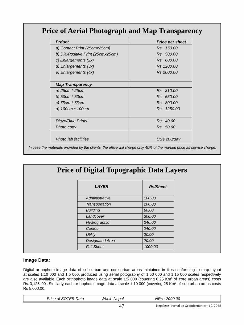
47 Nepalese Journal on Geoinformatics - 10, 2068Nepalese Journal on Geoinformatics - 8, 2066 33
Prduct Price per sheeta) Contact Print (25cmx25cm) Rs 150.00b) Dia-Positive Print (25cmx25cm) Rs 500.00c) Enlargements (2x) Rs 600.00d) Enlargements (3x) Rs 1200.00e) Enlargements (4x) Rs 2000.00
Map Transparency a) 25cm * 25cm Rs 310.00b) 50cm * 50cm Rs 550.00c) 75cm * 75cm Rs 800.00d) 100cm * 100cm Rs 1250.00
Diazo/Blue Prints Rs 40.00Photo copy Rs 50.00
Photo lab facilities US$ 200/day
Price of Aerial Photograph and Map Transparency
In case the materials provided by the clients, the office will charge only 40% of the marked price as service charge.
Price of Digital Topographic Data Layers
LAYER Rs/Sheet
Administrative Transportation Building Landcover Hydrographic Contour Utility Designated Area Full Sheet
100.00200.0060.00300.00240.00240.0020.0020.001000.00
Image Data:
Digital orthophoto image data of sub urban and core urban areas mintained in tiles conforming to map layout at scales 1:10 000 and 1:5 000, produced using aerial potography of 1:50 000 and 1:15 000 scales respectively are also available. Each orthophoto image data at scale 1:5 000 (couering 6.25 Km2 of core urban areas) costs Rs. 3,125. 00 . Similarly, each orthophoto image data at scale 1:10 000 (covering 25 Km2 of sub urban areas costs Rs 5,000.00.
Price of SOTER Data Whole Nepal NRs : 2000.00

48Nepalese Journal on Geoinformatics - 10, 2068
We all have our own life to pursue, our own kind of dream to be weaving and we all have some power to make wishes come true, as long as we keep believing and when we achieve that dream there is a overwhelming feeling that is hard to explain.Mountain climbing was a passion I developed right from my childhood and to climb atop the highest mountain in the world at the young age of 27 was quite an achievement and the feeling is still hard to absorb.As a resident of Dhital,Kaski the first thing I saw when I opened my eyes every morning was the beautiful Macchapuchre and I always used to wonder what the feeling would it be to touch the surface of the Macchapuchre.So,as a kid I always wanted to reach the summit of Macchapuchre but climbing there was not permitted due to various reasons and my dream could not be materialized. But may be my fate had other ideas for me and I became the first government service holder and the first survey professional in Nepal to reach the summit of the highest mountain in the world.
The idea of climbing the Everest was mooted by Chief Secretary of Government of Nepal Madhav Ghimire as a initiative to promote tourism in nepal in the year 2063 B.S. and it was finally realised this year.A expedition team of 15 civil servants was chosen from a total of 600 government service holders out of which 9 were succesful in reaching the summit.I was the first person from the group to set my foot on the summit of the Everest.From the experience I found that the journey to the top of the world is a lot difficult and demands a lot of physical and mental strength than people might think.The world seen from the top of the world is stunning but as much as the beauty of the whole expedition, it is equally as dangerous. Nevertherless the mountain fascinates and draws people from all over the world to try their luck in scaling the highest mountain in the world.So,if necessary steps are taken and a proper plan is formulated and set in action mountain climbing can turn out to be a major source of employement for many Nepalese people and consequently will help the economy of Nepal.
When I left my home on the 24th of Chaitra, 2067 B,S. I didn’t know if I would return my home safely so I bid farewell to my family and assured them that I would deceive death and succefully climb the Everest and now here I am after my succesful journey to the top of the mountain , became the first government service holder and the first survey professional in Nepal to scale the Mt. Everest.
To climb the 3rd pole is perhaps more difficult than to climp the southern and northern poles.Many of the climbers don’t even reach the “Khumbu Icefall”. The death of Former
Minister of Foreign Affairs Sailendra Kumar Upadhyaya also took place there.Avalanches are of regular occurence in the mountains and one of the things that mountain climbers must be very aware of it.Most of the deaths in the mountain are due to these avalanaches.
Reaching the base camp was a wonderful feeling.Namche Pass is no less different than many business centres in the world. The place is full of different mountaineering agencies from different countries. Our goal there was not only to reach to the summit but also study the impact of the global environmental changes in the mountain as well as to see the condition of the waste management in the Everest area. As a Surveyor I also looked at the map of the area and got a lot of confusions in the tourist maps published by different agencies, as for example the height of the Kala Pathar where the Cabinet meeting was held was shown as 5542 m which is the height of its peak but not of the base and my GPS instrument showed the height of the base to be 5315m
As our journey continued some of members of our group suffered from nausea,altitude sickeness but luckily I did not suffer from any major health problems .We reached the fourth camp ,at an altitude of 8000 metre on Jestha 3 at about 4 P.M. When we reached there our Sherpa suffered from some health problem and could not continue climbing with us.At that moment I too had a feeling that perhaps we could not continue our journey as well. The weather in the mountains is highly unpredictable and changes dramatically within hours. But still leaving behind fears and just focusing on what we were going to achieve we finally reached the South summit which is at an altitude of 8751 metres. The distance from the South summit to the top is known as the “Hillary step” and this climbing up to the top is the most challenging of the whole journey. Just 10 minutes of climbing was left when the oxygen in my cylinder was finished and I had to bear a high risk of staying without oxygen for 45 minutes in such a great altitude.
On 4 Jestha 2068 B.S. at 5:45 AM we finally reached the summit and I placed our national flag and the flag of Nepal Surveyors Association on the top of the world. Then gradually all the nine members of our group reached the top. We spent aboot 45 minutes at the summit. At that time I also released the musical album Atithi-2 of the world’s youngest singer 3 years old Atithi Gautam. The temperature changes from minus 40 to 45 degree celcious in the matter of minutes. The wind speed at the top of the mountain was about 90 km/hr and it was almost impossible to stay at the summit as the day grows of.
Feelings of the first Nepali Surveyor on top of Mount Everest
Khim Lal Gautam