near‐surface shear wave reflection surveys in the fraser ... wave reflection surveys in canada...
TRANSCRIPT
Near-surface shear wave reflection surveys in the Fraser River delta, B.C., CanadaJ.B. Harris,* Millsaps College; R.D. Miller and J. Xia, Kansas Geological Survey (KGS); J.A. Hunter,Geological Survey of Canada (GSC); C.B. Park and D.R. Laflen (KGS); and R.L. Good (GSC)
Summary
Shallow shear wave reflection surveys using high frequencyvibroseis techniques provides information about the Tertiarybedrock surface and Pleistocene sediments on the Fraser Riverdelta, in B.C., Canada. Besides the clear advantage of shearwave profiling in this shallow gas environment, the addedresolution potential and ability to measure the shear wavevelocity field enhances the fusion of this surface seismic datainto earthquake site response estimations. Surface materialsranging from undisturbed, native delta sediments to clay/rubble fill used in dike construction seemed amenable to thegeneration and recording of shear waves when using a small(6,000 kg) vibrator and engineering recording systems. Thethickness of Pleistocene sediments and depth to Tertiary bed-rock were mapped at three locations within the delta wheregaps existed in the geologic record. These three sites providedcultural and near-surface settings that uniquely tested thisshallow imaging technique.
Introduction
At thick soil sites delineating and mapping the bedrock surfaceand shear wave velocity structure of overlying unconsolidatedsediments is necessary to evaluate the intensity of shaking fora given potential earthquake event. A thick veneer of uncon-solidated alluvial and glacial-fluvial sediments overlay Terti-ary bedrock in the Fraser River delta, located in BritishColumbia, Canada. Concern about the vulnerability of anever-growing population density to significant earthquakes inthe Fraser River delta are justified considering the historicalseismicity along that portion of the west coast of NorthAmerica and the amplification potential of the sediments.
Determination of the depth, shape, and velocity contrast of theHolocene/Pleistocene and Pleistocene/Tertiary boundaries be-neath the Fraser River delta is critical for accurate modeling ofseismically-induced ground motion. Analysis of strong motionaccelerograms from two moderate-sized (~M 5) crustal earth-quakes in the region shows that amplification of seismicwaves increases above the thick Holocene sediments of theFraser delta when compared with rock or firm soil sites(Rogers et al., 1998). This is particularly significant in areas ofthe delta where soil column resonance periods are in the samerange as fundamental periods of buildings and other structures.Therefore, it is extremely important to map the thickness (andshear wave velocity structure) of Holocene sediments with asmuch detail as possible. Another source for seismic hazard isthe possibility of a very large “subduction zone” earthquakefrom the boundary between the North American and Juan de
Fuca/Explorer plates. Multidimensional long-period amplifica-tion (i.e., Harris et al., 1998) as a result of such an event wouldhave an impact on the response of large structures (i.e.,bridges, tall buildings, pipelines, tunnels), and would undoubt-edly be influenced by the depth and geometry of the Tertiarybedrock beneath the Fraser delta. Although a map of theTertiary bedrock surface has been developed through interpre-tation of existing industry seismic reflection profiles (Brittonet al., 1995), there are important areas of the delta where nodeep seismic coverage exists.
Shallow high resolution reflection profiling has been suc-cessful in many areas of the delta using small engineering-style recording systems and sledgehammer sources (Harriset al., 1996; Pullan et al., 1998). Reflection profiling usingshear waves has proven more effective delineating major agerelated geologic boundaries under certain conditions than
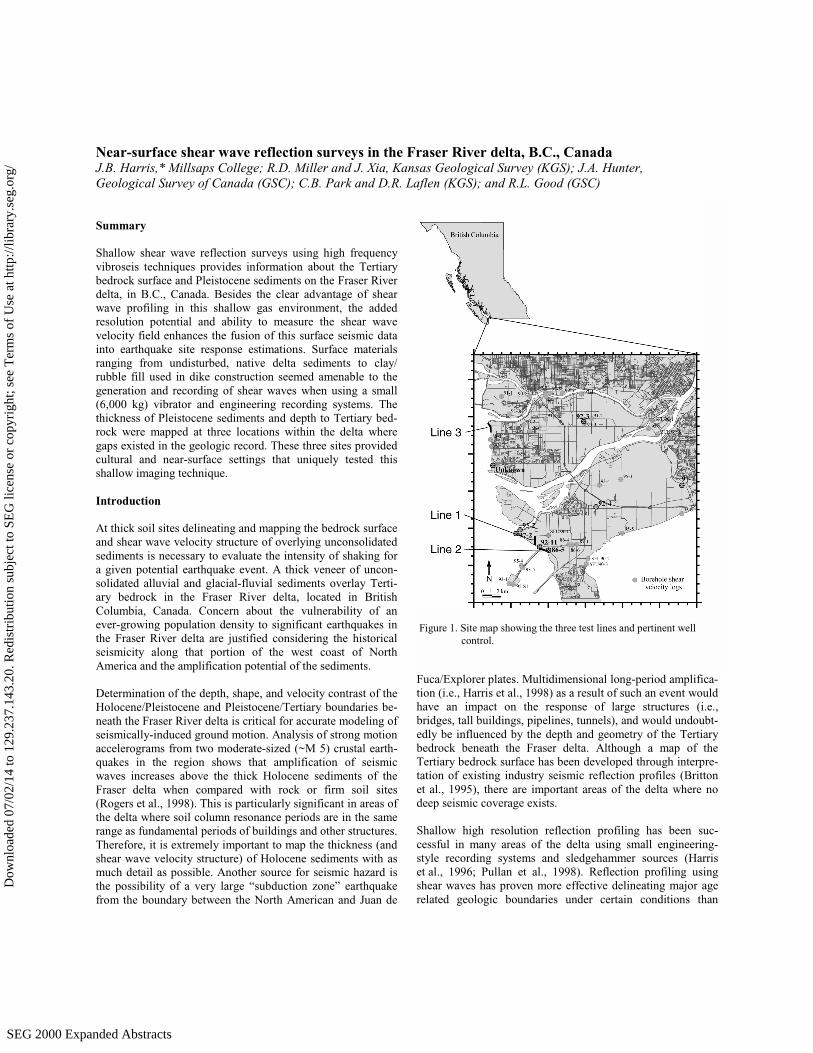
Figure 1. Site map showing the three test lines and pertinent wellcontrol.
SEG 2000 Expanded AbstractsSEG 2000 Expanded Abstracts
Dow
nloa
ded
07/0
2/14
to 1
29.2
37.1
43.2
0. R
edis
trib
utio
n su
bjec
t to
SEG
lice
nse
or c
opyr
ight
; see
Ter
ms
of U
se a
t http
://lib
rary
.seg
.org
/
Shear wave reflection surveys in Canada
compressional waves. In areas of the delta where conditionshave permitted propagation of compressional waves, surveyshave provided excellent ultra high resolution images of themany Holocene age sand, clay, and silt sequences (Pullan andHunter, 1987) extensively drilled and surveyed using boreholegeophysics (Hunter et al., 1998). Shear wave surveying in thedelta provides better results in some areas due to the insensi-tivity of shear waves to water saturation, strong attenuation ofcompressional waves in the presence of gas or peat, and theimproved resolution potential of shear wave profiling.
As part of a continuing effort by the Geological Survey ofCanada to define and assess earthquake hazards in the FraserRiver delta, a series of 2-D shear wave reflection profiles wereacquired to evaluate the potential and feasibility of high fre-quency shear wave vibroseis energy to return signal from thebase of up to 600 m of Pleistocene and Holocene sediments atthree uniquely different sites (Figure 1). Work to image Pleis-tocene sediments throughout the delta has meet with successwhen the geology is conducive to the techniques applied(Pullan et al., 1989; Pullan and Hunter, 1987). Extending theseismic images into pre-Quaternary sediments has been part ofpast petroleum exploration programs (Britton et al., 1995).The goal of this study was to ascertain the effectiveness ofvibroseis techniques in mapping the buried Pleistocene surfaceand the Tertiary bedrock surface at depths of around 100 m,150 m, and 600 m, through surface materials ranging fromundeveloped roads in direct contact with native Holocenedelta deposits to up to 5 m high dikes built of construction-grade clays and rubble in direct contact with delta deposits.
Shear wave reflection profiling in the delta inherently hasgreater resolution in this Holocene-Pleistocene sedimentaryenvironment; however, such surveys rarely result in signal-to-noise ratios on CMP stacked sections as high as equivalentcompressional wave profiles. This observation is not unique tothe delta, and is generally true for most geologic settings.Routinely observed lower signal-to-noise ratio characteristicof shear wave reflection profiling may be attributed to inter-ference from ground roll, the inherent difficulty coupling thesource, and challenges associated with generating predomi-nantly polarized shear waves. Shear wave reflections routinelyarrive within the noise cone, an area that is often muted oncompressional wave data since optimum time and offset win-dows for P-wave reflections generally occur before this highamplitude noise zone.
Data Acquisition and Processing
Acquisition equipment and parameters were consistent for allthree, shear wave reflection lines. All data were recorded on a180-channel Geometrics StrataView seismograph systeminterfaced to an IVI vibrator controller. Receivers were singleGeospace 14 Hz GS-11S horizontal geophones, leveled andoriented perpendicular to the survey line. This SH configura-tion was consistent with the alignment of the vibrator mass.The source was an IVI minivib in buggy configuration with its
approximately 135 kg mass oriented perpendicular to thevehicle and survey line. Five 25 to 150 Hz, 8-second sweepswere individually recorded in an uncorrelated format at eachshot station. This recording approach permitted pre-correlationprocessing and pre-vertical stack noise editing, both tech-niques have the potential to and generally will improve thesignal-to-noise ratio and resolution potential of correlateddata. Each vibroseis record included the recording of groundforce (weighted sum of mass and base plate accelerometers),which was used to correlate against for the production of theshot records. After correlation and vertical stacking, shotrecords have clearly identifiable shear wave reflection arrivalson all three lines.
Surface conditions and environmental noise were different foreach of the three lines. Line 1 was acquired along a gravelroad and road shoulder where the surface materials were forthe most part native, relatively undisturbed delta sediments.Line 2 was positioned between two wells (for ground truth)and on top a dike constructed of fill and rubble. Compoundingthe coupling problems caused by the dike for both source andreceivers was high amplitude train noise associated with theCoalport Causeway at the north end of the profile. Line 3 wasalong a dike immediately south of the airport and frequentedby pedestrian traffic. It was critical that all data acquisition below impact (environmental) and not interfere with the normalroutines of local citizens. The variety of surface settings, noisesources, and restrictions provided a good test of the feasibilityof vibroseis techniques in the delta.
Data were processed using routine shallow CMP processingalgorithms and approaches (Steeples and Miller, 1990). Withthe asymmetric recording style, fold was unbalanced, andtherefore significant effort was placed on editing traces out-side the necessary recording window so as to improve the foldbalance and maintain an offset distribution that was as uniformand optimum as possible. Enhancing signal from these noise-contaminated data represents the biggest obstacle to improvingthe interpretability of stacked sections. Static problems areevident on line 3 shot gathers. Routine static compensationtechniques such as surface consistent and residual are notsufficient.
Observations
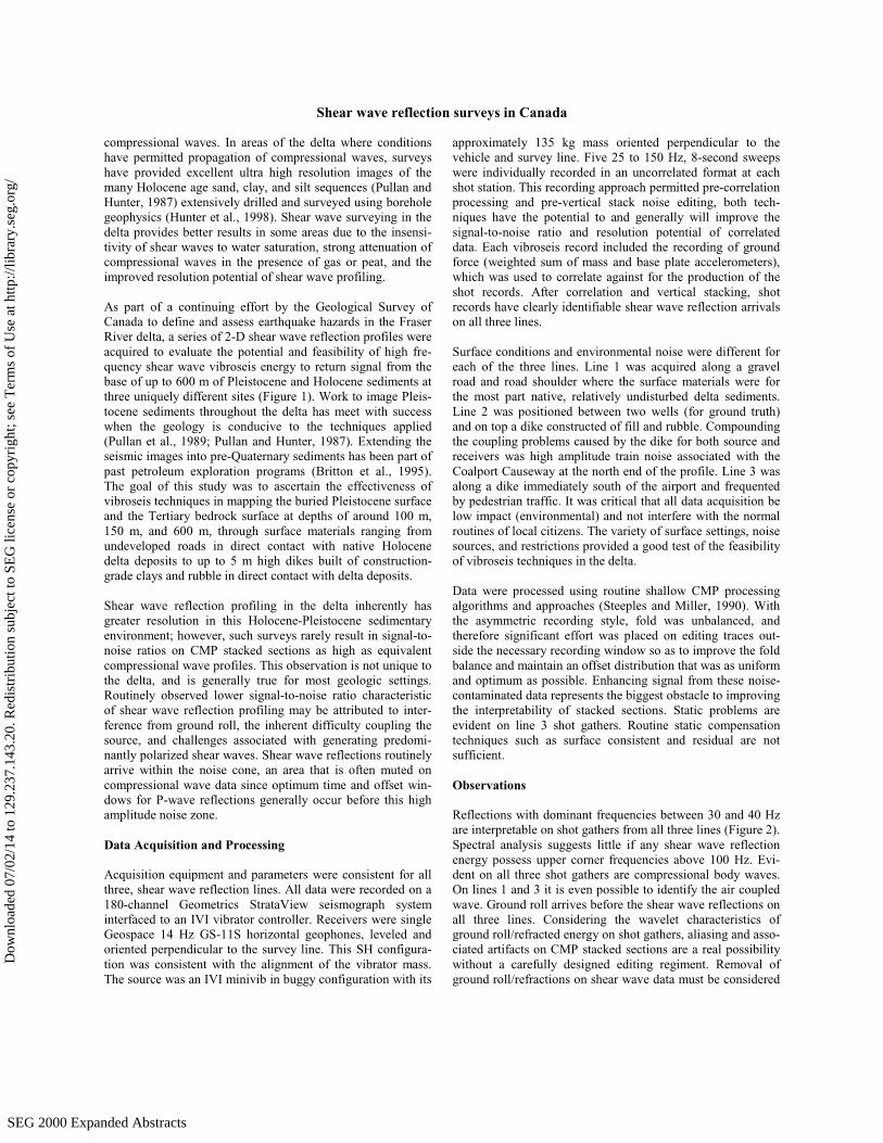
Reflections with dominant frequencies between 30 and 40 Hzare interpretable on shot gathers from all three lines (Figure 2).Spectral analysis suggests little if any shear wave reflectionenergy possess upper corner frequencies above 100 Hz. Evi-dent on all three shot gathers are compressional body waves.On lines 1 and 3 it is even possible to identify the air coupledwave. Ground roll arrives before the shear wave reflections onall three lines. Considering the wavelet characteristics ofground roll/refracted energy on shot gathers, aliasing and asso-ciated artifacts on CMP stacked sections are a real possibilitywithout a carefully designed editing regiment. Removal ofground roll/refractions on shear wave data must be considered
SEG 2000 Expanded AbstractsSEG 2000 Expanded Abstracts
Dow
nloa
ded
07/0
2/14
to 1
29.2
37.1
43.2
0. R
edis
trib
utio
n su
bjec
t to
SEG
lice
nse
or c
opyr
ight
; see
Ter
ms
of U
se a
t http
://lib
rary
.seg
.org
/

Shear wave reflection surveys in Canada
critical. Reflection arrivals possess velocities of between 200 and 600 m/sec. Thisrange of velocities seems slow, but is consistent with borehole shear wavemeasurements in this area.
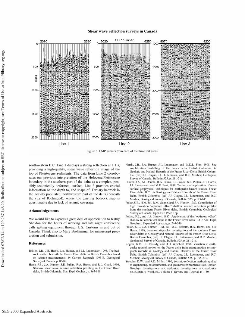
Reflections from the top of the firm Pleistocene sediments are interpretable on allthree lines (Figure 3). The base of the Holocene on line 1 is represented by a highamplitude reflection coherent across the entire section at about 1.1s. For the mostpart it appears relatively flat with only minor changes in wavelet characteristicsacross this section. Line 2 on the other hand has a series of reflections between0.5 and 1.0 s what appears to be a structural high in the Pleistocene near the cen-ter of the profile. Considering the dramatic change in slope and wavelet characterjust north of the mound, this localized feature could be tectonic in nature. Clearlythe base of the Holocene on line 2 begins to plunge to the north rapidly at thenorthern end of the profile. Data acquisition was halted along line 2 by the multi-rail train tracks that access the coal port. Line 3 provided the first glimpse of theTertiary bedrock at a location postulated to have some of the thickest overburdenin this part of the delta and an area which had been previously unexplored.
Statics corrections designed to compensate for dramatic lateral variations invelocity and filtering routines tailored to suppress noise on these data will both benecessary to increase data quality sufficiently on the line 3 stacked section toallow a high confidence identification of the top of bedrock. Extreme distortion inthe NMO curve is visible in the reflection at about 1.5 s on the line 3 shot gather(Figure 2). Comparing the shape of the reflection at 1.5 s with the higher ampli-tude reflection immediately above it at about 1.3 s and the ones below it at 2.0 s
it is clear that both static and structure arecontributing to the bowing/bending of re-flection hyperbola. With the observed vari-ation in reflection arrival times across suchshort distances, proper stacking of reflec-tion wavelets will mandate significantattention be paid to the effects of variousautomatic processes on reflection hyper-bola.
Conclusions
The shear wave vibroseis reflection methodimproves our ability to image the complexstructure of the Pleistocene and Tertiarysurfaces beneath the Fraser River delta in
Figure 2. Correlated vertically stacked, spectral balanced, and scaled shot gathers from thethree survey areas.
SEG 2000 Expanded AbstractsSEG 2000 Expanded Abstracts
Dow
nloa
ded
07/0
2/14
to 1
29.2
37.1
43.2
0. R
edis
trib
utio
n su
bjec
t to
SEG
lice
nse
or c
opyr
ight
; see
Ter
ms
of U
se a
t http
://lib
rary
.seg
.org
/
Shear wave reflection surveys in Canada
southwestern B.C. Line 1 displays a strong reflection at 1.1 s,providing a high-quality, shear wave reflection image of thetop of Pleistocene sediments. The data from Line 2 corrobo-rates our previous interpretation of the Holocene/Pleistoceneboundary in the southern part of the delta as a complex, pos-sibly tectonically deformed, surface. Line 3 provides crucialinformation on the depth to, and shape of, Tertiary bedrock inthe heavily populated, northwestern part of the delta (beneaththe city of Richmond), where the existing bedrock map isquestionable due to lack of seismic coverage.
Acknowledgements
We would like to express a great deal of appreciation to KathySheldon for the hours of working and late night conferencecalls getting equipment through U.S. Customs in and out ofCanada. Thank also to Mary Brohammer for manuscript prep-aration and submission.
References
Britton, J.R., J.B. Harris, J.A. Hunter, and J.L. Luternauer, 1995, The bed-rock surface beneath the Fraser River delta in British Columbia basedon seismic measurements: In Current Research 1995-E, GeologicalSurvey of Canada, p. 83-89.
Harris J.B., J.A. Hunter, S.E. Pullan, R.A. Burns, and R.L. Good, 1996,Shallow shear wave seismic reflection profiling in the Fraser Riverdelta, British Columbia: Soc. Expl. Geohys., p. 865-868.
Harris, J.B., J.A. Hunter, J.L. Luternauer, and W.D.L. Finn, 1998, Siteamplification modelling of the Fraser delta, British Columbia: InGeology and Natural Hazards of the Fraser River Delta, British Colum-bia; (ed.) J.J. Clague, J.L. Luternauer, and D.C. Mosher; GeologicalSurvey of Canada, Bulletin 525, p. 211-216.
Hunter, J.A., M. Douma, R.A. Burns, R.L. Good, S.E. Pullan, J.B. Harris,J.L. Luternauer, and M.E. Best, 1998, Testing and application of near-surface geophysical techniques for earthquake hazard studies, FraserRiver delta, B.C.: In Geology and Natural Hazards of the Fraser RiverDelta, British Columbia; (ed.) J.J. Clague, J.L. Luternauer, and D.C.Mosher; Geological Survey of Canada, Bulletin 525, p.123-145.
Pullan.S.E., H.M. Jol. R.M. Gagne, and J.A. Hunter, 1989, Compilation ofhigh resolution “optimum offset” shallow seismic reflection profilesfrom the southern Fraser River delta, British Columbia; GeologicalSurvey of Canada, Open File 1992, 16p.
Pullan, S.E., and J.A. Hunter, 1987, Application of the “optimum offset”shallow reflection technique in the Fraser River delta, B.C.: Soc. Expl.Geophys., Expanded Abstracts, p. 244-246.
Pullan, S.E., J.A. Hunter, H.M. Jol, M.C. Roberts, R.A. Burns, and J.B.Harris, 1998, Seismostratigraphic investigations of the southern FraserRiver delta: In Geology and Natural Hazards of the Fraser River Delta,British Columbia; (ed.) J.J. Clague, J.L. Luternauer, and D.C. Mosher;Geological Survey of Canada, Bulletin 525, p. 211-216.
Rogers, G.C., J.F. Cassidy, and D.H. Weichert, 1998, Variation in earth-quake ground motion on the Fraser delta from strong-motion seismo-graph records: In Geology and Natural Hazards of the Fraser RiverDelta, British Columbia; (ed.) J.J. Clague, J.L. Luternauer, and D.C.Mosher; Geological Survey of Canada, Bulletin 525, p. 195-210.
Steeples, D.W., and R.D. Miller, 1990, Seismic-reflection methods appliedto engineering, environmental, and groundwater problems: Soc. Explor.Geophys. Investigations in Geophysics, Investigations in Geophysicsno. 5, Stan H. Ward, ed., Volume 1: Review and Tutorial, p. 1-30.
Figure 3. CMP gathers from each of the three test areas.
SEG 2000 Expanded AbstractsSEG 2000 Expanded Abstracts
Dow
nloa
ded
07/0
2/14
to 1
29.2
37.1
43.2
0. R
edis
trib
utio
n su
bjec
t to
SEG
lice
nse
or c
opyr
ight
; see
Ter
ms
of U
se a
t http
://lib
rary
.seg
.org
/