national significant wildland fire potential · pdf filenational significant wildland fire...
TRANSCRIPT
National Significant Wildland Fire Potential Outlook
Predictive Services National Interagency Fire Center
Issued: April 1, 2018
Next Issuance: May 1, 2018
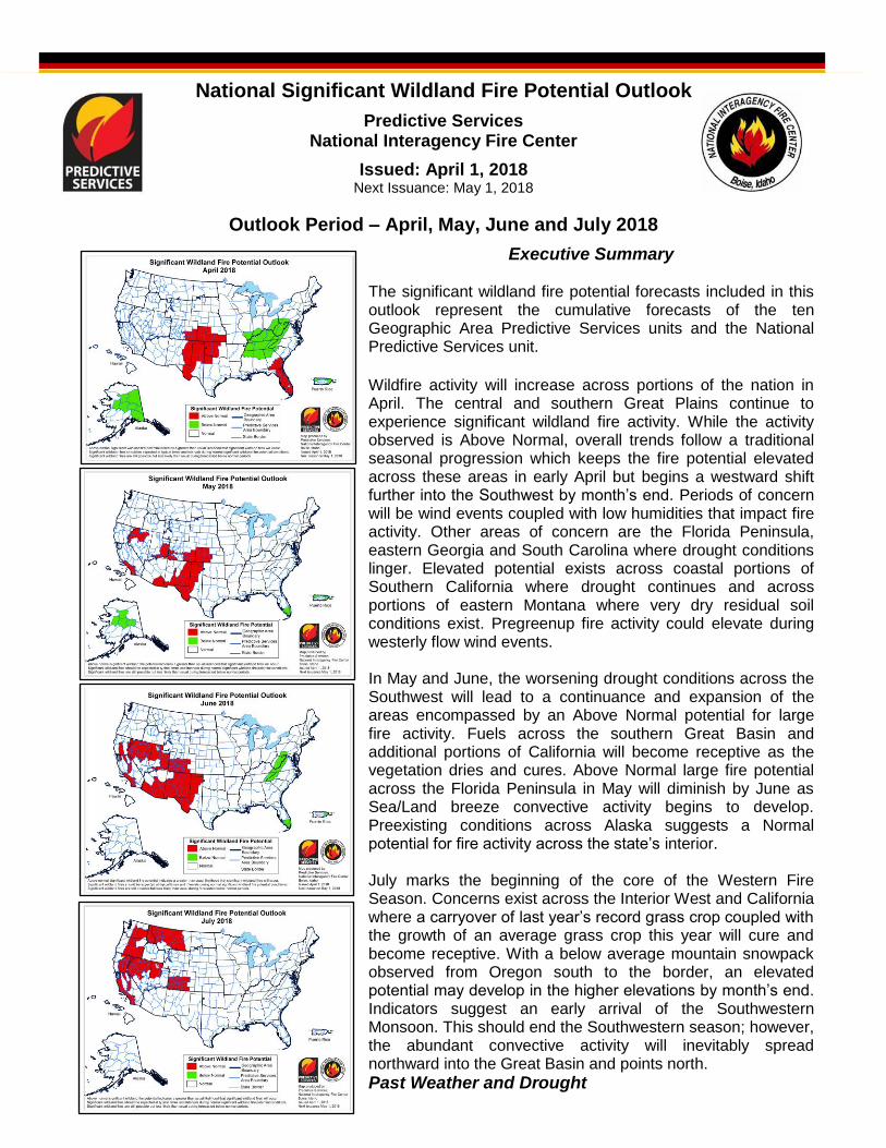
Outlook Period – April, May, June and July 2018
Executive Summary The significant wildland fire potential forecasts included in this outlook represent the cumulative forecasts of the ten Geographic Area Predictive Services units and the National Predictive Services unit.
Wildfire activity will increase across portions of the nation in April. The central and southern Great Plains continue to experience significant wildland fire activity. While the activity observed is Above Normal, overall trends follow a traditional seasonal progression which keeps the fire potential elevated across these areas in early April but begins a westward shift further into the Southwest by month’s end. Periods of concern will be wind events coupled with low humidities that impact fire activity. Other areas of concern are the Florida Peninsula, eastern Georgia and South Carolina where drought conditions linger. Elevated potential exists across coastal portions of Southern California where drought continues and across portions of eastern Montana where very dry residual soil conditions exist. Pregreenup fire activity could elevate during westerly flow wind events. In May and June, the worsening drought conditions across the Southwest will lead to a continuance and expansion of the areas encompassed by an Above Normal potential for large fire activity. Fuels across the southern Great Basin and additional portions of California will become receptive as the vegetation dries and cures. Above Normal large fire potential across the Florida Peninsula in May will diminish by June as Sea/Land breeze convective activity begins to develop. Preexisting conditions across Alaska suggests a Normal potential for fire activity across the state’s interior. July marks the beginning of the core of the Western Fire Season. Concerns exist across the Interior West and California where a carryover of last year’s record grass crop coupled with the growth of an average grass crop this year will cure and become receptive. With a below average mountain snowpack observed from Oregon south to the border, an elevated potential may develop in the higher elevations by month’s end. Indicators suggest an early arrival of the Southwestern Monsoon. This should end the Southwestern season; however, the abundant convective activity will inevitably spread northward into the Great Basin and points north.
Past Weather and Drought
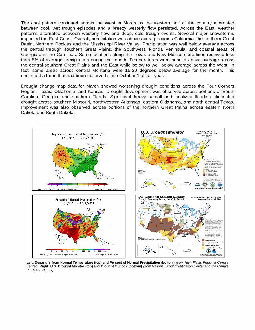
The cool pattern continued across the West in March as the western half of the country alternated between cool, wet trough episodes and a breezy westerly flow persisted. Across the East, weather patterns alternated between westerly flow and deep, cold trough events. Several major snowstorms impacted the East Coast. Overall, precipitation was above average across California, the northern Great Basin, Northern Rockies and the Mississippi River Valley. Precipitation was well below average across the central through southern Great Plains, the Southwest, Florida Peninsula, and coastal areas of Georgia and the Carolinas. Some locations along the Texas and New Mexico state lines received less than 5% of average precipitation during the month. Temperatures were near to above average across the central-southern Great Plains and the East while below to well below average across the West. In fact, some areas across central Montana were 15-20 degrees below average for the month. This continued a trend that had been observed since October 1 of last year. Drought change map data for March showed worsening drought conditions across the Four Corners Region, Texas, Oklahoma, and Kansas. Drought development was observed across portions of South Carolina, Georgia, and southern Florida. Significant heavy rainfall and localized flooding eliminated drought across southern Missouri, northwestern Arkansas, eastern Oklahoma, and north central Texas. Improvement was also observed across portions of the northern Great Plains across eastern North Dakota and South Dakota.
Left: Departure from Normal Temperature (top) and Percent of Normal Precipitation (bottom) (from High Plains Regional Climate Center). Right: U.S. Drought Monitor (top) and Drought Outlook (bottom) (from National Drought Mitigation Center and the Climate Prediction Center)
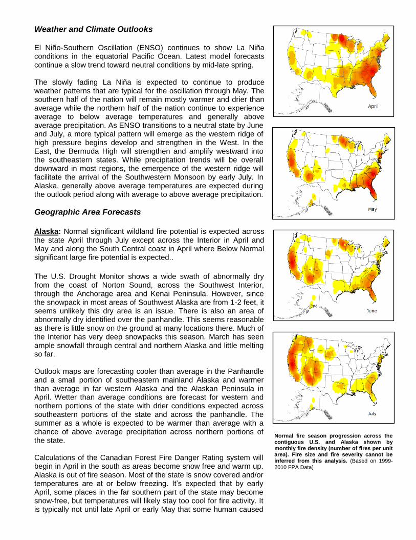
Normal fire season progression across the contiguous U.S. and Alaska shown by monthly fire density (number of fires per unit area). Fire size and fire severity cannot be inferred from this analysis. (Based on 1999-2010 FPA Data)
Weather and Climate Outlooks El Niño-Southern Oscillation (ENSO) continues to show La Niña conditions in the equatorial Pacific Ocean. Latest model forecasts continue a slow trend toward neutral conditions by mid-late spring. The slowly fading La Niña is expected to continue to produce weather patterns that are typical for the oscillation through May. The southern half of the nation will remain mostly warmer and drier than average while the northern half of the nation continue to experience average to below average temperatures and generally above average precipitation. As ENSO transitions to a neutral state by June and July, a more typical pattern will emerge as the western ridge of high pressure begins develop and strengthen in the West. In the East, the Bermuda High will strengthen and amplify westward into the southeastern states. While precipitation trends will be overall downward in most regions, the emergence of the western ridge will facilitate the arrival of the Southwestern Monsoon by early July. In Alaska, generally above average temperatures are expected during the outlook period along with average to above average precipitation.
Geographic Area Forecasts
Alaska: Normal significant wildland fire potential is expected across the state April through July except across the Interior in April and May and along the South Central coast in April where Below Normal significant large fire potential is expected..
The U.S. Drought Monitor shows a wide swath of abnormally dry from the coast of Norton Sound, across the Southwest Interior, through the Anchorage area and Kenai Peninsula. However, since the snowpack in most areas of Southwest Alaska are from 1-2 feet, it seems unlikely this dry area is an issue. There is also an area of abnormally dry identified over the panhandle. This seems reasonable as there is little snow on the ground at many locations there. Much of the Interior has very deep snowpacks this season. March has seen ample snowfall through central and northern Alaska and little melting so far. Outlook maps are forecasting cooler than average in the Panhandle and a small portion of southeastern mainland Alaska and warmer than average in far western Alaska and the Alaskan Peninsula in April. Wetter than average conditions are forecast for western and northern portions of the state with drier conditions expected across southeastern portions of the state and across the panhandle. The summer as a whole is expected to be warmer than average with a chance of above average precipitation across northern portions of the state. Calculations of the Canadian Forest Fire Danger Rating system will begin in April in the south as areas become snow free and warm up. Alaska is out of fire season. Most of the state is snow covered and/or temperatures are at or below freezing. It’s expected that by early April, some places in the far southern part of the state may become snow-free, but temperatures will likely stay too cool for fire activity. It is typically not until late April or early May that some human caused
fires will begin to crop up. Due to the heavy snowpack in the interior fire season is expected to be delayed in those areas Northwest: Normal significant wildland fire potential is expected for the Northwest through the Outlook period through June followed by Above Normal significant large fire potential for south central-southeastern Washington and southern and north central Oregon for July. The cool trend that settled over the region in mid-February continued through March. Monthly temperatures in March were below average for the region. Precipitation received through March was spotty and inconsistent. Much of Oregon and eastern Washington experienced above normal precipitation while western Washington was quite dry. Overall, much of Oregon remains well below average for accumulation of precipitation since early December. Snow accumulation at higher elevations across Washington is near to slightly above average, especially near the border with British Columbia. However, snow accumulation continues to lag well below average for Oregon. Despite the cooler conditions observed in late February and March, reporting basins in Oregon are reporting snow water equivalent accumulation 50 to 80% of average for the beginning of spring. Outlooks for the northwest geographic area for April suggest more of the same conditions which would suggest cooler and wetter than average for Washington. For Oregon, temperature and precipitation trends are not clear so average April conditions are as good a likelihood as any other. Through Spring into early Summer warmer and drier than average conditions are anticipated for the geographic area. Fire danger remains low for large, costly fires that are naturally ignited for the geographic area. Fire danger will not likely rise to such levels until June. Northern California and Hawaii: Normal significant large fire potential is expected in all areas in April and May. For June and July expect Normal significant large fire potential in most areas except: the far East Side, Sacramento Valley Foothills, and East Bay Area where Above Normal significant large fire potential is expected. In July, the northern Sierra and northeastern portion of California will be added to the Above Normal category as well. The precipitation outlook for the region for April and May is for near to slightly below average precipitation and slightly above average temperatures. In June and July the warmer and drier than conditions will be more pronounced. Recent precipitation throughout the region has moistened dead fuels of all sizes and at all elevations, brought the snow pack up to nearly half of the normal snow to water content, and helped with the live fuel green up phase at lower elevations. Warm and dry weather in April will spur the green up phase at middle elevations, and live fuels at higher elevations will follow beginning in May. Despite the recent wet weather, the entire region has a substantial precipitation deficit, receiving around 40-60% of average as of late March. Therefore, it is expected that live fuels in most areas will peak out at lower than average live fuel moisture readings and decline sooner than normal, reaching critical values for wildfire activity earlier than most years. Dead fuels are also expected to dry to critical levels at similar rates. Typically, little to no large fire activity occurs within the region through May. Enough precipitation has fallen to hold off the onset of the fire season prior to the end of May. The Large Fire Potential for April and May 2018 is Normal. Cold weather in late February and early March produced areas of frost kill at lower elevations that could add to fire potential beginning in June. With dry and warm conditions expected in June it is expected that fire activity will ramp up, and this represents an earlier start than average by a few weeks. The areas expected to have Above Normal large fire potential in June are the Far East Side, the foothills of the Sacramento Valley, and the Diablo portion of the eastern Bay Area. In July the Northeast California and Northern Sierra PSAs are added to the Above Normal areas. Sea surface temperatures (SSTs) surrounding the Hawaiian Islands have been slightly cooler than average, but dynamical forecast models expect SSTs to rebound to slightly above average during the outlook period. Temperatures throughout the islands are expected to be slightly above average from April through July. Hawaii is expected to receive average to above average precipitation in April then near average from May through July. Precipitation in recent months has been above average across
much of the region and there are no longer any portions of Hawaii considered to be in drought or even in the “Abnormally Dry” category. The large fire potential for April through July is Normal. Southern California: Normal significant wildland fire potential is expected across the region in April. Above Normal significant wildland fire potential is expected along the coast and foothills across Southern California in May. The Above Normal significant wildland fire potential will expand north and east to include the foothills and portions of the southern Sierras in June and July. Long term model data that forecasted a wetter weather pattern developing in March as far back as November verified. The region had one of the wettest Marches in decades. The longwave ridge over the Pacific retrograded westward which allowed a series of storms to bring widespread and significant wetting rain to the region. Some of the storms brought heavy snow to the Sierras early in the month. But the weather highlight of the month undoubtedly was the strong storm of March 21st and 22nd. Aided by a subtropical “atmospheric river”, rainfall from Ventura and Kern County northward was in the 2-4” range. Some areas of San Luis Obispo and Fresno County experienced over 8” of rainfall. But high snow levels kept additional snowpack gains from this storm at a minimum. The rainfall arrived just before seasonal grasses began to cure over Southern California. Therefore it is likely that most areas of the district will see a much heavier grass crop than was anticipated earlier. A rapid greenup is expected in April due to good subsoil moisture and a change to sunnier, drier, and warmer weather. These grasses will likely keep large fire potential at a minimum through April. Only the far southern part of the state which missed much of the rainfall this month will see much fire potential through May. However, by June, once grasses cure, large fire potential will climb to above normal once again. The ongoing tree mortality in the Sierra Foothills is also a concern. A heavy grass crop should supply abundant fine fuels, creating an ideal situation for fuel ladders in the high country. Other areas will see large fire potential climb to Above Normal significant large fire potential in late June into July due to the expectation of hotter than average weather to start off the summer. The ENSO is expected to trend back to near normal over the summer. A few of the long term models depict an above average monsoon season for the Southwest. It remains to be seen if a stronger monsoonal flow leads to enhanced convection this summer over our area. The current expectation is for more convection this summer compared to the past two which may lead to a higher amounts of initial attack in July. Northern Rockies: Normal significant wildland fire potential is expected for the Northern Rockies through the outlook period except in July from the Continental Divide west through northern Idaho where Above Normal significant fire potential is expected. The past month saw a continuance of the preexisting conditions that have been in place since fall. Temperatures were well below average region-wide, with the coldest departures in central/eastern Montana. Precipitation was near to above average for most of the region, with the exception being portions of northern Idaho and western Montana. Central/eastern Montana and most of North Dakota’s 30-day precipitation totals were 150 to 500 percent of average. Thus only a small area of moderate to severe drought persists in northeastern Montana and the western half of North Dakota, while the rest of the region is drought-free. Weak La Nina conditions are transitioning to ENSO neutral. ENSO neutral conditions are forecast to persist through the rest of spring and all summer, into the coming fall. Impacts from this in the region will be a tendency for near to below average temperatures and near to above average precipitation (mainly over the western areas) to persist into April, but transitioning to a somewhat drier pattern in May with near average temperatures. Long range outlooks depict above average temperatures and below average precipitation in June for most of the region. For July, long range outlooks depict above average temperatures region wide, with below average precipitation likelihood confined to northern Idaho and western Montana. ENSO neutral summers do tend to be warmer and drier than average in the region. Mountain snowpacks in the Western areas continue to have above to well above average snow water equivalent basin averages, especially over western Montana and Yellowstone National Park. Melting
rates of these generous snowpacks under current long range outlooks should begin after mid-April and occur at average times and rates through May, accelerating in June. Wildfire potential generally only exists for short periods in the early spring in the region east of the Continental Divide when gusty drying southwest and west winds occur. Precipitation has been well above average however over central and most of eastern Montana, and portions of North Dakota. The next few weeks are expected to remain cooler than average there with periods of precipitation likely. Thus if any extended periods of warm, dry and windy weather occur pregreenup, it would only be in the latter half of April. Greenup quickly occurs in May east of the Divide and is expected to be much more robust this year than last, with the greater precipitation that has occurred and with at least average precipitation expected there continuing. There will likely be a heavy fine-fuel loading developing there as a result, which will cure and dry by late June into July. The timbered middle and higher elevations of the western areas will also have a healthy greenup, and even if warmer and drier than average conditions develop in June, the heavy snowpacks will help to temporarily mitigate that until mid-July. The lower elevations of the western areas will also have a healthy green-p in late April and May, but will dry and cure faster in June, if precipitation ends up below average then. If July ends up warmer and drier than average, there will be heavy fine fuel loadings cured and dried at all elevations by the latter half of the month. Northern Idaho and western Montana are “out of season” during April and May, and will be depicted so on the maps. With cooler moist conditions expected to persist well into April over the eastern areas, followed by greenup in May, Normal significant large fire potential is anticipated there. June is always and will be a transition month as fuels dry and cure on both sides of the Continental Divide. If warmer and drier than average conditions occur region-wide in June as some outlooks suggest, and continue through July focused over the western areas, then Above Average fire potential will be likely over most of these, into at least central Montana by late June in the lower elevations. Heavy cured/dry fine-fuels loading in central/eastern Montana could thus lead to above-average potential there in July. Above-average potential with warmer and drier than average conditions wouldn’t be likely until mid-July in the middle and higher elevations of the western areas. The only exception to this would be in southwestern Montana, Yellowstone National Park, and the Absaroka-Beartooth mountains/plateau. Great Basin: Normal significant wildland fire potential is expected for the Great Basin in April. In May and June, Normal significant wildland fire potential is expected except across northwestern Nevada and portions of eastern Utah. In July, Normal significant wildland fire potential is expected except across northern Nevada, portions of extreme southwestern Idaho, and eastern Utah. Temperatures were one to nine degrees below average across the Great Basin over the past month, with the largest departure from average over parts of central and western Nevada. Precipitation was well below average over the southern half of the Great Basin, and parts of the higher terrain of Utah, but precipitation was well above average over the Sierra into western and northern Nevada, southern and central Idaho, northwestern Utah and Wyoming. The snowpack saw some more significant rises across Nevada and Utah over the last 30 days, and increased to 60-80% of average in most areas. The snowpack remained near to just above average in the central Idaho mountains, eastern Idaho and over Wyoming. However, precipitation since the beginning of the water year has been well below average over the southern 2/3 of the Great Basin and only near average over central/eastern Idaho into Wyoming. Therefore, drought has returned to all of Utah, the Arizona Strip and is beginning to return to southern and eastern Nevada. The mountains of central and southern Utah into southeastern Utah are currently experiencing severe to extreme drought. Fuels are predominantly dormant across the area; however, due to warmer temperatures earlier in February and multiple storms moving through the Great Basin, some fuels did start to show some green and budding for a period of time. Carryover fuels are expected to be a concern this year over the northern and western half of Nevada into parts of southern Idaho and northern Utah. There was a significant grass crop in 2017 from record precipitation, and a limited amount of long duration low elevation snowfall this year to compact the fuels. Therefore, a significant carryover grass crop is expected. A significant snowfall in mid-March over the Sierra into far western Nevada did compact some
of the grasses in those areas as deep snow remained on the ground for several days. However, these conditions likely only impacted parts of the Sierra Front. Grass has been observed growing on burn areas from 2017 due to recent precipitation, therefore some of the same areas that burned last year may burn again this year. Above Normal significant wildland fire potential is possible over southeastern Utah in May mainly in the middle to high elevations as extreme drought has set in with recent very dry conditions. Above Normal fire potential is also possible in May over parts of western/northwestern Nevada as the significant grasses begin drying out with spring wind events enhancing fire potential. This will be an early start to the Nevada fire season. As June progresses, Above Normal fire potential will expand east across all of northern Nevada into northwestern Utah, where the grass crop is expected to be well above normal again this year. Higher elevations may remain Normal at least through early June as the late season snowpack melts off and fuels dry out, but fire potential will likely increase later in June. Above Normal fire potential will also expand northward in Utah, especially in the higher elevations in June before the monsoon settles in. By July, all of central and southern Utah will return to Normal as the monsoon may be on more of a typical schedule. Above Normal fire potential will continue over western/northern Nevada and spread further east across northern Utah into July. Southwest: Above Normal significant wildland fire potential is expected across the region in April, May, and June, except across central-northern Arizona and northwestern New Mexico where Normal significant wildland fire potential is expected. For July, Normal significant wildland fire potential is expected region-wide. Over the past month, temperatures have generally been within three degrees of normal across the region with the warmest temperatures observed across southeastern New Mexico and West Texas and the coolest temperatures observed across Arizona. Precipitation anomalies continued to be extreme across portions of New Mexico east of the Continental Divide and West Texas where little if any precipitation fell. Other abnormally dry locations included southern Arizona and southwestern New Mexico. Drought monitoring products now place the nearly the entire region within varying degrees of drought. Confidence in this overall outlook is slightly above average as La Nina-like conditions have been a factor for months in both the eastern and central tropical Pacific ocean but there are now some indications that La Nina will weaken and turn into neutral conditions as early as May or June. Despite this, the expectation is for overall temperatures to generally remain warmer than average with drier than average conditions to remain intact overall for most areas of the region. Latest outlooks suggest a continuance of the drier than average conditions through mid-June. With above average temperatures also expected, large fire potential will become increasingly elevated and expand in coverage to include the entire outlook area. However, the data also suggests that some cooling is expected (with respect to normal temperatures) by July with the onset of the Southwest monsoon which is expected to arrive in typical fashion. . Rocky Mountain: Above Normal significant wildland fire potential is expected across southeastern Colorado (east of the Front Range foothills) and Kansas (except for the northeastern portion of the state) through May. In May, the Above Normal significant wildland fire potential will expand west to include south central Colorado while Kansas and the easternmost portion of Colorado return to Normal potential. All other areas can expect Normal significant fire potential during the outlook period. Precipitation decreased in March. Large deficits were observed across the southern half of Colorado, and to a lesser degree across western and southern portions of the region. Long term precipitation deficits were greatest across southern portions of the region as well. March temperatures were close to average through the middle of the month, except cooler anomalies were observed in the far north, and warm anomalies observed across southwestern Kansas into southeastern Colorado. Fuels available to burn this time of year are primarily categorized by dry grass and brush in the lower elevations of the geographic area, especially considering the pre-greenup period of March through mid-
April in the lower elevations east of the Continental Divide. Above average moisture during the 2017 spring growing season resulted in significant fuel loading across the Great Plains, especially in southern/western Kansas and southeastern Colorado. In regard to the above average fire risk area of western-southwestern Colorado, the 2017 snowpack was above average and could mean antecedent fuel loading is significant in the ladder fuels across the higher elevations, especially considering compaction is limited from this year’s low snowpack. Snow-pack deficits across the southern Colorado mountains are resulting in exposed fuels that are typically under snow this time of year. Short term model forecast precipitation for late March are reflective of an active storm track across the western U.S. generating rain and mountain snow at times over the region, with an exception of a dry swath across western KS. Model forecast precipitation during early April reflects a drying trend overall, with southern Colorado and western Kansas in a dry, warm, and windy regime at times. In the southern portion of the region, long range forecasts favor above average temperatures in combination with drier than average conditions in April, with an expansion of warm and dry trends across a larger portion of the region in May, and to a lesser degree in June. Moisture from the southwest monsoon is expected to moderate fire potential over southern Colorado after the early portion of July. Above average fire activity is expected to continue through May over southeast portions of the region (the southern Colorado front range foothills into southeastern Colorado and much of Kansas) as a result of drought and pre-green conditions and/or below average green-up. Continued drought and predicted temperature and precipitation patterns during the spring, above average fuel loading, and increasing cases of warm, dry and windy patterns through May are also expected to exacerbate the above average fire risk. Above average fire risk is predicted to expand across the remainder of southern Colorado into central Colorado for the May, and especially the June-early July period due to drought and persistent warm and dry forecasts overall. Snowpack is near historical minimums over the mountains of southern Colorado, and above average large fire activity (especially June) is highly correlated to years with very low spring snowpack. June-August core fire season acres burned is forecast to be above average for the first time since 2012. Eastern Area: Normal significant wildland fire potential is expected for the Eastern Area through the outlook period. Soil moisture anomalies were generally average to above average across most of the region in spite of precipitation anomalies that were generally well below average. The greatest precipitation deficits were observed along the Great Lakes from Michigan west into Minnesota. Pockets of above average precipitation were observed across southern portions of Illinois and Indiana and across the Pine Barrens of New Jersey. Temperature anomalies were generally within three degrees of normal with the warmest temperatures with respect to average being across New England and the coldest across Illinois and Indiana. Looking forward, overall warmer but wetter than average conditions are expected through the greenup period and into May and June. A transition toward drier than average conditions is expected to occur in July from Michigan west through Wisconsin and Minnesota…including portions of northern Iowa. 100 and 1000 hour fuel moistures are near seasonal averages over the majority of the region entering April. The region is relatively drought-free. Energy Release Components or Canadian Build-Up Indices are at or below averages at the majority of the RAWS entering the outlook period. Fire potential problems in the short term will be two fold, with neither possibility showing anything other than Normal large fire potential. First, pregreenup fire activity will be possible across the northern Plains prior to greenup when wind events arise from fronts moving southeast across the northern Great Plains. Secondly, there is a pocket of slightly drier than average conditions across decreasing portions of southwestern Missouri. There could be a slight risk for wildfire activity there as well. Looking beyond April, Normal potential is expected due to greenup and the above average precipitation that is expected. Southern Area: Normal significant wildland fire potential is expected across all areas during the outlook period except for the following where Above Normal significant wildland fire potential is expected: Central Oklahoma, north central Texas, southeastern Georgia, and the Florida Peninsula. Below Normal significant wildland fire potential will continue across eastern Kentucky, Tennessee, the Piedmont
regions of Georgia, Alabama, and Mississippi, the Blue Ridge Mountains, and Northern Puerto Rico in April. By May and June, the area encompassed by Below Normal Potential will be reduced to include eastern Puerto Rico and southern Florida. Overall, the areas of most concern will be areas that have been experiencing and will continue to experience warmer and drier than average conditions. These include: Oklahoma, Arkansas, east Texas, and Louisiana. For April, a still wet weather pattern along with continuing greenup should be favorable for producing
below average fire risk from eastern Kentucky to the Appalachian Mountains. While higher fire potential
coverage and risks should begin to recede out in Oklahoma and Texas areas, due to greenup and some
rain activity, a still drier trend for Florida and southeastern Georgia will keep fire risks here highest in the
South. South Carolina will need to be monitored for elevated fire potential.
In May, near to full greenup will be in play across the South and will be the chief fire mitigating factor. While areas of drier than average rainfall are expected, particularly in our eastern and southeastern states, Normal significant wildland fire potential is expected. June marks the beginning of the Atlantic hurricane season and increasing easterlies bringing moisture along with increasing relative humidity minimums are expected for the southeastern and central Gulf States. Downed timber/damage from last year’s hurricane landfalls will need to be monitored should a longer term dry trend evolve. A drying trend is expected to reemerge in the western portions of the region and will need to be monitored for increased large fire potential by July.
Outlook Objectives The National Significant Wildland Fire Potential Outlook is intended as a decision support tool for wildland fire managers, providing an assessment of current weather and fuels conditions and how these will evolve in the next four months. The objective is to assist fire managers in making proactive decisions that will improve protection of life, property and natural resources, increase fire fighter safety and effectiveness, and reduce firefighting costs. For questions about this outlook, please contact the National Interagency Fire Center at (208) 387-5050 or contact your local Geographic Area Predictive Services unit. Note: Additional Geographic Area assessments may be available at the specific GACC websites. The GACC websites can also be accessed through the NICC webpage at: http://www.nifc.gov/nicc/predictive/outlooks/outlooks.htm