myanmar also offers a variety of natural beauties and ...€¦ · web view2012 24 february – 2...
TRANSCRIPT

Myanmar

2012
24 February – 2 March
Compiled by Ooi Chooi Seng
Myanmar Golden Image Travels & Tours CO., Ltd
1

21/Shwehninsi street, Sanchaung tsp, Yangon, MyanmarTel:(95-1) 535944,Fax:(95-1)536470Email: [email protected] http://www.myanmargoldentravel.com
Tour confirmation prepared for Sister Bee Leng & Party
International flights : ( Booked by clients ) Arrival : KUL – YGN by AK 850 ( 24 Feb’ 2012 ) Departure : YGN - KUL by AK 851 ( 02 Mar’2012 )
Domestic flights : ( Booked by MGI ) ( 25 Feb’ 2012 ) : Yangon - Heho ( Inle Lake ) by YH - 811 ( 11 : 00 - 12 : 10 ) OK ( 29 Feb’ 2012 ) : Heho ( Yangon ) – Yangon by W9 – 122 ( 10 : 55 - 12 : 05 ) OK YH = Yangon Air Way / W9 = Air Bagan ( domestic airlines in Myanmar ) Above prices are subject to be changed slightly .
Hotel Accommodation : ( Booked by MGI ) Hotel Yangon / Yangon ( 24 - 25 Feb’2012 ) Confirmed for 12 Rooms Address : 91/93, Corner of Pyay Road and Kabar Aye Pagoda Road, 8th Mile Junction, Mayangone Township, Yangon, Myanmar. Tel: 95 1 667708, 667688 Fax: 95 1 667752 E-mail: [email protected] Website: www.hotelyangon.net
Hill Top Resort / Kalaw ( 25 – 26 Feb’2012 ) Confirmed for 12 Rooms Address : Southern Shan State, Kalaw, Myanmar
Conqueror Resort Hotel ( 26 – 27 Feb’2012 ) Confirmed for 12 Rooms Address :Singong quarter , Pindaya, Shan State , Myanmar .Tel : ++95-81-66106 / 66355 Fax : ++ 95-81-66355 www.conquerorresorthotel.com
Golden Island Cottage / Inle ( 27- 29 Feb’2012 ) Confirmed for 12 Rooms Address : Nanpan Village, Nyaung Shwe Township, Inle Lake.Southern Shan State, MyanmarTel :++ 95- 81- 29390 www.gicmyanmar.com
2

Hotel Yangon / Yangon ( 29 Feb - 02 Mar ’2012 ) Confirmed for 12 Rooms Address : 91/93, Corner of Pyay Road and Kabar Aye Pagoda Road, 8th Mile Junction, Mayangone Township, Yangon, Myanmar. Tel: 95 1 667708, 667688 Fax: 95 1 667752 E-mail: [email protected] Website: www.hotelyangon.net
English speaking guide :
Ms. Moe Moe Naing ( 0095-9-5164795 )
Land Operator : ( Emergency Contact )
Ms. May Yin ( 0095-95023081 )
Mr. Kyaw Soe Thu ( 0095-973106464 )
Transportation :
45- seater Bus fully aircon with tourist transportation license
Tour and sightseeing :Yangon - Kalaw-Pindaya - Kakku-Taunggyi - Inle Lake-
Yangon ( 08 days / 07 nights )
Day 01 : Arrive in Yangon ( D )
Arrive in Yangon International airport , meet and welcome by your guide . Dinner at
local restaurant .
Overnight in Yangon .
Day 02 : Yangon – Heho – Kalaw ( B / L / D )
Morning after breakfast , fly to Heho airport . Then drive to Kalaw . This was a
popular hill station in the British days and it is still a peaceful and quiet place. At an
altitude of 1320 m it is also pleasantly cool and a good place for hiking amid gnarled
pines, bamboo groves and rugged mountain scene. Travelling by car along the uphill
and winding road over the Shan Plateau, though taking some few hours, is
interesting and well-worth taking .Places of interest are Thein Taung Pagoda, Aung
Chan Tha Pagoda, Su Taung Pyae Pagoda and the King Church. Overnight in Kalaw .
3

Day 03 : Kalaw – Pindaya Cave ( B / L / D )
Morning after breakfast , drive to Pindaya . Pindaya is in southern Shan state. It is
situated 3880 above sea level . So it has a cool and pleasant weather . It is ideal for
the holidays marker during summer . Pindaya has three caves . These are southern
cave , Middle cave and northern cave . Southern cave is very famous and very
interesting . It is called Shwe Oo Min or Pindaya cave. Overnight in Pindaya .
Day 04 : Pindaya - Kakku –Taunggyi - Inle Lake ( B / L / D )
Morning after breakfast, proceeding t o Kakku relic pagoda, there is recorded that
2548 pagodas are located in the region.Then , continue to Inle Lake . Along the way ,
enjoy the beautiful landscape composed of the Shan Plateau , the list vegetation and
tribal people at work .
On the way to Inle Lake , Go and visit Taunggyi which is the capital city of Shan
state .Then drive to Inle Lake . Overnight at hotel in Inle Lake .
Day 05 : Inle Lake full-day sightseeing ( B/ L / D )
Morning after breakfast , enjoy a boat ride on Inle Lake for the whole day . Your
sightseeing will start with a visit to Phaungdawoo Pagoda , the main attraction
that houses five small Buddha images . Follow by Nga Phe Chaung Monastery ,an
attractive wooden monastery built on stilts over the lake at the end of the 1850s and
where you can see the popular jumping cats leap through the hoops . Silversmith
ateliers and silk or Lotus weaving cottage industries are among the most
fascinating attractions in the area . You also have a chance to see “Padaung” or
“Long-neck Karen hill tribe”. Your tour would be completed with a visit to local
traditional iron work and Shan paper -making industry . Overnight at hotel in
Inle Lake .
Day 06 : Inle Lake - Yangon meditation centre visit ( B / L / D )
Morning after breakfast transfer to the Heho airport for flight back to Yangon. Upon
arrival , visit meditation centers as per your requirement . ( Mahasi meditation
centre , Panditarama Shwe taung gone ,etc ) .
4

Evening , visit to the magnificent Shwedagon pagoda, landmark of Myanmar and
one of the greatest wonders of the world .Overnight at hotel in Yangon .
Day 07 : Yangon orphanages + Pauk Auk meditation centre ( B / L/ D )
In the morning , visit orphanages with nearby centre . ( Metta wadi orphanage ,
Christian blind school ,etc ) .
Afternoon , drive to Thanlyin ( Syriam ) . The city used to be the Portuguese
colonial during the 16th century and famous sea port in the region. Observe the
Kyauk Tan Yele pagoda , situated in the middle of the river .Then visit , Pa Auk
meditation centre in Thanlyin. Drive back to Yangon .
Overnight at hotel in Yangon.
Day 08 : Yangon Lunch Dana - Shopping - Departure . ( B/ L )
Breakfast at hotel . Enjoy photo stop at Kandawgyi Nature park . It is a popular
recreation centre of the capital of Yangon. The area of the Garden is 110 acres, water
areas is 150 acres, which makes it a total of 260 acres . After that , continue to
World Peace pagoda -built in 1954 in dedication to the Sixth Buddhist Council
(1954-56) & Mahapasana Guha Cave and Buddha tooth relic temple .
Lunch Dana at Naga Cave monastery . Afternoon, shopping in the Bogyoke
market formerly "Scott market", where you can get a wide range of Myanmar
handicraft, jewelries, fabrics, lacquer wares and so on ; and China town – vendors
selling fresh fruits , flowers and local delicacies . Transfer to airport for departure
flight .
*** END OF SERVICE ***
Price including :
Twin or double sharing hotel accommodation with daily breakfast
All Domestic flights tickets by private air lines
Tour and sightseeing with throughout English speaking guide
All necessary private air con car transfer and transportation as per itinerary
All Entrance and zone fee as mentioned places
Full-board meals as indicated
Private boat fare for Inle Lake excursion
5
Two bottle drinking waters and cold towels daily
Porter charges at the airports and hotel
All government and service tax
Price excluding :
International flights in / out
Yangon international airport departure tax ( 10 $ pp )
Personal expense ( camera fee, laundry , soft drink , tips etc.. )
Visa Fee
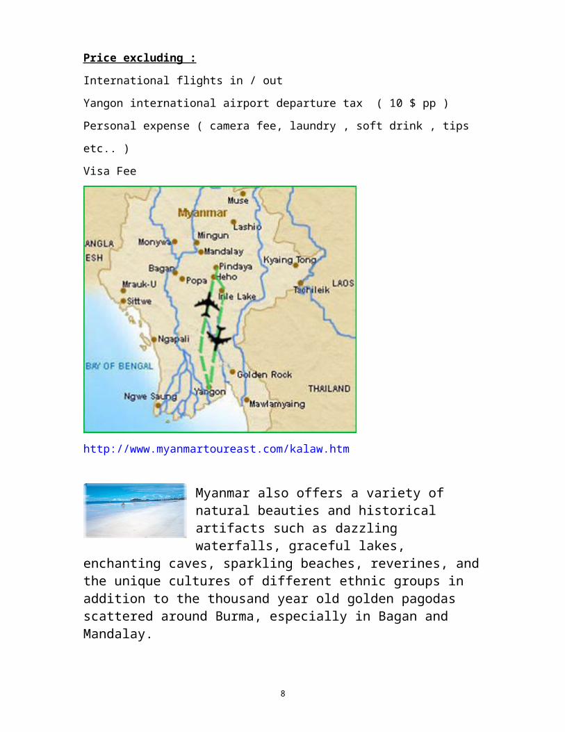
http://www.myanmartoureast.com/kalaw.htm
Myanmar also offers a variety of natural beauties and historical artifacts such as dazzling waterfalls, graceful lakes, enchanting caves, sparkling beaches, reverines, and the unique cultures of
different ethnic groups in addition to the thousand year old golden pagodas scattered around Burma, especially in Bagan and Mandalay.
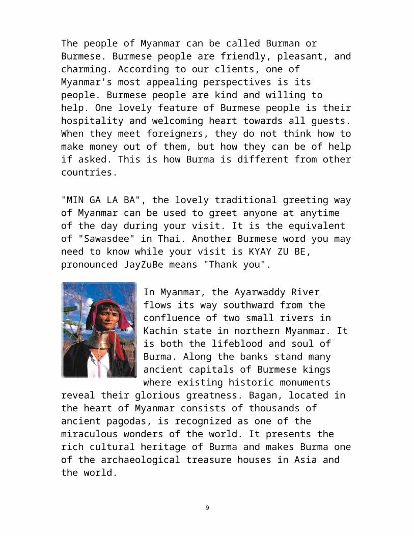
The people of Myanmar can be called Burman or Burmese. Burmese people are friendly, pleasant, and charming. According to our clients, one of Myanmar's most appealing perspectives is its people. Burmese people are kind and willing to help. One lovely feature of
6
Burmese people is their hospitality and welcoming heart towards all guests. When they meet foreigners, they do not think how to make money out of them, but how they can be of help if asked. This is how Burma is different from other countries.
"MIN GA LA BA", the lovely traditional greeting way of Myanmar can be used to greet anyone at anytime of the day during your visit. It is the equivalent of "Sawasdee" in Thai. Another Burmese word you may need to know while your visit is KYAY ZU BE, pronounced JayZuBe means "Thank you".
In Myanmar, the Ayarwaddy River flows its way southward from the confluence of two small rivers in Kachin state in northern Myanmar. It is both the lifeblood and soul of Burma. Along the banks stand many ancient capitals of Burmese kings where existing historic monuments reveal their glorious greatness. Bagan, located in the heart of Myanmar consists of thousands of ancient pagodas, is recognized as one of the miraculous
wonders of the world. It presents the rich cultural heritage of Burma and makes Burma one of the archaeological treasure houses in Asia and the world.
The infrastructure in Burma is now more developed currently, so travel to Myanmar is no longer an adventurous journey. Myanmar is one of the safest tour destinations in Asia opening her doors and stretching out her hands welcoming travelers around the world to visit Burma.
Tour Visa
In the past, people travel to Myanmar as FITs had to change USD 200 into FEC at the airport.
E.V.T ( F.I.T Tour ) need to change but E.V.T ( package Tour ) no need to change.
So at that time we recommended and assisted the travellers to get E.V.T ( Package Tour ).
Now things have improved. There is no need to change any more 7
regardless of the visa type.
So we now recommed our clients to get E.V.T (F.I.T Tour ) which is easy and simple to obtainned.However , travellers may get confused because an exchange counter still exist in yangon airport attracting the travel lers who do not know the latest developement to change USD to Myanmar currancy "Kyat ". This is not compulsory so no need to change if travel lers do not want to change.
The climate of Myanmar is tropical with three main seasons.
( 1 ) The rainy season is from mid-May to mid-October with an average temperature of 25-30 C. Although it rains heavily in Yangon and Inle Lake, traveling in Myanmar during this season is still enjoyable because Mandalay and Bagan lies in dry zones where it barely rains.
( 2 ) The cool season ( Winter ) is from mid-October to mid-February with an average temperature of 20-24 C. This is the best season to visit Burma. Some regions in upper Burma, Kalaw ( South-West of Shan State ) and Kyaing Tong ( Eastern Shan State ), has a temperature that ranges between 5 – 10 C, so travelers may need to bring some warm clothes to tour around this area.
( 3 ) The hot season ( Summer ) is from mid-February to mid-May with an average temperature of 30-35 C. Although it’s a bit hot, our programs are designed to make traveling enjoyable as we avoid the heat by touring about in the mornings and evenings.
Every nationality need visa to come to Myanmar.
Valid Passport with Entry Visa is required for all travelers to Burma. Visa can be obtained at any Myanmar Embassy or Consulate abroad. Visa fee is about US$ 20 in local currency.
The monetary unit is the Kyat ( pronounced chat ), which is divided into 100 pyas. The official exchange rate is about 6 Kyats to US $ 1.
For the convenience of the travelers, Foreign Exchange Certificates ( FECs) are issued by the Central Bank of Myanmar to use during their stay in Myanmar. FECs are acceptable like US dollars by any
8
person in the Union of Myanmar. It is printed on the note as 1 FEC = 1 USD.
There is no more compulsory exchange of USD200 into FEC 200 upon arrival at Yang on airport.
Myanmar cuisine is established around rice or noodles, usually served with a variety of curries between meat and fish, along with a dish of vegetables, salads, soup, and condiments. Myanmar curries tend to be less spicy than those served in Thailand. Meals & drinks at International Hotels are considerably expensive. There are many good local restaurants with almost the same quality of food and hygiene as hotels but at reasonable prices. They serve various dishes of Myanmar, Chinese, European (French and Italian), Thai and Indian cuisine. But roadside small restaurants are not recommended, as it can be risky for health.
There are also a wide variety of local snacks and delicacies. Mouk-hin-kha (thin rice noodles served with fish gravy and onion soup) and Ohn-noh-khauk-swe (noodles served with chicken and coconut gravy) are the most popular in Myanmar. Shan food is another delicacy. Shan style of cooking neither belongs to Myanmar nor Chinese nor Thai cuisine but they taste really good in their own way.
Restaurants and food served towards the travelers are carefully selected for hygiene as well as gastronomic considerations.
Myanmar arts and crafts, mostly hand-made, are lovely souvenirs. Lacquer ware, woodcarvings, tapestries, silverware, brassware, silk and cotton fabrics, and shoulder bags are some of the popular items. For jewelry, there are Burmese rubies, sapphires, jade and pearls available at Myanmar gems shops. All gems and jewelry purchased should be made through the government licensed dealers, who can give a voucher for export.
Bargaining is essential for obtaining reasonable prices. Possible price reductions of up to 70% are not uncommon.
There are no compulsory vaccinations for travel to Myanmar ( Burma ) but it is advisable to take precautions against malaria. Prescription drugs are not widely available in the remote areas of Myanmar so travel ers should bring any required medication with
9
them.
Insect repellents are highly recommended, especially when traveling to remote areas in conjunction with other measures to prevent mosquito bites. The sun can be remarkably hot so a hat and sunscreen is advisable.
It is advisable to purchase travel insurance in your own country. Pls choose a reputable insurance company who has agent in Myanmar. This is very important.
All foreign currencies (above US $ 2000), jewelries, electrical goods, and cameras must be declared to the Burmese Customs at the Airport. Travelers may bring in duty free 200 cigarettes, one quart of wine, and one pint of perfume. Export of Myanmar (Burma) antiques is prohibited. Only gems and jewelries purchased at the licensed dealers, or who can issue an export permit are allowed to be taken out of Myanmar.
Postal service in Myanmar is unreliable. Letters and postcards sent to overseas sometimes do not reach their destinations. Most hotels have IDD lines, but please be aware that the costs are high with average cost of a call to Europe approximate to USD 9 per minute and charged one full minute for any extra seconds. If you want to call home from a hotel, we advise to call and ask them to call you back.
Among the three beaches, Ngapali and Ngwesaung beaches are quiet so your choice should be Chaungtha beach. Its about 5 hours drive from Yangon. Its always very lively and active with its local crowd and different kind of restaurants and beer pubs ( we call beer station in Myanmar ).
a). Myanmar Airport tax
Airport tax for International flight in Myanmar is US $ (or) FEC 10, but there is no air port tax for domestic travel.
b). Burma Standard Time
GMT + 6 1/2 hours
c). Electricity in Myanmar
10
220 VOLT 50 HZ
A flashlight is helpful when traveling up country where electricity is poor.
BUSINESS HOURS
d). Business hour.
Government offices open from 09:30 to 16:30 on weekdays. Banking hours are from 10:00 to 14:00. Private companies work daily except Sunday and gazette holidays. Shopping centers and super markets open daily. But the most famous Bogyoke (Scott) market closes on Monday and gazette holidays. Busy hours at this place are from 10:00 am to 17:00 pm.
e). Tipping in Myanmar
Tipping in Myanmar is depending on how well you think they have been at your service.
f). What to wear?
Light clothing is required all year-round, but a sweater or jacket may be needed when traveling in hilly areas, especially during winter months. If visiting during the rainy season (May - September), an umbrella or raincoat will be required for the days in Inle lake and Yangon. It is required to dress decently within the precincts of religious buildings. Shoes and socks must be removed at pagodas and monasteries so it is advisable to bring a pair of slippers.
g). What to avoid?
Travelers are advised to keep away from touts who may approach them to exchange foreign currency or to sell gems of dubious quality. Travelers are also advised not to drink tap water. Purified bottled water is available everywhere in Myanmar. Taking photograph of military camps and soldiers are to be avoided.
History of Yangon
The history of Yangon is intertwined with the history of the Shwedagon Pagoda. Wherever one may be in Yangon, in the busy
11

town center, in the new towns of the east, in the industrial zone of the west, in the paddy fields of the north, the golden form of the Shwedagon will be seen on the skyline rising above the foliage of the tropical trees, and
The founding story of Shwedagon reaches back to the days of the Enlightenment of Gaudama Buddha when He discovered the cause of universal suffering and the way to its elimination. It was on the 49th day after the Enlightenment when two brothers, Taphussa and Bhallika, merchants from Ukkalapa in the land of Mon people in Lower Myanmar, came before Buddha. A nat (spirit) who had been the mother of the two brothers in a previous existence had guided them to the Buddha. The brothers offered honey cakes. After Buddha had eaten the cakes, the brothers asked for gift. Buddha passed His hand over His head and, obtaining eight Hairs, gave them to the brothers. Buddha, perceiving that the three previous Buddhas had caused their possessions to be enshrined in a pagoda on Singuttara hill in the country of the two brothers, bade them to do likewise with the
The brothers returned home and made landfall at Pagoda Point in the south-west coast of Myanmar. They sent word to king Ukkalapa of their arrival with the sacred Hairs. The King welcomed the Hairs with great ceremony at Asitanzana, north-west of present
The king and the brothers next sought for a man who could tell them the location of Singuttara Hill. No human knew the location but Sakka, King of the nats did, and guided them to the Hill. Singuttara Hill is known by seven names of which one is Trikhumba, meaning 'three pots' and signifying three pot-shaped hills. Tikhumba became Tikun and
When the brothers asked Sakka where the Hairs should be shrined, Sakka could not tell them where the earlier relics were enshrined because they were of such antiquity and he was not that old. However, Sule Nat knew where Kakusandha Buddha's staff was enshrined, Yawhani Nat knew where Konagamana Buddha's water-dipper was enshrined. Hmawbi Nat revealed that he had been assigned to guard the sacred objects. Finally, Gautama Buddha's Hairs were enshrined and stupa consecrated on the full moon day of
Along time after that, there that, there being no one to worship at the
12

Lagun shrine, it fell into ruin and was covered with jungle.Tradition states that 200 years after Buddha's Parinirvana in 543 BC. Sona and Uttara, two monks from Sri Lanka brought King Asoka to the Pagoda. The King had the jungle cleared and the Pagoda repaired. In the fifth century A.D. King Duttabaung paid homage at the Pagoda. In the 11th century, King Anawratha of Bagan offered gold and silver umbrellas and built a pagoda near the town of Twante across the Yangon River. Dalla, which is now a town on the bank opposite Yangon, was then located on the Twante Ridge and was more important than Dagon. Dagon at that time lay in low lying often water-logged land. Sule Pagoda, now in downtown Yangon, stood on a small island in the swamp, to the west down to he Hlaing River and Yangon /River to the south .The Shwedagon (then called Kyak Lagun in Mon)
The discovery of a votive of the Bagan period at Tadagale to the north of Yangon shows that the laterite ridge at the end of which Shwedagon lay was a scene of activity in the Bagan period and the ridge may have provided a road southwards to the Shwedagon Pagoda and Dagon Village beyond.
After the founding of the Shwedagon Pagoda. Alaungpaya's conquest of lower Myanmar is the second most important event in the history of Dagon. May 1775 marks the beginning of the modern town when Alaungpaya, to commemorate his victory, changed
Alaungpaya's Yangon was basically a log fortress, with the river frontage in the south, the site of the present 30th street in the west, a line of about 3300' cutting across the modern Maha Bandola Garden, Pansodan and Bo Aung Gyaw street in the north, and Theinbyu Street in the east. The town lay well to the east of the Sule Pagoda. Its area
Getting Around
Public Transport in Yangon
BusThere are over 250 bus lines running around Yangon. There are over 2.5 million commuters a day. Recently, CNG (Compressed Natural Gas) was introduced as new fuel for buses operating in Yangon. The bus fares starts from Ks 40 to Ks 120, depending on the distance the
13
traveller takes.
TrainCircular Train service is available. There are 11 local trains for ciruclar services through 37 railway stations. The train fares are cheaper than the bus fares. Yangon Central Railways Station near Aung San Stadium is the main station in Yangon.
City TaxiTaxis are plenty in Yangon. You can get any taxi easily anywhere in Yangon. The minimum cost is about Ks 1000 for a 10 minutes ride. The taxis do not have meters, so bargaining before taking the ride is the most suitable option.
Ferry BoatFor the commuters from Dala, to cross the Yangon River, takes about 10 minutes. They steam between Pansodan Warf and Dala Warf.
Domestic Transport from Yangon
BusThere are two highway bus terminals, one known as Dagon Ayeyar Highway Bus Terminalm in Hlaing Tharyar Township, which is mainly for the buses going to the Ayeyarwaddy Division. The other terminal is Aung Mingalar Highway Bus Terminal, which is for the buses tot the cities and towns of the whole country, except the Ayeyarwaddy Division.
BoatBoat services are available for Ayeyarwaddy Delta region. Tickets are available at Lan Thit Jetty in Seikkan Township.
TrainMyanma Railways operate 40 train-routes throughout the country. Tickets are available at Yangon Central Railway Station.
PlaneYangon International Airport is available for both International and Domestic Flights. Domestic flight carriers are (1) Myanma Airways (2) Air Bagan (3) Air Mandalay and (4) Yangon Airways.
14

Food in Yangon
There are a variety of food availabel in Yangon, since Yangon is populated with many different races of people such as Myanmars, Chinese, Indians and other ethnic groups. Restaurants are available everywhere. Chinese Food is available in China Town in Latha and Lanmadaw Township. Indian food is available in Kyauktada Township. There are some European restaurants in Yangon.
Shopping in Yangon
The main tourist destination in Yangon is the Bogyoke Market, where most of the Myanmmar made souvenirs are available. Traditional art & crafts such as Lacquerware, Paintings, Antiques, Tapestries, Textile, Souvenirs, Gems & Jewelries are available in this market and in downtown Yangon.
Entertainment in Yangon
Television Stations
The main TV Stations are located in Yangon. There are two local TV channels: TV Myanmar and Myawaddy with programs running from 7 am to 4 am; and from 4 pm to 11 pm. Most hotels also have satellite TV. Myawaddy was started on the 27th March, 1995. The average broadcasting hours is about 8 hours per day when it started. But now there's more, MRTV3, MRTV4 and Channel 5.
MRTV 3 - English programs are telecast for viewers in Myanmar from 9:00 A.M. to 10:00 A.M. The transmission hours for viewers from abroad are from 13:00 A.M. to 14:00 A.M., 18:00 P.M. to 19:00 P.M., and from 02:00 A.M. to 04:00 A.M. It is an English channel for oversea audience. It can be received from 126 countries and is transmitted from Thaicom-3 C Band Global beam. In addition, the Ministry have also broadcast the MRTV3 programs pm the Internet using web based video streaming system via the gateway of Myanma Posts and Telecommunications. It can be accessed on Internet through http://www.mrtv3.net.mm web site.
MRTV 4 - It was launched on (15-5-2004) like a streaming video via satellite. MRTV 4 contains non-formal education programs and other entertainment programs. But for receiving, it can be matched by MMBox (Myanmar Media Box). This transmission contains
15
educational programs from Ministries, Myanmar movies, English movies with Myanmar subtitles, cartoon programs and other entertainment programs. The transmission time is from 7 am to 11pm daily. For more quality and convenience, MRTV 4 will soon be broadcasting with Digital Video Broadcasting Technology (DVBT) terrestrial system.
Channel 5 - Broadcasts movies in different languages such as English, Chinese, Indian etc ... but all the movies are subtitled in Myanmar language. There are great cartoon programs for the children too.
Newspaper
Three morning newspapers Myanmar Ah Lin and Kye mon in Myanmar and The New Light of Myanmar in English are published in Yangon and The Yadanabon News in Myanmar is published in Mandalay. Myanmar Times Journal (English Version) is distributed every Monday, and the Myanmar Version is distributed ever Friday. Both journals are published in Yangon. The locally published magazines in English; Golden Myanmar, Myanmar Chronicle, and Myanmar Perspective, are available in bookshops. Foreign newspapers such International Herald Tribune, as Singapore Straits Times. and some foreign magazines and periodicals are available at In-wa (Ava) Bookshop, No.232, Sule Pagoda Road.
Radio
Radio Myanmar broadcasts English on the following schedule: 8:30 am to 9:00am 1:30 pm to 2:00 pm; and 9:00 pm to 10:30 pm. The new City FM broadcasts from 08:00 A.M. to 10:00 A.M., and from 13:00 P.M. to 17:00 P.M. daily, starting from January 1, 2002. City FM broadcasts from 7 am in the morning till 9pm in the evening. Myanmar & English songs, Entertainment programs, Live Interviews with Movie Stars are broadcast from this Channel.
Entertainment centers
There are entertainment centers such as Cinema Halls, Theatres and Karaoke Pubs. The main Music, Video and Film productions are in downtown Yangon.
Traditional Dances
16
There are also Traditional Dance sections at Karaweik Hall, where locals entertain with different Myanmar dances. Sometimes, entertainment of the Myanmar Orchestra is also programmed.
Beauty Salons and Spas
Yangon is full of Beauty Salons and Spas. Beautifications of hair and body are also popular in Yangon. The Spas are mainly included in the International Hotels in Yangon.
General Information
Age: 2500 years Area: 576 km²
Population: 4,082,000
Location: Latitude: 16°48' N, 96°9' E
Temperature: Min 16 'C - Max 34 'C
Formation of Yangon
Yangon is the largest city of Myanmar. There are 34 townships forming the city of Yangon. These townships in alphabetical orders are :Ahlone, Bahan, Botahtaung, Dala, Dagon, Dagon (Seikkan), Dawbon, East Dagon, Hlaing, Hlaing Tharyar, Insein, Kyeemyindaing, Kamaryut, Latha, Lanmadaw, Mingalardon, Mingalar Taung Nyunt, Mayangone, North Dagon, North Okkalapa, Pabedan, Pazundaung, Sanchaung, South Dagon, Seik Gyi Khanaung To, Seikkan, South Okkalapa, Shwe Pyi Thar, Thingangyun, Thaketa, Thanlyin, Tarmwe, Yankin
Communication Services
Internet ServicesMyanmar Posts and Telecommunication (MPT) sells email accounts and Internet access.
Cyber CafeThere are some Internet Cafe in downtown Yangon. The usage
17

charges are about 650 to 1000 Kyats per hour, depending on the Cyber Cafe.
Express Money OrderMoney Order service is available in the capitals of each states and divisions in Myanmar. The maximum amount is Ks 100,000 per remittance.
Parcel ServicesGeneral Post Office in Yangon downtown is the main Parcel Service center in Yangon.
Fax ServicesYangon Telegraph Office offers fax services to 88 oversea countries. The domestic fax lines are also widely used in Yangon.
Telephone ServicesGenerally there are three kinds of phone services in Yangon. Conventional Phones (or) Land Phones, Mobile Phones and IP Star Phones area available. The local phone calling costs are 15 Ks per minute for the conventional phones and 25 Ks per minute for Mobile Phones.Oversea calls are available but quite expensive, depending on the distance of the country.
Inle Lake , Shan State
Inle Lake is one of the two big lakes in Myanmar. It is the beautiful lan mark of the shan state . The other one is ‘ Indawgyi ‘ in the Nothern Kachin State . Both the lakes are very well known from the situation or the location .
The Inle Lake is situated in Nyaung Shwe town ship . It is 30 km away from TaungGyi , the capital of the shan state. And it is 900 metres above the sea level . Inle Lake is 22.4 kms long , 10.2 kms wide and about 3 to 4 meters deep. In some places soil under is about 8 metres deep . It is an elongated shape and the whole lake is just closely surrounding by hozy blue mountains .
Historically , the name of this lake was born by establishing of four villages . They are Ywama, Ywagyi , Naung daw and Nampan . In Myanmar ;In’ means lake and ‘Le’ means four .
18

The Inthas ( the native lake –dwellers ) are mainly inhabitants. Actually they are coming from Danu in Tanithayi devision . They are staying together with shans, PaOh, danu,Taung yoe ans some other ethnice on the lake .The population now is about 120000. Ther are about 100 villages in the lake . Commonly the speak their Inthas dialect, and shan Pa-Oh danu languages are widely used too.
The main business in the Lake is agriculture.They are farming on the floating Islands. They grow fruits and vegetables such as potatos, egg plant , peas ,bean, sugarcane, and tomatoes . The main Crops are paddy and tomatoes .
Floating Islands which is the special feature of their lifestyle and staple of their economy. There are two kinds of floating islands. They are naturally sinking island and artificially floating islands. Inthes make the floating islands from floating bushes growing beside the lake. Firstly they burn the bushes and growing beside the lake. Firstly they burn the bushes and cut the required size. After that they bring to near village .They put the soil and water weed on them as fertilizer. They plant some corps and vegetables . The size of the floating wide and thick. It could last about 20 years if composition is well compact. There are too interesting place for you to observe, like the market place at Ywa-ma which is in Inle Lake’s down town. The seller and shopping markers used their respective boats to do their business. It is the colorful market , in the Inle Lake .
It is also very interesting to observe in Inle Lake which is the leg-rowers who raw their boat with their legs. This unique-method in the Lake .Inthas row their boats with their legs because of till plants on the floating island. When they row the boat by sitting, they cannot see the way. By rowing with leg they can use all the body forces and they get more speed. Then they will get opportunity to watch the movement of the fishes in the clear water when they are fishing .
I also want to mention you about Phaung Daw Oo Pagoda in the Lake. It is on of the famous pagoda in our country . It is located in Nanhu village . There are five sacred Buddha images at the centre of the pagoda. Original height of these images were only 6 inches. Now it is about three times taller because many devotees have been guiding these images for many years. Now original features was only one story building in 1952, it was reconstructed into two story
19

building. Inle lake is famous for Phaung Daw Oo pagoda festival . It is held in late September and October every year during this festival .This four images from Phaung Daw Oo pagoda will be put on the royal karaweik barge. It is toured around the lake by the leg-rowers on long boats for about 18 days . It is famous not only for the procession on the lake but also for the leg rowing competitions . Inle Lake become one of the most well-known centre of the tourist attraction . After visiting the Inle lake, you will never forget this beautiful Lake .
Inle Lake
Inle Lake is 22km long and about 11km wide. The lake is at 1328 metres above sea level. Inle is one of the most popular tourist destination in the Shan State. The lake is full of floating vegetations and houses. The lake dwellers are one-legged rowers. They are well-known for it. They are called as "Inthar" meaning people of the lake. There are about 18 villages around the lake. They are Buddhist and about a hundred Buddhist monasteries can be found. A lot small pagodas can be found too.
Inle Lake and the surrounding mountain range
Inle lake dwellers or the Inthar, fishing with a specail kind of net used in this region
20

The blue sky matches the blue and clear lake of Inle
The boat stand in Nyaung Shwe, for Inle Lake
The floating water hyacinth are the major products of this region. Many hand made products such as bags, baskets are made from water hyacinth. Other vegetations are tomatoes, beans, cauliflower, cabbage, eggplant, garlic, onion, betel, melon, papaya and banana. Some villagers also grow rice.
The Inthars also make their living by fishing. The silk dresses and clothes of Inle are popular among local and foreign visitors. Inle also produces silverware.
Major Attractions
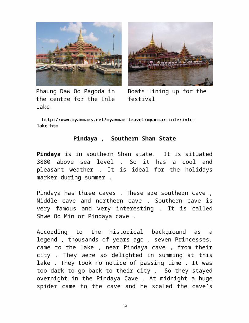
Phaung Daw Oo Pagoda - The main pagoda in the Inle lake is called as "Phaung Daw Oo" Pagoda. There are five small Buddha images all covered with gold and difficult to make out the figures. There is an annual festival around October/November.
Phaung Daw Oo Pagoda in the centre for the Inle Lake
Boats lining up for the festival
http://www.myanmars.net/myanmar-travel/myanmar-inle/inle-lake.htm
21

Pindaya , Southern Shan State
Pindaya is in southern Shan state. It is situated 3880 above sea level . So it has a cool and pleasant weather . It is ideal for the holidays marker during summer . Pindaya has three caves . These are southern cave , Middle cave and northern cave . Southern cave is very famous and very interesting . It is called Shwe Oo Min or Pindaya cave .
According to the historical background as a legend , thousands of years ago , seven Princesses, came to the lake , near Pindaya cave , from their city . They were so delighted in summing at this lake . They took no notice of passing time . It was too dark to go back to their city . So they stayed overnight in the Pindaya Cave . At midnight a huge spider came to the cave and he scaled the cave’s entrance in his web . So the princess were locked in the cave .
Next morning a prince was passing near the cave and he heard the cries for help .He considered what he should do . Finally he killed the huge spider with his bow and arrow .
When the spider died he shouted that “ Pinku Ya ”. Now “ Pinku Ya ” changed to “ Pindaya ” . Pinku means spider and Ya means got . So the princess became a Pindaya Conqueror . I would like to explain about the location of Pindaya . Pindaya cave is not on the plain . It’s Lies on the mountain side . It’s situated 1515 meters .So, the high of the cave is about 332 meters . And the depth of cave is 490 feet. Inside the cave 8094 Buddha images lined the wall of the cave . No one seems to know when the images were placed in the cave .
As you come up from covered stair-way to the entrance of the cave , first, you will be greeted by graceful pagoda called Shwe Oo Min pagoda . The prayer hall was built by U Khanti . Back in the corner of the platform is another antique stupa which was built by the Indian emperor Ashoka about over 2000 years ago .
Now, I want to explain the Buddha image inside the Pindaya cave .You can see the entrance of the cave , a Beehive Buddha images . Which are so small that they look like bees .
22
I would like to tell you some posture of Buddha images . Meaning the great Physician , we Buddhists since we are subject to birth ,old age , sickness and death . And the only the Buddha can cure the universal sickness by his Dhamma . These posture of Buddha images are hard to be found in other places .You can see Buddha holding medicine in his hand .
One of the great famous images is the seated Buddha image on elephant’s back . It is said to have curved about 600 years ago . It is strongly believed among the Buddhists that by worshipping of that particular posture of Buddha images . All the evil things in life will be overcome before they are going to give troubles and all the obstacles can be surmounted and within the cave . They are smaller meditation chambers which is accessible only by Crawling .
You can see in the cave labyrinth or maze Buddha images have been put in the cave over centuries and arranged in such away as to form a labyrinth .
It is learnt from the ancestors that those particular Buddha images were always wet with moisture in days of part .
You can see stalactites are called as rock gong and drums. We used to strike these rock in sharing our merits .And they sounded these lock drums or gongs. One of increasing thing in the stone pillar . It is formed b dripping of water containing lime . According to the geologists they had measured this stone pillar they had estimated that cave about 200 million years ago .
The native here believe that the water has some supernatural power . In fact , the water is cold and it naturally consists of zinc , copper iron and other menials coming out of the rock .
Stalactite is forced by the dripping of water containing lime. The spike of limestone hanging from the roof and if formed a stone pillar . The spike hanging from the roof is stalactite and the spike rising from the floor is stalagmite .
The cave has other phenomena victorious plot . The native believe that if we stand on this rock and pray to any god or holy one our wish come true .
23
Another one is fairy pound .Most of the people who have no religious principle in mind believe that the water in the well has the super natural power.
The pagoda festivals at the ground of the pagoda are as crowed as the interior .Visitors should plan to stay for one or two nights in Pindaya to explore the natural beautifies all around the tranquil lake, the limestone caves , the ancient pagodas and images and lovely old trees .
Pak AwTawya Meditation CentreMaelamine, Mon StateTanglin TownshipSyadaw U Agginaa
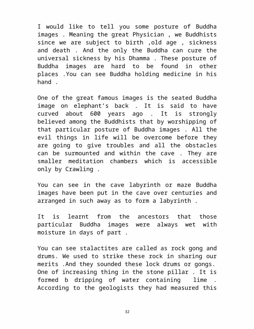
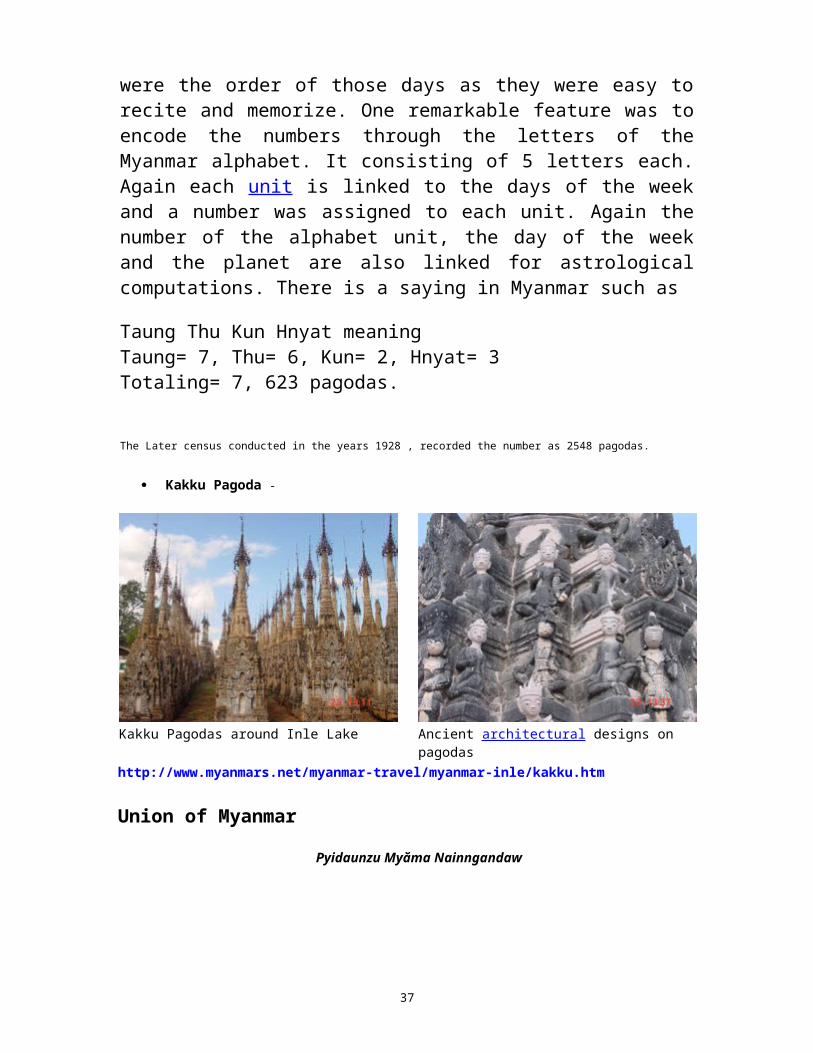
Kakku Pagodas
The Kakku relic pagoda of the southern Shan state, which only recently has become one of the most visited places in the Shan State. It is situated near Mway Taw Village, Kakku village tract, Taunggyi township, under the administration of special region 6, About 25 KM away from Taunggyi, the Capital of Shan State.
History The legend of Kakku goes far back to the 3th century B.C to the region of King Ashoka of the Indian Empire, and also to the 11th century Bagan dynasty during the region of the famous King Alaung Sithu.
24

A long range of pagodas in Kakku Beautiful carvings found on the pagodas
It is a well known fact that King Ashoka purified and propagated the Buddhist religion throughout the Indian Empire and extending even future to Myanmar. All of us are familiar with Asoka’s stupendous and monumental works of charity, where donated most significantly 84, 000 wells, 84, 000 ponds, 84,000 pagodas among many others forms or deeds of merits. Thus many ancient pagodas found in Myanmar are in some way or another links to his name. So went the oral history handed down through the generations.
Most of the pagodas are ruins from the past. Build by King Alaung Sithu and other devotees.
The Shan were also devoted to Budhhism in the ancient times.
Another popular legend in Myanmar History concerns King Alaung Sithu, of the flourishing Bagan Dynasty, gained legendary fame due to his nation –building endeavors and dedicate propagation of Buddhism in Myanmar. He was reputed to tour his Kingdom in the magical “Thit Ka Net” royal barge with a war way appearing mystically at the mere direction of his finger. He used to build pagodas among the banks, atop hills, and the plains as inspired by his royal vision. During one of his royal tours along what was the Shan State, he was deeply enchanted by the unraveling scenic beauty of this location. His majesty thereupon commanded his retinue to build a pagoda atop the hill over looking this magnificent valley. This pagoda was named “Phaungdaw Sit” meaning pagoda built where the royal barge berthed. It was also one of the largest structures among the group of the pagodas.
25

A closer view of the carving figures of a Nat or a spirit guardian.
Decorations showing the different architectures of ancient times.
Architecture The assemblage of Kakku pagodas consists of two distinct architectural presentations. One presentation was designed as the “Yun” assemblage of pagodas. The foremost pagodas donors were one of the dominant Shan ethnic nationalities known as the “Yun”. The structures have distinctive tapering spires. The largest pagoda of Yun design stands at the eastern sector and is known by several names, such as Ashoka pagoda, Shwewet Ku pagoda, Kakku relic pagoda, etc.
The seconds presentation followed the Myanmar design initiated by King Anawratha during the golden age of pagoda building. King Alaung Sithu was also famous for building pagodas at places where his royal barge anchored during his extensive travels along his kingdom. One of the imposing pagodas situated in the western sector is reputed to have been built by king Alaung Sithu bearing the august named “Phaung Daw Site” pagoda meaning the pagoda in memory of the place where his barge anchored. The pagodas in the western sector generally followed the Bagan Design. Devout
26

Buddhists of the later generations donated many smaller pagodas around the two large stupas. Thus the numbers grew through the passage of time heightening the aura and also enriching the architectural kaleidoscope.
NumbersIn the olden days Myanmar literature was recited to memory and handed down by word of mouth. Rhymes were the order of those days as they were easy to recite and memorize. One remarkable feature was to encode the numbers through the letters of the Myanmar alphabet. It consisting of 5 letters each. Again each unit is linked to the days of the week and a number was assigned to each unit. Again the number of the alphabet unit, the day of the week and the planet are also linked for astrological computations. There is a saying in Myanmar such as
Taung Thu Kun Hnyat meaning Taung= 7, Thu= 6, Kun= 2, Hnyat= 3 Totaling= 7, 623 pagodas.
The Later census conducted in the years 1928 , recorded the number as 2548 pagodas.
Kakku Pagoda -
Kakku Pagodas around Inle Lake Ancient architectural designs on pagodashttp://www.myanmars.net/myanmar-travel/myanmar-inle/kakku.htm
Union of Myanmar
Pyidaunzu Myăma Nainngandaw
27

Flag State seal
Anthem: Kaba Ma Kyei
Capital Naypyidaw19°45′N 96°6′E 19.75°N 96.1°E
Largest city Yangon (Rangoon)Official language(s) Burmese
Recognised regional languages
Jingpho, Kayah, Karen, Chin, Mon, Rakhine, Shan
Official scripts Burmese scriptDemonym Burmese/Myanma
Government Presidential republic, military dictatorship - President Thein Sein
- Vice President Tin Aung Myint OoSai Mauk Kham
Legislature Pyidaungsu Hluttaw - Upper House Amyotha Hluttaw - Lower House Pyithu Hluttaw
Formation - Pagan Dynasty 23 December 849 - Toungoo Dynasty 16 October 1510 - Konbaung Dynasty 21 March 1752 - Independence 4 January 1948 (from United Kingdom) - coup d'état 2 March 1962
Area
- Total 676,578 km2 (40th)261,227 sq mi
- Water (%) 3.06Population
- 2009 estimate 55,400,000[1] (24th) - 1983 census 33,234,000 (3)
- Density 73.9/km2 (119th)191.5/sq mi
GDP (PPP) 2009 estimate - Total $71.772 billion[2]
28

- Per capita $1,197[2] GDP (nominal) 2009 estimate - Total $34.262 billion[2] - Per capita $571[2]
HDI (2010) 0.451[3] (low) (132nd)Currency kyat (K) (mmK)Time zone MST (UTC+6:30)
Drives on the right[4]
Internet TLD .mmCalling code 95
1Some governments recognise Rangoon as the national capital.[5]
Burma, officially the Union of Myanmar, Burmese: ပြ�ည်ထေ�ာင်စု ပြ�န�်ာနိင်ုငံထေ�ာ်, Pyidaunzu Myăma Nainngandaw,
pronounced [pjìdà̀uɴzṵ mjəmà nàiɴŋàɴdɔ̀]) is a country in Southeast Asia. The country is bordered by the People's Republic of China on the northeast, Laos on the east, Thailand on the southeast, Bangladesh on the west, India on the northwest, and the Bay of Bengal to the southwest, with the Andaman Sea defining its southern periphery. One-third of Burma's total perimeter of 1,930 kilometres (1,200 mi) forms an uninterrupted coastline. Burma is the second largest country by geographical area in Southeast Asia.
The country's culture, heavily influenced by those of its neighbours, is based on Theravada Buddhism intertwined with local elements. Burma's diverse population has played a major role in defining its politics, history, and demographics in modern times, and the country continues to struggle to overcome its ethnic tensions. The military has dominated government since General Ne Win led a coup in 1962 that toppled the civilian government of U Nu. Burma remains under the control of the military-led State Peace and Development Council.
Etymology"Burma" is derived from the Burmese word "Bamar", which in turn is the colloquial form of Myanmar (or Mranma in old Burmese), both of which historically referred to the majority Burmans (or the Bamar). Depending on the register used the pronunciation would be "Bama" (pronounced [bəmà]), or "Myanmah" (pronounced [mjəmà]). The
29
name "Burma" has been in use in English since the time of British colonial rule.
In 1989, the military government officially changed the English translations of many colonial-era names, including the name of the country to "Myanmar". This prompted one scholar to coin the term "Myanmarification" to refer to the top-down programme of political and cultural reform in the context of which the renaming was done. The renaming remains a contested issue.While most of the name changes are closer to their actual Burmese pronunciations, many opposition groups and countries continue to oppose their use in English because they recognise neither the legitimacy of the ruling military government nor its authority to rename the country or towns in English. Various non-Burman ethnic groups choose not to recognise the name because the term Myanmar has historically been used as a label for the majority ethnic group, the Bamar, rather than for the country.
Various world entities have chosen to accept or reject the name change. The United Nations, of which Burma (under the name Myanmar) is a member, endorsed the name change five days after its announcement by the junta. However, governments of many countries including Australia, Canada, France, the United Kingdom and the United States still refer to the country as "Burma", with varying levels of recognition of the validity of the name change itself. Others, including the Association of Southeast Asian Nations and the governments of Germany, India, Japan, Russia ] and the People's Republic of China recognise "Myanmar" as the official name.
Media usage is also mixed. In spite of the usage by the United States government, some American news outlets including The New York Times, The Wall Street Journal, The International Herald Tribune and CNN, and international news agencies the Associated Press, Reuters and Agence France-Presse have adopted the name "Myanmar". The name "Burma" is still widely used by other news outlets, including Voice of America, The Washington Post, the BBC, ITN and most British newspapers, The Times of India and Time. Other sources often use combined terms such as "Burma, also known as Myanmar." Some media outlets that use "Myanmar" refer to "Burma" as the nation's "colonial name." The official name of the country used by the government is not clear. On 21 October 2010 some media reported that the government changed the official name to Republic of the
30

Union of Myanmar, which was established as part of the 2008 Constitution. But this information is still not confirmed by any Burmese government sources nor any other credible sources. Prior to this, the country was known formally as the Union of Myanmar since 1989. This had itself replaced the previous designation of the Socialist Republic of the Union of Burma used in the 1974 Constitution, which in turn had replaced the 1947 Constitution adopted following independence, which had referred simply to the Union of Burma.
Geography
Burma, which has a total area of 678,500 square kilometres (262,000 sq mi), is the largest country in mainland Southeast Asia, and the 40th-largest in the world. It lies between latitudes 9° and 29°N, and longitudes 92° and 102°E.
It is bordered to the northwest by Chittagong Division of Bangladesh and Mizoram, Manipur, Nagaland and Arunachal Pradesh of India to the northwest. Its north and northeast border straddles the Tibet and Yunnan regions of China for a Sino-Burman border total of 2,185 kilometres (1,358 mi). It is bounded by Laos and Thailand to the southeast. Burma has 1,930 kilometres (1,200 mi) of contiguous coastline along the Bay of Bengal and Andaman Sea to the southwest and the south, which forms one quarter of its total perimeter.[25]
In the north, the Hengduan Shan mountains form the border with China. Hkakabo Razi, located in Kachin State, at an elevation of 5,881 metres (19,295 ft), is the highest point in Burma.[26] Three mountain ranges, namely the Rakhine Yoma, the Bago Yoma, and the Shan Plateau exist within Burma, all of which run north-to-south from the Himalayas.[27] The mountain chains divide Burma's three river systems, which are the Ayeyarwady, Salween (Thanlwin), and the Sittaung rivers.[24] The Ayeyarwady River, Burma's longest river, nearly 2,170 kilometres (1,348 mi) long, flows into the Gulf of Martaban. Fertile plains exist in the valleys between the mountain chains. The majority of Burma's population lives in the Ayeyarwady valley, which is situated between the Rakhine Yoma and the Shan Plateau.
31
Climate
Much of the country lies between the Tropic of Cancer and the Equator. It lies in the monsoon region of Asia, with its coastal regions receiving over 5,000 mm (196.9 in) of rain annually. Annual rainfall in the delta region is approximately 2,500 mm (98.4 in), while average annual rainfall in the Dry Zone, which is located in central Burma, is less than 1,000 mm (39.4 in). Northern regions of the country are the coolest, with average temperatures of 21 °C (70 °F). Coastal and delta regions have an average maximum temperature of 32 °C (89.6 °F).
Wildlife
The country's slow economic growth has contributed to the preservation of much of its environment and ecosystems. Forests, including dense tropical growth and valuable teak in lower Burma, cover over 49% of the country, including areas of acacia, bamboo, ironwood and michelia champaca. Coconut and betel palm and rubber have been introduced. In the highlands of the north, oak, pine and various rhododendrons cover much of the land.[28] Heavy logging since the new 1995 forestry law went into effect has seriously reduced forest acreage and wildlife habitat.[29] The lands along the coast support all varieties of tropical fruits and once had large areas of mangroves although much of the protective mangroves have disappeared. In much of central Burma (the Dry Zone), vegetation is sparse and stunted.
Typical jungle animals, particularly tigers and leopards, occur sparsely in Burma. In upper Burma, there are rhinoceros, wild buffalo, wild boars, deer, antelope, and elephants, which are also tamed or bred in captivity for use as work animals, particularly in the lumber industry. Smaller mammals are also numerous, ranging from gibbons and monkeys to flying foxes and tapirs. The abundance of birds is notable with over 800 species, including parrots, peafowl, pheasants, crows, herons, and paddybirds. Among reptile species there are crocodiles, geckos, cobras, Burmese pythons, and turtles. Hundreds of species of freshwater fish are wide-ranging, plentiful and are very important food sources.[30] For a list of protected areas, see List of protected areas in Burma.
32
History
After the First Burmese War, the Ava kingdom ceded the provinces of Manipur, Tenassarim, and Arakan to the British.[31] Rangoon and southern Burma were incorporated into British India in 1853. All of Burma came directly or indirectly under British India in 1886 after the Third Burmese War and the fall of Mandalay.[31] Burma was administered as a province of British India until 1937 when it became a separate, self-governing colony. The country became independent from the United Kingdom on 4 January 1948, as the "Union of Burma".
It became the "Socialist Republic of the Union of Burma" on 4 January 1974, before reverting to the "Union of Burma" on 23 September 1988. On 18 June 1989, the State Law and Order Restoration Council (SLORC) adopted the name "Union of Myanmar" for English transliteration. This controversial name change in English, while accepted in the UN and in many countries, is not recognised by the Burmese democracy movement and by nations such as Canada, the United Kingdom and the United States.[32]
Early history
Archaeological evidence suggests that civilisation in the region which now forms Burma is quite old. The oldest archaeological find was of cave paintings and a Holocene assemblage in a hunter-gatherer cave site in Padah Lin in Shan State. The Mon people are thought to be the earliest group to migrate into the lower Ayeyarwady valley, and by the mid-10th century BC were dominant in southern Burma. The Tibeto-Burman speaking Pyu arrived later in the 1st century BC, and established several city states – of which Sri Ksetra was the most powerful – in central Ayeyarwady valley. The Mon and Pyu kingdoms were an active overland trade route between India and China. The Pyu kingdoms entered a period of rapid decline in early 9th century AD when the powerful kingdom of Nanzhao (in present-day Yunnan) invaded the Ayeyarwady valley several times.
Bagan (1044–1287)
Tibeto-Burman speaking Burmans, or the Bamar, began migrating to the Ayeyarwady valley from present-day Yunnan's Nanzhao kingdom
33

starting in 7th century AD. Filling the power gap left by the Pyu, the Burmans established a small kingdom centred in Bagan in 849. But it was not until the reign of King Anawrahta (1044–1077) that Bagan's influence expanded throughout much of present-day Burma.
After Anawrahta's capture of the Mon capital of Thaton in 1057, the Burmans adopted Theravada Buddhism from the Mons. The Burmese script was created, based on the Mon script, during the reign of King Kyanzittha (1084–1112). Prosperous from trade, Bagan kings built many magnificent temples and pagodas throughout the country – many of which can still be seen today.
Bagan's power slowly waned in 13th century. Kublai Khan's Mongol forces invaded northern Burma starting in 1277, and sacked Bagan city itself in 1287. Bagan's over two century reign of Ayeyarwady valley and its periphery was over.
Small kingdoms (1287–1531)
The Mongols could not stay for long in the searing Ayeyarwady valley. But the Tai-Shan people from Yunnan who came down with the Mongols fanned out to the Ayeyarwady valley, Shan states, Laos, Siam and Assam, and became powerful players in Southeast Asia.
The Bagan empire was irreparably broken up into several small kingdoms:
The Burman kingdom of Ava or Innwa (1364–1555), the successor state to three smaller kingdoms founded by Burmanised Shan kings, controlling Upper Burma (without the Shan states)
The Mon kingdom of Hanthawady Pegu or Bago (1287–1540), founded by a Mon-ised Shan King Wareru (1287–1306), controlling Lower Burma (without Taninthayi).
The Rakhine kingdom of Mrauk U (1434–1784), in the west. Several Shan states in the Shan hills in the east and the Kachin
Hills in the north while the north-western frontier of present Chin hills still disconnected yet.
This period was characterised by constant warfare between Ava and Bago, and to a lesser extent, Ava and the Shans. Ava briefly controlled Rakhine (1379–1430) and came close to defeating Bago a
34

few times, but could never quite reassemble the lost empire. Nevertheless, Burmese culture entered a golden age. Hanthawady Bago prospered. Bago's Queen Shin Saw Bu (1453–1472) raised the gilded Shwedagon Pagoda to its present height.
By the late-15th century, constant warfare had left Ava greatly weakened. Its peripheral areas became either independent or autonomous. In 1486, King Minkyinyo (1486–1531) of Taungoo broke away from Ava and established a small independent kingdom. In 1527, Mohnyin (Shan: Mong Yang) Shans finally captured Ava, upsetting the delicate power balance that had existed for nearly two centuries. The Shans would rule Upper Burma until 1555.
Taungoo (1531–1752)
Reinforced by fleeing Burmans from Ava, the minor Burman kingdom of Taungoo under its young, ambitious king Tabinshwehti (1531–1551) defeated the more powerful Mon kingdom at Bago, reunifying all of Lower Burma by 1540. Tabinshwehti's successor King Bayinnaung (1551–1581) would go on to conquer Manipur (1556), Shan states (1557), Chiang Mai (1557), Ayutthaya (1564, 1569) and Lan Xang (1574), bringing most of western South East Asia under his rule. Preparing to invade Rakhine State, a maritime power controlling the entire coastline west of Rakhine Yoma, up to Chittagong province in Bengal.
Bayinnaung's massive empire unravelled soon after his death in 1581. Ayutthaya Siamese had driven out the Burmese by 1593 and went on to take Tanintharyi. In 1599, Rakhine forces aided by Portuguese mercenaries sacked the kingdom's capital Bago. Chief Portuguese mercenary Filipe de Brito e Nicote (Burmese: Nga Zinga) promptly rebelled against his Rakhine masters and established Portuguese rule in Thanlyin (Syriam), then the most important seaport in Burma. The country was in chaos.
The Burmese under King Anaukpetlun (1605–1628) regrouped and defeated the Portuguese in 1611. Anaukpetlun reestablished a smaller reconstituted kingdom based in Ava covering Upper Burma, Lower Burma and Shan states (but without Rakhine or Taninthayi). After the reign of King Thalun (1629–1648), who rebuilt the war-torn country, the kingdom experienced a slow and steady decline for the next 100 years. The Mons successfully rebelled starting in 1740 with
35

French help and Siamese encouragement, broke away Lower Burma by 1747, and finally put an end to the House of Taungoo in 1752 when they took Ava.
Konbaung (1752–1885)
A British 1825 lithograph of Shwedagon Pagoda reveals early British occupation in Burma during the First Anglo-Burmese War.
King Alaungpaya (1752–1760), established the Konbaung Dynasty in Shwebo in 1752.[36] He founded Yangon in 1755. By his death in 1760, Alaungpaya had reunified the country. In 1767, King Hsinbyushin (1763–1777) sacked Ayutthya. The Qing Dynasty of China invaded four times from 1765 to 1769 without success. The Chinese invasions allowed the new Siamese kingdom based in Bangkok to repel the Burmese out of Siam by the late 1770s.
King Bodawpaya (1782–1819) failed repeatedly to reconquer Siam in 1780s and 1790s. Bodawpaya did manage to capture the western kingdom of Rakhine State, which had been largely independent since the fall of Bagan, in 1784. Bodawpaya also formally annexed Manipur, a rebellion-prone protectorate, in 1813.
King Bagyidaw's (1819–1837) general Maha Bandula put down a rebellion in Manipur in 1819 and captured then independent kingdom of Assam in 1819 (again in 1821). The new conquests brought the Burmese adjacent to the British India. The British defeated the Burmese in the First Anglo-Burmese War (1824–1826). Burma had to cede Assam, Manipur, Rakhine State (Arakan) and Tanintharyi (Tenessarim).
In 1852, the British attacked a much weakened Burma during a Burmese palace power struggle. After the Second Anglo-Burmese War, which lasted 3 months, the British had captured the remaining coastal provinces: Ayeyarwady, Yangon and Bago, naming the territories as Lower Burma.
King Mindon (1853–1878) founded Mandalay in 1859 and made it his capital. He skilfully navigated the growing threats posed by the competing interests of Britain and France. In the process, Mindon had to renounce Kayah (Karenni) states in 1875. His successor, King Thibaw (1878–1885), was largely ineffectual. In 1885, the British,
36
alarmed by the French conquest of neighbouring Laos, occupied Upper Burma. The Third Anglo-Burmese War (1885) lasted a mere one month insofar as capturing the capital Mandalay was concerned. The Burmese royal family was exiled to Ratnagiri, India. British forces spent at least another four years pacifying the country – not only in the Burmese heartland but also in the Shan, Chin and Kachin hill areas. By some accounts, minor insurrections did not end until 1896.
Colonial era (1886–1948)
The British conquest of Burma began in 1824 in response to a Burmese attempt to invade India. By 1886, and after two further wars, Britain had incorporated the entire country into the British Raj. Burma was administered as a province of British India until 1937 when it became a separate, self-governing colony. To stimulate trade and facilitate changes, the British brought in Indians and Chinese, who quickly displaced the Burmese in urban areas. To this day Rangoon and Mandalay have large ethnic Indian populations. Railways and schools were built, as well as a large number of prisons, including the infamous Insein Prison, then and now used for political prisoners. Burmese resentment was strong and was vented in violent riots that paralysed Yangon on occasion all the way until the 1930s.
Much of the discontent was caused by a disrespect for Burmese culture and traditions, for example, what the British termed the Shoe Question: the colonisers' refusal to remove their shoes upon entering Buddhist temples or other holy places. In October 1919, Eindawya Pagoda in Mandalay was the scene of violence when tempers flared after scandalised Buddhist monks attempted to physically expel a group of shoe-wearing British visitors. The leader of the monks was later sentenced to life imprisonment for attempted murder. Such incidents inspired the Burmese resistance to use Buddhism as a rallying point for their cause. Buddhist monks became the vanguards of the independence movement, and many died while protesting. One monk-turned-martyr was U Wisara, who died in prison after a 166-day hunger strike to protest a rule that forbade him from wearing his Buddhist robes while imprisoned.
Eric Blair (George Orwell) served in the Indian Imperial Police in Burma for five years; his experience yielded the novel Burmese Days (1934) and the essays "A Hanging" (1931) and "Shooting an Elephant" (1936). An earlier writer with the same expansive career
37

path was Saki. During the colonial period, intermarriage between European male settlers and Burmese women, as well as between Anglo-Indians (who arrived with the British) and Burmese caused the birth of the Anglo-Burmese community. This influential community was to dominate the country during colonial rule and through the mid-1960s.
On 1 April 1937, Burma became a separately administered territory, independent of the Indian administration. The vote for keeping Burma in India, or as a separate colony "khwe-yay-twe-yay" divided the populace, and laid the groundwork for the insurgencies to come after independence. In the 1940s, the Thirty Comrades, commanded by Aung San, founded the Burma Independence Army. The Thirty Comrades received training in Japan.[
During World War II, Burma became a major front-line in the Southeast Asian Theatre. The British administration collapsed ahead of the advancing Japanese troops, jails and asylums were opened and Rangoon was deserted except for the many Anglo-Burmese and Indians who remained at their posts. A stream of some 300,000 refugees fled across the jungles into India; known as 'The Trek', all but 30,000 of those 300,000 arrived in India. Initially the Japanese-led Burma Campaign succeeded and the British were expelled from most of Burma, but the British counter-attacked using primarily troops of the British Indian Army. By July 1945, the British had retaken the country.
Although many Burmese fought initially for the Japanese, some Burmese, mostly from the ethnic minorities, also served in the British Burma Army.[ In 1943, the Chin Levies and Kachin Levies were formed in the border districts of Burma still under British administration. The Burma Rifles fought as part of the Chindits under General Orde Wingate from 1943 to 1945. Later in the war, the Americans created American-Kachin Rangers who also fought against the Japanese. Many others fought with the British Special Operations Executive. The Burma Independence Army under the command of Aung San and the Arakan National Army fought with the Japanese from 1942–1944, but switched allegiance to the Allied side in 1945.
British soldiers waged a guerrilla war against Japanese forces in Burma. Chindits were formed into long range penetration groups trained to operate deep behind Japanese lines.[ A similar American
38
unit, Merrill's Marauders, followed the Chindits into the jungle in 1943.[42] Overall, the Japanese lost some 150,000 men in Burma. Only 1,700 prisoners were taken.[
In 1947, Aung San became Deputy Chairman of the Executive Council of Burma, a transitional government. But in July 1947, political rivals assassinated Aung San and several cabinet members.[
Democratic republic (1948–1962)
Main article: Post-independence Burma, 1948–1962
On 4 January 1948, the nation became an independent republic, named the Union of Burma, with Sao Shwe Thaik as its first President and U Nu as its first Prime Minister. Unlike most other former British colonies and overseas territories, it did not become a member of the Commonwealth. A bicameral parliament was formed, consisting of a Chamber of Deputies and a Chamber of Nationalities,[44] and multi-party elections were held in 1951–1952, 1956 and 1960.
The geographical area Burma encompasses today can be traced to the Panglong Agreement, which combined Burma Proper, which consisted of Lower Burma and Upper Burma, and the Frontier Areas, which had been administered separately by the British.[10]
In 1961, U Thant, then the Union of Burma's Permanent Representative to the United Nations and former Secretary to the Prime Minister, was elected Secretary-General of the United Nations; he was the first non-Westerner to head any international organisation and would serve as UN Secretary-General for ten years. [45] Among the Burmese to work at the UN when he was Secretary-General was a young Aung San Suu Kyi, who went on to become winner of the 1991 Nobel Peace Prize.
Rule by military junta (1962–present)Ne Win years
Democratic rule ended in 1962 when General Ne Win led a military coup d'état. He ruled for nearly 26 years and pursued policies under the rubric of the Burmese Way to Socialism. Between 1962 and 1974, Burma was ruled by a revolutionary council headed by the general, and almost all aspects of society (business, media, production) were
39

nationalized or brought under government control (even the Boy Scouts). In an effort to consolidate power, Ne Win and many other top generals resigned from the military and took civilian posts and, from 1974, instituted elections in a one-party system.
Between 1974 and 1988, Burma was effectively ruled by Ne Win through the Burma Socialist Programme Party (BSPP), which from 1964 until 1988 was the sole political party. During this period, Burma became one of the world's most impoverished countries. The Burmese Way to Socialism[ combined Soviet-style nationalisation and central planning with the governmental implementation of superstitious beliefs. Criticism was scathing, such as an article published in a February 1974 issue of Newsweek magazine describing the Burmese Way to Socialism as 'an amalgam of Buddhist and Marxist illogic'.
Almost from the beginning, there were sporadic protests against the military rule, many of which were organised by students, and these were almost always violently suppressed by the government. On 7 July 1962, the government broke up demonstrations at Rangoon University, killing 15 students. In 1974, the military violently suppressed anti-government protests at the funeral of U Thant. Student protests in 1975, 1976 and 1977 were quickly suppressed by overwhelming force.
Ne Win's rise to power in 1962 and his relentless persecution of "resident aliens" (immigrant groups not recognised as citizens of the Union of Burma) led to an exodus/expulsion of some 300,000 Burmese Indians. They migrated to escape racial discrimination and wholesale nationalisation of private enterprise a few years later in 1964. The Anglo-Burmese at this time either fled the country or changed their names and blended in with the broader Burmese society.
A new constitution of the Socialist Republic of the Union of Burma was adopted in 1974.
Hundreds of thousands of Rohingya Muslims fled Burma and many refugees inundated neighbouring Bangladesh including 200,000 in 1978 as a result of the King Dragon operation in Arakan.
1988 and the SPDC
40

In 1988, unrest over economic mismanagement and political oppression by the government led to widespread pro-democracy demonstrations throughout the country known as the 8888 Uprising. Security forces killed thousands of demonstrators, and General Saw Maung staged a coup d'état and formed the State Law and Order Restoration Council (SLORC). In 1989, SLORC declared martial law after widespread protests. The military government finalised plans for People's Assembly elections on 31 May 1989. SLORC changed the country's official English name from the "Socialist Republic of the Union of Burma" to the "Union of Myanmar" in 1989.
In May 1990, the government held free elections for the first time in almost 30 years. The National League for Democracy (NLD), the party of Aung San Suu Kyi, won 392 out of a total 489 seats(i.e., 80% of the seats), but the election results were annulled by SLORC, which refused to step down.[ Led by Than Shwe since 1992, the military regime has made cease-fire agreements with most ethnic guerilla groups. In 1992, SLORC unveiled plans to create a new constitution through the National Convention, which began 9 January 1993. In 1997, the State Law and Order Restoration Council was renamed the State Peace and Development Council (SPDC).
On 23 June 1997, Burma was admitted into the Association of Southeast Asian Nations (ASEAN). The National Convention continues to convene and adjourn. Many major political parties, particularly the NLD, have been absent or excluded, and little progress has been made. On 27 March 2006, the military junta, which had moved the national capital from Yangon to a site near Pyinmana in November 2005, officially named the new capital Naypyidaw, meaning "city of the kings". The CIA World Factbook, however, still considers the capital to be Rangoon.[
In November 2006, the International Labour Organization (ILO) announced it will be seeking at the International Criminal Court "to prosecute members of the ruling Myanmar junta for crimes against humanity" over the continuous forced labour of its citizens by the military. According to the ILO, an estimated 800,000 people are subject to forced labour in Myanmar.
The 2007 Burmese anti-government protests were a campaign of civil resistance. The main immediate cause of the protests was an event in mid-August: the unannounced decision of the ruling junta, the State Peace and Development Council, to remove fuel subsidies which
41
caused the price of diesel and petrol to suddenly rise as much as double, and the price of compressed natural gas for buses to increase fivefold in less than a week. The protest demonstrations were at first dealt with quickly and harshly by the junta, with dozens of protesters arrested and detained. Starting 18 September, the protests were led by thousands of Buddhist monks, and those protests were allowed to proceed until a renewed government crackdown on September 26.[ During the crack-down, there were rumours of disagreement within the Burmese armed forces, but none were confirmed. Some news reports referred to the protests as the Saffron Revolution.
During the 2007 anti-government protests a significant role was played by Aung San Suu Kyi, the leader of the opposition to the Burmese military government. Aung San Suu Kyi was under periods of house arrest from 1989-2010. In September 2007, hundreds of monks paid respects to her at the gate of her home, which was the first time in four years that people were able to see her in public. She was then given a second public appearance on 29 September, when she was allowed to leave house arrest briefly and meet with a UN envoy trying to persuade the junta to ease its crackdown against a pro-democracy uprising, to which the Myanmar government reluctantly agreed.
On 7 February 2008, SPDC announced that a referendum for the Constitution would be held and Elections by 2010. The Burmese constitutional referendum, 2008 was held on 10 May and promised a "discipline-flourishing democracy" for the country in the future.
World governments remain divided on how to deal with the military junta. Calls for further sanctions by Canada, the United Kingdom, the United States and France are opposed by neighbouring countries; in particular, China has stated its belief that "sanctions or pressure will not help to solve the issue".[63] There is some disagreement over whether sanctions are the most effective approach to dealing with the junta, such as from a Cato Institute study and from prominent Burmese such as Thant Myint-U (a former senior UN official and Cambridge historian), who have opined that sanctions may have caused more harm than good to the Burmese people. [64][65]
In 1950, the Karen became the largest of 20 minority groups participating in an insurgency against the government of Burma. The conflict continues as of 2009.[66] In 2004, the BBC, citing aid agencies,
42

estimates that up to 200,000 Karen have been driven from their homes during decades of war, with 120,000 more refugees from Burma, mostly Karen, living in refugee camps on the Thai side of the border. Many accuse the military government of Burma of ethnic cleansing.[67] As a result of the ongoing war in minority group areas, more than two million people have fled Burma to Thailand.[68]
On 3 May 2008, Cyclone Nargis devastated the country when winds of up to 215 km/h (135 mph)[69] touched land in the densely populated, rice-farming delta of the Irrawaddy Division.[70] It was the worst natural disaster in Burmese history. Reports estimated that more than 200,000 people were dead or missing, and damage totaled to 10 billion dollars (USD). The World Food Programme reported, "Some villages have been almost totally eradicated and vast rice-growing areas are wiped out."[71] The United Nations projects that as many as 1 million were left homeless; and the World Health Organization "has received reports of malaria outbreaks in the worst-affected area."[72] Yet in the critical days following this disaster, Burma's isolationist regime hindered recovery efforts by delaying the entry of United Nations planes delivering medicine, food, and other supplies. The government's action was described by the United Nations as "unprecedented."[73]
On 4 May 2009, an American, John Yettaw, allegedly swam across the lake uninvited to the house of Aung San Suu Kyi and remained there for two nights, resulting in the arrest of Yettaw and Suu Kyi, who were held in Insein Prison near Yangon.[74] As a result, Suu Kyi is being charged with violating the terms of her house arrest, and faces a sentence of up to five years.[75] Suu Kyi's house arrest was due to end on 27 May 2009.[76] On 11 August 2009, Suu Kyi was sentenced to an additional 18 months of house arrest following conviction on charges of violating the terms of her previous incarceration.[77] British Prime Minister Gordon Brown stated, "This is a purely political sentence designed to prevent her from taking part in the regime's planned elections next year." On August 12, 2009, U.S. Senator Jim Webb negotiated Yettaw's release on humanitarian grounds because of Yettaw's health. Myanmar authorities commuted Yettaw's sentence in half, suspending the remaining three-and-a-half years upon Yettaw's deportation. On August 14, Senator Webb flew with Yettaw to Thailand.
43

In early August 2009, a conflict known as the Kokang incident broke out in Shan State in northern Burma. For several weeks, junta troops fought against ethnic minorities including the Han Chinese,[78] Va, and Kachin.[79][80] From 8–12 August, the first days of the conflict, as many as 10,000 Burmese civilians fled to Yunnan province in neighbouring China.[79][80][81]
On 13 August 2010, Junta announces the election date for 2010 is 7 November.
In October, 2010, a new flag was adopted and the official name of the country changed to "Republic of the Union of Myanmar", replacing the old "Union of Myanmar" from 1989.
On November 9, 2010, Myanmar's ruling junta stated that the Union Solidarity and Development Party won 80% of the votes. This claim is widely disputed by pro-democracy opposition groups, asserting that the military regime engaged in rampant fraud to achieve its result. [82]
On November 13, 2010 the military authorities in Burma released the pro-democracy leader, Aung San Suu Kyi
Regions and statesThe 14 states and regions of BurmaThe country is divided into seven states and seven regions, formerly called divisions.] The announcement on the renaming of division to regions was made on 20 August 2010.[114] Regions are predominantly Bamar (that is, mainly inhabited by the dominant ethnic group). States, in essence, are regions which are home to particular ethnic minorities. The administrative divisions are further subdivided into districts, which are further subdivided into townships, wards, and villages.
Below are the number of districts, townships, cities/towns, wards, village Groups and villages in each divisions and states of Burma as of 31 December 2001:[115]
No. State/Region Districts Townships Cities/Towns Wards Village groups Villages1 Kachin State 3 18 20 116 606 26302 Kayah State 2 7 7 29 79 6243 Kayin State 3 7 10 46 376 20924 Chin State 2 9 9 29 475 13555 Sagaing Region 8 37 37 171 1769 6095
44

6 Tanintharyi Region 3 10 10 63 265 12557 Bago Region 4 28 33 246 1424 64988 Magway Region 5 25 26 160 1543 47749 Mandalay Region 7 31 29 259 1611 547210 Mon State 2 10 11 69 381 119911 Rakhine State 4 17 17 120 1041 387112 Yangon Region 4 45 20 685 634 211913 Shan State 11 54 54 336 1626 1551314 Ayeyarwady Region 6 26 29 219 1912 11651
Total 63 324 312 2548 13742 65148
Economy
The country is one of the poorest nations in Southeast Asia, suffering from decades of stagnation, mismanagement and isolation. Based on the Economist, IMF: Annual average GDP growth for periode 2001-2010 was 10.3 percent. For the periode, Burma is one of world's top ten Annual average GDP growth.
Under British administration, Burma was the second-wealthiest country in South-East Asia; second only to the Philippines. It had been the world's largest exporter of rice. During British administration, Burma supplied oil through the Burmah Oil Company. Burma also had a wealth of natural and labour resources. It produced 75% of the world's teak (although the land-clearing involved led to the creation of vast dust-bowl) and had a highly literate population.[8] The country was believed to be on the fast track to development.[8]
After a parliamentary government was formed in 1948, Prime Minister U Nu disastrously attempted to make Burma a welfare state and adopted central planning. Rice exports fell by two thirds and mineral exports by over 96%. Plans were partly financed by printing money, which led to inflation.[143] The 1962 coup d'état was followed by an economic scheme called the Burmese Way to Socialism, a plan to nationalise all industries, with the exception of agriculture. The catastrophic program turned Burma into one of the world's most impoverished countries.[47] Burma's admittance to Least Developed Country status by the UN in 1987 highlighted its economic bankruptcy.[144]
After 1988, the regime retreated from totalitarian rule. It permitted modest expansion of the private sector, allowed some foreign
45
investment, and received needed foreign exchange.[145] The economy is currently rated as the second least free in Asia (one up from North Korea).[146] All fundamental market institutions are suppressed. [146][147]
Private enterprises are often co-owned or indirectly owned by state. The corruption watchdog organisation Transparency International in its 2007 Corruption Perceptions Index released on 26 September 2007 ranked Burma the most corrupt country in the world, tied with Somalia.[148]
The national currency is Kyat. Burma has a dual exchange rate system similar to Cuba.[149] The market rate was around two hundred times below the government-set rate in 2006. [147] Inflation averaged 30.1% between 2005 and 2007.[146] Inflation is a serious problem for the economy. In April 2007, the National League for Democracy organised a two-day workshop on the economy. The workshop concluded that skyrocketing inflation was impeding economic growth. "Basic commodity prices have increased from 30 to 60 percent since the military regime promoted a salary increase for government workers in April 2006", said Soe Win, the moderator of the workshop. "Inflation is also correlated with corruption." Myint Thein, an NLD spokesperson, added: "Inflation is the critical source of the current economic crisis."[150]
In recent years, both China and India have attempted to strengthen ties with the government for economic benefit. Many nations, including the United States and Canada, and the European Union, have imposed investment and trade sanctions on Burma. The United States has banned all imports from Burma.[147] Foreign investment comes primarily from People's Republic of China, Singapore, South Korea, India, and Thailand.[151]
The major agricultural product is rice which covers about 60% of the country's total cultivated land area. Rice accounts for 97% of total food grain production by weight. Through collaboration with the International Rice Research Institute 52 modern rice varieties were released in the country between 1966 and 1997, helping increase national rice production to 14 million tons in 1987 and to 19 million tons in 1996. By 1988, modern varieties were planted on half of the country's ricelands, including 98 percent of the irrigated areas.[152]
The lack of an educated workforce skilled in modern technology contributes to the growing problems of the economy.[153]
46

Today, the country lacks adequate infrastructure. Goods travel primarily across the Thai border, where most illegal drugs are exported and along the Ayeyarwady River. Railways are old and rudimentary, with few repairs since their construction in the late 19th century.[154] Highways are normally unpaved, except in the major cities.[154] Energy shortages are common throughout the country including in Yangon. Burma is also the world's second largest producer of opium, accounting for 8% of entire world production and is a major source of illegal drugs, including amphetamines.[155] Other industries include agricultural goods, textiles, wood products, construction materials, gems, metals, oil and natural gas. The Norwegian company Seadrill owned by John Fredriksen is involved in offshore oildrilling, expected to give the Burmese Military Junta oil and oil export revenues.
The Union of Myanmar's rulers depend on sales of precious stones such as sapphires, pearls and jade to fund their regime. Rubies are the biggest earner; 90% of the world's rubies come from the country, whose red stones are prized for their purity and hue. Thailand buys the majority of the country's gems. Burma's "Valley of Rubies", the mountainous Mogok area, 200 km (120 mi) north of Mandalay, is noted for its rare pigeon's blood rubies and blue sapphires.[156] Many U.S. and European jewellery companies, including Bulgari, Tiffany, and Cartier, refuse to import these stones based on reports of deplorable working conditions in the mines. Human Rights Watch has encouraged a complete ban on the purchase of Burmese gems based on these reports and because nearly all profits go to the ruling junta, as the majority of mining activity in the country is government-run.[157]
Since 1992, the government has encouraged tourism in the country. However, fewer than 750,000 tourists enter the country annually. [158]
Aung San Suu Kyi has requested that international tourists not visit Burma. The junta's forced labour programmes were focused around tourist destinations which have been heavily criticised for their human rights records. Burma's Minister of Hotels and Tourism Maj-Gen Saw Lwin has stated that the government receives a significant percentage of the income of private sector tourism services. [159] Much of the country is completely off-limits to tourists, and the military very tightly controls interactions between foreigners and the people of Burma, particularly the border regions.[160] They are not to discuss politics with foreigners, under penalty of imprisonment, and in 2001,
47
the Myanmar Tourism Promotion Board issued an order for local officials to protect tourists and limit "unnecessary contact" between foreigners and ordinary Burmese people.[161]
The M9 gas field in Burma is expected to go online in 2012.[162]
Demographics
Burma has a population of about 56 million.[163] Population figures are rough estimates because the last partial census, conducted by the Ministry of Home and Religious Affairs under the control of the military junta, was taken in 1983.[164] No trustworthy nationwide census has been taken in Burma since 1931. There are over 600,000 registered migrant workers from Burma in Thailand, and millions more work illegally. Burmese migrant workers account for 80% of Thailand's migrant workers.[165] Burma has a population density of 75 per square kilometre (190 /sq mi), one of the lowest in Southeast Asia. Refugee camps exist along Indian, Bangladeshi and Thai borders while several thousand are in Malaysia. Conservative estimates state that there are over 295,800 refugees from Burma, with the majority being Rohingya, Kayin, and Karenni and are principally located along the Thai-Burma border. [166] There are nine permanent refugee camps along the Thai-Burma border, most of which were established in the mid-1980s. The refugee camps are under the care of the Thai-Burma Border Consortium (TBBC).
Ethnic groups
Main article: List of ethnic groups in BurmaEthnic Composition in Burma (rough estimate)
ethnic group percentBamar 68%Shan 9%Karen 7%Other groups 4.5%Rakhine 3.5%Chinese 2.5%Mon 2%Kachin 1.5%Chin 1%
48

Indians 1.25%Kayah 0.75%
Burma is home to four major linguistic families: Sino-Tibetan, Kradai, Austro-Asiatic, and Indo-European.[167] Sino-Tibetan languages are most widely spoken. They include Burmese, Karen, Kachin, Chin, and Chinese. The primary Kradai language is Shan. Mon, Palaung, and Wa are the major Austroasiatic languages spoken in Burma. The two major Indo-European languages are Pali, the liturgical language of Theravada Buddhism, and English.[168]
According to the UNESCO Institute of Statistics, Burma's official literacy rate as of 2000 was 89.9%.[169] Historically, Burma has had high literacy rates. To qualify for least developed country status by the UN in order to receive debt relief, Burma lowered its official literacy rate from 78.6% to 18.7% in 1987.[170]
Burma is ethnically diverse. The government recognises 135 distinct ethnic groups. While it is extremely difficult to verify this statement, there are at least 108 different ethnolinguistic groups in Burma, consisting mainly of distinct Tibeto-Burman peoples, but with sizeable populations of Daic, Hmong-Mien, and Austroasiatic (Mon-Khmer) peoples.[171] The Bamar form an estimated 68% of the population.[172]
10% of the population are Shan.[172] The Kayin make up 7% of the population.[172] The Rakhine people constitute 4% of the population. Overseas Chinese form approximately 3% of the population. [172][173]
Burma's ethnic minority groups prefer the term "ethnic nationality" over "ethnic minority" as the term "minority" furthers their sense of insecurity in the face of what is often described as "Burmanisation"--the proliferation and domination of the dominant Bamar culture over minority cultures.
Mon, who form 2% of the population, are ethno-linguistically related to the Khmer.[172] Overseas Indians comprise 2%.[172] The remainder are Kachin, Chin, Anglo-Indians and other ethnic minorities. Included in this group are the Anglo-Burmese. Once forming a large and influential community, the Anglo-Burmese left the country in steady streams from 1958 onwards, principally to Australia and the U.K.. Today, it is estimated that only 52,000 Anglo-Burmese remain in the country. There are 110,000 Burmese refugees in Thai border camps.[174]
49

89% of the country's population are Buddhist, according to a report on ABC World News Tonight in May 2008 and the Buddha Dharma Education Association.[175]
Culture
A diverse range of indigenous cultures exist in Burma, the majority culture is primarily Buddhist and Bamar. Bamar culture has been influenced by the cultures of neighbouring countries. This is manifested in its language, cuisine, music, dance and theatre. The arts, particularly literature, have historically been influenced by the local form of Theravada Buddhism. Considered the national epic of Burma, the Yama Zatdaw, an adaptation of India's Ramayana, has been influenced greatly by Thai, Mon, and Indian versions of the play.[176] Buddhism is practised along with nat worship which involves elaborate rituals to propitiate one from a pantheon of 37 nats. [177][178]
In a traditional village, the monastery is the centre of cultural life. Monks are venerated and supported by the lay people. A novitiation ceremony called shinbyu is the most important coming of age events for a boy when he enters the monastery for a short period of time. [179]
All boys of Buddhist family need to be a novice (beginner for Buddhism) before the age of twenty and to be a monk after the age of twenty. It is compulsory for all boys of Buddhism. The duration can be as little as one week. Girls have ear-piercing ceremonies ( ) at the same time.[179] Burmese culture is most evident in villages where local festivals are held throughout the year, the most important being the pagoda festival.[180][181] Many villages have a guardian nat, and superstition and taboos are commonplace.
British colonial rule also introduced Western elements of culture to Burma. Burma's educational system is modelled after that of the United Kingdom. Colonial architectural influences are most evident in major cities such as Yangon.[182] Many ethnic minorities, particularly the Karen in the southeast, and the Kachin and Chin (people) who populate the north and north-east, practice Christianity.[183] According to CIA World Factbook, the Burman population is 68%, and the Ethnic groups comprise of 32%. However, the exiled leaders and organisations claims that Ethnic population is 40% which is implicitly contrasted with CIA report (official U.S report).
50

Language
Burmese, the mother tongue of the Bamar and official language of Burma, is related to Tibetan and to the Chinese languages.[168] It is written in a script consisting of circular and semi-circular letters, which were adapted from the Mon script, which in turn was developed from a southern Indian script in the 8th century. The earliest known inscriptions in the Burmese script date from the 11th century. It is also used to write Pali, the sacred language of Theravada Buddhism, as well as several ethnic minority languages, including Shan, several Karen dialects, and Kayah (Karenni), with the addition of specialised characters and diacritics for each language.[184] The Burmese language incorporates widespread usage of honorifics and is age-oriented.[180] Burmese society has traditionally stressed the importance of education. In villages, secular schooling often takes place in monasteries. Secondary and tertiary education take place at government schools.
ReligionMembers of the Buddhist monkhood are venerated throughout Burma, which is one of the most predominantly Theravada Buddhist countries in the world.
Religion in Burmareligion percentBuddhism 89%Christianity 4%Islam 4%Others including Animism and Chinese folk religion 2%Hinduism 1%
Many religions are practised in Burma. Religious edifices and orders have been in existence for many years. Festivals can be held on a grand scale. The Christian and Muslim populations do, however, face religious persecution and it is hard, if not impossible, for non-Buddhists to join the army or get government jobs, the main route to success in the country.[185] Such persecution and targeting of civilians is particularly notable in Eastern Burma, where over 3000 villages have been destroyed in the past ten years. [186][187][188] More than 200,000 Rohingya Muslims have settled in Bangladesh, to escape persecution, over the past 20 years.[189]
51
89% of the population embraces Buddhism (mostly Theravada). Other religions are practiced largely without obstruction, with the notable exception of some ethnic minorities such as the Muslim Rohingya people, who have continued to have their citizenship status denied and therefore do not have access to education, and Christians in Chin State.[190] 4 percent of the population practices Christianity; 4 percent, Islam; 1 percent, traditional animistic beliefs; and 2 percent follow other religions, including Mahayana Buddhism, Hinduism, East Asian religions and the Bahá'í Faith.[191][192][193] However, according to a U.S. State Department's 2010 international religious freedom report, official statistics are alleged to underestimate the non-Buddhist population. Independent researchers put the Muslim population at 6 to 10% of the population,. A tiny Jewish community in Rangoon had a synagogue but no resident rabbi to conduct services.[194]
Education
The educational system of Burma is operated by the government Ministry of Education. Universities and professional institutes from upper Burma and lower Burma are run by two separate entities, the Department of Higher Education of Upper Burma and the Department of Higher Education of Lower Burma. Headquarters are based in Yangon and Mandalay respectively. The education system is based on the United Kingdom's system, due to nearly a century of British and Christian presences in Burma. Nearly all schools are government-operated, but there has been a recent increase in privately funded English language schools. Schooling is compulsory until the end of elementary school, probably about 9 years old, while the compulsory schooling age is 15 or 16 at international level.
There are 101 universities, 12 institutes, 9 degree colleges and 24 colleges in Burma, a total of 146 higher education institutions.[195]
There are 10 Technical Training Schools, 23 nursing training schools, 1 sport academy and 20 midwifery schools.
There are 2047 Basic Education High Schools, 2605 Basic Education Middle Schools, 29944 Basic Education Primary Schools and 5952 Post Primary Schools. 1692 multimedia classrooms exist within this system.
52

There are four international schools which are acknowledged by WASC and College Board – The International School Yangon (ISY), Crane International School Yangon (CISM), Yangon International School (YIS) and International School of Myanmar (ISM) in Yangon.
Units of measure
Burma is one of three countries that still predominantly uses a non-metric system of measure, according to the CIA Factbook.[196] The common units of measure are unique to Burma but the government web pages use both imperial units[197] and metric units.[198]
Media
Due to Burma's political climate, there are not many media companies in relation to the country's population, although a certain number exists. Some are privately owned, but all programming must meet with the approval of the censorship board.
Burma has figured in several motion pictures, such as Beyond Rangoon, starring Patricia Arquette, Rambo IV, starring Sylvester Stallone and Objective, Burma!, nominated for an Academy Award and starring Errol Flynn. Burma was also featured in the hit show Seinfeld. Burma is the primary subject of a 2007 graphic novel titled Chroniques Birmanes by Québécois author and animator, Guy Delisle. The graphic novel was translated into English under the title Burma Chronicles in 2008. In 2009, a documentary about Burmese videojournalists called Burma VJ was released.[199] This film was nominated for Best Documentary Feature at the 2010 Academy Awards.[200]
Yangon
Division Yangon RegionSettled 6th century AD
Government - Mayor Aung Thein Lynn
Area - Total 231.2 sq mi (598.75 km2)
Population (2010) - Total 4,348,000
53
- Density 18,808/sq mi (7,261.8/km2)
EthnicitiesBamar, Rakhine, Mon, Kayin, Burmese Chinese, Burmese Indians, Anglo-Burmese
Religions Buddhism, Christianity, IslamTime zone MST (UTC+6:30)
Area code(s) 1, 80, 99Website www.yangoncity.com.mm
Yangon also known as Rangoon, literally: "End of Strife") is a former capital of Burma (Myanmar) and the capital of Yangon Region (formerly Yangon Division). Although the military government has officially relocated the capital to Naypyidaw since March 2006,[3]
Yangon, with a population of over four million, continues to be the country's largest city and the most important commercial centre.Yangon's infrastructure is undeveloped compared to those of other major cities in Southeast Asia. Yangon has the largest number of colonial buildings in Southeast Asia today.[4] While many high-rise residential and commercial buildings have been constructed or renovated throughout downtown and Greater Yangon in the past two decades, most satellite towns that ring the city continue to be deeply impoverished.
Etymology
Yangon is a combination of the two words yan and koun, which mean "enemies" and "run out of" respectively. It is also translated as "End of Strife". "Rangoon" most likely comes from the British imitation of the pronunciation of "Yangon" in the Rakhine dialect (Arakanese) of Burmese,
Early HistoryYangon was founded as Dagon in the 6th century AD by the Mon, who dominated Lower Burma at that time. Dagon was a small fishing village centred about the Shwedagon Pagoda. In 1755, King Alaungpaya conquered Dagon, renamed it "Yangon", and added settlements around Dagon. The British captured Yangon during the First Anglo-Burmese War (1824–26) but returned it to Burmese administration after the war. The city was destroyed by a fire in 1841. [
Colonial Rangoon
54
The British seized Yangon and all of Lower Burma in the Second Anglo-Burmese War of 1852, and subsequently transformed Yangon into the commercial and political hub of British Burma. Based on the design by army engineer Lt. Alexander Fraser, the British constructed a new city on a grid plan on delta land, bounded to the east by the Pazundaung Creek and to the south and west by the Yangon River. Yangon became the capital of all British Burma after the British had captured Upper Burma in the Third Anglo-Burmese War of 1885. By the 1890s Yangon's increasing population and commerce gave birth to prosperous residential suburbs to the north of Royal Lake (Kandawgyi) and Inya Lake.[6] The British also established hospitals including Rangoon General Hospital and colleges including Rangoon University.
Colonial Yangon, with its spacious parks and lakes and mix of modern buildings and traditional wooden architecture, was known as "the garden city of the East."[6] By the early 20th century, Yangon had public services and infrastructure on par with London.Before World War II, about 55% of Yangon's population of 500,000 was Indian or South Asian, and only about a third was Bamar (Burman).[8] Karens, the Chinese, the Anglo-Burmese and others made up the rest.
After World War I, Yangon became the epicenter of Burmese independence movement, with leftist Rangoon University students leading the way. Three nationwide strikes against the British Empire in 1920, 1936 and 1938 all began in Yangon. Yangon was under Japanese occupation (1942–45), and incurred heavy damage during World War II. The city was retaken by the Allies in May 1945.Yangon became the capital of Union of Burma on 4 January 1948 when the country regained independence from the British Empire.
Contemporary Yangon
Soon after Burma's independence in 1948, many colonial names of streets and parks were changed to more nationalistic Burmese names. In 1989, the current military junta changed the city's English name to "Yangon", along with many other changes in English transliteration of Burmese names. (The changes have not been accepted by many Burmese who consider the junta unfit to make such changes, nor by many publications, news bureaux including the
55
BBC and foreign nations including the United Kingdom and United States.)
Since independence, Yangon has expanded outwards. Successive governments have built satellite towns such as Thaketa, North Okkalapa and South Okkalapa in the 1950s to Hlaingthaya, Shwepyitha and South Dagon in the 1980s. Today, Greater Yangon encompasses an area covering nearly 600 km²
During Ne Win's isolationist rule (1962–88), Yangon's infrastructure deteriorated through poor maintenance and did not keep up with its increasing population. In the 1990s, the current military government's more open market policies attracted domestic and foreign investment, bringing a modicum of modernity to the city's infrastructure. Some inner city residents were forcibly relocated to new satellite towns.
Many colonial-period buildings were demolished to make way for high-rise hotels, office buildings, and shopping malls, leading the city government to place about 200 notable colonial-period buildings under the Yangon City Heritage List. Major building programs have resulted in six new bridges and five new highways linking the city to its industrial hinterland. Still, much of Yangon remains without basic municipal services such as 24-hour electricity and regular rubbish collection.
Yangon has become much more indigenous Burmese in its ethnic make-up since independence. After independence, many South Asians and Anglo-Burmese left. Many more South Asians were forced to leave during the 1960s by Ne Win's xenophobic government.[8] Nevertheless, sizable South Asian and Chinese communities still exist in Yangon. The Anglo-Burmese have effectively disappeared, having left the country or intermarried with other Burmese groups.
Yangon was the centre of major anti-government protests in 1974, 1988 and 2007. The city’s streets saw bloodshed each time as protesters were gunned down by the government. In May 2008, Cyclone Nargis hit Yangon. While the city had few human casualties, three quarters of Yangon's industrial infrastructure was destroyed or damaged, with losses estimated at US$800 million.In November 2005, the military government designated Naypyidaw, 200 miles (322 km) north of Yangon, as the new administrative capital,
56
and subsequently moved much of the government to the newly developed city. At any rate, Yangon remains the largest city, and the most important commercial centre of Burma.
Geography
Yangon is located in Lower Burma (Myanmar) at the convergence of the Yangon and Bago Rivers about 19 miles (30 km) away from the Gulf of Martaban at 16°48' North, 96°09' East (16.8, 96.15). Its standard time zone is UTC/GMT +6:30 hours.
Climate
Yangon has a tropical monsoon climate under the Köppen climate classification system. The city features a lengthy rainy season from April through November where a substantial amount of rainfall is received and a relatively short, dry season from December through March, where little rainfall is seen. It's primarily due to the heavy precipitation received during the rainy season that Yangon falls under the tropical monsoon climate category. During the course of the year, average temperatures show little variance, with average highs ranging from 29 to 36 °C (84 to 97 °F) and average lows ranging from 18 to 25 °C (64 to 77 °F).
Climate data for Yangon (1961—1990)Month Jan Feb Mar Apr May Jun Jul Aug Sep Oct Nov Dec YearAverage high °C (°F)
32.2(90)
34.5(94.1
)
36.0(96.8
)
37.0(98.6
)
33.4(92.1)
30.2(86.4)
29.7(85.5)
29.6(85.3
)
30.4(86.7)
31.5(88.7
)
32.0(89.6
)
31.5(88.7
)
32.33(90.2)
Average low
°C (°F)
17.9(64.2
)
19.3(66.7
)
21.6(70.9
)
24.3(75.7
)
25.0(77)
24.5(76.1)
24.1(75.4)
24.1(75.4
)
24.2(75.6)
24.2(75.6
)
22.4(72.3
)
19.0(66.2
)
22.55(72.59)
Rainfall mm
(inches)
5(0.2)
2(0.08
)
7(0.28
)
15(0.59
)
303(11.93
)
547(21.54
)
559(22.01
)
602(23.7
)
368(14.49
)
206(8.11
)
60(2.36
)
7(0.28
)
2,681(105.55
)
Avg. rainy days
.2 .2 .4 1.6 12.6 25.3 26.2 26.1 19.5 12.2 4.8 .2 129.3
Source: World Meteorological Organisation [17]
A colonial building
Cityscape
Until the mid 1990s, Yangon remained largely constrained to its traditional peninsula setting between the Bago, Yangon and Hlaing rivers. People moved
57
in, but little of the city moved out. Maps from 1944 show little development north of Inya Lake and areas that are now layered in cement and stacked with houses were then virtual backwaters. Since the late 1980s, however, the city began a rapid spread north to where Yangon International airport now stands. But the result is a stretching tail on the city, with the downtown area well removed from its geographic centre.] The city's area has steadily increased from 72.52 square kilometres (28.00 sq mi) in 1901 to 86.2 square kilometres (33.3 sq mi) in 1940 to 208.51 square kilometres (80.51 sq mi) in 1974, to 346.13 square kilometres (133.64 sq mi) in 1985, and to 598.75 square kilometres (231.18 sq mi) in 2008.
Architecture
Downtown Yangon is known for its leafy avenues and fin-de-siècle architecture. The former British colonial capital has the highest number of colonial period buildings in Southeast Asia. Downtown Yangon is still mainly made up of decaying colonial buildings. The former High Court, the former Secretariat buildings, the former St. Paul's English High School and the Strand Hotel are excellent examples of the bygone era. Most downtown buildings from this era are four-story mix-use (residential and commercial) buildings with 14-foot (4.3 m) ceilings, allowing for the construction of mezzanines. Despite their less-than-perfect conditions, the buildings remain highly sought after and most expensive in the city's property market. A latter day hallmark of Yangon is the eight-story apartment building. (In Yangon parlance, a building with no elevators (lifts) is called an apartment building and one with elevators is called a condominium.[22]
Condos which have to invest in a local power generator to ensure 24-hour electricity for the elevators are beyond the reach of most Yangonites.) Found throughout the city in various forms, eight-story apartment buildings provide relatively inexpensive housing for many Yangonites. The apartments are usually eight stories high (including the ground floor) mainly because the city regulation, until February 2008, required that all buildings higher than 75 feet (23 m) or eight stories install elevators). The current code calls for elevators in buildings higher than 62 feet (19 m) or six stories, likely ushering in the era of the six-story apartment building. Although most apartment buildings were built only within the last 20 years, they look much older and rundown due to shoddy construction and lack of proper maintenance.
58
Unlike other major Asian cities, Yangon does not have any skyscrapers. Aside from a few high-rise hotels and office towers downtown, most high-rise buildings (usually 10 stories and up) are "condos" scattered across prosperous neighborhoods north of downtown such as Bahan, Dagon, Kamayut and Mayangon. The tallest building in Yangon, Pyay Gardens, is a 25-story condo in the city’s north.
Older satellite towns such as Thaketa, North Okkalapa and South Okkalapa are lined mostly with one to two story detached houses with access to the city's electricity grid. Newer satellite towns such as North Dagon and South Dagon are still essentially slums in a grid layout. The satellite towns – old or new – receive little or no municipal services.
Road layout
Downtown Yangon's road layout follows a grid pattern, based on four types of roads: Broad 160-foot (49-m) wide roads running west to east Broad 100-foot (30-m) wide roads running south to north Two narrow 30-foot (9.1-m) wide streets running south to north Mid-size 50-foot (15-m) wide streets running south to north The east-west grid of downtown Yangon was laid out by British military engineers Fraser and Montgomerie after the Second Anglo-Burmese War.[7] The city was later developed by the Public Works Department and Bengal Corps of Engineers. The pattern of south to north roads is as follows: one broad 100-foot (30 m) wide broad road, two narrow streets, one mid-size street, two more narrow streets, and then another 100-foot (30 m) wide broad road. This order is repeated from west to east. The narrow streets are numbered; the medium and broad roads are named.For example, the 100-foot (30 m) Lanmadaw Road is followed by 30-foot (9.1 m)-wide 17th and 18th streets then the medium 50-foot (15 m) Sint-Oh-Dan Road, the 30-foot 19th and 20th streets, followed by another 100-foot (30 m) wide Latha Road, followed again by the two numbered small roads 21st and 22nd streets, and so on.The roads running parallel west to east were the Strand Road, Merchant Road, Maha Bandula (née Dalhousie) Road, Anawrahta (Fraser) Road, and Bogyoke Aung San (Montgomerie) Road.
59

Kandawgyi Lake, a popular park near downtown Yangon
Parks and gardens
The largest and best maintained parks in Yangon are located around Shwedagon
Pagoda. To the southeast of the gilded stupa is the most popular recreational area in the city – Kandawgyi Lake. The 150-acre (60.7-ha) lake is surrounded by the 110-acre (44.5-ha) Kandawgyi Nature Park,[24] and the 69.25-acre (28-ha) Yangon Zoological Gardens, which consists of a zoo, an aquarium and an amusement park. [25]
West of the pagoda towards the former Hluttaw (Parliament) complex is the 130-acre (53-ha) People’s Square and People's Park, (the former parading ground on important national days when Yangon was the capital.)[26] A few miles north of the pagoda lies the 37-acre (15-ha) Inya Lake Park – a favorite hangout place of Yangon University students, and a well-known place of romance in Burmese popular culture.Hlawga National Park and Allied War Memorial at the outskirts of the city are popular day-trip destinations with the well-to-do and tourists.
Administration
Yangon City HallYangon is administered by the Yangon City Development Committee (YCDC). YCDC also coordinates urban planning.[27] The city is divided into four districts. The districts combined have a total of 33 townships. The mayor of Yangon currently is Brigadier General Aung Thein Lynn. Each township is administered by a committee of township leaders, who make decisions regarding city beautification and infrastructure. Myo-thit (lit. "New Towns", or satellite towns) are not within such jurisdictions.
Yangon Administrative Districts
60

TransportYangon is Myanmar's main domestic and international hub for air, rail, and ground transportation.
AirYangon International Airport, located 12 miles (19 km) from downtown, is the country's main gateway for domestic and international air travel. It has direct flights to regional cities in Asia – mainly, Hanoi, Ho Chi Minh city, Bangkok, Kuala Lumpur, Kunming, and Singapore. Although domestic airlines offer service to about 20 domestic locations, most flights are to tourist destinations such as Bagan, Mandalay, Heho and Ngapali, and to the capital, Naypyidaw.
RailwaysYangon Central Railway Station is the main terminus of Myanmar Railways' 5,403-kilometre (3,357 mi) rail network whose reach covers Upper Myanmar (Naypyidaw, Mandalay, Shwebo), upcountry (Myitkyina), Shan hills (Taunggyi, Lashio) and the Taninthayi coast (Mawlamyaing, Dawei)
Yangon Circular Railway runs a 45.9-kilometre (28.5 mi) 39-station commuter rail network that connects Yangon's satellite towns. The
61
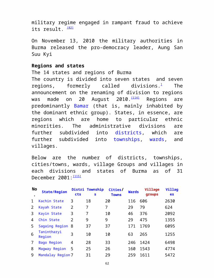
system is heavily utilized by the local populace, selling about 150,000 tickets daily.[ The popularity of the commuter line has jumped since the government reduced petrol subsidies in August 2007.
Buses and carsThe vast majority of Yangonites cannot afford a car and rely on an extensive network of buses to get around. Over 300 public and private bus lines operate about 6,300 crowded buses around the city, carrying over 4.4 million passengers a day. All buses and 80% of the taxis in Yangon run on compressed natural gas (CNG), following the 2005 government decree to save money on imported petroleum.]Highway buses to other cities depart from Dagon Ayeyar Highway Bus Terminal and Aung Mingala Highway Bus Terminal.
Motor transportation in Yangon is highly expensive for most of its citizens. As the government allows only a few thousand cars to be imported each year in a country with over 50 million people, [33] car prices in Yangon (and in Myanmar) are among the highest in the world. In July 2008, the two most popular cars in Yangon, 1986/87 Nissan Sunny Super Saloon and 1988 Toyota Corolla SE Limited, cost the equivalent of about US$20,000 and US$29,000 respectively.[34] A sports utility vehicle, imported for the equivalent of around US$50,000, goes for US$250,000. Illegally imported unregistered cars are cheaper – typically about half the price of registered cars. Nonetheless, car usage in Yangon is on the rise, a sign of rising incomes for some, and already causes much traffic congestion in highway-less Yangon's streets. As of March 2008, Yangon had over 173,000 registered motor vehicles in addition to an unknown number of unregistered
Since 1970, cars are driven on the right side of the road in Burma. However, as the government has not required left hand drive (LHD) cars to accompany the right side road rules, many cars on the road are still right hand drive (RHD) made for driving on the left side. Japanese used cars, which make up most of the country's imports, still arrive with RHD and are never converted to LHD. As a result, Burmese drivers have to rely on their passengers when passing other cars.Within Yangon, it is illegal to drive trishaws, bicycles, and motorcycles.
62

RiverYangon's four main passenger jetties, all located on or near downtown waterfront, mainly serve local ferries across the river to Dala and Thanlyin, and regional ferries to the Irrawaddy delta.[36] The 22-mile (35 km) Twante Canal was the quickest route from Yangon to the Irrawaddy delta until the 1990s when roads between Yangon and the Irrawaddy Division became usable year round. While passenger ferries to the delta are still used, those to Upper Burma via the Irrawaddy river are now limited mostly to tourist river cruises.
DemographicsHistorical populations
Year Pop. %±1824 10 —1856 46 360.0%1872 100 117.4%1881 165 65.0%1891 181 9.7%1901 248 37.0%1911 295 19.0%1921 340 15.3%
1931 400 17.6%1941 500 25.0%1950 1,302 160.4%1960 1,592 22.3%1970 1,946 22.2%1980 2,378 22.2%1990 2,907 22.2%2000 3,553 22.2%2010 4,348 22.4%2020 5,361 23.3%
Yangon is the most populous city by far in Myanmar although estimates of the size of its population vary widely. (All population figures are estimates since no official census has been conducted in Myanmar since 1983.) A UN estimate puts the population as 4.35 million in 2010 but a 2009 U.S. State Department estimate puts it at 5.5 million. The U.S. State Department's estimate is probably closer to the real number since the UN number is a straight-line projection, and does not appear to take the expansion of city limits in the past two decades into account. The city's population grew sharply after 1948 as many people (mainly, the indigenous Burmese) from other parts of the country moved into the newly built satellite towns of North Okkalapa, South Okkalapa, and Thaketa in the 1950s and East Dagon, North Dagon and South Dagon in the 1990s. Immigrants have founded their regional associations (such as Mandalay Association, Mawlamyaing Association, etc.) in Yangon for networking purposes. The government's decision to move the nation's administrative capital to Naypyidaw has drained an unknown number of civil servants away from Yangon.
63
Yangon is the most ethnically diverse city in the country. While Indians formed the slight majority prior to World War II,[8] today, the majority of the population is of Bamar (Burman) descent. Large communities of Indians/South Asians and the Chinese still exist especially in the traditional downtown neighborhoods. Intermarriage between ethnic groups—especially between the Bamar and the Chinese, and the Bamar and other indigenous Burmese—is common. A large number of Karen live in the city.
Burmese is the principal language of the city. English is by far the preferred second language of the educated class. In recent years, however, the prospect of overseas job opportunities has enticed some to study other languages: Mandarin Chinese is most popular, followed by Japanese, French, and Korean.[38]
Culture
Yangon is the country's hub for the movie, music, advertising, newspaper and book publishing industries. All media is heavily regulated by the military government. Television broadcasting is off limits to the private sector. All media content must first be approved by the government's media censor board, Press Scrutiny and Registration Division. Most television channels in the country are broadcast from Yangon. TV Myanmar and Myawaddy TV are the two main channels, providing Burmese language programming in news and entertainment. Other special interest channels are MWD-1 and MWD-2, MRTV-3, the English language channel that targets overseas audiences via satellite and via Internet, MRTV-4 with a focus on non-formal education programs and movies, and Movie 5, a pay-TV channel specializing in broadcasting foreign movies.]
Yangon has three radio stations. Myanmar Radio National Service is the national radio service and broadcasts mostly in Burmese (and in English during specific times.) Pop culture oriented Yangon City FM and Mandalay City FM radio stations specialize in Burmese and English pop music, entertainment programs, live celebrity interviews, etc. New radio channels such as Shwe FM and Pyinsawaddy FM can also be tuned with the city area.
Nearly all print media and industries are based out of Yangon. All three national newspapers — two Burmese language dailies Myanma Alin and Kyemon, and the English language The New Light of
64
Myanmar — are published by the government. Semi-governmental The Myanmar Times weekly, published in Burmese and in English, is mainly geared for Yangon's expatriate community. Over twenty special interest journals and magazines covering sports, fashion, finance, crime, literature (but never politics) vie for the readership of the general populace.
Access to foreign media is extremely difficult. Satellite television in Yangon (and in Myanmar) is highly expensive as the government imposes an annual registration fee of one million kyats. [39] Certain foreign newspapers and periodicals such as the International Herald Tribune and the Straits Times can be found only in a few (mostly downtown) bookstores. Internet access in Yangon, which has the best telecommunication infrastructure in the country, is slow and erratic at best, and the Burmese government implements one of the world's most restrictive regimes of Internet control. [41] International text messaging and voice messaging was permitted only in August 2008. CommunicationCommon facilities taken for granted elsewhere are luxury prized items in Yangon (and Myanmar). The price of a GSM mobile phone was about K1.1 million in August 2008. In 2007, the country of 55 million had only 775,000 phone lines (including 275,000 mobile phones), and 400,000 computers. Even in Yangon, which has the best infrastructure, the estimated telephone penetration rate was only 6% at the end of 2004, and the official waiting time for a telephone line was 3.6 years. Most people cannot afford a computer and have to use the city’s numerous Internet cafes to access a heavily restricted Internet, and a heavily censored local intranet. ] According to official statistics, in July 2010, the country had over 400,000 Internet users, with the vast majority hailing from just two cities, Yangon and Mandalay. Although Internet access was available in 42 cities across the country, the number of users outside the two main cities was just over 10,000. Lifestyle
The Karaweik at night time, at Kandawgyi Lake, which is one of a few major recreational parks in Yangon.
65
Yangon’s property market is the most expensive in the country and beyond the reach of most Yangonites. Most rent outside downtown and few can afford to rent downtown area apartments. (In 2008, rents for a typical 650-to-750 square foot apartments in downtown and vicinity range between K70,000 and K150,000 and those for high end condos between K200,000 and K500,000.)[ Most men of all ages (and some women) spend their time at ubiquitous tea-shops, found in any corner or street of the city. Watching European football (mostly English Premier League with occasional La Liga, Serie A, Bundesliga) matches while sipping tea is a popular pastime among many Yangonites, rich and poor alike. The average person stays close to his or her neighbourhood haunts. The well-to-do tend to visit shopping malls and parks on weekends. Some leave the city on weekends for Chaungtha and Ngwesaung beach resorts in Ayeyarwady Division.
Yangon is also home to many paya pwes (pagoda festivals), held during dry-season months (November – March). The most famous of all, the Shwedagon Pagoda Festival in March, attracts thousands of pilgrims from around the country. Yangon's museums are the domain of tourists and rarely visited by the locals. Most of Yangon's larger hotels offer some kind of nightlife entertainment, geared towards tourists and the well-to-do Burmese. Some hotels offer traditional Burmese performing arts shows complete with a traditional Burmese orchestra. The pub scene in larger hotels is more or less the same as elsewhere in Asia. Other options include karaoke bars and pub restaurants in Yangon Chinatown.
Due to the problems of high inflation, the lack of high denomination notes, and the fact that many of the population do not have access to checks, or credit or debit cards, it is common to see citizens carrying a considerable amount of cash.[48] (The highest denomination of Burmese currency kyat is 5000 (~US$5.)) Credit cards are only rarely used in the city, chiefly in the more lavish hotels.
SportsAs the city has the best sporting facilities in the country, most national-level annual sporting tournaments such as track and field, football, volleyball, tennis and swimming are held in Yangon. The 40,000-seat Aung San Stadium and the 32,000-seat Thuwunna Stadium are the main venues for the highly popular annual State and Division football tournament. Until April 2009, the now defunct
66

Myanmar Premier League, consisted of 16 Yangon-based clubs,[49]
played all its matches in Yangon stadiums, and attracted little interest from the general public or commercial success despite the enormous popularity of football in Myanmar. Most Yangonites prefer watching European football on satellite TV. It remains to be seen whether the Myanmar National League, the country's first professional football league, and its Yangon-based club Yangon United FC will attract a sufficient following in the country's most important media market.Yangon is also home to annual the Myanmar Open golf tournament, and the Myanmar Open tennis tournament. The city hosted the 1961 and 1969 South East Asian Games.
Economy
Yangon is the country’s main centre for trade, industry, real estate, media, entertainment and tourism. According to official government statistics, the city’s nominal GDP was K2.38 trillion (~US$2 billion) in 2007.
The city is Lower Myanmar’s main trading hub for all kinds of merchandise – from basic food stuffs to used cars although commerce continues to be hampered by the city's severely underdeveloped banking industry and communication infrastructure. Bayinnaung Market is the largest wholesale centre in the country for rice, beans and pulses, and other agricultural commodities.[51] Much of the country’s legal imports and exports go through Thilawa Port, the largest and busiest port in Myanmar.
Manufacturing accounts for a sizable share of employment. At least 14 light industrial zones ring Yangon,[ directly employing over 150,000 workers in 4,300 factories in early 2010.[ The city is the centre of country's garment industry which exported US$292 million in 2008/9 fiscal year. More than 80 percent of factory workers in Yangon work on a day-to-day basis. Most are young women between 15 and 27 years of age who come from the countryside in search of a better life. The manufacturing sector suffers from both structural problems (e.g. chronic power shortages) and political problems (e.g. economic sanctions). In 2008, Yangon's 2500 factories alone needed about 120 MW of power;[] yet, the entire city received only about 250 MW of the 530 MW needed.[ Chronic power shortages limit the factories' operating hours between 8 am and 6 pm.
67
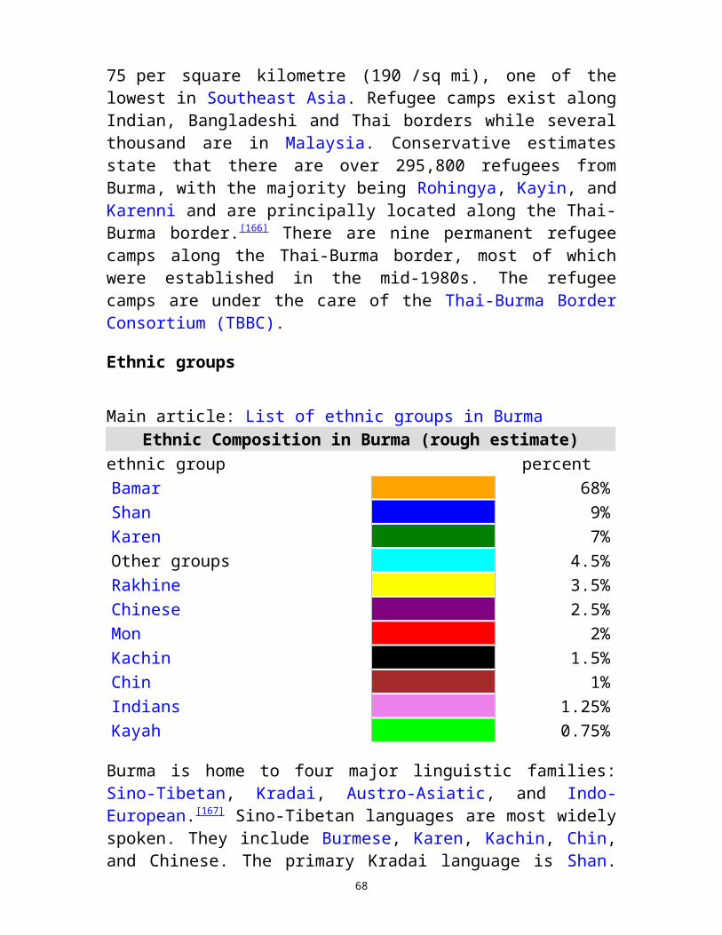
Construction is a major source of employment. The construction industry has been negatively affected by the move of state apparatus and civil servants to Naypyidaw, new regulations introduced in August 2009 requiring builders to provide at least 12 parking spaces in every new high-rise building, and the general poor business climate. As of January 2010, the number of new high-rise building starts approved in 2009-2010 was only 334, compared to 582 in 2008-2009. Tourism represents a major source of foreign currency for the city although by Southeast Asian standards the actual number of foreign visitors to Yangon has always been quite low (about 250,000 before the Saffron Revolution in September 2007). Cyclone Nargis dampened tourism even farther. The 2008 tourist arrivals at Yangon International are down to less than 50% from the previous year. Yangon's international standard hotels, built with foreign investment in the 1990s, still await the influx of tourists for which they were built.
EducationYangon has the best educational facilities and the highest number of qualified teachers in Myanmar where state spending on education is among the lowest in the world. A 2007 estimate by the London-based International Institute for Strategic Studies puts the spending for education at 0.5 percent of the national budget. The disparity in educational opportunities and achievement between rich and poor schools is quite stark even within the city. With little or no state support forthcoming, schools have to rely on forced "donations" and various fees from parents for nearly everything – school maintenance to teachers' salaries, forcing many poor students to drop out.While many students in poor districts fail to reach high school, a handful of Yangon high schools in wealthier districts like Dagon 1, Sanchaung 2, Bahan 2, Latha 2, and TTC provide the majority of students admitted to the most selective universities in the country, highlighting the extreme shallowness of talent pool in the country. The wealthy bypass the state education system altogether, sending their children to private English language instruction schools such as YIEC, or abroad (typically Singapore or Australia) for university education. In 2008, international schools in Yangon cost at least US$8,000 a year. Yangon is home to over 20 universities and colleges. While Yangon University remains the best known (its main campus is a part of popular Burmese culture e.g. literature, music, film, etc.), the nation's oldest university is now mostly a graduate school, deprived of
68

undergraduate studies. Following the 1988 nationwide uprising, the military government has repeatedly shut down universities, and has dispersed most of undergraduate student population to new universities in the suburbs such as Dagon University, the University of East Yangon and the University of West Yangon. Nonetheless many of the country's most selective universities are still in Yangon. Students from around the country still have to come to study in Yangon as some subjects are offered only at its universities. The University of Medicine 1, University of Medicine 2, Yangon Technological University, University of Computer Studies and Myanmar Maritime University are the most selective in the country.
Health careThe general state of health care in Yangon is poor. According to a 2007 estimate, the military government spends 0.4% of the national budget on health care, and 40% to 60% on defense. By the government's own figures, it spends 849 kyats (US$0.85) per person. ]
Although health care is nominally free, in reality, patients have to pay for medicine and treatment, even in public clinics and hospitals. Public hospitals including the flagship Yangon General Hospital lack many of the basic facilities and equipment.Wealthier Yangonites still have access to country's best medical facilities and internationally qualified doctors. Only do Yangon and Mandalay have any sizable number of doctors left as many Burmese doctors have emigrated. The well-to-do go to private clinics or hospitals like Pun Hlaing International Hospital and Bahosi Medical Clinic. A ten-day stay at a private hospital reportedly costs about K2.5 million (US$2300).[68] Still, medical malpractice is widespread even in private clinics and hospitals that serve the well-to-do. In 2009 and 2010, a spate of high profile deaths [67] brought out the severity of the problem, even for the relatively well off Yangonites. The wealthy do not rely on domestic hospitals and travel abroad (usually Bangkok or Singapore) for treatment.
69

Notable sites
Southern Gate of Shwe Dagon Pagoda
PagodasShwedagon Pagoda Sule Pagoda Botataung Pagoda Chauk Htat Gyi Pagoda Kyaukdawgyi Pagoda Kaba Aye Pagoda
RecreationAllied War Memorial Bogyoke Market (Scott's Market) Inya Lake (formerly Lake Victoria) Kandawgyi Lake (formerly Royal Lake) Hlawga National Park Maha Bandula Park People’s Square and People's Park St. Mary's Cathedral Yangon University Yangon Zoological Gardens (Zoo)
Museums and art galleriesNational Museum of Myanmar Defence Services Museum of Yangon Myanmar Gems Museum Bogyoke Aung San Museum Yangon Drugs Elimination Museum The Planetarium
Concert halls and theatresYangon National Theatre Myanmar Convention Centre
Interior View of Tooth Relic Pagoda
St. Mary's Cathedral at the corner of Bo Aung Kyaw Road
Yangon (Rangun) Rangoon
Yangon, the capital, was known as "Dagon" in former times. Yangon means "end of fight". The city is dominated by more than 2000 years old Shwedagon Pagoda, a world famous architectural wonder. The golden stupa of Shwedagon Pagoda raises 109 meters into blue tropical skies. The inner city is one of the most exotic districts in Asia: Neo-classical buildings and tree-lined streets bear testimony to a past when Burma was a colony in the British Empire. Despite being the business and financial hub of Myanmar, the city of Yangon retains a
70
fair degree of serenity - certainly a consequence of lush parks surrounding Kandawgyi Lake and Inya Lake. The National Museum and some other pagodas are worth to be visited and not too few tourists might also enjoy the quality of food in many of the city restaurants. Since there is only little nightlife yet this is the best opportunity to spend some hours out in the evening
http://asiatours.net/burma/info/yangon.html
Train in Myanmar
Myanmar has a wide network of railway reaches to all parts of the country but the schedules are not reliable and coaches and railways are very old and not well maintained, so they are not suitable for
tourists.The only route which tourists can consider is Yangon – Mandalay route.
It takes at least 16 hrs. To reach Mandalay . as the rail tracks are so old and is not maintained up to date, the clients may feel uncomfortable by shaking and bumping. Although there are first class compartments
with reclining seats, its not possible to sleep due to the bumping and the very annoying insects. The same goes for the sleepers compartments.
Steam Driven Locomotives
We are still using some very old steam driven locomotive in some part of the country. The photo shows the one running between Bago & Nyaungkhashe (about 2 hours one way). Clients
can drive to Bago (one & a half hrs one way) to take the train.
http://www.travelmyanmar.com/mapofmyanmar.html
71