multi-scale traffic safety and operational performance study of large trucks on mountainous...
TRANSCRIPT

Mm
SD
a
ARRA
KMLSMM
1
ii1gtdtAiaAr2roawA
0d
Accident Analysis and Prevention 43 (2011) 429–438
Contents lists available at ScienceDirect
Accident Analysis and Prevention
journa l homepage: www.e lsev ier .com/ locate /aap
ulti-scale traffic safety and operational performance study of large trucks onountainous interstate highway
uren Chen ∗, Feng Chen, Jun Wuept. of Civil & Environmental Eng., Colorado State University, Fort Collins, CO 80523, United States
r t i c l e i n f o
rticle history:eceived 26 January 2010eceived in revised form 8 September 2010ccepted 27 September 2010
eywords:ountainous highway
a b s t r a c t
In addition to multi-vehicle accidents, large trucks are also prone to single-vehicle accidents on themountainous interstate highways due to the complex terrain and fast-changing weather. By integratingboth historical data analysis and simulations, a multi-scale approach is developed to evaluate the trafficsafety and operational performance of large trucks on mountainous interstate highways in both scales ofindividual vehicle as well as traffic on the whole highway. A typical mountainous highway in Coloradois studied for demonstration purposes. Firstly, the ten-year historical accident records are analyzed to
arge trucksingle-vehicle accidentulti-vehicle accidentulti-scale
identify the accident-vulnerable-locations (AVLs) and site-specific critical adverse driving conditions.Secondly, simulation-based single-vehicle assessment is performed for different driving conditions atthose AVLs along the whole corridor. Finally, the cellular-automaton (CA)-based simulation is carriedout to evaluate the multi-vehicle traffic safety as well as the operational performance of the traffic byconsidering the actual speed limits, including the differential speed limits (DSL) at some locations. Itis found that the multi-scale approach can provide insightful and comprehensive observations of thehighway performance, which is especially important for mountainous highways.
. Introduction
Extensive works have been conducted on the traffic safety andnjury prevention related to multi-vehicle accidents of large trucksn past decades (e.g. Braver et al., 1997; Chang and Mannering,999; Lyman and Braver, 2003). Different from most passen-er vehicles which are dominantly vulnerable to multi-vehicleraffic conflicts, large trucks are also prone to single-vehicle acci-ents on the mountainous interstate highways due to the complexerrain and fast-changing weather (USDOT, 2005; Baker, 1991).lthough the absolute number of single-vehicle accidents is typ-
cally smaller than that of multi-vehicle accidents, single-vehicleccidents have caused serious injury and casualty (The Nationalcademies, 2006). For example, single-vehicle accidents wereesponsible for 57.8% of the total fatalities of traffic accidents in005 (USDOT, 2005). This is especially true when complex ter-ain couples with inclement weather conditions, such as snow, icer strong wind. Each year in the United States, adverse weather
lone is associated with more than 1.5 million vehicular accidents,hich result in 800,000 injuries and 7000 fatalities (The Nationalcademies, 2006).∗ Corresponding author. Tel.: +1 970 491 7722; fax: +1 970 491 7727.E-mail address: [email protected] (S. Chen).
001-4575/$ – see front matter © 2010 Elsevier Ltd. All rights reserved.oi:10.1016/j.aap.2010.09.013
© 2010 Elsevier Ltd. All rights reserved.
The primary causes of accidents involving large trucks on ruralhighways were found to be excessive speed and adverse drivingconditions (The Road Information Program, 2005). Different frompassenger vehicles, it is known that the safety performance of largetrucks in adverse driving conditions greatly depends on the specificterrain and local weather condition (USDOT, 2005; Baker, 1991). Toaccommodate the considerable difference on safety performanceof large trucks and common passenger vehicles, differential speedlimits (DSL) have been applied in many highways for large trucksat locations where the driving conditions are not ideal. There are,however, mixed opinions on the benefits of DSL to the traffic safetyand operational performance, which highly depend on the specificgeometric, traffic and environmental conditions (FHWA, 2004). Asa matter of fact, there is not yet compelling evidence to supportmore widespread applications of DSL instead of universal speedlimits (USL), and neither is strong evidence that DSL should be elim-inated (Garber et al., 2006; Awadallah, 2007; Harkey et al., 1990).On one hand, the lower speed limits for large trucks may reducethe risk of single-vehicle accidents. On the other hand, the differen-tial driving speeds for trucks and other vehicles, if not reasonable,may also cause additional risks of traffic conflicts between large
trucks and other vehicles and/or traffic congestions. Therefore, it isnecessary to comprehensively evaluate the safety and operationalperformance of large trucks on a mountainous highway by lookinginto not only the safety of individual trucks, but also the impacts tothe whole traffic on the highway.
4 s and
umwdohvsmasapb1owl
2
2SdolZ1dvmnSsmbi
2a
wvvb
csctsa
m
−
I
30 S. Chen et al. / Accident Analysi
In the present study, an attempt is made to integrally eval-ate the safety and operational performance of large trucks onountainous highways at both scales of individual vehicle andhole traffic flow. The I-70 corridor in Colorado is chosen toemonstrate the methodology because of its typical mountain-us terrain and adverse weather conditions. Firstly, ten-yearistorical accident records will be analyzed to identify the accident-ulnerable-locations (AVLs) and critical adverse driving conditionspecific to I-70. Secondly, simulation-based single-vehicle assess-ent will be performed for different inclement weather conditions
t these AVLs along the whole corridor. The advisory critical vehiclepeeds (CVS) will be compared to the corresponding speed limitslong the highway to give some insights about single-vehicle safetyerformance of large trucks. Finally, the cellular-automaton (CA)-ased multi-vehicle accident simulation (Nagel and Schreckenberg,992; Moussa, 2005) will be carried out to evaluate the impactsn traffic safety and operational performance of the whole high-ay by considering the actual speed limits, including DSL at some
ocations.
. Simulation-based analytical models
Extensive works have been carried out on both multi- (USDOT,005) and single-vehicle accidents (Young and Liesman, 2007a,b;ummerfield and Kosior, 2001; Edwards, 1998) with a focus onata analyses of historical accidents. In addition to analyses basedn historical data, there were also studies using various simu-ation models on multi-vehicle traffic conflicts (Moussa, 2005;hang et al., 2006) as well as single-vehicle accidents (Baker,991; Chen and Cai, 2004; Guo and Xu, 2006). Compared toata-based accident analyses, simulation-based analyses of multi-ehicle or single-vehicle accidents have the advantage of exploringore comprehensive collections of possible scenarios, which may
ot be covered by the historical accident data (Baker, 1991;naebjornsson et al., 2007; Chen et al., 2009). In this section, theimulation-based evaluation models of single-vehicle safety andulti-vehicle safety as well as operational performance which will
e used in the present study are briefly introduced in the follow-ng.
.1. Simulation-based assessment model of single-vehicleccidents
The single-vehicle simulation model recently developed by theriters (Chen and Chen, 2010, 2009) will be used to evaluate the
ehicle safety at the selected vulnerable locations. In order to pro-ide essential background information, the simulation model isriefly introduced below (Chen and Chen, 2010).
For a typical vehicle, the sprung mass rotates about the rollenter which is dependent on the kinematical properties of theuspensions. The unsprung masses can rotate with the verticalompliance of the tires. Five force and moment equilibrium equa-ions of vehicle motions of sprung mass, unsprung masses anduspensions in y and z directions are defined in Eqs. (1)–(5) (Chennd Chen, 2010).
sh�̈ = mV( ˙̌ + ̇) − Fy,f − Fy,r + Fw,y −mg� +may (1)
Ix′z′ �̈ + Iz′z′ ̈ = Fy,f af + Fy,rar +Mz (2)
x′x′ �̈ − Ix′z′ ̈ = msgh� +msVh( ˙̌ + ̇) +Mx −msgh� +msgay+ Fw,yhw − kf (� − �t,f ) − lf (�̇ − �̇t,f ) + uf − kr(� − �t,r)
− lr(�̇ − �̇t,r) + ur (3)
Prevention 43 (2011) 429–438
rFy,f = −mu,f V(hu,f − r)( ˙̌ + ̇) +mu,f g(hu,f − r)�t,f
+mu,f g(hu,f − r)� − arollIx′x′mfm
−mu,f ay(hu,f − r) + kt,f �t,f
− kf (� − �t,f ) − lf (�̇ − �̇t,f ) + uf (4)
rFy,r = −mu,rV(hu,r − r)( ˙̌ + ̇) +mu,rg(hu,r − r)�t,r
+mu,rg(hu,r − r)� − arollIx′x′mrm
−mu,ray(hu,r − r)
+ kt,r�t,r − kr(� − �t,r) − lr(�̇ − �̇t,r) + ur (5)
where the subscripts r and f refer to the rear and front axles,respectively. Fw,y, Mx, Mz are lateral wind force, wind-induced rollmoment and yaw moment, respectively. � is road superelevation.ay and aroll are accelerations in the lateral (y) direction and therolling direction of the supporting infrastructures (e.g. pavement orbridge), respectively. m, ms, mu are the total mass, sprung mass andunsprung mass, respectively. h is the height of the center of sprungmass. r and hu are the heights of rolling center and unsprung masscenter. Fy,f and Fy,r are lateral forces of front and rear tires, respec-tively. Ix′x′ , Ix′z′ , Iz′z′ are the roll moment, yaw-roll product and yawmoment of inertia of sprung mass, respectively. k, kt, l are roll stiff-ness of suspension, roll stiffness of tire and roll damping rate ofsuspension, respectively. � and �t are absolute roll angle of sprungmass and unsprung mass, respectively. ˇ and are sideslip angleand heading angle, respectively. u is active roll torque.
The dynamic models as introduced in Eqs. (1)–(5) are used whenthe wheels are not lifted up or sideslip. The dynamic simulation ofthe whole process of an accident involves series of vehicle dynamicsimulation models for different stages of the accident, such asbefore/after wheels being lifted up, before/after wheels starting toslide (Chen and Chen, 2010). At any time step of the simulation,the corresponding criterion will be checked to decide whether thewheels have been lifted up or sideslip has occurred. When any ofthese scenarios is identified to occur, the corresponding new setof dynamic equations, which consider the specific dynamic natureand restraints, will be adopted to continue the simulation (Chen andChen, 2010). As a result, the transient process of the overturn andsideswipe accidents can be simulated in a more rational way andmore details can be found in Ref. Chen and Chen, 2010. For any givendriving condition as well as specific vehicle conditions, the occur-rence of single-vehicle accidents will be evaluated at each drivingspeed. The simulation process continues by gradually increasingdriving speeds until any single-vehicle accident occurs. As a result,the advisory critical vehicle speed (CVS) for a specific combinationof environmental and vehicular conditions is the highest allowabledriving speed under which no single-vehicle accident is likely tohappen (Chen and Chen, 2010).
2.2. Multi-vehicle accident risk assessment using cellularautomaton model
The Cellular Automaton (CA) model proposed by Nagel andSchreckenberg (1992) is an efficient tool to study the operationalperformance of traffic flow and traffic safety in a microscopic scale(Moussa, 2005; Zhang et al., 2006). The major strength of the CAmodel is the robustness for different intricate features of traffic flow(Nagel and Schreckenberg, 1992). As a probabilistic microscopic-
scale traffic flow simulation tool, the CA-model can provide detailedtime-variant information of individual vehicles.The basic features of the CA model are as follows (Nagel andSchreckenberg, 1992): (1) each lane is divided into cells with anequal length; (2) each cell is empty or occupied by one vehicle at

s and
ab(atbfi(pta
l(s(tatpctmc(
ctcedea
1
2
tdlmw
3
3
ohaspaaoa
S. Chen et al. / Accident Analysi
time; (3) the instantaneous speed of a vehicle can be decidedy the number of cells the vehicle can move in each time step;4) the maximum velocity a vehicle can reach is defined by thectual speed limit of that particular stretch of the highway. At eachime step, a vehicle moves, accelerates, decelerates or changes lanesased on specific rules established according to the actual traf-c rules and some reasonable assumptions of the driver behaviorNagel and Schreckenberg, 1992; Wu and Chen, 2009). For exam-le, a driver is typically believed to have the intention to achievehe maximum driving speed without violating traffic rules (Nagelnd Schreckenberg, 1992).
When the conditions presented below are satisfied, the multi-ane CA model is implemented (Rickert et al., 1996; Li et al., 2006):1) the distance between Vehicle i and the vehicle ahead on theame lane is smaller than v + 1, where v is the vehicle velocity;2) the distance between Vehicle i and the vehicle ahead on thearget lane is more than v + 1; (3) the distance between Vehicle ind the back vehicle on the target lane is more than vmax, which ishe maximum velocity a vehicle is allowed to achieve; (4) with therobability of pch, Vehicle i changes the lane if all the three aboveonditions are satisfied. If Vehicle i changes lane, its location andhe velocity will be updated through two sub-steps: (1) Vehicle i
oves to the target lane transversely without advancing; (2) Vehi-le i moving forward to the target lane obeys the single-lane ruleNagel and Schreckenberg, 1992).
In the multi-lane CA accident model, two types of accidents areonsidered. Type I is that caused by the rear-end collision betweenwo successive vehicles moving on the same lane; Type II is thataused by lane-changing of the successive vehicles. Two param-ters are introduced to define the accident-prone conditions: theelayed reaction time (�) of the following vehicle and the decel-ration limit (vd) of the ahead vehicle. The prerequisites of Type Iccident can be expressed as follows (Moussa, 2005):
) The vehicle ahead of Vehicle k decelerates abruptly:
vk+1(t + 1) − vk+1(t) ≥ vd (6)
) Vehicle k cannot brake during the delayed reaction time period(�) to avoid a crash:
�vk(t) − vk+1(t + 1)> gk (t) (7)
where gk(t) is the distance between Vehicle k and Vehicle k + 1at time step t.
For Type II accidents, it is assumed that all the drivers obey theraffic rules when they change lanes, for example, keeping the safeistance. When two successive vehicles change to the same target
ane simultaneously, the crash may occur as the front vehicle auto-atically ignores the gap behind because it just focuses on the gapith the vehicles on the target lane (Moussa, 2005).
. Historical accident data analysis of I-70 in Colorado
.1. I-70 interstate corridor
The Interstate I-70 Mountain Corridor within the State of Col-rado, from Denver to Grand Junction is a typical mountainousighway in rural areas as it is a gateway to recreation, commercend everyday necessities for Colorado residents and visitors. Atome locations along the corridor, very steep grades which are cou-
led with extreme weather conditions have been blamed for manyccidents involving large trucks. Differential speed limits have beendopted at several locations where the terrains are complicatedn the I-70 mountain corridor. Ten-year (1996–2005) historicalccident data of I-70 in Colorado from Vail to Golden (Mile PostPrevention 43 (2011) 429–438 431
179.90–258.60) were studied. The percentage of trucks in traffic is5.7–13% on this corridor in Year 2005. Average daily traffic (ADT)on I-70 in Colorado is 32,962. During the ten-year period, therewere totally 1565 accidents reported, out of which 762 and 639accidents involved large trucks/bus as the first vehicle (Vehicle 1)and the second vehicle (Vehicle 2), respectively.
3.2. Data analysis and accident vulnerable locations (AVLs)
Based on the comprehensive analysis of the historical accidentdata on I-70 corridor between 1996 and 2005, some accident vul-nerable locations (AVLs) experiencing a considerable number ofpast accidents are summarized in Table 1. AVLs are selected basedon the number of accidents occurring on each segment (typically0.1 mile long), which is identified with the beginning and endingmileposts (MP) (e.g. MP 184.4–185.4). Due to the limit of the space,Table 1 only gives detailed information for several selected AVLs,including the mileposts (MP), the numbers of accidents associatedwith different vehicle types, accident types, geometric conditions,speed limits and adverse weather conditions. Most differentialspeed limits on I-70 are applied in the westbound direction, asshown in column 4 in Table 1. “No. of truck-initiated accidents(% of all accidents)” (column 5) is the number (and percentage) ofaccidents with large trucks (more than 10k lbs) as the first vehicle(Vehicle 1). Column 6 shows the number of accidents occurring atdifferent adverse road surface conditions (e.g. wet, icy or snowy).Column 7 gives the number of the accidents by accident type:single-vehicle accidents, including overturn and sideswipe acci-dents, and typical multi-vehicle accidents (rear-end accidents). Bycomparing the actual driving speeds reported in the accident recordwith the corresponding speed limits, the percentage of those truckswith the driving speeds at least 10 mph over the speed limits in thetruck-initiated accidents was given in Column 8.
Some general observations from the accident data analysis of I-70 AVLs include: (1) trucks were more vulnerable to accidents thanother vehicles (around 50–70% of all accidents were initiated bytrucks); (2) for multiple-vehicle accidents, rear-end collisions weredominant (over 80%); (3) adverse road surface conditions werefound to have significant impacts on traffic safety (associated withup to 70% accidents); and (4) dominant accident types at differ-ent locations were sideswipe or overturn accidents (single-vehicle),rear-end accidents (multi-vehicle) or both. Based on these obser-vations, the need and significance of the present study focusing ontrucks and adverse driving conditions are well justified.
3.3. Accident analysis under adverse driving conditions
Historical accidents are firstly studied for different adverse driv-ing conditions, such as windy, snowy, icy conditions of road surfaceand different terrains. Among all the adverse driving conditions,Figs. 1–3 give the statistics of historical accidents involving trucksunder several most significant adverse driving conditions on I-70,including strong wind, snow-covered, ice-covered road surface andon grades, respectively. Different sizes of the dots on the mapsrepresent different numbers of similar accidents happening at thesame locations during the past ten years, as defined in the legend.
It is found in Fig. 1 that there are about 30 accidents identifiedas wind-induced ones in the accident records during the ten-yearperiod. It is noted that the actual number may be higher sinceit is possible that some accidents were not identified as wind-induced ones on the accident report despite the fact that wind may
also contribute to the accidents along with other reported factors.According to Fig. 1, except for some scattered locations along I-70,most of the wind-induced accidents happened in the east portionof the corridor. Repetitive accidents happened at several locationsalong I-70, such as MP 229, 244, and 250–252.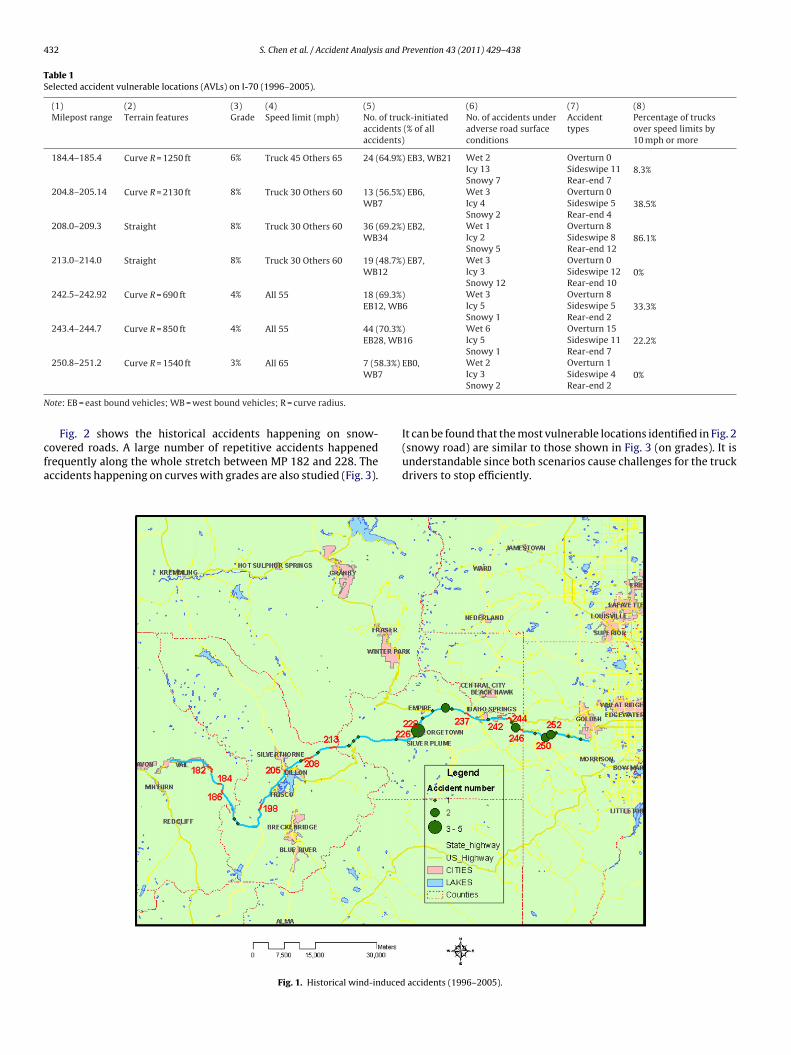
432 S. Chen et al. / Accident Analysis and Prevention 43 (2011) 429–438
Table 1Selected accident vulnerable locations (AVLs) on I-70 (1996–2005).
(1) (2) (3) (4) (5) (6) (7) (8)Milepost range Terrain features Grade Speed limit (mph) No. of truck-initiated
accidents (% of allaccidents)
No. of accidents underadverse road surfaceconditions
Accidenttypes
Percentage of trucksover speed limits by10 mph or more
184.4–185.4 Curve R = 1250 ft 6% Truck 45 Others 65 24 (64.9%) EB3, WB21 Wet 2 Overturn 08.3%Icy 13 Sideswipe 11
Snowy 7 Rear-end 7204.8–205.14 Curve R = 2130 ft 8% Truck 30 Others 60 13 (56.5%) EB6,
WB7Wet 3 Overturn 0
38.5%Icy 4 Sideswipe 5Snowy 2 Rear-end 4
208.0–209.3 Straight 8% Truck 30 Others 60 36 (69.2%) EB2,WB34
Wet 1 Overturn 886.1%Icy 2 Sideswipe 8
Snowy 5 Rear-end 12213.0–214.0 Straight 8% Truck 30 Others 60 19 (48.7%) EB7,
WB12Wet 3 Overturn 0
0%Icy 3 Sideswipe 12Snowy 12 Rear-end 10
242.5–242.92 Curve R = 690 ft 4% All 55 18 (69.3%)EB12, WB6
Wet 3 Overturn 833.3%Icy 5 Sideswipe 5
Snowy 1 Rear-end 2243.4–244.7 Curve R = 850 ft 4% All 55 44 (70.3%)
EB28, WB16Wet 6 Overturn 15
22.2%Icy 5 Sideswipe 11Snowy 1 Rear-end 7
250.8–251.2 Curve R = 1540 ft 3% All 65 7 (58.3%) EB0, Wet 2 Overturn 1
N
cfa
WB7
ote: EB = east bound vehicles; WB = west bound vehicles; R = curve radius.
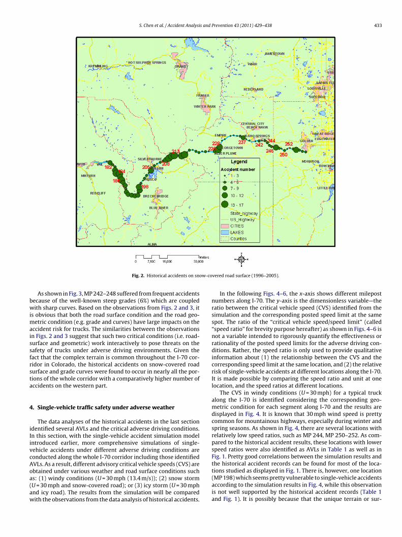
Fig. 2 shows the historical accidents happening on snow-overed roads. A large number of repetitive accidents happenedrequently along the whole stretch between MP 182 and 228. Theccidents happening on curves with grades are also studied (Fig. 3).
Fig. 1. Historical wind-induced
0%Icy 3 Sideswipe 4Snowy 2 Rear-end 2
It can be found that the most vulnerable locations identified in Fig. 2(snowy road) are similar to those shown in Fig. 3 (on grades). It isunderstandable since both scenarios cause challenges for the truckdrivers to stop efficiently.
accidents (1996–2005).
S. Chen et al. / Accident Analysis and Prevention 43 (2011) 429–438 433
w-co
bwimaissfrsta
4
iIivcAoa(aw
Fig. 2. Historical accidents on sno
As shown in Fig. 3, MP 242–248 suffered from frequent accidentsecause of the well-known steep grades (6%) which are coupledith sharp curves. Based on the observations from Figs. 2 and 3, it
s obvious that both the road surface condition and the road geo-etric condition (e.g. grade and curves) have large impacts on the
ccident risk for trucks. The similarities between the observationsn Figs. 2 and 3 suggest that such two critical conditions (i.e. road-urface and geometric) work interactively to pose threats on theafety of trucks under adverse driving environments. Given theact that the complex terrain is common throughout the I-70 cor-idor in Colorado, the historical accidents on snow-covered roadurface and grade curves were found to occur in nearly all the por-ions of the whole corridor with a comparatively higher number ofccidents on the western part.
. Single-vehicle traffic safety under adverse weather
The data analyses of the historical accidents in the last sectiondentified several AVLs and the critical adverse driving conditions.n this section, with the single-vehicle accident simulation modelntroduced earlier, more comprehensive simulations of single-ehicle accidents under different adverse driving conditions areonducted along the whole I-70 corridor including those identifiedVLs. As a result, different advisory critical vehicle speeds (CVS) are
btained under various weather and road surface conditions suchs: (1) windy conditions (U = 30 mph (13.4 m/s)); (2) snow stormU = 30 mph and snow-covered road); or (3) icy storm (U = 30 mphnd icy road). The results from the simulation will be comparedith the observations from the data analysis of historical accidents.vered road surface (1996–2005).
In the following Figs. 4–6, the x-axis shows different milepostnumbers along I-70. The y-axis is the dimensionless variable—theratio between the critical vehicle speed (CVS) identified from thesimulation and the corresponding posted speed limit at the samespot. The ratio of the “critical vehicle speed/speed limit” (called“speed ratio” for brevity purpose hereafter) as shown in Figs. 4–6 isnot a variable intended to rigorously quantify the effectiveness orrationality of the posted speed limits for the adverse driving con-ditions. Rather, the speed ratio is only used to provide qualitativeinformation about (1) the relationship between the CVS and thecorresponding speed limit at the same location, and (2) the relativerisk of single-vehicle accidents at different locations along the I-70.It is made possible by comparing the speed ratio and unit at onelocation, and the speed ratios at different locations.
The CVS in windy conditions (U = 30 mph) for a typical truckalong the I-70 is identified considering the corresponding geo-metric condition for each segment along I-70 and the results aredisplayed in Fig. 4. It is known that 30 mph wind speed is prettycommon for mountainous highways, especially during winter andspring seasons. As shown in Fig. 4, there are several locations withrelatively low speed ratios, such as MP 244, MP 250–252. As com-pared to the historical accident results, these locations with lowerspeed ratios were also identified as AVLs in Table 1 as well as inFig. 1. Pretty good correlations between the simulation results andthe historical accident records can be found for most of the loca-
tions studied as displayed in Fig. 1. There is, however, one location(MP 198) which seems pretty vulnerable to single-vehicle accidentsaccording to the simulation results in Fig. 4, while this observationis not well supported by the historical accident records (Table 1and Fig. 1). It is possibly because that the unique terrain or sur-
434 S. Chen et al. / Accident Analysis and Prevention 43 (2011) 429–438
s on g
rtot2t2ss
F(
Fig. 3. Historical accident
ounding near MP 198 may improve the actual wind condition fromhe theoretical one. This observation underscores the importancef collecting site-specific wind and other environmental data forhose locations with complex terrain or surroundings (Chen et al.,
010). One possible option is to use the mobile mapping technologyo collect the site-specific wind and environmental data (Chen et al.,010). A detailed investigation of this particular location involvesignificant data collection, which is beyond the scope of the presenttudy.ig. 4. Critical vehicle speed ratio of different mileposts in windy conditionsU = 30 mph).
rade curves (1996–2005).
Fig. 5 gives the CVS results on I-70 under snow storms (i.e.the road surface is covered by snow and the wind speed equalsto 30 mph). It can be found that there are several locations withthe speed ratios considerably lower than 1, such as MP 182–184,MP 250–252. Such a phenomenon observed from the simulation
results is generally consistent with the historical accident recordsas shown in Table 1 and Fig. 2, except for MP 205–213. In Fig. 5, thespeed ratios are all above 1 between MP 205–213, which seem tocontradict with the fact as shown in Fig. 2 that there were manyFig. 5. Critical vehicle speed ratio of different mileposts in snowstorm (U = 30 mphand snow).

S. Chen et al. / Accident Analysis and Prevention 43 (2011) 429–438 435
F(
aklltaalitd2asts
rrclifipttiwctfow
tFppaballea
Table 2Parameters of CA traffic model.
Parameters Value Description
Lc 7.5 m Length of each celldt 1 s The period of every time steppb 0.5 The probability of brakingpch 0.8 The probability of changing lane� 1 s The delayed reaction time
ig. 6. Critical vehicle speed ratio of different mileposts in cold winter seasonU = 30 mph and icy road).
ccidents happening during snowy conditions in that region. It isnown that MP 208–213 involves very steep grades with the speedimits of 30 mph for trucks and 60 mph for other vehicles. A closerook of Table 1 discloses that for MP 204–209, 38.5–86.1% of thoserucks which were involved in the accidents were actually drivent speeds at least 10 mph (16.1 km/h) higher than the speed limitsccording to the accident records. With the assumption that mostarge trucks were driven in speeds close to the posted speed lim-ts, the speed ratios used in the present study were usually foundo provide pretty accurate information about single-vehicle acci-ent risks for most of locations (Fig. 5). However, the results of MP04–213 in Fig. 5 also suggest the need of using the actual oper-tional speeds of trucks instead of the posted speed limits in thetudy for those special regions where the actual driving speeds ofhe large trucks are considerably different from those of the postedpeed limits.
The results of trucks under ice storm during winter seasons wereeported in Fig. 6. The wind speed is assumed to be 30 mph and theoad surface is covered with ice. For most locations of the wholeorridor, the speed ratios are around 0.3–0.4 which suggests veryarge difference between the advisory CVS and the speed limits. Its thus found that during a severe snow storm, the closure of traf-c to large trucks is probably the best solution. Most speed limits,rimarily decided based on normal driving conditions, provide lit-le information to the drivers about the appropriate driving speedshat the large trucks should maintain at a specific adverse driv-ng condition. Therefore, adaptive (variable) speed limits for trucks
hich can automatically adjust with different extreme weatheronditions at those critical locations will be helpful on improvingruck safety on mountainous highways. The information gatheredrom the present study and the simulation methodology may helpn developing the algorithm for the adaptive (variable) speed limitith ITS technology in the future.
In Figs. 4–6, the results for both fully loaded and partially loadedrucks (50% loaded) were plotted together. Although the results inigs. 4–6 show relatively larger risk (lower speed ratio values) forartially loaded trucks as compared to fully loaded vehicles, it isremature to make a general conclusion about which one betweenpartially loaded truck and a fully loaded truck is more vulnera-le. Compared to a partially loaded truck, a fully loaded truck has
higher center of gravity (C.G.) and also larger weight. A partiallyoaded truck is lighter, but usually also has a lower C.G. than a fullyoaded truck. It is effortless to find out from the simulation model orven common sense that vehicles with larger weights or lower C.G.re less prone to overturn accidents. For a particular truck, there-
vd 2 cell Deceleration limitCh 20% The percentage of heavy vehicle among all the
types of vehicles
fore, it is not straightforward to tell which situation (i.e. fully loadedor partially loaded) is more vulnerable to single-vehicle accidentswithout a specific and detailed analysis. The single-vehicle simula-tion model (Chen and Chen, 2010) can be used to conduct a detailedanalysis on a case-by-case basis.
5. Traffic safety and operational performance of wholetraffic with DSL
Like many mountainous highways around the country, differ-ential speed limits (DSL) are currently applied at several locationson the I-70 corridor. The lower speed limits for large trucks are pri-marily for avoiding serious overturn, sideswipe or losing controlsat some sharp turns and steep grades. As a tradeoff, it is also knownthat larger velocity difference may possibly introduce higher risksof multi-vehicle conflicts or congestion. In this section, the multi-vehicle safety and operational performance for the whole highwayare studied for those sections where DSL is applied. The CA-basedtraffic safety model which was briefly introduced in Section 2.2 willbe adopted to evaluate the accident probability of multi-vehicleaccidents as well as the traffic operational performance on thewhole I-70 corridor in Colorado.
The road is divided into cells each of which has a length of 7.5 m(24.6 ft). 7.5 m is defined as the typical distance between the masscenters of two consecutive vehicles when the road is in completecongestion (Nagel and Schreckenberg, 1992). The speed limits usedin the simulation at different sections remain same as the corre-sponding actual speed limits along I-70. For example, when thespeed limit is 65 mph (104 km/h), the vmax in the CA model can becomputed as follows:
104 km/h3600 s/h
× 1000 m/km7.5 m/cell
= 3.85 cell/s ≈ 4 cell/s (8)
The initial velocities of all vehicles are set to be zero. The obser-vation of the traffic flow starts after 1 h of the simulation beingmade when the traffic flow is believed to become steady (Wu andChen, 2009). With the assumption that the traffic occupancy doesnot fluctuate significantly during a short period of time (i.e. 5 min),the occupancy (unit: vehicle/cell) or the vehicle density (unit: vehi-cle/mile/lane) in this system keeps constant. All the parametersused in the CA traffic model are summarized in Table 2.
On I-70, there are several places that differential speed limits(DSL) are applied to trucks and other vehicles. In order to com-pare the DSL and the uniform speed limit (USL) setups, the safetyand operational performance studies are conducted for both DSL(actual) and USL (assumed) situations. To get the overall perfor-mance of safety and operation throughout the whole corridor inColorado, the CA model in a coarse scale of 1:20 is applied to eval-uate the overall performance of the whole corridor. Fig. 7(a) and
(b) shows the overall accident probability of Type I (rear-end) andII (change-lane) with different traffic densities, respectively. “DSL”means the results using actual differential speed limits at some sec-tions along the corridor. “USL” denotes the “what if” scenario usingthe same uniform speed limits for both trucks and other vehicles
436 S. Chen et al. / Accident Analysis and
0.0E+00
5.0E-04
1.0E-03
1.5E-03
2.0E-03
2.5E-03
806040200
Vehicle/mile/lane
Pro
bab
ilit
y o
f accid
en
ts
DSL
USL
(a) Accident type I
0.0E+00
2.0E-06
4.0E-06
6.0E-06
8.0E-06
1.0E-05
1.2E-05
1.4E-05
806040200
Vehicle/mile/lane
Pro
bab
ilit
y o
f accid
en
ts
DSL
USL
fiwUn(pv
wisamtrit
osdvboadFa
Foaf
above the posted speed limits. Therefore, some further studies ofspeed limits at this portion of I-70 may be needed to optimize trafficsafety and operational performance. One possible optimization isto narrow the gap of the current differential speed limits for trucksand other vehicles at that particular location.
0
20
40
60
80
100
806040200
Vehicle/mile/lane
Mean
velo
cit
y (
mp
h)
DSL
USL
(a) Mean velocity
0.0
0.5
1.0
1.5
2.0
806040200
CO
V o
f velo
cit
y
DSL
USL
(b) Accident type II
Fig. 7. Accident probability of the whole corridor.
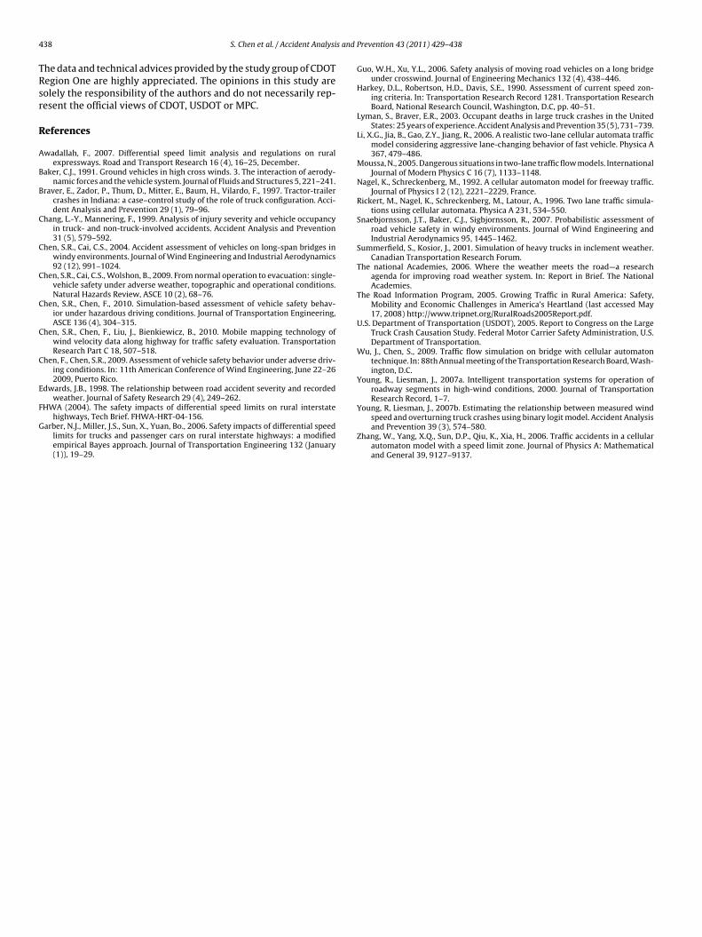
or the comparison purpose. As shown in Fig. 7(a), the probabil-ty of Type I accidents varies with traffic density in a nonlinear
ay. When the vehicle density is less than 32 veh/mile/lane, theSL scenario causes lower accident probability than the DSL sce-ario does. However, when vehicles are more densely distributed>32 veh/mile/lane), the DSL scenario can lead to smaller accidentrobability. For both cases, the peak accident rate occurs when theehicle density is about 51 veh/mile/lane.
As shown in Fig. 7(b), the accident probability of Type II variesith the traffic density randomly. As compared to that of Type I, it
s found that the accident probability of Type II is about 100 timesmaller. This is consistent with the observation from the historicalccident data analysis that rear-end accidents usually dominate theulti-vehicle accidents. Because of the relative insignificance of
he accident probability for Type II as compared to Type I, only theear-end accident probability (i.e. Type I accidents) will be studiedn the following sections, which is approximated to represent theotal probability of multi-vehicle accidents.
In addition to investigating the accident probability, the trafficperational performance along I-70 is also evaluated for differentcenarios. It is found from Fig. 8(a) that the mean velocity generallyecreases with the increase of the vehicle density and the meanelocity of the DSL case is lower than that of the USL case. This isecause the USL setup usually allows more convenient accelerationf vehicles than the DSL setup due to the smaller speed deferentialmong the vehicles. With the increase of the vehicle density, theifference between the two cases becomes smaller. As shown inig. 8(b), the COV of velocity of all vehicles for both cases are closend all gradually increase with the vehicle density.
The overall assessment of the I-70 corridor as shown in
igs. 7 and 8 can give the general trend about the traffic safety andperational performance on the I-70 corridor by considering thectual DSL scenarios. In order to look into the impacts on the per-ormance of local segments of the corridor, the refined assessmentPrevention 43 (2011) 429–438
of local traffic characteristics is also conducted by investigatingindividual portions of the corridor with a smaller scale (1:1). Thewhole corridor is separated into eight segments, each of which hasa length between 5 and 10 miles. The CA-model is applied to eachsegment to study the traffic safety and operational performancein the same way as the overall study introduced above except forusing the refined scale.
Similar to the overall analysis, for each segment, the actual speedlimits, including DSL in some locations, are applied. It is found thatmost segments show similar phenomena in the refined analysisas the overall assessment. For example, Fig. 9 gives the results ofaccident probability and operational performance of MP 249–253.With the increase of vehicle density, the DSL case usually has loweraccident probability than that of the USL case (Fig. 9(a)). Trafficoperational performance as shown in Fig. 9(b) shows similar resultsas those of the overall assessment in Fig. 8. It is found that thecurrent DSL setup on I-70 is generally more beneficial than theassumed USL setup when traffic is heavy (i.e. higher traffic density).When traffic is light, the DSL case may not have obvious benefitscompared to the USL case.
There is one section (MP 208–214) demonstrating unique char-acteristics which are different from other sections. As shown inFig. 10(a), the accident probability for DSL case is much higher thanthe USL situation. According to Table 1, the actual speed limits forMP 208–214 are 60 mph (96.6 km/h) for other vehicles and 30 mph(48.3 km/h) for heavy trucks. The historical accident data analysisin Section 3 also shows that a high percentage (>86%) of accidentsinvolving trucks which were speeding at least 10 mph (16.1 km/h)
Vehicle/mile/lane
(b) COV of velocity
Fig. 8. Traffic operational performance evaluation of the whole corridor.

S. Chen et al. / Accident Analysis and
0.0E+00
5.0E-04
1.0E-03
1.5E-03
2.0E-03
2.5E-03
806040200
Vehicle/mile/lane
Pro
bab
ilit
y o
f accid
en
ts
DSL
USL
(a) Accident probability
0
20
40
60
80
100
806040200
Vehicle/mile/lane
Mean
velo
cit
y (
mp
h)
DSL
USL
(b) Mean velocity
Fig. 9. Safety and operational performance evaluation of MP 249–253.
0.0E+00
5.0E-03
1.0E-02
1.5E-02
2.0E-02
2.5E-02
806040200
Vehicle/mile/lane
Pro
ba
bil
ity
of
ac
cid
en
ts
DSL
USL
(a) Accident probability
0
20
40
60
80
100
806040200
Vehicle/mile/lane
Mean
velo
cit
y (
mp
h)
DSL
USL
(b) Mean Velocity
Fig. 10. Safety and operational performance evaluation of MP 208–214.
Prevention 43 (2011) 429–438 437
6. Conclusions
An integrated study was conducted to evaluate the traffic safetyand operational performance of large trucks at two different scales:individual vehicles for single-vehicle accident risk assessment andthe whole traffic on the highway for multi-vehicle accident riskassessment and operational performance evaluation. It includesinvestigating the advisory critical vehicle speeds of large trucksunder site-specific adverse driving conditions as compared to theactual driving speed limits, as well as impacts on the overall traf-fic safety and operational performance of the whole corridor. Sucha methodology, integrating historical accident data analysis andsimulations with both single-vehicle accident and CA-based traf-fic safety and operational performance models, can be used onany mountainous highway experiencing complex driving condi-tions and high traffic volumes. The I-70 corridor in Colorado waschosen to demonstrate the methodology. The simulation resultsshowed good correlations with the historical accident data. Thespecific findings are summarized in the following.
(1) It was found from the 10-year historical accident data analysisthat snowy and icy road surfaces, windy weather and gradedcurves are the major critical adverse conditions for I-70.
(2) With the simulation model of single-vehicle accidents consid-ering site-specific topographic conditions along the highway,the advisory critical vehicle speeds (CVS) were obtained forthose critical adverse driving conditions identified from thedata analysis. The ratios between the CVS and the correspond-ing posted speed limits can be used to qualitatively evaluate theaccident risk as long as the actual operational speeds of largetrucks are close to the posted speed limits.
(3) Although the general wind information can lead to reason-able predictions of the traffic safety performance for most ofthe locations on I-70, it is possible that the unique terrain orsurrounding for some location may require site-specific windand environmental data. The site-specific data may be obtainedthrough the field data collection such as using the mobile map-ping technology.
(4) For those special locations where the actual operational speedsof large trucks are significantly different from those of theposted speed limits, a specific analysis using the actual oper-ational driving speeds rather than the posted speed limits isneeded.
(5) For a particular truck, it is not straightforward to tell which sit-uation (i.e. fully loaded or partially loaded) is more vulnerableto single-vehicle accidents without a specific analysis. The sim-ulation study with the model introduced in the present studyon a case-by-case basis is needed.
(6) Adaptive (variable) driving speed limits for trucks which canautomatically adjust with different extreme weather condi-tions at those critical locations will be helpful on improvingthe truck safety on mountainous highways. The informa-tion gathered from the present study and the multi-scalestudy methodology may help on the decisions about adoptingadvanced transportation management and ITS technology.
(7) DSL was found to be more beneficial to the traffic safety andoperational performance when the traffic density is high. Whentraffic is light, the DSL case may not have obvious benefits com-pared to the USL case.
Acknowledgements
The present study was partially supported by Colorado Depart-ment of Transportation (CDOT) and the United States Departmentof Transportation through the Mountain Plains Consortium (MPC).
4 s and
TRsr
R
A
B
B
C
C
C
C
C
C
E
F
G
38 S. Chen et al. / Accident Analysi
he data and technical advices provided by the study group of CDOTegion One are highly appreciated. The opinions in this study areolely the responsibility of the authors and do not necessarily rep-esent the official views of CDOT, USDOT or MPC.
eferences
wadallah, F., 2007. Differential speed limit analysis and regulations on ruralexpressways. Road and Transport Research 16 (4), 16–25, December.
aker, C.J., 1991. Ground vehicles in high cross winds. 3. The interaction of aerody-namic forces and the vehicle system. Journal of Fluids and Structures 5, 221–241.
raver, E., Zador, P., Thum, D., Mitter, E., Baum, H., Vilardo, F., 1997. Tractor-trailercrashes in Indiana: a case–control study of the role of truck configuration. Acci-dent Analysis and Prevention 29 (1), 79–96.
hang, L.-Y., Mannering, F., 1999. Analysis of injury severity and vehicle occupancyin truck- and non-truck-involved accidents. Accident Analysis and Prevention31 (5), 579–592.
hen, S.R., Cai, C.S., 2004. Accident assessment of vehicles on long-span bridges inwindy environments. Journal of Wind Engineering and Industrial Aerodynamics92 (12), 991–1024.
hen, S.R., Cai, C.S., Wolshon, B., 2009. From normal operation to evacuation: single-vehicle safety under adverse weather, topographic and operational conditions.Natural Hazards Review, ASCE 10 (2), 68–76.
hen, S.R., Chen, F., 2010. Simulation-based assessment of vehicle safety behav-ior under hazardous driving conditions. Journal of Transportation Engineering,ASCE 136 (4), 304–315.
hen, S.R., Chen, F., Liu, J., Bienkiewicz, B., 2010. Mobile mapping technology ofwind velocity data along highway for traffic safety evaluation. TransportationResearch Part C 18, 507–518.
hen, F., Chen, S.R., 2009. Assessment of vehicle safety behavior under adverse driv-ing conditions. In: 11th American Conference of Wind Engineering, June 22–262009, Puerto Rico.
dwards, J.B., 1998. The relationship between road accident severity and recordedweather. Journal of Safety Research 29 (4), 249–262.
HWA (2004). The safety impacts of differential speed limits on rural interstatehighways, Tech Brief. FHWA-HRT-04-156.
arber, N.J., Miller, J.S., Sun, X., Yuan, Bo., 2006. Safety impacts of differential speedlimits for trucks and passenger cars on rural interstate highways: a modifiedempirical Bayes approach. Journal of Transportation Engineering 132 (January(1)), 19–29.
Prevention 43 (2011) 429–438
Guo, W.H., Xu, Y.L., 2006. Safety analysis of moving road vehicles on a long bridgeunder crosswind. Journal of Engineering Mechanics 132 (4), 438–446.
Harkey, D.L., Robertson, H.D., Davis, S.E., 1990. Assessment of current speed zon-ing criteria. In: Transportation Research Record 1281. Transportation ResearchBoard, National Research Council, Washington, D.C, pp. 40–51.
Lyman, S., Braver, E.R., 2003. Occupant deaths in large truck crashes in the UnitedStates: 25 years of experience. Accident Analysis and Prevention 35 (5), 731–739.
Li, X.G., Jia, B., Gao, Z.Y., Jiang, R., 2006. A realistic two-lane cellular automata trafficmodel considering aggressive lane-changing behavior of fast vehicle. Physica A367, 479–486.
Moussa, N., 2005. Dangerous situations in two-lane traffic flow models. InternationalJournal of Modern Physics C 16 (7), 1133–1148.
Nagel, K., Schreckenberg, M., 1992. A cellular automaton model for freeway traffic.Journal of Physics I 2 (12), 2221–2229, France.
Rickert, M., Nagel, K., Schreckenberg, M., Latour, A., 1996. Two lane traffic simula-tions using cellular automata. Physica A 231, 534–550.
Snaebjornsson, J.T., Baker, C.J., Sigbjornsson, R., 2007. Probabilistic assessment ofroad vehicle safety in windy environments. Journal of Wind Engineering andIndustrial Aerodynamics 95, 1445–1462.
Summerfield, S., Kosior, J., 2001. Simulation of heavy trucks in inclement weather.Canadian Transportation Research Forum.
The national Academies, 2006. Where the weather meets the road—a researchagenda for improving road weather system. In: Report in Brief. The NationalAcademies.
The Road Information Program, 2005. Growing Traffic in Rural America: Safety,Mobility and Economic Challenges in America’s Heartland (last accessed May17, 2008) http://www.tripnet.org/RuralRoads2005Report.pdf.
U.S. Department of Transportation (USDOT), 2005. Report to Congress on the LargeTruck Crash Causation Study. Federal Motor Carrier Safety Administration, U.S.Department of Transportation.
Wu, J., Chen, S., 2009. Traffic flow simulation on bridge with cellular automatontechnique. In: 88th Annual meeting of the Transportation Research Board, Wash-ington, D.C.
Young, R., Liesman, J., 2007a. Intelligent transportation systems for operation ofroadway segments in high-wind conditions, 2000. Journal of TransportationResearch Record, 1–7.
Young, R, Liesman, J., 2007b. Estimating the relationship between measured windspeed and overturning truck crashes using binary logit model. Accident Analysisand Prevention 39 (3), 574–580.
Zhang, W., Yang, X.Q., Sun, D.P., Qiu, K., Xia, H., 2006. Traffic accidents in a cellularautomaton model with a speed limit zone. Journal of Physics A: Mathematicaland General 39, 9127–9137.