multi-language glossary of permafrost...
TRANSCRIPT

INTERNATIONAL PERMAFROST ASSOCIATION
MULTI-LANGUAGE GLOSSARY of
PERMAFROST and
RELATED GROUND-ICE TERMS
in
Chinese, English, French, German, Icelandic, Italian
Norwegian, Polish, Romanian, Russian, Spanish, and Swedish
Compiled and Edited by:
Robert O. van EverdingenThe Arctic Institute of North America
The University of CalgaryCalgary, Alberta, CANADA T2N 1N4
1998(revised 2005)
ii
CONTENTS
Contributors ........... ........... ........... ........... 1 p.
Introduction . ........... ........... ........... ........... 5 p.
I English ......................... ........ ........... ........... 8 p.
II Chinese (+ Pinyin) ... ........... ........... ........... 8 p.
III French........... ........... ........... .......... ........... 5 p.
IV German ...... ........... ........... ........... ........... 5 p.
V Icelandic ....... ........... ........... ........... ........... 4 p.
VI Italian ......... ........... ........... ........... ........... 5 p.
VII Norwegian .... ........... ........... ........... ........... 6 p.
VIII Polish ........... ........... ........... ........... ........... 5 p.
IX Romanian .... ........... ........... ........... ........... 5 p.
X Russian (+ Transliteration) ........... ........... 13 p.
XI Spanish ......... ........... ........... ........... ........... 6 p.
XII Swedish......... ........... ........... ........... ........... 6 p.
XIII Definitions .... ........... ........... ........... ........... 90 p.
XIV References .... ........... ........... ........... ........... 12 p.
XV Illustrations .. ........... ........... ........... ........... 46 p.
For information, corrections, and suggested additions contact:
Robert O. van Everdingen
The Arctic Institute of North America
The University of Calgary
Calgary, Alberta, Canada T2N 1N4
Phone: (403) 289-6823
FAX: (403) 282-4609
e-mail: [email protected]
iii
CONTRIBUTORS
The following members and corresponding members of the Terminology Working Groupof the International Permafrost Association have contributed to this Multi-LanguageGlossary:
H. J. Åkerman, Lunds Universitet, Lund, SwedenR. G. Barry, University of Colorado, Boulder, Colorado, USAJ. Brown, Woods Hole, Massachusets, USAE. Buk, Laboratorio Geocriologico, Mendoza, ArgentinaCheng Guodong, Lanzhou Institute, Lanzhou, P. R. ChinaA. E. Corte, Laboratorio Geocriologico, Mendoza, ArgentinaF. Dramis, Terza Università degil Studi di Roma, Roma, ItalyO. J. Ferrians, Jr., U.S. Geological Survey, Anchorage, Alaska, USAO. Gregersen, Norges Geotekniske Institut, Oslo, NorwayK. J. Hall, University of Northern British Columbia, Prince George, CanadaS. A. Harris, University of CalgaryJ. A. Heginbottom, Geological Survey of CanadaJ. Karte, Deutsche Forschungsgemeinschaft, Bonn, GermanyL. King, Justus Liebig Universität, Leipzig, GermanyV. N. Konishchev, Moscow State University, Moscow, RussiaS. Kozarsky, Adam Mickiewicz University, Poznań, PolandB. Ladanyi, Université de Montréal, Montréal, Québec, CanadaM. O. Leibman, Earth Cryosphere Institute, Moscow, RussiaJ.-P. Lautridou, Centre de Géomorphologie du C.N.R.S., Caen, FranceL. Marks, Warszaw University, Warszaw, PolandC. Ottone, Università di Pavia, Pavia, ItalyD. E. Palacios, Universidad Complutense, Madrid, SpainH. Pétursson, Icelandic Institute of Natural History, Akureyri, IcelandA. Pissart, Université de Liège, Liège, BelgiumQiu Guoqing, Lanzhou Institute, Lanzhou, P. R. ChinaJ. Repelewska-Pękalowa, Maria-Curie-Skłodowska University, Lublin, PolandN. N. Romanovskyi, Moscow State University, Moscow, RussiaO. Salvigsen, Norsk Polar Institut, Oslo, NorwayM. Seppälä, University of Helsinki, Helsinki, FinlandY. Shur, Anchorage, Alaska, USAC. Tarnocai, Agriculture Canada, Ottawa, CanadaD. Trombotto, Centro Nacional Patagónico, Puerto Madryn, ArgentinaF. Ugolini, University of Florence, Florence, ItalyP. Urdea, West University of Timisoara, Timisoara, RomaniaR. O. van Everdingen, Arctic Institute of North America, Calgary, CanadaB. van Vliet-Lanoe, Centre de Géomorphologie du C.N.R.S., Caen, FranceZhao Xiufeng, Lanzhou Institute, Lanzhou, P. R. ChinaZhou Youwu, Lanzhou Institute, Lanzhou, P. R. China

Introduction - 1
INTRODUCTION
Background
During the 5th International Conference on Permafrost, held in Trondheim (Norway) in
August 1988, the Council of the International Permafrost Association (IPA) authorized the
establishment of a Terminology Working Group with the mandate "to develop a set of
internationally accepted permafrost terms for use in engineering and science, with
equivalents in various languages, and to disseminate and encourage the use of such
terminology". The Terminology Working Group was established in the fall of 1988, with
members from Argentina, Canada, China, Finland, France, Germany, the USA, and the
(former) USSR. Members from Italy, Norway and Sweden were added later.
The Working Group agreed to use as the basis for its work the "Glossary of Permafrost and
Related Ground-Ice Terms", which had just been published (Permafrost Subcommittee,
1988). The initial effort was directed towards the preparation of a multi-language listing
incorporating the primary and secondary terms from the 1988 Glossary, and a number of
synonyms. The languages to be covered by the glossary were to be English, French,
German, Spanish, and Russian. By the end of 1994, Italian, Norwegian, and Swedish were
included. The effort was coordinated by the Chair of the Working Group, at the Arctic
Institute of North America.
In December 1994 a pre-publication version was printed for limited distribution to solicit
comments and corrections. Corrections were made and some additional terms
incorporated in 1995, 1996, and 1998. In addition, Chinese, Icelandic, Polish, and
Romanian were included.
In order to avoid possible confusion of entries such as "ice, wedge" and "ice wedge", all
multi-word terms have been entered using the natural word sequence (i.e. "wedge ice" and
"ice wedge" for the above example). The elimination of commas also improves the
readability.

Introduction - 2
Version 2
"Version - 2 (1998)" of the Glossary, published in 1998 at the IPA International
Permafrost Conference in Yellowknife, Canada, should be regarded as the latest stage of a
work in progress, because the terminology in permafrost science and engineering is
continuing to evolve, and the Glossary should evolve with it.
Chinese
Listings of Chinese equivalents were provided by Cheng Guodong, Qiu Guoqing, Zhao
Xiufeng and Zhou Youwu. The search for appropriate software delayed the inclusion of
Chinese terms in the Glossary database until late 1996. Word-processing for the Chinese
entries by Zhao Xiufeng is gratefully acknowledged.
Pinyin Version of Chinese
Pinyin conversions of the Chinese terms have been added to the Glossary for the
convenience of non-Chinese users.
French
At the time of publication of the 1988 Glossary (Permafrost Subcommittee, 1988), a
French translation was also published (Sous-comité de Pergélisol, 1988). From this, most
of the French equivalents of the primary and secondary terms were incorporated in the
database without change. Changes were made for 46 of the terms, following suggestions
from the French Commission for the Study of Periglacial Phenomena (Commission
Française pour l'Étude des Phénomènes Périglaciaires), which were received from J.-P.
Lautridou in January 1991. Examples of the changes include: "couche active" instead of
"mollisol"; "géli-adhérence" instead of "congélation adhérente"; and "frange gelante"
instead of "frange gelée". Corrections and a few additions, provided by B. van Vliet-
Lanoe, were incorporated in 1993, 1996, and 1998.
German
A German translation of "Permafrost Terminology" (Brown and Kupsch, 1974) had been
prepared in 1982 by J. Karte. The German equivalent terms from that translation were

Introduction - 3
incorporated in the database, with a number of corrections and additions provided by J.
Karte and L.King, in 1991. Additional terms were added in 1994, 1996, and 1998.
Icelandic
Preparation of a listing of Icelandic terms for the glossary was undertaken by H. Pétursson
in the spring of 1995. The list of Icelandic terms was received in December 1996, and the
terms were incorporated in the database. Corrections were made, and additional terms
incorporated in 1997 and 1998.
Italian
Italian translations of the terms from the 1988 Glossary were prepared by C. Ottone and F.
Dramis in 1992, and incorporated in the database after they were formally accepted in
November 1992 by the Italian adhering body for IPA. Translations for a few additional
terms were included in early 1994, in 1996, and in 1998.
Norwegian
Preparation of a listing of Norwegian terms for the glossary was undertaken by O.
Gregersen and O. Salvigsen in the fall of 1992. The list of Norwegian terms was received
in April 1993, and the terms were incorporated in the database before the 6th International
Conference on Permafrost in Beijing, July 1993. Translations for additional terms were
included in March 1994, in 1996, and in 1998.
Polish
Preparation of a listing of Polish terms for the glossary was started by K. Pekala in the
spring of 1995, with the cooperation of J. Repelewska-Pękalowa, S. Kozarsky, and L.
Marks. The list of Polish terms was received in July 1995, and the terms were
incorporated in the database shortly thereafter. A few additional terms were incorporated
in 1996 and 1998.
Romanian
Preparation of a listing of Romanian terms for the glossary was undertaken by

Introduction - 4
P. Urdea in 1996, and a list of Romanian terms was received later that year. A few
additional terms were added in 1998.
Russian
A copy of the Russian translation of the whole 1988 Glossary, prepared by N. N.
Romanovskiy, G. Rozenbaum, and V. N. Konishchev (Moscow, Russia), was received in
February 1991. The Russian equivalents of the primary and secondary terms have been
incorporated in the multi-language database. Corrections and translations for a number of
additional terms were provided by the same authors in early 1994. Further revisions were
made in the fall of 1995 during a visit by N. N. Romanovsky to The Arctic Institute of
North America. Additional Russian terms were incorporated in 1996 and 1998.
Transliterated Russian
Transliterations of Russian equivalent terms, from the Cyrillic alphabet to the Latin
alphabet, using the Library of Congress system, have been added to the multi-language
database for the convenience of non-Russian users.
Spanish
The Spanish translation of the terms from the 1988 Glossary was prepared by A. E. Corte,
E. Buk, and D.Trombotto (Argentina). Their listing of the Spanish equivalents of the
primary terms was received in February 1990; secondary terms were added in May 1990,
some additions and corrections were made in June and July 1993, in July 1995, and in
1996.
Swedish
Preparation of a listing of Swedish terms for the glossary was started by H. J. Åkerman in
the fall of 1992. The list of Swedish terms was received in April 1993, and the terms were
incorporated in the database before the 6th International Conference on permafrost in
Beijing, July 1993. Translations for additional terms were included in late 1993, in 1996,
and in 1998.
Introduction - 5
Synonyms
A number of synonyms (including terms designated as "not recommended" in the 1988
Glossary) are included in the current multi-language database, because many of these
terms are found in the early permafrost literature.
Definitions
Definitions for most of the primary terms in the multi-language glossary were adopted,
without change, from the 1988 Glossary (Permafrost Subcommittee, 1988). Permission for
this was obtained from the copyright holder (National Research Council of Canada).
Minor changes for some of the definitions, as well as definitions for the additional terms,
have been prepared by O. J. Ferrians, S.A.Harris, J.A. Heginbottom, B. Ladanyi, N. N.
Romanovsky , Y. Shur, and R. O. van Everdingen.
In the Definitions section, terms defined elsewhere in the text are printed in italics.
Illustrations
Photographs and diagrams illustrating the meaning of various terms were also adopted
from the 1988 Glossary (Permafrost Subcommittee, 1988). Permission for this was
obtained from the copyright holder (National Research Council of Canada). The original
Figure 1, showing the distribution of permafrost in Canada, has been replaced by a new
Figure 1 showing the distribution of permafrost in the northern hemisphere, kindly
supplied by J. A. Heginbottom. Figures 2 and 3 were modified slightly, and a new Figure
17i (from Mackay, 1990, Fig.3) was added to illustrate the three main types of ice wedges.
Revision - 2005
In 1998 and 2003 an English-only digital version was included on the CAPS versions 1
and 2 CD-ROMS prepared for the IPA by the National Snow and Ice Data Centre. The
current "Revision - 2005" digital version has been prepared to enable computer access to
the complete text of the Glossary, without the necessity to have Cyrillic and Chinese fonts
installed on the computer. Minor corrections have also been incorporated.
Revision - 2005 DEFINITIONS - 1
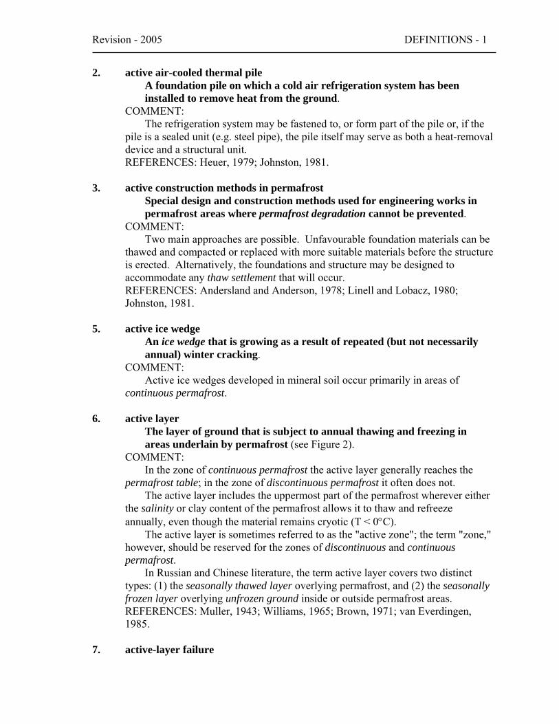
2. active air-cooled thermal pileA foundation pile on which a cold air refrigeration system has beeninstalled to remove heat from the ground.
COMMENT:The refrigeration system may be fastened to, or form part of the pile or, if the
pile is a sealed unit (e.g. steel pipe), the pile itself may serve as both a heat-removaldevice and a structural unit.REFERENCES: Heuer, 1979; Johnston, 1981.
3. active construction methods in permafrostSpecial design and construction methods used for engineering works inpermafrost areas where permafrost degradation cannot be prevented.
COMMENT:Two main approaches are possible. Unfavourable foundation materials can be
thawed and compacted or replaced with more suitable materials before the structureis erected. Alternatively, the foundations and structure may be designed toaccommodate any thaw settlement that will occur.REFERENCES: Andersland and Anderson, 1978; Linell and Lobacz, 1980;Johnston, 1981.
5. active ice wedgeAn ice wedge that is growing as a result of repeated (but not necessarilyannual) winter cracking.
COMMENT:Active ice wedges developed in mineral soil occur primarily in areas of
continuous permafrost.
6. active layerThe layer of ground that is subject to annual thawing and freezing inareas underlain by permafrost (see Figure 2).
COMMENT:In the zone of continuous permafrost the active layer generally reaches the
permafrost table; in the zone of discontinuous permafrost it often does not.The active layer includes the uppermost part of the permafrost wherever either
the salinity or clay content of the permafrost allows it to thaw and refreezeannually, even though the material remains cryotic (T < 0°C).
The active layer is sometimes referred to as the "active zone"; the term "zone,"however, should be reserved for the zones of discontinuous and continuouspermafrost.
In Russian and Chinese literature, the term active layer covers two distincttypes: (1) the seasonally thawed layer overlying permafrost, and (2) the seasonallyfrozen layer overlying unfrozen ground inside or outside permafrost areas.REFERENCES: Muller, 1943; Williams, 1965; Brown, 1971; van Everdingen,1985.
7. active-layer failure
2 – DEFINITIONS Revision – 2005
A general term referring to several forms of slope failures or failuremechanisms commonly occurring in the active layer overlying permafrost(see Figure 21a).
COMMENT:These include detachment failures but not retrogressive thaw slumps and thaw
slumping since these involve permafrost.SYNONYM: (not recommended) skin flow.
9. active-layer thicknessThe thickness of the layer of the ground that is subject to annual thawingand freeing in areas underlain by permafrost.
COMMENT:The thickness of the active layer depends on such factors as the ambient air
temperature, vegetation, drainage, soil or rock type and total water content,snowcover, and degree and orientation of slope. As a rule, the active layer is thinin the High Arctic (it can be less than 15 cm) and becomes thicker farther south (1m or more).
The thickness of the active layer can vary from year to year, primarily due tovariations in the mean annual air temperature, distribution of soil moisture, andsnowcover.
The thickness of the active layer includes the uppermost part of the permafrostwherever either the salinity or clay content of the permafrost allows it to thaw andrefreeze annually, even though the material remains cryotic (T < 0°C).
Use of the term "depth to permafrost" as a synonym for the thickness of theactive layer is misleading, especially in areas where the active layer is separatedfrom the permafrost by a residual thaw layer, that is, by a thawed or noncryotic (T> 0°C) layer of ground.REFERENCES: Muller, 1943; Williams, 1965; van Everdingen, 1985.
10. active liquid refrigerant pileA foundation pile on which a liquid coolant refrigeration system has beeninstalled to remove heat from the ground.
COMMENT:The refrigeration system may be fastened to, or form part of the pile or, if the
pile is a sealed unit (e.g. steel pipe), the pile itself may serve as both a heat-removaldevice and a structural unit.REFERENCES: Heuer, 1979; Johnston, 1981.
11. active rock glacierA mass of rock fragments and finer material, on a slope, that containseither an ice core or interstitial ice, and shows evidence of presentmovement.
COMMENT:Active rock glaciers possess steep fronts with slope angles that may exceed the
angle of repose. Gradual elimination of such oversteepening of the frontal portion
Revision - 2005 DEFINITIONS - 3
may suggest some movement long after the ice has melted and the main body of therock glacier has stopped moving.REFERENCES: White, 1976b; Washburn, 1979.
12. active thermokarstThe process by which characteristic landforms are currently developing as aresult of thawing of ice-rich permafrost or melting of massive ice.COMMENT:
The occurrence of active thermokarst indicates the presence of disequilibriumpermafrost.REFERENCES: French, 1976; Washburn, 1979.
14. adfreeze/adfreezingThe process by which two objects are bonded together by ice formedbetween them.
COMMENT:Adfreezing is the process that anchors piles or buried foundations in
permafrost, so that they can be unaffected by frost heave occurring in the activelayer.SYNONYM: frost grip.REFERENCE: Muller, 1943.
15. adfreeze strengthThe tensile or shear strength which has to be overcome to separate twoobjects that are bonded together by ice.
COMMENT:The term is usually used to describe the resistance to the force that is required
to separate frozen ground or an ice mass from an object (frequently a foundationunit) to which it is frozen. The shear stress required to separate an object fromfrozen ground is frequently referred to as the "tangential adfreeze strength".REFERENCES: Muller, 1943; Johnston, 1981.
18. aggradational iceThe additional ground ice formed as a direct result of permafrostaggradation (see Figure 10a).
COMMENT:Ice lenses form seasonally, especially in the lower part of the active layer, and
can be incorporated into the permafrost if they do not melt over a period of years.REFERENCES: Mackay, 1972b, 1983; Cheng, 1983.
19. air freezing indexThe cumulative number of degree-days below 0°C for the air temperatureduring a given time period.
COMMENT:The air freezing index differs from the corresponding surface freezing index
(see n-factor).

4 – DEFINITIONS Revision – 2005
20. air thawing indexThe cumulative number of degree-days above 0°C for the air temperatureduring a given period.
COMMENT:The air thawing index differs from the corresponding surface thawing index
(see n-factor).21. alas/alass
A large depression of the ground surface produced by thawing of a largearea of very thick and exceedingly ice-rich permafrost.
COMMENT:Typically, alasses are large depressions ranging from 0.5 to more than 100
km2 in area and from 5 to 20 m in depth. In the early stages of formation, a shallow(≤ 2 m) circular "alas lake" forms in a steep-sided depression. Enlargement andultimate drainage of a number of such lakes may leave low interalas plateaus(termed "mezhalasye" in Russian). Ultimately, the plateaus disappear and masswasting produces gentle side slopes. The term is of Yakut origin. The term is ofYakut origin. An analogous term of Nenets (northwestern Siberia) origin is"khasyrey".REFERENCES: Czudek and Demek, 1970; Soloviev, 1973.
22. albedoAlbedo is a measure of the reflecting power of a surface, expressed as thefraction of the incoming solar radiation reflected by the surface.
COMMENT:The albedo of natural land surfaces varies over a wide range, and it changes
with the seasons, primarily due to changes in vegetation and snowcover.
25. altitudinal limit of permafrostThe lowest altitude at which mountain permafrost occurs in a givenhighland area outside the general permafrost region.
COMMENT:The altitudinal limit of mountain permafrost generally rises progressively with
decreasing latitude.REFERENCE: Brown, 1967b.
26. altitudinal zonation of permafrostThe vertical subdivision of an area of mountain permafrost into permafrostzones, based on the proportion of the ground that is perennially cryotic.
COMMENT:As mean annual temperatures decrease with increasing elevation, mountain
permafrost can normally be expected to be more extensive, thicker and colder athigher elevations, although exposure and the extent of vegetation and snow coverwill moderate this effect. A noteable exception is found in the southwesternportion of Yukon, where (1) the high St. Elias Mountains block the circulation ofmoist and warm maritime air from the Pacific Ocean, particularly in winter, and (2)the deeply dissected nature of the terrain promotes cold-air drainage and ponding in
Revision - 2005 DEFINITIONS - 5
the valleys. As a result, permafrost is more extensive, thicker and colder in valleybottoms than at higher elevations.REFERENCE: Burn, 1994.
29. anti-syngenetic ice wedgeAn ice wedge that grows progressively downwards into a receding slope,in a direction normal to the surface (see Figure 17i).
COMMENT:The younger portions of the wedge extend farthest down. The downward rate
of growth is a function of the rate of slope recession and the rate of formation ofnew ice veinlets.REFERENCE: Mackay, 1990.
30. apparent heat capacityThe amount of heat required to raise the temperature of a unit mass offrozen ground by one degree.
COMMENT:Because the phase change in frozen ground often occurs gradually over a range
of temperatures, the apparent heat capacity (which is the sum of the specific heatcapacity and the latent heat released) may vary significantly with temperature. Apparent heat capacity is commonly expressed in Joules per kg per degree K.
31. approximate freezing indexThe cumulative number of degree-days below 0°C for a given time period,calculated from the mean monthly temperatures for a specific stationwithout making corrections for positive degree-days in spring and fall.
REFERENCES: Boyd, 1973, 1979.
32. approximate thawing indexThe cumulative number of degree-days above 0°C for a given time period,calculated from the mean monthly temperatures for a specific stationwithout making corrections for negative degree-days in spring and fall.
REFERENCES: Boyd, 1973, 1979.
33. artificial ground freezingThe process of inducing or maintaining a frozen condition in earthmaterials by artificial means.
COMMENT:The frozen condition can be induced or maintained by natural convection
movement of air, gases or liquids (e.g., through or in ventilation ducts, thermalpiles, thermosyphons), or by forced (mechanical) circulation of cold air or arefrigerant through a system of ducts or freeze pipes in the ground.REFERENCES: Jumikis, 1977; Johnston, 1981.
35. banded cryogenic fabric

6 – DEFINITIONS Revision – 2005
A distinct soil micromorphology, resulting from the effects of freezing andthawing processes, in which soil particles form subhorizontal layers (seeFigure 8c).
COMMENT:This fabric, found in cryosols, results from freeze-thaw processes accompanied
by eluviation.REFERENCES: Brewer and Pawluk, 1975; Pawluk and Brewer, 1975; Fox, 1983.
36. barrensAreas of discontinuous vegetation cover in the polar semi-desert of the HighArctic.COMMENT:
Unvegetated areas of polar desert may be caused by climatic factors (too coldand/or too dry), or edaphic factors (low soil nutrients or toxic substrate), or acombination of those.
37. basal cryopegA layer of unfrozen ground that is perennially cryotic (T < 0°C), formingthe basal portion of the permafrost (see Figures 2, 4 and 11).
COMMENT:In a basal cryopeg, freezing is prevented by freezing-point depression due to
the dissolved-solids content of its pore water.REFERENCE: Tolstikhin and Tolstikhin, 1974.
38. basal cryostructureThe cryostructure of a frozen deposit of boulders that is saturated with ice(see Figure 9e).
REFERENCE: Kudryavtsev, 1978.
40. basal-layered cryostructureThe cryostructure of a frozen layered deposit of gravel and boulders thatis saturated with ice (see Figure 9e).
REFERENCE: Kudryavtsev, 1978.
44. beaded streamA stream characterized by narrow reaches linking pools or small lakes(see Figure 22a).
COMMENT:A characteristic pattern of small streams in areas underlain by ice wedges. The
course of the stream channel is controlled by the pattern of the wedges, with thebeads (pools) occurring at the junctions of the wedges. When the interveningchannels are dry, they may be called "beaded channels".SYNONYMS: (not recommended) beaded drainage, button drainage.REFERENCES: Péwé, 1954; Hopkins et al., 1955; Ferrians et al., 1969; Brown,1970b; Lawson and Brown, 1978.
47. block field

Revision - 2005 DEFINITIONS - 7
A surficial layer of angular shattered rocks formed in either modern orPleistocene periglacial environments.
SYNONYMS: stone field and (not recommended) felsenmeer, blockmeer.REFERENCES: French, 1976; Washburn, 1979.
49. bottom temperature of snow cover (BTS)Temperature measured at the base of the snow cover during mid- to late-winter (February/March).
COMMENT:Such measurements are used in the BTS method to predict the presence or
absence of permafrost in mountain areas where the winter snow cover is thickerthan about 1.0 mREFERENCES: Haeberli, 1973; Hoelzle et al., 1993.
51. BTS methodMethod to predict the presence or absence of permafrost in a mountainarea, using measurements of the bottom temperature of snow cover in mid-to late-winter.
COMMENT:Snow cover, with its low thermal conductivity, insulates the soil from short-
term fluctuations in air temperature. In those mountain areas where snow-coverthickness equals or exceeds 1 m and surface melting is still negligible in mid- tolate-winter, BTS values remain virtually constant, mainly controlled by heattransfer from the upper ground layers, which in turn is strongly influenced by thepresence or absence of permafrost. According to published data, BTS values below-3°C, between -3°C and -1.7°C, and above -1.7C° suggest, respectively, thepresence, possible presence, and absence of permafrost.REFERENCES: Haeberli, 1973; Hoelzle et al., 1993.
54. buried iceIce formed or deposited on the ground surface and later covered bysediments.
COMMENT:Buried ice likely represents buried glacier ice or snowbanks; or less likely,
lake, river or sea ice, or icings.
56. cave iceIce formed in a closed or open cave.
COMMENT:Cave ice can form and persist in an area of temperate climatic conditions
where the configuration of the cave or cave system permits an influx of cold winterair by gravity flow but limits access of warm summer air.REFERENCE: Harris, 1979.
61. closed-cavity iceIce formed in a closed space, cavity or cave in permafrost.

8 – DEFINITIONS Revision – 2005
COMMENT:Along the western Arctic coast of Canada for example, underground cavities,
apparently formed by pockets of methane gas, have been found filled with icecrystals. The water from which the crystals have grown probably entered thecavities through vapour diffusion.REFERENCES: Mackay, 1965, 1972b.
62. closed-system freezingFreezing that occurs under conditions that preclude the gain or loss of anywater by the system (see Figure 7).
COMMENT:Pure closed-system conditions, in which water is neither added to nor removed
from the system, are sometimes referred to as "in situ freezing". Closed-systemfreezing of water-saturated soil causes expansion equal to about 9 percent of theoriginal pore volume of the unfrozen soil. Inside closed systems, someredistribution of water may take place during freezing.
63. closed-system pingoA pingo formed by doming of frozen ground due to freezing of injectedwater supplied by expulsion of pore water during permafrost aggradationin the closed talik under a former water body (see Figures 18 and 19a).
COMMENT:Most closed-system pingos are found in flat, poorly-drained terrain in the zone
of continuous permafrost. Repeated injections of expelled water into the overlyingpermafrost, followed by freezing of the injected water, cause progressive doming,and produce the massive ice forming the core of the pingo. Progressive formationof segregated ice and dilation crack ice can also contribute to the process.SYNONYMS: hydrostatic pingo and (not recommended) Mackenzie Delta pingo.REFERENCES: Mackay, 1973b, 1979, 1985.
64. closed talikA layer or body of unfrozen ground occupying a depression in thepermafrost table below a lake or river (see Figure 11).
COMMENT:The temperature of closed lake taliks and river taliks remains above 0°C
because of the heat storage effect of the surface water.REFERENCES: Williams, 1965; Washburn,1973; van Everdingen, 1976.
65. coefficient of compressibilityThe volume change per unit volume of a substance per unit increase ineffective compressive stress, under isothermal conditions.
COMMENT:Frozen soils are usually considered to be practically incompressible, and
volume-change deformations can therefore be neglected. Numerous investigationshave shown, however, that the compressibility of frozen soils can be significant andshould not be neglected in some cases, especially when large areas are to be loaded.
Revision - 2005 DEFINITIONS - 9
Compressibility and its time dependence in frozen soils are due to severalcauses, such as instantaneous compression of the gaseous phase, creep of the poreice due to shear stresses at the grain contacts, and hydrodynamic consolidation dueto the expulsion of unfrozen water under stress, the amount of which varies withthe applied pressure.
66. collapse scarThat portion of a peatland where the whole or part of a palsa or peatplateau has thawed and collapsed to the level of the surrounding peatland(see Figures 14 and 15e).
COMMENT:A collapse scar is not a depression but is marked by vegetation different from
the peatland that did not contain permafrost. Irregular topography (hencethermokarst terrain) may be present on the peatland as a whole but the collapsescars are only part of that thermokarst terrain, marked by the absence ofpermafrost, and by vegetation different from that on both the previously unfrozenpeatlands and the remnant permafrost peat landforms.REFERENCE: Zoltai, 1971.
68. composite wedgeA wedge showing evidence of both primary and secondary filling.
COMMENT:When used with reference to thermal contraction crack phenomena in
permafrost, it describes a wedge filled by a combination of ice and soil (usuallysand). The term is also frequently used to describe Pleistocene sand wedges andice-wedge casts. Typically, composite wedges are filled with material very similarin structure and texture to sands in a typical fissure of primary filling (i.e., sandwedge). However, there may be inclusions of material from the fissure walls andsome distortion of the adjacent sediments bordering the wedge, reflecting thepresence of ice in the original fill material.REFERENCES: Black and Berg, 1966; Goździk, 1973; French, 1976; Washburn,1979.
72. conglomeric cryogenic fabricA distinct soil micromorphology, resulting from the effects of freezing andthawing processes, in which coarser soil particles form compoundarrangements (see Figure 8f).
COMMENT:This fabric, found in cryosols, results from freeze-thaw processes probably
accompanied by cryoturbation.REFERENCES: Brewer and Pawluk, 1975; Pawluk and Brewer, 1975; Fox, 1983.
73. construction methods in permafrostSpecial design and construction procedures required when engineeringworks are undertaken in permafrost areas.
COMMENT:

10 – DEFINITIONS Revision – 2005
Design and construction of engineering works on permafrost normally followone of two broad principles which are based on whether or not the frozenfoundation soil or rock is thaw-stable (thaw-stable permafrost) or thaw-unstable(thaw-sensitive permafrost).
Permafrost conditions can be neglected, and conventional designs andconstruction methods used when foundation materials are stable upon thawing. When the foundation materials are thaw-sensitive, however, then either the"passive" or "active" design and construction method is selected.
The passive method maintains the foundation materials in a frozen state. Preservation of the frozen condition or permafrost aggradation can beaccomplished using thermal piles or thermosyphons, or by using either a ventilationor an insulation construction technique; often a combination of these techniques isused.
The ventilation technique requires that there is a clear space left between thebottom of the structure and the ground surface, or that the structure is placed on afill pad with ducts incorporated in the pad or the floor system. Movement of coldair through the air space or ducts dissipates heat from the structure above andremoves heat from the ground below.
Using the insulation technique, a relatively thick fill (sometimes containing alayer of insulation) is placed on the ground surface to prevent thawing or to reduceor control the depth of thaw below the original ground surface.
When permafrost degradation cannot be prevented, then one of the activemethods must be considered. Two main approaches are possible. Unfavourablefoundation materials are thawed and compacted or replaced with more suitablematerials before the structure is erected. Alternatively, the foundations andstructure are designed to accommodate the thaw settlements that will occur.REFERENCES: Andersland and Anderson, 1978; Linell and Lobacz, 1980;Johnston, 1981.
76. continuous permafrostPermafrost occurring everywhere beneath the exposed land surfacethroughout a geographic region with the exception of widely scatteredsites, such as newly deposited unconsolidated sediments, where the climatehas just begun to impose its influence on the thermal regime of the ground,causing the development of continuous permafrost (see Figure 1).
COMMENT:For practical purposes, the existence of small taliks within continuous
permafrost has to be recognized. The term, therefore, generally refers to areaswhere more than 90 percent of the ground surface is underlain by permafrost.REFERENCE: Brown, 1970b.
77. continuous permafrost zoneThe major subdivision of a permafrost region in which permafrost occurseverywhere beneath the exposed land surface with the exception of widelyscattered sites.
COMMENT:
Revision - 2005 DEFINITIONS - 11
Taliks associated with rivers and lakes may occur in the continuous permafrostzone.REFERENCE: Brown, 1970b.
79. creep of frozen groundThe slow deformation (or time-dependent shear strain) that results fromlong-term application of a stress too small to produce failure in the frozenmaterial.
COMMENT:In frozen soils, creep deformations are due mainly to the creep of pore ice and
the migration of unfrozen pore water. In ice-saturated frozen soils, most creepdeformations are distortional with little or no volume change. In frozen soils withlarge unfrozen water contents or in unsaturated frozen soils, slow deformations dueto consolidation, and creep due to volume change, may also occur. Usually, a largeportion of the creep deformation is permanent.REFERENCES: Vyalov, 1959; Ladanyi, 1972, 1981.
80. creep strengthThe failure strength of a material at a given strain rate or after a givenperiod under deviatoric stress.
COMMENT:Under high confining stress and at relatively high freezing temperatures, most
frozen soils creep and eventually fail in a plastic manner.
83. crust-like cryostructureThe cryostructure of a frozen deposit of angular blocks that are coatedwith ice, whereas large spaces between the blocks are not filled with ice(see Figure 9e).
COMMENT:A deposit with a crust-like cryostructure has a relatively low ice content.
REFERENCE: Kudryavtsev, 1978.
87. cryofrontThe boundary between cryotic and noncryotic ground as indicated by theposition of the 0°C isotherm in the ground (see Figures 4 and 5).
COMMENT:The permafrost base and the boundaries between noncryotic and cryotic
portions of the active layer constitute cryofronts. As a result of freezing-pointdepression, the freezing front usually lags behind the cryofront as it movesdownwards during annual freezing of the active layer.REFERENCE: van Everdingen, 1976.
88. cryogenesisThe combination of thermophysical, physico-chemical and physico-mechanical processes occurring in freezing, frozen and thawing earthmaterials.

12 – DEFINITIONS Revision – 2005
COMMENT:Specific processes of cryogenesis include water migration during freezing and
thawing of the ground, frost heave, heat and mass (moisture) exchange, regelationand gelifluction. In the Russian permafrost literature, cryogenesis includes mainlyprocesses that lead to development of permafrost cryostructure and landforms.REFERENCE: Poppe and Brown, 1976.
89. cryogenic aquicludeA layer of ground which, because of its frozen state, has a low enoughpermeability to act as a confining bed for an aquifer.
COMMENT:Annual freezing can turn the active layer into a cryogenic aquiclude.
REFERENCE: Fotiev, 1978.
90. cryogenic fabricThe distinct soil micromorphology resulting from the effects of freezingand thawing processes (see Figure 8).
COMMENT:The following cryogenic fabrics, found in cryosols, can be distinguished under
a microscope:1. granic and granoidic fabrics - soil particles form discrete loosely packed units.
These fabrics are generally attributed to freeze-thaw processes and theformation of needle ice near the ground surface.
2. fragmic and fragmoidal fabrics - soil particles form discrete units that areeither densely packed or coalescing. These fabrics commonly occur insubsurface soil horizons, usually close to the freezing front where soil materialis subject to ice lens formation.
3. banded and isoband fabrics - soil particles form subhorizontal layers whichresult from freeze-thaw processes accompanied by eluviation.
4. orbiculic, suscitic and conglomeric fabrics - coarser soil particles form circularto ellipsoidal patterns (orbiculic), vertical or near-vertical orientation(suscitic), and compound arrangements (conglomeric), probably as a result ofcryoturbation activity.
REFERENCES: Brewer and Pawluk, 1975; Pawluk and Brewer, 1975; Fox, 1983.
95. cryogenic temperatureIn international materials science, this term refers to temperaturesgenerally below -50°C, but usually to temperatures within a few degrees ofabsolute zero (-273°C).
101. cryolithologyThe study of the genesis, structure and lithology of frozen earth materials.
COMMENT:This is a Russian term not widely used in North America. It is a branch of
geocryology in which lithological and ground-ice conditions are emphasized.

Revision - 2005 DEFINITIONS - 13
106. cryopedologyThe study of soils at temperatures below 0°C, with particular reference tosoils subject to intensive frost action, and to soils overlying permafrost.
COMMENT:As originally defined (Bryan, 1946), the term comprised the whole science of
geocryology, including the civil engineering methods used to overcome difficultiesresulting from intensive frost action and the existence of permafrost.REFERENCES: Bryan, 1946; Canada Soil Survey Committee, 1978.
107. cryopegA layer of unfrozen ground that is perennially cryotic (forming part of thepermafrost), in which freezing is prevented by freezing-point depressiondue to the dissolved-solids content of the pore water (see Figures 2, 4 and11).
COMMENT:Three types of cryopeg can be distinguished on the basis of their position with
respect to permafrost:1. a basal cryopeg forms the basal portion of the permafrost;2. an isolated cryopeg is entirely surrounded by perennially frozen ground;3. a marine cryopeg is found in coastal or subsea perennially frozen ground;
marine cryopegs may also be basal and/or isolated. In Russian literature cryopegs are defined as lenses of "cryosaline water"
(supercooled brine) found within saline cryotic soils or rock.REFERENCE: Tolstikhin and Tolstikhin, 1974.
108. cryoplanationThe process through which cryoplanation terraces form.
COMMENT:Cryoplanation occurs most frequently in periglacial areas of moderate aridity
underlain by permafrost, under conditions of intense frost wedging associated withsnowbanks.
109. cryoplanation terraceA step-like or table-like bench cut in bedrock in cold climate regions.
COMMENT:Cryoplanation terraces may occur as both hillside benches or bevelled summit
surfaces and often lack structural control. They are thought to form underconditions of intense frost wedging associated with snowbanks. Cryoplanationterraces are more frequently reported from periglacial areas of moderate aridity. As these areas are usually underlain by permafrost, cryoplanation terraces areregarded by some as diagnostic landforms of permafrost terrain.REFERENCES: Eakin, 1916; Demek, 1969; French, 1976; Reger and Péwé, 1976;Washburn, 1979.
110. cryosol

14 – DEFINITIONS Revision – 2005
Soil formed in either mineral or organic materials having permafrosteither within 1 m below the surface or, if the soil is strongly cryoturbated,within 2 m below the surface, and having a mean annual groundtemperature below 0°C.
COMMENT:This is a pedological term for a major soil order. Cryosols are divided into
three groups:1. organic cryosols developed in organic (peat) materials;2. static cryosols developed in mineral soils and showing little or no evidence of
cryoturbation;3. turbic cryosols developed in mineral soils and showing strong evidence of
cryoturbation.SYNONYMS: (not recommended) cryosolic soil, pergelic soil.REFERENCE: Canada Soil Survey Committee, 1978.
112. cryosphereThat part of the earth's crust, hydrosphere and atmosphere subject totemperatures below 0°C for at least part of each year.
COMMENT:The cryosphere may be divided into the cryoatmosphere, the cryohydrosphere
(snowcover, glaciers, and river, lake and sea ice) and the cryolithosphere(perennially and seasonally cryotic ground). Some authorities exclude the earth'satmosphere from the cryosphere; others restrict the term "cryosphere" to theregions of the earth's crust where permafrost exists.REFERENCE: Baranov, 1978.
114. cryostructureThe structural characteristics of frozen earth materials (see Figure 9).
COMMENT:The cryostructure is determined by the amount and distribution of pore ice (or
ice cement) and lenses of segregated ice. The type and arrangement of ice in thefrozen material will depend largely on the initial total water content of the materialand the extent of moisture migration during subsequent freezing.
For engineering purposes, the structure of frozen soil may be described asmassive, layered or reticulate, based on the type and distribution of ice in the soil. A massive structure (not to be confused with massive ground-ice forms) ischaracterized by the predominant presence of pore ice and by a relatively low totalice content. In soils with a reticulate structure, ice veins generally form a randomnet, whereas in those with a layered structure, well-oriented horizontal ice lensesalternate with soil layers having a massive structure. In both cases their total icecontent is relatively high.
Russian permafrost scientists identify ten cryogenic structures orcryostructures: basal, basal-layered, crust-like, layered, lens-type, massive-agglomerate, massive, massive-porous, reticulate and reticulate-blocky.REFERENCES: U.S.S.R., 1969, 1973; Poppe and Brown, 1976; Kudryavtsev,1978.
Revision - 2005 DEFINITIONS - 15
115. cryosuctionA suction developed in freezing or partially frozen fine-grained materialsas a result of temperature-dependent differences in unfrozen watercontent.
COMMENT:Cryosuction occurs where gradients of the temperature-dependent unfrozen
water content in a freezing or partially frozen fine-grained earth material causehydraulic gradients large enough to induce migration of pore water from unfrozensoil into the partially frozen soil via unfrozen water films.SYNONYM: (not recommended) frost suction.REFERENCES: Blanchard and Frémond, 1982.
117. cryotextureThe textural characteristics of frozen, fine-grained organic and mineralearth materials cemented together with ice.
COMMENT:Cryotextures may be useful in determining the nature of the freezing process
and the conditions under which the sediments accumulated.REFERENCES: Poppe and Brown, 1976; Kudryavtsev, 1978.
118. cryotic groundSoil or rock at temperatures of 0°C or lower.
COMMENT:The terms "cryotic" and "noncryotic" were introduced to solve a major
semantic problem identified by Brown and Kupsch (1974), namely the lack ofspecific separate terms to designate "above 0°C" and "below 0°C" as opposed to"unfrozen" (not containing ice) and "frozen" (containing ice) (see Figure 3). Cryotic and noncryotic refer solely to the temperature of the material described,independent of its water or ice content. Perennially cryotic ground refers to groundthat remains at or below 0°C continuously for two or more years and is thereforesynonymous with permafrost.REFERENCES: Brown and Kupsch, 1974; van Everdingen, 1976.
119. cryoturbateA body of earth material moved or disturbed by frost action.
COMMENT:The process of cryoturbation results in the disruption and distortion of soil
horizons and structures, the formation of patterned ground, the growth ofinvolutions, and the redistribution of organic-rich subsurface masses and layers. Downslope soil movements are more properly termed solifluction, gelifluction andfrost creep, although many authors include the products of solifluction within theterm cryoturbate.SYNONYMS: cryoturbations and (not recommended) congeliturbate.
120. cryoturbation

16 – DEFINITIONS Revision – 2005
1. (Singular) A collective term used to describe all soil movements due tofrost action.
2. (Plural) Irregular structures formed in earth materials by deep frostpenetration and frost action processes, and characterized by folded,broken and dislocated beds and lenses of unconsolidated deposits,included organic horizons and even bedrock.
COMMENT:Cryoturbation encompasses frost heave, thaw settlement and all differential
movements, including expansion and contraction due to temperature changes andthe growth and disappearance of ground ice bodies, whether perennial or seasonal. Low temperatures alone are not enough to produce cryoturbation; the water-icephase change is necessary. Cryoturbation is an important process in thedevelopment of patterned ground.SYNONYMS: 1. (not recommended) congeliturbation, frost churning, froststirring; 2. cryoturbates.REFERENCES: French, 1976; Washburn, 1979.
121. debris flowA sudden and destructive variety of landslide, in which loose material on aslope, with more than 50 percent of particles larger than sand size, ismobilized by saturation and flows down a channel or canyon.
COMMENT:The water content of debris flows may range from 10 to over 50 percent by
volume. They may transport huge boulders for great distances down gentle slopes. Debris flows also occur in non-permafrost areas.
122. deformabilityThe ability of a material to change its shape or size under the influence ofan external or internal agency, such as stress, temperature, or porepressure.
123. degree-day (C or F)A derived unit of measurement used to express the departure of the meantemperature for a day from a given reference (or base) temperature.
COMMENT:The freezing index and the thawing index are expressed in degree-days with
respect to a reference temperature of 0°C (32°F); units: degree-day Celsius ordegree-day Fahrenheit.REFERENCE: Boyd, 1979.
124. degree of saturation1. The total degree of saturation of frozen soil is the ratio of the volume
of ice and unfrozen water in the soil pores to the volume of the pores.2. The degree of saturation of frozen soil by ice is the ratio of the volume
of ice in the soil pores to the volume of the pores.
Revision - 2005 DEFINITIONS - 17
COMMENT:Neither definition is the equivalent of the standard definition used in soil
mechanics where the degree of saturation is the ratio of the volume of water in asoil to the volume of the pores.
125. delayed strengthThe failure strength of a material at a given strain rate or after a givenperiod under deviatoric stress.
126. density of frozen groundThe mass of a unit volume of frozen soil or rock.
129. depth of seasonal frost penetrationThe maximum thickness of the seasonally frozen layer.
COMMENT:This term is primarily used in areas without permafrost, but also in areas with
permafrost where the seasonal frost does not reach the permafrost table.
130. depth of thawThe minimum distance between the ground surface and frozen ground atany time during the thawing season in an area subject to seasonal freezingand thawing (see Figure 4).
COMMENT:When no frozen ground remains, thawing is complete, and depth of thaw
cannot be determined.
131. depth of zero annual amplitudeThe distance from the ground surface downward to the level beneathwhich there is practically no annual fluctuation in ground temperature(see Figure 2).
COMMENT:A change of no more than 0.1°C throughout the year is arbitrarily considered
as "practically no annual fluctuation". The temperature at the depth (or level) ofzero annual amplitude ranges from about -0.1°C at the southern limit of thepermafrost region to about -15°C in the extreme polar reaches of the zone ofcontinuous permafrost. The depth of zero annual amplitude varies widely butgenerally lies between 10 and 20 m below the ground surface, depending onclimatic and terrain conditions such as amplitude of annual surface temperaturevariation, vegetation, snowcover and characteristics of the soils and rocks includingthermal diffusivity (see thermal properties of frozen ground).SYNONYMS: (not recommended) zone of minimum annual amplitude, zone ofzero annual amplitude.REFERENCE: Muller, 1943.
133. desiccation crack
18 – DEFINITIONS Revision – 2005
Crack or fissure developed in fine-grained soil material as a result ofshrinkage during drying.
134. desiccation polygonClosed, multi-sided patterned-ground feature formed by desiccation cracksin fine-grained soil material. Usually less than 2 m in diameter.
135. design depth of frost penetration1. (North-American usage) The mean of the three largest depths of
seasonal frost penetration measured during the past thirty years, orthe largest depth of seasonal frost penetration beneath a snow-free soilsurface measured during the past ten years.
2. (Russian usage) The mean of the depths of seasonal frost penetrationmeasured during at least the last ten years with the ground surfacefree of snow and the groundwater level below the depth of seasonalfrost penetration.
136. design freezing indexThe cumulative number of degree-days below 0°C, calculated by takingthe average of the seasonal freezing indices for the three coldest winters inthe most recent 30 years of record.
COMMENT:If data for 30 years are not available, then the index is based on the coldest
winter in the latest 10-year period of record.REFERENCE: U.S. Army/Air Force, 1966.
137. design thawing indexThe cumulative number of degree-days above 0°C, calculated by takingthe average of the seasonal thawing indices for the three warmest summersin the most recent 30 years of record.
COMMENT:If data for 30 years are not available, then the index is based on the warmest
summer in the latest 10-year period of record.REFERENCE: U.S. Army/Air Force, 1966.
138. detachment failureA slope failure in which the thawed or thawing portion of the active layerdetaches from the underlying frozen material (see Figure 21b).
COMMENT:Detachment failures are common on colluvial slopes in areas of fine-grained,
ice-rich deposits. They occur more frequently during warm summers or followingdisturbance of the vegetation or ground surface by, for example, tundra or forestfires or engineering activity, when the depth of thaw is greater than normal. Detachment failures that expose massive ice or icy sediments can develop intoretrogressive thaw slumps.SYNONYMS: (not recommended) skin flow, active-layer glide.

Revision - 2005 DEFINITIONS - 19
REFERENCES: Hughes, 1972; McRoberts and Morgenstern, 1974.
139. dielectric constantThe dielectric constant of a soil is a measure of the ability of the soil tostore electrical energy in the presence of an electrostatic field.
COMMENT:The dielectric constant is calculated as the ratio of the permittivity of the soil
to the permittivity of a vacuum. It varies with soil type, temperature, unfrozenwater content, and the dissolved-solids content of the pore water.SYNONYM: relative permittivity.
140. dilation crackA tensile fracture in a frozen material due to surface extension caused bydoming.
COMMENT:This usually occurs during the growth of frost mounds.
141. dilation crack iceIce that forms in dilation cracks (see Figure 10b).
COMMENT:Dilation crack ice may form a significant component of the total ice content of
features such as pingos. The ice is vertically banded and may be discoloured byinclusions of mineral soil and organic matter. Individual bands may be up to 20 cmwide.REFERENCES: Mackay, 1979, 1985.
142. discontinuous permafrostPermafrost occurring in some areas beneath the exposed land surfacethroughout a geographic region where other areas are free of permafrost(see Figure 1).
COMMENT:Discontinuous permafrost occurs between the continuous permafrost zone and
the southern latitudinal limit of permafrost in lowlands. Depending on the scale ofmapping, several subzones can often be distinguished, based on the percentage ofthe land surface underlain by permafrost, as shown in the following table.
English usage % Permafrost Russian Usage % Permafrost
Extensive 65-90% Massive Island 70-80%
Intermediate 35-65% Island 40-60%
Sporadic 10-35% Sporadic 5-30%
Isolated Patches 0-10% ? 0-5%SYNONYMS: (not recommended) insular permafrost; island permafrost; scatteredpermafrost.
20 – DEFINITIONS Revision – 2005
REFERENCES: Brown, 1970b; Kudryavtsev, 1978; Heginbottom, 1984;Heginbottom and Radburn, 1992; Brown et al., 1997.
143. discontinuous permafrost zoneThe major subdivision of a permafrost region in which permafrost occursin some areas beneath the exposed land surface, whereas other areas arefree of permafrost.
COMMENT:The zone of discontinuous permafrost lies between the continuous permafrost
zone and the southern latitudinal limit of permafrost in lowlands. Near its northernboundary, discontinuous permafrost is extensive, whereas near its southernboundary it occurs as isolated patches of permafrost, and sporadic permafrost. There is no sharp distinction, or boundary, between the continuous anddiscontinuous permafrost zones.REFERENCE: Brown, 1970b.
144. disequilibrium permafrostPermafrost that is not in thermal equilibrium with the existing meanannual surface or sea-bottom temperature and the geothermal heat flux.
REFERENCE: Mackay, 1972a.
145. drunken forestTrees leaning in random directions.
COMMENT:A descriptive term for trees usually growing on ice-rich terrain and subject to
repeated differential frost heave or thermokarst subsidence. Active, forested rockglaciers may also exhibit this phenomenon due to differential movements.REFERENCES: Muller, 1943; Zoltai, 1975.
146. dry densityThe mass of a unit volume of dried material (e.g. soil).
COMMENT:To determine the dry density of frozen ground, a measured volume of the
material has to be thawed and then dried and weighed.
147. dry frozen groundFrozen ground with a very low total water content consisting almostcompletely of interfacial water, and not cemented by ice.
COMMENT:The compressibility of dry frozen ground is the same as that of unfrozen
ground of the same composition, total water content, and density.REFERENCE: van Everdingen, 1976.
148. dry permafrostPermafrost containing neither free water nor ice.
COMMENT:

Revision - 2005 DEFINITIONS - 21
A negligible quantity of moisture in the form of interfacial water may bepresent. Dry permafrost is thaw-stable.REFERENCE: van Everdingen, 1976.
149. dynamic modulus of elasticityThe ratio of stress to strain for a material under dynamic loadingconditions.
150. dynamic Poisson's ratioThe absolute value of the ratio between the linear strain changes,perpendicular to and in the direction of a given uniaxial stress change,respectively, under dynamic loading conditions.
151. earth hummockA hummock having a core of silty and clayey mineral soil which may showevidence of cryoturbation (see Figure 20a, b).
COMMENT:Earth hummocks are a type of nonsorted circle (see also patterned ground)
commonly found in the zone of continuous permafrost. They develop in materialsof a high silt and clay content and/or of high ice content. Earth hummocks foundoutside the southern limit of present-day permafrost are believed to have formedduring a previous period of cooler climate when the area was underlain bypermafrost.SYNONYMS: mud hummock and (not recommended) earth mound, tundrahummock.REFERENCES: Tarnocai and Zoltai, 1978; Washburn, 1979.
154. electrical conductivityThe inverse of electrical resistivity.
COMMENT:The electrical conductivity of unfrozen soils decreases slightly with a decrease
in temperature. A significant decrease in conductivity occurs when a soil freezes,but this change is directly related to the decreasing unfrozen water content of thefrozen ground, and it may be affected by cryostructure. Available data show thatthe conductivities of frozen ground may be from 1 to more than 2 orders ofmagnitude smaller than those of the same material when unfrozen. Theconductivity of frozen soils decreases further with further decreases in temperature.
155. electrical properties of frozen groundThe dielectric constant (or relative permittivity), electrical conductivity andelectrical resistivity are the major electrical properties governing the flowof electric current through frozen ground.
COMMENT:The dielectric constant of a soil is a measure of the ability of the soil to store
electrical energy in the presence of an electrostatic field; it is the ratio of the soil's

22 – DEFINITIONS Revision – 2005
permittivity to the permittivity of a vacuum. The electrical conductance of a soil isthe inverse of the resistance offered by a soil to current flow.
Current flow under an electrical gradient in a frozen soil occurs almost entirelythrough the unfrozen water films. Electrical conduction is related to the thicknessof these water films and their degree of interconnection; it decreases withdecreasing temperature and increases with increasing pressure. As a consequence,all these electrical properties are influenced by soil type, density, salinity,temperature and, in particular, the unfrozen water content.
For example, the resistivity of unfrozen soils increases slightly with decreasein temperature. A significant increase in resistivity occurs when the soil freezes;this change is directly related to the decreasing unfrozen water content of the frozenground. Available data show that the resistivities of frozen soils and rocks may befrom 10 to more than 100 times larger than those of the same materials whenunfrozen.
Electromagnetic geophysical techniques for mapping permafrost, and theelectrical grounding of various types of machines and electrical equipment, powertransmission systems and radio transmitting antennae in permafrost areas, require aknowledge of the electrical properties of frozen ground.REFERENCE: Johnston, 1981.
156. electrical resistivityThe property of a material that determines the electrical current flowingthrough a centimetre cube of the material when an electrical potential isapplied to opposite faces of the cube.
COMMENT:The electrical resistivity of unfrozen soils increases slightly with a decrease in
temperature. A significant increase in resistivity occurs when a soil freezes, butthis change is directly related to the decreasing unfrozen water content of the frozenground, and it may be affected by cryostructure. Available data show that theresistivities of frozen ground may be from 10 to more than 100 times larger thanthose of the same material when unfrozen. The resistivity of frozen soils increasesfurther with further decreases in temperature.
157. epigenetic iceGround ice developed in epigenetic permafrost, or in previously formedsyngenetic permafrost.
COMMENT:If epigenetic ice occurs in the form of ice lenses in which the volume of ice to
soil is large, the more descriptive term segregated ice is preferred. Examples ofepigenetic ice also include wedge ice and intrusive ice.REFERENCE: Mackay, 1972b.
158. epigenetic ice wedgeAn ice wedge developed in epigenetic permafrost, or in previously formedsyngenetic permafrost (see Figure 17i).
COMMENT:

Revision - 2005 DEFINITIONS - 23
Epigenetic ice wedges grow progressively wider, rather than deeper, and arecharacteristically wedge-shaped. The ice of an epigenetic ice wedge is oldest onthe outside edges.REFERENCES: Romanovskii, 1973; Mackay, 1990.
159. epigenetic permafrostPermafrost that formed through lowering of the permafrost base inpreviously deposited sediment or other earth material.
160. equilibrium permafrostPermafrost that is in thermal equilibrium with the existing mean annualsurface or sea-bottom temperature and with the geothermal heat flux.
SYNONYM: contemporary permafrost.REFERENCE: Mackay, 1972a.
161. excess iceThe volume of ice in the ground which exceeds the total pore volume thatthe ground would have under natural unfrozen conditions (see Figure 7).
COMMENT:In standard geotechnical terminology, a soil is considered normally
consolidated when its total pore volume or its total water content is in equilibriumwith the acting gravity stresses. Due to the presence of ground ice, the total watercontent of a frozen soil may exceed that corresponding to its normally consolidatedstate when unfrozen. As a result, upon thawing, a soil containing excess ice willsettle under its own weight until it attains its consolidated state.
162. extensive discontinuous permafrost1. (North-American usage) Permafrost underlying 65 to 90 percent of the
area of exposed land surface.2. (Russian usage) Permafrost underlying 70 to 80 percent of the area of
exposed land surface.COMMENT:
It is suggested that this term be used as a replacement for "widespread"discontinuous permafrost, because the word "widespread" can mean either"extensively distributed" or "widely spaced".SYNONYM: widespread discontinuous permafrost.REFERENCE: Heginbottom and Radburn, 1992.
163. fabricSoil micromorphology.
175. fragmic cryogenic fabricA distinct soil micromorphology, resulting from the effects of freezing andthawing processes, in which soil particles form discrete units that aredensely packed.
COMMENT:
24 – DEFINITIONS Revision – 2005
This fabric, found in cryosols, commonly occurs in soil horizons close to thefreezing front, where soil material is subject to ice lense formation.REFERENCES: Brewer and Pawluk, 1975; Pawluk and Brewer, 1975; Fox, 1983.
176. fragmoidal cryogenic fabricA distinct soil micromorphology, resulting from the effects of freezing andthawing processes, in which soil particles form discrete units that arecoalescing (see Figure 8b).
COMMENT:This fabric, found in cryosols, commonly occurs in soil horizons close to the
freezing front, where soil material is subject to ice lense formation.REFERENCES: Brewer and Pawluk, 1975; Pawluk and Brewer, 1975; Fox, 1983.
177. free waterFree water is that portion of the pore water that is free to move betweeninterconnected pores under the influence of gravity.
COMMENT:The term free water also covers water in fissures, solution channels, and other
openings in soils or rocks. The temperature at which free water will change phasedepends primarily on its dissolved-solids content, which determines the freezing-point depression.
179. freeze-thaw cycleFreezing of a material followed by thawing.
COMMENT:Natural freeze-thaw cycles consist of the freezing and subsequent thawing
during a freezing season and the following thawing season. In laboratoryexperiments and geotechnical testing, freeze-thaw cycles are usually much shorter(several days to a few months).
180. freezebackRefreezing of thawed materials.
COMMENT:This term is used to describe:
1. seasonal refreezing of the thawed active layer (see Figure 4), or2. refreezing of soil thawed as a result of construction activity or drilling of a
well in permafrost, and of soil placed as backfill or a slurry around foundationsor engineering facilities buried or embedded in frozen ground, e.g., pipelines,piles or shallow foundations in permafrost.
REFERENCE: Johnston, 1981.
181. freezing (of ground)The changing of phase from water to ice in soil or rock.
COMMENT:The temperature at which ground freezing starts may be lower than 0°C as a
result of freezing-point depression.

Revision - 2005 DEFINITIONS - 25
183. freezing frontThe advancing boundary between frozen (or partially frozen) ground andunfrozen ground (see Figures 4 and 5).
COMMENT:In the usual case, where the active layer extends to the permafrost table, two
freezing fronts will be present during annual freezing of the ground, one movingdownward from the ground surface, the other moving upward from the permafrosttable.
The freezing front may not coincide with the 0°C isotherm (cryofront).SYNONYMS: (not recommended) freezing plane, frost front.REFERENCES:Corte, 1962; Mackay, 1974a; van Everdingen, 1976.
184. freezing indexThe cumulative number of degree-days below 0°C for a given time period.
COMMENT:Four main types of air freezing indices have been used:
1. approximate freezing index - calculated from the mean monthly airtemperatures for a specific station without making corrections for positivedegree-days (T > 0°C) in spring and fall (Boyd, 1973, 1979);
2. total annual freezing index - calculated by adding all the negative mean dailyair temperatures (°C) for a specific station during a calendar year (Harris,1981);
3. seasonal freezing index - calculated as the arithmetic sum of all the negativeand positive mean daily air temperatures (°C) for a specific station during thetime period between the highest point in the fall and the lowest point the nextspring on the cumulative degree-day time curve (Huschke, 1959);
4. design freezing index - calculated by taking the average of the seasonalfreezing indices for the three coldest winters in the most recent 30 years ofrecord. If data for 30 years are not available, then the index is based on thecoldest winter in the latest 10-year period of record (U.S. Army/Air Force,1966).The total annual freezing index has been used to predict permafrost
distribution, and the design freezing index is commonly used in engineering toestimate the maximum thickness of lake ice and the maximum depth of frostpenetration in the ground.
A surface (ground, pavement, etc.) freezing index differs from the air freezingindex (see n-factor).
187. freezing point1. The temperature at which a pure liquid solidifies under atmospheric
pressure.2. The temperature at which a ground material starts to freeze.
COMMENT:See also freezing-point depression.
26 – DEFINITIONS Revision – 2005
188. freezing-point depressionThe number of degrees by which the freezing point of an earth material isdepressed below 0°C (see Figures 2 and 3).
COMMENT:The highest temperature at which soil, water, ice and air can coexist at
equilibrium. In soils, the freezing-point depression is due mainly to capillarity andsurface adsorption. It depends on soil particle effects (curvature and nature of soilparticle surfaces), pressure, and the effects of dissolved solids in the pore water.
The freezing-point depression can often be determined from the groundtemperature profile where it is the difference between the temperature at the baseof the ice-bearing permafrost and 0°C.REFERENCES: Anderson and Morgenstern, 1973; van Everdingen, 1976;Osterkamp and Payne, 1981.
189. freezing pressureThe positive pressure developed at ice-water interfaces in a soil as itfreezes.
COMMENT:It is also known to result in a heaving pressure or frost-heave pressure that is
responsible for the heaving of utilities, foundations and pavements. Ice-waterinterfaces occur at the contact between ice lenses and the frozen fringe.REFERENCES: Jumikis, 1977; Andersland and Anderson, 1978; Johnston, 1981;Gilpin, 1982.
190. friable permafrostPermafrost in which the soil particles are not held together by ice.
191. frostThe occurrence of air temperatures below 0°C.
COMMENT:An alternative definition states that "frost is the condition existing when the
surface temperature falls below freezing (0°C)". In British usage, "ground frost" isrecorded when a minimum thermometer just above a grass surface reads less than30.4°F.
192. frost actionThe process of alternate freezing and thawing of moisture in soil, rock andother materials, and the resulting effects on materials and on structuresplaced on, or in, the ground.
COMMENT:Frost action in soils describes the detrimental processes of frost heave that
occurs in the ground during the freezing period, and thaw weakening (followed bythaw settlement) that occurs as the seasonally frozen ground thaws.

Revision - 2005 DEFINITIONS - 27
Although it normally refers to seasonal freezing and thawing processes andeffects, the term "frost action" has also been used to describe the long-term heavingthat occurs when soils are subjected continuously to a freezing temperature over along period of time (years), e.g., under cold storage plants and buried chilledpipelines.
Frost action contributes to the mechanical weathering (i.e., disintegration orbreakdown) of soil and rock materials, by frost wedging, cryoturbation activity,and to the development of cryotexture and cryogenic fabric in soils.REFERENCES: Hennion, 1955; Washburn, 1979; Johnston, 1981.
193. frost blisterA seasonal frost mound produced through doming of seasonally frozenground by a subsurface accumulation of water under elevated hydraulicpotential during progressive freezing of the active layer (see Figures 12 and13).
COMMENT:Freezing of the accumulated subsurface water produces a domed layer of clear
ice beneath the overlying frozen ground. Frost blisters are formed in a singlewinter; their decay may take more than a year. They are distinguished from icingblisters by the layer of seasonally frozen ground overlying the ice layer.SYNONYMS: (not recommended) cryolaccolith, hydrolaccolith, seasonal pingo,winter pingo.REFERENCES: Muller, 1943; van Everdingen, 1978; Pollard and French, 1984.
194. frost boilA small mound of soil material, presumed to have been formed by frostaction (see Figure 16c, d).
COMMENT:A type of nonsorted circle; they are commonly found in fine-grained
sediments underlain by permafrost, but also occur in non-permafrost areas.SYNONYM: mud boil.REFERENCES: Thorn, 1976; Shilts, 1978.
195. frost bulbA more or less symmetrical zone of frozen ground formed around a buriedchilled pipeline or beneath or around a structure maintained attemperatures below 0°C (see Figure 23).
COMMENT:Heaving of the ground and/or of a structure or facility may occur as the frost
bulb forms.REFERENCES: Andersland and Anderson, 1978; Johnston, 1981.
200. frost creepThe net downslope displacement that occurs when a soil, during a freeze-thaw cycle, expands normal to the ground surface and settles in a nearlyvertical direction.

28 – DEFINITIONS Revision – 2005
REFERENCES: Benedict, 1970; Washburn, 1979.
204. frost heaveThe upward or outward movement of the ground surface (or objects on,or in, the ground) caused by the formation of ice in the soil (see Figure 7).
COMMENT:Frost action in fine-grained soils increases the volume of the soil not only by
freezing of in situ pore water (≈ 9% expansion) but also by drawing water to thefreezing front where ice lenses form. Soils that have undergone substantial heavingmay consist of alternate layers of ice-saturated soil and relatively clear ice lenses. The lenses are formed normal to the direction of heat flow and when freezingpenetrates from the ground surface (which may be horizontal, sloping or vertical),they form parallel to that surface. When unrestrained, the amount of surface heavemay be almost as much as the total thickness of the ice lenses. Frost heave canoccur seasonally or continuously if freezing of the ground proceeds withoutinterruption over a period of years.
Differential, or non-uniform, frost heaving is one of the main detrimentalaspects of the frost action process and reflects the heterogeneous nature of mostsoils, or variations in heat removal rate and groundwater supply over shortdistances.
Depending on the degree of restraint, large freezing pressures (up to 1 MPa)can be developed as the ground freezes. These can be transmitted to a foundation,structure or other object placed on the ground surface, or embedded or buried in theground, as basal (i.e., vertical) forces acting on their underside, or throughadfreezing of the soil to the sides of the foundation, structure or object.REFERENCES: Penner, 1967, 1968; Washburn, 1979; Linell and Lobacz, 1980;Chamberlain, 1981; Johnston, 1981.
205. frost-heave extentThe difference between the elevations of the ground surface before andafter the occurrence of frost heave.
208. frost jackingCumulative upward displacement of objects embedded in the ground,caused by frost action.
COMMENT:Frost jacking results from basal or vertical freezing pressures acting on the
underside of a foundation, structure or object, or from adfreezing of soil to the sidesof these objects. The cumulative upward movement over a period of time (one orseveral freeze-thaw cycles) may result in the foundation unit or object being ejectedfrom the ground.
Fence posts and utility poles or towers are commonly affected, and both deep(pile) and shallow (post) foundations (e.g., used for bridges, wharves, unheated orlightweight buildings) have been seriously affected by frost jacking.
Blocks of jointed or fractured bedrock have also been displaced upward byfrost jacking.

Revision - 2005 DEFINITIONS - 29
SYNONYM: (not recommended) upfreezing.REFERENCE: Linell and Lobacz, 1980.
209. frost moundAny mound-shaped landform produced by ground freezing combinedwith accumulation of ground ice due to groundwater movement or themigration of soil moisture.
COMMENT:Various types of frost mounds, (e.g., frost blisters, icing blisters, palsas and
pingos) can be distinguished on the basis of their structure and duration, and thecharacter of the ice contained in them.SYNONYMS: (not recommended) bugor, bulgunniakh, cryogenic mound, earthmound, frost hummock, ground-ice mound, tundra hummock.REFERENCES: Porsild, 1938; Muller, 1943; van Everdingen, 1978; Pollard andFrench, 1984.
210. frost penetrationThe movement of the freezing front into the ground during freezing.
211. frost phenomenaEffects on earth materials and on structures placed in or on the ground,resulting from frost action.
216. frost shatteringThe mechanical disintegration of rock by the pressure of the freezing ofwater in pores and along grain boundaries.
COMMENT:Frost shattering is the process of grain loosening and rock disintegration by the
freezing pressure of water in films of varying thickness on the surfaces ofindividual mineral grains. Freezing of the water drawn between the grains byvarious particle surface forces exerts sufficient differential pressure to loosen andseparate the grains.
217. frost sortingThe differential movement of soil particles of different size ranges as aresult of frost action.
COMMENT:Frost sorting often accompanies cryoturbation.
REFERENCE: Washburn, 1979.
219. frost-stable groundGround (soil or rock) in which little or no segregated ice forms duringseasonal freezing.
COMMENT:

30 – DEFINITIONS Revision – 2005
Significant cumulative ice segregation and frost heave may occur even inseasonally frost-stable ground (e.g., gravels and rock) under conditions ofcontinuous freezing and plentiful water supply.SYNONYM: (not recommended) non-frost-susceptible ground.REFERENCES: van Everdingen, 1976; Chamberlain, 1981; Konrad andMorgenstern, 1983.
220. frost-stable soilSoil in which little or no segregated ice forms during seasonal freezing.
SYNONYM: (not recommended) non-frost-susceptible soil.
223. frost-susceptible groundGround (soil or rock) in which segregated ice will form (causing frostheave) under the required conditions of moisture supply and temperature.
COMMENT:Frost-susceptible ground will eventually become ice-rich, regardless of its
initial total water content, if the appropriate moisture supply and temperatureconditions persist. By implication, frost-susceptible ground may also besusceptible to thaw weakening effects when it thaws.SYNONYM: (not recommended) frost-sensitive ground.REFERENCES: van Everdingen, 1976; Chamberlain, 1981; Konrad andMorgenstern, 1983.
224. frost-susceptible soilSoil in which segregated ice will form (causing frost heave) under therequired conditions of moisture supply and temperature.
SYNONYM: (not recommended) frost-sensitive soil.
226. frost weatheringThe disintegration and break-up of soil or rock by the combined action offrost shattering, frost wedging and hydration shattering.
COMMENT:Hydration shattering is the process of grain loosening and soil or rock
disintegration by the wedging pressure of water in films of varying thickness on thesurfaces of silicate minerals. Water is drawn between the grains by various particlesurface forces and exerts sufficient differential pressure to loosen and separate thegrains. The process can act in all climates without the aid of freezing and thawing. When combined with freezing and thawing (frost shattering and frost wedging),however, the resulting process of frost weathering can be a very efficientmechanism for the break-up of soil or rock.SYNONYM: (not recommended) rock shattering.REFERENCES: White, 1976a; Washburn, 1979.
228. frost wedging

Revision - 2005 DEFINITIONS - 31
The mechanical disintegration, splitting or break-up of rock by thepressure of the freezing of water in cracks, crevices, pores, joints orbedding planes.
COMMENT:A wide variety of terms has been used to describe what appears to be a single
process.SYNONYMS: congelifraction, frost bursting, frost prying, frost riving, frostsplitting, gelifraction.REFERENCE: Washburn, 1979.
229. frozen fringeThe zone in a freezing, frost-susceptible soil between the warmest isothermat which ice exists in pores and the isotherm at which the warmest ice lensis growing (see Figure 5).
COMMENT:The temperature at the growing ice lens is slightly below 0°C.
REFERENCES: Miller, 1972; Konrad and Morgenstern, 1983.
230. frozen groundSoil or rock in which part or all of the pore water has turned into ice.
COMMENT:Perennially and seasonally frozen ground can vary from being partially to
extensively frozen depending on the extent of the phase change. It may bedescribed as hard frozen ground, plastic frozen ground, or dry frozen ground,depending on the pore ice and unfrozen water contents and its compressibilityunder load. Hard-frozen soils are firmly cemented by ice, are subject to brittlefailure, and exhibit practically no consolidation under load. Plastic-frozen soils arecemented by ice but have viscous properties due to their high unfrozen watercontent and therefore will compress under load. Dry-, or friable-frozen, soils havea very low total water content and are not cemented by ice; their compressibility isthe same as for unfrozen soils having the same composition, total water contentand density.REFERENCES: U.S.S.R., 1969, 1973; van Everdingen, 1976.
232. gas hydrateA special form of solid clathrate compound in which crystal lattice cagesor chambers, consisting of host molecules, enclose guest molecules.
COMMENT:Gas hydrates are formed under special temperature and pressure conditions.
The host molecules are water, and the guest molecules may be a variety of gases,including argon, nitrogen, carbon dioxide, hydrogen sulfide, methane, ethane,halogens and other small molecules. In permafrost regions, gas hydrates arecommonly found near the permafrost base and may lead to unexpected problemsduring drilling for hydrocarbons.REFERENCES: Bily and Dick, 1974; Kaplan, 1974; Judge, 1982.
32 – DEFINITIONS Revision – 2005
233. gelifluctionThe slow downslope flow of unfrozen earth materials on a frozensubstrate.
COMMENT:Gelifluction is a type of solifluction implying the presence of either seasonal
frost or permafrost.REFERENCE: Washburn, 1979.
235. geocryologyThe study of earth materials having a temperature below 0°C.
COMMENT:The term is derived from the Russian word "geokriologiya". Although glaciers
are not excluded, the term is usually applied to the study of frozen ground,including seasonally frozen ground as well as permafrost.REFERENCES: Fyodorov and Ivanov, 1974; Poppe and Brown, 1976; Washburn,1979.
236. geothermal gradientThe rate of temperature increase with depth in the subsurface (see Figure2).
COMMENT:Commonly expressed as °C per metre depth.
237. geothermal heat fluxThe amount of heat moving steadily outward from the interior of theearth through a unit area in unit time.
COMMENT:Commonly expressed as joules per square metre per second.
238. granic cryogenic fabricA distinct soil micromorphology, resulting from the effects of freezing andthawing processes, in which soil particles form discrete loosely packedunits (see Figure 8a).
COMMENT:This fabric, found in cryosols, is generally attributed to freeze-thaw processes
and the formation of needle ice near the ground surface.REFERENCES: Brewer and Pawluk, 1975; Pawluk and Brewer, 1975; Fox, 1983.
239. granoidic cryogenic fabricA distinct soil micromorphology, resulting from the effects of freezing andthawing processes, in which soil particles form more or less discreteloosely packed units.
COMMENT:This fabric, found in cryosols, is generally attributed to freeze-thaw processes
and the formation of needle ice near the ground surface.REFERENCES: Brewer and Pawluk, 1975; Pawluk and Brewer, 1975; Fox, 1983.

Revision - 2005 DEFINITIONS - 33
241. gravimetric (total) water contentThe ratio of the mass of the water and ice in a sample to the dry mass ofthe sample, commonly expressed as a percentage.
COMMENT:Because of the way it is defined, the gravimetric total water content can greatly
exceed 100 percent. During thawing of a sample of frozen ground the gravimetrictotal water content remains constant, unless excess water is allowed to drain out ofthe sample.REFERENCE: Anderson and Morgenstern, 1973.
243. ground iceA general term referring to all types of ice contained in freezing andfrozen ground (see Figure 10).
COMMENT:Ground ice occurs in pores, cavities, voids or other openings in soil or rock
and includes massive ice. It generally excludes buried ice, except in Russian usage. Ground ice may be epigenetic or syngenetic, contemporaneous or relict, aggradingor degrading, perennial or seasonal. It may occur as lenses, wedges, veins, sheets,seams, irregular masses, or as individual crystals or coatings on mineral or organicparticles. Perennial ground ice can only occur within permafrost bodies.REFERENCES: Mackay, 1972b; Pollard and French, 1980.
251. hard frozen groundFrozen ground (soil or rock) which is firmly cemented by ice.
COMMENT:Hard frozen ground is subject to brittle failure, and exhibits practically no
consolidation under load.REFERENCE: U.S.S.R., 1969, 1973.
252. heat capacityThe amount of heat required to raise the temperature of a unit mass of asubstance by one degree.
COMMENT:This term is a commonly used abbreviation of specific heat capacity, which
does not include the effects of changes in latent heat due to the melting of ice or thefreezing of water with changes in temperature. Because the phase change in afrozen soil often occurs gradually over a range of temperatures, the apparent heatcapacity (covering both sensible and latent heat contents) may vary significantlywith temperature. Heat capacity is commonly expressed in Joules per kg perdegree K.
254. heaving pressureUpward pressure developed during freezing of the ground.
34 – DEFINITIONS Revision – 2005
COMMENT:Heaving pressure develops during the formation of both pore ice and ice
lenses. It is responsible for the heaving of utilities, foundations, pavements etc.
256. high-centre polygonAn ice-wedge polygon in which melting of the surrounding ice wedges hasleft the central area in a relatively elevated position.
258. hydraulic conductivityThe volume of fluid passing through a unit cross section in unit timeunder the action of a unit hydraulic potential gradient.
COMMENT:The hydraulic conductivity is a function of the viscosity and density of the
fluid, which in turn depend on the fluid temperature. In practice it is commonlyexpressed in cm per second or m per day.
259. hydraulic diffusivityThe ratio of the hydraulic conductivity and the storage capacity of agroundwater aquifer.
COMMENT:The hydraulic diffusivity expresses the facility with which an aquifer will
undergo a pressure change.
261. hydraulic thawingArtificial thawing (and removal) of frozen ground by the use of a streamor jet of water under high pressure.
COMMENT:Hydraulic thawing (hydraulicking) is a common method of working frozen
placer deposits in North America.
262. hydrochemical talikA layer or body of cryotic (but unfrozen) ground in a permafrost area,maintained by moving mineralized groundwater (see Figure 11).
COMMENT:In a hydrochemical talik, freezing is prevented by freezing-point depression
due to the dissolved-solids content of mineralized groundwater moving through thetalik.REFERENCE: van Everdingen, 1976.
267. hydrothermal talikA layer or body of noncryotic unfrozen ground in a permafrost area,maintained by moving groundwater (see Figure 11).
COMMENT:In a hydrothermal talik, the temperature is maintained above 0°C by the heat
supplied by moving groundwater.REFERENCE: van Everdingen, 1976.

Revision - 2005 DEFINITIONS - 35
268. iceWater in the solid state.
COMMENT:Ice commonly occurs as hexagonal crystals. In permafrost regions, ice may
occupy voids in soils and rocks and may develop in a variety of forms. Ice may becolourless to pale blue or greenish-blue. It may appear white due to included gasbubbles; in exposures, ground ice may also appear black. Various types of groundice are defined elsewhere in this Glossary.
269. ice-bearing permafrostPermafrost that contains ice.
271. ice-bonded permafrostIce-bearing permafrost in which the soil particles are cemented together byice.
COMMENT:Frozen soils may be partially-bonded, poorly-bonded or friable, if the soil
particles are held together (cemented) weakly by the ice. If ice bonding is strong,the soil is said to be well-bonded. The distinction between ice-bonded permafrostand permafrost that contains ice but in which the ice does not act as a cement, isparticularly important in subsea permafrost, where the dissolved-solids content ofthe pore water affects the ability of ice to act as a cement. Acoustic geophysicalmethods can be used to delineate ice-bonded permafrost, but use of the term"acoustically-defined permafrost" is not recommended except as a modifier todescribe the method used to determine the permafrost conditions.REFERENCES: Pihlainen and Johnston, 1963; Linell and Kaplar, 1966; Johnston,1981; Hunter, 1984; Sellmann and Hopkins, 1984.
273. ice contentThe amount of ice contained in frozen or partially frozen soil or rock.
COMMENT:Ice content is normally expressed in one of two ways:
1. on a dry-weight basis (gravimetric), as the ratio of the mass of the ice in asample to the mass of the dry sample, expressed as a percentage, or
2. on a volume basis (volumetric), as the ratio of the volume of ice in a sample tothe volume of the whole sample, expressed as a fraction.The volumetric ice content cannot exceed unity whereas the gravimetric ice
content can greatly exceed 100 percent.REFERENCES: Penner, 1970; Anderson and Morgenstern, 1973; Johnston, 1981.
274. ice-cored topographyTopography that is due almost solely to differences in the amount ofexcess ice underlying its surface.

36 – DEFINITIONS Revision – 2005
COMMENT:The relief may be totally or partially due to thermokarst, or to irregular
development of ground ice, primarily segregated ice, or to buried glacier ice. Anexample is the "involuted hill" near Tuktoyaktuk, N.W.T.REFERENCES: Rampton, 1974; Rampton and Walcott, 1974.
276. ice lensA dominantly horizontal, lens-shaped body of ice of any dimension.
COMMENT:The term is commonly used for layers of segregated ice. Ice lenses may range
in thickness from hairline to more than 10 m. Very thick and extensive ice lensesare better termed massive ice beds.REFERENCES: Mackay, 1971, 1973a; Rampton and Walcott, 1974.
278. ice-nucleation temperatureThe temperature at which ice first forms during freezing of a soil/watersystem that does not initially contain ice.
COMMENT:The ice-nucleation temperature may be lower than 0°C due to freezing-point
depression caused by the dissolved-solids content of the pore water.
279. ice-rich permafrostPermafrost containing excess ice.
COMMENT:A qualitative term. Ice-rich permafrost is thaw-sensitive.
280. ice segregationThe formation of discrete layers or lenses of segregated ice in freezingmineral or organic soils, as a result of the migration (and subsequentfreezing) of pore water.
COMMENT:The migration of pore water to the frozen fringe is caused by cryosuction.
REFERENCES: Miller, 1972; Penner, 1972.
282. ice veinAn ice-filled crack or fissure in the ground.
284. ice wedgeA massive, generally wedge-shaped body with its apex pointingdownward, composed of foliated or vertically banded, commonly white,ice (see Figure 17).
COMMENT:The size of ice wedges varies from less than 10 cm to more than 3 m in width
at the top, commonly tapering to a feather edge at a depth of 1 to more than 10 m. Some ice wedges may extend downward as much as 25 m and may have shapesdissimilar to wedges. Epigenetic ice wedges are characteristically wedge-shaped,

Revision - 2005 DEFINITIONS - 37
whereas syngenetic ice wedges and anti-syngenetic ice wedges are generallywedge-shaped but with more irregular sides (see also epigenetic permafrost,syngenetic permafrost).
Ice wedges are formed in thermal contraction cracks in which hoar frost (seeopen-cavity ice) forms and into which water from melting snow penetrates in thespring. Repeated annual contraction cracking of the ice in the wedge, followed byfreezing of water in the crack, gradually increases the width (and possibly thedepth) of the wedge and causes vertical banding of the ice mass. The surfaceexpression of ice wedges is generally a network of polygons. Ice wedges growingas a result of repeated (but not necessarily annual) winter cracking are called activeice wedges. They occur primarily in areas of continuous permafrost whendeveloped in mineral soil. Inactive ice wedges can be stable and remain for manycenturies without changing.REFERENCES: Dostovalov and Popov, 1966; Lachenbruch, 1966; Mackay andBlack, 1973; French, 1976; Washburn, 1979; French et al., 1982; Mackay andMatthews, 1983; Mackay, 1990.
285. ice-wedge castA filling of sediment in the space formerly occupied by an ice wedge.
COMMENT:An ice-wedge cast is a wedge of secondary filling. When the permafrost
thawed, the ice wedge melted and the enclosing and overlying sediments collapsedinto the resulting trough.
An ice-wedge cast is one of the few acceptable criteria indicating the earlierpresence of permafrost.
The term "fossil ice wedge" is not recommended because ice is no longerpresent.SYNONYM: (not recommended) ice-wedge pseudomorph.REFERENCES: Washburn, 1979, 1980.
286. ice-wedge polygonA polygon outlined by ice wedges underlying its boundaries.
COMMENT:Ice-wedge polygons occur in both mineral terrain and peatland, commonly in
poorly drained permafrost areas.
288. icinessA qualitative term describing the quantity of ice in frozen ground.
COMMENT:In Russian literature, the equivalent term is used to describe volumetric ice
content of frozen, or partially frozen, soil or rock. The "relative iciness" isexpressed as the ratio of the mass of ice to the total mass of water (ice and unfrozenwater) present.REFERENCE: U.S.S.R., 1969.
289. icing
38 – DEFINITIONS Revision – 2005
A sheetlike mass of layered ice formed on the ground surface, or on riveror lake ice, by freezing of successive flows of water that may seep from theground, flow from a spring or emerge from below river or lake icethrough fractures.
COMMENT:Icings also occur in non-permafrost areas. Many icings incorporate snow. In
North America the term "icing" is gradually replacing a variety of terms used in thepast. Aufeis (German), flood ice, flood-plain icing, ice field, naled (Russian) andoverflow ice usually indicated icings formed on river ice and floodplains. Chrystocrene (or crystocrene), ground icing, groundwater icing and spring icingusually indicated icings formed by freezing of ground-water discharge. Use ofthe term "glacier" to describe icings, which is common in Alaska and the Yukon, isinappropriate and should be avoided.REFERENCES: Muller, 1943; Carey, 1970, 1973.
290. icing blisterA seasonal frost mound consisting of ice only and formed at least in partthrough lifting of one or more layers of an icing by injected water (seeFigures 12 and 13).
COMMENT:Freezing of the injected water will produce a layer of clear ice, contrasting
with the overlying thinly layered ice of the icing. Rupture and draining of an icingblister may leave an empty cavity. Icing blisters are distinguished from frostblisters by the absence of a covering layer of seasonally frozen ground; they aredistinguished from icing mounds by the layer of clear ice, and in some cases by thepresence of an empty cavity. They have also been termed "ice blisters" (notrecommended).REFERENCE: van Everdingen, 1978.
291. icing gladeAn area kept clear of trees and shrubs by the annual occurrence of icings.
COMMENT:Icing glades along streams may also show the effects of lateral erosion
occurring along the edges of the icings during and after the snowmelt.
292. icing moundA seasonal frost mound consisting exclusively of thinly layered ice, formedby freezing of successive flows of water issuing from the ground or frombelow river ice.
COMMENT:Icing mounds may incorporate snow.
SYNONYM: (not recommended) ice mound.REFERENCES: Muller, 1943; van Everdingen, 1978.
294. inactive ice wedgeAn ice wedge that is no longer growing.

Revision - 2005 DEFINITIONS - 39
COMMENT:Inactive ice wedges can be stable and remain unchanged for decades or
centuries.
295. inactive rock glacierA mass of rock fragments and finer material, on a slope, that containseither an ice core or interstitial ice, and shows evidence of past, but notpresent, movement.
COMMENT:Rock glaciers are said to be inactive when their main body ceases to move, and
they show no evidence of very recent movement.REFERENCES: White, 1976b; Washburn, 1979.
298. interfacial waterInterfacial water forms transition layers at mineral/water andmineral/water/ice interfaces in frozen ground.
COMMENTS:The intermolecular forces involved are such that interfacial water does not moveunder the influence of gravity. The temperature at which any portion of theinterfacial water will change phase depends on the total energy of the variousadsorption forces, which in turn depends on the distance from the mineral surface,the type of mineral, and the solute content of the water.REFERENCE: Anderson and Morgenstern, 1973.
299. intermediate discontinuous permafrost1. (North-American usage) Permafrost underlying 35 to 65 percent of the
area of exposed land surface.2. (Russian usage) Permafrost underlying 40 to 60 percent of the area of
exposed land surface.REFERENCE: Heginbottom and Radburn, 1992.
301. intrapermafrost waterWater occurring in unfrozen zones (taliks and cryopegs) within permafrost(see Figure 11).
COMMENT:Intrapermafrost water includes water in open, lateral and transient taliks and
in basal, isolated and marine cryopegs. Sometimes erroneously calledinterpermafrost water.REFERENCES: Williams, 1965, 1970; Tolstikhin and Tolstikhin, 1974.
302. intrusive iceIce formed from water injected into soils or rocks (see Figure 10c).
COMMENT:Freezing of injected water will normally lift the ground above it, thereby
producing topographic forms somewhat resembling those of igneous intrusions inrocks. Thus, a tabular mass of intrusive ice is analogous to a sill or a dyke (see ice
40 – DEFINITIONS Revision – 2005
vein) whereas the domed form is analogous to a laccolith (see frost blister, pingo). Use of terms such as "sill ice" or "hydrolaccolith," however, is not recommended.
Intrusive ice may develop in porous unconsolidated sediments and in jointed orfractured bedrock. Fractures may become enlarged by hydraulic fracturing or frostwedging processes. For the greatest effect, water must become trapped in the jointsor fractures and be subjected to relatively rapid freezing.SYNOMYM: (not recommended) injection ice.REFERENCES: Mackay, 1972b; Dyke, 1981, 1984.
304. isoband cryogenic fabricA distinct soil micromorphology, resulting from the effects of freezing andthawing processes, in which soil particles form subhorizontal layers ofsimilar thickness.
COMMENT:This fabric, found in cryosols, results from freeze-thaw processes accompanied
by eluviation.305. isolated cryopeg
A body of unfrozen ground, that is perennially cryotic (T < 0°C) andentirely surrounded by perennially frozen ground (see Figure 11).
COMMENT:In an isolated cryopeg, freezing is prevented by freezing-point depression due
to the dissolved-solids content of its pore water.REFERENCE: Tolstikhin and Tolstikhin, 1974.
306. isolated patches of permafrostPermafrost underlying less than 10 percent of the exposed land surface.
COMMENT:Individual areas of permafrost are of limited areal extent, widely separated,
and are completely surrounded by unfrozen ground.SYNONYMS: (not recommended) insular permafrost; island permafrost; scatteredpermafrost.REFERENCES: Heginbottom and Radburn, 1992.
307. isolated talikA layer or body of unfrozen ground entirely surrounded by perenniallyfrozen ground (see Figure 11).
COMMENT:Isolated taliks are commonly cryotic (see isolated cryopeg), but they may be
noncryotic (see transient talik).REFERENCE: van Everdingen, 1976.
308. kurumA general term for all types of coarse clastic formations on slopes of 2-3 to40 degrees, moving downslope mainly due to creep.
COMMENT:

Revision - 2005 DEFINITIONS - 41
This Russian term, used extensively in Siberia, covers "stone streams", "rockstreams", "rock covers", and "rock fields".REFERENCE: Tiurin, Romanovskii and Poltev, 1982.
309. lake talikA layer or body of unfrozen ground occupying a depression in thepermafrost table beneath a lake.
COMMENT:The temperature of a lake talik remains above 0°C due to the heat storage
effect of the lake water. Depending on the permafrost thickness and the size of thelake, such taliks may be either open or closed.REFERENCES: Williams, 1965; Washburn, 1973; van Everdingen, 1976.
310. latent heat (of fusion)The amount of heat required to melt all the ice (or freeze all the porewater) in a unit mass of soil or rock.
311. lateral talikA layer or body of unfrozen ground, overlain and underlain by perenniallyfrozen ground (see Figure 11).
COMMENT:Lateral taliks may be cryotic (see hydrochemical talik) or noncryotic (see
hydrothermal talik).REFERENCE: van Everdingen, 1976.
312. latitudinal limit of permafrostThe southernmost (northernmost) latitude at which permafrost occurs ina lowland region in the northern (southern) hemisphere.
313. latitudinal zonation of permafrostThe subdivision of a permafrost region into permafrost zones, based on thepercentage of the area that is underlain by permafrost.
314. layered cryostructureThe cryostructure of frozen silt or loam in which ice layers alternate withmineral layers that have a massive cryostructure (see Figure 9e).
COMMENT:Silt or loam with a layered cryostructure has a relatively high ice content.
REFERENCE: Kudryavtsev, 1978.
315. lens iceGround ice occurring as ice lenses.
316. lens-type cryostructureThe cryostructure of frozen silt or loam containing numerous ice lenses(see Figure 9e).
42 – DEFINITIONS Revision – 2005
COMMENT:Silt or loam with a lens-type cryostructure has a relatively high ice content.
REFERENCE: Kudryavtsev, 1978.
319. long-term strengthThe failure strength of a material after a long period of creepdeformation.
COMMENT:It is sometimes defined in practice as the creep strength (or the delayed
strength) related to the service life of a structure, but its general definition is thefailure strength attained when the strain rate tends to zero or time tends to infinity.
320. low-centre polygonAn ice-wedge polygon in which thawing of ice-rich permafrost has left thecentral area in a relatively depressed position.
322. macro-scale polygonsMacro-scale polygons are closed, multi-sided, roughly equidimensionalpatterned-ground features, typically 15 to 30 m across, commonlyresulting from thermal contraction cracking of the ground.
COMMENT:Macro-scale polygons form random or oriented polygonal patterns in both
mineral terrain and peatland in permafrost areas.REFERENCES: Rapp and Clark, 1971; Washburn, 1979.
323. marine cryopegA layer or body of unfrozen ground, that is perennially cryotic (T < 0°C),forming part of coastal or subsea permafrost (see Figure 11).
COMMENT:Freezing of a marine cryopeg is prevented by freezing-point depression due to
the high dissolved-solids content of its pore water.REFERENCE: Tolstikhin and Tolstikhin, 1974.
324. mass wastingDownslope movement of soil or rock on, or near, the earth's surface underthe influence of gravity (see Figure 21).
COMMENT:Mass wasting includes slow displacements such as frost creep, gelifluction or
solifluction, and more rapid movements such as earthflows or active-layer failures. It does not include crustal displacements resulting from tectonic activity or thosemovements where material is carried directly by an active transporting medium,such as glacial ice, snow, water or air. In permafrost areas, mass wasting is notlimited to the active layer; it can include displacements caused by the formationand creep of ground ice within permafrost. When frost heave is a component offrost creep, it is a mass wasting process.REFERENCES: Hutchinson, 1968; Savage, 1968; Washburn, 1979.

Revision - 2005 DEFINITIONS - 43
325. massive-agglomerate cryostructureThe cryostructure of frozen silt or loam in which ice veins form anirregular three-dimensional network (see Figure 9e).
COMMENT:Massive-agglomerate cryostructure is characterized by a relative high ice
content.REFERENCE: Kudryavtsev, 1978.
326. massive cryostructureThe cryostructure of frozen sand in which all mineral particles arebonded together by ice, and all pore spaces completely filled with ice (seeFigure 9e).
COMMENT:Massive cryostructure is characterized by the predominance of pore ice.
REFERENCE: Kudryavtsev, 1978.
327. massive iceA comprehensive term used to describe large masses of ground ice,including ice wedges, pingo ice, buried ice and large ice lenses (see Figure10d, e, f).
COMMENT:Massive ice beds typically have an ice content of at least 250 percent (on an
ice-to-dry-soil weight basis). If the ice content is less than 250 percent, the bedsare better termed "massive icy beds". Some massive ice beds are more than 40 mthick and 2 km in horizontal extent, and some are responsible for prominenttopographic rises.REFERENCES: Rampton and Mackay, 1971; Mackay, 1971, 1973a; Rampton andWalcott, 1974.
328. massive-porous cryostructureThe cryostructure of frozen sand and gravel in which all mineral particlesare bonded together with ice, but larger pore spaces are not completelyfilled with ice (see Figure 9e).
COMMENT:Massive-porous cryostructure is characterized by the predominance of pore ice
and a relatively low ice content.REFERENCE: Kudryavtsev, 1978.
329. mean annual ground-surface temperature (MAGST)Mean annual temperature of the surface of the ground.
COMMENT:Permafrost exists if the mean annual ground-surface temperature is perennially
below 0°C. Although the mean annual surface temperature may be below 0°C, thesurface temperature will fluctuate during the year, causing a layer of groundimmediately beneath the surface to thaw in the summer and freeze in the winter

44 – DEFINITIONS Revision – 2005
(the active layer). Small changes in the annual range of surface temperature and inthe mean annual surface temperature from year to year, or over a period of a fewyears, may cause a layer of ground between the bottom of the active layer and thepermafrost table to remain at a temperature above 0°C, creating a talik or residualthaw layer.
330. mean annual ground temperature (MAGT)Mean annual temperature of the ground at a particular depth.
COMMENT:The mean annual temperature of the ground usually increases with depth
below the surface. In some northern areas, however, it is not uncommon to findthat the mean annual ground temperature decreases in the upper 50 to 100 metresbelow the ground surface as a result of past changes in surface and climateconditions. Below that depth, it will increase as a result of the geothermal heat fluxfrom the interior of the earth. The mean annual ground temperature at the depth ofzero annual amplitude is often used to assess the thermal regime of the ground atvarious locations.
331. mechanical properties of frozen groundThe properties of frozen ground governing its deformability and strength.
COMMENT:1. Properties under quasi-static loading:The behaviour of frozen soils under quasi-static loading is usually different fromthat of unfrozen soils because of the presence of ice and unfrozen water films. Inparticular, frozen soils are more susceptible to creep and relaxation effects, andtheir behaviour is strongly affected by temperature change. In addition to creep,volumetric consolidation may also develop in frozen soils with large unfrozenwater contents.
As with unfrozen soils, the strength of frozen soils depends on interparticlefriction, particle interlocking and cohesion. In frozen soil, however, bonding ofparticles by ice is the dominant strength factor. This is complicated by theunfrozen water films surrounding the soil particles, which reduce interparticlebonding. The strength of ice in frozen soil is dependent on many factors, such astemperature, pressure, strain rate, grain size, crystal orientation and density. Atvery high ice contents, frozen soil behaviour under load is similar to that of ice. Atlow ice contents, however, when interparticle forces begin to contribute, theunfrozen water films play an important role, especially in fine-grained frozen soils.
(a) Deformability and strength:The deformability and strength of a frozen soil can be studied by specially
designed tests either in a cold room or in situ. Quasi-static elastic parametersusually determined in such tests are: Young's modulus and Poisson's ratio for short-term response, and creep parameters (used in a creep equation) for long-termresponse. In addition, the variation of strength with time or with strain rate is alsodetermined from the tests. The strength is usually found to vary from a high short-term value to a much smaller long-term value, which is considered to govern the

Revision - 2005 DEFINITIONS - 45
behaviour of frozen soil under sustained loading. Under high confining stressesand at relatively high freezing temperatures, most frozen soils creep and eventuallyfail in a plastic manner. On the other hand, under compression at low confiningstresses, or at tensile stresses combined with low temperatures, many frozen soilsfail in a brittle manner by tensile crack propagation.
(b) Compressibility of frozen soils:Although frozen soils are usually considered to be practically incompressible,
and volume change deformations can therefore be neglected, investigations show,however, that the compressibility of frozen soils can be significant and should notbe neglected in some cases, especially when large areas are loaded.
Compressibility and its time dependence in frozen soils are due to severalcauses, such as instantaneous compression of the gaseous phase, creep of the poreice due to shear stresses at the grain contacts, and hydrodynamic consolidation dueto the expulsion of unfrozen water under stress, the amount of which varies withthe applied pressure.
2. Dynamic properties of frozen ground:Information on the dynamic properties of frozen soils is important with regard
to the behaviour of structures subjected to seismic or vibratory loads, and theevaluation of results of seismic field surveys in permafrost areas.
Dynamic properties are expressed either in terms of two dynamic elasticparameters: the dynamic modulus of elasticity and the dynamic Poisson's ratio, orin terms of the propagation velocities of compressional waves and shear waves inthe material. The two sets of dynamic parameters are uniquely related by thetheory of elasticity.
The dynamic elastic parameters deduced from wave propagation velocities aredifferent from those obtained from any type of static loading tests because the lattercontain the additional effects of elastic relaxation and creep. Parameters thatinfluence the compressional and shear wave velocities in soils and rocks includegrain size, lithology, total water content, porosity and pore structure, the nature,temperature and degree of freezing of the interstitial water, degree of cementation,and confining pressure.
Due to the ice content, seismic velocities are generally higher in frozen soils orrocks than in the same unfrozen materials. The change in velocity can occurgradually as temperatures decrease below 0°C, if freezing point depressionconditions exist in the soil.REFERENCES: Garg, 1973; Tsytovich, 1973; King et al., 1974; Vinson, 1978;Johnston, 1981.
332. mechanical strengthThe failure strength of a material under given loading conditions.
334. micro-scale polygon

46 – DEFINITIONS Revision – 2005
Micro-scale polygons are closed, multi-sided, roughly equidimensionalpatterned-ground features, less than 2 m in diameter, usually caused bydesiccation cracking of fine-grained soil materials.
335. minerogenic palsaA palsa in which the frozen core extends below the peat into underlyingmineral material.
COMMENT:Palsas were originally regarded as having developed completely in peat (Fries
and Bergström, 1910). Later it was found that such true palsas are relatively rare,and that the frozen core in most palsa-like landforms extends down into minerallayers (Lundqvist, 1962; Lundqvist and Mattsson, 1965; Wramner, 1965). Fosgren(1966) and Åhman (1977) also reported "palsas" developed entirely in mineral soil,and they called both types "minerogenic palsas". Harris (1993) described asequence of stages in the development of palsa-like mounds developed entirely inmineral soils in the Fox Lake area (Yukon), for which he proposed the name"lithalsa". He suggested a new name was needed, because the heat- andmoisture-transport processes in mineral soils differ from those in peat (Brown,1970a).REFERENCES: Åhman, 1977; Fosgren, 1966, 1968; Fries and Bergström, 1910;Harris, 1993; Lundqvist, 1962; Lundqvist and Mattsson, 1965; Wramner, 1965.
338. mountain permafrostPermafrost existing at high altitudes in high, middle, and low latitudes(see Figure 1).
COMMENT:Mountain permafrost may show some degree of altitudinal zonation.
Mountain permafrost grades into the permafrost of high latitudes in areas such asthe North American Cordillera. Plateau permafrost is a subdivision of mountainpermafrost but use of this term is not recommended.SYNONYMS: alpine permafrost, high-altitude permafrost.REFERENCES: Fujii and Higuchi, 1978; Harris and Brown, 1978, 1982; Péwé,1983.
340. mud circleA type of nonsorted circle developed in fine-grained materials.
SYNONYM: mud boil
343. multiple retrogressive slideA type of mass movement associated with shear failure in unfrozensediments underlying permafrost, leading to detachment of blocks offrozen ground that move downslope.
COMMENT:A degree of back-tilting or rotation of the failure components may be involved.
REFERENCE: McRoberts and Morgenstern, 1974.

Revision - 2005 DEFINITIONS - 47
344. n-factorThe ratio of the surface freezing or thawing index to the air freezing orthawing index.
COMMENT:At any site, (standard) air temperatures are seldom the same as surface
(air/substrate boundary) temperatures. Because air temperatures (measured atweather stations) are usually available and surface temperatures are not, the n-factor (an empirically determined coefficient) is used to relate air temperatures tosurface temperatures in order to establish the thermal boundary condition at thesurface, particularly for engineering purposes.
The difference between air and surface temperatures at any specific time andlocation is greatly influenced by climatic, surface and subsurface conditions (e.g.,latitude, cloud cover, time of day or year, relative humidity, wind speed, type ofsurface--wet, dry, moss, snow, natural vegetated terrain, mineral soil, pavements--and thermal properties of the ground). The average surface temperature and n-factor may vary significantly from year to year, even for a given surface andlocation, as well as for different sites, surfaces and soil systems.
Values of the freezing and thawing n-factors have been determined for a largenumber of sites and surfaces and are widely used for predicting surfacetemperatures and the thermal regime of the ground. The data vary widely,however, and indicate that a rigorous value of n for a given site cannot simply bechosen from these data. Direct determination of the n-factor for a specific locationis much better and requires concurrent observations of air and surface temperaturesthroughout at least one and preferably several complete freezing and thawingseasons.REFERENCES: Carlson and Kersten, 1953; Lunardini, 1978, 1981.
346. needle iceThin, elongated ice crystals that form perpendicular to the ground surface(see Figure 10g).
COMMENT:Needle ice forms during nights when there is extensive radiative cooling,
causing ice segregation in the surface layer of the soil. The needles can form understones, soil peds, moss or other surface vegetation and are best developed in alpineareas with maritime temperate climates where silty or organic soils are present. They can also form on coarse-grained, porous volcanic ejectamenta (e.g., in BritishColumbia and Iceland). The Swedish term "pipkrake" is sometimes used todescribe needle ice.REFERENCES: Krumme, 1935; Mackay and Mathews, 1974; Washburn, 1979.
349. noncryotic groundSoil or rock at temperatures above 0°C (see Figures 2 and 3).
COMMENT:

48 – DEFINITIONS Revision – 2005
Noncryotic ground is not synonymous with thawed ground (which implies anearlier frozen state), nor with unfrozen ground (the temperature of which may bebelow 0°C).REFERENCE: van Everdingen, 1976.
350. nonsorted circleA nonsorted circle is a patterned ground form that is equidimensional inseveral directions, with a dominantly circular outline which lacks a borderof stones.
COMMENT:Nonsorted circles characteristically have margins of vegetation; they occur
singly or in groups; their diameter is commonly between 0.5 and 3.0 m. Theircentral areas tend to be slightly dome-shaped and may be cracked into smallnonsorted polygons. In places, the long axes of stones and sand particles tendtoward vertical. The term covers both mud circles, developed in fine-grainedmaterials, and stony earth circles, developed in gravelly materials.REFERENCE: Washburn, 1979.
351. nonsorted netA nonsorted net is a type of patterned ground with cells that areequidimensional in several directions, neither dominantly circular norpolygonal, and lacking borders of stones.
COMMENT:Nonsorted nets occur on nearly horizontal surfaces. Diameters of individual
cells range from 0.5 to as much as 10 m. Where vegetation is sparse, it is generallyconcentrated in furrows bordering the individual cells of the net, emphasizing thepattern.REFERENCE: Washburn, 1979.
352. nonsorted polygonA nonsorted polygon is a patterned ground form that is equidimensional inseveral directions, with a dominantly polygonal outline which lacks aborder of stones.
COMMENT:Nonsorted polygons commonly occur in extensive patterns, most frequently on
nearly horizontal surfaces (although small forms have been found on slopes up to27°; large ones have been found on slopes as steep as 31° in polar regions). Micro-scale polygons range in size from 5 cm to about 1 m; macro-scale polygons may bemore than 100 m in diameter. Where vegetation is sparse, it is generallyconcentrated in furrows along the borders between the polygons, emphasizing thepattern. The mineral soil can be well-sorted fines, sand, gravel, or a mixture.REFERENCE: Washburn, 1979.
353. nonsorted stepA nonsorted step is a patterned ground feature with a step-like form and adownslope border of vegetation embanking an area of relatively bareground upslope.

Revision - 2005 DEFINITIONS - 49
COMMENT:Nonsorted steps are only found on slopes, commonly ranging from 5° to 15°;
their downslope border forms a low riser fronting a tread whose slope is less thanthe general slope. Nonsorted steps are assumed to be derived from nonsorted netsor hummocks or nonsorted polygons, rather than to develop independently.REFERENCE: Washburn, 1979.
354. nonsorted stripeNonsorted stripes form patterned ground with a striped and nonsortedappearance, due to parallel strips of vegetation-covered ground andintervening strips of relatively bare ground, oriented down the steepestavailable slope.
COMMENT:Nonsorted stripes, both large and small, occur on slopes of 5-6°, downslope
from nonsorted polygons or nonsorted nets. In some places the vegetated and non-vegetated strips are equally wide; in other places vegetated strips of 0.3-0.6 m arespaced from 3 to 4.5 m apart. They can be several hundred metres long.REFERENCE: Washburn, 1956.
356. onshore permafrostPermafrost occurring beneath exposed land surfaces.
COMMENT:Often used to indicate permafrost in coastal land areas, as contrasted with
subsea permafrost.SYNONYM: continental permafrost.
357. open-cavity iceIce formed in an open cavity or crack in the ground by reversesublimation of water vapour.
COMMENT:Open-cavity ice is similar to hoar frost, except that the ice crystals grow in
cavities rather than on the surface. It is common in thermal contraction cracks,mine workings, ice caves and ice cellars in permafrost.SYNONYM: sublimation ice.REFERENCE: Mackay, 1972b.
358. open-system freezingFreezing that occurs under conditions that allow gain or loss of water bythe system. (see Figure 7).
COMMENT:The effects of open-system freezing can be quite different for different soil
materials. During freezing of clean, medium- to coarse-grained materials, somepore water may be expelled ahead of the freezing front (compensating for thevolume increase during phase change) thus reducing frost heave. During freezingof fine-grained materials, however, water often migrates to the freezing front,contributing to the formation of segregated ice, thus causing increased frost heave.

50 – DEFINITIONS Revision – 2005
359. open-system pingoA pingo formed by doming of frozen ground due to freezing of injectedwater supplied by groundwater moving downslope through taliks to thesite of the pingo, where it moves towards the surface (see Figure 19b).
COMMENT:Most open-system pingos are found in or near areas of marked relief, mainly in
the discontinuous permafrost zone. High hydraulic potential, due to wateroriginating in elevated areas, causes repeated injection of water into the weakestportion of the permafrost, followed by freezing. This leads to the development ofthe massive ice forming the core of the pingo.SYNONYMS: hydraulic pingo and (not recommended) East Greenland pingo.REFERENCES: Müller, 1959; Hughes, 1969.
360. open talikA body of unfrozen ground that penetrates the permafrost completely,connecting suprapermafrost and subpermafrost water (see Figure 11).
COMMENT:Open taliks can be found below large rivers (see river talik) and lakes (see lake
talik). They may be noncryotic (see hydrothermal talik) or cryotic (seehydrochemical talik).SYNONYMS: (not recommended) through talik, penetrating talik, perforatingtalik, piercing talik.REFERENCES: Williams, 1965; Washburn, 1973; van Everdingen, 1976.
361. orbiculic cryogenic fabricA distinct soil micromorphology, resulting from the effects of freezing andthawing processes, in which coarser soil particles form circular toellipsoidal patterns (see Figure 8d).
COMMENT:This fabric, found in cryosols, results from freeze-thaw processes probably
accompanied by cryoturbation.REFERENCES: Brewer and Pawluk, 1975; Pawluk and Brewer, 1975; Fox, 1983.
362. organic cryosolAn organic soil having a surface layer containing more than 17% organiccarbon by weight, with permafrost within 1 m below the surface..
COMMENT:Organic cryosol is more than 40 cm thick, or more than 10 cm thick over a
lithic contact, or more than 10 cm thick over an ice layer that is at least 30 cmthick. Organic cryosols have mean annual ground temperatures below 0°C.REFERENCE: Canada Soil Survey Committee, 1978.
364. oriented lakeOne of a group of lakes possessing a common, preferred, long-axisorientation (see Figure 22b).

Revision - 2005 DEFINITIONS - 51
COMMENT:Oriented lakes appear to develop by differential erosion of permafrost
shorelines formed in fine-grained, homogeneous sediments under the influence ofpredominant winds. In some cases, bedrock structural control may also determinelake orientation. Oriented lakes also occur in non-permafrost environments.REFERENCES: Black and Barksdale, 1949; Rex, 1961; Carson and Hussey, 1962;Price, 1968; Sellman et al., 1975; Harry and French, 1983.
366. palsaA peaty permafrost mound possessing a core of alternating layers ofsegregated ice and peat or mineral soil material (see Figures 14 and 15a).
COMMENT:Palsas are typically between 1 and 7 m in height and a few metres to 100 m in
diameter. The term is of Fennoscandian origin, originally meaning ".... a hummockrising out of a bog with a core of ice" (Seppälä, 1972). Implicit in this definitionare their constructional nature, their origin in wetlands (fens or peat bogs), and thatice segregation in mineral soil beneath peat is the process responsible for growth. Most, but not all, palsas occur in the discontinuous permafrost zone.
A more general definition has been proposed by Washburn (1983) in which theterm is applied in a descriptive sense to a broader range of permafrost mounds thatmay include intrusive as well as segregated ice: "Palsas are peaty permafrostmounds, ranging from about 0.5 to about 10 m in height and exceeding about 2 min average diameter, comprising (1) aggradation forms due to permafrostaggradation at an active-layer/permafrost contact zone, and (2) similar-appearingdegradation forms due to disintegration of an extensive peaty deposit". Thedisadvantage of this broader definition is that mounds of entirely different origins(e.g., those including intrusive ice) are grouped under one term. It is proposed,therefore, that the term "palsa" be restricted to those features where the internalstructure shows the presence of segregated ice and where the environment lackshigh hydraulic potentials, provided that other parameters (size, shape, location inwetlands) are also satisfied. The term "frost mound" should be used as a non-genetic term to describe the range of morphologically similar, but geneticallydifferent, features that occur in permafrost terrain.SYNONYMS: peat hummock; peat mound.REFERENCES: Fries and Bergström, 1910; Lundqvist, 1969; Seppälä, 1972;Zoltai and Tarnocai, 1971, 1975; Washburn, 1983.
367. palsa bogA poorly-drained lowland underlain by organic-rich sediments, whichcontains perennially frozen peat bodies (peat plateaux) and occasionallypalsas.
COMMENT:Palsa bogs occur in subarctic lowlands and are characteristic of the zone of
discontinuous permafrost.SYNONYM: palsa mire.REFERENCE: Sollid and Sorbel, 1974.

52 – DEFINITIONS Revision – 2005
369. partially-bonded permafrostIce-bearing permafrost in which some of the soil particles are not heldtogether by ice.
370. passive construction methods in permafrostSpecial design and construction methods used for engineering works inpermafrost areas where preservation of the frozen condition is feasible.
COMMENT:Passive methods should maintain the foundation materials in a frozen state.
Preservation of the frozen condition or permafrost aggradation can beaccomplished using thermal piles or thermosyphons, or by using either a ventilationor an insulation construction technique; often a combination of these techniques isused.
The ventilation technique requires that there is a clear space left between thebottom of the structure and the ground surface, or that the structure is placed on afill pad with ventilation ducts incorporated in the pad or the floor system. Movement of cold air through the air space or ducts dissipates heat from thestructure above and removes heat from the ground below.
Using the insulation technique, a relatively thick fill (sometimes containing alayer of insulation) is placed on the ground surface to prevent thawing or to reduceor control the depth of thaw below the original ground surface.
371. passive single-phase thermal pileA foundation pile provided with a single-phase natural convection coolingsystem to remove heat from the ground.
COMMENT:Natural convection cooling systems consist of self-powered devices,
commonly referred to as thermosyphons, or heat pipes, which operate only whenair temperatures are lower than the ground temperature.
Passive single-phase thermal piles usually contain a sealed tube with a smallradiator above the ground surface, and are filled with a liquid or gas which does notchange phase. During the winter, heat from the soil surrounding the embeddedportion of the pipe is absorbed by and thus warms the working fluid, which rises tothe above-ground radiator section of the pipe exposed to the cooler air and loses itsheat by conduction and natural convection.
372. passive two-phase thermal pileA foundation pile provided with a two-phase natural convection coolingsystem to remove heat from the ground.
COMMENT:Natural convection cooling systems consist of self-powered devices,
commonly referred to as thermosyphons, or heat pipes, which operate only whenair temperatures are lower than the ground temperature.
Passive two-phase thermal piles usually contain a sealed tube with a smallradiator above the ground surface, and are filled with a substance which can be inthe liquid or vapour phase, depending on its temperature. When the air temperature

Revision - 2005 DEFINITIONS - 53
falls below the ground temperature, the vapour condenses in the radiator section ofthe tube, the pressure in the tube is reduced and the liquid in the lower section startsto boil. The resulting cycle of boiling, vapour movement up the tube,condensation, and return of the condensate by gravity flow is an effective way oftransferring heat up the tube, thus cooling the ground.
373. patterned groundA general term for any ground surface exhibiting a discernibly ordered,more or less symmetrical, morphological pattern of ground and, wherepresent, vegetation (see Figure 16).
COMMENT:Some patterned ground features are not confined to permafrost regions but
they are best developed in regions of present or past intensive frost action. Adescriptive classification of patterned ground includes such features as nonsortedand sorted circles, nets, polygons, steps and stripes, and solifluction features. Inpermafrost regions, the most ubiquitous macro-form is the ice-wedge polygon, anda common micro-form is the nonsorted circle. The latter includes mud boils, mudhummocks, frost boils, stony earth circles, earth hummocks, turf hummocks, thufaand (not recommended) tundra hummocks. Nonsorted circles are not all of thesame origin. Some, such as mud and earth hummocks and frost boils, involvecryoturbation activity and differential heave of frost-susceptible materials. Others,such as mud boils, involve hydraulic pressures and diapiric displacements of water-saturated sediments. The genesis of many types of patterned ground phenomena isnot clearly understood.
Patterned ground also occurs in peatland in the form of string fens and otherpeatland features (see Stanek, 1977 and Stanek and Worley, 1983).REFERENCES: Washburn, 1956, 1979; Mackay and MacKay, 1976; Tarnocai andZoltai, 1978; Shilts, 1978; Mackay, 1980.
374. peatA deposit consisting of decayed or partially decayed humified plantremains.
COMMENT:Peat is commonly formed by the slow decay of successive layers of aquatic
and semi-aquatic plants in swampy or water-logged areas, where oxygen is absent.
375. peat hummockA hummock consisting of peat.
377. peat plateauA generally flat-topped expanse of peat, elevated above the general surfaceof a peatland, and containing segregated ice that may or may not extenddownward into the underlying mineral soil (see Figures 14 and 15b).
COMMENT:Some controversy exists as to whether peat plateaus and palsas are
morphological variations of the same features, or genetically different. Layers or
54 – DEFINITIONS Revision – 2005
lenses of segregated ice occur especially in the mineral soil but they are thinnerand less extensive in peat plateaus than in palsas. Flat-topped, somewhat raisedpeatlands without an icy core occur in non-permafrost environments but are notpeat plateaus.SYNONYM: (not recommended) palsa plateau.REFERENCES: Brown, 1970a; Zoltai, 1972; Zoltai and Tarnocai, 1975.
378. peatlandPeat-covered terrain.
COMMENT:Stanek (1977) and Stanek and Worley (1983) should be consulted for
definitions and information on peat and peatland and associated features.There is no international agreement on the minimum thickness of peat required
for the terrain to be classified as "peatland". In Canada, peatland is defined as atype of wetland formed by the accumulation of plant remains with negligibledecomposition.
In the discontinuous permafrost zone, especially near the southern limit,peatland is often underlain by permafrost, reflecting the thermal insulating qualitiesof peat. Palsas, peat plateaus and polygonal peat plateaus are permafrost-relatedpeatland features (see Figure 15).SYNOMYMS: (not recommended) muskeg; organic terrain.REFERENCES: Zoltai and Tarnocai, 1975; Stanek, 1977; Tarnocai, 1980; Stanekand Worley, 1983.
381. pereletokA layer of frozen ground which forms as part of the seasonally frozenground (in areas free of permafrost or with a lowered permafrost table),remains frozen throughout one or several summers, and then thaws.
COMMENT:Use of this Russian term is not recommended. It presupposes arbitrarily that
pereletok is not permafrost although the definition assigns a sufficient duration oftime for it to be considered as permafrost. Furthermore, the definition implies abasic difference in characteristics between pereletok, on the one hand, andpermafrost of only a few years' duration, on the other hand, where in fact nodifference exists. It is preferable to regard frozen ground as permafrost if it lasts atleast from one winter through the succeeding thawing season to the next winter,and as seasonally frozen ground if it lasts only through part of a year. For the samereason, the use of the term "climafrost" as a synonym for pereletok is notrecommended.REFERENCE: Brown, 1966.
386. periglacialThe conditions, processes and landforms associated with cold, nonglacialenvironments.
COMMENT:

Revision - 2005 DEFINITIONS - 55
The term was originally used to describe the climatic and geomorphicconditions of areas peripheral to Pleistocene ice sheets and glaciers. Modern usagerefers, however, to a wider range of cold climatic conditions regardless of theirproximity to a glacier, either in space or time. Many, but not all, periglacialenvironments possess permafrost; all are dominated by frost action processes.REFERENCES: Dylik, 1964; French, 1976; Washburn, 1979.
387. periglacial phenomenaLandforms and soil characteristics produced by periglacial processes.
COMMENT:Periglacial phenomena include landforms like seasonal and perennial frost
mounds, as well as the cryotextures, cryostructures and cryogenic fabrics found insoils.
388. periglacial processesProcesses associated with frost action in cold, nonglacial environments.
COMMENT:Periglacial processes include frost jacking, frost sorting, frost wedging,
cryoturbation, and the development of cryotextures, cryostructures and cryogenicfabrics in soils.
389. permacreteAn artificial mixture of frozen soil materials cemented by pore ice, whichforms a concrete-like construction material used in cold regions.
COMMENT:When soils of appropriate gradation are brought to their saturation moisture
content, mixed and compacted to maximum density and then frozen, a material ofrelatively high strength is obtained so long as it is kept frozen. Permacrete hasbeen moulded in brick or block form or placed in forms and used for construction(e.g., of walls and columns, both underground in tunnels, mines, etc., and on theground surface in a freezing environment).REFERENCE: Swinzow, 1966.
390. permafrostGround (soil or rock and included ice and organic material) that remainsat or below 0°C for at least two consecutive years (see Figure 2).
COMMENT:Permafrost is synonymous with perennially cryotic ground: it is defined on the
basis of temperature. It is not necessarily frozen, because the freezing point of theincluded water may be depressed several degrees below 0°C; moisture in the formof water or ice may or may not be present. In other words, whereas all perenniallyfrozen ground is permafrost, not all permafrost is perennially frozen. Permafrostshould not be regarded as permanent, because natural or man-made changes in theclimate or terrain may cause the temperature of the ground to rise above 0°C.
Permafrost includes perennial ground ice, but not glacier ice or icings, orbodies of surface water with temperatures perennially below 0°C; it does include

56 – DEFINITIONS Revision – 2005
man-made perennially frozen ground around or below chilled pipelines, hockeyarenas, etc.
Russian usage requires the continuous existence of temperatures below 0°C forat least three years, and also the presence of at least some ice. (see pereletok).SYNONYMS: perennially frozen ground, perennially cryotic ground and (notrecommended) biennially frozen ground, climafrost, cryic layer, permanentlyfrozen ground.REFERENCES: Muller, 1943; van Everdingen, 1976; Kudryavtsev, 1978.
391. permafrost aggradationA naturally or artificially caused increase in the thickness and/or arealextent of permafrost.
COMMENT:Permafrost aggradation may be caused by climatic cooling or by changes in
terrain conditions, including vegetation succession, infilling of lake basins and adecrease in snowcover. It can also occur under ice arenas, road and airfieldembankments, etc. It may be expressed as a thinning of the active layer and athickening of the permafrost, as well as an increase in the areal extent ofpermafrost.
392. permafrost baseThe lower boundary surface of permafrost, above which temperatures areperennially below 0°C (cryotic) and below which temperatures areperennially above 0°C (noncryotic) (see Figures 2, 4 and 11).
393. permafrost boundary1. The geographical boundary between the continuous and discontinuous
permafrost zones.2. The margin of a discrete body of permafrost.
395. permafrost degradationA naturally or artificially caused decrease in the thickness and/or arealextent of permafrost.
COMMENT:Permafrost degradation may be caused by climatic warming or by changes in
terrain conditions, such as disturbance or removal of an insulating vegetation layerby fire, or by flooding caused by a landslide-blocked stream, or by human activity. It may be expressed as a thickening of the active layer, a lowering of thepermafrost table, a raising of the permafrost base, or a reduction in the areal extentor the complete disappearance of permafrost.
396. permafrost limitOutermost (latitudinal) or lowest (altitudinal) limit of the occurrence ofpermafrost (see Figure 1).
398. permafrost region
Revision - 2005 DEFINITIONS - 57
A region in which the temperature of some or all of the ground below theseasonally freezing and thawing layer remains continuously at or below0°C for at least two consecutive years.
COMMENT:The permafrost region is commonly subdivided into permafrost zones (see
Figure 1).
399. permafrost tableThe upper boundary surface of permafrost (see Figures 2, 4 and 11).
COMMENT:The depth of this boundary below the land surface, whether exposed or
covered by a water body or glacier ice, is variable depending on such local factorsas topography, exposure to the sun, insulating cover of vegetation and snow,drainage, grain size and degree of sorting of the soil, and thermal properties of soiland rock.REFERENCES: Muller, 1943; Stearns, 1966; Washburn, 1979.
400. permafrost thicknessThe vertical distance between the permafrost table and the permafrost base(see Figures 2 and 4).
COMMENT:The thickness of permafrost may range from less than 1 m to more than 1000
metres.
401. permafrost zoneA major subdivision of a permafrost region (see Figure 1).
COMMENT:A permafrost region is commonly subdivided into permafrost zones based on
the proportion of the ground that is perennially cryotic. The basic subdivision inhigh latitudes is into zones of continuous permafrost and discontinuous permafrost.REFERENCES: Muller, 1943; Brown, 1967b, 1978; Washburn, 1979; Péwé, 1983.
404. pingoA perennial frost mound consisting of a core of massive ice, producedprimarily by injection of water, and covered with soil and vegetation.
COMMENT:Pingos occur in both the continuous and discontinuous permafrost zones. The
term "pingo," a local Inuktitut term used in the Mackenzie Delta, Canada, wasapplied to relatively large features with heights of 10 m or more and horizontaldimensions of more than 100 m. Most pingos are conical, somewhat asymmetric,and have a circular or oval base and a fissured top that may be cratered. Thefissures and craters are the result of rupturing of the soil and vegetation coverduring doming due to progressive development of the ice core (see dilation crack). Seasonal frost mounds (e.g., frost blisters), should not be called pingos.SYNONYMS: (not recommended) bulgunniakh, hydrolaccolith.REFERENCES: Porsild, 1938; Mackay, 1973b, 1979; Washburn, 1979.
58 – DEFINITIONS Revision – 2005
405. pingo iceMassive ice forming the core of a pingo (see Figure 10h).
COMMENT:The ice in a pingo may be nearly pure or mixed with sediment. It includes
intrusive ice, segregated ice and dilation crack ice.REFERENCES: Rampton and Mackay, 1971; Mackay, 1973b, 1985; Pissart andFrench, 1976.
406. pingo remnantA collapsed pingo (see Figure 19c).
COMMENT:In contemporary permafrost environments, a pingo remnant is commonly
represented by a low, circular or arcuate ridge of material resulting from theslumping of the sides of the pingo during thawing. The former centre is marked bya depression which may be filled with water.SYNONYM: (not recommended) fossil pingo.REFERENCES: Black, 1969; Washburn, 1979.
407. pingo scarA pingo remnant in a contemporary non-permafrost environment.
COMMENT:Their occurrence provides evidence of former permafrost conditions.
REFERENCE: Flemal, 1976.
409. planetary permafrostPermafrost occurring on other planetary bodies (planets, moons,asteroids).
COMMENT:The most extensive suite of permafrost-related features known is from Mars,
where large volumes of water and/or ice are believed to exist beneath the planet'ssurface. Water ice, alone or in combination with methane ice and/or gas hydrates,is also believed to occur on moons of Jupiter (Callisto, Ganymede and Europa) andSaturn (Titan). Most of the moons and asteroids of the solar system arecharacterized by permafrost (temperature perennially below 0°C), but in theabsence of any water they are all unfrozen, although cryotic. All the planetarybodies noted above include some frozen material.REFERENCES: Anderson et al., 1973; Fanale and Clark, 1983.
410. plastic frozen groundFine-grained soil in which only a portion of the pore water has turned intoice.
COMMENT:Plastic frozen ground is cemented by ice, but it has viscous properties due to
its high unfrozen water content and will therefore indergo plastic deformationunder load, rather than brittle failure.

Revision - 2005 DEFINITIONS - 59
REFERENCE: U.S.S.R., 1969, 1973.
412. Poisson's ratioThe absolute value of the ratio between linear strain changes,perpendicular to and in the direction of a given uniaxial stress change,respectively.
413. polygonPolygons are closed, multi-sided, roughly equidimensional patterned-ground features, bounded by more or less straight sides; some of the sidesmay be irregular (see Figure 16a, b).
COMMENT:Macro-scale polygons, typically 15 to 30 m across, result from thermal
contraction cracking of the ground and form random or oriented polygonal patterns. They occur in both mineral terrain and peatland (see polygonal peat plateau). Ice-wedge polygons are common in poorly drained areas and may be either high-centred or low-centred. Sand-wedge polygons occur where wedges of primarymineral infill underly the polygon boundaries. Some polygons may be formed byseasonal frost cracking in areas of deep seasonal frost.
Micro-scale polygonal patterns, usually less than 2 m in diameter, are normallycaused by desiccation cracking.SYNONYMS: frost polygon, frost-crack polygon, and (not recommended)depressed-centre polygon, fissure polygon, raised-centre polygon, Taimyr polygon,tundra polygonREFERENCES: Rapp and Clark, 1971; Washburn, 1979.
415. polygon troughThe narrow depression surrounding a high-centre polygon.
COMMENT:A polygon trough develops as a result of thawing of the ice wedges
surrounding an ice-wedge polygon.
417. polygonal patternA pattern consisting of numerous multi-sided, roughly equidimensionalfigures bounded by more or less straight sides.
418. polygonal peat plateauA peat plateau with ice-wedge polygons (see Figure 15c).
COMMENT:Polygonal peat plateaus are commonly found near the boundary between the
zones of discontinuous and continuous permafrost.REFERENCES: Zoltai and Tarnocai, 1975; Zoltai and Pollett, 1983.
419. poorly-bonded permafrostIce-bearing permafrost in which few of the soil particles are held togetherby ice.

60 – DEFINITIONS Revision – 2005
420. pore iceIce occurring in the pores of soils and rocks.
COMMENT:Pore ice does not include segregated ice. On melting, pore ice does not yield
water in excess of the pore volume of the same soil when unfrozen.SYNONYMS: ice cement, interstitial ice.REFERENCES: Brown and Kupsch, 1974; Johnston, 1981.
421. pore waterWater occurring in the pores of soils and rocks.
COMMENT:Pore water includes free water and interfacial (adsorbed) water.Free water is that portion of the pore water that is free to move between
interconnected pores under the influence of gravity. The temperature at which freewater will change phase depends primarily on its dissolved-solids content, whichdetermines freezing-point depression. It should be noted that the term "free water"also covers water in fissures, solution channels and other openings in soils or rocks.
Interfacial water forms transition layers at mineral/water and mineral/water/iceinterfaces. The intermolecular forces involved are such that this water does notmove under the influence of gravity. The temperature at which any portion of theinterfacial water will change phase depends on the total energy of the variousadsorption forces, which in turn depend on distance from the mineral surface, typeof mineral and solute content of the water.REFERENCE: Anderson and Morgenstern, 1973.
422. pressure-meltingLowering the melting point of ice by applying pressure.
COMMENT:Application of pressure increases the unfrozen water content by a small
amount in frozen soils at a given temperature. Ice in soils is more easily melted bythis process than bulk ice, because of stress concentrations at the soil intergranularcontacts.REFERENCES: Anderson and Morgenstern, 1973; Glen, 1974.
424. relative permittivityThe relative permittivity of a soil is the ratio of the permittivity of the soilto the permittivity of a vacuum.
COMMENT:The relative permittivity varies with soil type, temperature, unfrozen water
content, and the dissolved-solids content of the pore water.SYNONYM: dielectric constant.
425. relict active layer

Revision - 2005 DEFINITIONS - 61
A layer of ground, now perennially frozen, lying immediately below themodern active layer. Its thickness indicates the greater annual depth ofthaw that occurred during a previous period.
COMMENT:The base of the relict active layer is a thaw unconformity, which may be
recognized by differences in ice contents, stable isotope contents, and heavymineral and pollen assemblages above and below the unconformity, and by thetruncation of ice bodies.REFERENCES: Delorme et al., 1978; Mackay, 1978.
426. relict iceIce formed in, and remaining from, the geologically recent past.
COMMENT:Relict ice may include ground ice preserved in cold regions such as the coastal
plains of western Arctic Canada and northern Siberia, where relict permafrost ofPleistocene age has been preserved. In Russian literature the term is usuallyassociated with buried ice.SYNONYM: (not recommended) fossil ice.REFERENCES: Mackay et al., 1972; Mackay, 1975.
427. relict permafrostPermafrost existing in areas where permafrost can not form underpresent climatic conditions.
COMMENT:Relict permafrost (including relict ice) formed when the mean annual surface
temperature was lower than at present; it is in disequilibrium with the present meanannual surface temperature. This permafrost persists in places where it could notform today.SYNONYM: (not recommended) fossil permafrost.REFERENCE: Mackay et al., 1972.
428. residual stressThe effective stress generated in a thawing soil if no volume change ispermitted during thaw.
REFERENCES: Morgenstern and Nixon, 1971; Nixon and Morgenstern, 1973.
429. residual thaw layerA layer of thawed ground between the seasonally frozen ground and thepermafrost table (see Figure 4).
COMMENT:This layer may result from thawing of the permafrost which causes a lowering
of the permafrost table, or from incomplete freezing of the active layer during amild winter after a very warm summer, or during a winter in which an unusuallyheavy snowfall (providing a thick insulating cover on the ground surface) occursbefore extreme cold sets in. It may exist for one year or for several years, or it maybe permanent if permafrost is degrading due to climatic warming or changes in

62 – DEFINITIONS Revision – 2005
terrain conditions resulting from natural or human disturbance or activity. Thislayer does not exist where the seasonal frost extends to the permafrost table.REFERENCE: Linell and Kaplar, 1966.
430. reticulate-blocky cryostructureThe cryostructure in which horizontal and vertical ice veins form a three-dimensional, irregular rectangular lattice (see Figure 9e).
COMMENT:The mesh size in reticulate-blocky cryostructure is larger and more irregular
than that in reticulate cryostructure. It is found in frozen loam, silt and claydeposits with a high ice content.REFERENCE: Kudryavtsev, 1978.
431. reticulate cryostructureThe cryostructure in which horizontal and vertical ice veins form a three-dimensional, rectangular or square lattice (see Figure 9e).
COMMENT:Reticulate cryostructure is often found in frozen glaciolacustrine sediments
with a high ice content.REFERENCE: Kudryavtsev, 1978.
432. reticulate iceA network of horizontal and vertical ice veins forming a three-dimensional, often rectangular or square lattice (see Figure 9c, d).
COMMENT:Field observations suggest that reticulate ice veins grow in horizontal and
vertical shrinkage cracks with much of the water coming from the adjacent materialin a semi-closed freezing system, rather than from migration of water in an opensystem. It is commonly found in frozen glaciolacustrine sediments.REFERENCE: Mackay, 1974b.
434. retrogressive thaw slumpA slope failure resulting from thawing of ice-rich permafrost (see Figure21c, d).
COMMENT:Retrogressive thaw slumps consist of a steep headwall that retreats in a
retrogressive fashion due to thawing, and a debris flow formed by the mixture ofthawed sediment and meltwater that slides down the face of the headwall and flowsaway. Such slumps are common in ice-rich glaciolacustrine sediments and fine-grained diamictons.SYNONYMS: (not recommended) bi-modal flow, ground-ice slump, ice slump,retrogressive-thaw flow slide, thermocirque, thermo-erosional cirque.REFERENCES: Mackay, 1966; Rampton and Mackay, 1971; Hughes, 1972;McRoberts and Morgenstern, 1974; Washburn, 1979.
436. river talik

Revision - 2005 DEFINITIONS - 63
A layer or body of unfrozen ground occupying a depression in thepermafrost table beneath a river.
COMMENT:The temperature of a river talik remains above 0°C due to the heat storage
effect of the river water. Depending on the permafrost thickness and the size of theriver, such taliks may be either open or closed.REFERENCES: Williams, 1965; Washburn, 1973; van Everdingen, 1976.
437. rock glacierA mass of rock fragments and finer material, on a slope, that containseither interstitial ice or an ice core and shows evidence of past or presentmovement.
COMMENT:Rock glaciers do not form where there is insufficient moisture to form the
interstitial ice that permits movement of the mass. Some are believed to have beenformed, at least partly, by burial of glacier ice. Active rock glaciers move at speedsup to 50 m per year and possess steep fronts with slope angles greater than theangle of repose. Rock glaciers are said to be inactive when the main body ceases tomove. Most rock glaciers have transverse ridges and furrows on their surface.REFERENCES: Capps, 1910; White, 1976b; Washburn, 1979.
439. saline permafrostPermafrost in which part or all of the total water content is unfrozenbecause of freezing-point depression due to the dissolved-solids content ofthe pore water.
COMMENT:Saline permafrost is found in cryopegs. At temperatures below the ice-
nucleation temperature, a higher than normal unfrozen water content will persistdue to increased dissolved-solids content of the remaining pore water.
440. salinity1. A general property of aqueous solutions caused by the alkali, alkaline
earth, and metal salts of strong acids (Cl, SO4 and NO3) that are nothydrolyzed.
2. In soil science, the ratio of the weight of salt in a soil sample to thetotal weight of the sample.
COMMENT:Often used, inappropriately, as a synonym for the dissolved-solids content of
aqueous solutions.
441. sand wedgeA wedge-shaped body of sand produced by filling of a thermal contractioncrack with sand either blown in from above or washed down the walls ofthe crack (see Figure 17h).
COMMENT:
64 – DEFINITIONS Revision – 2005
Sand wedges are wedges of primary filling since, at the time of theirformation, they are filled with mineral soil. Upon thawing of the permafrost, thereis little or no void space left, and any subsequent downward movement of materialinto the wedge is negligible.
A sand wedge is not a replacement feature (or ice-wedge cast) associated withthe melting of an ice wedge. It is a type of soil wedge showing marked verticalfabric and laminations.SYNONYM: (not recommended) tesselation.REFERENCES: Berg and Black, 1966; Black, 1976; Washburn, 1979; Mackay andMatthews, 1983.
442. sand-wedge polygonA polygon outlined by sand wedges underlying its boundaries.
COMMENT:Sand-wedge polygons may be formed by seasonal thermal contraction
cracking in areas of deep seasonal frost.REFERENCE: Washburn, 1979.
445. seasonal freezing indexThe cumulative number of degree-days below 0°C, calculated as thearithmetic sum of all the negative and positive mean daily airtemperatures (°C) for a specific station during the time period betweenthe highest point in the fall and the lowest point the next spring on thecumulative degree-day time curve.
REFERENCES: Huschke, 1959.
446. seasonal frostThe occurrence of ground temperatures below 0°C for only part of theyear.
SYNONYMS: (not recommended) active frost, winter frost.
448. seasonal thawing indexThe cumulative number of degree-days above 0°C, calculated as thearithmetic sum of all the positive and negative mean daily airtemperatures (°C) for a specific station during the time period betweenthe lowest point in the spring and the highest point the next fall on thecumulative degree-day time curve.
REFERENCE: Huschke, 1959.
449. seasonally-active permafrostThe uppermost layer of the permafrost which undergoes seasonal phasechanges due to a lowered thawing temperature (see Figures 2 and 4).
COMMENT:

Revision - 2005 DEFINITIONS - 65
Seasonally-active permafrost can occur wherever its salinity or clay contentallows it to thaw and refreeze annually, even though the materials remains cryotic(T < 0°C). It forms part of the active layer.REFERENCE: van Everdingen, 1985.
450. seasonally frozen groundGround that freezes and thaws annually (see Figures 2 and 4).
COMMENT:In Russian and Chinese literature, seasonally frozen ground forms the "active
layer" in areas without permafrost or with a deep permafrost table.
451. seasonally frozen layer (SFL)"Active layer" in areas without permafrost.
COMMENT:In Chinese and Russian literature, the seasonally frozen layer is synonymous
with the "active layer" in areas without permafrost or with a deep permafrost table. It is underlain by unfrozen ground and usually has a positive mean annual groundtemperature. Freezing progresses from the surface downward, whereas thawingprogresses both downward from the surface, and upward from the bottom of theseasonally frozen layer.
452. seasonally thawed groundGround that thaws and refreezes annually (see Figures 2 and 4).
COMMENT:In areas with permafrost, seasonally thawed ground forms the active layer; it
can include the uppermost portion of the permafrost in places where annualthawing takes place at temperatures slightly below 0°C, due to high salinity or ahigh clay content.
453. seasonally thawed layer (STL)The active layer in permafrost areas.
COMMENT:The seasonally thawed layer is synonymous with the active layer in areas with
permafrost where seasonal freezing commonly reaches the permafrost table. Thawing progresses from the surface downward, whereas freezing progresses bothdownward from the surface and upward from the permafrost table. The seasonallythawed layer usually has a negative mean annual ground temperature.
454. segregated iceIce in discrete layers or ice lenses, formed by ice segregation (Figure 9a).
COMMENT:Segregated ice can range in thickness from hairline to more than 10 m. It
commonly occurs in alternating layers of ice and soil (see ice lens).SYNONYMS: (not recommended) ice gneiss, sirloin ice and Taber ice.REFERENCES: Taber, 1929; Mackay, 1966; Penner, 1972.
66 – DEFINITIONS Revision – 2005
455. segregation potentialThe ratio of the rate of moisture migration to the temperature gradient ina frozen soil near the 0°C isotherm.
COMMENT:An engineering parameter that couples mass (water) flow and heat flow in a
freezing soil. It is used by some workers to predict amounts of frost heave.REFERENCES: Nixon, 1982; Konrad and Morgenstern, 1983, 1984.
456. short-term strengthThe failure strength of a material under a short-term loading (e.g. up toabout 10 minutes in a uniaxial compression test).
458. single-phase thermosyphonA passive heat transfer device, filled with either a liquid or a gas, installedto remove heat from the ground (see Figure 24).
COMMENT:A single-phase thermosyphon usually consists of a sealed tube, with a small
radiator above the ground surface, containing a fluid (liquid or gas) which does notchange phase. These devices have no moving parts, and they require no externalpower for operation.
During the winter, heat from the soil surrounding the embedded portion of thepipe is absorbed by and thus warms the working fluid, which rises to the above-ground radiator section of the pipe exposed to the cooler air and loses its heat byconduction and natural convection.
461. snowIce crystals precipitated from the atmosphere, mainly in complex hexagon(plate, column or needle) form, often agglomerated into snowflakes.
COMMENT:Meteorologically, snow also includes snow grains (opaque granular ice
particles). Snow pellets are aggregations of supercooled water droplets collectedon an initial ice crystal.
462. snowcoverThe accumulation of fallen snow covering the ground.
463. snowdriftAn accumulation of wind-blown snow, commonly considerably thickerthan the surrounding snowcover.
464. snowlineThe lower boundary of a highland region in which snow never melts.
465. snowmeltMelting of the snowcover, and also the period during which melting of thesnowcover occurs at the end of the winter.

Revision - 2005 DEFINITIONS - 67
467. snowpatchRelatively small area of snowcover remaining after the main snowmeltperiod.
COMMENT:Such areas commonly represent remnants of snowdrifts.
469. soil wedgeA wedge-shaped body of soil that is different in structure and texturefrom the surrounding soil (see Figure 17g).
COMMENT:A soil wedge may be an ice-wedge cast (i.e., a feature of secondary filling), or
a sand wedge (i.e., a feature of primary filling), or it may be produced by repeatedformation of thermal contraction cracks in seasonally frozen ground followed byfilling of the crack with soil. It is usually difficult to distinguish between soilwedges in the active layer, soil occupying cracks in seasonally frozen ground (i.e.,in a non-permafrost environment), soil as original fillings in cracks in permafrost,and soil replacing ice wedges.REFERENCES: Jahn, 1975; Black, 1976; Washburn, 1979.
470. solifluctionSlow downslope flow of saturated unfrozen earth materials (see Figure16d).
COMMENT:The presence of a frozen substrate, or even freezing and thawing is not implied
in the original definition (Andersson, 1906). However, one component ofsolifluction can be the creep of frozen ground. Rates of flow vary widely. Theterm is commonly applied to processes operating in both seasonal frost andpermafrost areas.REFERENCES: Andersson, 1906; Washburn, 1979.
471. solifluction apronA fan-like deposit at the base of a slope, produced by solifluction.
REFERENCES: Brown, 1969; Benedict, 1970; Washburn, 1979.
473. solifluction featuresGeomorphological features of varying scale produced by the process ofsolifluction (see Figure 16d).COMMENT:Typical solifluction features include:
1. solifluction apron - a fan-like deposit at the base of a slope;2. solifluction lobe - an isolated, tongue-shaped feature, up to 25 m wide and 150
m or more long, formed by more rapid solifluction on certain sections of aslope showing variations in gradient; commonly has a steep (15°-60°) frontand a relatively smooth upper surface. Fronts covered by a vegetation mat arecalled "turf-banked lobes" whereas those that are stony are called "stone-banked lobes".

68 – DEFINITIONS Revision – 2005
SYNONYM: (not recommended) mud-debris tongue.3. solifluction sheet - a broad deposit of nonsorted, water-saturated, locally
derived materials that is moving or has moved downslope. Sorted and/ornonsorted stripes are commonly associated with solifluction sheets.SYNONYM: solifluction mantle.
4. solifluction terrace - a low step, or bench, with a straight or lobate front, thelatter reflecting local differences in rate of flow. A solifluction terrace mayhave bare mineral soil on the upslope part and 'folded-under' organic matter inboth the seasonally thawed ground and the frozen ground. Those covered witha vegetation mat are called "turf-banked terraces"; those that are stony arecalled "stone-banked terraces".SYNONYMS: solifluction bench, solifluction step and (not recommended)soliflual garland terrace.
REFERENCES: Brown, 1969; Benedict, 1970; Washburn, 1979.
474. solifluction lobeAn isolated, tongue-shaped solifluction feature, up to 25 m wide and 150 mor more long, formed by more rapid solifluction on certain sections of aslope showing variations in gradient.
COMMENT:Commonly has a steep (15°-60°) front and a relatively smooth upper surface.
Solifluction lobes with fronts covered by a vegetation mat are called "turf-bankedlobes" whereas those that are stony are called "stone-banked lobes".SYNONYM: (not recommended) mud-debris tongue.REFERENCES: Brown, 1969; Benedict, 1970; Washburn, 1979.
476. solifluction sheetA broad deposit of nonsorted, water-saturated, locally derived materialsthat is moving or has moved downslope.
COMMENT:Sorted and/or nonsorted stripes are commonly associated with solifluction
sheets.SYNONYM: solifluction mantle.REFERENCES: Brown, 1969; Benedict, 1970; Washburn, 1979.
478. solifluction terraceA low step, or bench, with a straight or lobate front, the latter reflectinglocal differences in the rate of solifluction movement.
COMMENT:A solifluction terrace may have bare mineral soil on the upslope part and
'folded-under' organic matter in both the seasonally thawed ground and the frozenground. Those covered with a vegetation mat are called "turf-banked (solifluction)terraces"; those that are stony are called "stone-banked (solifluction) terraces".SYNONYMS: solifluction bench, solifluction step and (not recommended) soliflualgarland terrace.REFERENCES: Brown, 1969; Benedict, 1970; Washburn, 1979.

Revision - 2005 DEFINITIONS - 69
479. sorted circleA sorted circle is a patterned ground form that is equidimensional inseveral directions, with a dominantly circular outline, and a sortedappearance commonly due to a border of stones surrounding a centralarea of finer material.
COMMENT:Sorted circles occur singly or in groups; their diameter is commonly between
0.5 and 3.0 m. Their central areas have a concentration of fines, with or withoutstones. The stones of the borders surrounding the central areas tend to increase insize with the size of the circles. Tabular stones tend to stand on edge, with theirlong axes in the vertical plane parallel to the border.REFERENCE: Washburn, 1956.
480. sorted netA sorted net is a type of patterned ground with cells that areequidimensional in several directions, neither dominantly circular norpolygonal, with a sorted appearance commonly due to borders of stonessurrounding central areas of finer material.
COMMENT:Sorted nets occur most frequently on nearly horizontal surfaces. Diameters of
individual cells range from 0.5 to as much as 10 m. Central areas have aconcentration of fines, with or without stones. The bordering stones tend toincrease in size with the size of the net.REFERENCE: Washburn, 1979.
481. sorted polygonA sorted polygon is a patterned ground form that is equidimensional inseveral directions, with a dominantly polygonal outline, and a sortedappearance commonly due to a border of stones surrounding a centralarea of finer material.
COMMENT:Sorted polygons commonly occur in extensive patterns, most frequently on
nearly horizontal surfaces, and on slopes of less then 20°. They range in size from10 cm to about 10 m. In places, small sorted polygons occur in the central areas oflarger polygons. Central areas have a concentration of fines, with or withoutstones. The bordering stones tend to increase in size with the size of the polygons,but to decrease with depth, regardless of the size of the polygons.REFERENCE: Washburn, 1956.
482. sorted stepA sorted step is a patterned ground feature with a step-like form and adownslope border of stones embanking an area of relatively fine-grainedbare ground upslope.
COMMENT:

70 – DEFINITIONS Revision – 2005
Sorted steps are only found on slopes ranging from 5° to 15°; their downslopeborder forms a low riser fronting a tread whose slope is less than the general slope. Sorted steps are presumed to be derived either from sorted circles or from sortedpolygons, rather than to develop independently. Some sorted steps clearly form anintermediate stage between sorted polygons and sorted stripes.SYNONYM: stone garland.REFERENCE: Washburn, 1979.
483. sorted stripeSorted stripes form patterned ground with a striped and sortedappearance, due to parallel strips of stones and intervening strips of finermaterial, oriented down the steepest available slope.
COMMENT:Sorted stripes, both large and small, occur on slopes of more than 3°,
downslope from sorted polygons or sorted nets; they are derived by downslopeextension of sorted polygons or sorted nets. They can be several hundred metreslong. The stones of the coarse stripes can range from pebbles to boulders,depending on the size of the stripes. The intervening finer material can be stone-free or contain stones and be a diamicton.REFERENCE: Washburn, 1956.
484. specific heat capacityThe amount of heat required to raise the temperature of a unit mass of asubstance by one degree.
COMMENT:Specific heat capacity is commonly expressed in Joules per kg per degree K.
485. sporadic discontinuous permafrost1. (North-American usage) Permafrost underlying 10 to 35 percent of the
exposed land surface.2. (Russian usage) Permafrost underlying 5 to 30 percent of the exposed
land surface.COMMENT:
Individual areas of permafrost are completely surrounded by unfrozen ground.SYNONYMS: (not recommended) insular permafrost; island permafrost; scatteredpermafrost.REFERENCES: Muller, 1943; Brown, 1967b; Heginbottom and Radburn, 1992.
487. static cryosolA mineral soil showing little or no evidence of cryoturbation, withpermafrost within 1 m below the surface .
COMMENT:Static cryosols occur most commonly in coarse-textured materials, and
patterned ground features may or may not be present. They have mean annualground temperatures below 0°C.REFERENCE: Canada Soil Survey Committee, 1978.
Revision - 2005 DEFINITIONS - 71
488. stone-banked (solifluction) lobeA solifluction lobe with a stony front.
REFERENCES: Brown, 1969; Benedict, 1970; Washburn, 1979.
489. stone-bankeded (solifluction) terraceA solifluction terrace with a stony front.
REFERENCES: Brown, 1969; Benedict, 1970; Washburn, 1979.
492. stone garlandA stone garland is the downslope border of stones along a sorted step,embanking an area of relatively fine-grained bare ground upslope.
493. stony earth circleA type of nonsorted circle developed in gravelly materials.
REFERENCE: Thorn, 1976.
495. string fenA peatland with roughly parallel narrow ridges of peat dominated byfenland vegetation interspersed with slight depressions, many of whichcontain shallow pools (see Figure 15d).
COMMENT:The ridges or strings are arranged at right angles to the slope, which is usually
less than 2°. They are typically 1 to 3 m wide, up to 1 m high and may be over 1km long. Although the ridges are usually parallel to one another, they mayinterconnect at acute angles. On nearly level fens the ridges are farther apart butshorter; and they interconnect frequently, giving a roughly polygonal appearance. Since the strings are elevated, they are better drained and allow shrubs and trees togrow on them. String fens are composed of sedge-fen peat with some woody shrubremains. The ridges are composed of moss-sedge or moss peat. They are bestdeveloped in the zone of discontinuous permafrost and immediately to the south ofthe permafrost region. In the central and northern parts of the zone ofdiscontinuous permafrost, the ridges are often perennially frozen. Permafrostconditions may extend into the underlying soil.SYNONYMS: string bog, ribbed fen.REFERENCES: Zoltai, 1971; Zoltai and Tarnocai, 1975; Tarnocai, 1980; Zoltaiand Pollett, 1983.
497. subglacial permafrostPermafrost beneath a glacier.
498. subglacial talikA layer or body of unfrozen ground beneath a glacier in an area withpermafrost.
499. sublimation ice

72 – DEFINITIONS Revision – 2005
Ice formed by reverse sublimation of water vapour onto cold surfaces.COMMENT:
Hoar frost and open-cavity ice are examples of sublimation ice.
501. subpermafrost waterWater occurring in the noncryotic ground below the permafrost (seeFigure 11).
COMMENT:This term does not include the water in basal cryopegs, i.e., the unfrozen zones
that may occur in the basal portion of the permafrost (see intrapermafrost water).REFERENCES: Williams, 1965, 1970; Tolstikhin and Tolstikhin, 1974.
502. subsea permafrostPermafrost occurring beneath the sea bottom (see Figures 1 and 11).
COMMENT:Subsea permafrost either occurs in response to negative sea-bottom water
temperatures, or it formed in now submerged coastal areas that were exposedpreviously to air temperatures below 0°C (relict permafrost).
Much of the ice-bonded permafrost that has been found beneath the sea bottomhas been inferred from acoustic geophysical surveys, and the term "acoustically-defined permafrost" has been used to describe such permafrost found in areaswhere temperature records or visual confirmation of ice bonding are not available.SYNONYMS: offshore permafrost, and (not recommended) sea-bed permafrost,submarine permafrost, sub-seabed permafrost.REFERENCES: Mackay, 1972a; Hunter et al., 1976.
503. subsea talikA layer or body of unfrozen ground beneath the seabottom, and formingpart of the subsea permafrost.
COMMENT:Subsea taliks are usually cryotic (T < 0°C). See also marine cryopeg.
505. supercoolingCooling of a liquid to a temperature below its freezing point, withoutcausing solidification.
506. suprapermafrost waterWater occurring in unfrozen ground above perennially frozen ground (seeFigure 11).
COMMENT:Suprapermafrost water occurs in the active layer, between the active layer and
the permafrost table, and in taliks below rivers and lakes. It is replenished byinfiltration of rain, snowmelt or surface waters, or from intra- or subpermafrostwater via open taliks. Much of the suprapermafrost water in the active layer mayfreeze in the winter; the remainder can temporarily become confined and subjected

Revision - 2005 DEFINITIONS - 73
to increasing pressure during progressive freezing of the active layer (see cryogenicaquiclude).REFERENCES: Williams, 1965, 1970; Tolstikhin and Tolstikhin, 1974.
507. surface freezing indexThe cumulative number of degree-days below 0°C for the surfacetemperature (of the ground, pavement, etc.) during a given time period.
COMMENT:The surface freezing index differs from the corresponding air freezing index
(see n-factor).
508. surface thawing indexThe cumulative number of degree-days above 0°C for the surfacetemperature (of the ground, pavement, etc.) during a given period.
COMMENT:The surface thawing index differs from the corresponding air thawing index
(see n-factor).
509. suscitic cryogenic fabricA distinct soil micromorphology, resulting from the effects of freezing andthawing processes, in which coarser soil particles have vertical or near-vertical orientation (see Figure 8e).
COMMENT:This fabric, found in cryosols, results from freeze-thaw processes probably
accompanied by cryoturbation.REFERENCES: Brewer and Pawluk, 1975; Pawluk and Brewer, 1975; Fox, 1983.
510. syngenetic iceGround ice developed during the formation of syngenetic permafrost.
SYNONYM: (not recommended) penecontemporaneous ice.
511. syngenetic ice wedgeAn ice wedge developed during the formation of syngenetic permafrost (seeFigure 17i).
COMMENT: Syngenetic ice wedges grow both wider and higher, more or less
simultaneously with the deposition of additional sediment or other earth materialon the ground surafce. Hence the ice on the outside edges decreases in age frombottom to top. Syngenetic ice wedges are generally wedge-shaped but with moreirregular sides than epigenetic ice wedges.REFERENCES: Romanovskii, 1973; Mackay, 1990.
512. syngenetic permafrostPermafrost that formed through a rise of the permafrost table during thedeposition of additional sediment or other earth material on the groundsurface.
74 – DEFINITIONS Revision – 2005
515. talikA layer or body of unfrozen ground occurring in a permafrost area due toa local anomaly in thermal, hydrological, hydrogeological, orhydrochemical conditions (see Figure 11).
COMMENT:Taliks may have temperatures above 0°C (noncryotic) or below 0°C (cryotic,
forming part of the permafrost). Some taliks may be affected by seasonal freezing. Several types of taliks can be distinguished on the basis of their relationship to thepermafrost (closed, open, lateral, isolated and transient taliks), and on the basis ofthe mechanism responsible for their unfrozen condition (hydrochemical,hydrothermal and thermal taliks):1. closed talik - a noncryotic talik occupying a depression in the permafrost table
below a lake or river (also called "lake talik" and "river talik"); its temperatureremains above 0°C because of the heat storage effect of the surface water;
2. hydrochemical talik - a cryotic talik in which freezing is prevented bymineralized groundwater flowing through the talik.
3. hydrothermal talik - a noncryotic talik, the temperature of which is maintainedabove 0°C by the heat supplied by groundwater flowing through the talik;
4. isolated talik - a talik entirely surrounded by perennially frozen ground;usually cryotic (see isolated cryopeg), but may be noncryotic (see transienttalik);
5. lateral talik - a talik overlain and underlain by perennially frozen ground; canbe noncryotic or cryotic;
6. open talik - a talik that penetrates the permafrost completely, connectingsuprapermafrost and subpermafrost water, (e.g., below large rivers and lakes). It may be noncryotic (see hydrothermal talik) or cryotic (see hydrochemicaltalik).SYNONYMS: (not recommended) through talik, penetrating talik, perforatingtalik, piercing talik;
7. thermal talik - a noncryotic talik, the temperature of which is above 0°C due tothe local thermal regime of the ground;
8. transient talik - a talik that is gradually being eliminated by freezing, e.g., theinitially noncryotic closed talik below a small lake which, upon draining of thelake, is turned into a transient isolated talik by permafrost aggradation (seealso closed-system pingo).
REFERENCES: Williams, 1965; Washburn, 1973; van Everdingen, 1976.
518. temperature profileThe graphic or analytical expression of the variation in groundtemperature with depth.
521. thaw basinA depression of the permafrost table created by naturally induced thawing.
Revision - 2005 DEFINITIONS - 75
COMMENT:In permafrost regions, thaw basins exist beneath bodies of water such as lakes
or rivers that do not freeze to the bottom in winter. They may be quite extensiveboth in depth (from a few metres to more than a 100 m) and in areal extent (fromseveral tens of metres to more than 2 km) and they may be irregular in shape. Their depth, areal extent and shape depend on the size of the water body, the typeand properties of earth material underlying it, and the presence of ground ice andgroundwater.SYNONYMS: closed talik and (not recommended) thaw depression.
522. thaw bulbA zone of thawed ground below or surrounding a man-made structureplaced on or in permafrost and maintained at temperatures above 0°C(see Figure 23).
COMMENT:Construction and operation of structures usually lead to alteration of the
thermal regime of the ground. Where permitted, the development of a thaw bulbunder a structure is taken into account and controlled as part of the engineeringdesign. It is frequently nearly symmetrical in form and limited in size understructures such as buildings. Beneath linear structures or facilities built inpermafrost areas, such as road embankments or buried warm pipelines, the thawbulb may extend for the full length of the structure. Settlement of the ground andthe structure or facility may occur as the thaw bulb forms.
A thaw bulb may also form when a structure or facility, around which a frostbulb has developed, is abandoned and the ground is no longer maintained at atemperature below 0°C.REFERENCES: Andersland and Anderson, 1978; Johnston, 1981.
523. thaw consolidationTime-dependent compression resulting from thawing of frozen ground andsubsequent draining of excess water.
COMMENT:If during thaw, the flow of water from the thawed ground is unimpeded, then
the variation of thaw settlement with time is controlled solely by the position of thethawing front. If the thawed ground is not sufficiently permeable, and flow isimpeded, however, the rate of settlement with time is also controlled by thecompressibility and permeability of the thawed ground.
In the case of thawing fine-grained soils, if the rate of thaw is sufficiently fast,water is released at a rate exceeding that at which it can flow from the soil, andpore pressures in excess of hydrostatic will be generated. These excess porepressures may cause severe instability problems in slopes and foundation soils.
It has been found that excess pore pressures and the degree of consolidation inthawing soils depend principally on the thaw consolidation ratio.REFERENCES: Morgenstern and Nixon, 1971; Andersland and Anderson, 1978;Johnston, 1981.
76 – DEFINITIONS Revision – 2005
524. thaw consolidation ratioA dimensionless ratio describing the relationship between the rate of thawand the rate of consolidation of a thawing soil, which is considered to be ameasure of the relative rates of generation and expulsion of excess waterduring thaw.
COMMENT:According to Morgenstern and Nixon (1971), a value of the ratio greater than
unity would predict the danger of sustained substantial pore pressures at thethawing front and hence the possibility of instability due to the reduction of shearstrength at that plane.REFERENCES: Morgenstern and Nixon, 1971; Johnston, 1981.
528. thaw penetrationThe downward movement of the thawing front during thawing of frozenground.
COMMENT:The rate of thaw penetration depends on the rate of heat conduction and on the
ice content of the ground.
530. thaw-sensitive permafrostPerennially frozen ground which, upon thawing, will experience significantthaw settlement and suffer loss of strength to a value significantly lowerthan that for similar material in an unfrozen condition.
COMMENT:Ice-rich permafrost is thaw-sensitive.
SYNONYM: (not recommended) thaw-unstable permafrost.REFERENCES: Linell and Kaplar, 1966; van Everdingen, 1976.
531. thaw settlementCompression of the ground due to thaw consolidation (see Figure 7).
COMMENT:In coarse-grained and dense soils, the amount of thaw settlement is usually
small because it is governed mainly by the melting of pore ice. In ice-richpermafrost, and seasonally frozen ground containing excess ice, however, theamount of thaw settlement may be quite substantial.
In general, on thawing, any frozen ground will settle both under its own weightand under applied stresses. The settlement will continue as long as the thawingfront advances and until the pore pressures generated during thawing aredissipated.
In relatively permeable coarse-grained soils, where draining of pore water israpid, the thaw settlement rate will usually follow closely the rate of thaw, anddevelopment of pore pressures will be negligible during the thaw period. On theother hand, if a relatively impermeable fine-grained soil is thawed rapidly, thenexcess pore pressures will be generated. If these excess pore pressures aresustained for any length of time, then severe problems may develop (e.g., slopes

Revision - 2005 DEFINITIONS - 77
may become unstable, dam foundations may fail, and differential settlements maybe aggravated).REFERENCES: Andersland and Anderson, 1978; Johnston, 1981.
532. thaw sinkA closed thaw basin with subterranean drainage.
SYNONYMS: (not recommended) thaw hole, thaw pit.REFERENCES: Wallace, 1948; Hopkins, 1949.
533. thaw slumpingA slope failure mechanism characterized by the melting of ground ice, anddownslope sliding and flowing of the resulting debris.
COMMENT:The resulting landform is a retrogressive thaw slump.
SYNONYM: (not recommended) ice slump.REFERENCES: Mackay, 1966; McRoberts and Morgenstern, 1974; Washburn,1979.
535. thaw-stable permafrostPerennially frozen ground which, upon thawing, will not experience eithersignificant thaw settlement or loss of strength.
COMMENT:Thaw-stable permafrost may have the same mineral and particle-size
compositions as thaw-sensitive permafrost. It may be frost-susceptible. Drypermafrost is thaw-stable.REFERENCE: Linell and Kaplar, 1966.
536. thaw strainThe amount that frozen ground compresses upon thawing.
COMMENT:The thaw strain is equal to the thaw settlement divided by the original
thickness of the frozen ground before thawing. When freezing of the groundoccurred in a closed system, the thaw strain is due only to the 9 percent volumecontraction associated with the melting of pore ice.
537. thaw unconformityA boundary sometimes identified in perennially frozen ground,representing the base of a relict active layer, as well as the correspondingearlier permafrost table.
COMMENT:A thaw unconformity may be recognized by differences in ice contents, stable
isotope contents, and heavy mineral and pollen assemblages above and below theunconformity, and by the truncation of ice bodies.REFERENCES: Delorme et al., 1978; Mackay, 1978.
539. thaw weakening
78 – DEFINITIONS Revision – 2005
The reduction in shear strength due to the decrease in effective stressesresulting from the generation and slow dissipation of excess porepressures when frozen soils containing ice are thawing.
COMMENT:Thaw weakening, although generally used with respect to the thawing of
seasonally frozen ground when melting of ice lenses and pore ice occurs, is equallyapplicable to thawing of ice-bearing and ice-rich permafrost. The usual effects ofthaw weakening are a significant decrease in bearing capacity and an increase instability problems (e.g., on road embankments, natural slopes, etc.).SYNONYM: thaw softening.REFERENCE: Johnston, 1981.
540. thawed groundPreviously frozen ground in which all ice has melted.
COMMENT:Unfrozen ground is thawed ground only if it were previously frozen. Thawed
ground is commonly noncryotic, but it may be cryotic.REFERENCE: van Everdingen, 1976.
541. thawing (of frozen ground)Melting of the ice in frozen ground, usually as a result of a rise intemperature.
543. thawing frontThe advancing boundary between thawed ground and frozen ground (seeFigure 4).
COMMENT:The thawing front may be advancing into either seasonally or perennially
frozen ground during progressive thawing. In non-permafrost areas there will betwo thawing fronts during the annual thawing period, one moving downward fromthe surface, the other moving upward from the bottom of the seasonally frozenground. The thawing front usually coincides more closely with the position of the0°C isotherm than the freezing front, except in saline permafrost.SYNONYM: frost table.
544. thawing indexThe cumulative number of degree-days above 0°C for a given time period.
COMMENT:Four main types of air thawing indices have been used:
1. approximate thawing index - calculated from the mean monthly airtemperatures for a specific station without making corrections for negativedegree-days (T < 0°C) in spring and fall (Boyd, 1973, 1979);
2. total annual thawing index - calculated by adding all the positive mean dailytemperatures (°C) for a specific station during a calendar year (Harris, 1981);

Revision - 2005 DEFINITIONS - 79
3. seasonal thawing index - calculated as the arithmetic sum of all the positiveand negative mean daily air temperatures (°C) for a specific station during thetime period between the lowest point in the spring and the highest point thenext fall on the cumulative degree-day time curve (Huschke, 1959);
4. design thawing index - calculated by taking the average of the seasonalthawing indices for the three warmest summers in the most recent 30 years ofrecord. If data for 30 years are not available, then the index is based on thewarmest summer in the latest 10-year period of record (U.S. Army/Air Force,1966).The total annual thawing index has been used to predict permafrost
distribution, and the design thawing index is commonly used in engineering designto estimate the maximum depth of thaw in frozen ground.
A surface (ground, pavement, etc.) thawing index differs from the air thawingindex (see n-factor).
545. thermal conductivityThe quantity of heat that will flow through a unit area of a substance inunit time under a unit temperature gradient.
COMMENT:Commonly expressed in joules per second per metre per degree K.
546. thermal-contraction crackA tensile fracture resulting from thermal stresses in frozen ground.
COMMENT:Tensile stresses caused by a reduction in ground temperature are probably a
major factor in thermal contraction cracking, but it is usually difficult to prove thatdesiccation is not also involved. Ice wedges, sand wedges, soil wedges and iceveins form in thermal contraction cracks.SYNONYMS: frost crack, frost fissure, and (not recommended) frost wedge,contraction crack.REFERENCES: Lachenbruch, 1962, 1966; Washburn, 1979.
547. thermal-contraction-crack iceIce formed in thermal contraction cracks in the ground (see Figure 17).
COMMENT:Both wedge ice and some kinds of vein ice are types of thermal contraction
crack ice. Open-cavity ice may be a constitutent of thermal contraction crack ice.REFERENCE: Mackay, 1972b.
548. thermal diffusivityThe ratio of the thermal conductivity to the volumetric heat capacity.
COMMENT:The thermal diffusivity expresses the facility with which a material will
ondergo a temperature change.
549. thermal erosion

80 – DEFINITIONS Revision – 2005
The erosion of ice-bearing permafrost by the combined thermal andmechanical action of moving water.
COMMENT:Thermal erosion is a dynamic process involving the wearing away by thermal
means (i.e., the melting of ice), and by mechanical means (i.e., hydraulic transport). Thermal erosion is distinct from the development of thermokarst terrain, whichresults from thermal melting followed by subsidence of the ground but withouthydraulic transport of earth materials. An example of the combined thermal andmechanical effects of moving water is the formation of a thermo-erosional niche.REFERENCES: Walker and Arnborg, 1966; Mackay, 1970; French, 1976; Are,1978; Newbury et al., 1978.
550. thermal expansion (or contraction) coefficientThe volume change per unit volume of a substance due to a one degreechange in its temperature.
551. thermal pileA foundation pile on which natural convection or forced circulationcooling systems or devices have been installed to remove heat from theground (see Figure 24).
COMMENT:There are two basic types of thermal piles. Passive or natural convection
systems use self-powered devices, commonly referred to as thermosyphons, or heatpipes, which operate only when air temperatures are lower than the groundtemperature. Forced circulation refrigeration systems require external power andmechanical equipment to circulate refrigerants, such as antifreeze liquids, chilledgases or cool air, and may be operated throughout the year or only during thewinter. Both types may be fastened to, or form part of, the pile, or, if the pile is asealed unit (e.g., a steel pipe), the pile itself may serve as a heat-removal device aswell as a structural unit.
Thermal piles are used to decrease the time for and ensure freezeback of theslurry and ground around piles, to prevent or control long-term permafrostdegradation, and to decrease the existing ground temperatures around piles,particularly in warm temperature permafrost areas.REFERENCES: Heuer, 1979; Johnston, 1981.
552. thermal properties of frozen groundThe properties of the ground governing the flow of heat through it, and itsfreezing and thawing conditions.
COMMENT:The position of the interface between thawed and frozen soil with respect to
the ground surface, for a given surface-temperature regime, depends on the thermalproperties of the strata located above and immediately below the interface. Thebasic thermal properties of frozen ground are thermal conductivity, heat capacityand latent heat of fusion.
Revision - 2005 DEFINITIONS - 81
Thermal conductivity is a measure of the quantity of heat that will flowthrough a unit area of a substance in unit time under a unit temperature gradient.
Heat capacity (specific heat) is the amount of heat required to raise thetemperature of a unit mass of a substance by one degree (sensible heat capacity). Volumetric heat capacity is the amount of heat required to raise the temperature ofa unit volume of a substance by one degree. It is equal to the heat capacitymultiplied by the density. Because the phase change in frozen soils is often gradualand continuous, the term "apparent heat capacity" is introduced to designate therate of change of the total heat content (sensible plus latent heat) with temperature.
The volumetric latent heat of fusion is the amount of heat required to melt theice (or freeze the water) in a unit volume of soil. When phase change occurs over atemperature range, the latent heat manifests itself as an apparent (large) increase inheat capacity.
Thermal diffusivity is defined as the ratio of the thermal conductivity to thevolumetric heat capacity. It expresses the facility with which a material willundergo temperature change.
These thermal properties vary with phase composition and hence temperature,soil type, total water content, porosity, degree of saturation, density and organiccontent.REFERENCE: Johnston, 1981.
553. thermal regime of the groundA general term encompassing the temperature distribution and heat flowsin the ground and their time-dependence (see Figure 2).
COMMENT:Permafrost exists as a result of thermal conditions that maintain a ground
temperature that does not rise above 0°C for at least two years. The groundtemperature distribution is complicated, varying with depth from the surface andwith time. Ground temperatures fluctuate in cyclical patterns on a daily and ayearly basis, in response to the heat losses and gains at the ground surface. Theheat balance at the ground surface (which is indicated by the surface temperature)is highly variable with time, being affected by terrain and climate conditions aswell by as the thermal properties of the ground itself.
Changes in surface temperature impose a response that decays while travellingdownwards. The rate of decay depends on the time scale involved, on the soilthermal properties and on the occurrence of freezing and thawing phenomena. Thedepth beyond which ground temperature fluctuations can be consideredinsignificant is the depth of zero annual amplitude. The effects of dailytemperature variations at the ground surface penetrate to only a few centimetres;those due to weekly variations (e.g., transient weather systems) penetrate toperhaps several metres; and annual variations penetrate to a depth of about 10 to 20metres. Longer-term changes in surface temperature caused by changes in climateand surface conditions may modify the thermal regime of the ground to muchgreater depths.
Permafrost exists if the mean annual surface temperature is perennially below0°C. Although the mean annual surface temperature may be below 0°C, the

82 – DEFINITIONS Revision – 2005
surface temperature will fluctuate during the year, causing a layer of groundimmediately beneath the surface to thaw in the summer and freeze in the winter(the active layer). Small changes in the annual range of surface temperature and inthe mean annual surface temperature from year to year, or over a period of a fewyears, may cause a layer of ground between the bottom of the active layer and thepermafrost table to remain at a temperature above 0°C, creating a talik or residualthaw layer.
The mean annual ground temperature usually increases with depth below thesurface. In some northern areas, however, it is not uncommon to find that the meanannual ground temperature decreases in the upper 50 to 100 metres below theground surface as a result of past changes in surface and climate conditions. Belowthat depth, it will increase as a result of heat flow from the interior of the earth. The rate of change of temperature with depth in the earth is known as thegeothermal gradient
The geothermal gradient at a specific location can be determined fromaccurate measurements of ground temperature made at several depths to obtain thetemperature profile over a period of time. A rough approximation of the meanannual surface temperature can be made by extrapolating the geothermal gradientto the ground surface. In permafrost areas, extrapolation of the gradientdownwards to the point where the ground temperature changes from below toabove 0°C will provide an estimate of the depth to the permafrost base. Thethermal regime of the ground at various locations is often assessed using the meanannual ground temperature at the depth of zero annual amplitude.
The geothermal heat flux is the amount of heat moving steadily outward fromthe interior of the earth by conduction through a unit area in unit time. It isgenerally calculated as the product of the geothermal gradient and the thermalconductivity of the earth materials at a given depth; its value is very small.REFERENCES: Lachenbruch, 1959; Gold, 1967; Gold and Lachenbruch, 1973;Goodrich, 1982.
554. thermal talikA layer or body of unfrozen ground (in a permafrost area) in which thetemperature is above 0°C due to the local thermal regime of the ground.
COMMENT:The seasonally thawed ground in the active layer is a thermal talik.
REFERENCE: van Everdingen, 1976.
555. thermo-erosional cirqueThe usually steep, horseshoe-shaped headwall of a retrogressive thawslump.
556. thermo-erosional nicheA recess at the base of a river bank or coastal bluff, produced by thermalerosion of ice-bonded permafrost (see Figure 22d).
COMMENT:

Revision - 2005 DEFINITIONS - 83
A niche may extend more than 10 m into a river bank or coastal bluff. Subsequently, the undercut sediments may collapse along a line of weakness, suchas an ice wedge, destroying the niche. Niche development and bank/bluff collapseis a unique mechanism of erosion in permafrost regions. Very rapid coastal orbank retreat can occur if collapse debris is removed by waves or water currents.REFERENCES: Walker and Arnborg, 1966; Czudek and Demek, 1970; French,1976; Are, 1978; Newbury et al., 1978; Harry et al., 1983.
558. thermokarstThe process by which characteristic landforms result from the thawing ofice-rich permafrost or the melting of massive ice.
COMMENT:Landforms found in thermokarst terrain include alasses, thermokarst lakes,
and thermokarst mounds.REFERENCES: French, 1976; Washburn, 1979.
559. thermokarst lakeA lake occupying a closed depression formed by settlement of the groundfollowing thawing of ice-rich permafrost or the melting of massive ice (seeFigure 22c).
COMMENT:Thermokarst lakes are generally shallow. The depressions may expand by
active-layer failure processes (see alas); the lakes may expand by thermokarstprocesses (see also oriented lake). In glaciated terrain they may be similar inappearance to kettle lakes.SYNONYMS: (not recommended) thaw lake, cave-in lake.REFERENCES: Wallace, 1948; Hopkins, 1949.
560. thermokarst moundA hummock remaining after melting of the ice wedges surrounding an ice-wedge polygon (see Figure 22e).
COMMENT:Thermokarst mounds occur in groups forming a distinctive surficial network of
regularly shaped mounds separated by troughs formed by the melting of icewedges.SYNONYMS: (not recommended) baydzherakh, cemetery mound, graveyardmound.REFERENCES: Péwé, 1954; Brown, 1967a; French, 1975.
561. thermokarst terrainThe often irregular topography resulting from the melting of excessground ice and subsequent thaw settlement (see Figure 22).
COMMENT:Thermokarst terrain is so named because of its superficial resemblance to the
karst topography typical of limestone regions.

84 – DEFINITIONS Revision – 2005
The melting of ground ice may be initiated by climatic change, destruction ofan insulating vegetation cover by fire, animals or man, or by any other disturbanceof the thermal regime of the ground, including the acceleration of the rate ofthawing by moving water. Annual thawing of the active layer does not producethermokarst terrain.
Morphological features of thermokarst topography include depressions (seealas); lakes (see oriented lake; thermokarst lake); mounds (see thermokarstmound); and small, more or less equidimensional depressions or pits.
Thermokarst landforms may be divided into active and inactive forms. Inactive thermokarst indicates that thermal equilibrium has been regained, whereasactive thermokarst indicates continuing thermal disequilibrium.
Except for thaw sinks there may be little underground drainage in thermokarstterrain.REFERENCES: Hopkins, 1949; Czudek and Demek, 1970; French, 1976.
563. thermosyphonA passive heat transfer device installed to remove heat from the ground(see Figure 24).
COMMENT:A thermosyphon, also called thermotube, or heat pipe, usually consists of a
sealed tube, with a small radiator above the ground surface, containing a liquidand/or gas. These devices have no moving parts, require no external power foroperation, and function only when air temperatures are lower than the groundtemperature. They may be either single- or two-phase systems.
A single-phase thermosyphon is usually liquid- or air-filled. During thewinter, heat from the soil surrounding the embedded portion of the pipe is absorbedby and thus warms the working fluid, which rises to the above-ground radiatorsection of the pipe exposed to the cooler air and loses its heat by conduction andnatural convection.
A two-phase thermosyphon contains a working fluid that can be in either theliquid or vapour phase, depending on its temperature. When the air temperaturefalls below the ground temperature, the vapour condenses in the radiator section ofthe tube, the pressure in the tube is reduced and the liquid in the lower section startsto boil. The resulting cycle of boiling, vapour movement up the tube,condensation, and return of the condensate by gravity flow is an effective way oftransferring heat up the tube, thus cooling the ground.REFERENCES: Long, 1966; Heuer, 1979; Johnston, 1981; Hayley, 1982; Hayleyet al., 1983.
566. thufurPerennial hummocks formed in either the active layer in permafrost areas,or in the seasonally frozen ground in non-permafrost areas, duringfreezing of the ground (see Figure 20d).
COMMENT:Thufur (an Icelandic term, plural of "thufa") can be formed in the warmer part
of the zone of discontinuous permafrost and also under conditions of maritime

Revision - 2005 DEFINITIONS - 85
seasonal frost. The hummocks may be as much as 50 cm in height and 160 cm indiameter and can reform within 20 years following destruction. Growth is favouredby silty sediments, a maritime climate and reasonably good drainage.REFERENCES: Thorarinsson, 1951; Schunke, 1975; Scotter and Zoltai, 1982.
567. total annual freezing indexThe cumulative number of degree-days, calculated by adding all thenegative mean daily air temperatures (°C) for a specific station during acalendar year.
REFERENCE: Harris, 1981.
568. total annual thawing indexThe cumulative number of degree-days, calculated by adding all thepositive mean daily air temperatures (°C) for a specific station during acalendar year.
REFERENCE: Harris, 1981.
569. total water content (of frozen ground)The total amount of water (unfrozen water plus ice) contained in soil orrock (see Figure 3).
COMMENT:When no ice is present, the total water content is usually referred to as "water
content" or "moisture content". The total water content of a soil or rock sampleincludes free water, interfacial (adsorbed) water, and water absorbed by organicmaterial. Water of crystallization or hydration (e.g., in gypsum) is usually notincluded.
The total water content is normally determined in one of two ways:1. on a dry-weight basis (gravimetric total water content), as the ratio of the mass
of the water and ice in a sample to the dry mass of the sample, expressed as apercentage; or
2. on a volume basis (volumetric total water content), as the ratio of the volumeof water and ice in a sample to the volume of the whole sample, expressed as afraction (or, less commonly, as a percentage).Because of the way in which it is defined, the volumetric total water content
cannot exceed unity, whereas the gravimetric total water content can greatlyexceed 100 percent. During thawing of a sample of frozen ground the volumetrictotal water content decreases, but the gravimetric total water content remainsconstant.REFERENCE: Anderson and Morgenstern, 1973.
570. transient talikA layer or body of unfrozen ground (in a permafrost area) that isgradually being eliminated by freezing (see Figure 11).
COMMENT:
86 – DEFINITIONS Revision – 2005
An example is the initially noncryotic closed talik below a small lake which,upon draining of the lake, is turned into a transient, isolated talik by permafrostaggradation.REFERENCE: van Everdingen, 1976.
571. tundraTreeless terrain, with a continuous cover of vegetation, found at both highlatitudes and high altitudes.
COMMENT:Tundra vegetation comprises lichens, mosses, sedges, grasses, forbs and low
shrubs, including heaths, and dwarf willows and birches. This vegetation coveroccurs most widely in the zone immediately north of the boreal forest including thetreeless parts of the forest-tundra ecotone adjacent to the treeline. In high altitudes,tundra occurs immediately above the forest zone, and the upper altitudinaltimberline.
The term "tundra" is used to refer to both the region and the vegetationgrowing in the region. It should not be used as an adjective to describe lakes,polygons or other physiographic features.
Areas of discontinuous vegetation in the polar semi-desert of the High Arcticare better termed barrens. Unvegetated areas of polar desert may be caused byclimatic (too cold or too dry) or edaphic (low soil nutrients or toxic substrate)factors or a combination of both.REFERENCE: Polunin, 1951.
574. turbic cryosolA mineral soil showing marked evidence of cryoturbation, as indicated bybroken horizons and displaced material.
COMMENT:Turbic cryosols generally occur on patterned ground. They have mean
annual ground temperatures below 0°C, with permafrost within 2 m below thesurface.REFERENCE: Canada Soil Survey Committee, 1978.
575. turf-banked (solifluction) lobeA solifluction lobe with its front covered by a vegetation mat.
REFERENCES: Brown, 1969; Benedict, 1970; Washburn, 1979.
576. turf-banked (solifluction) terraceA solifluction terrace with its front covered by a vegetation mat.
REFERENCES: Brown, 1969; Benedict, 1970; Washburn, 1979.
577. turf hummockA hummock consisting of vegetation and organic matter with or without acore of mineral soil or stones (see Figure 20c).
REFERENCES: Raup, 1966; Washburn, 1979.

Revision - 2005 DEFINITIONS - 87
578. two-layer permafrostGround in which two layers of permafrost are separated by a layer ofunfrozen ground.
COMMENT:In two-layer permafrost, the lower permafrost layer may represent relict
permafrost remaining from an earlier cold period, whereas the upper permafrostlayer represents more recent development of epigenetic permafrost. Theintervening unfrozen layer could be a hydrothermal talik or a hydrochemical talik.
579. two-phase thermosyphonA passive heat transfer device, filled with a temperature-dependentliquid/vapour combination, installed to remove heat from the ground (seeFigure 24).
COMMENT:A two-phase thermosyphon consists of a sealed tube with a small radiator
above the ground surface, containing a working fluid that can be in either the liquidor vapour phase, depending on its temperature. These devices have no movingparts, and they require no external power for operation.
When the air temperature falls below the ground temperature, the vapourcondenses in the radiator section of the tube, the pressure in the tube is reduced andthe liquid in the lower section starts to boil. The resulting cycle of boiling, vapourmovement up the tube, condensation, and return of the condensate by gravity flowis an effective way of transferring heat up the tube, thus cooling the ground.
580. unfrozen groundSoil or rock that does not contain any ice.
COMMENT:Unfrozen ground can be cryotic (T ≤ 0°C) if freezing-point depression
prevents freezing of the pore water (see Figures 2 and 3), or if no water is availableto freeze (e.g., in dry permafrost). It should not be called thawed ground, unless itis known that the ground has previously contained ice.REFERENCE: van Everdingen, 1976.
581. unfrozen water contentThe amount of unfrozen (liquid) water contained in frozen soil or rock(see Figure 3).
COMMENT:The unfrozen water content can include free water that can be moved by
gravity, and/or interfacial (adsorbed) water that cannot be moved by gravity.The main factors controlling the unfrozen water content in frozen ground (or in
partially frozen ground) are temperature, specific surface area of mineral particles,mineral type, pore size distribution, dissolved-solids content of the pore water, andkind of exchangeable ions. The unfrozen water content at temperatures below 0°Cis highest in clays and decreases with decreasing temperature, clay content, anddissolved-solids content, and with increasing particle size. Unfrozen water content,like total water content, can be determined either gravimetrically or volumetrically.

88 – DEFINITIONS Revision – 2005
SYNONYM: (not recommended) liquid water content.REFERENCES: Williams, 1967; Penner, 1970; Anderson and Morgenstern, 1973;van Everdingen, 1976.
584. upward freezingThe advance of a freezing front upwards from the permafrost table duringannual freezing of the active layer.
COMMENT:Upward freezing can only occur where the active layer extends to the
permafrost table.
585. vein iceA comprehensive term for ice of any origin occupying cracks inpermafrost.
COMMENT:Vein ice occurs in various forms, including horizontal layers or lenses, tabular
sheets, wedges and reticulate nets.REFERENCES: Mackay, 1972b; Washburn, 1979.
586. volumetric heat capacityThe amount of heat required to raise the temperature of a unit volume ofa substance by one degree.
COMMENT:The volumetric heat capacity of a material is equal to its (specific) heat
capacity multiplied by the density of the material.
587. volumetric latent heat of fusionThe amount of heat required to melt all the ice (or freeze all the porewater) in a unit volume of soil or rock.
COMMENT:When the phase change occurs over a range of temperature, then the latent heat
manifests itself as an apparent (large) increase in the heat capacity.
588. volumetric (total) water contentThe ratio of the volume of the water and ice in a sample to the volume ofthe whole sample, expressed as a fraction (or, less commonly, as apercentage).
COMMENT:Because of the way it is defined, the volumetric total water content cannot
exceed unity (or 100 percent). During thawing of a sample of frozen ground thevolumetric total water content decreases.REFERENCE: Anderson and Morgenstern, 1973.
589. waterbody encircling a palsaA water-filled depression surrounding a palsa.

Revision - 2005 DEFINITIONS - 89
591. wedge iceIce occurring in an ice wedge (see Figure 17).
COMMENT:Wedge ice comprises a series of ice veins formed in thermal contraction
cracks at the same location over a period of time. The ice is vertically tosubvertically banded and may be discoloured by sediments and contain air bubblesthat tend to be arranged in nearly vertical bands. The presence of many smallbubbles may give the ice a milky appearance. Individual bands of ice are a fewmillimetres to a centimetre in width.REFERENCES: Gell, 1978; Washburn, 1979.
592. well-bonded permafrostIce-bearing permafrost in which all the soil particles are held together byice.
596. Young's modulusThe ratio of increase in stress acting on a test specimen, to the resultingincrease in strain, under constant transverse stress.
COMMENT:Limited to materials having a linear stress-strain relationship over the range of
loading applied.SYNONYM: elastic modulus.
597. zero curtainThe persistence of a nearly constant temperature, very close to thefreezing point, during annual freezing (and occasionally during thawing)of the active layer (see Figure 6).
COMMENT:The zero curtain results from the dissipation of the latent heat of fusion of
water during freezing or thawing of the ground. It can persist for several hours orseveral weeks depending largely on the total water content of the ground,snowcover and air temperatures. Although the zero curtain can occur in non-permafrost areas, it is most pronounced in permafrost areas, especially duringfreezing of the active layer.
The zero curtain is not only evident in freezing and thawing of undisturbednatural terrain but is also an important factor with respect to frost action, refreezingof the ground (backfill or slurry) around foundations, etc. and can have a majoreffect on the thermal regime of the active layer and of the permafrost.REFERENCES: Sumgin et al., 1940; Brewer, 1958; French, 1976; Washburn,1979; Outcalt et al., 1990.
598. zone of gas-hydrate stabilityThat portion of the subsurface where the conditions of temperature andpressure are suitable for the formation and preservation of gas hydrates.

90 – DEFINITIONS Revision – 2005
COMMENT:In permafrost regions, the zone of gas-hydrate stability is commonly found
near the permafrost base.

INTERNATIONAL PERMAFROST ASSOCIATION
MULTI-LANGUAGE GLOSSARY ofPERMAFROST and
RELATED GROUND-ICE TERMSin
Chinese, English, French, German, Icelandic, Italian
Norwegian, Polish, Romanian, Russian, Spanish, and Swedish
ILLUSTRATIONS
Use BOOKMARKS to find individual Figures
Compiled and Edited by:
Robert O. van EverdingenThe Arctic Institute of North America
The University of CalgaryCalgary, Alberta, CANADA T2N 1N4
1998(revised 2005)

Figure 1. General distribution of permafrost in the Northern Hemisphere (by J. A. Heginbottom,February 1998).

Figure 2. Terms used to describe the ground temperature relative to 0°C, and the state of thewater versus depth, in a permafrost environment (modified from van Everdingen, 1985}

Figure 3. Terms used to describe the state of the water relative to ground temperature in soilmaterials subjected to freezing temperatures (modified from van Everdingen, 1985)
Figure 4. Terms used to describe seasonal changes in the ground temperature relative to 0°C,and in the state of the water versus depth, in a permafrost environment (modifiedfrom van Everdingen, 1985)

Figure 5. Diagram showing the relative positions of the frozen fringe, the freezing front and thecryofront during freezing of a fine-grained, frost-susceptible soil

Figure 6. Diagram illustrating the zero curtain
Figure 7. Diagrams illustrating frost heave and thaw settlement resulting from closed- andopen-system freezing of soil materials and the formation of excess ice

Figure 8a
Figure 8b
Figure 8. Cryogenic fabrics, as seen in thin sections (Photos by C.A. Fox, Agriculture Canada,except for (c) by C. Tarnocai, Agriculture Canada).
(a) Discrete, rounded to subangular, units of soil material, granic fabric, at the 0 to 30 cm depthof a Brunisolic Turbic Cryosol developed in an earth hummock formed on an undulatingmorainal till deposit in the Mackenzie Plain, N.W.T. Plane-polarized light, vertical section.
(b) Planar voids resulting from the coalescence of discrete units at their contact points(fragmoidic fabric). Observed within permafrost at a depth of 25 to 38 cm in an OrthicTurbic Cryosol developed in an earth hummock formed on a rolling morainal till in theMackenzie Plain near Carcajou River, N.W.T. Plane polarized light, vertical section.

Figure 8c
Figure 8d
Figure 8 (continued).
(c) Banded fabric showing a gradation of fine-to-coarse particle sizes within each layer.Observed within the active layer at approximately 30 cm in an Orthic Turbic Cryosol. Thissoil was developed in a small polygon formed on rolling terrain near Goodsir Inlet, BathurstIsland, N.W.T. Partially crossed nicols, vertical section.
(d) Coarse-sized particles form a circular to ellipsoidal pattern referred to as orbiculic fabric. Thelarge circular black regions are pore space (vesicular pores). Observed at a depth of 0 to 20cm in an Orthic Turbic Cryosol developed in a non-sorted circle on an unglaciated colluvialdeposit of the Carcajou Range (Mackenzie Mountains) N.W.T. Crossed nicols, verticalsection.

Figure 8e
Figure 8f
Figure 8 (continued).
(e) Coarse-sized particles showing a tendency to be vertically or nearly vertically aligned(suscitic fabric). Some of the particles are also associated with surface accumulations of finermaterial. Observed at a depth of 0 to 20 cm in an Orthic Turbic Cryosol in a non-sorted circleon an unglaciated colluvial deposit of the Carcajou Range (Mackenzie Mountains) N.W.T.Partially crossed nicols, vertical section.
(f) Cryogenic processes have formed a complex morphology (conglomeric fabric) in whichdiscrete fragments and rounded units are displaced, then enclosed by finer material andsubjected to ice lens formation as evidenced by the associated planar voids. Observed withinpermafrost at a depth of 31 to 65 cm in a Gleysolic Turbic Cryosol developed in an earthhummock on a morainal till deposit in the Horn Plateau Region, N.W.T. Plane-polarizedlight, vertical section.

Figure 9a
Figure 9b
Figure 9. Examples of cryostructures in frozen ground
(a) Segregated ice in varved glaciolacustrine silty clay, Thompson, Manitoba (Photo by G.H.Johnston, National Research Council of Canada)
(b) Inclined ice lenses, 30 to 80 cm long and 5 to 10 cm thick, formed by subaqueous syngeneticfreezing of glaciolacustrine silty clay near Mayo, Yukon Territory (Photo by H.M. French,University of Ottawa)

Figure 9c
Figure 9d
Figure 9 (continued).
(c) Coarse reticulate network of ice veins formed in glaciolacustrine clay, Sabine Point, BeaufortSea coastal plain, Yukon Territory (Photo by D.G. Harry, Geological Survey of Canada)
(d) Fine reticulate network of ice veins formed in silty clay diamicton, Pelly Island, MackenzieDelta, N.W.T. (Photo by H.M. French, University of Ottawa)

Figure 9e. Schematic drawings illustrating various cryostructure terms (after hand-drawnsketches by N. N. Romanovskii, 1995).

Figure 10a
Figure 10b
Figure 10. Examples of types of ground ice
(a) Aggradational ice at the top of permafrost and exposed at the 2 m depth in a pipeline trench,approximately 98 km south of Norman Wells, N.W.T. (Photo by D.G. Harry, GeologicalSurvey of Canada)
(b) Ice (dilation crack ice?) between the ice core and heaved, silty, gravelly overburden of acollapsed pingo, Thomsen River, north central Banks Island, N.W.T. (Photo by H.M. French,University of Ottawa)
Figure 10c
Figure l0d
Figure 10 (continued).
(c) Columnar ice crystals in a 10 to 20 cm thick layer of intrusive ice from within a seasonalfrost blister, North Fork Pass, Ogilvie Mountains, Yukon Territory (Photo by W.H. Pollard,Memorial University)
(d) Massive ice exposed at Peninsula Point, 5 km southwest of Tuktoyaktuk, Mackenzie Delta,N.W.T. (Photo by H.M. French, University of Ottawa)

Figure 10e
Figure 10f
Figure 10 (continued).
(e) Glacially deformed massive ice exposed on north coast of Pelly Island, Mackenzie Delta,N.W.T. The exposure is approximately 7 to 10 m high. (Photo by D.G. Harry, GeologicalSurvey of Canada)
(f) Massive ice body near Sabine Point, Beaufort Sea coastal plain, Yukon Territory. (Photo byH.M. French, University of Ottawa)

Figure 10g
Figure 10h
Figure 10 (continued).
(g) Needle ice exposed after removal of a stone, Boutillier Pass, Alaska Highway, YukonTerritory. (Photo by S.A. Harris, University of Calgary)
(h) Large body of pingo ice exposed near summit of a small growing pingo, 3 km west ofTuktoyaktuk, Mackenzie Delta, N.W.T. (Photo by H.M. French, University of Ottawa)

Figure 11. Cross sections illustrating terms used to describe unfrozen zones in a permafrostenvironment, and their relationships with surface water and groundwater flow(modified from van Everdingen, 1976)

Figure 12. Sequence of events in the formation and decay of frost blisters andicing blisters (modified from van Everdingen, 1978)

Figure 13a Figure 13b
Figure 13c
Figure 13. Seasonal frost mounds at Bear Rock, near Ft. Norman, N.W.T. (Photos by R.O. vanEverdingen, Environment Canada)
(a) Frost blister in early July, after melting of snow and the surrounding icing
(b) The same frost blister in early September, after thawing of the seasonally frozen soil cover and partialcollapse of the intrusive ice into the drained cavity
(c) Drained cavity (up to 40 cm high) exposed below cut-away intrusive ice in one of the frost blisters(cut at left is about 60 cm high)

Figure 13d
Figure 13e
Figure 13 (continued).
(d) Ruptured and partially collapsed icing blister in March (drained cavity was 90 cm high); notesmaller icing blister in foreground
(e) Block of layered icing ice and massive intrusive ice from a ruptured icing blister (top is atleft; tape shows centimetres)

Figure 14. Cross section of a peat plateau - collapse scar area with a young palsa in thediscontinuous permafrost zone (modified from Tarnocai, 1973)

Figure 15a
Figure 15b
Figure 15. Examples of permafrost landforms developed in peatlands
(a) Palsa and peat plateau complex, Sheldrake Lake area, Quebec (Photo by M.K. Seguin,Universit~ Laval)
(b) Peat plateaus occurring as islands in an unfrozen string fen, Nelson River area, Manitoba(Photo by S.C. Zoltai, Environment Canada)

Figure 15c
Figure 15d
Figure 15 (continued).
(c) Polygonal peat plateau near the tree line, Richardson Mountains, N.W.T. (Photo by S.C.Zoltai, Environment Canada)
(d) A string fen, looking upstream, Lac La Ronge, Saskatchewan (Photo by S.C. Zoltai,Environment Canada)

Figure 15 (continued).
(e) Collapse scars, some with remnant peat plateaus marked by tall trees, near Wabowden,Manitoba (Photo by S.C. Zoltai, Environment Canada)

Figure 16. Examples of patterned ground
(a) Oblique aerial view of high-centre polygons on sediments of the Deer Bay Formation,northern Fosheim Peninsula, Ellesmere Island, N.W.T. (Photo by M.F. Nixon, GeologicalSurvey of Canada)

Figure 16 (continued).
(b) Oblique aerial view of low-centre polygons on a river terrace north of Raddi Lake,southwestern Banks Island, N.W.T. (Photo by J-S. Vincent, Geological Survey of Canada)

Figure l6 (continued).
(c) Frost boils on shallow lacustrine silts overlying till, on the west side of Irene Bay, centralEllesmere Island, N.W.T. (Photo by D.A. Hodgson, Geological Survey of Canada)

Figure 16 (continued).
(d) Solifluction of till across marine-limit raised beaches near Kaminak Lake, N.W.T. Frost boilscan be seen on the till, thermal contraction crack polygons are seen on the raised beaches, andsolifluction stripes are visible on the till in the middle-right of the field of view. Thedownslope edge of the solifluction sheet forms a turf-banked terrace. The white bar is theantenna of the helicopter. (Photo by W.W. Shilts, Geological Survey of Canada)

Figure 16 (continued).
(e) Non-sorted stripes in thin till overlying Cretaceous sandstones, eastern Banks Island, N.W.T.(Photo by H.M. French, University of Ottawa)

Figure 16 (continued).
(f) Sorted stripes on fissile sandstone of Jurassic age, near Mould Bay, Prince Patrick Island,N.W.T. (Photo by H.M. French, University of Ottawa)

Figure 17. Ice, sand and soil wedges
(a) Ice wedge, about 4 m wide at the top, in postglacial lake silts that overlie truncated glaciallydeformed. ice-rich Pleistocene sediments more than 40,000 years old. Garry Island, N.W.T.(Photo by J.R. Mackay, University of British Columbia)

Figure 17b Figure 17c Figure 17d
Figure 17 (continued).
(b) Inactive ice wedge formed in silty clay, Sachs River lowlands, Southern Banks Island,N.W.T. (Photo by D.G. Harry, Geological Survey of Canada)
(c) Small syngenetic ice wedge formed in silty sand of late-Quaternary age, Sachs Riverlowlands, southern Banks Island, N.W.T. (Photo by D.G. Harry, Geological Survey ofCanada)
(d) Rejuvenated ice wedge showing primary and secondary wedge exposed in coastal bluff 3 kmwest of Sachs Harbour, southern Banks Island, N.W.T. (Photo by H.M. French, University ofOttawa)

Figure 17e
Figure 17f
Figure 17 (continued).
(e) Epigenetic ice wedge exposed in coastal bluff 3 km west of Sachs Harbour, southern BanksIsland, N.W.T. (Photo by D.G. Harry, Geological Survey of Canada)
(f) Ice-wedge ice showing foliated nature, southern Banks Island, N.W.T. (Photo by H.M.French. University of Ottawa)

Figure 17g Figure 17h
Figure 17 (continued).
(g) Soil wedge in "Wounded Moose" paleosol developed on pre-Reid till, Willow Hills, YukonTerritory (Photo by K. Valentine, Agriculture Canada)
(h) Sand wedge beneath polygonal trench in glaciofluvial deposits, Mary River area, northernBaffin Island, N.W.T. (Photo by G.H. Johnston, National Research Council of Canada)

Figure 17 (continued).
(i) Schematic diagram showing three stages in the growth of epigenetic, syngenetic, and anti-syngenetic ice wedges: 1 - early, 2 - intermediate, and 3 - late (from Mackay, 1990, Fig.3). Inan epigenetic ice wedge the ice on the sides is the oldest (a). In a syngenetic ice wedge theice on the sides decreases in age from the bottom to the top. In an anti-syngenetic ice wedgethe ice on the sides decreases in age from the top to the bottom.
Figure 18. Illustration of the growth of a closed-system pingo (modified from Mackay, 1985)
Figure 19. Pingos
(a) A closed-system pingo (Ibyuk Pingo), 49 m high and 300 m in basal diameter, in the bottomof a drained lake near Tuktoyaktuk, N.W.T. The flats in the foreground are just above sealevel and are flooded during storm surges. The pingo overburden is 15 m thick, theunderlying sediments are sands and the pingo is still growing at the top at a rate of about 2cm/year. (Photo by J.R. Mackay, University of British Columbia)
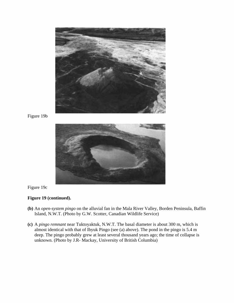
Figure 19b
Figure 19c
Figure 19 (continued).
(b) An open-system pingo on the alluvial fan in the Mala River Valley, Borden Peninsula, BaffinIsland, N.W.T. (Photo by G.W. Scotter, Canadian Wildlife Service)
(c) A pingo remnant near Tuktoyaktuk, N.W.T. The basal diameter is about 300 m, which isalmost identical with that of Ibyuk Pingo (see (a) above). The pond in the pingo is 5.4 mdeep. The pingo probably grew at least several thousand years ago; the time of collapse isunknown. (Photo by J.R- Mackay, University of British Columbia)
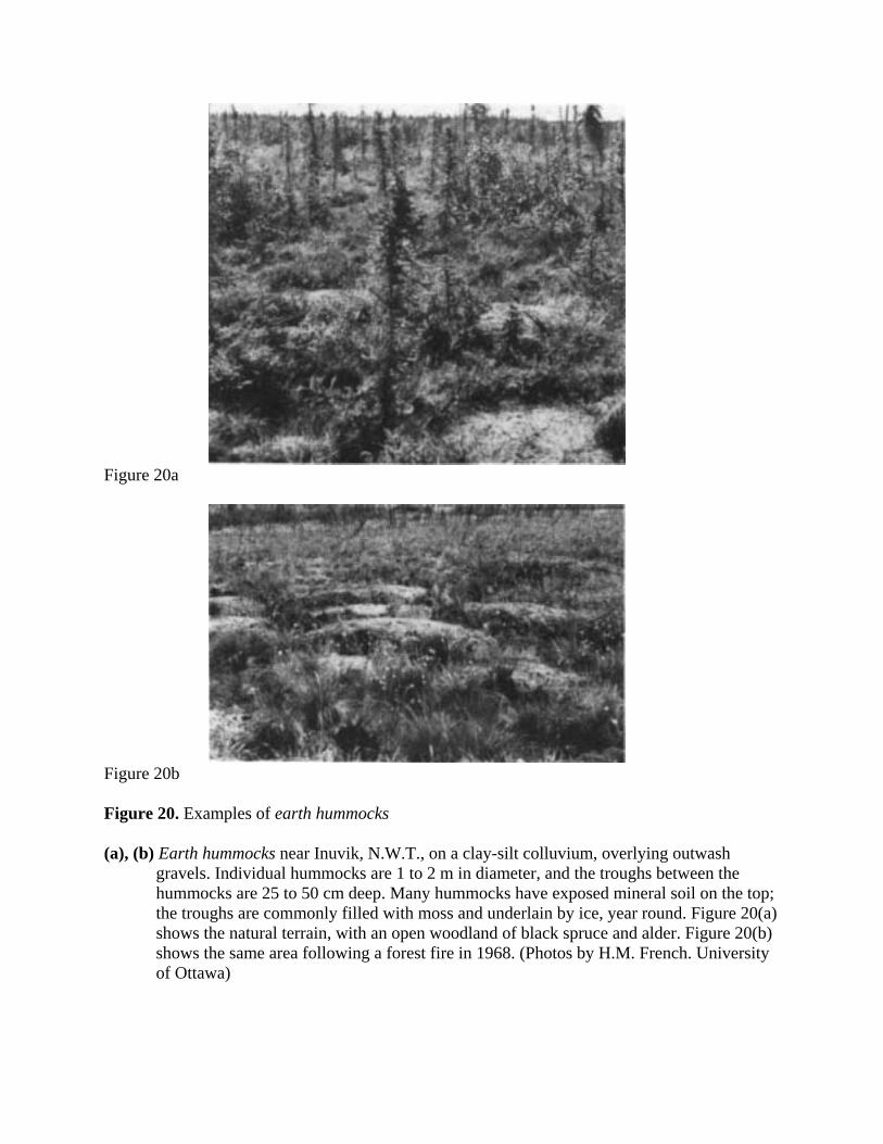
Figure 20a
Figure 20b
Figure 20. Examples of earth hummocks
(a), (b) Earth hummocks near Inuvik, N.W.T., on a clay-silt colluvium, overlying outwashgravels. Individual hummocks are 1 to 2 m in diameter, and the troughs between thehummocks are 25 to 50 cm deep. Many hummocks have exposed mineral soil on the top;the troughs are commonly filled with moss and underlain by ice, year round. Figure 20(a)shows the natural terrain, with an open woodland of black spruce and alder. Figure 20(b)shows the same area following a forest fire in 1968. (Photos by H.M. French. Universityof Ottawa)

Figure 20c
Figure 20d
Figure 20 (continued).
(c) Turf hummock consisting of living and dead Sphagnum fuscum, District of Keewatin, N.W.T.(Photo by S.C. Zoltai, Environment Canada)
(d) Thufa in volcanic ash soils, Sunshine Meadows, near Banff, Alberta. (Photo by S.C. Zoltai,Environment Canada)
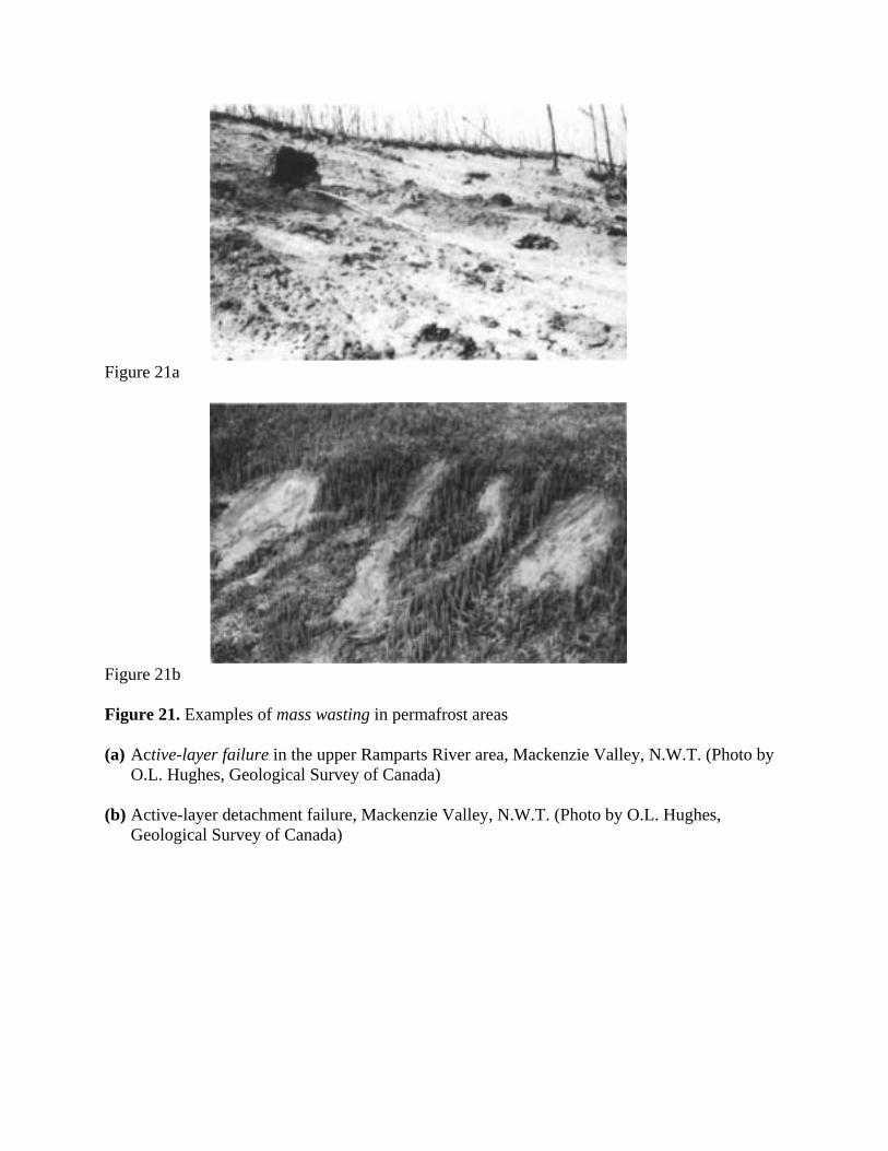
Figure 21a
Figure 21b
Figure 21. Examples of mass wasting in permafrost areas
(a) Active-layer failure in the upper Ramparts River area, Mackenzie Valley, N.W.T. (Photo byO.L. Hughes, Geological Survey of Canada)
(b) Active-layer detachment failure, Mackenzie Valley, N.W.T. (Photo by O.L. Hughes,Geological Survey of Canada)

Figure 21c
Figure 21d
Figure 21 (continued).
(c) Retrogressive thaw slumping in a borrow pit on the Dempster Highway near Ft. McPherson,N.W.T. (Photo by O.L. Hughes, Geological Survey of Canada)
(d) Retrogressive thaw slumping on the Yukon coastal plain near King Point, Yukon Territory.(Photo by J-S. Vincent, Geological Survey of Canada)
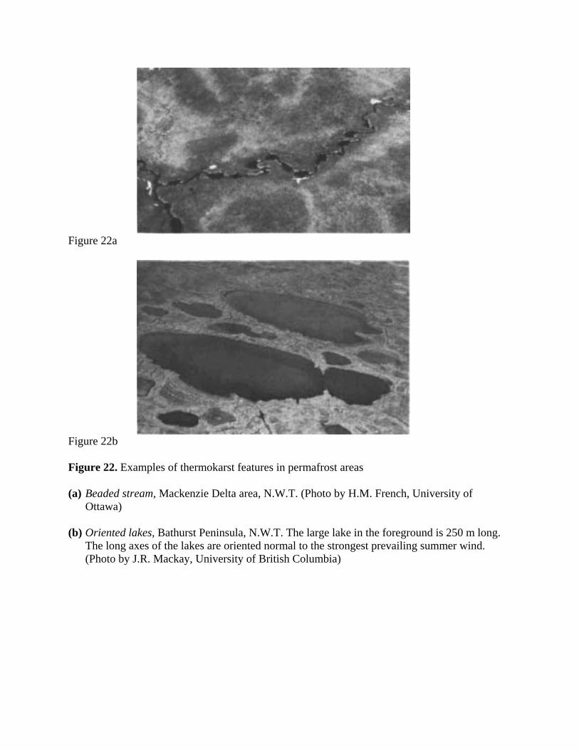
Figure 22a
Figure 22b
Figure 22. Examples of thermokarst features in permafrost areas
(a) Beaded stream, Mackenzie Delta area, N.W.T. (Photo by H.M. French, University ofOttawa)
(b) Oriented lakes, Bathurst Peninsula, N.W.T. The large lake in the foreground is 250 m long.The long axes of the lakes are oriented normal to the strongest prevailing summer wind.(Photo by J.R. Mackay, University of British Columbia)

Figure 22c Figure 22d
Figure 22e
Figure 22 (continued).
(c) Thermokarst lake showing shoreline erosion; shore of a typical expanding lake on overgrownpasture, west of Takhini River Crossing, Alaska Highway, Yukon Territory. (Photo by R.W.Klassen, Geological Survey of Canada)
(d) Thermo-erosional niche along the bank of the Rock River, Yukon Territory. (Photo by O.L.Hughes, Geological Survey of Canada)
(e) Fresh thermokarst terrain developing as a result of thawing of ice wedges in a borrow pit onthe Dempster Highway near the crossing of the Blackstone River, Yukon Territory. (Photoby O.L. Hughes, Geological Survey of Canada)

Figure 23. Illustration of the development of frost and thaw bulbs around buried pipelines andunder buildings placed on the ground surface in permafrost and non-permafrostareas. For pipelines, the diagram illustrates a chilled pipeline in a non-permafrostarea and a warm pipeline in a permafrost area. For buildings, the diagram illustratesa cold structure (e.g., an ice rink) in a non-permafrost area and a warm structure(e.g., a powerhouse) in a permafrost area. In all cases the pipelines and buildings areoperated at temperatures either above or below 0°C, continuously for several years.
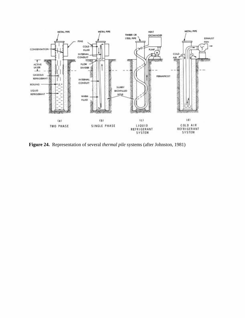
Figure 24. Representation of several thermal pile systems (after Johnston, 1981)

Revision – 2005 REFERENCES - 1
Åhman, R., 1977. "Palsar i Nordnorge." Meddelanden från Lund Universitets GeografiskaInstitution, Avhandlingar No.78, 165 p.
Åkerman, H.J. and van Everdingen, R.O., 1993. Permafrost Terms - The Swedish Contribution tothe International Permafrost Association Multilingual Index of Permafrost Terms. LundsUniversitets Naturgeografiska Institution, Rapporter och Notiser, No.78, 31 p.
Andersland, O.B. and Anderson, D.M. (Editors), 1978. Geotechnical Engineering for ColdRegions. McGraw-Hill, New York, N.Y., 576 p.
Anderson, D.M., Gatto, L.W. and Ugolini, F., 1973. "An examination of Mariner 6 and 7 imageryfor evidence of permafrost terrain on Mars." Proceedings Second International Conferenceon Permafrost, Yakutsk, U.S.S.R., July 1973, North American Contribution, U.S. NationalAcademy of Sciences, Washington, D.C., pp.499-508.
Anderson, D.M. and Morgenstern, N.R., 1973. "Physics, chemistry and mechanics of frozenground: A review." Proceedings Second International Conference on Permafrost, Yakutsk,U.S.S.R., July 1973, North American Contribution, U.S. National Academy of Sciences,Washington, D.C., pp.257-288.
Andersson, J.G., 1906. "Solifluction, a component of subaerial denudation." Journal of Geology,Vol. 14, pp.91-112.
Are, F.E., 1978. " The reworking of shorelines in the permafrost zone." Proceedings SecondInternational Conference on Permafrost, Yakutsk, U.S.S.R., July 1973, U.S.S.R.Contribution, U.S. National Academy of Sciences, Washington, D.C., pp.59-62.
Baranov, I.Ya., 1978. "Problems of cryology." Proceedings Second International Conference onPermafrost, Yakutsk, U.S.S.R., July 1973, U.S.S.R. Contribution, U.S. National Academyof Sciences, Washington, D.C., pp.3-7.
Benedict, J.B., 1970. "Downslope soil movement in a Colorado alpine region: rates, processes andclimatic significance." Arctic and Alpine Research, Vol. 2, No. 3, pp.165-226.
Berg, T.E. and Black, R.F., 1966. "Preliminary measurements of growth of nonsorted polygons,Victoria Land, Antarctica." In: Antarctic Soils and Soil-Forming Processes (J.F.S. Tedrow,Editor), American Geophysical Union Antarctic Research Series, U.S. National Academy ofSciences, Washington, D.C., Publication 1418, pp.61-108.
Bily, C. and Dick, J.W.L., 1974. "Naturally occurring gas hydrates in the Mackenzie Delta,N.W.T." Bulletin of Canadian Petroleum Geology, Vol. 22, pp.340-352.
Black, R.F., 1969. "Climatically significant fossil periglacial phenomena in northcentral UnitedStates." Biuletyn Periglacjalny, No. 20, pp.225-238.
Black, R.F., 1976. "Features indicative of permafrost." Annual Review of Earth and PlanetarySciences (F.A. Donath, Editor). Annual Reviews, Inc., Palo Alto, California, Vol. 4, pp.75-94.
Black, R.F. and Barksdale, W.L., 1949. "Oriented lakes of northern Alaska." Journal of Geology,Vol. 57, pp.105-118.
Black, R.F. and Berg, T.E., 1966. "Patterned ground in Antarctica." Proceedings PermafrostInternational Conference, Lafayette, Indiana, November 1963, U.S. National Academy ofSciences, Washington, D.C., Publication No. 1287, pp.121-128.
Blanchard, D. and Frémond, M., 1982. "Cryogenic suction in soils." Proceedings ThirdInternational Symposium on Ground Freezing, Hanover, New Hampshire, June 1982, (Vol.1), pp.233-238.
Boyd, D.W., 1973. Normal freezing and thawing degree-days for Canada: 1931-1960. Environment Canada, Atmospheric Environment Service, Downsview, Ontario, PublicationCLI 4-73, 38 p.
Boyd, D.W., 1979. Degree days: The different types. National Research Council Canada,Division of Building Research, Ottawa, Building Research Note No. 138, 8 p.
Brewer, M.C., 1958. "Some results of geothermal investigations of permafrost in northernAlaska." Transactions, American Geophysical Union, Vol. 39, No. 1, pp.19-26.
2 – REFERENCES Revision – 2005
Brewer, R. and Pawluk, S., 1975. "Investigations of some soils developed in hummocks of theCanadian sub-Arctic and southern Arctic regions." 1. Morphology and Micromorphology. Canadian Journal of Soil Science, Vol. 55, No. 3, pp.301-319.
Brown, J., 1969. "Soils of the Okpilak River Region, Alaska." In: The Periglacial Environment(T.L. Péwé, Editor), McGill-Queen's University Press, Montreal, pp.93-128.
Brown, J., Ferrians, O.J. Jr., Heginbottom, J.A., and Melnikov, E.S., 1997. Circumarctic map ofpermafrost and ground ice conditions. U.S. Geological Survey, Map CP-45, scale1:10,000,000.
Brown, R.J.E., 1966. "Permafrost, climafrost, and the muskeg H factor." Proceedings EleventhMuskeg Research Conference, National Research Council Canada, Associate Committee onSoil and Snow Mechanics, Ottawa, Technical Memorandum No. 87, pp.159-178.
Brown, R.J.E., 1967a. "Comparison of permafrost conditions in Canada and the U.S.S.R." PolarRecord, Vol. 13, No. 87, pp.741-751.
Brown, R.J.E., 1967b. Permafrost Map of Canada. National Research Council Canada, Pub. NRC9769 and Geological Survey of Canada, Map 1246A (with marginal notes).
Brown, R.J.E., 1970a. "Occurrence of permafrost in Canadian peatlands." Proceedings ThirdInternational Peat Congress, Quebec, 1968, National Research Council Canada, Ottawa,pp.174-181.
Brown, R.J.E., 1970b. Permafrost in Canada: Its influence on northern development. Universityof Toronto Press, Toronto, 234 p.
Brown, R.J.E., 1971. Characteristics of the active layer in the permafrost region of Canada. Proceedings Seminar on Permafrost Active Layer, May 1971, National Research CouncilCanada, Associate Committee on Geotechnical Research, Ottawa, Technical Memorandum103, pp.1-7.
Brown, R.J.E., 1978. Permafrost Map of Canada. In: Hydrological Atlas of Canada, Departmentof Fisheries and Environment, Ottawa, Canada, Plate No. 32.
Brown, R.J.E. and Kupsch, W.O., 1974. Permafrost Terminology. National Research CouncilCanada, Associate Committee on Geotechnical Research, Ottawa, Technical MemorandumNo. 111, 62 p.
Brown, R.J.E. and Kupsch, W.O., 1979. Terminologie du pergélisol. Conseil national derecherches du Canada, Comité associé de recherches géotechniques, Ottawa, Mémoiretechnique No. 111, 66 p.
Bryan, K., 1946. "Cryopedology - the study of frozen ground and intensive frost action withsuggestions on nomenclature." American Journal of Science, Vol. 244, pp.622-642.
Burn, C., 1994. "Permafrost, tectonics, and past and future regional climate change, Yukon andadjacent Northwest Territories." Canadian Journal of Earth Sciences, Vol.31, pp.182-191.
Canada Soil Survey Committee, 1978. The Canadian System of Soil Classification. AgricultureCanada, Ottawa, Publication 1646, 164 p.
Capps, S.R., Jr., 1910. "Rock glaciers in Alaska." Journal of Geology, Vol. 18, pp.359-375.Carey, K.L., 1970. Icing occurrence, control and prevention: An annotated bibliography. U.S.
Army, C.R.R.E.L., Hanover, New Hampshire, Special Report 151, 57 p.Carey, K.L., 1973. Icings developed from surface water and ground water. U.S. Army,
C.R.R.E.L., Hanover, New Hampshire, Monograph MIII-D3, 67 p.Carlson, H. and Kersten, M.S., 1953. "Calculation of depths of freezing and thawing under
pavements." U.S. National Research Council, Highway Research Board, Bulletin No. 71,pp.81-98 (includes Discussion by H.P.Aldrich and H.M. Paynter).
Carson, C.E. and Hussey, K.M., 1962. "The oriented lakes of Arctic Alaska." Journal of Geology,Vol. 70, pp.417-439.
Chamberlain, E.J., 1981. Frost susceptibility of soil: Review of index tests. U.S. Army,C.R.R.E.L., Hanover, New Hampshire, Monograph 81-2, 121 p.
Cheng, Guodong, 1983. "The mechanism of repeated-segregation for the formation of thicklayered ground ice." Cold Regions Science and Technology, Vol. 8, pp.57-66.

Revision – 2005 REFERENCES - 3
Corte, A.E., 1962. "Vertical migration of particles in front of a moving freezing plane." Journal ofGeophysical Research, Vol. 67, pp.1085-1090.
Czudek, T. and Demek, J., 1970. "Thermokarst in Siberia and its influence on the development oflowland relief." Quaternary Research, Vol. I, pp.103-120.
Delorme, L.D., Zoltai, S.C. and Kalas, L.L., 1978. "Freshwater shelled invertebrate indicators ofpaleoclimate in northwestern Canada during late glacial times: Reply". Canadian Journal ofEarth Sciences, Vol. 15, No. 3, pp.462-463.
Demek, J., 1969. "Cryoplanation terraces, their geographical distribution, genesis anddevelopment." Ceskoslovenské Akademie Ved Rozprovy, Rada Matematickych aPrirodnich Ved, Vol. 79, No. 4, 80 p.
Dostovalov, B.N. and Popov, A.I., 1966. "Polygonal systems of ice wedges and conditions of theirdevelopment." Proceedings Permafrost International Conference, Lafayette, Indiana,November 1963, U.S. National Academy of Sciences, Washington, D.C., Publication 1287,pp.102-105.
Dyke, L.D., 1981. "Bedrock heave in the central Arctic." Geological Survey of Canada, Ottawa,Paper 81-1A, pp.157-167.
Dyke, L.D., 1984. "Frost heaving of bedrock in permafrost regions." Bulletin of the Associationof Engineering Geologists, Vol. 21, No. 4, pp.389-405.
Dylik, J., 1964. "Éléments essentiels de la notion de 'périglaciaire'." Biuletyn Peryglacjalny, No.14, pp.111-132.
Dylikowa, A. (Ed.), 1995. Permafrost Terminology. Biuletyn Peryglacjalny, No.32, 176 p.Eakin, H.M., 1916. "The Yukon-Koyukuk region, Alaska." U.S. Geological Survey, Bulletin No.
631, pp.67-88.Fanale, F.P. and Clark, R.N., 1983. "Solar system ices and Mars permafrost." Proceedings Fourth
International Conference on Permafrost, Fairbanks, Alaska, July 1983, National AcademyPress, Washington, D.C., pp.289-294.
Ferrians, O.J., Jr., Kachadoorian, R. and Greene, G.W., 1969. Permafrost and related engineeringproblems in Alaska. U.S. Geological Survey, Professional Paper 678, 37p.
Flemal, R.C., 1976. "Pingos and pingo scars: Their characteristics, distribution, and utility inreconstructing former permafrost environments." Quaternary Research, Vol. 6, No. 1,pp.37-53.
Fosgren, B., 1966. "Tritium determinations in the study of palsa formation." Geografiska Annaler,Vol. 48A, pp.102-110.
Fosgren, B., 1968. "Studies of palsas in Finland, Norway and Sweden." Biuletyn Peryglacjalny,No. 17, pp.117-123.
Fotiev, S.M., 1978. "Effect of long-term cryometamorphism of earth materials on the formation ofgroundwater." Proceedings Third International Conference on Permafrost, Edmonton,Alberta, National Research Council Canada, Ottawa, Vol. 1, pp.181-187 (In Russian).Translation in: English translations of the forty-nine Soviet papers, the one French paper,and the three invited Soviet theme papers, Part I: English translations of twenty-six of theSoviet papers, National Research Council Canada, Ottawa, Publication No. NRCC 18119,1980, pp.177-194.
Fox, C.A., 1983. "Micromorphology of an orthic turbic cryosol--a permafrost soil." In: SoilMicromorphology (P.Bullock and G.P.Murphy, Editors), A.B. Academic Publishers,Oxford, pp.699-705.
French, H.M., 1975. "Man-induced thermokarst development, Sachs Harbour airstrip, BanksIsland, N.W.T." Canadian Journal of Earth Sciences, Vol. 12, No. 2, pp.132-144.
French, H.M., 1976. The Periglacial Environment. Longman Group Limited, London and NewYork, 309 p.
French, H.M., Harry, D.G. and Clark, M.J., 1982. "Ground ice stratigraphy late-Quaternary events,southwest Banks Island, Canadian Arctic." The Roger J.E. Brown Memorial Volume,
4 – REFERENCES Revision – 2005
Proceedings Fourth Canadian Permafrost Conference, Calgary, Alberta, March 1981,National Research Council Canada, Ottawa, pp.81-90.
Fries, T. and Bergström, E., 1910. "Några iakttagelser öfver palsar och deras förekomst inordligaste Sverige." Geologiska Föreningen Förhandlingar, Vol.32, pp.195-205.
Fujii, Y. and Higuchi, K., 1978. "Distribution of alpine permafrost in the northern hemisphere andits relation to air temperature." Proceedings Third International Conference on Permafrost,Edmonton, Alberta, July 1978, National Research Council Canada, Ottawa, Vol. 1, pp.366-371.
Fyodorov, J.S. (compiler) and Ivanov, N.S. (Editor), 1974. English-Russian geocryologicaldictionary. Yakutsk State University, Yakutsk, U.S.S.R., 127 p.
Garg, O.P., 1973. "In situ physicomechanical properties of permafrost using geophysicaltechniques." Proceedings Second International Conference on Permafrost, Yakutsk,U.S.S.R., July 1973, North American Contribution, U.S. National Academy of Sciences,Washington, D.C., pp.508-517.
Gell, W.A., 1978. "Thermal contraction cracks in massive segregated ice, Tuktoyaktuk Peninsula,N.W.T., Canada." Proceedings Third International Conference on Permafrost, Edmonton,Alberta, July 1978, National Research Council Canada, Ottawa, Vol. 1, pp.278-281.
Gilpin, R.R., 1982. "A frost heave interface condition for use in numerical modelling." The RogerJ.E. Brown Memorial Volume, Proceedings Fourth Canadian Permafrost Conference,Calgary, Alberta, March 1981, National Research Council Canada, Ottawa, pp.459-465.
Glen, J.W., 1974. The physics of ice. U.S. Army, C.R.R.E.L., Hanover, New Hampshire,Monograph II-C2a, 86 p.
Gold, L.W., 1967. "Influence of surface conditions on ground temperature." Canadian Journal ofEarth Sciences, Vol. 4, No. 2, pp.199-208.
Gold, L.W. and Lachenbruch, A.H., 1973. "Thermal conditions in permafrost: A review of NorthAmerican literature." Proceedings Second International Conference on Permafrost, Yakutsk,U.S.S.R., July 1973, North American Contribution, U.S. National Academy of Sciences,Washington, D.C., pp.3-25.
Goodrich, L.E., 1982. "The influence of snow cover on the ground thermal regime." CanadianGeotechnical Journal, Vol. 19, No. 4, pp.421-432.
Goździk, J., 1973. "Origin and stratigraphic position of periglacial structures in Middle Poland." Acta Geographica, Vol. 31, pp.104-117.
Haeberli, W., 1973. "Die Basis-Temperatur der winterlichen Schneedecke als möglicher Indikatorfür die Verbreitung von Permafrost in den Alpen." Zeitschrift für Gletscherkunde undGlazialgeologie, Vol. 9, pp.221-227.
Harris, S.A., 1979. "Ice caves and permafrost zones in southwest Alberta." Erdkunde, Vol. 33,pp.61-70.
Harris, S.A., 1981. "Climatic relationships of permafrost zones in areas of low winter snow-cover." Arctic, Vol. 36, No. 1, pp.64-70.
Harris, S.A., 1986. "Permafrost distribution, zonation and stability along the eastern ranges of theCordillera of North America." Arctic, Vol. 39, No. 1, pp.29-38.
Harris, S.A., 1993. "Palsa-like mounds developed in a mineral substrate, Fox Lake, YukonTerritory." Proceedings, Sixth International Conference on Permafrost, Beijing, 1993, SouthChina University of Technology Press, Vol.1, pp.238-243.
Harris, S.A. and Brown, R.J.E., 1978. "Plateau Mountain: A case study of alpine permafrost in theCanadian Rocky Mountains." Proceedings Third International Conference on Permafrost,Edmonton, Alberta, July 1978, National Research Council Canada, Ottawa, Vol. 1, pp.385-391.
Harris, S.A. and Brown, R.J.E., 1982. "Permafrost distribution along the Rocky Mountains inAlberta." The Roger J.E. Brown Memorial Volume, Proceedings Fourth CanadianPermafrost Conference, Calgary, Alberta, March 1981, National Research Council Canada,Ottawa, pp.59-67.
Revision – 2005 REFERENCES - 5
Harry, D.G. and French, H.M., 1983. "The orientation and evolution of thaw lakes, southwestBanks Island, Canadian Arctic." Proceedings Fourth International Conference onPermafrost, Fairbanks, Alaska, July 1983, U.S. National Academy Press, Washington, D.C.,pp.456-461.
Harry, D.G., French, H.M. and Clark, M.J., 1983. "Coastal conditions and processes, SachsHarbour, southwest Banks Island, Western Canadian Arctic." Zeitschrift fürGeomorphologie, Supplement Band 47, pp.1-26.
Hayley, D.W., 1982. "Application of heat pipes to design of shallow foundations on permafrost." The Roger J.E. Brown Memorial Volume, Proceedings Fourth Canadian PermafrostConference, Calgary, Alberta, March 1981, National Research Council Canada, Ottawa,pp.535-544.
Hayley, D.W., Roggensack, W.D., Jubien, W.E. and Johnson, P.V., 1983. "Stabilization ofsinkholes on the Hudson Bay Railway." Proceedings Fourth International Conference onPermafrost, Fairbanks, Alaska, July 1983, U.S. National Academy Press, Washington, D.C.,pp.468-473.
Heginbottom, J.A., 1984. "The mapping of permafrost." Canadian Geographer, Vol. 28, No. 1,pp.78-83.
Heginbottom, J.A. and Radburn, L.K. (compilers), 1992. Permafrost and ground ice conditions ofNorthwestern Canada / Conditions relatives au pergélisol et à la glace de sol du nord-ouestdu Canada. Geological Survey of Canada / Commission géologique du Canada. Map / carte1691-A, scale / échelle de 1:1,000,000, 2 sheets / feuilles (Bilingual / bilangue).
Hennion, F., 1955. "Frost and permafrost definitions." U.S. National Research Council, HighwayResearch Board, Washington, D.C., HRB Bulletin 111, pp.107-110.
Heuer, C.E., 1979. The application of heat pipes on the Trans-Alaska pipeline. U.S. Army,C.R.R.E.L., Hanover, New Hampshire, Special Report 79-26, 33 p.
Hoelzle, M.W., Haeberli, W. and Keller, F. 1993. "Application of BTS-measurements formodelling mountain permafrost distribution." Proceedings, Sixth International Conferenceon Permafrost, Beijing, 1993, South China University of Technology Press, Vol.1, pp.272-277.
Hopkins, D.M., 1949. "Thaw lakes and thaw sinks in the Imuruk Lake area, Seward Peninsula,Alaska." Journal of Geology, Vol. 57, pp.119-131.
Hopkins, D.M., Karlstrom, T.D. and others, 1955. "Permafrost and ground water in Alaska." U.S.Geological Survey, Professional Paper 264-F, pp.113-146.
Hughes, O.L., 1969. Distribution of open-system pingos in central Yukon Territory with respect toglacial limits. Geological Survey of Canada, Ottawa, Paper 69-34, 8 p.
Hughes, O.L., 1972. "Surficial geology and land classification." Proceedings Canadian NorthernPipeline Conference, Ottawa, Ontario, February 1972, National Research Council Canada,Associate Committee on Geotechnical Research, Ottawa, Technical Memorandum No. 104,pp.17-24.
Hunter, J.A., 1984. "Geophysical techniques for subsea permafrost investigations." FinalProceedings Fourth International Conference on Permafrost, Fairbanks, Alaska, July 1983,U.S. National Academy Press, Washington, D.C., pp.88-89.
Hunter, J.A., Judge, A.S., MacAulay, H.A., Good, R.L., Gagne, R.M. and Burns, R.A., 1976. Theoccurrence of permafrost and frozen sub-seabottom materials in the southern Beaufort Sea. Environment Canada, Ottawa, Beaufort Sea Technical Report No. 22: Beaufort Sea Project,174 p.
Huschke, R.E. (Editor), 1959. Glossary of Meteorology. American Meteorological Society, 638 p.Hutchinson, J.N., 1968. "Mass movement." In: Encyclopedia of Geomorphology (R.W.
Fairbridge, Editor), Reinhold Book Corporation, New York, N.Y., pp.688-689.Jahn, A., 1975. Problems of the periglacial zone (Zagadnienia strefy peryglacjalnej). Warsaw,
Panstwowe Wydawnictwo Naukowe, 223 p.
6 – REFERENCES Revision – 2005
Johnston, G.H. (Editor), 1981. Permafrost: Engineering Design and Construction. John Wiley &Sons, Canada Ltd., Toronto, 540 p.
Judge, A.S., 1982. "Natural gas hydrates in Canada." The Roger J.E. Brown Memorial Volume,Proceedings Fourth Canadian Permafrost Conference, Calgary, Alberta, March 1981,National Research Council Canada, Ottawa, pp.320-328.
Jumikis, A.R., 1977. Glossary of terms in thermal soil mechanics. Rutgers University, NewJersey, Engineering Research Publication No. 57, 155 p.
Kaplan, I.R., 1974. "Introduction." In: Natural Gases in Marine Sediments (I.R. Kaplan, Editor),Plenum Press, New York, N.Y., pp.1-11.
King, M.S., Bamford, T.S. and Kurfurst, P.J., 1974. "Ultrasonic velocity measurements on frozenrocks and soils." Proceedings Symposium on Permafrost Geophysics, Calgary, Alberta,National Research Council Canada, Associate Committee on Geotechnical Research,Ottawa, Technical Memorandum No. 113, pp.35-42.
Konrad, J-M. and Morgenstern, N.R., 1983. "Frost susceptibility of soils in terms of theirsegregation potential." Proceedings Fourth International Conference on Permafrost,Fairbanks, Alaska, July 1983, U.S. National Academy Press, Washington, D.C., pp.660-665.
Konrad, J-M. and Morgenstern, N.R., 1984. "Frost heave prediction of chilled pipelines buried inunfrozen soils." Canadian Geotechnical Journal, Vol. 21, No. 1, pp.100-115.
Krumme, O., 1935. Frost und Schnee in ihrer Wirkung auf den Boden im Hochtaunus. Rhein-Mainische Forschungen, 13, 73 p.
Kudryavtsev, V.A. (Editor), 1978. Obshcheye merzlotovedeniya (Geokriologiya) (Generalpermafrost science) In Russian. Izd. 2, (Edu 2) Moskva (Moscow), Izdatel'stvoMoskovskogo Universiteta, (Moscow University Editions), 404 p.
Lachenbruch, A.H., 1959. "Periodic heat flow in a stratified medium with application topermafrost problems." U.S. Geological Survey, Bulletin 1083-A, pp.1-36.
Lachenbruch, A.H., 1962. Mechanics of thermal contraction cracks and ice-wedge polygons inpermafrost. U.S. Geological Survey, Special Paper 70, 69 p.
Lachenbruch, A.H., 1966. "Contraction theory of ice-wedge polygons: a qualitative discussion." Proceedings Permafrost International Conference, Lafayette, Indiana, November 1963, U.S.National Academy of Sciences, Washington, D.C., Publication 1287, pp.63-71.
Ladanyi, B., 1972. "An engineering theory of creep of frozen soils." Canadian GeotechnicalJournal, Vol. 9, No. 1, pp.63-80.
Ladanyi, B., 1981. "Mechanical behaviour of frozen soils." In: Mechanics of Structured Media,Proceedings International Symposium on the Mechanical Behaviour of Structured Media,Ottawa, Canada, May 1981. (A.P.S. Selvadurai, Editor) Part B, Elsevier, Amsterdam,pp.205-245.
Lawson, D.E. and Brown, J., 1978. "Disturbance of permafrost, massive ground ice, and surficialmaterials." In: Tundra disturbance and recovery following the 1949 exploratory drilling,Fish Creek, Northern Alaska by D.E. Lawson et al., U.S. Army, C.R.R.E.L., Hanover, NewHampshire, Report 78-28, pp.14-24.
Linell, K.A., and Kaplar, C.W., 1966. "Description and classification of frozen soils." Proceedings Permafrost International Conference, Lafayette, Indiana, November 1963, U.S.National Academy of Sciences, Washington, D.C., Publication 1287, pp.481-487.
Linell, K.A. and Lobacz, E.F., 1980. Design and construction of foundations in areas of deepseasonal frost and permafrost. U.S. Army, C.R.R.E.L., Hanover, New Hampshire, SpecialReport 80-34, 320 p.
Long, E.L., 1966. "The Long Thermopile." Proceedings Permafrost International Conference,Lafayette, Indiana, November 1963. U.S. National Academy of Sciences, Washington,D.C., Publication 1287, pp.487-491.
Lunardini, V.J., 1978. "Theory of n-factors and correlation of data." Proceedings ThirdInternational Conference on Permafrost, Edmonton, Alberta, July 1978, National ResearchCouncil Canada, Ottawa, Vol. 1, pp.41-46.

Revision – 2005 REFERENCES - 7
Lunardini, V.J., 1981. Heat Transfer in Cold Climates. Van Nostrand Reinhold, New York, N.Y.,704 p.
Lundqvist, S., 1962. "Patterned ground and related phenomena in Sweden." Sveriges GeologiskaUndersökning, Series C, No. 583.
Lundqvist, J., 1969. "Earth and ice mounds: A terminological discussion." In: The PeriglacialEnvironment (T.L. Péwé, Editor), McGill-Queen's University Press, Montreal, pp.203-215.
Lundqvist, S. and Mattsson, J.O., 1965. "Studies on the thermal structure of pals." SvenskGeografisk Årgbok, Vol. 41, pp.38-49
Mackay, J.R., 1965. "Gas-domed mounds in permafrost, Kendall Island, N.W.T." GeographicalBulletin, Vol. 7, No. 2, pp.105-115.
Mackay, J.R., 1966. "Segregated epigenetic ice and slumps in permafrost, Mackenzie Delta area,N.W.T." Geographical Bulletin, Vol. 8, No. 1, pp.59-80.
Mackay, J.R., 1970. "Disturbances to the tundra and forest tundra environment of the westernArctic." Canadian Geotechnical Journal, Vol. 7, No. 4, pp.420-432.
Mackay, J.R., 1971. "The origin of massive icy beds in permafrost, western Arctic coast, Canada." Canadian Journal of Earth Sciences, Vol. 8, No. 4, pp.397-422.
Mackay, J.R., 1972a. "Offshore permafrost and ground ice, southern Beaufort Sea, Canada." Canadian Journal of Earth Sciences, Vol. 9, No. 11, pp.1550-1561.
Mackay, J.R., 1972b. "The world of underground ice." Annals Association AmericanGeographers, Vol. 62, No. 1, pp.1-22.
Mackay, J.R., 1973a. "Problems in the origin of massive icy beds, western Arctic coast, Canada." Proceedings Second International Conference on Permafrost, Yakutsk, U.S.S.R., July 1973,North American Contribution, U.S. National Academy of Sciences, Washington, D.C.,pp.223-228.
Mackay, J.R., 1973b. "The growth of pingos, western Arctic coast, Canada." Canadian Journal ofEarth Sciences, Vol. 10, No. 6, pp.979-1004.
Mackay, J.R., 1974a. "Measurement of upward freezing above permafrost with a self-positioningthermistor probe." Geological Survey of Canada, Ottawa, Paper 74-1, Part B, pp.250-251.
Mackay, J.R., 1974b. "Reticulate ice veins in permafrost, northern Canada." CanadianGeotechnical Journal, Vol. 11, No. 2, pp.230-237.
Mackay, J.R., 1975. "Relict ice wedges, Pelly Island, N.W.T." Geological Survey of Canada,Ottawa, Paper 75-1, pp.469-470.
Mackay, J.R., 1978. "Freshwater shelled invertebrate indicators of paleoclimate in northwesternCanada during late glacial times: Discussion." Canadian Journal of Earth Sciences, Vol. 15,No. 3, pp.461-462.
Mackay, J.R., 1979. "Pingos of the Tuktoyaktuk Peninsula area, Northwest Territories." Géographie physique et Quaternaire, Vol. 33, No. 1, pp.3-61.
Mackay, J.R., 1980. "The origin of hummocks, western Arctic coast, Canada." Canadian Journalof Earth Sciences, Vol. 17, No. 8, pp.996-1006.
Mackay, J.R., 1985. "Pingo ice of the western Arctic coast, Canada." Canadian Journal of EarthSciences, Vol. 22, No. 10, pp.1452-1464.
Mackay, J.R., 1990. "Some observations on the growth and deformation of epigenetic, syngeneticand anti-syngenetic ice wedges." Permafrost and Periglacial Processes, Vol. 1, pp.15-29.
Mackay, J.R. and Black, R.F., 1973. "Origin, composition, and structure of perennially frozenground and ground ice: A review." Proceedings Second International Conference onPermafrost, Yakutsk, U.S.S.R., July 1973, North American Contribution, U.S. NationalAcademy of Sciences, Washington, D.C., pp.185-192.
Mackay, J.R. and MacKay, D.K., 1976. "Cryostatic pressures in nonsorted circles (mudhummocks), Inuvik, Northwest Territories." Canadian Journal Earth Sciences, Vol. 13, No.7, pp.889-897.
Mackay, J.R. and Mathews, W.H., 1974. "Needle ice striped ground." Arctic and AlpineResearch, Vol. 6, No. 1, pp.79-84.

8 – REFERENCES Revision – 2005
Mackay, J.R. and Matthews, J.V., Jr., 1983. "Pleistocene ice and sand wedges, Hooper Island,Northwest Territories." Canadian Journal of Earth Sciences, Vol. 20, No. 7, pp.1087-1097.
Mackay, J.R., Rampton, V.N. and Fyles, J.G., 1972. "Relic pleistocene permafrost, western Arctic,Canada." Science, Vol. 176, pp.1321-1323.
McRoberts, E.C. and Morgenstern, N.R., 1974. "The stability of thawing slopes." CanadianGeotechnical Journal, Vol. 11, No. 4, pp.447-469.
Miller, R.D., 1972. Freezing and heaving of saturated and unsaturated soils. U.S. NationalResearch Council, Washington, D.C., Highway Research Record, No. 393, pp.1-11.
Morgenstern, N.R. and Nixon, J.F., 1971. "One-dimensional consolidation of thawing soils." Canadian Geotechnical Journal, Vol. 8, No. 4, pp.558-565.
Müller, F., 1959. Beobachtungen über Pingos. Detailuntersuchungen in Ostgrönland und in derkanadischen Arktis: Meddelelser om Grønland, Vol. 153, No. 3, 127 p. (Observations onPingos. Translation published by National Research Council Canada, Ottawa, TechnicalTranslation 1073, 1963, 117 p.)
Muller, S.W., 1943. Permafrost or permanently frozen ground and related engineering problems. U.S. Engineers Office, Strategic Engineering Study, Special Report No. 62, 136 p.(Reprinted in 1947, J.W. Edwards, Ann Arbor, Michigan, 231 p.)
Newbury, R.W., Beaty, K.G. and McCullough, G.K., 1978. "Initial shoreline erosion in apermafrost affected reservoir, Southern Indian Lake, Canada." Proceedings ThirdInternational Conference on Permafrost, Edmonton, Alberta, July 1978, National ResearchCouncil Canada, Ottawa, Vol. 1, pp.833-839.
Nixon, J.F., 1982. "Frost heave predictions using the segregation potential concept." CanadianGeotechnical Journal, Vol. 19, No. 4, pp.526-529.
Nixon, J.F. and Morgenstern, N.R., 1973. "The residual stress in thawing soils." CanadianGeotechnical Journal, Vol. 10, No. 4, pp.571-580.
Osterkamp, T.E. and Payne, M.W., 1981. "Estimates of permafrost thickness from well logs innorthern Alaska." Cold Regions Science and Technology, Vol. 5, No. 1, pp.13-27.
Outcalt, S.I., Nelson, F.E. and Hinkel, K.M. 1990. The zero-curtain effect: Heat and mass transferacross an isothermal region in freezing soil. Water Resources Research, Vol. 26, No. 7,pp.1509-1516.
Pawluk, S. and Brewer, R., 1975. "Micromorphological and analytical characteristics of some soilsfrom Devon and King Christian Islands, N.W.T." Canadian Journal of Soil Science, Vol. 55,No. 3, pp.349-361.
Penner, E., 1967. "Pressures developed during the uni-directional freezing of water-saturatedporous materials." Proceedings International Conference on Low Temperature Science,Sapporo, Japan, 1966, Vol. 1, Part 2, pp.1401-1412.
Penner, E., 1968. "Particle size as a basis for predicting frost action in soils." Soils andFoundations, Vol. 8, No. 4, pp.21-29.
Penner, E., 1970. "Thermal conductivity of frozen soils." Canadian Journal of Earth Sciences,Vol. 7, No. 3, pp.982-987.
Penner, E., 1972. "Soil moisture redistribution by ice lensing in freezing soils." Proceedings 17thAnnual Meeting, Canadian Society of Soil Science, Lethbridge, Alberta, July 1971, pp.44-62.
Permafrost Subcommittee. 1988. Glossary of Permafrost and Related Ground-Ice Terms. Associate Committee on Geotechnical Research, National Research Council of Canada,Ottawa, Technical Memorandum No. 142, 156p.
Péwé, T.L., 1954. "Effect of permafrost upon cultivated fields." U.S. Geological Survey, Bulletin989-F, pp.315-351.
Péwé, T.L., 1983. "Alpine permafrost in the contiguous United States: A review." Arctic andAlpine Research, Vol. 15, No. 2, pp.145-156.
Revision – 2005 REFERENCES - 9
Pihlainen, J.A. and Johnston, G.H., 1963. Guide to a field description of permafrost. NationalResearch Council Canada, Associate Committee on Soil and Snow Mechanics, Ottawa,Technical Memorandum No. 79, 21 p.
Pissart, A. and French, H.M., 1976. "Pingo investigations, north central Banks Island, CanadianArctic." Canadian Journal of Earth Sciences, Vol. 13, No. 7, pp.937-946.
Pollard, W.H. and French, H.M., 1980. "A first approximation of the volume of ground ice,Richards Island, Pleistocene Mackenzie Delta, Northwest Territories, Canada." CanadianGeotechnical Journal, Vol. 17, No. 4, November, pp.509-516.
Pollard, W.H. and French, H.M., 1984. "The groundwater hydraulics of seasonal frost mounds,North Fork Pass, Yukon Territory." Canadian Journal of Earth Sciences, Vol. 21, No. 10,pp.1073-1081.
Polunin, N., 1951. "The real Arctic; suggestions for its delimitation, subdivision, andcharacteristics." Journal of Ecology, Vol. 39, pp.308-315.
Poppe, V. and Brown, R.J.E., 1976. Russian-English glossary of permafrost terms. NationalResearch Council Canada, Associate Committee on Geotechnical Research, Ottawa,Technical Memorandum No. 117, 25 p.
Porsild, A.E., 1938. "Earth mounds in unglaciated Arctic northwest America." GeographicalReview, Vol. 28, pp.46-58.
Price, W.A., 1968. "Oriented lakes." In: Encyclopedia of Geomorphology (R.W. Fairbridge,Editor), Reinhold Book Corporation, New York, N.Y., pp.784-796.
Qiu Guoqing, Liu Jinren, and Liu Hongxu (Eds.), 1994. Geocryological Glossary: Chinese-English-Russian. Lanzhou Institute of Glaciology and Geocryology, Lanzhou, China, 275 p.
Rampton, V.N., 1974. "The influence of ground ice and thermokarst upon the geomorphology ofthe Mackenzie-Beaufort region." In: Research in Polar and Alpine Geomorphology (B.D.Fahey and R.D. Thompson, Editors), Proceedings 3rd Guelph Symposium onGeomorphology, pp.43-59.
Rampton, V.N. and Mackay, J.R., 1971. Massive ice and icy sediments throughout theTuktoyaktuk Peninsula, Richards Island, and nearby areas, District of Mackenzie. Geological Survey of Canada, Ottawa, Paper 71-21, 16 p.
Rampton, V.N. and Walcott, R.I., 1974. "Gravity profiles across ice-cored topography." CanadianJournal of Earth Sciences, Vol. 11, No. 1, pp.110-122.
Rapp, A. and Clark, G.M., 1971. "Large nonsorted polygons in Padjelanta National Park, SwedishLappland." Geografiska Annaler, 53A, pp.71-85.
Raup, H.M., 1966. "Turf hummocks in the Mesters Vig District, Northeast Greenland." Proceedings Permafrost International Conference, Lafayette, Indiana, November 1963, U.S.National Academy of Sciences, Washington, D.C., Publication 1287, pp.43-50.
Reger, R.D. and Péwé, T.L., 1976. "Cryoplanation terraces: indicators of a permafrostenvironment." Quaternary Research, Vol. 6, pp.99-109.
Rex, R.W., 1961. "Hydrodynamic analysis of circulation and orientation of lakes in northernAlaska." In: Geology of the Arctic (G.O. Raasch, Editor), University of Toronto Press,Toronto, Vol. 2, pp.1021-1043.
Romanovskii, N.N., 1973. "Regularities in the formation of frost-fissures and development offrost-fissure polygons." Biuletyn Peryglacjalny, No. 23, pp.237-277.
Savage, C.N., 1968. "Mass wasting." In: Encyclopedia of Geomorphology (R.W. Fairbridge,Editor), Reinhold Book Corporation, New York, N.Y., pp.696-700.
Schunke, E., 1975. Die Periglazialerscheinungen Islands in Abhängigkeit von Klima und Substrat.Akad. Wiss. Göttingen Abh., Math.-Phys. Kl., Folge 3, 30, 273 p.
Scotter, G.W. and Zoltai, S.E., 1982. "Earth hummocks in the Sunshine area of the RockyMountains, Alberta and British Columbia." Arctic, Vol. 35, No. 3, pp.411-416.
Sellmann, P.V., Brown J., Lewellen, R.I., McKim, H. and Merry, C., 1975. The classification andgeomorphic implications of thaw lakes on the Arctic coastal plain, Alaska. U.S. Army,C.R.R.E.L., Hanover, New Hampshire, Research Report 344, 24 p.

10 – REFERENCES Revision – 2005
Sellmann, P.V. and Hopkins, D.M., 1984. "Subsea permafrost distribution on the Alaskan shelf." Final Proceedings Fourth International Conference on Permafrost, Fairbanks, Alaska, July1983, U.S. National Academy Press, Washington, D.C., pp.75-82.
Seppälä, M., 1972. "The term 'palsa'." Zeitschrift für Geomorphologie, N.F. 16, p.463.Shilts, W.W., 1978. "Nature and genesis of mudboils, central Keewatin, Canada." Canadian
Journal of Earth Sciences, Vol. 15, No. 7, pp.1053-1068.Sollid, J.L and Sorbel, L., 1974. "Palsa bogs at Haugtjornin, Dovrefjell, south Norway." Norsk
Geografisk Tidsstrift, Vol. 28, pp.53-60.Soloviev, P.A., 1973. "Thermokarst phenomena and landforms due to frost heaving in Central
Yakutia." Biuletyn Peryglacjalny, No. 23, pp.135-155.Sous-comité de pergélisol. 1988. La terminologie du pergélisol et notions connexes. Comité
associé de recherches géotechniques, Conseil national de recherches du Canada, Ottawa,Note de service technique No. 142, 154p.
Stanek, W., 1977. "A list of terms and definitions." Appendix to: Muskeg and The NorthernEnvironment in Canada, University of Toronto Press, Toronto, Ontario, pp.367-382.
Stanek, W. and Worley, I.A., 1983. "A terminology of virgin peat and peatlands." ProceedingsInternational Symposium on Peat Utilization (C.H. Fuchsman and S.A. Spigarelli, Editors),Bemidji State University, Bemidji, Minnesota, October 1983, pp.75-102.
Stearns, S.R., 1966. Permafrost (perennially frozen ground). U.S. Army, C.R.R.E.L., Hanover,New Hampshire, Monograph I-A2, 77 p.
Swinzow, G.K., 1966. "Tunneling and subsurface installations in permafrost." ProceedingsPermafrost International Conference, Lafayette, Indiana, November 1963, U.S. NationalAcademy of Sciences, Washington, D.C., Publication 1287, pp.519-526.
Sumgin, M.I., Kachurin, S.P., Tolstikhin, N.I. and Tumel', V.F. 1940. General Permafrostology(in Russian). Akademiia Nauk SSR, Moscow, 240 p.
Taber, S., 1929. "Frost heaving." Journal of Geology, Vol. 37, pp.428-461.Tarnocai, C., 1973. Soils of the Mackenzie River area. Indian and Northern Affairs Canada,
Environmental- Social Program, Northern Pipelines, Task Force on Northern OilDevelopment, Ottawa, Report No. 73-26, 136 p.
Tarnocai, C., 1980. "Summer temperatures of cryosolic soils in the north-central Keewatin,N.W.T." Canadian Journal of Soil Science, Vol. 60, No. 2, pp.311-327.
Tarnocai, C. and Zoltai, S.C., 1978. "Earth hummocks of the Canadian Arctic and Subarctic." Arctic and Alpine Research, Vol. 10, No. 3, pp.581-594.
Thorarinsson, A., 1951. "Notes on patterned ground in Iceland, with particular reference to theIcelandic 'flas'." Geografiska Annaler, Vol. 33, pp.144-156.
Thorn, C.E., 1976. "A model of stoney earth circle development, Schefferville, Quebec." Association of American Geographers, Proceedings, Vol. 8, pp.19-23.
Tiurin, A.I., Romanovskii, N.N. and Poltev, H.F., 1982. Frost-analysis of rock streams. Izdatel'stvo "Nauka", Moscow.
Tolstikhin, N.I. and Tolstikhin, O.N., 1974. "Groundwater and surface water in the permafrostregion." Chapter IX, General Permafrost Studies (P.I. Melnikov and O.N. Tolstikhin,Editors), U.S.S.R. Academy of Sciences, Novosibirsk. English translation published byEnvironment Canada, Inland Waters Directorate, Ottawa, Technical Bulletin No. 97, 1976,25 p.
Tsytovich, N.A., 1973. Mekhanika merzlykh gruntov (The mechanics of frozen ground), VysshayaShkola Press, Moscow (In Russian), 446 p. Translation by Scripta Technica (G.K. Swinzowand G.P.Tschebotarioff, Editors), Scripta/McGraw-Hill, New York, N.Y., 1975, 426 p.
U.S.S.R., 1969. (S.S. Vyalov, and G.V. Porkhaev, Editors). Handbook for the design of bases andfoundations of buildings and other structures on permafrost. National Research CouncilCanada, Canada Institute for Scientific and Technical Information, Ottawa, TechnicalTranslation TT-1865, 1976, 286 p.

Revision – 2005 REFERENCES - 11
U.S.S.R., 1973. (Sarkisyan et al., Editors). Handbook on the determination of the physical,thermal and mechanical properties of frozen soils. National Research Council Canada,Canada Institute for Scientific and Technical Information, Ottawa, Technical TranslationTT-2064, 1983, 202 p.
U.S. Army/Air Force, 1966. Arctic and subarctic construction: general provisions. TechnicalManual TM-852-1/AFM 88-19, Chapter 1, 48 p.
van Everdingen, R.O., 1976. "Geocryological terminology." Canadian Journal of Earth Sciences,Vol. 13, No. 6, pp.862-867.
van Everdingen, R.O., 1978. "Frost mounds at Bear Rock, near Fort Norman, N.W.T., 1975-1976." Canadian Journal of Earth Sciences, Vol. 15, No. 2, pp.263-276.
van Everdingen, R.O., 1985. "Unfrozen permafrost and other taliks." Workshop on PermafrostGeophysics, Golden, Colorado, October 1984 (J. Brown, M.C. Metz, P.Hoekstra, Editors). U.S. Army, C.R.R.E.L., Hanover, New Hampshire, Special Report 85-5, pp.101-105.
van Everdingen, R.O. (Ed.), 1994. Multi-Language Glossary of Permafrost and Related Ground-Ice Terms. International Permafrost Association, The University of Calgary PrintingServices, Calgary, Canada, 311 p.
Vinson, T.S., 1978. "Parameter effects on dynamic properties of frozen soils." American Societyof Civil Engineers, Journal Geotechnical Engineering Division, Vol. 104, No. GT10,pp.1289-1306.
Vyalov, S.S., 1959. Rheological properties and bearing capacity of frozen soils. U.S. Army,C.R.R.E.L., Hanover, New Hampshire, Translation 74, 1965, 219 p.
Walker, H.J. and Arnborg, L., 1966. "Permafrost and ice-wedge effect on riverbank erosion." Proceedings Permafrost International Conference, Lafayette, Indiana, November 1963, U.S.National Academy of Sciences, Washington, D.C., Publication 1287, pp.164-171.
Wallace, R.F., 1948. "Cave-in lakes in the Nabesna, Chisana and Tanana River valleys, easternAlaska." Journal of Geology, Vol. 56, pp.171-181.
Washburn, A.L., 1956. "Classification of patterned ground and review of suggested origins." Bulletin Geological Society of America, Vol. 67, pp.823-865.
Washburn, A.L., 1973. Periglacial processes and environments. Edward Arnold, London, 320 p.Washburn, A.L., 1979. Geocryology. Edward Arnold, London, 406 p.Washburn, A.L., 1980. "Permafrost features as evidence of climatic change." Earth Science
Reviews, Vol. 15, pp.327-402.Washburn, A.L., 1983. "What is a Palsa?" In: Mesoformen des Reliefs im Heutigen
Periglazialraum (H. Poser and E. Schunke, Editors), Göttingen, Abhandlungen derAkademie der Wissenschaften in Göttingen, Mathematisch - Physikalische Klasse, DritteFolge Nr. 35, pp.34-47.
White, S.E., 1976a. "Is frost action really only hydration shattering? A Review." Arctic andAlpine Research, Vol. 8, No. 1, pp.1-6.
White, S.E., 1976b. "Rock glaciers and blockfields. Review and new data." Quaternary Research,Vol. 6, pp.77-97.
Williams, J.R., 1965. Ground water in permafrost regions: An annotated bibliography. U.S.Geological Survey, Water-Supply Paper 1792, 294 p.
Williams, J.R., 1970. Ground water in the permafrost regions of Alaska. U.S. Geological Survey,Professional Paper 696, 83 p.
Williams, P.J., 1967. Properties and behaviour of freezing soils. Norwegian GeotechnicalInstitute, Publication No. 72, 119 p.
Wramner, P., 1965. "Fynd av palsar med mineraljordkärna i Sverige." Geologiska FöreningenFörhandlingar, Vol. 86, pp.498-499.
Zoltai, S.C., 1971. "Southern limit of permafrost features in peat landforms, Manitoba andSaskatchewan." Geological Association of Canada, Special Paper No. 9, pp.305-310.
Zoltai, S.C., 1972. "Palsas and peat plateaus in central Manitoba and Saskatchewan." CanadianJournal of Forest Research, Vol. 2, No. 3, pp.291-302.
12 – REFERENCES Revision – 2005
Zoltai, S.C., 1975. "Tree ring record of soil movements on permafrost." Arctic and AlpineResearch, Vol. 7, No. 4, pp.331-340.
Zoltai, S.C. and Pollett, F.C., 1983. "Wetlands in Canada: Their classification, distribution, anduse." In: Mires, Swamp, Bog, Fen and Moor, Regional Studies (A.J.P.Gore, Editor),Elsevier Scientific Publishing Company, Amsterdam, pp.245-268.
Zoltai, S.C. and Tarnocai, C., 1971. "Properties of a wooded palsa in Northern Manitoba." Arcticand Alpine Research, Vol. 3, No. 2, pp.115-119.
Zoltai, S.C. and Tarnocai, C., 1975. "Perennially frozen peatlands in the western Arctic andSubarctic of Canada." Canadian Journal of Earth Sciences, Vol. 12, No. 1, pp.28-43.
1 of 2
IPA Multi-Language Glossary of Permafrost and Related Ground-Ice Terms
ERRATA for the 1998 printed Version - 2
1. On page iv add:P. Urdea, West University of Timisoara, Timisoara, Romania after the entry for F. Ugolini
2. On INTRODUCTION page 4, para 1, line 6, change: wdges to wedges
3. On INTRODUCTION page 4, para 5, first line, change: twelf to twelve
4. On FRENCH page 1, in the right-hand column, change:crohydrosphère to cryohydrosphère
and move to after the entry for cryogenèse (88)
5. On ITALIAN page 1, in the left-hand column, change:capacitá termica (252) to capacità termica (also on ENGLISH page 20)
6. On ITALIAN page 4, in the left-hand column, change:profonditá di penetrazione .... (128) to profondità ... (also on ENGLISH page 10)and profonditá di progetto .... (135) to profondità ... (also on ENGLISH page 11)
7. On RUSSIAN page 1, in the right-hand column change:.. raprostraneniia ...(25) to rasprostraneniia ... (also on ENGLISH page 3)
8. On RUSSIAN page 3, in the right-hand column, after (161) change:.., пастущая .. to .. растущая .. and
.. пклоне� (29) to .. склоне ... (also on ENGLISH page 3)
9. On RUSSIAN page 4, in the left-hand column, change:[kratkovremennyi... (570) to [kratkovremenno... (also on ENGLISH page 49)
10. On RUSSIAN page 14, in the left-hand column, add:хасырей (→ алас) [khasyrei (→ alas)]
after the entry for фронт протаивания [front protaivaniia](543)
11. On SPANISH page 2, in the right-hand column, change:cuña de hielo fosil to .... fósil
12. On SPANISH page 4, in the left-hand column, change:hielo fosil to .... fósil
13. On SPANISH page 5, in the left-hand column, change:permafrost fosil to .... fósil
14. On SPANISH page 6, in the right-hand column, change:termocarst fosil to .... fósil

2 of 2
15. On DEFINITIONS page 3, at the end of the COMMENT of entry 21, add:An analogous term of Nenets (northwestern Siberia) origin is "khasyrei".
16. On DEFINITIONS page 12, at the end of the COMMENT of entry 107 add:In Russian literature cryopegs are defined as lenses of "cryosaline water"
(supercooled brine) found within saline cryotic soils or rock.