movements in the earth
TRANSCRIPT


1.CONTINENTAL DRIFT THEORY
2.SEAFLOOR SPREADING
3.PLATE TECTONICS


Continental drift is the movement of the Earth's continents relative to each other, thus appearing to "drift" across the ocean bed.Thespeculation that continents might have 'drifted' was first put forward by Abraham Ortelius in 1596. The concept was independently and more fully developed by Alfred Wegener in 1912, but his theory was rejected by some for lack of a mechanism (though this was supplied later by Holmes) and others because of prior theoretical commitments.


Alfred Lothar Wegener (November 1, 1880 –November 1930) was a German polar researcher, geophysicist and meteorologist.
During his lifetime he was primarily known for his achievements in meteorology and as a pioneer of polar research, but today he is most remembered for advancing the theory of continental drift (Kontinentalverschiebung) in 1912, which hypothesized that thecontinents were slowly drifting around the Earth. His hypothesis was controversial and not widely accepted until the 1950s, when numerous discoveries such as palaeomagnetism provided strong support for continental drift, and thereby a substantial basis for today's model of plate tectonics.


Similar plant and animal fossils are found around the shores of different continents, suggesting that they were once joined.
The fossils of Mesosaurus, a freshwater reptile rather like a small crocodile, found both in Brazil and South Africa, are one example; another is the discovery of fossils of the land reptile Lystrosaurus in rocks of the same age at locations in Africa, India, and Antarctica.

There is also living evidence—the same animals being found on two continents. Some earthworm families (e.g. Ocnerodrilidae, Acanthodrilidae, Octochaetidae) are found in South America and Africa, for instance.
The similarities of rock type and age along the matching cost lines.

Mesosaurus


Pangaea or Pangea was a supercontinent that existed during the late Paleozoic and early Mesozoic eras. It formed approximately 300 million years ago and then began to break apart after about 100 million years.Unlike the present Earth, much of the land mass was in the Southern Hemisphere. Pangaea was the first reconstructed supercontinent and it was surrounded by a super ocean, known as Panthalassa.


The theory of continental drift was not accepted for many years. One problem was that a plausible driving force was missing. And it did not help that Wegener was not a geologist. Other geologists also believed that the evidence that Wegener had provided was not sufficient. It is now accepted that the plates carrying the continents do move across the Earth's surface; ironically one of the chief outstanding questions is the one Wegener failed to resolve: what is the nature of the forces propelling the plates?

First, it had been shown that floating masses on a rotating geoid would collect at the equator, and stay there. This would explain one, but only one, mountain building episode between any pair of continents; it failed to account for earlier orogenicepisodes.
Second, masses floating freely in a fluid substratum, like icebergs in the ocean, should be in isostatic equilibrium (in which the forces of gravity and buoyancy are in balance). But gravitational measurements showed that many areas are not in isostatic equilibrium.

Third, there was the problem of why some parts of the Earth's surface (crust) should have solidified while other parts were still fluid. Various attempts to explain this foundered on other difficulties.


Seafloor spreading is a process that occurs at mid-ocean ridges, where new oceanic crust is formed through volcanic activity and then gradually moves away from the ridge. Seafloor spreading helps explain continental drift in the theory of plate tectonics. When oceanic plates diverge, tensional stress causes fractures to occur in the lithosphere. Basaltic magma rises up the fractures and cools on the ocean floor to form new sea floor. Older rocks will be found farther away from the spreading zone while younger rocks will be found nearer to the spreading zone.


Harry Hammond Hess (May 24, 1906 – August 25, 1969) was a geologist and United States Navy officer in World War II.
Considered one of the "founding fathers" of the unifying theory of plate tectonics, Rear Admiral Harry Hammond Hess was born on May 24, 1906 in New York City. He is best known for his theories on sea floor spreading, specifically work on relationships betweenisland arcs, seafloor gravity anomalies, and serpentinized peridotite, suggesting that the convection of the Earth's mantle was the driving force behind this process


In the 1960s, scientists found evidence that new material is indeed erupting along mid-ocean ridges. The scientists dived to the ocean floor in Alvin, a small submarine built to withstand the crushing pressures four kilometers down in the ocean. In a ridge’s central valley, Alvin’s crew found strange rocks shaped like pillows or like toothpaste squeezed from a tube. Such rocks form only when molten material hardens quickly after erupting under water. These rocks showed that molten material has erupted again and again along the mid-ocean ridge.
When scientists studied patterns in the rocks of the ocean floor, they found more support for sea-floor spreading. You read earlier that Earth behaves like a giant magnet, with a north pole and a south pole. Surprisingly, Earth’s magnetic poles have reversed themselves many times during Earth’s history. The last reversal happened 780,000 years ago. If the magnetic poles suddenly reversed themselves today, you would find that your compass needle points south.
Scientists discovered that the rock that makes up the ocean floor lies in a pattern of magnetized “stripes.” These stripes hold a record of reversals in Earth’s magnetic field. The rock of the ocean floor contains iron. The rock began as molten material that cooled and hardened. As the rock cooled, the iron bits inside lined up in the direction of Earth’s magnetic poles. This locked the iron bits in place, giving the rocks a permanent “magnetic memory.”

The final proof of sea-floor spreading came from rock samples obtained by drilling into the ocean floor. The Glomar Challenger, a drilling ship built in 1968, gathered the samples. The Glomar Challenger sent drilling pipes through water six kilometers deep to drill holes in the ocean floor. This feat has been compared to using a sharp-ended wire to dig a hole into a sidewalk from the top of the Empire State Building.
Samples from the sea floor were brought up through the pipes. Then the scientists determined the age of the rocks in the samples. They found that the farther away from a ridge the samples were taken, the older the rocks were. The youngest rocks were always in the center of the ridges. This showed that sea-floor spreading really has taken place.


Plate tectonics is the theory that the outer rigid layer of the earth (the lithosphere) is divided into a couple of dozen "plates" that move around across the earth's surface relative to each other, like slabs of ice on a lake.
The drawing above is a cross section of the earth showing the components that lie within plate tectonic theory. The cross section should really be curved to correspond to the earth's curvature, but it has been straightened out here.
Note the continental craton (stable continent) in the middle of the drawing. Note the line under the craton; that is the lower boundary of the plate. Everything above that line is the plate. All similar lines in the cross section mark the bottom of the plates. Technically, everything above that line is lithosphere, the rigid, brittle shell of the earth. Everything below is asthenosphere, the hot, plastic interior of the earth.

Within the asthenosphere are convection cells, slowly turning over hot, plastic rock. The convection cells bring heat from the earth's interior out to the surface, but slowly. Movement is about 10 centimeters a year. When the convection cells reach the base of the lithosphere they release heat to the surface at the divergent plate boundary to escape to space. The cooled plastic rock then turns sideways and moves parallel to the earth's surface before descending back into the earth at subduction zones to become reheated. It is this turning over of the convection cells the drives the plate movements.

Simplistically, the earth consists of the plates, and plate boundaries, those zones where the plates contact and interact. Observe that 7 different plates are labeled in the cross section. Plates are combinations of two units, continents and ocean basins. A plate may be an ocean basin alone, or a continent alone, or a combination of ocean basin+continent (common).
It is possible a plate could be a continent alone, but for this to occur all edges of the continent would have to be a plate boundary (very rare, perhaps not practically possible). Note that in the cross section several different ocean basin/continent combinations are present, but that it is difficult to get a continent with all plate boundaries.


A divergent boundary occurs when two tectonic plates move away from each other. Along these boundaries, lava spews from long fissures and geysers spurt superheated water. Frequent earthquakes strike along the rift. Beneath the rift, magma—molten rock—rises from the mantle. It oozes up into the gap and hardens into solid rock, forming new crust on the torn edges of the plates. Magma from the mantle solidifies into basalt, a dark, dense rock that underlies the ocean floor. Thus at divergent boundaries, oceanic crust, made of basalt, is created.


When two plates come together, it is known as a convergent boundary. The impact of the two colliding plates buckles the edge of one or both plates up into a rugged mountain range, and sometimes bends the other down into a deep seafloor trench. A chain of volcanoes often forms parallel to the boundary, to the mountain range, and to the trench. Powerful earthquakes shake a wide area on both sides of the boundary.


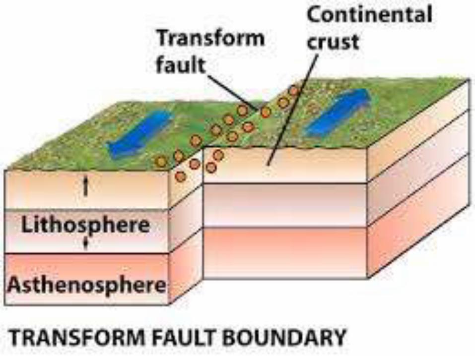
Two plates sliding past each other forms a transform plate boundary. Natural or human-made structures that cross a transform boundary are offset—split into pieces and carried in opposite directions. Rocks that line the boundary are pulverized as the plates grind along, creating a linear fault valley or undersea canyon. As the plates alternately jam and jump against each other, earthquakes rattle through a wide boundary zone. In contrast to convergent and divergent boundaries, no magma is formed. Thus, crust is cracked and broken at transform margins, but is not created or destroyed.


The essence of plate tectonic theory is that the plates (ocean basins plus or minus continents) slide around over the earth surface, interacting as they do at the plate boundaries. Thus, any time there is a divergent plate boundary where two plates are separating, there must be a convergent plate boundary (subduction zone) where the earth comes together again. And convergent boundaries always, eventually, lead to collisions between continents, or continents and terranes(island arcs plus or minus microcontinents). Observe the subduction zones in the cross section. Next to each one is a remnant ocean basin (ROB). An ROB is one that is disappearing down a subduction zone; it is a remnant of its former self. But all subduction zones must eventually disappear completely and when they do the floating blocks on either side will collide, and create a mountain range. The continent-continent collision in the cross section is a case where the collision has already occurred.

But in the larger picture, it is common for a divergent plate boundary to come into existence and create a new ocean basin, and then for that ocean basin to close again along a convergent plate boundary until two continents collide. This opening and closing of ocean basins is the Wilson Cycle, and is the simplest model we have of how the earth operates historically.

