monarto south intermodal and land use study · 7.5 murray bridge township industrial market 75 ......
TRANSCRIPT
MONARTO SOUTH INTERMODAL AND LAND USE STUDY
Final Report
Prepared for the
MONARTO COMMON PURPOSE GROUP
In association with
December 2008
W:\PROJECTS\2008 Numbers\P3608\final report\P3608 final report 10 Dec 08.doc
TABLE OF CONTENTS
Executive Summary
1 INTRODUCTION 5
1.1 Background 5 1.2 Purpose of This Study 5 1.3 Interests of the Councils 6 1.4 The Study Process 7
2 INTERMODAL FACILITIES 8
2.1 What is an Intermodal Facility? 8 2.2 Factors for Success 8 2.3 Trends in Logistics and Warehouse Development 9
2.3.1 Global trends 9 2.3.2 Australian Trends 12
2.4 Intermodal Case Studies 13 2.4.1 South Australia 13 2.4.2 New South Wales 13 2.4.3 Victoria 21
2.5 Trends in Freight Regulation and Operations 25 2.5.1 Overview 25 2.5.2 Regulation/Policy 25 2.5.3 Consumer Demand/Population Growth 26 2.5.4 Fuel, Peak Oil and Climate Change 26 2.5.5 Congestion 26 2.5.6 Supply Chain Management 27 2.5.7 Distribution Facilities 27 2.5.8 Freight Statistics 27
3 STRATEGIC AND POLICY CONTEXT 29
3.1 State Strategies 29 3.1.1 Strategic Infrastructure Plan for South Australia 2005/06 - 2014/15 29 3.1.2 South Australia's Strategic Plan 2007 30 3.1.3 Planning Strategy for Regional South Australia January 2003 (As amended at December 2007) 30 3.1.4 Metropolitan Adelaide Industrial Land Strategy (April 2007) 32 3.1.5 Employment Lands Planning Forum 32
3.2 Existing Development Plan Policy 33 3.3 Relevant Studies and Reviews 35
3.3.1 Regional North South Transport Corridor - Final Report (February 2006) 35 3.3.2 National Intermodal Terminal Study - Final Report (February 2006) 35 3.3.3 South Australian Rail Freight - A Bypass to Save the Heart of Adelaide (2007) 36 3.3.4 Adelaide Rail Freight Movements Study (2008 - 2010) 37 3.3.5 The Planning Review 2008/09 37 3.3.6 Monarto Community Plan (June 2000) 38
3.4 Summary 38
4 OTHER CHARACTERISTICS OF THE STUDY AREA 40
W:\PROJECTS\2008 Numbers\P3608\final report\P3608 final report 10 Dec 08.doc
4.1 Existing Land Use 40 4.2 Existing Physical Conditions and Social and Environmental Context 41 4.3 Primary Industry Assessment 42 4.4 Implications 44
5 POTENTIAL FOR AN INTERMODAL FACILITY AT MONARTO SOUTH 45
5.1 Introduction 45 5.2 Benefits of Monarto South 45 5.3 Operational Requirements 47
5.3.1 Overview 47 5.3.2 Road 48 5.3.3 Rail 49 5.3.4 Trip Time 51 5.3.5 Air 51 5.3.6 Sea 52 5.3.7 Port of Adelaide 52 5.3.8 Intermodal 52 5.3.9 Network Constraints 53 5.3.10 Alternative Options 54 5.3.11 Industry Consultation 55
6 POTENTIAL FOR AN AIRPORT AT MONARTO SOUTH 58
6.1 Introduction 58 6.2 Site Options 58 6.3 Preliminary Assessment 60
6.3.1 Planning and Land Use 60 6.3.2 Land Area 60 6.3.3 Infrastructure Needs 61 6.3.4 Transport and Access 61 6.3.5 Noise Impacts 61 6.3.6 Flight Paths / Obstacle Limitation Surfaces / Air Space Control 62 6.3.7 Air Quality 62 6.3.8 Flora and Fauna 62 6.3.9 Visual and Landscape 63 6.3.10 Hazards and Risks 63
6.4 Relationship to an Intermodal Facility 63
7 INDUSTRIAL LAND SUPPLY AND DEMAND ASSESSMENT 65
7.1 Metropolitan Adelaide and National Trends 65 7.1.1 Structural Change and the Rise of the Logistics Sector 65 7.1.2 Growth in Take up 66
7.2 From Manufacturing to Warehousing 67 7.2.1 Profitability and Fuel Prices 68 7.2.2 Infrastructure 69 7.2.3 Clustering 69 7.2.4 Availability of Serviced Land 69 7.2.5 The Rise of Institutional Investors 70 7.2.6 Competing Uses in Inner Suburban Areas 71 7.2.7 Metropolitan Adelaide Price Indicators 71 7.2.8 Conclusions and Outlook 71
W:\PROJECTS\2008 Numbers\P3608\final report\P3608 final report 10 Dec 08.doc
7.3 The Case for a Regional Intermodal at Monarto 72 7.4 Mount Barker Industrial Market 73
7.4.1 Land Supply 73 7.4.2 Take up / Demand 74 7.4.3 Major Industries 74 7.4.4 Price Indicators 75 7.4.5 Outlook 75
7.5 Murray Bridge Township Industrial Market 75 7.5.1 Land Supply 75 7.5.2 Take Up 76 7.5.3 Major Industries 76 7.5.4 Price Indicators 76 7.5.5 Outlook 77
7.6 Adelaide Hills LGA Industrial Market 77 7.7 Alexandrina LGA Industrial Market 77 7.8 Mining Activity 78 7.9 Monarto South Industrial Market 79
7.9.1 Outlook 80 7.10 Industrial Forecasts 81
8 INFRASTRUCTURE ASSESSMENT 84
8.1 Water 84 8.2 Sewer 86 8.3 Gas 86 8.4 Electricity 88 8.5 Communication/IT Services 89
9 INTERMODAL TRANSPORT HUB BUSINESS CASE 90
9.1 Demand Analysis 90 9.1.1 Existing Situation 90 9.1.2 Factors Determining Demand 91
9.2 Potential Complementary Activities 92 9.3 Container Park Facilities (Inland Port Concept) 93 9.4 Large Volume Container Packing 93 9.5 Other Activities 93 9.6 Terminal Operating Requirements 93 9.7 Terminal Concepts 94 9.8 Turnouts 94 9.9 Sidings 94 9.10 Equipment 94 9.11 Terminal Design Options 95
9.11.1 Terminal Design Option 1: Simple Loop Siding 95 9.11.2 Terminal Design Option 2: Double Grouped Sidings 96
W:\PROJECTS\2008 Numbers\P3608\final report\P3608 final report 10 Dec 08.doc
9.11.3 Terminal Design Option 3: Double Separated Sidings 96 9.12 Terminal Management Options 99
9.12.1 Introduction 99 9.12.2 Stakeholders in the Intermodal Transport Chain 99 9.12.3 Assets Deployed in the Land-based Intermodal Transport Chain 100 9.12.4 Terminal Access Considerations 100 9.12.5 Terminal Ownership Options 101 9.12.6 Terminal Operating Options 102 9.12.7 Operation Scenarios 103
9.13 Government Funding Opportunities 105 9.13.1 Federal Government 105 9.13.2 State Government 105
10 COMMUNITY CONSULTATION AND FURTHER STAKEHOLDER ENGAGEMENT 107
10.1 Community Information Meeting 107 10.2 Submissions 108 10.3 Consultation with Monarto Zoo 111
11 LAND USE PLANNING IMPLICATIONS 113
11.1 Introduction 113 11.2 Land Area Requirements 113 11.3 Suggested Development Plan Policy Approach 114
11.3.1 Commercial (Monarto South) Zone and Policy Areas 114 11.3.2 Interim Airport Policies 115
12 RECOMMENDATIONS 119 Appendix 1: Stakeholder Engagement Workshop 1 Attendance List Appendix 2: Stakeholder Engagement Workshop 2 Attendance List
Appendix 3: Strategic Assessment of Primary Industry around Murray Bridge Maps Appendix 4: Penfield Intermodal Zone Extract Appendix 5: References
Appendix 6: Persons / Organisations Consulted

Monarto South Intermodal and Land Use Study - Final Report December 2008
J e n s e n Page 1 P L A N N I N G & D E S I G N
Executive Summary This Study was commissioned by the Monarto Common Purpose Group (MCPG), which consists of representatives of the Murraylands, Adelaide Hills and Fleurieu Regional Development Boards and the Rural City of Murray Bridge, District Council of Mount Barker and Alexandrina Council. The Study objectives for the Consultant Team were:
Prepare a business case for an intermodal transport hub at Monarto South; Undertake a demand survey for key infrastructure requirements generated by an
intermodal transport hub and associated industrial activity; and Prepare a case for the Metropolitan Adelaide Industrial Land Strategy to be
extended to include the Monarto Precinct. The Monarto South precinct provides the opportunity to further enhance the growing commercial and industrial business sector that has already established in the area through the provision of transport infrastructure links to key markets. These road and rail links will provide opportunities for new industry development that is consistent with infrastructure investment strategies. The Monarto South precinct is strategically positioned along the AusLink national highway and rail network. AusLink is the federally funded Australian transport network linking the road, rail, air and sea sectors. The network was established by the Federal Government to promote the efficient movement of goods through an integrated transport system that facilitates economic development at a regional and national level. An assessment of the strategic and policy context for the Monarto South region revealed the following: There is Government acknowledgement of the need to improve the State's
competitiveness through more efficient freight transport networks, and the importance of intermodal terminals to facilitate rapid transhipment between road and rail;
There is broad agreement of the benefits in moving the freight task from roads to rail;
The current Development Plan provisions for the Monarto South region will require review and updating following the outcomes of this study, particularly to ensure that suitable land is reserved for a potential intermodal facility and associated development, and to minimise and manage off-site impacts;
The Regional North South Transport Corridor (Ferries McDonald Road) will improve freight transport linkages to/from Monarto South and regions to the north and south as well as the existing national freight and rail networks;
The Adelaide Freight Movements Study to be completed early 2010 will inform the longer term intentions for moving freight by existing or possible new rail networks that may bypass Monarto South. This will have implications for any future intermodal facility at Monarto South;
The State Government's announcements regarding future strategic planning arrangements for Greater Adelaide will provide an opportunity for the outcomes of this study to be considered and incorporated into a future plan for the region.
Any intensification of development within the Monarto South precinct should be cognisant of the following: There is an existing, albeit low density, population settlement within and beyond
the Monarto South area. Any future development needs to consider the longer term implications for these communities, including traffic generation, safety and
Monarto South Intermodal and Land Use Study - Final Report December 2008
J e n s e n Page 2 P L A N N I N G & D E S I G N
impacts, the visual impact of development, noise, light overspill, after hours activity, demand on emergency services, physical infrastructure services capacity and stock management;
The Ferries McDonald Road / Freeway interchange is a significant 'gateway' to Monarto South and the Monarto Zoo. Accordingly, the quality of development within the precinct needs to reflect this important role and be designed to a high standard;
The quality of the public realm should be of a higher standard than currently prevails within the precinct. This will require greater attention to the design and management of verges, stormwater, other services, landscaping and signage;
The broader environmental context of the Monarto South precinct will require some attention to the notion of wildlife corridors. This could extend to the need to consider a broader role of buffer landscaping requiring greater attention to species selection, the width of and linkages between vegetation buffers.
The establishment of a successful intermodal facility requires access to the main rail line, preferably running adjacent to a long straight stretch of land with access to the main arterial road network. The main rail line between Adelaide and Melbourne runs east-west through Monarto South adjacent to the South Eastern Freeway. This section of track runs straight for approximately 7 kilometres - 2 kilometres to the east of Ferries McDonald Road and 5 kilometres to the west. The land surrounding the main line is relatively flat. The location of an intermodal hub in Monarto South will provide industry with the choice of transport modes for the movement of goods. It can provide an opportunity to overcome rail issues through the Adelaide Hills by either moving goods between Melbourne and Monarto via rail and then via road to Adelaide; or move goods from Adelaide to Monarto by road and then rail to Melbourne. Goods from surrounding primary producers can be value added in the Monarto South precinct prior to being moved by road or rail to an ultimate destination, including the Port of Adelaide. The establishment of intermodal terminals and commercial precincts can result in the creation of employment, reduced traffic, sustainable commercial and population growth in the area. In recent years there has been some speculation regarding the possible relocation of the Parafield Airport and/or the impending need to consider another site to accommodate Adelaide's general aviation requirements. Sites near Two Wells and Monarto South have been referred to as possible locations for either of the airports. The investigations suggest that there will be limited synergies between an intermodal facility and a regional airport, not the least because of the small proportion of freight transported by air. However, the primary production catchment of Monarto South, combined with the excellent east-west and, eventually, north-south, transport connections, suggests some potential for exporting high value produce (e.g. wine, fresh meat, vegetables etc) from the region.
The State Government’s policy is to identify 25 years supply of industrial land throughout the greater metropolitan area. Based on the forecasts identified by the Study it has been estimated that 140Ha of future industrial land will cater for 25 years supply, assuming a high growth scenario.
In order to protect the future opportunity of an intermodal facility at Monarto South, land should also be set aside for this use. It is not expected that an intermodal at Monarto South would require a site any where near as large as some existing intermodals such as at Parkes (500Ha). Other intermodal facilities operate on significantly smaller sites. Accordingly a site of up to 50 - 60Ha is likely to be sufficient to secure future intermodal operations at Monarto South.
Monarto South Intermodal and Land Use Study - Final Report December 2008
J e n s e n Page 3 P L A N N I N G & D E S I G N
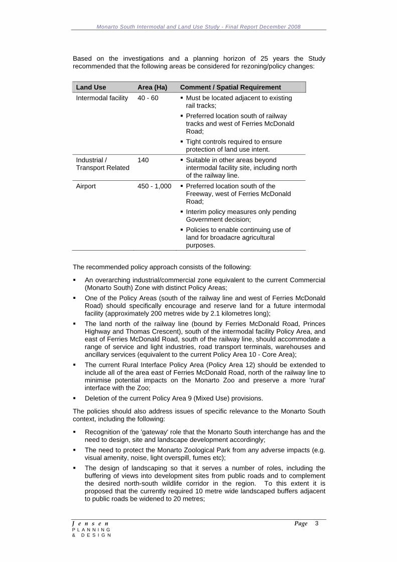
Based on the investigations and a planning horizon of 25 years the Study recommended that the following areas be considered for rezoning/policy changes:
Land Use Area (Ha) Comment / Spatial Requirement Intermodal facility 40 - 60 Must be located adjacent to existing
rail tracks; Preferred location south of railway tracks and west of Ferries McDonald Road;
Tight controls required to ensure protection of land use intent.
Industrial / Transport Related
140 Suitable in other areas beyond intermodal facility site, including north of the railway line.
Airport 450 - 1,000 Preferred location south of the Freeway, west of Ferries McDonald Road;
Interim policy measures only pending Government decision;
Policies to enable continuing use of land for broadacre agricultural purposes.
The recommended policy approach consists of the following:
An overarching industrial/commercial zone equivalent to the current Commercial (Monarto South) Zone with distinct Policy Areas;
One of the Policy Areas (south of the railway line and west of Ferries McDonald Road) should specifically encourage and reserve land for a future intermodal facility (approximately 200 metres wide by 2.1 kilometres long);
The land north of the railway line (bound by Ferries McDonald Road, Princes Highway and Thomas Crescent), south of the intermodal facility Policy Area, and east of Ferries McDonald Road, south of the railway line, should accommodate a range of service and light industries, road transport terminals, warehouses and ancillary services (equivalent to the current Policy Area 10 - Core Area);
The current Rural Interface Policy Area (Policy Area 12) should be extended to include all of the area east of Ferries McDonald Road, north of the railway line to minimise potential impacts on the Monarto Zoo and preserve a more 'rural' interface with the Zoo;
Deletion of the current Policy Area 9 (Mixed Use) provisions.
The policies should also address issues of specific relevance to the Monarto South context, including the following:
Recognition of the 'gateway' role that the Monarto South interchange has and the need to design, site and landscape development accordingly;
The need to protect the Monarto Zoological Park from any adverse impacts (e.g. visual amenity, noise, light overspill, fumes etc);
The design of landscaping so that it serves a number of roles, including the buffering of views into development sites from public roads and to complement the desired north-south wildlife corridor in the region. To this extent it is proposed that the currently required 10 metre wide landscaped buffers adjacent to public roads be widened to 20 metres;
Monarto South Intermodal and Land Use Study - Final Report December 2008
J e n s e n Page 4 P L A N N I N G & D E S I G N
The effective management of traffic movements to/from the Zone and individual sites to minimise the impacts on traffic flows through the area and maximise road safety;
Ensuring that land division results in the creation of a range of allotment sizes to accommodate the type of development envisaged, in particular larger sites for more regional facilities (currently the prescribed 1 hectare minimum allotment size is not resulting in a sufficiently diverse allotment pattern);
Policies that discourage the ability to establish activities within the zone that are more suitably located within the existing townships (e.g. service industries, service trade premises).
An optimum intermodal facility should allow for a 2.1 kilometre length of straight railway line to accommodate the optimum 1.8 kilometre length trains. Currently, the length of railway line extending west from Ferries McDonald Road to the boundary of the Scenic Corridor Zone is only around 1.6 kilometres. While this is sufficient to accommodate the current train lengths (1.5 kilometres) it is not sufficient to accommodate the optimum train lengths (1.8 kilometres). Therefore, some consideration will need to be given to extending the Commercial (Monarto South) Zone into the adjacent Scenic Corridor Zone to achieve the optimum length.
In addition to the expanded Commercial (Monarto South) Zone the Study recommends that consideration be given to applying interim policies within defined parts of the Primary Industry Zone: South West Area - Policy Area 16 to the south of the Freeway. The policies would be designed to minimise the potential for development that may compromise the long term potential to establish a future airport.
Monarto South Intermodal and Land Use Study - Final Report December 2008
J e n s e n Page 5 P L A N N I N G & D E S I G N
1 INTRODUCTION 1.1 Background
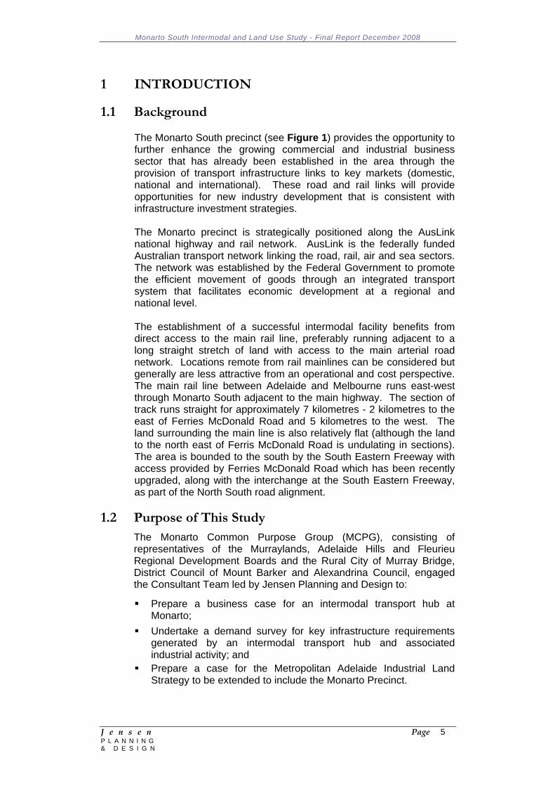
The Monarto South precinct (see Figure 1) provides the opportunity to further enhance the growing commercial and industrial business sector that has already been established in the area through the provision of transport infrastructure links to key markets (domestic, national and international). These road and rail links will provide opportunities for new industry development that is consistent with infrastructure investment strategies. The Monarto precinct is strategically positioned along the AusLink national highway and rail network. AusLink is the federally funded Australian transport network linking the road, rail, air and sea sectors. The network was established by the Federal Government to promote the efficient movement of goods through an integrated transport system that facilitates economic development at a regional and national level. The establishment of a successful intermodal facility benefits from direct access to the main rail line, preferably running adjacent to a long straight stretch of land with access to the main arterial road network. Locations remote from rail mainlines can be considered but generally are less attractive from an operational and cost perspective. The main rail line between Adelaide and Melbourne runs east-west through Monarto South adjacent to the main highway. The section of track runs straight for approximately 7 kilometres - 2 kilometres to the east of Ferries McDonald Road and 5 kilometres to the west. The land surrounding the main line is also relatively flat (although the land to the north east of Ferris McDonald Road is undulating in sections). The area is bounded to the south by the South Eastern Freeway with access provided by Ferries McDonald Road which has been recently upgraded, along with the interchange at the South Eastern Freeway, as part of the North South road alignment.
1.2 Purpose of This Study The Monarto Common Purpose Group (MCPG), consisting of representatives of the Murraylands, Adelaide Hills and Fleurieu Regional Development Boards and the Rural City of Murray Bridge, District Council of Mount Barker and Alexandrina Council, engaged the Consultant Team led by Jensen Planning and Design to:
Prepare a business case for an intermodal transport hub at Monarto;
Undertake a demand survey for key infrastructure requirements generated by an intermodal transport hub and associated industrial activity; and
Prepare a case for the Metropolitan Adelaide Industrial Land Strategy to be extended to include the Monarto Precinct.
Monarto South Intermodal and Land Use Study - Final Report December 2008
J e n s e n Page 6 P L A N N I N G & D E S I G N
Figure 1: Monarto South Study Area
1.3 Interests of the Councils
The Rural City of Murray Bridge (RCMB) recognised that Monarto South is a strategic area due to its proximity to excellent transport corridors, existing infrastructure and availability of suitable land for commercial / industrial purposes. When the opportunity came from the Regional Development Boards and adjoining Councils to undertake investigations and strategic options to also consider a regional airport, the RCMB supported the idea for a coordinated Regional Intermodal Project and to promote industry and employment opportunities for adjoining Councils. This project has been supported in the State Government Strategic Plan for Industrial Land and the State and Federal Strategic Transport Corridor programme and has now been included in the studies being undertaken in the Plan for Greater Adelaide. Council sees this study and potential development as a
Monarto South Intermodal and Land Use Study - Final Report December 2008
J e n s e n Page 7 P L A N N I N G & D E S I G N
positive step in the sustainable economic growth of the Mt Barker, Alexandrina and Murray Bridge Regions.
The Alexandrina Council was initially interested in this project when there was some discussion about the possible relocation of the Parafield Airport to the Monarto South region. The interest of Council grew with the scope of the project expanding to include the possible development of a significant concentration of industrial/commercial development within Monarto South. This interest was further reinforced with Council having completed its part of the Kangaroo Road and Ferries McDonald Road upgrade. Council is of the view that the north-south road corridor will be able to be utilised as a major transport link to the South Eastern Freeway and through to the Barossa and other key regional areas where produce from the Council area, such as grapes, needs to be delivered. As a rapidly expanding Hills community the District Council of Mount Barker is committed to sustainable and ordered growth that links the supply of residential with local and regional employment opportunities. The District Council of Mount Barker is prepared to be involved in a regional approach to employment generation that provides its residents and the regional with a diverse range of employment options and economic development that contributes the vibrant economy of the region. Projects such as the Monarto South Intermodal and Land Use study will contribute to regional development occurring in those areas with locational, infrastructure or employment advantage.
1.4 The Study Process The study process leading up to the preparation and release of this Draft Final Report consisted of the following:
Literature review and one-on-one consultation with various stakeholders;
Stakeholder Engagement Workshop 1 in Murray Bridge on 14 August 2008 (see Appendix 1 for a list of the attendees);
Preparation of a Draft Issues and Options Paper (15 September 2008) and a presentation to the Steering Committee;
Preparation of a Final Issues and Options Paper (20 October 2008);
Community Information Meeting at Monarto South on 21 October 2008 attended by approximately 65 people;
Stakeholder Engagement Workshop 2 in Murray Bridge on 28 October 2008 (see Appendix 2 for a list of the attendees);
Further research, consultation and consideration of written submissions prior to preparing the Draft Final Report (November 2008).
Monarto South Intermodal and Land Use Study - Final Report December 2008
J e n s e n Page 8 P L A N N I N G & D E S I G N
2 INTERMODAL FACILITIES 2.1 What is an Intermodal Facility?
Intermodal freight transport is the concept of utilising two or more suitable transport modes, in combination, to form an integrated transport chain aimed at achieving operationally efficient and cost-effective delivery of goods in an environmentally sustainable manner from their point of origin, to their final destination. This includes road haulage collection and final delivery journeys combined with a rail freight trunk-haul delivery, known as a ‘combined road-rail’ operation. The aim of utilising intermodal is to maximise the use of each individual transport mode to its best advantage.
The essence of efficient intermodal transport lies in the use of a unit-load system capable of transfer between road, rail and other transport modes, which allows for the collection of consignments by road, rail and / or trans-shipment of the load. The standard practice of loading units take the form of either road-going semi trailers conforming to standard dimensions and designed to be “piggybacked” aboard rail wagons, or more commonly, swap bodies and shipping containers built to international standards that are fully interchangeable between a variety of road vehicle combinations, rail wagons and ships. In all of these circumstances the load remains intact and secure within the loading unit which is lifted or transferred by purpose-built equipment onto a rail wagon, or into the hold of a ship and then back to a road vehicle at the end of the trunk-haul leg of the journey.
Road transport or haulage in any combination with either rail freighting, short-sea, or coastal shipping still proves to be the most viable option at both an economic and operational perspective. However, in certain cases, particularly where no Roll-on and Roll-off (RO-RO) vehicle ferry service, road or rail tunnel facility exists, shipping by container vessel may be necessary, and especially for trans-global freight movements.
The benefits of unit-load intermodalism are that it can provide:
Lower transit costs over long journeys; Potentially faster delivery times in certain circumstances; A reduction in road congestion; A more environmentally acceptable solution to congestion and
related problems (i.e. Emission of noise/fumes, damage to built environment by vibration etc.);
Reduced consumption of fossil fuels as long-haul section of routes are more fuel efficient;
Safer transit for some dangerous products. 2.2 Factors for Success
A number of factors are critical to the economic and environmental success of new terminals:
A critical mass to offer economies of scale;
Monarto South Intermodal and Land Use Study - Final Report December 2008
J e n s e n Page 9 P L A N N I N G & D E S I G N
Proximity to markets; Proximity to the rail and arterial road networks; Bundling of integrated, value-added services e.g. Empty container
storage and Australian Quarantine and Inspection Service (AQIS) / Customs inspections;
Maximising the use of fixed assets throughout 24/7 operations; and Adequate buffering from residential areas.
2.3 Trends in Logistics and Warehouse Development 2.3.1 Global trends
Improved efficiencies in the management of supply chain processes have seen a structural shift within the distribution and logistics industry. Inventory management has contributed to increased business demands for low-cost goods (e.g. apparel, electronics, motor vehicles, appliances and machinery) and forced manufacturers to move production centres abroad in order to take advantage of inexpensive global labour. The offshore movement in production has had a dramatic impact upon the Australian, regional and global industrial real estate market. In the United States and Europe, the trend has seen more warehousing and distribution centres (DCs) built close to ports and major inland (regional) distribution hubs. Technology and timed-delivery services have also helped to transform the way companies around the world now run businesses through more efficient methods of product delivery.
Road access remains the most important transport consideration for warehouse operators in Australia and abroad but increasing customer service demands and road congestion are forcing prospective tenants to build flexibility into their supply chains with multimodal options1. More recently the price hike in fuel costs is also forcing reconsideration in favour of rail freight.
Proximity to rail and port facilities are a common interest among disruption-wary shippers and transport operators, and is likely to become crucial for domestic consignees looking for better control over inbound shipments in terms of accessing capacity and further streamlining time to markets and costs.
The hub-and-spoke model for warehousing network operation has seen the need for goods to be transported from one warehouse to another via rail as this mode can provide major benefit to companies that move products inbound over long distances, especially from ports. Due to the economies of scale provided by freight rail facilities and the large land parcels / long buildings needed to accommodate a suitable siding for rail, some shippers are finding it desirable to locate close to a site that contains a rail terminal. Typically, the terminals are operated by a third party that build in flexibility of scale and use to the retailer / consignee.
1 O’Reilly J, Retail Logistics: Shopping for the Right Site, Inbound Logistics – feature story, January 2007, www.inboundlogistics.com
Monarto South Intermodal and Land Use Study - Final Report December 2008
J e n s e n Page 10 P L A N N I N G & D E S I G N
The proximity of industrial sites to port locations is becoming vital due to the nature of offshore manufacturing. Ninety per cent of global freight is transported by ship. Some companies gain customs and tax benefits from being ‘on port’, while occupiers generally require a distribution centre inland from the port. The rise of inland, regional locations in close proximity to ports are becoming increasingly popular due mainly to the cost associated within metropolitan areas, as well as the efficiencies gained from direct freight access. The movement of freight by air and the location of hubs in close proximity to airports are becoming of lesser significance globally, with the exception of the perishable goods industries and parcel operators.
The trend in multimodal compatibility is seeing the convergence between industrial property development and supply chain management strategy in the United States and Europe. Many global businesses are adamant they have access to a myriad of transport options in / near their primary distribution facilities.
In the US, many companies have shown a growing interest in developing better inland transportation infrastructure and locating warehouses in less-congested areas with multiple transport options to serve as pivot points for redistribution. In the areas of Phoenix, Atlanta and Chicago, inland distribution hubs are sparking the interest of institutions as availability in space, flexibility and cost are driving demand in the south and Midwest regions. In the south, the Dallas Logistics Hub is the only facility that offers two intermodal terminals with competing rail lines providing direct access to port and airport modes. Given that the bulk of US ocean freight arrives through Los Angeles, Long Beach and the Port of New York and Port of New Jersey, inland transport modes are becoming more important across the country.
The rise in inland hubs is evident throughout the country as logistics operators and investors see the added benefits that can be achieved through increased economies of scale and greater logistics control from multimodal operations. This can be seen with the decline in domestic manufacturing industries and the strong growth seen in imports (10% increase per annum over the past five years), which has resulted in the proliferation of manufactured goods entering US ports.
In addition, at many port locations there is increasing pressure on the availability of land. Larger vessels generally mean a larger exchange of containers/freight and less port calls. This larger exchange places pressure on landside facilities and wharf/port space becomes a premium. Therefore, freight needs to be moved off the port quickly such that inland terminals become an option to receive and distribute that freight. These inland terminals can provide a useful option to aggregate outwards freight, delivering larger volumes of containers/product to port in shorter timeframes. The use of rail for this movement offers opportunities in reduction in road congestion and if the trains can be scheduled into off peak periods, there is the opportunity to utilise spare capacity on the rail network.
Monarto South Intermodal and Land Use Study - Final Report December 2008
J e n s e n Page 11 P L A N N I N G & D E S I G N
Five major trends have emerged in the US, resulting in the convergence of interests held by global logistics and real estate development2:
Use of larger ships: There is an increasing reliance on goods purchased from and manufactured overseas (transhipment of goods) which places a heavy burden on the efficiencies to be made within shipping vessels. Larger ships are needed to carry the rise in bulk cargo across this mode. However, larger vessels may not be accommodated within inland ports and only a limited number of ports can handle their size and cargo volume. In the US, the growth of large ships coming into ports on the west coast has pressured some consignees to offload cargo to nearby inland DCs for redistribution. This trend is also evident in Australia which is why the major eastern seaboard ports are undergoing expansion (e.g. Port Botany, Port of Melbourne and Port of Brisbane).
The return of rail: Rail’s share of total freight movement has increased, especially within the US, as an increasing number of shippers are using rail instead of road transport due to it being a cost-effective method for shipping a variety of goods to inland regions. Rail is a preferred option for the movement of freight to big box DCs throughout inland locations, especially for large shipments that can be sourced directly from ports to holding destinations. The increased use of rail has led to growth in industrial markets surrounding some of the nation’s biggest interior hubs, such as Chicago Memphis and Dallas-Fort Worth. These regions have the ability to serve large markets within the intersection of multiple rail lines across the US. The large population / market in the US means economies of scale in rail freight movement (and lower costs), making rail more feasible, in terms of provision of freight rail infrastructure and usage by customers / logistics operators. This is expected to occur in Australia over the longer term.
Super-sized distribution centres: The US has seen the rise of large 1 million ft2 (or 92,900m2) distribution centres as a result of the sheer scale of low cost imports entering the country. Speculative warehouse construction escalated in 2005-2007, however the bulk of construction activity involved build-to-suit facilities for large multi-national and international logistics tenants.
Emergence of large in-land urban distribution centres: Mega-sized distribution facilities are becoming a common development option for many large tenants in the periphery of major urban markets where land is cheap. Retailers have shown an increasing acceptance of big box warehouses as a central hub for regional distribution networks across the country. The distribution centres also allow shippers to utilise multiple distribution strategies, from cross-docking to transloading to short-term storage, and make more efficient use of rail and intermodal transportation.
Shifting the load: A common trend in the intermediate stage of the logistics process is to break down shipments in order to reload goods to more efficient means of transportation. The process of
2 O’Reilly J, Retail Logistics: Shopping for the Right Site, Inbound Logistics – feature story, January 2007, www.inboundlogistics.com
Monarto South Intermodal and Land Use Study - Final Report December 2008
J e n s e n Page 12 P L A N N I N G & D E S I G N
transloading goes against traditional supply chain strategies by adding an extra mode to the process. While the practice does increase facility costs in the short term, the longer term effect has seen cost savings in other links of the supply chain.
Within Europe, businesses have had to adjust their supply chain strategies to account for the increasing trade at the global scale. Post-Panamax vessels are increasingly popular, however current infrastructure sees only a limited number of European ports being able to accommodate the ships. As a result, the rise in break-bulk facilities and short-sea shipping routes are becoming more important. The ports of Rotterdam, Antwerp, Hamburg and Felixstowe represent gateways to Europe in terms of ocean freight, but the European Union is trying to spread the load by developing additional ports in the Baltic and in Southern Europe.
Ultimately, a country's or region’s transportation infrastructure and resources not only effects whether a business might locate a DC there, but also dictates the type of distribution strategy and facility it will use to serve its supply chain needs. In the US, fixed transportation obstacles, aging infrastructure, insufficient labour, high fuel costs and ever-fickle consumer buying trends require retailers, in particular, to sharpen their focus on where they locate DCs in relation to new / existing stores and where they source products.
2.3.2 Australian Trends
As with many other markets, Australia depends heavily on long-distance road transport for its internal freight movements, especially for goods other than bulk commodities such as coal, ore, other minerals and grain, which are predominantly rail borne. Rail freight accounts for only 15-25% of general traffic, although there are exceptions. On the 3,400km route from Melbourne to Perth, rail carries 80% of all freight and similarly, between Brisbane and Cairns, 40% of freight is carried on the narrow gauge rail line.
Some of the origin and destination points for long distance general freight cannot be competitively serviced by rail because the rail network does not directly parallel major highways that link areas through the shortest practicable route.
Containerisation is the predominant intermodal method used in Australia and most general goods are conveyed by this means, with container trains operating between dedicated terminals in most major built up areas. Container movements are arranged by rail based forwarding agents who deal directly with the rail company, or by market oriented rail operators themselves who act as the primary contractor and hire in road haulage for the local collection and delivery operations.
The plan for the Federal Government to boost rail freight share in the country is being facilitated by a Strategic Intermodal Terminal Plan. The plan seeks to draw key initiatives to co-ordinate and support the establishment of intermodal terminals, which is seen as being a private sector responsibility. It is the Government’s role to facilitate the establishment of terminals and to ensure that they are located on strategic sites that fit in with the State’s economic development,
Monarto South Intermodal and Land Use Study - Final Report December 2008
J e n s e n Page 13 P L A N N I N G & D E S I G N
transport and land use plans. Many State governments have set targets for rail mode share to ports. In Victoria, a target of 25% is being used, whilst in NSW a target of 40% for Port Botany is in place.
Attention is particularly focused on developing innovative systems to reduce the time, and at present, cumbersome procedures for transferring cargo (containerised freight at present, but potentially road-railer and swap body systems in the future) between road and rail modes. There is a concern that regulatory barriers should not inhibit intermodal efficiency.
Modal and intermodal standards and regulations for the weights and dimensions of containers and other ILUs have been identified as one means of improving intermodal efficiency. Within Australia, this can be seen with the implementation of consistencies across gauge widths as different States operate under a standard or dual gauge system of rail tracking. In regional areas, much attention has been given to the upgrading of existing rail infrastructure. The combination of the strategic action by the ARTC, along with Auslink funding, has helped the industry gain greater funding through the 2007/2008 Federal Budget. Not only does this translate to a greater emphasis on rail freight share in the transport sector, but also paves the way to boosting regional economies in transport related employment.
2.4 Intermodal Case Studies 2.4.1 South Australia
Bowmans This intermodal terminal is located at Bowmans in SA’s Mid-North approximately ten kilometres east of Port Wakefield and was opened in 2003. It is strategically positioned adjacent to the ARTC Adelaide to Perth main line.
It is operated by Patrick Portlink and predominantly accommodates international export containers of hay through the ports of Adelaide and Melbourne. The facility has an annual total throughput of 11,000 TEU. The potential expansion of the Olympic Dam mine (Roxby Downs) could see a transfer of freight from road to rail through the Bowmans Intermodal Terminal. Other possible traffics include Pork (via Primo), salt, and expanded output from the Virginia producing area.
It has a paved hardstand area of 10,000 m2, and a further unpaved area of 10,000 m2. Trains servicing the terminal are limited to a length of 685 metres.
2.4.2 New South Wales
Blayney Blayney is located in the Central Tablelands, 240 kilometres west of Sydney. The town is situated along the Mid-Western Highway, giving it
Monarto South Intermodal and Land Use Study - Final Report December 2008
J e n s e n Page 14 P L A N N I N G & D E S I G N
direct road access to Sydney, Melbourne and Adelaide. By rail, it connects to Sydney’s ports along the Great Western line.
The major industries located in Blayney include pet food, copper concentrate, frozen and canned food products, gold mining and honey and bee exports.
FCL Interstate Transport Services operate the intermodal terminal, which mainly handles export container freight bound for Sydney ports. The operation is one of Australia’s busiest inland container terminals, with freight throughput exceeding 100,000 TEUs (Twenty Foot Equivalent Units) per annum.
The site is 3.2Ha, including 20,000m² of hardstand, a 500m² transit warehouse, a modern two-storey office and three rail sidings. Services provided include AQIS inspections on ISO containers, ensuring cleanliness to load food and grain products, as well as fumigation services for ISO containers.
Cootamundra Cootamundra is centrally located between Sydney and Melbourne and is less than two hours drive from Canberra. It connects to the Olympic Highway and sits at the intersection of two main rail lines – the Main South line leading to Sydney and the North-South line linking Melbourne and Brisbane.
The town’s access to road and rail make it a key transport hub for the region, where rail and truck services provide links to the Riverina and South West Slopes Regions, as well as Sydney, Melbourne and Canberra.
The main industry within the region is the export of grains to the overseas and, to a lesser extent, domestic markets. The industrial market within the region is dominated by silos and other plant and equipment holding areas dedicated to the grain market. Grain that is loaded upon the rail network is transported directly to Sydney Ports for export.
Other industries within the region include sheep skin manufacture, oilseeds, mustard seed oil, green tree condiments, cold pressed canola oil, almonds, abattoirs, gas turbine engine aircraft maintenance, airline operations, furniture, joinery, transport and cold storage and distribution.
The intermodal terminal is run by Sutherland’s Transport and is serviced by 1-2 trains per week (~32,000 – 38,000 TEUs/year). The site has direct rail access with a 200 metre rail siding.

Monarto South Intermodal and Land Use Study - Final Report December 2008
J e n s e n Page 15 P L A N N I N G & D E S I G N
Parkes Parkes is located approximately 365 kilometres west of Sydney and 170 kilometres south of Dubbo and serves as a major urban centre along the western edge of the Great Dividing Range. At this location the Newell Highway (which links Brisbane and Melbourne) crosses the transcontinental railway (which links Sydney, Adelaide and Perth).
The main industries in Parkes are copper and gold mining, wheat, wool and transport and storage.
The intermodal site is run by FCL and sits on 100Ha of land and has 5Ha of hardstand. The annual throughput by rail was nearly 20,000 TEUs in 2004/5. Rail services can be directly accessed from the site, which has a 350 metre rail siding. It primarily services domestic intermodal business and offers a limited range of container services.
FCL offers centralised warehousing and distribution services from the site. In future, it plans to use land it owns adjacent to the site for factory and warehouse development.
The NSW Department of Planning recently gave approval to a second rail operator, Terminals Australia, to build a $150 million facility in Parkes, over a 15 year timeframe. The Terminals Australia facility will cover over 200Ha and it is proposed that hardstand and open sheds at the southern end of the rail line in Parkes will be included3.
Growth in containerised freight to this site is expected to double over the next 5 years. There are a number of driving factors behind the projected expansion of this facility. Firstly, the Australian Rail Track Corporation (ARTC) has signalled its intention to invest $21 million on
3 GHD Consultants & Terminals Australia, Parkes Intermodal Terminal - Environmental Assessment for Concept Approval, Feb 2006

Monarto South Intermodal and Land Use Study - Final Report December 2008
J e n s e n Page 16 P L A N N I N G & D E S I G N
the Western line linking Parkes to Broken Hill (the main trade route linking Sydney to Adelaide). Improvements will focus on raising height clearances (work has been completed), upgrading communications systems, and strengthening and upgrading bridges to improve efficiency and capacity4.
Parkes has witnessed strong growth in its economy in recent years since the construction of the intermodal terminal. In November 2004, over 500 Ha of land was rezoned by the Parkes Shire Council to accommodate for the growth of the industrial sector within the Parkes region. This land is located to the west of the rail line where service providers, small transport operators and manufacturers have taken advantage of its strategic location within the terminal precinct. The majority of freight handled within Parkes is carried to the west, in particular Perth. The SCT terminal facility receives the bulk of their freight from the Port of Brisbane by road, which is then transferred to the rail network bound for Perth.
Parkes (New) In addition to the existing intermodal terminal run by FCL, there are plans for a new multi-modal terminal on the outskirts of Parkes. Parkes’ location has made it central to the Federal Government’s plans to develop an inland railway for freight transport. The rail line is planned to run between Brisbane, Parkes and Melbourne and will make the transport of freight along the east-west and north-south corridors more efficient.
The council released over 500 Ha of land specifically to cater for the growth and development of a multi-modal facility. It is proposed that a national terminal be built on the site for large scale transport, warehousing and storage of freight.
The development will be a National Transport Node, which will endeavour to provide modal interfaces to allow modal choice and complete freight logistics chain management.
The Parkes development aims to:
Provide competitive advantage through a multimodal approach to freight logistics;
Provide competitive access to national and international markets; Provide ecologically sustainability opportunities for freight related
commercial development; Facilitate leading edge, logistic operation and logistics chain
management; Provide supporting freight logistics for Inland Marketers and the
Parkes Airport; Champion logistics, research, development and innovation; and Meet the logistics demands of market driven agriculture.
4 DOTARS, 2004
Monarto South Intermodal and Land Use Study - Final Report December 2008
J e n s e n Page 17 P L A N N I N G & D E S I G N
The site will have direct access by road and rail. By road, the development will connect to the Newell Highway via a proposed ring road. The Newell Highway is the major freight route between Melbourne and Brisbane, currently carrying 1,400 heavy vehicles per day, 40% of which are B-Doubles. By rail, 28 rail terminals will connect to rail lines heading north-south and east-west that cross onto the site providing easy rail access to Sydney, Melbourne, Adelaide, Perth and Brisbane.
Growth expectations for the terminal are high, with containerised freight volumes expected to reach 240,000 TEU by 2010 and 530,000 by 20205.
Wagga Wagga Wagga Wagga is located 450 kilometres south west of Sydney and is one of Australia’s largest inland cities. The city is centrally located half way between Sydney and Melbourne and provides direct links to the Sturt and Olympic Highways. Connections to the Hume Highway are 48 kilometres east of the city. By rail, the city connects to the main southern rail line linking it to ports in Sydney and Melbourne.
Wagga Wagga is one of the key centres in the Riverina region and caters for a large variety of industries. Some of its key businesses are Cargill Abattoir, Watties, BOC Gas and Riverina Wool Combing. The number of national and multi-national businesses securing distribution, logistics and light manufacturing / value added product facilities in the Wagga region has grown significantly over the last three years. A range of manufacturing, retail and logistics businesses have secured sites in and around the Bomen Business Park to take advantage of Wagga Wagga’s intermodal terminal facility. Bomen Business Park is located on the main southern railway line, midway between Melbourne and Sydney. Various rail spurs traverse parts of the Bomen Business Park.
Patrick Corporation (now Toll Group) runs the intermodal terminal at Bomen Business Park, which has an annual throughput of approximately 10,000 TEU. The terminal handles containers to Melbourne every week day and returns from Melbourne twice weekly. It is able to handle refrigerated containers and has capacity to grow in order to cater to other distribution centres and terminals. The Wagga Wagga Shire Council is currently in planning stages to increase the size of the Bomen Business Park to accommodate the significant rise in industrial demand within the region. A revision of the LEP is currently being undertaken and involves the rezoning of over 1,500 Ha of rural zoned land adjacent to the estate to accommodate for future rail freight demand. As part of the plan, Council seeks to provide direct road access to the rail terminal throughout the estate with major upgrades planned to infrastructure in and around Wagga Wagga.
Demand for industrial space within Wagga Wagga comes predominantly from large scale manufacturers, processors, and value added industries as well as from the traditional primary sectors.
5 Parkes Shire Council, Parkes and National Multi-Modal Transport, 2006 (retrieved 2 May, 2007)
Monarto South Intermodal and Land Use Study - Final Report December 2008
J e n s e n Page 18 P L A N N I N G & D E S I G N
Commodities, raw materials, beef, wool and value added regional products make up the bulk of goods carried through the rail terminal for export. The Bomen Business Park has seen strong demand between 2003/7, with little space currently available on its 300 Ha site. Since the introduction of the intermodal facility in Wagga, ten national and multinational tenants have moved into the region to take advantage of the direct rail access. Looking ahead, this trend will continue as the release of additional industrial land in and around the terminal will attract further interest from companies wishing to take advantage of the multimodal network of transport.
Land prices have seen strong growth throughout the Wagga Wagga region not only in the industrial market, but also the commercial and residential sectors. The establishment of the intermodal terminal has acted as a catalyst for companies wishing to gain entry to the road, rail and port network. As such, land values in the industrial market have seen sustained growth over the past 5 years and range between $50/m2 - $90/m2. The top end of the range encompasses land within close proximity to major road arterials and the rail terminal. Land that has direct access to major highways and the rail terminal can expect to be sold between $80/m2 - $90/m2 range, based on a large serviced allotment. At the bottom end of the range, land prices have risen significantly within the Wagga Wagga region increasing from $20/m2 for large englobo sites in 2002 to approximately $50/m2 seen currently.
Dubbo Dubbo is recognised as being the unofficial capital of western New South Wales and is situated in the central west of the state. The city is a major service centre for the Orana and Far Western regions of New South Wales. It lies at the meeting point of the Newell, Mitchell and Golden Highways and is 5 hours drive to Sydney, 4 hours drive to both Newcastle and Canberra and a 10 hour drive to both Melbourne and Brisbane.
Patrick Corporation and Inland Container Terminals provide intermodal services in Dubbo. Together both companies offer rail and road connections (respectively) to all capital cites, as well as the local area. Services offered at the terminal include:
20 foot and 40 foot container loading and handling facilities; Storage of empty containers; Packing and unpacking containers; PRA documentation; AQIS empty box inspection; Container transport services; and Container side lifter service.
Patrick operates the rail operations which process approximately 10,000 TEU of rail freight per annum6.
6 Sourced from Patrick Corporation’s Portlink at Dubbo
Monarto South Intermodal and Land Use Study - Final Report December 2008
J e n s e n Page 19 P L A N N I N G & D E S I G N
Albury (New) The Colin Rees Group (CRG) has proposed the development of the Ettamogah Intermodal Hub, ten kilometres outside of Albury. The site is located near the Hume Highway and plans include the upgrade of roads leading to and from the Hub to accommodate B-doubles. The site will have direct access to the main train lines connecting Sydney and Melbourne.
Construction on the 10 Ha site will begin later this year with development of the facility carried out in three stages over six years. Upon completion, the fully operational facility will handle 100,000 tonnes per annum7.
Planned services include import/export facilities with customs services, an empty container pool and a rail-connected warehouse. The site will have open-access arrangements for rail operators as well offering scope for a variety of specialised transportation methods.
Kelso (New) Slobobax Pty Ltd proposes to construct and operate a rail/road intermodal terminal with associated storage and business facilities at Kelso, situated in the Bathurst LGA. The proposed site is located approximately four kilometres east of the Bathurst town centre and is bounded by the Great Western Highway to the north and the Great Western Railway line to south. Development surrounding the site comprises of a mix of rural, industrial, service businesses and residential development. The proposed development would increase the efficiency and economy of road/rail freight operations within this region of NSW and is a compatible land use with the surrounding industrial zoned land.
It is proposed that the terminal be used to transfer goods and produce originating from the Bathurst region to rail services heading to Sydney, Port Kembla, Newcastle, Melbourne and Brisbane. It is estimated that the proposed facility will initially operate at a capacity of 24,336 TEUs per annum and ultimately reach a maximum capacity of 73,008 TEUs per annum8. The proposal would be staged incrementally, with the first stage involving construction of rail sidings, hardstands, roads and landscaping. The estimated capital value on completion of the project is $100 million.
The development plan includes:
Two private rail sidings adjacent to the Great Western Railway directly on the proposed site;
Hardstand areas for storage of containerised goods; Warehousing and open storage areas; Highway use sites for warehousing and bulky goods developments;
7 Colin Rees Group, http://www.alburycity.nsw.gov.au/business/economic/20073543596.htm 8 NSW Department of Planning, Major Project Assessment: Slobobax Regional Road/Rail Terminal – Kelso, Aug 2006
Monarto South Intermodal and Land Use Study - Final Report December 2008
J e n s e n Page 20 P L A N N I N G & D E S I G N
A service station; Administrative and maintenance facilities for the intermodal
terminal; and Internal and access roads throughout the site.
The regional warehousing and public service station component of the proposal would operate 24 hours a day. The development is still awaiting approval for construction and, if approved, is likely to be completed in late 2009/10.
Moss Vale (New) The NSW government is planning to discontinue port operations at Glebe Island by February 2008 and move trade to Port Kembla. This will provide a number of economic benefits to the Southern Highlands including projected throughput into Port Kembla to the value of approximately $3 billion.
As a result of this projected growth, the Port Kembla Port Corporation (PKPC) and the Wingecarribee Shire Council (WKC) have put forward a proposal to build an intermodal terminal in the Southern Highlands region near Moss Vale. This area was chosen because of its access to the Hume Highway, the main south rail line and the direct train line to Port Kembla.
Moss Vale is located approximately 120 kilometres south west of Sydney and is the industrial and agricultural centre of the Southern Highlands. The main industries are limestone quarries, dairy and stock grazing.
The terminal will be designed to act as an inland port for Port Kembla and used to ease the pressure of expected increases in freight movements in the area. The site will also service businesses within the new industrial site, the Eco Enterprise Zone, located between Moss Vale and Blue Circle (exact location of the terminal still to be determined). In addition, the intermodal terminal is expected to offer a range of services including:
Import/export facilities; Warehousing and storage; Container storage; Preparation of containers for food transportation; Road, rail and equipment repairs; and Cool chain management of sea freight exports.
WKC and PKPC are planning the terminal opening around 2008 to coincide with the increased shipments expected to enter through Port Kembla.
Monarto South Intermodal and Land Use Study - Final Report December 2008
J e n s e n Page 21 P L A N N I N G & D E S I G N
2.4.3 Victoria Shepparton Shepparton is located 180km north of Melbourne. An important part of the economic base of Greater Shepparton is manufacturing, which is closely linked to the agricultural sector through many international and national food processing and packaging companies. It is through this range of integrated industries that Greater Shepparton is known as the ‘Food Bowl of Australia’. Major companies operating in the region include SPC Ardmona, Campbell’s Soups, Unilever, Snowbrand, Tatura Dairies and Dairy Farmers.
The Toll Group runs the intermodal facility 5 kilometres outside of Shepparton at the Mooroopna rail yard. The facility has a footprint of 3Ha with a 11,500 m2 paved hardstand area. The terminal’s annual throughput is around 24,000 TEU, 90% of which heads to Melbourne for export, with the remainder heading to West Australia as domestic trade9. The facility averages 10 trains per week which are limited to length to 480 metres. SPC Ardmona is the major shipper from the Shepparton intermodal, with approximately 40,000 TEU being shipped to and from their warehouses. Other commodities moving from the site include rice from southern NSW and goods from the Kraft facility at Strathmerton.
Looking ahead, industry factors, such as the consolidation of logistics suppliers, are likely to influence future rail volumes through Shepparton. SPC Ardmona was taken over by Coca Cola Amatil (CCA) in 2005 and the SPC-A logistics contract, currently with the Toll Group, comes up for renewal in the next two years. CCA currently uses Linfox for the bulk of its distribution and in the future might choose to consolidate the SPC-A logistics task with another logistic provider, which may result in the SPC-A freight moving onto road if the commercial factors of improved scale and technical economies make road a cheaper alternative.
CCA have already announced the construction of a major new warehouse for SPC-A products which will replace the current 12 smaller warehouses in Shepparton, and are planning to spend $100M on supply chain improvements. The proposed site is on the former Shepparton Showgrounds which, with the approved closure of two roads, will be adjacent to both the Shepparton Plant and the intrastate rail network.
The Shepparton Business Park, located on Doyles Road in Shepparton, provides adequate industrial land suitable for service and light industries within the region. The estate caters for both commercial and industrial uses from small to medium sized businesses. The Business Park is located on the major north / south national highway link and within close proximity to the Midland Highway (Benalla Road) and Goulburn Valley Highway. A major bypass is planned along the Nagambie Highway that will alleviate the traffic safety and congestion issues concerning central Shepparton. The Shepparton Bypass and the Nagambie Bypass, upon completion in the medium term future, will
9 Rail Freight Task – Victoria; Meyrick and Associates; 2005
Monarto South Intermodal and Land Use Study - Final Report December 2008
J e n s e n Page 22 P L A N N I N G & D E S I G N
help to boost the integration between efficient road and rail freight access.
Merbein Merbein is located 570km north-west of Melbourne on the banks of the Murray River. The terminal sits in the heart of the Sunraysia Irrigation District and the predominant industries within this region include citrus, vineyards, wineries, and dried fruits.
Wakefield Transport/ Ironhorse Intermodal operates the intermodal facility where it handles over 13,000 TEU by rail as well as over 2,000 TEU and 75,000 tonnes of non-containerised cargo by road. An average of 5 trains per week is managed by the rail freight task within the terminal. The facility also provides 25,000m2 of dry storage as well as 2,450m2 of cool room storage. Specially designed loading stations within the terminal allow for the transfer of fruit directly from cool rooms to containers without temperature fluctuations.
The terminal operates from 0600-1900, 6 days a week and provides a number of services other than pure intermodal. These services include empty container storage, packing/unpacking of containers and quarantine clearance as well as container equipment repair, warehousing, forwarding, management of freight less than a container load (LCL) and fumigation.
In the 2004-05 year, the facility moved over 13,000 TEUs by rail, however, the economies of scale for road transport has led to this form possessing a competitive advantage over rail due to the significant time saved from this mode. Transportation by road takes 5.5 hours, compared with the 14 hours needed for rail mode (on a line with limited axle loadings of 19 tonnes per wagon), when travelling to Melbourne’s ports. The rail system is regarded as less than suitable for fresh cargos such as grapes and these limitations are inhibiting growth in traffic on rail.
The facility is mainly used for the export of oranges, grapes, dried fruit, frozen concentrate, wine, mineral sands and vegetables from the local area. Pacific National is currently the sole rail operator using the terminal with competing road services also present that service the local region, as well as Adelaide. The primary function of the terminal is cold chain management of perishable cargo, where these goods are transported by rail to Melbourne’s Ports.
Looking ahead, estimates are that intermodal volumes on the Mildura line could increase from the current 13,000 TEU per annum to approximately 25,000 TEU by 2015 if there is a predicated rise in demand for agricultural exports, in particular citrus exports to Asia. Bulk products such as cement and petroleum transported by rail from Melbourne to Mildura are not believed to be increasing in volume. The overall volume of freight via rail from the Mildura area is expected to remain at current levels. The volumes of gypsum shipped from Cowangie – Ouyen to Geelong which were over 55,000 tonnes per annum are believed to have reduced significantly and future movement by rail is in doubt.
Monarto South Intermodal and Land Use Study - Final Report December 2008
J e n s e n Page 23 P L A N N I N G & D E S I G N
In the nearby area of Thurla, a new industrial and freight gate centre is under construction, involving a large scale subdivision of rural land for storage, freight and transport purposes. Wakefield Transport, operators of the nearby Merbein intermodal terminal, has part interest in the development which has already secured several large tenants in the engineering, construction, fertilizer and also dangerous goods industries to the estate.
Large 2Ha to 8Ha lots are being offered with 25 metre wide road access. The freight gate centre will be boosted in the short to medium term future with the Stuart Highway-Woolga Road bypass which will alleviate the congestion and traffic safety issues surrounding Mildura.
Barnawatha, Wodonga (New) The City of Wodonga is establishing a major new intermodal facility at Barnawatha, 20 kilometres south west of Wodonga. The project will be based upon significant inputs from key stakeholders in both the private and public sectors. The site, zoned for industrial development, is serviced by the Hume Freeway, at the intersection to the Murray Valley Freeway. Proposed is the facilitation of both the standard gauge interstate rail network and the broad gauge intrastate rail network to provide efficient access for freight to travel across State borders as the site is located on the main interstate train line between Sydney and Melbourne.
The State Government has approved a $4M grant towards the development and the Department of Innovation, Industry and Regional Development is providing Regional Infrastructure Development Funds for the purpose of connecting services.
The primary purpose of the terminal will be to provide rail access for the LOGIC tenants. It is proposed the terminal will be constructed to accommodate trains up to 1,800 metres as well as provide access to adjacent private sidings for bulk and general freight use.
If approved, the terminal will be operational by early 2009 and handle an estimated 125,000 TEU of containerised freight. However, it is understood that development of the terminal has been impacted by a number of issues and its development has been delayed.
Monarto South Intermodal and Land Use Study - Final Report December 2008
J e n s e n Page 24 P L A N N I N G & D E S I G N
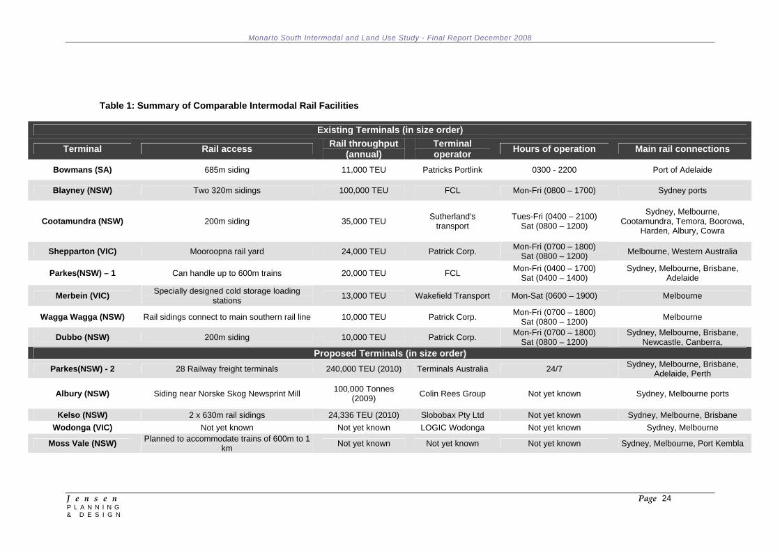
Table 1: Summary of Comparable Intermodal Rail Facilities
Existing Terminals (in size order) Terminal Rail access Rail throughput
(annual) Terminal operator Hours of operation Main rail connections
Bowmans (SA) 685m siding 11,000 TEU Patricks Portlink 0300 - 2200 Port of Adelaide
Blayney (NSW) Two 320m sidings 100,000 TEU FCL Mon-Fri (0800 – 1700) Sydney ports
Cootamundra (NSW) 200m siding 35,000 TEU Sutherland's transport
Tues-Fri (0400 – 2100) Sat (0800 – 1200)
Sydney, Melbourne, Cootamundra, Temora, Boorowa,
Harden, Albury, Cowra
Shepparton (VIC) Mooroopna rail yard 24,000 TEU Patrick Corp. Mon-Fri (0700 – 1800) Sat (0800 – 1200) Melbourne, Western Australia
Parkes(NSW) – 1 Can handle up to 600m trains 20,000 TEU FCL Mon-Fri (0400 – 1700) Sat (0400 – 1400)
Sydney, Melbourne, Brisbane, Adelaide
Merbein (VIC) Specially designed cold storage loading stations 13,000 TEU Wakefield Transport Mon-Sat (0600 – 1900) Melbourne
Wagga Wagga (NSW) Rail sidings connect to main southern rail line 10,000 TEU Patrick Corp. Mon-Fri (0700 – 1800) Sat (0800 – 1200) Melbourne
Dubbo (NSW) 200m siding 10,000 TEU Patrick Corp. Mon-Fri (0700 – 1800) Sat (0800 – 1200)
Sydney, Melbourne, Brisbane, Newcastle, Canberra,
Proposed Terminals (in size order) Parkes(NSW) - 2 28 Railway freight terminals 240,000 TEU (2010) Terminals Australia 24/7 Sydney, Melbourne, Brisbane,
Adelaide, Perth
Albury (NSW) Siding near Norske Skog Newsprint Mill 100,000 Tonnes (2009) Colin Rees Group Not yet known Sydney, Melbourne ports
Kelso (NSW) 2 x 630m rail sidings 24,336 TEU (2010) Slobobax Pty Ltd Not yet known Sydney, Melbourne, Brisbane Wodonga (VIC) Not yet known Not yet known LOGIC Wodonga Not yet known Sydney, Melbourne
Moss Vale (NSW) Planned to accommodate trains of 600m to 1 km Not yet known Not yet known Not yet known Sydney, Melbourne, Port Kembla
Monarto South Intermodal and Land Use Study - Final Report December 2008
J e n s e n Page 25 P L A N N I N G & D E S I G N
2.5 Trends in Freight Regulation and Operations 2.5.1 Overview
This section examines the emerging regulatory and operational trends which influence freight movement at a local, regional and national level.
The National Transport Commission (NTC), in its report Twice the Task (2006), forecast that the overall freight task for Australia would double between 2005 and 2020. The Bureau of Infrastructure, Transport and Regional Economics (2006) has also predicted a similar increase in the Australian freight task, with significant increases in volumes for both road and rail networks. Further to this, the Productivity Commission (2005), identified that Australia’s existing transport system, linking road, rail, sea and air, would not be able to provide the service needed to meet the demands that would be placed on it by the growing freight task. Government is keen to create an efficient transport network as it drives productivity improvements and increases the competitiveness of industry at both a national and international level. Government policy aims to deliver an effective balance between community amenity, mobility and the economic benefit derived from the movement of freight on the road network.
2.5.2 Regulation/Policy
The growing levels of traffic congestion on roads and the localized congestion around port areas has resulted in state and territory governments across Australia implementing policy to increase the rail share of freight. To support this, long term investment by both national and state governments has been announced to ensure rail infrastructure bottlenecks are removed and that connectivity between transport modes is encouraged to develop seamless transport systems.
Recently, government has considered regulatory processes that have focused on cost recovery for infrastructure use for both road and rail, in particular, recovering direct and indirect costs for the maintenance and construction of infrastructure from asset users. It is understood that these regulations are still under review.
Regulatory reform in the transport sector has been driven by 4 key attributes:
National consistency - Reform is to be consistent across states to encourage competition.
Safety - Improve technology and operator regulation. Environment – Adopt the latest emissions standards and
monitoring programs. Productivity - Provide framework that facilitates operations and
competitiveness of industry.
Monarto South Intermodal and Land Use Study - Final Report December 2008
J e n s e n Page 26 P L A N N I N G & D E S I G N
2.5.3 Consumer Demand/Population Growth
Increases in population and consumer wealth drives demand for more exotic, high cost goods, typically sourced from other regions or internationally. The overall transport task associated with importing goods is much greater than locally or regionally produced goods. Along with sea based freight movements, additional road/rail based trips are required to move goods from the port to the ultimate destination.
2.5.4 Fuel, Peak Oil and Climate Change
Notwithstanding the projections referred to above regarding Australia's expected increase in the overall freight task, relatively recent global oil increases coupled with climate change concerns and the likely move towards a more 'carbon neutral' economy may have ongoing implications for the drivers of increased freight and the methods with which freight is moved. For example, the historical growth in demand for and consumption of goods may be tempered by the increased costs that will inevitably accrue to goods as oil price hikes and carbon taxes are gradually factored in. Furthermore, the increase in fuel costs will gradually drive more efficient methods for the transportation of goods and may influence the shift from road to rail transport methods.
Generally, transport operators will pass on increased costs associated with rises in fuel prices to the end user. To mitigate costs, there are a number of options available to transport operators such as:
reduce the amount of empty running (i.e. kilometres travelled whilst unloaded) through improved scheduling;
upgrade to vehicles that provide better fuel efficiencies; seek alternative forms of transport (i.e. rail over road, sea freight);
or change distribution practices.
Notwithstanding the potential to pass increased transportation costs onto the end consumer, there is a 'risk' that broader community concerns about the ongoing environmental impact of current high consumption lifestyle choices will dampen demand for goods and therefore the need for large-scale freight facilities such as intermodal hubs.
2.5.5 Congestion
Delays due to congestion have a major impact on operating costs to industries that rely on the transport network to move time sensitive products and to companies engaged in the transfer of freight. Congestion impacts on the freight industry by increasing travel costs and travel time and reducing operating efficiency. Eventually more trucks, or longer operating hours, will be required to undertake the same transport task as a result of traffic congestion. Rail operations are impacted by suburban passenger priorities in many cities thus

Monarto South Intermodal and Land Use Study - Final Report December 2008
J e n s e n Page 27 P L A N N I N G & D E S I G N
placing constraints on hours of operation and causing reduced reliability.
2.5.6 Supply Chain Management
Typically freight movement has been a disjointed exercise between the owners of the freight, the trucking company, the warehouse, the shipping agent and at times the storage facility. Poor knowledge and control of the supply chain has often resulted in heavy vehicles operating at well below capacity, resulting in road movements below optimum capacity. Recent trends have seen larger logistics businesses integrate the overall supply chain process incorporating road, rail, storage, warehousing and at times shipping. By being in charge of the supply chain, the logistics operator now has the incentive to behave in an efficient and effective manner to reduce costs and fully utilise their equipment. Experience has shown that this integrated practice typically reduces the number of heavy vehicles required to undertake the freight task through improved efficiencies.
2.5.7 Distribution Facilities
As with Big W at Monarto, centralised distribution centres are being created on the outskirts of larger cities in close proximity to freeways and other major transport networks. Business relies on the urban road network to quickly access their major customer base via the urban road network to deliver freight as required. The distribution centres either serve the immediate surrounding area, or can serve the region or entire country, based on their proximity to the road, rail and air networks. A distribution centre allows business to focus its bulk shipment of freight through larger vehicles and use smaller delivery vehicles to co-ordinate customer deliveries.
Logistics and freight companies have been altering the manner in which they do business due to changes in consumer demand. The move by retailers to have lower stock holdings and the reliance on commercial vehicles to become mobile warehouses has resulted in the logistics concept of ‘Just In Time’ delivery. This results in the generation of more frequent deliveries utlising smaller vehicles to meet customer demand.
2.5.8 Freight Statistics
The freight task along the Adelaide - Melbourne transport corridor was approximately 8 million net tonne kilometres in 2007 (BITRE 2008), with 4.35 million net tonne kilometres being between Melbourne and Adelaide and 3.65 million net tonne kilometres between Adelaide and Melbourne. BITRE (2006) estimates that along the corridor, the road network is used to transport approximately 58% of non-bulk freight goods while rail moves 41% (these goods are predominantly import/export goods which are consolidated in Melbourne or Adelaide and then railed between the two cities). Air transport and coastal shipping account for less than 1% of goods moved. Forecasts for 2025 (BITRE, 2006) along the corridor show that freight will more than

Monarto South Intermodal and Land Use Study - Final Report December 2008
J e n s e n Page 28 P L A N N I N G & D E S I G N
double to over 13 million tonnes and the reliance on the road modal share will increase to 78% and rail will decrease to 22%. Air and coastal shipping will continue to play minor roles, although the Federal Government has recently released a report which aims to increase coastal shipping’s share of the task indicating some renewed commitment to that mode.
BTRE identifies the reduction in the percentage of goods carried by rail will result from major network constraints along the rail network which will continue to make the movement of goods via road a more competitive option. The introduction of B-double trucks and the opening of the South East Freeway have increased heavy vehicle traffic along the corridor significantly over this period.
Adelaide has a container throughput of 260,000 TEU per annum. Around 120,000 of these container movements are by rail specifically between the ports of Adelaide and Melbourne. The Port of Melbourne has a throughput of over 2,000,000 TEU per annum and the Port of Adelaide 200,000 per annum (BTIRE 2008).
BITRE (2006) have identified the Adelaide to Melbourne transport corridor as the most competitive between road and rail in Australia. Overall road and rail costs (door to door shipping) are similar for the shipment of containers between the two cities, however recent increases in fuel prices are starting to impact upon the balance for the overall freight task. The cost to move containers via road or rail varies based on competition along the corridor which is influenced by the delivery time, the urgency of the delivery, the location of the destination, the dwell time of the container in the yard and other similar factors. The Productivity Commission (2006) found that the information on freight rates along this corridor was inadequate to develop an accurate cost figure. The report by the Productivity Commission also identified that in real terms, the freight cost for rail and road had fallen based on a cents per tonne kilometer up until 2001 (last set of figures by BITRE).
Monarto South Intermodal and Land Use Study - Final Report December 2008
J e n s e n Page 29 P L A N N I N G & D E S I G N
3 STRATEGIC AND POLICY CONTEXT 3.1 State Strategies 3.1.1 Strategic Infrastructure Plan for South Australia 2005/06 - 2014/15
The Transport section of the SIPSA notes that:
Nationally, the majority of domestic freight, measured by tonnage and value, is moved by road (72%), followed by rail, sea and air;
When distance carried is taken into account, road, rail and sea carry similar proportions (37%, 35% and 28% respectively);
The quantity of freight moved has increased by 70% during the past two decades; and is anticipated to double between 2002 and 2020.
It identifies the need to "improve the State's competitiveness through efficient freight transport networks and improved international links" as a strategic priority and notes that "the use of rail for freight … has the potential to reduce road congestion, improve safety and reduce environmental impacts from road vehicles… especially ….for bulky goods on long haul." It identifies a number of infrastructure challenges to increasing the role of rail, including the lack of intermodal facilities feeding the standard gauge network.
Importantly, the SIPSA suggests that "the long-term strategic aim for rail is to develop a connected metropolitan, regional and interstate standard-gauge network, capable of supporting the axle weights and lengths of modern freight trains. The network should be serviced by intermodal terminals that facilitate rapid transhipment between road and rail."
In this regard, another strategic priority is to "encourage the shift to rail transport for passenger and freight movements where justified by environmental, economic or social imperatives."
Amongst the Projects identified within the Transport section is one to "develop intermodal facilities in northern Adelaide and the Barossa Valley and consider intermodal developments at Port Augusta, Riverland and Port Stanvac", which is given a priority 1 ranking (with the private sector having the lead responsibility).
The Murray and Mallee section of the SIPSA notes that "future economic growth will require efficient transportation links. A priority is therefore to identify and upgrade local linking freight routes, which will improve the efficiency of freight handling and transfer, the level of service to the major highway links and road safety."
The Murray and Mallee Projects of interest to this study include:
Consider the general aviation potential of Murray Bridge (priority 3 ranking with local government having the lead responsibility);
Monarto South Intermodal and Land Use Study - Final Report December 2008
J e n s e n Page 30 P L A N N I N G & D E S I G N
Determine the feasibility of developing an industrial/intermodal precinct at Tailem Bend (priority 2 with local government and the private sector having the lead responsibility).
3.1.2 South Australia's Strategic Plan 2007
A scan of SASP revealed few if any specific targets of relevance to this study, the possible exception being the following target under Objective 1: Growing Prosperity:
T1.21 TARGET – Strategic infrastructure (existing –modified): match the national average in terms of investment in key economic and social infrastructure.
3.1.3 Planning Strategy for Regional South Australia January 2003 (As
amended at December 2007)
The PSRSA includes a number of references, both general and specific, to the Murraylands region that are of relevance to this study, including the following:
INFRASTRUCTURE 5.1 GOALS
Reliable, efficient and competitive inter and intra-regional infrastructure Regional infrastructure that supports economic development Efficient and competitive regional freight transport system A safe regional transport system for all users Priorities
Transport
Improving the reliability, efficiency and competitiveness of the transport system.
Planning for new, larger truck combinations particularly at transfer points in towns and cities.
Encouraging transfer from road to rail and sea where commercially viable.
TRANSPORT Moving People, Goods and Services
Efficient road, rail, sea and air freight is critical in enabling the efficient export of South Australian products and importing essential material for production. While unprocessed food and raw material will continue to remain major exports, there is also expected to be a significant increase in value added food product exports. As metropolitan Adelaide remains the focus for South Australian exports, competitive and efficient road, rail, sea and air connections to Port Adelaide and Adelaide Airport are necessary.
Trends in the movement of freight within and between regions will result in substantial changes to cargo chains. An important factor will be further deep sea port development. Another will be the identification of strategic silo sites to facilitate the efficient storage of grain for delivery to port and subsequent

Monarto South Intermodal and Land Use Study - Final Report December 2008
J e n s e n Page 31 P L A N N I N G & D E S I G N
export. The identification of these sites will result in an increase in the use of rail to transport grain to the ports. Additional opportunities for the transfer of freight from road to rail are also receiving increasing attention through inland rail and road hubs. Efficient road freight access to key terminals, such as ports, airports, road and rail terminals and grain silos, will be important, both in regional areas and in Adelaide where a large part of intrastate/interstate and international freight is consolidated. Access to facilities such as cold stores and packing and processing facilities is also critical. Good access is essential to ensure freight movements are efficient and needs to accommodate emerging larger and more efficient heavy vehicle combinations. The road system needs to be designed to allow vehicles carrying large, heavy loads to access strategically located inter-modal terminals to minimise road wear.
5.4 STRATEGIES MOVING PEOPLE, GOODS AND SERVICES Road
22 Develop an integrated transport system that provides access for all users. a. … b. Encourage the development of intermodal freight facilities that
maximise the efficiency of the transport system. c. Set clear direction for future land use and development activity
at country towns in regional South Australia with a particular focus on key intermodal locations.
d. Secure the long-term future of regional freight access and operating arrangements at key intermodal locations.
e. Improve regional freight transport efficiency and freight access to and from and within regions.
23 Encourage the development of an efficient and competitive road
transport system that supports businesses. a. Encourage the development of handling and processing facilities
in regions and adjacent areas, where economically feasible, to reduce the demand for freight movement.
b. Encourage uptake of e-commerce and other information based solutions at inter-modal terminals and key freight collection points to minimise time lost in accessing the terminal complex.
c. Provide information on the comparative performance of freight transport modes and vessel/vehicle configurations.
d. … e. Support an increase in rail transport as a cost-effective
alternative to road. f. Manage the transport infrastructure, including the location of
inter-modal transfers, efficiently and effectively by using an integrated approach.
Rail 29 Upgrade and maintain an efficient and competitive rail system to
and within regions. a. Facilitate the integration and take up of rail as a freight mode in
the State. b. Monitor the operations and investment strategies proposed and
adopted by Australian Rail Track Corporation as they impact on the State.
Monarto South Intermodal and Land Use Study - Final Report December 2008
J e n s e n Page 32 P L A N N I N G & D E S I G N
c. Encourage open, competitive and seamless access to the national rail system on a consistent and equitable basis.
d. … e. …
30 Ensure the rail transport system supports South Australian
business. a. Investigate the re-opening or standardisation of particular
intrastate broad gauge lines and the development of new lines. b. …
MURRAYLANDS PLANNING AND DEVELOPMENT AREA
Infrastructure Strategies 43 Investigate the major impediments to manufacturing and
processing caused by electricity supply and develop particular solutions.
44 Undertake a feasibility study to extend reliable gas supplies into the Murray Bridge/Monarto and Tailem Bend area to enhance the development of a food industry cluster and other value-adding activities.
45 Investigate opportunities for the transfer of freight from road to rail where commercially viable.
46 Ensure access to local and export markets by maintenance of the road network.
47 Improve access between the Murraylands, Port Adelaide and Adelaide International Airport.
48 Maintain key rail links to an appropriate standard.
3.1.4 Metropolitan Adelaide Industrial Land Strategy (April 2007)
The Metropolitan Adelaide Industrial Land Strategy (MAILS) was released by the Minister for Urban Development and Planning in May 2007. The Strategy proposes a number of key strategies and 16 actions to achieve the aim of ensuring a continuous supply of market-ready industrial land available for development in Adelaide.
The geographic scope of MAILS does not include the Rural City of Murray Bridge or the Murraylands area. However, it is noted in the introduction to the Strategy that the State Government does intend to widen the purview of the Strategy to include the peri-urban areas, including the Rural City of Murray Bridge. The Strategy states that "the Government appreciates that in certain parts of the peri-urban arc surrounding metropolitan Adelaide (the outer metropolitan region, as defined in the Planning Strategy, plus the Rural City of Murray Bridge) there is also considerable industrial and other development activity occurring. It is intended to extend the Strategy to include these areas at a later time."
Planning SA has undertaken preliminary work on the preparation of a draft Outer Metropolitan Adelaide Industrial Land Strategy.
3.1.5 Employment Lands Planning Forum
One of the key actions (Action 11) of the MAILS is to establish a joint State Government, Local Government and private sector industry
Monarto South Intermodal and Land Use Study - Final Report December 2008
J e n s e n Page 33 P L A N N I N G & D E S I G N
reference group to monitor industrial land supply, demand and utilisation issues and trends.
In April 2008, the Minister for Urban Development and Planning announced the formation of a reference group called the Employment Lands Planning Forum. He stated that the “Forum will monitor both the metropolitan area and the outer metropolitan regions surrounding Adelaide, including Port Wakefield, Bowmans, Balaklava, Monarto, Murray Bridge and Tailem Bend.” And that “To assist and support the Forum, additional work is being carried out within the State Government to extend the detailed information on the supply of and demand in outer metropolitan Adelaide for land to be developed for job generating commercial uses.”
3.2 Existing Development Plan Policy
The existing zoning arrangements within Monarto South are shown in Figure 2. The broad intent of each of the zones is summarised as follows:
Zone Extent of Zone Intent of Zone Commercial (Monarto South)
East and west of Ferries McDonald Road either side of railway and smaller parcel south of SE Freeway, east of Ferries McDonald Road - includes Big W, Inghams, Uniken, APC and former Gerard Industries site.
Distribution facilities, warehousing, service industries, rural industries, rural processing, horticulture, farming, bulk handling, storage and transportation of farm commodities and a roadside service centre. Area to the south of the SE Freeway intended for a service centre/petrol filling station.
Primary Industry Extensive areas north and south of SE Freeway
Primary industry, including primary production, on-farm activities related to the breeding, growing, harvest and storage of that production, value added processing and, in appropriate locations, processing of raw products. Area to north of SE Freeway to accommodate mixed farming including horticulture and some intensive animal keeping. Area to south of SE Freeway to accommodate wide range of general farming, intensive animal keeping and other primary production activities on large land holdings in an open rural landscape.
Rural (Monarto Zoological Park)
Approximates the extent of the zoological park
International standard fauna conservation park and educational and passive recreational resource. Protection from development likely to adversely effect existing watercourses and other environmentally important features.
Scenic Corrridor Band of revegetation extending along northern side of SE Frewway
Development directly associated with agriculture, recreational and community use of an open character that does not detract from the scenic character of the zone when viewed from the SE Freeway.
The geographic extent of the Commercial (Monarto South) Zone is limited. Furthermore, if an intermodal facility was to occur within the region policies would need to be developed to protect key parcels of
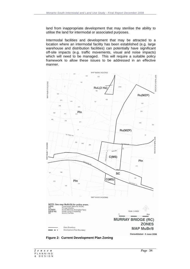
Monarto South Intermodal and Land Use Study - Final Report December 2008
J e n s e n Page 34 P L A N N I N G & D E S I G N
land from inappropriate development that may sterilise the ability to utilise the land for intermodal or associated purposes.
Intermodal facilities and development that may be attracted to a location where an intermodal facility has been established (e.g. large warehouse and distribution facilities) can potentially have significant off-site impacts (e.g. traffic movements, visual and noise impacts) which will need to be managed. This will require a suitable policy framework to allow these issues to be addressed in an effective manner.
Figure 2: Current Development Plan Zoning
Monarto South Intermodal and Land Use Study - Final Report December 2008
J e n s e n Page 35 P L A N N I N G & D E S I G N
3.3 Relevant Studies and Reviews 3.3.1 Regional North South Transport Corridor - Final Report (February
2006)
This study confirmed that the Regional North South Transport Corridor (defined in the report as Kangaroo Road, Ferries McDonald Road, Schenscher Road, Pallamana-Wagenknecht Road, Mannum-Murray Bridge Road, Sedan, Cambrai, Bower Boundary Road) has significant support and strategic merit. The report indicated that the upgrading of the nominated roads will enable the establishment of a Regional North South Transport Corridor that will:
Create a transport route of regional and state strategic significance for not only South Australia, but also of national significance to support interstate freight access;
Support a diverse cross section of industry needs and service a broad catchment area;
Link three major state and national freight corridors, namely the South East Freeway, the Sturt Highway and the Morgan to Burra Road.
Upgrade of the southern leg of the north-south corridor has been funded and the planning has commenced (i.e. sealing of the Ferries McDonald and Kangaroo Roads). Upon completion, the corridor will ultimately provide enhanced road connections between the Langhorne Creek region to the south and Barossa Valley to the north. The north-south corridor will ultimately be designated as a B-Double freight route and it is noted that potions of this corridor are already approved for B-Double operations.
3.3.2 National Intermodal Terminal Study - Final Report (February 2006)
While predominantly confined to intermodal terminals that play or will play a nationally significant role and not terminals of local or regional significance, the study did identify a number of regional intermodal sites under consideration at the time the study was undertaken, including the following:
Mount Gambier, with the freight task comprising wood chips and paper products;
The Adelaide-Brighton cement works site at Angaston; The Barossa Valley, with wine being shipped to Port Adelaide for
export and to the ARTC network for interstate distribution (requiring a 70 kilometre rail link to connect the Barossa to the ARTC network);
Port Augusta and/or Pimba, supporting the freight task of the Olympic Dam mining operations;
Olympic Dam, involving a dedicated BHPB intermodal terminal taking supplies to the mine and carrying copper sheets to Port Adelaide.
Monarto South Intermodal and Land Use Study - Final Report December 2008
J e n s e n Page 36 P L A N N I N G & D E S I G N
The study notes that "the major limitation on regional terminals is that the freight task moves mostly in one direction, with limited scope for backhaul cargos. The only major exceptions to this would be the Olympic Dam and Barossa Valley sites."
3.3.3 South Australian Rail Freight - A Bypass to Save the Heart of
Adelaide (2007)
This report was prepared by the Rail Freight Task Force (RFTF), an initiative of the Mitcham Council, in response to concerns from residents in the Mitcham hills suburbs about the impact of the use of the Adelaide Hills line for the movement of freight trains. The RFTF is of the view that the existing Adelaide Hills line is outdated for rail freight and not upgradeable to achieve current safety standards without significant cost.
The report advocates a solution to this problem in the form of a rail bypass. The suggested rail bypass would deviate from its current alignment at a location west of Murray Bridge (approximately 10km east of the Monarto interchange), heading north around the Adelaide Hills then bearing west near Angaston to connect to the main line to the north of Adelaide at Mallala. While the bypass route separates the AusLink road and rail corridors, access to rail from the South Eastern Freeway would remain via key freight routes (general and higher mass limit 26m B-double routes), including the proposed North South transport freight route which would intersect the rail bypass west of the Pallamana Airfield.
A rail bypass would result in all rail freight destined to/from Adelaide accessing Adelaide from the north; potentially linking into the proposed Northern Connector (a 14km road/rail freight corridor in Adelaide’s north linking the Northern Expressway to the Port River Expressway). The State Government (DTEI) has commenced a planning study to review options for a Northern Connector, with construction expected to commence in 2010 (subject to Government approval).
The report provides a cost estimate for a rail bypass of $150m. This cost allowed for the construction of the track work only and did not include the cost of any required signaling work, rail passing loops, land acquisition, fencing requirements and road crossings. The rail bypass would also intersect a number of key road corridors, including the Sturt Highway, which would require grade separation at significant cost. A previous ARTC estimate for a 180km bypass proposal was $300 – 400m.
The report does not include a detailed economic analysis of the operation of the existing alignment for rail line or the proposed bypass. Nor does the report assess the impact of realigning the route on other communities; intrastate train schedules; schedules and access paths for the rail network to the north of Adelaide; train scheduling on the main line between Melbourne, Adelaide and Perth; and port rail access requirements.
Monarto South Intermodal and Land Use Study - Final Report December 2008
J e n s e n Page 37 P L A N N I N G & D E S I G N
3.3.4 Adelaide Rail Freight Movements Study (2008 - 2010)
The Federal Department of Infrastructure, Transport, Regional Development and Local Government (DITRDLG) has recently commenced the Adelaide Rail Freight Movements Study. The study, to be completed early 2010, will identify and address feasible options for increasing the efficiency and capacity of the freight rail network leading into and through Adelaide, including the option of an Adelaide Hills rail bypass referred to above. Until such time as this study is completed it is highly unlikely that State or Federal Governments will make any decision on a rail bypass for the Adelaide Hills.
Funding submissions for an Adelaide Hills rail bypass would need to be made under AusLink 3. It is considered unlikely that any infrastructure works would be considered in the immediate future (pre 2014) given the current level of rail investment proposed for the eastern seaboard and the proposed Northern Connector. Nevertheless, the outcomes of this study will have significant implications for the establishment of an intermodal facility at Monarto South and therefore will need to be monitored.
3.3.5 The Planning Review 2008/09
In June 2008 the Minister for Urban Planning and Development announced a planning reform agenda for South Australia, which will have implications for the Monarto South region and some of the above documents. Of particular interest are the intentions to:
Create more detailed Regional Plans for all areas of the State, which will include employment and housing targets and major infrastructure requirements. The Regional Plans will become volumes of the Planning Strategy and direct the growth and development of each region;
Identify a rolling 25 year supply of broad acre land for both residential and employment purposes, with 15 years supply zoned for use at any time. Some key principles in the assessment of potential new growth areas will be the proximity to existing transport corridors and to major employment lands.
Importantly, the Government has decided to develop by mid 2009 a new Plan for Greater Adelaide to guide the next three decades of growth. Seven regional partnerships with local councils, industry and state agencies will be established to assist in preparing the Plan. Of the seven regions, the Murray Bridge Council area will be included within the Adelaide Hills region (along with the Adelaide Hills and Mount Barker councils). This is an important departure from the previous strategic planning arrangements where the Murray Bridge council area was included within the Murraylands region of the Regional Planning Strategy for South Australia.
Each of the seven planning regions will identify agreed Growth Precincts for major land releases and redevelopment projects to be included in the Plan for Greater Adelaide. The intended timelines for the preparation of the Plan provides an opportunity for the outcomes
Monarto South Intermodal and Land Use Study - Final Report December 2008
J e n s e n Page 38 P L A N N I N G & D E S I G N
of this Study to be considered as part of the broader strategic planning exercise for the Adelaide Hills region and Greater Adelaide.
3.3.6 Monarto Community Plan (June 2000)
The Monarto Community Plan was prepared by the Monarto Residents Association Inc. and attempts to express a collective view on how change should be managed in the Monarto area. The Plan expresses a number of concerns relating to commercial development within the Commercial (Monarto South) Zone, including: Increased road-side littering and anti-social behaviour; Local roads are expected to carry 'arterial' traffic speeds and
volumes; Road accidents; Noise and air pollution; Public infrastructure under stress (particularly water pressure); Out of character development adjacent to the gateway to the
Monarto Zoo.
In raising these concerns the Plan urges the following actions:
The access road and surrounds be developed to reflect the character of the major destination: the Monarto Zoological Park;
Approval for commercial development in the town centre commercial zone contain integral controls to maintain the gateway character;
Speed controls on the road and access to the road from abutting properties also be consistent with local traffic use and pedestrian traffic needs in the town centre.
The Plan envisages a 'town centre', which approximates the location of the existing Commercial (Monarto South) Zone and which "can integrate urban residential development together with existing public, community and business facilities, and emergent commercial facilities." It goes on to urge the upgrading of the 'town centre' to provide adequate holding areas for commercial vehicles to obviate the need for roadside parking, the segregation of these parking areas from residential areas, and the repair of damaged road shoulders with gravel and plantings to improve amenity and deter commercial vehicle parking.
3.4 Summary In summary:
There is Government acknowledgement of the need to improve the State's competitiveness through more efficient freight transport networks, and the importance of intermodal terminals to facilitate rapid transhipment between road and rail;
There is broad agreement of the benefits in moving the freight task from roads to rail;
Monarto South Intermodal and Land Use Study - Final Report December 2008
J e n s e n Page 39 P L A N N I N G & D E S I G N
The scope of the Metropolitan Adelaide Industrial Land Strategy (April 2007) will be expanded in the future to include the Rural City of Murray Bridge;
The current Development Plan provisions for the Monarto South region will require review and updating following the outcomes of this study, particularly to ensure that suitable land is reserved for a potential intermodal facility and associated development, and to minimise and manage off-site impacts;
The Regional North South Transport Corridor will improve freight transport linkages to/from Monarto South and regions to the north and south as well as the existing national freight and rail networks;
A major limitation of regional intermodal facilities under consideration within South Australia is that the freight task moves mostly in one direction with limited scope for backhaul cargos;
The Adelaide Freight Movements Study to be completed early 2010 will inform the longer term intentions for moving freight by existing or possible new rail networks that may bypass Monarto South. This will have implications for any future intermodal facility at Monarto South;
The State Government's announcements regarding future strategic planning arrangements for Greater Adelaide will provide an opportunity for the outcomes of this study to be considered and incorporated into a future plan for the region;
The Monarto Community Plan raises a number of concerns regarding commercial development and its associated impacts on the character and function of the Monarto South area and the need for future development to be designed, developed and managed in a way that minimises impacts and reflects the importance of the way to Monarto Zoo.
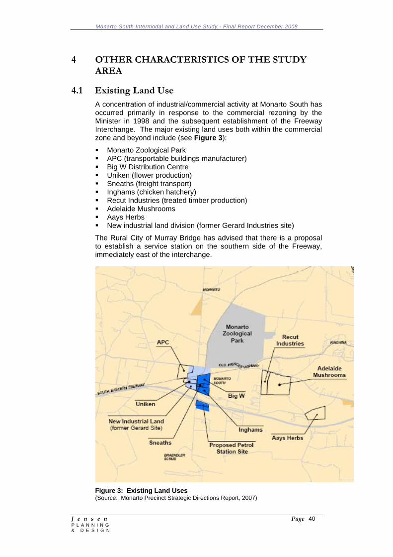
Monarto South Intermodal and Land Use Study - Final Report December 2008
J e n s e n Page 40 P L A N N I N G & D E S I G N
4 OTHER CHARACTERISTICS OF THE STUDY AREA 4.1 Existing Land Use
A concentration of industrial/commercial activity at Monarto South has occurred primarily in response to the commercial rezoning by the Minister in 1998 and the subsequent establishment of the Freeway Interchange. The major existing land uses both within the commercial zone and beyond include (see Figure 3):
Monarto Zoological Park APC (transportable buildings manufacturer) Big W Distribution Centre Uniken (flower production) Sneaths (freight transport) Inghams (chicken hatchery) Recut Industries (treated timber production) Adelaide Mushrooms Aays Herbs New industrial land division (former Gerard Industries site)
The Rural City of Murray Bridge has advised that there is a proposal to establish a service station on the southern side of the Freeway, immediately east of the interchange.
Figure 3: Existing Land Uses (Source: Monarto Precinct Strategic Directions Report, 2007)
Monarto South Intermodal and Land Use Study - Final Report December 2008
J e n s e n Page 41 P L A N N I N G & D E S I G N
Further to the north (approximately 3 kilometres from Old Princes Highway) is the Monarto rural living area comprising residential dwellings on smaller (2 Ha) rural living holdings. Smaller 'hobby farm' holdings are also located approximately 5 kilometres to the south of the Freeway near the bend in the Ferries McDonald Road. Dwellings, associated with either rural living / hobby farm / or larger rural land holdings tend to be concentrated along Ferries McDonald Road.
Intensive animal keeping operations (poultry sheds, piggery) are scattered throughout the broader region, with the predominant land use being broadacre agriculture.
Both the Monarto and Ferries McDonald Conservation Parks are located approximately 4 and 10 kilometres to the south of the Freeway, adjacent to and straddling the Ferries McDonald Road.
4.2 Existing Physical Conditions and Social and
Environmental Context The dominant physical / landscape features within the Monarto South Study Area include:
The confluence of the South Eastern Freeway, the Adelaide - Melbourne railway line, Ferries McDonald Road and Princes Highway and the resultant concentration of commercial activity within this area. Amongst this concentration of activity are grain silos (north-west of the Ferries McDonald/railway junction), and various community facilities including a Memorial Hall, community post office, CFS Station and tennis club facilities. A rarely used spur line extends from the main railway line in a north east direction at Monarto South;
The Monarto Zoological Park, which is a 1,000 hectare open-range sanctuary known for its role in breeding programs for rare and endangered species. The Park is accessed from Princes Highway, usually via the Freeway and Ferries McDonald Road interchange and is a major tourist attraction within the region, attracting around 100,000 people per annum. The vast majority of visitors to the Park would drive through the adjacent Monarto South commercial precinct;
The extensive areas of revegetation that occurred principally along the northern side of the South Eastern Freeway. The revegetation was an initiative of the then Monarto Development Commission and was intended as a buffer between the Freeway and the proposed new town at Monarto in the early 1970's.
As mentioned, the region includes two Conservation Parks located to the south of the Freeway near the Ferries McDonald Road. Both Parks continue to preserve significant tracts of both remnant and regenerated vegetation. Important remnant vegetation also exists beyond the Park system, including within the Monarto Zoological Park and on private holdings. However, with the exception of the
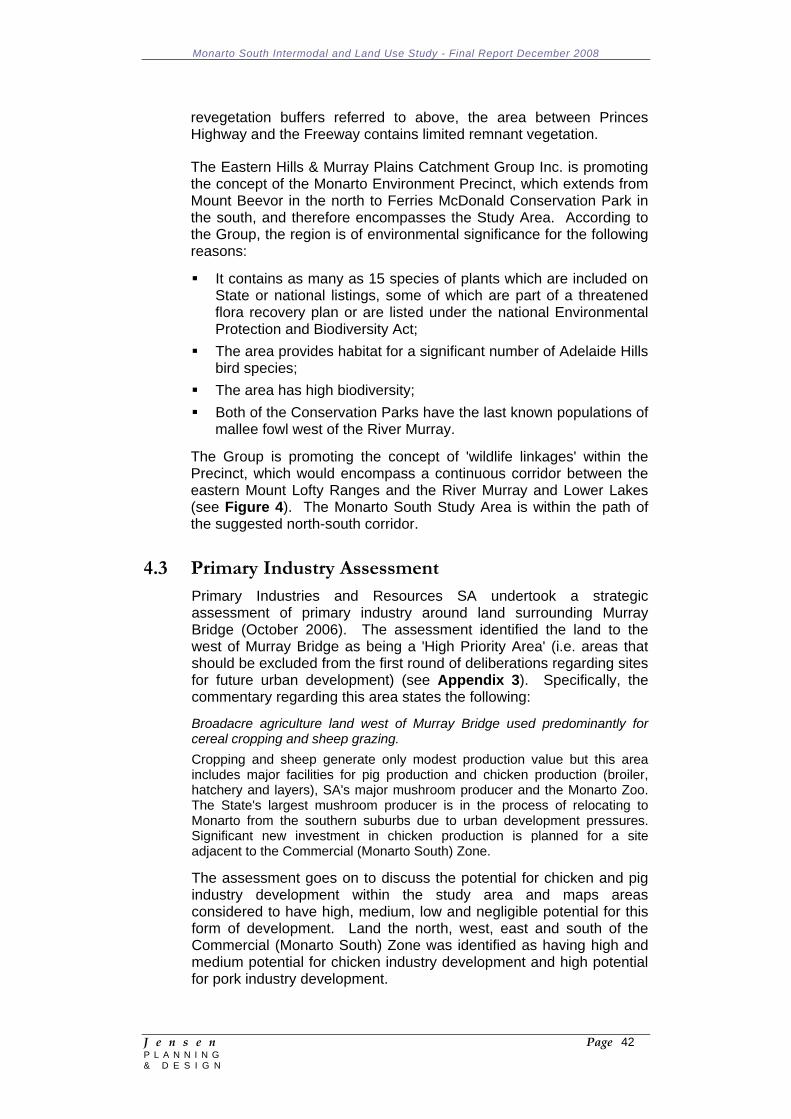
Monarto South Intermodal and Land Use Study - Final Report December 2008
J e n s e n Page 42 P L A N N I N G & D E S I G N
revegetation buffers referred to above, the area between Princes Highway and the Freeway contains limited remnant vegetation.
The Eastern Hills & Murray Plains Catchment Group Inc. is promoting the concept of the Monarto Environment Precinct, which extends from Mount Beevor in the north to Ferries McDonald Conservation Park in the south, and therefore encompasses the Study Area. According to the Group, the region is of environmental significance for the following reasons:
It contains as many as 15 species of plants which are included on State or national listings, some of which are part of a threatened flora recovery plan or are listed under the national Environmental Protection and Biodiversity Act;
The area provides habitat for a significant number of Adelaide Hills bird species;
The area has high biodiversity; Both of the Conservation Parks have the last known populations of
mallee fowl west of the River Murray.
The Group is promoting the concept of 'wildlife linkages' within the Precinct, which would encompass a continuous corridor between the eastern Mount Lofty Ranges and the River Murray and Lower Lakes (see Figure 4). The Monarto South Study Area is within the path of the suggested north-south corridor.
4.3 Primary Industry Assessment
Primary Industries and Resources SA undertook a strategic assessment of primary industry around land surrounding Murray Bridge (October 2006). The assessment identified the land to the west of Murray Bridge as being a 'High Priority Area' (i.e. areas that should be excluded from the first round of deliberations regarding sites for future urban development) (see Appendix 3). Specifically, the commentary regarding this area states the following:
Broadacre agriculture land west of Murray Bridge used predominantly for cereal cropping and sheep grazing. Cropping and sheep generate only modest production value but this area includes major facilities for pig production and chicken production (broiler, hatchery and layers), SA's major mushroom producer and the Monarto Zoo. The State's largest mushroom producer is in the process of relocating to Monarto from the southern suburbs due to urban development pressures. Significant new investment in chicken production is planned for a site adjacent to the Commercial (Monarto South) Zone.
The assessment goes on to discuss the potential for chicken and pig industry development within the study area and maps areas considered to have high, medium, low and negligible potential for this form of development. Land the north, west, east and south of the Commercial (Monarto South) Zone was identified as having high and medium potential for chicken industry development and high potential for pork industry development.
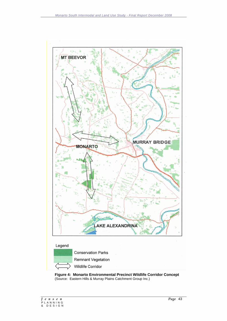
Monarto South Intermodal and Land Use Study - Final Report December 2008
J e n s e n Page 43 P L A N N I N G & D E S I G N
Figure 4: Monarto Environmental Precinct Wildlife Corridor Concept (Source: Eastern Hills & Murray Plains Catchment Group Inc.)
Monarto South Intermodal and Land Use Study - Final Report December 2008
J e n s e n Page 44 P L A N N I N G & D E S I G N
The commentary in the report suggests that the mapping "… simply identifies sites that meet basic requirements for intensive livestock production. There are numerous other site with high and medium potential across the Murray Bridge council area and the State, and market demand is unlikely to require more than a handful of these to be developed."
4.4 Implications
Any intensification of development within the Monarto South precinct, and the policies that are formulated to facilitate such development, should be cognisant of the following:
There is an existing, albeit low density population settlement within and beyond the Monarto South area with a small grouping of community facilities in Monarto South. Accordingly, any future development within the Precinct needs to consider the longer term implications for these communities, including traffic generation, safety and impacts, the visual impact of development, noise, light overspill, after hours activity, demand on emergency services, physical infrastructure services capacity and stock management;
The Ferries McDonald Road / Freeway interchange and the adjacent commercial areas is a significant 'gateway' to Monarto South generally and to the Monarto Zoological Park specifically. Accordingly, the quality of development within the Precinct, particularly when viewed from public roads, needs to reflect this important role and be designed to a high standard. This includes the buildings, perimeter landscaping, associated infrastructure such as car parking areas and stormwater detention basins, fencing etc;
Similarly, the quality of the public realm, which is under the care and control of the Rural City of Murray Bridge, should be of a higher standard than currently prevails within the Precinct. This will require greater attention to the design and management of verges, stormwater, other services, landscaping and signage;
The broader environmental context of the Monarto South Precinct will require some attention to the notion of wildlife corridors as promoted by the Eastern Hills & Murray Plains Catchment Group Inc. For example, this could extend to the need to consider a broader role of buffer landscaping (i.e. beyond just screening undesirable views of buildings and operations) so that greater attention is paid to species selection, the width of and linkages between vegetation buffers.
Monarto South Intermodal and Land Use Study - Final Report December 2008
J e n s e n Page 45 P L A N N I N G & D E S I G N
5 POTENTIAL FOR AN INTERMODAL FACILITY AT MONARTO SOUTH 5.1 Introduction
The Monarto South precinct provides the opportunity to further enhance the growing commercial and industrial business sector that has already been established in the region utilising existing transport infrastructure links to key markets (domestic, national and international). These road and rail links will provide opportunities for new industry development that is consistent with infrastructure investment strategies (see Figure 5).
The Monarto precinct is strategically positioned along the AusLink national highway and rail network. AusLink is the federally funded Australian transport network linking the road, rail, air and sea sectors. The network was established by the Federal Government to promote the efficient movement of goods through an integrated transport system that facilitates economic development at a regional and national level.
Monarto is approximately 60 kilometres from Adelaide city centre and 80 kilometres from the port. It is in close proximity to the Adelaide Hills (35 kilometres) and the Fleurieu Peninsula (90 kilometres). Utilising the north south road network, it is approximately 130 kilometres from Gawler.
5.2 Benefits of Monarto South
The establishment of a successful intermodal facility requires access to the main rail line, preferably running adjacent to a long straight stretch of land with access to the main arterial road network. The main rail line between Adelaide and Melbourne runs east-west through Monarto South adjacent to the main highway. The section of track runs straight for approximately 7 kilometres - 2 kilometres to the east of Ferries McDonald Road and 5 kilometres to the west. The land surrounding the main line is relatively flat; however the land to the north east of Ferris McDonald Road is undulating in sections. The area is bound to the south by the South Eastern Freeway with access provided by Ferries McDonald Road, which has been recently upgraded, along with the interchange at the South East Freeway, as part of the North South regional transport corridor.
The location of an intermodal hub in Monarto South will provide industry with the choice of transport modes for the movement of goods. It can provide an opportunity to avoid rail gradients and track congestion issues through the Adelaide Hills by either moving goods between Melbourne and Monarto via rail and then via road to Adelaide; or by moving goods from Adelaide to Monarto by road and then rail to Melbourne. Goods from surrounding primary producers can be value added in the Monarto precinct prior to being moved by road or rail to an ultimate destination, including the Port of Adelaide. The use of road as an alternative transport option will need to be
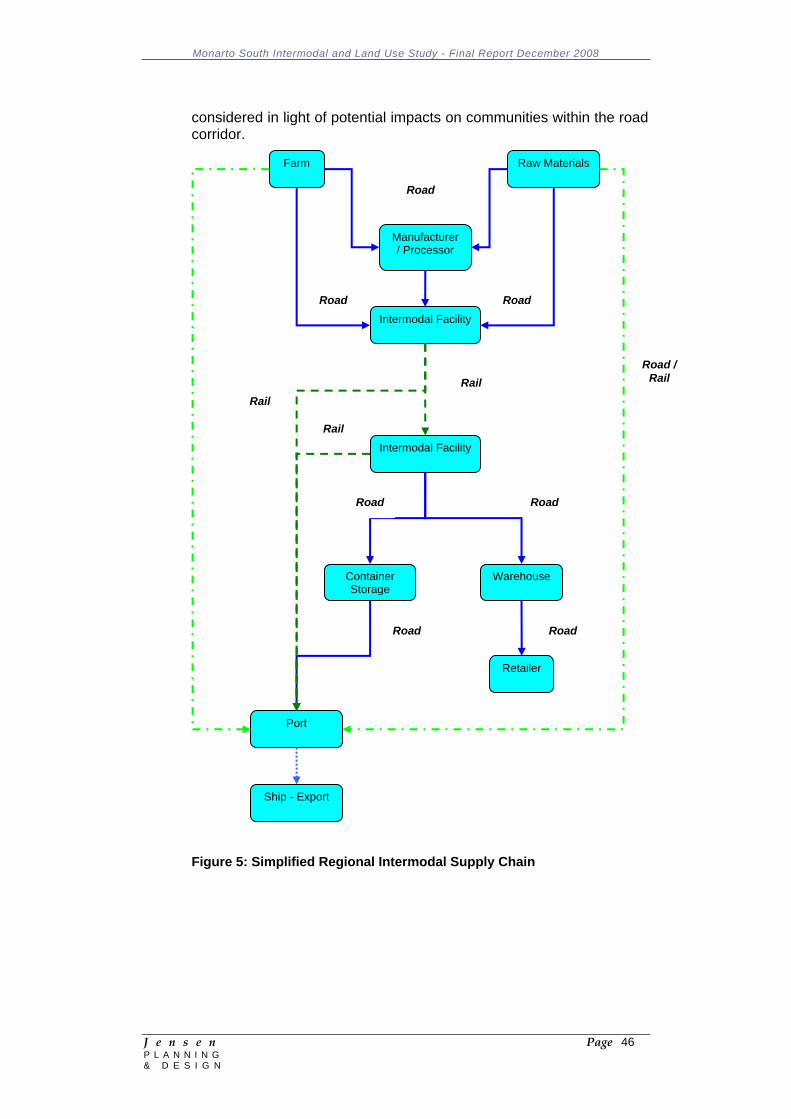
Monarto South Intermodal and Land Use Study - Final Report December 2008
J e n s e n Page 46 P L A N N I N G & D E S I G N
considered in light of potential impacts on communities within the road corridor.
Figure 5: Simplified Regional Intermodal Supply Chain
Farm
Intermodal Facility
Ship - Export
Retailer
Manufacturer / Processor
Container Storage
Intermodal Facility
Port
Warehouse
Raw Materials
Rail Road /
Rail
Road
Road
Road
Road Road
Road
Road
Rail
Rail
Monarto South Intermodal and Land Use Study - Final Report December 2008
J e n s e n Page 47 P L A N N I N G & D E S I G N
As well as providing an economic advantage through improved efficiencies and economies of scale for businesses which establish in the area, an intermodal terminal can also have a positive affect on the environment through reducing the number of vehicle trips (road over rail) and the number of other trips due to co-location of industry on the site. The establishment of an intermodal terminal and commercial precinct has been proven to improve social outcomes for communities through the creation of employment in the area, reduced traffic in urban areas, sustainable commercial growth in designated areas, and population growth in the area.
Summary of Benefits: Access to the Adelaide Hills and region to the south east of
Adelaide; Good road access to the Port of Adelaide and surrounding
industrial areas; Regional industries – wineries, mining, fresh produce, value
added; Future growth forecasts for Adelaide; Consumer and industry demand will continue to increase; Continued growth in the north Asian markets (China and Korea); Some containerized freight does not have to pass through
Adelaide Hills – adds 3 hours to journey time; Trucks can travel from Monarto to the Port of Adelaide in 1.5
hours; Trucks can access the Adelaide Hills and south of Adelaide in 0.5
– 1.0 hours; Trucks can access north Adelaide in 1.5 hours; Reduce transport cost to industry if they establish in Monarto area;
and Long Term Issues to Consider: Rail bypass of the Adelaide Hills (2015+); and Deepening of the channel in the Port of Adelaide (2018+).
5.3 Operational Requirements 5.3.1 Overview
To develop a successful intermodal operation at the Monarto South site, any future terminal will need to be able to operate as a stand alone enterprise. Although it will be expected to generate a number of ancillary industries, the intermodal terminal will need to be independently commercially viable. The Sea Freight Council of NSW in its 2004 report Regional Intermodal Terminals - Indicators for Sustainability identified 6 key attributes necessary to develop a successful intermodal terminal:
Volume;
Monarto South Intermodal and Land Use Study - Final Report December 2008
J e n s e n Page 48 P L A N N I N G & D E S I G N
Distance; Terminal Capacity (& Initial Investment); Seasonality; Competing Channels; and Economic and Social Impact.
The key findings of the report were that to be successful, an intermodal terminal needs to be located at a distance of at least 500 kilometres from a port and have a long term annual TEU throughput of at least 30,000. As the volume of throughput increases, the average cost for handling each TEU decreases, making the terminal more cost competitive. Effective use of rail services can also further improve the commercial competiveness of the intermodal terminal.
The Goulburn Valley Freight and Logistics Centre near Shepparton in Victoria is a local government led project where government and industry are working hand in hand to develop an industrial precinct and intermodal facility to service the regional area. The report by Price Waterhouse Coopers on the Goulburn Valley Freight and Logistics Centre identified a long term operating throughput for the intermodal facility of 35,000 TEU over a 20 year development period. The entire facility complex will be built on a site of approximately 210 hectares adjacent to the main rail line from Melbourne and near the Shepparton highway bypass. The complex will be developed in a staged process to maximize commercial investment and operating efficiency for the intermodal terminal.
An intermodal facility at Monarto will not only need the backing of local government, assisted by the Monarto Common Purpose Group, but also State and Federal Government support and assistance. Local government will lead the way with land use planning and other local incentives; State Government will provide policy for business and economic growth in the area (and funding through associated capital / infrastructure works); and the Federal Government will provide funding through the AusLink program.
5.3.2 Road
The South East Freeway (Princess and Dukes Highway east beyond Murray Bridge) forms part of the AusLink network linking Adelaide and Melbourne as well as intra-state freight movements between regional centres within South Australia. The route not only carries freight between Adelaide and Melbourne, but also links through to Darwin and Perth, with over 2.5 million tonnes of freight per year moving between these cities and Adelaide.
The road network between Adelaide and Melbourne also acts as a key link for the movement of goods between Adelaide and the port of Melbourne. For businesses dealing with North East Asia and North America, ships do not call into the Port of Adelaide, so products need to be transported to the Port of Melbourne for export. BTRE (2006) figures show that approximately one-quarter of South Australia’s containerized trade use the road and rail network to move goods
Monarto South Intermodal and Land Use Study - Final Report December 2008
J e n s e n Page 49 P L A N N I N G & D E S I G N
between Adelaide and Melbourne. Export commodities include grain, wine, timber, mining outputs and manufactured goods.
The South Australian Government’s Heavy Vehicle Access Framework establishes key freight routes suitable for B-double vehicles operating under higher mass limits (HML). The road between Monarto and Adelaide (including the Port of Adelaide) is designated as a HML route under this proposal, as well as between Monarto and Melbourne. This will allow vehicles to move between a potential intermodal terminal in Monarto and the Port of Adelaide and other industrial/commercial areas along dedicated freight routes.
5.3.3 Rail
The national standard gauge rail corridor between Adelaide and Melbourne is under the operational control of the Australian Rail Track Corporation (ARTC). The ARTC owns the standard gauge track in South Australia and is the lessee in Victoria. It owns the track between the SA border and Kalgoorlie in WA with the right to sell access between Kalgoorlie and Perth. The length of track between Adelaide and Melbourne is 832 kilometres, comprising predominantly a single track between the two capital cities. The rail corridor extends east from Adelaide, through the Adelaide Hills, to Monarto and Murray Bridge then south east towards the Victorian border. In Victoria, the rail corridor heads east to Horsham then south east to Geelong and north to Melbourne terminating at the Dynon Rail Yards (with direct port access). The rail corridor has 14 crossing loops within the South Australian section and a further 18 crossing loops in the Victorian section between the South Australian border and Geelong. In Adelaide and Melbourne the line is double tracked.
Interstate movements
ARTC provided access for approximately 4,600 train movements in 2006/07 between Adelaide and Melbourne with over 90% of the movements freight related. Along the entire east west route between Melbourne and Perth, ARTC operated over 6,600 services.
Intrastate movements
Of the train movements occurring in South Australia, 700 were intra-state movements, with most of these being grain related (grain product or empty cars being repositioned). Monarto is also serviced by the Apmurra standard gauge spur line which operates on a seasonal basis during peak grain periods, and the Loxton and Pinnaroo lines further to the east, which enter the main line at Tailem Bend.
ARTC scheduling data (ARTC 2008) shows between 9 and 17 scheduled movements along the main line per day, with variations to this roster occurring during busy periods and as a result of seasonal demand.
Monarto South Intermodal and Land Use Study - Final Report December 2008
J e n s e n Page 50 P L A N N I N G & D E S I G N
Benchmarks
The Australian Transport Council (ATC) has established benchmarks for rail freight trip performance between Adelaide and Melbourne. This includes:
Train lengths of 1800 metres; 11.5 hours trip time in each direction; Average speed of 80 kmh at axle loads of up to 21 tonnes; and Average speed of 60kmh at axle loads between 21 tonnes and 25
tonnes.
ARTC advised that the current average trip time between Melbourne and Adelaide is approximately 12.75 hours (average speed of 65 kmh) and between Adelaide and Melbourne 14.5 hours (average speed of 59kmh). Existing passing loops are not able to handle 1500m trains with the range varying from 643 metres at Mt Lofty to 1018 metres at Coomandook near Tailem Bend. The average train length running along the corridor is approximately 1100 metres.
Service Factors
The issues impacting on the level of service are discussed below:
Infrastructure issues:
There are a number of infrastructure issues along the corridor between Melbourne and Adelaide:
Steep track grades and tight curves in the Adelaide Hills; Torrens Junction; Single track; Tunnels (Adelaide and Melbourne); and Lengthening existing crossing loops to handle at least 1500m
train lengths (although 1800m trains are the aim of ARTC).
Capacity:
The capacity on the rail corridor is determined by the number of existing trains and the extra number of trains the corridor can cope with without impacting on travel time. With existing infrastructure, the addition of trains along the corridor will result in increased transit times and increased operating costs to the end user and a move away from rail to road.
Capacity along the Adelaide to Melbourne rail corridor is linked to infrastructure issues coupled with the number of trains accessing the line, signaling capability, competition with passenger services along the corridor and, in urban sections of the network, train (load) capacity, the age of rolling stock, time of day, scheduling and destination requirements (i.e. port access slots). Along the corridor, most freight services operate during the night, with day services typically allocated to passenger access.
Monarto South Intermodal and Land Use Study - Final Report December 2008
J e n s e n Page 51 P L A N N I N G & D E S I G N
Scheduling:
ARTC is required to provide an ‘Access Undertaking’ to above ground operators in line with the agreement struck with the Australian Competition and Consumer Commission (ACCC, 2002). Train scheduling becomes a complicated tool when considering the issues discussed earlier in this section. Services along this corridor suffer reduced reliability and a reduced operating speed with bunching experienced during peak times and the competing nature of sharing the line with broad gauge trains on the dual gauge section of the track. ARTC data (2008) shows that approximately 60% of rail services ran outside the scheduled service times.
With the freight task predicted to grow significantly along the corridor over the next 20 years, the addition of extra trains to the network will result in extra pressures being placed on the system, potentially increasing the number of delays and travel time.
5.3.4 Trip Time
The average trip time for a loaded semi / b-double between Adelaide and Melbourne is 9.5 hours. This does not take into account peak periods nor the loading or unloading of goods.
The average trip time for a loaded freight train between Adelaide and Melbourne varies between 13 and 15 hours (port to port). The variation in rail time is due to access slot and passing loop availability and the time of day for operations.
5.3.5 Air
Air transport plays a minor role as a freight transport option in the Monarto area with no recorded ABS figures for air transport in the immediate area. For the Adelaide to Melbourne freight corridor, air moves less than 1% of non-bulk freight by volume, although air transport does move goods that are time dependent and of high value.
The Strategic Infrastructure Plan for South Australia – Regional Overview indentified that there was little demand for commercial air services in the Murraylands region. Given this assessment, the Infrastructure Plan has identified Murray Bridge as a potential site for general aviation activities.
From a freight perspective, a regional airport would play a very minor role in a commercial sense for an intermodal and commercial development at Monarto. As a stand alone general aviation airport, a detailed assessment into the opportunities available will need to be undertaken, including the use of the airport as a pilot training centre, an alternative airport to Adelaide for general aircraft, a regional air services hub and for other airport related activities such as repairs and maintenance (refer to Section 6).
Monarto South Intermodal and Land Use Study - Final Report December 2008
J e n s e n Page 52 P L A N N I N G & D E S I G N
5.3.6 Sea
Coastal shipping represented less than 1% (3,400 tonnes) of non-bulk freight goods movement between Adelaide and Melbourne. Of all freight movements, BTRE estimates the sea-freight share of the total task at around 12% of the total corridor task (2006), which were predominantly bulk goods. The majority of this freight was liquid bulk petroleum and minerals. This market will not compete with any potential intermodal facility at Monarto South.
5.3.7 Port of Adelaide
The Port of Adelaide is managed by Flinders Ports (which also controls another 6 ports in South Australia). The port has two main terminals, Outer Harbour, which is the container terminal and Berth 29, which is the port’s bulk facility.
The Port had an annual throughput of 220,000 TEU in 2007 with forecasting predicting this to exceed 530,000 TEU by 2020. The forecasting identifies a continued increase in bulk product being shipped through the terminals, in particular grain and minerals (from mineral sands).
At present the Port has rail access for both containers and bulk product directly to the terminals via the rail yards at South Dry Creek and Islington. The Port does not experience any delays in moving goods to and from the Port via rail as the rail yards are used to marshal and dispatch trains. To cater for the predicted growth, the Port is upgrading infrastructure to manage additional services with the Dry Creek rail yard being the main rail terminal that all trains accessing the Port must go through. Capacity at this rail yard will be increased by the planned addition of a passing loop.
Upgrading of access to the Port via the addition of a rail bridge over the river as part of the Port River Expressway upgrade will ensure growth in port related rail traffic is accommodated. Further growth along the Adelaide – Melbourne corridor can be experienced by upgrading the track to allow the passage of double stack containers through the Adelaide Hills. This will need to be complemented by upgrade works in Victoria.
Road access to and from the Port does not impact on productivity for the Port. The South East Expressway and the Northern Expressway further enhance access to the Port. The gates at the Port have been reconfigured to ensure an improvement in the flow of traffic through the Port and to minimise congestion within the terminal (which currently occurs only in peak periods).
5.3.8 Intermodal
In its Strategic Infrastructure Plan for South Australia (2005), the Department for Transport, Energy and Infrastructure identified the need to develop major intermodal transport storage and logistics facilities to support freight movement by optimizing the use of existing

Monarto South Intermodal and Land Use Study - Final Report December 2008
J e n s e n Page 53 P L A N N I N G & D E S I G N
export routes. Accordingly the State Government is working with the private sector to establish intermodal facilities that would integrate storage, road, rail and air movements.
Along the Adelaide to Melbourne freight corridor, there are two proposed intermodal terminals – Monarto South and Tailem Bend. The Monarto South facility would be based around a commercial and industrial development in the immediate area relying on access to the national standard gauge rail track and nearby South Eastern Freeway. The terminal would operate as a loading and unloading point for containers moving between Melbourne and Adelaide (and Perth/Darwin) as well as providing a transport option for industry in the immediate area.
The proposal for an intermodal terminal at Tailem Bend, south east of Monarto along the Princes Highway, would capture the potential market for mineral sands exports in the north east of the state along with other bulk commodities in the region.
5.3.9 Network Constraints
To gain maximum efficiencies from the operation of an intermodal terminal, the supporting network needs to allow for maximum operational performance. A desk top review of the road and rail infrastructure assets along the Adelaide – Melbourne transport corridor has identified the following constraints:
Road
Capacity of the road network to use longer and/or heavier vehicles (bridges and pavement);
Road geometry and pavement rehabilitation between Murray Bridge and Horsham;
Local government planning; Congestion in urban areas (Adelaide); and Port access (Melbourne).
Rail
Rail access; Single track main line; Passing loops; Signaling; Track capacity (weight); Track geometry (speed restrictions); Rolling stock – availability and capacity; Steep grades in the Adelaide Hills (limit speed and capacity of
trains); Receiving capacity at terminal destinations; and Tunnels restricting option of double stacking of containers.
Road network constraints are being addressed through the Department of Transport, Energy and Infrastructure through strategies such as the Heavy Vehicle Access Framework and the Strategic Infrastructure Plan for South Australia. Upgrades of the road network leading to the Port of Adelaide are being complemented by declaration
Monarto South Intermodal and Land Use Study - Final Report December 2008
J e n s e n Page 54 P L A N N I N G & D E S I G N
of higher mass limit routes for vehicles accessing the port and industrial areas.
Rail network constraints are the responsibility of a number of stakeholders; ARTC for the main line maintenance, the Port of Adelaide for terminals in the port; the service providers for rolling stock and the State and Federal governments for long term infrastructure planning and funding. Upgrades of the main line will be a longer term outcome with some programs (including tunnel upgrades) forecast to be a 20 year funding proposition.
5.3.10 Alternative Options
The operation of the freight rail line through the Adelaide Hills has been a point of discussion for a number of years. Federal and state government funding to undertake a study for the area (discussed above in Section 3.3.4.) will provide some longer term strategic review of the operations of the main line.
The bypass options discussed to date (but without any agreement) identify rerouting the line to the north from an area between Tailem Bend and Murray Bridge to connect with the main line well north of Adelaide. Rerouting of the line at this point, some 30 kilometres to the east of Monarto, will have major impacts on the potential to establish an intermodal facility at Monarto South.
In the event that the bypass option was to occur there may be an opportunity to establish an intermodal facility in or around Tailem Bend. Such a facility would likely be designed to cater for both container traffic as well as the bulk products from the grain areas and the mining regions. The establishment of an intermodal facility at Tailem Bend would require suitable land, rezoning of existing surrounding land, a long straight stretch of track (at least 1.5 kilometres in length for 1.2km trains), road access, services and appropriate infrastructure capacity (road and rail).
The establishment of a bypass route around the Adelaide Hills would have a short to medium term impact on the operation of an intermodal facility to the east of Adelaide. Trains will be able to access the north/west markets without having to stop in Adelaide, the establishment of intermodal terminals to the north of Adelaide will provide quick access along purpose built roads to the Port and other industrial/commercial areas, and train travel time will be reduced (although not significantly due to the additional travel distance to bypass the hills). However, this scenario will be controlled by the level of congestion along the main line to the north of Adelaide. Current data available from ARTC (2008) shows the capacity of the network north of Gawler at Crystal Brook is peaking on certain days and most weekdays between 8am and 6pm. The addition of extra trains from Melbourne through this point will create pressures on access based on existing infrastructure availability. At present Crystal Brook is the junction point for main lines from NSW, WA and the NT. The establishment of intermodal facilities in the area will have short to medium term improvements on the capacity of the main line, however
Monarto South Intermodal and Land Use Study - Final Report December 2008
J e n s e n Page 55 P L A N N I N G & D E S I G N
this will be dictated by the overall growth in demand for the network and any infrastructure upgrades.
Once congestion levels are reached at this junction on the main line, the viability of an intermodal terminal at Tailem Bend could be revisited.
5.3.11 Industry Consultation
Industry groups, bodies and individual companies were contacted to ascertain the opportunities and threats to the establishment of an intermodal terminal in Monarto. Freight forwarders, road operators, rail operators and associations were engaged to obtain feedback on the successful establishment of both a freight and logistics precinct at Monarto and an associated intermodal facility. All persons consulted were in agreement that along the Adelaide - Melbourne corridor, industry relies heavily on road transportation due to service flexibility, cost competitiveness and faster delivery time. Goods moved by container between Adelaide and Melbourne are nearly a third cheaper than from Melbourne to Adelaide (there is less demand for goods to be moved from Adelaide to Melbourne, hence competition is high from road operators seeking a ‘backload’ with rates reflecting that high level of competition). While rail is cheaper per TEU moved directly between Melbourne and Adelaide, the additional time and costs associated with the road transport journeys required to move containers to and from the rail head makes rail a less attractive option for many industries along the corridor.
Toll SPD, a major operator along this corridor, undertakes most of its container movements along the corridor via road, with an approximate annual throughput of 1000 TEU by rail. Other operators along the corridor include SCT, Linfox, Scotts and K & S. The use of rail between Adelaide and Melbourne is mainly for ‘land bridging’ containers from the Port of Adelaide to Melbourne (AusLink, 2007). Containers moved from Melbourne to Adelaide tend to be moved via road; with most goods moved by rail having an ultimate destination in either Western Australia or the Northern Territory. Industry sees little value in the use of Monarto to move containers between ports (Adelaide and Melbourne) for international goods and instead considers that the operational focus should be on moving goods within Australia, in particular facilitating the movement of containers.
The establishment of an intermodal facility should also identify local industries that can utilise the terminal to move goods via containerized transport, including some bulk products which can be moved by road to Monarto at a cheaper rate (either in bulk or in containers) than moving the goods through to Adelaide or other rail heads/ports. Industries identified include grain, mineral sands and timber products. However there may need to be associated investments in infrastructure (including converting track to dual gauge to capture markets currently served by broad gauge rail) to achieve this end.
The attractiveness of Monarto as an intermodal facility for industry will be linked to the establishment of large distribution centres such as the
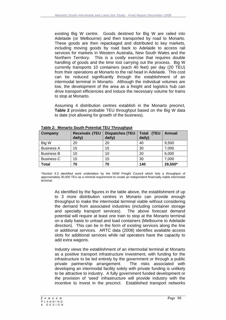
Monarto South Intermodal and Land Use Study - Final Report December 2008
J e n s e n Page 56 P L A N N I N G & D E S I G N
existing Big W centre. Goods destined for Big W are railed into Adelaide (or Melbourne) and then transported by road to Monarto. These goods are then repackaged and distributed to key markets, including moving goods by road back to Adelaide to access rail services for markets in Western Australia, New South Wales and the Northern Territory. This is a costly exercise that requires double handling of goods and the time lost carrying out the process. Big W currently transports 10 containers (each 40 feet) per day (20 TEU) from their operations at Monarto to the rail head in Adelaide. This cost can be reduced significantly through the establishment of an intermodal terminal in Monarto. Although the individual volumes are low, the development of the area as a freight and logistics hub can drive transport efficiencies and induce the necessary volume for trains to stop at Monarto.
Assuming 4 distribution centres establish in the Monarto precinct, Table 2 provides probable TEU throughput based on the Big W data to date (not allowing for growth of the business).
Table 2: Monarto South Potential TEU Throughput Company Receivals (TEU
daily) Dispatches (TEU daily)
Total (TEU daily)
Annual
Big W 20 20 40 9,500 Business A 15 15 30 7,000 Business B 10 10 20 6,000 Business C 15 15 30 7,000 Total 70 70 140 29,500* *Section 5.3 identified work undertaken by the NSW Freight Council which lists a throughput of approximately 30,000 TEU as a minimal requirement to create an independent financially viable intermodal terminal.
As identified by the figures in the table above, the establishment of up to 3 more distribution centres in Monarto can provide enough throughput to make the intermodal terminal viable without considering the demand from associated industries (including container storage and specialty transport services). The above forecast demand potential will require at least one train to stop at the Monarto terminal on a daily basis to unload and load containers (Melbourne to Adelaide direction). This can be in the form of existing services along the line or additional services. ARTC data (2008) identifies available access slots for additional services while rail operators have the capacity to add extra wagons.
Industry views the establishment of an intermodal terminal at Monarto as a positive transport infrastructure investment, with funding for the infrastructure to be led entirely by the government or through a public private partnership arrangement. The risks associated with developing an intermodal facility solely with private funding is unlikely to be attractive to industry. A fully government funded development or the provision of ‘seed’ infrastructure will provide industry with the incentive to invest in the precinct. Established transport networks
Monarto South Intermodal and Land Use Study - Final Report December 2008
J e n s e n Page 57 P L A N N I N G & D E S I G N
(road and rail) with appropriately zoned and priced land will provide an impetus for industry to locate their operations at Monarto.
It is the view of industry that the Monarto precinct can be successful based on the initial provision of appropriate infrastructure in a staged development and the enticement of freight and logistics industries, including distribution centres. This, in turn, would attract complementary and ancillary industries to the area and create a self sufficient precinct.
Monarto South Intermodal and Land Use Study - Final Report December 2008
J e n s e n Page 58 P L A N N I N G & D E S I G N
6 POTENTIAL FOR AN AIRPORT AT MONARTO SOUTH 6.1 Introduction
The Brief required some consideration of the potential for integrating airport activity within a future intermodal hub at Monarto South. The issue of an airport and intermodal hub was given some consideration in the Monarto Precinct Strategic Directions Report (September 2007). That report referred to previous investigations that were undertaken in the 1970's examining the need for a preferred location of an airport to service the needs of the then proposed new town at Monarto (Joint Government Advisory Committee on Adelaide's Airline Airport Requirements February 1975).
In more recent years there has been some speculation regarding the possible relocation of the Parafield Airport and/or the impending need to consider another site to accommodate Adelaide's general aviation requirements. Locations near Two Wells and, perhaps because of the 1970's investigations, Monarto South have been referred to as possible locations for either of the airports.
It is also worth noting that the Strategic Infrastructure Plan for South Australia 2005/06 - 2014/15 does identify the following as a Project: Consider the general aviation potential of Murray Bridge (priority 3 ranking with local government having the lead responsibility).
It is emphasised that the following is a preliminary assessment only. A proposal to locate an airport at Monarto South would require a decision by the Federal Government which, presumably, would follow more extensive investigations of the need, suitability and feasibility of locating an airport at Monarto South.
6.2 Site Options
The Joint Government Advisory Committee report (1975) referred to above examined four possible airport sites within the Monarto region:
Monarto South (south of the Freeway and west of Ferries McDonald Road)
Brinkley Harriot Hill Pallamana
However, this was in the context of the proposed City of Monarto proceeding in an area to the north of the Freeway. Notwithstanding this limitation, the Committee concluded that the Monarto South site was the preferred site for an airport (albeit only to service the needs of a township with a maximum population of 200,000 people) (see Figure 6). It formed this conclusion on the basis of an assessment of a range of criteria, including:
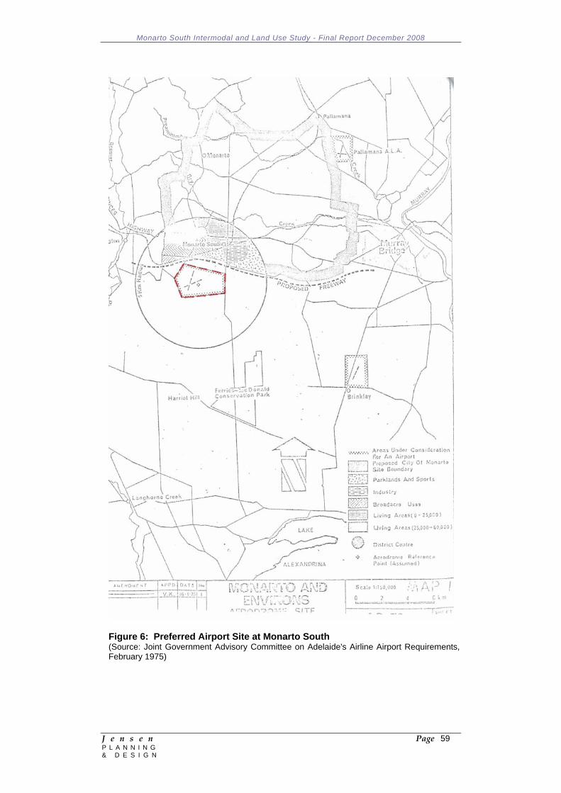
Monarto South Intermodal and Land Use Study - Final Report December 2008
J e n s e n Page 59 P L A N N I N G & D E S I G N
Figure 6: Preferred Airport Site at Monarto South (Source: Joint Government Advisory Committee on Adelaide's Airline Airport Requirements, February 1975)
Monarto South Intermodal and Land Use Study - Final Report December 2008
J e n s e n Page 60 P L A N N I N G & D E S I G N
Existing Physical Limitations: Land availability Site development Climate Obstructions Usability Availability of construction material
Proposed New City of Monarto Township Impacts: Noise Buildings Construction material for new city
Environment and Conservation: Topography Soil Drainage Crops and farm animals Poultry farming Native flora and fauna Historical Archaeological
General: Distance and travel time from Monarto Access Roads
6.3 Preliminary Assessment 6.3.1 Planning and Land Use
The planning horizon for establishing / relocating either a regional or general aviation airport is significant. Accordingly, it is important to ensure that land use decisions made today do not compromise the long term intention to establish a new airport in a particular location.
Broad acre agricultural land probably represents the best 'interim' land use pending the development of an airport. Generally, such land has limited capital investment and has often resulted in the widespread removal of remnant vegetation. It is also usually comprised of larger land holdings, thereby minimising the number of the required acquisition transactions.
Based on this criterion alone, land to the south of the Freeway and west of Ferries McDonald Road exhibits favourable characteristics.
6.3.2 Land Area
The establishment of a general aviation airport to replace Adelaide Airport would require in the order of 1,000 hectares while the relocation of Parafield Airport would require in the order of 450 hectares.
Monarto South Intermodal and Land Use Study - Final Report December 2008
J e n s e n Page 61 P L A N N I N G & D E S I G N
6.3.3 Infrastructure Needs
Accommodating an airport of any dimension will have significant service infrastructure implications above and beyond those associated with a nearby intermodal facility. As documented in Section 8 of this report, there are currently a number of limitations on power, water supply and telecommunication services in the Monarto South region. These services are even more constrained to the south of the Freeway.
The management of stormwater and wastewater pose less of a constraint.
6.3.4 Transport and Access
Access to the Adelaide CBD and the Adelaide metropolitan area generally is relatively easily achieved via the South Eastern Freeway, assuming a future airport site is located relatively close to the Freeway. Congestion is likely to occur at the 'Tollgate', particularly during peak periods and would likely require some attention to the existing capacity constraints of the Freeway/Cross Road/Portrush Road intersection (e.g. grade separation) and to the capacity of Glen Osmond Road.
Most modern general aviation airports located significant distances from the city centre are provided with a rapid transit system linking the airport with the associated city. The provision of such a fixed track road based system within the existing Freeway road reserve will pose some challenges given the topographical constraints and the 'squeeze' points created by the Heysen Tunnels and the intersection referred to above.
Notwithstanding these challenges, the car-based trip between the CBD and a site located close to the Freeway interchange at Monarto South is in the order of 1 hour (ignoring potential congestion issues), which is not considered to be beyond reasonable expectations for a modern airport.
6.3.5 Noise Impacts
The potential noise impacts associated with either a regional or general aviation airport at Monarto South are unlikely to be of a magnitude to render such a proposal unacceptable. With the exception of rural living/hobby farm holdings to the north and south of Monarto South, the Town of Murray Bridge to the east and Callington to the west, there is no large concentration of housing within close proximity of Monarto South.
However, this is not to suggest that a future airport would not have any significant noise impacts on the existing rural living/hobby farm and farm holding residents in the region. Similarly, the noise from aircraft movements is likely to have an impact on native fauna, the
Monarto South Intermodal and Land Use Study - Final Report December 2008
J e n s e n Page 62 P L A N N I N G & D E S I G N
Monarto Zoological Park and existing intensive animal industries in the region, depending on the actual flight paths.
6.3.6 Flight Paths / Obstacle Limitation Surfaces / Air Space Control
No assessment of the likely flight paths and obstacle limitation surfaces (OLS) associated with a future airport was undertaken. However, it is reasonable to assume that there are unlikely to be many (if any) structures that will impose constraints to a future airport at Monarto South.
A future airport/aerodrome of any dimension at Monarto South would result in changes to the current airspace arrangements. Furthermore, not all of the existing airspace activities within and around the Monarto South area would necessarily be compatible and be able to co-locate with a future airport. This may require the compensation and possible relocation of existing operators.
6.3.7 Air Quality
An airport of any dimension will have associated air quality impacts, particularly in a rural context such as Monarto South.
The Joint Government Advisory Committee report (1975) indicated that "the (Monarto) area lies in the rain shadow of the Mount Lofty Ranges and may be susceptible to fog during certain months of the year."
6.3.8 Flora and Fauna
The Joint Government Advisory Committee report (1975) indicated that the Monarto area was 'favourable' with regard to native flora and fauna and that there was no known native flora and fauna of special consequence in the area. This conclusion is questionable, particularly in the light of the existence of two conservation parks to the south and the Monarto Zoological Park to the north. Furthermore, there has been a significant decline in the number of bird species within the Mount Lofty Ranges, primarily as a consequence of loss of habitat, since the time of that report.
The area to the south of the Freeway, previously earmarked as the preferred location for an airport (1975) consists substantially of cleared broadacre agricultural land, with some small pockets of remnant vegetation.
Any future proposal for an airport in the region would need to be preceded but an extensive examination of the potential impact and mitigation measures for protecting native flora and fauna, both within the selected site and within adjoining areas, including the conservation parks and the Monarto Zoological Park.
Monarto South Intermodal and Land Use Study - Final Report December 2008
J e n s e n Page 63 P L A N N I N G & D E S I G N
6.3.9 Visual and Landscape
The visual impact of a future airport at Monarto South is likely to be significant given its potential size (anywhere between 450 - 1,000 hectares) and its likely proximity to the South Eastern Freeway. This will necessitate some attention to its ultimate design and site planning, probably requiring extensive buffer landscaping to minimise views.
6.3.10 Hazards and Risks
The relatively flat nature of the terrain at Monarto South (particularly to the south of the Freeway) would enable relatively easy containment and effective management of the potential hazards and risks associated with airport activity (e.g. chemical spills, explosives etc). Again, a more extensive investigation would require consideration of flooding/stormwater management, the management of impacts on groundwater, and a raft of other risk management strategies.
6.4 Relationship to an Intermodal Facility
Discussions were held with Adelaide Airport Limited (AAL) to identify the long term potential for locating a regional airport in Monarto South and the potential synergies with an intermodal facility. There has been speculation over several years about the possibility of Parafield Airport being closed and relocated, possibly to Monarto South. Such a move would require the Federal Government to rescind current lease arrangements with AAL, which extend to the year 2097.
Currently, Parafield Airport serves a very small freight task. Therefore, even if the move from Parafield to Monarto was to be considered, this would have to be accompanied by a change in the airports operational functions if it was to have an increased freight role.
Analysis was also undertaken of the document South Australia Exports by Air - Calendar Year 2007 (DTEI, February 2008), which revealed the following:
Freight exports by air constituted a very small proportion of total exports from South Australia by volume (0.2%) and a significant, but relatively small proportion by value (8.4%) in 2007;
The types of items/products that are exported by air freight from South Australia typically include newspapers/magazines, parcels, fish/crustaceans, fresh fruit and nuts, fresh meat, beverages, precious stones and metals;
The majority of air freight is combined with passenger transport services and therefore there is usually (although not always) a direct relationship with passenger airports;
Singapore Airlines currently has two weekly air freight flights to Adelaide Airport. Whilst aircraft curfews are in place at Adelaide Airport, air freight movements are not constrained by the current curfew arrangements;
Monarto South Intermodal and Land Use Study - Final Report December 2008
J e n s e n Page 64 P L A N N I N G & D E S I G N
South Australia's share of Australian exports by air in 2007 is relatively modest in volume (6.5%) and value (3%). This represented a decrease on the preceding year by volume (7.6%) and value (3.1%).
While this suggests that there will be limited synergies between an intermodal facility and a regional airport, not the least because of the small proportion of freight transported by air, the primary production catchment of Monarto South, combined with the excellent east-west and, eventually, north-south, transport connections, does suggest some potential for exporting produce (e.g. wine, fresh meat, vegetables etc) from the region.
Monarto South Intermodal and Land Use Study - Final Report December 2008
J e n s e n Page 65 P L A N N I N G & D E S I G N
7 INDUSTRIAL LAND SUPPLY AND DEMAND ASSESSMENT 7.1 Metropolitan Adelaide and National Trends
This section reviews the major trends impacting on the industrial property market in Australia and more specifically in Adelaide. These trends are likely to also impact on future demand within the Monarto region. Furthermore, Monarto and other outer metropolitan regions provide potential longer term supply of industrial space for the greater metropolitan market. Therefore trends in supply and demand currently impacting on the Adelaide market may influence future demand in Monarto.
7.1.1 Structural Change and the Rise of the Logistics Sector
Over the last few years, both the demand for and supply of Australian industrial property has grown dramatically. The expansion has been far in excess of that indicated by economic growth, a traditional driver of demand for industrial property. The reason for the sudden growth was a structural change in the property needs of industrial space occupiers.
The change in occupier needs was sparked by changes in technology. Mobile communications as well as improved data and inventory management has seen firms in the transport and storage as well as the wholesale and retail service industries change their business processes. Changes include outsourcing to specialist logistics companies, consolidation and centralisation of warehousing as well as the adoption of “just-in-time” inventory management.
The sudden change in operations is evident in a survey of expenditure conducted by the Australian Bureau of Statistics (ABS). The ABS conducts a survey each December of the planned expenditure over the following 12 months by industries on buildings and structures and plant and equipment. Figure 77 shows that planned expenditure by companies in the transport and storage sector leapt by over 220% between 2001 and 2004 as they planned moves to new premises following land releases and road openings. While slow over 2006 to 2007, the change continues with expenditure in 2008/09 expected to jump by 89% on 2007/08 levels.
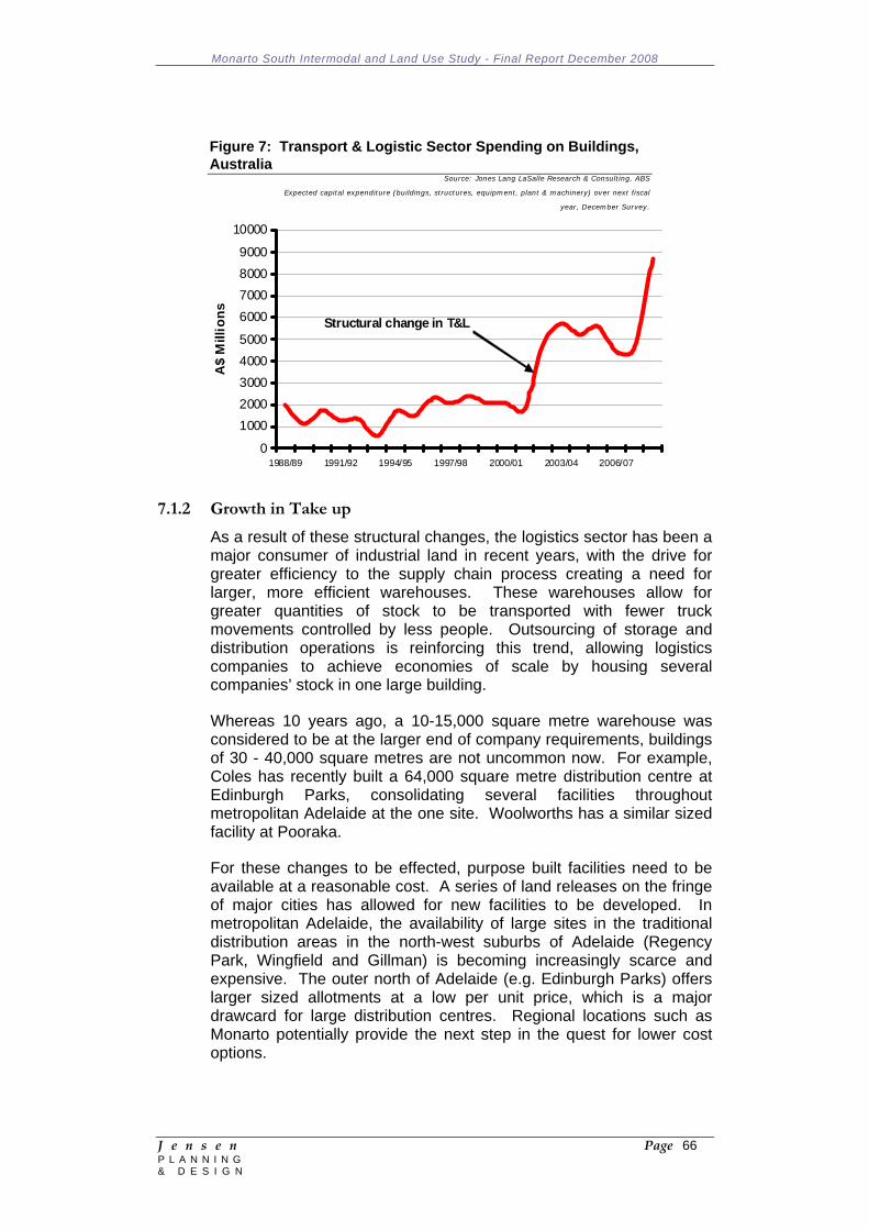
Monarto South Intermodal and Land Use Study - Final Report December 2008
J e n s e n Page 66 P L A N N I N G & D E S I G N
Figure 7: Transport & Logistic Sector Spending on Buildings, Australia
Source: Jones Lang LaSalle Research & Consulting, ABS
Expected capital expenditure (buildings, structures, equipment, plant & machinery) over next fiscal
year, December Survey.
0
10002000300040005000
6000700080009000
10000
1988/89 1991/92 1994/95 1997/98 2000/01 2003/04 2006/07
A$
Mill
ions Structural change in T&L
7.1.2 Growth in Take up
As a result of these structural changes, the logistics sector has been a major consumer of industrial land in recent years, with the drive for greater efficiency to the supply chain process creating a need for larger, more efficient warehouses. These warehouses allow for greater quantities of stock to be transported with fewer truck movements controlled by less people. Outsourcing of storage and distribution operations is reinforcing this trend, allowing logistics companies to achieve economies of scale by housing several companies’ stock in one large building.
Whereas 10 years ago, a 10-15,000 square metre warehouse was considered to be at the larger end of company requirements, buildings of 30 - 40,000 square metres are not uncommon now. For example, Coles has recently built a 64,000 square metre distribution centre at Edinburgh Parks, consolidating several facilities throughout metropolitan Adelaide at the one site. Woolworths has a similar sized facility at Pooraka.
For these changes to be effected, purpose built facilities need to be available at a reasonable cost. A series of land releases on the fringe of major cities has allowed for new facilities to be developed. In metropolitan Adelaide, the availability of large sites in the traditional distribution areas in the north-west suburbs of Adelaide (Regency Park, Wingfield and Gillman) is becoming increasingly scarce and expensive. The outer north of Adelaide (e.g. Edinburgh Parks) offers larger sized allotments at a low per unit price, which is a major drawcard for large distribution centres. Regional locations such as Monarto potentially provide the next step in the quest for lower cost options.
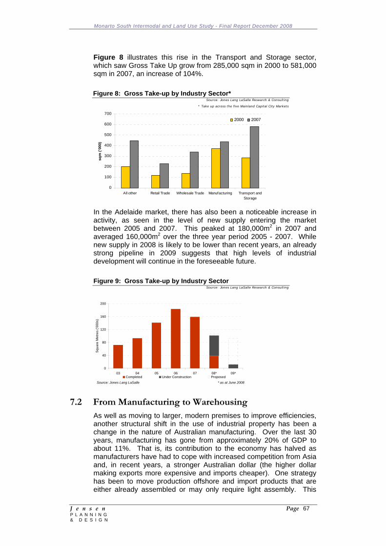
Monarto South Intermodal and Land Use Study - Final Report December 2008
J e n s e n Page 67 P L A N N I N G & D E S I G N
Figure 8 illustrates this rise in the Transport and Storage sector, which saw Gross Take Up grow from 285,000 sqm in 2000 to 581,000 sqm in 2007, an increase of 104%.
Figure 8: Gross Take-up by Industry Sector* Source: Jones Lang LaSalle Research & Consulting
* Take up across the five Mainland Capital City Markets
0
100
200
300
400
500
600
700
All other Retail Trade Wholesale Trade Manufacturing Transport andStorage
sqm
('00
0)
2000 2007
In the Adelaide market, there has also been a noticeable increase in activity, as seen in the level of new supply entering the market between 2005 and 2007. This peaked at 180,000m2 in 2007 and averaged 160,000m2 over the three year period 2005 - 2007. While new supply in 2008 is likely to be lower than recent years, an already strong pipeline in 2009 suggests that high levels of industrial development will continue in the foreseeable future.
Figure 9: Gross Take-up by Industry Sector Source: Jones Lang LaSalle Research & Consulting
0
40
80
120
160
200
03 04 05 06 07 08* 09*
Squa
re M
etre
s ('0
00s)
Completed Under Construction ProposedSource: Jones Lang LaSalle * as at June 2008
7.2 From Manufacturing to Warehousing
As well as moving to larger, modern premises to improve efficiencies, another structural shift in the use of industrial property has been a change in the nature of Australian manufacturing. Over the last 30 years, manufacturing has gone from approximately 20% of GDP to about 11%. That is, its contribution to the economy has halved as manufacturers have had to cope with increased competition from Asia and, in recent years, a stronger Australian dollar (the higher dollar making exports more expensive and imports cheaper). One strategy has been to move production offshore and import products that are either already assembled or may only require light assembly. This
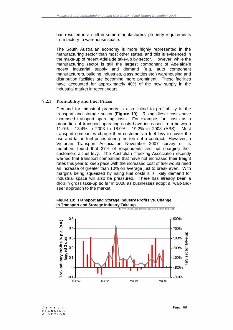
Monarto South Intermodal and Land Use Study - Final Report December 2008
J e n s e n Page 68 P L A N N I N G & D E S I G N
has resulted in a shift in some manufacturers’ property requirements from factory to warehouse space.
The South Australian economy is more highly represented in the manufacturing sector than most other states, and this is evidenced in the make-up of recent Adelaide take-up by sector. However, while the manufacturing sector is still the largest component of Adelaide’s recent industrial supply and demand (e.g. auto component manufacturers, building industries, glass bottles etc.) warehousing and distribution facilities are becoming more prominent. These facilities have accounted for approximately 40% of the new supply in the industrial market in recent years.
7.2.1 Profitability and Fuel Prices
Demand for industrial property is also linked to profitability in the transport and storage sector (Figure 10). Rising diesel costs have increased transport operating costs. For example, fuel costs as a proportion of transport operating costs have increased from between 11.0% - 13.4% in 2003 to 18.0% - 19.2% in 2008 (ABS). Most transport companies charge their customers a fuel levy to cover the rise and fall in fuel prices during the term of a contract. However, a Victorian Transport Association November 2007 survey of its members found that 27% of respondents are not charging their customers a fuel levy. The Australian Trucking Association recently warned that transport companies that have not increased their freight rates this year to keep pace with the increased cost of fuel would need an increase of greater than 10% on average just to break even. With margins being squeezed by rising fuel costs it is likely demand for industrial space will also be pressured. There has already been a drop in gross take-up so far in 2008 as businesses adopt a “wait-and-see” approach to the market.
Figure 10: Transport and Storage Industry Profits vs. Change in Transport and Storage Industry Take-up
Source: Jones Lang LaSalle Research & Consulting, ABS
-0.1
0
0.1
0.2
0.3
0.4
0.5
Mar-02 Mar-04 Mar-06 Mar-08
T&S
Indu
stry
Pro
fits
% p
.a. (
s.a.
) la
gged
2 q
trs
-300%
-100%
100%
300%
500%
700%
900%
T&S
sect
or ta
ke-u
p
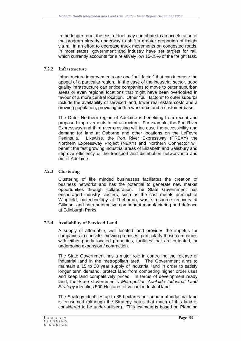
Monarto South Intermodal and Land Use Study - Final Report December 2008
J e n s e n Page 69 P L A N N I N G & D E S I G N
In the longer term, the cost of fuel may contribute to an acceleration of the program already underway to shift a greater proportion of freight via rail in an effort to decrease truck movements on congested roads. In most states, government and industry have set targets for rail, which currently accounts for a relatively low 15-25% of the freight task.
7.2.2 Infrastructure
Infrastructure improvements are one “pull factor” that can increase the appeal of a particular region. In the case of the industrial sector, good quality infrastructure can entice companies to move to outer suburban areas or even regional locations that might have been overlooked in favour of a more central location. Other “pull factors” to outer suburbs include the availability of serviced land, lower real estate costs and a growing population, providing both a workforce and a customer base.
The Outer Northern region of Adelaide is benefiting from recent and proposed improvements to infrastructure. For example, the Port River Expressway and third river crossing will increase the accessibility and demand for land at Osborne and other locations on the LeFevre Peninsula. Likewise, the Port River Expressway (PREXY) the Northern Expressway Project (NEXY) and Northern Connector will benefit the fast growing industrial areas of Elizabeth and Salisbury and improve efficiency of the transport and distribution network into and out of Adelaide.
7.2.3 Clustering
Clustering of like minded businesses facilitates the creation of business networks and has the potential to generate new market opportunities through collaboration. The State Government has encouraged industry clusters, such as the cast metals precinct at Wingfield, biotechnology at Thebarton, waste resource recovery at Gillman, and both automotive component manufacturing and defence at Edinburgh Parks.
7.2.4 Availability of Serviced Land
A supply of affordable, well located land provides the impetus for companies to consider moving premises, particularly those companies with either poorly located properties, facilities that are outdated, or undergoing expansion / contraction.
The State Government has a major role in controlling the release of industrial land in the metropolitan area. The Government aims to maintain a 15 to 20 year supply of industrial land in order to satisfy longer term demand, protect land from competing higher order uses and keep land competitively priced. In terms of development ready land, the State Government’s Metropolitan Adelaide Industrial Land Strategy identifies 500 Hectares of vacant industrial land.
The Strategy identifies up to 85 hectares per annum of industrial land is consumed (although the Strategy notes that much of this land is considered to be under-utilised). This estimate is based on Planning
Monarto South Intermodal and Land Use Study - Final Report December 2008
J e n s e n Page 70 P L A N N I N G & D E S I G N
SA’s Industrial Land Database, which indicated take-up between 1996 and 2002 of 85 Ha per annum in metropolitan Adelaide. Preliminary data indicates that this has grown to 95 Ha per annum between 2002 and 2008.
Assuming 95 Ha per annum take-up, there is only 6 years of development ready supply. A long term supply pipeline is considered important in containing growth in industrial land prices as well as supporting economic development.
Further opportunities are identified (approximately 800 Ha) but require significant infrastructure development or rezoning before it is ready for development. Of all potential identified opportunities, approximately 85% is in the northern metropolitan area, with the only major supply in the south being at Lonsdale. Longer term supply is likely to include areas that currently lie outside the Adelaide metropolitan area. Monarto may provide one of these opportunities.
Table 3: Industrial Land Supply, 2005 Source: Strategic Infrastructure Plan for South Australia, 2005
Supply Area (ha) Comments Development Ready (unconstrained)
511 ha Major areas include Edinburgh Parks and Parafield Airport
Constrained Industrial Land 391 ha Direk, Osborne, Gillman, Outer Harbour
Brownfield Opportunities 170 ha Re-use of existing industrial land
Total 1,072 ha 7.2.5 The Rise of Institutional Investors
Institutional investors and developers have become increasingly active in the Adelaide market, drawn by the relatively attractive returns available in the Adelaide market when compared to the eastern seaboard markets. This trend is set to continue, with institutions now holding prime strategic sites throughout the Adelaide metropolitan area. Institutions have forged strong relationships with major corporate occupiers throughout Australia and are therefore well placed to attract these tenants to new industrial estates in Adelaide.
Institutional investors have been particularly drawn to emerging estates in the City’s northern industrial belt, where infrastructure improvements and industrial clustering has increased the appeal of the land releases. These larger sized estates are something more akin to the type of industrial assets that major institutions typically invest in interstate. The significant commitment to the Adelaide industrial market made by market leaders such as Goodman International is likely to lead other institutional investors to look more closely at the Adelaide market. This will see the amount of pre-lease activity pick up, as institutions develop their land holdings in the Adelaide market.
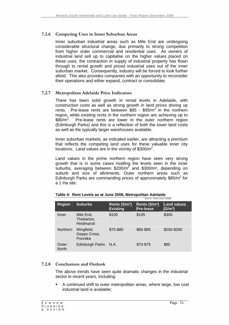
Monarto South Intermodal and Land Use Study - Final Report December 2008
J e n s e n Page 71 P L A N N I N G & D E S I G N
7.2.6 Competing Uses in Inner Suburban Areas
Inner suburban industrial areas such as Mile End are undergoing considerable structural change, due primarily to strong competition from higher order commercial and residential uses. As owners of industrial land sell up to capitalise on the higher values placed on these uses, the contraction in supply of industrial property has flown through to rental growth and priced industrial uses out of the inner suburban market. Consequently, industry will be forced to look further afield. This also provides companies with an opportunity to reconsider their operations and either expand, contract or consolidate.
7.2.7 Metropolitan Adelaide Price Indicators
There has been solid growth in rental levels in Adelaide, with construction costs as well as strong growth in land prices driving up rents. Pre-lease rents are between $85 - $95/m2 in the northern region, while existing rents in the northern region are achieving up to $80/m2. Pre-lease rents are lower in the outer northern region (Edinburgh Parks) and this is a reflection of both the lower land costs as well as the typically larger warehouses available.
Inner suburban markets, as indicated earlier, are attracting a premium that reflects the competing land uses for these valuable inner city locations. Land values are in the vicinity of $300/m2.
Land values in the prime northern region have seen very strong growth that is in some cases rivalling the levels seen in the inner suburbs, averaging between $200/m2 and $300/m², depending on suburb and size of allotments. Outer northern areas such as Edinburgh Parks are commanding prices of approximately $85/m2 for a 1 Ha site.
Table 4: Rent Levels as at June 2008, Metropolitan Adelaide Source: Jones Lang LaSalle
Region Suburbs Rents (S/m²)Existing
Rents (S/m²)Pre-lease
Land values (S/m²)
Inner Mile End, Thebarton, Hindmarsh
$100 $105 $300
Northern Wingfield, Gepps Cross, Pooraka
$75-$80 $85-$95 $200-$300
Outer North
Edinburgh Parks N.A. $70-$75 $85
7.2.8 Conclusions and Outlook
The above trends have seen quite dramatic changes in the industrial sector in recent years, including:
A continued shift to outer metropolitan areas, where large, low cost industrial land is available;
Monarto South Intermodal and Land Use Study - Final Report December 2008
J e n s e n Page 72 P L A N N I N G & D E S I G N
A greater emphasis on efficiency in “the freight task”, with accessibility to quality infrastructure (road, rail, sea) and large modern distribution centres key “pull factors; and
An overall increase in the take up, or demand for, industrial space, which is partly attributed to the rise of the logistics sector.
These trends are expected to continue.
With the recent growth in land prices in all sectors of metropolitan Adelaide, areas further afield, such as Monarto to the east or Virginia to the north, are likely to come under the microscope for industrial development. However, land price is just one determining factor, with access to employment, infrastructure and markets also critical considerations.
Infrastructure improvements have been focussed very much on the northern area of Adelaide and further improvements are in the pipeline. This is likely to see the northern industrial markets continue to be the focus for the majority of industrial activity. Any change to this dynamic would require a substantial infrastructure investment in other parts of the metropolitan or outer metropolitan area.
7.3 The Case for a Regional Intermodal at Monarto
An intermodal at Monarto would primarily service the Melbourne-Adelaide-Perth / Darwin freight route. This route has the following characteristics:
The distance by road is approximately 745km; The distance by rail between Melbourne and Adelaide is
approximately 848km; In 1999, 6.7 million tonnes of freight moved between Melbourne
and Adelaide (road, rail and sea). This is expected to grow to 13 million tonnes by 2025;
Approximately 75% of this total was non-bulk freight (i.e. manufactured goods). This is expected to comprise 80% of the freight task by 2025;
Freight with origins / destinations in Perth and Darwin use the corridor, bringing total volume of freight using the corridor to over 9 million tonnes of freight in 1999. By 2025 this is estimated to double to 18 million tonnes;
Road is more attractive than rail or coastal shipping for non-bulk freight transport for shorter distance trips; and
On shorter distance inter-capital routes, such as Melbourne – Adelaide, rail’s share is projected to decline.
Success factors / advantages of regional intermodals include:
Land availability; Good connection to urban / regional / interstate freight lines; Location near customers;
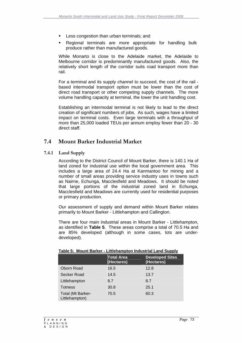
Monarto South Intermodal and Land Use Study - Final Report December 2008
J e n s e n Page 73 P L A N N I N G & D E S I G N
Less congestion than urban terminals; and Regional terminals are more appropriate for handling bulk
produce rather than manufactured goods.
While Monarto is close to the Adelaide market, the Adelaide to Melbourne corridor is predominantly manufactured goods. Also, the relatively short length of the corridor suits road transport more than rail.
For a terminal and its supply channel to succeed, the cost of the rail - based intermodal transport option must be lower than the cost of direct road transport or other competing supply channels. The more volume handling capacity at terminal, the lower the unit handling cost.
Establishing an intermodal terminal is not likely to lead to the direct creation of significant numbers of jobs. As such, wages have a limited impact on terminal costs. Even large terminals with a throughput of more than 25,000 loaded TEUs per annum employ fewer than 20 - 30 direct staff.
7.4 Mount Barker Industrial Market 7.4.1 Land Supply
According to the District Council of Mount Barker, there is 140.1 Ha of land zoned for industrial use within the local government area. This includes a large area of 24.4 Ha at Kanmantoo for mining and a number of small areas providing service industry uses in towns such as Nairne, Echunga, Macclesfield and Meadows. It should be noted that large portions of the industrial zoned land in Echunga, Macclesfield and Meadows are currently used for residential purposes or primary production.
Our assessment of supply and demand within Mount Barker relates primarily to Mount Barker - Littlehampton and Callington.
There are four main industrial areas in Mount Barker - Littlehampton, as identified in Table 5. These areas comprise a total of 70.5 Ha and are 85% developed (although in some cases, lots are under-developed).
Table 5: Mount Barker - Littlehampton Industrial Land Supply
Total Area (Hectares)
Developed Sites (Hectares)
Oborn Road 16.5 12.8 Secker Road 14.5 13.7 Littlehampton 8.7 8.7 Totness 30.8 25.1 Total (Mt Barker-Littlehampton)
70.5 60.3

Monarto South Intermodal and Land Use Study - Final Report December 2008
J e n s e n Page 74 P L A N N I N G & D E S I G N
Oborn Road is an older industrial precinct comprising a mix of local industries, GMH car sales fronting Alexandrina Road and a large landscaping / paving business.
Secker Road precinct is a modern industrial estate with a mix of bulky goods showrooms (Bed e Buys, Petwares, Leading Edge Flooring, Carpet Burners, Greenslades Landscaping, Beaumont Tiles, Home Hardware and Mitre 10), service trade and light industrial uses serving the regional population.
The Totness zone, located to the north of the South Eastern Freeway along the Mount Barker Road, is a mix of older industrial uses (including some local manufacturers), warehousing, service industries and depots. Bunnings has commenced site works on their first store in the Adelaide Hills within this precinct.
Littlehampton is a relatively small area within the township with limited development potential and surrounded by nearby housing.
7.4.2 Take up / Demand
Recent developments have primarily been located in the industrial estate of Secker Road / Light Crescent in Mount Barker. This 14.5 Ha estate has been progressively developed over the last 14 years, which suggests relatively low take-up.
Opportunities have also been taken up at Littlehampton on Crompton Road, Diagonal Road and Follet Close. Most of the demand has been for showroom space, including bulky goods retailing. This market has been a significant growth area in Mount Barker, with the Adelaide Hills Homemaker Centre also completed recently, anchored by Harvey Norman and Radio Rentals.
There has been very little demand for warehouse and distribution space. In smaller non-metropolitan markets, this function is either undertaken “onsite” in association with a retail outlet or the warehouse is located in metropolitan Adelaide and serves the greater metropolitan area.
In terms of development applications relating to the industrial sector, Mount Barker Council has averaged 34 applications per annum over the past three financial years (out of an average of 1,500 applications per year).
7.4.3 Major Industries
Mount Barker has limited local industry, with the major occupiers of industrial space being services to the local population. Outside of the township, there are some major industrial uses, such as Kanmantoo Mines. Chapman’s factory operated in Nairne until 2002 and has since moved to new premises near Murray Bridge (Big River Pork).
Monarto South Intermodal and Land Use Study - Final Report December 2008
J e n s e n Page 75 P L A N N I N G & D E S I G N
7.4.4 Price Indicators
With much of the new space in Mount Barker being relatively high quality showroom space rather than a warehouse, rental levels are quite high at the upper end, ranging from $70 - $110/m² net.
Land values are also relatively high, and reflect a commercial land value rather than strictly industrial land value. A 2,000m2 lot is likely to achieve a sale price in the vicinity of $250/m².
7.4.5 Outlook
There is limited current capacity for growth within Mount Barker, with 90% of available industrial and industrial / commercial zoned land in Mount Barker - Littlehampton already developed. Provision of additional industrial land to cater for future growth is constrained by residential development pressures and land use conflicts.
While there is potential for redevelopment of older, under-utilised stock, this is likely to occur slowly, keeping upwards pressure on land values and rents within Mount Barker.
The recent spike in demand for bulky goods retail, which has been developed both in industrial zoned land and within the Regional Town Centre zone, may decline, with many of the key anchor stores already represented.
Demand is likely to continue to be for small industrial premises in the 250 - 400m2 floor area range rather than large distribution warehouses.
Future growth is likely to be driven primarily by population growth, with its commensurate increase in demand from local service industries and small manufacturers.
While there is some potential for manufacturers that don’t rely heavily on being close to the local catchment to relocate to lower cost areas such as Monarto, we do not see this as being a major factor in future demand at Monarto.
7.5 Murray Bridge Township Industrial Market 7.5.1 Land Supply
The Rural City of Murray Bridge has approximately 257 Ha of general and light industrial zoned land. The Urban Growth Plan identified considerable opportunities for expansion of industrial land supply, however the current supply is considered to be under-utilised.
The main areas of industrial zoned land are:
A large Light Industry Zone centred along Adelaide Road and the junction with Maurice Road. This zone comprises small local service industries and showrooms fronting Adelaide Road. The major industrial use in this zone is a National Foods factory. A

Monarto South Intermodal and Land Use Study - Final Report December 2008
J e n s e n Page 76 P L A N N I N G & D E S I G N
number of industrial uses associated with the rural sector are also present;
A General Industry Zone south of the freeway, used as the Council dump;
A General Industry Zone bordered by the Old Swanport Road and Hindmarsh Road, with a mix of engineering, manufacturing and other uses (including Stratco, Moore Engineering). The zone is largely under-developed and we understand there is a proposal to use part of the site for bulky goods retailing;
The main General Industry Zone to the west of the town centre, fronting Thomas Street, Cypress Terrace and Maurice Road. This comprises rural related industrial premises such as Incitec Pivot and sale yards, a recycling depot, junk yard, SA Water Depot, Council Depot, MBP Castings and Jackson Metal Fabrication. The area is considered to be under-utilised with opportunities for further development / expansion;
To the north west of the town centre, there is a smaller General Industry Zone containing the local abattoirs.
7.5.2 Take Up
There has been limited recent development or take up of industrial land within the Murray Bridge township. A small subdivision (Chris Collins Court) has attracted some new businesses near the corner of Adelaide Road and Maurice Road (service industries, small manufacturing, wholesaler, minor retail, kids play room, Tradelink).
Most recent activity has been within the Light Industry Zone and has been for small business uses serving the local population. There has been limited demand for larger industry uses, particularly within the town.
There is growing interest in bulky goods, with Bunnings committed to opening a store near the corner of Adelaide Road and Maurice Road.
7.5.3 Major Industries
Major industries in and around Murray Bridge are associated with the rural sector, including National Foods, Ridley Agriproducts T & R Meatworks and Big River Pork. Further rural sector industries are located at or near Monarto, including Ingham, Adelaide Mushrooms and Aays Herbs.
7.5.4 Price Indicators
There has been limited recent rental evidence within Murray Bridge, with owner-occupiers a significant part of the market and relatively limited new supply entering the market.
Monarto South Intermodal and Land Use Study - Final Report December 2008
J e n s e n Page 77 P L A N N I N G & D E S I G N
7.5.5 Outlook
Recent take-up suggests relatively weak demand moving forward within Murray Bridge, although there is likely to be solid demand for bulky goods retailing as the catchment area grows and catchment thresholds are met to support such retail activities. In this regard, Murray Bridge is perhaps 10 years behind Mount Barker in this form of development and, with continued population growth, this activity can be expected to pick up.
There is a large supply of both light and general industrial zoned land in Murray Bridge, which is expected to more than cater for local industrial demand.
Industries that are not considered suitable for location in townships may look to locate to areas such as Monarto, or outside township boundaries.
7.6 Adelaide Hills LGA Industrial Market
Discussions with Council planning staff revealed the following trends within the Adelaide Hills LGA relating to industrial supply and demand:
The main industrial zones in Adelaide Hills LGA are: Woodside North Extension Policy Area Lobethal North Policy Area Woollen Mills Policy Area;
There is not considered to be strong demand for industrial land, with existing areas under-developed and few applications for industrial development;
There is anecdotal evidence of service industries gravitating to Mount Barker as a base for the Adelaide Hills region;
The northern section of Adelaide Hills tends to be served by the Adelaide Plains for service industry needs;
There are no current plans to increase industrial zoned land within the Council area;
The Old Woollen Mills at Lobethal, which closed a decade ago, is now the Heart of the Hills Market, a tourism centre and home to other small business enterprises. It now employs more people than when the woollen mills were operational.
7.7 Alexandrina LGA Industrial Market
The northern part of Alexandrina LGA is relatively close to Monarto, with the main centre being Strathalbyn. Strathalbyn has experienced relatively low demand for industrial land and has a large area zoned for such use, with considerable potential for industrial expansion.
The Angas Mine is now operational, with concentrate being freighted from the mine via road. This is not expected to influence demand for industrial space at Monarto South.
Monarto South Intermodal and Land Use Study - Final Report December 2008
J e n s e n Page 78 P L A N N I N G & D E S I G N
It is understood that grapes from Langhorne Creek vineyards are primarily transported via road to wineries in the Barossa Valley, utilising McDonald Ferries Road. This may benefit from any upgrades to the road network in association with expansion of industrial activity at Monarto South.
7.8 Mining Activity
The recent increase in the prices of commodities has seen renewed interest in the mining sector throughout South Australia and the reopening of disused mines. There are four mines within relatively close proximity to Monarto South:
Bird in Hand - The historic Bird in Hand Gold Mine is located in the Adelaide Hills, near Woodside. Maximus Resources has undertaken a series of tests to investigate the potential of the mine for further production. The gold reserves are relatively small (measured in ounces rather than tonnes) and will not require heavy vehicular transport to move gold off site for production / export.
Kanmantoo Copper Mine - Hillgrove Resources proposes to redevelop the old Kanmantoo copper mine, which operated from 1971 to 1976. The open pit mine will have a 6 - 8 year life and produce up to 80,000 tonnes per annum of copper concentrates for export (including traces of gold and silver).
The concentrate will be transported by road to Port Adelaide for shipment to an overseas smelter. Assuming an average load of 50 tonnes per trip, this will generate approximately 1,600 loaded vehicle trips per annum (which will be about 3,200 total trips). The designated heavy vehicle route through Adelaide is Portrush Road / Grand Junction Road to Port Adelaide.
Angas Zinc Mine - The Angas zinc project is located 2km from Strathalbyn and is operated by Terramin Australia Ltd. The deposit was discovered in 1991 but was not considered large enough for viable production. In 2007 PIRSA approved the development of the mine, which is now in production. Production is expected to yield around 65,000 tonnes of zinc and 24,000 tonnes of copper-lead concentrate on site annually. The zinc is transported by road to Port Adelaide while the lead-silver concentrate will go to Port Pirie Smelters. Initial estimates are for seven years operation, with further potential deposits likely to expand the life of the mine.
Mindarie Australian Zircon – This mine is operational, producing a mix of heavy mineral sands for export. The mine is located 150km east of Adelaide and is principally a zircon mine, but will also produce ilmenite, rutile and leucoxene. Shipments are via rail direct to Port Adelaide.
It should be noted that in addition to outward products, each of these mines will create a demand for inwards freight such as chemicals,
Monarto South Intermodal and Land Use Study - Final Report December 2008
J e n s e n Page 79 P L A N N I N G & D E S I G N
building materials, consumable items used in the mining process, food for the workforce etc.
Given the proximity of the three Adelaide Hills based mines to Port Adelaide, it is considered unviable to freight by road to Monarto then rail to the Port of Adelaide. Furthermore, most of the mines have relatively short life spans, which may well be over prior to infrastructure being developed to accommodate possible mining needs.
We do not consider that the mining activity in the local region will have a marked impact on industrial demand at Monarto South.
7.9 Monarto South Industrial Market
Monarto South has gained some interest recently as an industrial location, with the subdivision of land opposite Big W on Ferries-McDonald Road. The subdivision of 17, one Ha lots has proved successful, with 12 lots reported to be under contract as at July 2008.
Discussions with the sales agent have revealed the following trends:
Interest from investors / operators from the local region, with Adelaide Hills and Murray Bridge investors accounting for over 50% of sales;
Interest from metropolitan Adelaide and interstate investors; Land selling for $40 per sqm; Mix of transport, construction, earth moving companies as well as
investors; Some interest in larger lots, with two purchases of multiple lots (1 X
2; 1 X 3); Appeal due to low cost of land, proximity to freeway and easy
access to regional nodes (10 minutes from Murray Bridge; 15 minutes from Mount Barker).
Larger land uses are present in Monarto South, including:
Big W Sneaths Inghams Australian Portable Camps
Discussions with Sneaths indicated that the reason for locating at Monarto South is that they hold a contract to move for primary and secondary freight for Big W.
Food production is recognised as an important industry within the Murraylands region, with a wholesale value of $487 million in 2005-06. This is predominantly livestock (63%) but dairy and horticulture are also important. Given the region’s close proximity to the Adelaide market, it is well placed to capitalise in value added food production industries. Such industry at or near Monarto South includes chicken lots, Inghams Hatchery and Adelaide Mushrooms.
Monarto South Intermodal and Land Use Study - Final Report December 2008
J e n s e n Page 80 P L A N N I N G & D E S I G N
While opportunities within this sector are strong, it is likely that some of these types of activities would be more suitable to primary industry zones where appropriate buffers can be incorporated. Other factories may find Monarto South a desirable location, with good freeway access, and far enough away from major towns where land use conflicts may occur but close enough to workforces at Mount Barker, Murray Bridge, and to a lesser extent Callington, Kanmantoo and other small townships.
7.9.1 Outlook
It is possible that the relatively strong recent activity in Monarto has been due to pent up demand, with 12 Ha under contract within the first 6 months of marketing. Therefore, we do not expect that demand for relatively small industrial lots of 1 Ha will continue at this pace, which represents sales activity of 24 Ha per annum.
Recent land sales in Monarto suggest there is a market for industrial land with good access to the South Eastern Freeway and without the constraints that often exist within townships. The relatively low price compared to industrial zones in nearby townships is also a factor in driving demand. This location, however, will not suit users that rely on a local catchment for trade, such as service trade premises and showrooms.
Even the low land price may not be a considerable advantage. With very strong price increases in steel, construction costs have risen sharply for industrial buildings and the land cost as a percentage of overall development costs has therefore reduced. Monarto’s land price advantage is likely to be most beneficial for industry that required primarily open storage or hard stand space rather than enclosed space.
Companies that serve the broader Hills and Murraylands region and require a central depot may also find Monarto a desirable location, given its good access to the Freeway, 15 minutes to Mount Barker and 10 minutes to Murray Bridge.
Manufacturing, transport and storage uses may be drawn to Monarto. Groups such as APC manufacture portable camps for use throughout Australia. A low cost location is therefore a determining factor.
Monarto’s proximity to a relatively large regional workforce within 20 minutes and still being only 40 minutes from metropolitan Adelaide provides good access to both labour and the market. While industrial development can help diversify the local employment base, its location is still close enough to the major labour market of Adelaide.
Future demand at Monarto South from the local region (including Adelaide Hills and Murray Bridge) is likely to be limited to small industrial enterprises (e.g. construction sector, storage, local manufacturing).
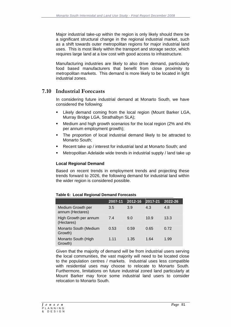
Monarto South Intermodal and Land Use Study - Final Report December 2008
J e n s e n Page 81 P L A N N I N G & D E S I G N
Major industrial take-up within the region is only likely should there be a significant structural change in the regional industrial market, such as a shift towards outer metropolitan regions for major industrial land uses. This is most likely within the transport and storage sector, which requires large land at a low cost with good access to infrastructure.
Manufacturing industries are likely to also drive demand, particularly food based manufacturers that benefit from close proximity to metropolitan markets. This demand is more likely to be located in light industrial zones.
7.10 Industrial Forecasts
In considering future industrial demand at Monarto South, we have considered the following:
Likely demand coming from the local region (Mount Barker LGA, Murray Bridge LGA, Strathalbyn SLA);
Medium and high growth scenarios for the local region (2% and 4% per annum employment growth);
The proportion of local industrial demand likely to be attracted to Monarto South;
Recent take up / interest for industrial land at Monarto South; and Metropolitan Adelaide wide trends in industrial supply / land take up
Local Regional Demand Based on recent trends in employment trends and projecting these trends forward to 2026, the following demand for industrial land within the wider region is considered possible.
Table 6: Local Regional Demand Forecasts 2007-11 2012-16 2017-21 2022-26 Medium Growth per annum (Hectares)
3.5 3.9 4.3 4.8
High Growth per annum (Hectares)
7.4 9.0 10.9 13.3
Monarto South (Medium Growth)
0.53 0.59 0.65 0.72
Monarto South (High Growth)
1.11 1.35 1.64 1.99
Given that the majority of demand will be from industrial users serving the local communities, the vast majority will need to be located close to the population centres / markets. Industrial uses less compatible with residential uses may choose to relocate to Monarto South. Furthermore, limitations on future industrial zoned land particularly at Mount Barker may force some industrial land users to consider relocation to Monarto South.
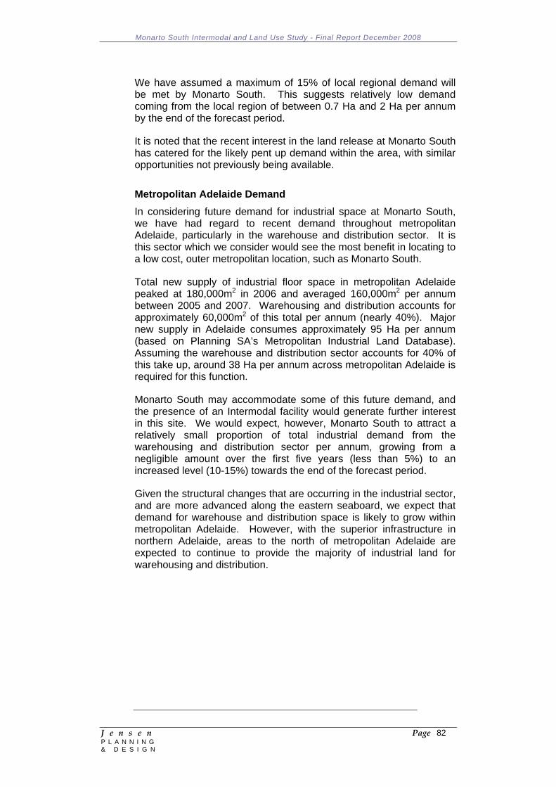
Monarto South Intermodal and Land Use Study - Final Report December 2008
J e n s e n Page 82 P L A N N I N G & D E S I G N
We have assumed a maximum of 15% of local regional demand will be met by Monarto South. This suggests relatively low demand coming from the local region of between 0.7 Ha and 2 Ha per annum by the end of the forecast period.
It is noted that the recent interest in the land release at Monarto South has catered for the likely pent up demand within the area, with similar opportunities not previously being available.
Metropolitan Adelaide Demand In considering future demand for industrial space at Monarto South, we have had regard to recent demand throughout metropolitan Adelaide, particularly in the warehouse and distribution sector. It is this sector which we consider would see the most benefit in locating to a low cost, outer metropolitan location, such as Monarto South.
Total new supply of industrial floor space in metropolitan Adelaide peaked at 180,000m2 in 2006 and averaged 160,000m2 per annum between 2005 and 2007. Warehousing and distribution accounts for approximately 60,000m2 of this total per annum (nearly 40%). Major new supply in Adelaide consumes approximately 95 Ha per annum (based on Planning SA’s Metropolitan Industrial Land Database). Assuming the warehouse and distribution sector accounts for 40% of this take up, around 38 Ha per annum across metropolitan Adelaide is required for this function.
Monarto South may accommodate some of this future demand, and the presence of an Intermodal facility would generate further interest in this site. We would expect, however, Monarto South to attract a relatively small proportion of total industrial demand from the warehousing and distribution sector per annum, growing from a negligible amount over the first five years (less than 5%) to an increased level (10-15%) towards the end of the forecast period.
Given the structural changes that are occurring in the industrial sector, and are more advanced along the eastern seaboard, we expect that demand for warehouse and distribution space is likely to grow within metropolitan Adelaide. However, with the superior infrastructure in northern Adelaide, areas to the north of metropolitan Adelaide are expected to continue to provide the majority of industrial land for warehousing and distribution.
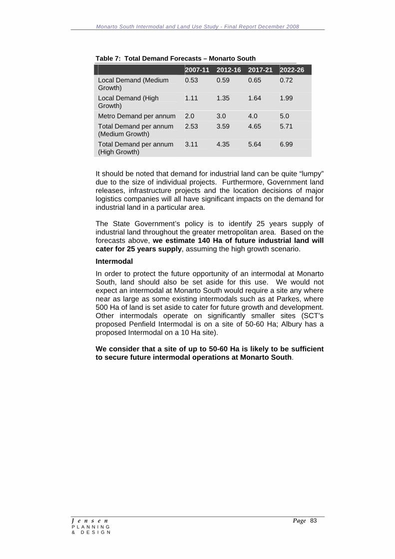
Monarto South Intermodal and Land Use Study - Final Report December 2008
J e n s e n Page 83 P L A N N I N G & D E S I G N
Table 7: Total Demand Forecasts – Monarto South 2007-11 2012-16 2017-21 2022-26 Local Demand (Medium Growth)
0.53 0.59 0.65 0.72
Local Demand (High Growth)
1.11 1.35 1.64 1.99
Metro Demand per annum 2.0 3.0 4.0 5.0 Total Demand per annum (Medium Growth)
2.53 3.59 4.65 5.71
Total Demand per annum (High Growth)
3.11 4.35 5.64 6.99
It should be noted that demand for industrial land can be quite “lumpy” due to the size of individual projects. Furthermore, Government land releases, infrastructure projects and the location decisions of major logistics companies will all have significant impacts on the demand for industrial land in a particular area.
The State Government’s policy is to identify 25 years supply of industrial land throughout the greater metropolitan area. Based on the forecasts above, we estimate 140 Ha of future industrial land will cater for 25 years supply, assuming the high growth scenario.
Intermodal In order to protect the future opportunity of an intermodal at Monarto South, land should also be set aside for this use. We would not expect an intermodal at Monarto South would require a site any where near as large as some existing intermodals such as at Parkes, where 500 Ha of land is set aside to cater for future growth and development. Other intermodals operate on significantly smaller sites (SCT’s proposed Penfield Intermodal is on a site of 50-60 Ha; Albury has a proposed Intermodal on a 10 Ha site).
We consider that a site of up to 50-60 Ha is likely to be sufficient to secure future intermodal operations at Monarto South.
Monarto South Intermodal and Land Use Study - Final Report December 2008
J e n s e n Page 84 P L A N N I N G & D E S I G N
8 INFRASTRUCTURE ASSESSMENT
8.1 Water Preliminary advice from SA Water is that the existing potable water supply infrastructure is close to capacity and will have limited ability to supply the future development needs of the Monarto Precinct. Future large scale development will require duplication of the existing mains water supply system.
The Murray Bridge Commercial Zone (Monarto South) Concept Plan area is serviced by a water main along the entire length of Ferries MacDonald Road within the concept plan (see Figure 11).
SA Water has provided advice based on assumptions they have made regarding possible rates and forms of development. SA Water has assumed that the proposed development will take place in the North-Western portion of the area defined by the Murray Bridge Commercial Zone (Monarto South) Concept Plan which can accommodate approximately one hundred and eighty (180), one hectare allotments (although realistically the nominated site is likely to accommodate less allotments due to buffering/plantation requirements indicated on the concept plan).
SA Water has assumed that the area nominated in their assumptions will be developed at a rate of 5 - 6 allotments per annum over the next 30 - 35 years and will be developed for light industry.
The annual water supply requirements were estimated at 4 ML/ha/annum and peak day demands using a peaking day factor of 2.1 times the average annual flow.
The results of SA Water’s modelling are shown in the table below:
Water Supply Demands for the Proposed Land Development in Monarto South
Year Allotments Annual Demand (ML/a)
Peak Day (ML/d)
Peak Day (L/s)
2009 5 20 0.12 1.33 2014 30 120 0.69 7.99 2019 55 220 1.27 14.65 2024 80 320 1.84 21.31 2029 105 420 2.42 27.97 2034 130 520 2.99 34.63 2039 155 620 3.57 41.29 2044 180 720 4.14 47.95
The modelling results conclude that the existing system is not able to supply the entire development of 180 allotments and that only approximately 30 allotments with a peak day supply of 0.69 ML/day and an annual supply of 120 ML/annum can be serviced.
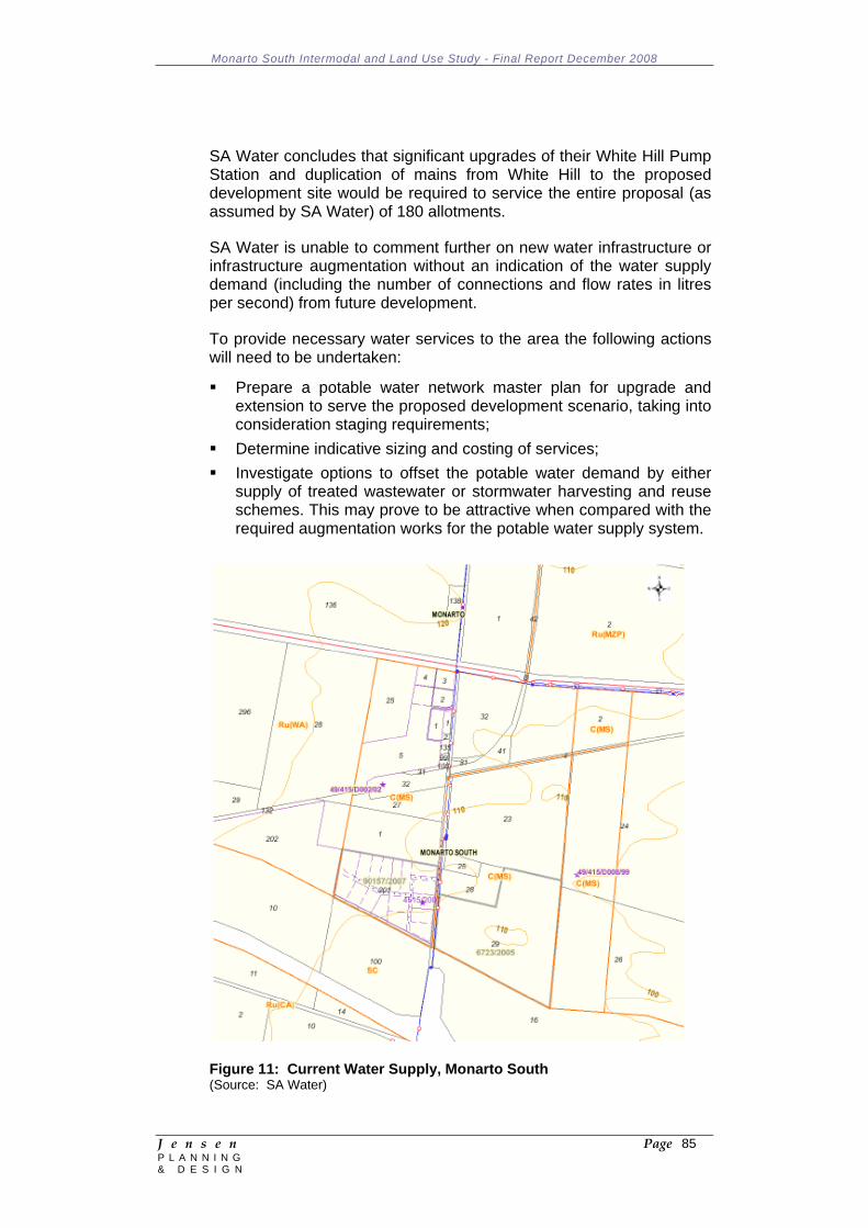
Monarto South Intermodal and Land Use Study - Final Report December 2008
J e n s e n Page 85 P L A N N I N G & D E S I G N
SA Water concludes that significant upgrades of their White Hill Pump Station and duplication of mains from White Hill to the proposed development site would be required to service the entire proposal (as assumed by SA Water) of 180 allotments.
SA Water is unable to comment further on new water infrastructure or infrastructure augmentation without an indication of the water supply demand (including the number of connections and flow rates in litres per second) from future development.
To provide necessary water services to the area the following actions will need to be undertaken:
Prepare a potable water network master plan for upgrade and extension to serve the proposed development scenario, taking into consideration staging requirements;
Determine indicative sizing and costing of services; Investigate options to offset the potable water demand by either
supply of treated wastewater or stormwater harvesting and reuse schemes. This may prove to be attractive when compared with the required augmentation works for the potable water supply system.
Figure 11: Current Water Supply, Monarto South (Source: SA Water)
Monarto South Intermodal and Land Use Study - Final Report December 2008
J e n s e n Page 86 P L A N N I N G & D E S I G N
8.2 Sewer There is no reticulated sewer within 5 kilometres of the proposed development area. The following options are available to service the site:
Connect to the Murray Bridge sewer network which is approximately 6km (minimum) from the site;
Provide a local Community Wastewater Management Scheme with a wastewater treatment plant to service the proposed development area;
Allow each allotment to have on site wastewater treatment and disposal utilising an approved aerated treatment system.
The nearest existing sewer network is located at Murray Bridge. In order to connect to the Murray Bridge sewer, a local sewer network connected to a pump station and rising main will be required. The rising main would terminate at the nearest available connection point with adequate capacity in Murray Bridge.
Depending on the nature of activities undertaken at Monarto South and quantities of wastewater generated, it may be necessary to review the capacity of the Murray Bridge wastewater plant. However, unless processing industries that consume large volumes of water and generate corresponding volumes of wastewater are established, it is likely that wastewater volumes generated will be small.
To provide sewer services to the area (if required) it would be necessary to prepare a sewerage network master plan for upgrade and extension to serve the proposed development scenario, taking into consideration staging requirements.
In summary it is recommended that, given the size of the allotments and the local climate at Monarto South, sewerage treatment should be provided for via on-site treatment methods enabling re-use of treated waste water for the irrigation of landscaping (or other industrial purposes).
8.3 Gas
In South Australia the major transmission pipelines such as the Moomba to Adelaide pipeline and the SEA GAS pipeline from Victoria are owned privately and deliver gas to a distribution network owned by Envestra Pty Ltd and managed and operated on their behalf by Australian Pipeline Trust. Companies such as Origin and AGL have a direct relationship with the customers as retailers of the gas.
There are no gas services in the Monarto area. Significant extensions to gas transmission lines or a connection into the SEA GAS Victoria to South Australia Gas Pipeline (located within 10km of Monarto South) are potential options to service the area. Other options include establishing a reticulated LPG system (which may be feasible if transmission lines cannot be economically justified) or through individual LPG systems. A reticulated LPG system could potentially
Monarto South Intermodal and Land Use Study - Final Report December 2008
J e n s e n Page 87 P L A N N I N G & D E S I G N
be established with appropriate pipe sizes to cater for future connection to natural gas transmission lines.
The largest natural gas consumers are the metal product industries (predominantly alumina kilns and ore smelting), the chemical industry (where natural gas and ethane are used as a feedstock for fertilisers and plastics), and the glass, brick and cement industries (where natural gas is used mainly in the kilns).
Funding of gas infrastructure is generally provided by Origin Energy but investment decisions are made on the basis of individual business cases (i.e. a decision to install infrastructure is made only when there is a committed customer or customers with the demand for gas). This is certainly the case with industrial estates where demand for gas is highly variable from one industrial estate to another.
The SEA GAS pipeline has an existing off-take valve at Tailem Bend that could be used to connect a new lateral pipeline to Monarto. Alternatively, a “hot-tap” connection could be provided along the main pipeline for an off-take point at a location closer to Monarto. Any reduction in lateral pipeline costs would need to be weighed up against the cost of a new connection to the SEA GAS pipeline. An option to run a lateral pipeline from the SEA GAS pipeline to Monarto would require approval from landowners and relevant government authorities.
Conceptually, a lateral pipeline of roughly 10kms could be laid from the SEA GAS mainline valve (MLV) at Pallamanna (north-west of Murray Bridge). Once at the industrial/commercial site at Monarto South a ring main is probably the most cost effective solution. Based on experience in the south-east of South Australia, SEA GAS indicates that there would be a pressure cut at the MLV and once again at the ring main.
SEA GAS has indicated that if Compressed Natural Gas (CNG) is required for vehicle refueling (should this be a service that is desired in Monarto South) this would require higher pressure than that of a distribution main and would therefore be run from the lateral main to avoid additional costs related to compression.
Another aspect of design is the supply of gas to support the industrial area if there were restrictions on the State’s regular gas supply. SEA GAS has suggested that a 10km lateral main may provide a few hours of supply so that an orderly shut down of industrial processes and equipment could take place.
SEA GAS indicate that it is likely that there would need to be a buyer’s group established (thus indicating that a volume, and hence industrial base, would be required before supply would be possible) to tender for gas from the ‘shippers’ on the mainline and to pay the transportation tariff.
It is generally considered that it would only be economically feasible where there is a very high demand for gas or energy, such as large
Monarto South Intermodal and Land Use Study - Final Report December 2008
J e n s e n Page 88 P L A N N I N G & D E S I G N
industrial user(s). Publicly available information on the National Gas Bulletin Board indicates that SEA GAS customers in the south – east of the State are ‘shipping’ around 10 to 30 Terrajoules per day. This is via a 200mm main over a distance of 30 – 40 kilometres.
For many years the District Council of Mount Barker and the Adelaide Hills Regional Development Board have been advocating for an extension of the SEA GAS pipeline to the Mount Barker township to provide gas for both residential and commercial customers. A 2003 business case report included a cost estimate for a lateral pipeline extension to Mount Barker of $6.6 million dollars.
Naturally the business case for an extension to Mount Barker would be significantly improved if there was a business case for an extension to Monarto. It is therefore clear that any business case argument for an extension to Monarto must also take into account the potential for a further extension of the pipeline to Mount Barker.
Given the uncertainty as to whether or not there will be large scale consumers of gas at Monarto, further investigations will need to await the outcomes of both the Study and any future development of large scale gas consumers at Monarto.
8.4 Electricity
Power is supplied to the area via a 12.5MVA electricity substation at Monarto South. This substation links to the Mobilong distribution substation (NW of Murray Bridge) via a 33kV sub-transmission line and has 2 x 11kV feeder lines servicing existing development within the area.
The Monarto South substation is currently operating at approximately 30% capacity under peak load. Based on a forecast growth rate of 3.2%, ETSA does not envisage any substation or feeder load constraints in the next 3 years (Electricity System Development Plan 2008).
ETSA Utilities is currently preparing a speculative estimate for the augmentation charges on a speculative 17 allotment land division. These charges relate to the electrical system beyond the immediate development and an additional charge for connection points.
It should be noted that the ETSA Utilities augmentation charges do not necessarily indicate that the system requires immediate augmentation to supply a land division of this nature. The augmentation charges apply for any new allotment with a load above 90kVA at a rate of $132 per kVA, plus the cost of two connection points which ETSA indicates is a non-contestable cost for a service only provided by ETSA. Two connections are required to ensure back-up where the load exceeds 1000 kVA.
The extension of electricity infrastructure from the connection points to the development / land division are described by ETSA as contestable
Monarto South Intermodal and Land Use Study - Final Report December 2008
J e n s e n Page 89 P L A N N I N G & D E S I G N
works that may be undertaken by either ETSA Utilities or other accredited designers and constructors.
There is potential to extend and upgrade lines, feeders and the substation to meet customer demand.
The Monarto precinct is within 5km of the 132kV transmission line between Mobilong and Cherry Gardens (Adelaide). Preliminary advice from ElectraNet is that, should it be required, a direct connection to the 132kV transmission network would be possible.
Electricity can be provided to the proposed development. However, the actual cost and need for provision of upgraded electricity infrastructure will be assessed by ETSA Utilities on a stage by stage basis as land division proceeds. This is the only possible approach to assessing electricity infrastructure capacity and cost, because there is not a firm staging plan or timing and there is also likely to be other development in the area requiring electrical supply.
8.5 Communication/IT Services
The Monarto area is serviced by a Telstra exchange at White Hill, operating on a canopy system. Wireless broadband services are available in the area.
There are no fixed (cable) broadband or broadband ADSL services. Telstra is unable to advise on the future availability of cable or ADSL broadband for the Monarto area.
Internode has surveyed the Monarto Telstra exchange for potential ADSL2+ enablement and advised that it would be a straightforward build for them. Internode considers that it has ample capacity to satisfy potential future telecommunications requirements in the area.
Telstra is obliged to provide a narrowband service to any place of business at a minimum cost, however, this obligation does not extend to the provision of broadband. Wideband services are provided on a commercial basis. A recoverable works charge applies to the relocation of existing plant at the request of the developer. Telstra requests access to common services trench (CST) at no cost to service new developments.
Monarto South Intermodal and Land Use Study - Final Report December 2008
J e n s e n Page 90 P L A N N I N G & D E S I G N
9 INTERMODAL TRANSPORT HUB BUSINESS CASE 9.1 Demand Analysis 9.1.1 Existing Situation
The economic output of the South East region of South Australia from Murray Bridge to the Victorian border is expected to increase by up to 75% by 2020. This economic growth will be achieved across a range of industry sectors including: agriculture, timber, mining, manufacturing and tourism. Complementing this growth east of Monarto is the continued population growth in the Adelaide Hills and surrounding areas. The construction of the South Eastern Freeway to Murray Bridge has encouraged residential growth east of Adelaide with commuting between the City and Murray Bridge becoming more common. Eastern South Australia will experience increased movements in general freight and business activity necessary to support growing semi urban and regional areas.
International shipping deliveries are predominantly made at Melbourne, Sydney and Brisbane ports, from which goods are distributed nationally, including Adelaide and then to Perth and Darwin. As discussed in Section 5.3.6, the Port of Adelaide has a throughput of approximately 200,000 TEU per annum. The focus on commercial activities on just in time deliveries has resulted in high demand for the efficient and cost effective movement of goods via road and rail freight from these centres. Current supply chain systems have national distribution centres for most containerized non bulk goods located in or surrounding major urban centres.
The Monarto Precinct Strategic Directions Report (2007) identified a number of major industries and commercial ventures that have been established in Monarto over recent years along with a number of sites within the Monarto industrial/commercial area that were in the process of being developed.
Exiting industrial and commercial ventures include:
Big W (distribution centre); Sneaths Transport; Inghams Hatchery; Australian Portable Camps (APC); Recut Industries; Adelaide Mushrooms; Hillgrove Mine; Aays Herb’s; Neutrog Pty Ltd; and Peat Soils.
Industrial and commercial projects currently underway include the creation of an industrial subdivision at the former Gerrards site opposite Inghams, a service station on the South Eastern Freeway
Monarto South Intermodal and Land Use Study - Final Report December 2008
J e n s e n Page 91 P L A N N I N G & D E S I G N
and the redevelopment of the Uniken Flowers site adjacent the main rail line.
Big W is one business enterprise that has established a regional distribution warehouse with their development at Monarto in 1998. The warehouse services South Australia, Western Australia and the Northern Territory. It is positioned alongside the main highway linking Adelaide to Melbourne making it capable of the efficient movement of goods via the national highway network to all parts of Australia. The property abuts the ARTC national rail network to the north and has area to expand to the east. The future prospect of the establishment of an intermodal freight hub can add an extra dimension to the operations of the Big W distribution centre as well as reducing its reliance on road transport for the movement of goods.
9.1.2 Factors Determining Demand
In order to assess the future demand for the Monarto Intermodal Freight Hub, it is necessary to identify existing industries in the region; forecast growth; future land use zoning; transport infrastructure connectivity; the potential industry users of the infrastructure as well as future tenants of the freight hub and the surrounding industrial precinct. Industries currently in Monarto and surrounding areas are:
Distribution Centre; Grain; Wine; Packaging; Produce – fresh and value added; Timber – raw and manufactured; Manufacturing; Logistics.
Potential growth industries identified by the Monarto Common Purpose Group Working Party and the South Australian Government include:
Food processing (value adding); Intensive animal production; Manufacturing; Transport and logistics; Warehouse / Distribution Centre; Winery; Mining; and Forestry.
Based on the operation of other intermodal terminals in Australia, the main on-site activities would focus on the storage, handling and packing of containers. More extensive manufacturing activities are not likely to be undertaken on-site. For the industry types identified, a number of factors will influence the relative attractiveness of the Monarto site as an intermodal hub:
The geographical proximity of the area increases the relative attractiveness for potential users in particular industries that support the growth in the Adelaide Hills and those focused on
Monarto South Intermodal and Land Use Study - Final Report December 2008
J e n s e n Page 92 P L A N N I N G & D E S I G N
distribution activities seeking larger expanses of land serviced by both modes of transport with good access to port facilities. The support by local government of rezoning land to encourage commercial and industrial activity in the Monarto South area will also attract users;
Businesses that transport goods to interstate warehouses that are located close to rail services can benefit from the intermodal freight hub. In contrast businesses that distribute most of their products directly to specific outlets are likely to rely on road transport as it is more flexible for multiple destinations;
The development of ancillary industries to support intermodal activities at the proposed site.
The demand forecasts for the Monarto intermodal freight hub have been based on existing industries operating in the area, the Monarto Precinct Strategic Directions Report, growth forecasts for South Australia and Australia as a whole, discussions with key industry bodies and freight associations, and demand experienced in other intermodal freight hubs.
9.2 Potential Complementary Activities
Development of a new intermodal freight hub at Monarto South will create opportunities to establish complementary activities and businesses in the surrounding area. Some of the potential complementary activities that could be anticipated if an intermodal freight hub is built at Monarto include:
Container park facilities; Large volume container packing; Bulk loading facility (grain, mining products); Containerised grain for export markets; Freight forwarding activities; Secure warehouse storage prior to transporting; Facilities for refrigerated containers; Fumigation; AQIS inspection; Export documentation; and Establishment of complementary business (i.e. transport and
logistic seeking businesses).
Many businesses regard transport and logistics as an important part of their supply chain and seek out locations that are close to rail intermodal terminals and major roads. The Monarto South site has the potential for access to both and therefore is expected to be in demand for businesses such as:
Freight forwarders; Warehousing and distribution into the Adelaide market; Perishable products that need to be shipped/distributed as quickly
as possible; and
Monarto South Intermodal and Land Use Study - Final Report December 2008
J e n s e n Page 93 P L A N N I N G & D E S I G N
High transport cost items (such as beverages) where it is important to minimise the amount of transfer between manufacture and the end user.
9.3 Container Park Facilities (Inland Port Concept)
The terminal will handle containers that are already committed to particular customers for a particular export order. Shipping companies will only release empty containers from container parks when a customer books space on a ship for an export order. It is envisaged that if the new terminal was a container park it would hold, on behalf of the shipping companies, a stock of containers that were not yet committed to particular export orders.
Uncertainty, delays and costs resulting from the arrangement for obtaining containers from container parks around Adelaide and regional areas are the main reasons why some export processors prefer to use road transport. Road transport provides a degree of flexibility to manage these effects. If these companies could obtain containers directly from a container park in the Monarto region instead of from Adelaide or Melbourne they would probably make greater use of rail transport.
9.4 Large Volume Container Packing
Facilities that allow freight forwarders to consolidate loading into containers for export or distribution around Australia, and destuff incoming containers sorting consignments by local customers could be appropriate. This requires commitment from a freight forwarding company to be feasible. This concept fully utilises the rail/road multimodal aspects of an intermodal facility.
9.5 Other Activities
Other possible activities or facilities that have been suggested for a new freight terminal include:
Secure warehouse storage (of wine etc) prior to transporting; Facilities for refrigerated containers (possibly in conjunction with
abattoir or horticulture developments); Fumigation; AQIS inspections; and Export documentation.
9.6 Terminal Operating Requirements
The design of an intermodal terminal needs to account for the range of factors discussed in the preceding sections of this report including:
Throughput – the number of containers that the terminal will handle on an annual basis as well as the tonnes of bulk product;

Monarto South Intermodal and Land Use Study - Final Report December 2008
J e n s e n Page 94 P L A N N I N G & D E S I G N
Land – the availability of suitable land to build and operate the terminal and the land available for adjoining industries;
Access – road and rail access; Equipment – operating equipment within the terminal; and Ownership – who will own and operate the terminal.
9.7 Terminal Concepts
As discussed in Section 5.3.2, ARTC is the owner of the standard gauge rail track in South Australia. Therefore, all proposals for connections and alterations to the interstate main line network have to be approved by ARTC. ARTC requires all connections to the main line, or passing loops, to be signalled and controlled by ARTC from its Adelaide Train Control Centre. Straight through sidings are preferred ahead of spur sidings, as it greatly increases train operating efficiency, and minimises occupancy time on the mainline.
The distance between the centreline of a siding loop track and that of the adjacent mainline track needs to be sufficient to ensure safety for shunting personnel when trains pass on the main line at speeds of up to 110km/hr (for passenger trains). The minimum required distance between sets of tracks is 5.5 metres to allow for a fence to be built between the tracks to aid the security of the intermodal terminal.
9.8 Turnouts
There are two options for the mainline turnouts into the sidings. A fully automated system enables the turnouts to be closed remotely once the train is clear of the sidings or mechanical switch locks that a member of the terminal staff is trained to operate to facilitate arrival and departure of trains. The automated system is capital cost intensive while the mechanical switch system is less capital intensive and only incurs an additional cost of training up an operator.
9.9 Sidings
The ultimate design option for the intermodal terminal involves a compromise between the ideal requirements of rail and terminal operators. A single loading/unloading siding the length of the train is best from a rail operation viewpoint, ensuring no shunting requirements. However a long terminal increases container handling costs for the terminal operator due to the transfer distance involved over the length of a train. Alternatively, if there are multiple shorter sidings to suit the terminal operator, rail operation costs are increased because the train has to be broken into sections and shunted into place.
9.10 Equipment
A further consideration is the type of materials handling equipment to be used in the terminal. Reach stackers are limited in the number of tracks over which they can operate. A typical 45 tonne reach stacker
Monarto South Intermodal and Land Use Study - Final Report December 2008
J e n s e n Page 95 P L A N N I N G & D E S I G N
has the ability to lift fully loaded containers over one rake of wagons onto a wagon on a second siding (it also has the ability to move empty containers from a third parallel siding). However for safety reasons and problems with sight lines, operation onto wagons in the second track requires the wagon on the first track to be empty. Whilst this imposes a degree of restriction on operations it means that two sidings can be configured side by side for loading and unloading purposes, with a third track that could be used for unloading of empties.
The other alternative is to utilise rubber tyred gantries (RTG) that come in a variety of sizes and can span up to 4 tracks and a truck roadway. RTG’s often need to be supported by reach stackers to manage the storage yard activities and generally this configuration is more expensive than a reach stacker terminal unless high throughput volumes are involved.
9.11 Terminal Design Options
The layout of the terminal will be influenced by:
The nature of train operations and their costs; The amount of land available (particularly length adjacent to the
mainline); The type of materials handling equipment to be deployed; ARTC interface requirements (turnouts, signalling and shunting
tracks); Infrastructure cost; and The ability to scale the terminal to the task presented.
There are a large number of terminal layout options that could be developed. The following sections aim to present the most likely solutions from our experience in order to narrow the range of choice.
9.11.1 Terminal Design Option 1: Simple Loop Siding
This option aims to accommodate a complete train within the terminal on a single loop track adjacent to the mainline (refer to the schematic in Figure 12).
The length of the loop can be adjusted depending on the train sizes that need to be accommodated, but there will be a cost associated with relocating the mainline turnouts on each occasion the length is changed. The maximum length of the loop siding is controlled by the location of the end of the ARTC mainline crossing loop turnouts.
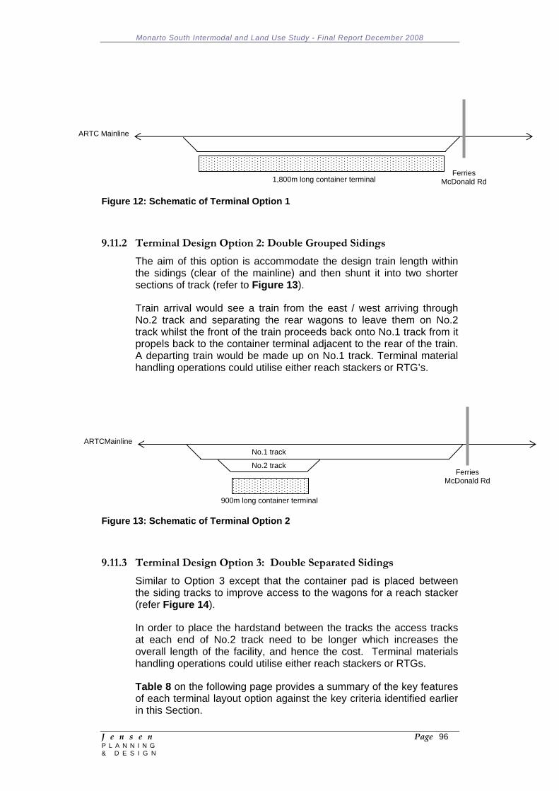
Monarto South Intermodal and Land Use Study - Final Report December 2008
J e n s e n Page 96 P L A N N I N G & D E S I G N
Figure 12: Schematic of Terminal Option 1
9.11.2 Terminal Design Option 2: Double Grouped Sidings
The aim of this option is accommodate the design train length within the sidings (clear of the mainline) and then shunt it into two shorter sections of track (refer to Figure 13).
Train arrival would see a train from the east / west arriving through No.2 track and separating the rear wagons to leave them on No.2 track whilst the front of the train proceeds back onto No.1 track from it propels back to the container terminal adjacent to the rear of the train. A departing train would be made up on No.1 track. Terminal material handling operations could utilise either reach stackers or RTG’s.
Figure 13: Schematic of Terminal Option 2
9.11.3 Terminal Design Option 3: Double Separated Sidings
Similar to Option 3 except that the container pad is placed between the siding tracks to improve access to the wagons for a reach stacker (refer Figure 14).
In order to place the hardstand between the tracks the access tracks at each end of No.2 track need to be longer which increases the overall length of the facility, and hence the cost. Terminal materials handling operations could utilise either reach stackers or RTGs.
Table 8 on the following page provides a summary of the key features of each terminal layout option against the key criteria identified earlier in this Section.
ARTC Mainline
Ferries
McDonald Rd1,800m long container terminal
ARTCMainline
Ferries McDonald Rd
900m long container terminal
No.1 track
No.2 track

Monarto South Intermodal and Land Use Study - Final Report December 2008
J e n s e n Page 97 P L A N N I N G & D E S I G N
Figure 14: Schematic of Terminal Option 3
ARTCMainline
Ferries McDonald Rd
900m long container terminal
No.1 track
No.2 track
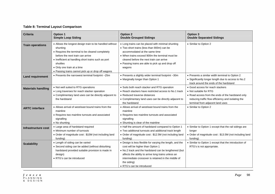
J e n s e n Page 98 P L A N N I N G & D E S I G N
Table 8: Terminal Layout Comparison
Criteria Option 1 Simple Loop Siding
Option 2 Double Grouped Sidings
Option 3 Double Separated Sidings
Train operations • Allows the longest design train to be handled without shunting
• Requires the terminal to be cleared completely before the next train can arrive
• Inefficient at handling short trains such as port shuttles
• Only one train at a time • Passing trains cannot pick up or drop off wagons
• Long trains can be placed with minimal shunting • Two short trains (less than 900m) can be
accommodated at the same time • When trains exceed 900m the terminal must be
cleared before the next train can arrive • Passing trains are able to pick up and drop off
wagons
• Similar to Option 2
Land requirement • Presents the narrowest terminal footprint ~25m • Presents a slightly wider terminal footprint ~30m • Marginally longer than Option 1
• Presents a similar width terminal to Option 2 • Significantly longer length due to access to No.2
track around the ends of the hardstand
Materials handling • Not well suited to RTG operations • Long traverses for reach stacker operation • Complimentary land uses can be directly adjacent to
the hardstand
• Suits both reach stacker and RTG operation • Reach stackers have restricted access to No.1 track • Reduced traverse distances • Complimentary land uses can be directly adjacent to
the hardstand
• Good access for reach stackers • Not suitable for RTG • Road access from the ends of the hardstand only
reducing traffic flow efficiency and isolating the terminal from adjacent land uses
ARTC interface • Allows arrival of west/east bound trains from the mainline
• Requires two mainline turnouts and associated signalling
• No shunting
• Allows arrival of west/east bound trains from the mainline
• Requires two mainline turnouts and associated signalling
• Shunting is clear of the mainline
• Similar to Option 2
Infrastructure cost • Large area of hardstand required • Minimum number of turnouts • Order of magnitude cost : $15M (not including land
funding)
• Half the amount of hardstand compared to Option 1 • Two additional turnouts and additional track length • Order of magnitude cost : $12.5M (not including land
funding)
• Similar to Option 1 except that the rail sidings are longer
• Order of magnitude cost : $13.5M (not including land funding)
Scalability • Length of siding can be varied • Second siding can be added (without disturbing
hardstand provided suitable provision is made in design)
• RTG’s can be introduced
• Design is less flexible for varying the length, and the cost will be higher than Option 1
• No.2 track and the hardstand can be lengthened (but affects the ability to arrive long trains unless an intermediate crossover is retained in the middle of the siding)
• RTG’s can be introduced
• Similar to Option 1 except that the introduction of RTG’s is not appropriate.
Monarto South Intermodal and Land Use Study - Final Report December 2008
J e n s e n Page 99 P L A N N I N G & D E S I G N
9.12 Terminal Management Options 9.12.1 Introduction
The ownership and management structures that are adopted for the new intermodal terminal will be key factors in determining its effectiveness and providing benefits to local industries. The arrangements that are adopted should maximise the likelihood of benefits being passed through to freight customers and producers, while at the same time providing appropriate incentives for transport operators to service the terminal.
Open access arrangements and periodic contestability of the terminal management contract would maximise the likelihood of benefits being distributed. However such arrangements may provide insufficient security to justify the terminal operator or other transport stakeholders making necessary investment in equipment and terminal maintenance.
In the case of the proposed new Monarto intermodal terminal it will be important that there is a close relationship between the terminal operator and the industry located close to the site, as well as those producers who may seek to haul their freight to the terminal in preference to using other terminals located in the Adelaide area.
9.12.2 Stakeholders in the Intermodal Transport Chain
Stakeholders in the intermodal transport chain may include:
Consignor Road transport operators Terminal operator Terminal owner Container/equipment providers Wagon providers Train operators Rail infrastructure providers Forwarding agents Shipping lines Stevedores Port operators Consignee Banks and insurance companies Government and its agents.
The activities of all these stakeholders need to be coordinated to maximise the efficiency and reliability of the transport chain. Some of the roles are undertaken by the same organisation. For example one company could be both the road transport operator and terminal operator. Pacific National is a wagon provider and train operator. Containers tend to be provided by shipping lines.
There are both advantages and disadvantages in these combined roles. A single organisation can internalise transactions although this may not necessarily reduce the coordination task. A single vertically
Monarto South Intermodal and Land Use Study - Final Report December 2008
J e n s e n Page 100 P L A N N I N G & D E S I G N
integrated organisation can also restrict competition and raise prices. This disadvantage can be minimised by requiring all roles to be contestable by other organisations. In practice such arrangements can be difficult to monitor and enforce so full separation of roles is often seen as preferable. However, combining some roles can deliver operational savings and incentives to invest in improved services so care is required to determine the appropriate balance for a particular situation.
9.12.3 Assets Deployed in the Land-based Intermodal Transport Chain
Assets deployed in the land-based intermodal transport chain (freight customer to port) include:
Containers – generally owned by shipping companies; Road trailers and prime movers – owned by a wide variety of
trucking companies, some of which are very large and vertically and horizontally integrated, as well as sole traders;
Access roads – Transport South Australia, local government and possibly private ownership;
Warehousing – Can be operated by individual production facilities or by third party operators;
Terminal infrastructure such as hard-standing areas and tracks – options for ownership are explored in the following sections of this report;
Materials handling equipment – owned or leased by the terminal operator;
Rail access tracks including the mainline – Australian Rail Track Corporation (ARTC);
Locomotives and rail wagons – usually owned or leased by railway operators such as Pacific National, Queensland National, or Genesee Wyoming Australia.
Owners of all of these assets need to be able to earn an acceptable return on their investment. However it is likely that asset owners in competitive parts of the logistics chain will only earn normal returns, while owners of the monopoly elements such as terminal and rail track access will win any excess returns that might be available. This presents the opportunity to consider the intermodal terminal operation as a profitable business in its own right or in conjunction with other parts of the logistics chain.
9.12.4 Terminal Access Considerations
The National Intermodal Terminal Study (2006) identified three positions that can be adopted with respect to access to intermodal terminals:
A purely commercial approach, in which the decision on who has access to the terminal on what terms is a matter solely for the terminal operator – this is the approach preferred by Pacific
Monarto South Intermodal and Land Use Study - Final Report December 2008
J e n s e n Page 101 P L A N N I N G & D E S I G N
National, which argues that it maximises incentives to invest and maintain the terminal fit for purpose;
A regulated access regime, under which there is a legal requirement of the terminal operator to provide access to all who seek it on fair and reasonable terms;
A structurally separated system under which the terminal operator is not an above-rail operator or at least not an above-rail operator who is or is likely to be a user of the terminal – this is the approach preferred by some potential customers of the terminal.
The National Intermodal Terminal Study considered that due to the difficulties in establishing and finding potential investors for regional intermodal terminals, the risks associated with regulating terminal access may well exceed the rewards.
If government funding for the establishment of the terminal is not sought, then a private terminal operator will be able to dictate the terms of access to the terminal. If government funding can be secured for most of the cost of the proposed terminal, it will be possible to require that the terminal and connecting track are operated as a common user terminal.
Theoretically, agreements can be drafted which force an appointed operator to behave in a neutral manner in the treatment of parties wanting to use the terminal or track. In practice this is very difficult to achieve unless the operator has no interest whatsoever in other parts of the intermodal transport chain. For this reason it could be desirable for rail operators to be excluded from any role in terminal ownership or operations.
9.12.5 Terminal Ownership Options
Choosing an appropriate operator for the terminal could influence the ongoing role of the terminal and its degree of success. But first it is important to consider the key success factors against which the options should be assessed. There are 3 distinct options for ownership of the site in Monarto South:
The land is purchased by the South Australian government’s Land Management Corporation (LMC);
The land is developed by the existing owners or sold off to other private interests for development; and
The land is purchased by the Monarto Common Purpose Group (or entity thereof).
There are a number of options available for consideration in relation to ownership and ongoing involvement with the Monarto Intermodal Terminal. The options discussed below relate to the level of control and influence the Monarto Common Purpose Group or State Government wish to have on the development and operation of the intermodal terminal at Monarto South. The options include:
The terminal is owned and developed by the government – This provides the highest level of control over the terminal and its future
Monarto South Intermodal and Land Use Study - Final Report December 2008
J e n s e n Page 102 P L A N N I N G & D E S I G N
operation but involves an ongoing commitment in an area that would not be seen as a core responsibility;
The government builds the terminal then contracts out its operation –Control of the terminal is retained but would remove the ongoing commitment to its operation. This option may be attractive if it is identified that ownership control is important but the group will have no ongoing interest in the location or whether the intermodal terminal is sustainable;
Government leases the land to a third party to design, construct and operate – This removes responsibilities in relation to the ongoing management of the terminal and passes all project risk to the owner/operator but allows the group to act as the landlord to control future utilisation of the site; or
Private developers design, construct and operate the terminal – This removes the ability to influence the ongoing management of the site and the way in which it relates to other land uses in the estate.
9.12.6 Terminal Operating Options
There are a number of alternative ownership and contractual arrangements that prevail in existing regional intermodal terminals which provide an indication of advantages and disadvantages of different arrangements.
Gray’s Transport’s intermodal terminal at Tocumwal (NSW) is an example of a relatively successful terminal. The terminal was developed on Gray’s own land and then connected to the Tocumwal – Mangalore rail line which is controlled by Pacific National through a lease. In this case the terminal owner has full ownership and control of all improvements to the terminal and hence an incentive to maintain and enhance the asset. The Victorian rail access rules ensure that rail operations to the terminal are contestable.
At Merbein (Mildura, Victoria) the intermodal terminal operated by Wakefield Transport is on a mix of freehold and Pacific National (PN) leased land. The rail sidings are all on PN land. Similarly, the terminal at Mooroopna (Victoria) is also on a mix of freehold and PN land. Having an intermodal terminal straddle between leased and freehold land enables the terminal operator to build all buildings and other improvements on their freehold land where they retain undisputed ownership of such improvements. Ownership of improvements on PN leased land is uncertain for the terminal operator and is unlikely to be accepted as security by banks. Terminal facilities on freehold land give the operator bargaining power with PN because they can use the threat of converting to road transport to negotiate satisfactory terms.
The intermodal terminal facility that is being developed as part of the Logic industry hub near Wodonga (Victoria) is considered a relatively successful model. Logic is on City of Wodonga owned land and comprises a number of development sites around an intermodal rail terminal and freeway interchange. The City has obtained State
Monarto South Intermodal and Land Use Study - Final Report December 2008
J e n s e n Page 103 P L A N N I N G & D E S I G N
Government contributions to fund all rail infrastructure between the Logic terminal and the main line. A concession has been awarded to a terminal operator. Instead of paying annual lease payments, the operator paid a single up-front payment reflecting the capitalised value of 25 years of lease payments. The up-front payment provided sufficient funding to cover construction of the terminal hardstand. The 25 year prepaid lease provides a bankable asset on the operator’s balance sheet. The government funded track between the mainline and the terminal is a common user facility into the terminal. The terminal operator has control of the terminal but is required to handle freight through the terminal for anyone who asks, based on a standard schedule of rates.
9.12.7 Operation Scenarios
The operational scenarios discussed here assume an owner/operator arrangement for the terminal. Practical and safety factors dictate that the terminal should be operated by a single operator. It is desirable that, whatever scenario is adopted, open access is maintained for all transport operators on both the road and rail side of the operation. The exception to this may be where the terminal is intended to be used as a single product/client facility and there is no desire to share it with other potential users.
This raises the issue of competition and the provision of open access to all parties. It is most likely that the throughput of the terminal will be optimised if the facility is made available to as many users as is possible. However the transport industry is very competitive and companies seek to gain competitive advantage by cornering aspects of the market place, and intermodal terminals are effective in supporting such outcomes. Competition will primarily be in the form of between rail operators and between road operators. In some larger companies, such as Toll, vertical integration means that they span both sides of the terminal operation with interests in road and rail.
Table 9 identifies the types of ownership options that may exist and their respective advantages and disadvantages:

Monarto South Intermodal and Land Use Study - Final Report December 2008
J e n s e n Page 104 P L A N N I N G & D E S I G N
Table 9: Terminal Operation Scenarios
Ownership Scenario
Comment Advantages Disadvantages
Government Government is unlikely to want to become involved in managing intermodal terminals. It has already outsourced or sold these types of functions.
• Provides the highest level of security for the facility and ensures open access to all freight
• On going issues of terminal efficiency and competitiveness will be an issue
Rail track manager ARTC manages the interstate rail network but does not get involved in terminal ownership or management GWA manages the SA intrastate network but is also a train operator (refer below)
• Integration into the broader rail network
• Single management of the rail interface between the terminal and the mainline
• No established relationship with customers or trucking companies
• Not part of core business
Railway operator Rail operators such as PN, QN and GWA already operate intermodal terminals to support their train operations. However they are competitors and therefore reluctant to provide access for another party
• Have experience with operating intermodal terminals
• Good at co-ordinating the train services to the terminal and can manage train loads and shunting needs
• Requires a legally sound access agreement in order to ensure access to the terminal by other rail operators
• Preferential treatment towards their business interests
Manufacturer or producer
A unique type of terminal, similar to a private siding arrangement. Also suits a freight forwarder who is vertically integrated into freight not in containers such as SCT.
• Single dedicate client with clear contractual relationship
• Easy to determine priorities and access arrangements
• The future of the terminal is dependent on the success of a single client
• Does not assist with promoting land take-up in surrounding areas.
Third party terminal operator
A party who concentrates on owning and operating terminals without a rail or road interest.
• Operator will be interested in maximising terminal throughput
• Willing to deal with all transport providers
• Needs a significant terminal throughput to make this a viable option.
• Difficult to find such a body given the cross ownership arrangements in the transport and logistics business
Road transport operator or third party logistics provider
Would be looking for more than just a terminal but also sufficient space for warehousing and container storage
• Will actively encourage business through the site
• Established reputation will be a freight and business attractor
• Most logistics providers are associated with a transport company (either road, rail or both)
ARTC Australian Rail Track Corporation GWA Genesee Wyoming Australia PN Pacific National QN Queensland National SCT Specialised Container Transport
Monarto South Intermodal and Land Use Study - Final Report December 2008
J e n s e n Page 105 P L A N N I N G & D E S I G N
The intermodal freight terminal will require appropriate maintenance of buildings, hardstand and paved areas, and rail infrastructure. If a private sector operator built and owned the terminal it would be likely to adopt the optimum long term maintenance strategy. However when the ownership and operation of the terminal is divided between different organisations the responsibility for maintenance and rehabilitation can also become unclear.
If the terminal operator owns the buildings it has an incentive to maintain them in good condition and fit for its purpose. Similarly if the operator invests its own capital in the terminal hardstand it will keep heavy equipment off lower strength surfaces to minimise damage and repair costs. Furthermore it will be interested in optimising the design strength of the pavement to the loadings of the equipment that it intends to operate so that the whole-life operating and maintenance cost is minimised.
This would require land ownership or necessitate a relatively long lease term in order for the terminal operator recover investment and gain the benefits of an appropriate asset management strategy.
9.13 Government Funding Opportunities 9.13.1 Federal Government
The Federal Government has committed $3 million on an Adelaide Metropolitan Freight Study, which will investigate, amongst other things, the future of the Hills Freight Rail Line, which runs alongside the Belair passenger line through the Adelaide Hills. This line provides the final link on the Adelaide-Melbourne line and is the first stage towards a possible realignment of the line north around the Adelaide Hills. Other funding programs available for the Monarto Intermodal Hub are identified below:
AusLink:
Roads to Recovery; Blackspot funding; and Strategic regional program.
9.13.2 State Government
In 2005, the South Australian Government developed the Strategic Infrastructure Plan to assess and determine funding options for infrastructure projects across the state. The purpose of this plan is to provide a consistent approach to analysing and assessing the value of infrastructure projects, and providing the opportunity for all forms of government to identify and propose projects within the long term strategic window.
Under the Strategic Infrastructure Plan, the South Australian Government has implemented a 5 step approach to develop and assess infrastructure projects:
Identify the service need;
Monarto South Intermodal and Land Use Study - Final Report December 2008
J e n s e n Page 106 P L A N N I N G & D E S I G N
Outline the case for change and define the services required; Substantiate and assess the project; Determine the funding method and resource allocation; and Deliver the project.
As discussed, the State Government is reviewing the possible upgrade of the Belair urban rail line in the Adelaide Hills within the context of this strategy. The government has also identified the need to develop intermodal terminals at strategic locations in urban and rural areas across the State to help facilitate the movement of freight and to effectively utilise existing infrastructure. Murraylands is one region that has been identified as a site for a possible intermodal terminal.
The operation of intermodal terminals in urban areas has typically proven to be unsuccessful. Operations in Melbourne and Sydney have previously been commercially unviable. The CRT Group in Melbourne established an unsuccessful intermodal terminal in the western suburbs operating short shuttle services between the terminal and the port. CRT, in a submission to the Independent Pricing and Regulatory Tribunal in NSW (2007) identified the ability to gain access on the rail network at all times, the high stevedoring charges for lifting containers, port penalties for delayed trains, the cost competition of road transport, and the internal rail charges for accessing the network as constraints to the operation of an intermodal facility in a metropolitan region. These issues correlate with the findings of the report by the NSW Sea Freight Council which determined that an effective intermodal facility needs to be at least 300km away from a major port and have a high TEU throughput to maintain rail cost competitiveness with the road alternative.
Monarto South Intermodal and Land Use Study - Final Report December 2008
J e n s e n Page 107 P L A N N I N G & D E S I G N
10 COMMUNITY CONSULTATION AND FURTHER STAKEHOLDER ENGAGEMENT 10.1 Community Information Meeting
A Community Information Meeting was held at the Monarto War Memorial Hall in the evening of 21 October 2008. The meeting was publicised via letters to some property owners, notices in local papers circulated within the three Council areas and posters placed on notice boards at Monarto South and Callington. Approximately 65 people attended the meeting. A paper summarising the Issues and Options Paper was made available to the public on request. In summary, the following issues were raised and discussed at the meeting: Issues Raised at Commencement of the Meeting:
1. Poor publicity of the public meeting. Many residents not contacted by mail.
2. Monarto South is not 'terra nullius'. 3. Impacts on Monarto Zoo. 4. Maintenance of clean air/air pollution concerns. 5. Future airport:
- How much freight? - Size of aircraft? - 24 hour operations? - Impact on airspace. - Impacts on existing airports.
6. Impact of intermodal/commercial development on: - Lifestyle/quality of life. - Fauna / flora. - Farming community. - Farm animals. - Property values. 7. Land division potential and impacts. 8. Changes to existing zoning. 9. Compulsory acquisition of land? 10. Implications of Adelaide Freight Study. 11. Adequate water supply? 12. Light overspill from industry/commercial premises. 13. Impact on roads and other physical infrastructure/services. 14. Impact on Conservation Parks. 15. The community needs certainty. 16. Will this be called in as a 'Major Development'?
Monarto South Intermodal and Land Use Study - Final Report December 2008
J e n s e n Page 108 P L A N N I N G & D E S I G N
Issues Discussed During the Meeting:
1. Need to improve quality of public areas / streetscape and ensure better quality built and site outcomes. Criticisms of APC development.
2. Future development needs to be of a high quality and achieve high environmental standards i.e. no heavy industry.
3. Concerns about length of time allowed for submissions, tokenistic consultation and unavailability of the complete study report.
4. Need for further consultation with the Monarto Zoo. 5. Concern about delays at rail crossing resulting from slow
moving trains. 6. Will the facility operate 24 hours a day? 7. Impact on property values. 8. Questionable justification for the north-south corridor and the
impact on the Conservation Parks and native fauna. 9. Consider relocating western boundary along the existing road. 10. Impact on residential growth areas within other towns (e.g.
Murray Bridge, Callington). 11. Support for Monarto Common Purpose Group to develop
consultation strategy beyond the meeting. 12. Need to consider consequences for local CFS, which is already
overstretched.
10.2 Submissions
Fourteen (14) written submissions were received following the public meeting. All but three of the submissions expressed opposition to the expansion of the Commercial (Monarto South) Zone and establishing an intermodal facility. In summary, the following issues were raised in the written submissions (brief responses to the issues raised are provide in italics): The impact on land values within adjacent areas resulting from
further commercial/industrial development at Monarto South; The expansion of the commercial zone is expected to have a positive impact on land values of land contained within the future zone boundaries and a minimal impact on land values of the adjacent agricultural land given that future development will not limit the ability to continue predominantly broadacre agricultural practices.
Concerns regarding the compulsory acquisition of land and the means of ensuring suitable compensation; There is no intention to compulsorily acquire land.
Monarto South Intermodal and Land Use Study - Final Report December 2008
J e n s e n Page 109 P L A N N I N G & D E S I G N
The removal of arable land from primary production; The proportion and amount of land removed from primary production will be minimal.
Additional pressures on CFS operations; This is a legitimate concern that will need to be addressed regardless of whether the commercial zone is expanded or not.
The negative impacts on noise and air pollution, particularly if the intermodal facility operates 24 hours per day; Policies will need to ensure that current and future operations perform to a high environmental standard.
Should an airport proceed in the area, the impact on stock, Monarto Zoo and the operations of the existing small aerodromes within the region, particularly impacts on existing aviation practice; If a future airport within the region is to be pursued then these and other matters will need to be addressed through the assessment and approval processes.
Impacts on the Monarto Zoo, the Ferries McDonald and Monarto Conservation Parks and flora and fauna (e.g. Mallee Fowl) in the region; The proposed expansion of the commercial zone is in a westerly direction away from the zoo. Furthermore, policy recommendations address the issue of minimizing impacts on the zoo. Any future airport in the region will need to address adequate buffers from and minimizing impacts on the Conservation Parks.
The proposal to extend into the current Scenic Corridor Zone, which will have impacts on native flora and fauna; The proposal will involve a minor incursion into the Scenic Corridor Zone, however, the inclusion of the need to provide wider and additional landscaped buffers should compensate for the resultant loss in vegetation.
Concerns regarding the water supply capacity of existing infrastructure; The proposed expansion of the commercial zone will only take place if an adequate water supply can be assured and without compromising supply to other surrounding areas.
The cost to ratepayers and the Rural City of Murray Bridge and other Councils in funding the study; We understand that this Study was substantially funded by the Department of Trade and Economic Development.
Employment generated by future development will mainly be for unskilled workers whereas many residents of the region are professionals who work elsewhere and are unlikely to benefit; Both skilled and unskilled employment is likely and we suspect that there are those residing within the region who would be interested in unskilled employment.
Skepticism about the potential for value adding of primary produce within the area;
Monarto South Intermodal and Land Use Study - Final Report December 2008
J e n s e n Page 110 P L A N N I N G & D E S I G N
There are no guarantees that value adding operations will locate within the region, however, provided adequate services are provided and conditions prevail there will be some potential for such operations to locate in the zone.
Doubts about the future upgrade and status of the Ferries McDonald Road and indeed the need to upgrade the road; The need to upgrade the Ferries McDonald Road is beyond the scope of this Study. An intermodal facility and expansion of the commercial zone is not dependent on such a road upgrade occurring.
The Adelaide Freight Movement Study may render the proposal for an intermodal transport hub at Monarto South redundant; While the outcomes of that Study may render such a proposal more difficult, it does not mean that an intermodal facility could not occur on a spur line from the main line. Furthermore, the potential for further commercial development in the region is not dependent on an intermodal facility.
The visual impact of existing commercial development at Monarto South; The consultants have noted that the visual impact and quality of some development within the commercial zone is unsatisfactory and that future policy measures and assessment processes will need to ensure higher quality development outcomes.
Question whether an intermodal will result in a reduction in road congestion within the Monarto South area; Traffic generation within the region will depend on the extent to which current and future operations utilize rail for freight movement.
There remain significant technical reasons that preclude Monarto South as a credible location for a future airport; This may well be the case, however, the investigation of these are beyond the scope of this Study and will need to be considered in future studies.
Impact of heavy vehicles on the structural integrity of older dwellings located close to Ferries McDonald Road; This is an issue that will arise regardless of the outcomes of this Study.
The inadequate level of public consultation and information provided to the community; This criticism is noted by the consultants and recommendations regarding future consultation and engagement processes have been made accordingly.
The need for more and better visual screening of existing and future buildings in the area by vegetation and fencing/walls (e.g. similar to walls established along parts of the Southern Expressway), particularly along Ferries McDonald Road and Princes Highway;
Monarto South Intermodal and Land Use Study - Final Report December 2008
J e n s e n Page 111 P L A N N I N G & D E S I G N
The consultants concur with this criticism and have recommended the need for wider and more effective buffers along the public road network within and surrounding the commercial zone.
The need for a more effective community consultation process, possibly involving the establishment of a formal process/forum for the voicing and resolving of issues; This criticism is noted by the consultants and recommendations regarding future consultation and engagement processes have been made accordingly.
The proposed expansion of commercial development and establishment of an intermodal hub in Monarto South is contrary to the aspirations of the local community for nature based activities and lifestyle allotments, as expressed in the Monarto Community Plan (2000); The consultants are of the view that future expansion of the commercial zone and the establishment of an intermodal facility will not compromise these other aspirations in the surrounding region.
The proposal to indefinitely impose land use restrictions to protect the long term potential to establish an airport at Monarto South imposes a private cost when there remain significant doubts as to a future airport in the region; The recommendation of this Study is that the need for and suitability of Monarto South for accommodating a future airport should be investigated and determined as soon as possible and that it not remain an indefinite and uncertain option.
10.3 Consultation with Monarto Zoo
A meeting was held with personnel from the Monarto Zoological Park on 31 October 2008 to discuss the proposals for an intermodal facility, the potential expansion of the commercial zone and the implications for and concerns of the Zoo. In summary, the following issues were raised and discussed (responses are provided in italics): The flight path and hours of operation of a potential airport
development could seriously impact the inhabitants of the Zoo. Currently a flight exclusion zone exists over the Zoo; This is a matter that will need to be considered as part of the decision making process regarding a future airport in the region.
Additional heavy industrial traffic mixed with increasing visitation to the Zoo will require a widening of the road to allow a greater vehicle pull off area in to the Zoo entry; The consultants agree with the need for traffic management within and surrounding the commercial zone to be further considered as part of the future planning for the area.
Additional 24 hour operations from the commercial hub could potentially impact the Zoo from additional noise and light pollution;
Monarto South Intermodal and Land Use Study - Final Report December 2008
J e n s e n Page 112 P L A N N I N G & D E S I G N
The proposed expansion of the commercial zone and the proposed intermodal facility are some distances from the boundary of the Zoo. Policies will need to ensure that current and future operations perform to a high environmental standard.
Consideration needs to be given to the creation of wildlife and vegetation corridors for native residents, including northern hemisphere bird species migrating to the region as an ongoing consequence of climate change; The consultants concur with this suggestion and a recommendation has been made accordingly.
Application of a conservation levy to business within the hub, directly contributing to carbon offset programs including the establishment of wildlife vegetation corridors; The consultants concur with this suggestion and a recommendation has been made accordingly.
Consideration to water catchment from the site, which could be re-directed to revegetation programs around the site and at Monarto Zoo; The consultants concur with this suggestion and a recommendation has been made accordingly.
Vegetation buffer zones should be included adjacent roadsides surrounding the development to assist in the aesthetics of the development and provide a green belt; The consultants concur with this suggestion and a recommendation has been made accordingly.
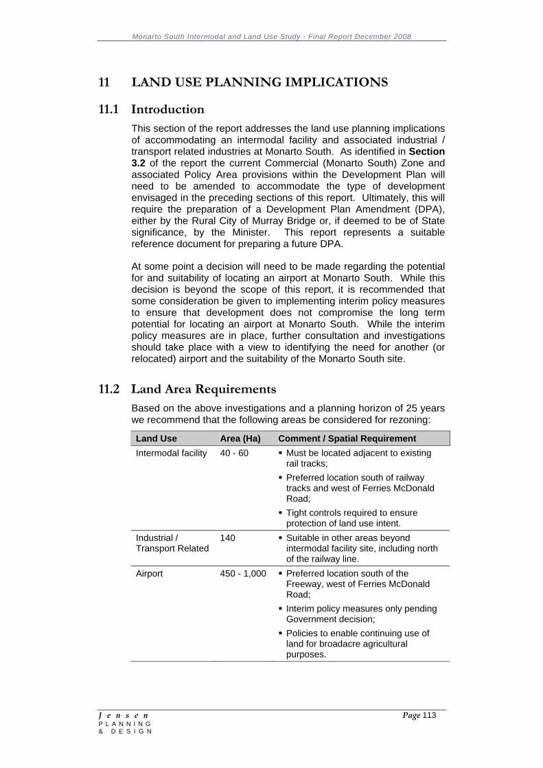
Monarto South Intermodal and Land Use Study - Final Report December 2008
J e n s e n Page 113 P L A N N I N G & D E S I G N
11 LAND USE PLANNING IMPLICATIONS 11.1 Introduction
This section of the report addresses the land use planning implications of accommodating an intermodal facility and associated industrial / transport related industries at Monarto South. As identified in Section 3.2 of the report the current Commercial (Monarto South) Zone and associated Policy Area provisions within the Development Plan will need to be amended to accommodate the type of development envisaged in the preceding sections of this report. Ultimately, this will require the preparation of a Development Plan Amendment (DPA), either by the Rural City of Murray Bridge or, if deemed to be of State significance, by the Minister. This report represents a suitable reference document for preparing a future DPA.
At some point a decision will need to be made regarding the potential for and suitability of locating an airport at Monarto South. While this decision is beyond the scope of this report, it is recommended that some consideration be given to implementing interim policy measures to ensure that development does not compromise the long term potential for locating an airport at Monarto South. While the interim policy measures are in place, further consultation and investigations should take place with a view to identifying the need for another (or relocated) airport and the suitability of the Monarto South site.
11.2 Land Area Requirements
Based on the above investigations and a planning horizon of 25 years we recommend that the following areas be considered for rezoning:
Land Use Area (Ha) Comment / Spatial Requirement Intermodal facility 40 - 60 Must be located adjacent to existing
rail tracks; Preferred location south of railway tracks and west of Ferries McDonald Road;
Tight controls required to ensure protection of land use intent.
Industrial / Transport Related
140 Suitable in other areas beyond intermodal facility site, including north of the railway line.
Airport 450 - 1,000 Preferred location south of the Freeway, west of Ferries McDonald Road;
Interim policy measures only pending Government decision;
Policies to enable continuing use of land for broadacre agricultural purposes.
Monarto South Intermodal and Land Use Study - Final Report December 2008
J e n s e n Page 114 P L A N N I N G & D E S I G N
11.3 Suggested Development Plan Policy Approach 11.3.1 Commercial (Monarto South) Zone and Policy Areas
We note that the BDP Planning Policy Library (Version 3) does not include the equivalent of an 'intermodal zone'. Appendix 4 contains an extract from the Playford (City) Development Plan of the recently authorised Intermodal Zone at Penfield as an example of the type of policies that might be envisaged for Monarto South (the highlighted sections are specific to the Penfield site and are not likely to be relevant to Monarto South). It is worth noting that the Penfield Intermodal Zone provisions do not necessarily protect certain parts of the zone (i.e. adjacent to the railway line) specifically for intermodal facilities.
In Monarto South we envisage a policy approach that would consist of the following:
An overarching industrial/commercial zone equivalent to the current Commercial (Monarto South) Zone with distinct Policy Areas;
One of the Policy Areas (south of the railway line and west of Ferries McDonald Road) would specifically encourage and reserve land for a future intermodal facility (approximately 200 metres wide by 2.1 kilometres long);
The land north of the railway line (bound by Ferries McDonald Road, Princes Highway and Thomas Crescent), south of the intermodal facility Policy Area, and east of Ferries McDonald Road, south of the railway line (see Figure 16) would accommodate a range of service and light industries, road transport terminals, warehouses and ancillary services (equivalent to the current Policy Area 10 - Core Area);
The current Rural Interface Policy Policy Area (Policy Area 12) would be extended to include all of the area east of Ferries McDonald Road, north of the railway line to minimise potential impacts on the Monarto Zoo and preserve a more 'rural' interface with the Zoo;
Deletion of the current Policy Area 9 (Mixed Use) provisions.
The policies (similar in scope to those contained within the Penfield Intermodal Zone) should also address issues of specific relevance to the Monarto South context, including the following:
Recognition of the 'gateway' role that the Monarto South interchange has and the need to design, site and landscape development accordingly;
The need to protect the Monarto Zoological Park from any adverse impacts (e.g. visual amenity, noise, light overspill, fumes etc);
The design of landscaping so that it serves a number of roles, including the buffering of views into development sites from public roads and to complement the desired north-south wildlife corridor in the region. To this extent, it is proposed that the currently
Monarto South Intermodal and Land Use Study - Final Report December 2008
J e n s e n Page 115 P L A N N I N G & D E S I G N
required 10 metre wide landscaped buffers adjacent to public roads be widened to 20 metres;
The effective management of traffic movements to/from the Zone and individual sites to minimise the impacts on traffic flows through the area and maximise road safety;
Ensuring that land division results in the creation of a range of allotment sizes to accommodate the type of development envisaged, in particular larger sites for more regional facilities (currently the prescribed 1 hectare minimum allotment size is not resulting in a diverse allotment pattern);
Policies that discourage the ability to establish service industries within the zone.
It should be noted that the current Commercial (Monarto South) Zone currently covers approximately 266 hectares and that the proposed expanded zone equates to approximately 508 hectares. We would anticipate that the proposed expansion of the zone in a westerly direction occur in a staged manner over a period of time to ensure more consolidated development outcomes and the economic delivery of services and infrastructure upgrades.
As mentioned previously in this report, an optimum intermodal facility should allow for a 2.1 kilometre length of straight railway line to accommodate 1.8 kilometre length trains. Currently, the length of railway line extending west from Ferries McDonald Road to the boundary of the Scenic Corridor Zone is only around 1.6 kilometres. While this is sufficient to accommodate the current train lengths (1.5 kilometres) it is not sufficient to accommodate the optimum train lengths (1.8 kilometres). Therefore, some consideration will need to be given to extending the Commercial (Monarto South) Zone into the adjacent Scenic Corridor Zone to achieve the optimum length. Alternatively, the intermodal facility/Policy Area could be located on the northern side of the railway line, however this will require consideration of the impact on the existing bulk storage facilities and necessitate more truck movements across the railway (given that the majority of truck movements to/from the facility are likely to occur via the Freeway interchange to the south).
11.3.2 Interim Airport Policies
In addition to the expanded Commercial (Monarto South) Zone we recommend that consideration be given to applying interim policies within defined parts of the Primary Industry Zone: South West Area - Policy Area 16 to the south of the Freeway. The policies would be designed to minimise the potential for development that may compromise the long term potential to utilise the area for a future airport.
Currently the policies for this area allow intensive animal keeping and land division to create smaller allotments in certain circumstances. The interim policy measures could consider limiting the potential for further land division (other than perhaps the readjustment of existing allotment boundaries) and precluding the ability to establish intensive
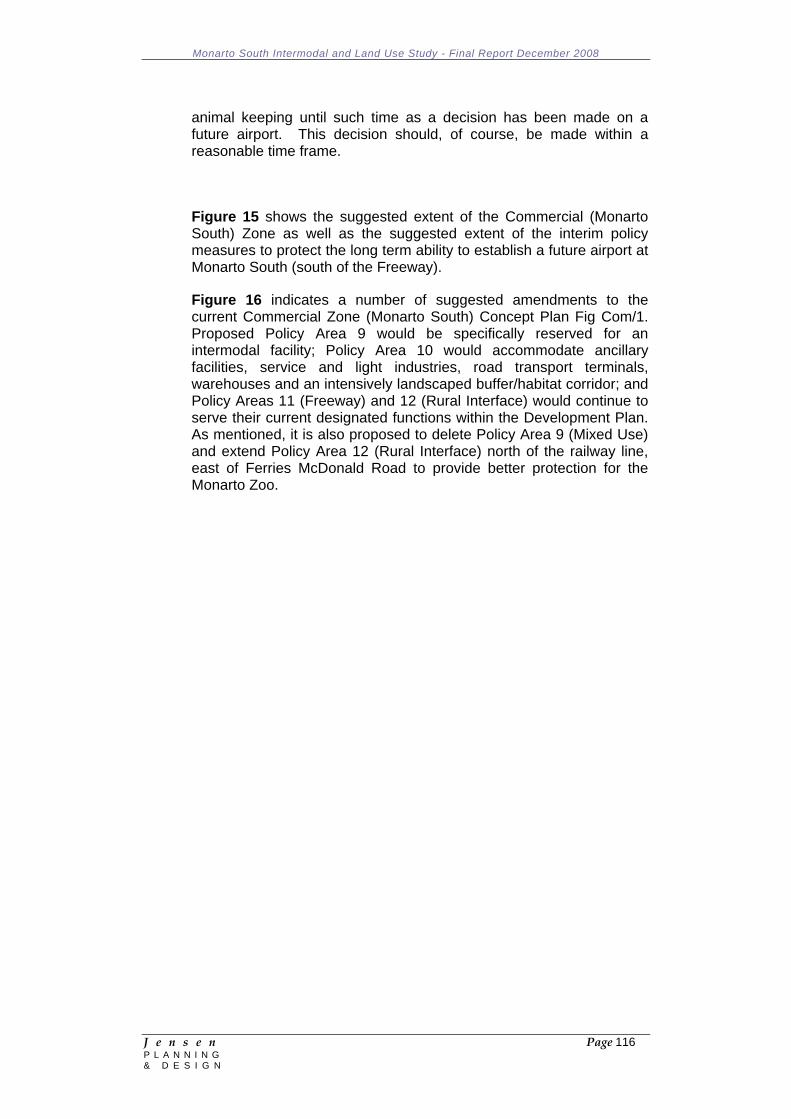
Monarto South Intermodal and Land Use Study - Final Report December 2008
J e n s e n Page 116 P L A N N I N G & D E S I G N
animal keeping until such time as a decision has been made on a future airport. This decision should, of course, be made within a reasonable time frame.
Figure 15 shows the suggested extent of the Commercial (Monarto South) Zone as well as the suggested extent of the interim policy measures to protect the long term ability to establish a future airport at Monarto South (south of the Freeway).
Figure 16 indicates a number of suggested amendments to the current Commercial Zone (Monarto South) Concept Plan Fig Com/1. Proposed Policy Area 9 would be specifically reserved for an intermodal facility; Policy Area 10 would accommodate ancillary facilities, service and light industries, road transport terminals, warehouses and an intensively landscaped buffer/habitat corridor; and Policy Areas 11 (Freeway) and 12 (Rural Interface) would continue to serve their current designated functions within the Development Plan. As mentioned, it is also proposed to delete Policy Area 9 (Mixed Use) and extend Policy Area 12 (Rural Interface) north of the railway line, east of Ferries McDonald Road to provide better protection for the Monarto Zoo.
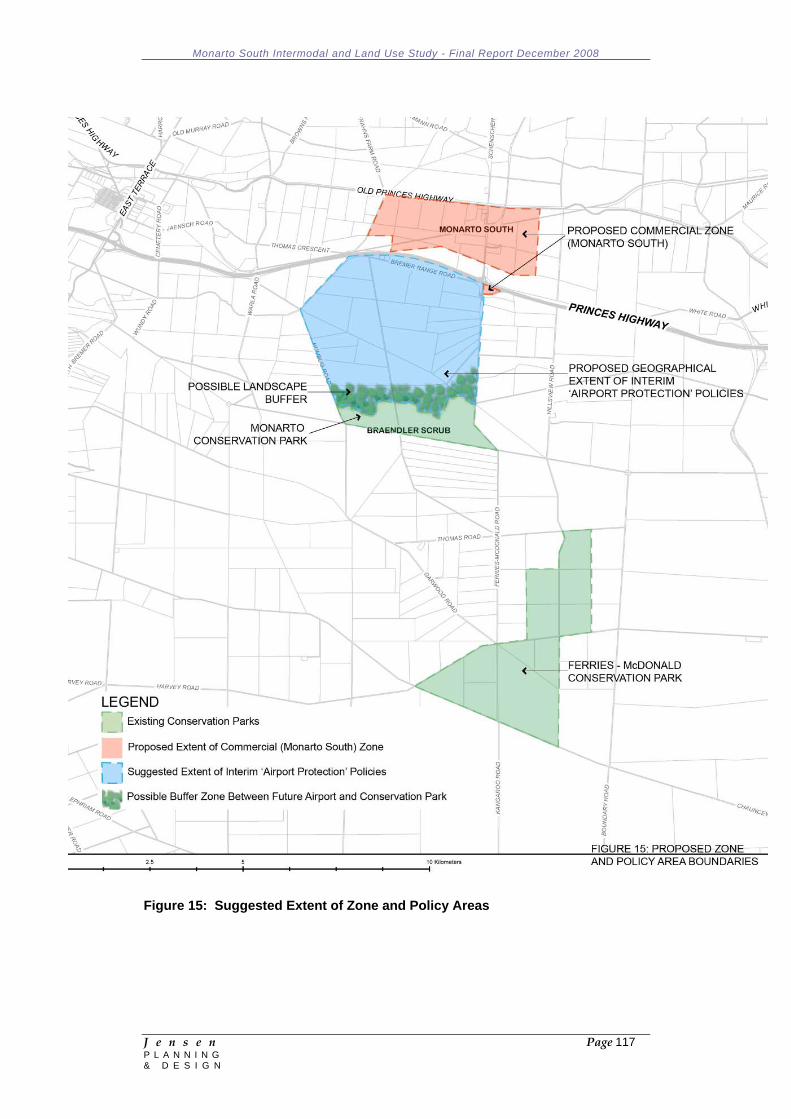
Monarto South Intermodal and Land Use Study - Final Report December 2008
J e n s e n Page 117 P L A N N I N G & D E S I G N
Figure 15: Suggested Extent of Zone and Policy Areas
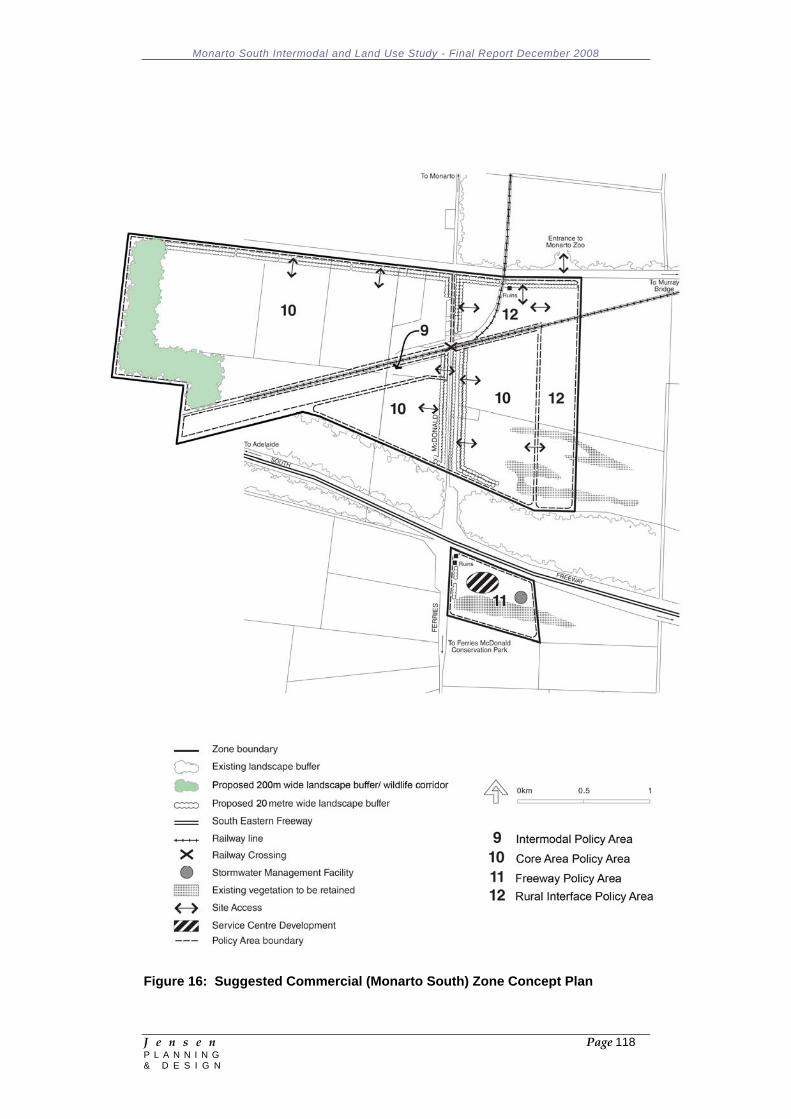
Monarto South Intermodal and Land Use Study - Final Report December 2008
J e n s e n Page 118 P L A N N I N G & D E S I G N
Figure 16: Suggested Commercial (Monarto South) Zone Concept Plan
Monarto South Intermodal and Land Use Study - Final Report December 2008
J e n s e n Page 119 P L A N N I N G & D E S I G N
12 RECOMMENDATIONS Plan for Greater Adelaide It is recommended that the MCPG, through the Rural City of
Murray Bridge, makes a deputation to Planning SA and its consultants with a view to advising of the outcomes of this Study and ensuring that the long term intentions for Monarto South are given full consideration within the planning investigations for Greater Adelaide.
Adelaide Freight Movement Study (AusLink Study) It is recommended that the MCPG make a deputation to the State
Project Management Group within the Department for Transport Energy and Infrastructure (DTEI) with a view to advising of the outcomes of this Study and ensuring that the long term intentions for Monarto South are given full consideration within the AusLink Study.
Metropolitan Adelaide Industrial Land Strategy It is recommended that the MCPG makes a deputation to the
Employment Lands Planning Forum with a view to advising of the outcomes of this Study and ensuring that the long term intentions for Monarto South are given full consideration within a future update of the Greater Adelaide Industrial Land Strategy.
Public Consultation
It is recommended that the Monarto Common Purpose Group (MCPG) and/or the Rural City of Murray Bridge, following endorsement of the findings and content of this Study, undertake a comprehensive public consultation process to advise and receive feedback on the Study.
It is recommended that the consultation process make widely available the full Study Report to the community (i.e. hard copies within the offices of the three Councils and Boards and public libraries, as well as links on the web sites of each of the Councils and Boards).
It is recommended that the MCPG explore alternative mechanisms for better engaging the various communities of interest within the Monarto South region. One option would be a funded and ongoing community consultative committee with agreed Terms of Reference and responsibilities. This Committee could, for example, explore ways of addressing current demands on the local CFS, as well as have inputs into some of the other initiatives suggested in this section.
Environmental / Public Realm Improvement
It is recommended that the Rural City of Murray Bridge initiates a public realm improvement study of the Commercial (Monarto
Monarto South Intermodal and Land Use Study - Final Report December 2008
J e n s e n Page 120 P L A N N I N G & D E S I G N
South) Zone with a view to identifying and implementing improvements to the streetscape, access arrangements (including to the adjacent Monarto Zoo), landscaping, signage, services etc. External funding sources, such as Planning SA, should be explored.
Future Airport It is recommended that the MCPG makes a deputation to the
Department of Premier and Cabinet with a view to encouraging further State and Federal investigations into the need for a future airport site and the suitability of the Monarto South site.
Land Use Planning Policies It is recommended that, subject to the outcomes from some of the
above recommendations, the Rural City of Murray Bridge initiates the Development Plan Amendment (DPA) process (or requests that the Minister initiate such a process) to achieve the following policy changes:
Expansion of the Commercial (Monarto South) Zone to the
west to accommodate anticipated future demand for industrial/commercial and intermodal development;
The protection of the ability to establish intermodal facilities adjacent to the railway line;
The design, site planning and landscaping of development of a high visual quality which minimises associated impacts on the road network and surrounding land uses;
Interim policies to the south of the Freeway (west of Ferries McDonald Road) to preserve the long term potential to establish a future airport in the region;
A more detailed Concept Plan for the Zone, which should address staging, access arrangements, buffers/habitat corridors, the integration of development on individual parcels of land etc.
Services and Infrastructure
It is recommended that the MCPG initiate the following additional investigations:
Prepare a potable water network master plan for upgrade and extension to serve the proposed development scenario, taking into consideration staging requirements;
Investigate options to offset the potable water demand by either supply of treated wastewater or stormwater harvesting and reuse schemes (this may prove to be attractive when compared with the required augmentation works for the potable water supply system);
A formal engineering study and detailed analysis of demand requirements for gas to service future development scenarios within Monarto South and eastwards into the Adelaide Hills.

Monarto South Intermodal and Land Use Study - Final Report December 2008
J e n s e n Page 121 P L A N N I N G & D E S I G N
Appendix 1: Stakeholder Engagement Workshop One Attendance List 14 August 2008 Consultant Team Peter Jensen, Jensen Planning & Design John Tagliaferri, Jensen Planning & Design David Snoswell, Jones Lang La Salle Parry Serafim, Maunsell AECOM Marcia Beinke, Maunsell AECOM Client Group Brenton Lewis, Murraylands Regional Development Board Bob Goreing, Adelaide Hills Regional Development Barry Featherstone, Fleurieu Regional Development Inc. Others David Altmann, Rural City of Murray Bridge Alan Arbon, Rural City of Murray Bridge Andrew Stuart, DC Mount Barker Ann Ferguson, DC Mount Barker Darren Starr, DC Mount Barker Mike Shelley, Alexandrina Council Anne Woolford, Alexandrina Council Sally Roberts, Alexandrina Council Kim Duffield, Representing Adrian Pederick MP, State Member for Hammond Neil Murphy, SA Freight Council Lochie McKinna, Retired Industry Operator Malcolm Govett, Planning SA Dr Marianne Hellers, DTED Lou Jansen, DTED Eric Filmer, Scott's Transport Nicholas Molloy Doug Schirripa, Adelaide Mushrooms
Monarto South Intermodal and Land Use Study - Final Report December 2008
J e n s e n Page 122 P L A N N I N G & D E S I G N
Appendix 2: Stakeholder Engagement Workshop Two Attendance List 28 October 2008 Consultant Team Peter Jensen, Jensen Planning & Design John Tagliaferri, Jensen Planning & Design In Attendance Brenton Lewis, Murraylands Regional Development Board Bob Goreing, Adelaide Hills Regional Development Alan Arbon, Rural City of Murray Bridge Gloria Booker, Rural City of Murray Bridge Kym Miller, Rural City of Murray Bridge Andrew Stuart, DC Mount Barker Ann Ferguson, DC Mount Barker Darren Starr, DC Mount Barker Robyn Dunstall, Alexandrina Council Anne Woolford, Alexandrina Council Sally Roberts, Alexandrina Council Kim Duffield, Representing Adrian Pederick MP, State Member for Hammond Neil Murphy, SA Freight Council Malcolm Govett, Planning SA Eric Filmer, Scott Group Nicholas Molloy Doug Schirripa, Adelaide Mushrooms Andy Rehmann, SCT Logistics Rick Brandon, Murraylands RCN
Monarto South Intermodal and Land Use Study - Final Report December 2008
J e n s e n Page 123 P L A N N I N G & D E S I G N
Appendix 3: Strategic Assessment of Primary Industry Around Murray Bridge Maps (Source: Primary Industries and Resources SA, October 2006)
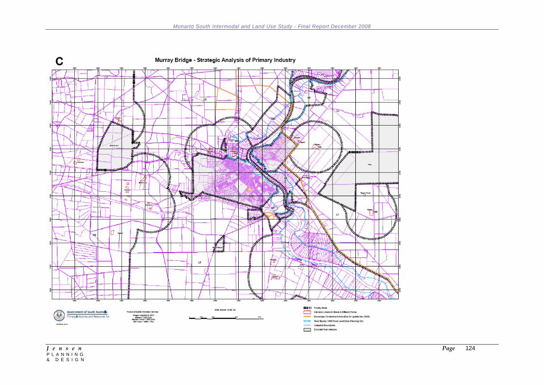
Monarto South Intermodal and Land Use Study - Final Report December 2008
J e n s e n Page 124 P L A N N I N G & D E S I G N
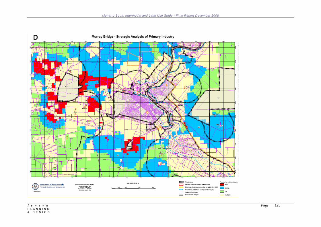
Monarto South Intermodal and Land Use Study - Final Report December 2008
J e n s e n Page 125 P L A N N I N G & D E S I G N
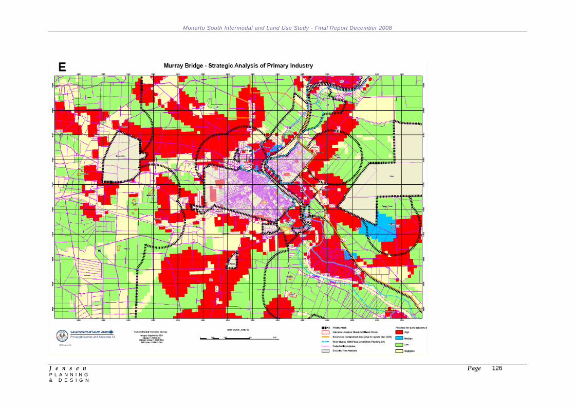
Monarto South Intermodal and Land Use Study - Final Report December 2008
J e n s e n Page 126 P L A N N I N G & D E S I G N
Monarto South Intermodal and Land Use Study - Final Report December 2008
J e n s e n Page 127 P L A N N I N G & D E S I G N
Appendix 4: Penfield Intermodal Zone Extract (Source: Playford (City) Development Plan) INTERMODAL ZONE Introduction The Objectives and Principles of Development Control that follow apply in the Intermodal Zone shown on Maps Play/8, 9 and Structure Plan Map Play/1(Overlay 1). They are additional to those expressed for the whole of the council area and, in cases of apparent conflict, take precedence over the more general provisions. OBJECTIVES Objective 1: A zone primarily accommodating intermodal rail freight terminal operations and associated activities. Objective 2: A zone in which commodities are received, stored and dispatched in bulk. Objective 3: A zone primarily accommodating marshalling yards, covered outdoor goods handling areas, large scale warehousing, railway workshop and road transport terminal associated with road/rail freight terminal operations. Objective 4: Development sited and designed to minimise adverse impacts on the landscape and on and from surrounding land uses. Objective 5: Buildings and structures screened from adjoining areas by landscaping using locally indigenous plant species. Objective 6: Development that contributes to the desired character of the zone. Objective 7: Development that ensures the long-term operational, safety and aviation requirements of the RAAF airfield continue to be met. DESIRED CHARACTER Development within the Intermodal Zone should provide for the efficient use of the land for intermodal rail freight terminal facilities including marshalling yards, railway workshops and locomotive maintenance activities, covered loading and unloading areas and warehousing for the storage and handling of shipping containers and goods. The intermodal terminal will include an administrative office accessed separately from the transit area to minimise the interface between visitor and office traffic with heavy vehicles. The intermodal facility will include overnight accommodation, including food preparation facilities to cater for train crew between shifts. The balance of the land will be developed for warehousing of goods requiring rail and road transport and associated ancillary offices.
Monarto South Intermodal and Land Use Study - Final Report December 2008
J e n s e n Page 128 P L A N N I N G & D E S I G N
The zone will service movement of freight from throughout the state and interstate and is likely to operate on a 24 hour, seven day per week basis. Agricultural and horticultural uses currently occurring in the zone will gradually be replaced by the uses envisaged in the zone. The zone will be developed in a way that minimises potential amenity impacts on sensitive land uses through the use of appropriate setbacks from key road frontages such as Pellew Road and Taylors Road. Warehouses in the zone will generally be large in scale, with buildings ranging in size from 7,000 to 30,000 square metres. Built form within the zone should comprise quality contemporary architecture; incorporate associated offices to the front of buildings to assist with breaking up the visual bulk of the building; and use a variety of building finishes and materials. Development will incorporate extensive landscaped areas containing a variety of vegetation, including locally indigenous species which require minimal maintenance, to soften the appearance of the built form. Setback areas adjacent to principal site boundaries will be planted with tall native trees and other vegetation to help screen the development from external view. Plantings will include a substantial proportion of trees in scale with the main buildings and trees located within and adjacent to parking areas to provide shade. Storage areas and unsightly activities and structures will be screened from public view, and buildings, parking and driveway areas will be softened or enhanced by landscaping. PRINCIPLES OF DEVELOPMENT CONTROL Land Use 1 The following forms of development are envisaged in the zone: Intermodal rail freight terminal facilities and associated rail infrastructure Office (ancillary to the intermodal rail freight terminal) Railway rolling stock servicing facilities Temporary/overnight workers’ accommodation (ancillary to the intermodal rail freight terminal) Warehousing (including associated offices). 2 Development listed as non-complying is generally inappropriate and not acceptable unless it can be demonstrated that it does not undermine the objectives and principles of the Development Plan. Form and Character 3 Development should not be undertaken unless it is consistent with the desired character for the zone. 4 In areas where a uniform street setback pattern has not been established, buildings should be set back in accordance with the following criteria (subject to adequate provision of car parking spaces and landscaping between buildings and the road): (a) buildings up to a height of 6 metres should be sited at least 8 metres from the primary street alignment; (b) buildings exceeding a height of 6 metres should be sited at least 10 metres from the primary street alignment;
Monarto South Intermodal and Land Use Study - Final Report December 2008
J e n s e n Page 129 P L A N N I N G & D E S I G N
(c) where an allotment has two street frontages, no building should be erected within 5 metres of the secondary street alignment. 5 Facilities for the handling, storage and dispatch of commodities in bulk should be sited, designed and operated to minimise risks of contamination to the environment and adverse impacts on nearby sensitive land uses and from surrounding land uses. 6 Development of facilities for the handling, transportation and storage of bulk commodities should have: (a) areas set aside on the site of the development for the marshalling and manoeuvring of vehicles attending the site; (b) roadways and parking areas surfaced in a manner sufficient to control dust emissions from the site; (c) vehicle circulation between activity areas contained within the site and without the need to use public roads; (d) a buffer area for the establishment of dense landscaping adjacent road frontages; (e) security fencing around the perimeter of the site. 7 Building facades should: (a) comprise quality contemporary architecture; (b) use a variety of building finishes; (c) not consist solely of metal cladding; (d) contain materials of low reflectivity; (e) incorporate design elements to add visual interest; (f) avoid large expanses of blank walls. 8 Buildings should not occupy more than 50 percent of the total area of the site upon which they are located. Access and Parking 9 Access to and from the site should be designed to allow simultaneous movement of vehicles entering and exiting in a forward direction to minimise interference to other traffic using adjacent public roads. 10 Development should: (a) provide for all loading and unloading to take place on the site of the development; (b) separate access, loading and unloading areas from parking areas to avoid conflict; (c) ensure that vehicle movements are safe and convenient. 11 Warehouses, stores and associated industries should be provided with sufficient and convenient parking for staff and visitors based on the following criteria: (a) for that part of the development used as office space, at least 1 car parking space for every 30 square metres (b) for that part of the development used as non-office space: (i) at least 1 car parking space for every 50 square metres up to 200 square metres; (ii) an additional car parking space for every 75 square metres between 200 and 2000 square metres; (iii) an additional car parking space for every 150 square metres above 2000 square metres. 12 Off-street car parking areas should be surfaced with suitable hard paving and be line marked to indicate car parking spaces.
Monarto South Intermodal and Land Use Study - Final Report December 2008
J e n s e n Page 130 P L A N N I N G & D E S I G N
13 Points of access on sites abutting areas primarily used by rural living activities should be located so that the number of vehicles associated with the development using nearby roads is kept to a minimum. 14 There should be as few points of access across open ‘swale’ stormwater drains as practicable and they should not impede the orderly flow of drainage water. 15 Landscaping should ensure adequate sight lines at vehicle entry and exit points. Stormwater 16 Provision should be made on the site for the capture, storage, treatment and environmentally responsible management and/or reuse of stormwater. 17 Open ‘swale’ stormwater drainage should: (a) be used in conjunction with roadways to cater for major stormwater flows and where practicable, for minor (2 to 10 year) stormwater flows; (b) be designed in an attractive form with grass-lined sides of no more than a 1 in 5 gradient; (c) allow for the planting of trees and shrubs on both sides of the channel. Hazard Risk Minimisation 18 Buildings should be established with a sufficient minimum floor level to avoid risk of inundation by the predicted 1 in 100 year flood event, and to minimise property damage within a building in the event of a major stormwater flow which exceeds the predicted 1 in 100 year flood event. Noise 19 Development should be consistent with the relevant provisions in the current Environmental Protection (Noise) Policy. Edinburgh Defence Precinct 20 Development should not be located where it will be adversely affected by noise nuisance from aircraft or is likely to detrimentally affect the RAAF airfield and DSTO operations. 21 The height and location of buildings and structures should not adversely affect the long-term operational, safety and aviation requirements of the RAAF airfield. 22 Development within areas affected by aircraft noise should be consistent with Australian Standard AS2021 – Acoustics – Aircraft Noise Intrusion – Building Siting and Construction. 23 Development should not create a risk to public safety and the operations/activities occurring at the Edinburgh Defence Precinct (RAAF Base Edinburgh and the Defence Science and Technology Organisation) through: (a) lighting glare; (b) smoke, exhaust fumes and plumes; (c) air turbulence;

Monarto South Intermodal and Land Use Study - Final Report December 2008
J e n s e n Page 131 P L A N N I N G & D E S I G N
(d) storage of flammable and hazardous materials; (e) radio frequency, electrical or electro-magnetic interference; (f) attraction of birds; (g) structures and materials that affect navigational aids, air traffic control or base communications; (h) use of reflective surfaces. Advertising and Signage 24 Advertisements and advertisement displays should: (a) not include portable, flashing or moving displays; (b) not include bunting, streamers, flags, or wind vanes; (c) not include roof-mounted advertisements projected above the roofline; (d) not include parapet-mounted advertisements projecting above the top of the parapet; (e) where internally illuminated, be unobtrusive and not be conspicuous from residential properties; (f) be of an appropriate size having regard to the scale of the building or wall and the setback from a public road; (g) not cover more than 10 percent of a total surface area of a wall oriented to a public road or reserve. 25 For sites accommodating a number of tenancies, a single sign designed in a graphically and colour coordinated manner that lists each tenant should be provided at a central location or access point. 26 Freestanding structures should not exceed 6 metres in height. Land Division 27 Land division should be undertaken in a coordinated manner and should ensure that: (a) development is staged in a sequence which avoids unnecessary cost to public authorities; (b) allotments have an area of at least 1 hectare and frontage to a public road of 60 metres, unless intended for a specific purpose for which a lesser site requirement can be demonstrated; (c) sufficient land is reserved for the satisfactory management or detention of stormwater; (d) roadways are designed to accommodate major stormwater flows in excess of the capacity of the underground drainage system. Complying Development 28 Complying developments are prescribed in Schedule 4 of the Development Regulations 1993. Non-complying Development 29 The following kinds of development are non-complying in the Intermodal Zone: Amusement machine centre Boarding house Caravan park Cemetery Community centre Concert hall Consulting room
Monarto South Intermodal and Land Use Study - Final Report December 2008
J e n s e n Page 132 P L A N N I N G & D E S I G N
Dwelling Educational establishment Fun fair Golf course/driving range Gymnasium Health centre Hospital Hotel Intensive animal keeping Library Meeting hall Motel Motor race track Motor repair station Non-residential club Nursing home Office except where it is: (a) ancillary to, and in association with a, development envisaged in the zone (b) necessary to support the operation of the development (c) located on the same allotment as the development Petrol filling station Pre-school Place of worship Police station Prescribed mining operations Primary school
Private hotel Recreation area Residential club Residential flat building Retail showroom Row dwelling Semi-detached dwelling Service industry Shop or group of shops with a gross leasable area greater than 80 square metres Squash court Stadium Stock slaughter works Timber yard Theatre Tourist accommodation Welfare institution Public Notification 30 All kinds of development except non-complying are assigned as Category 2 Development.
Monarto South Intermodal and Land Use Study - Final Report December 2008
J e n s e n Page 133 P L A N N I N G & D E S I G N
Appendix 5: References ABS (March 2001) 9220.0 Freight Movements, Australia
About Australia’s Regions (June 2008), BTRE
Access Undertaking – ARTC (2002), ACCC
Air Transport Services in Regional Australia (2008), BTRE
Annual Planning Review 2008 – 2028 (May 2008), ElectraNet
ARTC Annual Report (2007)
ARTC Customer Commitment Charter (2008)
ARTC Schedules Adelaide to Melbourne (2008)
ARTC Schedlues Melbourne to Adelaide (2008)
ARTC SA/WA Corridor Network Diagram
AusLink Demand Projections for Non-Urban Corridors: Methodology and Projections – Working Paper 66 (2006)
Australian Intercapital Rail Freight Performance Indicators 2006-2007 (2008), BTRE
Australian Transport Statistics (June 2008)
Australian Yearbook Statistics 2007 (2008) BTRE
CRT Group Submission: Review of the Interface between the Land Transport Industries and the Stevedores at Independent Pricing and Regulatory Tribunal of New South Wales (July 2007)
Developing Freight Hubs - A Guide to Sustainable Intermodal Terminal for Regional Communities Sea Freight Council of NSW
Electricity System Development Plan 2008 - Issue 1.3 (June 2008), ETSA Utilities
Heavy Vehicle Access Framework (2008), South Australia Department for Transport, Energy and Infrastructure
Information Sheet 22 - Freight Between Australian Cities 1972-2001 (2001), BTRE
Intermodal Logistics Centre at Enfield - Environmental Assessment Executive Summary (October 2005) SKM and Sydney Ports
Joint Government Advisory Committee on Adelaide's Airline Airport Requirements - Sub Working Group to Consider Airport Requirements at Monarto (February 1975)
Melbourne Adelaide Corridor Strategy (June 2007), Commonwealth of Australia
Metropolitan Adelaide Industrial Land Strategy (April 2007)
Monarto Community Plan (June 2000), Monarto Residents Association Inc.
Monarto Environmental Precinct Eastern Hills & Murray Plains Catchment Group Inc.
Monarto Precinct Strategic Directions Report - Final Report (September 2007), Dynamic Project Delivery
National Intermodal Terminal Study - Final Report (February 2006), Meyrick and Associates and ARUP
Monarto South Intermodal and Land Use Study - Final Report December 2008
J e n s e n Page 134 P L A N N I N G & D E S I G N
Parkes Intermodal Terminal - Environmental Assessment for Concept Approval Executive Summary GHD
Planning Strategy for Outer Metropolitan Adelaide Region (December 2007), Government of South Australia
Planning Strategy for Regional South Australia (Amended December 2007), Government of South Australia
Regional North South Transport Corridor - Final Report (February 2006), Limestone Ridge Project Management
Regional Intermodal Terminals - Indicators for Sustainability (2004), NSW Sea Freight Council
Road and Rail Freight Infrastructure Pricing (2006), Productivity Commission
South Australia Exports By Air Calendar Year 2007 (February 2008), South Australia Department for Transport, Energy and Infrastructure
South Australian Rail Freight - A Bypass to Save the Heart of Adelaide (2007), Mitcham Community Rail Freight Task Force
South Australia's Strategic Plan 2007 (January 2007), Government of South Australia
Strategic Assessment of Primary Industry Around Murray Bridge (October 2006), Primary Industries and Resources SA
Strategic Infrastructure Plan for South Australia 2005/06 - 2014/15 (April 2005), Government of South Australia
Sydney's Intermodal Solution (April 2007) Sea Freight Council of NSW
Sydney's Intermodal System - Development of a Business Plan for an Open Access Intermodal Terminal in Sydney (June 2007) Sea Freight Council of NSW Websites: ARTC
ATC
NTC
ABS
BTRE
AquaMap (SA Water’s web-based mapping application) – www.aquamap.sawater.com.au/eview
Dial Before You Dig (Australia’s national referral service for information on underground pipes and cables) – www.dialbeforeyoudig.com.au
Telstra – www.telstra.com.au
Optus – www.optus.com.au
Monarto South Intermodal and Land Use Study - Final Report December 2008
J e n s e n Page 135 P L A N N I N G & D E S I G N
Appendix 6: People / Organisations Consulted Jeff Cook, Manager Finance and Commercial, SEA Gas Neil Chambers, Deputy CEO, VTA Andy Martin, National Strategic Development Manager, Toll SPD Neil Murphy, General Manager, South Australian Freight Council Andrew Pellazzari, Flinders Ports Ben Leske, Infrastructure Manager, ARTC Steve Shearer, Executive Director SARTA John Connell, Victorian Transport Manager, Cement Australia Andy Rehmann, State Manager, SCT Logistics Phil Baker, Managing Director, Adelaide Airport Ltd Ken May, General Manager Property Development, Adelaide Airport Ltd Mark Williams, Manager Rail Policy and Investments, DTEI Rex Phillips, Advisor, Rail Policy and Investment, DTEI Phil Dawes, DTEI John Jarrad, DTEI David Bartlett, DTEI Brian Pelham, Executive Director, DTED Damian Papps, Director Investment, DTED Bruce Rippin, Director, Planning Strategy, Planning SA Peter Hall, Manager, Strategic Planning Unit, Planning SA Malcolm Govett, Senior Project Officer, Strategic Development Division, Planning SA Gloria Booker, Rural City of Murray Bridge Darren Starr, District Council of Mount Barker Nathan Sim, District Council of Mount Barker Kim Vivian, Alexandrina Council Sally Roberts, Alexandrina Council Paul Mickan, Adelaide Hills Council Eric Filmer, General Manager, Scotts Transport Steve Smith, General Manager, Goodman International Jim Whiting, Managing Director, Badge Constructions James Sexton, RE/MAX Chris Giannes, Pope Nitschke First National Emilis Prelgauskas, Monarto South Resident John Laird, Candetti Constructions Phil Clarke, Major Development Proposals and Client Manager, SA Water Trevor Gregory, Network Manager South, ETSA Geoff Wegener, Asset Manager (Hills & Murray), ETSA Chris Rae, Network Customer Manager, ElectraNet Jeff Cooke, Manager Finance & Commercial, SEA Gas Paul Budde, Managing Director, Paul Budde Communication Pty Ltd
Monarto South Intermodal and Land Use Study - Final Report December 2008
J e n s e n Page 136 P L A N N I N G & D E S I G N
Simon Hackett, Managing Director Internode Janelle Owen, Internode Peter Clark, Sarah Brown, Steve Callery, Monarto Zoo