mobile data collection with arcgis online · mobile data collection with arcgis online ... data...
TRANSCRIPT

Mobile Data Collection with
ArcGIS Online
Jennifer Kuntz

• For Individuals
• For Organizations
• For Developers
• For Governments
Web
Mobile
Desktop
Cloud
Server
ArcGIS as a Platform We Believe in Geographic Understanding
ArcGIS Online

ArcGIS Online
Leverage existing
investments
Multiple API’s for the
development
community
Ready to use apps
Expanding
infrastructure needs
Secure sharing &
collaboration
Organized data &
document
ownership
Cross platform &
multiple device
support
Self-service
Making the Platform Easy

The Power of ArcGIS Online
Intelligent Web Maps that can be used everywhere
One Map – Many Devices
Desktop
Tablets
Smartphones
Websites
ArcGIS Online
Browsers
Social media

Mobile Data Collection Examples
• Stormwater retention basin inspections
• Illicit discharges into streams and other water
quality data
• Americans with Disabilities Act curb ramp
inspection
• Tree and Sign inventories
• Event infrastructure planning and status
• Disaster recovery operations
• Pre-fire planning

What Types of Devices Can I Use?
• iPhones and iPads
• Android Phones and Tablets
• Windows Phones

Apps and SDKs for Mobile Data Collection
Windows
Mobile
Windows
iOS Android
Runtime SDK
• .NET CF
Runtime SDKs
• WPF, Java
Linux
Runtime SDK
• Java
Runtime SDK
• Objective C
Runtime SDK
• Java
Windows
Phone
Runtime SDK
• Silverlight
Apps
• ArcGIS for
Windows Mobile
• ArcPad
Apps
• ArcGIS for
Windows Mobile
• ArcPad
Apps
• ArcGIS App
Apps
• ArcGIS App
• Collector
Apps
• ArcGIS App
• Collector

ArcGIS at your fingertips when you are on the move
ArcGIS on Smartphones and Tablets
• Carry your maps with you on the go
• Collect and update data
• Multiple users can seamlessly use the
same map
• Get access to dynamic information

What are the benefits of Mobile GIS?
• Data access in the field
• Fast data collection
• Fewer errors
• Live Access to edits
• Less Paper
Accessible intelligent Web Maps from anywhere
Make Informed and Timely Decisions
Seamless Data
Integration
Rapid Data
Collection
Improve Efficiency
and Accuracy

A Look at Where We’re
Headed….

ArcGIS on
Smartphones and
Tablets

ArcGIS on Smartphones and Tablets
• Designed for touch-screen phones and tablets
• Connected Workflows (Wifi, 3G)
• Location Integration
• Replace Paper Surveys
- Intelligent forms
- Field Validation
- Media Integration
• Replace paper map books
Service Requests
Parcel Valuation
VGI
Campus Maps
Emergency Operations

Who is this for ?
Knowledge Worker Decision Maker / Storyteller Customer

Discovering and Viewing Maps
• Discover and view web
maps
- ArcGIS Online
- Connect to your
organization
- Groups, Favorites
• Explore maps
- Popups, gestures

Finding Your Way
• Reverse geocoding
• Location based searches
• Bookmarks
• Predefined queries (App)
• Get Directions (Collector)

Tools
• GPS
• Measure
• Data Collection and Editing
- Points with Collector
- Points, Lines, or Polygons
with App
• Track Collectors (Collector)

Data Collection and Editing
• Authored maps
- ArcGIS Server Feature layers
• Attributes
- Types / Domains
- Attachments
• Features
- Template based
• Updates server

How To Plan and Implement
Mobile Data
Collection Project
ArcGIS

Plan Your Project
• Is ArcGIS Online the Right Choice?
- Will positional accuracy suit project needs?
- Is data connectivity available in data collection
location?
• Gather Input
- Understand and use the terminology of data
collectors
- Provide shortcuts for speed and accuracy

General Steps
1. Prepare the data
2. Publish the data as a feature service
3. Make and share a web map using the feature
service
4. Edit features using the ArcGIS App or
Collector

Step 1a: Data Preparation Decide where to host the Feature Service
• On ArcGIS Online (organizational account)
- Publish with Desktop
- Shapefile or CSV added to ‘My Content’
- Empty service based on existing service
• On Your Server
- Publish with Desktop

Architecture with
Service Hosted Online
ArcGIS Services
ArcGIS Online

Architecture with Server
ArcGIS Services
ArcGIS Server
ArcGIS Online

Secured Services
• ArcGIS Server Manager
• Users and Roles
• Web Map prompts users
for credentials
• REST exposure without
the security risk
• Can use versions

Step 1b: Data Preparation
• If dataset is new, set up the schema
• Consider using an Esri data model
- Local Government Information Model
- Saves time
- Extensible
- Used with Esri apps

Step 1c: Data Preparation Prepare Data
• If publishing from Desktop, optionally set:
- Domains
- Symbols
- Field aliases
• If publishing to Server, optionally set:
- Subtypes
- Default values
• Do you want attachments?
• Do you want to track editors?
• Set permissions for data
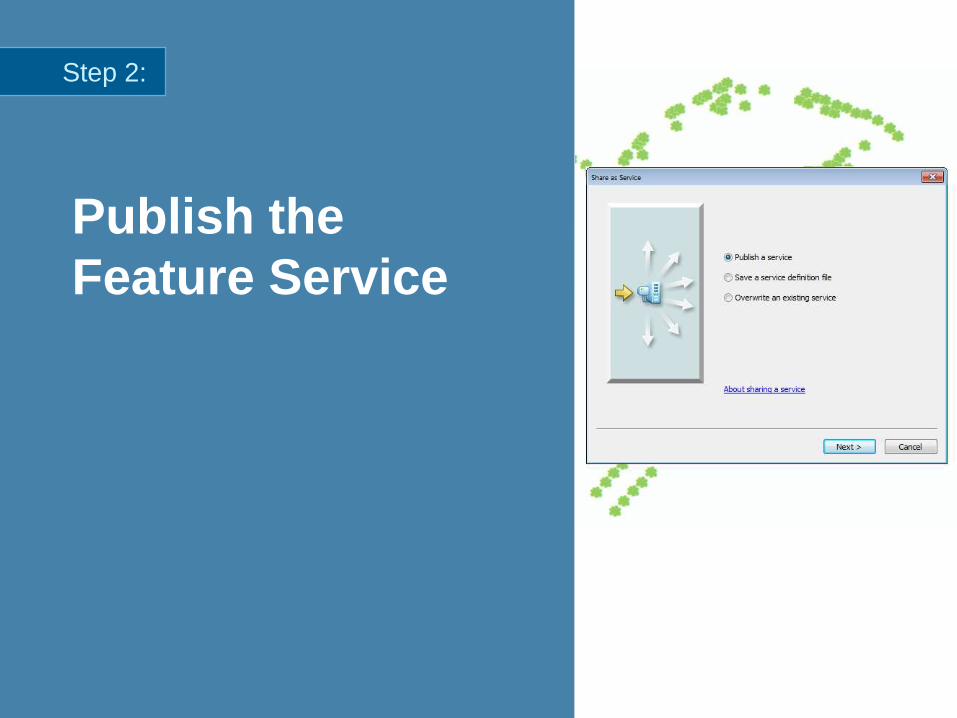
Publish the
Feature Service
Step 2:

Step 3: Make the Web Map
• Check settings on feature service
• Choose a basemap
• If not done in Desktop:
- Symbology
- Configure Attributes
• Make bookmarks
• Layer visibility ranges

Make the Web
Map
Step 3:

Step 4: Collect Data Choose an App
Collector for ArcGIS ArcGIS for iOS / Android /
Windows Phone
Data Collection App Map Viewing App with Editing
iOS and Android (Windows
Phone Coming Soon)
iOS, Android, Windows Phone
Points Points, Lines, Polygons
Routing
Report Editor Locations

How to Make a
Local Copy of
Hosted Features
FAQ

How do I get started ?
• Download from device app store
• Evaluate ArcGIS Online Organization
• Resources available on
http://resources.arcgis.com
• Community and User driven support on
- http://forums.arcgis.com

Further information
• http://resources.arcgis.com/en/communities/smartphone-apps/
