missile defense agency ballistic missile defense system (bmds) · missile defense agency ballistic...
TRANSCRIPT
Missile Defense Agency Ballistic Missile Defense System (BMDS)
Draft Programmatic Environmental Impact Statement
1 September 2004
VOLUME 2 APPENDICES Department of Defense Missile Defense Agency 7100 Defense Pentagon Washington, DC 20301-7100
Volume 2 Table of Contents
APPENDIX A CONSULTATION AND COORDINATION...................................A-1 APPENDIX B PUBLIC INVOLVEMENT................................................................B-1 B.1 Scoping....................................................................................................................B-2 B.2 Public Comment Period ........................................................................................B-14 APPENDIX C RELATED DOCUMENTATION .....................................................C-1 APPENDIX D DESCRIPTIONS OF PROPOSED BMDS ELEMENTS ...............D-1 D.1 Airborne Laser.........................................................................................................D-2 D.2 Kinetic Energy Interceptor ....................................................................................D-10 D.3 AEGIS Ballistic Missile Defense..........................................................................D-15 D.4 Ground-Based Midcourse Defense .......................................................................D-20 D.5 Patriot Advanced Capability-3 ..............................................................................D-30 D.6 Terminal High Altitude Area Defense ..................................................................D-37 D.7 Arrow Weapon System .........................................................................................D-44 D.8 Medium Extended Air Defense System................................................................D-48 APPENDIX E DESCRIPTIONS OF PROPOSED BMDS SENSORS ...................E-1 APPENDIX F ADVANCED SYSTEMS .................................................................... F-1 APPENDIX G APPLICABLE LEGAL REQUIREMENTS....................................G-1 APPENDIX H BIOME DESCRIPTIONS..................................................................H-1H.1 Arctic Tundra Biome...............................................................................................H-1
H.1.1 Air Quality ........................................................................................H-1 H.1.2 Airspace ............................................................................................H-3 H.1.3 Biological Resources.........................................................................H-5 H.1.4 Geology and Soils ...........................................................................H-10 H.1.5 Hazardous Materials and Hazardous Waste ...................................H-12 H.1.6 Health and Safety ............................................................................H-12 H.1.7 Noise ...............................................................................................H-13 H.1.8 Transportation .................................................................................H-14 H.1.9 Water Resources .............................................................................H-15
H.2 Sub-Arctic Taiga Biome........................................................................................H-16 H.2.1 Air Quality ......................................................................................H-17 H.2.2 Airspace ..........................................................................................H-19 H.2.3 Biological Resources.......................................................................H-20 H.2.4 Geology and Soils ...........................................................................H-24 H.2.5 Hazardous Materials and Hazardous Waste ...................................H-26 H.2.6 Health and Safety ............................................................................H-27 H.2.7 Noise ...............................................................................................H-27 H.2.8 Transportation .................................................................................H-27 H.2.9 Water Resources .............................................................................H-29
H.3 Deciduous Forest Biome .......................................................................................H-30 H.3.1 Air Quality ......................................................................................H-30
i

H.3.2 Airspace ..........................................................................................H-35 H.3.3 Biological Resources.......................................................................H-37 H.3.4 Geology and Soils ...........................................................................H-43 H.3.5 Hazardous Materials and Hazardous Waste ...................................H-46 H.3.6 Health and Safety ............................................................................H-48 H.3.7 Noise ...............................................................................................H-48 H.3.8 Transportation .................................................................................H-48 H.3.9 Water Resources .............................................................................H-49
H.4 Chaparral Biome ...................................................................................................H-52 H.4.1 Air Quality ......................................................................................H-53 H.4.2 Airspace ..........................................................................................H-57 H.4.3 Biological Resources.......................................................................H-58 H.4.4 Geology and Soils ...........................................................................H-62 H.4.5 Hazardous Materials and Hazardous Waste ...................................H-64 H.4.6 Health and Safety ............................................................................H-64 H.4.7 Noise ...............................................................................................H-64 H.4.8 Transportation .................................................................................H-64 H.4.9 Water Resources .............................................................................H-65
H.5 Grasslands Biome..................................................................................................H-66 H.5.1 Air Quality ......................................................................................H-66 H.5.2 Airspace ..........................................................................................H-68 H.5.3 Biological Resources.......................................................................H-69 H.5.4 Geology and Soils ...........................................................................H-70 H.5.5 Hazardous Materials and Hazardous Waste ...................................H-71 H.5.6 Health and Safety ............................................................................H-72 H.5.7 Noise ...............................................................................................H-72 H.5.8 Transportation .................................................................................H-72 H.5.9 Water Resources .............................................................................H-73
H.6 Desert Biome.........................................................................................................H-75 H.6.1 Air Quality ......................................................................................H-76 H.6.2 Airspace ..........................................................................................H-77 H.6.3 Biological Resources.......................................................................H-78 H.6.4 Geology and Soils ...........................................................................H-80 H.6.5 Hazardous Materials and Hazardous Waste ...................................H-82 H.6.6 Health and Safety ............................................................................H-83 H.6.7 Noise ...............................................................................................H-83 H.6.8 Transportation .................................................................................H-83 H.6.9 Water Resources .............................................................................H-84
H.7 Tropical Biome......................................................................................................H-85 H.7.1 Air Quality ......................................................................................H-86 H.7.2 Airspace ..........................................................................................H-88 H.7.3 Biological Resources.......................................................................H-90 H.7.4 Geology and Soils ...........................................................................H-94
ii
H.7.5 Hazardous Materials and Hazardous Waste ...................................H-96 H.7.6 Health and Safety ............................................................................H-98 H.7.7 Noise ...............................................................................................H-98 H.7.8 Transportation .................................................................................H-98 H.7.9 Water Resources .............................................................................H-99
H.8 Savanna Biome....................................................................................................H-101 H.8.1 Air Quality ....................................................................................H-101 H.8.2 Airspace ........................................................................................H-102 H.8.3 Biological Resources.....................................................................H-103 H.8.4 Geology and Soils .........................................................................H-106 H.8.5 Hazardous Materials and Hazardous Waste .................................H-106 H.8.6 Health and Safety ..........................................................................H-107 H.8.7 Noise .............................................................................................H-107 H.8.8 Transportation ...............................................................................H-107 H.8.9 Water Resources ...........................................................................H-108
H.9 Mountain Biome..................................................................................................H-108 H.9.1 Air Quality ....................................................................................H-109 H.9.2 Airspace ........................................................................................H-110 H.9.3 Biological Resources.....................................................................H-111 H.9.4 Geology and Soils .........................................................................H-112 H.9.5 Hazardous Materials and Hazardous Waste .................................H-113 H.9.6 Health and Safety ..........................................................................H-113 H.9.7 Noise .............................................................................................H-114 H.9.8 Transportation ...............................................................................H-114 H.9.9 Water Resources ...........................................................................H-115
H.10 Broad Ocean Area ..............................................................................................H-117 H.10.1 Air Quality ....................................................................................H-118 H.10.2 Airspace ........................................................................................H-122 H.10.3 Biological Resources.....................................................................H-123 H.10.4 Geology and Soils .........................................................................H-126 H.10.5 Hazardous Materials and Hazardous Waste .................................H-128 H.10.6 Health and Safety ..........................................................................H-129 H.10.7 Noise .............................................................................................H-130 H.10.8 Transportation ...............................................................................H-131 H.10.9 Water Resources ...........................................................................H-132
H.11 Atmosphere ........................................................................................................H-134 H.11.1 Air Quality ....................................................................................H-138 H.11.2 Airspace ........................................................................................H-138 H.11.3 Biological Resources.....................................................................H-139 H.11.4 Orbital Debris................................................................................H-139
APPENDIX I CUMULATIVE IMPACTS.................................................................. I-1 APPENDIX J GLOSSARY ..........................................................................................J-1INDEX VOLUME 2 ......................................................................................... Index V2-1
iii
Table of Exhibits Exhibit B-1 Notice of Intent.......................................................................................B-3 Exhibit B-2. Local and Regional Publications and Dates ...........................................B-5 Exhibit B-3. Scoping Meeting Notification List .........................................................B-6 Exhibit B-4. Example of Scoping Meeting Notification Letter ..................................B-8 Exhibit B-5. Media Representatives Contacted ..........................................................B-9 Exhibit B-6. Example of Scoping Meeting Press Release ........................................B-10 Exhibit B-7. Public Scoping Meeting Attendees and Comments Provided..............B-11 Exhibit B-8. Issues Addressed in Scoping Comments..............................................B-13 Exhibit B-9. Scoping Comment Excerpts .................................................................B-15
Exhibit D-1. Airborne Laser........................................................................................D-3 Exhibit D-3. Kinetic Energy Interceptor Terrestrial and Sea-Based Concepts.........D-10 Exhibit D-2. Aegis Cruiser USS LAKE ERIE ..........................................................D-16 Exhibit D-4. COMSATCOM Earth Terminal ...........................................................D-23 Exhibit D-5. In-Flight Data Terminals ......................................................................D-24 Exhibit D-6. MDA GMD ETR Test and Test Support Locations.............................D-26 Exhibit D-7. PAC-3 Launch ......................................................................................D-30 Exhibit D-8. Example THAAD Missile Configuration.............................................D-38
Exhibit G-1. Location of Categorical Exclusions in Agency or Service NEPA Implementing Regulations......................................................................G-4
Exhibit G-2. National Ambient Air Quality Standards ...............................................G-6 Exhibit G-3. De Minimis Thresholds in Non-Attainment Areas ................................G-8
Exhibit H-1. Arctic National Wildlife Refuge ............................................................H-8 Exhibit H-2. Regulation of Activities Near Seabird Colonies in Arctic Regions .....H-10 Exhibit H-3. Hurricane Activity in the U.S. ..............................................................H-32 Exhibit H-4. Examples of Threatened and Endangered Vegetation Species in
the Inland Deciduous Forest Biome .....................................................H-39 Exhibit H-5. Examples of Threatened and Endangered Wildlife Species in the
Deciduous Forest Biome ......................................................................H-41 Exhibit H-6. Examples of Threatened and Endangered Species of the
Everglades ............................................................................................H-42 Exhibit H-8. Federally Listed Threatened or Endangered Species within the
Chaparral Biome...................................................................................H-59 Exhibit H-9. Volcanic Hazards (based on activity in the last 15,000 years).............H-63 Exhibit H-10. High Plains Aquifer System .................................................................H-74 Exhibit H-11. Critical Desert Tortoise Habitat............................................................H-80 Exhibit H-12. Special Use Airspace in the PMRF/Main Base Airspace Use
Region of Influence ..............................................................................H-89 Exhibit H-13. Surface Currents of the World’s Oceans ............................................H-134 Exhibit H-14. Relationship between Airspace Classifications and Atmospheric
Layers .................................................................................................H-139
iv
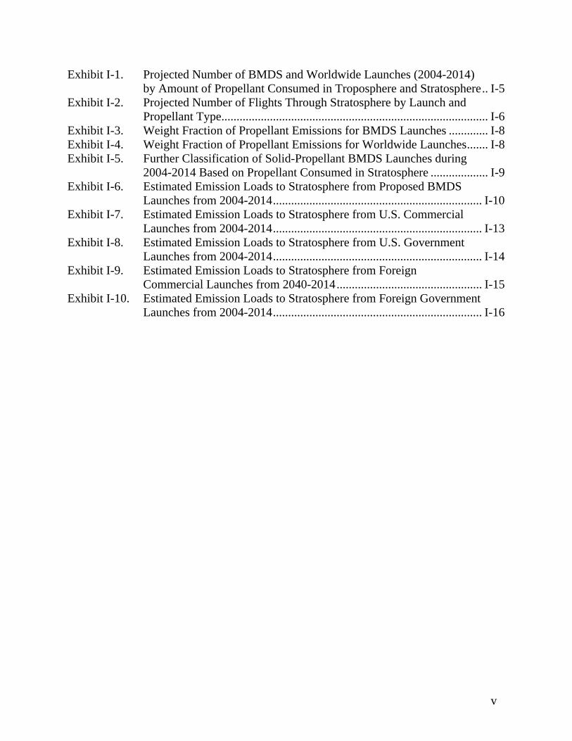
Exhibit I-1. Projected Number of BMDS and Worldwide Launches (2004-2014) by Amount of Propellant Consumed in Troposphere and Stratosphere.. I-5
Exhibit I-2. Projected Number of Flights Through Stratosphere by Launch and Propellant Type........................................................................................ I-6
Exhibit I-3. Weight Fraction of Propellant Emissions for BMDS Launches ............. I-8 Exhibit I-4. Weight Fraction of Propellant Emissions for Worldwide Launches....... I-8 Exhibit I-5. Further Classification of Solid-Propellant BMDS Launches during
2004-2014 Based on Propellant Consumed in Stratosphere ................... I-9 Exhibit I-6. Estimated Emission Loads to Stratosphere from Proposed BMDS
Launches from 2004-2014..................................................................... I-10 Exhibit I-7. Estimated Emission Loads to Stratosphere from U.S. Commercial
Launches from 2004-2014..................................................................... I-13 Exhibit I-8. Estimated Emission Loads to Stratosphere from U.S. Government
Launches from 2004-2014..................................................................... I-14 Exhibit I-9. Estimated Emission Loads to Stratosphere from Foreign
Commercial Launches from 2040-2014................................................ I-15 Exhibit I-10. Estimated Emission Loads to Stratosphere from Foreign Government
Launches from 2004-2014..................................................................... I-16
v
APPENDIX A
CONSULTATION AND COORDINATION
A-1
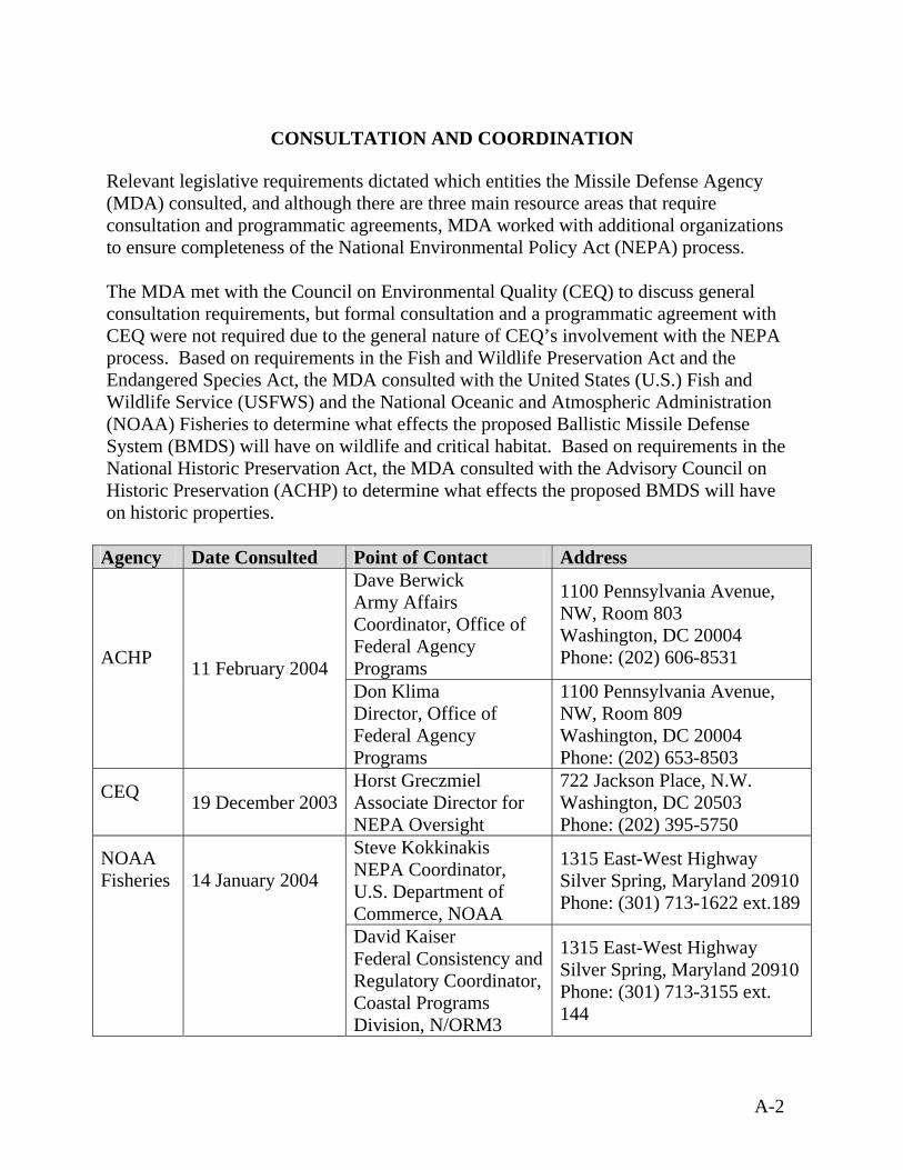
CONSULTATION AND COORDINATION
Relevant legislative requirements dictated which entities the Missile Defense Agency (MDA) consulted, and although there are three main resource areas that require consultation and programmatic agreements, MDA worked with additional organizations to ensure completeness of the National Environmental Policy Act (NEPA) process. The MDA met with the Council on Environmental Quality (CEQ) to discuss general consultation requirements, but formal consultation and a programmatic agreement with CEQ were not required due to the general nature of CEQ’s involvement with the NEPA process. Based on requirements in the Fish and Wildlife Preservation Act and the Endangered Species Act, the MDA consulted with the United States (U.S.) Fish and Wildlife Service (USFWS) and the National Oceanic and Atmospheric Administration (NOAA) Fisheries to determine what effects the proposed Ballistic Missile Defense System (BMDS) will have on wildlife and critical habitat. Based on requirements in the National Historic Preservation Act, the MDA consulted with the Advisory Council on Historic Preservation (ACHP) to determine what effects the proposed BMDS will have on historic properties.
Agency Date Consulted Point of Contact Address Dave Berwick Army Affairs Coordinator, Office of Federal Agency Programs
1100 Pennsylvania Avenue, NW, Room 803 Washington, DC 20004 Phone: (202) 606-8531 ACHP
11 February 2004 Don Klima Director, Office of Federal Agency Programs
1100 Pennsylvania Avenue, NW, Room 809 Washington, DC 20004 Phone: (202) 653-8503
CEQ 19 December 2003
Horst Greczmiel Associate Director for NEPA Oversight
722 Jackson Place, N.W. Washington, DC 20503 Phone: (202) 395-5750
Steve Kokkinakis NEPA Coordinator, U.S. Department of Commerce, NOAA
1315 East-West Highway Silver Spring, Maryland 20910 Phone: (301) 713-1622 ext.189
NOAA Fisheries
14 January 2004
David Kaiser Federal Consistency and Regulatory Coordinator, Coastal Programs Division, N/ORM3
1315 East-West Highway Silver Spring, Maryland 20910 Phone: (301) 713-3155 ext. 144
A-2
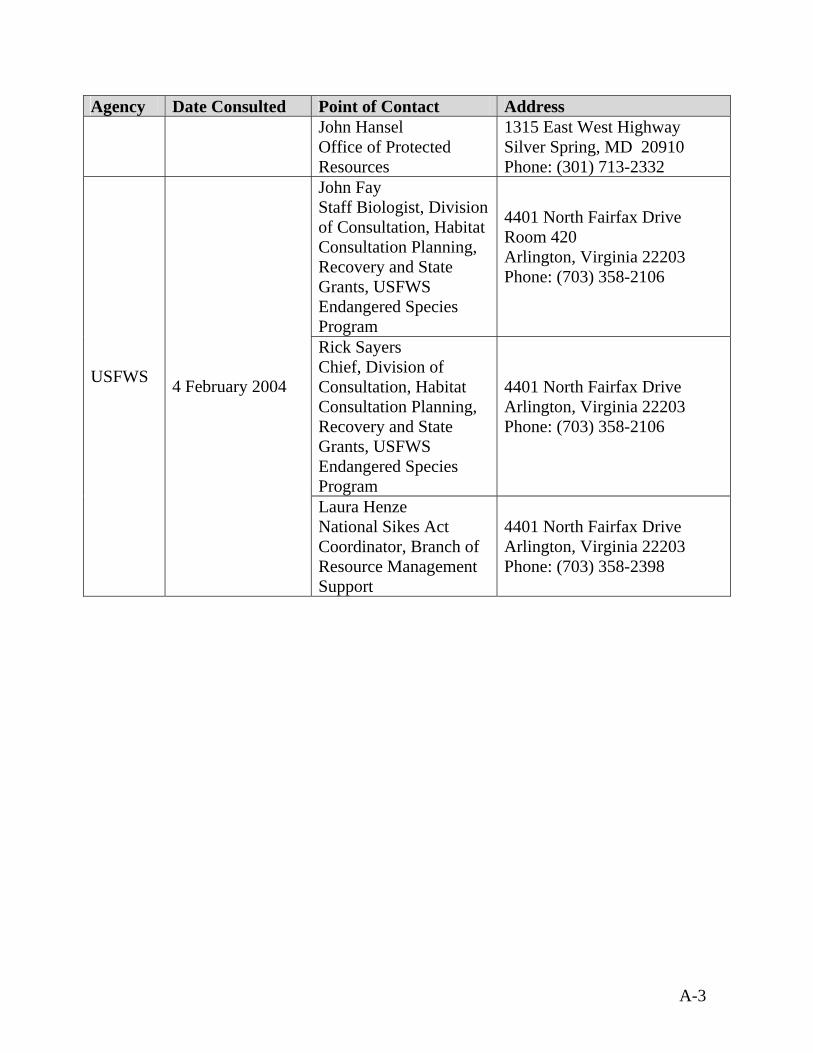
Agency Date Consulted Point of Contact Address John Hansel Office of Protected Resources
1315 East West Highway Silver Spring, MD 20910 Phone: (301) 713-2332
John Fay Staff Biologist, Division of Consultation, Habitat Consultation Planning, Recovery and State Grants, USFWS Endangered Species Program
4401 North Fairfax Drive Room 420 Arlington, Virginia 22203 Phone: (703) 358-2106
Rick Sayers Chief, Division of Consultation, Habitat Consultation Planning, Recovery and State Grants, USFWS Endangered Species Program
4401 North Fairfax Drive Arlington, Virginia 22203 Phone: (703) 358-2106
USFWS 4 February 2004
Laura Henze National Sikes Act Coordinator, Branch of Resource Management Support
4401 North Fairfax Drive Arlington, Virginia 22203 Phone: (703) 358-2398
A-3

APPENDIX B
PUBLIC INVOLVEMENT
B-1

PUBLIC INVOLVEMENT
The Council on Environmental Quality (CEQ) implementing regulations for the National Environmental Policy Act (NEPA) describe the public involvement requirements for agencies (40 Code of Federal Regulations [CFR] 1500-1508). Public participation in the NEPA process not only provides for and encourages open communication between the Missile Defense Agency (MDA) and the public, but also promotes better decision-making. Throughout preparation of the Ballistic Missile Defense System (BMDS) Programmatic Environmental Impact Statement (PEIS), the MDA aimed to Obtain meaningful input concerning the issues that should be addressed in the BMDS
PEIS, Provide interested parties, especially the public, with accurate and timely information
concerning the MDA’s efforts to meet NEPA requirements in the BMDS PEIS process,
Ensure meaningful public involvement during scoping and the public review of the Draft PEIS,
Ensure that the MDA responded to inquiries and comments in a timely manner and discuss how input was considered, and
Ensure that the MDA recognized and responded to changing stakeholder needs for input and involvement in a timely and informative way.
B.1 Scoping
The CEQ implementing regulations for NEPA require an open process for determining the scope of issues related to the proposed action and alternatives. The scope consists of the range of actions, alternatives, and impacts to be considered in the PEIS. Scoping is a useful tool for discovering alternatives to a proposed action, identifying significant impacts, eliminating insignificant issues, communicating information, consulting with agencies and organizations, and soliciting public comments. During scoping, the MDA invited the participation of Federal, state, and local agencies, Native American Tribes, environmental groups, organizations, citizens, and other interested parties to assist in determining the scope and significant issues to be evaluated in the BMDS PEIS. Scoping for the development of the BMDS PEIS began with the publication of the Notice of Intent (NOI) in the Federal Register (Vol. 68, No. 70 FR 17784) on April 11, 2003. The NOI announced the MDA’s intent to prepare a PEIS on the proposed BMDS; provided information on the proposed action and reasonable alternatives, including the no action alternative; listed the dates and locations of scoping meetings; and provided contact information for submitting comments to the MDA. The NOI is shown in Exhibit B-1.
B-2
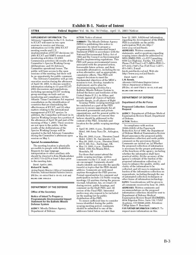
Exhibit B-1. Notice of Intent
B-3

The MDA developed a web site, http://www.acq.osd.mil/bmdo/peis/html/peis.html, to provide information on the BMDS PEIS and solicit scoping comments. The web site includes a schedule and summaries of the scoping meetings; background information about the NEPA process, the BMDS, and the PEIS; and links to relevant web sites. In addition, the web site provides an electronic comment form for individuals to submit scoping comments directly to the MDA. The MDA also established a toll-free phone line, toll-free fax, e-mail address, and mailbox for submittal of public comments and questions. The MDA held public scoping meetings in accordance with CEQ regulations. The purpose of the scoping meetings was to solicit input from the public on concerns regarding the proposed activities, as well as information and knowledge of issues relevant to analyzing the environmental impacts of the BMDS. The public scoping meetings also provided the public with an opportunity to learn more about the MDA’s proposed action and alternatives. MDA personnel were available at the scoping meetings to explain the objectives of the BMDS PEIS process. The scoping meetings consisted of informal poster sessions; formal presentations by MDA officials on the proposed BMDS, the NEPA process, and public involvement; and a formal public comment session. The MDA provided background and information materials to those who attended the scoping meetings and provided numerous ways to submit comments and obtain additional information. A court reporter was present at each of the meetings to document the proceedings, including public comments, for the administrative record. Issues highlighted at the public scoping meetings were posted on the BMDS PEIS web site. Scoping Meeting Legal Notices In addition to announcing the public scoping meetings in the NOI, the MDA placed paid legal notices in local and regional publications. Exhibit B-2 summarizes the publications in which the scoping meetings were advertised, including publication dates.
B-4
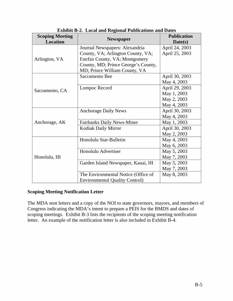
Exhibit B-2. Local and Regional Publications and Dates Scoping Meeting
Location Newspaper Publication Date(s)
Arlington, VA
Journal Newspapers: Alexandria County, VA; Arlington County, VA; Fairfax County, VA; Montgomery County, MD; Prince George’s County, MD; Prince William County, VA
April 24, 2003 April 25, 2003
Sacramento Bee April 30, 2003 May 4, 2003
Sacramento, CA Lompoc Record April 29, 2003 May 1, 2003 May 2, 2003 May 4, 2003
Anchorage Daily News April 30, 2003 May 4, 2003
Fairbanks Daily News-Miner May 1, 2003 Anchorage, AK Kodiak Daily Mirror April 30, 2003
May 2, 2003 Honolulu Star-Bulletin May 4, 2003
May 6, 2003 Honolulu Advertiser May 5, 2003
May 7, 2003 Garden Island Newspaper, Kauai, HI May 5, 2003
May 7, 2003
Honolulu, HI
The Environmental Notice (Office of Environmental Quality Control)
May 8, 2003
Scoping Meeting Notification Letter The MDA sent letters and a copy of the NOI to state governors, mayors, and members of Congress indicating the MDA’s intent to prepare a PEIS for the BMDS and dates of scoping meetings. Exhibit B-3 lists the recipients of the scoping meeting notification letter. An example of the notification letter is also included in Exhibit B-4.
B-5
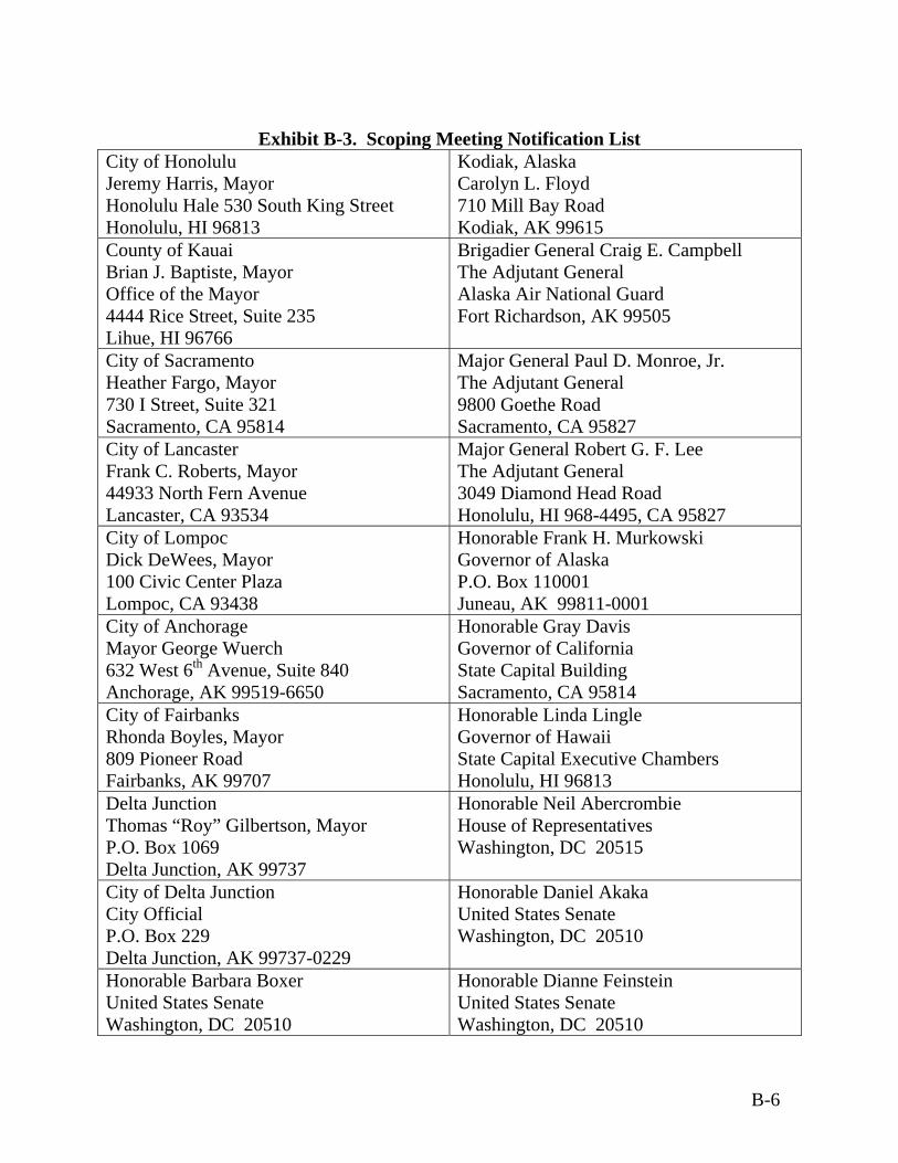
Exhibit B-3. Scoping Meeting Notification List
City of Honolulu Jeremy Harris, Mayor Honolulu Hale 530 South King Street Honolulu, HI 96813
Kodiak, Alaska Carolyn L. Floyd 710 Mill Bay Road Kodiak, AK 99615
County of Kauai Brian J. Baptiste, Mayor Office of the Mayor 4444 Rice Street, Suite 235 Lihue, HI 96766
Brigadier General Craig E. Campbell The Adjutant General Alaska Air National Guard Fort Richardson, AK 99505
City of Sacramento Heather Fargo, Mayor 730 I Street, Suite 321 Sacramento, CA 95814
Major General Paul D. Monroe, Jr. The Adjutant General 9800 Goethe Road Sacramento, CA 95827
City of Lancaster Frank C. Roberts, Mayor 44933 North Fern Avenue Lancaster, CA 93534
Major General Robert G. F. Lee The Adjutant General 3049 Diamond Head Road Honolulu, HI 968-4495, CA 95827
City of Lompoc Dick DeWees, Mayor 100 Civic Center Plaza Lompoc, CA 93438
Honorable Frank H. Murkowski Governor of Alaska P.O. Box 110001 Juneau, AK 99811-0001
City of Anchorage Mayor George Wuerch 632 West 6th Avenue, Suite 840 Anchorage, AK 99519-6650
Honorable Gray Davis Governor of California State Capital Building Sacramento, CA 95814
City of Fairbanks Rhonda Boyles, Mayor 809 Pioneer Road Fairbanks, AK 99707
Honorable Linda Lingle Governor of Hawaii State Capital Executive Chambers Honolulu, HI 96813
Delta Junction Thomas “Roy” Gilbertson, Mayor P.O. Box 1069 Delta Junction, AK 99737
Honorable Neil Abercrombie House of Representatives Washington, DC 20515
City of Delta Junction City Official P.O. Box 229 Delta Junction, AK 99737-0229
Honorable Daniel Akaka United States Senate Washington, DC 20510
Honorable Barbara Boxer United States Senate Washington, DC 20510
Honorable Dianne Feinstein United States Senate Washington, DC 20510
B-6

Exhibit B-3. Scoping Meeting Notification List Honorable Daniel Inouye United States Senate Washington, DC 20510
Honorable Don Young House of Representatives Washington, DC 20515
Honorable Robert Matsui House of Representatives Washington, DC 20515
Honorable Lisa Murkowski United States Senate Washington, DC 20510
Honorable Ted Stevens Chairman Subcommittee on Defense Committee on Appropriations United States Senate Washington, DC 20510
Honorable Jerry Lewis Chairman Subcommittee on Defense Committee on Appropriations House of Representatives Washington, DC 20515
Honorable Duncan Hunter Chairman Committee on Armed Services House of Representatives Washington, DC 20515
Honorable John Warner Chairman Arms Service Committee United States Senate Washington, DC 20510
B-7
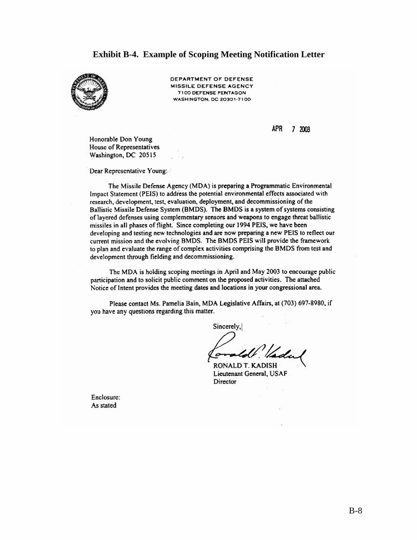
Exhibit B-4. Example of Scoping Meeting Notification Letter
B-8
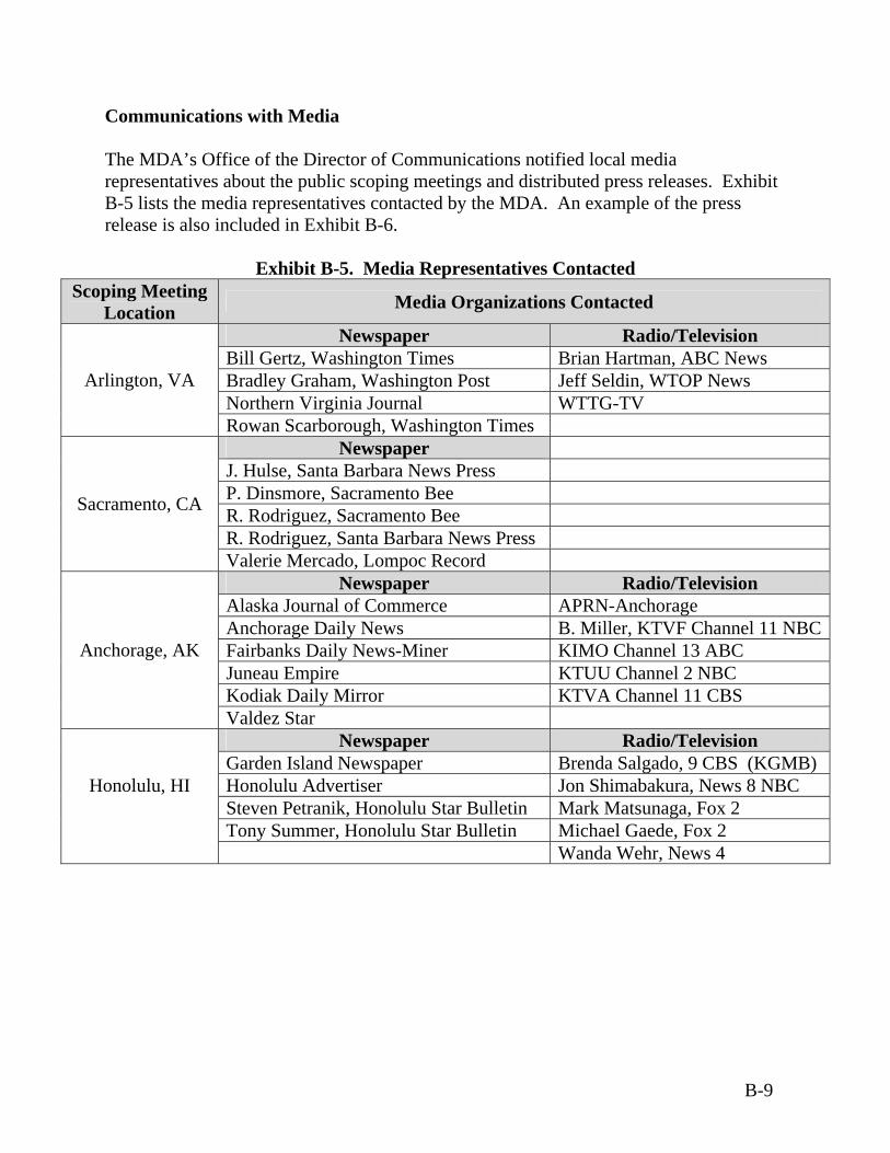
Communications with Media The MDA’s Office of the Director of Communications notified local media representatives about the public scoping meetings and distributed press releases. Exhibit B-5 lists the media representatives contacted by the MDA. An example of the press release is also included in Exhibit B-6.
Exhibit B-5. Media Representatives Contacted Scoping Meeting
Location Media Organizations Contacted
Newspaper Radio/Television Bill Gertz, Washington Times Brian Hartman, ABC News Bradley Graham, Washington Post Jeff Seldin, WTOP News Northern Virginia Journal WTTG-TV
Arlington, VA
Rowan Scarborough, Washington Times Newspaper
J. Hulse, Santa Barbara News Press P. Dinsmore, Sacramento Bee R. Rodriguez, Sacramento Bee R. Rodriguez, Santa Barbara News Press
Sacramento, CA
Valerie Mercado, Lompoc Record Newspaper Radio/Television
Alaska Journal of Commerce APRN-Anchorage Anchorage Daily News B. Miller, KTVF Channel 11 NBC Fairbanks Daily News-Miner KIMO Channel 13 ABC Juneau Empire KTUU Channel 2 NBC Kodiak Daily Mirror KTVA Channel 11 CBS
Anchorage, AK
Valdez Star Newspaper Radio/Television
Garden Island Newspaper Brenda Salgado, 9 CBS (KGMB) Honolulu Advertiser Jon Shimabakura, News 8 NBC Steven Petranik, Honolulu Star Bulletin Mark Matsunaga, Fox 2 Tony Summer, Honolulu Star Bulletin Michael Gaede, Fox 2
Honolulu, HI
Wanda Wehr, News 4
B-9

Exhibit B-6. Example of Scoping Meeting Press Release
B-10
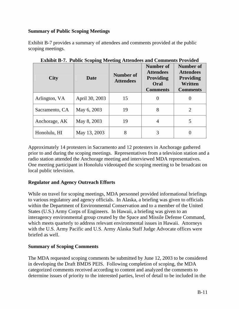
Summary of Public Scoping Meetings Exhibit B-7 provides a summary of attendees and comments provided at the public scoping meetings.
Exhibit B-7. Public Scoping Meeting Attendees and Comments Provided
City Date Number of Attendees
Number of Attendees Providing
Oral Comments
Number of Attendees Providing Written
Comments
Arlington, VA April 30, 2003 15 0 0
Sacramento, CA May 6, 2003 19 8 2
Anchorage, AK May 8, 2003 19 4 5
Honolulu, HI May 13, 2003 8 3 0
Approximately 14 protesters in Sacramento and 12 protesters in Anchorage gathered prior to and during the scoping meetings. Representatives from a television station and a radio station attended the Anchorage meeting and interviewed MDA representatives. One meeting participant in Honolulu videotaped the scoping meeting to be broadcast on local public television. Regulator and Agency Outreach Efforts While on travel for scoping meetings, MDA personnel provided informational briefings to various regulatory and agency officials. In Alaska, a briefing was given to officials within the Department of Environmental Conservation and to a member of the United States (U.S.) Army Corps of Engineers. In Hawaii, a briefing was given to an interagency environmental group created by the Space and Missile Defense Command, which meets quarterly to address relevant environmental issues in Hawaii. Attorneys with the U.S. Army Pacific and U.S. Army Alaska Staff Judge Advocate offices were briefed as well. Summary of Scoping Comments The MDA requested scoping comments be submitted by June 12, 2003 to be considered in developing the Draft BMDS PEIS. Following completion of scoping, the MDA categorized comments received according to content and analyzed the comments to determine issues of priority to the interested parties, level of detail to be included in the
B-11
Draft BMDS PEIS, sources of information to be used, and issues to be addressed and evaluated in the Draft BMDS PEIS. During scoping, MDA received a total of 285 comments via e-mail (62 percent), toll-free fax (11 percent), the BMDS PEIS web site (three percent), mail (12 percent), toll-free phone line (five percent), and during the scoping meetings (oral - five percent and written - two percent). Approximately 84 percent of comments were from private citizens, less than four percent represented non-government organizations, less than one percent represented government agencies, and less than seven percent represented other groups including media and religious organizations. Approximately 21 percent of comments received appeared to be derived from NGO-provided templates or form letters. The MDA identified key issues addressed in the scoping comments and sorted the comments based on these issue areas. The comments included issues both within and outside of the scope of the Draft BMDS PEIS. Types of issues considered “in scope” related to the resource areas analyzed in this Draft BMDS PEIS; feasible alternatives; laws and regulations; affected regions; specific hazards, such as perchlorate contamination and debris; and BMDS activities, such as decommissioning. Types of issues considered “out of scope” related to general opposition to the BMDS, opinions about Department of Defense (DoD) budget and policy, and effects from the proposed action and alternatives that were not relevant to the environmental analysis. The majority of comments were considered to be outside the scope of the Draft BMDS PEIS. These comments were related to the opposition to the BMDS, especially with regard to the use of space as a weapons platform; concern that the program would bankrupt the economy and that Federal funds should be channeled to address socioeconomic problems, better health care and insurance coverage, and education; and concern that the BMDS would create an arms race, especially in space. Other key issues included opposition to development of nuclear weapons and concern that missile defense could be a first strike capability for U.S. worldwide military domination. Exhibit B-8 summarizes the number of comments received from the public related to resource areas; human health and environmental impacts; alternatives; and DoD policy, budget, and program issues. Many comments received addressed multiple issues. Exhibit B-9 includes representative examples of the comments received for each topic. Inclusion of representative excerpts seeks to eliminate duplicative comments that were received on each topic.
B-12
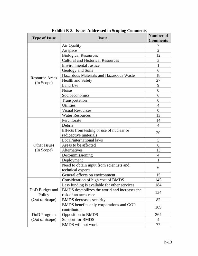
Exhibit B-8. Issues Addressed in Scoping Comments
Type of Issue Issue Number of Comments
Air Quality 7 Airspace 2 Biological Resources 12 Cultural and Historical Resources 3 Environmental Justice 1 Geology and Soils 6 Hazardous Materials and Hazardous Waste 18 Health and Safety 27 Land Use 9 Noise 0 Socioeconomics 6 Transportation 0 Utilities 4 Visual Resources 0
Resource Areas (In Scope)
Water Resources 13 Perchlorate 14 Debris 4 Effects from testing or use of nuclear or radioactive materials 20
Local/international laws 5 Areas to be affected 6 Alternatives 13 Decommissioning 4 Deployment 1 Need to obtain input from scientists and technical experts 6
Other Issues (In Scope)
General effects on environment 15 Consideration of high cost of BMDS 145 Less funding is available for other services 184 BMDS destabilizes the world and increases the risk of an arms race 134
BMDS decreases security 82
DoD Budget and Policy
(Out of Scope) BMDS benefits only corporations and GOP contributors 109
Opposition to BMDS 264 Support for BMDS 4
DoD Program (Out of Scope)
BMDS will not work 77
B-13
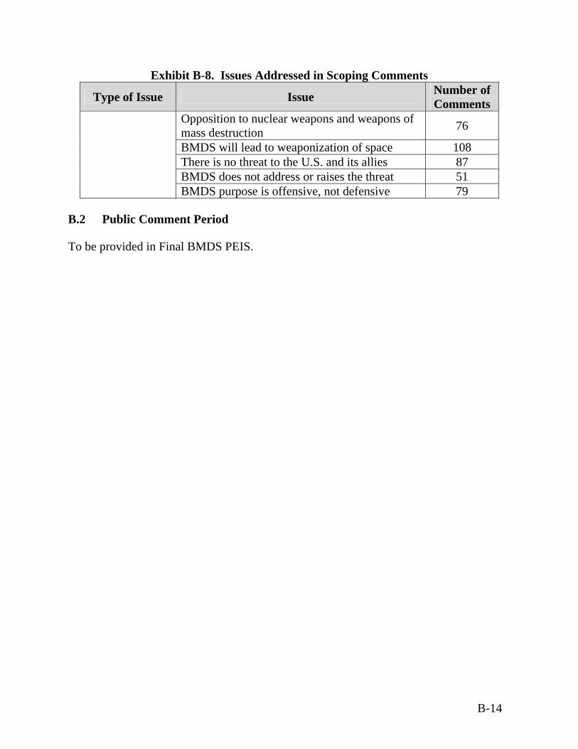
B-14
Exhibit B-8. Issues Addressed in Scoping Comments
Type of Issue Issue Number of Comments
Opposition to nuclear weapons and weapons of mass destruction 76
BMDS will lead to weaponization of space 108 There is no threat to the U.S. and its allies 87 BMDS does not address or raises the threat 51 BMDS purpose is offensive, not defensive 79
B.2 Public Comment Period
To be provided in Final BMDS PEIS.
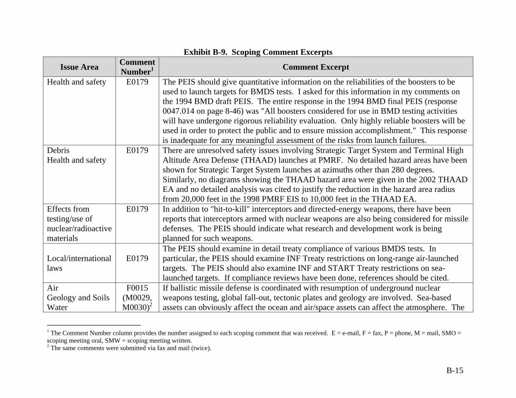
Exhibit B-9. Scoping Comment Excerpts
Issue Area Comment Number1 Comment Excerpt
Health and safety E0179 The PEIS should give quantitative information on the reliabilities of the boosters to be used to launch targets for BMDS tests. I asked for this information in my comments on the 1994 BMD draft PEIS. The entire response in the 1994 BMD final PEIS (response 0047.014 on page 8-46) was "All boosters considered for use in BMD testing activities will have undergone rigorous reliability evaluation. Only highly reliable boosters will be used in order to protect the public and to ensure mission accomplishment." This response is inadequate for any meaningful assessment of the risks from launch failures.
Debris Health and safety
E0179 There are unresolved safety issues involving Strategic Target System and Terminal High Altitude Area Defense (THAAD) launches at PMRF. No detailed hazard areas have been shown for Strategic Target System launches at azimuths other than 280 degrees. Similarly, no diagrams showing the THAAD hazard area were given in the 2002 THAAD EA and no detailed analysis was cited to justify the reduction in the hazard area radius from 20,000 feet in the 1998 PMRF EIS to 10,000 feet in the THAAD EA.
Effects from testing/use of nuclear/radioactive materials
E0179 In addition to "hit-to-kill" interceptors and directed-energy weapons, there have been reports that interceptors armed with nuclear weapons are also being considered for missile defenses. The PEIS should indicate what research and development work is being planned for such weapons.
Local/international laws
E0179
The PEIS should examine in detail treaty compliance of various BMDS tests. In particular, the PEIS should examine INF Treaty restrictions on long-range air-launched targets. The PEIS should also examine INF and START Treaty restrictions on sea-launched targets. If compliance reviews have been done, references should be cited.
Air Geology and Soils Water
F0015 (M0029, M0030)2
If ballistic missile defense is coordinated with resumption of underground nuclear weapons testing, global fall-out, tectonic plates and geology are involved. Sea-based assets can obviously affect the ocean and air/space assets can affect the atmosphere. The
1 The Comment Number column provides the number assigned to each scoping comment that was received. E = e-mail, F = fax, P = phone, M = mail, SMO = scoping meeting oral, SMW = scoping meeting written. 2 The same comments were submitted via fax and mail (twice).
B-15
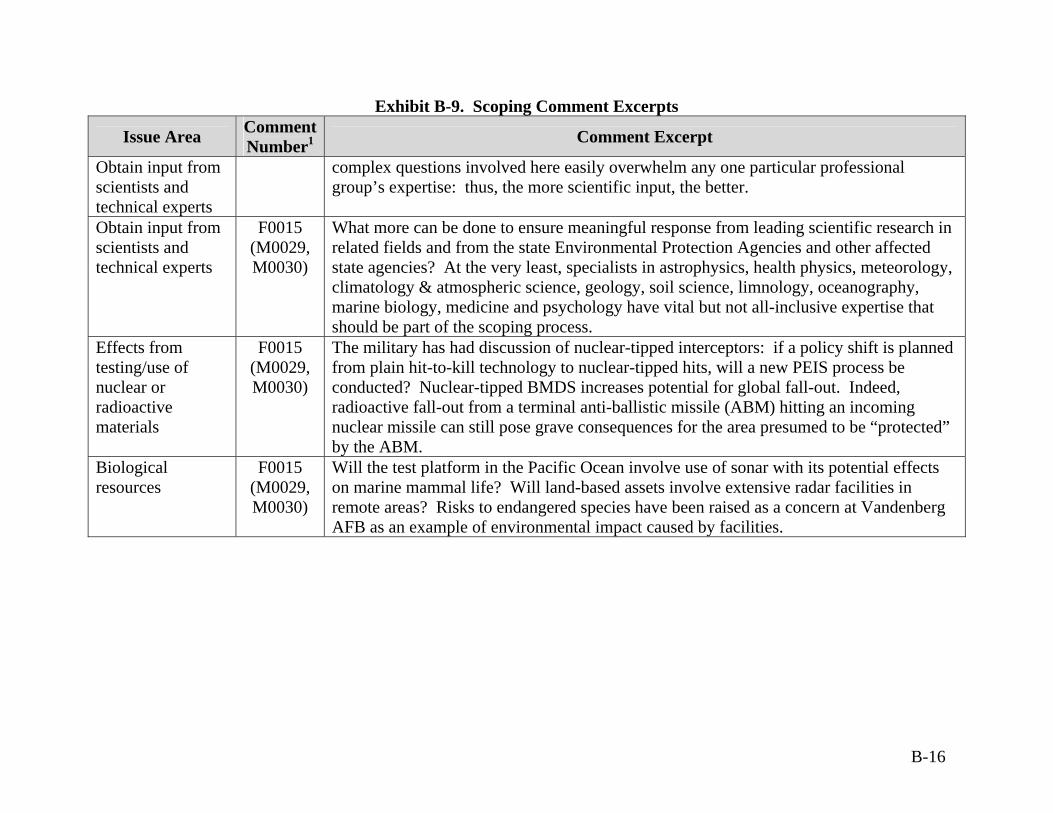
Exhibit B-9. Scoping Comment Excerpts
Issue Area Comment Number1 Comment Excerpt
Obtain input from scientists and technical experts
complex questions involved here easily overwhelm any one particular professional group’s expertise: thus, the more scientific input, the better.
Obtain input from scientists and technical experts
F0015 (M0029, M0030)
What more can be done to ensure meaningful response from leading scientific research in related fields and from the state Environmental Protection Agencies and other affected state agencies? At the very least, specialists in astrophysics, health physics, meteorology, climatology & atmospheric science, geology, soil science, limnology, oceanography, marine biology, medicine and psychology have vital but not all-inclusive expertise that should be part of the scoping process.
Effects from testing/use of nuclear or radioactive materials
F0015 (M0029, M0030)
The military has had discussion of nuclear-tipped interceptors: if a policy shift is planned from plain hit-to-kill technology to nuclear-tipped hits, will a new PEIS process be conducted? Nuclear-tipped BMDS increases potential for global fall-out. Indeed, radioactive fall-out from a terminal anti-ballistic missile (ABM) hitting an incoming nuclear missile can still pose grave consequences for the area presumed to be “protected” by the ABM.
Biological resources
F0015 (M0029, M0030)
Will the test platform in the Pacific Ocean involve use of sonar with its potential effects on marine mammal life? Will land-based assets involve extensive radar facilities in remote areas? Risks to endangered species have been raised as a concern at Vandenberg AFB as an example of environmental impact caused by facilities.
B-16

Exhibit B-9. Scoping Comment Excerpts
Issue Area Comment Number1 Comment Excerpt
Hazardous Materials/Waste Health and Safety Perchlorate
F0015 (M0029, M0030)
What waste will be produced by the development, testing, deploying and decommissioning activities of BMDS and how will this waste be handled? Will any of this waste constitute hazardous materials? The answer is likely to be yes, given that perchlorate contamination results from rocket fuel. Perchlorate disrupts thyroid hormone function in humans and other animals.
Air F0015(M0029, M0030)
Directed energy missile defense systems sound like they involve lasers. What effects will use of such lasers during testing or actual activation have on the layers of our atmosphere, including ozone and green house gas effects? Will this have an effect on global warming? How will communication and weather satellites be affected by space-based platforms?
Perchlorate F0021 Perchlorate at site 8 at Vandenberg AFB. Perchlorate throughout the state of California, principally in the Colorado River where
irrigation water laced with perchlorate has contaminated Imperial Valley. Vandenberg AFB uses ammonium perchlorate.
Health and Safety F0021 Perchlorate has been shown to cause fetal damage and serious harm to children as well as nursing mothers.
Missile explosions happen and are dangerous which cause beach closures to keep the burning, toxic cinders from harming people and animals, yet harm is unavoidable.
Hazardous Materials/Waste Land Use
F0021 Aerospace corporations such as Boeing Rocketdyne and Boeing Delta Mariner should not be allowed to operate until all toxic emittants and water contaminants are removed. Boeing should not be allowed to sell its Santa Susana lab land until all contaminants are cleaned thoroughly.
Biological Resources
F0021 Sea life should not be ‘taken’, harassed, or tortured for missile defense and should be banned.
Land Use F0021 Housing and agricultural land in Northern Santa Barbara and Southern San Luis Obispo should be thoroughly tested for rocket toxics immediately. No housing projects should be considered around Vandenberg AFB unless the land is thoroughly tested for toxics. This includes Providence Landing.
B-17
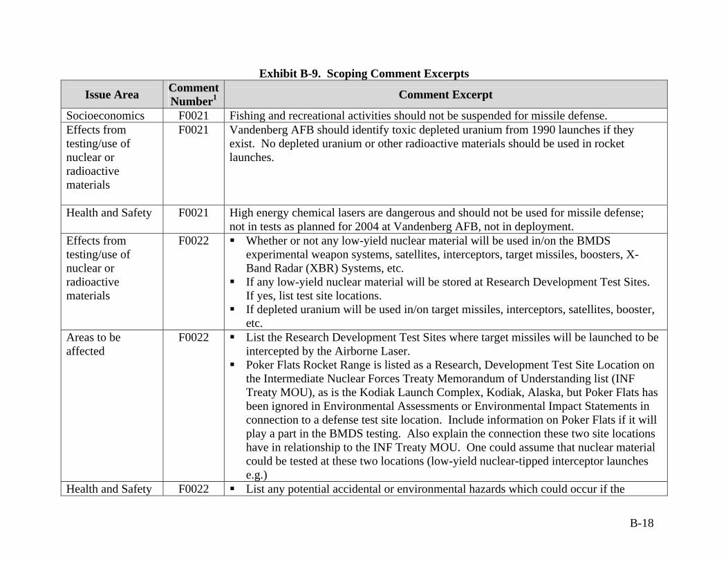
Exhibit B-9. Scoping Comment Excerpts
Issue Area Comment Number1 Comment Excerpt
Socioeconomics F0021 Fishing and recreational activities should not be suspended for missile defense. Effects from testing/use of nuclear or radioactive materials
F0021 Vandenberg AFB should identify toxic depleted uranium from 1990 launches if they exist. No depleted uranium or other radioactive materials should be used in rocket launches.
Health and Safety F0021 High energy chemical lasers are dangerous and should not be used for missile defense; not in tests as planned for 2004 at Vandenberg AFB, not in deployment.
Effects from testing/use of nuclear or radioactive materials
F0022 Whether or not any low-yield nuclear material will be used in/on the BMDS experimental weapon systems, satellites, interceptors, target missiles, boosters, X-Band Radar (XBR) Systems, etc.
If any low-yield nuclear material will be stored at Research Development Test Sites. If yes, list test site locations.
If depleted uranium will be used in/on target missiles, interceptors, satellites, booster, etc.
Areas to be affected
F0022 List the Research Development Test Sites where target missiles will be launched to be intercepted by the Airborne Laser.
Poker Flats Rocket Range is listed as a Research, Development Test Site Location on the Intermediate Nuclear Forces Treaty Memorandum of Understanding list (INF Treaty MOU), as is the Kodiak Launch Complex, Kodiak, Alaska, but Poker Flats has been ignored in Environmental Assessments or Environmental Impact Statements in connection to a defense test site location. Include information on Poker Flats if it will play a part in the BMDS testing. Also explain the connection these two site locations have in relationship to the INF Treaty MOU. One could assume that nuclear material could be tested at these two locations (low-yield nuclear-tipped interceptor launches e.g.)
Health and Safety F0022 List any potential accidental or environmental hazards which could occur if the
B-18

Exhibit B-9. Scoping Comment Excerpts
Issue Area Comment Number1 Comment Excerpt
Airborne Laser misses its target. Include detailed information on how High-Powered Microwaves (Directed Energy)
will be used as part of the BMDS and the environmental hazards associated with their transmission into the atmosphere and ionosphere (include human EMR hazards).
Health and Safety Hazardous Materials/Waste Land Use Water
F0022 The Pentagon is willing to use U.S. citizens as guinea pigs by jeopardizing the safety and health of the public living near the locations of the Research and Development Test Sites in order to test the new weapons systems, with no regard to environmental hazards from “exploding” missiles and hazardous missiles which will have a detrimental effect on the land, water, and environment which will be passed on to future generations.
Information Source
F0027 Are the overall binary effects on the environment of all the components listed in the MTCR Report: July 1, 1993; ITEM 4 – Category 11: Propellants and constituent chemicals for propellants (3) available to the public for independent scientific peer review via FOIA or any other method?
What effects do laser weapons and halogens, i.e., propellants and constituent chemicals for propellants listed in the MTCR report: July 1, 1993; ITEM 4 – Category 11 have on the environment?
Perchlorate Found in Plants, Animals at Six Sites in U.S. in 2001. Orbital Debris F0027 In addition to existing rocket and jet fuel contamination, already lower orbital space is full
of space trash such as a fork, tools, and thousands of pieces of junk which are a hazard to astronauts, spacecraft, and the space station.
Hazardous Materials/Waste Health and Safety Land Use Water Biological Resources
F0031 (M0035)
The Scope of the BMDS PEIS should consider impacts of hazardous waste and materials and on Health and safety, Land use, Water Resources, and Biological resources of environmental contamination from toxic and hazardous components of rocket fuels and explosives.
Perchlorate F0031 Toxic environmental contamination from ammonium perchlorate and other toxic and
B-19
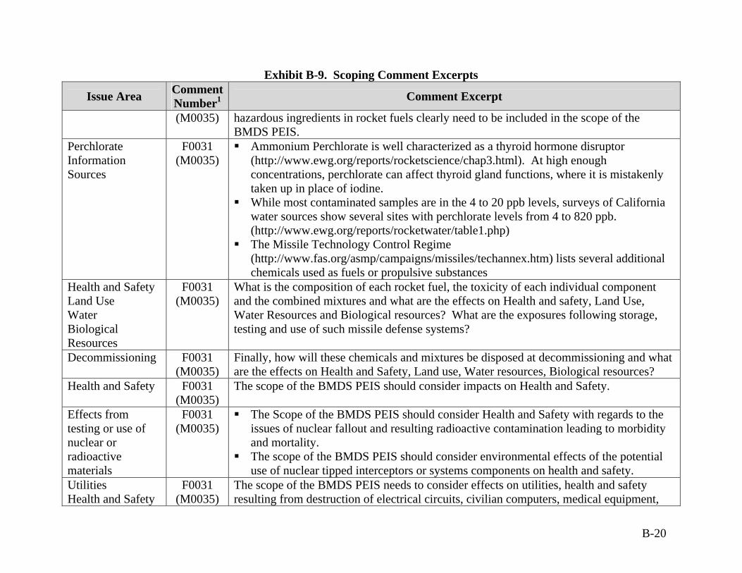
Exhibit B-9. Scoping Comment Excerpts
Issue Area Comment Number1 Comment Excerpt
(M0035) hazardous ingredients in rocket fuels clearly need to be included in the scope of the BMDS PEIS.
Perchlorate Information Sources
F0031 (M0035)
Ammonium Perchlorate is well characterized as a thyroid hormone disruptor (http://www.ewg.org/reports/rocketscience/chap3.html). At high enough concentrations, perchlorate can affect thyroid gland functions, where it is mistakenly taken up in place of iodine.
While most contaminated samples are in the 4 to 20 ppb levels, surveys of California water sources show several sites with perchlorate levels from 4 to 820 ppb. (http://www.ewg.org/reports/rocketwater/table1.php)
The Missile Technology Control Regime (http://www.fas.org/asmp/campaigns/missiles/techannex.htm) lists several additional chemicals used as fuels or propulsive substances
Health and Safety Land Use Water Biological Resources
F0031 (M0035)
What is the composition of each rocket fuel, the toxicity of each individual component and the combined mixtures and what are the effects on Health and safety, Land Use, Water Resources and Biological resources? What are the exposures following storage, testing and use of such missile defense systems?
Decommissioning F0031(M0035)
Finally, how will these chemicals and mixtures be disposed at decommissioning and what are the effects on Health and Safety, Land use, Water resources, Biological resources?
Health and Safety F0031 (M0035)
The scope of the BMDS PEIS should consider impacts on Health and Safety.
Effects from testing or use of nuclear or radioactive materials
F0031 (M0035)
The Scope of the BMDS PEIS should consider Health and Safety with regards to the issues of nuclear fallout and resulting radioactive contamination leading to morbidity and mortality.
The scope of the BMDS PEIS should consider environmental effects of the potential use of nuclear tipped interceptors or systems components on health and safety.
Utilities Health and Safety
F0031 (M0035)
The scope of the BMDS PEIS needs to consider effects on utilities, health and safety resulting from destruction of electrical circuits, civilian computers, medical equipment,
B-20
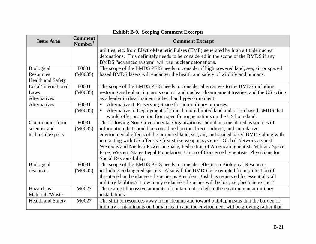
Exhibit B-9. Scoping Comment Excerpts
Issue Area Comment Number1 Comment Excerpt
utilities, etc. from ElectroMagnetic Pulses (EMP) generated by high altitude nuclear detonations. This definitely needs to be considered in the scope of the BMDS if any BMDS “advanced system” will use nuclear detonations.
Biological Resources Health and Safety
F0031 (M0035)
The scope of the BMDS PEIS needs to consider if high powered land, sea, air or spaced based BMDS lasers will endanger the health and safety of wildlife and humans.
Local/International Laws Alternatives
F0031 (M0035)
The scope of the BMDS PEIS needs to consider alternatives to the BMDS including restoring and enhancing arms control and nuclear disarmament treaties, and the US acting as a leader in disarmament rather than hyper-armament.
Alternatives F0031(M0035)
Alternative 4: Preserving Space for non-military purposes. Alternative 5: Deployment of a much more limited land and or sea based BMDS that
would offer protection from specific rogue nations on the US homeland. Obtain input from scientist and technical experts
F0031 (M0035)
The following Non-Governmental Organizations should be considered as sources of information that should be considered on the direct, indirect, and cumulative environmental effects of the proposed land, sea, air, and spaced based BMDS along with interacting with US offensive first strike weapon systems: Global Network against Weapons and Nuclear Power in Space, Federation of American Scientists Military Space Page, Western States Legal Foundation, Union of Concerned Scientists, Physicians for Social Responsibility.
Biological resources
F0031 (M0035)
The scope of the BMDS PEIS needs to consider effects on Biological Resources, including endangered species. Also will the BMDS be exempted from protection of threatened and endangered species as President Bush has requested for essentially all military facilities? How many endangered species will be lost, i.e., become extinct?
Hazardous Materials/Waste
M0027 There are still massive amounts of contamination left in the environment at military installations.
Health and Safety M0027 The shift of resources away from cleanup and toward buildup means that the burden of military contaminants on human health and the environment will be growing rather than
B-21
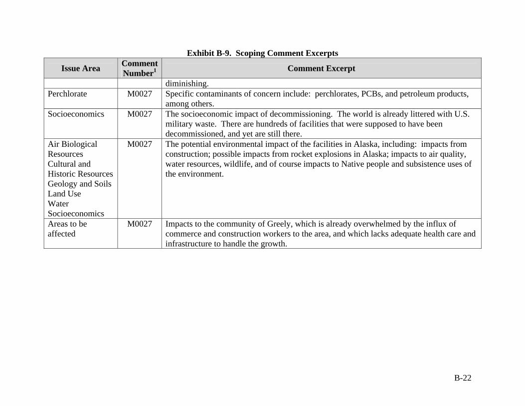
Exhibit B-9. Scoping Comment Excerpts
Issue Area Comment Number1 Comment Excerpt
diminishing. Perchlorate M0027 Specific contaminants of concern include: perchlorates, PCBs, and petroleum products,
among others. Socioeconomics M0027 The socioeconomic impact of decommissioning. The world is already littered with U.S.
military waste. There are hundreds of facilities that were supposed to have been decommissioned, and yet are still there.
Air Biological Resources Cultural and Historic Resources Geology and Soils Land Use Water Socioeconomics
M0027 The potential environmental impact of the facilities in Alaska, including: impacts from construction; possible impacts from rocket explosions in Alaska; impacts to air quality, water resources, wildlife, and of course impacts to Native people and subsistence uses of the environment.
Areas to be affected
M0027 Impacts to the community of Greely, which is already overwhelmed by the influx of commerce and construction workers to the area, and which lacks adequate health care and infrastructure to handle the growth.
B-22

C-1
APPENDIX C
RELATED DOCUMENTATION
RELATED DOCUMENTATION
The documentation identified below has been incorporated by reference in the Draft Ballistic Missile Defense System (BMDS) Programmatic Environmental Impact Statement (PEIS). The information and analyses contained in these documents were used in the development of this PEIS and have been summarized as appropriate. These environmental assessments and environmental impact statements have previously been prepared to support the development of the specific technologies that may be used as part of the BMDS and the locations where these technologies may be used. Ballistic Missile Defense Organization, Space and Missile Systems Center, 2001.
Space-Based Laser Integrated Flight Experiment Ground Testing Environmental Assessment, January.
Ballistic Missile Defense Organization, 2000. Ballistic Missile Defense Organization
Cooperative-Engagement-Capability/PATRIOT (CEC/PATRIOT) Interoperability Test Environmental Assessment, July.
Ballistic Missile Defense Organization, 1998. Air Drop Target System Program
Programmatic Environmental Assessment, May. Cortez III Environmental, 1996. Lance Missile Target Environmental Assessment.
Federal Aviation Administration, 1996. Environmental Assessment of the Kodiak
Launch Complex, Kodiak Island, Alaska, June. Missile Defense Agency (MDA), 2003. Ground-Based Midcourse Defense Initial
Defensive Operations Capability at Vandenberg AFB Environmental Assessment, July.
MDA, 2003. Airborne Laser Program Supplemental Environmental Impact
Statement, June. Strategic Defense Initiative Organization, 1992. Midcourse Space Experiment
Environmental Assessment, September.
United States (U.S.) Army Space and Missile Defense Command, 2003. Ground-Based Midcourse Defense Extended Test Range Environmental Impact Statement, July.
U.S. Army Space and Missile Defense Command, 2002. Theater High Altitude Air
Defense Pacific Test Flights Environmental Assessment, 20 December.
C-2
U.S. Army Space and Missile Defense Command, 2002. White Sands Missile Range, New Mexico, Liquid Propellant Targets Environmental Assessment, 23 May.
U.S. Army Space and Missile Defense Command, 2002. Ground-Based Midcourse
Defense Validation of Operational Concept Environmental Assessment, 15 March. U.S. Army Space and Missile Defense Command, 2000. National Missile Defense
Deployment Environmental Impact Statement, July. U.S. Army Space and Missile Defense Command, 1999. Dismantlement or
Destruction of Anti-Ballistic Missile Facilities, Stanley R. Mickelsen Safeguard Complex, North Dakota Environmental Assessment, 1 October.
U.S. Army Space and Strategic Defense Command, 1998. Theater Missile Defense
Extended Test Range Supplemental Environmental Impact Statement, June. U.S. Army Space and Strategic Defense Command, 1998. Tactical High Energy
Laser Advanced Concept Technology Demonstration Environmental Assessment, 17 April.
U.S. Army Space and Strategic Defense Command, 1995. U.S. Army Kwajalein Atoll
Temporary Extended Test Range Environmental Assessment, 19 October. U.S. Army Space and Strategic Defense Command, 1994. Theater Missile Defense
Extended Test Range Environmental Impact Statement, November. U.S. Army Space and Strategic Defense Command, 1994. Theater Missile Defense
Ground Based Radar Testing Program at Fort Devens, Massachusetts Environmental Assessment, 22 June.
U.S. Army Space and Strategic Defense Command, 1994. Theater High Altitude
Area Defense Initial Development Program Environmental Assessment, March. U.S. Army Space and Strategic Defense Command, 1993. Theater Missile Defense
Programmatic Life Cycle Environmental Impact Statement, September. U.S. Army Space and Strategic Defense Command, 1993. Ground Based Radar
Family of Strategic and Theater Radars Environmental Assessment, June. U.S. Army White Sands Missile Range, 1998. White Sands Missile Range, Range-
wide Environmental Impact Statement, January.
C-3
U.S. Department of the Air Force, 2002. Early Warning Radar Service Life Extension Program, Cape Cod Air Force Station Environmental Assessment, Massachusetts, September.
U.S. Department of the Air Force, 2000. Evolved Expendable Launch Vehicle
Program Supplemental Environmental Impact Statement, March. U.S. Department of the Air Force, 1998. Evolved Expendable Launch Vehicle
Program Environmental Impact Statement, April. U.S. Department of the Air Force, 1997. U.S. Air Force atmospheric interceptor
technology Program Environmental Assessment, November. U.S. Department of the Air Force, 1997. Environmental Impact Statement for the
Program Definition and Risk Reduction Phase of the Airborne Laser Program, April. U.S. Department of the Air Force, 1990. Starlab Program Environmental
Assessment, 17 August.
U.S. Department of the Navy, 2002. Point Mugu Environmental Impact Statement/Overseas Environmental Impact Statement, March.
U.S. Department of the Navy, 1998. Pacific Missile Range Facility Enhanced
Capability Environmental Impact Statement, December.
C-4
APPENDIX D
DESCRIPTIONS OF PROPOSED BMDS ELEMENTS
D-1
DESCRIPTIONS OF PROPOSED BMDS ELEMENTS
D.1 Airborne Laser
Introduction The Airborne Laser (ABL) is a part of the Boost Phase Defense Segment of the Ballistic Missile Defense System (BMDS). The ABL is a rapidly deployable airborne platform equipped with a long-range laser weapon capable of acquiring, tracking, and negating threat ballistic missiles in the boost phase of their flight (i.e., powered flight, prior to booster burn-out). ABL is designed to operate autonomously or in concert with other BMDS elements. The ABL aircraft is a Boeing 747-400F modified to accommodate the laser weapon system, laser fuel storage tanks, onboard sensors, battle management command, control, communications, computers, and intelligence (BMC4I), and a beam control/fire control (BC/FC) system (see Exhibit D-1). The ABL aircraft would fly at altitudes above 10,668 meters (35,000 feet) and would detect and track launches of enemy ballistic missiles using its onboard sensors. Directed energy from the laser weapon would heat the threat missile body canister causing overpressure and/or stress fracture, which would destroy the missile. Ground support assets of the ABL element include chemical storage, mixing, and handling facilities; chemical transport and loading/unloading; optics handling and maintenance; and aircraft support and maintenance facilities. The ABL consists of several coordinated sensor and laser systems. The BMC4I infrared search and track (IRST) suite would detect and track the target ballistic missiles. The Active Ranging System (ARS) laser is a lower-power carbon dioxide (CO2) laser that would acquire and assess the range to the target. The Track Illuminator Laser (TILL) is a lower power, solid-state laser. Designed to track the intended target, reflected light from the TILL returned to sensors onboard the ABL aircraft provides information about the target’s speed, elevation, and vector. The Beacon Illuminator Laser (BILL) is a lower-power, solid-state laser that serves as part of a laser-beam control system designed to focus the laser weapon beam on the target and to correct for any atmospheric distortion. The High Energy Laser (HEL) is a megawatt class American National Standards Institute (ANSI) Classification 4 chemical laser designed to destroy the target missile. The HEL is a chemical oxygen iodine laser (COIL). The ARS, TILL, and BILL are ANSI Classification 4 lasers with a power output in the kilowatt range.
D-2
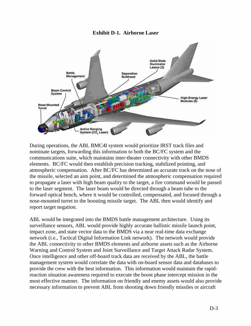
Exhibit D-1. Airborne Laser
During operations, the ABL BMC4I system would prioritize IRST track files and nominate targets, forwarding this information to both the BC/FC system and the communications suite, which maintains inter-theater connectivity with other BMDS elements. BC/FC would then establish precision tracking, stabilized pointing, and atmospheric compensation. After BC/FC has determined an accurate track on the nose ofthe missile, selected an aim point, and determined the atmospheric compensation requiredto propagate a laser with high beam quality to the target, a fire command would be passeto the laser segment. The laser beam would be directed through a beam tube to the forward optical bench, where it would be controlled, compensated, and focused through a nose-mounted turret to the boosting missile target. The ABL then would identify and report target negation.
d
grated into the BMDS battle management architecture. Using its sors, ABL would provide highly accurate ballistic missile launch point,
e oting down friendly missiles or aircraft
ABL would be intesurveillance senimpact zone, and state vector data to the BMDS via a near real-time data exchange network (i.e., Tactical Digital Information Link network). The network would provide the ABL connectivity to other BMDS elements and airborne assets such as the Airborne Warning and Control System and Joint Surveillance and Target Attack Radar System. Once intelligence and other off-board track data are received by the ABL, the battle management system would correlate the data with on-board sensor data and databases toprovide the crew with the best information. This information would maintain the rapid-reaction situation awareness required to execute the boost phase intercept mission in the most effective manner. The information on friendly and enemy assets would also providnecessary information to prevent ABL from sho
D-3
and to enhance able self-defense. The ABL has an Identification Friend or Foe transponder capability that identifies ABL when interrogated by friendly assets. Development The United States (U.S.) Air Force (USAF) began to develop the concept of aerial battleships armed with one or more high-power lasers that could be used to blast enemy ircraft or ground-to-air missiles in the 1970s. Initially a KC-135A was chosen to be the
the
ly
hoot down five Sidewinder air-to-air missiles.
f
g ing
e.
ere
is a arious ABL components
rior to placing them in the actual Block 2004 aircraft. The development of the Block g a
e
tion
r systems. Ground support enhancements would focus on redesigning the laser fluid
aplatform for a CO2 gas dynamic laser. Christened the Airborne Laser Laboratory, specially modified aircraft shot down its first target – a towed drone – over the White Sands Missile Range (WSMR) in New Mexico on May 2, 1981. The event marked the first time a high-energy laser beam had ever been fired from an airborne aircraft. On Ju26, 1983, the Air Force announced that the Airborne Laser Laboratory had been used to s In 1992, following the Persian Gulf War, interest was revived in developing laser weapons systems to counter ballistic missiles. In 1993, the USAF began development oABL as part of Strategic Defense Initiative (SDI) since one of SDI's goals was to study ways that directed energy could be used in a weapons system. On November 12, 1996, the USAF awarded a $1.1 billion contract to three defense contractors to begin workinon a prototype ABL that would detect, track, and destroy theater ballistic missiles durtheir boost phas Present development efforts are focused on completing the Block 2004 aircraft at Edwards Air Force Base (AFB), California. The Boeing 747 aircraft was purchased and flown to Wichita, Kansas where the nose was removed and several modifications wmade, including attaching a mock turret. The aircraft was then flown to Edwards AFB for integration of the weapon components, sensors, BMC4I, and BC/FC. Also located at Edwards AFB is the Systems Integration Laboratory (SIL). The SIL Boeing 747 body that is being used to test the integration of the vp2004 ABL would involve completion of ground testing of ABL components includinflight worthy, six module, weapon class laser and ground and flight testing of the BC/FC system. It would focus integration and ground testing of the laser, BC/FC, and battle management. Block 2004 ABL would culminate in a shoot down of a threat missiltarget in 2005. Block 2006 would continue to perform ground and flight tests of the first ABL weaponssystem. Program emphasis would be on continuing ABL-specific technology maturafor integration and testing on subsequent blocks. Technology maturation includes improvements in domestic capabilities to produce advanced optics for high-energy lase
D-4
management system for air transportability and rapid deployment to enable the ABLmove to and operate from a forw
to ard operating location. Specific locations for these
ot
lock 2008 would include maturation and development of a second ABL aircraft to ty. The
r y
etails of full operations for each lock are under development.
, and Surrogate High Energy Laser [SHEL]) at Edwards AFB. The
HEL is a lower-power laser designed to simulate the operating characteristics and
FligweandAF the lower-power lasers and the HEL. The tests would include cquisition and tracking of missiles as well as high-energy tests. The tests would be
aircLan (i.e ould culminate with the hoot down of a ballistic missile target. The specific Block 2004 testing areas currently
p ential forward operating locations have not been determined. Binclude new technologies, enhanced lethality, and additional operational suitabiliBlock 2008 aircraft would be similar to the Block 2004 aircraft (i.e., a Boeing 747-400outfitted with COIL technology and tracking and ranging lasers) but would utilizeapproximately 30 percent more chemicals to obtain increased performance. New lasermodule designs and advances in optics and control systems would be tested in the SIL then integrated onto the Block 2006 and 2008 aircraft. The Block 2008 aircraft would support the BMDS test bed and potential ABL production decisions. The USAF is planning an operational fleet of ABL aircraft to conduct dual-orbit operations in a majoregional conflict. Dual-orbit operations involve two aircraft operating simultaneouslalong a flight path near the theater of operations. DB Testing - Block 2004 The ABL test program is intended to build on the technology and risk reduction accomplishments of testing activities to date. The Block 2004 testing would initially focus on testing and verifying independent components of the ABL system. The individual components would then be integrated and tested in the SIL and then on the aircraft, leading up to a lethal shoot down. This testing involves both ground and flight-testing. Extensive ground testing includes segment level testing at a variety of contractor and government facilities and system level testing of the lower-power laser systems (i.e.,ARS, BILL, TILLSwavelength of the HEL during testing activities.
ht-testing in Block 2004 consists of airworthiness testing of the ABL aircraft itself as ll as testing of individual segments after they are integrated into the weapon system after laser testing in the SIL. Test flights at WSMR, Edwards AFB, and Vandenberg B would be used to test
aconducted against instrumented, diagnostic target boards carried by balloons, missiles, or
raft, including the Missile Alternative Range Target Instrument (MARTI) Drop; the ce, Black Brant IX, Hera, and/or Two-Stage Terrier missiles, and the Proteus Aircraft
., manned aircraft with target board attached). Flight-testing wsplanned include
D-5

BC/FC Ground Test. This test would be conducted at contractor facilities inSunnyvale, California and would involve positioning the turret in the correct relationship to the illuminator bench of the laser weapon component to ensure proper alignment. Testing would also demonstrate the TILL and BILL operation through t
he BC/FC system. The objective is to demonstrate the performance of the beam-control
d
d
RS
uilding 151 at Edwards FB. Ground testing of the HEL would be conducted at Edwards AFB, within Building
into
er
rcraft. The HEL weapon system ould be connected to a Ground Pressure Recovery Assembly to test the laser on the
o p
segment at low power. SIL Laser Ground Tests. This test would be conducted at Edwards AFB and woul
involve a step-by-step buildup of laser operation. The objective is to verify successfulintegration of all HEL modules in the SIL. The major milestones for the SIL grountests include chemical flow, first light, and full duration lase.
Integration of the BC/FC with BMC4I. This test would demonstrate the ability to
operate the BC/FC on the aircraft in preparation for flight tests. System Demonstration. This test would involve the shoot down of a threat
representative ballistic missile target. The test missile would be launched from Vandenberg AFB with engagement and negation occurring over the Western Range. Up to three target missiles could be used, with the goal of one successful negation.
Ground-testing activities of the lower-power laser systems (i.e., ARS, BILL, TILL, and SHEL) would be conducted from an aircraft parking pad or the end of a runway at Edwards AFB, with the laser beam directed over open land toward ground targets withnatural features (e.g., mountains, hills, buttes) or earthen berms as a backstop. The Awould also be tested using a ground-based simulator within BA151 or in the SIL, using a ground-based simulator or an enclosed test cell. No open-rangetesting of the HEL would be conducted at Edwards AFB. These activities would involve testing the laser components (Block 2004 configuration, upgrades of new technologies,and Block 2008 configuration) on the ground in the SIL and after they are integratedthe Block 2004 aircraft. The ground tests would be conducted to verify that the lascomponents operate together safely in a simulated flight environment. Photons from the tests may be utilized in an enclosed test cell to evaluate the effect of the HEL on various target-representative materials. Up to 500 rotoplane (Ferris wheel-like rotating target) and 500 ground target board tests would be conducted for the Block 2004 aircraft. Similar tests would be conducted for the Block 2008 aiwground. On the ground, the Ground Pressure Recovery Assembly would simulate the atmospheric pressure that occurs naturally when the laser device is operating in theaircraft at altitudes of 10,388 meters (35,000 feet) or higher. Flight-testing activities would occur at WSMR, Edwards AFB, and Vandenberg AFB ttest the ARS, BILL, TILL, and SHEL, and the high-power HEL. Up to 50 MARTI Dro
D-6
tests would be conducted at each of Edwards AFB and WSMR to test the ARS, BILL, TILL, and SHEL. Half of the MARTI tests at each location would also incorporate
sting of the HEL. Up to 50 Proteus Aircraft tests would be conducted at each of
n (e.g., upward at a star). These tar shots may be part of any of the HEL operations.
rom olve
the
yzed in the
heater Ballistic Missile Targets Final Programmatic Environmental Assessment (EA) (1997) to test the ARS, BILL, TILL, and HEL systems. Interwoven with the proposed standard flight tests, additional activities would be done to use the ABL detection, tracking, and communications capability. The ABL could be used to track other targets of opportunity. Targets of opportunity come in two forms. The first is a simple infrared signal given off by a moving military article (aircraft, missile, or similar vehicle) that can be passively observed with the IRST, and, in the case of unmanned target vehicles, the BILL/TILL/ARS lasers. The second type is for a missile or similar vehicle that is unmanned and the target can handle the flash of the HEL (similar to the MARTI HEL activities where a simple flash is done to the target without destroying it). The IRST and the lower-power lasers may also be used to detect, track, and monitor flights from other BMDS operations as opportunities became available. During exercises, these same systems would be used to track the targets. In addition, the HEL could flash the targets in a manner similar to the HEL MARTI tests.
teEdwards AFB and WSMR. The Proteus tests would involve only testing the ARS, BILL, TILL, and SHEL systems. Flights may also include on-board beam dumps to internallycheck the HEL firing, as well as diagnostic checks of the inertial guidance systems by lazing with the HEL to an inertial point above the horizos Up to 35 missile flight tests utilizing solid or liquid propellant missiles would occur at WSMR using WSMR restricted airspace, Federal Aviation Administration (FAA) controlled airspace, and airspace utilized by Fort Bliss. Missiles would be launched fexisting approved launch areas. Approximately ten of these flight tests would invtesting the ARS, BILL, TILL, and SHEL systems. The remaining 25 tests would also incorporate the HEL. Lasing activities during flight tests at WSMR would involve ABL aircraft flying outside of restricted airspace and firing the lasers at targets within WSMR restricted airspace. Up to 25 missile flight tests would occur at the Western Range used by Vandenberg AFB.Missiles would be launched from Vandenberg AFB from launch areas analT
D-7
Testing - Block 2006 The primary focus of Block 2006 testing would be verifying the effectiveness and suitability of the upgraded laser fluid management system (ground testing), deployable support equipment, flight testing of capabilities deferred from Block 2004, and participation in BMDS System Integration Tests. Additional efforts may focus on weapon system effectiveness at negating extended range ballistic missiles if targets are available. Testing - Block 2008 Block 2008 testing would be similar in scope and concept to the Block 2004 testing. With the modification of a new aircraft into the Block 2008 configuration, the same complete weapon system verifications would have to be accomplished. In Block 2008, the SIL would be transitioned to a permanently based hardware-in-the-loop “Iron Bird” facility (i.e., a laser module and beam control test facility and lethality cell). Block 2008 testing would also include testing on the Iron Bird. These system-level ground tests would complement the flight test efforts from Block 2006 to assure system readiness for integration onto the Block 2008 aircraft. The Iron Bird would also be used for continuing design and component upgrade testing. Block 2008 would continue building on the lethality demonstrations from prior Blocks to arrive at a measure of the ABL’s lethality. After completion of weapon system validation, Block 2008 would also be used in the BMDS System Integration Tests. Block 2008 testing is expected to take approximately 24 months. Deployment At the conclusion of Block 2004, a single aircraft would be delivered for integration and testing within the BMDS test bed. This aircraft would be capable of providing, if directed, an emergency operational capability that offers limited rudimentary protection against ballistic missile threats in a regional crisis situation. Block 2006 activity would involve enhancing the software and hardware on the Block 2004 aircraft and would add deployable ground support equipment, including chemical production and storage facilities to produce the required laser fuel, to allow for forward deployment of the ABL as a weapon. Block 2008 would add the second aircraft that could be deployed into the BMDS to provide additional operational capability. Decommissioning Decommissioning of ABL facilities and equipment would involve demilitarizing or disposing of the aircraft and aircraft support facilities, the laser weapon components, chemical production and storage facilities, sensors, and BMC4I assets as required by the appropriate regulations.
D-8
National Environmental Policy Act (NEPA) Analysis The following NEPA analyses support the majority of ABL test and development efforts. Airborne Laser Program Final Supplemental Environmental Impact Statement (June
2003) Point Mugu Sea Range Final Environmental Impact Statement/Overseas
Environmental Impact Statement (Department of the Navy, March 2002) Program Definition and Risk Reduction Phase of the Airborne Laser Program Final
Environmental Impact Statement (April 1997) Theater Ballistic Missile Targets Final Programmatic Environmental Assessment
(U.S. Air Force, December 1997) Programmatic Environmental Assessment, Theater Missile Defense Lethality
Program (U.S. Army Space and Strategic Defense Command, April 1993)
D-9
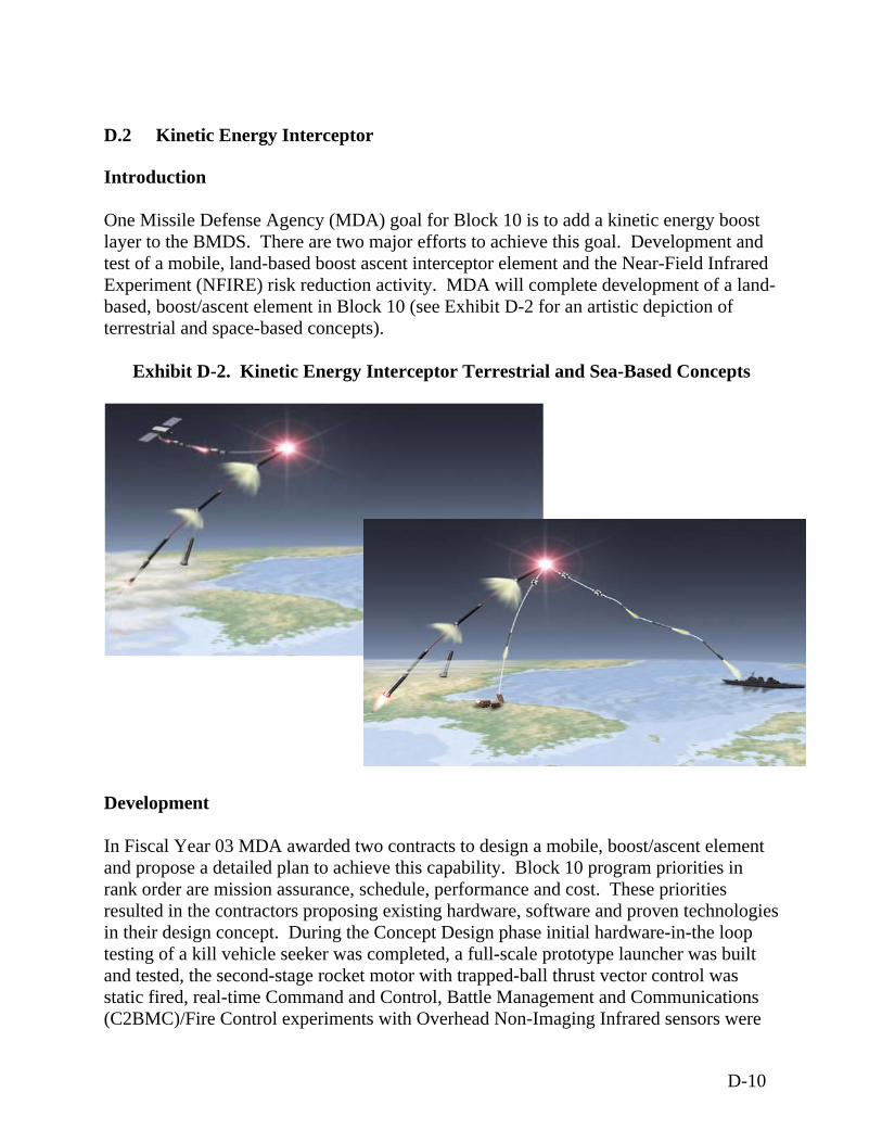
D.2 Kinetic Energy Interceptor
Introduction One Missile Defense Agency (MDA) goal for Block 10 is to add a kinetic energy boost layer to the BMDS. There are two major efforts to achieve this goal. Development and test of a mobile, land-based boost ascent interceptor element and the Near-Field Infrared Experiment (NFIRE) risk reduction activity. MDA will complete development of a land-based, boost/ascent element in Block 10 (see Exhibit D-2 for an artistic depiction of terrestrial and space-based concepts).
Exhibit D-2. Kinetic Energy Interceptor Terrestrial and Sea-Based Concepts Development In Fiscal Year 03 MDA awarded two contracts to design a mobile, boost/ascent element and propose a detailed plan to achieve this capability. Block 10 program priorities in rank order are mission assurance, schedule, performance and cost. These priorities resulted in the contractors proposing existing hardware, software and proven technologies in their design concept. During the Concept Design phase initial hardware-in-the loop testing of a kill vehicle seeker was completed, a full-scale prototype launcher was built and tested, the second-stage rocket motor with trapped-ball thrust vector control was static fired, real-time Command and Control, Battle Management and Communications (C2BMC)/Fire Control experiments with Overhead Non-Imaging Infrared sensors were
D-10
conducted, and a high-fidelity simulation of entire Kinetic Energy Interceptor (KEI) element concept was built and exercised. In December 2003, MDA awarded a contract for the KEI Development and Test (D&T) Program to a defense contractor team. The KEI land-based element design is based on mature technologies proven in ground and flight test at the component level. The KEI kill vehicle combines the Standard Missile (SM)-3 seeker/avionics with an Exoatmospheric Kill Vehicle (EKV) liquid divert and attitude control system to achieve a high performance boost/ascent interceptor with inherent midcourse defense capability. The KEI third stage is a production SM-3 third stage rocket motor with a new attitude and control subsystem derived from Ground-based Midcourse Defense (GMD). The first and second stage motors utilize advanced solid axial stage technologies we have been developing and testing incrementally over the last decade. The C2BMC component builds upon an extensive suite of concept design phase algorithms and the contractor’s substantial investments as lead developer of the GMD C2BMC capability. The mobile launcher is a modification of military-off-the-shelf equipment. The KEI D&T program is structured much differently than predecessor missile defense programs. The D&T integrated master plan/integrated master schedule features an unprecedented mix of program content during the early years of execution. This content is driven by newly defined MDA engineering and manufacturing, software, and operational readiness level criteria. The MDA has defined the new readiness levels as exit criteria (knowledge points) for design reviews and the Block 10 capability milestone. MDA’s objective is to focus early development work on manufacturing, producibility, quality, affordability, and operational suitability in addition to the traditional upfront emphasis on technical performance. The Fiscal Year 04/05 D&T program content includes: 1) mitigation of key risks through early build and test of full scale prototypes based on mature technologies, 2) complete definition of all requirements and interfaces by Design Review-1, 3) design of the interceptor, C2BMC, and launcher production lines, 4) establishment of machines and tooling in a laboratory environment for selected items, 5) development of engineering models as flight test unit pathfinders, 6) initiating builds of all integration labs and activating test facilities, 7) initiate procurement of flight test targets, and 8) extensive involvement of the User (STRATCOM, NORTHCOM, Army) in KEI capability design and operations concept definition. Work will be conducted across multiple geographic centers where the integrated product teams are based. Mobility of the interceptor is an essential characteristic enhancing its military utility. The KEI contractor is developing a canisterized interceptor, which is completely common to both land and sea basing and compatible with land and sea environments. These attributes will provide both flexibility and robustness to the test program, and ease the transition to a fully integrated sea based capability.
D-11
The collection of the near field infrared measurements of boosting targets will be from an on-orbit satellite. Currently, MDA is building the NFIRE satellite. The major objective of this effort is to collect near field long, medium and short wave infrared measurements of the rocket plume and body in the boost phase of flight to anchor our understanding of the plume phenomenology and plume to rocket body discrimination. MDA will also use this data to validate the models and simulations that are fundamental to developing the navigation, guidance and control and endgame homing algorithms for the KEI D&T program. Testing – Block 2010
Land-based Kinetic Energy Interceptor
Developing a realistic, robust test program for the BMDS Interceptor element is paramount to the BMDS. Beginning in Fiscal Year 08 the interceptor will be tested from both land-based ranges and a sea-based platform. Launching the interceptor from a sea-based platform is critical to providing realistic coverage of the operational envelope and intercept geometries. Based on results of a Military Sealift Command market survey, the agency, through Military Sealift Command, will acquire a containership to support the BMDS interceptor testing. While serving to enhance the flexibility of the BMDS test bed, the containership may be deployed in case of a national emergency. MDA will execute a series of two flight tests (Element Characterization Flight and Ship-launched Risk Reduction Flight) and five Integrated Flight Tests (1-5) against targets during the D&T. These flight tests will be preceded by a robust series of ground testing including multiple static fire tests of all three rocket motor stages and integrated Kill Vehicle hover testing as well as a Booster Flight test, a Partial Full Scale flight test and a Control Test Vehicle flight test. Numerous integrated ground tests of the Element C2BMC with the BMDS and the Element C2BMC with the launcher will also be conducted. All five Integrated Flight Test missions will have the objective of intercepting the target. Beginning with Integrated Flight Test-3, the element will be tested using production hardware and software with Integrated Flight Test-5 mission conducted by the user. To support this strategy MDA will procure nine targets (including two spares). Block 10 testing focuses on boost/ascent phase intercept. Technical and operational issues resolved during land-based development and testing mitigate risks for future evolutions of this mobile and highly effective capability. MDA continues to conduct a disciplined approach to collecting data to better understand the physics and phenomenology of boosting flight. This measurements test program exploits existing targets of opportunity flights such as intercontinental ballistic missile and space launches through the use of ground, aircraft-borne and space based sensors.
D-12

The importance of these data products enables improvements to be made to guidance algorithms, scene generation fidelity levels, and modeling and simulation results that are used to analyze interceptor performance capabilities against various threat type characteristics to include plume to hard body discrimination under different scenarios. MDA intends to conduct additional target of opportunity flights, varying the geometries of the flight test scenarios and instrument set-ups to improve the fidelity of data sets to include near field data needs throughout boost. Two payloads will be integrated onto the NFIRE satellite to execute four missions. The first mission set tracks ground targets such as forest fires, volcanoes, and static tests of rocket engines. This mission will verify, on-orbit, the pointing accuracy of the gimbaled system and calibrate the tracking sensors. The second mission set tracks targets of opportunity worldwide that take place regardless of the NFIRE experiment. These might include aircraft flights, space launches and operational missile tests. The two primary missions require the spacecraft to maneuver to view a boosting intercontinental ballistic missile closing on the spacecraft. During the second of these two missions, the spacecraft releases the kill vehicle for a fly-by of the burning missile. Testing – Block 2012
Sea-based Kinetic Energy Interceptor
In Block 12, MDA will complete the transition from land to sea, inaugurating this capability from a Navy vessel, likely a surface combatant or a submarine. MDA will also begin testing the system's inherent midcourse capability during Block 12, expanding the range and flexibility of the new BMDS interceptor. Operating in international waters obviates basing restrictions that reduce the effectiveness of the land mobile interceptor element in some scenarios. MDA’s plan leverages the common canisterized interceptor system built in Block 10, developing and testing those interfaces necessary for launch from a sea-based platform. During Block 10 containership testing, MDA will mitigate many of the issues for transition to sea-based platforms. The platform options for MDA’s Block 12 sea-based capability include baseline two to four Aegis Cruisers, SSBN (ballistic missiles) submarine and SSGN (guided missiles) submarine. The Agency will work closely with the Navy and STRATCOM in Fiscal Year 04 to define an acquisition strategy and platform for operational integration of the interceptor. The contractor will complete a series of sea-based, boost/ascent intercept flight tests in Block 2012 to demonstrate this integrated sea based capability. MDA will modify contracts to begin activities for integration of the interceptor into the Navy-approved platform.
D-13
Further definition of the KEI Block 2012 test program will occur after a contract is awarded for this effort. Deployment The KEI program office will develop deployment plans in the event the Department of Defense (DoD) makes a positive deployment decision. As of the 3rd Quarter Fiscal Year 04, MDA will deploy KEI only to the BMDS test bed. Decommissioning The program office will develop decommissioning plans in the event the DoD makes a positive deployment decision. NEPA Analysis NEPA analysis is underway for early test events.
D-14
D.3 AEGIS Ballistic Missile Defense
Introduction The Aegis Ballistic Missile Defense (BMD) is a sea-based element designed to negate ballistic missiles in the midcourse flight phase and provide surveillance and tracking support to the BMDS against ballistic missiles of all ranges. Aegis BMD would use hit-to-kill technology to intercept and destroy short- to medium-range ballistic missiles. Future development would expand to use hit-to-kill technology to counter intermediate-range ballistic missiles. Currently, the focus of Aegis BMD is to counter ballistic missile threats in the ascent and midcourse phase. Future flight tests would address the element’s ability to intercept ballistic missile lower in the exoatmosphere. Aegis BMD components consist of a select number of Aegis Guided Missile Cruisers and Destroyers employing the AN/SPY-1 Radar with Standard Missile (SM)–3 missiles. Designated Aegis equipped ships would be modified to provide Long Range Surveillance and Tracking. Interceptors The Aegis BMD midcourse defense element of the BMDS integrates the SM-3 with the existing Aegis Weapons System aboard Navy cruisers to provide protection against short- to medium-range ballistic missiles. The SM-3 is based on the SM-2 Block IV airframe and propulsion stack, but incorporates a third stage rocket motor, a Global Positioning System/Inertial Navigation System guidance section, and the SM-3 kinetic warhead. The SM-3 is a solid propellant-fueled, tail-controlled, surface-to-air missile. The SM-3 is an evolution of the Lightweight Exoatmospheric Projectile developed in the mid-1980s to demonstrate hit-to-kill technology. The Aegis weapons system/SPY-1 Radar detects and tracks a ballistic missile and passes that information to the SM-3. The SM-3 is launched from the vertical launch system and controlled by the Aegis Weapon System up to the kinetic warhead ejection from the third stage rocket motor. The Global Positioning System/Inertial Navigation System guides the missile on an intercept trajectory. The kinetic warhead is equipped with propulsion, a long wave infrared seeker, and a guidance and control system enabling it to acquire, track, discriminate, divert and intercept a ballistic missile target above the Earth’s atmosphere.
D-15
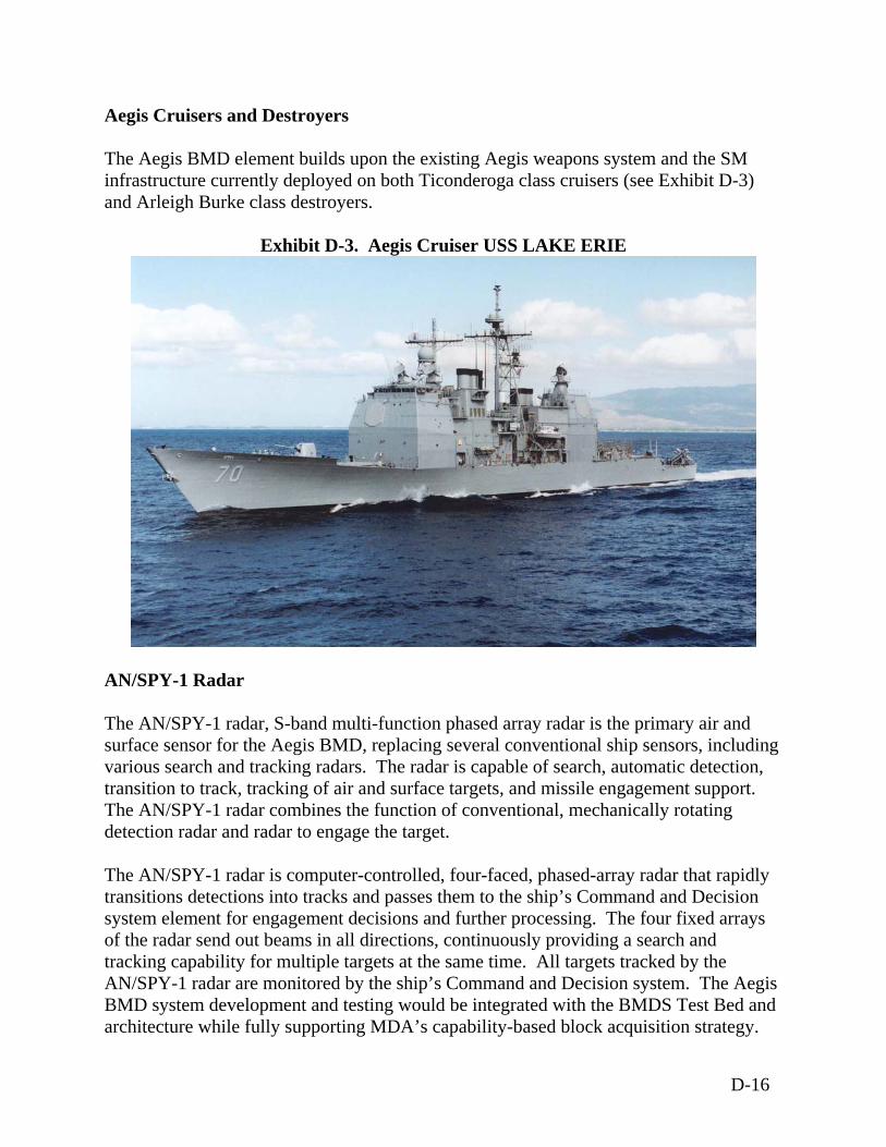
Aegis Cruisers and Destroyers The Aegis BMD element builds upon the existing Aegis weapons system and the SM infrastructure currently deployed on both Ticonderoga class cruisers (see Exhibit D-3) and Arleigh Burke class destroyers.
Exhibit D-3. Aegis Cruiser USS LAKE ERIE
AN/SPY-1 Radar The AN/SPY-1 radar, S-band multi-function phased array radar is the primary air and surface sensor for the Aegis BMD, replacing several conventional ship sensors, including various search and tracking radars. The radar is capable of search, automatic detection, transition to track, tracking of air and surface targets, and missile engagement support. The AN/SPY-1 radar combines the function of conventional, mechanically rotating detection radar and radar to engage the target. The AN/SPY-1 radar is computer-controlled, four-faced, phased-array radar that rapidly transitions detections into tracks and passes them to the ship’s Command and Decision system element for engagement decisions and further processing. The four fixed arrays of the radar send out beams in all directions, continuously providing a search and tracking capability for multiple targets at the same time. All targets tracked by the AN/SPY-1 radar are monitored by the ship’s Command and Decision system. The Aegis BMD system development and testing would be integrated with the BMDS Test Bed and architecture while fully supporting MDA’s capability-based block acquisition strategy.
D-16
Development The Aegis BMD development began with the TERRIER Lightweight Exoatmospheric Projectile Program, which included four flight tests between 1992 and 1995, and demonstrated that Lightweight Exoatmospheric Projectile could be integrated into a sea-based tactical missile for ballistic missile defense based on exoatmospheric intercepts. The next step in program development was the Aegis Lightweight Exoatmospheric Projectile Intercept project that built upon the lessons learned from the TERRIER- Lightweight Exoatmospheric Projectile program and emerging technologies. The purpose of the Aegis Lightweight Exoatmospheric Projectile Intercept was to demonstrate technologies required to hit a ballistic missile target in the exoatmosphere from a ship at sea. The project test requirements were satisfied with two successful intercepts from the USS LAKE ERIE: Flight Mission (FM)-2 and FM-3 in January 2002 and June 2002, respectively. FM-2 accomplished a direct hit of a ballistic missile target and successfully demonstrated kinetic warhead guidance, navigation, and control operations against a live target. FM-3 successfully repeated the intercept of a live ballistic missile target. With the successful completion of FM-3, the Navy considers the exit criteria of the Aegis Lightweight Exoatmospheric Projectile Intercept project to have been met. Current developmental efforts for Aegis BMD Block 2004 are focused on defeating short- and medium-range ballistic missiles while providing surveillance support to the BMDS. Block 2004 would verify the Aegis BMD capability to provide long-range surveillance and tracking against intermediate range and intercontinental ballistic missiles to other components of the BMDS. Aegis BMD flight-testing would include a series of test flight missions that demonstrate increasingly complex capability against ballistic missiles such as testing against unitary targets, separating targets, separating targets in clear environments and separating targets that include countermeasures. The operational objective of the Aegis BMD Block 2004 Test Bed capability is to act synergistically with other BMDS boost, midcourse, and terminal elements to maximize BMD capability. The Japan Cooperative Research project consists of joint research conducted by Japan and the U.S. to enhance the capabilities of the SM-3 for BMD. This program is part of the U.S. security alliance with U.S. allies, which would complement the incremental capability approach. The focus of research is on four components of the SM-3 guided missile - sensor, advanced kinetic warhead, second stage propulsion, and lightweight nosecone. Initial flight-testing would test advanced nosecone functionality, which may be integrated into the Aegis BMD Block 2006 capability.
D-17
Testing – Block 2004 The Aegis BMD program test strategy consists of coordinated ground and flight-testing to verify the expanding capabilities of the system’s evolutionary block development. The Block 2004 flight test program is designed to demonstrate capability against an increasingly complex range of ballistic missile targets. These flight tests will provide the opportunity to demonstrate both ascent and descent phase intercept capability and to flight test the divert-and-attitude control system kinetic warhead. Block 2004 flight missions will demonstrate the capability to tactically engage unitary ballistic missile targets including one in the low exoatmosphere as well as demonstrate an initial capability against simple separating ballistic missile targets. Aegis BMD is also developing a capability to deliver long-range surveillance and tracking support to the BMDS and GMD. As part of this development, Aegis BMD Blocks 04 and beyond, will participate in all GMD Integration Flight Test missions and System Integration Flight Test (SIFT) missions to provide a long-range surveillance and tracking capability to GMD. At some point in Aegis BMD development, future blocks may participate in Integrated Flight Tests as an engagement asset (Block 08 or later). In the near term, Aegis BMD will be demonstrating connectivity between an Aegis ship in the western Pacific and the BMDS. Testing - Block 2006 The Block 2006 flight test program will demonstrate system capability improvements to defeat short range, medium range, and intermediate range ballistic missiles, enhanced discrimination, and will provide capability against countermeasures. The flight test program will include Launch on Boost in addition to Engage on Remote. Other plans for system improvements are under development. Additionally, Japan Cooperative Research Project flight tests will be conducted to demonstrate the SM-3 lightweight nosecone. Testing - Block 2008 Aegis BMD Block 2008 will provide fully integrated radar discrimination and other enhancements against Long Range Ballistic Missiles and countermeasures as well as continued upgrades for BMDS Command and Control, Battle Management, and Communication. It will include multiple simultaneous engagement capability. Further details are being developed within MDA. Testing - Block 2010 The Block 2010 flight test program will demonstrate a weapon system upgrade that will permit the incorporation of Aegis BMD into the Navy developed Aegis Weapon System
D-18
open architecture, thereby fully integrating BMD into the Aegis multi-mission capability. Additional performance in countermeasure environments will also be demonstrated. Deployment Deployment would include production, manufacture and fielding of the Aegis BMD elements and any test-related assets. At the conclusion of Block 2004, three Aegis BMD cruisers and 15 Aegis BMD destroyers would be available for deployment. Deployment locations have not yet been determined. Decommissioning The U.S. Navy would decommission the Aegis cruisers or destroyers at the end of their useful life. Decommissioned ships may be overhauled and returned to service, sold to an Allied Navy through foreign military sales, or the ship may be sold for scrap metal. The disposition of all weapons and sensors would be in accordance with applicable DoD and U.S. Navy policy. NEPA Analysis The following NEPA analyses support the majority of Aegis BMD test and development efforts. Rim of the Pacific Programmatic Environmental Assessment (June 2002) Point Mugu Sea Range Final Environmental Impact Statement/Overseas
Environmental Impact Statement (Department of the Navy, March 2002) Pacific Missile Range Facility Enhanced Capability Final Environmental Impact
Statement (December 1998) Lightweight Exoatmospheric Projectile Test Program Environmental Assessment
(June 1991)
D-19
D.4 Ground-Based Midcourse Defense
Introduction The Ground-Based Midcourse Defense (GMD) segment of the BMDS is comprised of ground-based interceptor missiles, radars and other sensors, and Ground-based Midcourse Defense Fire Control (GFC) Node and is designed to neutralize a threat ballistic missile during the midcourse phase of its flight. The midcourse phase is best defined as the ballistic portion of a missile’s flight after it leaves the atmosphere and before it reenters the atmosphere. An operational GMD within the proposed BMDS includes the following key components Ground-Based Interceptors (GBIs) Sea-Based X-Band Radar (SBX) Ground-Based Midcourse Defense Fire Control/Communications (GFC/C) facilities
and links Upgraded Early Warning Radars (EWRs).
Sensors Sensors proposed for the GMD include the SBX, upgraded early warning radar (e.g., Cobra Dane on Eareckson Air Station, EWRs at Beale AFB, Royal Air Force Fylingdales, and Thule Air Base), AN/SPY-1 Radar, BMDS Radar (FBX-T), AN/FPQ-14 Radar, and space-based sensors. The GMD program also may use sensors from other elements of the BMDS. See Appendix E for a detailed description of the BMDS sensors. Interceptors The GBI is designed to intercept incoming ballistic missile warheads outside the Earth’s atmosphere and destroy them through force of impact. The GBI consists of a multi-stage solid propellant booster and an EKV. Each interceptor booster may contain up to approximately 20,500 kilograms (45,000 pounds) of solid propellant. During flight, the GBI receives information from the GFC/C to update the location of the incoming ballistic target, enabling the EKV’s onboard sensor system to identify and home in on the threat re entry vehicle. Each EKV contains approximately 7.5 liters (2 gallons) of liquid monomethyl hydrazine fuel and 7.5 liters (2 gallons) of liquid nitrogen tetroxide oxidizer. The liquid fuel and liquid oxidizer tanks arrive at GMD test and operational sites fully fueled. Interceptors are assembled on site. The components associated with a typical GBI launch site include the Launch Control Center, range sensors, and In-Flight Interceptor Communications System Data Terminal
D-20
(IDT). The Launch Control Center is linked to the GBI silo via fiber optic cable and contains computer terminals and the flight control center. Range sensors and telemetry equipment are used to monitor all missile flights. The IDT provides an in flight tactical or communications link between the GFC/C and the interceptor during flight. Each GMD site uses commercial power with electrical generators for backup power. Interceptor missile boosters, payloads, and support equipment will be transported by air, ship, or over-the-road common carrier from U.S. Government storage depots or contractor facilities to the test range. Shipping is conducted in accordance with Department of Transportation (DOT) regulations. The interceptor will be placed in existing or newly constructed facilities for assembly and launch preparation. Applicable safety regulations are followed in the transport, receipt, storage, and handling of hazardous materials. An appropriate explosive safety quantity distance (ESQD), as approved by the DoD Explosives Safety Board, surrounds facilities where interceptors and ordnance are stored or handled. Ground-Based Fire Control/Communications (GFC/C) The GFC/C facilities and links are presented below in two categories: 1) Ground-Based Midcourse Defense Fire Control (GFC) command nodes, and GFC communications links, which include the Ground Based Communications Network, and 2) the IDTs. Ground-Based Midcourse Defense Fire Control (GFC) Command Nodes The existing and proposed GFC command nodes with their related facilities and hardware exist or are under construction at identified locations for either test or operational purposes. The command level GFC/C sites are located at the Joint National Integration Center and Fort Greely. GFC/C sites will be operational 24 hours a day. Execution level GFC/C nodes are located at GMD GBI sites and use electric power from the base or GBI site. The operational concept is for GFC/C to consist mostly of battle management functions and to act as the centralized point for readiness, monitoring, and maintenance. GFC/C provides the user with system status displays, threat displays, predictive planning displays, and weapons control data to support both GMD and BMDS level command and control decision-making and execution. The sensor level site communications node is co-located with the sensor or, in the case of spaced-based sensors, at the appropriate satellite control center to communicate sensor data to the GFC/C network.
D-21
GFC/C system sites may include Peterson AFB, Colorado (Command Level Node) Schriever AFB, Colorado (Command Level Node) Cheyenne Mountain Complex, Colorado (Command Level Node) Beale AFB, California (Sensor Level Site Communications Node) Eareckson Air Station, Alaska (Sensor Level Site Communications Node) Fort Greely, Alaska (Execution Level Node) Vandenberg AFB, California (Execution Level Node) Thule Air Base, Greenland (Sensor Site Communications Node) Royal Air Force Fylingdales, England (Sensor Site Communications Node)
These GFC/C nodes use existing facilities where available. These existing facilities usually only require minor modifications, hardware and software upgrades, and connections to existing communications lines. However, some sites require new facility construction, such as satellite earth terminals or new utility or communications lines. Ground-Based Midcourse Defense Communications Network The GMD Communications Network is that portion of the GFC/C component that provides voice and data communications through a network of transmission equipment and circuits, cryptographic equipment, and local and wide area networks necessary to provide a dedicated, reliable, and secure GMD communication capability. Components of the network provide connectivity to all components of the test bed and for initial defensive capability (IDC), providing functional connectivity to the IDTs, the GBI and target launch facilities, radars, and the GFC/C system. Communications occur over a combination of existing and new communication cables (either fiber optic or copper), Military Satellite Communications and Commercial Satellite Communications (COMSATCOM) terminals. Satellite Communications The primary power for Military Satellite Communications and COMSATCOM Earth Terminals (see Exhibit D-4) is commercial, with backup power provided by generator. Communication cables between the terminal and the launch control complex are required. Equipment can be housed in a military van, a small building, or an existing facility if an adequate structure is available. The site requirements include a concrete base for the Earth Terminal, an all-weather road to the site, a prepared surface and fencing around the site.
D-22
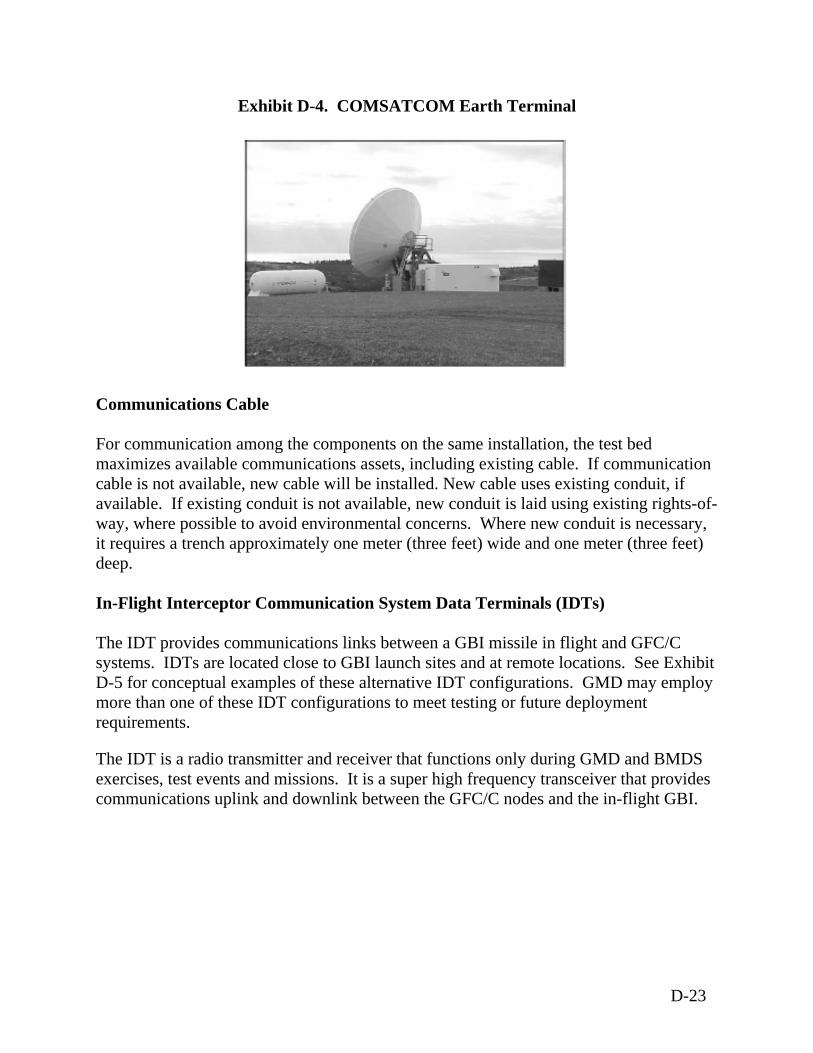
Exhibit D-4. COMSATCOM Earth Terminal Communications Cable For communication among the components on the same installation, the test bed maximizes available communications assets, including existing cable. If communication cable is not available, new cable will be installed. New cable uses existing conduit, if available. If existing conduit is not available, new conduit is laid using existing rights-of-way, where possible to avoid environmental concerns. Where new conduit is necessary, it requires a trench approximately one meter (three feet) wide and one meter (three feet) deep. In-Flight Interceptor Communication System Data Terminals (IDTs) The IDT provides communications links between a GBI missile in flight and GFC/C systems. IDTs are located close to GBI launch sites and at remote locations. See Exhibit D-5 for conceptual examples of these alternative IDT configurations. GMD may employ more than one of these IDT configurations to meet testing or future deployment requirements. The IDT is a radio transmitter and receiver that functions only during GMD and BMDS exercises, test events and missions. It is a super high frequency transceiver that provides communications uplink and downlink between the GFC/C nodes and the in-flight GBI.
D-23
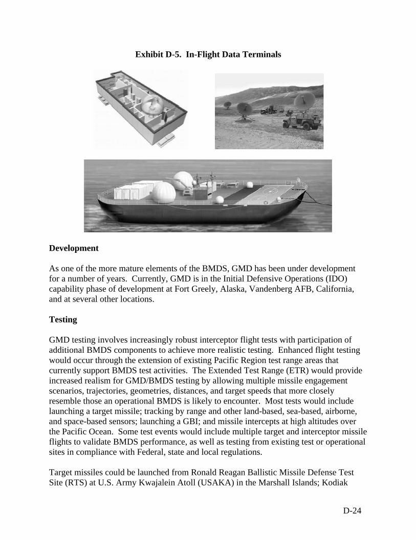
Exhibit D-5. In-Flight Data Terminals
Development
s that more closely
e
k
As one of the more mature elements of the BMDS, GMD has been under developmentfor a number of years. Currently, GMD is in the Initial Defensive Operations (IDO) capability phase of development at Fort Greely, Alaska, Vandenberg AFB, California, and at several other locations. Testing GMD testing involves increasingly robust interceptor flight tests with participation of additional BMDS components to achieve more realistic testing. Enhanced flight testingwould occur through the extension of existing Pacific Region test range areas that currently support BMDS test activities. The Extended Test Range (ETR) would provide increased realism for GMD/BMDS testing by allowing multiple missile engagement scenarios, trajectories, geometries, distances, and target speedresemble those an operational BMDS is likely to encounter. Most tests would include launching a target missile; tracking by range and other land-based, sea-based, airborne, and space-based sensors; launching a GBI; and missile intercepts at high altitudes over the Pacific Ocean. Some test events would include multiple target and interceptor missilflights to validate BMDS performance, as well as testing from existing test or operationalsites in compliance with Federal, state and local regulations. Target missiles could be launched from Ronald Reagan Ballistic Missile Defense Test Site (RTS) at U.S. Army Kwajalein Atoll (USAKA) in the Marshall Islands; Kodia
D-24
Launch Complex (KLC), Alaska; Vandenberg AFB, California; Pacific Missile Range Facility (PMRF) on Kauai, Hawaii; and/or from mobile platforms situated in the Pacific
cean. GMD’s existing deployed sites also may be involved in test firing and other test t
erg
cquisition and tracking would be provided by sea-based sensors (e.g., egis cruisers and destroyers, SBX) and land-based sensors in the Pacific Region; a
ed
B, ir Force Station, Alaska, and Eareckson Air Station, Alaska (see
xhibit D-6).
ed sites and expected intercept areas. Satellite communications terminals will
e constructed at launch sites that do not have fiber optic communication links and at
of missile-launches (interceptors and/or targets) from ach launch facility per year. The total per year will vary to meet the needs of the
program. The GMD flight test program consists of various Integrated Flight Tests in which an intercept is attempted, and Radar Characterization Flights in which only a target vehicle is flown and observed by radars.
Oactivities to assess system performance. Exhibit D-6 shows these and other test and tessupport locations. Interceptor missiles are launched from RTS, KLC, and/or VandenbAFB, California. Dual target and interceptor missile launches may occur in some scenarios. Existing, modified, and new infrastructure would support launch activities at the various locations. Target missile aAtransportable test X-band radar (TPS-X) or the forward deployed radar (FDR) positionat test ranges such as Vandenberg AFB, KLC, RTS, or PMRF; the existing prototype X-band Ground Based Radar (GBR-P) at RTS; and existing/upgraded radars at Beale AFCalifornia, Clear AE IDTs may be located at GBI launch sites or on sea-based platforms near the proposGBI launchbother locations. GMD test plans include a numbere
D-25
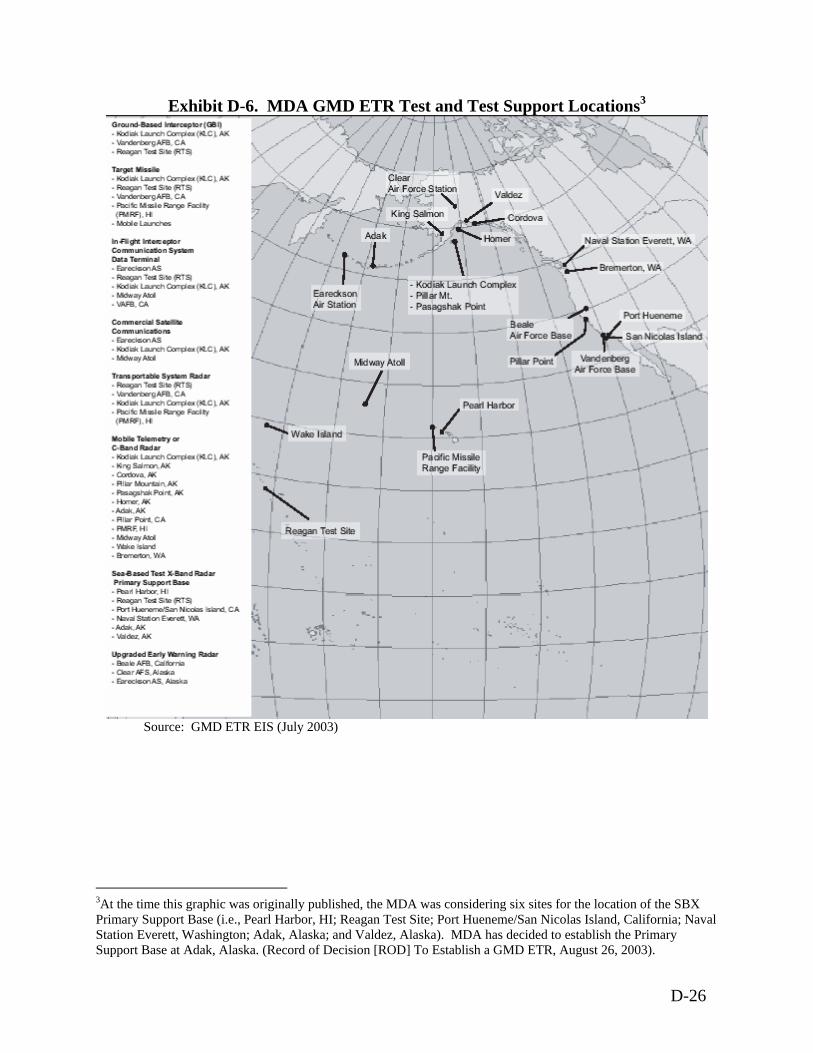
Exhibit D-6. MDA GMD ETR Test and Test Support Locations3
Source: GMD ETR EIS (July 2003)
3At the time this graphic was originally published, the MDA was considering six sites for the location of the SBX Primary Support Base (i.e., Pearl Harbor, HI; Reagan Test Site; Port Hueneme/San Nicolas Island, California; Naval Station Everett, Washington; Adak, Alaska; and Valdez, Alaska). MDA has decided to establish the Primary Support Base at Adak, Alaska. (Record of Decision [ROD] To Establish a GMD ETR, August 26, 2003).
D-26
Testing - Block 2004 Block 2004 GMD element proposed actions include introduction of the SBX into the BMDS Test Bed to increase test capability and realism against more stressful long-range targets and countermeasures suites.4 Testing - Block 2006 Block 2006 GMD proposed actions include prototype hardware and software maturation for all GMD interceptor, sensor, and GFC/C components; ground and flight-testing to demonstrate added performance, and interfaces with external sensors; and the upgrade of the EWR at Thule Air Base, Greenland.5 Testing - Block 2008
Block 2008 GMD proposed actions include demonstrating advanced engineering and pre-planned equipment improvements for boosters, interceptors, early warning and fire control radars, and GFC/C software builds; and demonstrating improved performance based on overall enhancements to BMDS integration, including KEI and space-based sensors.6 Testing - Block 2010 Block 2010 GMD-proposed actions include continued flight-testing of improved weapon and sensor components, and design, engineering and integration of an advanced KEI.7 Deployment In light of the new security environment and advances made to date in missile defense development, the President directed the DoD to field initial operational missile defense capabilities in 2004-2005 to meet growing ballistic missile threats. The initial set of GMD capabilities planned for 2004-2005 will include as many as 16 GBIs at Fort Greely, Alaska and four interceptors at Vandenberg AFB, California. Additionally, the GMD element of the BMDS will take advantage of land-, sea-, and space-based sensors, including existing early warning satellites and an upgraded radar located at Eareckson Air Station, Alaska, and new SBX. MDA plans to upgrade EWRs in the United Kingdom and the Kingdom of Denmark.8
4 MDA Fiscal Year 2004/2005 Budget Estimate Submission Press Release (page 11) 5 Ibid. (page 13) 6 Ibid. (page 16) 7 Ibid. (page 17) 8 DoD Press Release, December 2002
D-27
The exact nature of future GMD deployment activities (i.e., additional interceptors, land-based radars, and the construction of necessary support facilities) has yet to be determined. Any decision to deploy additional interceptors would be addressed in additional NEPA analysis or the appropriate analysis under Executive Order (EO) 12114, if appropriate. Currently, the IDO ROD dated April 18, 2003, supports deployment of as many as 40 interceptors at Fort Greely, Alaska.9 Decommissioning Decommissioning of all or parts of the GMD element is dependent on many variables. The exact timing of decommissioning activities has not been determined. The decommissioning of GBI missiles and the demolition of GMD element facilities (e.g., silos, radar buildings, etc.) will be in accordance with the applicable environmental regulations and standard practices. The decommissioning effort will seek to reuse and recycle materials to the maximum extent possible. NEPA Analysis The following NEPA analyses support the majority of GMD test and development efforts including establishment of the IDO capability. Ground-Based Midcourse Defense Extended Test Range Final Environmental Impact
Statement (July 2003) National Missile Defense Deployment Final Environmental Impact Statement (July
2000) Ground-Based Midcourse Defense Initial Defensive Operations Capability at
Vandenberg AFB Environmental Assessment (August 2003) Alternate Boost Vehicle Verification Tests Environmental Assessment (August 2002) Ground-Based Midcourse Defense Validation of Operational Concept Environmental
Assessment (March 2002) Ground-Based Midcourse Defense Supplemental Validation of Operational Concept
Environmental Assessment (December 2002) Exoatmospheric Kill Vehicle Final Assembly and Checkout Operations at Redstone
Arsenal, Alabama Environmental Assessment (March 2000) Integration, Assembly, Test, and Checkout of National Missile Defense Components
at Redstone Arsenal, Alabama Environmental Assessment (February 1999 Additional Facilities at the National Missile Defense Ground-Based Interceptor
Development and Integration Laboratory, Huntsville, Alabama Environmental Assessment (March 1999)
9 MDA, DoD. ROD to Establish GMD IDO Capability at Fort Greely, Alaska, April 18, 2003.
D-28
Booster Verification Tests Environmental Assessment, Vandenberg AFB (March 1999)
Related Environmental Documentation North Pacific Targets Program Environmental Assessment (April 2001) Theater Ballistic Missile Targets Programmatic Environmental Assessment
(December 1997) Kodiak Launch Complex Environmental Assessment (May 1996)
D-29
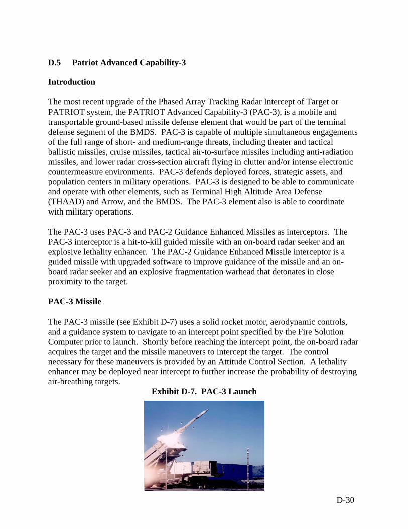
D.5 Patriot Advanced Capability-3
Introduction The most recent upgrade of the Phased Array Tracking Radar Intercept of Target or PATRIOT system, the PATRIOT Advanced Capability-3 (PAC-3), is a mobile and transportable ground-based missile defense element that would be part of the terminal defense segment of the BMDS. PAC-3 is capable of multiple simultaneous engagements of the full range of short- and medium-range threats, including theater and tactical ballistic missiles, cruise missiles, tactical air-to-surface missiles including anti-radiation missiles, and lower radar cross-section aircraft flying in clutter and/or intense electronic countermeasure environments. PAC-3 defends deployed forces, strategic assets, and population centers in military operations. PAC-3 is designed to be able to communicate and operate with other elements, such as Terminal High Altitude Area Defense (THAAD) and Arrow, and the BMDS. The PAC-3 element also is able to coordinate with military operations. The PAC-3 uses PAC-3 and PAC-2 Guidance Enhanced Missiles as interceptors. The PAC-3 interceptor is a hit-to-kill guided missile with an on-board radar seeker and an explosive lethality enhancer. The PAC-2 Guidance Enhanced Missile interceptor is a guided missile with upgraded software to improve guidance of the missile and an on-board radar seeker and an explosive fragmentation warhead that detonates in close proximity to the target. PAC-3 Missile The PAC-3 missile (see Exhibit D-7) uses a solid rocket motor, aerodynamic controls, and a guidance system to navigate to an intercept point specified by the Fire Solution Computer prior to launch. Shortly before reaching the intercept point, the on-board radar acquires the target and the missile maneuvers to intercept the target. The control necessary for these maneuvers is provided by an Attitude Control Section. A lethality enhancer may be deployed near intercept to further increase the probability of destroying air-breathing targets.
Exhibit D-7. PAC-3 Launch
D-30
The PAC-3 missile consists of the seeker assembly, Attitude Control Section, Mid Section Assembly, solid rocket motor Section, and the Aft Section Assembly. The seeker assembly is mounted at the forward end of the PAC-3 missile. It consists of a protective ceramic cover called a radome, active Ka Band Radar that acquires the target, an aluminum and graphite composite assembly and housing, the on-board radar, and associated electronics. The Attitude Control Section contains a number of small, short duration, solid propellant (aluminum and ammonium perchlorate and hydroxyl-terminated polybutadiene) rocket motors (side thrusters) that enable the PAC-3 missile to maneuver to achieve an intercept of a target in response to the instructions provided by the on-board guidance processor. The Attitude Control Section housing and assembly is aluminum and graphite composite. The Attitude Control Section also contains one lithium thermal battery. The mid section assembly contains various guidance, control, and communications electronics and antennas mounted in aluminum and graphite composite housing and assembly. The mid section assembly also contains a lethality enhancer to further increase the kill probability at intercept. The lethality enhancer contains various standard explosives, standard explosive detonators, two lithium thermal batteries, and a number of steel fragments. The main explosive charge is a low explosive that has been fully qualified for production and operational use. The lethality enhancer also serves as the Missile Destruct System for the PAC-3 missile. In the event that the PAC-3 missile diverges from a safe trajectory, the missile operator in the Engagement Control Station can command the lethality enhancer to detonate, breaking up the airframe of the missile, terminating thrust of the solid rocket motor, and causing it to terminate its flight and fall as debris. The solid rocket motor Section includes the single stage solid rocket motor, fixed fins, pyrotechnic motor initiators, and a graphite composite case. The fixed fins are titanium and are secured to the rocket motor casing by titanium attachments. The solid rocket motor contains approximately 160 kilograms (350 pounds) of solid propellant (aluminum and ammonium perchlorate and hydroxyl-terminated polybutadiene). PAC-2 Missile The PAC-2 missile is equipped with four clipped-delta movable control surfaces mounted on the tail. The missile propulsion is furnished by a single-grain solid propellant rocket motor. A high explosive warhead provides target-kill. The PAC-2 missile would consist of the radome, guidance section, warhead section, propulsion section, and the control actuator section.
D-31
The radome provides an aerodynamic shape for the missile and microwave window and thermal protection for the Track-via-Missile seeker and electronic components. The guidance section consists of a Modular Digital Airborne Guidance System and is comprised of two parts. The Modular Midcourse Package, which is located in the forward portion of the warhead section, consists of the navigational electronics and a Missile Borne Computer which computes the guidance and autopilot algorithms and provides steering commands in accordance with a resident computer program. The Terminal Guidance section is the Track-via-Missile seeker, which consists of an antenna mounted on an inertial platform, antenna control electronics, a receiver, and a transmitter. The propulsion section is comprised of the rocket motor, external heat shield, and two external conduits and contains a conventional, case-bonded solid propellant. The control actuator section is located at the aft end of the missile. It receives commands via the missile autopilot and positions the fins to steer and stabilize missile flight. The fin servo system consists of hydraulic actuators and valves and an electrohydraulic power supply consisting of battery, motor-pump, oil reservoir, gas pressure bottle, and accumulator. Development The U.S. Army first introduced the PATRIOT air defense system in 1983, and the PATRIOT system was fielded in Europe in the mid 1980’s. Continuous improvements and upgrades have been made to enhance its ability to counter evolving threats. The PATRIOT system was used to defend against Iraqi scud missiles in 1991 during Operation Desert Shield and Operation Desert Storm. The PATRIOT system was again utilized to defend against Iraqi missile threats in 2003 during Operation Iraqi Freedom. The Block 2004 IDC would include 340 PAC-2 Guidance Enhanced Missiles and 192 PAC-3 Missiles, 11 PATRIOT AN/MPQ-53 Radars and 43 PATRIOT AN/MPQ-65 Radars, and PATRIOT Battle Management/Command and Control (BMC2) (Information and Coordination Central Control Units/Engagement Control Stations) to provide defense against short range and medium range threats. The PAC-3 program was formally transferred to the U.S. Army in Fiscal Year 03. The Army became responsible for the development, testing, budgeting, operations, fielding, and sustaining functions for the PAC-3 program. MDA remains involved from the BMDS perspective including BMDS performance, interoperability, and system testing. Testing Testing falls into one of four test categories, pre-production test, ground test, flight test, and lethality/survivability test.
D-32
Pre-Production Test The pre-production test includes production qualification tests and production conformation tests. These two types of tests involve subjecting the upgraded components to a standard battery of natural environment, induced environment, supportability, transportability, mobility, performance, and other sub-tests. Production conformation tests demonstrate that deficiencies discovered during production qualification tests are fixed and operating properly. Upon completion of production qualification tests, the upgraded components would be integrated into the system and the system would undergo system level ground tests. Ground Test Ground testing would include simulations and performance tests. Simulations would be used to predict and verify system performance. Performance tests would include Developmental Testing and Evaluation, Information Assurance, Search Track, Ground-to-Ground and Ground-to-Air, and Operational Demonstration. Developmental Testing and Evaluation would ensure that hardware and software upgrades to the system have been successfully integrated and are ready for operational testing. Information Assurance would evaluate the vulnerability of the software and information systems. Search Track testing consists of a series of integrated hardware and software tests using simulated and real targets, electronic countermeasures, and penetration aids. Ground-to-ground and ground-to-air tests allowed checkout of missile guidance functions against simulated and real targets prior to flight tests. An Operational Demonstration was performed to demonstrate the technical merits of the hardware and software when tested in an operationally realistic environment. Interoperability testing will assess upgrades that allow the PATRIOT system to interoperate and trade data with other BMDS Command, Control, Communications, and Intelligence platforms. Flight Test Programs The Counter Anti-Radiation Missile program will involve one flight test that would demonstrate that the PAC-3 element could detect, track, engage, and successfully intercept an Anti-Radiation Missile flying a threat representative trajectory. This flight test will occur at WSMR, New Mexico, during Block 2002 testing. The PATRIOT Service Life Extension Program would modernize and repackage the PATRIOT system to meet the requirement that the PATRIOT be transportable by C-130 aircraft. A flight test would demonstrate that the modifications can support system functionality to detect, track, threat process, engage, and intercept a threat representative target. The flight test would occur at WSMR during Block 2006 testing.
D-33

The Light Antenna Mast Group would be an improved, scaled-down version of the existing tactical PATRIOT Antenna Mast Group and is a sub-program of the Service Life Extension Program. A flight test would demonstrate that the Light Antenna Mast Group could support system functionality to detect, track, threat process, engage, and intercept a threat representative aerial target. The flight test would occur at WSMR during Block 2004 testing. The Evolutionary Development Program would be a continuing process that results in Block Upgrades to the PATRIOT system. Initially there are 16 tasks foreseen, and three are still being evaluated. The Evolutional Development Program would test computer software and processing, sensors, communications, Command and Control/Battle Management (C2BM), ability to counter evolving threats, and upgrades to the PAC-3 missile. Several flight tests are scheduled to occur at WSMR under this program during Blocks 2004 and 2006. Ripple Fire testing would assess the ability of the two PAC-3 missiles fired successively to intercept two tactical ballistic missile targets. Two Ripple Fire tests are currently planned to occur at WSMR in the fourth quarter of Fiscal Year 04. Two flight tests are currently planned to assess the ability of the PAC-3 missile to engage tactical ballistic missiles. These flight tests would occur at WSMR in Block 04 testing. PAC-3 would also perform an intercept of a tactical ballistic missile during SIFT 2-2 at WSMR. Lethality/Survivability Test Requirements for lethality testing are still being addressed. Survivability testing would involve nuclear, biological, and chemical contamination survivability. BMDS Testing The PAC-3 element would play a role in SIFT 2-1 and SIFT 3. Information from other SIFTS could be used to construct overlay scenarios for the PAC-3 element. In SIFT 2-1, a launch would be detected by Defense Support Program (DSP), which would notify C2BMC of the launch. C2BMC would pass cueing information to PAC-3. PAC-3 would place the incoming ballistic missile under track and engage from WSMR. Following the intercept PATRIOT would perform a hit assessment and inform C2BMC of the results. Deployment PAC-3 units are fielded, operated, and sustained within the U.S. Army, U.S. National Guard, and other Air Defense Artillery units throughout the U.S. Up to four surveillance rounds will be fired per year during operation and fielding phases. PAC-3 operators and
D-34
maintainers would receive initial and follow-up training. The PAC-3 units would be upgrades of existing PAC-2 units, resulting in minimal training impacts. Routine field training in tactics, techniques, and procedures for PAC-3 fielded units would provide the PAC-3 operators the opportunity to realistically train against systems similar to those likely to be encountered in a hostile environment. Field training activities occur at least on a weekly basis. Simulation training and live fire training will be conducted throughout the service life of the PAC-3 missile and system. Live fire training occurs at regular intervals, at qualified test ranges. Decommissioning The PAC-3 system is anticipated to be in the U.S. Army inventory for approximately 30 years. Upon reaching the conclusion of its U.S. Army effective service life, the system would be withdrawn from military service, decommissioned, and disposed. Some components could be evaluated for continued use by other U.S. Government agencies or as candidates for Foreign Military Sales. Various adaptive reuses could be analyzed and implemented if appropriate. If no appropriate requirements were identified, the PAC-3 units would be demilitarized and disposed of. Demilitarization is the act of destroying a system's offensive and defensive capabilities to prevent the equipment from being used for its intended military purpose. Disposal is the process of redistributing, transferring, donating, selling, abandoning, destroying, or any other disposition of the property. Key items to be demilitarized include explosives; propellants and propellant fillers; toxic materials; incendiary or smoke content; other military design features; and any features determined to be hazardous to the general public. Items to be demilitarized include the entire missile or vehicle. To ensure freedom from explosive, toxic, incendiary, smoke, or design hazards, the process would be undertaken as economically as practicable and in accordance with existing environmental standards and safety and operational regulations. PAC-3 system disposal would involve establishing disposal facility availability and shipping hardware to disposal site. Disposal of material would then conform to DoD directives, Joint Service Regulations, and comply with all Federal and state laws. Each individual piece of equipment has disposition instructions that have been prepared by its development contractor or project office. These instructions identify the hazardous materials contained in the item of equipment. A copy of the disposition instructions would be provided to the depot or contractor performing the demilitarization and disposal. Disposal would be conducted according to the supplied disposition instructions in accordance with all federal, state, and local laws. Transportation of PAC-3 system components to demilitarization and disposal locations from military units, training, and maintenance locations would be by commercial ground transportation in accordance with DOT, state, and local transportation and safety regulations and procedures.
D-35
NEPA Analysis The following NEPA analyses support the majority of PATRIOT test and development efforts. PATRIOT Advanced Capability-3 (PAC-3) Life Cycle Final Supplemental
Environmental Assessment (U.S Army Space and Missile Defense Command, January 2002)
PATRIOT Advanced Capability-3 (PAC-3) Life Cycle Environmental Assessment (U.S. Army Space and Strategic Defense Command, May 1997)
PATRIOT Missile System, White Sands Missile Range, New Mexico Environmental Assessment (U.S. Army, June 1995)
Theater Missile Defense Flight Test Supplemental Environmental Assessment (U.S. Army Space and Strategic Defense Command, November 1995)
D-36
D.6 Terminal High Altitude Area Defense
Introduction The Terminal High Altitude Area Defense (THAAD) weapons system is a mobile, land-based missile system designed to intercept and destroy short and medium range ballistic missiles in the endo- and exoatmosphere and to provide surveillance support to the BMDS against ballistic missiles of all ranges. The BMDS is envisioned as a system of layered, yet independent, defenses that use complementary interceptors, sensors and C2BMC to intercept ballistic missiles of all ranges in all phases of flight. The THAAD element would be integrated as part of the BMDS to provide protection against incoming ballistic missiles in the terminal phase of their flight. Complete with its own radar and BMC2, the THAAD missile could operate independently as a ballistic missile defense system or could be deployed as a sensor to provide surveillance and tracking of target missiles and to communicate data to other elements in the BMDS. The THAAD missile system consists of four principle components: interceptor missiles, truck-mounted launchers, the THAAD radar system, and the BMC2. All components of the THAAD missile system, with the exception of certain radar components, can be transported by a C-130 aircraft for deployment by sea, rail, and/or road. Interceptor Missiles The THAAD missile is intended to intercept and destroy incoming ballistic missiles with ranges of up to 3,000 kilometers (1,860 miles). The missile rounds are comprised of a single-stage booster attached to a non-explosive warhead kill vehicle. The THAAD kill vehicle includes an infrared seeker that detects and homes in on the target missile to destroy the target by high-speed collision. This hit-to-kill technology uses kinetic energy to eliminate the enemy missile. The kill vehicle consists of a shroud, fore-cone, seeker, divert and attitude control system, and guidance and control electronics. The kill vehicle has an uncooled sapphire window with an infrared seeker mounted on a two-axis stabilized platform. See Exhibit D-8 for an example configuration of a THAAD missile.
D-37
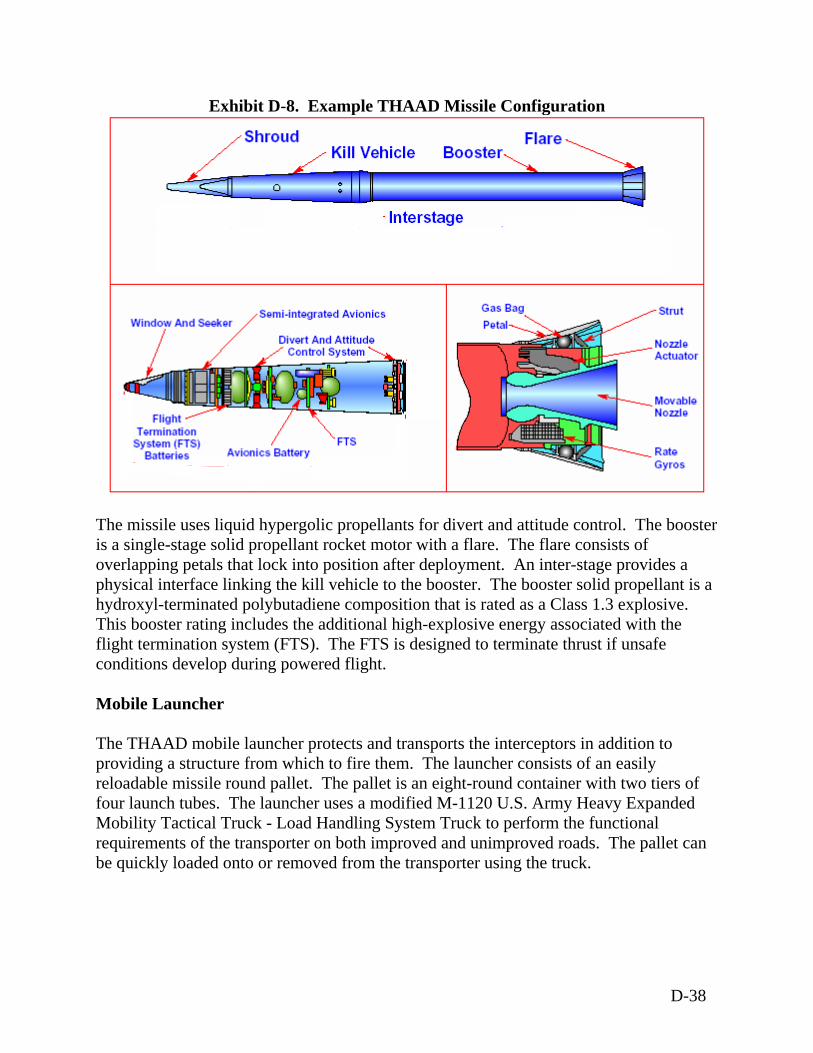
Exhibit D-8. Example THAAD Missile Configuration
The missile uses liquid hypergolic propellants for divert and attitude cis a single-stage solid propellant rocket motor with a flare. The flare coverlapping petals that lock into position after deployment. An inter-physical interface linking the kill vehicle to the booster. The booster hydroxyl-terminated polybutadiene composition that is rated as a ClasThis booster rating includes the additional high-explosive energy assoflight termination system (FTS). The FTS is designed to terminate thconditions develop during powered flight. Mobile Launcher The THAAD mobile launcher protects and transports the interceptorsproviding a structure from which to fire them. The launcher consists reloadable missile round pallet. The pallet is an eight-round containerfour launch tubes. The launcher uses a modified M-1120 U.S. Army Mobility Tactical Truck - Load Handling System Truck to perform threquirements of the transporter on both improved and unimproved roabe quickly loaded onto or removed from the transporter using the truc
ontrol. The booster onsists of
stage provides a solid propellant is a s 1.3 explosive. ciated with the rust if unsafe
in addition to of an easily with two tiers of
Heavy Expanded e functional ds. The pallet can k.
D-38
THAAD Radar The THAAD prototype radar is a wide-band, X-band, single faced, phased array radar system of modular design. The transmit/receive module has been upgraded to higher power outputs and improved reception levels. It performs surveillance, tracks the target, and controls firing functions. The radar communicates with the interceptor while it is in flight. The THAAD radar consists of four units: Antenna Equipment Unit, Electronic Equipment Unit, Cooling Equipment Unit, and Prime Power Unit. The Antenna Equipment Unit includes all transmitter and beam steering components as well as power and cooling distribution systems. The Electronic Equipment Unit houses the signal and data processing equipment, operator workstations, and communications equipment. The Cooling Equipment Unit contains the fluid-to-air heat exchangers and pumping system to cool the antenna array and power supplies. The Prime Power Unit, used to power the THAAD radar system, is a self-contained trailer in a noise-dampening shroud that contains a diesel generator, governor and associated controls, a diesel fuel tank, and air-cooled radiators. Each individual unit is housed on a separate trailer interconnected with power and signal cabling, as required. Operation of the Prime Power Unit would require refueling operations. The fuel tank of the Unit would be filled from a fuel truck as necessary. BMC2 System The BMC2 system manages and integrates all THAAD components by providing instructions, processing sensor data, and communicating between radar, interceptor, and launch vehicle. The BMC2 system also links the THAAD to other missile and air defense systems in the BMDS via the system-wide C2BMC. The BMC2 is connected internally and externally to allow the exchange of data and commands among the various components of the THAAD element. It uses a netted, distributed, and replicated flow of information to ensure uninterrupted execution of engagement operations. Key engagement operations include surveillance, threat evaluation, weapon assignment, engagement control, target engagement, and kill assessment. Missile launch procedures are controlled from separate BMC2 shelters mounted on XM-1113 High Mobility Multipurpose Wheeled Vehicles. Launch commands to the M-1120 Heavy Expanded Mobility Tactical Truck - Load Handling System Truck are transmitted via fiber-optic cable. Development The THAAD element has been under development since the early 1990’s. THAAD was formerly part of Theater Defense and is now an element of the Terminal Defense Segment. By the middle of Fiscal Year 2000, THAAD had completed the
D-39
Demonstration/Validation phase of its development. It is currently in the Engineering and Manufacturing Development phase. THAAD has implemented a block approach. Block 2004 THAAD program development will include the design and development of a significant, fundamental THAAD capability against short- and medium-range ballistic missiles. Development plans for Block 2004 aim to reduce risk and to characterize component and element capabilities. Development activities include contractor conducted testing and modeling and simulations. The development program seeks to identify and correct failures at the lowest level possible and implement corrective actions early to support early design maturation, reduce risk, and control cost. For example, the THAAD prototype radar has been upgraded and has already undergone assembly and integration. Verifying element capabilities would support THAAD integration into BMDS Block 2004 architecture. Development plans for Block 2006 would include conducting THAAD system integration laboratory hardware-in-the-loop activities of hardware and software in preparation of flight-testing. Ongoing upgrades to the missile, radar, launcher and C2BM software would continue. Training programs would be conducted for staff planners and other Military Occupational Specialties. Testing Demonstration of the THAAD’s capabilities during the 1990’s was performed at WSMR, New Mexico where eleven flight tests were conducted in the Program Definition and Risk Reduction Phase. Upon successful intercept, the THAAD program began planning to validate the performance capability and overall effectiveness of the THAAD element, flights tests, and intercepts of target missile launches over more realistic distances [50 to 3,000 kilometers (31 to 1,860 miles)] prior to its procurement and deployment. These distances are not available at WSMR; therefore, current testing plans for THAAD include missile launches and radar operation from PMRF on Kauai, Hawaii and from islands in the Republic of Marshall Islands. These ranges include short- (less than 482 kilometers), medium- (482 to 1,609 kilometers) and long-range (more than 1,609 kilometers) testing. Up to 50 THAAD interceptor missiles and up to 50 target missiles could be launched over a four-year period. This action was analyzed in the Theater High Altitude Area Defense Pacific Test Flights Environmental Assessment (U.S. Army Space and Missile Defense Command, 2002) and some of the activities proposed are summarized below. The THAAD Development flight test program would consist of 16 contractor and government conducted flight tests and two radar data collection missions. These tests would be conducted in biannual blocks: Block 2004, Block 2006, and Block 2008. Target missiles would be used to test the tracking and intercept ability of the THAAD components against realistic ballistic missile threats. Small solid propellant “kick motors” (M26) might be used to provide additional thrust during launch. Target missiles
D-40
may carry payloads with biological or chemical simulants to test the effectiveness, or lethality, of the THAAD interceptor. These simulants are chemically and biologically neutral substances that mimic the significant qualities, such as dispersion, weight, and viscosity, of a toxic or hazardous substance that threat missiles could be armed with. Testing - Block 2004 During Block 2004, testing would verify THAAD’s capability against short- and medium-range ballistic missiles and would demonstrate its exoatmospheric and high endoatmospheric capability against unitary and separating targets in limited battle space. The Block 2004 flight test program would consist of four flight tests: one interceptor controls flight test; one seeker characterization test; and two intercept flight tests. The interceptor controls flight test would be conducted to confirm proper flight control operations in the exoatmospheric intercept regime. The seeker characterization flight test would ensure proper functioning of the interceptor’s seeker in a live intercept environment. The remaining two flight tests would focus on demonstrating and characterization exoatmospheric performance capability, ultimately with soldier operation of the element. Demonstration activities at PMRF would begin in late Fiscal Year 2005 and continue through Fiscal Year 2010. The Block 2004 THAAD element consists of an interceptor missile with range safety package (test missile), launcher, radar, and BMC2. One or more THAAD missiles would be loaded in the missile round pallet. The remaining tubes would be filled with dummy missiles, which serve to balance the load across the breadth of the pallet. Operating radar and back up radar would be required. Some construction would be required at the selected radar site for a re-radiation tower that would verify the X-band communication link (transmit and receive) between the THAAD radar and the THAAD launch site. To operate the BMC2, a Data Analysis Team would consist of 45 persons in two trailers. A Simulation Over Live Driver would generate simulated targets to add to live targets during flight tests. As of the publication date of the Theater High Altitude Area Pacific Test Flights Environmental Assessment (December 2002), specific support sensors and radars for each test had not been determined. Solid propellant target missiles would be used to provide realistic threat scenarios. Target missiles would consist of a single reentry vehicle, a guidance and control unit, solid fuel boosters, and an aft skirt assembly. Solid rocket motors that could be used include the SR-19, GEM-40, Castor IV, Orbus-1, Polaris A3 and A3R, and the M-57A-1. Testing - Block 2006 The Block 2006 flight test program would be conducted to demonstrate the endoatmospheric and exoatmospheric engagement capability. Block 2006 would consist of two radar data collection missions and 12 flight tests: an interceptor controls flight test,
D-41
a seeker characterization flight test and 10 interceptor flight tests. The two radar data collection missions would be non-interceptor (i.e., target only) flights using separating target missiles to gather data to support the development of radar software required later in the Block 2006 flight test program. The interceptor controls flight test would be conducted to confirm proper flight control operations in the endoatmospheric intercept regime. The seeker characterization flight test would ensure proper functioning of the interceptor’s seeker in an endoatmospheric intercept environment. Flight Test 9 would consist of two THAAD interceptors launched against a single target. The Flight Test 13 would be conducted as a multiple simultaneous engagement mission (two interceptors against two targets, conducted simultaneously). All other Block 2006 flight tests would be single intercept missions (single interceptor, single target). The Flight Tests 15 and 16 would demonstrate expanded capability for THAAD to acquire and intercept threat-representative targets at higher velocities and longer ranges. Block 2006 flight-testing would resolve critical technical issues and critical operational suitability and effectiveness issues associated with the THAAD element design using the production representative missile configuration, BMC2, and radar software upgrades. Testing - Block 2008 The Block 2008 element may contain hardware and software improvements deemed necessary from the earlier block demonstrations. Future program upgrades would define deployability and survivability enhancements and expand THAAD element capabilities against faster and longer-range threats. Testing - Block 2010 The technical details of Block 2010 are less defined than near-term block efforts. Block 2010 would focus on improving THAAD BMC2 and communications to better assimilate the element into the over all BMDS. Some flight-testing that is scheduled to occur as part of the THAAD element development and demonstration also would be used to evaluate the overall interoperability of the BMDS.
D-42
Deployment Deployment would include production, manufacture, and fielding of the THAAD element and any test-related assets. The THAAD element is designed to be a highly mobile interceptor weapon; therefore, fielding of the THAAD would include the transportation of the element components to designated locations and installation of component and support equipment. These locations have not yet been determined. Deployment would also include training of personnel to operate and perform ongoing operations and maintenance activities on the THAAD. Fort Bliss, Texas currently houses the only user-operational evaluation system battalion that supports flight-testing and soldier training. The THAAD program plans to build a new THAAD training facility at Ft. Bliss to train soldiers on the deployed system by late fiscal year 2008. Eventually, responsibility for operating and maintaining the THAAD would be transferred from MDA to the U.S. Army. Decommissioning Final ownership and disposition of permanent facilities constructed in support of THAAD testing would be determined by an inter-service agreement between the MDA and the host installation. Decommissioning would include the disposal of rocket propellant used in the THAAD booster. The THAAD’s Class 1.3 propellant has a 20-year shelf life. Excess propellant would be recycled, burned or sold for re-use. NEPA Analysis The following NEPA analyses support the majority of THAAD test and development efforts. Theater High Altitude Area Defense Pacific Test Flights Environmental Assessment
(December 2002) Theater Missile Defense Extended Test Range Supplemental Environmental Impact
Statement– Eglin Gulf Test Range (June 1998) Theater Missile Defense Flight Test Environmental Assessment (U.S. Army Space and
Strategic Defense Command, April 1995 Theater Missile Defense Flight Test Supplemental Environmental Assessment (U.S.
Army Space and Strategic Defense Command, November 1995) Theater High Altitude Area Defense Initial Development Program Environmental
Assessment (U.S. Army Space and Strategic Defense Command, March 1994) Theater Missile Defense Extended Test Range Environmental Impact Statement
(November 1994) Ground Based Radar Family of Strategic and Theater Radars Environmental
Assessment (U.S. Army Space and Strategic Defense Command, June 1993)
D-43
D.7 Arrow Weapon System
Introduction The Arrow Weapon System (AWS) is a ground-based missile defense system that is capable of tracking and destroying multiple targets during the terminal phase of their flight path. Development of the AWS is a cooperative effort between the U.S. and the Government of Israel to develop a missile defense system for the State of Israel. The AWS would defend Israel and U.S. and Allied forces deployed in the region from the evolving threats in the Middle East Region. The presence of a ballistic missile defense system in Israel helps ensure U.S. freedom of action in future contingencies and would serve as a deterrent to aggression and proliferation of weapons in the Middle East. The AWS consists of the Arrow II interceptor, the mobile launcher, the Fire Control Radar, the Fire Control Center, and the Launcher Control Center. The AWS is mobile and transportable. The Arrow II interceptor missile is a two-staged vehicle launched from a six-pack mobile launcher. The missile contains solid rocket propellant with a hazard classification of 1.3 in the booster. The interceptor contains a focused blast fragmentation warhead to eliminate incoming missiles. The Arrow II interceptor is not hit-to-kill. It is controlled through aerodynamic and thrust vector control and contains a FTS. The Arrow II interceptor is capable of intercepting and destroying short- and medium-range ballistic missiles in the mid and high endo-atmosphere. The fire control radar is L-Band phased-array radar with search, acquisition, track, and fire control function configured in four vehicles (power, cooling, electronics, and antenna). The fire control radar is towable, using range-supplied vehicles on improved roads. The fire control center is a mobile shelter in which all the battle management, command and control, communications, and intelligence functions are performed. It connects through multiple high-capacity communications interfaces to support communications with the fire control radar and other fire control centers. The launcher control center is a mobile shelter that provides a communication interface between the fire control center and the Arrow Launcher. Its primary function is to enable monitoring of launcher and missile status and it also provides missile maintenance and diagnostic capabilities. The launcher control center can support operations at remote distances from the fire control center.
D-44
Diesel generators supply power to the AWS, with several smaller miscellaneous generators used for various support equipment. Nitrogen (N2) tanks are kept at the launch control area, and N2 gas is used to cool the on-board electro-optical sensor of the missile. Development The Arrow program was initiated in 1988. The first two phases were primarily focused on the development of the Arrow interceptor and launcher. In the third phase, integration and testing of other system components (launcher control center, fire control radar and fire control center) were accomplished. The latest phase of the Arrow program is the Arrow System Improvement Program (ASIP). The purpose of the ASIP is to enhance the operational capabilities of the AWS to defeat emerging ballistic missile threats, including longer-range missiles and countermeasures. In addition, ASIP would enhance the capability of the AWS to interoperate with deployed U.S. missile defense systems. Technology development and data collection resulting from the ASIP would benefit both U.S. and Israeli missile defense efforts. As part of the ASIP, the current (baseline) AWS and the improved AWS would be tested in a series of flight tests in both the U.S. and Israel. The ASIP consists of three phases. During the initial phase of the ASIP, technologies for insertion into the AWS were identified. The second phase of the ASIP consists of system development, in which the required component improvements would be designed, fabricated, tested and integrated into the total system. In addition, flight tests of the baseline AWS would be conducted in both the U.S. and Israel. The third phase of the program would focus on the testing and evaluation of the improvements implemented during the second phase. Testing All testing of the AWS before the ASIP was conducted in Israel. Because of the limited geography and airspace of the Israeli test range, the ASIP would include tests of the AWS in the U.S. to test the capability of the AWS to engage longer-range threats. Flight tests of the AWS in the U.S. would consist of intercept flight tests at the Naval Air Warfare Center Weapons Division Point Mugu Sea Range against various short- and long-range threat representative target missiles launched from the surrounding test range open ocean area. Currently two series, or caravans, of tests are planned in the U.S. over a period of five years. Caravan 1, currently planned for fiscal year 2004, would consist of two flight tests necessary to evaluate the baseline AWS, including performance of critical subsystem and
D-45
element level components, against current threat-representative target missiles at realistic ranges. The primary objectives of Caravan 1 are to Perform baseline flight tests against current threats at full range, and Provide data to evaluate critical performance parameters.
Caravan 2 would consist of two flight tests of the enhanced AWS at a U.S. test range (to be determined) against a threat-representative target at approximately full range. To the extent they are available, U.S. theater missile defense elements or components would be used in interoperability testing and in data collection. The first flight test is planned to be an engagement of a Long Range Air-Launched Target configuration. The second flight test is planned to be a simultaneous engagement of an LRALT configuration and a Hera-based configuration at the maximum possible range allowed by test range constraints. Deployment The AWS system will be deployed in Israel and operated by the Israeli Air Force. Decommissioning The decommissioning of all or parts of the AWS element are dependent on many variables and the exact timing of any decommissioning activities has not been determined at this time. The decommissioning of AWS missiles and the demolition of element facilities (e.g., silos, radar buildings, etc.) would be in accordance with the applicable U.S. and Israeli environmental regulations and standard practices. The decommissioning effort would seek reuse and recycle materials to the maximum extent possible. NEPA Analysis The ASIP EA/Finding of No Significant Impact was signed in November 2003. The ASIP EA analyzed the potential environmental consequences of the flight tests that are part of the ASIP that are scheduled to occur at a U.S. test range. The ASIP test program will include four missile intercept tests divided between two series, or caravans, of two tests each. The ASIP EA did not consider efforts being implemented in the State of Israel. Other relevant NEPA analyses include Development and Demonstration of the Long Range Air Launch Target System
Environmental Assessment (October 2002) Point Mugu Sea Range Final Environmental Impact Statement /Overseas
Environmental Impact Statement (March 2002)
D-46

Theater Missile Defense Extended Test Range Supplemental Environmental Impact Statement– Eglin Gulf Test Range (June 1998)
Air Drop Target System Program Programmatic Environmental Assessment (May 1998)
Theater Ballistic Missile Targets Final Programmatic Environmental Assessment (December 1997) Theater Missile Defense Extended Test Range Environmental Impact Statement (November 1994)
D-47
D.8 Medium Extended Air Defense System
Introduction The Medium Extended Air Defense System (MEADS) program is a transatlantic cooperative effort between the U.S., Germany, and Italy to develop a surface-to-air missile defense system that is strategically transportable and tactically mobile. MEADS would improve the limited area defense of vital assets, population centers, and deployed troops and would provide capability to move with and protect forces as they maneuver in combat. It would be capable of intercepting short- and medium-range threats including ballistic missiles and air breathing threats such as aircraft, unmanned aerial vehicles, and cruise missiles in the terminal phase of their flight path. MEADS would incorporate the PAC-3 interceptor into a smaller, more self-sufficient missile defense system. Ground-based operations communicate with the missile before and during flight to guide the missile to the target. The PAC-3 interceptor is a hit-to-kill missile that uses a track-via-missile seeker to track and directly hit the target. A solid rocket motor propels the missile, and aerodynamic controls and an Attitude Control Section allow for the precision necessary for a direct hit. A lethality enhancer consisting of standard explosives can increase the probability of destroying the threat missile. MEADS would be more tactically mobile than the PAC-3 element and therefore would be more capable of participating in combat maneuvers. MEADS would reduce strategic airlift requirements and therefore would be more easily transportable and readily deployable than the PAC-3 element. MEADS would have greater firepower and would require less manpower than its predecessors. MEADS would also have greater lethality and improved capability against evolving threats in more stressing combat scenarios and is eventually expected to replace the PATRIOT system. The components of MEADS would be linked by a flexible communications network with netted and distributed architecture enabling the MEADS units to be organized according to military strategy and expected threats. Within this network, battle management stations can hand over command and control of launchers and missiles to neighboring battle management units. The MEADS battle management units would share information from MEADS sensors and would have access to a broad range of sensors from other systems and services. The multiple paths of communication result in the system being very robust against jamming and also allow the units to be dispersed over a wide area. MEADS would be able to operate with the overall BMDS and other Army, joint, and allied systems. The international nature of MEADS increases the potential for the program to promote interoperability of U.S. and allied forces and to aid transatlantic defense cooperation. The missile launchers can be located well away from the ground
D-48
radar and the battle management units. This reduces the risk of detection of the launchers. The MEADS Fire Unit would consist of six launchers and three reloaders, two Tactical Operations Centers, one Surveillance Radar, two Multi-Function Fire Control Radars, two armored security vehicles, and PAC-3 missiles. The MEADS fire unit would be mobile and C-130 roll-on/roll-off and C-160 transportable. The MEADS fire unit would also be CH-47 and CH-53 transportable. The tactical operations center would perform the BMC4I functions of the MEADS Fire Unit. It would provide a single shelter for Engagement Operations/Force Operations and sensor and launcher control. A battle monitor would provide real-time link between engagement operations and force operations. The tactical operations center would have workspace for three operators. Each tactical operations center would be capable of serving as the battalion tactical operations center as well as the Fire Unit tactical operations center in a “multi-echelon configurability” approach. The surveillance radar would employ Ultra-High Frequency Pulse Doppler Phased Array radar. It would be mounted on a truck and would provide 360-degree coverage. An on-board generator and transformer would provide power to each surveillance radar unit. The multi-function fire control radars would employ X-band Pulse Doppler Phased Array radar and would also provide 360-degree coverage. It would include a generator and transformer to provide power and would missile uplink/downlink software. Development The MEADS project would pass through three development phases, product definition/validation, design and development, and production. The participating countries would negotiate a Memorandum of Understanding for each of these phases. MEADS is currently in the first stage, product definition/validation. In 1999, MEADS development was restructured to add a Risk Reduction Effort to the production definition/validation phase. The primary objectives of MEADS risk reduction effort are to Demonstrate validity of the system design incorporating the PAC-3 missile; Identify and reduce areas of technical, schedule, and cost risks; Obtain an updated performance assessment with the PAC-3 missile integrated; Assess critical technology areas; and Develop overall planning and cost of a Design and Development phase.
Italy, Germany, and the U.S. have signed the MEADS Memorandum of Understanding. The risk reduction effort would be completed in calendar year 2004. Should the decision
D-49

be made to allocate resources to move MEADS through to the Production phase, low rate initial production could start in 2009. Following operational test and evaluation of these initial systems, MEADS could enter full rate production. The first MEADS units could reach the field as early as 2012. The responsibility for MEADS was transferred from MDA to the U.S. Army at the same time as transfer of the PAC-3 element to the U.S. Army, in early 2003. The Army is responsible for the development, testing, budgeting, operations, fielding, and sustaining functions for MEADS. MDA remains involved from the BMDS perspective including BMDS performance, interoperability, and system testing. Testing Developmental testing would place emphasis on performance; integrated logistics support; reliability, availability, and maintainability; manpower and personnel integration; safety verification; environment; survivability; interoperability; and live fire test – survivability and lethality The U.S. proposed developmental testing would include 10 missions, 22 missiles, and 15 targets. Developmental testing would certify that the system is prepared for operational testing. The U.S. proposed operational testing would include three missions, 14 missiles, and seven targets.
Developmental Testing Engineering development tests would be conducted during system development and demonstration to provide data on performance; safety; nuclear, biological, and chemical survivability; achievability of a system’s critical technical parameters; refinement of hardware configurations; and determination of technical risks.
Operational Testing Operational testing would consist of ground-to-ground testing, ground-to-air testing, flight mission simulation, digital simulations, and large search and track exercises. Ground-to-ground testing would confirm proper functioning of ground equipment interfaces prior to conducting ground-to-air testing and flight tests. Ground-to-ground testing would use a Fire Unit along with a ground-to-ground test set to simulate the pre-launch communication activities and to “engage” a software-simulated target. The objectives of ground-to-ground testing include confirming the system baseline; verifying system software and hardware; and verifying radar and communication systems. Simulated faults would be inserted at various points in the launch sequence to test system contingency logic.
D-50

Ground-to-air testing would verify the integrated system and confirm missile and ground equipment interfaces prior to conducting flight tests. Ground-to-air testing would employ a Fire Unit to use an actual missile to engage an actual aircraft target (e.g., F-16 or MQM-107 Drone) or a simulated missile to engage a simulated Air-Breathing Threat. The objectives of ground-to-air testing include verifying radar and communications systems, verifying system hardware and software, verifying missile seeker target acquisition and target tracking functionality, and verifying system target handover and missile cueing. Flight Mission Simulation would test the ability of the system to acquire, track, discriminate, and classify a threat target. The simulation would employ system sensors and computers in real-time scenarios. This simulation would evaluate the ability of the system to perform multiple simultaneous engagements. The simulation would assess the techniques, procedures, and tactics of the system. Large Search and Track Exercises would test sensors in comprehensive and varied environments, including electronic countermeasures, low/high altitude, clutter, multi-path, and benign conditions. Deployment The first MEADS units could reach the field as early as 2012. Decommissioning The decommissioning of all or parts of the MEADS element are dependent on many variables and the exact timing of any decommissioning activities has not been determined at this time. The decommissioning of MEADS missiles and the demolition of MEADS element facilities (e.g., silos, radar buildings, etc.) would be in accordance with the applicable environmental regulations and standard practices. The decommissioning effort would seek reuse and recycle materials to the maximum extent possible. NEPA Analysis Because the MEADS concept and technology are still in development, existing environmental analyses are limited.
Pacific Missile Range Facility Enhanced Capability Environmental Impact Statement
(December 1998) PATRIOT Advanced Capability-3 (PAC-3) Life Cycle Environmental Assessment
(U.S. Army Space and Strategic Defense Command, May 1997)
D-51

APPENDIX E
DESCRIPTIONS OF PROPOSED BMDS SENSORS
E-1
DESCRIPTIONS OF PROPOSED BMDS SENSORS
Ballistic Missile Defense System (BMDS) sensors comprise four sensor technologies (radar, infrared, optical, and laser) based on the frequency or electromagnetic energy spectrum involved. Sensors can be found on land, sea, air or space-based operating environments. Sensors planned for deployment as part of the proposed BMDS architecture have surveillance and tracking missions and may be stand-alone or part of individual weapons components. These sensors would be included in testing of the BMDS. However, some existing sensors are used solely for testing purposes and would not be used in a deployed BMDS. There are two types of land-based radar that are currently components of the proposed BMDS: early warning radar (EWR) and fire control radar. The EWRs are existing, fixed, land-based radars, which include the Position and Velocity Extraction Phased Array Warning System (PAVE PAWS), Ballistic Missile Early Warning System (BMEWS), COBRA DANE, and Advanced Research Project Agency Lincoln C-Band Observable Radar (ALCOR). Each of these radars already has a Department of Defense (DoD) mission to detect and track inter-continental ballistic missiles, submarine launched ballistic missiles, and satellite objects. Fire control radar is used to provide target information inputs, such as providing continuous positional data to a weapon fire control system to support firing the weapon and guiding it to the target. Some fire control radars are multi-function and have early warning capabilities such as the PATRIOT Advanced Capability-3 (PAC-3) radar. Land-based fire control radars may be fixed, located in or on a building, such as the Ground-Based Radar Prototype (GBR-P). Alternatively, they may be mobile, located on a vehicle or trailer, such as the PAC-3 radar. The sea-based radars that are components of the proposed BMDS include the Aegis SPY-1 radar, the sea-based X-band radar (SBX) that is under development, and mobile sensors placed on sea-based platforms. Land-based infrared sensors would provide threat identification and location data to the proposed BMDS using the short and long wave infrared energy from the threat. Air-based infrared coverage for the proposed BMDS would be provided by the Airborne Laser (ABL). Space-based Infrared Sensors (SBIRs) include the Defense Support Program (DSP), SBIRS-High, and the planned Space Tracking and Surveillance System (STSS). These three systems are independent yet would complement each other by providing global infrared coverage. These systems support four mission areas: Missile Warning, Missile Defense, Technical Intelligence, and Battle Space Characterization.
E-2
Other BMDS sensors would operate in the visible light spectrum. Using data obtained from optical wavebands, the sensors would acquire and track threat ballistic missiles during all phases of flight. Laser sensors also would be used to track a target and focus a laser weapon on the target missile. Sensor Descriptions Airborne Laser (ABL). The ABL has infrared and laser sensors mounted
onboard an aircraft (a modified Boeing 747). These sensors include the Active Ranging System (ARS), Track Illuminator Laser (TILL), and Beacon Illuminator Laser (BILL). These are American National Standards Institute (ANSI) Classification 4 lasers; the BILL and TILL have a power output in the kilowatt range and the ARS is in the hundred watt range.
Active Ranging System (ARS). The ARS laser operates at altitudes of greater
than 10,668 meters (35,000 feet). It is a low power carbon dioxide (CO2) laser that performs target acquisition and ranging for the ABL. The ABL ARS would be deployed as part of the BMDS architecture.
Track Illuminator Laser (TILL). The TILL is a lower power solid-state
laser that uses a crystal as its lasing medium. The TILL is part of the laser beam control system and is designed to provide information on the target’s speed, elevation, and vector. The TILL would be deployed as part of the BMDS architecture.
Beacon Illuminator Laser (BILL). The BILL is a lower power solid-state
laser that uses a crystal as its lasing medium. The BILL is also part of the laser beam control system and is designed to focus the ABL weapon or High Energy Laser (HEL) on the target and to correct for any atmospheric distortion.
Infrared Search and Track (IRST). The IRST uses six infrared sensors to
detect and track targets for the ABL. The IRST would be deployed as part of the BMDS architecture.
Advanced Research Project Agency Lincoln C-band Observable Radar
(ALCOR). ALCOR is a fixed, land-based system with wide-band radar that functions in the C-band. The ALCOR conducts long-range, high-power tracking. It would be deployed as part of the BMDS architecture.
Aegis SPY-1 Radar. The United States (U.S.) Navy Aegis Weapons System
is a multi-mission weapon system used on both Ticonderoga (CG-47)-class guided missile cruisers and on Arleigh Burke (DDG-51)-class guided missile destroyers. It is S-band multi-function phased array radar and is the primary
E-3
air and surface sensor for the Aegis Ballistic Missile Defense (BMD). The SPY-1 replaces several conventional ship sensors, including long range search and fire control quality tracking radars. The SPY-1 radar has been modified to perform ballistic missile detection and tracking as part of its new capability as part of the BMDS. The SPY-1 radar is capable of collecting ballistic missile track data and would be integrated into the proposed BMDS through the Command and Control/Battle Management/Communications (C2BMC). The SPY-1 radar has four antenna arrays that send out beams of electromagnetic energy in all directions simultaneously. The SPY-1 radar can track many targets simultaneously. The SPY-1 radar would be deployed as part of the BMDS architecture.
Air Force Research Laboratory (AFRL) Ka-Band Radar. The Air Force
Cloud Profiling Radar system is Ka-band radar specifically designed for cloud microphysical measurements. The system has the capability to provide characterizations of clouds and large atmospheric aerosols in terms of internal structure, geometric thickness, particle asymmetry, orientation, and relative motion. This radar would provide test data for the Missile Defense Agency (MDA) Measurements Program.
Air Force Research Laboratory (AFRL) Mobile Atmospheric Pollutant
Mapper CO2 Lidar. The AFRL Space Vehicles Directorate’s Mobile Atmospheric Pollutant Mapper CO2 Light Detection and Ranging (Lidar) is a mobile trailer-based system. It employs a precision full hemispherical scanner. The Lidar’s operating wavelength and transmitted beam size make it eye-safe at the exit aperture. This Lidar requires a 100-amp power supply and nitrogen (N2), helium and CO2 gases, approximately 60 liters (16 gallons) of liquid N2, and approximately 76 liters (20 gallons) of distilled water.
Air Force Research Laboratory (AFRL) Mobile Light Detection and
Ranging Trailer. This AFRL Lidar system is based in a Mobile Lidar Trailer which houses a steerable Lidar. The Lidar operates at three wavelengths making it highly sensitive. One of the signals can be used to spot the aerosol layers and direct other ground-based and airborne sensors when the plume is no longer visible. This mobile Lidar trailer requires a 30-amp power supply and is operated by the Battlespace Environment Division in the AFRL, Space Vehicles Directorate.
AN/FPS-16. AN/FPS-16 is a fixed, land-based system that functions in the C-
band. It conducts close-range, high-precision tracking. The AN/FPS-16 would only be a test sensor.
E-4
AN/TPQ-18. AN/TPQ-18 is a fixed, land-based system that functions in the C-band. It conducts long-range, small-target tracking. The AN/TPQ-18 would only be a test sensor.
AN/MPS-36. AN/MPS-36 is a mobile, land-based system that functions in the
C-band. It conducts close-range, high-precision tracking. The AN/MPS-36 would only be a test sensor.
AN/MPS-39. AN/MPS-39 is phased-array radar that functions in the C-band.
It is a multiple object tracking radar. The AN/MPS-39 would only be a test sensor.
ATR-500C. Information is not available for this test sensor.
AN/FPQ-6. AN/FPQ-6 is a fixed, land-based system that functions in the
C-band. It conducts long-range, small-target tracking. The AN/FPQ-6 would only be a test sensor.
Arrow Fire Control Radar. The Arrow Fire Control Radar is part of the
Arrow Weapon System. Specifically, the Arrow Fire Control Radar is L-band, mobile phased array radar with search, acquisition, track and fire control functions contained in four vehicles (power, cooling, electronics and antenna). This radar can be towed over the road. The Arrow Fire Control Radar is currently used by the nation of Israel and testing in the U.S. is proposed for the near future. It would be deployed as part of the BMDS architecture.
BMDS Forward Deployed Radar (FDR). The FDR is relocatable wide-
band, phased array radar that operates in a portion of X-band spectrum. The radar uses the hardware/software design of the Terminal High Altitude Area Defense (THAAD) radar with addition of algorithms to support forward basing and software modules to enhance its ability to identify and track boost phase threats. This forward deployed radar will assemble data for tracking the threats and hand-over the threat tracks to the BMDS C2BMC element for control of intercept. (See Appendix D, THAAD and in this Appendix, TPS-X.) BMDS radar has the Antenna Equipment Unit, Electronic Equipment Unit, and Cooling Equipment Unit design from THAAD. The BMDS radar uses commercial power with a backup generator or a diesel generator(s), typical of those used for back-up power to industrial facilities, which requires routine refueling. The radar has an intrinsic capability to transition to a THAAD radar mission with the addition of the THAAD Battle Management/Command and Control (BMC2) and interceptor launchers. With the commonality of design and use, the National Environmental Policy Act (NEPA) analysis developed for THAAD radar is applicable to the BMDS radar. The TPS-X radar, also
E-5
X-band, is an earlier demonstration design (hardware and software) of the THAAD radar and is a test bed for development and risk reduction of the FDR radar software and C2BMC connectivity.
Ballistic Missile Early Warning System (BMEWS). The BMEWS consists
of Solid-State Phased-Array Radar System radars, which operate in the Ultra High Frequency range and would have the same mission as the PAVE PAWS in the proposed BMDS. The BMEWS radar network includes three sites; Clear Air Force Station, Alaska, Thule Air Base in Greenland; and Royal Air Force Air Base, Fylingdales, United Kingdom. The Clear and Thule BMEWS are two faced phased array radars, and the Fylingdales BMEWS is three-faced phased array radar. BMEWS tracks intercontinental ballistic missiles, short-range ballistic missiles, and earth orbiting satellites. The BMEWS would be part of the EWR system and would be deployed as part of the BMDS architecture.
COBRA DANE AN/FPS-108. The large L-band, computer-controlled,
phased array radar system with local wide- and narrow-band communication systems, and an operations and test complex is located at Eareckson Air Station, Shemya, Alaska. It has historically fulfilled three concurrent missions: intelligence data collection of strategic missile systems; treaty verification; and early warning of ballistic missile attack against the continental U.S. and southern Canada. The system provides coverage that spans the eastern Russian peninsula and northern Pacific Ocean. It would provide warning and target track information to the proposed BMDS. The COBRA DANE would be deployed as part of the BMDS architecture.
COBRA GEMINI. COBRA GEMINI is a ship-based system that functions in
the S-band and X-band. It performs detection, acquisition, tracking, and data collection on threat missiles and testing activities. COBRA GEMINI would be part of the BMDS and would be used during testing.
Defense Support Program (DSP). The DSP is a system of satellites operated
by the Air Force Space Command that is a key part of North America's early warning systems and would be part of the proposed BMDS. In their more than 35,406 kilometer (22,000 mile) Geosynchronous Earth Orbits (GEO), DSP satellites help protect the U.S. and its allies by detecting missile launches, space launches and nuclear detonations. DSP satellites use an infrared sensor to detect heat from missile and booster plumes against the Earth’s background. In 1995, technological advancements were made to ground processing systems, enhancing detection capability of smaller missiles to provide improved warning of attack by short-range missiles against U.S. and allied forces overseas.
E-6

The U.S. Air Force (USAF) has units that report warning information, via communications links, to the North American Aerospace Defense Command and U.S. Space Command early warning centers. These centers immediately forward data to various agencies and areas of operations around the world. Typically, DSP satellites are launched into GEO on a Titan IV booster. However, one DSP satellite was launched using the space shuttle on mission STS-44 (November 24, 1991). For more than 30 years, the DSP has provided integrated tactical warning attack assessment to the President and Secretary of Defense. For nearly 10 years DSP has provided theater commanders with similar missile warning notifications, first through the Attack Launch and Early Reporting to Theater system and most recently via the SBIRS Mission Control Station. Additionally, DSP host sensors provide nuclear detonation detection. Twenty-three DSP satellites have been built and all but two have been launched. The remaining inventory of satellites is scheduled for launch by 2005. A step toward a more robust infrared capability in space was taken December 18, 2001, with the declaration of the Mission Control Station at Buckley AFB, Colorado as operationally capable. The Mission Control Station consolidates command and control and data processing elements from dispersed legacy systems into a single modern peacetime facility. The Mission Control Station is also designed to accommodate the new capability up through the SBIRS High constellation. The DSP would be deployed as part of the BMDS architecture.
Ground-Based Radar-Prototype (GBR-P). GBR-P is an X-band phased array radar located at Ronald Reagan Ballistic Missile Defense Test Site (RTS). The GBR-P phased array antenna face is mounted on a rotating assembly. It currently provides real-time operations as the Ground-Based Midcourse Defense (GMD) fire control radar. GBR-P provides precision tracking, target discrimination, target-object-mapping and the kill assessment for the GMD and would be used similarly for the proposed BMDS. The radar system design leverages technology developed for the THAAD radar. Prior to commitment of interceptors, the GBR-P performs surveillance autonomously or as cued by other sensors, and will acquire, track, classify/identify and estimate trajectory parameters for target(s). In post-commit (after interceptor launch), the radar will discriminate and track the target(s), and provide an In-Flight Target Update and a Target Object Map to the GMD interceptor(s) (the in-flight exoatmospheric kill vehicle [EKV]) via the In-Flight Interceptor Communications System. The GBR-P would be deployed as part of the BMDS architecture.
E-7
Homing All-the-Way-Killer X-Band Doppler Radar. This radar was developed in the late 1950s as an anti-aircraft missile system. Among the original components was Doppler surveillance radar that operated in the X-band. The Homing All-the-Way Killer radar has been operated at White Sands Missile Range (WSMR) to support the Aerial Dispersion Experiment tests (the release of 25 to 50 metal experiment objects). Power for the radar is supplied by a self-contained generator.
High Accuracy Instrumentation Radar (HAIR). The HAIR is a fixed, land-
based system that operates in the C-band. It conducts long-range, small-target tracking. The HAIR would be a test sensor only.
High Altitude Observatory (HALO). The HALO-I is an airborne system
housed in a modified Gulfstream IIB. It is an infrared imaging system with high-speed visible and infrared photodocumentation. The HALO-II is an airborne system housed in a modified Gulfstream IIB that operates at altitudes up to 13,716 meters (45,000 feet). It has visible and infrared photodocumentation and ultra high frequency satellite communication. It performs target acquisition and tracking. The HALO System would be test sensors only.
Innovative Science and Technology Experimentation Facility (ISTEF).
The ISTEF is a research and development site that has designed a suite of transportable tracking mounts with variable range optics. The ISTEF mobile sensors use optics, passive sensors, and active (lasers) sensors to track missiles in the boost, midcourse and terminal flight segments. The ISTEF would be deployed as part of the BMDS architecture.
Infrared Sensor Simulator. The Infrared Sensor Simulator is a Joint Installed
System Test Facility sponsored by the Central Test and Evaluation Investment Program. The Navy is the lead for development of this system, which would be used to stimulate installed infrared and ultraviolet Electro-Optic sensors undergoing integrated developmental and operational testing. The simulator is a family of integrated software applications and hardware that would support all phases of the infrared simulation and test process. The Infrared Sensor Simulator would be specifically designed to support the design, development, integration, and testing of infrared electro-optic sensor systems. It would support testing of a sensor’s installed/integrated functional performance and a sensor’s performance characterization. The simulator would generate radiometrically correct scenes in real-time for reactive installed sensor-in-the-loop testing of a variety of infrared sensor systems. The generated scenes would provide a realistic portrayal of the infrared scene radiance as viewed by
E-8
the unit under test in operational scenarios, and would be used for the direct (projected) and/or injected stimulation of the sensor.
Long Range Tracking and Instrumentation. Long Range Tracking and
Instrumentation is a fixed, land-based system that operates in the X-band. It is used for detecting, tracking, and imaging targets and interceptors. Long Range Tracking and Instrumentation would be a test sensor only.
Maui Space Surveillance System (MSSS). The MSSS is located on the
summit of 3,048-meter (10,000-foot) Mount Haleakala on the island of Maui, Hawaii. The MSSS is a space surveillance and Research and Development site. The Air Force Maui Optical and Supercomputing (AMOS) detachment of the AFRL operates the MSSS, a national resource providing measurement support to various government agencies and the scientific community. One of the objectives of the AMOS program is to serve as a test bed for newly developed, evolving electro-optical sensors. The Maui Space Surveillance Complex consists of two facilities, the MSSS and the Ground-based Electro-Optical Deep Space Surveillance system. The MSSS is a state-of-the-art electro-optical facility that provides primary space surveillance coverage and high accuracy trajectory information. The MSSS has two telescopes with infrared sensors, the long-wave infrared sensor on the 3.6-meter (12-foot) telescope and the GEMINI sensor on the 1.6-meter (5-foot) telescope. The MSSS would be used in the proposed BMDS as a test and development support sensor. Specifically, the telescopes would observe MDA test activities and provide images for post-test analysis. The infrared sensors would be used for operations and research on tracking and imaging space objects for the proposed BMDS. The suite of passive and active sensors at MSSS AMOS would conduct mid-course target tracking and satellite tracking and would be deployed as part of the BMDS architecture.
Medium Extended Air Defense System (MEADS) Surveillance Radar. The
MEADS radar is being developed as mobile, land-based radar that will be a part of the MEADS system. It will function in the X-band ultra high frequency with rotating, Pulse Doppler phased array radar. It will perform surveillance, tracking and fire control. The MEADS radar would be deployed as part of the BMDS architecture.
Midcourse Space Experiment (MSX). The MSX is a space-based system
that uses eleven optical sensors functioning in the low wavelength infrared to ultraviolet range to detect, track and discriminate targets. The MSX would be used during testing only.
E-9
Millimeter Wave Radar. The Millimeter Wave radar is a fixed, land-based system that functions in the Ku-band and W-band. It performs imaging and tracking of targets and interceptors. This radar would be used during testing only.
Naval Surface Warfare Center. The Naval Surface Warfare Center has a
suite of fixed and mobile infrared and optical sensors with air-, land-, and sea-based capabilities. The Naval Surface Warfare Center sensors would perform target tracking during testing only.
PATRIOT Radar (AN/MPQ-53 [AN/MPQ-65 upgrade]). The PATRIOT
radar is a mobile system consisting of AN/MPQ-53 C-band multifunction phased array radar mounted on a semi-trailer towed by a Heavy Expanded Mobility Tactical Truck. The PATRIOT radar is the primary mission sensor for the PATRIOT system and performs surveillance, target tracking and controls firing functions. It is a single faced, non-rotating, phased array radar that provides targeting and tracking information to the Engagement Control Station (i.e., the PATRIOT Battle Management/Command, Control and Communications [BMC3]) throughout PATRIOT defensive operations, and particularly during PATRIOT missile flight and intercept. The AN/MPQ-65 is an upgrade to the AN/MPQ-53 (both will be part of the Block 2004 Initial Defensive Operations (IDO) Capability). An Electrical Power Plant powers the Radar Station. The Radar Station has a personnel exclusion area established 120 meters (395 feet) to the front, and extending 60 degrees to each side of the center of the radar during radar operations. The PATRIOT radar is currently used at various military installations worldwide. The radar would be deployed as part of the BMDS architecture.
Phased Array Warning System (PAVE PAWS). PAVE PAWS is a solid-
state phased-array radar system, designated AN/FPS-115. Each of the PAVE PAWS radars is housed in a 32-meter (105-foot) high building with three sides. Two sides of the building house the flat phased array antenna faces, each containing approximately 1,800 individual active radiating antenna elements that transmit and receive radiofrequency signals generated by the radar. Besides detecting and tracking intercontinental and submarine launched ballistic missiles, the system also has a secondary mission to detect and track Earth-orbiting satellites. Information received from the PAVE PAWS radar systems is forwarded to the U.S. Space Command's Missile Warning and Space Control Centers at Cheyenne Mountain AFB, Colorado. Data are also sent to the National Military Command Center and the U.S. Strategic Command. Currently the PAVE PAWS network includes two solid-state phased-array radar systems located at Cape Cod Air Force Station,
E-10

Massachusetts and Beale AFB, California. The PAVE PAWS would be deployed as part of the BMDS architecture.
SBX. The SBX, which is under development, would consist of a sea-based
platform or commercial oil-drilling platform modified to support X-band radar (XBR). The platform would be an existing, commercial column-stabilized semi-submersible platform with two pontoons and six stabilizing columns supporting the upper hull. Communication systems and an In-Flight Interceptor Communications System Data Terminal (IDT) would be mounted on opposite sides of the platform. The XBR, which would be mounted on top of the platform, is multifunction radar that would perform tracking, discrimination, and kill assessments of over flying target missiles. The XBR would use high frequency and advanced radar signal processing technology to improve target resolution, which permits the radar to discriminate against various threats. The XBR would provide data from the midcourse phase of a target/threat missile’s trajectory and real-time in-flight tracking data. The data would be transmitted using radio and military satellite communications and potentially though a connection to a fiber optic transmission line. The initial operations for the first SBX are planned for the Pacific Ocean region and the Primary Support Base for the first SBX is Adak, Alaska. The SBX would be deployed as part of the BMDS architecture.
Space Tracking and Surveillance System (STSS). The STSS was previously
called the SBIRS Low program. Through its spiral development process, STSS would provide space-based infrared capability to acquire, track and discriminate ballistic missiles and supply over-the-horizon fire control to BMDS weapon systems extending their effective range. The near term emphasis for STSS is on tracking performance, followed by improvements in the sensor's discrimination capability. Using the advantage of a lower operational altitude, the STSS would track tactical and strategic ballistic missiles. The satellite’s sensors would operate in Low Earth Orbit (LEO) across long and short wave infrared frequencies to acquire and track missiles in the boost phase of flight. By combining information collected by infrared and optical sensors, STSS satellites would substantially improve the performance of ballistic missile defenses for the boost and midcourse phases of flight. The STSS is expected to launch its first satellites in 2007. The STSS would be deployed as part of the BMDS architecture.
Space Based Infrared System High (SBIRS High). SBIRS High features a
mix of four GEO satellites, two highly elliptical Earth orbit payloads, and associated ground hardware and software. These satellites would use infrared sensors to detect heat from missile and booster plumes. SBIRS High would have both improved sensor flexibility and sensitivity. Sensors would cover
E-11

short-wave IR, expanded mid-wave IR and see-to-the-ground bands allowing it to perform a broader set of missions as compared to DSP. SBIRS High is a USAF program that would eventually replace the DSP. The SBIRS High would be deployed as part of the BMDS architecture.
THAAD Radar. The THAAD radar is part of the THAAD system. It is a
mobile, land-based system with a wideband, X-band, single faced, phased-array radar. The radar performs detection, target discrimination, tracking, and kill assessment. The THAAD radar would be deployed as part of the BMDS architecture.
TPS-X (Transportable System Radar). The TPS-X radar is a relocatable
wide-band, X-band phased array radar system of modular design. The TPS-X is the User Operational Evaluation System THAAD radar now being used as the test bed for the BMDS FDR. As single faced, non-rotating, phased array radar it performs surveillance, tracks the target and will transmit data used by C2BMC for controlling firing functions. TPS-X consists of three units: Antenna Equipment Unit, Electronic Equipment Unit, and Cooling Equipment Unit. The Antenna Equipment Unit includes all transmitter and beam steering components as well as power and cooling distribution systems. The Electronic Equipment Unit houses the signal and data processing equipment, operator workstations and communications equipment. The Cooling Equipment Unit contains the fluid-to-air heat exchangers and pumping system to cool the antenna array and power supplies. The power is provided by a commercial line with a backup generator or a diesel generator(s), typical of those used for back-up power to industrial facilities and requires routine refueling. Each individual unit is housed on a separate trailer interconnected with power and signal cabling, as required. The fuel tank of the generator would be filled from a fuel truck as necessary.
Tracking and Discrimination Experiment Radar. This radar is a fixed,
land-based system that functions in the S-band with L-band capabilities. It performs target tracking and discrimination. The tracking and discrimination experiment radar would only be a test sensor.
Transportable Telemetry System. The transportable telemetry system is
under development and will be a mobile, ground-based sensor consisting of telemetry and instrumentation trailers and a back-up generator and uninterruptible power supply. The transportable telemetry system is expected to function in the C-band and conduct target and interceptor tracking. This system would be deployed as part of the BMDS architecture.
E-12
USNS Observation Island. The USNS Observation Island is a ship-based, phased array radar system. The USNS Observation Island radar systems are a national system for technical verification of foreign ballistic missile reentry systems. The instrumentation consists of the world’s largest ship-borne phased array radar, parabolic dish-type radar, and a telemetry system. The USNS Observation Island includes S-band and X-band radars, which would be used to verify treaty compliance and provide support to missile development tests by the MDA. The radars would also be used for research and development work in areas not accessible to ground-based sensors. The Military Sealift Command is responsible for operating the mobile platform, while the USAF is responsible for operating the radar systems and administrative support. USNS Observation Island would be deployed as part of the BMDS architecture.
W-Band Tornado Radar. The W-band Tornado radar is a polarmetric,
pulsed Doppler radar. It has a dish antenna and is mobile. The antenna is mounted on a crew-cab pickup truck. For power this radar uses a 3,500-watt generator, mounted on the tail hitch of the truck. The radar runs on 110-volt alternating current and has a 15-amp maximum current. The radar is jointly operated by the Universities of Massachusetts and Oklahoma.
Widebody Airborne Sensor Platform (WASP). The WASP is an airborne
system housed in a modified DC-10. It has ultra high frequency satellite communication and performs target acquisition and tracking. The WASP would be only a test sensor.
E-13
APPENDIX F
ADVANCED SYSTEMS
F-1
ADVANCED SYSTEMS
Introduction Missile Defense Agency (MDA) Advanced Systems develops and transitions science and technology hardware and software programs into Ballistic Missile Defense System (BMDS) elements. New concepts are inserted by MDA and external participants, including industry, research facilities, and foreign governments. New concepts and technologies undergo an initial review that includes Assessment of BMDS utility, Assessment of technology maturity - expected technology development progress,
defined utilizing Technology Readiness Levels, and Assignment of transition targets - users of the technology are identified and liaison
takes place to develop a transition plan to the appropriate elements. Upon completion of this initial review, the concepts and developing technologies enter a continuous process that evaluates the technology’s development process, BMDS utility, and transition prospects. Advanced Systems monitors the technology maturation and assesses the technology at regular intervals. Promising and mature technologies are transferred to one or more BMDS elements. The sections below summarize current Advances Systems programs. Project Hercules The objective of Project Hercules is to develop algorithms that increase BMDS capability to counter the full spectrum of potential threats. Project Hercules is developing a communications structure that would pass data during flight tests. Project Hercules works with BMDS Elements, Prime Contractors, and System Engineers to identify potential algorithmic areas of improvement. Project Hercules also looks for long-term promising algorithm methodologies. Advanced Concepts Analysis Group The Advanced Concepts Analysis Group conducts short- and long-term studies of promising concepts and technologies for future block upgrades.
F-2
Small Business Innovation Research Program The Small Business Innovation Research Program works to stimulate technological innovation, meet research and development needs of the MDA, foster opportunities for small businesses, and support commercialization of technology. Terminal Missile Defense
Long Range Atmospheric Defense (LRAD) The goal of LRAD is to develop a long-range, high endoatmospheric interceptor that can engage intercontinental ballistic missile threats in the terminal phase of flight. LRAD would provide a backstop for midcourse tier leakage and would hedge against technological surprise in adversaries’ countermeasure capability elements including any attempt to fly under existing defense architectures. LRAD would enhance the effectiveness of the multi-tier system and provide total United States terminal defense coverage with a small number of defense units. LRAD is currently in the Concept Definition Phase and is based on using atmospheric interaction with the threat cloud as the key metric for discrimination of the lethal object(s). A number of revolutionary technology advancements have been evaluated indicating the most promising set for development including an approved development plan. Execution of this LRAD development plan will yield component demonstration and concept down select for an eventual proof-of-principle prototype integrated flight test of the LRAD interceptor. The goal is to provide a new LRAD element fully integrated into the BMDS 2015 - 2020 architecture. Midcourse Missile Defense
Discriminating Seeker A Discriminating Seeker would be developed that is able to accurately discriminate emerging countermeasures, decoys, and re-entry vehicles. The technologies under development are multi-spectral infrared focal plane arrays, ultra compact laser radar (ladar), high-speed miniature processors, and data fusion algorithms. These components would be integrated into a lightweight Track-Via-Missile seeker after development and demonstration. At greater distances (400 to 800 kilometers [249 to 497 miles]), the focal plan arrays would acquire the target cluster and perform simple discriminations. At shorter distances (less than 400 kilometers [249 miles]) the focal plan arrays and ladar would work together to accurately discriminate and track the target. The multi-spectral infrared focal plane arrays can accurately measure thermal characteristics of non-gray-body re-entry
F-3
vehicles and decoys. Ladar actively illuminate the target with a laser and measures back-scattered Doppler-shifted radiation to calculate target range, velocity, and angular rates. Ladar does not rely on external illumination or emitted radiation from the target. Ladar substantially increases the number of target features measurable and significantly improves discrimination and aim point selection. Ladar could be applied to early deployment phase to track threat cloud dispersal. Ladar would assist in boost phase functions of hard body/plume discrimination and final aim-point selection. After development and testing of the individual technology components of the seeker, the components would be integrated into a lightweight Track-Via-Missile seeker.
Advanced Discrimination Initiative The Advanced Discrimination Initiative would investigate and develop interceptor payloads that move beyond the current hit-to-kill Kill Vehicle payloads. The Advanced Discrimination Initiative would validate these advanced interceptor payload concepts and understand how they would generate into the BMDS block plans. This initiative is a cross-Agency effort to modify BMDS weapons and sensors to defeat adversary countermeasures.
Multiple Kill Vehicles The Multiple Kill Vehicles program aims to develop small, lightweight, and lethal interceptors from a single booster. The integrated payload would be designed to fit on existing and future interceptor boosters. One or more Multiple Kill Vehicles can be assigned to intercept all credible targets within a threat cluster when discrimination is challenging. Multiple Kill Vehicles have the potential to solve many of the most difficult countermeasure challenges. The Multiple Kill Vehicles project will demonstrate the feasibility and lethality of Multiple Kill Vehicles through conceptual designs, analyses, simulations, and flight testing and critical hardware demonstrations. Existing and emerging miniaturization technology would be evaluated and subsequently integrated into a functional system. Boost Missile Defense
Early Launch Detection and Tracking The Early Launch Detection and Tracking program would develop and demonstrate all-weather surveillance techniques that detect, track, and classify ballistic missile threats as soon as possible after liftoff with very high confidence and low false alarm rates. The program is analyzing, developing, integrating, and testing several sensor technologies that may provide detection of boosting threats significantly earlier than currently
F-4
available sensors. Both active and passive sensors using optical and radiofrequency band concepts are being evaluated.
Pumped Propulsion The Pumped Propulsion program aims to develop a lightweight, high mass fraction kill vehicle divert and attitude control system utilizing non-toxic propellants. Boost phase interceptors must have the ability to quickly accelerate and catch the target. A low mass, high mass fraction kill vehicle divert and attitude control system would enhance Boost phase interceptor capability. Pumped propulsion has traditionally been used in large launch vehicles; however, several challenges exist in applying pumped propulsion to light weight boost interceptors. Global Defense
Space-Based Passive Surveillance The goal of the Space-Based Passive Surveillance program is to extend the wavelength response into the very-long wavelength of electro-optical component technologies, in order to enable the detection and tracking of distant exoatmospheric targets, thereby improving exo-intercept capability. Space-based Passive Surveillance technology development efforts would include advanced Focal Plane Arrays, optical elements, cryocoolers and radiation-hardened electronics – technologies that can be used by the Space Tracking Surveillance Satellites (STSS) System.
High Altitude Airship (HAA) The High Altitude Airship (HAA) would be a mobile, unmanned and untethered airship that can be deployed worldwide as a stable, geo-stationary communications, sensors, and weapons platform. The HAA would be able to operate autonomously in long-endurance operations of more than one year. The HAA would operate at 21,336 meters (70,000 feet) above mean sea level (MSL) where wind conditions are minimal and the HAA would have a large field of view. The HAA would be used in homeland defense and theater operations for missile defense and military communications. The HAA would help overcome the challenge of detecting and countering low-flying and maritime threats, especially cruise missiles. The HAA would be able to broadcast and relay communications. Command and control of the airship would be from a fixed ground location in Colorado Springs. Compared to satellites, a fleet of HAAs would have lower costs and simplified battle management with reduced timelines. Currently, a fleet of 12 HAAs is envisioned to enhance national security and improve missile defense capabilities.
F-5
The HAA would contain helium to make it a “lighter-than-air” technology, thereby saving energy and reducing emissions. The HAA would be built from strong, lightweight, and durable materials. The HAA vehicle would be 152 meters (500 feet) long and 46 meters (150 feet) wide. Photovoltaic cells and fuel cells would power the HAA. Electric-powered propeller technology would be used to propel the HAA and maintain geo-stationary location. The HAA would be able to carry a minimum payload of approximately 1,800 kilograms (4,000 pounds) and would be able to deliver at least 75 kilowatts to the payload. The airship vehicle and subsystems, along with system integration interfaces and control systems, would be sufficiently developed, tested, and integrated to meet mission requirements. Strong, durable materials, lightweight renewable energy sources, and propeller technologies would have to be developed and improved to make the HAA technically feasible. Components and subsystems would be tested prior to integration, and the integrated system would undergo ground testing and flight-testing. The HAA Advanced Concept Technology Demonstration is to develop a prototype HAA in order to demonstrate the feasibility and utility of the HAA concept. The prototype HAA would be an unmanned, untethered airship that would operate autonomously for one month at a geo-stationary location 18,288 to 21,336 meters (60,000 to 70,000 feet) above MSL with a payload of 1,814 kilograms (4,000 pounds). The prototype HAA would be able to deliver 15 kilowatts of power. The demonstration would test the technical readiness of all necessary technologies, materials, aerodynamics, flight control, and internal environment management. It would also test the launch, flight, and recovery capabilities. Based on the demonstration results, the operational concepts would be validated and refined. Enabling Technology
Radar Technology Emerging component technologies would allow for radar systems that have increased sensitivity and longer ranges, lower elevation angles, and increased discrimination capability. The technologies would allow radar systems to be more effective against enemy countermeasures. The radar systems would have increased transportability and reduced costs.
Laser Technology Program
The objective of the Laser Technology Program is to pursue laser technologies on a broad front across multiple functions of boost, midcourse, and terminal phase defense tiers. This program will select laser projects that significantly support BMDS block upgrades
F-6
or lead to entirely new defense system capabilities while generally excluding laser communications, processors, and basic research projects. The Laser Technology Program is designed to support significant improvements to execute ballistic missile defense functions and to add new capabilities to BMDS components. Low power solid-state laser technology supports improvements in optical sensor angle and range resolution and precision tracking, target discrimination, and kinetic energy weapon guidance. Low- and medium-power lasers can provide improved target imaging and long-range acquisition and tracking, while medium and high-power lasers can contribute to advanced discrimination and kill assessment. Improvements in high power chemical lasers can significantly enhance the potential effectiveness of future laser weapon systems. The Laser Technology Program includes the following projects: Strategic Illuminator Laser, Advanced Inertial Reference Unit, Advanced Detectors for Ladar, and Small Laser Amplifier for Ladar.
Multi-Application Focal Plane Arrays Development of focal plane arrays technology, including simultaneous, high sensitivity dual-band (Medium Wavelength Infrared and Long Wavelength Infrared) Focal plane arrays would allow for increased range and sensitivity for detecting targets. Development would emphasize continuous tracking over boost to post-boost phases. Increased sensitivity would enable detection by miniature interceptors of targets in the boost or in post boost phases. Higher frame rates would enable acquisition and tracking of targets at high approach speeds. Higher frame rates would also allow for tracking of error signals. Focal plane arrays would be inserted into a camera system and tested to characterize performance. Testing would include data collection in the laboratory and acquisition and tracking of target launch and flight in boost and post-boost phases. Focal plane arrays would enhance Airborne Laser (ABL) and Kinetic Energy Interceptor (KEI) capabilities.
Spectral Imaging Spectral Imaging may be utilized in BMDS sensors because it provides a broader and more comprehensive view of material properties, availability of more regions to target for improved discrimination, and can be tailored to a variety of applications. Spectral Imaging may be used to track and discriminate target objects within all phases of missile flight and kill assessment by providing characteristic infrared spectral fingerprints for all objects in a scene of interest. The Spectral Imaging program would identify useful spectral signatures that are characteristic of targets and countermeasures. Spectral Imaging provides more accurate temperature estimation than current sensors. Advances in miniature spectral sensors with lower cost and reduced mass and volume increase the utility of spectral sensors to the BMDS. Spectral Imaging is in an advanced stage of development as a stand-alone measurement tool, however, spectral sensors must be
F-7
adapted to specific BMDS elements and platforms, and supporting algorithms must be customized to specific signatures. Joint Industry Programs for Technology The Joint Industries Programs for Technology includes three programs: Technology Applications Program Commercial Technology Exploitation Initiative Joint Technology Development with Industry Program
The Technology Applications Program seeks to identify commercial applications for technology developed by MDA. The objectives of this program are to reduce final product cost through economies of scale and to assure maturation of the technology. The Commercial Technology Exploitation Initiative seeks to identify non-defense commercial technologies that are either currently available or in the final stages of development and can potentially contribute to MDA systems. Commercial technologies may satisfy the needs of BMDS elements with lower costs, increased performance, and shorter development timelines. The Joint Technology Development with Industry creates a team effort between MDA, the program elements, and industry to understand common development needs, maximize technology development resources, and reduce development costs through shared efforts. Innovative Science and Technology The Innovative Science and Technology program invests seed money in selected applied and exploratory research and development high-risk technologies relevant to missile defense. The Innovative Science and Technology program interacts with Universities and the research community, identifies research and development breakthroughs as they arise, and works with researchers to develop novel technologies for the BMDS. The program is currently pursuing several research and development efforts. The Optical Target Characterization Innovative Science and Technology Experimentation Facility (ISTEF) aims to further the understanding of target observables and associated sensing instrumentation, procedures, and signal processing. The Dual-Mode Experimentation on Bowshock Interaction Flight Experiment would further the understanding of chemistry associated with hypersonic flight in hit-to-kill applications within the Earth’s atmosphere. The Innovative Science and Technology program would develop and demonstrate stability of holographic glass with the capability to enhance high power laser beams and optical sensors. The Innovative Science and Technology program would develop polymeric photonic devises and demonstrate their utility for discrimination and identification during boost and midcourse phase, and for assisting track-via-missile seekers during the discrimination process. The Innovative Science and Technology
F-8
program would also develop and demonstrate polymer-based modulators for novel control schemes of phased array radars. International The MDA International Program aims to identify technologies being developed in other countries that surpass, complement, or represent a viable alternative to those available through United States supplies. The program fosters and cultivates relationships with friends and allies and their scientific communities. MDA exchanges ideas and perspectives on missile defense and promotes international support. The MDA cooperates with officials and scientists of the United Kingdom and Germany to investigate, test, and develop technologies that are of mutual interest and can contribute to missile defense. The MDA funds researchers in Israel to research and improve missile guidance against maneuvering targets. The MDA funds researchers in the Czech Republic to develop focal plane arrays for infrared detector technology. The MDA funds researchers in Hungary to investigate the use of cellular nonlinear network image processing to perform target detection and classification and sensor fusion. The MDA funds researchers in Russia to investigate the synthesis of high energy materials for propulsion and explosives. MDA awards research grants to foreign research facilities and sponsors travel to the U.S. as a means to facilitate exchange of technical information among scientists. Other
Tactical High Energy Laser A Tactical High Energy Laser could be used to counter short-range missiles, rockets, and other air threats. The United States is assisting Israel in developing a mobile, tactical-sized laser to defend Israel’s northern cities from short-range threats. Testing of a laser demonstrator began in 2000.
Satellite-Based Laser Communications Satellite-Based Laser Communications would allow for more efficient and rapid transmission of large amounts of information.
F-9

APPENDIX G
APPLICABLE LEGAL REQUIREMENTS
G-1
APPLICABLE LEGAL REQUIREMENTS
This appendix provides an overview of the applicable federal statutes enacted by Congress; corresponding regulations promulgated by the Federal agency charged with implementing the statute; Executive Orders (EO) signed by the President of the United States (U.S.) and directed to Federal agencies; internal orders, directives10, and policies implemented by the Federal agencies; and international treaties and convention to which the U.S. is a party. This overview is not exhaustive, as it does not include all possibly applicable legal requirements, further, all of the listed requirements may not be relevant to every activity associated with the proposed ballistic missile defense system (BMDS). Therefore, site-specific environmental documentation may require a more thorough investigation into the specific Federal and International legal requirements. Likewise, local laws and regulations are excluded and should be addressed in site-specific environmental documentation. With the exception of requirements that apply generally to the Missile Defense Agency (MDA) or to the BMDS Programmatic Environmental Impact Statement (PEIS), and those that apply to orbital debris, the legal requirements in this appendix are organized by Resource Area. Generally Applicable Missile Defense Act (Public Law 92-190), enacted as part of the National Defense Authorization Act of 1992, establishes goals for theater and national missile defenses. It directs the Department of Defense (DoD) to develop a theater missile defense system for possible deployment at an initial Anti-Ballistic Missile Treaty-compliant site by 1996 or as soon as appropriate technology would allow. In July 1992, Secretary of Defense Cheney outlined a plan for the development and deployment of theater and national missile defenses. In passing the National Defense Authorization Act (Public Law 92-484) of 1993, Congress deleted the dates contained in the Act and in the conference report accompanying this Act. Congress endorsed a plan to deploy a limited national missile defense system by 2002. National Missile Defense Act of 1999 (Public Law 106-38), states that "[i]t is the policy of the United States to deploy as soon as is technologically possible an effective National Missile Defense system..." The Treaty between the United States of America and the Union of Soviet Socialist Republics on the Reduction and Limitation of Strategic Offensive Arms (START Treaty) is a treaty that provides for reductions in U.S. and Soviet strategic offensive nuclear 10 DoD Services may have their own policies that apply to various resource areas. For example, the U.S. Army recently developed Army Regulation 200-4: Cultural Resources Management (AR 200-4), which is an official policy for management, care and preservation of cultural resources. Policies specific to DoD services are not addressed in this PEIS and should be considered as part of site-specific environmental analyses.
G-2
forces. START I is a protocol between the U.S. and Russia, Belarus, Kazakhstan, and Ukraine and is recognized for its complexity and comprehensive approach. START II was signed by the U.S. and Russia after the demise of the Soviet Union and calls for further reductions in nuclear arsenals (by approximately two-thirds) and prohibits the use of Inter Continental Ballistic Missiles (ICBMs). National Environmental Policy Act (NEPA) of 1969, as amended (42 United States Code [U.S.C.] 4321), requires federal agencies, early in the agency’s planning process, to assess the potential environmental impacts of implementing major federal actions so that this information can be used in the decision-making process. The Act requires analysis of effects from the full range of project alternatives, along with public comment and review. NEPA specifies several levels of environmental review, ranging from Categorical Exclusion for categories of actions that have been determined to not have a substantial effect on the environment, to Environmental Impact Statements for major, unprecedented, or controversial actions having potentially significant environmental impacts. NEPA is implemented through Council on Environmental Quality (CEQ) regulations at 40 Code of Federal Regulations (CFR) Parts 1500-1508. Regulations developed by the CEQ (40 CFR Part 1500) define the procedures for completing the environmental review and analysis called for in NEPA. The regulations outline the principles to be followed in the environmental impact analysis process, including incorporating environmental review early in project planning, preparing an action-forcing environmental document to assist in project decisions rather than one that documents decisions previously made, and ensuring public involvement throughout the process. The regulations also include guidelines for determining what level of environmental review is required; the contents of environmental documents; procedures for comments by the public and federal agencies; and schedules. In accordance with the CEQ regulations for implementing NEPA (40 CFR 1507.3(b)), the DoD and the military services have developed regulations that further implement NEPA within the Department. These regulations establish categorical exclusions for those actions, which do not individually or cumulatively have a significant effect on the human environment. (See Exhibit G-1.) Where appropriate, the DoD and the military services have established categorical exclusions for such activities. For example, infrequent, temporary (less than 30 days) increases in air operations up to 50 percent of the typical installation aircraft operation rate are categorically excluded.
G-3
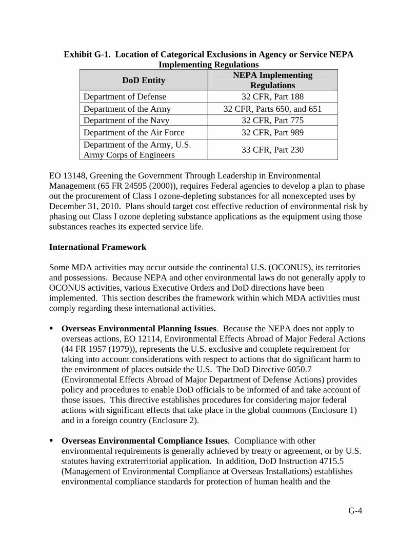
Exhibit G-1. Location of Categorical Exclusions in Agency or Service NEPA Implementing Regulations
DoD Entity NEPA Implementing Regulations
Department of Defense 32 CFR, Part 188 Department of the Army 32 CFR, Parts 650, and 651 Department of the Navy 32 CFR, Part 775 Department of the Air Force 32 CFR, Part 989 Department of the Army, U.S. Army Corps of Engineers 33 CFR, Part 230
EO 13148, Greening the Government Through Leadership in Environmental Management (65 FR 24595 (2000)), requires Federal agencies to develop a plan to phase out the procurement of Class I ozone-depleting substances for all nonexcepted uses by December 31, 2010. Plans should target cost effective reduction of environmental risk by phasing out Class I ozone depleting substance applications as the equipment using those substances reaches its expected service life. International Framework Some MDA activities may occur outside the continental U.S. (OCONUS), its territories and possessions. Because NEPA and other environmental laws do not generally apply to OCONUS activities, various Executive Orders and DoD directions have been implemented. This section describes the framework within which MDA activities must comply regarding these international activities. Overseas Environmental Planning Issues. Because the NEPA does not apply to
overseas actions, EO 12114, Environmental Effects Abroad of Major Federal Actions (44 FR 1957 (1979)), represents the U.S. exclusive and complete requirement for taking into account considerations with respect to actions that do significant harm to the environment of places outside the U.S. The DoD Directive 6050.7 (Environmental Effects Abroad of Major Department of Defense Actions) provides policy and procedures to enable DoD officials to be informed of and take account of those issues. This directive establishes procedures for considering major federal actions with significant effects that take place in the global commons (Enclosure 1) and in a foreign country (Enclosure 2).
Overseas Environmental Compliance Issues. Compliance with other
environmental requirements is generally achieved by treaty or agreement, or by U.S. statutes having extraterritorial application. In addition, DoD Instruction 4715.5 (Management of Environmental Compliance at Overseas Installations) establishes environmental compliance standards for protection of human health and the
G-4
environment at DoD installations in foreign countries. Under this authority, the DoD has established an Overseas Environmental Baseline Guidance Document, which is a set of standards designed to protect human health and the environment. The Overseas Environmental Baseline Guidance Document and applicable international agreements constitute compliance requirements for DoD activities outside the U.S.
To further this process, the DoD designates an Environmental Executive Agent where the level of DoD presence justifies such a designation. The Environmental Executive Agent establishes Final Governing Standards, which are a comprehensive set of country-specific substantive provisions (i.e. effluent limitations, specific management practices), by comparing the Overseas Environmental Baseline Guidance Document with applicable host-national or international standards. The EEA typically uses the more protective standard in establishing Final Governing Standards. Once established, the Final Governing Standards constitute the environmental compliance requirements for military activities overseas.
Air Quality
United States The Clean Air Act (42 U.S.C. 7401) requires the adoption of primary and secondary National Ambient Air Quality Standards (NAAQS) to protect the public health, safety, and welfare from known or anticipated effects of the identified criteria air pollutants. The primary standards were established to protect public health with an adequate margin of safety, while the secondary standards were intended to protect the public welfare from any known or anticipated adverse effects of a pollutant (e.g., plant life, cultural monuments, and wildlife). These threshold levels were determined based on years of research on the health effects of various concentrations of pollutants on biological organisms. Exhibit G-2 summarizes the primary and secondary NAAQS. The Clean Air Act gives state and local authorities the responsibility to ensure regional attainment of the standards. To further define local and regional air quality, the Environmental Protection Agency (EPA) designates areas with air quality better than the NAAQS as attainment areas, and areas with worse air quality as non-attainment areas. These classifications generally are based on air quality monitoring data collected at certain sites in the state. The criteria for non-attainment designation vary by pollutant. An area is in non-attainment for ozone if its NAAQS has been exceeded more than three discontinuous times in three years at a single monitoring station. An area is in non-attainment for any other pollutant if its NAAQS has been exceeded more than once per year. Some areas are unclassified because insufficient data exist to characterize the area;
G-5

Exhibit G-2. National Ambient Air Quality Standards
Standardsa
Pollutant Averaging Time Concentration Primary
b,cConcentration Secondary
b,d
1 hour 0.12 ppme (235 µg/m3)
f Same as primary Ozone 8 hour 0.08 ppm (157 µg/m3) Same as primary 8 hour 9.0 ppm (10 mg/m3)
g --- Carbon monoxide (CO) 1 hour 35 ppm (40 mg/m3) --- Nitrogen dioxide (NO2)
Annual arithmetic mean 0.053 ppm (100 µg/m3) Same as primary
1 hour --- ---
3 hours --- 0.5 ppm (1,300 µg/m3)
24 hour 0.14 ppm (365µg/m3) --- Sulfur dioxide (SO2)
Annual (arithmetic mean) 0.03 ppm (80 µg/m3) ---
24 hour 150 µ/m3 Same as primary Particulate matter as PM10
Annual (arithmetic mean) 50 µg/m3 Same as primary
24 hour 65 µg/m3 Same as primary Particulate matter as PM2.5
Annual (arithmetic mean) 15 µg/m3 Same as primary
Quarterly average 1.5 µg/m3 Same as primary Lead 30-day average --- ---
Source: EPA, 2003f
a These standards, other than for ozone, PM, and those based on annual averages, must not be exceeded more than once per year. The eight-hour ozone standard is attained when the fourth highest eight-hour concentration in a year, averaged over three years, is equal to or less than the standard. For PM10, the 24-hour standard is attained when the expected number of days per calendar year with a 24-hour average concentration above the standard is equal to or less than one. For PM2.5, the 24-hour standard is attained when 98 percent of the daily concentrations, averaged over three years, are equal to or less than the standard. b Concentration is expressed first in units in which it was adopted and is based on a reference temperature of 25°Celsius (°C ) (77 °Fahrenheit [°F]) and a reference pressure of 760 millimeters (1,013.2 millibars) of mercury. All measurements of air quality must be corrected to a reference temperature of 25°C (77 °F) and a reference pressure of 760 millimeters (1,013.2 millibars) of mercury. Parts per million (ppm) in this exhibit refers to parts per million by volume or micromoles of pollutant per mole of gas. c National primary standards are the levels of air quality necessary, with an adequate margin of safety, to protect the public health. d National secondary standards are the levels of air quality necessary to protect the public welfare from any known or anticipated adverse effects of a pollutant. e Parts per million by volume or micromoles per mole of gas f Micrograms per cubic meter g Milligrams per cubic meter
G-6
other areas are deemed maintenance areas. Maintenance areas are regions where NAAQS were exceeded in the past, and are subject to restrictions specified in a State Implementation Plan (SIP)-approved maintenance plan to preserve and maintain the newly regained attainment status. The Clean Air Act requires the preparation of a SIP that describes how the state will meet or attain the NAAQS. The SIP contains emission limitations as well as record keeping and reporting requirements for affected sources. As a result of the Clean Air Act Amendments, the requirements and compliance dates for reaching attainment are based on the severity of the air quality standard violation. Section 176(c)(1) of the Clean Air Act mandates the general conformity rule. This requirement is further implemented in 40 CFR parts 51 and 93. The general conformity rule prohibits the Federal government from conducting, supporting or approving any actions that do not conform to an approved Clean Air Act SIP. Federal agencies are required to perform a conformity review for federal actions taking place in a region designated non-attainment for a particular pollutant, or in a maintenance area. The U.S. Federal government is exempt from the requirement to perform a conformity analysis if two conditions are met. 1. The ongoing activities do not produce emissions above the de minimis levels
specified in the rule. Exhibit G-3 shows the de minimis threshold levels of various non-attainment areas.
2. The Federal action is not considered a regionally significant action. A Federal action
is considered regionally significant when the total emissions from the action equal or exceed ten percent of the air quality control area’s emissions inventory for any criteria pollutant.
The EPA considers emissions at or below 914 meters (3,000 feet) to evaluate ambient air quality and calculate de minimis levels. Air quality modeling is used to determine the effects of air emission sources on the ambient air concentrations. The types and amounts of pollutants, the topography of the air basin, and the prevailing meteorological parameters that most often affect pollutant dispersions are wind speed, wind direction, atmospheric stability, mixing height, and temperature.
G-7
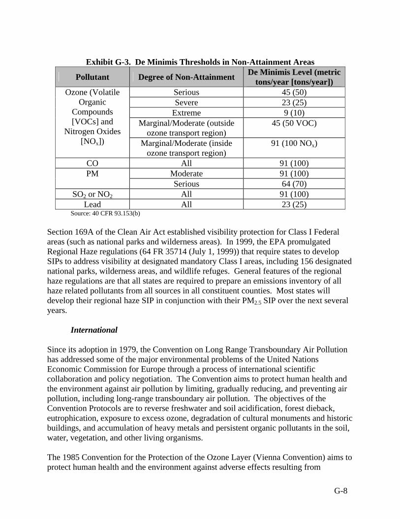
Exhibit G-3. De Minimis Thresholds in Non-Attainment Areas
Pollutant Degree of Non-Attainment De Minimis Level (metric tons/year [tons/year])
Serious 45 (50) Severe 23 (25)
Extreme 9 (10) Marginal/Moderate (outside
ozone transport region) 45 (50 VOC)
Ozone (Volatile Organic
Compounds [VOCs] and
Nitrogen Oxides [NOx]) Marginal/Moderate (inside
ozone transport region) 91 (100 NOx)
CO All 91 (100) Moderate 91 (100) PM Serious 64 (70)
SO2 or NO2 All 91 (100) Lead All 23 (25)
Source: 40 CFR 93.153(b) Section 169A of the Clean Air Act established visibility protection for Class I Federal areas (such as national parks and wilderness areas). In 1999, the EPA promulgated Regional Haze regulations (64 FR 35714 (July 1, 1999)) that require states to develop SIPs to address visibility at designated mandatory Class I areas, including 156 designated national parks, wilderness areas, and wildlife refuges. General features of the regional haze regulations are that all states are required to prepare an emissions inventory of all haze related pollutants from all sources in all constituent counties. Most states will develop their regional haze SIP in conjunction with their PM2.5 SIP over the next several years.
International Since its adoption in 1979, the Convention on Long Range Transboundary Air Pollution has addressed some of the major environmental problems of the United Nations Economic Commission for Europe through a process of international scientific collaboration and policy negotiation. The Convention aims to protect human health and the environment against air pollution by limiting, gradually reducing, and preventing air pollution, including long-range transboundary air pollution. The objectives of the Convention Protocols are to reverse freshwater and soil acidification, forest dieback, eutrophication, exposure to excess ozone, degradation of cultural monuments and historic buildings, and accumulation of heavy metals and persistent organic pollutants in the soil, water, vegetation, and other living organisms. The 1985 Convention for the Protection of the Ozone Layer (Vienna Convention) aims to protect human health and the environment against adverse effects resulting from
G-8
modifications of the ozone layer, especially from increased ultraviolet solar radiation. It requires that states reduce their reliance on ozone-depleting substances and conduct collaborative research to find alternatives to harmful substances such as chlorofluorocarbons and halons. The Montreal Protocol on Substances that Deplete the Ozone Layer was developed under the guidance of the United Nations Environmental Program in September 1987 and based on the recommendations of the Vienna Convention. The Montreal Protocol identifies the main ozone-depleting substances and specifies a timetable for phasing out the consumption and production of ozone depleting substances. Title VI of the Clean Air Act Amendments of 1990 establishes phase out requirements for ozone depleting substances consistent with the Montreal Protocol. The United Nations Framework Convention on Climate Change, an international agreement for addressing climate change, was adopted at the United Nations Conference on Environment and Development (Earth Summit) in Rio de Janeiro, Brazil, in 1992. The framework aims to regulate levels of greenhouse gas concentrations in the atmosphere. Airspace
United States Airspace management and use in the U.S. are governed by the Federal Aviation Act of 1958 (Public Law 85-725) and its implementing regulations set forth by the Federal Aviation Administration (FAA). FAA Order 7490, “Policies and Procedures for Air Traffic Environmental Actions,” includes procedures and guidance for coordination between FAA and DoD on environmental issues regarding special use airspace. FAA Order 7610.4H, “Special Military Operations,” specifies procedures for air traffic control planning, coordination, and services during defense activities, and special military operations conducted in airspace controlled by or under the jurisdiction of the FAA. The U.S. airspace is divided into 21 zones (centers), and each zone is divided into sectors. Also within each zone are portions of airspace, about 81 kilometers (50 miles) in diameter, called Terminal Radar Approach Control airspaces. Multiple airports exist within each of these airspaces, and each airport has its own airspace with an eight-kilometer (five-mile) radius.
G-9
International For international airspace, the procedures of the International Civil Aviation Organization (ICAO) are followed. These procedures are outlined in ICAO Document 444, “Rules of the Air and Air Traffic Services.” The ICAO ensures the safe, efficient, and orderly evolution of international civil aviation through the establishment of international standards and recommended practices. Biological Resources
United States The Endangered Species Act of 1973 (16 U.S.C. 1531) requires all Federal departments and agencies to seek to conserve endangered species and threatened species. The Secretary of the Interior was directed to create lists of endangered and threatened species. Endangered species designation is given to any plant or animal species that is in danger of extinction throughout all or a significant portion of its range. The Act defines a threatened species as any species that is likely to become an endangered species within the foreseeable future throughout all or a significant portion of its range. Critical habitat for a threatened or endangered species is defined as specific areas, within the geographical area occupied by the species at the time it is listed, which contain the physical or biological features essential to conservation of the species and may require special management considerations or protection. Critical habitat also includes specific areas, outside the geographic area occupied by the species at the time it is listed, which are essential to conservation of the species. The National Defense Authorization Act for Fiscal Year 2004 (Public Law 108-136, Section 318) amended the Endangered Species Act to allow the Secretary of the Interior to exempt DoD sites from critical habitat designations if an adequate natural resources management plan is in place at the sites. A key provision of the Endangered Species Act for Federal activities is Section 7, Consultation. Under Section 7 of the Act, every Federal agency must consult with the Secretary of the Interior, U.S. Fish and Wildlife Service (USFWS), to ensure that an agency action is not likely to jeopardize the continued existence of any endangered or threatened species or result in the destruction or adverse modification of habitat of such species. Under the Act, if a threatened or endangered species may be affected, a biological assessment is required to determine the impact. The Fish and Wildlife Coordination Act of 1958 (16 U.S.C. 661) requires Federal agencies to consult with the USFWS and state wildlife agencies where any water body or wetlands under U.S. Army Corps of Engineers jurisdiction is proposed to be modified by a Federal agency.
G-10

The Migratory Bird Treaty Act of 1918 (16 U.S.C. 703-712) protects migratory waterfowl and all seabirds. Specifically, the Act prohibits the pursuit, hunting, taking, capture, possession, or killing of such species or their nests and eggs. The USFWS Division of Migratory Bird Management develops migratory bird permit policy. The regulations governing migratory bird permits can be found in General Permit Procedures (50 CFR 13) and Migratory Bird Permits (50 CFR 21). Most states require a state permit for activities involving migratory birds (USFWS, 2002). Taking of migratory birds by Federal agencies is governed by EO 13186, Responsibilities of Federal Agencies To Protect Migratory Birds (66 FR 3853 (January 17, 2001)), which requires Federal agencies taking actions that have, or are likely to have, a measurable negative effect on migratory bird populations to develop and implement a Memorandum of Understanding with the USFWS that promotes the conservation of migratory bird populations. The Marine Mammal Protection Act of 1972 (16 U.S.C. 1361) outlines prohibitions for the taking of marine mammals. The Act gives the USFWS and the National Oceanic & Atmospheric Administration (NOAA) Fisheries (formerly the National Marine Fisheries Service) co-authority to protect the resource. The Marine Mammal Commission, which was established under the Act, reviews laws and international conventions, studies worldwide populations, and makes recommendations to Federal officials concerning marine mammals. The National Defense Authorization Act for Fiscal Year 2004 amended the Marine Mammal Protection Act to redefine harassment as activities that “injure, disturb or are likely to disturb” marine mammals. This new standard applies to DoD actions and research done by or for the Federal government. In addition, the amendments grant the DoD an exemption from the Marine Mammal Protection Act for actions “necessary for national defense” as determined by the Secretary of Defense. The Marine Protection, Research, and Sanctuaries Act (33 U.S.C. 1401) regulates the disposal of all materials into the ocean to prevent adverse effects to human welfare, the marine environment, ecological systems, or the economy. It provides the EPA with the authority to issue permits for ocean dumping. The Bald and Golden Eagle Protection Act (16 U.S.C. 668) establishes penalties for the unauthorized taking, possession, selling, purchase, or transportation of bald or golden eagles, their nests, or their eggs. If a Federal activity might disturb eagles or a nest is found in areas where activities for the proposed BMDS may occur, consultation with the USFWS for appropriate mitigation is required. The National Wildlife Refuge System Administration Act of 1966 (16 U.S.C. 668dd-668ee) consolidates the categories of lands that are administered by the Secretary of the Interior for the conservation of fish and wildlife, including species that are threatened with extinction. Provisions of the Act relating to determinations of the compatibility of a use shall not apply to overflights above a refuge or activities authorized, funded, or conducted by a Federal agency (other than USFWS) that has primary jurisdiction over a
G-11
refuge or a portion of a refuge, if the management of those activities is in accordance with a memorandum of understanding between the Secretary/Director and the head of the Federal agency with primary jurisdiction over the refuge governing the use of the refuge. The Magnuson–Stevens Fishery Conservation and Management Act (16 U.S.C. 1801) requires Federal agencies to consult with NOAA Fisheries on activities that could harm Essential Fish Habitat areas. Essential Fish Habitat refers to “those waters and substrate (sediment, hard bottom) necessary to fish for spawning, breeding, feeding, or growth to maturity.” The Fish and Wildlife Conservation Act of 1980 (16 U.S.C. 2901-2912) provides for financial and technical assistance to states to develop conservation plans, subject to approval by the Department of Interior, and implement state programs for fish and wildlife resources. The Act also encourages all Federal departments and agencies to utilize their statutory and administrative authority to conserve and promote conservation of non-game fish and wildlife and their habitats. The Sikes Act (Conservation Programs on Military Installations) (16 U.S.C. 670) requires the Secretary of each military department to carry out a program for the conservation, restoration, and management of ecosystem, wildlife, and fishery resources on military reservations. Federal and state fish and wildlife agencies are given priority for managing these resources and a cooperative plan must be implemented to sell or lease land or forest products. The National Defense Authorization Act for Fiscal Year 2004 amendments authorize the Secretary of the Interior to exempt DoD land from critical habitat designation where the Secretary finds that the natural resources plan prepared pursuant to the Sikes Act provides a benefit to the species for which the critical habitat designation is proposed. EO 8646, Establishing the San Andres National Wildlife Refuge, New Mexico (6 FR 592 (1941)), creates the San Andres National Wildlife Refuge, an area that provides habitat for a variety of sensitive species, for the conservation and development of natural wildlife resources. EO 11990, Protection of Wetlands (42 FR 26961 (1977)), requires Federal agencies to provide leadership and work to minimize the destruction, loss, and degradation of wetlands and to preserve and enhance the natural and beneficial values of wetlands while carrying out the agency’s responsibility for acquiring, managing, using, and disposing of Federal lands. The National Defense Authorization Act for Fiscal Year 2004 authorizes the Federal government to participate in mitigation banks for wetlands. The mitigation banks allow developers to fill wetlands in one area in exchange for a payment to create wetlands in another area.
G-12
EO 13061, Federal Support of Community Efforts Along American Heritage Rivers (62 FR 48445, 1997), requires Federal agencies to preserve, protect, and restore rivers designated American Heritage Rivers, including their natural resources and associated historical, cultural, and economic resources. EO 13089, Coral Reef Protection (63 FR 32701 (1998)), requires all Federal agencies to “identify their actions that may affect U.S. coral reef ecosystems; utilize their programs and authorities to protect and enhance the conditions of such ecosystems; and to the extent permitted by law, ensure that any actions they authorize, fund, or carry out will not degrade the conditions of such ecosystems.” EO 13112, Invasive Species (64 FR 6183 (1999)), directs the prevention of invasive species introduction and provides means for their control to minimize economic, ecological, and human health impacts they may cause. EO 13178, Northwestern Hawaiian Islands Coral Reef Ecosystem Reserve (65 FR 76903 (2000)), establishes the Northwestern Hawaiian Island Coral Reef Ecosystem Reserve, which lies to the northwest of the main islands of the Hawaiian chain, to “ensure the comprehensive, strong, and lasting protection of the coral reef ecosystem and related marine resources and species (resources) of the Northwestern Hawaiian Islands.” The Natural Resources Management Program (DoD Directive 4700.4) instructs DoD to show active concern for natural resource value in all its efforts to achieve military missions. Under this directive, DoD must inform key decision-makers of potential conflicts between military and conservation actions. The DoD Memorandum of Understanding to Follow the Ecosystem Approach (1995) asserts that Federal agencies should provide a leadership role in working with landowners and communities to sustain and restore the health, productivity, and biodiversity of ecosystems. The ecosystem approach should be integrated with social and economic goals in a way that improves the overall quality of life.
International The Convention on Wetlands of International Importance Especially as Waterfowl Habitat, or Ramsar Convention, has been in force since 1975 and aims to stem the progressive encroachment on and loss of wetlands, now and in the future. It requires its Parties to designate at least one national wetland of international importance; establish wetlands nature reserves and cooperate in information exchange for wetlands management; assess the impacts of any changes in use on identified wetland sites; and take responsibility for conservation, management, and wise use of migratory stocks of waterfowl.
G-13
The 1986 Convention for the Protection of the Natural Resources and Environment of the South Pacific Region is a comprehensive, umbrella agreement for the protection, management, and development of the marine and coastal environment of the South Pacific Region. Sources of pollution that require control under SPREP are ships, dumping, land-based sources, seabed exploration and exploitation, atmospheric discharges, storage of toxic and hazardous wastes, testing of nuclear devices, mining, and coastal erosion. Cultural Resources Numerous laws and regulations require that possible effects on cultural resources be considered during the planning and execution of Federal undertakings. These laws and regulations stipulate a process of compliance, define the responsibilities of the Federal agency proposing the action, and prescribe the relationship among other involved agencies (e.g., State Historic Preservation Officer, the Advisory Council on Historic Preservation). The National Historic Preservation Act (16 U.S.C. 470f and 470h-2(a)) establishes a national policy to preserve, restore, and maintain cultural resources. The Act establishes the National Register of Historic Places as the mechanism to designate public or privately owned properties deserving protection. Federal agencies must take into account the effect of a project on any property included in or eligible for inclusion in the National Register. The Native American Graves Protection and Repatriation Act (25 U.S.C. 3001) is triggered by the possession of human remains or cultural items by a federally funded repository or by the discovery of human remains or cultural items on Federal or tribal lands. It provides for the inventory, protection, and return of cultural items to affiliated Native American groups. Permits are required for intentional excavation and removal of Native American cultural items from Federal or tribal lands. The Act includes provisions that, upon inadvertent discovery of remains, the action will cease in the area where the remains were discovered, and the responsible official will protect the materials and notify the appropriate lands management agency. The Archaeological Resources and Protection Act (16 U.S.C. 470aa - 470mm) ensures the protection of archaeological sites on Federal land. It requires Federal permits to be obtained before cultural resource investigations begin at sites on Federal land and investigators to consult with the appropriate Native American groups prior to initiating archaeological studies on sites of Native American origin. The American Indian Religious Freedom Act (42 U.S.C. 1996) states that it is the policy of the U.S. to protect and preserve for American Indians their inherent right of freedom to believe, express, and exercise the traditional religions including but not limited to access
G-14

to sites, use and possession of sacred objects, and the freedom to worship through ceremonial and traditional rites. The Antiquities Act of 1906 (16 U.S.C. 431) was the first piece of historic preservation legislation, and it protects sites and objects of antiquity, including historic landmarks, historic and prehistoric structures, and other objects of historic or scientific interest that are situated upon lands owned or controlled by the U.S. The Act prohibits excavation or destruction of such antiquities unless a permit is obtained. Antiquity permits issued under this law are still in effect, though new permits are now being issued under the Archaeological Resources Protection Act of 1979 (16 U.S.C. § 470aa-mm) and its implementing regulations (43 CFR 7). These regulations enable Federal land managers to protect archaeological resources, taking into consideration provisions of the American Indian Religious Freedom Act (42 U.S.C. 1996), through permits authorizing excavation and/or removal of archaeological resources, through civil penalties for unauthorized excavation and/or removal, through provisions for the preservation of archaeological resource collections and data, and through provisions for ensuring confidentiality of information about archaeological resources when disclosure would threaten the archaeological resources. EO 13007, Indian Sacred Sites (61 FR 26771 (1996)), requires each executive branch that manages Federal lands, whenever practicable and permitted by law, to accommodate access to and ceremonial use of Indian sacred sites by Indian religious practitioners and to avoid adversely affecting the physical integrity of such sacred sites. EO 13287, Preserving America (68 FR 10635 (2003)) establishes Federal policy to provide leadership in preserving America's heritage by actively advancing the protection, enhancement, and contemporary use of the historic properties owned by the Federal Government, and by promoting intergovernmental cooperation and partnerships for the preservation and use of historic properties. Environmental Justice EO 12898, Federal Actions to Address Environmental Justice in Minority Populations and Low-Income Populations (56 FR 7629 (1994)) requires each Federal agency to identify and address, as appropriate, “disproportionately high and adverse human health and environmental effects on minority and low-income populations.” The demographics of the affected area should be examined to determine whether minority populations or low-income populations are present in the area impacted by the proposed action. If so, a determination must be made whether the implementation of the proposed action may cause disproportionately high and adverse human health or environmental effects on those populations.
G-15
Geology and Soils Although there are no Federal regulations pertaining specifically to geology and soils in areas where activities for the proposed BMDS may occur, some water quality regulations are indirectly related with respect to erosion and resultant turbidity (mixing) in surface waters (Clean Water Act sections 402 and 405 National Pollutant Discharge Elimination System (NPDES) permitting program, codified at 40 U.S.C. 1342 and 1345, respectively), avoidance of development in floodplains (EO 11988, Floodplain Management), and spill response plans to ensure that ground water is not adversely impacted. (U.S. Army Space and Missile Defense Command, 2003) Several states and counties have regulations or ordinances in place to protect and mitigate impacts to soils. Such regulations and procedures include best management practices, which typically are outlined in sediment and erosion control handbooks (e.g. Virginia Erosion and Sediment Control Handbook). The Best Management Practices outlined in the state and local handbooks are designed to address the storm water run-off and water quality criteria specified in the CWA. (See discussion under Water Resources.) Hazardous Materials and Hazardous Waste
United States The Comprehensive Environmental Response, Compensation, and Liability Act (CERCLA), or Superfund, (42 U.S.C. 9601) creates authority and procedures for conducting emergency responses, removal, and remediation actions at sites requiring a cleanup of releases of hazardous substances. The Act specifies standards of liability and provides procedures for determining compensation, reportable quantities of releases of hazardous substances, penalties, employee protection, claims procedures, and cleanup standards. The Superfund Amendment and Reauthorization Act of 1986 revised and extended CERCLA in 1986. SARA Title III, the Emergency Planning and Community Right To Know Act, provides for emergency planning and preparedness, community right-to-know reporting, and toxic chemical release reporting. The Act requires information about hazardous materials be provided to state and local authorities, including material safety data sheets, emergency and hazardous chemical inventory forms, and toxic chemical release reports. Resource Conservation and Recovery Act (RCRA), or Solid Waste Disposal Act, (42 U.S.C. 6901) authorizes the EPA to regulate the generation, storage, and disposal of hazardous wastes. RCRA also applies to underground storage tanks and establishes a “cradle-to-grave” or life cycle system of requirements for managing hazardous waste, from generation to eventual disposal.
G-16
The Pollution Prevention Act of 1990 (42 U.S.C. 13101) defines pollution prevention as source reduction and other practices that reduce or eliminate the creation of pollutants. It requires the EPA to develop standards for measuring waste reduction, serve as an information clearinghouse, and provide matching grants to state agencies to promote pollution prevention. Facilities with more than ten employees that manufacture, import, process, or otherwise use any chemical listed in and meeting threshold requirements of the Emergency Planning and Community Right To Know Act must file a toxic chemical source reduction and recycling report. The Hazardous Materials Transportation Act of 1975 (49 U.S.C. 1801) gives the Department of Transportation (DOT) authority to regulate shipments of hazardous substances by air, highway, or rail. These regulations may govern any safety aspect of transporting hazardous materials, including packing, repacking, handling, labeling, marking, placarding, and routing (other than with respect to pipelines). The Ocean Dumping Act (33 U.S.C. 1401) imposes restrictions on what items and substances may be dumped into the open ocean. To protect the marine environment, the Act restricts dumping to designated locations and strictly prohibits dumping of materials such as biological warfare substances. The U.S. Coast Guard conducts surveillance as a regulatory enforcement measure. The Oil Pollution Act of 1990 (33 U.S.C. 2701) requires oil storage facilities and vessels to submit to the Federal government plans detailing how they will respond to large discharges. The Oil Pollution Act requires the Federal government to “ensure effective and immediate removal of a discharge, and mitigation or prevention of a substantial threat of a discharge, of oil or a hazardous substance” into the navigable waters of the U.S., adjoining shorelines, and the exclusive economic zone. The Act requires the development of Area Contingency Plans to prepare and plan for oil spill response on a regional scale. The Toxic Substances Control Act of 1976 (15 U.S.C. 2601) gives the EPA authority to require testing of new and existing chemical substances entering the environment and the authority to regulate these substances. Section 6 of the Act specifically addresses, among others, polychlorinated biphenyls and asbestos. EO 12856, Federal Compliance with Right-to-Know Laws and Pollution Prevention Requirements (58 FR 41981 (1993)), requires the head of each Federal agency to develop and implement a written pollution prevention strategy that aims to minimize release of toxic chemicals to the environment and report in a public manner toxic chemicals entering the waste stream of the agency. This order relates to compliance with the Emergency Planning and Community Right To Know Act and the Pollution Prevention Act.
G-17
International The Convention on the Prevention of Marine Pollution by Dumping of Wastes and Other Matter, generally known as the London Dumping Convention, was adopted in 1972. Its objective is to control pollution of the sea caused by dumping and to encourage regional agreements supplementary to the Convention. It prohibits the dumping of certain hazardous materials, requires a prior special permit for the dumping of a number of other identified materials, and requires a prior general permit for other wastes or matter. “Dumping” has been defined as the deliberate disposal at sea of wastes or other matter from vessels, aircraft, platforms or other man-made structures, as well as the deliberate disposal of these vessels or platforms themselves. Discharges of spent stages from missiles and of residual propellants are part of the normal operation of launch vehicles, and therefore are not covered by the London Dumping Convention or other related agreements. The U.S. is party to the Protocol of 1978 Relating to the International Convention for the Prevention of Pollution from Ships of 1973 as Amended (MARPOL) and Annexes I, II, III, and IV to MARPOL. Normal debris released by missiles after launch is not covered by MARPOL, as this agreement applies to ships. After lift-off from the launch pad, vehicles and their payloads are not ships within the meaning of MARPOL. The 1989 Convention on the Control of Transboundary Movements of Hazardous Wastes and their Disposal (Basel Convention) aims to establish obligations for State Parties with the objective of reducing transboundary movements of wastes subject to the Basel Convention to a minimum consistent with the environmentally sound and efficient management of such wastes; minimizing the amount and toxicity of hazardous wastes generated and ensuring their environmentally sound management (including disposal and recovery operations) as close as possible to the source of generation; and assisting developing countries in environmentally sound management of the hazardous and other wastes they generate. Hazardous wastes shall be exported only if the state of export does not have the technical capacity and facilities to dispose of them in environmentally sound management. Health and Safety Regulatory requirements related to the Occupational Safety and Health Act of 1970 (29 U.S.C. 651 et seq.) have been codified in the General Industry Standards (29 CFR 1910) and Construction Industry Standards (29 CFR 1926). The regulations specify equipment, performance, and administrative requirements necessary for compliance with Federal occupational safety and health standards, and apply to all occupational (workplace) situations in the U.S. The requirements are monitored and enforced by the Occupational
G-18
Safety and Health Administration (OSHA), which is a part of the U.S. Department of Labor. The Occupational Safety and Health Standards regulations (29 CFR 1910) address electrical and mechanical safety and work procedures, sanitation requirements, life safety requirements (such as fire and evacuation safety and emergency preparedness), design requirements for certain types of facility equipment (such as ladders and stair lifting devices), mandated training programs (such as employee Hazard Communication training and use of powered industrial equipment), and record-keeping and program documentation requirements. For any construction or construction-related activities, additional requirements specified in the Safety and Health Regulations for Construction (29 CFR 1926) also apply. The Safe Drinking Water Act provides the EPA with the authority to set standards for drinking water quality and oversee states, localities, and water suppliers who implement those standards. Additional information on the Safe Drinking Water Act can be found in Section 3.1.15, Water Resources. RCRA gave the EPA the authority to control hazardous waste from “cradle-to-grave.” This includes generation, transportation, treatment, storage, and disposal of hazardous waste. Additional information on RCRA can be found in Section 3.1.7, Hazardous Materials and Hazardous Waste. The Federal Water Pollution Control Act, as amended by the Clean Water Act of 1977 (33 U.S.C. 1251) has special enforcement provisions for oil and hazardous substances. For example, the Spill Prevention Control and Countermeasure (SPCC) Plan covers the release of hazardous substances, as identified by EPA, which could reasonably be expected to discharge into the waters of the U.S. Additional information on the Clean Water Act can be found in Section 3.1.15, Water Resources. Requirements pertaining to the safe shipping and transport handling of hazardous materials, which can include hazardous chemical materials and explosives, are found in the DOT Hazardous Materials Regulations and Motor Carrier Safety Regulations. (49 CFR parts 107, 171-180 and 390-397) These regulations specify all requirements that must be observed for shipment of hazardous materials over highways or by air. Requirements include those for specific packaging, material compatibility issues, permissible vehicle/shipment types, vehicle marking, driver training and certification, and notification. Safety and Health Regulations for Marine Terminals (29 CFR 1917) apply to employment within a marine terminal including the loading, unloading, movement or other handling of cargo, ship's stores, or gear within the terminal or into or out of any land carrier, holding or consolidation area, and any other activity within and associated
G-19
with the overall operation and functions of the terminal, such as the use and routine maintenance of facilities and equipment. Cargo transfers accomplished with the use of shore-based material handling devices also are regulated. Safety and Health Regulations for Longshoring (29 CFR 1918) applies to longshoring operations and related employments aboard marine vessels. EO 13045, Protection of Children from Environmental Health Risks and Safety Risks (62 FR 19885 (1997)), as amended by EO 13229 (66 FR 52013 (2001)) and EO 13296 (68 FR 19931 (2003)), provides for the consideration of potential environmental effects from federal actions on health and safety risks that may disproportionately affect children. Defense Directive 3200.11, Major Range and Test Facility Base, provides the framework under which the national ranges operate and provide services to range users. Range Commanders Council (RCC) Standard 321-02, Common Risk Criteria for National Test Ranges, sets requirements for minimally acceptable risk criteria to occupational and non-occupational personnel, test facilities, and non-military assets during range operations. Methodologies for determining risk also are set forth. RCC 319-92, Flight Termination System Commonality Standards, specifies performance requirements for flight termination systems used on various flying weapons systems. DoD 6055.9-STD, DoD Ammunition and Explosives Safety Standards describes appropriate safety measures to be followed during loading of missiles and propellants as required by DoD. Land Use
United States The Coastal Zone Management Act (16 U.S.C. 1451) seeks to preserve, protect, and restore coastal areas. Coastal areas include wetlands, floodplains, estuaries, beaches, dunes, barrier islands, coral reefs, and fish and wildlife and their habitat. All Federal agencies must assess whether their activities will affect a coastal zone and ensure, to the maximum extent possible, that the activities are consistent with approved state Coastal Zone Management Plans. The Farmland Protection Act of 1981 (7 U.S.C. 4201) is designed to require Federal agencies to consider alternatives to projects that would convert farmlands to nonagricultural use. The Act is limited to procedures to assure that the actions of Federal agencies do not cause U.S. farmland to be irreversibly converted to nonagricultural uses
G-20
in cases in which other national interests do not override the importance of the protection of farmland nor otherwise outweigh the benefits of maintaining farmland resources. The Wilderness Act of 1964 (16 U.S.C. 1131-1136) provides Congressional protection of several named wilderness areas and establishes a National Wilderness Preservation System for inclusion of lands within national forests, national parks, and national wilderness refuges. The Federal Land Policy and Management Act of 1976 (43 U.S.C. 1701) repeated a number of public land statutes and instituted a number of new programs including review of all lands managed by the Bureau of Land Management for possible designation by Congress as “wilderness,” including a stipulation that the Federal agency must manage the public lands so as not to impair their wilderness potential.
International The Convention on Environmental Impact Assessment in a Transboundary Context of 1991 aims to promote environmentally sound and sustainable economic development through the application of environmental impact assessment, especially as a preventive measure against transboundary environmental degradation. It stipulates the obligations of Parties to assess the environmental impact of certain activities at an early stage of planning. It also requires states to notify and consult each other on all major projects under consideration that are likely to have a significant adverse environmental impact across boundaries. Noise Federal and state governments have established noise regulations and guidelines for the purpose of protecting citizens from potential hearing damage and various other adverse physiological, psychological, and social effects associated with noise. The Federal government preempts the state on control of noise emissions from aircraft, helicopters, railroads, and interstate highways. The Noise Control Act (42 U.S.C. 4901) directs all Federal agencies, to the fullest extent within their authority, to carry out programs in a manner that promotes an environment that is free from noise. The act requires a Federal department or agency engaged in any activity resulting in the emission of noise to comply with Federal, state, interstate, and local requirements respecting control and abatement of environmental noise. OSHA regulations (29 CFR 1910.95) establish a maximum noise level of 90 A-weighted decibel (dBA) for a continuous eight-hour exposure during a workday and higher sound levels for a shorter time of exposure in the workplace. When information indicates that
G-21
an employee’s exposure may equal or exceed an eight-hour time-weighted average of 85 decibels (dB), the employer shall develop and implement a monitoring program. The DoD Noise–Land Use Compatibility Guidelines state that sensitive land use areas, such as residential areas, are incompatible with annual day/night average sound level (Ldn) greater than 65 dBA. Socioeconomics The CEQ implementing regulations for NEPA provide no specific thresholds of significance for socioeconomic impact assessment. Significance varies depending on the setting of the proposed action (40 CFR 1508.27(a)). However, 40 CFR 1508.8 states that indirect effects may include those that are growth inducing and others related to induced changes in the pattern of land use, population density, or growth rate. Transportation and Infrastructure Regulations pertaining to transportation are implemented by the DOT and are located in Title 49 of the CFR. Title 49 includes regulations applicable to railroads (49 CFR 200-299), highways (49 CFR 300-399; 49 CFR 500-599), coastal transportation (49 CFR 400-499), transportation safety (49 CFR 800-899), and surface transportation generally (49 CFR 1000-1199). In addition, the DOT oversees air transportation and the applicable regulations are located at Title 14 of the CFR. Utilities There are significant numbers of legal requirements that exist for utilities; however, these are most appropriately considered in action- and site-specific environmental analyses. Therefore they will not be included in this PEIS. Subsequent site-specific environmental analyses will examine the applicable legal requirements for utilities, including Federal, state, and local regulations. Visual and Aesthetic Resources There are no Federal aesthetics permits or regulations for visual resources applicable to the proposed action and alternatives. Local planning guidelines may be included in city and county general plans to preserve and enhance the visual quality and aesthetic resources within the plan’s jurisdiction. Protection of visual resources typically results from local zoning and building ordnances.
G-22
Water Resources The Clean Water Act (33 U.S.C. 1251) establishes water pollution control standards and programs with the objective of restoring and maintaining the chemical, physical, and biological integrity of U.S. water resources. The Act provides for the elimination of the discharge of pollutants into navigable waters and for water quality goals to protect fish and wildlife. The Act specifies (1) that actions must comply with Federal and state water quality criteria; (2) regulations for issuing permits under the NPDES for storm water discharge be established by the EPA; and (3) states assess non-point source water pollution problems and develop pollution management plans. Water quality and the consumption and diversion of water are regulated by a number of Federal and state agencies in the U.S. The EPA has the primary authority for implementing and enforcing the Clean Water Act. (33 U.S.C. 1251) The EPA, along with state agencies to which the EPA has delegated some of its authority, issues permits under the Clean Water Act to maintain and restore the quality of U.S. water resources. The Clean Water Act requires permits for activities that result in the discharge of pollutants to water resources or the placement of fill material in waters of the U.S. Storm water Pollution Prevention Plans (SWPPs) are typically prepared and permitted under the NPDES to ensure construction activities do not lead to unacceptable levels of erosion and water pollution. The Safe Drinking Water Act of 1974 (42 U.S.C. 300f) provides the EPA with the authority to regulate the quality of U.S. drinking water supplies, including surface water and ground water sources. The EPA has delegated some of its authority for enforcement to all of the states, with the exception of Wyoming and the District of Columbia. The appropriation of water, including diversions, consumption of potable water, and other uses usually is regulated by the same state agencies that regulate water quality. EO 11988, Floodplain Management (42 FR 26951 (1977)), requires Federal agencies to provide leadership and work to minimize the impacts of floods on property loss and human health and safety and simultaneously preserving the natural and beneficial values served by floodplains while carrying out the agency’s responsibility for acquiring, managing, using, and disposing of Federal lands.
G-23
Orbital Debris Executive Branch Policy Directive, National Space Policy (1996) directive provides guidance for orbital debris: “The U.S. will seek to minimize the creation of space debris. The National Aeronautics and Space Administration (NASA), the Intelligence Community and the DoD, in cooperation with the private sector, will develop design guidelines for future government procurements of spacecraft, launch vehicles and services. The design and operation of space tests, experiments and systems will minimize or reduce accumulation of space debris consistent with mission requirements and cost effectiveness.”
G-24

APPENDIX H
BIOME DESCRIPTIONS
BIOME DESCRIPTIONS
This Appendix provides detailed descriptions for each of the nine terrestrial biomes and the Broad Ocean Area (BOA) and the Atmosphere as discussed in Section 3, Affected Environment.
H.1 Arctic Tundra Biome
The Arctic Tundra Biome11 discussion encompasses the arctic coastal regions that border the North Atlantic Ocean and Arctic Ocean. This biome includes coastal portions of Alaska in the United States (U.S.), Canada, and Greenland (administered by Denmark). The majority of the Arctic Tundra Biome is located north of the latitudinal tree line and consists of the northern continental fringes of North America from approximately the Arctic Circle northward. For example, Thule Air Force Base (AFB), Greenland, which is located approximately 1,100 kilometers (700 miles) north of the Arctic Circle, is the northernmost installation where Missile Defense Agency (MDA) activities for the proposed Ballistic Missile Defense System (BMDS) may occur. The Arctic Tundra Biome includes other coastal locations that may be situated south of the Arctic Circle but have a climate and ecosystem similar to that of inland Arctic Tundra. These sites are located on the islands of the Aleutian chain and include Eareckson Air Station, Shemya Island, Alaska, and Port of Adak, Adak, Alaska.
H.1.1 Air Quality
Climate The Arctic Tundra Biome has very short, cool summers and long, severe winters. No more than 188 days per year, and sometimes as few as 55, have a mean temperature higher than 0°Celsius (°C) (32°Fahrenheit [°F]). On average, the frost-free period ranges from 40 to 60 days. The average annual temperature is -28°C (-18°F). Nights can last for weeks when the sun barely rises during winter months, and the temperature can drop to -70°C (-94°F). During the summer, the sun shines almost 24 hours per day and average summer temperatures range from 3oC to 16°C (37oF to 60°F). The climate of the Arctic Tundra Biome is characterized as polar maritime with persistent overcast skies, high winds, frequent and often violent storms, and a narrow range of temperature fluctuation throughout the year. Weather at these coastal sites tends to be localized. (U.S. Army Space and Missile Defense Command, 2003) Parts of the Arctic
11 Exhibit H-12 shows the global location of the Arctic Tundra ecosystem. However, based on reasonably foreseeable locations for activities for the proposed BMDS to occur, the affected environment highlights the coastal portions of this ecosystem.
H-1
Tundra may be classified as desert due to low precipitation. Annual precipitation is light, often less than 200 millimeters (eight inches). Most precipitation falls as snow in October through November. However, because potential evaporation also is very low, the climate tends to be humid. The Arctic Tundra also is characterized by high winds, which can blow between 48 to 97 kilometers (30 to 60 miles) per hour. The Aleutian Islands are a representative example of locations where activities for the proposed BMDS may occur, and persistent cloudy weather, fog, mist, drizzle, and rain borne on powerful driving winds characterize the climate of the Aleutian Islands. Cold ocean currents keep land temperatures consistently cool, even during the warmest summer weather. The mean daily temperature in the Aleutian Islands of 3.9°C (39°F) has an annual range of only ± 9.4°C (49°F). (U.S. Geologic Survey [USGS], 1999) The Aleutian Islands typically receive some form of precipitation every day of the year, which averages approximately 76 to 137 centimeters (30 to 54 inches) annually, usually in the form of rain. Local shifts and rapid changes in velocity characterize the wind conditions of sites located on the Aleutian Islands. Regional Air Quality Air quality in the Arctic Tundra Biome is considered good, however, some areas in and around urban centers are in non-attainment for carbon monoxide (CO). Mixing heights in the Arctic Tundra Biome adversely affect regional air quality and vary greatly depending on atmospheric conditions. The mixing height is highest during afternoon hours and lowest during the evening and early morning. Temperature inversions, which occur most often in the winter, may cause extended periods of low mixing heights. Low mixing heights adversely affect regional air quality. During episodes of cold winter weather, atmospheric inversions may trap contaminants and cause exceedances of U.S. National Ambient Air Quality Standards (NAAQS) or regional standards. The Aleutian Islands are located in an attainment area for ambient concentrations of air pollutants. Although there is little actual ambient air quality monitoring in the Aleutians, the climate of the islands is conducive to good air quality, except during times of very high winds and dry weather, when blowing, natural dust can occur. The wet conditions of these coastal regions help to reduce windblown dust. (U.S. Army Space and Missile Defense Command, 2003) Existing Emission Sources Major emissions sources associated with proposed BMDS activities in the Arctic Tundra Biome include boilers, engines, hush houses, gas stations, fuel handling, chemicals, generators, storage tanks, miscellaneous equipment, and prescribed burning/firefighter training. Title V Air permits are maintained or applications have been submitted for
H-2
some sites where proposed BMDS activities may occur. Existing natural emissions surrounding the Aleutian Islands stem primarily from regional volcanic activity. The Arctic Tundra region absorbs more carbon dioxide (CO2) than it releases. During the short summer, tundra plants absorb CO2 through photosynthesis and release CO2 through decomposition. However, due to the short, cool summer and freezing winter temperatures, plants cannot decompose. Remains of plants thousands of years old have been found in the tundra permafrost. In this way, the tundra traps the CO2 and removes it from the atmosphere. However, every year an area of tundra permafrost melts and is lost due to rising global temperatures. As the tundra permafrost melts, the plant mass decomposes and returns CO2 to the atmosphere.
H.1.2 Airspace
Controlled and Uncontrolled Airspace Airspace above U.S. military airfields in the Arctic Tundra Biome includes controlled airspace and operates under Instrument Flight Rules (IFR). Alaskan airspace is located within the Anchorage Oceanic Control Area/Flight Information Region and within the U.S. Alaskan Air Defense Identification Zone. The Anchorage Air Route Traffic Control Centers (ARTCC) controls Alaskan airspace. Communication and radar products are sent and received at the Anchorage Center via satellite, ground, and microwave transmitters and receivers. Due to the mountainous terrain, many areas have marginal to no communications and may lack radar coverage. The publication, Flight Tips for Pilots in Alaska, provides information to pilots flying to and within Alaska. It should be used in addition to the current Alaska Supplement, Sectional Aeronautical Charts, World Aeronautical Charts, Airmen's Information Manual, current Notices to Airmen (NOTAMs), and current weather briefings. The Arctic Tundra Biome also includes regions that are located in international airspace and therefore, the procedures of the International Civil Aviation Organization (ICAO) are followed. Flight plans, notifications, and itineraries are mandatory for all operations over Canadian terrain. Current NOTAMs should be obtained, as well as the Canadian Flight Supplement, which updates the aeronautical charts every 56 days and lists facility frequencies. In sparsely settled areas, Air Navigation Orders require aircraft to be equipped with certain radio and emergency equipment. In addition, the Transport Canada Aviation Group has designated a mandatory frequency for use at selected uncontrolled aerodromes or aerodromes that are uncontrolled during certain hours. The Danish Civil Aviation Administration is the authority in Greenland, where Thule AFB is located. Controlled airspace includes the Sondrestrom Flight Information Region for operations outside the shoreline of Greenland. Much of the airspace in Greenland is uncontrolled. With the exception of control zones and terminal control areas at
H-3
Sondrestrom Airport and Thule AFB, the Sondrestrom Flight Information Region is uncontrolled airspace below Flight Level (FL) 195. Special Use Airspace Alaska has some of the largest Military Operations Areas (MOAs) in the world. Much of Alaska's aviation activity takes place within existing MOAs, through a shared-use agreement, with information provided by the Special Use Airspace Information Service, which is a system operated by the U.S. Air Force (USAF) under agreement with the Federal Aviation Administration (FAA) Alaskan Region to assist pilots with flight planning and situational awareness while operating in or around MOAs or Restricted Areas in interior Alaska. The service provides a means for civil and USAF pilots to obtain information regarding activity of aircraft so that pilots can fly safely in those areas. Pilots must be aware of the hazards associated with sharing special use airspace with aircraft of vastly different capabilities, as civilian aircraft are considerably slower and less maneuverable than their military counterparts. In Canada, the Air Navigation Services and Airspace Services of Transport Canada are responsible for issues involved with airspace utilization and classification, levels of service for Air Navigation Service facilities, and services, including weather, navigation, radar, and communication services. Transport Canada issues NOTAMs regarding special use airspace and closures in Canada. In Greenland, the Danish Civil Aviation Administration issues NOTAMs regarding restricted airspace. Special use airspace typically involves military ranges. Airports/Airfields Civilian, military, and private airports exist in the Arctic Tundra Biome. There are five major civilian airports, over 650 other airports registered with the FAA, and more than 3,000 airstrips in Alaska, most of which are designed for small aircraft, such as single engine planes and helicopters. Most of the airports are owned and operated by the State of Alaska and certified by the FAA. However, many airports are private and not maintained on a regular basis. As a result, runway conditions may not be favorable at some airport locations. Existing military airfields, which have runways that are paved and in good condition, would be used to support activities for the proposed BMDS. The National Airports System of Canada is comprised of a core network of 26 airports that currently handles over 90 percent of all scheduled passenger and cargo traffic in Canada. These airports are the points of origin and destination for almost all inter-provincial and international air service in Canada. Locations of these airports include national, provincial, and territorial capitals, as well as airports that handle at least 200,000 passengers each year. Canada also has regional, local, military, and remote airports.
H-4
Greenland has both civilian and military airports, many of which are located in remote areas and have unpaved runways. Three airports in Greenland handle international flights, while the rest are used for air transportation between towns where ground transportation is not available.
En Route Airways and Jet Routes
Civilian aircraft generally fly along established flight corridors that operate under Visual Flight Rules (VFR). Numerous Minimum En route Altitudes are present in Alaska. Minimum En route Altitudes from 2,400 to 4,000 meters (8,000 to 13,000 feet) are common throughout the state, and in some areas they can be as high as 7,000 meters (23,000 feet). The Transport Canada Aviation Group and Danish Civil Aviation Administration establish Minimum En route Altitudes and other routes for Canada and Greenland, respectively.
H.1.3 Biological Resources
Vegetation Much of the Arctic Tundra Biome lies beyond the latitudinal tree line. As a result, vegetation on the Arctic Tundra consists of grasses, sedges, lichens, and willow shrubs. Tundra is characterized by treeless areas, which consist of dwarfed shrubs and miniature wildflowers adapted to a short growing season. At southern latitudes of the Arctic Tundra the vegetation changes into birch-lichen woodland and then into needleleaf forest. In some places, a distinct tree line separates forest from tundra. In the Arctic Tundra, the ground remains frozen beneath the top layer of soil, preventing trees from sending their roots down. Willows are able to grow on some parts of the Arctic Tundra, but only as low carpets about eight centimeters (three inches) high. Most plants grow in a dense mat of roots that has developed over thousands of years. Vegetation common to the Arctic Tundra region includes arctic moss (Calliergon giganteum), arctic willow (Salix arctica), bearberry (Arctostaphylos Uva-Ursi), caribou moss (Cladonia rangifernia), diamond-leaf willow (Salix pulcha), labrador tea (Ledum latifolium), pasque flower (Pulsatilla vulgaris), and tufted saxifrage (Saxifraga caespitosa). Wet meadows are extensive throughout the Arctic Tundra region. Despite low annual precipitation, lakes and ponds are abundant, and their margins in certain seasons are red with Arctic pendantgrass (Arctophila fulva). Wet meadows are dominated by pure and mixed stands of water sedge (Carex aquatilis), cottongrass (Eriophorum), and tundra grass (Dupontia fisheri). Exposed lake bottoms offer bare soil for colonization by plants.
H-5
Outside the reach of the modifying effects of the ocean, rises in temperature and changes in plants are significant. Tussock tundra is absent near the coast of the Arctic Ocean but is the dominant vegetation type inland and in the arctic foothills. Only prostrate (low-lying, horizontal) shrubs occur near the coast, but the abundance of willows increases inland, especially in riparian settings. Dwarf birch (Betula nana) forms thickets on the southern uplands. Balsam poplar (Populus balsamifera) persists well north of the tree line in the headwaters of several arctic rivers where gravels, through which ground water passes, are sheltered by benches and bluffs. (USGS, 1999) Vegetation in the Aleutian Islands differs from that of mainland Arctic Tundra. For example, on Shemya Island, the predominant vegetative associations consist of beach grass (Ammophila breviligulata) that tends to colonize disturbed areas, and remnants of crowberry (Empetrum sp.) tundra. Beach grass dominates the shorelines within bays, inlets, and coves of the island. Other plants inhabiting this area are beach pea (Lathyrus japonicus), seabeach sandwort (Honkenya peploides), cow parsnip (Heracleum maximum), cinquefoil (Potentilla sp.), and species of sedge. The Aleutian tundra is composed mainly of grasses, sedges, heath, and composite families with an almost continuous mat of mosses and lichens. Dwarf shrubs such as crowberry, cloudberry (Rubus chamaemorus), lapland cornel (Cornus suecica), and blueberry (Vaccinium sp.) are located at higher elevations with better drainage. Forbs such as bistort (Polygonum bistorta), buttercup (Ranunculaceae), lousewort (Pedicularis), monkshood (Aconitum species), and violet (Viola odorata) are scattered throughout Shemya Island. There are no large native trees. Eelgrass (Zostera marina) beds are confined to lagoons and estuaries and are an important food source for waterfowl and invertebrates and provide food and rearing habitat for juvenile groundfish and salmon. Pondweed (Potamogeton sp.), water milfoil (Myriophyllum spicatum), and mare’s tail (Hippuris vulgaris L.) are the primary freshwater vegetation. Large mosses and leafy liverworts are located in freshwater Aleutian streams. (U.S. Army Space and Missile Defense Command, 2000) Although plant cover in the Aleutian Islands is sparse, the mountainous backbone of the islands and the fell-fields on the exposed slopes and ridge crests (even near sea level) provide habitats for some plants that are endemic to the Aleutians. These include Aleutian draba (Draba aleutica), Aleutian chickweed (Cerastium beringinanum variety aleuticum), Aleutian wormwood (Artemisia aleutica), Aleutian shield-fern (Polystichum aleuticum), and Aleutian saxifrage (Saxifraga aleutica). Aleutian wormwood is known from only two islands, and the Aleutian shield fern is known only from Adak and is Federally listed as an endangered species. Personnel at the Alaska Maritime National Wildlife Refuge, which administers the area, are attempting to find additional Aleutian shield fern populations and to protect the species from damage by introduced caribou. (USGS, 1999) On numerous sites where activities for the proposed BMDS may occur, native vegetation has been removed, and the land is landscaped and maintained by mowing and brush
H-6
control measures. Isolated pockets of vegetation may remain on sites where activities for the proposed BMDS may occur, however, vegetation on off-site areas is widespread and may be undisturbed. Wildlife Species of land mammals found on the Arctic Tundra consist of slightly modified shrews, hares, rodents, wolves, foxes, bears and deer. Large herds of caribou, or reindeer, which feed on lichens and plants, are present in North America. There are also smaller herds of musk oxen (Ovibos Moschatus). Wolves, wolverines (Gulo gulo), arctic foxes (Alopex Lagopus), and polar bears (Ursus maritimus) are the predators of the Arctic Tundra. Smaller mammals include snowshoe rabbits (Lepus Americanus) and lemmings. Insect species are limited in the tundra, but black flies (Simuliidae), deer flies (Chrysops spp.), mosquitoes (Diptera – order) and “no-see-ums” (tiny biting midges [Culicoides furens]) appear during the summer. Migratory birds such as the harlequin duck (Histrionicus histrionicus), sandpipers, and plovers have been sighted in marshy areas of the tundra. Several lakes in the Arctic Tundra region support a small, unique assemblage of freshwater fishes, including Arctic grayling (Thymallus Arcticus), lake trout (namaycush), and burbot (Lota lota). However, many lakes and streams in the region, especially in mountainous areas, freeze severely in winter, often to the bottom. Consequently, habitat becomes extremely limited in winter, and fish may become concentrated in small areas of rivers and at the bottom of lake basins. In the Aleutian waters, freshwater fish species most used by humans are the Dolly Varden (Salvelinus malma Walbaum) and sockeye (Oncorhynchus nerka), pink (Oncorhynchus gorbuscha), coho (Oncorhynchus kisutch), and chum salmon (Oncorhynchus keta). (USGS, 1999) Arctic mountain lakes support small numbers of breeding waterfowl, primarily ducks, during the summer. Golden eagles (Aquila chrysaetos) and merlins (Falco columbarius) commonly breed in mountainous regions of the Arctic Tundra, and gyrfalcons (Falco rusticolus) and peregrine falcons (Falco peregrinus) may nest where suitable cliff-nesting habitats are available. The Aleutian Islands provide nesting habitat for about ten million seabirds, which all feed heavily on fishes in the marine environment and may eat locally spawned young salmon. (USGS, 1999) Marine mammals with Federal or state threatened or endangered status that may occur in the Aleutian Islands include the Steller sea lion (Eumetopias jubatus), northern sea otter (Eumetopias jubatus), blue whale (Balaenoptera musculus), bowhead whale (Balaena mysticetus), fin whale (Balaenoptera physalus), humpback whale (Megaptera novaeangliae), northern right whale (Eubalaena glacialis), sperm whale (Physeter macrocephalus), and short-tailed albatross (Phoebastria albatrus). (U.S. Army Space and Missile Defense Command, 2002d) The recently delisted Aleutian Canada goose (Branta canadensis leucopareia) can occur in the area during migration. Several bird species that
H-7
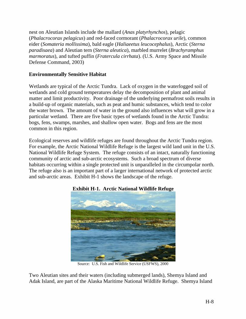
nest on Aleutian Islands include the mallard (Anas platyrhynchos), pelagic (Phalacrocorax pelagicus) and red-faced cormorant (Phalacrocorax urile), common eider (Somateria mollissima), bald eagle (Haliaeetus leucocephalus), Arctic (Sterna paradisaea) and Aleutian tern (Sterna aleutica), marbled murrelet (Brachyramphus marmoratus), and tufted puffin (Fratercula cirrhata). (U.S. Army Space and Missile Defense Command, 2003) Environmentally Sensitive Habitat Wetlands are typical of the Arctic Tundra. Lack of oxygen in the waterlogged soil of wetlands and cold ground temperatures delay the decomposition of plant and animal matter and limit productivity. Poor drainage of the underlying permafrost soils results in a build-up of organic materials, such as peat and humic substances, which tend to color the water brown. The amount of water in the ground also influences what will grow in a particular wetland. There are five basic types of wetlands found in the Arctic Tundra: bogs, fens, swamps, marshes, and shallow open water. Bogs and fens are the most common in this region. Ecological reserves and wildlife refuges are found throughout the Arctic Tundra region. For example, the Arctic National Wildlife Refuge is the largest wild land unit in the U.S. National Wildlife Refuge System. The refuge consists of an intact, naturally functioning community of arctic and sub-arctic ecosystems. Such a broad spectrum of diverse habitats occurring within a single protected unit is unparalleled in the circumpolar north. The refuge also is an important part of a larger international network of protected arctic and sub-arctic areas. Exhibit H-1 shows the landscape of the refuge.
Exhibit H-1. Arctic National Wildlife Refuge
Source: U.S. Fish and Wildlife Service (USFWS), 2000
Two Aleutian sites and their waters (including submerged lands), Shemya Island and Adak Island, are part of the Alaska Maritime National Wildlife Refuge. Shemya Island
H-8
also is part of the National Wildlife Refuge System. In addition, the USFWS has indicated that the Upper, Middle, and Lower Lake system of Shemya is of interest for its ability to support migratory birds and provide a resting place. Asian birds, not observed elsewhere in the U.S., are often blown off course during migration by storms and appear to be attracted by the airfield lights located in the vicinity of the lakes at Eareckson Air Station. (U.S. Army Space and Missile Defense Command, 2002d) Protection of wildlife and natural resources is a concern throughout the Arctic Tundra, including international territories. The Conservation of Arctic Flora and Fauna, a working group of the Arctic Council, aims to conserve arctic biodiversity and to ensure that the use of arctic living resources is sustainable. The purpose of the Arctic Council, which consists of eight arctic countries, namely Canada, Denmark (which administers Greenland), Finland, Iceland, Norway, Sweden, the U.S., and the Russian Federation, is to provide a policy forum for discussion of environmental and sustainable development issues of common concern to the arctic-rim countries. The Conservation of Arctic Flora and Fauna advises the arctic governments on conservation matters and sustainable use issues of international significance and common concern. Disturbance caused by boats or aircraft usually is controlled by distance or altitude regulations in protected areas and advisory restrictions elsewhere. Sometimes boat activities, such as the use of horns, are restricted. Exhibit H-2 provides examples of distance/altitude restrictions currently in place in some Arctic countries. Canada, Greenland, and the U.S. restrict the distance boats can approach breeding seabirds, but restrictions apply only to specific protected areas. Distance restrictions range from 15 meters (49 feet) for unmotorized boats in some reserves within Newfoundland, Canada to 1,600 meters (5,250 feet) in reserves in the U.S. Arctic countries restrict the altitude below which aircraft cannot fly over a seabird colony. In general, minimum altitudes are in the range of 300-500 meters (984-1,640 feet) but are higher over some reserves in the U.S. (700 meters [2,300 feet]). Canadian flight manuals advise a minimum altitude of over 600 meters (2,000 feet) when flying over bird concentrations. In Greenland, advisory rules are in place restricting disturbance to wildlife caused by mineral resource exploration and extraction (directed mainly at helicopters).
H-9
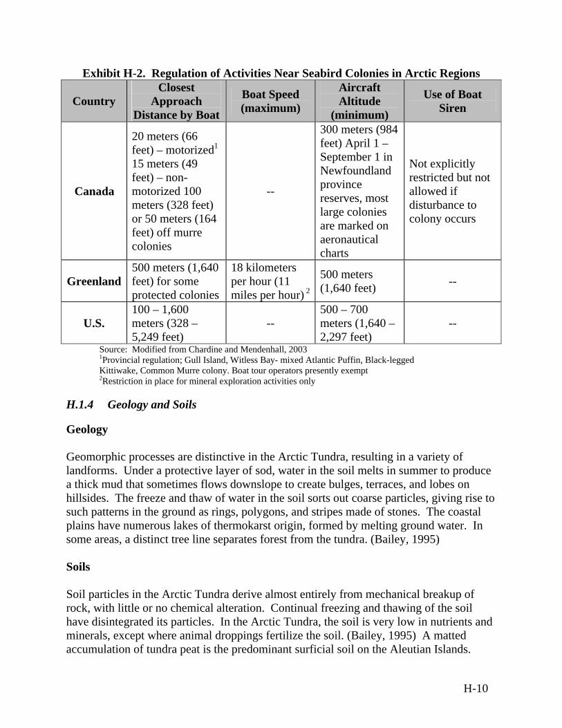
Exhibit H-2. Regulation of Activities Near Seabird Colonies in Arctic Regions
Country Closest
Approach Distance by Boat
Boat Speed (maximum)
Aircraft Altitude
(minimum)
Use of Boat Siren
Canada
20 meters (66 feet) – motorized1 15 meters (49 feet) – non-motorized 100 meters (328 feet) or 50 meters (164 feet) off murre colonies
--
300 meters (984 feet) April 1 – September 1 in Newfoundland province reserves, most large colonies are marked on aeronautical charts
Not explicitly restricted but not allowed if disturbance to colony occurs
Greenland 500 meters (1,640 feet) for some protected colonies
18 kilometers per hour (11 miles per hour) 2
500 meters (1,640 feet) --
U.S. 100 – 1,600 meters (328 – 5,249 feet)
-- 500 – 700 meters (1,640 – 2,297 feet)
--
Source: Modified from Chardine and Mendenhall, 20031Provincial regulation; Gull Island, Witless Bay- mixed Atlantic Puffin, Black-legged Kittiwake, Common Murre colony. Boat tour operators presently exempt 2Restriction in place for mineral exploration activities only
H.1.4 Geology and Soils
Geology Geomorphic processes are distinctive in the Arctic Tundra, resulting in a variety of landforms. Under a protective layer of sod, water in the soil melts in summer to produce a thick mud that sometimes flows downslope to create bulges, terraces, and lobes on hillsides. The freeze and thaw of water in the soil sorts out coarse particles, giving rise to such patterns in the ground as rings, polygons, and stripes made of stones. The coastal plains have numerous lakes of thermokarst origin, formed by melting ground water. In some areas, a distinct tree line separates forest from the tundra. (Bailey, 1995) Soils Soil particles in the Arctic Tundra derive almost entirely from mechanical breakup of rock, with little or no chemical alteration. Continual freezing and thawing of the soil have disintegrated its particles. In the Arctic Tundra, the soil is very low in nutrients and minerals, except where animal droppings fertilize the soil. (Bailey, 1995) A matted accumulation of tundra peat is the predominant surficial soil on the Aleutian Islands.
H-10
This highly saturated material is typical of tundra regions. (U.S. Army Space and Missile Defense Command, 2002d) Below the soil is the tundra's permafrost, a permanently frozen layer of earth. The majority of the Arctic Tundra Biome resides on a layer of permafrost. In the central and southern portions of the Arctic Tundra region, permafrost is discontinuous, absent on most southern exposures, and irregularly present adjacent to rivers and lakes. In more northern areas, the permafrost level may be two to four meters (six to 12 feet) deep. In the lowlands of the broad interior valleys, permafrost restricts drainage and accounts for the presence of extensive wetlands that form a complex of marshes, shrub thickets, small ponds, and forested islands. During the short summers, the top layer of soil may thaw just long enough to allow plants to grow and reproduce. Water from melting permafrost and snow forms lakes and marshes each summer because the saturated ground cannot absorb any more water beneath its surface. Geologic Hazards Geologic hazards in the Arctic Tundra Biome include earthquakes, forest fires, volcanic activity, avalanches, and flooding. Volcanic eruptions in Alaska average one to two per year and significantly affect air transportation every three to four years. Earthquake epicenters are scattered throughout the Arctic Tundra Biome, especially throughout the Aleutian Islands. The Aleutians extend nearly 1,900 kilometers (1,180 miles) from the tip of the eastern Alaskan Peninsula to the western tip of Attu Island. The island arc is the product of the convergence of the Earth's crustal plates, formed when the massive Pacific plate was forced downward beneath the Bering Sea plate. This rupturing of the Earth's crust is characterized by extreme tectonic activity, frequent earthquakes, and extensive volcanism. Of the 76 volcanoes throughout the Aleutians, about 40 have been active in the last 250 years. (USGS, 1999) For example, Shemya Island falls within seismic zone 4, which reflects the highest hazard potential for earthquakes and severe ground shaking. Eareckson Air Station also is susceptible to tsunamis (tidal waves) resulting from earthquake ground displacements and earthquake triggered submarine landslides. (U.S. Army Space and Missile Defense Command, 2002d)
H-11
H.1.5 Hazardous Materials and Hazardous Waste
Hazardous Materials Installations where MDA activities for the proposed BMDS may occur may store and use large quantities of hazardous materials, including a variety of flammable and combustible liquids. Hazardous materials stored at these installations may include fuels, antifreeze, paints, paint thinners and removers, adhesives, lead-acid batteries, nickel-cadmium batteries, plating solution, epoxy primer, lubricants, solvents, pesticides, and sodium dichromate. Materials used for boat, vehicle, and aviation repair; power and heat generation; wastewater treatment; photo processing; and building maintenance also are common. Fuels may include aviation gasoline, motor gasoline, and diesel fuel. Fuels can be transported to the sites via pipeline, truck, rail, or aircraft. Procedures for managing hazardous materials are developed to establish standard operating procedures for the correct management and storage of hazardous materials at installations. Hazardous material inventories are regularly reviewed and updated as needed. Due to the extreme climate, special measures may be necessary for storage and handling of hazardous materials in arctic areas. Hazardous Waste Hazardous wastes generated at MDA installations where activities for the proposed BMDS may occur typically are associated with equipment maintenance. Wastes generated by the facility include oils, fuels, antifreeze, paint, paint thinner and remover, photo chemicals, pesticides, aerosol canisters, batteries, used acetone, sulfuric acid, and sewage sludge. Procedures are developed for managing hazardous wastes at sites where activities for the proposed BMDS may occur. The procedures include details necessary for maintaining compliance with U.S. and international regulations when handling hazardous waste. Aboveground storage tanks with a range of capacities may be present at specific sites. The tanks and any supporting equipment are periodically inspected using visual inspection, hydrostatic inspection, or a system of nondestructive shell thickness testing. Protection of the contents of aboveground storage tanks from the extreme climate of the Arctic Tundra Biome is necessary. Sites where activities for the proposed BMDS may occur also may have underground storage tanks with a range of capacities. However, underground storage tanks are not likely to be found in areas where permafrost occurs.
H.1.6 Health and Safety
All activities associated with the proposed BMDS would comply with Federal, state, and local laws and regulations applicable to worker and environmental health and safety. All
H-12
sites where activities for the proposed BMDS may occur have established safety plans for various operations and accident scenarios, including the range; region; ordnance management; ocean area; fire and crash; rocket propellant and motor exhaust constituents; electromagnetic radiation; communications-electronics frequency; explosive safety quantity-distance arcs; and sea range concerns. These safety plans are coordinated with the appropriate local governments. The MDA would take every reasonable precaution during the planning and execution of the operations, training exercises, and test and development activities to prevent injury to human life or property. Potential hazards from explosive devices, physical impact, electromagnetic hazards, chemical contamination, ionizing and non-ionizing radiation, and lasers are considered in the safety plans. (U.S. Department of the Navy, 1998) Where applicable, warning areas are established in international airspace and waters to contain activity that may be hazardous, and to alert pilots and captains of nonparticipating vessels to the potential danger. NOTAMs and NOTMARs are published and circulated in accordance with established procedures to provide warning to pilots and mariners (including recreational users of the space) that outline any potential impact areas that should be avoided. Launch complexes and impact areas are generally located in remote areas often on military installations or ranges. Launches generally do not overfly areas where the majority of site personnel are located. Mission-essential personnel are instructed in safety procedures and equipped with necessary safety devices such as hearing protection. A launch can proceed only after all required safety evacuations have been accomplished to ensure that no unauthorized personnel are present in hazardous areas. Flight safety procedures include determining the dimensions of the safety zone surrounding the launch and impact area; identifying areas of the site that are evacuated for each mission; and activation of the flight-termination system in the event of missile failure. Areas that are exposed to debris should be evacuated even though risk may be considered minimal. Health and safety procedures should be available in site-specific operating documents.
H.1.7 Noise
Eareckson Air Station is a representative location where activities for the proposed BMDS may occur in the sparsely populated Arctic Tundra Biome. Eareckson Air Station is located on Shemya Island, which has no population other than personnel associated with the air station, and would be expected to have a background noise level of day/night average sound level (Ldn) less than or equal to 55 A-weighted decibel (dBA). Shemya Island is quiet due to the prevailing winds, and aircraft noise is heard only when standing next to the airfield. The closest civilian community is approximately 604 kilometers (375 miles) from Shemya Island. (U.S. Army Space and Missile Defense Command, 2000)
H-13
The principal sources of noise from missile defense operations are vehicular traffic and military activities, including aircraft operations, rocket testing, and rocket launches. Frequency and duration of noise from military activities vary as a factor of the irregular training schedules, and noise levels vary with the type of activities at these facilities. Sonic booms are experienced near some of these facilities. Facilities that generate high outdoor noise levels have established programs with the goal of ensuring compatibility with land uses in the vicinity of these facilities. Examples of these programs are the Air Installation Compatible Use Zone program for Department of Defense (DoD) air installations and the Installation Compatible Use Zone program for Army installations and facilities. (BMDO, 1994) Noise from missile defense activities, while intermittent, can be fairly loud. For example, noise from weapons testing typically ranges from 112 to 190 dBA. The noise levels on the ground from a helicopter at 460 meters (1,500 feet) and 76 meters (250 feet) of altitude are 79 dBA and 95 dBA, respectively. Maintenance equipment, such as the tracked vehicles used for trail maintenance, can generate noise levels up to 105 dBA. Aircraft noise occurs during aircraft engine warm-up, maintenance and testing, taxiing, takeoffs, approaches, and landings. Generally, sites where activities for the proposed BMDS may occur are located far from towns and population centers and are surrounded by open space. Ambient noise levels have the potential to impact wildlife resources. Because there are no absolute standards of short-term noise impacts to potentially noise-sensitive species, a short-term maximum noise exposure of 92 decibels (dB) has been suggested as a significance cut-off for impacts. (U.S. Army Space and Missile Defense Command, 2002c) Measurements of ambient sound levels should be analyzed in site-specific environmental documents.
H.1.8 Transportation
Ground Transportation Roadway travel in the Arctic Tundra Biome is generally limited due to the vast, undeveloped terrain. Highways decrease as one moves northward. Especially in the Arctic Tundra, roads between towns may be nonexistent. The quality of roads also varies greatly. Many roads in developed areas are two lanes and paved, however, some roads in remote areas may be unpaved and covered with dirt or gravel. Due to the limited number of roadways, the traffic volume in sparsely populated areas tends to be greater than the volume experienced in urban areas. The summer months experience the highest amount of traffic, due to tourism and good weather.
H-14
Ground transportation also includes railway systems. The Arctic Tundra Biome includes systems that provide freight, passenger, and intermodal transportation across North America, as well as regional and local service railways. Some rail lines, especially those located in northern regions of this biome, pass through scenic areas such as fjords, national parks and forests, mountains, and historic rivers. Given the vast area of the Arctic Tundra Biome and the limited road network, aircraft provide an alternate means of transportation. Private and military aircraft comprise a large portion of air traffic in this region. Helicopters serve many domestic routes; especially where towns lack airstrips and ground transportation is not available. Chartered airplanes often are used for passenger service. Air Transportation Given the vast area of the Sub-Arctic Taiga Biome and the limited road network, aircraft provide an alternate means of transportation. Private and military aircraft comprise a large portion of air traffic in this region. Helicopters serve many domestic routes; especially where towns lack airstrips and ground transportation is not available. Chartered airplanes often are used for passenger service. Marine Transportation Marine travel tends to be limited in the Arctic Tundra Biome due to glacial patches found throughout many waterways. Transit operations in the arctic ice have proven hazardous to many large vessels in the past, especially cargo and merchant ships. The use of air transportation for cargo has alleviated the need for sea transportation in the Arctic. However, both local residents and tourists visiting this northern environment commonly rely on marine transportation. Small commercial vessels are used primarily for ferry passenger service and fishing activities and often are limited to designated waterways.
H.1.9 Water Resources
Surface Water and Ground Water Resources In the Arctic Tundra, alluvial deposits are the principal aquifers for ground water, which is greatly restricted by permafrost. When under pressure from frost, ground water may burst to the surface in places, forming conical hills of mud and debris called pingos. The Arctic Tundra Biome is characterized by permafrost, or ground that is permanently frozen. Because the permafrost has no cracks or pores, water is unable to penetrate it. There is little to no surface water in winter. During the summer, the surface layer above the permafrost, known as the active layer, thaws. The thickness of the active layer depends on its location in the tundra; the active layer becomes thinner in more northerly
H-15
locations. As a result, during the summer, the Arctic Tundra is characterized by large quantities of surface water. When snow melts, the water percolates through the active layer but is unable to penetrate the permafrost. Pools of water form on the surface, and the active layer becomes saturated. The thawing permafrost creates wetland conditions, dotting the landscape with countless lakes, bogs, streams, and meadows. Surface waters in the Arctic Tundra tend to be acidic and rich in organic material. In addition, glaciers are present throughout the Arctic Tundra region. Different types of streams may be found throughout the Arctic Tundra. Glacier streams are fed from glacier melt water. While glacier-fed streams have moderate nutrient levels, which are supplied by subsurface runoff of the melt water, they also have very high sediment loads. The sediment is made up of fine rock particulates called glacial “flour.” This suspended sediment blocks light and scours the stream bottom. Glacier-fed streams also have highly variable discharge and water temperature on a diurnal cycle and are high gradient streams with unstable substrate. These factors inhibit the colonization of substantial amounts of algae and insects, leading to low biodiversity. Tundra streams have clear water that is often stained light brown with organic matter from the tundra. Many nutrients are locked within the permafrost, although there may be pulses of high nutrient levels during the spring runoff. The low gradient and generally stable flows of most tundra streams allow for the colonization of benthic algae and insects. However, a short growing season and the lack of phosphorus limit substantial algal accumulation. Water Quality Surface water and ground water quality is generally good in the Arctic Tundra Biome except in isolated areas of known contamination. Although soils in the Arctic Tundra Biome are strongly acidic, pH of regional surface waters in North America is around 7, ranging from 6.8 to 7.5 in streams and 7.1 to 7.3 in lakes. The relatively high pH and capacity of streams and lakes to buffer acid inputs from natural and man-made sources are presumed to be the result of ions (e.g., calcium and magnesium) that have been carried into the atmosphere with sea spray and subsequently returned in rainfall. This is a common occurrence in coastal maritime regions. (Wetzel 1975, as referenced in FAA, 1996)
H.2 Sub-Arctic Taiga Biome
The Sub-Arctic Taiga Biome discussion focuses on the sub-arctic regions of North America, including portions of Alaska. This biome is generally located between latitudes 50 and 60 degrees north (see Figure 3-12). The sub-arctic climate zone coincides with a great belt of needleleaf forest, often referred to as boreal forest, and with the open lichen
H-16
woodland known as taiga. Existing inland sites found in Alaska in the Sub-Arctic Taiga Biome include Fort Greely (which includes Delta Junction), Clear Air Force Station, Eielson AFB, and Poker Flat Research Range. Coastal sites also are located in the Sub-Arctic Taiga Biome, including portions of southwestern and western Alaska. Coastal sites are influenced by the cool climate generated by the cold waters of the North Atlantic Ocean and share maritime characteristics. Existing coastal sites where proposed BMDS activities may occur are found in Alaska in the Sub-Arctic Taiga Biome and include the Kodiak Launch Complex (KLC) and Port of Valdez.
H.2.1 Air Quality
Climate The climate of the Sub-Arctic Taiga Biome shows great seasonal range in temperature and rapid seasonal changes. Winters are severe and the cold, snowy forest climate remains moist all year, with cool, short summers. The average temperature is below freezing for six months out of the year. Winter is the dominant season and the temperature range is -54°C to -1°C (-65°F to 30°F). All moisture in the soil and subsoil freezes solidly to significant depths because average monthly temperatures remain subfreezing for six to seven consecutive months. Summers are mostly warm, rainy, and humid, and temperatures range from –7°C to 21°C (20°F to 70°F). Summer warmth is insufficient to thaw more than the surface, so permafrost prevails under large areas. Seasonal thaw penetrates from 0.6 to four meters (two to 14 feet), depending on latitude, aspect, and kind of ground. Altitude strongly influences the presence and extent of permafrost. The total precipitation in a year is 30 to 85 centimeters (12 to 33 inches), which may fall as rain or snow or accumulate as dew. Most of the precipitation in the taiga falls as rain in the summer. Fire is a natural feature of the ecology of this biome. Early summer is often dry with an increased risk of fires, which are caused primarily by lightning. Coastal locations in the Sub-Arctic Taiga Biome have a marine phase of the tundra climate, which is characterized by long, cold winters and short, cool summers. Maritime tundra dominates throughout southwestern and western Alaska and is the product of the cool climate generated by North Atlantic Ocean waters. The Arctic Ocean, which receives relatively warm north-flowing currents from the Atlantic and Pacific, acts as a moderating influence on the climate of the maritime tundra. Annual temperature ranges are much smaller in the marine phase than other sub-arctic regions. Winters are milder, and annual precipitation is greater. The average January temperature is about 16°C (3°F), and average temperatures in July are below 10°C (50°F). Fairly heavy snowfall occurs in winter and heavy concentrations of rain occur in summer. Average annual precipitation
H-17
is about 46 centimeters (18 inches), and average annual snowfall ranges from 100 to 200 centimeters (39 to 78 inches). Surface winds along the coast are much stronger and more persistent than at inland areas. For example, on Kodiak Island, while winds tend to be from the northwest at about 19 kilometers (12 miles) per hour, high winds occur throughout the year. Peak gusts range from 56 kilometers (35 miles) per hour in June to 134 kilometers (83 miles) per hour in December. Typically one day of heavy fog occurs per month, with visibility of 0.4 kilometer (0.25 mile) or less. The largest monthly snowfall occurs during December and January, with the maximum snowfalls ranging from 100 to 110 centimeters (40 to 45 inches) per month. (U.S. Army Space and Missile Defense Command, 2003) Regional Air Quality Air quality in the Sub-Arctic Taiga Biome generally is considered favorable; however, some areas in and around urban centers, such as Anchorage and Fairbanks are in non-attainment for CO concentrations, as designated by the U.S. The primary pollutant of concern from mobile sources in Alaska is CO. According to Fairbanks North Star Borough studies, approximately 90 percent of all CO produced within the borough is from vehicles. (U.S. Army Space and Missile Defense Command, 2002d) During episodes of cold winter weather, atmospheric inversions may trap contaminants and cause exceedances of the NAAQS or state standards. Vehicle “cold starts” during moderately cold weather, prolonged idling periods, and low-level temperature inversions contribute to pronounced air quality impacts from motor vehicle emissions in cold climates. For example, up to 80 percent of CO emissions contributing to exceedances of the NAAQS in Fairbanks have been attributed to mobile sources. Other pollutants from mobile sources include hydrocarbons, nitrogen oxides (NOx), and particle emissions. (U.S. Army Space and Missile Defense Command, 2002d) Mixing heights (altitudes at which pollutants and atmospheric gases are thoroughly combined) in the Sub-Arctic Taiga Biome adversely affect regional air quality and vary greatly depending on atmospheric conditions. The mixing height is generally highest during afternoon hours and lowest during the evening and early morning. However, temperature inversions, which occur most often in the winter, may cause extended periods of low mixing heights. Low mixing heights adversely affect regional air quality. For example, mixing heights in the taiga may range from 198 meters (650 feet) on winter mornings to 604 meters (1980 feet) on summer afternoons. Existing Emission Sources Emissions from activities for the proposed BMDS include CO, NOx, sulfur oxides (SOx), volatile organic compounds (VOCs), hazardous air pollutants (HAPs), and particulate
H-18
matter (PM). In coastal areas, wind-blown volcanic dust is the primary air contaminant. Major emissions sources associated with activities for the proposed BMDS in the Sub-Arctic Taiga Biome would include boilers, engines, hush houses, gas stations, fuel handling, chemicals, generators, storage tanks, miscellaneous equipment, and prescribed burning/firefighter training. Most sites where activities for the proposed BMDS may occur would be classified as a major emissions source. Sites where activities for the proposed BMDS may occur maintain, or have submitted an application for, Title V Air Permits. For example, Clear Air Force Station operates under a Title V Air Permit. (U.S. Army Space and Missile Defense Command, 2002d)
H.2.2 Airspace
Controlled and Uncontrolled Airspace Airspace above U.S. military airfields in the Sub-Arctic Taiga Biome generally includes controlled airspace and operates under IFR. In positive controlled areas, aircraft separation and safety advisories are provided by air traffic control centers. In general controlled airspace, operations may be either under IFR or VFR, and traffic advisories may be provided to aircraft operating under VFR. In uncontrolled airspace, operations may be under VFR or IFR, but no air traffic control is provided. Alaskan airspace is located within the Anchorage Oceanic Control Area/Flight Information Region and within the U.S. Alaskan Air Defense Identification Zone. The Anchorage Air ARTCC controls Alaskan airspace. Communication and radar products are sent and received at the Anchorage Center via satellite, ground, and microwave transmitters and receivers. Due to the mountainous terrain, many areas have marginal to no communications and may lack radar coverage. The publication Flight Tips for Pilots in Alaska provides information to pilots flying to and within Alaska. It should be used in addition to the current Alaska Supplement, Sectional Aeronautical Charts, World Aeronautical Charts, Airmen's Information Manual, current NOTAMs, and current weather briefings. Special Use Airspace Alaska has some of the largest MOAs in the world. Much of Alaska's aviation activity takes place within existing MOAs, through a shared-use agreement, with information provided by the Special Use Airspace Information Service, which is a system operated by the USAF under agreement with the FAA Alaskan Region to assist pilots with flight planning and situational awareness while operating in or around MOAs or Restricted Areas in interior Alaska. Special use airspace designations typically are coordinated with airspace users through existing protocols for the site where activities for the proposed BMDS may occur, commercial aircraft carriers, and military aircraft. In addition, military facilities may have missile-firing ranges, drop zones, air-to-ground training
H-19
weapons ranges, ammunition storage areas, and restricted areas. Pilots are advised to avoid overflight of such areas. Airports/Airfields There are over 650 civilian, military, and private airports registered with the FAA and more than 3,000 airstrips in Alaska. Most of the airports are owned and operated by the State of Alaska and certified by the FAA. However, many airports are private and not maintained on a regular basis. As a result, runway conditions may not be favorable at some airport locations. Existing military airfields, which have runways that are paved and in good condition, would be used to support activities for the proposed BMDS. En Route Airways and Jet Routes Civilian aircrafts generally fly along established flight corridors that operate under VFR. Numerous Minimum En route Altitudes are present in Alaska. Minimum En route Altitudes from 2,400 to 4,000 meters (8,000 to 13,000 feet) are common throughout the state, and in some areas they can be as high as 7,000 meters (23,000 feet).
H.2.3 Biological Resources
Vegetation The vegetation of the Sub-Arctic Taiga Biome is primarily boreal forest, which is a complex array of plant communities shaped by fire, soil temperature, drainage, and exposure. Forest types are mixed and species composition is determined by steepness of slopes, aspects (the cardinal direction a slope faces), and fire histories. Natural wildfires, which are a critical component of the boreal forest biome, occur about every 50 to 70 years. Vegetation at and near sites where activities for the proposed BMDS may occur located in interior Alaska is typical of boreal forest regions. The boreal forest is a transition zone of scattered coniferous or evergreen trees and shrubs, which are mixed with tundra vegetation. The most common trees are spruce and larch. The conifers of the boreal forest are white spruce (picea glauca), which are found on well-drained floodplain soils, uplands, and south-facing slopes where seasonal thaw is deep. Black spruce (Picea mariana) grows in lowlands and on north-facing slopes where the annual thaw is shallow and permafrost is close to the surface. A broad-leaved deciduous forest of quaking aspen (Populus tremuloides), balsam poplar (Populus balsamifera), and Alaska paper birch (Betula neoalaskana) is prominent on well-drained uplands, whereas floodplain forests are composed of balsam poplar, white spruce, paper birch mixed with mountain alder (alnus tenuifolia) and several species of willow. White birch, (Betula papyrifera) one of the few deciduous trees able to withstand the cold
H-20
climate, also is found in this region. There is little precipitation and a short growing season. The stunted and slow-growing trees often are of little use to humans. Rocky areas in the central part of the boreal forest region contain small trees but little other vegetation. The rest of this region is covered mainly with lakes and swamps called muskegs. Dense growths of spruce and tamarack (Larix laricina) are found around the edges of muskegs while many shrubs and cranberries (Vaccinium oxycoccus) grow near the center. In coastal regions, plant life is transitional between the Arctic Tundra and Sub-Arctic Taiga regions. Lava fields of recent origin provide unusual sites for plants. Groves of balsam poplar and other boreal forbs and ferns, which are common in the boreal forest but unusual here, occur in the immediate vicinity of hot springs, presumably because soils are suffused with warm mineral waters. Clusters of pingos and thermokarst lakes (sites of erosion and subsidence by thawing of permafrost) occur in the interior lowlands, which were formed by large rivers, and also may occur in association with isolated groves of balsam poplar where other trees are absent. In the sedge-graminoid meadows where flooding occurs, important taxa include the Ramenski sedge (Carex ramenski), loose-flowered alpine sedge, Lyngby sedge (Carex Lyngbyei), reedgrass, forbs silverweed cinquefoil, and low chickweed (stellaria media). Sandy beaches are common in the maritime areas, some of which are associated with dune fields. Mudflats support open communities of halophytic plants that are adapted to a saline environment and include grasses, sedges, and forbs such as creeping alkaligrass (Puccinellia phryganodes), Hoppner sedge (Carex subspathacea), sea-beach sandwort (Honkenya peploides), and oysterleaf (Mertensia maritime). The sandy beaches are dominated by beach ryegrass (Elymus arenarius) and forbs such as beach pea and seaside ragwort (Senecio resedifolius). In places where dunes formed, strong floristic differences exist between plants on prominences and those in depressions, and between plants on dunes and those on backslopes. On numerous sites where activities for the proposed BMDS may occur, native vegetation has been removed, and the land is landscaped and maintained by mowing and brush control measures. Isolated pockets of vegetation may remain on sites where activities for the proposed BMDS may occur, however, vegetation on off-site areas is widespread and may be undisturbed. Wildlife The interior areas of the Sub-Arctic Taiga Biome are populated with unique animals that have techniques for preserving warmth and staying dry. Animals of the taiga tend to be predators such as the lynx and members of the weasel family such as wolverines, bobcats (Lynx rufus), minks (Mustela vison), and ermine (Mustela erminea), which hunt
H-21
herbivores such as snowshoe rabbits, red squirrels (Tamiasciurus hudsonicus), and voles. Red deer (Cervus elaphus), elk (Cervus Canadensis), and moose (Alces alces) can be found in regions of the taiga where more deciduous trees grow. Many insect-eating birds come to the boreal forest to breed and leave at the end of the breeding season. Seed-eating birds, such as finches and sparrows, and omnivorous birds, such as crows, are present year-round. The wildlife at sites where activities for the proposed BMDS may occur in interior Alaska is typical of the fairly undisturbed nature of the surrounding taiga. Fish species that occur in the freshwaters of the taiga include chinook (Oncorhynchus tshawytscha), chum, and coho salmon; rainbow trout (Salmo gairdneri); sheefish (Stenodus leucichthys); humpback (Coregonus clupeaformis) and round whitefish (Propopium cylindraceum); least cisco (Coregonus sardinella); Arctic grayling (Thymallus arcticus); lake trout; northern pike (Esox lucius); and burbot. Adaptations of fish species to different systems or to different parts of the same system have sometimes caused complex migrations to overwintering, spawning, and feeding sites. Large numbers of breeding waterfowl summer on wetlands of the boreal forest, and thousands more pass through this region during migration. The region is important for trumpeter swans (Cygnus buccinator) and tundra swans (Cygnus colombianus), canvasbacks (Aythya valisineria), and greater white-fronted geese (Anser albifrons). Bald eagles (Haliaeetus leucocephalus) that breed along major river systems have maintained relatively stable populations. The recently delisted American peregrine falcon (Falco peregrinus anatum) and arctic peregrine falcon (Falco peregrinus tundrius) migrate through the area during the spring and fall migration periods. Four other species are of special concern because of declining population trends throughout North America: the olive-sided flycatcher (Contopus borealis), gray-cheeked thrush (Catharus minimus), Townsend's warbler (Dendroica townsendi), and blackpoll warbler (Dendroica striata). (USGS, 1999) In coastal areas of the Sub-Arctic Taiga Biome, the freshwaters include fish species such as the sheefish, whitefishes, Arctic grayling, Arctic char (Salvenlinus alpinus), Dolly Varden (Salvelinus malma Walbaum), rainbow trout, northern pike, Alaska blackfish (Orcinus orca), and five salmon species (sockeye, coho, chinook, chum, and pink). In some coastal areas, freshwaters are subject to severe freezing in winter, making springs important to the overwinter survival of freshwater fishes. The region's spawning (anadromous) and freshwater resident fishes and their eggs provide food for a diversity of mammals, birds, and other fishes. All estuarine and marine areas out to the Exclusive Economic Zone of the U.S. used by Alaskan Pacific salmon are designated as Essential Fish Habitat for salmon fisheries. Salmon occur in the Prince William Sound mainly from June through September as they return from the ocean to spawn. Essential Fish Habitat also has been designated for
H-22
scallops and Gulf of Alaska ground fish in the Port of Valdez. (U.S. Army Space and Missile Defense Command, 2003) The coastal sub-arctic region supports large populations of brant (Branta bernicla), cackling Canada geese (Branta canadensis minima), emperor geese (Anser canagicus), and greater white-fronted geese (Anser albifrons). Birds of prey are relatively rare in this area, although the pealei subspecies of peregrine falcons (Falco peregrinus pealei) is common around seabird colonies. The large numbers of shorebirds that breed on coastal maritime tundra in western Alaska include the world's population of black turnstones (Arenaria melanocephala) and most of the world's population of bristle-thighed curlews (Numenius tahitiensis). The mammalian fauna of this region is composed of shared elements from the boreal forest (muskrat [Ondatra zibethicus], northern red-backed vole [Clethrionomys rutilus], tundra vole [Microtus oeconomus], and red fox [Vulpes vulpes]) and from the Arctic Tundra (Greenland collared lemming [Dicrostonyx groenlandicus], Arctic ground squirrel [Spermophilus parryii], and Arctic fox [Alopex lagopus]). Species that have been absent from much of the area in the recent past include the moose, caribou, snowshoe hare (Lepus Americanus), lynx (Felis lynx), beaver (Castor Canadensis), coyote (Canis latrans clepticus), and gray wolf (Canis lupus), however, many of these species have begun to return to the maritime tundra region. (USGS, 1999) Marine mammals with Federal or state status that may occur in the coastal areas of the Sub-Arctic Taiga Biome include the Steller sea lion, humpback whale (Megaptera novaeangliae), Northern right whale, Sei whale (Balaenoptera borealis), blue whale (Balaenoptera musculus), fin whale, sperm whale, short-tailed albatross, and Steller’s eider. For example, consistent and extensive use of the Kodiak area by the Steller's eider has been observed. Although critical habitat has not been designated in the Kodiak Archipelago, the area still contains important habitat for Steller’s eiders and protection afforded by the Endangered Species Act still applies. Critical habitat for the Steller sea lion includes a special aquatic foraging area in the Shelikof Strait area consisting in part of an area between the Alaskan Peninsula and the western side of Kodiak Island. (U.S. Army Space and Missile Defense Command, 2002d) Environmentally Sensitive Habitat Wetlands in the U.S. support vegetation, provide habitat for fish and wildlife, and contribute to flood control and sediment retention. Palustrine, emergent, persistent, seasonally flooded and palustrine scrub/shrub, broad-leaved deciduous, saturated wetlands are located throughout the Sub-Arctic Taiga Biome. Most wetlands in the Sub-Arctic Taiga generally are classified as palustrine (non-flowing) or riverine, which occur alongside rivers and streams. The most common type of vegetated wetland is black
H-23
spruce (Picea mariana) wetlands. On most wetlands in the sub-arctic region, wet soils result from poor drainage caused by permafrost. Extensive deposits of sand and sand dunes were formed over some present-day boreal forest areas in the late glacial time. Forest cover stabilized many of these deposits, but others remain exposed along riverbanks and deltas. For example, the exceptional, extensive, active dune fields of the Great Kobuk Sand Dunes occur on the middle Kobuk River, where the wildflower Kobuk locoweed (Oxytropis kobukensis) is endemic, and on the Nogahabara Sand Dunes of the Koyukuk River, which is the sole Alaskan locality of the Baikal Sedge (Carex sabulosa), a sedge of desert-steppe landscapes in Asia. This species is known from North America only from similar habitats in a few localities in the southwestern Yukon Territory, Canada. These unique landscapes and their plant complexes are protected because they are located in national parks or national wildlife refuges. (USGS, 1999) Steppe vegetation can be located and defined by its south-facing topographic aspect. The steepest portions of slopes are generally treeless, presumably because of drought and geomorphic instability. Each steppe site can be thought of as a small island in a sea of forest. The steppe bluffs are characterized by rare plant taxa. The vascular plants of these steppe bluffs, for example, the disjunct species American alyssum (Alyssum obovatum) and the wormwood Artemisia laciniatiformis, occur only in the sub-arctic interior of Alaska and in the adjacent Canadian Yukon Territory. Researchers are exploring how these isolated plant communities became established on these bluffs and why they remain so restricted. (USGS, 1999) Coastal areas of the Sub-Arctic Taiga support unique populations of freshwater fishes. These populations are considered to have intrinsic ecological values that reach beyond this region because they have not been genetically altered by releases of fishes from hatcheries and represent some of the only truly wild populations left in the world. (USGS, 1999)
H.2.4 Geology and Soils
Geology High mountains, broad lowlands, diverse streams and lakes, and complex rock formations characterize the geology of the Sub-Arctic Taiga Biome. High mountains in inland areas shelter the interior from the moist maritime air that occurs in the south and the cold arctic air characteristic of the north. The uplift of foothills, advance and retreat of glaciers, and subsequent erosion by major drainages originating in the Alaska Range and foothills have provided the source for major sedimentary deposition throughout the Sub-Arctic Taiga Biome. Beaches, lagoons, and sandy sediments also characterize coastal areas.
H-24
Soils The boreal forest grows on poorly developed soils with pockets of wet, organic histosols. These light gray soils are wet, strongly leached, and acidic; they form a highly distinct layer beneath a topsoil layer of organic matter. Agricultural potential is poor due to the natural infertility of soils and the prevalence of swamps and lakes left by departing ice sheets. In some places, ice has scoured rock surfaces bare. Elsewhere, rock basins have been formed and stream courses dammed, creating countless lakes. (Bailey, 1995) Permafrost is mostly continuous in the northern portion of the boreal forest region, except in riverbeds, beneath lakes, and on steep, south-facing bluffs. Permafrost is permanently frozen soil, subsoil, or other deposit and is characteristic of arctic and some sub-arctic regions. Permafrost is a thermal condition in which the ground remains at a temperature below freezing, year-round. In permafrost regions, summers are only long and warm enough to thaw the surface of the ground, known as the active layer. In coastal areas, permafrost is generally absent or discontinuous. Soils in the coastal areas are typically rocky, organic, or volcanic. These soils support tall brush, grass, and some moist tundra at higher elevations and coastal spruce on lower slopes. Limitations on types of vegetation are due not only to soil types but also to land slopes. Soils in the maritime region are formed in ash deposits of various thicknesses and are underlain by glacial gravel or silty sediments. Coastal plain soils are formed in gravels, cinders, or weathered rock blanketed by thick sedge peat. Permafrost is sporadic or absent. The maritime taiga is characterized by poor drainage of surface water. Geologic Hazards Geologic hazards in the Sub-Arctic Taiga Biome include earthquakes, forest fires, volcanic activity, avalanches, and flooding. Volcanic eruptions in Alaska average one to two per year and significantly affect air transportation every three to four years. The coastal regions of the taiga are subject to ash falls from active volcanoes in the Aleutian chain. Over 40 volcanoes are active in the Aleutian arc. Earthquake epicenters are scattered throughout the interior Sub-Arctic Taiga Biome. For example, portions of Alaska are located in Seismic Zone 3, a northeast-trending band of seismic activity, where major earthquake damage has a ten percent probability of occurring at least once in 50 years. An average of five or six earthquakes a year is actually felt in this zone. In June 1967, a series of three earthquakes of about magnitude six had epicenters in this seismic zone. In November 2002, the Denali Fault earthquake occurred on the Denali-Totschunda fault system with a magnitude of 7.9.
H-25
H.2.5 Hazardous Materials and Hazardous Waste
Hazardous Materials Installations where activities for the proposed BMDS may occur may store and utilize large quantities of hazardous materials, including a variety of flammable and combustible liquids. Hazardous materials stored at these installations in the Sub-Arctic Taiga Biome may include fuels, antifreeze, paints, paint thinners and removers, adhesives, lead-acid batteries, nickel-cadmium batteries, plating solution, epoxy primer, lubricants, solvents, pesticides, and sodium dichromate. Materials used for boat, vehicle, and aviation repair; power and heat generation; wastewater treatment; photo processing; and building maintenance also are common. Fuels may include aviation gasoline, motor gasoline, and diesel fuel. Fuels can be transported to the sites via pipeline, truck, rail, or aircraft. Procedures for managing hazardous materials are developed to establish standard operating procedures for the correct management and storage of hazardous materials at installations where activities for the proposed BMDS may occur. Hazardous material inventories are regularly reviewed and updated as needed. Above- and underground tanks with a range of capacities may be present at specific sites. The tanks and any supporting equipment are periodically inspected using visual inspection, hydrostatic inspection, or a system of nondestructive shell thickness testing. Currently, Fort Greely has 49 aboveground storage tanks with capacities ranging from 946 to 2,384,809 liters (250 to 630,000 gallons). There are 23 underground storage tanks at Fort Greely with capacities ranging from 1,136 to 189,270 liters (300 to 50,000 gallons). (U.S. Army Space and Missile Defense Command, 2002d) The Port of Valdez, a coastal site in the Sub-Arctic Taiga Biome, serves as the southern terminal of the Trans-Alaska Pipeline System. This terminal occupies approximately 404.7 hectares (1,000 acres) of land owned by the Alyeska Pipeline Service Company. The terminal serves to store and load crude oil and houses the Operations Control Center for the Trans-Alaskan Pipeline System. The most prevalent hazardous material at the terminal is diesel fuel, with approximately 30 million liters (eight million gallons) nominally being stored at any given time. Other common materials include gasoline for equipment and vehicles, propane, organic solvents, heat transfer fluids, glycol-based coolants, refrigerants, protective coatings, fire suppression chemicals, and cleaning agents. (U.S. Army Space and Missile Defense Command, 2003) Hazardous Waste Hazardous wastes generated at specific installations where activities for the proposed BMDS may occur typically are associated with equipment maintenance. Wastes generated by the facility include oils, fuels, antifreeze, paint, paint thinner and remover,
H-26
photo chemicals, pesticides, aerosol canisters, batteries, used acetone, sulfuric acid, and sewage sludge. Procedures typically are developed for managing hazardous wastes at sites where activities for the proposed BMDS may occur. Installations may recycle non-hazardous waste that includes paper, cardboard, plastics, glass, and aluminum; however, recycling capabilities in Alaska are limited. For example, the Valdez Marine Terminal is considered a large quantity generator. Hazardous waste would be generated from various routine and preventative maintenance and repair activities at the terminal. These wastes include spent thinners, cleaning solvents, flammable paints and coatings, corrosive acids, flammable adhesives, used oils containing chlorinated compounds, spent coolants, spent aerosol cans and crushed fluorescent lights. Sludge and residues removed from equipment and sumps also may be characterized as hazardous. The largest quantity of potentially hazardous waste would be from tank bottoms and “materials in process” that are periodically removed from equipment and storage tanks. Some spill debris and containment media also may be characterized as hazardous. (U.S. Army Space and Missile Defense Command, 2003)
H.2.6 Health and Safety
Health and Safety attributes of the Sub-Arctic Taiga Biome are similar to those discussed in Section H.1.6.
H.2.7 Noise
The Sub-Arctic Taiga Biome generally is sparsely populated and most of the region is expected to have a background noise level of Ldn less than or equal to 55 dBA. The KLC is representative of noise levels for sites where activities for the proposed BMDS may occur in the Sub-Arctic Coastal Biome. Ambient noise levels range from 70 dBA to 95 dBA. (DOT, 2001) Noise sources associated with the proposed BMDS are described in Section H.1.7.
H.2.8 Transportation
Ground Transportation Roadway travel in the Sub-Arctic Taiga Biome is generally limited due to the vast, undeveloped terrain. Highways are found throughout the region and decrease as one moves northward. Roads between towns may be nonexistent. The quality of roads also varies greatly. Many roads in developed areas are two-lanes and paved, however, some roads may be unpaved in remote areas and covered with dirt or gravel. Due to the limited number of roadways, the traffic volume in sparsely populated areas tends to be greater than experienced in urban areas. The summer months experience the highest amount of traffic due to tourism and good weather.
H-27
Ground transportation also includes railway systems. The Sub-Arctic Taiga Biome includes systems that provide freight, passenger, and intermodal transportation across North America, as well as regional and local service railways. Some rail lines, especially those located in northern regions of this biome, pass through scenic areas such as fjords, national parks and forests, mountains, and historic rivers. Air Transportation Given the vast area of the Sub-Arctic Taiga Biome and the limited road network, aircraft provide an alternate means of transportation. Private and military aircraft comprise a large portion of air traffic in this region. Helicopters serve many domestic routes, especially where towns lack airstrips and ground transportation is not available. Chartered airplanes often are used for passenger service. Kodiak Island, for example, currently supports C-130 aircraft and H-60 helicopters. Personnel and most types of equipment can be transported to Kodiak Island on daily flights offered by Alaska Airlines and ERA Aviation. (U.S. Army Space and Missile Defense Command, 2003) Marine Transportation Marine travel tends to be limited in the Sub-Arctic Taiga Biome due to glacial patches found throughout many waterways. Transit operations in the arctic ice have proven hazardous to many large vessels in the past, especially cargo and merchant ships. The use of air transportation for cargo has alleviated the need for sea transportation in the Arctic. However, both local residents and tourists visiting this northern environment commonly rely on marine transportation. Small commercial vessels are used primarily for ferry passenger service and fishing activities and often are limited to designated waterways. For example, Kodiak Island offers a full range of dockage and marine services for commercial fishing, cargo, passenger, and recreational vessels. Large vessels, including the state ferry, cruise ships, and cargo vessels are moored at three deepwater piers. In the Prince William Sound area, marine transportation plays an important role, including its role in shipping petroleum products from the Valdez Marine Terminal. The Port of Valdez is equipped with the highest level of marine infrastructure, accommodating interstate and international cargo receipt and shipment. The Port of Valdez is an ice-free port with access to Interior Alaska, the U.S. Pacific Northwest, Northern Canada, and the Pacific Rim trade routes. (U.S. Army Space and Missile Defense Command, 2003)
H-28
H.2.9 Water Resources
Surface Water and Ground Water Resources Ground water is supplied by nearby rivers, precipitation, and melt water in the Sub-Arctic Taiga Biome. The depth and amount of ground water fluctuates in response to changes in the seasons and weather. Ground water levels are highest in the late summer, when snow and ice melt is augmented by rainfall. The lowest levels generally occur in the fall, and a slow rise in winter levels is normal. Local variations in flow directions occur near surface water bodies and sources of ground water, such as melting snow. Characteristic of the taiga are innumerable water bodies, including bogs, fens, marshes, shallow lakes, rivers and wetlands, which are intermixed among the forest and hold vast amounts of water. Creeks and ponds also are common throughout this biome. Many rivers in the boreal forest region are glacier-fed and silt-laden. The peak flow of these rivers is reached in late summer, when snow and ice melt is augmented by rainfall. Minimum flow occurs in winter when precipitation occurs as snow. Many bodies of water remain frozen during the winter. Permafrost is present only in patches, and during the summer, the unfrozen layer is generally thick. The water is often acidic and rich in organic material from the surrounding landscape. Because the ground has a limited ability to store water, the spring flood can be violent, undercutting the riverbank and causing extensive erosion along its path. Rainstorms also may cause high flows and floods, especially on small streams. The effects of floods and storms can be much less severe on rivers with large drainage basins. Spring streams in the sub-arctic region derive water from underground sources. As a result, springs are rich in cations (positively charged particles that aid in uptake by plants) and nutrients, flow year-round, and have stable water temperatures. This provides a stable, enriched habitat for primary and secondary producers leading to high biomass and diversity of algae, moss, and insects. In coastal areas, ground water is found primarily in river basins and recharged by infiltration of melt water from precipitation and glaciers. Ground water typically is derived from unconfined aquifers composed of sand and gravel. The coastal region generally consists of wet, saturated organic materials spread across flat lands, extensive areas of peatlands, swamps, streams, small lakes, and wetlands. Kettle lakes and lakes formed by glacial erosion are found in upland areas. Sea ice occasionally occurs in water formations. During high tides, marshes and lagoons that feed into the coastline may be subject to saltwater inundation.
H-29

Water Quality Water quality for sites where activities for the proposed BMDS may occur in interior Alaska, such as Fort Greely and Clear Air Force Station, typically meets state drinking water standards. Water quality is subject to seasonal variations, but remains within established Environmental Protection Agency (EPA) drinking water standards. However, at Eielson AFB, background ground water quality analyses have shown that the average iron and manganese concentrations typically exceed the secondary maximum contaminant levels for drinking water. Arsenic has been identified as a constituent of concern at Eielson AFB, and one background sample exceeded the primary drinking water standard of 50 micrograms per liter. (U.S. Army Space and Missile Defense Command, 2002d) Water quality in the coastal areas of the Sub-Arctic Taiga Biome is generally good.
H.3 Deciduous Forest Biome
As shown in Exhibit 3-13, the Deciduous Forest Biome includes the deciduous forest regions of North America, which include most of the eastern portion of the U.S. and parts of central Europe and East Asia. The description in this section of the U.S. deciduous forest is representative of this biome throughout the world. Existing inland sites in the Deciduous Forest Biome include Redstone Arsenal, Alabama; Fort Devens, Massachusetts; and Aberdeen Proving Ground, Maryland. Coastal sites also are located in the Deciduous Forest Biome. These sites share maritime characteristics. Existing coastal sites include Naval Air Station Pax River, Maryland; Wallops Island, Virginia; Cape Canaveral Air Force Station, Florida; Cape Cod Air Force Station, Massachusetts; and Eglin AFB, Florida.
H.3.1 Air Quality
Climate The average annual temperature in a deciduous forest is 10°C (50°F). The average rainfall is 76 to 152 centimeters (30 to 60 inches) a year, with nearly 36 centimeters (14 inches) of rain in the winter and more than 46 centimeters (18 inches) of rain in the summer. Humidity in these forests is high, ranging from 60 to 80 percent. Because of its location, air masses from both the cold polar region and the warm tropical region contribute to the climate changes in this biome. Most deciduous forests have mild summers with temperatures averaging about 21°C (70°F). Winter temperatures are cool with an average temperature slightly below 0°C (32°F). The humid subtropical climate, marked by high humidity, especially in summer,
H-30
and the absence of cold winters, prevails in the Southern Atlantic and Gulf Coast states. Most deciduous forests are located near oceans. The ocean and wind are two key factors that determine the variability in temperature and climate changes in this ecological system. In the northern part of the deciduous forest, the frost-free or growing season lasts for three to six months. In the coastal regions of the Deciduous Forest Biome, climate is influenced by three main air masses, the Continental Arctic, the Continental Polar, and the Maritime Tropical. The Continental Arctic air masses usually originate north of the Arctic Circle and plunge across Canada and the U.S. during winter. The Continental Arctic air masses have extremely cold temperatures and very little moisture. Continental Polar air masses form farther south and often dominate the weather in the U.S. during winter. During the summer, the Continental Polar air masses bring clear weather to the northeastern U.S. Continental Polar air masses have cold and dry air, but not as cold as Arctic air masses. Maritime Tropical air masses originate over the warm waters of the southern Atlantic Ocean and the Gulf of Mexico and can form year-round. Maritime Tropical air masses have warm temperatures with copious moisture and are responsible for the hot, humid summer across the South and the East. The climate along the U.S. coast differs according to latitudinal location. Differences in climate in this region are characterized according to the Northern Atlantic states and the Southern Atlantic and Gulf Coast states. The coastal region is considered moist and rainfall decreases with distance from the ocean. Located squarely between the source regions of Continental Polar air masses to the north and Maritime or Continental Tropical air masses to the south, coastal areas of the northern states are subject to strong seasonal contrasts in temperature as these air masses push back and forth across the continent. (Bailey, 1995) The humid subtropical climate, marked by high humidity, especially in summer, and the absence of cold winters, prevails in the Southern Atlantic and Gulf Coast states. The climate is temperate and rainy with hot summers. The climate has no dry season, and even the driest summer month receives at least 30 millimeters (1.2 inches) of rain. The average temperature of the warmest summer month is above 22 °C (72 °F). Precipitation is ample all year but is greatest during summer. Winter precipitation, some in the form of snow, is of the frontal type. Temperatures are moderately wide in range and comparable to those in tropical deserts, but without the extreme heat of a desert summer. (Bailey, 1995) Thunderstorms are frequent, especially in the summer, and may be thermal, squall line, or cold front in origin. Tropical cyclones or hurricanes strike the southern U.S. Atlantic coastal area occasionally, bringing heavy rains. Hurricanes form in the Atlantic basin to the east of the continental U.S. in the Atlantic Ocean, Gulf of Mexico, and Caribbean
H-31

Sea. In the Atlantic coast region, hurricanes form anywhere from the tropical central Atlantic to the Gulf of Mexico. Those that form in the central Atlantic and Caribbean region usually start off moving westward, then may curve towards and strike the North American mainland. Some storms that begin in the Gulf of Mexico may move pole-ward and eastward from their inception. Along the U.S. Atlantic and Gulf coasts, the Gulf Stream provides a source of warm waters (greater than 26.5°C [80°F]) to help maintain hurricane activity. Exhibit H-3 shows that the Deciduous Forest Biome in the U.S. is subject to significant hurricane activity.
Exhibit H-3. Hurricane Activity in the U.S.
Source: USGS, 2002e The areas shown in Exhibit H-3 reflect the number of hurricanes per 100 years expected to pass within 159 kilometers (75 nautical miles) of any point in the shaded regions. The highest-risk area (the southern and Mid-Atlantic coast) shows where 60 hurricanes per 100 years skim up the east coast. The high-risk area would see 40-60 hurricanes per 100 years, and the moderate-risk area would see 20-40 hurricanes per 100 years. The period of observation was 1888 to 1988.
H-32
Regional Air Quality Many metropolitan regions on the U.S. Atlantic Coast are in non-attainment for EPA’s NAAQS for ozone, the primary constituent of urban smog. The EPA recently conducted a national-scale assessment of 33 air pollutants (a subset of 32 HAPs plus diesel PM), including sources, ambient concentrations, and human health risk (cancer and noncancer). Many of the highest-ranking 20 percent of counties in terms of risk are located in the Atlantic and Gulf coastal areas in Texas, Louisiana, Alabama, and coastal areas from northern Virginia to Maine. (EPA, 1996) For example, Cape Cod Air Force Station is situated within the Southeastern Massachusetts Air Quality Control Region, which is classified as serious non-attainment for ozone and attainment or unclassified for all other NAAQS. (U.S. Department of the Air Force, 2002) The southern Atlantic coast from Virginia through Florida is in attainment for all criteria air pollutants. However, the entire coastal area from northern Virginia through Maine is in non-attainment for ozone (ranging from moderate to severe), and small areas in Connecticut are in moderate non-attainment for PM10. The air in the eastern Gulf of Mexico has very low concentrations of air pollutants. There are few emissions sources (air traffic, drilling platforms, surface vessel exhaust, transport phenomena), and while each of these sources individually has limited localized effects on air quality, their cumulative impact on overall Gulf of Mexico air quality has not been documented. (U.S. Department of the Air Force, 2002) Air pollutants occasionally reach relatively high levels when strong ground-based temperature inversions trap pollutants near the ground. Many coastal areas experience inversions during the night. Although these inversions normally break during the morning due to surface heating, sometimes they persist for more than one day. In the Gulf region, on average there are five to seven days each winter during which the inversion does not break. Most often this is due to a deep layer of sea fog reducing the amount of surface heating. (U.S. Department of the Air Force, 2002) For example, the atmosphere of the Eglin AFB area has a limited tolerance to high pollution because of the regular occurrence of inversions. It is, however, more capable of dispersing air pollutants than adjacent areas to the north but not so much that winter air pollution episodes could not occur. Low-velocity winds and inversion conditions contribute to short-duration, low-level concentrations of air pollution, especially in areas with high traffic concentrations. (U.S. Department of the Air Force, 1998a) The meteorology and climatology of the Gulf Coast region are dominated by the western Gulf with extremes in humidity, precipitation, and coastal air mass movements. The Gulf Coast has an unusual mix of large industrial emission sources, extensive transportation emission sources, significant biogenic emissions, and a complex coastal meteorology.
H-33
These sources and the meteorology interact to produce high levels of ozone, HAPs, and fine PM. Ozone concentrations in areas of the region are among the highest in the nation. Air quality throughout East Asia varies markedly. The region includes highly industrialized cities, such as Tokyo and Kyoto in Japan, with comparatively low air quality. Of Asian countries, Japan’s average annual sulfur dioxide (SO2) emissions are the highest, at 0.26 milligrams per cubic meter (mg/m3). By way of comparison, the average annual SO2 emissions in China and the U.S are 0.06 mg/m3. There are many largely unpopulated rural areas in remote coastal areas of East Asia that are far less polluted. (World Bank, 2003a) Existing Emission Sources Sites where activities for the proposed BMDS may occur maintain, or have submitted an application for, Title V Air Permits. Many activities for the proposed BMDS would be located at existing facilities with emissions generated by automobile and other vehicular exhaust, airplane and rocket exhaust, and diesel-powered generator emissions. Some manufacturing facilities could be located in existing major manufacturing areas that are likely to be in non-attainment for one or more pollutants. Emissions from activities for the proposed BMDS include CO, NOx, SOx, VOCs, HAPs, and PM. Major emissions sources associated with activities for the proposed BMDS in the Deciduous Forest Biome would include boilers, engines, hush houses, gas stations, fuel handling, chemicals, generators, storage tanks, miscellaneous equipment, and prescribed burning/firefighter training. Most sites where activities for the proposed BMDS may occur would be classified as a major emissions source. For example, at Wallops Flight Facility, an example of a coastal site in the biome, sources of air pollution include operation of the central boiler plant, rocket launches, disposal of rocket motors by open burning, aircraft emissions and auto emissions. (U.S. Department of the Navy, 1991) Existing emissions sources in the coastal areas of the Deciduous Forest Biome are primarily the same as those in the inland areas. Industry and manufacturing sources historically are located in coastal urban areas because of access to marine transportation, so emissions levels from those sources would be greater on the coast than inland. Furthermore, because most of the existing sites in the Deciduous Forest Biome are on the coast, many of the activities for the proposed BMDS would occur in this biome. The East Asian continental rim region is characterized by anthropogenic emissions that are already high in many localities and are increasing throughout the region more rapidly than in most other parts of the world. Within two decades, emissions from East Asia could account for roughly half of the sulfur and nitrogen (N2) and a third of the carbon emitted from all anthropogenic sources worldwide. (IGAC, 2000) Air pollution in urban areas along the East Asian Coast (with a drastically expanding transportation sector)
H-34
originates predominately from traffic, power generation, home cooking, and biomass burning. (World Bank, 2003b) In addition, widespread transport of Asian-originated emissions is a growing concern. Aeolian dusts and gaseous and particulate pollutants from the Asian continent, including NOx and polycyclic aromatic hydrocarbons, are transported eastward over the Pacific, especially in the spring, towards the western U.S.
H.3.2 Airspace
Controlled and Uncontrolled Airspace The Deciduous Forest Biome in the U.S. contains all FAA classifications for airspace, as described in Section 3.1.2. Airspace at Santa Rosa Island on Eglin AFB is described as representative of airspace for this biome. Approximately 85 kilometers (53 miles) to the west and 107 kilometers (66 miles) to the east of the Santa Rosa Island launch site, is controlled airspace. This airspace is composed of Class A airspace from 5,486 meters (18,000 feet) above mean sea level (MSL) up to and including FL 600, including the airspace overlying the waters within 22.2 kilometers (12 nautical miles) of the coast, and Class E airspace below 5,486.4 meters (18.000 feet) above MSL. Class C and D airspace surrounds Pensacola and Pensacola Regional airports to the west of the special use airspace. No Class B airspace, which usually surrounds the nation’s busiest airports, or Class G (uncontrolled) airspace is found in the vicinity. (U.S. Army Space and Strategic Defense Command, 1994a) The airspace beneath R-2915C is Class G uncontrolled airspace. However, there is Special Air Traffic Rule Part 93 Airspace at Eglin AFB. Part 93 Airspace is established to cover certain special situations of air traffic where normal rules do not apply. The Part 93 Airspace underlies R-2915C and extends eastward underneath R-2919B. It requires pilots to obtain an Air Traffic Control clearance/advisory prior to entering or operating in the Eglin/Valparaiso terminal area. (U.S. Army Space and Strategic Defense Command, 1994a) The deciduous forest parts of East Asia are located in international airspace and therefore, the procedures of the ICAO are followed. The Honolulu ARTCC would manage airspace in this region.
Special Use Airspace The special use airspace for Santa Rosa Island on Eglin AFB consists of the following areas: R-2915C restricted area, which lies immediately above Sites A-15 and A-10 on Santa Rosa Island; the western portion of the overlying Eglin E MOA; the Santa Rosa CFA; and the W-l55A and W-151A warning areas offshore. The R-2915A restricted area is part of the special use airspace complex over Eglin AFB, which includes several
H-35
restricted areas, the Eglin E and Eglin F MOAs, and two Special Air Traffic Rule Corridors. (U.S. Army Space and Strategic Defense Command, 1994a) W-151 is a large volume of airspace extending south and east of Eglin AFB to Cape San Blas and approximately 190 kilometers (118 miles) over the Gulf of Mexico. The large warning area is divided into smaller units for airspace management purposes. The W-151 Test Area is scheduled for more than 27,000 hours per year and is used by approximately 15,000 sorties per year. Training accounts for 80 percent of the total hours scheduled for W-151. Test activities account for most of the rest, with exercises taking less than one percent. W-470 is adjacent to and east of W-151. The W-470 Test Area is scheduled for more than 13,000 hours per year and is used by approximately 20,000 sorties per year. W-155 Test Area is scheduled primarily by the U.S. Navy for more than 3,300 hours per year. The Navy conducts surface to air and surface-to-surface missile testing using Eglin restricted airspace, W-151, and the Eglin Water Test Area several times a year. (U.S. Army Space and Strategic Defense Command, 1994a) An east-west corridor underlies the R-2915C restricted area over and just south of Santa Rosa Island. The purpose of the Special Air Traffic Rule Corridors is to alert aircraft that they must contact the appropriate air traffic control function prior to flight entry or operation in these terminal areas to obtain routing and altitude clearance. The east-west corridor extends from the surface to 2,591 meters (8,500 feet) above MSL, commencing at the eastern boundary of R-29148, continuing between and below the northern and southern boundaries of R-29148 and R-2919B, and west below R-2915C. (U.S. Army Space and Strategic Defense Command, 1994a) Unless otherwise authorized by the Eglin Radar Control Facility, aircraft cannot operate within the corridor without two-way radio communication with the Eglin Radar Control Facility or an appropriate FAA facility. The east-west corridor allows non-participating aircraft access to airports in the Eglin AFB-Fort Walton Beach area. Low-altitude/low speed private and commercial aircraft also use this corridor. (U.S. Army Space and Strategic Defense Command, 1994a) Facilities would be required to request NOTMARS and NOTAMs prior to each test. Missile and target drone flight paths and intercepts may take place over the Gulf of Mexico within the confines of warning areas W-151 and W-470. Jacksonville ARTCC controls this airspace, which extends from sea level to an unlimited altitude and currently is in use only intermittently. W-151 and W-470 are not crossed by any low-altitude airways or any high-altitude jet routes, although Gulf Route 26 (low altitude) and J58-86 (high altitude) pass just to the south. (U.S. Army Space and Strategic Defense Command, 1994a)
H-36
Airports/Airfields Civilian, military, and private airports exist in the Deciduous Forest Biome to serve different aircraft. Considerable civil and commercial flying activities take place in this biome. For example, approximately five civil airports located near Eglin AFB would be affected by closure of Eglin's Part 93 Airspace. General aviation aircraft may fly unrestricted in VFR conditions up to 5,486 meters (18,000 feet) above MSL. (U.S. Army Space and Strategic Defense Command, 1998a)
En Route Airways and Jet Routes Numerous airways and jet routes that traverse international airspace are found in this biome. The airway and jet route segments located near Eglin AFB lie within airspace managed by Jacksonville, Miami, and Houston ARTCCs, and Houston Oceanic Control. ARTCCs exercise control of air traffic within sectors, usually dividing the airspace both vertically and horizontally. The vertical divisions, Low, High, and Ultra-High, are further divided into several horizontal sectors. Both ARTCCs and Oceanic Control activate and deactivate the various sectors as traffic loads warrant, and no set times are used. (U.S. Army Space and Strategic Defense Command, 1998a) Jacksonville ARTCC manages traffic in Sector 30, which extends from the surface. It covers the area south of the Florida panhandle from the Florida Coast on the east to Mobile, Alabama, on the west and south to the boundary with Miami ARTCC. Miami ARTCC manages Sectors five, six, and eight south of Jacksonville's airspace past the southern tip of Florida and west to the 100-degree latitude, where it abuts Houston-managed airspace. Houston ARTCC manages traffic in Sector 24, which extends from the surface. It covers the area south of the New Orleans area, from Mobile, Alabama, on the east to Baton Rouge on the west, and south to the boundary with Houston Oceanic. Houston Oceanic manages Sector 29 south of Houston ARTCC to the northern edge of Merida (Mexico) Upper Control Area, from Miami Oceanic on the east to Monterrey (Mexico) Upper Control Area on the west. (U.S. Army Space and Strategic Defense Command, 1998a)
H.3.3 Biological Resources
Vegetation
On numerous sites where activities for the proposed BMDS may occur, native vegetation has been removed, and the land is landscaped and maintained by mowing and brush control measures. Isolated pockets of vegetation may remain on sites where activities for the proposed BMDS may occur, however, vegetation on off-site areas is widespread and may be undisturbed.
H-37
Although evergreens are found in this region, the Deciduous Forest Biome is characterized by an abundance of deciduous trees. In deciduous forests there are five different zones. The first zone is the tree stratum zone, which contains such trees as oak, beech, maple, chestnut hickory, elm, basswood, linden (Tilia platyphylla), walnut, and sweet gum (Liquidambar styraciflua) and has height ranges between 18 and 30 meters (60 and 100 feet). The small tree and sapling zone, the second zone, has young and short trees. The third zone, the shrub zone, includes such shrubs as rhododendrons (R. Fragrantissimum), azaleas, mountain laurel, and huckleberries. The Herb zone is the fourth zone, which contains short plants such as herbal plants. The final zone is the Ground zone, which contains lichen, club mosses, and true mosses. At Redstone Arsenal, Alabama, an existing site in this biome, vegetation consists largely of forests, shrublands, cultivated land and pastures, and mowed, grassy areas. Approximately 20 percent of the installation is covered by wetlands. The Wheeler National Wildlife Refuge is located along the southern boundary of Redstone Arsenal; 1,620 hectares (4,000 acres) of the refuge are located within Redstone Arsenal. The vegetation along the U.S. Atlantic coast is widely varied. The Everglades region is dominated by two principal natural communities adapted to moist conditions, an extensive treeless savanna (the Everglades) on the eastern side of the area and forested woodlands (the Big Cypress Swamp) on the western side. The Everglades region consists of a shallow, broad (95 kilometers [60 miles]) river with freshwater flowing southward from Lake Okeechobee to the Gulf of Mexico. Vegetation here varies by duration of inundation and amount of salt content and includes grasses in permanently submerged freshwater habitats, trees in dry to intermittently flooded freshwater habitats, and shrubs to small trees in saltwater estuary habitats. Coastal areas influenced by saltwater tidal zones are occupied by successive zones of vegetation from freshwater to saltwater environments and include button mangroves, black mangroves, and red mangroves. For example, on Cape San Blas, an existing site located in Florida, the vegetation is typical of Atlantic or Gulf barrier island vegetation associations. Salt tolerance is an important factor in the tidal communities along the beaches. Fresh or brackish water communities are found behind the primary dune system and are either scrubby or forested marshes and swamps. Cape San Blas also has upland habitat, including flatwoods, shrubs, xeric and old scrub dunes, and a variety of disturbed areas in various stages of recovery. Several stands of large pines occur at Cape San Blas. In the Outer Coastal Plain, gum and cypress trees dominate the extensive coastal marshes and interior swamps. The American Chaffseed (Schwalbea americana) is an example of a threatened or endangered species in the Outer Coastal Plain.
H-38
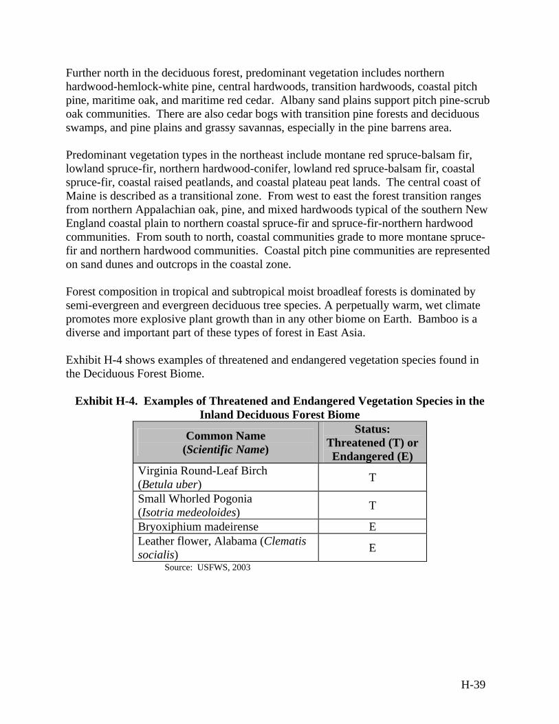
Further north in the deciduous forest, predominant vegetation includes northern hardwood-hemlock-white pine, central hardwoods, transition hardwoods, coastal pitch pine, maritime oak, and maritime red cedar. Albany sand plains support pitch pine-scrub oak communities. There are also cedar bogs with transition pine forests and deciduous swamps, and pine plains and grassy savannas, especially in the pine barrens area. Predominant vegetation types in the northeast include montane red spruce-balsam fir, lowland spruce-fir, northern hardwood-conifer, lowland red spruce-balsam fir, coastal spruce-fir, coastal raised peatlands, and coastal plateau peat lands. The central coast of Maine is described as a transitional zone. From west to east the forest transition ranges from northern Appalachian oak, pine, and mixed hardwoods typical of the southern New England coastal plain to northern coastal spruce-fir and spruce-fir-northern hardwood communities. From south to north, coastal communities grade to more montane spruce-fir and northern hardwood communities. Coastal pitch pine communities are represented on sand dunes and outcrops in the coastal zone. Forest composition in tropical and subtropical moist broadleaf forests is dominated by semi-evergreen and evergreen deciduous tree species. A perpetually warm, wet climate promotes more explosive plant growth than in any other biome on Earth. Bamboo is a diverse and important part of these types of forest in East Asia. Exhibit H-4 shows examples of threatened and endangered vegetation species found in the Deciduous Forest Biome.
Exhibit H-4. Examples of Threatened and Endangered Vegetation Species in the Inland Deciduous Forest Biome
Common Name (Scientific Name)
Status: Threatened (T) or Endangered (E)
Virginia Round-Leaf Birch (Betula uber) T
Small Whorled Pogonia (Isotria medeoloides) T
Bryoxiphium madeirense E Leather flower, Alabama (Clematis socialis) E
Source: USFWS, 2003
H-39
Wildlife The Deciduous Forest Biome provides habitat for a wide variety of animals. The black bear (Ursus americanus) and the endangered Florida panther are found in small numbers in isolated areas, and the whitetail deer is one of the only large indigenous mammals. Common small mammals include raccoons (Procyon lotor), opossums, flying squirrels, rabbits, red fox and numerous species of ground-dwelling rodents. Bobwhite and wild turkey are the principal game birds. Migratory non-game bird species are numerous, as are migratory waterfowl. Ducks, geese, rails, herons, shore birds, beaver, mink, and muskrats are found in inland ponds, marshes, and swamps. Winter birds are diverse and numerous. The endangered red-cockaded woodpecker (Picoides borealis), bald eagle, Atlantic piping plover (Charadrius melodus), and Florida panther inhabit the lower coastal plains and flatlands of the middle portion of this biome. Further north, threatened and endangered species include the gray wolf, mountain lion, lynx, peregrine falcon, and bald eagle. Fort Devens, Massachusetts, is an existing inland site in this biome. Undeveloped lands of this installation are known to support migratory birds including waterfowl, wading birds, raptors, shorebirds, and passerrines (perching birds). Other species found on site include resident mammals, reptiles and amphibians, and invertebrates. The installation lands support breeding areas for at least 12 state-listed animal species and provide migration, feeding, and resting habitat for two federally listed endangered species. The neighboring Oxbow National Wildlife Refuge is a migratory bird refuge on the Atlantic Flyway. Swamp and floodplains surround the oxbows of the Nashua River. On the upland edge a few pine-covered knolls, marshes, swamps and open water areas exist. The Oxbow refuge is also a good birding area where pheasant, woodcock, grouse, snipe, bittern, herons, sandpipers, passerines and woodland birds are likely to be found. Ducks and geese can be present, especially during migration periods. It is assumed that birds found on the refuge also will fly over or utilize the Fort Devens area. Raptors that are expected to use the base area during the breeding season include the American kestrel (Falco sparverius), red-tailed hawk (Buteo jamaicensis), screech (Otus asio), barred (Strix varia) and great horned owls (Bubo virginianus), plus the forest dwelling sharp-shinned (Accipiter striatus), coopers (Accipiter cooperii) and goshawks (Accipiter gentiles), and the red-shouldered (Buteo lineatus) and broad-winged (Buteo platypterus) hawks. Many additional species have been identified during migration. (U.S. Army Space and Strategic Defense Command, 1994b) Oxbow National Wildlife Refuge and Fort Devens are also home to several mammalian species. Those likely to be observed are woodchucks (Marmota monax), snowshoe hares (Lepus Americanus), red (Tamiasciurus hudsonicus) and gray squirrels and cottontail rabbits. Those less likely to be observed are raccoons, skunks, opossum, river otters
H-40
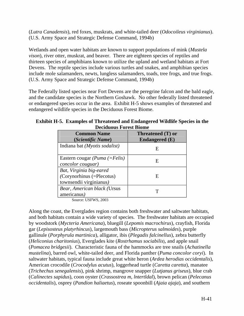
(Lutra Canadensis), red foxes, muskrats, and white-tailed deer (Odocoileus virginianus). (U.S. Army Space and Strategic Defense Command, 1994b) Wetlands and open water habitats are known to support populations of mink (Mustela vison), river otter, muskrat, and beaver. There are eighteen species of reptiles and thirteen species of amphibians known to utilize the upland and wetland habitats at Fort Devens. The reptile species include various turtles and snakes, and amphibian species include mole salamanders, newts, lungless salamanders, toads, tree frogs, and true frogs. (U.S. Army Space and Strategic Defense Command, 1994b) The Federally listed species near Fort Devens are the peregrine falcon and the bald eagle, and the candidate species is the Northern Goshawk. No other federally listed threatened or endangered species occur in the area. Exhibit H-5 shows examples of threatened and endangered wildlife species in the Deciduous Forest Biome.
Exhibit H-5. Examples of Threatened and Endangered Wildlife Species in the Deciduous Forest Biome
Common Name (Scientific Name)
Threatened (T) or Endangered (E)
Indiana bat (Myotis sodalist) E
Eastern cougar (Puma (=Felis) concolor couguar) E
Bat, Virginia big-eared (Corynorhinus (=Plecotus) townsendii virginianus)
E
Bear, American black (Ursus americanus) T
Source: USFWS, 2003 Along the coast, the Everglades region contains both freshwater and saltwater habitats, and both habitats contain a wide variety of species. The freshwater habitats are occupied by woodstork (Mycteria Americana), bluegill (Lepomis macrochirus), crayfish, Florida gar (Lepisosteus platyrhincus), largemouth bass (Micropterus salmoides), purple gallinule (Porphyrula martinica), alligator, ibis (Plegadis falcinellus), zebra butterfly (Heliconius charitonius), Everglades kite (Rostrhamus sociabilis), and apple snail (Pomacea bridgesii). Characteristic fauna of the hammocks are tree snails (Achatinella mustelina), barred owl, white-tailed deer, and Florida panther (Puma concolor coryi). In saltwater habitats, typical fauna include great white heron (Ardea herodias occidentalis), American crocodile (Crocodylus acutus), loggerhead turtle (Caretta caretta), manatee (Trichechus senegalensis), pink shrimp, mangrove snapper (Lutjanus griseus), blue crab (Calinectes sapidus), coon oyster (Crassostrea m, lntertldal), brown pelican (Pelecanus occidentalis), osprey (Pandion haliaetus), roseate spoonbill (Ajaia ajaja), and southern
H-41

bald eagle (Haliaeetus leucocephalus). Exhibit H-6 contains examples of the threatened and endangered species of the Everglades. Gulf of Mexico estuaries provide critical feeding, spawning, and nursery habitats for a rich assemblage of fish, wildlife, and plant species. Hundreds of species of birds, recreational and commercial fish and shellfish species, native cypress and mangroves,
Exhibit H-6. Examples of Threatened and Endangered Species of the Everglades Type of Species Common Name
(Scientific Name) Threatened (T) or Endangered (E)
Atlantic Ridley Turtle (Lepidochelys kempi) E Reptiles and Amphibians
American Crocodile (Crocodylus acutus) E
Birds Southern Bald Eagle (Haliaeetus leucocephalus leucocephalus)
T
Florida Panther (Puma concolor coryi) E Mammals
West Indian Manatee (Trichechus manatus) E
Insects Schaus Swallowtail Butterfly (Heraclides aristodemus) E
Source: USFWS, 2003 and threatened and endangered species such as sea turtles, Gulf sturgeon (Acipenser oxyrhynchus desotoi), beach mice, and manatees can be found in Gulf estuary habitats. Along the northeastern coast, the northern spring salamander (Gyrinophilus porphyriticus), four-toed salamander (Hemidactylium scutatum), grey tree frog (Hyla versicolor), mink frog (Rana septentrionalis), American toad (Bufo americanus), eastern box turtle (Terrapene carolina Carolina) northern brown snake (Storeria dekayi)., and eastern milk snake (Lampropeltis triangulum) characterize rich reptile and amphibian populations. Peregrine falcons are returning to coastal areas to nest. The storm petrel (Hydrobates pelagicus), razorbill (Alca tord), roseate tern (Sterna dougallii), laughing gull (Larus atricilla), Atlantic puffin (Fraterculus arctica), black guillemot (Cepphus grylle), and sharp-tailed sparrow (Ammospiza caudacuta) occur in a variety of coastal habitats. Historically, Atlantic salmon was found in the major rivers (Penobscot and Kennebec) of this area. Restoration of Atlantic salmon to the Penobscot is underway. Numerous whales, dolphins, and seals seasonally migrate through the Gulf of Maine, as do several marine turtle species such as the leatherback (Ammospiza caudacuta), loggerhead (Caretta caretta)., and Atlantic Ridley turtle (Lepidochelys kempi). No Federally listed threatened and endangered species are unique to this area.
H-42
The canopy in the East Asian tropical and subtropical moist broadleaf forests is home to many of the forest's animals, including apes and monkeys. Below the canopy, the lower understory contains snakes and big cats. The forest floor, relatively clear of undergrowth due to the thick canopy above, is home to animals such as gorillas and deer. Wildlife specific to this biome in East Asia include the Calamian deer (Axis calamianesis), Chinese pangolin (Manis pentadactyla), Sunda tree squirrel (Sundasciurus juvencus), and gray imperial-pigeon (Ducula pickeringii). Characteristic wildlife of the temperate broadleaf and mixed forest are either mast-eaters (nut and acorn feeders) or omnivores. Mammals show adaptations to an arboreal life and a few hibernate during the winter months. Wildlife specific to this biome in Asia include the Japanese otter (Lutra Iatra whiteleyi), Japanese serow (Capricornis crispus), Shika deer (Cervis nippon), Blakeston’s fish owl and Tokyo Salamander (Hynobius tokyoensis). The Okinawa Woodpecker is an example of a threatened species that occurs in the Southeast Asia portion of the Deciduous Forest Biome. Environmentally Sensitive Habitat The Florida Keys have been designated a National Marine Sanctuary, Outstanding Florida Waters, and an Area of Critical State Concern. In addition, the Nature Conservancy has designated the Keys one of the ten most significant ecological communities in the world. (U.S. Army Space and Strategic Defense Command, 1998a) For example, Cape San Blas, Florida encompasses habitat that is of unique and critical importance, perhaps the most conspicuous of which is the coastal beach and primary dune system. A variety of micro-habitats exist within the three miles of beach front at Cape San Blas, including overwash sites, mud flats, and sandbars. Cape San Blas is within a migratory bird route and is heavily used by a wide variety of migratory shorebirds throughout the year. Cape San Blas also is a known shorebird wintering and nesting area. Of special concern are sea turtles, which nest along the Cape San Blas shoreline, particularly the Atlantic loggerhead. Cape San Blas has the highest sea turtle nesting density in northwest Florida with approximately ten nests per kilometer (15 nests per mile). (U.S. Army Space and Strategic Defense Command, 1998a)
H.3.4 Geology and Soils
Geology The geology of the Deciduous Forest inland is varied. The Appalachian Mountains run the length of this region. They are low mountains of crystalline rocks with valleys underlain by folded strong and weak strata. Some dissected plateaus with mountainous topography are also present. The relief is high (up to 900 meters [3,000 feet]). Elevations range from 90 to 1,800 meters (300 to 6,000 feet) and are higher to the south, reaching 2,037 meters (6,684 feet) at Mount Mitchell, North Carolina. West of the
H-43
Appalachian Mountains are the Appalachian Plateaus. The sedimentary formations there are nearly horizontal, a typical plateau structure, but they are so elevated and dissected that the landforms are mostly hilly and mountainous. Altitudes range from about 300 meters (1,000 feet) along their western edge to somewhat more than 900 meters (3,000 feet) on the eastern edge. East of the mountains is the Piedmont Plateau and coastal plain, where altitudes range from sea level to about 300 meters (1,000 feet). Most of New England is comprised of glacial features such as small to large delta plains, lake basins, isolated mounds and extended ridges of unstratified rocks. The area gradually descends in a series of broad, hilly plateaus to the coastal zone. Elevation ranges from sea level to 450 meters (1,500 feet), with some high hills in lower New England (monadnocks) at 600 meters (2,000 feet). Most of the Upper Atlantic Coastal Plain has elevations of less than 50 meters (150 feet). In the northernmost part of Lower New England, coastal lowlands are covered by glacial marine sediments (mostly clay). Inland, the bedrock is covered by a thin layer of glacial sediments deposited by rivers and in lakes. In the Upper Atlantic Coastal Plain, a series of terraces is composed of progressively younger sediment layers that range from poorly defined to unconsolidated and include interbedded mud, silt, sand, and gravel. The Coastal Plain is predominantly flat and is covered with terrestrial sediments. Elevation ranges from 0 to 25 meters (0 to 80 feet) in the Middle Atlantic Coastal Plain, Atlantic Coastal Flatlands, and along the West Florida Coastal Lowlands, and from 0 to 50 meters (0 to 160 feet) along the Louisiana Coastal Prairies and Marshes. Elevation ranges from 25 to 200 meters (80 to 660 feet) along the Lower Coastal Plains and Flatwoods and in the Western Gulf Coastal Plains and Flatlands. The majority of the mid Atlantic coastal area is characterized by low ridges surrounded by poorly drained and relatively flat terrain. Lakeshore and river erosion, transport, and deposition are the primary processes shaping the landscape. Elevation ranges from 25 to 300 meters (80 to 1,000 feet). Most of this province has low relief, but rolling hills occur in many places. Lakes, poorly drained depressions, morainic hills (those created by an accumulation of earth and stones carried and deposited by a glacier), drumlins (oval hills made by glacial drift), eskers (long narrow ridges or mounds of sand, gravel, and boulders deposited by a stream flowing on, within, or beneath a stagnant glacier), outwash plains, and other glacial features are typical of the area, which was entirely covered by glaciers during parts of the Pleistocene era. Elevations range from sea level to 730 meters (2,400 feet). The coastal lowlands are covered by Pleistocene marine sediments (mostly clay). Stratified drift overlay the rest of the bedrock. The Everglades, in the coastal area of this biome, are predominantly a flat plain. The sediments covering the plain are of marine origin. Elevation ranges from sea level to 25 meters (85 feet). Poorly defined broad streams, canals, and ditches drain into the ocean. Much of south Florida is underlain by a fossiliferous limestone, a rock composed primarily of calcium carbonate. The calcium carbonate is subject to dissolution when exposed to acidic water, such as acid rain.
H-44
Soils Deciduous trees shed their leaves each fall, and as the leaves decompose, the soil absorbs the nutrients contained in the leaves. For this reason, the soils of this ecological system tend to be fertile due to high amounts of decaying organic matter. There are two types of soil found in deciduous forests in the U.S. Fertile soils with high organic content occupy roughly 14 percent of the U.S. land area. These soils are rich in nutrients and have well-developed layers of clay. The second type, the “red clay” soil occupies roughly nine percent of the U.S. and is found mainly in the southeast. These “red clay” soils are found in humid temperate and tropical areas of the world, typically on older, stable landscapes. While the clay layer is well developed, many of the nutrients have been washed or leached out of the soil over time. Because of the favorable climate regime, these soils can support productive forests, but are poorly suited for continuous agriculture without the use of fertilizer and lime. For example, Fort Belvoir, Virginia has uplands that are underlain by sands, silts, and clays of riverine origin. Uplands underlain by sands and silts tend to be more stable than those underlain by clays. Uplands that are underlain by clayey soils form undulating and rolling hills, and the dominant geomorphic process in these areas is mass wasting that includes downhill creep, landslides, slumping, and rock falls. Lowlands and valley bottoms are typically underlain with alluvium. The dominant geomorphic process is active riverine erosion and deposition during overbank flooding. Surface drainage is commonly poor due to the shallow water table. Drainage usually occurs as surface runoff, with runoff greatest on the steeper slopes and increasing with construction activity and the removal of vegetation, which greatly increases the rate of erosion and the probability of creep and slumping. In coastal areas of this biome, soils are predominantly deep and adequately drained. However, those soils found in the Western Florida Coastal Lowlands and part of the Louisiana Coastal Prairies and Marshes are poorly drained. Soils in the Everglades are composed mainly of organic materials and have varying degrees of stratification. Most soils inland from the Florida coasts are poorly drained, shallow, and moderately textured. Some coastal soils are deep sands that are well drained or excessively drained. These soils are topographically situated in low-lying areas and are subject to tidal flooding. Geological Hazards Because limited seismic activity occurs along the Atlantic continental shelf, the risk of an earthquake in the Deciduous Forest Biome is low. For example, there are no known areas of volcanic activity within Alabama, where the existing Redstone Arsenal is located. According to the Uniform Building Code, this installation is located in seismic zone 1. Within this seismic zone there is a low probability of earthquakes. No unique
H-45
geologic landforms have been identified in the area. (U.S. Army Space and Missile Defense Command, 1999b) Volcanic activity generally is not observed along the U.S. Atlantic and Gulf Coasts, however, cracks present in the Eastern Seaboard have the potential to cause the seabed to crumble and create a tsunami that would push huge masses of seawater toward the coast.
Landslides are a significant geologic hazard throughout the Deciduous Forest Biome.
The U.S. Atlantic and Gulf Coasts are susceptible to coastal land loss. The physical factors that have the greatest influence on coastal land loss are reductions in sediment supply, relative sea level rise, and frequent storms, including hurricanes, whereas the most important human activities are sediment excavation, river modification, and coastal construction. As a result of these agents and activities, coastal land loss is manifested most commonly as beach or bluff erosion and coastal submergence.
H.3.5 Hazardous Materials and Hazardous Waste
Hazardous Materials At the Stennis Space Center in Mississippi, an existing site in the Deciduous Forest Biome, numerous types of hazardous materials are used to support its various missions, research, operations, and general maintenance. These materials include common building paints, industrial solvents, and certain chemicals used in the scientific and photographic labs. Propellant and oxidizer are used to test rocket engine components. Hazardous materials also are used by on-station contractors to support station construction and operations. Hazardous materials such as solvents and paints, chlorine, sulfuric acid, oils, sodium hydroxide, and sulfide solutions are used in maintenance activities. (BMDO, 2001) Under the Comprehensive Environmental Response, Compensation and Liability Act (CERCLA), the resident agencies at the Stennis Space Center, National Aeronautics and Space Administration (NASA), and contractors are responsible for reporting releases of reportable quantities to the National Response Center within 24 hours. The Stennis Space Center implements this program through NASA Management Instruction 1040.1C, which provides a comprehensive emergency plan. Routine and accidental releases, as well as quantities of listed chemicals stored on site, are reported annually in accordance with the Emergency Planning and Community Right To Know Act. The Stennis Space Center Fire Department is trained to handle hazardous materials. (BMDO, 2001) Federal Oil Pollution Prevention regulations require the preparation of a Spill Prevention, Control, and Countermeasure (SPCC) Plan for aboveground petroleum storage tanks with a capacity greater than 2,500 liters (660 gallons) or 5,000 liters (1,320 gallons) in
H-46

aggregate. The Stennis Space Center has a limited number of tanks to which this requirement applies. The Stennis Space Center maintains an SPCC Plan as part of the contingency plan (SPG 4l30.3C). (BMDO, 2001) Hazardous materials commonly utilized at Cape Cod Air Force Station, Massachusetts, an existing site in the coastal section of this biome, include adhesives; batteries; biocides; corrosives; ethylene glycol (antifreeze); diesel fuel; gasoline; paint; petroleum, oil, and lubricants; solvents; biocides; and household products. (U.S. Department of the Air Force, 2002) In addition, the main mission computers generate a large amount of heat and are mechanically cooled using approximately 45 kilograms (100 pounds) of the hydrochlorofluorocarbon refrigerant R-401a. R-401a is an ozone-depleting substance, but it is not listed as a Class I or Class II ozone-depleting substance due to its low ozone-depleting potential. The installation does not vent R-401a to the atmosphere; it is reclaimed. The Tech Facility Chiller utilizes approximately 1,900 kilograms (4,200 pounds) of R-134a, which is not an ozone-depleting substance. Hazardous Waste Hazardous materials and hazardous waste are stored and managed in accordance with applicable laws and regulations. At Redstone Arsenal, Alabama, hazardous waste is stored prior to disposal in igloos in restricted areas. Each igloo is designated for one type of waste and is inspected on a regular basis. At some installations, it is the responsibility of each contractor to manage and dispose of all hazardous waste generated from its operations in accordance with all local, state, and Federal regulations. (U.S. Department of the Air Force, 2000) For example, at the Stennis Space Center, Mississippi, all individuals or organizations are responsible for administering the applicable regulations and plans regarding hazardous waste and for complying with applicable regulations regarding the temporary accumulation of waste at the process site. Individual contractors and organizations maintain hazardous waste satellite accumulation points and 90-day hazardous waste accumulation areas in accordance with 40 CFR 262.34. All hazardous wastes placed in the accumulation areas must be shipped off-site for treatment, storage, and disposal within 90 days of the start of accumulation. At other installations, DoD contracts out waste management responsibilities to local private companies. For example, Cape Cod Air Force Station is considered a small quantity generator of hazardous waste. The installation generates less than 1,000 kilograms of hazardous waste per month and can accumulate up to 6,000 kilograms (13,000 pounds) of hazardous waste on site at any one time. As a small quantity generator, Cape Cod Air Force Station can store hazardous waste on site for up to 180 days (only if the amount stored is less than 6,000 kilograms (13,000 pounds)) before shipping the waste to an off-site disposal location. The Defense Reutilization and Marketing Office in Groton, Connecticut, or Portsmouth, New Hampshire, acts as the principal agent for the procurement of an environmental services disposal company to
H-47
transport and dispose of hazardous waste generated at Cape Cod Air Force Station. (U.S. Department of the Air Force, 2002) Underground storage tanks are subject to Federal regulations within RCRA, 42 United States Code (U.S.C.) 6991, and EPA regulations, Title 40 Code of Federal Regulations (CFR) 265. Aboveground storage tanks are subject to regulation under the Clean Water Act (33 U.S.C. 1251-1578) and oil pollution provisions (40 CFR 112). For example, the Mississippi Department of Environmental Quality has adopted the Federal UST program and is the administering agency for USTs at the Stennis Space Center, Mississippi. Currently, Stennis Space Center contains three USTs and twenty-four ASTs that are subject to Federal regulations. (BMDO, 2001)
H.3.6 Health and Safety
Health and Safety attributes of the Deciduous Forest Biome are similar to those discussed in Section H.1.6.
H.3.7 Noise
The Eastern Range is a representative example of noise levels for sites where activities for the proposed BMDS may occur in the Deciduous Forest Biome. Ambient noise levels based on daytime monitoring, range from 60 dBA to 80 dBA. (DOT, 2001) Noise sources associated with the proposed BMDS are similar to those described in Section H.1.7.
H.3.8 Transportation
Coastal environments sustain widespread infrastructure, including marine ports and docks that are supported by traffic circulation systems such as highways and byways, unpaved roads, non-maintained roads, trails, railroad lines, municipal, private, and military airports and any other system involved in mass transportation. Ground Transportation For example, at Cape Canaveral Air Force Station, Florida, on-site roadways provide access to launch complexes, support facilities, and industrial areas. During peak hours, traffic flow remains steady, and significant delays seldom occur. Several off-site roads and major highways provide access to the installation. Railways transport both cargo and passengers in the region. (U.S. Army Space and Missile Defense Command, 1999a) Air Transportation There are numerous commercial, private, and military airports within the Deciduous Forest Biome. They vary in size from major international airports such as Hartsfield-
H-48
Jackson Atlanta International Airport in Georgia that supports 80 million passengers each year to small, rural airstrips that support single engine planes. Marine Transportation The top ports in U.S. foreign trade are deep draft (with drafts of at least 12 meters [40 feet]). Twenty-five U.S. ports, located within the Deciduous Forest Biome, received 73 percent of total vessel calls, including Portland, Maine; New York, New York; Baltimore, Maryland; Hampton Roads, Virginia; Charleston, South Carolina; Savannah, Georgia; Jacksonville, Florida; Miami, Florida; Port Everglades, Florida; Mobile, Alabama; Lake Charles, Louisiana; LOOP Terminal, Louisiana; Beaumont, Texas; Corpus Christi, Texas; Freeport, Texas; and Texas City, Texas. Of vessels over 1,000 gross tons, tankers and containerships called at U.S. ports more often in 2000 than did other types of vessels. (DOT BTS, 2001)
H.3.9 Water Resources
Surface Water and Ground Water Resources Ground water provides about 40 percent of the U.S. public water supply. Freshwater aquifers along the Atlantic coastal zone are among the most productive in the U.S., supplying drinking water to an estimated 30 million people from Maine to Florida. (USGS, 2000) More than 40 million people, including most of the rural population, supply their own drinking water from domestic wells. Ground water is also the source of much of the water used for irrigation. It is the principal reserve of fresh water and represents much of the potential future water supply. Ground water is a major contributor to flow in many streams and rivers and has a strong influence on river and wetland habitats for plants and animals. In the Northern U.S. coastal areas, nearly all rural, domestic, and small-community water systems obtain water from ground water wells. Where water demand is great, sophisticated reservoir, pipeline, and purification systems are needed to meet demands. In the Mid-Atlantic, rivers are important sources of water supply for many cities, but populations living on the Coastal Plain depend on ground water for supply. For example, at Cape San Blas, Florida, the Floridian aquifer is the primary potable water source, although the surficial aquifer may be used as a potable water source in rural areas. Ground water resources along the Atlantic Coast are vulnerable to saltwater intrusion and nutrient contamination. Saltwater intrusion, the movement of saline water into freshwater aquifers, is most often caused by ground water pumping near the coast. Nutrient contamination results from many human activities and has caused widespread increases of nitrate in shallow ground water. (USGS, 2000)
H-49
Sole Source Aquifer designations under the Safe Drinking Water Act protect drinking water supplies in areas with few or no alternative sources to the ground water resource, or where, if contamination occurred, using an alternative source would be extremely expensive. The designation protects an area’s ground water resource by requiring EPA review of any proposed projects within the designated area that are receiving Federal financial assistance. Many sole-source aquifers have been designated in coastal areas, especially on near shore islands. For example, there are 15 designated Sole Source Aquifers in New England, most of which are in coastal areas. (EPA, 2003a) The Coastal Plain of the Atlantic Coast has a moderate density of small to medium size perennial streams and a low density of associated rivers, most with moderate volume of water flowing at very low velocity. In the Mid-Atlantic Coastal Flatlands and Lowlands and Louisiana Prairies and Marshes, the water table is high in many areas, resulting in poor natural drainage and abundance of wetlands. In the Lower Coastal Plains, few natural lakes occur, except in central Florida where they are abundant. Large, freshwater springs are common in central Florida, especially in areas of limestone rock formations. In the Upper Atlantic Coastal Plain streams flow relatively slowly to the Atlantic Ocean or the Delaware Bay. Natural lakes are rare to non-existent. Small water impoundments are common along the upper reaches of streams. Bogs, swamps, and salt marshes exist along the Atlantic Coast. Bogs tend to be very acidic. Rates of stream flow near the Delaware Bay and the coast fluctuate daily in response to tides. Tests show that salt content is sufficiently low that tidewater from streams may be used for irrigation without adverse effects on soils and vegetation. Currently, there is ample water for farm, urban, and industrial uses. However, urban development increasingly affects the hydrology of the area, including infiltration, underground water storage, and runoff. The source of most surface water in the Everglades, other than precipitation, is Lake Okeechobee, about 1,940 square kilometers (750 square miles) in area, immediately north of this area. Most waterways are canals that were built to carry a moderate to high volume of water at very low velocity. The water table is high in many areas, resulting in poor natural drainage and abundance of wetlands. A poorly defined drainage pattern has developed on this landscape, which is relatively young and weakly dissected. Water Quality The quality of the ocean along the east coast of the U.S. is highly impacted by human activity. A great percentage of our population lives within 50 miles of the coast and much of the land along the coast has been developed. Water testing shows that the ocean of the Mid-Atlantic is highly affected by the flow into the ocean from the Hudson River, the Delaware River, and the Chesapeake Bay. Water that falls on land can make its way to streams and rivers that empty into the ocean, carrying pollutants, such as fertilizers and pesticides from farms and homes. Pollution of coastal waters also comes from rainfall
H-50

that can carry particulates and other pollutants; sewage treatment plants; combined sewer overflows; and storm drains that discharge liquid waste directly into the ocean through pipelines, dumping of materials dredged from the bottoms of rivers and harbors, and waste from fish processing plants, legal and illegal dumping of wastes from ships and ground water from coastal areas. Along the east coast, some indicators of water quality show improvement, while others indicate worsening conditions. Overall, the long-term trend is for increasing loads of contaminants in the ocean caused by an ever-increasing population impacting the coastal area. (EPA, 2003e) The majority of estuaries assessed in the Gulf of Mexico were in good ecological condition, meaning that neither environmental stressors (nutrients, contaminants, etc.) nor aquatic life communities showed any signs of degradation. However, some estuaries showed indications of poor aquatic life conditions, and some were impaired for human uses. These estuaries support submerged aquatic vegetation communities that stabilize shorelines from erosion, reduce non-point source loadings, improve water clarity, and provide habitat. Water clarity in Gulf Coast estuaries is fair. Water clarity was estimated by light penetration through the water column. For approximately 22 percent of the waters in Gulf of Mexico estuaries, less than ten percent of surface light penetrated to a depth of one meter (three feet). Dissolved oxygen conditions in Gulf Coast estuaries are generally good, except in a few highly eutrophic, or nutrient rich regions. Estimates for Gulf of Mexico estuaries show that about four percent of the bottom waters in the Gulf estuaries have hypoxic conditions characterized by low dissolved oxygen (less than 2 parts per million) on a continuing basis in late summer. These areas are largely associated with Chandeleur and Breton Sounds in Louisiana, some shoreline regions of Lake Pontchartrain, northern Florida Bay, and small estuaries associated with Galveston Bay, Mobile Bay, Mississippi Sound, and the Florida panhandle. While hypoxia resulting from human activities is a relatively local occurrence in Gulf of Mexico estuaries, accounting for less than five percent of the estuarine bottom waters, the occurrence of hypoxia in the Gulf’s shelf waters is much more significant. The Gulf of Mexico hypoxic zone is the largest zone of anthropogenic, or human-caused, coastal hypoxia in the Western Hemisphere. (National Oceanic and Atmospheric Administration [NOAA], 2000) Since 1993, midsummer bottom water hypoxia in the northern Gulf of Mexico has been larger than 10,000 square kilometers (3,861 square miles), and in 1999, it reached 20,000 square kilometers (7,722 square miles). (NOAA, 2000) Over half of the N2 load comes from non-point sources north of the confluence of the Ohio and Mississippi Rivers, with much of the loading coming from the drainage of agricultural lands. (NOAA, 2000) Gulf of Mexico ecosystems and fisheries are affected
H-51
by the widespread hypoxia. Mobile organisms leave the hypoxic zone for more oxygen-rich waters, and those that cannot leave die as a result of hypoxia. The condition of Gulf Coast estuaries as measured by eutrophic (high nutrient) conditions is poor. Expression of eutrophic condition was high in 38 percent of the area in Gulf estuaries. The symptoms of eutrophic condition are expected to increase in over half of Gulf of Mexico estuaries by 2020. High expressions of chlorophyll were determined for about 30 percent of the estuarine area of the Gulf of Mexico. The areas with high chlorophyll were largely in Louisiana, Laguna Madre, Texas, Tampa Bay, Florida, and Charlotte Harbor, Florida. (EPA, 2003e) The coastal wetlands indicator for the Gulf of Mexico receives a score of poor. Wetland losses along the Gulf of Mexico from the 1780s to 1980s are among the highest in the nation. Losses over the 200-year time span were 50 percent throughout the Gulf and ranged from 46 percent declines in Florida and Louisiana (although the absolute losses in these states were the highest) to a 59 percent decline in Mississippi. During the 1970s to 1980s, the Gulf lost five percent of its wetlands, with the largest declines seen in Texas. Not all of the wetland losses in the Gulf of Mexico are due to coastal development. Sea-level rise, coastal subsidence, and interference with normal erosion and depositional processes also contribute to wetland loss.
H.4 Chaparral Biome
The Chaparral Biome includes regions corresponding to those shown in Exhibit 3-14, but focuses on a portion of the California Coast and the coastal region of the Mediterranean from the Alps to the Sahara Desert and from the Atlantic Ocean to the Caspian Sea. Representative sites where activities for the proposed BMDS may occur are part of the Western Range, including Vandenberg AFB and the Point Mugu Sea Range. Coastal areas consist of land areas that are affected by proximity to the sea, and sea areas that are affected by proximity to the land. As noted above, the coastal area consists of the Exclusive Economic Zone, which is 322 kilometers (200 miles) offshore and incorporates the 19.3-kilometer (12-mile) designation often used by the Navy to define coastal areas. The coastal zone also extends one kilometer (.6 mile) inland of the coastal shoreline, tidal wetlands, coastal wetlands, and coastal estuaries. Sea-based activities may occur in near shore areas of the Chaparral Biome. The near shore is an indefinite zone extending seaward from the shoreline beyond the breaker zone (see Figure H-7). This typically includes water depths less than 20 meters (65 feet). (Discover the Outdoors, 2002)
H-52
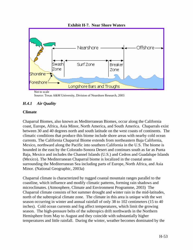
Exhibit H-7. Near Shore Waters
Not to scale Source: Texas A&M University, Division of Nearshore Research, 2003
H.4.1 Air Quality
Climate Chaparral Biomes, also known as Mediterranean Biomes, occur along the California coast, Europe, Africa, Asia Minor, North America, and South America. Chaparrals exist between 30 and 40 degrees north and south latitude on the west coasts of continents. The climatic conditions that produce this biome include shore areas with nearby cold ocean currents. The California Chaparral Biome extends from northeastern Baja California, Mexico, northward along the Pacific into southern California in the U.S. The biome is bounded in the east by the Colorado-Sonora Desert and continues south as far as Punta Baja, Mexico and includes the Channel Islands (U.S.) and Cedros and Guadalupe Islands (Mexico). The Mediterranean Chaparral biome is localized in the coastal areas surrounding the Mediterranean Sea including parts of Europe, North Africa, and Asia Minor. (National Geographic, 2003a) Chaparral climate is characterized by rugged coastal mountain ranges parallel to the coastline, which influence and modify climatic patterns, forming rain shadows and microclimates. (Atmosphere, Climate and Environment Programme, 2003) The Chaparral climate consists of hot summer drought and winter rain in the mid-latitudes, north of the subtropical climate zone. The climate in this area is unique with the wet season occurring in winter and annual rainfall of only 38 to 102 centimeters (15 to 40 inches). Cold ocean currents and fog affect temperatures, which limit the growing season. The high-pressure belts of the subtropics drift northwards in the Northern Hemisphere from May to August and they coincide with substantially higher temperatures and little rainfall. During the winter, weather becomes dominated by the
H-53
rain-bearing low-pressure depressions. While usually mild, such areas can experience cold snaps when exposed to the icy winds of the large continental interiors, where temperatures can drop to -40°C (-40oF) in the extreme continental climates. (Atmosphere, Climate and Environment Programme, 2003) Regional Air Quality The primary sources of air pollutants in coastal areas include stationary sources, area sources, mobile sources, and biogenic sources such as forest fires. Many VOCs react with sunlight in the atmosphere to produce ozone (i.e., smog). In some areas, background levels of air pollutants are relatively high due to air currents depositing pollution from sources outside of the coastal area. The EPA recently conducted a national-scale assessment of 33 air pollutants (a subset of 32 HAPs plus diesel PM), including sources, ambient concentrations, and human health risk (cancer and noncancer). Many of the highest-ranking 20 percent of counties in terms of risk are located in the Pacific coastal areas in central and southern California. (EPA, 1996) There is a large area along the Pacific coast, particularly in southern California that is in non-attainment for ozone (ranging from severe to extreme). Non-attainment for ozone is found within all of the air basins along the southern California coast. Los Angeles and Orange counties are in extreme non-attainment for ozone. Ventura and San Diego counties are in serious and severe non-attainment for ozone, respectively, and Santa Barbara County is in moderate non-attainment. Several factors contribute to this including Increases in industrial and automotive activity associated with population growth, Stagnant air movement, Strong inversions during warm weather, and Pollutants migrating from neighboring areas.
There are also many areas along the Pacific coast that are in non-attainment for PM10. A large area in southern California is in severe non-attainment for PM10, while smaller areas are in moderate non-attainment in coastal Oregon and Washington. (EPA, 2003f) The EPA has designated the near shore areas of southern California as unclassified/attainment areas. Due to the lack of major emissions sources in the area and the presence of strong northeast winds, the likelihood of pollutants remaining in the ambient air is low. The European Union eight-hour air quality standard for ozone (53 nmol/mol) is exceeded throughout the summer in the entire Mediterranean region. Typical ozone mixing ratios
H-54
in summer are 55 to 70 nmol/mol, and the diurnal variability is small (approximately 10 percent). In addition, the concentrations of aerosols are high. The fine aerosol fraction (less than1micrometer) is composed mainly of sulfate (35 to 40 percent), organics (30 to 35 percent), ammonium (10 to 15 percent) and black carbon (five to 10 percent) and is produced mostly by fossil fuel and biomass combustion. The persistent northerly winds in summer carry large pollution loads from Europe to the Mediterranean Sea, affecting water quality and contributing to eutrophication. Aerosols further influence the Mediterranean atmospheric energy budget by scattering and absorbing solar radiation. They reduce solar radiation absorption by the sea by about ten percent and they alter the heating profile of the lower troposphere. As a result, evaporation and moisture transport, in particular to North Africa and the Middle East, are suppressed. Furthermore, aerosols interfere with the cloud microstructure and convection, which may lead to decreased precipitation. There is a remarkably high level of air pollution from the surface to the top of the troposphere (up to 15 kilometers [nine miles] altitude). The strongest anthropogenic influence was observed in the lower four kilometers (two miles), originating from both West and East Europe transported by the northerly flow. Major sources of air pollution along the Mediterranean coast include industrial activity, traffic, forest fires, and agricultural and domestic burning. Because the Mediterranean region has very few clouds in summer, solar radiation levels are high so that noxious reaction products such as ozone and peroxyacetyl nitrate are formed in photochemical smog. At higher altitudes, above four kilometers (two miles), significant contributions from long-distance pollution transport from North America and Asia are present. About half of the mid-tropospheric CO over the Mediterranean originates from Asia and 25 to 30 percent from North America. These transports follow the prevailing westerly winds that are typical of the extra-tropics. These layers are affected substantially by ozone that is mixed from the stratosphere. The middle troposphere, in particular, is influenced in summer by stratosphere-troposphere exchange, leading to a stratospheric contribution to column ozone in the troposphere up to 25 to 30 percent. Transport of anthropogenic ozone and its precursor gases from the U.S. exert a significant influence in the free troposphere. A distinct layer that is associated with high levels of reactive species such as formaldehyde is found in the upper troposphere (above eight kilometers [five miles] altitude). This layer of pollution is caused by anthropogenic emissions transported from South Asia, following convective lifting into the upper troposphere by thunderstorms in the Indian monsoon. Subsequently these air parcels follow the easterly tropical jet and turn north over the eastern Mediterranean in a large upper level anticyclone. The chemical “fingerprint” of biomass burning (e.g., enhanced acetonitrile, methyl chloride, acetylene), in particular by biofuel use in India as observed during the Indian Ocean
H-55
Experiment, is evident. From the upper troposphere over the eastern Mediterranean these substances can penetrate the lowermost stratosphere. It appears that the Mediterranean region is a preferred location for cross-tropopause exchanges, partly related to direct convective penetration of the lower stratosphere over southern Europe. (Lelieveld, 2002) Existing Emission Sources The southern U.S. Pacific coast has intensely populated areas with heavy urban development. Heavy industrial activities, high automobile traffic, and energy generation are the main sources of air pollutants in this area. The South Coast Air Basin includes a population that accounts for 40 percent of the traveled vehicle miles and creates one-third of the air pollution in California. The main emission source in this area is automobiles. However, continued construction and development is causing increased fugitive dust levels resulting in growing PM10 concentrations. Emission sources in the south central coastal area include power plants, oil extraction and refining activities, transportation, and agriculture. Ozone concentrations in this district are improving, but the area still struggles with high PM10 levels. Existing air emissions in the near shore environment include emissions from aircraft operations, missile/target operations, and marine vessel operations. Power plants and transportation provide the greatest sources of global warming gases emissions in Europe, including the southern regions of the Mediterranean Biome. Electricity demand continues to rise in the European Union, securing the presence of CO2 as a growing emission, with emission levels possibly rising to 23 percent over their 1995 levels by 2020. Emissions of polyaromatic hydrocarbons are another pollutant of concern, deriving primarily from combustion processes in the region, especially in small boilers with often poor combustion. Road traffic is another contributor. The European Union also pays special attention to hydrofluorocarbons, perfluorocarbons and sulfur hexafluoride as global warming contributors. They are primarily emitted from refrigeration practices, air conditioning (including in cars), and industry. Emissions of each of these three gases have been on the rise lately due to their substitution for ozone depleting substances banned by the Montreal Protocol. (Acid News, 2003) While most Mediterranean countries studied are not big polluters, the Mediterranean region is a crossroads area for pollution carrying air currents from Europe, Asia, and North America. (Lelieveld, 2002) In fact, studies show that trans-Atlantic pollution transport from North America exerts the greatest influence over the Mediterranean region. (Bey and Schultz, 2003)
H-56
The main sources of atmospheric pollution in Northern Africa are bush fires, vehicle emissions, manufacturing, mining, and industry. Major industrial sources include thermal power stations, copper smelters, ferro-alloy works, steel works, foundries, fertilizer plants, and pulp and paper mills. The use of leaded fuel in vehicles also greatly contributes to emissions, which are worsening due to the ageing of the region’s vehicles, most of which are more than 15 years old. These older vehicles also are said to emit five times more hydrocarbons and CO, and four times more NOx, than new vehicles. (UNEP, 2000)
H.4.2 Airspace
Controlled and Uncontrolled Airspace The Chaparral Biome in the U.S. contains all FAA classifications for airspace, as described in Section 3.1.2. Airspace in coastal regions of North America contains “North American Coastal Routes,” which are numerically coded routes preplanned over existing airways and route systems to and from specific coastal fixes. See Section 3.1.2 for a description of North American Routes. Portions of the Chaparral Biome are located in international airspace. Therefore, the procedures of ICAO (outlined in ICAO Document 444, Rules of the Air and Air Traffic Services) are followed. The ICAO is a specialized agency of the United Nations whose objective is to develop the principles and techniques of international air navigation and to foster planning and development of international civil air transport. The FAA acts as the U.S. agent for aeronautical information to the ICAO, and the Los Angeles ARTCC manages air traffic in the California portion of the Chaparral Biome. In December of 2002, the European Union adopted the “single sky” directive, which will create a single European airspace by 2004. The single sky proposal will eliminate many of the national boundaries that currently divide Europe's airspace to create several “functional blocks of airspace” that will be regulated as a single entity. European Union airspace above 8,687 meters (28,500 feet) will be under unified control. Special Use Airspace There are numerous restricted areas in the near shore environment associated with the Western Range. These include restricted areas R-235A and R-2535B, and eight warning areas (W-289, W-289N, W-290, W-412, W-532, W-537, W-60, W-61). The airspace in each warning area extends from the surface (sea level) to an unlimited altitude. The FAA Los Angeles ARTCC controls civil aircraft operating under IFR clearances and transiting areas associated with the Western Range along the U.S. Pacific Coast. Aircraft operating under VFR conditions are not precluded from operating in the Warning Area airspace;
H-57
however, during hazardous operations every effort is made to ensure that non-participating aircraft are clear of potential hazard areas. The procedures for scheduling each portion of airspace are performed in accordance with letters of agreement with the controlling FAA facility, Los Angeles ARTCC. Schedules are provided to the FAA facility as agreed between the agencies involved. Aircraft transiting the open ocean portion of the region of influence that could be affected by tests events would be notified, and any necessary rerouting would be accommodated before departing their originating airport. This may require affected aircraft to take on additional fuel before take-off. Airports/Airfields Numerous airports and airfields exist within the Chaparral Biome. For example, the area that encompasses the Vandenberg AFB includes the Santa Barbara Municipal, Santa Ynez, Lompoc, and Santa Maria Public airports. Vandenberg AFB also maintains its own runway, which is capable of handling large aircraft (U.S. Army Space and Missile Defense Command, 2002b). En Route Airways and Jet Routes Numerous jet routes that cross the Pacific pass through the U.S. Chaparral Biome, including A331, A332, A450, R463, R465, R584, Corridor V506 and Corridor G10.
H.4.3 Biological Resources
Vegetation Chaparral Biome occurs in mild temperate climate zones with moderate winter precipitation and long, hot, dry summers or where there is moderate precipitation, but the sandy soils have low water-holding capacities. The Chaparral supports a broad variety of xeric (requiring little water) woodlands from piñon-juniper woodlands to pine barrens to sandhill pine woodlands, sandpine scrub, and pine flatwoods. The vegetation of the Chaparral is characterized by the presence of Sclerophyllous (hard, tough, evergreen) leaves and low, shrubby appearance. Many plants are specially adapted to areas of nearly toxic, magnesium-rich soil (known as serpentine). Due to the summer drought, many plants that thrive in other European areas are unable to thrive on the Mediterranean Coast. Shrubs and low-growing vegetation are the main components of the region. However, some areas exhibit growth that extends to larger trees and hard-leaf forests, as well as aromatic plants. The vegetation is hardy and drought-resistant and includes evergreens, cacti, olive and fruit trees, and cork oak.
H-58
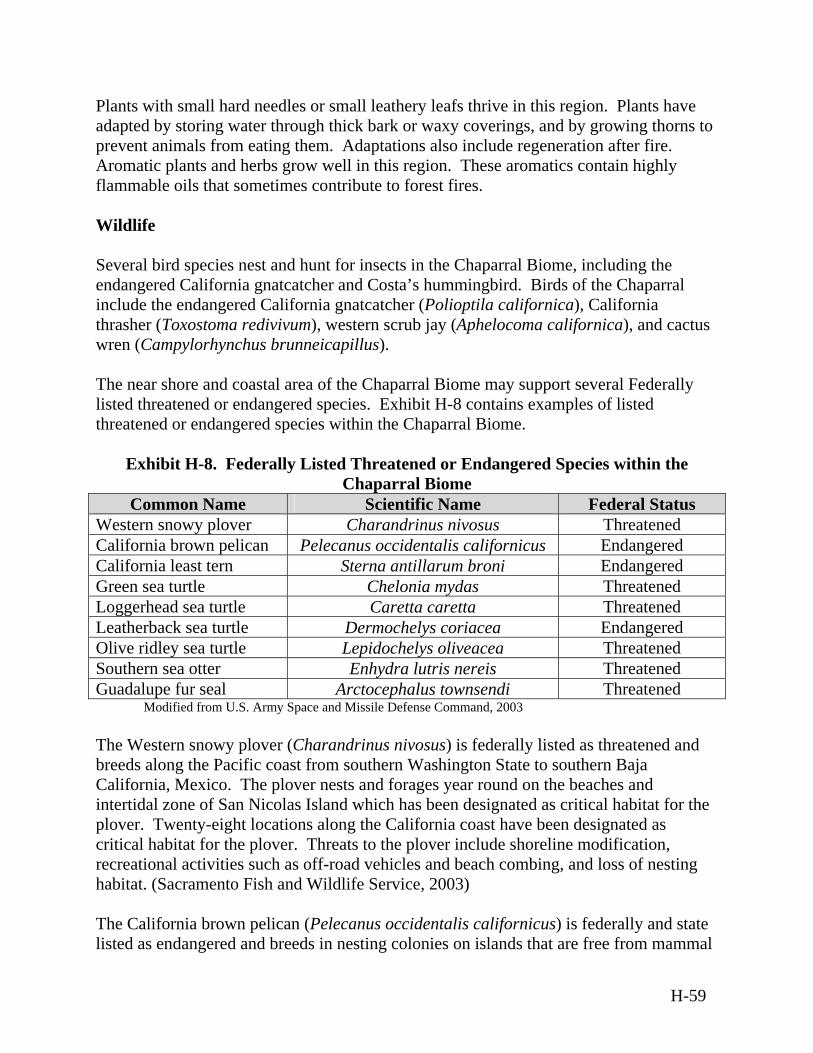
Plants with small hard needles or small leathery leafs thrive in this region. Plants have adapted by storing water through thick bark or waxy coverings, and by growing thorns to prevent animals from eating them. Adaptations also include regeneration after fire. Aromatic plants and herbs grow well in this region. These aromatics contain highly flammable oils that sometimes contribute to forest fires. Wildlife Several bird species nest and hunt for insects in the Chaparral Biome, including the endangered California gnatcatcher and Costa’s hummingbird. Birds of the Chaparral include the endangered California gnatcatcher (Polioptila californica), California thrasher (Toxostoma redivivum), western scrub jay (Aphelocoma californica), and cactus wren (Campylorhynchus brunneicapillus). The near shore and coastal area of the Chaparral Biome may support several Federally listed threatened or endangered species. Exhibit H-8 contains examples of listed threatened or endangered species within the Chaparral Biome.
Exhibit H-8. Federally Listed Threatened or Endangered Species within the Chaparral Biome
Common Name Scientific Name Federal Status Western snowy plover Charandrinus nivosus Threatened California brown pelican Pelecanus occidentalis californicus Endangered California least tern Sterna antillarum broni Endangered Green sea turtle Chelonia mydas Threatened Loggerhead sea turtle Caretta caretta Threatened Leatherback sea turtle Dermochelys coriacea Endangered Olive ridley sea turtle Lepidochelys oliveacea Threatened Southern sea otter Enhydra lutris nereis Threatened Guadalupe fur seal Arctocephalus townsendi Threatened
Modified from U.S. Army Space and Missile Defense Command, 2003 The Western snowy plover (Charandrinus nivosus) is federally listed as threatened and breeds along the Pacific coast from southern Washington State to southern Baja California, Mexico. The plover nests and forages year round on the beaches and intertidal zone of San Nicolas Island which has been designated as critical habitat for the plover. Twenty-eight locations along the California coast have been designated as critical habitat for the plover. Threats to the plover include shoreline modification, recreational activities such as off-road vehicles and beach combing, and loss of nesting habitat. (Sacramento Fish and Wildlife Service, 2003) The California brown pelican (Pelecanus occidentalis californicus) is federally and state listed as endangered and breeds in nesting colonies on islands that are free from mammal
H-59
predators. The nesting colonies range from Baja California to West Anacapa and Santa Barbara Islands. The breeding season is from March to August. Brown pelicans may roost along the Pacific coast from the Gulf of California to Washington State and southern British Columbia. Threats to the California brown pelican include a decline in the food supply because of over-fishing, entanglement with hooks and fishing lines, disturbances at roosting sites, disease, and climate changes. (Sacramento Fish and Wildlife Service, 2003) The California least tern (Sterna antillarum browni) is federally and state listed as endangered and is a highly migratory species that is present in California from April to September. It migrates further south during the winter. The least tern nests on sandy beaches close to lagoons and forages in the near shore waters. Threats to the California least tern include habitat loss, human disturbance, predation, and climatic events. (Sacramento Fish and Wildlife Service, 2003) The Green sea turtle (Chelonia mydas) is a federally threatened sea turtle found in the eastern North Pacific from Baja California to southern Alaska. Green sea turtles forage in the kelp beds off western San Nicolas Island but there are no known nesting locations on the island. The sea turtles are sighted year round in the Western Range generally in waters less than 50 meters (164 feet) deep. Populations appear to be highest from July to September. Threats to the Green sea turtle include over-harvesting by humans, habitat loss, fishing net entanglement, boat collisions, and disease. (Sacramento Fish and Wildlife Service, 2003) The Loggerhead sea turtle (Caretta caretta) is a federally threatened sea turtle similar to the Green sea turtle. It has been observed in the Range at depths up to 1,000 meters (3,280 feet). Juvenile Loggerhead sea turtles are spotted frequently in the Western Range particularly from July to September but adult Loggerheads are rarely seen in the Western Range. Threats to Loggerhead sea turtles include exploitation, loss of habitat, fishing practices, and pollution. The Leatherback sea turtle (Dermochelys coriacea) is a federally listed endangered species. The Leatherback sea turtle is a highly migratory species and is more pelagic (using deep ocean waters) than other sea turtle species. They may forage in the kelp beds off western San Nicolas Island, but there are no known nesting beaches on the island. They have been observed in the Western Range at depths of up to 1,000 meters (3,280 feet). They are most common from July to September. Threats to the Leatherback sea turtle include exploitation, loss of habitat, fishing practices, and pollution. The Olive ridley sea turtle (Lepidochelys oliveacea) is a federally listed threatened species. (NOAA, 2003a) The Olive ridley is primarily tropical, nesting from southern Sonora, Mexico to Colombia. These turtles are rarely seen in the waters off the
H-60
southwestern U.S. They have been observed in the Western Range in waters less than 50 meters (164 feet) but are rarely encountered. The Southern sea otter (Enhydra lutris nereis) is federally listed as threatened. The sea otter lives in shallow water along the shores of the North Pacific. Sea otters inhabit intertidal and shallow, subtidal zones often in kelp beds. Sea otters can be found throughout the year in the kelp beds at the west end of San Nicolas Island and in smaller numbers off the north end of the island. Threats to the sea otters include shootings, boat strikes, capture and relocation, oil spills, and exposure to other toxic contaminants. The Guadalupe fur seal (Arctocephalus townsendi) is federally listed as threatened. Individuals have been observed in the southern Channel Islands, including San Nicolas Island. The decline in the species appears to have been due to historic commercial hunting. Environmentally Sensitive Habitat The Chaparral Biome around the world supports 20 percent of all plants, but these areas are all relatively small and highly threatened. For example, the California Chaparral is one of only five Chaparral shrublands and woodlands of its kind and is the only one in North America. The biggest problem for this habitat is agricultural and urban expansion, which destroys and fragments remaining patches of Chaparral. Smaller patches also experience higher impacts from introduced plants and animals. Small patches also lose species that require larger areas of habitat for survival. In addition, fire suppression causes fuels to build up and can trigger very hot, devastating fires. In 1980, a 4,294-square kilometers (1,252-square nautical miles) portion of the Santa Barbara Channel was designated as the Channel Islands National Marine Sanctuary. The sanctuary is an area of national significance that encompasses the waters that surround Anacapa, Santa Cruz, Santa Rosa, San Miguel and Santa Barbara Islands and extends from mean high tide to 11 kilometers (six nautical miles) offshore around each of the five islands. The sanctuary’s primary goal is the protection of natural resources contained within its boundaries. The NOAA plans to expand the Channel Islands National Marine Sanctuary off the coast of Vandenberg AFB. The study area for this expansion includes an area off the coast of California from south of Point Mugu to north of Point Sal. (NOAA, 2003a) Essential Fish Habitat includes those waters and sediment that are necessary to complete the life cycle for fish from spawning to maturity. The two Essential Fish Habitat zones in this region are for coastal pelagic and groundfish species. The coastal pelagic species include Pacific sardine (Sardinops sagax) Pacific mackerel (Scomber japonicus), northern anchovy (Engraulis mordax), jack mackerel (Trachurus symmetricus), and squid. The groundfish species include rockfish, shark, and cod. Migratory fish species in the area
H-61
include tunas, marlin, and swordfish (Xiphias gladius). The east-west boundary for the Essential Fish Habitat zone includes all marine and estuary waters from the coast of California to the limits of the Exclusive Economic Zone (322 kilometers [200 miles]) where the U.S. has authority over the management of fisheries.
H.4.4 Geology and Soils
Geology The California Chaparral Biome consists of narrow ranges with wide plains in between, as well as alluviated lowlands and coastal terraces. Elevation ranges from zero to 2,280 meters (zero to 7,500 feet). In the Mediterranean region, the African plate pushes northward, causing the plate to move beneath, or subduct, European countries along the north coast of the Mediterranean. Many of these countries are known for their mountains and volcanoes, a result of this continuing process. There are many points of convergence and subduction throughout the Mediterranean, making it a distinctly geologically active region. Tectonics explains the size of the mountains around the Mediterranean Basin. Recent, high mountains with rough-hewn shapes rise either on the sea or a few kilometers inland. The main mountain ranges are the Atlas, the Betic chain, the Pyrenees, the Alps, the Apennines, the Dinaric massif, the Pinde mountains, the Taurus, and Mount Lebanon. In the northern part of the Mediterranean Basin, large plains are infrequent. However, in the southern part, along the thousands of kilometers of coastline, mountains are replaced by usually flat stretches where the desert often runs to the sea. (UNEP, 2003) Soils The soils of the Chaparral Biome may be classified into four categories, coastal beach sands, tidal flats, loamy sands, and silty clay. The erosion hazard of these soils depends on slope and vegetation cover. In addition, the soils of the north Mediterranean Basin, where the climate is more humid, contain plant matter, which breaks down faster into soils rich in organic matter. In the southern Mediterranean Basin, because of extreme temperatures and lack of water, soils become depleted in organics, leaving behind a higher concentration of minerals. In addition, organics are removed by encroaching seawater along the coast that can cause salinization of soils. These soils, which are sensitive to desertification, become shallow and have a low water-holding capacity. (UNEP, 2003) Mediterranean soils are subject to intense erosion due to irregular and often violent precipitation such as monsoons, wind, the steep topography, and reduction in plant cover caused by the severe climate and man-made activities. (UNEP, 2003)
H-62
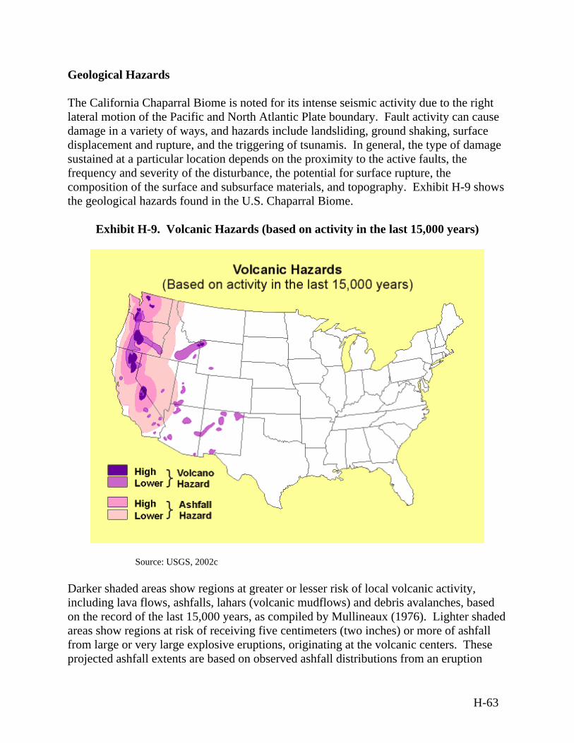
Geological Hazards The California Chaparral Biome is noted for its intense seismic activity due to the right lateral motion of the Pacific and North Atlantic Plate boundary. Fault activity can cause damage in a variety of ways, and hazards include landsliding, ground shaking, surface displacement and rupture, and the triggering of tsunamis. In general, the type of damage sustained at a particular location depends on the proximity to the active faults, the frequency and severity of the disturbance, the potential for surface rupture, the composition of the surface and subsurface materials, and topography. Exhibit H-9 shows the geological hazards found in the U.S. Chaparral Biome.
Exhibit H-9. Volcanic Hazards (based on activity in the last 15,000 years)
Source: USGS, 2002c Darker shaded areas show regions at greater or lesser risk of local volcanic activity, including lava flows, ashfalls, lahars (volcanic mudflows) and debris avalanches, based n the record of the last 15,000 years, as compiled by Mullineaux (1976). Lighter shaded
t risk of receiving five centimeters (two inches) or more of ashfall om large or very large explosive eruptions, originating at the volcanic centers. These
projected ashfall extents are based on observed ashfall distributions from an eruption
oareas show regions afr
H-63
(large) of Mt. St. Helens that took place 3,400 years ago, and the eruption of Mt. Ma(very large) that formed Crater Lake, Oregon, 6,800 years ago.
H.4.5 Hazardous Materials and Hazardous Waste
Hazardous Materials Hazardous materials use within the Chaparral Biome must conform to applicable Federal,
zama
tions. Existing ranges located within the U.S. Chaparral Biome have established procedures for obtaining hazardous materials from off-base
procedures are in accordance with the Hazardous Materials Management
Plan. Spills of hazardous materials are covered under the Hazardous Materials nse Plan. This plan ensures that adequate and appropriate guidance,
andled through established procedures, which describe andling, transporting, and disposing of hazardous waste.
ansported to the off-site Treatment, torage, and Disposal Facility (U.S. Army Space and Missile Defense Command, 2001).
representative example of noise levels for sites where activities for e proposed BMDS may occur in the Chaparral Biome. Ambient noise levels at
with
spread infrastructure, including marine ports and docks that are ation systems such as highways and byways, unpaved roads,
state and local laws and regula
suppliers. Hazardous materials are tracked using Environmental Management Systemsoftware. These
Emergency Respopolicies, and protocols regarding hazardous material incidents and associated emergency response are available to all installation personnel. Hazardous Waste Hazardous waste would be hprocedures for packaging, hHazardous wastes are typically collected at the point of generation and, if not reused or recycled, transported to a collection-accumulation point. Following initial containerization, waste may remain at the collection-accumulation point for up to 90 days, at which point all hazardous waste must be trS
H.4.6 Health and Safety
Health and Safety attributes of the Chaparral Biome are similar to those discussed in Section H.1.6.
H.4.7 Noise
Vandenberg AFB is athVandenberg AFB range from 48 to 67 dBA. (DOT, 2001) Noise sources associated the proposed BMDS are described in Section H.1.7.
H.4.8 Transportation
Coastal areas sustain wideupported by traffic circuls
H-64
non-maintained roads, trails, railroad lines, municipal, private, and military airports andany other system involved in mass transportation. Ground Transportation For example, at Vandenberg AF
B, California, on-site roadways provide access to launch complexes, support facilities, and industrial areas, and significant delays seldom occur.
jor highways provide access to the installation. Railways
Los Angeles, California that supports 55 million passengers each
navigation lanes
se ting
urface Water and Ground Water Resources
ery few perennial streams occur in the Southern California coastal area. Perennial and ly to the
n
ine areas, urban and industrial evelopment and tourism have resulted in growing pressures on already hard-pressed
Several off-site roads and matransport both cargo and passengers in the region. Air Transportation There are numerous commercial, private, and military airports within the Chaparral Biome. They vary in size from major international airports such as Los Angeles International Airport in year to small, rural airstrips that support single engine planes. Marine Transportation The top ports in U.S. foreign trade are deep draft (with drafts of at least 12 meters [40 feet]). Two major U.S. ports are located within the Chaparral Biome, including San
iego and Los Angeles, California. Once a shipping vessel leaves theDleading to sea, there are no regulations or directions obliging commercial vessels to uspecific cross-ocean shipping lanes. NOTMARs can be issued to warn vessels of tesevents occurring in this area.
H.4.9 Water Resources
S Vintermittent streams occur in alluvial and weak bedrock channels that flow directPacific Ocean. High velocity and quantity flows periodically occur in the numerous intermittent drainages. There is relative scarcity, on a per capita basis, of freshwater supplies in Mediterranearegions, where agriculture competes for freshwater with growing tourism and industrial use. (UNEP Plan Bleu, 2000) In coastal and mardareas. Parts of the Mediterranean Sea are affected by high nutrient inputs, coastal degradation, over-fishing, and the disposal of plastics. (UNEP, 1999)
H-65
Drinking water production represents only a small part of the total quantity of water
s
ment include dissolved nitrogen, phosphates, and silicates. Dissolved inorganic nitrogen occurs as nitrates, nitrites, and
being most common. The nitrate concentration of water in the onment varies annually from 0.1 to 10.0 micrograms per liter with the
ncentrations occurring in the summer months. At a depth of 10 meters (33
s substances into or upon U.S
-
h ica, Eurasia, and Australia (see Exhibit 3-15). The description in this
ction is representative of this biome throughout the world. Currently there are no
the Grasslands Biome, approximately 25 to 76 centimeters (ten to 30 inches) of lly, while in May, June, and August, some regions may receive
p to ten to 12 centimeters (four to five inches) of precipitation per month. Northern grasslands often receive large quantities of snowfall. The temperature varies due to the vast latitudinal span of the grasslands, with annual temperatures ranging from -20°C to
mobilized and used in the Mediterranean region (15 to 20 percent in the developed countries to the North; less than ten percent in countries with a high demand for irrigation water). For example more than 80 percent of the population in Mediterranean Countriehas access to drinking water. (Margat and Vallée, 1999) Water Quality Major water nutrients in the near shore environ
ammonia, with nitrates near shore envirlowest cofeet), concentrations of phosphate and silicate in the near shore environment range from0.25 to 1.25 micrograms per liter, respectively. The Clean Water Act prevents the release of hazardouwaters out to 370 kilometers (200 nautical miles) from the shore. Shipboard waste handling procedures for commercial and U.S. Navy vessels govern the discharge of nonhazardous waste.
H.5 Grasslands Biome
As shown in Exhibit 3-15, the Grasslands Biome includes the grasslands biomes of Nortand South Amerseactive sites in the Grasslands Biome where proposed activities for the BMDS might occur; however, past military installations within this biome make it reasonably foreseeable that future activity for the proposed BMDS could occur here. There are nocoastal sites located in the Grasslands Biome.
H.5.1 Air Quality
Climate Grasslands can be found in the middle latitudes, spanning from 55 degrees north to 30 degrees south within the interiors of continents. Grasslands in North America are known as Prairies, and those in Eurasia are called Steppes. Inprecipitation falls annuau
H-66
43°C (-4°F to 104°F). The average annual temperature across the Grasslands Biome is 24°C (43°F). The low humidity of the Grasslands Biome arises because mountain barriers block warm, moist air from oceans. For example, in the U.S, the Rocky Mountains block moistures from the Pacific Ocean, which dry grassland areas in the interior of the country where ummers are hot and dry and winters are very cold. The mean temperatures for the U.S.
sults in and
growth of large rests.
egional Air Quality
. The
ir pollution issues of special concern to the Grasslands Biome are emissions from open
of ousehold waste. Further, because dry grasslands may experience periods of drought and
ads
th
Due to the low population density of most grassland areas, biogenic (naturally occurring) ominant sources of air pollution emissions in this biome.
thane VOCs from livestock and crop sources ary pollutants, such as ozone, which in turn
amages crops and natural fauna. N2 also is produced from aerobic vegetative processes, anaerobic soil activity, and through animal excretion. Ammonia emissions are likewise
sprairies are -7ºC and 21ºC (20ºF and 70ºF) for January and July, respectively. In Eurasia, warm, moist air from the Indian Ocean is blocked by the Himalayas creating dry grassland areas in the Eurasian steppes. There are, however no barriers to block arcticwinds in the Eurasian steppes, therefore, winters are extremely cold and windy. Winter temperatures in this region can reach as low as -40°C (-40°F), while summer temperatures may reach 21°C (70°F). A lack of natural barriers, such as trees, reconstant, often violent, winds throughout the Grasslands Biome. Erratic precipitationhot summer temperatures cause drought and fire, which prevent thefo R Air quality over the plains of the U.S. is regulated by EPA Regions 5, 6, 7, and 8locations of non-attainment areas within the U.S. Grasslands Biome are indicated in Exhibit 3-2. The European Union monitors ambient air quality through its 1996 Framework Directive 96/62/EC. This directive sets limits and/or threshold values for the above pollutants as a concentration of the pollutant by mass per volume of air, as well as provides guidance for ambient air quality assessment and management. Aburning and fugitive dust. Open burning frequently occurs in rural areas to eliminate noxious weeds or crop-damaging pests/insects in agricultural fields and to dispose hhigh winds, fugitive dust, such as dust from mining or construction activity, gravel roor wind erosion from agricultural fields, may be kicked up and circulated in the atmosphere, and may travel long distances due to the lack of natural barriers. (SouDakota Department of Environment and Natural Resources, 2003) Existing Emission Sources
activities are the predAgriculture produces a variety of non-mehat contribute to the production of secondt
d
H-67
attributed to livestock wastes. Ruminant animals (e.g., cows) exhale dimethyl sulfidwhich oxidizes to sulfuric acid that contributes to the formation of acid rain.
e,
nthropogenic sources of emissions in the Grasslands Biome may include industrial
akota epartment of Health. A 1997 emissions inventory identified the following sources at
n Safeguard Complex: dual-fuel boiler, five dual-fuel generators, mergency generators, air compressor, and fire water pumps. (U.S. Army Space and
uropean Union adopted the “single sky” directive, which will The single sky proposal will eliminate many
of the national boundaries that currently divide Europe's airspace to create several “functional blocks of airspace” that will be regulated as a single entity. European Union airspace above 8,687 meters (28,500 feet) will be under unified control. Special Use Airspace For restricted airspace or established Warning Areas, aircraft operating under VFR conditions are not precluded from operating in these areas; however, during hazardous operations every effort is made to ensure that non-participating aircraft are clear of potential hazard areas. Examples of restricted airspace occurring within the Grasslands Biome include the R-5401 Restricted Area southeast of Devils Lake in the Devils Lake East MOA, the Tiger North and Tiger South MOA, and the Devils Lake East and Devils Lake West MOA in the U.S. IFR Military Training Routes occurring in the Grasslands Biome are designated such that the military assumes responsibility for separation of aircraft operations established by coordinated scheduling. (U.S. Army Space and Missile Defense Command, 2000)
Aactivity, electricity generation and transmission, and traffic in metropolitan areas. For example, at the Stanley R. Mickelson Safeguard Complex in North Dakota, thepower plant located at the Cavalier Air Station is classified as a major emission source and maintains a Title V Air Pollution Control Permit issued by the North DDthe Stanley R. MickelsoeMissile Defense Command, 1999b)
H.5.2 Airspace
Controlled and Uncontrolled Airspace The Grasslands Biome in the U.S. contains all FAA classifications for airspace, as described in Section 3.1.2. The appropriate ARTCC would control civil aircraft operating under IFR clearances within the biome.
December of 2002, the EIncreate a single European airspace by 2004.
H-68
Airports/Airfields Civilian, military, and private airports exist in the Grasslands Biome. En Route Airways and Jet Routes Civilian aircraft generally fly along established flight corridors that operate under VFR. Numerous Minimum En route Altitudes are present in the Grasslands Biomes. The airway and jet route segments in this Biome lie within airspace managed by the Minneapolis ARTCC.
H.5.3 Biological Resources
Vegetation Latitude, soil, and local climates determine what kinds of plants grow in particular grasslands. Short grasses, which are predominant throughout the Grasslands Biome, have adapted physiological responses to widespread drought and fire. Grasses can survive fires because they grow underground storage structures for holding vital nutrients and because they grow from the bottom, slightly below ground surface, rather than from the top. Therefore, their stems can grow again after being burned off. Wildlife Wildlife in the Grasslands Biome varies from amphibians and reptiles to a variety of small mammals (field mice, voles, prairie dogs) to a host of avian species, including migratory species. Some of resident and migratory species rely on ephemeral prairie potholes that exist in the Grasslands Biome. Many endangered or threatened animals are found in the Grasslands Biome. In the U.S., the Whooping crane (Grus americana) is endangered, and the Piping plover (Charadrius melodus) is threatened. Naturally occuring grasslands are becoming harder to find due to human encroachment that can be attributed to increasing population pressures, desire for farmland, and oil exploration, among others. Environmentally Sensitive Habitat Critical habitat for the Whooping Crane has been designated in the states of Colorado, Idaho, Kansas, Nebraska, New Mexico, Oklahoma, and Texas. Critical habitat is designated for wintering grounds for the Piping Plover, including units in Texas. The USFWS has proposed areas for critical habitat designation throughout other plains states, yet no final rule has been promulgated.
H-69
Kelly’s Slough Wildlife Management Area is located approximately three kilometers (two miles) east of Grand Forks AFB, a former installation located in this biome. This 656-hectare (1,620-acre) wetland area, managed by the USFWS, is a stopover for migratory waterfowl. Wetlands occur in drainage-ways, low-lying areas, and potholes. Approximately 10 hectares (24 acres) of wetlands were identified within the boundary of Grand Forks AFB. An additional 73 hectares (180 acres) are located east of the main base and are associated with four sewage lagoons. Several small prairie potholes on Grand Forks AFB support non-forested wetlands. (U.S. Army Space and Missile Defense Command, 2000)
H.5.4 Geology and Soils
Geology The majority of the Grasslands Biome in the U.S. is part of the North American craton, which is an area that has been tectonically stable throughout most of geologic time. The area includes crystalline Precambrian rocks that underlie Paleozoic and younger sedimentary rocks, which in some areas are covered by glacial sediments. Precambrian rocks are exposed only in the St. Francois Mountains of southeastern Missouri, where they are locally more than 1,000 feet above sea level; these rocks are buried to depths of as much as 6,000 feet below sea level in southwestern Kansas on the northern flank of the Anadarko Basin. (USGS, 1997) Post-depositional erosion of the Paleozoic sedimentary-rock sequence from eastern Missouri to central Kansas and eastern Nebraska has beveled off some of the rocks. As a consequence, progressively younger rocks are exposed to the west and northwest of the Precambrian core of the St. Francois Mountains in southeastern Missouri. The glacial sediments cover portions of the bedrock strata in eastern Nebraska, northeastern Kansas, and northern Missouri, and stream-valley deposits are prevalent along the major streams and some secondary streams. The widespread areas of Tertiary and Quaternary sediments in western Kansas and Nebraska are not related to erosion or beveling of rocks away from the St. Francois Mountains and the Ozark Uplift. These Tertiary and Quaternary sediments are mostly alluvium that was derived from erosion of the Rocky Mountains to the west of the segment. (USGS, 1997) The Tertiary and Quaternary deposits are the most widespread geologic unit in the Grassland Biome and are especially prominent in Kansas and Nebraska. They are characterized mainly by unconsolidated sand and gravel, but locally include beds of sandstone, siltstone, silt, and clay. Various other geologic formations present in the Grasslands Biome include Cambrian rocks (sandstones and dolomite), Ordovician rocks (dolomite and limestone interbedded with minor sandstone and shale), Silurian rocks (a thin sequence of dolomite and limestone), Devonian rocks (limestone interbedded with minor sandstone and chert) Mississippian rocks (limestone (commonly cherty) but
H-70
include some beds of sandstone and shale), and Pennsylvanian strata crop (shale, sandstone, limestone, and some coal beds). Other geologic formations that are present in the biome, but to a lesser extent include Permian rocks (shale and sandstone but also contain beds of halite (rock salt), gypsum, anhydrite, and minor limestone), and Triassic and Jurassic rocks (shale, siltstone, and dolomite), Cretaceous rocks (consist largely of shale, with some widespread sandstones). (USGS, 1997) Soils Grasslands typically consist of flat to rolling terrain with open fields and meadows carpeted by deep-rooted grasses and sparse trees. The soil of most grasslands is too thin and dry for trees to survive. Grasses with deep root systems keep the soil from blowing away. The predominant soil type found throughout the Grasslands Biome is characterized by a thick, dark surface horizon resulting from the long-term addition of organic matter derived from plant roots. This type of soil occupies roughly 21 percent of the U.S. land area and is some of the most productive agricultural soil in the world. However, where the grasslands are more arid, the soil is characteristically dry most of the year. The soil has accumulated clays, calcium carbonate, silica, and salts. This type of soil occupies roughly eight percent of the U.S. land area and is used mainly for range, wildlife, and recreation. Because of the dry climate in which they are found, they are not used for agricultural production unless irrigation water is available. Geological Hazards There are no significant widespread geological hazards within the Grasslands Biome.
H.5.5 Hazardous Materials and Hazardous Waste
Hazardous Materials Hazardous materials use at ranges within the Grasslands Biome include diesel fuel, gasoline, lubricating oil, thinners, kerosene, solvents, and sulfuric acid. All areas that contain hazardous materials have appropriate Material Safety Data Sheets that provide workers and emergency personnel with the proper procedures for handling or working with a particular substance. (U.S. Army Space and Missile Defense Command, 2000) Typically, all personnel working with hazardous materials have initial and updated training in Hazard Communication that enables them to identify the hazards of the material. Material Safety Data Sheets are provided with materials or they can be obtained from the Bioenvironmental Engineering Services office or a Pharmacy, a type of facility that would dispense hazardous materials to users.
H-71
Hazardous Waste Missile facilities generate batteries, battery acid, paint and solvent wastes, and sodium chromate solution and rags. When a hazardous material is spilled, spent, or contaminated to the extent that it is not able to be used for its original purpose, or cannot be converted to a usable product, it becomes a hazardous waste. Hazardous wastes can be generated on a continual basis or generated if a spill of a hazardous material occurs. Hazardous wastes also are generated at deployment area facilities. For example, spent sodium chromate solution, rags used to handle the solution, and rags or gloves used to handle sodium chromate are wastes generated during daily routine operations and maintenance of the missile system.
H.5.6 Health and Safety
Health and Safety attributes of the Grasslands Biome are similar to those discussed in Section H.1.6.
H.5.7 Noise
Noise sources associated with the proposed BMDS are similar to those described in Section H.1.7.
H.5.8 Transportation
The plains states of the U.S. have, within the last decade, become a major transportation corridor for the transport of goods between Mexico, the U.S., and Canada, as the North American Free Trade Agreement opened up the conjoining international borders to free trade. Thus, most transportation through the plains is for commercial purposes. Ground Transportation Railroads and motor carriage (i.e., trucking) are the backbone of the freight transportation system in the Grassland region. Railroads in the Grasslands region of the U.S. compete with barges for business. The highway system in the prairies consists largely of rural roads, many of which are local roads that are maintained by county and township governments. Air Transportation There are numerous commercial, private, and military airports within the Deciduous Forest Biome. They vary in size from major international airports such as Kansas City International that handles around 11 million passengers each year to small, rural airstrips that support single engine planes.
H-72
Marine Transportation In the U.S. Grasslands Biome, the transportation of grains and other agricultural commodities is of utmost importance. Barges haul over half of all U.S. grain shipments to export ports, predominately via the Upper Mississippi River towards the Gulf of Mexico. The Upper Mississippi River is the dominant river for originating barge grain traffic for export, and it originates almost as much grain for exports as all the regional railroads combined. As there are no coastal sites located in the Grasslands Biome, there are no major coastal ports associated with this Biome.
H.5.9 Water Resources
Surface Water and Ground Water Resources The prairies of the U.S. typically exhibit an arid climate. Therefore, water is an important natural resource. Sources of water in the Grasslands Biome include precipitation, ground water in aquifers, and surface water in rivers, streams, lakes, and wetlands. The High Plains aquifer system, also referred to as the Ogallala Aquifer, underlies 362,102 square kilometers (225,000 square miles) in parts of eight states, as shown in the Exhibit H-10 below. Competing uses for ground water include agriculture, domestic and commercial consumption, recreation, natural ecosystems, and industrial uses (such as cooling water for energy generation and to keep dust down at mining sites, etc.). Agriculture (e.g., irrigation and livestock) is the largest consumptive use category of water in almost all prairie states, accounting for 40 percent of the total water used in most states. Due to the heavy dependence on underground water systems for irrigation of the plains’ extensive farmland (and to a lesser extent for municipal water systems and industrial development), the depletion of the Grassland Biome’s aquifers is of special concern. Withdrawal of this ground water has greatly surpassed the aquifer’s rate of natural recharge, resulting in a drawdown of the water table. Some areas overlying the aquifer have already exhausted their underground supply as a source of irrigation. States in the South Plains are more affected by the depletion than are the northern states. (Glantz, 1989) Not only does aquifer depletion result in a loss of available water resources, but the overlying land also may subside, disrupting surface drainage, reducing aquifer storage, causing earth fissures, and damaging wells, buildings, roads, and utility infrastructure. (Cyberwest Magazine, 2003)
H-73
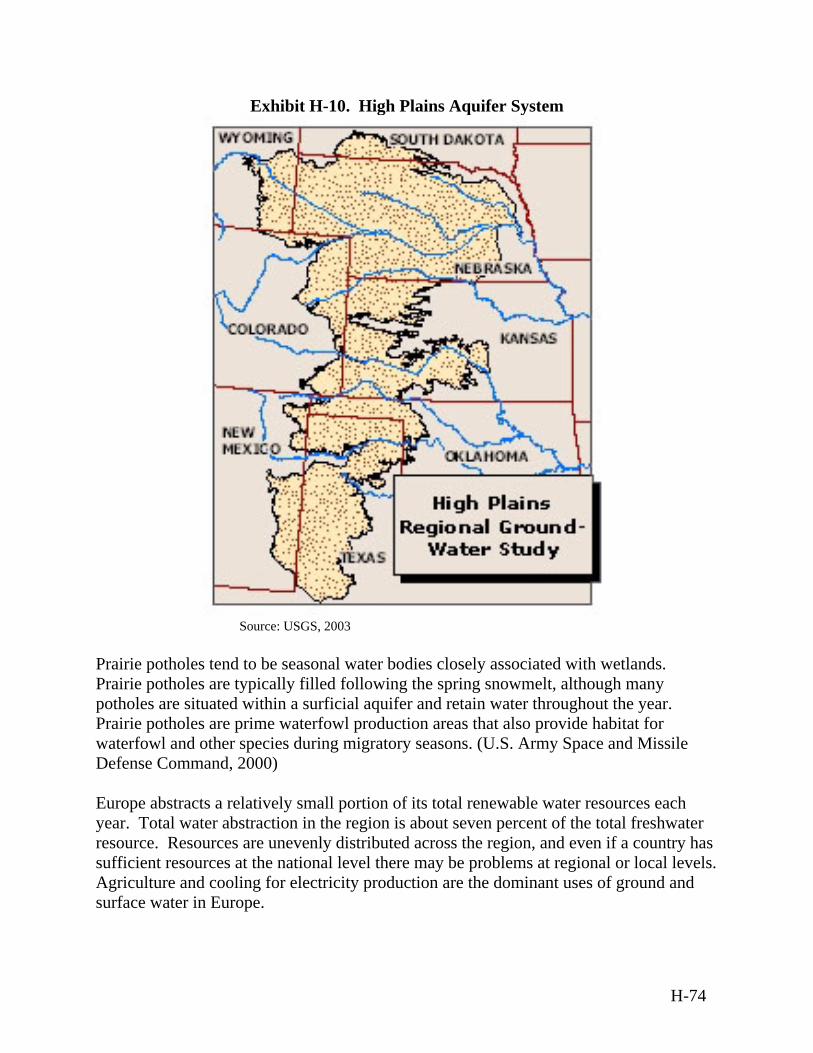
Exhibit H-10. High Plains Aquifer System
Source: USGS, 2003 Prairie potholes tend to be seasonal water bodies closely associated with wetlands. Prairie potholes are typically filled following the spring snowmelt, although many potholes are situated within a surficial aquifer and retain water throughout the year. Prairie potholes are prime waterfowl production areas that also provide habitat for waterfowl and other species during migratory seasons. (U.S. Army Space and Missile Defense Command, 2000) Europe abstracts a relatively small portion of its total renewable water resources each year. Total water abstraction in the region is about seven percent of the total freshwater resource. Resources are unevenly distributed across the region, and even if a country has sufficient resources at the national level there may be problems at regional or local levels. Agriculture and cooling for electricity production are the dominant uses of ground and surface water in Europe.
H-74
Water Quality The quality of water in the High Plains aquifer generally is suitable for irrigation use, but in many places, the water does not meet EPA drinking water standards with respect to several dissolved constituents: dissolved solids/salinity, fluoride, chloride, and sulfate. (USGS, 2003) The primary sources of water contamination in the U.S. prairies are agricultural practices (especially non-point source runoff from crop inputs and animal wastes), oil and gas extraction, and industry. Natural conditions, such as low flows, also contribute to violations of standards. (U.S. Army Space and Missile Defense Command, 2000) The European Union monitors surface water quality and drinking water quality via the 1976 Council Directive 76/160/EEC on Bathing Water Quality and the 1998 Council Directive 98/83/EC on the Quality of Water Intended for Human Consumption, respectively. Due to the outdated content of the former directive, the European Commission adopted a proposal for a revised directive (COM(2002)581) in October of 2002. Though this revision uses only two bacteriological indicators, Intestinal Enterococci (I.E.) and Escherischia coli (E.C.), it sets a higher health standard than the existing directive. In the 1970s and 1980s, freshwater, surface water and ground water sources throughout Europe suffered eutrophication when they became flooded with organic matter, nitrogen from fertilizer, and phosphorus from industrial and residential wastewater. In recent decades, however, water quality improvements have been made across Europe. In Central and Eastern Europe, 30 percent to 40 percent of households were not yet connected to sewer systems as of 1990, and water treatment in this area was still inadequate. (UNEP, 2002) (European Union, 1998)
H.6 Desert Biome
The Desert Biome includes the desert regions of North America, which include the western arid environment of the southwestern U.S. (see Exhibit 3-16). The description in this section of the U.S. desert is representative of this biome throughout the world. Existing inland sites in the Desert Biome include White Sands Missile Range (WSMR), New Mexico; Fort Bliss, Texas; Edwards AFB, California; and the Nevada Test Site, Nevada. There are no coastal sites located in the Desert Biome.
H-75
H.6.1 Air Quality
Climate Deserts cover about one-third of the Earth. Although deserts may be predominantly hot or cold, all deserts are dry. The two main distinguishing characteristics between different desert types are temperature and degree of aridity. In cold desert regions, temperatures range from 2ºC to 4ºC (36ºF to 39ºF) in the winter and from 21ºC to 26ºC (70ºF to 79ºF) in the summer. These regions usually have larger amounts of precipitation in the winter and spring, followed by a dry season. Total annual precipitation averages 15 to 26 centimeters (six to ten inches). In contrast, hot desert regions have average monthly temperatures above 18ºC (64ºF), with typical temperatures ranging from 20ºC to 25ºC (68ºF to 77ºF). The extreme maximum temperature for hot desert biomes ranges from 44ºC to 49ºC (111ºF to 120ºF). Hot desert regions usually have very little precipitation annually and/or concentrated precipitation in short periods, totaling less than 15 centimeters (six inches) a year. Existing sites where activities for the proposed BMDS may occur reside within the hot desert biome. Hot desert regions span the equatorial belt from 15 to 28 degrees north and south of the equator, with most of these deserts lying near the Tropic of Cancer or the Tropic of Capricorn. While the characteristics of the desert biome are similar throughout the world, this discussion focuses on the deserts of the western U.S., including parts of California, Utah, Nevada, Arizona, New Mexico, and Texas. Deserts are characterized by high-pressure zones in which cold air descends. The descending air then becomes warm, but instead of releasing rain, the heat from the ground evaporates the water. Because deserts are dry, they have large daily temperature variations. Temperatures are high during the day because there is very little moisture in the air to block the sun's rays from reaching Earth. As the sun sets, the heat absorbed during the day quickly escapes back into space, resulting in cold nightly temperatures. Regional Air Quality A unique pollutant of concern in desert regions is dust, i.e., PM, which contributes to desertification, the process of creating deserts. Activities that expose and disrupt topsoil, such as grazing and agricultural cultivation common throughout the western U.S., can increase the amount of dust released into the air. Dust and other particles in the air cause water droplets in clouds to be smaller. The size of the water droplets in a cloud determines whether gravity will force the droplets towards the earth’s surface, instead of remaining suspended in the air. Therefore, the more dust and other particulates that are suspended in the air, the less rain falls to the earth, thereby enhancing drought conditions and contributing to further desertification. (NASA, 2001)
H-76
Regional air quality at WSMR is described as representative of the Desert Biome. Otero County is in attainment for state and Federal standards. Doha Ana County is currently considered to be in attainment with the NAAQS. However, the Air Quality Bureau has recorded exceedances of the standard for PM10 in the county. (U.S. Army Space and Missile Defense Command, 2002d) Existing Emission Sources As discussed above, the predominant source of air pollution in the Desert Biome is agriculture, which disturbs the surface layer soil and emits dust into the air. Animal excrements are also a source of N2, ammonia, and non-methane VOCs, which may contribute to the formation of ozone and particulates in the atmosphere. Reduced air quality also can be attributed to natural and man-made fires, as well as to industrial activity.
H.6.2 Airspace
Controlled and Uncontrolled Airspace The U.S. Desert Biome contains all FAA classifications for airspace, as described in Section 3.1.2. Ranges in the Desert Biome, such as WSMR in New Mexico may include airspace that may be recalled for purposes such as conducting testing operations. This airspace is controlled by the Holloman AFB radar approach control facility, by agreement with the FAA through the Albuquerque ARTCC. The radar approach control airspace has been divided into five areas for recall purposes when conducting testing operations. Depending on the airspace and safety requirements of a particular WSMR mission, one or more of these areas can be recalled by WSMR for a specified period of time. WSMR recalls portions of the radar approach control areas for research and development missions, which has the effect of limiting instrument approaches to Holloman from the north, limiting departures to the north directly into WSMR airspace, modifying VFR arrivals from the north, and tightening IFR departures to the southwest. (U.S. Army Space and Missile Defense Command, 2002d) Special Use Airspace Ranges within the Desert Biome may contain special-use airspace, which enables the airspace to be utilized for military purposes without interference. For example, the R-5107 complex of special-use airspace covering WSMR was especially chartered to protect non-participating aviation from potentially hazardous military operations, including missile testing. WSMR controls a complex of 19 restricted areas. Any aircraft that have not been authorized and scheduled by the controlling agency are prohibited from entering active restricted airspace. During part of the day, WSMR may return some
H-77
of the restricted airspace to FAA control for use by aircraft under a shared-use agreement between WSMR and the FAA. All areas are joint-use except R-5107B, which is in continuous use by WSMR and is not released back to the FAA. Many of the restricted areas are used extensively by Holloman AFB for advanced training missions. (BMDO, 1994) Airports/Airfields Civilian, military, and private airports exist in the U.S. Desert Biome to serve different aircraft. General aviation airports are located in Las Cruces and Alamogordo, New Mexico, and El Paso, Texas. The Las Cruces International Airport is used primarily for general and some commercial aviation. The Alamogordo/White Sands Regional Airport is used mainly for general and some commercial aviation. The El Paso International Airport is used primarily for commercial and general aviation. (U.S. Army WSMR, 1998) En Route Airways and Jet Routes The airway and jet route segments in the flight corridor at WSMR lie within airspace managed by the Albuquerque ARTCC. This office exercises control of its Class A and B airspace traffic within sectors, dividing the airspace both vertically and horizontally. Some military low-level routes and refueling routes are within the region. (U.S. Army Space and Strategic Defense Command, 1997)
H.6.3 Biological Resources
Vegetation From a biogeographic perspective, the Desert Biome encompasses three major vegetation types. In order of dominance, these are semi-desert grassland, plains-mesa sand scrub, and desert scrub. In species composition, these three vegetation types correspond to the desert scrub biotic community and the semi-desert grassland biotic community. Grassland habitat merges with desert scrub, creating a complex landscape mosaic. Major vegetation in the desert scrub area includes a combination of woody and herbaceous shrubs such as the Creosote Bush (Larrea tridentata), Shadscale (Atriplex confertifolia), Winterfat (Ceratoides lanata), and White Bursage (Ambrosia dumosa). Plains-mesa sand scrub separates semi-desert grassland and desert scrub vegetation. The desert scrub vegetation is divided into broadleaf evergreen and broadleaf deciduous types. There are no wetland types in this biome; however, springs may support wetland type vegetation, such as Cattail (Typha latifolia), sedges (Carex spp.), and rushes (Juncus spp.). Plants in the Desert Biome have adapted to the harsh climatic conditions of intense heat with little shade and precipitation. Plants, such as cacti, have adapted to the biome by altering their physical structure and usually have special means of storing and conserving
H-78
water. Other plants have acclimated to arid environments by growing extremely long roots, allowing them to acquire moisture at or near the water table. Still other desert plants have adjusted their behavior so that they grow and reproduce during the seasons of greatest moisture and/or coolest temperatures and remain dormant during the harshest (i.e., hottest and driest) months. In the U.S., the Holmgren Milk Vetch (Astragalus homgreniorum) is endangered, and Welsh’s Milkweed (Asclepias welshii) is threatened. Wildlife Desert animals include small nocturnal carnivores, insects, arachnids, reptiles, and birds. Desert animals are even more susceptible to the extremes of the desert climate than are plants. In response to extremely high temperatures and large diurnal temperature variations, many desert animals have evolved behavioral and/or physiological mechanisms to cope with the heat and aridity of the desert. Desert animals may adjust their behavior by breeding in the desert during the relatively cool spring and then migrating to cooler habitat for the remainder of the year, or they may be active only at dusk and dawn and retreat to the shade or burrow underground during the heat of the day. Some animals are completely nocturnal for this same reason. Some animals estivate (the opposite of hibernate), sleeping during the hottest and driest summer months. To increase their water intake, many desert animals rely on succulent plants, such as cacti, that store water in their tissue The bald eagle could occur as a transient species in Desert biomes and it may fly over desert sites. Baird's sparrow and McCown's longspur are attracted to playas and grasslands that are also common in Desert biomes. Peregrine falcons have been reported from Lake Holloman, and potential feeding and nesting areas occur in other areas of the desert. These raptors may fly over the site. The Desert Tortoise (Gopherus agassizii) and Chiricahua Leopard Frog (Rana chiricahuensis) are threatened under the Endangered Species Act in the U.S., and the Alamosa Springsnail (Tryonia alamosae) is endangered. (U.S. Army Space and Strategic Defense Command, 1997) The White Sands pupfish (Cyprinodon tularosa), which is the only fish known to occur naturally on WSMR, is listed as endangered by the State of New Mexico and is endemic to Salt Creek, Malpais, and Mound Springs drainage basins. Environmentally Sensitive Habitat The USFWS designated habitat critical to the survival and recovery of the Mojave Desert populations of the Desert Tortoise in 1994. Critical Habitat Units in the map in Exhibit H-11 below were designated in California, Nevada, Utah, and in Arizona north and west of the Grand Canyon. This area includes Joshua Tree National Park.
H-79
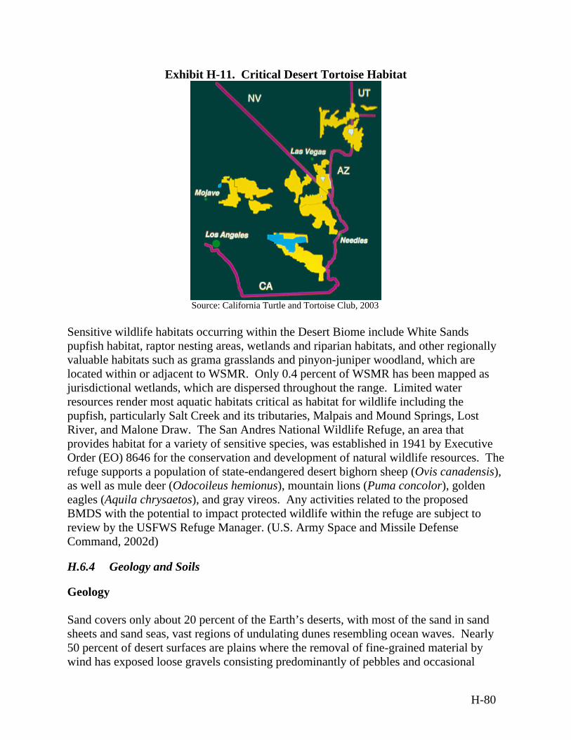
Exhibit H-11. Critical Desert Tortoise Habitat
Source: California Turtle and Tortoise Club, 2003
Sensitive wildlife habitats occurring within the Desert Biome include White Sands pupfish habitat, raptor nesting areas, wetlands and riparian habitats, and other regionally
nyon-juniper woodland, which are located within or adjacent to WSMR. Only 0.4 percent of WSMR has been mapped as
nal wetlands, which are dispersed throughout the range. Limited water sources render most aquatic habitats critical as habitat for wildlife including the
The
),
y vireos. Any activities related to the proposed MDS with the potential to impact protected wildlife within the refuge are subject to
about 20 percent of the Earth’s deserts, with most of the sand in sand and sand seas, vast regions of undulating dunes resembling ocean waves. Nearly cent of desert surfaces are plains where the removal of fine-grained material by
oose gravels consisting predominantly of pebbles and occasional
valuable habitats such as grama grasslands and pi
jurisdictiorepupfish, particularly Salt Creek and its tributaries, Malpais and Mound Springs, Lost River, and Malone Draw. The San Andres National Wildlife Refuge, an area that provides habitat for a variety of sensitive species, was established in 1941 by ExecutiveOrder (EO) 8646 for the conservation and development of natural wildlife resources.refuge supports a population of state-endangered desert bighorn sheep (Ovis canadensisas well as mule deer (Odocoileus hemionus), mountain lions (Puma concolor), golden eagles (Aquila chrysaetos), and graBreview by the USFWS Refuge Manager. (U.S. Army Space and Missile Defense Command, 2002d)
H.6.4 Geology and Soils
Geology
and covers onlySsheets0 per5
wind has exposed l
H-80

cobbles, forming “desert pavement.” Deflation basins, called “blowouts,” are hollows formed by the removal of particles by wind. Blowouts are generally small, but may be to several kilometers in diameter. The remaining surfaces of the Desert Biome are composed of exposed bedrock outcropdesert soils, and fluvial deposits, including alluvial fans (a cone-shaped deposit of sediments), playas (dry lake beds), desert lakes, and oases. Bedrock outcro
up
s,
ps commonly ccur as small mountains surrounded by extensive erosional plains. Wind-driven grains
uses istinct salt layers to form. Thus, poorly drained areas may develop saline soils and dry
red with salt deposits. Desert soils tend to be low in humus and igh in calcium carbonate. Calcium carbonate may cement sand and gravel into hard
in arid environments, such as the Desert Biome, where vegetative cover is sparse. These crusts are formed by living organisms and their by-products, creating a crust of soil particles bound together by organic materials. Aboveground crust thickness can reach up to ten centimeters (four inches); however, crusts usually are concentrated in the top one to four millimeters (.04 to .16 inches) of soil. Due to their presence near the top surface layers of the soil, crusts primarily affect processes that occur at the land surface or soil-air interface, including soil stability and erosion, atmospheric N2 fixation, nutrient contributions to plants, soil-plant-water relations, infiltration (of water), seedling germination, and plant growth. Geological Hazards Exhibits 3-5, 3-6, and H-9 show the geographic distribution for earthquakes, landslides, and volcanoes in the continental U.S. These geological hazards are concentrated in the western U.S., including areas where deserts lie.
oabrade landforms, creating grooves or small depressions in rock. Sculpted landforms have been streamlined by desert winds and can be up to tens of meters high and kilometers long. Soils The desert soil is mostly sandy and is similar to the arid grassland soil described in the Section H.5.4. Desert soils are predominately mineral soils with low organic content. The repeated accumulation and subsequent evaporation of water in some soils cadlakebeds may be covehlayers called “calcrete” that form layers up to 50 meters (164 feet) thick. Biological soil crusts are often commonly found
H-81
H.6.5 Hazardous Materials and Hazardous Waste
Hazardous Materials WSMR and Holloman AFB are existing sites where activities for the proposed BMDS may occur. The types of hazardous materials and hazardous waste produced at WSMR and Holloman AFB are representative of those that may be generated at other such sites within the Desert Biome, and they display appropriate management techniques. A variety of hazardous materials are utilized and stored at WSMR to provide range-infrastructure support activities and at Holloman AFB to support mission activities. These include cleaning solvents, paints, motor fuels, and other petroleum products. These materials are issued through the facility supply system to individual users. The majority of these materials are consumed in operational processes, and the remaining materials are collected as hazardous waste. Specific types and quantities of materials can vary depending upon specific system and test-configuration requirements. Each agency utilizing WSMR is responsible for procurement and management of its hazardous materials. All use of hazardous materials by WSMR users requires approval and coordination with WSMR safety and environmental organizations. (U.S. Department of the Air Force, 1997b) Hazardous Waste When a hazardous material is spilled, spent, or contaminated to the extent that it is not able to be used for its original purpose, or cannot be converted to a usable product, it becomes a hazardous waste. Hazardous wastes can be generated on a continual basis or generated if a spill of a hazardous material occurs. Users of hazardous materials are responsible for the proper collection and disposal of hazardous waste generated as a result of their activity. This includes both waste generated during preflight activities at WSMR facilities, and waste generated following test operations. WSMR Regulation 200-1, Environmental Hazardous Waste Management, provides guidelines for handling and management of hazardous waste, and ensures compliance with Federal, state, and local laws regulating the generation, handling, treatment, storage, and disposal of hazardous waste. Under this regulation, hazardous waste generated during activities at WSMR is initially collected at the point of generation. Waste is containerized and segregated by waste type. From the initial collection point, all hazardous waste is collected and brought to a central collection facility for off-site shipment and disposal. Each range user is responsible for the cost of disposal of hazardous waste from its activities.
H-82
Holloman AFB maintains a Hazardous Materials Management Plan; a Hazardous Waste Management Plan to ensure compliance with applicable Federal, state, and local regulations; and Air Force directives related to hazardous materials and hazardous waste management. Holloman AFB also maintains a Spill Prevention and Response Plan in accordance with AFI 32-4002, Hazardous Materials Emergency Planning and Response Program. The Plan complies with EPA SPCC requirements; Emergency Planning and Community Right-to-Know Act; and Occupational Safety and Health Act requirements. The Plan provides guidance for the identification of possible hazardous material sources, the discovery and reporting of a hazardous materials release, and procedures to follow in the event a release occurs.
H.6.6 Health and Safety
Health and Safety attributes of the Desert Biome are similar to those discussed in Section H.1.6.
H.6.7 Noise
Ambient noise levels for remote desert environments range from 22 to 38 dBA, whereas, ambient noise levels at a representative sites where activities for the proposed BMDS may occur within the Desert Biome range from 65 to 85 dBA at Edwards AFB and from 45 dBA to 65 dBA at WSMR. (DOT, 2001) Noise sources associated with the proposed BMDS are described in Section H.1.7.
H.6.8 Transportation
In the Desert Biome of the western U.S., transportation is one of the primary environmental concerns with regard to air quality, water quality, habitat protection, land use, hazardous waste transportation, and noise pollution. Because the population density is so low and dispersed throughout most of the region, transportation infrastructure is concentrated near metropolitan centers, such as Phoenix, Arizona, and Los Angeles, California. Metropolitan areas are characterized by urban transit, a complex mix of heavy, light, and commuter rail; buses and demand responsive vehicles; ferries; and other less prevalent types such as inclined planes, trolley buses, and automated guide ways. Ground Transportation An extensive network of interstate highways and by-ways, spanning the vast distances between city centers transverse the western U.S. Desert Biome. The railroad system is also well developed throughout this region. The road system at WSMR is described as representative of other installations located in the Desert Biome. WSMR's road network is extensive, but in relatively poor condition. There are three classifications of the road types on WSMR: major roads, secondary roads,
H-83
and trails. The major roads are two lane roads that are paved, graded, and maintained as funding permits. All the major roads on WSMR have the capacity to support 1,200 cars per hour for each lane. Approximately 966 kilometers (600 miles) of secondary roads serve the WSMR network. Secondary roads on WSMR are unpaved roads that are graded and maintained as funding permits. The WSMR road network has approximately 2,414 kilometers (1,500 miles) of bladed trails. These unpaved trails are bladed but not maintained on a regular basis. (U.S. Army Space and Missile Defense Command, 2002d) A network of Federal and state highways serves WSMR and the immediate area. The Federal or U.S. highway system in the area is a network of six major routes that serve most of WSMR and the immediate area. The state highway system in the area provides access to local markets and urban areas. (U.S. Army WSMR, 1998) Air Transportation The major commercial airports serving the U.S. Desert region are Los Angeles International Airport, McCarran International Airport (Las Vegas, Nevada), Phoenix Sky Harbor International Airport, and Albuquerque International Airport all of which move millions of passengers each year. Marine Transportation There are no major U.S. ports associated with the Desert Biome because it does not extend to any coastal areas. There may be some ports associated with the international portions of this biome (e.g., Ensenada Port, Mexico).
H.6.9 Water Resources
Surface Water and Ground Water Resources In the Desert Biome, droughts and aquifer supply issues are of particular concern. Increasing population pressures and need for irrigation water are quickly draining the limited underground reserves of water for the western U.S., making adequate water resources a contentious topic of scholarly and political debate. For example, at WSMR, water supply sources are a critical concern in many areas. Freshwater aquifers are in a state of overdraft resulting in declining water tables and degraded water quality. The volume of ground water pumped in the Main Post area decreased from approximately 3.5 million cubic meters (925 million gallons) in 1967 to 3.3 million cubic meters (872 million gallons) in 1992. Water use in other areas varies from year to year according to missions in operation. (U.S. Army Space and Missile Defense Command, 2002d)
H-84
Water Quality The leading causes of impairment of rivers and streams include pathogens (bacteria), siltation (sedimentation), and habitat alterations, and the leading sources for these include agriculture, hydraulic modifications, and habitat modifications. The leading causes of impairment of lakes, ponds, and reservoirs include nutrients, metals (primarily mercury), and siltation (sedimentation), and the leading sources for these are agriculture, hydraulic modifications, and urban runoff/storm sewers. The leading causes of impairment of estuaries include metals (primarily mercury), pesticides, and oxygen-depleting substances, and the leading sources for these include municipal point sources, urban runoff/storm sewers, and industrial discharges. (EPA, 2002) The water quality of the freshwater aquifers at both WSMR and Fort Bliss is very good. Total dissolved solids at WSMR range from 200 to 420 milligrams per liter (parts per million). Hueco Bolson aquifers have total dissolved solids of approximately 600 milligrams per liter (parts per million). However, the quality of many of the freshwater aquifers in this region is decreasing due to increasing salinity. Because irrigation is commonly practiced in arid desert biomes, drainage water from irrigated fields is a water body of concern. In 1982, dying waterfowl and waterfowl with birth defects and reproductive failures were discovered by the USFWS at the Kesterson Reservoir, National Wildlife Refuge, California. The cause of the problem was high levels of selenium in the irrigation drain water discharged into the reservoir. Since then, there has been significant media and congressional interest concerning the potential for similar toxic impacts from irrigation drain water at other locations across the western U.S. (Department of the Interior, 2003)
H.7 Tropical Biome
The Tropical Biome encompasses areas within the Pacific and Atlantic Oceans. For the purposes of this Programmatic Environmental Impact Statement (PEIS, the coastal zone is defined as the Exclusive Economic Zone, which is 322 kilometers (200 miles) off shore. The coastal zone also stretches 1,000 meters (3,281 feet) inland of the coastal shoreline, tidal wetlands, coastal wetlands, and coastal estuaries. (CPC of Australia, 2003) Because many of the islands within the Pacific and Atlantic Oceans are relatively small, the entire island may be considered within this affected environment section. The Pacific Tropical Biome would include islands found within the equatorial region. The Pacific contains approximately 25,000 islands, the majority of which are found south of the equator. (Wikipedia, 2003) Current Ranges within this biome where activities of the proposed BMDS may occur include the Pacific Missile Range Facility (PMRF), U.S. Army Kwajalein Atoll (USAKA), Wake Island, and Midway.
H-85
The majority of islands in the Atlantic Tropical Biome are in the Caribbean between the Caribbean Sea and the North Atlantic Ocean.
H.7.1 Air Quality
Climate The climate for the Tropical Biome is tropical marine to semi-tropical marine, characterized by relatively high annual rainfall and warm to hot, humid weather throughout the year. The months of December to February tend to be cool, windy and wet, while May through October tend to be warm and sunny. Steadily blowing trade winds allow for relatively constant temperatures of 21°C to 27°C (70°F to 81°F) throughout the year. For islands lying South of the equator in the Pacific, such as American Somoa, the driest months are June to September and the wettest months are December to March.
Pacific The annual rainfall in the Pacific Tropical Biome is approximately 127 to 1,016 centimeters (50 to 400 inches). In the Pacific, tropical storms and typhoons are common between May and December but can occur in any month. Regional trade winds from the eastern portion of the Pacific push equatorial surface water in to a mound in the west-equatorial Pacific Ocean, which affects atmospheric conditions. The trade winds occasionally weaken, causing a reverse flow of warm surface waters to the east, which then mound against South America. The additional pressure of warm water in the east-equatorial Pacific Ocean inhibits and slows the upwelling of the more dense, cold, and nutrient-rich deep ocean water (DOT, 2001b) in a phenomenon known as the El Nino/Southern Oscillation. The El Nino effect includes an extreme decline in ecological productivity along the coast of South America, and great fluctuations in heat transfer and molecular exchange between the ocean and the atmosphere throughout the Pacific region. (DOT, 2001b)
Atlantic The Atlantic Tropical Biome typically experiences hurricanes that form close to the coast of West Africa and move westwards to the Caribbean. The hurricane season falls between June and November. However, most hurricanes tend to form during the month of September. The number of hurricanes varies annually from as few as two to as many as twelve. Hurricane weather is variable ranging from very low to heavy rainfall. Hurricane wind speeds tend to be severe, often traveling at more than 100 kilometers per hour (62 miles per hour). Hurricane tracks typically move across the Caribbean towards the southeastern U.S. and Mexico. (Caribbean, 2003)
H-86
Regional Air Quality
Pacific Ambient air quality monitoring data is not readily available for islands in the Pacific. There is a sampling station on the island of Kauai, which monitors for PM10. The area around the sampling station is classified as being in attainment for both National and State Ambient Air Quality Standards. However, the sampling station is located in the city of Lihue, which is located 42 kilometers (26 miles) from PMRF and is on the southeast side of the island; thus, air quality measurements there may not be representative of air quality at PMRF. Strong winds in the tropical Pacific region tend to disperse local emissions. Therefore there are no major air pollution problems.
Atlantic In the Caribbean, increasing urbanization and rampant forest destruction have led to considerable air quality degradation. Rapid urbanization, population growth, industrialization, and a growing number of motor vehicles are the main causes of air pollution. The growth of industry, agriculture, and the transportation sector over the past 30 years has been accompanied by a steady increase in CO2 emissions. Industrial pollutants originate mostly from fuel combustion processes in the power generation sector, although emissions of heavy metals, such as lead and mercury, also are important. Air quality at the local and regional level is affected by other sources of air pollution, such as pesticide use in agriculture and airborne particles resulting from soil erosion and biomass combustion. Existing Emission Sources
Pacific Primary pollution sources in the Pacific Tropical Biome include power plants, diesel-fuel powered generators, fuel storage tanks, solid waste incinerators, aircraft operations, and vehicles. Existing rocket launches in the area are typical of smaller sources of emissions. The primary toxic air contaminant emitted from solid rocket launches is hydrochloric acid. The Clean Air Act Amendments allow regulation of rocket engine test firing by the manufacturer and do not regulate the launch by an operational user. Because of the relatively small numbers and types of air pollution sources, dispersion caused by trade winds, and lack of topographic features at most locations, air quality in the equatorial region is considered good (i.e., well below the maximum pollution levels established for air quality in the U.S.). (U.S. Army Space and Missile Defense Command, 2003)
H-87
Atlantic The main contributors to poor air quality in the Atlantic Tropical Biome include inadequate vehicle emissions controls, exacerbated by recent influxes of foreign used vehicles with inadequate emission devices; industrial activity; inefficient energy use; high-density settlements and urban areas; pesticide residues from spraying in rural agricultural communities; and particulates from soil erosion and sugar cane burning. Regulations and infrastructure for ambient air quality monitoring in the Caribbean are limited. Counties with dependence on the U.S. have well-established ambient air monitoring programs for PM, SO2, and CO. Routine monitoring in other islands is limited to stations near industrial sources.
H.7.2 Airspace
Controlled and Uncontrolled Airspace
Pacific The majority of islands in the Pacific Tropical Biome are located in international airspace and therefore, the procedures of the ICAO are followed. ICAO Document 4444 is the equivalent air traffic control manual to the FAA Handbook 7110.65, Air Traffic Control. The ICAO is not an active air traffic control agency and has no authority to allow aircraft into a particular sovereign nation’s Flight Information Region or Air Defense Identification Zone and does not set international boundaries for air traffic control purposes. The ICAO is a specialized agency of the United Nations whose objective is to develop the principles and techniques of international air navigation and to foster planning and development of international civil air transport. The FAA acts as the U.S. agent for aeronautical information to the ICAO. Airspace in this region would be managed by the Honolulu and Oakland ARTCCs.
Atlantic The Atlantic Tropical Biome consists of both U.S. and international airspace. U.S. territorial possessions in the Caribbean are defined as Puerto Rico, which includes Puerto Rico, Vieques, Culebra, Caja de Muertos, Desecheo Island, and Mona Island, and the U.S. Virgin Islands, which include Saint Croix, Saint John, and Saint Thomas. On November 28, 2001, the FAA authorized aircraft registered in the U.S., Canada, Mexico, the Bahamas, Bermuda, Cayman Islands, and British Virgin Islands to operate VFR/IFR in the sovereign airspace of the U.S. and its territorial possessions. International airspace in the Caribbean is subject to the operating rules of the ICAO. The airspace of all states and territories of the Eastern Caribbean Islands including adjacent international waters comprise the Piarco Flight Information Region.
H-88
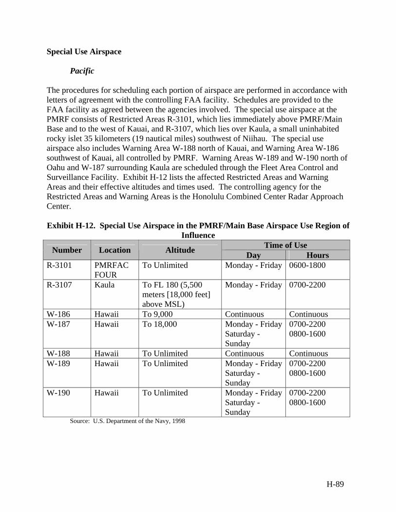
Special Use Airspace
Pacific The procedures for scheduling each portion of airspace are performed in accordance with letters of agreement with the controlling FAA facility. Schedules are provided to the FAA facility as agreed between the agencies involved. The special use airspace at the PMRF consists of Restricted Areas R-3101, which lies immediately above PMRF/Main Base and to the west of Kauai, and R-3107, which lies over Kaula, a small uninhabited rocky islet 35 kilometers (19 nautical miles) southwest of Niihau. The special use airspace also includes Warning Area W-188 north of Kauai, and Warning Area W-186 southwest of Kauai, all controlled by PMRF. Warning Areas W-189 and W-190 north of Oahu and W-187 surrounding Kaula are scheduled through the Fleet Area Control and Surveillance Facility. Exhibit H-12 lists the affected Restricted Areas and Warning Areas and their effective altitudes and times used. The controlling agency for the Restricted Areas and Warning Areas is the Honolulu Combined Center Radar Approach Center. Exhibit H-12. Special Use Airspace in the PMRF/Main Base Airspace Use Region of
Influence Time of Use Number Location Altitude Day Hours
R-3101 PMRFAC FOUR
To Unlimited Monday - Friday 0600-1800
R-3107 Kaula To FL 180 (5,500 meters [18,000 feet] above MSL)
Monday - Friday 0700-2200
W-186 Hawaii To 9,000 Continuous Continuous W-187 Hawaii To 18,000 Monday - Friday
Saturday - Sunday
0700-2200 0800-1600
W-188 Hawaii To Unlimited Continuous Continuous W-189 Hawaii To Unlimited Monday - Friday
Saturday - Sunday
0700-2200 0800-1600
W-190 Hawaii To Unlimited Monday - Friday Saturday - Sunday
0700-2200 0800-1600
Source: U.S. Department of the Navy, 1998
H-89
Airports/Airfields
Pacific There are numerous Range-affiliated airport and airfields located within the Pacific Tropical Biome, including Wake Island, USAKA, PMRF, and Midway. Many of these airfields are engaged in activities similar to those of the proposed activities. Future test events would act in accordance with existing activities at the airfields.
Atlantic The majority of local airports within the Atlantic Tropical Biome handle smaller, private aircraft, which are uncontrolled. En Route Airways and Jet Routes
Pacific High-altitude overseas jet routes cross the Pacific Tropical Biome via nine Control Area Extension corridors off the California coast. These corridors and associated jet routes continue northwest to Alaska and then southwest to the Orient. These corridors can be opened or closed at the request of a user in coordination with the FAA. A Memorandum of Agreement exists between users and the FAA to stipulate the conditions under which the Control Area Extensions can be closed to civil traffic. Under most circumstances, at least one Control Area Extension must remain available for use by general aviation and commercial air carriers.
H.7.3 Biological Resources
Vegetation
Pacific Many plant species have been introduced to the islands in the Pacific Tropical Biome since the arrival of permanent residents. The most common of these include ironwood (Ostrya virginiana), golden crown-beard (Verbesina encelioides), wild poinsettia (Euphorbia heterophylla), Haole koa (Leucaena leucocephala), sweet alyssum (Lobularia maritima), buffalo grass (Buchloe dactuloides), peppergrass (Lepidium lasiocarpum), and Bermuda grass (Cynodon dactylon). Some examples of indigenous vegetation on the islands include beach naupaka (sericea Vahl), tree heliotrope (Tournefortia argentea), beach morning glory (Ipomoea imperati), lovegrass, sickle grass (Pholiurus incurvus), ihi (Portulaca molokiniensis), alena (Boerhavia repens), puncture vine (nohu) (Tribulus citadoides), and ‘ena’ena (Pseudognaphalium [=Gnaphalium]
H-90
sandwicensium var. molokaiense). Some islands also include ruderal vegetation, which is vegetation that grows where the natural vegetational cover is disturbed by human activities in addition to the naturally occurring kiawe (Prosopis pallida)/koa haole (Leucaena leucocephala) scrub.
Atlantic The Atlantic Tropical Biome habitat includes seagrass meadows, which occur in the protected waters landward of coral reefs. The two main seagrass species, the turtle grass (Thalassia testudinum) and the manatee grass (Syringodium filiforme), occur either in mixed or in monospecific beds. Mangroves are found along the coasts of tropical and subtropical regions. The term mangrove refers to both the forest and the tree. Mangroves protect coasts against erosion by breaking storm waves and dampening tidal currents. Wildlife
Pacific The Laysan albatross (Diomedea immutabilis), a migratory bird protected under the Migratory Bird Treaty Act, uses ruderal vegetation areas in some islands in the Pacific Tropical biome for courtship and nesting. The Laysan albatross is being discouraged from nesting at existing Ranges to prevent interaction between the species and aircraft using the runway. This action is being accomplished under USFWS permits. Other species of birds found in this region include red-tailed tropicbirds (Phaethon rubricauda), black noddies (Anous minutus), Pacific golden plover (Pluvialis fulva), ruddy turnstone (Arenaria interpres), white terns (Chlidonias leucopterus), short-tailedand black-footed albatross (Phoebastria nigripes); shearwaters; brown (Sula leucogaster), masked (Sula dactylatra), and red-footed booby (Sula sula rubripes). There are five species of giant clams found in areas of the Western Pacific Tropical Biome. The largest species (Tridacna gigas) was observed during a 1998 inventory (Army, 2001). The species has been significantly reduced in numbers. All species of mollusks in the family Tridacnidae are listed as protected under the Convention for the International Trade on Endangered Species (USFWS, 2002).
Atlantic Grazers, such as green sea turtles (Chelonia mydas), fish, and sea urchins feed directly on seagrasses. Seagrass beds also serve as nursery grounds for the juveniles of many commercially important species, such as snappers, grunts, lobsters and conchs. Mangroves serve as nursery grounds for the juveniles of many commercially important fisheries species and provide habitat for a variety of small fish, crabs, and birds. Sea
H-91
turtles use many beaches in the Caribbean to dig their nests and deposit their eggs. The beach also provides habitat for burrowing species, such as crabs, clams, and other invertebrates. Hawaiian monk seals (Monachus schauinslandi) are found throughout the region. Eastern and Spit islands are the main pupping areas. The monk seal is endemic to the Hawaiian archipelago and is found almost exclusively in the Northwestern Hawaiian Islands. The Hawaiian (American) coot (Fulica americana alai), Hawaiian black-necked stilt (Himantopus mexicanus knudseni), Hawaiian common moorhen (Gallinula chloropus sandvicensis), and Hawaiian duck (Anas wyvilliana) are Federal and State endangered species that have been observed in the drainage ditches and ponds on PMRF/Main Base. The Hawaiian Gallinule (Gallinula chloropus sandvicensis) is a Federally listed endangered subspecies of the common North American moorhen. Newell's shearwater (Puffinus auricularis newelli) and the dark-rumped petrel (Pterodrome phaeopygia sandwicense) are listed as federally endangered species. The Hawaiian duck (Anas wyvilliana) is a federally listed endangered species of duck, which has been observed in the wetlands of PMRF and the ditches of Mana. The Green sea turtle (Chelonia mydas) is a federally threatened sea turtle found in the eastern North Pacific from Baja California to southern Alaska. The sea turtles are sighted year round in eastern portions of the Pacific Ocean, generally in waters less than 50 meters (164 feet) deep. Populations appear to be highest from July to September. Threats to the green sea turtle include over harvesting by humans, habitat loss, fishing net entanglement, boat collisions, and disease. (Sacramento Fish and Wildlife Office, 2003) The Loggerhead sea turtle (Caretta caretta) is a federally threatened sea turtle similar to the green sea turtle. It has been observed at depths up to 1,000 meters (3,280 feet). Threats to loggerhead sea turtles include exploitation, loss of habitat, fishing practices, and pollution. The Leatherback sea turtle (Dermochelys coriacea) is a federally listed endangered species. The Leatherback is a highly migratory species and is more pelagic than other sea turtles, meaning they tend to stay in the open ocean rather than in areas closer to the coast. They are sighted most often during July to September. Threats to the sea turtles include exploitation, loss of habitat, fishing practices, and pollution. The Olive ridley sea turtle (Lepidochelys oliveacea) is a federally listed threatened species. (NOAA, 2003b) The Olive ridley is primarily tropical nesting from southern Sonora, Mexico to Colombia. Individuals are seen rarely in the waters off the
H-92
southwestern U.S. They have been observed in the eastern Pacific Ocean in waters less than 50 meters (164 feet), but are rarely encountered. Marine mammals that may reside in the ocean area and that are listed under the Endangered Species Act include several species of cetaceans (i.e., the blue whale [Balaenoptera musculus], finback whale [Balaenoptera physalus], humpback whale [Megaptera noveangliae], and sperm whale [Physter catodon]). These are open-water, widely distributed species. Non-native species, such as feral dogs (Canis familiaris) and cats (Felis catus) occur in the region and prey on native and introduced species of birds. Rodents including the Polynesian black rat (Rattus exulans), Norway or brown rat (Rattus norwegicus), and the house mouse (Mus musculus domesticus) also are known to inhabit the region. (U.S. Army Space and Strategic Defense Command, 1993a) Environmentally Sensitive Habitat
Pacific A submerged barrier reef that is roughly 13 kilometers (eight miles) long and composed of fossil coral (Porites compressa) lies offshore of the island of Kauai. The reef has an irregular appearance resulting from numerous ledges, walls, slumped limestone blocks, and mounds. Coral and fish diversity is low within the exercise area as a result of deep water, low coral density, and seasonal sand scouring. Fishes associated with the low vertical relief habitat include the bluestripe snapper (Lutjanus kasmira) and several species of burrowing blennies. Pelagic (open ocean) fishes associated with the exercise area include jacks (Esox lucius), amberjack (Seriola dumerili), and flying fishes. The Hawaiian Islands Humpback Whale National Marine Sanctuary was designated by Congress in 1992. Humpback whales (Megaptera novaeangliae) are endangered marine mammals and are therefore protected under provisions of the Endangered Species Act and the Marine Mammal Protection Act wherever they are found. Humpbacks are present in the winter months in the shallow waters surrounding the Hawaiian Islands, where they congregate to mate and calve. By agreement with the Governor of the State of Hawaii in 1997, NOAA’s Sanctuaries and Reserves Division modified the Congressionally defined boundary of the Hawaiian Islands Humpback Whale National Marine Sanctuary so that it includes certain portions of the shallow water along northern Kauai. Regulations implementing designation of the sanctuary specifically recognize that all existing military activities outlined or external to the sanctuary are authorized, as are new military activities following consultation with the National Marine Fisheries Service. (62 FR 14816, 15 CFR §922.183)
H-93

All of Midway Atoll, except for Sand Island and its harbor, has been designated as critical habitat for the Hawaiian monk seal. A small (less than 0.2 hectares [0.5 acres]), emergent wetland area has been identified on Sand Island. It is located west of Decatur Avenue, north of the cemetery, and south of Halsey Drive. (U.S. Department of the Navy, 1998) The Coral Reef Ecosystem Fishery Management Plan for the western Pacific has established Marine Protected Areas. No-take Marine Protected Areas are at 0 to 10 fathom (0 to 18 meter [0 to 60 foot]) depths. No-take Marine Protected Areas also are located from ten to 50 fathoms (18 to 91 meters [59 to 299 feet]) at French Frigate Shoals, Laysan, and the northern half of Midway. The southern half of Midway is for recreational catch and release only. (Western Pacific Fisheries Management Council, 2003)
H.7.4 Geology and Soils
Geology
Pacific Geomorphically, islands within the Pacific Tropical Biome are exceedingly varied and therefore difficult to generalize. The islands range from atolls with small, low inlets and extensive lagoons, to raised limestone islands, to volcanic high islands with substantial topographic and internal climatic diversity. About half of the Caroline Islands and 80 percent of the Marshall Islands are atolls, some of which peak at only a few feet above present sea level. Volcanic islands, on the other hand, can reach heights of more than 3,962 meters (13,000 feet), as does the snow-capped peak of Mauna Kea on the island of Hawaii. (East-West Center, 2001) Coral reefs have developed upon the eroded platforms around some of the islands. Wave action has eroded the coral surface in many areas, creating a primary source for beach sand, which is actively being deposited and reworked along the shorelines of some islands. Some of the reefs and islands consist entirely of the remains of coral reef rock and sediments to a thickness of several thousand feet atop submarine volcanoes, which formed 70 to 80 million years ago. As the volcanoes became extinct and began to subside, living coral reefs grew and formed atolls. The reef rock is formed entirely from the remains of marine organisms that secrete external skeletons of calcium and magnesium carbonates. (East-West Center, 2001) High volcanic islands, which tend to have larger surface areas, generally have more fresh water, better soils, and more diverse resource bases. Low-lying atolls, on the other hand, are prone to drought and erosion, and generally (at least on land) have limited natural resources. (East-West Center, 2001)
H-94
Windward oceanic reef flats generally are composed of hard rock that extends downward for 0.6 to 1.2 meters (two to four feet), with softer or unconsolidated rock below that level. (U.S. Army Space and Strategic Defense Command, 1993a) Lagoon reef flats are typically narrower than the ocean reef flats and are composed of softer rock.
Atlantic Islands within the Atlantic Tropical Biome are composed of two distinctive chains of islands, the Lesser and Greater Antilles. The Lesser Antilles are a line of mainly volcanic islands sweeping northward from the island of Trinidad, while the Greater Antilles consist of four large islands that are part of a submerged mountain range jutting westward into the Caribbean for over a thousand miles. The islands are characterized by a range of geological formations, from volcanic and sedimentary strata to coral limestone and alluvium. The majority of the islands lack rivers or streams due to the porous nature of mountainous rock and the absence of hills or valleys. The lack of water and sediment runoff into the sea contributes to the clarity of surrounding waters. Numerous cracks and fissures may be found within the rock formations. Soils
Pacific
The soils on smaller atolls in the Pacific Tropical Biome have poor fertility and are deficient in N2, potash, and phosphorous. This low fertility is due to alkalinity, which inhibits the absorption of iron, manganese, zinc, boron, and aluminum; and course soil particles and low organic matter content, which both impair the soils water-holding capacity. All of these factors severely inhibit plant growth. Poor soil fertility on some islands also is due to human activities (e.g., forest cutting, slash and burn, copra plantations, war). High volcanic islands tend to have larger surface areas, and have better soils. In many places, the surface layers are dark brown as a result of accumulated organic matter and alluvium. The silt is neutral to moderately alkaline through its profile. The soils are permeable, and infiltration is rapid. Wind erosion is severe when vegetation has been removed.
Atlantic The islands within the Atlantic Tropical Biome include a wide range of soils, which may be derived from limestone, serpentine, dolomite, basalt, granite, diorite, gabbro, sandstone, or slate. The humid tropical environment and mountainous terrain of many islands are conducive to high rates of sedimentation. Washed from the hill slopes and construction sites, sediments settle out in the calm waters of the reservoirs, thus reducing the storage capacity of the reservoirs. Major floods associated with hurricanes and
H-95
tropical disturbances may cause extensive land erosion and sediment transport that rapidly deplete the storage capacity of reservoirs. Geological Hazards
Pacific Volcanic islands within the Pacific Tropical Biome have been built of successive lava flows. Volcano eruptions occur relatively frequently on the islands. Eruptions typically start with lava issuing vertically from a central vent or fissure in a rhythmic jet-like eruption, called a lava fountain. (NOAA, 2003b)
Atlantic
Many earthquakes and tsunamis have occurred in the northeastern Caribbean, where the movements of the Earth's surface plates are rapid and complicated. The Caribbean is one of the smaller surface plates of the Earth. The approximately rectangular plate extends from Central America on the west to the Lesser Antilles on the east, and from just south of Cuba on the north to South America on the south. Earthquakes occur all around its periphery. Tsunami waves form when large pieces of the sea floor undergo abrupt vertical movement due to fault rupture, landslides, or volcanism. (USGS, 2001) Volcanoes erupt on the eastern and western sides of the Caribbean plate. There are active volcanoes in the southern Caribbean islands, most recently on the island of Montserrat. Current eruptions of the Soufriere Hills Volcano, which is located at the south end of Montserrat Island in the Lesser Antilles, began on July 18, 1995. The summit area consists primarily of a series of east/southeast-trending lava domes. The volcano is 915 meters (3,010 feet) high and monitored by the Montserrat Volcano Observatory. (USGS, 2002a)
H.7.5 Hazardous Materials and Hazardous Waste
Hazardous Materials
Pacific Test event sponsors would be responsible for safe storage and handling of the materials that they obtain and must adhere to all Department of Transportation (DOT) hazardous materials transportation regulations. Hazardous materials used in support of test event activities would include propellants, various cleaning solvents, paints, cleaning fluids, fuels, coolants, and other materials. Releases of materials in excess of reportable quantities specified by CERCLA would be reported to the EPA. Material and Safety Data Sheets would be available at the use and storage locations of each material.
H-96
The use of hazardous materials at the ranges is limited primarily to materials used in facility infrastructure support and flight operations, with some additional quantities of hazardous materials used by various test operations at the range. The use of these materials must conform to Federal, DoD, and Army hazardous materials management requirements. Hazardous materials used in base infrastructure support activities include various cleaning solvents, paints, cleaning fluids, pesticides, motor fuels and other petroleum products, freons, and other materials. Aircraft and helicopter flights use various grade of jet propellant, which are refined petroleum products. All shipping would be conducted in accordance with DOT-approved procedures and routing, as well as OSHA requirements, U.S. Army safety regulations, and USAF regulations. Appropriate safety measures would be followed during transportation of the propellants as required by the DOT and as described in 49 CFR 171-180, Hazardous Materials Regulations of the Department of Transportation. For ship or barge transportation, U.S. Coast Guard and/or applicable U.S. Army transportation safety regulations also would be followed. Appropriate safety measures would be followed during loading of missiles and propellants as required by DoD and as described in DoD 6055.9-STD, DoD Ammunition and Explosives Safety Standards.
Atlantic The transport of potentially hazardous substances, such as oil, fertilizers and insecticides is always a hazardous activity, and there have been several oil spills within the Caribbean region. While the local impact is immediate and obvious, there is little information and few quantified studies on the long-term effects of oil in the coastal zone. Corals do not die from oil remaining on the surface of the water. However, gas exchange between the water and the atmosphere is decreased, with the possible result of oxygen depletion in enclosed bays where surface wave action is minimal. Coral death does result from smothering when submerged oil directly adheres to coral surfaces, and oil slicks affect sea birds and other marine animals. Tar accumulation on beaches reduces tourism potential of coastal areas. With increased shipping activity in the Caribbean, the dumping of garbage and washing of bilges at sea have become serious problems. Garbage dumped in international waters are driven by wind and currents to the shorelines of the Caribbean, causing persistent pollution, which threatens both the tourism and fishing industries, as well as the health of coastal communities. Hazardous Waste
Pacific Test event sponsors would be responsible for tracking hazardous waste; for proper hazardous waste identification, storage, transportation, and disposal; and for
H-97
implementing strategies to reduce the volume and toxicity of the hazardous waste generated. Federal Ranges located within the Pacific Tropical Biome manage hazardous materials through the Navy’s Consolidated Hazardous Materials Reutilization and Inventory Management Program. This program mandates procedures to control, track, and reduce the variety and quantities of hazardous materials use at facilities. Individual Ranges may have additional management and disposal procedures for used oils and fuels and management plans for pollution prevention, installation restoration, storage tanks, pesticides, radon, ordnance, polychlorinated biphenyls, medical and biohazard wastes, lead-based paints, and asbestos.
Atlantic Hazardous waste generated within the Atlantic region of the Tropical Biome that require disposal is disposed of in accordance with Federal safety and environmental regulations.
H.7.6 Health and Safety
Health and Safety attributes of the Tropical Biome are similar to those discussed in Section H.1.6.
H.7.7 Noise
Natural background sound levels in the Tropical Biome are relatively high due to wind and surf. Sources of noise in the Tropical Biome are similar to principle sources of noise associated with sites where activities for the proposed BMDS may occur, as described in the Section H.1.7.
H.7.8 Transportation
The Tropical Biome includes transportation that could be affected by the Proposed Action. The smaller islands may require marine transport vessels to transport passengers and supplies between islands. The isolated locations of the equatorial environments make transportation vital to many of the locations. Many of the islands or atolls are chains of multiple islands that may require transportation of workers, visitors, and cargo between outside locations and the islands. Also, there are many islands that serve as refueling stops for military and nonmilitary flights in the Pacific Ocean. Small DeHaviland-7 aircraft or helicopters may be used for intra-island transportation.
H-98
Ground Transportation Ground transportation facilities consist of roadways and pathways used by motor vehicles, bicycles, and pedestrians. For many of the islands, distances traveled are short, and people travel mostly on bicycle or on foot, or by using scheduled shuttle buses. Private automobiles are banned on some islands such as USAKA. Air Transportation Air transportation is an integral method used to transport goods to and from the island locations in this biome, due to the fact that are not linked to U.S. mainland ground transportation networks. Airports range in size from small airfields, supporting single engine planes, to larger international airports such as Luis Munoz Marin International Airport in Puerto Rico, which is the 37th most active passenger airport in the U.S. Marine Transportation Ships and smaller craft carry ocean cargo and fuel to the Equatorial Islands and deliver workers and cargo, including fuel, between islands. Many of the islands associated with this biome have major working ports, such as San Juan Harbor, Puerto Rico, which is in the top 17 ports of the world for container movement.
H.7.9 Water Resources
Surface Water and Ground Water Resources
Pacific On some of the islands, seasonal infiltration of rainwater recharges the aquifer, and potable water is provided by rainwater catchments. Coral atolls typically lack surface water bodies or defined drainage channels due to extreme porosity and permeability of the soils. Rainwater typically drains rapidly into the ground. Seasonal rainfall is the primary source of freshwater for most small atolls. Catchments are used to capture rainfall for potable use. Raw water is stored in aboveground storage tanks. On the Kwajalein atoll in particular, water is shipped from Kwajalein to the other islands that do not have catchments and to ships that visit. Ground water on the smaller atolls typically occurs as a lens of fresh to brackish water floating on deeper marine waters in the subsurface rock strata of larger and wider islands. Seasonal infiltration of rainwater recharges the aquifer. The size and salinity of the lens are affected by many factors, including the distribution and composition of the rock, tidal
H-99
fluctuations, gravitational forces, salt spray, mineral dissolution, and the rate of ground water pumping.
Atlantic Coastal areas of the Caribbean near major watersheds often contain large lagoons of fresh or brackish water. Estuaries, coastal lagoons, and other inshore marine waters are very fertile and productive ecosystems, because they serve as important sources of organic material and nutrients and provide feeding, nesting, and nursery areas for various birds and fish. These ecosystems act as sinks of terrestrial runoff, trapping sediments and toxins, which may damage the fragile coral reefs. Salinas, or shallow ponds or lakes with limited water circulation and tidal contact, are found on many dry Caribbean islands. They function as sediment traps, protecting coral reefs from excessive sediment loading. Water Quality The coastal zone is the ultimate depository of most pollutants originating from land or sea. Of the land-based sources of pollution, eutrophication, or nutrient enrichment, from human sewage disposal is a growing problem in the Caribbean, particularly in the vicinity of large coastal cities and harbors. Increased nutrient loading from sewage stimulates algal growth and degrades coral reefs and seagrasses. Activities outside of the coastal zone also may have a direct impact on the health of the coastal areas, for example when sedimentation and pollution from forestry and agriculture enter coastal areas via rivers and other waterways. Agricultural pesticides and fertilizers result in changes in the reef and seagrass communities, and in high concentrations, may cause fish kills in areas of poor water circulation. Sedimentation from land clearance results in increased water turbidity, which in turn decreases the productivity of coral reefs and seagrasses. With high levels of sedimentation, physical smothering of corals and benthic organisms by sediments and fine silt may take place.
Pacific
The prevailing trade winds cause strong currents to enter the lagoon water in the Pacific Atolls. The currents are a major source of seawater exchanging with lagoon water, and they help to keep the lagoons in the Pacific relatively well mixed. Water quality in the near shore and lagoon waters is generally of very high quality, with high dissolved oxygen and pH at levels typical of mid-oceanic conditions. Open sea waters are typically alkaline, and have a pH of greater than 8.0, which allows the buffering of acidic rocket emissions without significant long-term change to water chemistry. Water quality in the open ocean is described as having high water clarity, low
H-100
concentrations of suspended matter, dissolved oxygen concentrations at or near saturation, and low concentrations of contaminants such as trace metals and hydrocarbons.
Atlantic Problems with freshwater ecosystems are a major environmental issue in the Caribbean. Water pollution, siltation of reservoirs, and excessive withdrawals of fresh water from rivers are problems associated with the growing human populations of the islands. (USGS, 1999)
H.8 Savanna Biome
The Savanna Biome includes the transitional zone between the tropical forest and the semi-desert scrub vegetation types and typically occupies latitudes between 5º and 20º North and South of the equator (see Exhibit 3-18). Savannas cover extensive areas in the tropics and subtropics of Central and South America, Central and South Africa, and northern Australia in both inland and coastal areas. The description in this section is representative of this biome throughout the world.
H.8.1 Air Quality
Climate The climate of the Savanna Biome is typically semi-humid tropical, with a six- to eight-month hot, rainy summer season and a cooler, drier winter season.12 A marked temperature and rainfall gradient is shown across the latitudinal range. Towards the equator, annual rainfall is typically higher relative to the more poleward edges of the Savanna belt, and total annual precipitation may be as high as 250 centimeters (98 inches). On the Savanna edges nearest the tropics (towards the poles), annual rainfall totals may be as little as 50 centimeters (20 inches). In Australian Savanna Biomes, coastal areas receive twice as much rainfall as inland savannas. Annual temperatures in the Savanna Biome are relatively constant, averaging roughly 24ºC to 27ºC (75ºF to 80ºF). When the temperature fluctuates (ranging between 20ºC to 30ºC [68ºF to 86ºF]), it is a gradual change; the Savanna Biome does not experience drastic temperature swings. The average temperature during the wet summer season is 29ºC (85ºF) and can reach 49ºC (120ºF) in locations away from the moderating effects of the coastal waters. The temperature during the dry winter season averages around 21ºC (70ºF). 12 Summer/winter references are in terms of Southern hemisphere concepts of seasons. The wet season would occur during the Northern hemisphere winter, and the dry season would be in the Northern hemisphere summer.
H-101
The wet season may experience periods of flooding due to the poorly drained soils, especially at the start of the season when the ground is particularly parched. The dry season is marked by months of drought and fire, which are essential to the maintenance of savannas and which require adaptive mechanisms for plants and animals to survive.
Regional Air Quality The Savanna Biome faces similar air quality concerns as those found in the Grassland Biome, namely emissions from open burning, natural drought-driven fires, and other fugitive dust. Open burning frequently occurs in more rural areas to eliminate noxious weeds or crop-damaging pests in agricultural fields and to dispose of household waste. Because savannas may experience periods of drought during the dry season, fugitive dust may be kicked up and circulated in the atmosphere, enabling it to travel long distances due to the lack of natural barriers. Savanna fires represent the dominant source of carbon released to the atmosphere from global annual biomass burning, contributing one to 1.6 giga-tons of carbon. Additionally, large quantities of NOx have been observed in plumes of savanna fires. (Committee on Earth Observation Satellites, 2000) Dust can be blamed for the trans-regional transport of air toxics and other pollutants that “hitch a ride” on airborne dust particles. Therefore, pollution that arises in the Savanna Biome or nearby areas can degrade global air quality. Existing Emission Sources Due to the rural nature, and therefore low population density, of most Savanna Biomes, biogenic, or naturally occurring, activities are the predominant sources of air pollution emissions in this biome. Fire is a predominant emission source, while anthropogenic activities, such as agriculture and mining also contribute. Overgrazing of ranch lands increases fugitive dust emissions. Agriculture produces a variety of non-methane VOCs from livestock and crop sources that contribute to the production of secondary pollutants, such as ozone, which in turn damages crops and natural fauna. N2 also is produced from aerobic vegetative processes, anaerobic soil activity, and through animal excretion. Ammonia emissions are likewise attributed to livestock wastes. It also has been established that ruminant animals (e.g., cows) exhale dimethyl sulfide, which oxidizes to sulfuric acid and contributes to the formation of acid rain.
H.8.2 Airspace
Controlled and Uncontrolled Airspace The Savanna Biome is located in international airspace; and therefore, the procedures of the ICAO are followed. ICAO Document 4444 is the equivalent air traffic control manual to the FAA Handbook 7110.65, Air Traffic Control. The ICAO is not an active
H-102
air traffic control agency and has no authority to allow aircraft into a particular sovereign nation’s Flight Information Region or Air Defense Identification Zone and does not set international boundaries for air traffic control purposes. The ICAO is a specialized agency of the United Nations whose objective is to develop the principles and techniques of international air navigation and to foster planning and development of international civil air transport. The FAA acts as the U.S. agent for aeronautical information to the ICAO. Special Use Airspace Warning Areas are established in international airspace to contain activity that may be hazardous and to alert pilots of nonparticipating aircraft to the potential danger. Airports/Airfields Civilian, military, and private airports exist in the Savanna Biome. En Route Airways and Jet Routes There are no domestic jet routes in the Savanna Biome. Site specific analysis would be conducted to ensure that international and foreign government airspace requirements are met.
H.8.3 Biological Resources
Vegetation Savannas are characterized by a continuous cover of perennial grasses, often one to two meters (three to six feet) tall at maturity. They also may have an open canopy of drought- or fire-resistant trees or an open shrub layer. The Savanna Biome is a transitional biome between those dominated by forest and those dominated by grasses. Most savanna grass is coarse and grows in tufts with intervening patches of bare ground. Trees may be scattered individually or grow in small intermittent groves. The presence of trees is limited by the low annual level of rainfall and intense sunlight, as well as seasonal fires that burn back forests and stimulate the growth of grasses, similar to those occurring in the Grasslands Biome. The type of vegetation found in the Savanna Biome varies geographically based on soil and rainfall characteristics between the three continents where savannas are predominantly found – Central and South America, Central and South Africa, and northern Australia. Annual rainfall is higher in the Central and South America savannas and therefore, cypress (Cupressus sempervirens) and nance (Byrsonima crassifolia) trees thrive in this region. Fire tolerant tree species, such as Caranday palm (Copernicia alba)
H-103
and tusequi (Machaerium hirtum), exist in drier areas. Sedges and grasses, such as Mexican papyrus (Cyperus giganteus), annual spikerush (Eleocharis geniculata), and brook crowngrass (Paspalum acuminatum), among others, dominate the more flood-prone areas. Wetlands also may be found in these savannas due to seasonal flooding. Cactii may be present on termite mounds that commonly are found in the Savanna Biome. In African savannas, acacia (Acacia spp.) and baobab trees (Adansonia Digitata) dominate the savanna overstory. Other hardy plants that constitute the grassy-shrub understory include the boscia (Boscia angustifolia) and sporobolu (Sporobolus indicus); Combretum (Combretum molle) and Terminalia (Terminalia arjuna) shrub and tree species; and tall grasses, such as elephant grass (Pennisetum purpureum), Sorghum (Sorghum bicolor), and Eriachne (Eriachne spp.). Australian savannas are marked by eucalypt woodland with a grassy understory. Dominant tree species in the coastal lowland savannas are Darwin woolybutt (Eucalyptus miniata) and Darwin stringybark (Eucalyptus tetradonta). Lancewood (Acacia shirleyi) and bullwaddy (Macropteranthes keckwickii) display characteristics of rainforests and are found in wetter savannas. Mulgas, small acacia trees or shrubs, are highly drought-resistant and therefore, survive in drier Australian savannas. Tall grasses similar to those found in African savannas are common in Australia. Vegetation in the Savanna Biome has developed adaptive mechanisms to tolerate the dry season and periodic fires. Some trees (e.g., the baobab tree) produce leaves only during the wet season and these leaves are small to limit water loss via evapotranspiration. The baobab tree also stores water in its large trunk to maintain reserves during periods of drought. Other adaptive mechanisms include developing long taproots that reach to deep ground water sources. Mulga trees use this approach with a two-layered root system – a surface layer to collect light rainfall and another layer deep below the surface to obtain deep-water sources. Additionally, the mulga’s crown and branches are shaped to collect and direct rainfall efficiently. Many grasses and trees of the Savanna Biome are fire-resistant and flourish during the wet season and then enter a state of dormancy during periods of drought. Wildlife Geographic differences also determine the animal species present in the Savanna Biome. Typical South and Central American savanna wildlife include pumas (Puma concolor), jaguars (Panthera onca), giant anteaters (Myrmecophaga tridactyla), giant armadillos (Priodontes maximus), tapirs (Tapirus spp.), rodents (Akodon dayi, Kunsia tomentosus, Oxymyceterus inca), opossums (Monodelphis kunsi, Marmosops dorothea, Lutreolina crassicaudata), and bats (Vampyrum spectrum, Phyllostomus hastatus, Micronycteris behnii). Common bird species are the harpy eagle (Harpia harpyja), the jabiru (Jabiru
H-104
mycteria), the great tinamou (Tinamus major), and the savanna hawk (Heterospizias meridionalis). The blue-throated macaw (Ara glaucogularis) is a threatened bird species in this region. African animal species include wildebeest (Connochaetes taurinus), warthog (Phacochoerus aethiopicus), zebra (Equus burchelli), rhinoceros (Diceros bicornis [black], Ceratotherium simum [white]), giraffe (Giraffa camelopardalis), gazelle (Gazella spp.), hyena (Crocuta crocuta), ostrich (Struthio camelus), mousebird (Colius spp.), starling (Sturnus spp.), and weaver (Ploceus spp.). Threatened species include the African elephant (Loxodonta Africana), wild dog (Lycaon pictus), cheetah (Acinonyx jubatus), leopard (Panthera pardus), and lion (Panthera leo). Animal species found in Australian savannas are largely endemic to this region. Mammal fauna include numerous species of wallaby (spectacled hare-wallaby [Lagorchestes conspicillatus], northern nailtail wallaby [Onychogalea unguifera], bridled nailtail wallaby [Onychogalea fraenata]), red (Macropus rufus) and gray (Macropus giganteus) kangaroos, dingos (Canis lupus dingo), fawn antechinus (Antechinus bellus), antilopine wallaroo (Macropus antilopinus), and several species of skinks (Mabuya spp.). Reptiles may include copper or brown mulga snake (Pseudechis australis), Oenpelli python (Nyctophilopython oenpelliensis), Ord Curl Snake (Suta ordensis), Kings' goanna (Varanus kingorum), and the agamid lizard (Cryptagama aurita). Common bird species are the Australian bustard (Ardeotis australis), grey falcon (Falco Hypoleucos), pigeons (chestnut-quilled rock pigeon [Petrophassa rufipennis], pied imperial pigeon [Ducula bicolor], orioles (Oriolus spp.), cuckoos (Cuculus spp.), lorikeets (Charmosyna spp.), and the Australasian shoveler (Anas rhynchotis). Black-striped wallaby (Macropus dorsalis), yellow-footed rock wallaby (Petrogale xanthopus), purple-crowned fairy-wren (Malurus coronatus), and wingless dung beetle (Onthophagus apterus) are examples of threatened animal species in Australian savannas. Animal species must also be adaptive to the seasonal drought and fires of the Savanna Biome. Many of the large mammals and most birds migrate during the dry season in search of water. While elephants are migratory, they have a unique physical strength and anatomy that enables them to tear open the trunk of acacia trees that harbor water in their large trunks. Burrowing animals remain dormant during times of drought. The ability to fly or to run fast enables most birds and large mammals to escape from fire, while burrowing animals survive by digging underground and waiting for the flames to pass them by. Termites and ants often build mounds throughout the Savanna Biome in all continental regions.
H-105
Environmentally Sensitive Habitat National parks and reserves have been established to preserve and protect threatened vegetative and wildlife species in the Savanna Biome. There are several National Wildlife Refuges along the Gulf Coast.
H.8.4 Geology and Soils
Geology Savannas are similar to grasslands in geologic and topographic features, predominantly characterized by flat terrain and may be marked with escarpments and other plateau-like features of sandstone or limestone composition. Soils Savannas typically have porous (often sandy) soil, with only a thin covering of nutrient-rich humus and an overall low concentration of nutrients. Some soils have a hard crust that is subject to cracking, which allows trees to send their roots down to water held deep beneath the surface. Termite and ant mounds are common throughout savanna plains, and their inhabitants are important for soil formation. Coastal soils tend to be better drained relative to inland soils. Geological Hazards There are no significant widespread geological hazards throughout the Savanna Biome.
H.8.5 Hazardous Materials and Hazardous Waste
Missile facilities generate batteries, battery acid, paint and solvent wastes, and sodium chromate solution and rags. Hazardous wastes also are generated at deployment area facilities. For example, spent sodium chromate solution, rags used to handle the solution, and rags or gloves used to handle sodium chromate are wastes generated during daily routine operations and maintenance of the missile system. Hazardous Materials There are no existing facilities proposed for use in the BMDS in the Savanna Biome. However, future sites would use hazardous materials similar to those in use at existing sites discussed in this chapter and would produce similar hazardous wastes.
H-106
Hazardous Waste Any future facilities that may be used as part of the proposed BMDS would adhere to all applicable legal requirements for hazardous materials and hazardous waste management as described in Section 3.1.7.
H.8.6 Health and Safety
Health and Safety attributes of the Savanna Biome are similar to those discussed in Section H.1.6.
H.8.7 Noise
Sources of noise in the Savanna Biome are similar to principle sources of noise associated with sites where activities for the proposed BMDS may occur, as described in the Section H.1.7.
H.8.8 Transportation
Transportation in the Savanna Biome is typically limited due to the frequently remote and rural nature of savannas. However, there are some cities located in the Savanna Biome such as Miami, Florida, and New Orleans, Louisiana. Ground Transportation Highways, if present, are typically unpaved and may not be regularly maintained due to the low volume of traffic carried and remote locations. Railways are not a dominant form of transportation in the Savanna Biome. Airports with paved runaways are scarce in the Savanna Biome. Air Transportation Airport facilities in this biome are likely to small in size, and support single engine planes. However, there are a few locations with major airports such as Miami International Airport, which handles more than 33 million passengers a year. Marine Transportation Navigable waterways are present in some wetter savannas and may be used to transport goods to ports along coastal savannas. Some major ports exist along the coastal regions of this biome, such as the Port of Miami that moved nearly 4 million passengers and over 9 million tons of cargo through the port in 2003.
H-107
H.8.9 Water Resources
Surface Water and Ground Water Resources Riparian zones, although covering a small percentage of the total land area of the Savanna Biome, are vital to biodiversity, stream channel morphology, water quality, and the local economy. Within watersheds, savanna grasslands absorb rainfall, recharge aquifers, stabilize soils, and moderate run-off. However, savanna water resources are highly vulnerable to the effects of weed invasion, feral animals, overgrazing, and fire. Water resources are further strained by heavy water use in riparian areas for agriculture and tourism. (Douglas and Lukacs, 2004) For example, irrigated agriculture accounts for more than 70 percent of Australia’s water use, and this water is increasingly extracted from ground water reserves. (Hutley, Eamus, and O’Grady, 1999) During the wet season, rainfall is absorbed by the soil or becomes surface run-off. In wetter savanna regions during periods of heavy precipitation, the soil’s absorptive capacity is quickly exceeded, and water drains from the soil, recharging shallow ground water aquifers or flowing into nearby streams. During the dry season, surface water resources are readily depleted, forcing plants to rely on deeper ground water supplies and animals to migrate to areas of more plentiful water. (Hutley, Eamus, and O’Grady, 1999) Water Quality Water quality problems most commonly are caused by livestock and feral animals during the dry season. During the wet season, large volumes of rain elicit surface water flow. Additionally, cattle tend to be dispersed away from waterholes during the wet season. However, as the dry season progresses, water levels fall, surface flow ceases, and pressure from grazing cattle increases. Cattle and feral animals stir up bottom sediments in surface streams, which reduces water clarity, thereby limiting the penetration of sunlight and in turn, the growth of aquatic plants. (Cooperative Research Centre for Tropical Savannas Management, 2003)
H.9 Mountain Biome
As shown in Exhibit 3-19, the Mountain Biome includes the mountainous regions of North America and Europe, which include the Rocky Mountains in the western U.S. and the Alps in central Europe. The description in this section is representative of this biome throughout the world. Mountain biomes are found at high altitudes and lie just below and above the snow line of a mountain. Existing inland sites in the Mountain Biome include Buckley AFB, Cheyenne Mountain AFB and Fort Carson Military Reserve, Colorado; and F.E. Warren AFB, Wyoming. It is not reasonably foreseeable that activities for the proposed BMDS will occur on coastal locations within the Mountain Biome.
H-108

H.9.1 Air Quality
Climate The Mountain Biome, often referred to as the Alpine biome, Tundra biome, or Alpine Tundra biome, encompasses the high mountain regions of the world and accounts for approximately one-fifth of the world’s landscape. This biome occurs at high altitudes and lies just below and above the snow line of a mountain. Given its high altitude, the Mountain Biome is characteristically cold with heavy snowfall and frequently bitter winds. Temperatures remain below freezing for at least seven months of the year, and in the summer, average temperatures range from 10°C to 15°C (50°F to 59°F). Nighttime temperatures are almost always below freezing (0°C [32°F]). The average precipitation across mountain biomes is 30 centimeters (11.8 inches) a year. The seaward sides of mountain ranges receive rain or snow from moist oceanic air masses, whereas the interior sides are typically arid. The Rocky Mountains in western North America are representative of the Mountain Biome as a whole, and the majority of sites where activities for the proposed BMDS may occur are located within this mountain range. The Rocky Mountain range lies at 35 degrees north to 60 degrees north latitude and 115 degrees east to 165 degrees east longitude. The Rocky Mountains experience unpredictable weather, which can change rapidly. As with other mountain climates, the climate changes with increasing altitude. In general, the Rockies have mild summers, cold winters, and large amounts of precipitation. The seasons differ drastically from one another. In the winter, deep snow, high winds, and sudden blizzards are common, whereas spring is characterized by unpredictable weather and may be wet or dry, cold or warm. In the summer, there are sunny mornings, afternoon thunderstorms, and clear nights. The fall has cool days, wind, and decreasing precipitation. The average annual temperature in the Rocky Mountains is 6°C (43°F), with a winter average temperature of –2°C (28°F) and a summer average temperature range of 10°C to 15°C (50°F to 59°F). In the spring, the temperature averages 4°C (40°F), and the fall average temperature is 6°C (44°F). The highest temperature is 28°C (82°F) in July, while the lowest temperature is -14°C (7°F) in January. The average precipitation per year is 36 centimeters (14 inches). The average winter precipitation is 3.6 centimeters (1.4 inches), and the summer receives 15 centimeters (5.9 inches) of precipitation on average. In the spring, an average of 10.7 centimeters (4.2 inches) of precipitation falls across the Rocky Mountains, and the fall averages 6.6 centimeters (2.6 inches) of precipitation.
H-109

Regional Air Quality Mountain Biomes exhibit particular sensitivity to air pollution via deposition of both wet and dry pollutants, principally in snowpacks, which can in turn result in reduced surface water quality. Regional air pollutants of concern to mountainous areas include visibility-reducing PM, deposition of nitrogen and sulfur compounds, ozone, greenhouse gases that contribute to localized warming, and air toxics such as mercury and persistent organic pollutants. An emerging air quality concern is the issue of the effects of CO2 and other toxics released from prescribed burns meant to actively manage the forested regions lying below the Mountain Biome. (Tonnessen, 2003) Another air quality issue unique to the Mountain Biome is increasing UV-B radiation, which affects human and ecological health. (Welch, 2002) Existing Emission Sources Typical sources of air pollutants in the Mountain Biome include population centers, energy development and power plants, and agricultural. Global emissions of air pollutants such as mercury, dioxin, pesticides, and polychlorinated biphenyls result in deposition to high elevation areas due to the “cold condensation” effect, which permits pollutants to partition out of air and into water as air masses cool as they rise in elevation. (Tonnessen, 2002)
H.9.2 Airspace
Controlled and Uncontrolled Airspace The U.S. Mountain Biome contains all FAA classifications for airspace, as described in Section 3.1.2. The Denver ARTCC, located within the U.S. Mountain Biome, has the responsibility for maintaining separation between aircraft, which operate on IFR within this geographical area. The Center's area is divided into sectors. Low altitude sectors control from the ground to FL 260 (7,925 meters [26,000 feet]); high altitude sectors control FL 270 (8,230 meters [27,000 feet]) and above. From one to three controllers may work a sector, depending upon the traffic density. Controllers have direct communication with pilots, with surrounding sectors and Centers, plus the Towers and Flight Service Stations under their jurisdiction. Special Use Airspace The Denver ARTCC designates special use and restricted airspace for the Rocky Mountain region. Potential sites in the Mountain Biome where BMDS activities could occur would coordinate test events with the ARTCC to ensure that appropriate NOTAMs are issued.
H-110
Airports/Airfields Civilian, military, and private airports exist in the Mountain Biome. En Route Airways and Jet Routes Civilian aircraft generally fly along established flight corridors that operate under VFR. Numerous Minimum En route Altitudes are present in the Grasslands Biomes. The airway and jet route segments in this Biome lie within airspace managed by the Denver ARTCC.
H.9.3 Biological Resources
Vegetation Mountain Biomes are located at elevations too high to support the growth of trees; however, about 200 species of mountain plants are able to withstand the harsh climatic conditions of the Mountain Biome. The Mountain Biome is typically covered with a single dense layer of vegetation, usually only a few centimeters or decimeters in height. At high altitudes, there is very little CO2, which plants need to perform photosynthesis. Because of the cold and wind, most species are slow-growing perennials (lasting for three growing seasons or more, as opposed to annuals that die and grow back year after year) and plants that have been forced to adapt to such an extreme environment. Plants protect themselves from the cold and wind by “hugging” the ground. Some plants have waxy coatings or hairs for minimal loss of heat and water to the wind. Dominant plants tend to be dwarf perennial shrubs, sedges, grasses, mosses, and lichens. Alpine Phacelia (Phacelia sericea), Bear Grass (Xerophyllum tenax), Moss Campion (Silen acaulis), and Pygmy Bitterroot (Lewisia pygmaea) are all commonly found throughout the Mountain Biome. Despite their generally low productivity during most of the year, mountain plants exhibit bursts of productivity during the short growing season, lasting up to 180 days. Wildlife Mountain animals have to tolerate cold temperatures and intense ultraviolet radiation. Due to the high altitude, the atmosphere is thinner in the Mountain Biome, allowing more UV wavelengths to penetrate to the ground surface. Because of the year-round cold, only warm-blooded animals can survive in the Mountain Biome, although insects also exist. Some lakes in the Mountain Biome support a small but unique assemblage of freshwater fishes, including Arctic Grayling (Thymallus arcticus), Lake Trout (Salvelinus namaycush), and Burbot (Lota lota). Many lakes and streams in the interior mountains
H-111
freeze severely in winter, often to the bottom. Consequently, habitat becomes extremely limited in winter, and fish may become concentrated in small areas of rivers and at the bottoms of lake basins. Mountain lakes also support small numbers of breeding waterfowl, primarily ducks, during the summer. Golden Eagles (Aquila chrysaetos) and Merlins (Falco columbarius) commonly breed in the Mountain Biome, and Gyrfalcons (Falco tinnunculus) and Peregrine Falcons (Falco peregrinus) may nest where suitable cliff-nesting habitats are available. Mountain animals adapt to the cold by hibernating, migrating to lower, warmer areas, or insulating their bodies with layers of fat. They also tend to have shorter appendages, including legs, tails, and ears, than their relatives in warmer environments to reduce heat loss. In addition, mountain animals have larger lungs, more blood cells, and more hemoglobin to combat the increased atmospheric pressure and lack of oxygen found in higher altitudes. Two endangered animal species that may be found in the Mountain Biome are the Black-footed ferret (Mustela nigripes) and the Least tern (Sterna antillarum). A full list of endangered species under the Endangered Species Act may be found at the USFWS website (http://endangered.fws.gov). The web site allows the user to search for threatened and endangered species by geographic location and species name. Environmentally Sensitive Habitat Several mammals of the Mountain Biome, including the Dall Sheep (Ovis dalli dalli), Collared Pika (Ochotona collaris), Arctic Ground Squirrel (Spermophilus parryii), and Singing Vole (Microtus montanus), occur only in the state of Alaska and northwest Canada. These species survived the last glaciations in this region and are adapted to the short summers and long winters of their mountain habitats. These mammals are considered sensitive species and may warrant special conservation measures.
H.9.4 Geology and Soils
Geology The Mountain Biome is a complex network of mountain ranges characterized by extreme physiographic variability. Wide differences in elevation, slope steepness, and exposure exist locally and between major mountain masses. The Mountain Biome occurs at high altitudes and lies just below and above the snow line of a mountain. Soils Much of the Mountain Biome appears as barren rock or a cover of thin soils. Soils in the biome are relatively fragile and are subject to erosion when disturbed. The cold weather
H-112
of the Mountain biome delays decomposition of plant material therefore, mountainous soils typically do not contain many nutrients. Soils on steep or rocky slopes have had less time to develop. These younger soils occupy roughly 12 percent of the U.S. land area. Soils with similar characteristics to the arid grassland soil can also be found in mountainous areas, where the soil has accumulated clays, calcium carbonate, silica, and salts. This type of soil occupies roughly eight percent of the U.S. land area and is used mainly for range, wildlife, and recreation. Because of the dry climate in which they are found, they are not used for agricultural production unless irrigation water is available. Geological Hazards Mountain Biomes are subject to numerous geological hazards, including earthquakes, landslides, and volcanoes. Exhibits 3-5, 3-6 and H-9 show the geographic distribution for such hazards in the continental U.S.
H.9.5 Hazardous Materials and Hazardous Waste
Hazardous Materials Maintenance support and flight support operations at Ranges or installations within the Mountain Biome use products containing hazardous materials, which include solvents, oils, lubricants, batteries, fuels, surface coatings, and cleaning compounds. These products are used and stored at locations throughout the base, but are found primarily in the industrial and maintenance facilities. Procedures are developed for hazardous material management. Hazardous Waste Hazardous waste generated at specific BMDS installations typically is associated with equipment maintenance. Wastes generated by the facility include oils, fuels, antifreeze, paint, paint thinner and remover, photo chemicals, pesticides, aerosol canisters, batteries, used acetone, sulfuric acid, and sewage sludge. Procedures are developed for managing hazardous wastes at sites where activities for the proposed BMDS may occur. Due to the extreme climate of this biome, special measures may be necessary for storage and handling of hazardous materials and hazardous wastes in mountain areas.
H.9.6 Health and Safety
Health and Safety attributes of the Mountain Biome are similar to those discussed in Section H.1.6.
H-113
H.9.7 Noise
Sources of noise in the Mountain Biome are similar to principle sources of noise associated with sites where activities for the proposed BMDS may occur, as described in Section H.1.7.
H.9.8 Transportation
Mountain areas in central Europe sustain widespread infrastructure, including traffic circulation systems such as highways and byways, unpaved roads, non-maintained roads, trails, railroad lines, municipal, private, and military airports and any other system involved in mass transportation. Ground Transportation The sites where activities for the proposed BMDS may occur in the Mountain Biome are concentrated in Colorado, predominantly in the Colorado Springs area (Fort Carson Military Reserve, Peterson AFB, Schriever AFB). U.S. Interstates 70 and 25 are major arteries serving this region, as are U.S. Highway 24 and (Colorado) State Highways 94 and 115. I-25, a four-lane freeway that meets most of the Federal standards established for the interstate system, connects Colorado Springs with urban centers to the north (Denver) and south (Pueblo). I-25 is currently undergoing a major modernization effort, called the I-25 Corridor Improvements Project, to upgrade an outdated, aging interstate facility through the construction of improved interchanges and roadways. The east-west I-70 Mountain Corridor is a 225-kilometer (140-mile) stretch of rural, mountainous roadway that serves as a major intra- and inter-state highway. A PEIS is currently being prepared to address needed mobility improvements and congestion-reducing measures along the roadway. (Colorado DOT, 2003) Air Transportation Due to the extreme cold and heavy snowfall characteristic of the Mountain Biome, airports within this region require the ability to provide landing access under zero visibility conditions such as blizzards and de-icing capability. Marine Transportation Given the location of the Mountain Biome away from the coast, marine transportation is not a major source of transportation in this biome.
H-114
H.9.9 Water Resources
Surface Water and Ground Water Resources Surface water resources in the Mountain Biome include glacial lakes, streams, and rivers fed by rainfall and melting snow or that originate from ground water sources. The water in mountain regions usually is clear with moderate amounts of nutrients provided from rain and melting snow runoff. The Rocky Mountains of the western U.S. are characteristic of the water supply and uses found throughout the Mountain Biome. The Rocky Mountain region is arid to semi-arid with limited water resources. The watershed of the Rocky Mountains is known as the Great Basin. While agriculture is the biggest consumer of area water supply, draining approximately 80 percent of the total available water, urban, industrial, recreational, and historic Native American rights are intensifying competition for water. All available water is already allocated to some designated use; therefore, the watershed cannot readily support any extra demand on the region’s water supply. About 85 percent of the water used by the population of the Great Basin is derived from surface water, namely streams. Approximately three-fourths of the region’s stream flow originates from melt and runoff of the yearly snowpacks found in the higher elevations of the Rockies. These snowpacks are the sources of many of the U.S.’s rivers, including the Missouri, Yellowstone, Platte, Arkansas, Rio Grande, Colorado, and Snake. Rocky Mountain waters flow into the Mississippi and Columbia River systems, and subsequently into the Pacific Ocean, the Gulf of Mexico, and the Gulf of California. Thus, the Great Basin contributes to the water needs of municipalities outside the region, including Los Angeles and San Diego, California; Phoenix, Arizona; and Albuquerque, New Mexico. Most of the Great Basin is an interior drainage basin. Therefore, its streams typically do not reach the oceans, largely draining internally into the Great Salt Lake and numerous playas (seasonally dry lakebeds). (USGCRP, 2003) Europe abstracts a relatively small portion of its total renewable water resources each year. Total water abstraction in the region is about seven percent of the total freshwater resource. Resources are unevenly distributed across the region, and even if a country has sufficient resources at the national level there may be problems at regional or local levels. Agriculture accounts for 50 to 70 percent of total water abstraction in southwestern Europe, while cooling for electricity production is the dominant use in central Europe. Water Quality The National Water Quality Inventory summarizes the water quality assessments performed by state, local and Tribal governments. (EPA, 2000a) Water quality standards consist of three elements: (1) designated uses assigned to a water body (e.g., drinking,
H-115
swimming, and fishing); (2) criteria to protect the designated use (e.g., chemical specific threshold limits); and (3) antidegradation policy to prevent deterioration of current water quality. In the Mountain Biome, elevated levels of contaminants accumulate in snowpacks, negatively impacting local flora and fauna. Upon melting, the concentrated pollutants are dispersed throughout the area watershed, deteriorating the quality of downstream surface and ground water systems. U.S. Geological Survey studies indicate that concentrations of ammonium, nitrate, and sulfate (contaminants of particular concern for their tendency to form acid precipitation) are higher in heavily developed areas. The highest concentrations of nitrate and sulfate in the Rocky Mountain region are found in snowpacks that lie adjacent to both the highly developed Denver metropolitan area to the east and coal-fired power plants to the west. Ammonium concentrations are highest in northwestern Wyoming and southern Montana. (USGS, 2003) Mining and agriculture are two other activities common in the Rockies that can degrade water quality. Concentrations of cadmium and zinc in streambed sediment are generally orders of magnitude higher than background concentrations. These elevated concentrations in turn degrade fish communities and habitat conditions. Agricultural areas often exhibit higher concentrations of nutrients and selenium than background levels. (USGS, 1999) The European Union monitors surface water quality and drinking water quality via the 1976 Council Directive 76/160/EEC on Bathing Water Quality and the 1998 Council Directive 98/83/EC on the Quality of Water Intended for Human Consumption, respectively. Due to the outdated content of the former directive, the European Commission adopted a proposal for a revised directive (COM(2002)581) in October of 2002. Though this revision uses only two bacteriological indicators, Intestinal Enterococci (I.E.) and Escherischia coli (E.C.), it sets a higher health standard than the existing directive. The directive uses these bacteriological indicators to provide bathing water quality goals and maximum bacterial concentrations, and pH to measure bathing water acidity, in a quantitative manner. The remaining parameters (phytoplankton blooms or micro-algae proliferation, mineral oils, tarry residues and floating materials) offer a qualitative measure of the minimal allowable bathing water quality.
Water quality is a serious environmental issue across Europe. While water pollution is a particularly critical issue in Central and Eastern Europe, water abstraction (extraction) for public use is a primary concern in Western Europe. In the 1970s and 1980s, freshwater surface water and ground water sources throughout Europe suffered eutrophication when they became flooded with organic matter, nitrogen from fertilizer, and phosphorous from industrial and residential wastewater. In recent decades, however, water quality improvements have been made across Europe. In
H-116
Western Europe, phosphorous discharge from urban wastewater treatment plants has decreased by 50 to 80 percent since the 1980s. In Central and Eastern Europe, 30 percent to 40 percent of households were not yet connected to sewer systems as of 1990, and water treatment in this area was still inadequate. Improved efficiency for domestic and industrial water use in Western Europe decreased water abstraction for public water supply by eight to ten percent from 1985 through 1995. (UNEP, 2002)
H.10 Broad Ocean Area
For the purposes of this PEIS, the BOA encompasses the Pacific Ocean, the Atlantic Ocean, and the Indian Ocean. Proposed activities in the BOA would take place at a distance of several hundred kilometers from any land mass. The BOA is subject to EO 12114, Environmental Effects Abroad of Major Federal Actions, which requires consideration of Federal actions abroad with the potential for impacts to the environment. The EO specifically defines environment as “the natural and physical environment, and excludes social, economic, and other environment.” Therefore, potential impacts to environments other than the natural and physical area not analyzed in this document. The Pacific Ocean is comprised of approximately 155.6 million square kilometers (60.1 million square miles) and includes the Bali Sea, Bering Sea, Bering Strait, Coral Sea, East China Sea, Flores Sea, Gulf of Alaska, Gulf of Tonkin, Java Sea, Philippine Sea, Savu Sea, Sea of Japan, Sea of Okhotsk, South China Sea, Tasman Sea, Timor Sea, and other tributary water bodies. Its maximum length is 14,500 kilometers (9,000 miles) and its greatest width is 17,700 kilometers (11,000 miles), which lies between the Isthmus of Panama and the Malay Peninsula. (Encyclopedia.com, 2003) The Atlantic Ocean is comprised of 76.8 million square kilometers (29.6 million square miles) and includes the Baltic Sea, Black Sea, Caribbean Sea, Davis Strait, Denmark Strait, part of the Drake Passage, Gulf of Mexico, Mediterranean Sea, North Sea, Norwegian Sea, almost all of the Scotia Sea, and other tributary water bodies. The Atlantic Ocean extends from the North Pole southward for 16,093 kilometers (10,000 miles) to the Antarctic continent. The width of the Atlantic varies from about 2,850 kilometers (1,770 miles) between Brazil and Liberia to approximately 4,830 kilometers (3,000 miles) between Norfolk, VA, and Gibraltar. The average depth is 3,660 meters (12,000 feet) and the greatest depth is approximately 8,650 meters (28,400 feet) in the Puerto Rico Trench. (Oceans of the World, 2003) The Indian Ocean is comprised of approximately 68 million square kilometers (26 million square miles) and includes the Andaman Sea, Arabian Sea, Bay of Bengal, Great Australian Bight, Gulf of Aden, Gulf of Oman, Mozambique Channel, Persian Gulf, Red Sea, Strait of Malacca, and other tributary water bodies. It is triangular and bordered by
H-117
Africa, Asia, Australia, and the Southern Ocean. Its maximum width is about 10,000 kilometers (6,200 miles) between the southernmost portions of Africa and Australia, and its average depth is about 3,900 meters (12,750 feet). The greatest depth occurs in the Java Trench at 7,300 meters (23,800 feet) below sea level. (Oceans of the World, 2003)
H.10.1 Air Quality
Two kinds of circulation create the currents in the ocean, wind-driven circulation and Thermohaline circulation. Wind-driven circulation results from the wind setting the surface waters into motion as currents. The currents generally flow horizontally or parallel to the earth’s surface. The wind mainly affects only the upper 100 to 200 meters (328 to 656 feet) of water; however, the flow of wind-driven currents may extend to depths of 1,000 meters (3,280 feet) or more. (University of Washington, Department of Atmospheric Sciences, 2003) Thermohaline circulation produces great vertical currents that flow from the surface to the ocean bottom and back. The currents largely result from differences in water temperature and salinity. The currents move sluggishly from the polar regions, along the sea floor, and back to the surface. Climate Because oceans have great capacity for retaining heat, maritime climates are moderate and free from extreme seasonal variations. The oceans are the major source of the atmospheric moisture that is obtained through evaporation. Climatic zones vary with latitude and the warmest climatic zones stretch across the Atlantic, north of the equator. Ocean currents contribute to climatic control by transporting warm and cold waters to other regions. Adjacent land areas are affected by the winds that are cooled or warmed when blowing over these currents.
Pacific Ocean The atmosphere and ocean continually interact in physical and chemical cycles in the eastern portion of the Pacific. Ocean surface temperatures play a large role in atmospheric conditions. A daily cycle of solar heat drives convective mixing, which occurs as a result of changes in water stability. In this case, the surface water sinks and the subsurface water rises to the surface, thus creating a mixing effect. Regional trade winds from the east push equatorial surface water into a mound in the west-equatorial Pacific Ocean that affects atmospheric conditions. The trade winds occasionally weaken, causing a reverse flow of warm surface waters to the east, which then mound against South America. The additional pressure of warm water in the east-equatorial Pacific Ocean inhibits and slows the upwelling of the more dense, cold, and nutrient-rich deep ocean water (DOT, 2001b) in a phenomenon known as the El Nino/Southern Oscillation. The El Nino effect includes an extreme decline in ecosystem productivity along the coast
H-118
of South America and great fluctuations in heat transfer and molecular exchange between the ocean and the atmosphere throughout the Pacific region. (DOT, 2001b) Winds and currents in the Pacific flow predominantly from East to West. Above the equator Pacific Ocean trade winds blow from the northeast, while below the equator, they blow from the southeast. Across the equatorial Pacific, prevailing trade winds push warm surface waters westward from Ecuador toward Indonesia. Deep, cold waters off the coast of South America rise, creating an east-west temperature contrast. That, in turn, lowers air pressure in the west, which draws in winds from the east. Tropical cyclones (hurricanes) may form south of Mexico from June to October and affect Mexico and Central America. (Oceans of the World, 2003) Weather patterns in the north Pacific Ocean can be influenced by landmasses. The western Pacific tends to be monsoonal; a rainy season occurs during the summer months, when moisture-laden winds blow from the ocean over the land; and a dry season occurs during the winter months, when dry winds blow from the Asian landmass back to the ocean. Tropical cyclones (typhoons) may strike southeast and east Asia from May to December. (Oceans of the World, 2003)
Atlantic Ocean The temperatures of the surface waters, water currents, and winds influence the climate of the Atlantic Ocean and adjacent land areas. The Gulf Stream, for example, warms the atmosphere of the British Isles and northwestern Europe, and the cold water currents contribute to heavy fog off the coast of northeastern Canada and the northwestern coast of Africa. In general, winds tend to transport moisture and warm or cool air over land areas. Precipitation over the Atlantic BOA varies between ten centimeters (four inches) per year in the subtropics, with minimum amounts occurring near St. Helena and the Cape Verde Islands, and more than 200 centimeters (79 inches) per year occurring in the tropics. The region of highest rainfall follows the Intertropical Convergence Zone in a narrow band along five degrees north. A second band of high rainfall, with values of 100 to 150 centimeters (39 to 59 inches) per year, follows the path of storm systems in the Westerlies of the North Atlantic from Florida (28 to 38 degrees north) to Ireland, Scotland, and Norway (50 to 70 degrees north). No significant decrease in annual mean precipitation is observed from west to east; however, rainfall is not uniform across the band through the year. Most of the rain near Florida falls during summer, whereas closer to Europe it rains mainly in winter. (Tomczak and Godfrey, 2001) The Atlantic BOA demonstrates a large seasonal variation of northern hemisphere winds. Important seasonal changes in wind direction occur along the east coast of North America, which experiences offshore winds during most of the year but warm,
H-119
alongshore winds in summer. As part of the North Atlantic circulation, warm surface water from the equatorial Atlantic in the Gulf of Mexico travels north-westward as the Gulf Stream into the North Atlantic before cooling and sinking. The sinking water, called the North Atlantic deep water, acts as a pulling force and maintains the strength of the Gulf Stream. The presence of the warm Gulf Stream influences the climate of Western Europe, keeping winter temperature many degrees warmer than they would be otherwise. The North Atlantic Westerlies enter the ocean from the northwest and bring cold, dry air out over the Gulf Stream. The Atlantic northeast trade winds blow surface waters toward the equator and are somewhat stronger in winter than in summer. Seasonal wind reversals, characteristic of monsoons, are of minor importance and limited to the Florida-Bermuda area in the Atlantic BOA. (Tomczak and Godfrey, 2001) Tropical cyclones, or hurricanes, develop off the coast of Africa near Cape Verde and move westward into the Caribbean Sea. Hurricanes can occur from May to December, but are most frequently observed from August to November. Storms are common in the North Atlantic Ocean during northern winters, making ocean crossings more difficult and dangerous. From October to May, ships may be subject to superstructure icing in extreme northern areas.
Indian Ocean The climate of the Indian Ocean is marked by seasonal monsoons, which are seasonally shifting winds that produce either heavy precipitation or dry conditions, depending on the direction of the winds. (Virtual Domain Application Data Center, 2004) Low atmospheric pressure over Southwest Asia from rising hot summer air results in the southwest monsoon, which brings heavy rainfall from June to October. Cold, falling winter air builds high-pressure systems over northern Asia that contributes to the dry northeast monsoon from December to April. (CIA, 2003) Differential heating between the land and ocean and the storage and subsequent release of energy that occurs as water changes from liquid to vapor and back (latent heat) intensifies the effects of the Indian Ocean Monsoon more than any other place in the world. (Virtual Domain Application Data Center, 2004) Similar to the El Nino effect in the Pacific Ocean, the Indian Ocean experiences an El Nino event, as well. A warm pool in the Indian Ocean moves eastward along the equator in a cycle of three to seven years. The warm pool migrates to the central Indian Ocean, where the warmest sea surface temperatures form, and then continues eastward to Indonesia and southward into the Timor Sea, north of Australia. The warm pool in the Indian Ocean propagates eastward along the equator more slowly than it does in the Pacific Ocean. (Columbia University Record, 1994) Tropical cyclones occur during May and June and October and November in the northern Indian Ocean and during January and February in the southern Indian Ocean. (CIA,
H-120
2003) Cyclones also may occur in the Arabian Sea and the Bay of Bengal when monsoon winds change. (Wikipedia, 2003) Regional Air Quality No sources of ambient air quality monitoring data are known to exist for the BOA. Air quality over the Pacific Ocean is expected to be good because there are no major sources of air pollution, and the nearly constant trade winds in the area serve to disperse any pollutants from transient sources, such as passing seagoing vessels or low-flying aircraft. In the Atlantic Ocean, there is potential for large, thick plumes of aerosols blowing eastward over the North Atlantic. The aerosol plume is the regional haze produced by the industrial northeastern U.S. and typically occurs during the summer months. The haze is composed of sulfates and organics that originate from power plants and automotive sources. (NASA, 2003) Air quality over the Indian Ocean is seasonally poor due to anthropogenic emissions from growing South and Southeast Asian countries, particularly India. During the dry monsoon season (northern hemisphere winter), air pollutants in South and Southeast Asia are transported long distances to the Indian Ocean by persistent northeasterly monsoon winds. A dense, brown haze covers an area greater than ten million square kilometers (3.9 million square miles) over most of the northern Indian Ocean (Max Planck Society, 2001), including the Arabian Sea, much of the Bay of Bengal, and part of the equatorial Indian Ocean to about five degrees south of the equator. (Environmental News Network, 1999) The haze extends from the ocean surface up to three kilometers (1.9 miles). Comprised primarily of soot, sulfates, nitrates, organic particles, fly ash, and mineral dust, the airborne particles can reduce visibility over the BOA to less than 10 kilometers (6.3 miles) and reduce the solar heating of the ocean by about 15 percent. The haze also contains relatively high concentrations of gases, including CO, SO2, and other organic compounds. (Environmental News Network, 1999) Existing Emission Sources There are no known existing emission sources in the Pacific Ocean. Ozone and other pollutants found in the Atlantic Ocean are primarily the result of anthropogenic sources. Agricultural, urban, and industrial production that occurs on continental landmasses surrounding the Atlantic Ocean may impact emission levels, as well as marine life. A monitoring station in the Maldives Islands records air quality in the Indian Ocean. (Environmental News Network, 1999) The aerosol cloud covering much of the northern Indian Ocean originates primarily (at least 85 percent) from anthropogenic sources (Max Planck Society, 2001), namely agricultural and other biomass burning, the use of biofuels, and fossil fuel combustion, in South and Southeast Asia. (Lelieveld et al., 2001) Model calculations indicate that, in contrast to European and North American pollution, anthropogenic emissions from South and East Asia reduce the concentration of hydroxyl
H-121
(OH) radicals. Because OH is a powerful oxidant and acts as an atmospheric cleansing agent, the Asian pollution decreases the oxidizing power of the atmosphere, contributing to greater pollution problems over the Indian Ocean. (Max Planck Society, 2001)
H.10.2 Airspace
Controlled and Uncontrolled Airspace Because the airspace in the BOA is beyond the territorial limit and is in international airspace, the procedures of the ICAO, outlined in ICAO Document 444, Rules of the Air and Air Traffic Services are followed. The FAA acts as the U.S. agent for aeronautical information to the ICAO. The Honolulu or Oakland ARTCC manages air traffic in the Pacific region of influence and the New York ARTCC manages the air traffic in the Atlantic region of influence. The Oakland Oceanic Flight Information Region is the world’s largest, covering approximately 48.4 million square kilometers (18.7 million square miles) and handling over 560 flights per day. Special Use Airspace Domestic Warning Areas are established in international airspace to contain activity that may be hazardous and to alert pilots of nonparticipating aircraft to the potential danger. Special use airspace is established at PMRF, Warning Area W-188 north of Kauai, and Warning Areas W-189 and W-190 north of Oahu. There are numerous warning areas along the U.S. Pacific coastline. Airports and Airfields There are no airports or airfields located in the BOA. En Route Airways and Jet Routes Before conducting a missile launch, NOTAMs would be sent in accordance with the conditions of the directive specified in Operations Naval Instruction 3721.20. In addition, the responsible commander would obtain approval from the FAA Administrator, through the appropriate U.S. Navy airspace representative. Hazardous operations would be suspended when it is known that any non-participating aircraft has entered any part of the danger zone until the non-participating entrant has left the area or a thorough check of the suspected area has been performed. High-altitude overseas jet routes cross the Pacific BOA via nine control area extension corridors off the California coast. These corridors and associated jet routes continue northwest to Alaska and then southwest to the Orient. These corridors can be opened or closed at the request of a user in coordination with the FAA. A Memorandum of
H-122
Agreement exists between users and the FAA to stipulate the conditions under which the control area extensions can be closed to civil traffic. Under most circumstances, at least one control area extension must remain available for use by general aviation and commercial air carriers. The FAA is gradually permitting aircraft to select their own routes as an alternative to flying above 8,830 meters (29,000 feet) following the published jet routes through a Free Flight program. The program is designed to enhance the safety and efficiency of the National Airspace System. The concept moves the National Airspace System from a centralized command-and-control system between pilots and air traffic controllers to a distributed system that allows pilots, whenever practical, to choose their own route, and file a flight plan that follows the most efficient and economical route. (ICF Kaiser for Beal Aerospace, 1998) The Free Flight program would become fully implemented once procedures are modified, and technologies become available and are acquired by users and service providers. Advanced satellite voice and data communications would be used to provide faster and more reliable transmission to enable reductions in vertical, lateral, and longitudinal separation, more direct flights and tracks, and faster altitude clearances. (ICF Kaiser for Beal Aerospace, 1998) With full implementation of this program, the amount of airspace in the region that is likely to be clear of traffic will decrease as pilots, whenever practical, choose their own route and file a flight plan that follows the most efficient and economical route, rather than following the published jet routes.
H.10.3 Biological Resources
Marine biology of the open ocean consists of the animal and plant life that lives in and just above the surface waters of the sea and its fringes; physical and chemical properties of the ocean; biological diversity; and the characteristics of its different ecosystems or communities. The general composition of the ocean includes water, sodium chloride, dissolved gases, minerals, and nutrients. These characteristics determine and direct the interactions between the seawater and its inhabitants. The most important physical and chemical properties are salinity, density, temperature, pH, and dissolved gases. For oceanic waters, the salinity is approximately 35 parts of salt per 1,000 parts of sea water. Most organisms have a distinct range of temperatures in which they thrive. A greater number of species live within the moderate temperature zones, with fewer species tolerant of extremes in temperature. Most areas maintain a temperature of 4°C (39.2°F). Surface sea water often has a pH between 8.1 and 8.3 (slightly basic), but generally is stable with a neutral pH. The amount of oxygen present in sea water will vary with the rate of production by plants, consumption by animals and plants, bacterial decomposition,
H-123
and surface interactions with the atmosphere. CO2 is a gas required by plants for photosynthetic production of new organic matter and is 60 times more concentrated in seawater than it is in the atmosphere.
Vegetation Organisms inhabiting the open ocean typically do not come near land, continental shelves, or the seabed (DOT, 2001b). Marine plants and plant-like organisms can live only in the sunlit surface waters of the ocean, known as the photic zone, which extends to only about 101 meters (330 feet) below the surface. Beyond the photic zone, the light is insufficient to support plants and plant-like organisms. Animals, however, live throughout the ocean from the surface to the greatest depths. The organisms living in the open ocean communities may be drifters (plankton) or swimmers (nekton). These organisms make up approximately two percent of marine species populations. Plankton consists of plant-like organisms and animals that drift with the ocean currents, with little ability to move through the water on their own. Benthic, or sea floor, communities are made up of marine organisms, such as kelp, sea grass, clams, and other species that live on or near the sea floor. Regulation of marine wildlife in the BOA is diverse and may involve Federal, state, local, or international agencies and organizations. A report by NOAA’s National Marine Fisheries Service, Our Living Oceans (1999) covers the majority of living marine resources that are of interest for commercial, recreational, subsistence, and aesthetic or intrinsic reasons to the U.S. Wildlife Organisms inhabiting the open ocean typically do not come near land, continental shelves, or the seabed (DOT, 2001b). The organisms living in the open ocean communities may be drifters (plankton) or swimmers (nekton). These organisms make up approximately two percent of marine species populations. Nekton consists of animals that can swim freely in the ocean, such as fish, squids, and marine mammals. Benthic, or sea floor, communities are made up of marine organisms, such as kelp, sea grass, clams, and other species that live on or near the sea floor. The deep-sea benthic community, which lives a thousand to several thousand meters beneath open ocean waters, has been stable over long periods of geologic time and has allowed for the evolution of numerous highly specialized species. (DOT, 2001b) Less than one percent of benthic species live in the deep ocean below 2,000 meters (6,562 feet). Regulation of marine wildlife in the BOA is diverse and may involve Federal, state, local, or international agencies and organizations. A report by NOAA’s National Marine Fisheries Service, Our Living Oceans (1999) covers the majority of living marine
H-124
resources that are of interest for commercial, recreational, subsistence, and aesthetic or intrinsic reasons to the U.S. Sea turtles are highly migratory and widely distributed throughout the world’s oceans. Six species of seas turtles are found in the U.S. and all are listed as endangered or threatened. The loggerhead (Caretta caretta), Kemp’s ridley (Lepidochelys kempi), green (Chelonia mydeas), Olive ridley (Lepidochelys olivacea), green (Chelonia mydeas), hawksbill (Eretmochelys imbricate), and leatherback (Dermochelys coriacea) commonly are found in BOA waters. The Kemp’s ridley, hawksbill, and leatherback are listed as endangered throughout their ranges, while the loggerhead and green turtle are listed as threatened. The National Marine Fisheries Service report noted that ingestion of marine debris could be a serious threat to sea turtles. When feeding, sea turtles can mistake debris for natural food items. Plans are underway to prioritize actions that are necessary to conserve and recover the species. (NMFS, 1999) Federally listed endangered species that exist within the BOA include the Sei Whale (Balaenoptera borealis), the Blue whale (Balaenoptera musculus), the Fin Whale (Balaenoptera physalus), the Humpback whale (Megaptera novaengliae), and the Sperm whale (Physeter macrocephalus). Threats to these species include commercial whalers, historic whaling practices, offshore drift gillnet fishing, and ship strikes. Environmentally Sensitive Habitat EO 13178 established the Northwestern Hawaiian Island Coral Reef Ecosystem Reserve, which lies to the northwest of the main islands of the Hawaiian chain, to “ensure the comprehensive, strong, and lasting protection of the coral reef ecosystem and related marine resources and species of the Northwestern Hawaiian Islands.” The Reserve includes submerged lands and waters of the Northwestern Hawaiian Islands, extending approximately 2,220 kilometers (1,200 nautical miles) long and 185 kilometers (100 nautical miles) wide. The Reserve also includes the Hawaiian Islands National Wildlife Refuge to the extent that it expands beyond the seaward boundaries of Hawaii. The seaward boundary of the Reserve is 93 kilometers (50 nautical miles) from the approximate geographical centerline of Nihoa, Necker, French Frigate Shoals, Gardner Pinnacles, Maro Reef, Laysan, Lisianski, Pearl and Hermes Reef, Midway Atoll, and Kure. Congress created the Hawaiian Islands Humpback Whale National Marine Sanctuary in 1992. Humpback whales (Megaptera novaeangliae) are endangered marine mammals and are protected under provisions of the Endangered Species Act and the Marine Mammal Protection Act wherever they are found. In the winter months, Humpbacks are typically seen in the shallow waters surrounding the Hawaiian Islands, where they congregate to mate and calve. Regulations implementing designation of the sanctuary specifically recognize that all existing military activities external to the sanctuary are
H-125
authorized, as are new military activities following consultation with the National Marine Fisheries Service. (62 FR 14816, 15 CFR 922.183)
H.10.4 Geology and Soils
Geology
Pacific Ocean The Pacific Ocean floor of the central Pacific basin is relatively uniform, with a mean depth of about 4,270 meters (14,000 feet). The western part of the floor consists of mountain arcs that rise above the sea as island groups, such as the Solomon Islands and New Zealand, and deep trenches, such as the Marianas Trench, the Philippine Trench, and the Tonga Trench. Most of the deep trenches lie adjacent to the outer margins of the wide western Pacific continental shelf. (Encyclopedia.com, 2003) The Pacific Ocean floor is characterized by the Central Pacific Trough. This feature extends from the Aleutian Islands southward to Antarctica and from Japan to the west coast of North America. Along with a number of deep ocean trenches, the Pacific has many flat-topped seamounts called guyots. (Oceans of the World, 2003) The approximately 20,000 islands in the Pacific Ocean are concentrated in the south and west. Most of the larger islands are structurally part of the continent and rise from the continental shelf; these include the Japanese island arc, the Malay Archipelago, and the islands of northwest North America and southwest South America. Scattered around the Pacific and rising from the ocean floor are high volcanic islands. Along the eastern margin of the Pacific basin is the East Pacific Rise, which is a part of the worldwide mid-oceanic ridge. About 3,000 kilometers (1,800 miles) across, the rise stands about three kilometers (two miles) above the adjacent ocean floor. Because a relatively small land area drains into the Pacific, and because of the ocean's immense size, most sediments are authigenic (minerals that grow in place with a rock) or pelagic in origin. Pelagic deposits, which contain the remains of organisms that sink to the ocean floor, include red clays and Globigerina, pteropod, and siliceous oozes. Covering most of the ocean floor and ranging in thickness from 60 meters (200 feet) to 3,300 meters (10,900 feet), pelagic deposits are thickest in the convergence belts and in the zones of upwelling. Authigenic deposits, which are materials that grow in place with a rock, rather than having been transported and deposited, consist of such materials as manganese nodules and occur in locations where sedimentation proceeds slowly or currents sort the deposits. (Wikipedia, 2003) The Earth’s crust in the equatorial Pacific region is broken into roughly two-dozen plates, which create various features on the ocean floor, such as ridges, trenches, and volcanoes. (DOT, 2001b) The floor of the Pacific Ocean, which has an average depth of 4,300 meters (14,000 feet), is largely a deep-sea plain. The greatest known depth is the
H-126
Challenger Deep in the Marianas Trench, which is 10,911.5 meters (35,798.6 feet) deep. (Encyclopedia.com, 2003)
Atlantic Ocean
The principal feature of the bottom topography of the Atlantic BOA is a great submarine mountain range called the Mid-Atlantic Ridge. It extends from Iceland in the north to approximately 58 degrees south latitude, reaching a maximum width of about 1,600 kilometers (1,000 miles). A great rift valley also extends along the Mid-Atlantic Ridge over most of its length. The depth of water over the ridge is less than 2,700 meters (8,900 feet) in most places, and several mountain peaks rise above the water, forming islands. The Mid-Atlantic Ridge separates the Atlantic BOA into two large troughs with depths averaging between 3,660 and 5,485 meters (12,000 and 18,000 feet). (Oceans of the World, 2003) The deep ocean floor of the Atlantic is thought to be fairly flat, although numerous seamounts and some guyots exist. Several deeps or trenches also are found on the ocean floor. The deepest elevation point is the Milwaukee Deep in the Puerto Rico Trench. The shelves along the margins of the continents constitute about 11 percent of the bottom topography. In addition, a number of deep channels cut across the continental rise.
Indian Ocean The Mid-Ocean Ridge, a broad submarine mountain range extending from Asia to Antarctica, dominates the terrain of the Indian Ocean floor and divides the Indian BOA into three major sections – the African, Antardis, and Australasian. The ridge rises to an average height of approximately 3,000 meters (10,000 feet), and a few peaks emerge as islands. A large rift, an extension of the Great Rift Valley that runs through the Gulf of Aden, extends along most of the ridge’s length. The Indian Ocean is subdivided into a series of deep sea basins (abyssal plains) by the Southeast Indian Ocean Ridge, Southwest Indian Ocean Ridge, and Ninetyeast Ridge (CIA, 2003). The floor of the Indian Ocean has an average depth of approximately 3,886 meters (12,750 feet). The greatest depth occurs in the Java Trench at 7,258 meters (23,812 feet) below sea level. (Oceans of the World, 2003) Glacial outwash dominates the extreme southern latitudes. (Wikipedia, 2003) Soils (Sediment) Ocean sediments are composed of terrestrial, pelagic, and authigenic material. Terrestrial deposits consist of sand, mud, and rock particles formed by erosion, weathering, and
H-127
volcanic activity on land and then washed to sea. These materials are largely found on the continental shelves and are thickest off the mouths of large rivers or desert coasts. Pelagic deposits, which contain the remains of organisms that sink to the ocean floor, include red clays and Globigerina, pteropod, and siliceous oozes. Covering most of the ocean floor and ranging in thickness from 60 meters (200 feet) to 3,300 meters (10,900 feet), pelagic deposits are thickest in the convergence belts and in the zones of upwelling. Authigenic deposits, which are materials that grow in place with a rock, rather than having been transported and deposited, consist of such materials as manganese nodules and occur in locations where sedimentation proceeds slowly or currents sort the deposits. (Wikipedia, 2003) Geologic Hazards The Pacific Ocean is surrounded by a zone of violent volcanic and earthquake activity sometimes referred to as the “Pacific Ring of Fire.” Icebergs are common in the Davis Strait, Denmark Strait, and the northwestern Atlantic Ocean from February to August and have been spotted as far south as Bermuda and the Madeira Islands. (Oceans of the World, 2003) Occasional icebergs occur in the southern reaches of the Indian Ocean. (CIA, 2003)
H.10.5 Hazardous Materials and Hazardous Waste
Hazardous Materials Test event sponsors would be responsible for safe storage and handling of the materials that they obtain and must adhere to all DOT hazardous materials transportation regulations. Hazardous materials used in support of test event activities would include propellants, various cleaning solvents, paints, cleaning fluids, fuels, coolants, and other materials. Releases of materials in excess of reportable quantities specified by CERCLA would be reported to the EPA. Material and Safety Data Sheets would be available at the use and storage locations of each material. For test events using sea-based platforms, hazardous materials would be conducted in accordance with all applicable state and Federal regulations as well as Range-specific and U.S. Navy standard operating procedures. The transport, receipt, storage, and handling of hazardous materials will adhere to the Army TM 38-410, Navy NAVSUP PUB 505, Air Force AFR 69-9, Marine Corps MCO 4450-12 or Defense Logistics Agency DLAM 4145.11, Storage and Handling and Implementing Regulations Governing Storage and Handling of Hazardous Materials.
H-128
Hazardous Waste The Clean Water Act prohibits the discharge of hazardous substances into or upon U.S. waters out to 370 kilometers (200 nautical miles). Also shipboard waste handling procedures for commercial and U.S. Navy vessels govern the discharge of hazardous wastes as well as non-hazardous waste streams. These categories include “blackwater” (sewage); “greywater” (leftover cleaning water); oily wastes; garbage (plastics, non-plastics, and food-contamination); hazardous wastes; and medical wastes. (U.S. Department of the Navy, 2002b) Under the regulations implementing the Act to Prevent Pollution from Ships, as amended, and the Marine Plastics Pollution Research and Control Act, the discharge of plastics, including synthetic ropes, fishing nets, plastic bags, and biodegradable plastics, into water is prohibited. A slurry of sea water, paper, cardboard, or food waste capable of passing through a screen with opening no larger than 12 millimeters (0.4 inch) in diameter may not be discharged within 5.6 kilometers (three nautical miles) of land. Discharge of floating dunnage, lining, and packing materials is prohibited in navigable waters and in offshore areas less than 46.3 kilometers (25 nautical miles) from the nearest land. Test event sponsors would be responsible for tracking hazardous wastes; for proper hazardous waste identification, storage, transportation, and disposal; and for implementing strategies to reduce the volume and toxicity of the hazardous waste generated. For test events using a sea-based platform, hazardous materials and hazardous waste management would be conducted in accordance with all applicable state and Federal regulations as well as Range-specific and U.S. Navy standard operating procedures. The transport, receipt, storage, and handling of hazardous materials would comply with Army TM 38-410, Navy NAVSUP PUB 505, Air Force AFR 69-9, Marine Corps MCO 4450-12 or Defense Logistics Agency DLAM 4145.11, Storage and Handling and Implementing Regulations Governing Storage and Handling of Hazardous Materials.
H.10.6 Health and Safety
The region of influence for health and safety in the BOA would be limited to work crews located on sea-based platforms. If noise exposures equal or exceed an 8-hour time-weighted average of 85 dB, personnel on the sea-based platform would be required to wear appropriate hearing protection equipment. The WorldWide Navigational Warning Service is a worldwide radio and satellite broadcast system for the dissemination of Maritime Safety Information to U.S. Navy and merchant ships. The WorldWide Navigational Warning Service provides timely and
H-129
accurate long range and coastal warning messages promoting the safety of life and property at sea and Special Warnings that inform mariners of potential political or military hazards that may affect safety of U.S. shipping. The world is divided into 16 Navigational Areas for global dissemination of Maritime Safety Information. National Imagery and Mapping Agency is the coordinator of Navigational Areas. The International Maritime Organization is a specialized agency of the United Nations, whose objective is to develop and facilitate the general adoption of the highest practicable standards in matters of ship safety, training, operation, construction, and certification, efficiency of navigation, and pollution prevention and control. The Maritime Safety Committee is the organization’s senior technical body on safety-related matters. The International Maritime Organization also has developed and adopted international collision regulations and global standards for seafarers, as well as international conventions and codes relating to search and rescue, the facilitation of international maritime traffic, load lines, the carriage of dangerous goods, pollution and tonnage measurement.
H.10.7 Noise
Baseline or ambient noise levels on the ocean surface are a function of local and regional wind speeds. Studies of ambient noise of the ocean have found that the sea surface is the predominant source of noise, and that the source is associated with the breaking of waves. (Knudsen, et al., 1948, as referenced in DOT, 2001a) Wave breaking is further correlated to wind speed, resulting in a relationship between noise level and wind speed. (Cato, et al., 1994 as referenced in DOT, 2001) Seasonal changes in winds usually do not include changes in wind speed but rather wind direction. (NIMA, 1998, as referenced in DOT, 2001a) Storms and other weather events, however, would increase localized wind speed, and therefore would increase the noise level for the duration of that weather event. Common sources of background noise for large bodies of water are tidal currents and waves; wind and rain over the water surface; water turbulence and infrasonic noise; biological sources (e.g., marine mammals); and human-made sounds (e.g., ships, boats, low-flying aircraft). The ambient noise levels from natural sources are expected to vary according to numerous factors including wind and sea conditions, seasonal biological cycles, and other physical conditions. Noise levels from natural sources can be as loud as 120 dB in major storms. (U.S. Army Space and Strategic Defense Command, 1994a) The primary human-made noise source within the BOA is associated with ship and vessel traffic, including transiting commercial tankers and container ships, commercial fishing boats, and military surface vessels and aircraft. Noise sources also would include launch or other activities from sea-based platforms.
H-130
H.10.8 Transportation
The potential transportation issue related to the BOA is marine shipping. Ground Transportation Given the nature of the BOA, no ground transportation exists in this biome. Air Transportation Because no airfields are located in the BOA, air transportation is not associated with this biome. Several national and international commercial air traffic routes pass over the BOA. Marine Transportation Marine shipping refers to the conveyance of freight, commodities, and passengers via mercantile vessels. There are no regulations or directions obliging commercial vessels to comply with specific cross-ocean lanes. Once a commercial vessel has left the navigation lanes leading out to the open sea, the majority of shipping will follow the course of least distance between two ports. As of January 1, 1999, the domestic fleet includes Domestic coastal and oceangoing vessels including 55 container ships, 104 tankers,
982 dry cargo barges, and 456 tank barges; An inland-barge fleet consisting of 22,279 dry cargo barges and 2,791 tank barges; A tug and towing system consisting of 5,424 vessels that move coastal and inland
barges and provide ship docking, vessel escort, lightering, and other services; A Great Lakes system consisting of a fleet of 56 dry bulk carriers, eight cement
carriers, three tankers, and an additional 101 dry cargo barges and 41 tank barges; and Hundreds of passenger vessels that serve as ferries, excursion vessels, and gaming
vessels. The Pacific and Atlantic oceans are important commercial seaways, carrying a substantial portion of the U.S. trade in raw materials and finished products. For example, in 1996, about 21 percent of all commercial vessels importing and exporting goods to and from the U.S. top 30 ports departed from, or were bound for, ports on the U.S. Pacific seaboard. (DOT, 1999) The Indian Ocean provides major sea routes connecting the Middle East, Africa, and East Asia with Europe and the Americas. It carries a particularly heavy traffic of petroleum and petroleum products from the oilfields of the Persian Gulf and Indonesia. (CIA, 2003)
H-131
H.10.9 Water Resources
The two main factors that define ocean water are the temperature and the salinity of the water. Ocean water gets denser when either the temperature decreases or the salinity increases. (UCAR, 2001b) Surface water temperatures vary with latitude, current systems, and seasons and reflect the latitudinal distribution of solar energy. Temperatures range from less than 2°C to 29°C (28°F to 84°F). Maximum temperatures occur north of the equator, and minimum values are found in the Polar Regions. In the middle latitudes, which is the area of maximum temperature variations, values may vary by 7°C to 8°C (13°F to 14°F). Surface seawater often has a pH between 8.1 and 8.3 (slightly basic), but generally is very stable with a neutral pH. The amount of oxygen present in seawater will vary with the rate of products by plants, consumption by animals and plants, bacterial decomposition, and surface interactions with the atmosphere.
Pacific Ocean Water temperatures in the Pacific vary from freezing in the poleward areas to about 29°C (84°F) near the equator. Water near the equator is less salty than that found in the mid-latitudes because of abundant equatorial precipitation throughout the year. Poleward of the temperate latitudes salinity is also low, because little evaporation of seawater takes place in these areas. The surface of the Pacific Ocean generally circulates clockwise in the Northern Hemisphere and counterclockwise in the Southern Hemisphere. (Wikipedia, 2003)
Atlantic Ocean The salinity of the surface waters in the open ocean ranges from 33 to 37 parts per thousand and varies with latitude and season. Although the minimum salinity values are found just north of the equator, in general the lowest values are in the high latitudes and along coasts where large rivers flow into the ocean. Maximum salinity values occur at about 25 degrees north latitude. Surface salinity values are influenced by evaporation, precipitation, river inflow, and melting of sea ice. For example, poleward of the Westerlies, sea surface salinity decreases further as a result of freshwater supply from glaciers and icebergs. In subtropical areas, water with high salinity flows westward with the North Equatorial Current, and continuous evaporation further increases surface salinity. (Tomczak and Godfrey, 2001) Effects on sea surface salinity are somewhat alleviated by the large land drainage area of the Atlantic BOA, which includes the American continent north of the equator, Europe, large parts of northern Africa, and northern Asia (Siberia). Many of the world's largest rivers, including the Mississippi and Rhine Rivers, empty into the Atlantic BOA, while
H-132
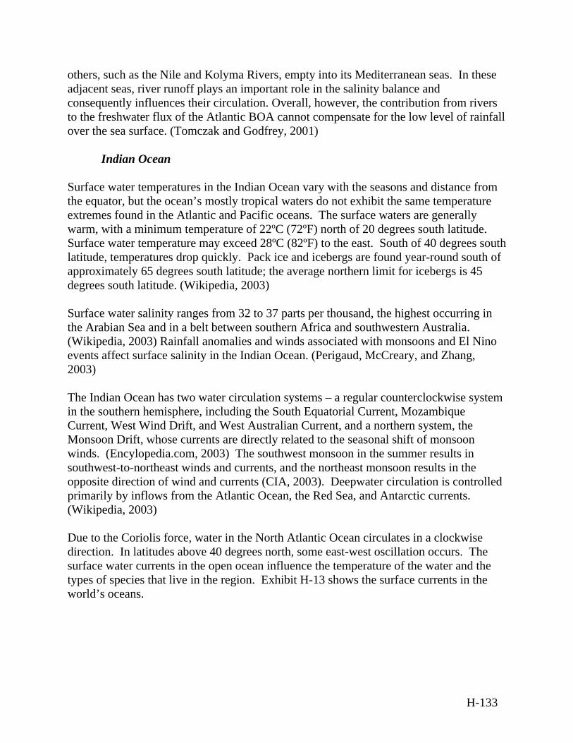
others, such as the Nile and Kolyma Rivers, empty into its Mediterranean seas. In these adjacent seas, river runoff plays an important role in the salinity balance and consequently influences their circulation. Overall, however, the contribution from rivers to the freshwater flux of the Atlantic BOA cannot compensate for the low level of rainfall over the sea surface. (Tomczak and Godfrey, 2001)
Indian Ocean Surface water temperatures in the Indian Ocean vary with the seasons and distance from the equator, but the ocean’s mostly tropical waters do not exhibit the same temperature extremes found in the Atlantic and Pacific oceans. The surface waters are generally warm, with a minimum temperature of 22ºC (72ºF) north of 20 degrees south latitude. Surface water temperature may exceed 28ºC (82ºF) to the east. South of 40 degrees south latitude, temperatures drop quickly. Pack ice and icebergs are found year-round south of approximately 65 degrees south latitude; the average northern limit for icebergs is 45 degrees south latitude. (Wikipedia, 2003) Surface water salinity ranges from 32 to 37 parts per thousand, the highest occurring in the Arabian Sea and in a belt between southern Africa and southwestern Australia. (Wikipedia, 2003) Rainfall anomalies and winds associated with monsoons and El Nino events affect surface salinity in the Indian Ocean. (Perigaud, McCreary, and Zhang, 2003) The Indian Ocean has two water circulation systems – a regular counterclockwise system in the southern hemisphere, including the South Equatorial Current, Mozambique Current, West Wind Drift, and West Australian Current, and a northern system, the Monsoon Drift, whose currents are directly related to the seasonal shift of monsoon winds. (Encylopedia.com, 2003) The southwest monsoon in the summer results in southwest-to-northeast winds and currents, and the northeast monsoon results in the opposite direction of wind and currents (CIA, 2003). Deepwater circulation is controlled primarily by inflows from the Atlantic Ocean, the Red Sea, and Antarctic currents. (Wikipedia, 2003) Due to the Coriolis force, water in the North Atlantic Ocean circulates in a clockwise direction. In latitudes above 40 degrees north, some east-west oscillation occurs. The surface water currents in the open ocean influence the temperature of the water and the types of species that live in the region. Exhibit H-13 shows the surface currents in the world’s oceans.
H-133
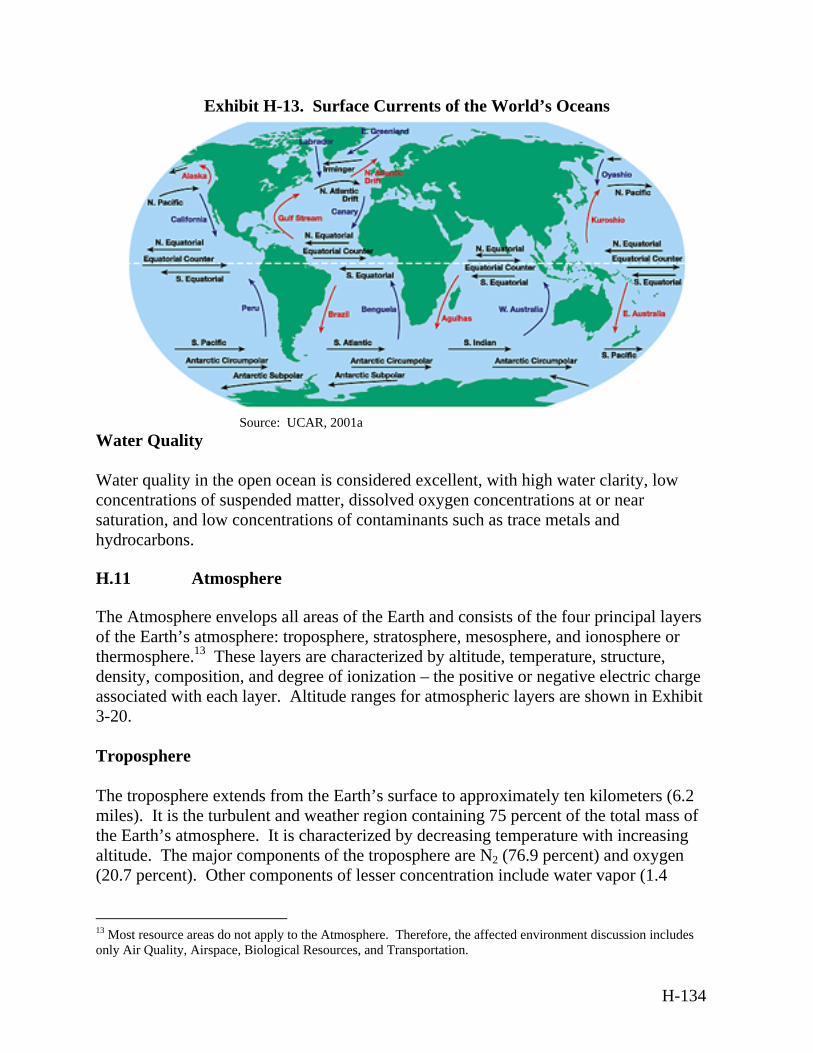
Exhibit H-13. Surface Currents of the World’s Oceans
Source: UCAR, 2001a
Water Quality Water quality in the open ocean is considered excellent, with high water clarity, low concentrations of suspended matter, dissolved oxygen concentrations at or near saturation, and low concentrations of contaminants such as trace metals and hydrocarbons.
H.11 Atmosphere
The Atmosphere envelops all areas of the Earth and consists of the four principal layers of the Earth’s atmosphere: troposphere, stratosphere, mesosphere, and ionosphere or thermosphere.13 These layers are characterized by altitude, temperature, structure, density, composition, and degree of ionization – the positive or negative electric charge associated with each layer. Altitude ranges for atmospheric layers are shown in Exhibit 3-20.
Troposphere The troposphere extends from the Earth’s surface to approximately ten kilometers (6.2 miles). It is the turbulent and weather region containing 75 percent of the total mass of the Earth’s atmosphere. It is characterized by decreasing temperature with increasing altitude. The major components of the troposphere are N2 (76.9 percent) and oxygen (20.7 percent). Other components of lesser concentration include water vapor (1.4
13 Most resource areas do not apply to the Atmosphere. Therefore, the affected environment discussion includes only Air Quality, Airspace, Biological Resources, and Transportation.
H-134
percent in the lower atmosphere), argon, CO2, nitrous oxide, hydrogen (H2), xenon, and ozone. The troposphere is composed of two sub-layers: the atmospheric boundary layer (lower troposphere) and the free troposphere. The altitude of the atmospheric boundary layer is a function of surface roughness and temperature gradient and extends from the surface of the Earth to approximately two kilometers (1.2 miles). The altitude of the free troposphere is a function of time and location, and ranges from approximately two to 10 kilometers (1.2 to 6.2 miles) above the Earth’s surface. Clouds and gases in the free troposphere regulate incoming and outgoing radiation, which affects the thermal heat balance of the Earth’s surface. Air pollutants frequently move through the atmospheric boundary layer and into the free troposphere, where they are subject to photochemical oxidation and chemical reactions within cloud droplets and return through precipitation to the atmospheric boundary layer or the Earth’s surface. Certain emissions or toxic contaminants, from both human and natural activities, can cause acute health exposure, degrade ambient air quality, can form acid rain that is deposited on Earth, or can travel to the upper atmosphere to contribute to global warming and ozone depletion. Approximately ten percent of the Earth’s ozone is in the troposphere. Ozone at the Earth’s surface is of great concern because it can directly damage life, including crop production, forest growth, and human health. Ozone is also a key ingredient for smog production. Stratosphere The stratosphere is located approximately 10 to 50 kilometers (6.2 to 31 miles) above the Earth's surface. Unlike the troposphere, the stratosphere is characterized by higher temperatures at the higher altitudes. It is the main region of ozone production in the atmosphere. Stratospheric ozone absorbs ultraviolet solar radiation, which is known to increase rates of skin cancer in humans and can be harmful to plant and animal life. Most atmospheric ozone (90 percent) is found in the stratosphere. The highest ozone concentrations are found in the lower stratosphere. The concentration of ozone results from a dynamic balance between the ozone transported by stratospheric circulation and ozone destruction and production by chemical means. The dynamic nature of this balance means that ozone can vary on many timescales. Variations on timescales of up to 11 years have been observed, correlating with the solar cycle. Annual variations in the total ozone column can be as much as one percent, while day-to-day changes can be greater than ten percent. Causes of temporal ozone variations include changes in ozone transport, changes in ozone chemistry, or a coupling of these processes. Although the tropical latitudes have fairly constant year-
H-135
round ozone levels, temperate altitudes exhibit strong seasonal ozone variations with a maximum peaking in March/April and a minimum in October/November in the northern hemisphere, and the reverse variation in the southern hemisphere. Variations in ozone concentrations may be solar-related or caused by other natural or man-induced variations in the chemistry of the stratosphere. Ozone is continually created and destroyed by naturally occurring photochemical processes, and its concentration fluctuates seasonally (25 percent) and annually (one to two percent). Ozone is made up of three oxygen atoms and is generated by the action of sunlight to combine an oxygen molecule with an atom of oxygen. Atomic oxygen is produced by photolysis, or the use of radiant energy to produce chemical changes, of molecules of oxygen, nitrogen dioxide (NO2), or ozone. Ozone can be depleted by compounds that contain various elements, most notably chlorine, fluorine, H2, and N2. Aluminum oxide (Al2O3) (particulates) and soot also may provide a reaction surface for the destruction of ozone. NO2 is also important in the stratosphere; it functions as a major catalyst for ozone destruction at those altitudes. The capability for stratospheric ozone depletion by a particular organo-chlorine compound is basically a consequence of its ability to deliver chlorine to the stratosphere and is primarily a function of its number of chlorine atoms, atmospheric lifetime, and stratospheric reactivity. Ozone depletion potentials have been developed for organo-chlorine compounds. They represent the relative amount of ozone depletion calculated in atmospheric models in comparison to the losses from an equivalent tonnage of CFC-11 set as 1.0. Concerns about the ozone layer, and in particular the effect of man-made chlorine, led to the Montreal Protocol of 1987. Under the Montreal Protocol, more than 90 nations, including the U.S., agreed to limit future production of ozone-depleting compounds. There are two classes of ozone-depleting compounds. Class I substances include chlorofluorocarbons, carbon tetrachloride, halons, methyl bromide, and methyl chloroform. Class II substances consist of hydrochlorofluorocarbons. In the U.S., the 1990 Clean Air Act Amendments established phase-out schedules that surpassed those established during the Montreal Protocol and subsequent international meetings. The term “phase-out” refers to discontinuation of both production and consumption. Production of Class I substances was phased out by January 1, 1996, with the exception of halons, production of which was phased out on January 1, 1994. Class II substances have a more gradual phase-out schedule, which began in 2000 and extends to approximately 2020. The EPA can issue exceptions to the ban on use of some of these substances for medical, aviation safety, national security, and fire-extinguishing purposes. EO 13148, Greening the Government Through Leadership in Environmental Management (65 FR 24595, 2000) requires Federal agencies to develop “a plan to phase
H-136
out the procurement of Class I ozone-depleting substances for all nonexcepted uses by December 31, 2010. Plans should target cost effective reduction of environmental risk by phasing out Class I ozone depleting substance applications as the equipment using those substances reaches its expected service life. DoD contracts may not include a specification that requires the use of a Class 1 ozone-depleting substance, unless a waiver is granted. An agency may request a waiver, and waiver requests must provide: (1) an explanation of the mission critical use of the chemical; (2) an explanation of the nature of the need for the chemical to protect human health; (3) a description of efforts to identify a less harmful substitute chemical or alternative processes to reduce the release and transfer of the chemical in question; and (4) a description of the off-site transfers of toxic chemicals for treatment directly associated with environmental restoration activities.” The stratospheric ozone discussed above can be characterized as beneficial to the human environment. This is contrasted to the ozone produced near the surface of the earth formed through chemical reactions between precursor emissions of volatile organic compounds and NOx in the presence of sunlight. High concentrations of ozone at ground level are a major health and environmental concern. Mesosphere The mesosphere extends from 50 to 80 kilometers (31 to 53 miles) above the Earth’s surface. The upper boundary of the ozone layer occurs at the base of the mesosphere. The temperature in the mesosphere decreases with altitude and distance from radiation adsorbing ozone molecules. Varied wind speeds and directions also characterize the mesosphere. Ionosphere/Thermosphere The ionosphere is the lowest part of the Earth’s upper atmosphere and roughly extends from 80 to 1,000 kilometers (50 to 620 miles). In the ionosphere, the temperature rises with altitude due to the molecular adsorption of high-energy solar radiation. The ionosphere is further characterized by its high ion and electron density and is composed of several layers, each with different properties. The E layer is the lowest layer, occurring between 80 and 140 kilometers (50 and 87 miles), and the dominant ion in the E layer is the NO+ ion. The F1 and F2 layers occur between 140 and 1,000 kilometers (621 miles), and the dominant ion in these layers is O+. The F2 layer always is present, and the highest electron concentration occurs within this layer at about 300 kilometers (186 miles). Above 300 kilometers (186 miles), the electron concentration decreases to a distance equivalent to several Earth radii. At this point, the Earth’s magnetic field and the protonosphere (the outermost portion of the ionosphere) become indistinct from the solar wind or space.
H-137
The major neutral (non-charged) constituents of the ionosphere are atomic oxygen, N2 and oxygen, and minor constituents are NO, atomic nitrogen, helium, argon, and CO2. These neutral constituents are influenced strongly by the motions of plasma, or ionized gas. Though this layer has properties similar to a vacuum (by comparison to the Earth’s surface), orbiting satellites still encounter drag forces within it. The different layers of the ionosphere are important to low frequency radio communications. Radiation from the visible spectrum (e.g., aurora) originates in this region. The ionosphere is influenced by solar radiation, variations in the Earth’s magnetic field and the motion of the upper atmosphere. Because of these interactions, the systematic properties of the ionosphere vary greatly with geographic latitude and time (diurnally, seasonally, and over the approximately 11-year solar cycle).
H.11.1 Air Quality
Radiation Balance/Global Climate Change During the past 150 years, combustion of fossil fuels has resulted in increasing concentrations of atmospheric gases that are believed to influence global climate. Some of the activities associated with the BMDS could involve launches that use rocket fuels derived from fossil fuels. The partial products of combustion (burning) of the rocket fuel (which consists of hydrocarbons) are CO2 and water. Both liquid and solid fuel propulsion systems emit water vapor and CO2, either directly from the nozzle or as a result of afterburning in the exhaust fumes. The temperature of the earth's atmosphere is determined by three factors: the sunlight it receives, the sunlight it reflects, and the infrared radiation absorbed by the atmosphere. The principal absorbers include CO2, water vapor, nitrous oxide, CFCs, and methane. In general, higher concentrations of these gases produce increased absorption of infrared radiation and warmer temperatures. This phenomenon is commonly referred to as the “greenhouse effect.”
H.11.2 Airspace
Exhibit H-14 illustrates the relationship between airspace classifications and atmospheric layers.
H-138
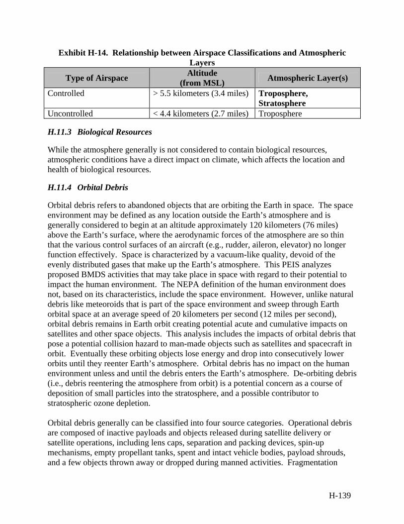
Exhibit H-14. Relationship between Airspace Classifications and Atmospheric Layers
Type of Airspace Altitude (from MSL) Atmospheric Layer(s)
Controlled > 5.5 kilometers (3.4 miles) Troposphere, Stratosphere
Uncontrolled < 4.4 kilometers (2.7 miles) Troposphere
H.11.3 Biological Resources
While the atmosphere generally is not considered to contain biological resources, atmospheric conditions have a direct impact on climate, which affects the location and health of biological resources.
H.11.4 Orbital Debris
Orbital debris refers to abandoned objects that are orbiting the Earth in space. The space environment may be defined as any location outside the Earth’s atmosphere and is generally considered to begin at an altitude approximately 120 kilometers (76 miles) above the Earth’s surface, where the aerodynamic forces of the atmosphere are so thin that the various control surfaces of an aircraft (e.g., rudder, aileron, elevator) no longer function effectively. Space is characterized by a vacuum-like quality, devoid of the evenly distributed gases that make up the Earth’s atmosphere. This PEIS analyzes proposed BMDS activities that may take place in space with regard to their potential to impact the human environment. The NEPA definition of the human environment does not, based on its characteristics, include the space environment. However, unlike natural debris like meteoroids that is part of the space environment and sweep through Earth orbital space at an average speed of 20 kilometers per second (12 miles per second), orbital debris remains in Earth orbit creating potential acute and cumulative impacts on satellites and other space objects. This analysis includes the impacts of orbital debris that pose a potential collision hazard to man-made objects such as satellites and spacecraft in orbit. Eventually these orbiting objects lose energy and drop into consecutively lower orbits until they reenter Earth’s atmosphere. Orbital debris has no impact on the human environment unless and until the debris enters the Earth’s atmosphere. De-orbiting debris (i.e., debris reentering the atmosphere from orbit) is a potential concern as a course of deposition of small particles into the stratosphere, and a possible contributor to stratospheric ozone depletion. Orbital debris generally can be classified into four source categories. Operational debris are composed of inactive payloads and objects released during satellite delivery or satellite operations, including lens caps, separation and packing devices, spin-up mechanisms, empty propellant tanks, spent and intact vehicle bodies, payload shrouds, and a few objects thrown away or dropped during manned activities. Fragmentation
H-139
debris results from either collisions or explosions. Deterioration debris is very small debris particles created by the gradual disintegration of spacecraft surface as a result of exposure to the space environment, including paint flaking and plastic and metal erosion. Solid rocket motor ejecta results from the ejection of thousands of kilograms of Al2O3 dust from solid rocket motors into the orbital environment. (DOT, 2001b) Orbital debris particles can be characterized by size as Small – debris particles smaller than 1.02 centimeters (0.4 inch) in diameter, Medium – debris particles between 1.02 and 10.2 centimeters (0.4 and four inches) in
diameter, and Large – debris particles larger than 10.2 centimeters (four inches) in diameter.
Large particles represent five percent of the total population of debris particles. Particles of this size can be tracked and catalogued by the Space Surveillance Network. (U.S. Department of the Air Force, 2000) The major source of orbital debris is explosion/collision-induced satellite breakups. Although the exact cause of most breakups is unknown, it is generally thought to result primarily from inadvertent mixing of hypergolic fuels, overheating of residual propellants or deliberate fragmentation. (U.S. Department of the Air Force, 2000) The interaction among these three classes combined with their long residual times in orbit creates concern that there may be collisions producing additional fragments and causing the total debris population to grow, which may increase the chance of reentry into Earth’s atmosphere. The National Research Council estimated that there are more than 10,000 objects greater than 10.2 centimeters (four inches) in size in orbit (including the almost 8,0999 tracing by AFSPC), tens of millions between 0.099 and 10.2 centimeters (0.039 and four inches) in size, and a trillion less than 0.099 centimeters (0.0.39 inch) in size. (U.S. Department of the Air Force, 2000) A 1996 Executive Branch policy directive, National Space Policy, provides guidance for orbital debris: “The U.S. will seek to minimize the creation of space debris. NASA, the Intelligence Community and the DoD, in cooperation with the private sector, will develop design guidelines for future government procurements of spacecraft, launch vehicles and services. The design and operation of space tests, experiments and systems will minimize or reduce accumulation of space debris consistent with mission requirements and cost effectiveness.” Hazards to Space Operations from Orbital Debris The effects of launch-vehicle-generated orbital debris impacts on other spacecraft depend on the altitude, orbit, velocity, angle of impact, and mass of the debris. Debris particles defined as “small” in size would cause surface pitting and erosion. Over a long period of
H-140

time, the cumulative effect of individual particles colliding with a satellite may become significant. Medium sized debris would produce significant impact damage that can be serious, depending on system vulnerability and defensive design provisions. Large particles can produce catastrophic damage. Astronauts or cosmonauts engaging in extra-vehicular activities could be vulnerable to the impact of small debris. On average, debris 1 millimeter (0. 04 inch) is capable of perforating current U.S. space suits. (Cour-Palais, 1991, as referenced in Commission on Engineering and Technical Systems, 1995) Solid rocket motors eject Al2O3 dust (typically less than 0.004 inch) into the orbital environment, and may release larger chunks of unburned solid propellant or slag. However, solid rocket motor particles typically either decay very rapidly, probably within a few perigee (lowest point of orbit) passages, or are dispersed by solar radiation pressure. Thus, the operational threat of solid rocket motor dust is probably limited to brief periods of time related to specific mission events. (U.S. Department of the Air Force, 2000) Orbital debris generated by launch vehicles contributes to the larger problem of pollution in space that includes radio-frequency interference and interference with scientific observations in all parts of the spectrum. For example, emissions at radio frequencies often interfere with radio astronomy observations (Office of Technology Assessment, 1990). Not only can orbital debris interfere with the performance of scientific experiments, but may even accidentally destroy them. (U.S. Department of the Air Force, 2000) Over a long period of time, the cumulative effect of individual particles colliding with a satellite might become significant because the number of particles in this size range is very large in Low Earth Orbit (LEO). Although solid rocket motor ejecta are very small, long-term exposure of payloads to such particles is likely to cause erosion of exterior surfaces, chemical contamination, and may degrade operations of vulnerable components such as optical windows and solar panels. (DOT, 2001b)
H-141

APPENDIX I
CUMULATIVE IMPACTS
I-1
CUMULATIVE IMPACTS
Background Cumulative impacts are defined as the sum of the incremental impacts of a proposed action when added to the impacts of the activities of other past, present, and reasonably foreseeable future actions, regardless of the agency or person who undertakes them. As discussed in Section 4.2.3, the proposed action is worldwide in its scope and potential application; therefore, similar actions, which are worldwide in scope, have been considered for this analysis. Worldwide commercial and government launch programs were determined to be activities of international scope that might reasonably be considered along with projected ballistic missile defense system (BMDS) launches for cumulative impacts in this Programmatic Environmental Impact Statement (PEIS). Launches can contribute to cumulative impacts including ozone depletion, global warming, and orbital debris. In the stratosphere, cumulative impacts of worldwide launches could affect global warming and depletion of the stratospheric ozone layer because combustion products emitted during launch activities can play a role in these atmospheric conditions. In the stratosphere, cumulative impacts of worldwide launches could affect global warming and depletion of the stratospheric ozone layer because launch emissions and their subsequent exhaust and atmospheric reaction products could play a role in causing or exacerbating these conditions. The cumulative impact, however, on global warming from launches would be insignificant when compared to other industrial sources of greenhouse gases and ozone-depleting substances. Further, the cumulative impact on stratospheric ozone depletion from launches would be far below and indistinguishable from the effects attributable to other natural and man-made causes. Ongoing research in this area indicates that ozone depletion from launch exhaust is limited spatially and temporally, and that these reactions do not have a globally significant impact on stratospheric chemistry. (Ross et al, 1997 as referenced in DOT, 2001b) There has been extensive research on the potentially harmful effects of large solid propellant exhaust on global ozone depletion supported by the Air Force and the National Aeronautics and Space Administration (NASA). These studies are generally based on a high launch rate, which allows for evaluation of large chlorine loads to the stratosphere. One such study by the World Meteorological Organization (1994 as referenced in Department of Transportation [DOT], 2001b) examined the effects of 10 launches annually of each of the following vehicles: Space Shuttle, Titan IV, and Ariane 5, which release 62, 29, and 52 metric tons
I-2
(68, 32, and 57 tons) of Cl per launch, respectively, directly into the stratosphere. A total of 1,424 metric tons (1,570 tons) of Cl deposited in the stratosphere each year from these launches corresponds to only 0.064% of the 1994 total stratospheric burden of chlorine from industrial sources. Analyses in the Rocket Impact on Stratospheric Ozone study (Ross, 1998 as referenced in DOT, 2001b) have confirmed that ozone loss occurs in the plume wakes of large solid propellant boosters (e.g., Titan IV and Space Shuttle), but the amount and duration of the loss appears to be temporary and limited. This appendix presents the methodology used to estimate BMDS and other worldwide launch emission loads to the stratosphere as discussed in Section 4.2.3. These launch emission loads were then used to determine the cumulative impact on global warming from carbon monoxide (CO) and carbon dioxide (CO2) emissions and the cumulative impact on stratospheric ozone depletion from chlorine emissions. Major inputs needed to determine the emission loads to the stratosphere and troposphere were Booster residence time, or the amount of time it takes the booster to travel
through each layer of the atmosphere, Projected number of BMDS and worldwide launches, and Emission weight fractions, or the amounts of each emission (such as hydrogen
chloride [HCl] and aluminum oxide [Al2O3]) from combustion of the propellant.
Booster Residence Time The booster residence time is determined based on the amount of time it takes the booster to travel through each layer of the atmosphere. The four layers of the Earth’s atmosphere are the troposphere, extending from the surface to 10 kilometers (six miles); stratosphere, extending 10 to 50 kilometers (six to 31 miles); mesosphere, extending 50 to 80 kilometers (31 to 50 miles); and ionosphere, extending 80 to 1,000 kilometers (50 to 621 miles). See Exhibit 3-20 in Section 3.2.11. The residence time is used as the basis for determining the amount of propellant expended and thereby the amount of combustion products emitted in each layer of the atmosphere. The time a booster spends in an atmospheric layer is roughly correlated with the size of the booster. A smaller booster moves faster and therefore, spends less time in each atmospheric layer. The atmospheric interceptor technology (ait) booster is representative of boosters that would be part of the BMDS. The ait has been shown to spend approximately 25 seconds in both the troposphere and stratosphere. This PEIS provides a conservative analysis, which assumes that all boosters would spend approximately
I-3
60 seconds in both the troposphere and stratosphere. This residence time is sufficiently conservative to account for emissions from BMDS launches and from other worldwide launches of larger boosters. Because the residence time for boosters traveling through the troposphere and stratosphere was the same, it was assumed that the type and quantity of combustion product emissions would be the same in both the troposphere and stratosphere. (Department of Air Force, 1990 as referenced in DOT, 2001b) Projected Number of BMDS and Worldwide Launches The number of BMDS projected launches was estimated at 51514 during the years 2004 to 2014. Worldwide projected launches, which include 77 United States (U.S.) commercial launches (Federal Aviation Administration [FAA] Associate Administrator for Commercial Space Transportation [AST], 2003); 99 U.S. government launches (NASA, 2003a; NASA, 2003b; NASA, 2003c); 183 foreign commercial launches (COMSTAC, 2003); and 476 foreign government launches (NASA, 2004; Gunter’s Space Page, 2004; Spaceflight Now, 2004a; Spaceflight Now, 2004b), were estimated to total 835 launches during the years 2004 and 2014. U.S. military launches were either captured under BMDS launches or under U.S. government launches (e.g., NASA launching a military satellite). Launches were categorized by classes of boosters using a method developed in the PEIS for Licensing Launches. (DOT, 2001b) Boosters were classified into ranges based on the size of the propulsion system, specifically, the amount of propellant consumed in both the troposphere and the stratosphere. The ranges are Low (up to 75,000 kilograms [165,347 pounds] of propellant); Medium (75,000-100,000 kilograms [165,347-220,462 pounds] of propellant); Intermediate (100,000-200,000 kilograms [220,462-440,925 pounds] of
propellant); and High (greater than 200,000 kilograms [440,925 pounds] of propellant).
Exhibit I-1 shows the number of BMDS launches and worldwide launches.
14 Projected number of launches based on internal proposed test events.
I-4
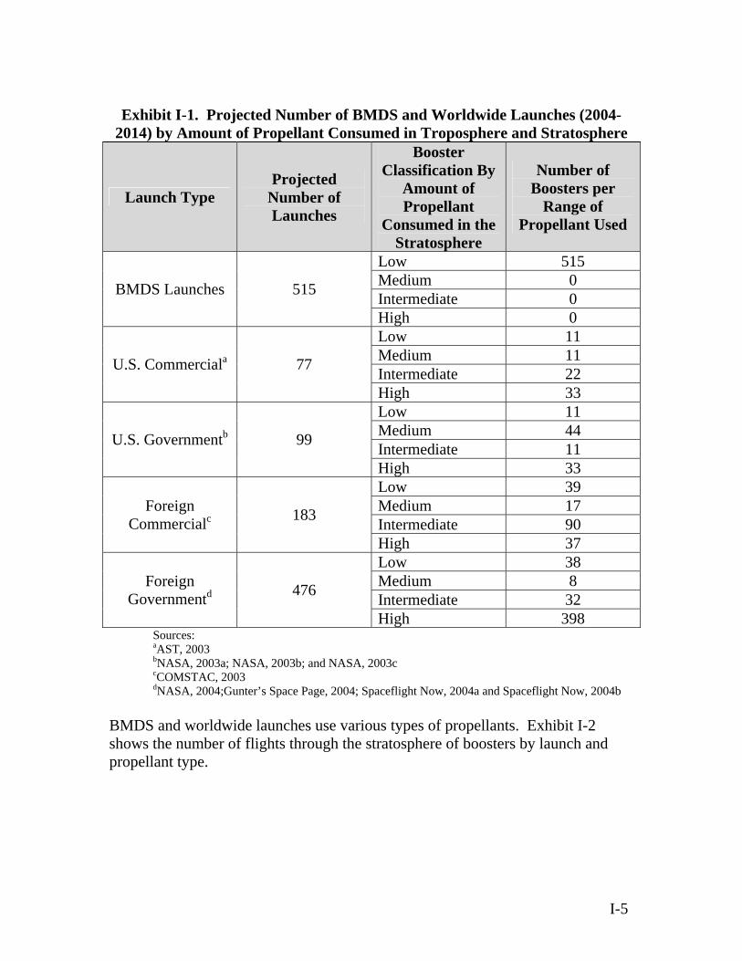
Exhibit I-1. Projected Number of BMDS and Worldwide Launches (2004-
2014) by Amount of Propellant Consumed in Troposphere and Stratosphere
Launch Type Projected
Number of Launches
Booster Classification By
Amount of Propellant
Consumed in the Stratosphere
Number of Boosters per
Range of Propellant Used
Low 515 Medium 0 Intermediate 0 BMDS Launches 515
High 0 Low 11 Medium 11 Intermediate 22 U.S. Commerciala 77
High 33 Low 11 Medium 44 Intermediate 11 U.S. Governmentb 99
High 33 Low 39 Medium 17 Intermediate 90
Foreign Commercialc 183
High 37 Low 38 Medium 8 Intermediate 32
Foreign Governmentd 476
High 398 Sources: aAST, 2003 bNASA, 2003a; NASA, 2003b; and NASA, 2003c cCOMSTAC, 2003
dNASA, 2004;Gunter’s Space Page, 2004; Spaceflight Now, 2004a and Spaceflight Now, 2004b BMDS and worldwide launches use various types of propellants. Exhibit I-2 shows the number of flights through the stratosphere of boosters by launch and propellant type.
I-5
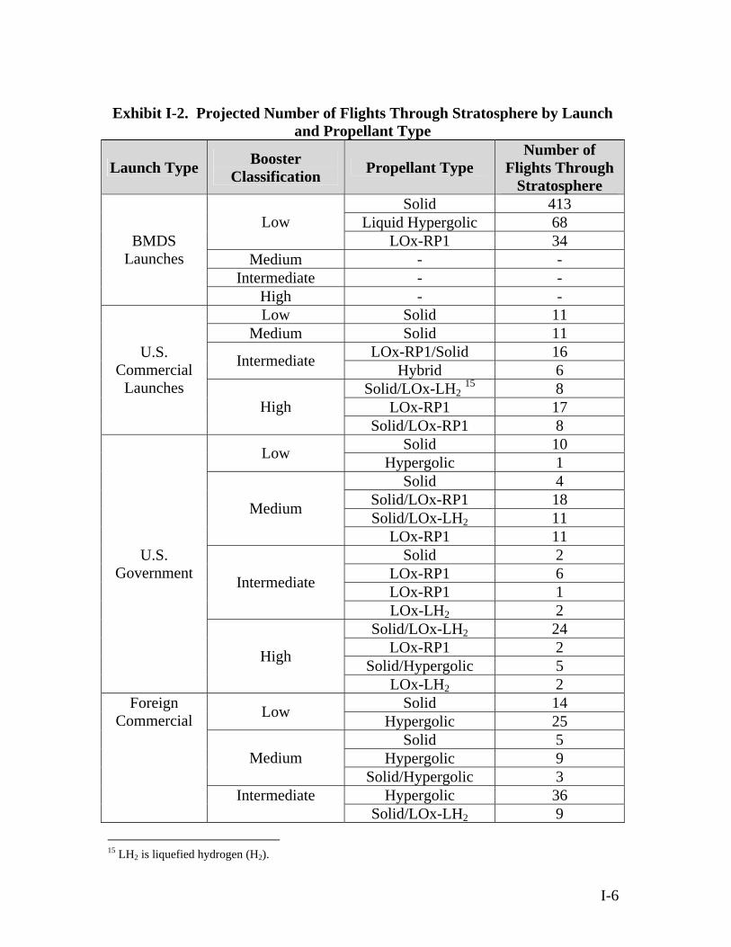
Exhibit I-2. Projected Number of Flights Through Stratosphere by Launch
and Propellant Type
Launch Type Booster Classification Propellant Type
Number of Flights Through
Stratosphere Solid 413
Liquid Hypergolic 68 Low LOx-RP1 34
Medium - - Intermediate - -
BMDS Launches
High - - Low Solid 11
Medium Solid 11 LOx-RP1/Solid 16 Intermediate Hybrid 6
Solid/LOx-LH2 15 8 LOx-RP1 17
U.S. Commercial
Launches High
Solid/LOx-RP1 8 Solid 10 Low Hypergolic 1 Solid 4
Solid/LOx-RP1 18 Solid/LOx-LH2 11 Medium
LOx-RP1 11 Solid 2
LOx-RP1 6 LOx-RP1 1 Intermediate
LOx-LH2 2 Solid/LOx-LH2 24
LOx-RP1 2 Solid/Hypergolic 5
U.S. Government
High
LOx-LH2 2 Solid 14 Low Hypergolic 25 Solid 5
Foreign Commercial
Hypergolic 9 Medium Solid/Hypergolic 3
Hypergolic 36 Intermediate Solid/LOx-LH2 9
15 LH2 is liquefied hydrogen (H2).
I-6
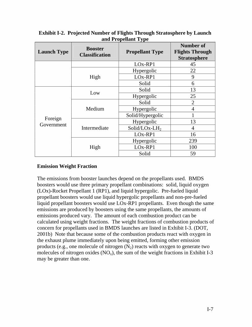
Exhibit I-2. Projected Number of Flights Through Stratosphere by Launch and Propellant Type
Launch Type Booster Classification Propellant Type
Number of Flights Through
Stratosphere LOx-RP1 45
Hypergolic 22 LOx-RP1 9 High
Solid 6 Solid 13 Low Hypergolic 25 Solid 2
Hypergolic 4 Medium Solid/Hypergolic 1
Hypergolic 13 Solid/LOx-LH2 4
Foreign Government Intermediate
LOx-RP1 16 Hypergolic 239 LOx-RP1 100 High
Solid 59 Emission Weight Fraction The emissions from booster launches depend on the propellants used. BMDS boosters would use three primary propellant combinations: solid, liquid oxygen (LOx)-Rocket Propellant 1 (RP1), and liquid hypergolic. Pre-fueled liquid propellant boosters would use liquid hypergolic propellants and non-pre-fueled liquid propellant boosters would use LOx-RP1 propellants. Even though the same emissions are produced by boosters using the same propellants, the amounts of emissions produced vary. The amount of each combustion product can be calculated using weight fractions. The weight fractions of combustion products of concern for propellants used in BMDS launches are listed in Exhibit I-3. (DOT, 2001b) Note that because some of the combustion products react with oxygen in the exhaust plume immediately upon being emitted, forming other emission products (e.g., one molecule of nitrogen (N2) reacts with oxygen to generate two molecules of nitrogen oxides (NOx), the sum of the weight fractions in Exhibit I-3 may be greater than one.
I-7
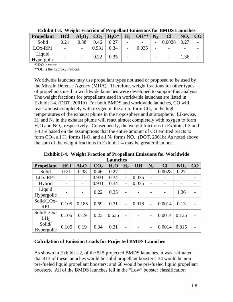
Exhibit I-3. Weight Fraction of Propellant Emissions for BMDS Launches Propellant HCl Al2O3 CO2 H2O* H2 OH** N2 Cl NOx CO
Solid 0.21 0.38 0.46 0.27 - - - 0.0028 0.27 - LOx-RP1 - - 0.931 0.34 - 0.035 - - - -
Liquid Hypergolic - - 0.22 0.35 - - - - 1.36 -
*H2O is water. **OH is the hydroxyl radical. Worldwide launches may use propellant types not used or proposed to be used by the Missile Defense Agency (MDA). Therefore, weight fractions for other types of propellants used in worldwide launches were developed to support this analysis. The weight fractions for propellants used in worldwide launches are listed in Exhibit I-4. (DOT, 2001b) For both BMDS and worldwide launches, CO will react almost completely with oxygen in the air to form CO2 in the high temperatures of the exhaust plume in the troposphere and stratosphere. Likewise, H2 and N2 in the exhaust plume will react almost completely with oxygen to form H2O and NOx, respectively. Consequently, the weight fractions in Exhibits I-3 and I-4 are based on the assumptions that the entire amount of CO emitted reacts to form CO2, all H2 forms H2O, and all N2 forms NOx. (DOT, 2001b) As noted above the sum of the weight fractions in Exhibit I-4 may be greater than one.
Exhibit I-4. Weight Fraction of Propellant Emissions for Worldwide Launches
Propellant HCl Al2O3 CO2 H2O H2 OH N2 Cl NOx COSolid 0.21 0.38 0.46 0.27 - - - 0.0028 0.27 -
LOx-RP1 - - 0.931 0.34 - 0.035 - - - - Hybrid - - 0.931 0.34 - 0.035 - - - - Liquid
Hypergolic - - 0.22 0.35 - - - - 1.36 -
Solid/LOx-RP1 0.105 0.185 0.69 0.31 - 0.018 - 0.0014 0.13 -
Solid/LOx-LH2
0.105 0.19 0.23 0.635 - - - 0.0014 0.135 -
Solid/ Hypergolic 0.105 0.19 0.34 0.31 - - - 0.0014 0.815 -
Calculation of Emission Loads for Projected BMDS Launches As shown in Exhibit I-2, of the 515 projected BMDS launches, it was estimated that 413 of these launches would be solid propellant boosters; 34 would be non-pre-fueled liquid propellant boosters; and 68 would be pre-fueled liquid propellant boosters. All of the BMDS launches fell in the “Low” booster classification
I-8

range. However, within the Low range there are many types and sizes of solid propellant boosters. Therefore, these boosters were further classified (as shown in Exhibit I-5) based on the quantity of propellant consumed in the stratosphere to obtain a more accurate representation of emission loads to the stratosphere from proposed BMDS launches.
Exhibit I-5. Further Classification of Solid-Propellant BMDS Launches during 2004-2014 Based on Propellant Consumed in Stratosphere
Maximum Propellant Quantity
Consumed in Stratosphere in
kilograms (pounds)a
Percent of BMDS Launches in Each
Booster Classification
Number of Booster Flights Through
Stratosphere
Booster Classification
Low (A) Up to 500 (1,102) 13% 54
Low (B) 500-1,000 (1,102-2,205) 10% 41
Low (C) 1,000-5,000 (2,205-11,023) 10% 41
Low (D) 5,000-8,000 (11,023-17,637) 22% 91
Low (E) 8,000-15,000 (17,637-33,069) 29% 120
Low (F) 15,000-30,000 (33,069-66,139) 3% 12
Low (G) 30,000-60,000 (66,139-132,277) 13% 54
aAmount of propellant quantity consumed in the stratosphere was based on review of existing booster propellant information and booster residence time
Exhibit I-6 presents the estimated emissions loads to the stratosphere from BMDS launches from 2004 to 2014. Exhibit I-6 includes Propellant type used during flight through stratosphere; Number of booster flights through the stratosphere; and Maximum quantity of propellant consumed in the stratosphere, which is
determined based on the booster residence time in the stratosphere (60 seconds assumed).
I-9
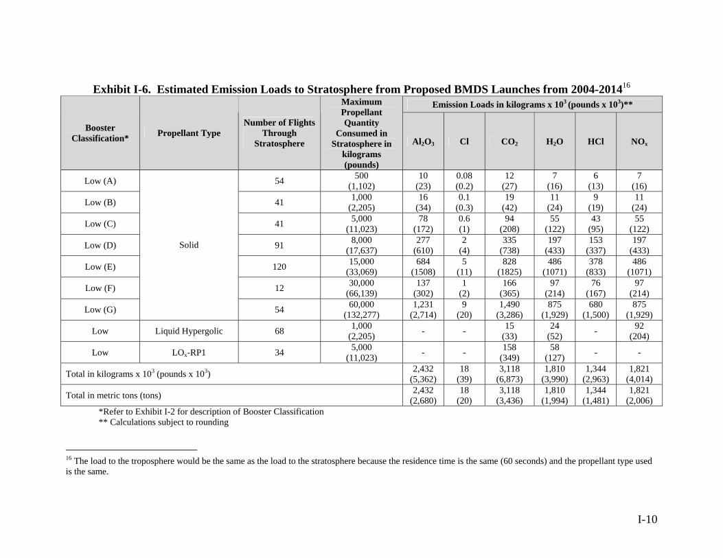
I-10
Exhibit I-6. Estimated Emission Loads to Stratosphere from Proposed BMDS Launches from 2004-201416
Emission Loads in kilograms x 103 (pounds x 103)**
Booster Classification* Propellant Type
Number of Flights Through
Stratosphere
Maximum Propellant Quantity
Consumed in Stratosphere in
kilograms (pounds)
Al2O3 Cl CO2 H2O HCl NOx
Low (A) 54 500 (1,102)
10 (23)
0.08 (0.2)
12 (27)
7 (16)
6 (13)
7 (16)
Low (B) 41 1,000 (2,205)
16 (34)
0.1 (0.3)
19 (42)
11 (24)
9 (19)
11 (24)
Low (C) 41 5,000 (11,023)
78 (172)
0.6 (1)
94 (208)
55 (122)
43 (95)
55 (122)
Low (D) 91 8,000 (17,637)
277 (610)
2 (4)
335 (738)
197 (433)
153 (337)
197 (433)
Low (E) 120 15,000 (33,069)
684 (1508)
5 (11)
828 (1825)
486 (1071)
378 (833)
486 (1071)
Low (F) 12 30,000 (66,139)
137 (302)
1 (2)
166 (365)
97 (214)
76 (167)
97 (214)
Low (G)
Solid
54 60,000 (132,277)
1,231 (2,714)
9 (20)
1,490 (3,286)
875 (1,929)
680 (1,500)
875 (1,929)
Low Liquid Hypergolic 68 1,000 (2,205) - - 15
(33) 24
(52) - 92 (204)
Low LOx-RP1 34 5,000 (11,023) - - 158
(349) 58
(127) - -
Total in kilograms x 103 (pounds x 103) 2,432 (5,362)
18 (39)
3,118 (6,873)
1,810 (3,990)
1,344 (2,963)
1,821 (4,014)
Total in metric tons (tons) 2,432 (2,680)
18 (20)
3,118 (3,436)
1,810 (1,994)
1,344 (1,481)
1,821 (2,006)
*Refer to Exhibit I-2 for description of Booster Classification ** Calculations subject to rounding
16 The load to the troposphere would be the same as the load to the stratosphere because the residence time is the same (60 seconds) and the propellant type used is the same.
The number of flights through the stratosphere was multiplied by the maximum quantity of propellant consumed in the stratosphere to find the total amount of propellant consumed in the stratosphere for projected BMDS launches. The total amount of propellant was then multiplied by the appropriate weight fraction based on the type of propellant used (listed in Exhibit I-3 for BMDS launches). Calculation of Emissions Loads for Worldwide Launches Exhibits I-7 and I-8 present the estimated emission loads to the stratosphere from U.S. commercial and government launches from 2004 to 2014, respectively. Within each booster classification (Low, Medium, Intermediate, and High) the percent of rockets using various propellants was calculated based on previous studies. (DOT, 2001b) Representative vehicles were used for each propellant within each vehicle classification to determine emission loads. Propellant quantities and types for U.S. commercial and government vehicles in the Low propellant use vehicle classification were based on quantities currently used for commercial launches. Propellant quantities and types for U.S. commercial and government vehicles in the High propellant use vehicle classification were based on the Titan IV and Space Shuttle. (Isakowitz, 1999 as referenced in DOT, 2001b) Exhibits I-7 and I-8 also include the maximum quantity of propellant consumed in the stratosphere, which was determined based on the booster’s residence time. The number of flights was multiplied by the maximum quantity of propellant consumed to determine the total amount of propellant consumed in the stratosphere for projected U.S. commercial and government launches. The total amount of propellant was then multiplied by the appropriate weight fraction based on the propellant used (listed in Exhibit I-4 for worldwide launches). Exhibits I-9 and I-10 present the emission loads to the stratosphere from foreign commercial and government launches from 2004 to 2014, respectively. Within each vehicle classification (Low, Medium, Intermediate, and High) the percent of vehicles using various propellants was calculated based on previous studies. (DOT, 2001b) Representative boosters were used for each propellant within each booster classification to determine emission loads. Specific international vehicles that are used currently or are under development were examined. These include the Zenit (Russia), Proton (Russia), Ariane IV and V (European Space Agency), Long March (China), H2 (Japan), GSLV (India), PSLV (India), and M-V (Japan). The propellant quantities and types used in various layers of the Earth’s atmosphere were developed from previous studies. (Isakowitz, 1999 as referenced in DOT, 2001b) Exhibits I-9 and I-10 also include the maximum quantity of propellant consumed in the stratosphere, which was determined based on the booster’s residence time in
I-11

the stratosphere. The number of flights was multiplied by the maximum quantity of propellant consumed to determine the total amount of propellant consumed in the stratosphere for projected foreign commercial and government launches. This total amount of propellant was then multiplied by the appropriate weight fraction based on the propellant used (listed in Exhibit I-4 for worldwide launches).
I-12

I-13
Exhibit I-7. Estimated Emission Loads to Stratosphere from U.S. Commercial Launches from 2004-2014 Emission Loads in kilograms x 103 (pounds x 103)*
Booster Classification
Percent Boosters using Various
Propellant Types During Flight
through Stratosphere
Example of Booster Type
Number of Flights
Through Stratosphere
Maximum Propellant Quantity
Consumed in Stratosphere in kilograms
(pounds)
Al2O3 Cl CO2 H2O HCl NOx
Low 100% Solid Taurus/ Athena 11 30,000
(66,139) 125
(276) 0.9 (2)
152 (335)
89 (196)
69 (153)
89 (196)
Medium 100% LOx-RP1/Solid Delta 2 11 75,000
(165,347) 153
(336) 1
(3) 569
(1,255) 256
(564) 87
(191) 107
(236) 75% LOx-RP1/Solid
Delta 3, Atlas IIAS 16 100,000
(220,462) 296
(653) 2
(5) 1,104
(2,434) 496
(1,093) 168
(370) 208
(459) Intermediate 25% Hybrid To be
developed 6 100,000 (220,462) - - 559
(1,231) 204
(450) - -
25% Solid/LOx-LH2
Delta 4H Commercial 8 110,000
(242,508) 167
(369) 1
(3) 202
(446) 559
(1,232) 92
(204) 119
(262)
50% LOx-RP1 Zenit Sea Launch/BA-2 17 250,000
(551,156) - - 3,957 (8,723)
1,445 (3,186) - -High
25% Solid/LOx-RP1
Atlas 5 Commercial 8 250,000
(551,156) 370
(816) 3
(6) 1,380
(3,042) 620
(1,367) 210
(463) 260
(573)
Total in kilograms x 103 (pounds x 103) 1,111 (2,450)
8 (19)
7,923 (17,466)
3,669 (8,088)
626 (1,381)
783 (1,726)
Total in metric tons (tons) 1,111 (1,225)
8 (9) (8,734) (4,044) (690) (863)
783 626 3,669 7,923
* Calculations subject to rounding
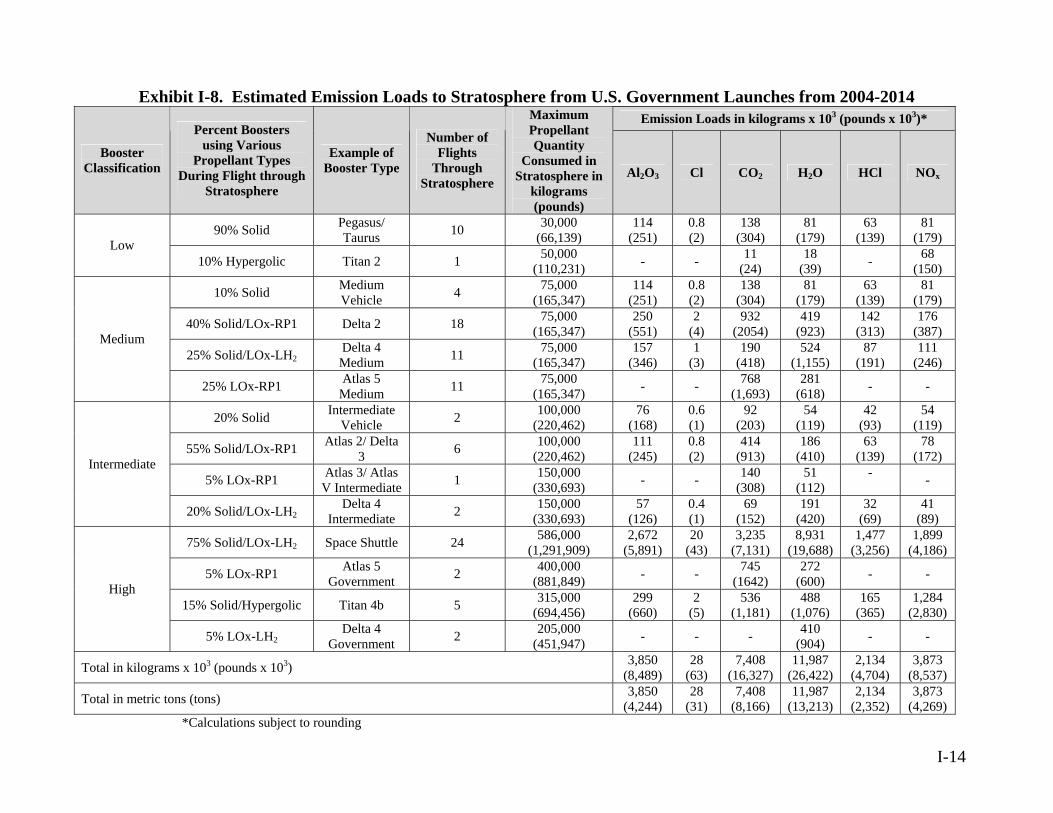
I-14
Exhibit I-8. Estimated Emission Loads to Stratosphere from U.S. Government Launches from 2004-2014 Emission Loads in kilograms x 103 (pounds x 103)*
Booster ation
Percent Boosters using Various
Propellant Types During Flight through
Stratosphere
Example of Booster Type
Number of Flights
Through Stratosphere
Maximum Propellant Quantity
Consumed in Stratosphere in
kilograms (pounds)
Al2O3 Cl CO2 H2O HCl NOx
90% Solid Pegasus/ Taurus 10 30,000
(66,139) 114
(251) 0.8 (2)
138 (304)
81 (179)
63 (139)
81 (179) Low
10% Hypergolic Titan 2 1 50,000 (110,231) - - 11
(24) 18
(39) - 68 (150)
10% Solid Medium Vehicle 4 75,000
(165,347) 114
(251) 0.8 (2)
138 (304)
81 (179)
63 (139)
81 (179)
40% Solid/LOx-RP1 Delta 2 18 75,000 (165,347)
250 (551)
2 (4)
932 (2054)
419 (923)
142 (313)
176 (387)
25% Solid/LOx-LH2Delta 4 Medium 11 75,000
(165,347) 157
(346) 1
(3) 190
(418) 524
(1,155) 87
(191) 111
(246)
Medium
25% LOx-RP1 Atlas 5 Medium 11 75,000
(165,347) - - 768 (1,693)
281 (618) - -
20% Solid Intermediate Vehicle 2 100,000
(220,462) 76
(168) 0.6 (1)
92 (203)
54 (119)
42 (93)
54 (119)
55% Solid/LOx-RP1 Atlas 2/ Delta 3 6 100,000
(220,462) 111
(245) 0.8 (2)
414 (913)
186 (410)
63 (139)
78 (172)
5% LOx-RP1 Atlas 3/ Atlas V Intermediate 1 150,000
(330,693) - - 140 (308)
51 (112)
- -
Intermediate
20% Solid/LOx-LH2Delta 4
Intermediate 2 150,000 (330,693)
57 (126)
0.4 (1)
69 (152)
191 (420)
32 (69)
41 (89)
75% Solid/LOx-LH2 Space Shuttle 24 586,000 (1,291,909)
2,672 (5,891)
20 (43)
3,235 (7,131)
8,931 (19,688)
1,477 (3,256)
1,899 (4,186)
5% LOx-RP1 Atlas 5 Government 2 400,000
(881,849) - - 745 (1642)
272 (600) - -
15% Solid/Hypergolic Titan 4b 5 315,000 (694,456)
299 (660)
2 (5)
536 (1,181)
488 (1,076)
165 (365)
1,284 (2,830)
High
5% LOx-LH2 Delta 4 Government 2 205,000
(451,947) - - - 410 (904) - -
Total in kilograms x 103 (pounds x 103) 3,850 (8,489)
28 (63)
7,408 (16,327)
11,987 (26,422)
2,134 (4,704)
3,873 (8,537)
Total in metric tons (tons) 3,873 (4,269)
2,134 (2,352)
7,408 (8,166)
11,987 (13,213)
3,850 (4,244)
28 (31)
*Calculations subject to rounding
Classific
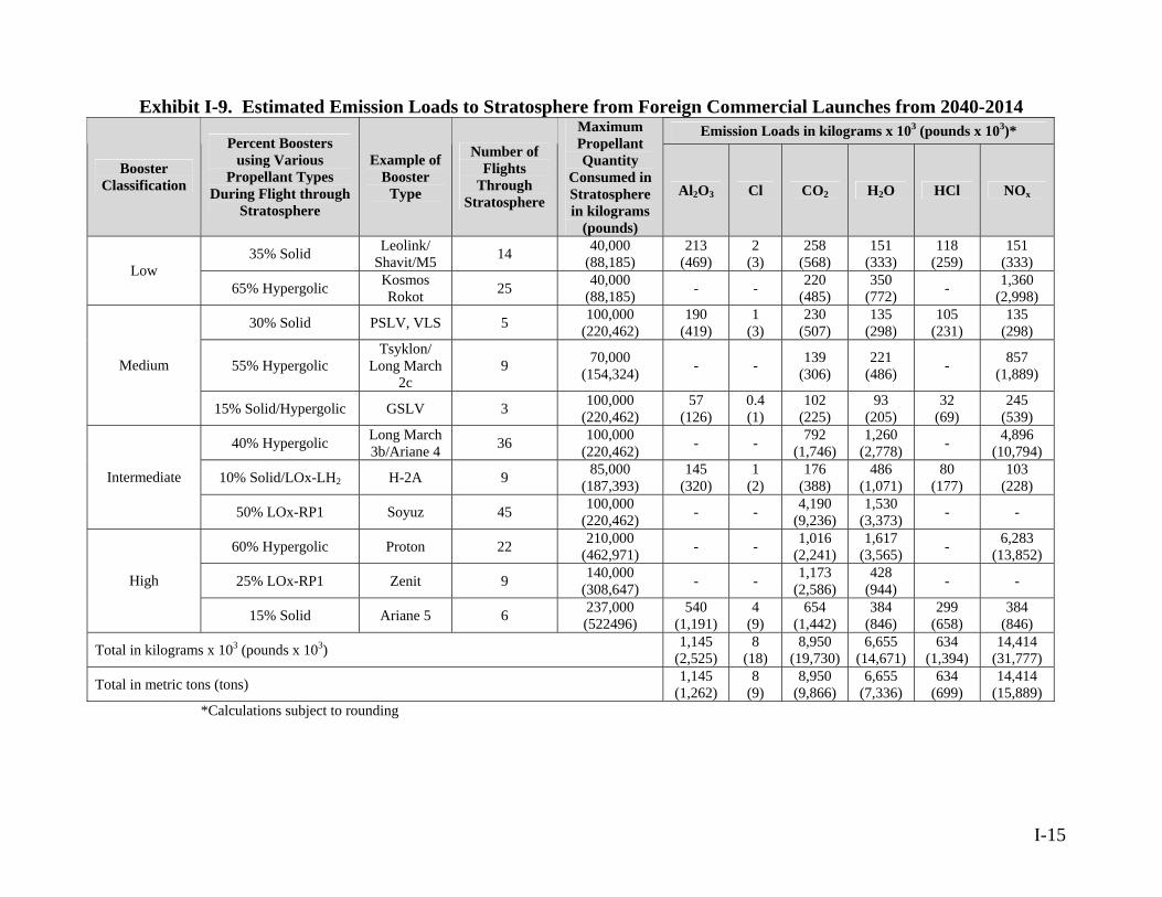
I-15
Exhibit I-9. Estimated Emission Loads to Stratosphere from Foreign Commercial Launches from 2040-2014 Emission Loads in kilograms x 103 (pounds x 103)*
Booster Classification
Percent Boosters using Various
Propellant Types During Flight through
Stratosphere
Example of Booster
Type
Number of Flights
Through Stratosphere
Maximum Propellant Quantity
Consumed in Stratosphere in kilograms
(pounds)
Al2O3 Cl CO2 H2O HCl NOx
35% Solid Leolink/ Shavit/M5 14 40,000
(88,185) 213
(469) 2
(3) 258
(568) 151
(333) 118
(259) 151
(333) Low 65% Hypergolic Kosmos
Rokot 25 40,000 (88,185) - - 220
(485) 350
(772) - 1,360 (2,998)
30% Solid PSLV, VLS 5 100,000 (220,462)
190 (419)
1 (3)
230 (507)
135 (298)
105 (231)
135 (298)
55% Hypergolic Tsyklon/
Long March 2c
9 857 70,000 (154,324) - - 139
(306) 221
(486) - (1,889) Medium
15% Solid/Hypergolic GSLV 3 100,000 (220,462)
57 126( ) (
0.4 (1)
102 225)
93 (205)
32 (69)
245 (539)
40% Hypergolic Long March 3b/Ariane 4 36 100,000
(220,462) - 792 - - (1,746) 1,260
(2,778) 4,896
(10,794)
10% Solid/LOx-LH2 H-2A 9 85,000 (187,393)
145 (320)
1 (2)
176 (388)
486 (1,071)
80 (177)
103 (228) Intermediate
50% LOx-RP1 45 ( - Soyuz 100,000 220,462) - - 4,190
(9,236) 1,530
(3,373) -
60% Hypergolic Proton 210,000 - ( 22 (462,971) - - 1,016 (2,241)
1,617 (3,565)
6,283 13,852)
25% LOx-RP1 Zenit 9 140,000 (308,647) - - 1,173
(2,586) 428
(944) - -High
15% Solid Ariane 5 6 237,000 (522496)
540 (1,191)
4 299 (9)
654 (1,442)
384 (846) (658)
384 (846)
Total in kilograms x 103 (pounds x 103) 1,145 (2,525)
8 (18)
8,950 (19,730)
6,655 (14,671)
634 (1,394)
14,414 (31,777)
Total in metric tons (tons) ) ( ( 1,145
(1,262) 8
(98,950
(9,866) 6,655
(7,336) 634 699)
14,414 15,889)
*Calculations subject to rounding
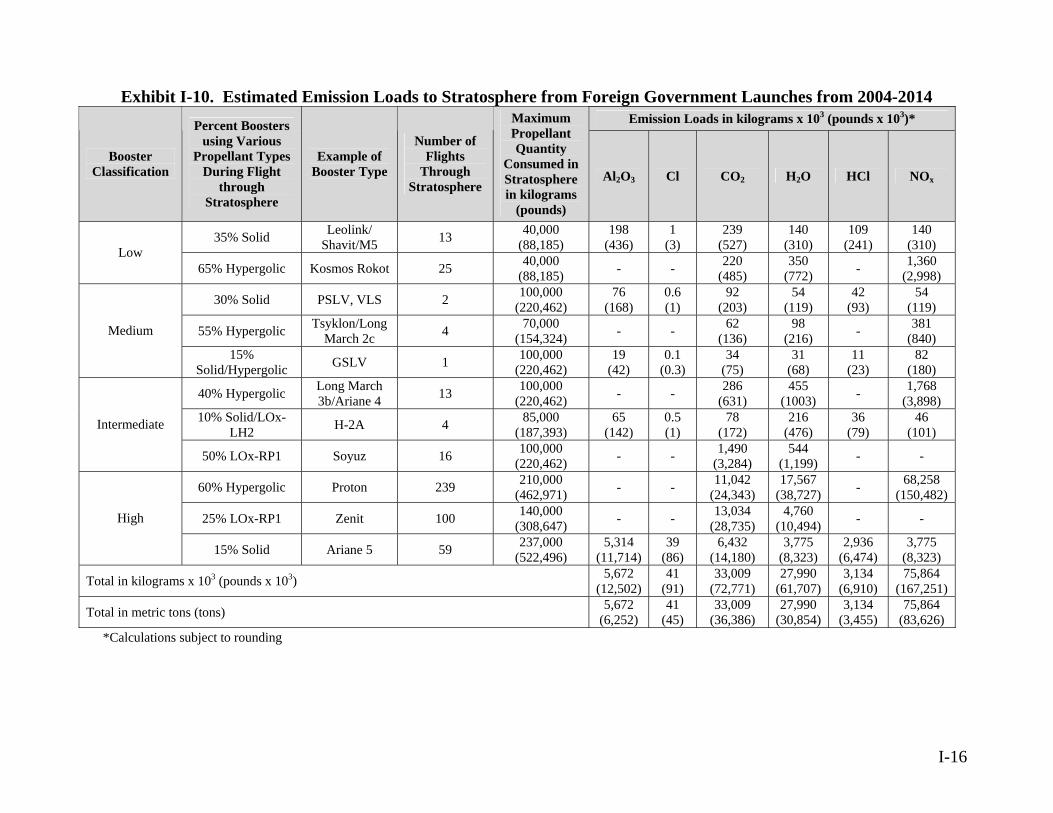
I-16
Exhibit I-10. Estimated Emission Loads to Stratosphere from Foreign Government Launches from 2004-2014 Emission Loads in kilograms x 103 (pounds x 103)*
Booster Classification
Percent Boosters using Various
Propellant Types During Flight
through Stratosphere
Example of Booster Type
Number of Flights
Through Stratosphere
Maximum Propellant Quantity
Consumed in Stratosphere in kilograms
(pounds)
Al2O3 Cl CO2 H2O HCl NOx
35% Solid 13 Leolink/ Shavit/M5
40,000 (88,185)
198 (436)
1 (3)
239 (527)
140 (310)
109 (241)
140 (310) Low
65% Hypergolic Kosmos Rokot 25 40,000 (88,185) - - 220
(485) 350
(772) - 1,360 (2,998)
30% Solid PSLV, VLS 2 100,000 (220,462)
76 (168)
0.6 (1)
92 (203)
54 (119)
42 (93)
54 (119)
55% Hypergolic 4 Tsyklon/Long March 2c
70,000 (154,324) - - 62
(136) 98
(216) - 381 (840) Medium
15% Solid/Hypergolic 1 ( ) GSLV 100,000
(220,462) 19
(42) 0.1
(0.3) 34
(75) 31
(68) 11
(23) 82 180
40% Hypergolic Long March 3b/Ariane 4 - 455 - ) 13 100,000
(220,462) - 286 (631) (1003)
1,768 (3,898
10% Solid/LOx-LH2 H-2A 65 0.5 46 4 85,000
(187,393) (142) (1) 78
(172) 216
(476) 36
(79) (101) Intermediate
- 50% LOx-RP1 Soyuz 16 100,000 (220,462) - 1,490
(3,284) 544
(1,199) - -
60% Hypergolic Proton 239 210,000 462,971)( ( - - 11,042
(24,343) 17,567 38,727) - 68,258
(150,482)
25% LOx-RP1 Zenit 100 140,000 (308,647) - - 13,034
(28,735) 4,760
(10,494) - -High
15% Solid Ariane 5 59 237,000 (522,496)
5,314 (11,714)
39 (86)
6,432 (14,180)
3,775 (8,323)
2,936 (6,474)
3,775 (8,323)
Total in kilograms x 103 (pounds x 103) 5,672 (12,502)
41 (91)
33,009 (72,771)
27,990 (61,707)
3,134 (6,910)
75,864 (167,251)
Total in metric tons (tons) 5,672 (6,252)
41 (45)
33,009 (36,386)
27,990 (30,854)
3,134 (3,455)
75,864 (83,626)
*Calculations subject to rounding

APPENDIX J
GLOSSARY
J-1

GLOSSARY
A-weighted decibels (dBA) – Unit of measurement representing the sound level which is frequency-weighted according to a prescribed frequency response established by the American National Standards Institute (1983) and accounts for the response of the human ear.
Active Sensor – A sensor that illuminates a target, producing return-secondary radiation for tracking and/or identifying the target. An example is radar. Air Quality – A resource area determined by the type and amount of pollutants emitted into the atmosphere, the size and topography of the air basin, and the prevailing meteorological conditions. Air Quality Control Region – A contiguous geographic area designated by the Federal government in which communities share a common air pollution status. Air Route Traffic Control Center (ARTCC) – A facility established to provide air traffic control services to aircraft operating on Instrument Flight Rules (IFR) flight plans within controlled airspace and principally during the en route phase of flight. When equipment capabilities and controller workload permit, certain advisory/assistance services may be provided to aircraft operating under Visual Flight Rules. Air Traffic Control – A service operated by appropriate authority to promote the safe, orderly, and expeditious flow of air traffic.
Airspace – The space lying above a nation and coming under its jurisdiction. American National Standards Institute (ANSI) – An organization which fosters the creation of consensus standards developed by representatives of industry, scientific communities, physicians, government agencies, and the public.
Aquifer – The water-bearing portion of subsurface earth material that yields or is capable of yielding useful quantities of water to wells.
Atmosphere – An environment that includes the atmosphere enveloping all areas of the Earth. It consists of four principle layers: troposphere, stratosphere, mesosphere, and ionosphere (or thermosphere).
Atmospheric Dispersion – The process of air pollutants being distributed into the atmosphere. This occurs by wind carrying pollutants away from their source and by
J-2
turbulent-air motion resulting from solar heating of the Earth's surface and air movement over rough terrain and surfaces. Attainment Area – An air quality control region that has been designated by the United States (U.S.) Environmental Protection Agency (EPA) and the appropriate state air quality agency as having ambient air quality levels as good as or better than the standards set forth by the National Ambient Air Quality Standards (NAAQS), as defined in the Clean Air Act. A single geographic area may have acceptable levels of one criteria air pollutant, but unacceptable levels of another; thus, an area can be in attainment and non-attainment status simultaneously. Background Noise – The total acoustical and electrical noise from all sources in a measurement system that may interfere with the production, transmission, time averaging, measurement, or recording of an acoustical signal.
Ballistic Missile – Any missile that does not rely upon aerodynamic surfaces to produce lift and consequently follows a ballistic trajectory when thrust is terminated.
Ballistic Missile Defense System (BMDS) – An integrated system that employs layered defenses to intercept missiles during their boost, midcourse, and terminal flight phases.
Biological Resources – A collective term for native or naturalized vegetation, wildlife, and the habitats in which they occur.
Biome – A major type of natural vegetation that occurs wherever a particular set of climatic and soil conditions prevail, but that may contain different taxa in different regions.
Blocks – A biennial increment of the BMDS that provides an integrated set of capabilities, which has been rigorously tested as part of the BMDS Test-bed and assessed to adequately characterize its military utility. Once tested, elements and components are available for limited procurement, transition to production, or for emergency deployment as directed. These “off ramps” may occur at any time during the Block Cycle to support timely execution of these transition or deployment decisions.
The configuration for each Block is drawn from the following sources: The prior BMDS Block; BMDS elements, components, technologies, and concepts; BMDS Battle Management, Command, Control, and Communications (BMC2/C)
specifications and products; Externally managed systems, elements, or technologies (e.g., Defense Support
Program [DSP], Global Command and Control System, MILSTAR, etc).
J-3

Each successive Block provides increasing levels of capability to counter ballistic missiles of all ranges and complexity. Boost Phase – The first phase of a ballistic missile trajectory during which it is being powered by its engines. During this phase, which usually lasts 3 to 5 minutes for an intercontinental ballistic missile, the missile reaches an altitude of about 200 kilometers (124 miles) whereupon powered flight ends and the missile begins to dispense its reentry vehicles. Booster – An auxiliary or initial propulsion system that travels with a missile or aircraft and that may not separate from the parent craft when its impulse has been delivered; may consist of one or more units.
Broad Ocean Area (BOA) – An environment that includes the Pacific, Atlantic, and Indian Oceans, and is the area outside of the Exclusive Economic Zone, which extends 322 kilometers (200 miles) off shore.
Chemical Oxygen Iodine Laser (COIL) – A laser in which chemical action is used to produce the laser energy.
Chlorofluorocarbons (CFCs) – A group of inert, nontoxic, and easily liquefied chemicals (such as Freon) used in refrigeration, air conditioning, packaging, or insulation or as solvents or aerosol propellants.
Carbon Monoxide (CO) – A colorless, odorless, poisonous gas produced by incomplete fossil-fuel combustion; one of the six pollutants for which there is a NAAQS (see Criteria Pollutant).
Coastal Zone – Lands and waters adjacent to the coast that exert an influence on the uses of the sea and its ecology, or, adversely, whose uses and ecology are affected by the sea. Command and Control, Battle Management, and Communications (C2BMC) – The overall integrator of the BMDS, would consist of electronic equipment and software that enable military commanders to receive and process information, make decisions, and communicate those decisions regarding the engagement of threat missiles. Community Noise Equivalent Level – Describes the average sound level during a 24-hour day in dBA. Component – Subsystem, assembly, or subassembly of logically grouped hardware and software, that performs interacting tasks to provide BMDS capability at a functional level.
J-4

Controlled Airspace – Airspace of defined dimensions within which air traffic control service is provided to IFR flights and to Visual Flight Rules flints in accordance with the airspace classification. Controlled airspace is divided into five classes, dependent upon location, use, and degree of control: Class A, B, C, D, and E. Controlled Firing Area – Airspace wherein activities are conducted under conditions so controlled as to eliminate hazards to non-participating aircraft and to ensure the safety or person and property on the ground. Cooperating Agency – Any Federal agency, other than a lead agency, that has jurisdiction by law or special expertise with respect to any environmental impact involved in a proposal (or reasonable alternative) for legislation or other major Federal action significantly affecting the quality of the human environment. Council on Environmental Quality (CEQ) – Established by the National Environmental Policy Act (NEPA), the CEQ consists of three members appointed by the President. A CEQ regulation (Title 40 Code of Federal Regulations (CFR) 1500-1508, as of July 1, 1986) describes the process for implementing NEPA, including preparation of environmental assessments and environmental impact statements, and the timing and extent of public participation. Countermeasures – Tactical or technical actions taken to alter ballistic missile characteristics to hinder or prevent ballistic missile defense systems from identifying or hitting the incoming missiles.
Criteria Pollutants – Pollutants identified by the U.S. EPA (required by the Clean Air Act to set air quality standards for common and widespread pollutants) and established under state ambient air quality standards. There are standards in effect for seven criteria pollutants: carbon monoxide, lead, ozone, nitrogen dioxide (NO2), particulate matter with a diameter of less than ten microns (PM10), particulate matter with a diameter of less than 2.5 microns (PM2.5), and sulfur dioxide (SO2). Critical Habitat – Specific areas within a geographical area occupied by threatened or endangered species at the time they are listed which contain the physical or biological features essential to conservation of the species and may require special management considerations or protection. Cultural Resources – The prehistoric and historic artifacts, archaeological sites (including underwater sites), historic buildings and structures, and traditional resources (such as Native American and Native Hawaiian religious sites). Cumulative Impact – The impact on the environment which results from the incremental impact of the action when added to the other past, present, and reasonably
J-5
foreseeable future actions regardless of what agency (Federal or non-Federal) or person undertakes such other actions. Cumulative impacts can result from individually minor but collectively significant actions taking place over a period of time. Day/Night Average Sound Level (Ldn) – The average sound level during a 24-hour day, reported in A-weighted decibels (dBA) and used to predict human annoyance and community reaction to unwanted sound. Decibel (dB) – A unit of measurement on a logarithmic scale which describes the magnitude of a particular quantity of sound pressure or power with respect to a standard reference value; the accepted standard unit for the measurement of sound. Decommissioning – The removal or the rendering useless of obsolete or no longer needed components of the BMDS from service. Demilitarization – The act of destroying a system’s offensive and defensive capabilities to prevent the equipment from being used for its intended military purpose. Deployment – Fielding a weapon system by delivering the completed production system to operational use with units in the field/fleet and placing it on alert. Development – The various activities that would support research and development of the BMDS components and the overall system. Activities include planning, budgeting, research and development, systems engineering, maintenance and sustainment, manufacture of test articles (prototypes) and initial testing, and tabletop exercises. Directed Blast Fragmentation – Weapon technology that involves the interceptor approaching the threat ballistic missile and exploding close to it, thereby disrupting the path of the threat missile and possibly destroying it. Disposal – The process of redistributing, transferring, donating, selling, abandoning, destroying or any other disposition of a property. Ecosystem – The set of biotic (living) and abiotic (nonliving) components in a given environment. Effluent – An outflowing branch of a main stream or lake; waste material (such as smoke, liquid industrial refuse, or sewage) discharged into the environment. Electroexplosive Device – A single unit, device, or subassembly, in which electrical energy is used to initiate an enclosed explosive, propellant, or pyrotechnic material. Electromagnetic Radiation (EMR) – Waves of energy with both electric and magnetic components at right angles to one another.
J-6
Element – A complete, integrated set of components capable of autonomously providing BMDS capability. Endangered Species – A plant or animal species that is threatened with extinction throughout all or a significant portion of its range. Engagement Sequence – A unique combination of detect-control-engage functions performed by BMDS components (such as sensors, weapon and C2BMC equipment) used to engage a threat ballistic missile. The command and control, battle management, and fire control functions enable the engagement sequence functions. Engagement Sequence Group (ESG) – The logical categorization of engagement sequences based upon common capabilities or characteristics (e.g., effectiveness or functionality). Creating ESGs requires identification of the components (e.g., sensors, weapons and C2BMC equipment) that perform overlapping or similar functions in the execution of an engagement. Environmental Justice – The fair treatment and meaningful involvement of all people regardless of race, color, national origin, or income with respect to the development, implementation, and enforcement of environmental laws, regulations, and policies. Executive Order 12898 requires identification of potential disproportionately high and adverse impacts on low-income and/or minority populations that may result from proposed Federal Actions. Equivalent Noise Level – Energy mean A-weighted sound level during a stated measurement period. Erosion – The wearing away of a land surface by water, wind, ice, or other geologic agents. Essential Fish Habitat – Those waters and substrate (sediment, hard bottom) necessary to fish for spawning, breeding, feeding or growth to maturity.
Estuary – A water passage where the tide meets a river current; an arm of the sea at the lower end of a river; characterized by brackish water.
Exclusive Economic Zone – An offshore boundary, set at 200 nautical miles (320 km), establishing a nation’s economic sovereignty over the resources present within that perimeter. Explosive Safety Quantity-Distance (ESQD) – The quantity of explosive material and distance separation relationships providing defined types of protection based on levels of risk considered acceptable.
J-7
Fielding – Activities which include acquiring and transferring BMDS components to military services.
Flight Level (FL) – A level of constant atmospheric pressure related to a reference datum of 76 centimeters (29.92 inches) of mercury stated in three digits that represent hundreds of feet. For example, FL 250 represents a barometric altimeter indication of 7,620 meters (25,000 feet); FL 255 represents an indication of 7,772 meters (25,500 feet).
Flight Termination System (FTS) – All components, onboard a launch vehicle, which provide the ability to end a launch vehicles flight in a controlled manner. A flight termination system consists of all command destruct systems, inadvertent separation destruct systems, or other systems or components that are onboard a launch vehicle and used to terminate flight. Floodplain – Areas of low-level ground present along a river or stream channel. Such lands may be subject to periodic or infrequent inundation due to rain or melting snow. Fugitive Dust – Any solid particulate matter (PM) that becomes airborne, other than that emitted from an exhaust stack, directly or indirectly as a result of the activities of man. Fugitive dust may include emission from haul roads, wind erosion of exposed soil surfaces, and other activities in which soil is either removed or redistributed. Functional Capabilities – The functional capabilities of the proposed BMDS are to detect, identify, track, discriminate, intercept, and destroy a threat ballistic missile during a specific phase of flight. They also include the long-term flexibility of the BMDS to evolve to meet future threats whether they are technological or geographic in nature.
Geologic Hazards – Geologic phenomena such as landslides, flooding, ground subsidence, volcanic activity, faulting, earthquakes, and tsunamis (tidal waves).
Geology – The study of the composition and configuration of the Earth’s surface and subsurface features.
Geosynchronous Earth Orbit (GEO) – An orbit 35,890 kilometers (22,300 miles) in altitude that is synchronized with Earth’s rotation.
Global Positioning System – A space-based radio positioning, navigation, and time-transfer system. The system provides highly accurate position and velocity information, and precise time, on a continuous global basis to unlimited number of properly equipped users. The system is unaffected by weather, and provides a worldwide common grid reference system.
J-8

Greenhouse Gases – Atmospheric gases (principally carbon dioxide (CO2), water vapor, nitrous oxide, chlorofluorocarbons, and methane) that absorb infrared radiation and contribute to the “greenhouse effect.”
Ground water – Water within the earth that supplies wells and springs; specifically, water in the zone of saturation where all openings in rocks and soil are filled, the upper surface of which forms the water table.
Habitat – The area or type of environment in which a species of ecological community normally occurs Hazardous Air Pollutants (HAPs) – A group of 188 chemicals identified in the 1990 Clean Air Act Amendments. Exposure to these pollutants can cause or contribute to cancer, birth defects, genetic damage, and other adverse health effects.
Hazardous Material – A substance that can cause, because of its physical or chemical properties, an unreasonable risk to the health and safety of individuals, property, or the environment.
Hazardous Waste – A waste, or combination of wastes, which, because of its quantity, concentration, or physical, chemical, or infectious characteristics, may either cause or significantly contribute to an increase in mortality or an increase in serious irreversible illness or pose a substantial present or potential hazard to human health or the environmental when improperly treated, stored, transported, disposed of, or otherwise managed.
Health and Safety – Includes consideration of any activities, occurrences or operations that have the potential to affect the well being, safety, or health of workers or members of the general public.
Hertz – A unit of frequency equal to one cycle per second.
Historic Properties – Under the National Historic Preservation Act, these are properties of national, state, or local significance in American history, architecture, archaeology, engineering, or culture, and worthy of preservation.
Hit-to-Kill Technology – Using only the force of the direct collision to destroy the target.
Hypergolic – The self-ignition of a fuel and an oxidizer upon mixing with each other without a spark or other external energy.
J-9
Immediately Dangerous to Life and Health (IDLH) – An atmospheric concentration of any toxic, corrosive or asphyxiant substance that poses an immediate threat to life or would cause irreversible or delayed adverse health effects or would interfere with an individual's ability to escape from a dangerous atmosphere. Impacts (Effects) – An assessment of the meaning of changes in all attributes being studied for a given resource; an aggregation of all the adverse effects, usually measured using a qualitative and nominally subjective technique. Infrared – A range of electromagnetic-radiation wavelengths longer than visible light and shorter than microwave wavelengths. Infrared Sensors – A sensor designed to detect the electromagnetic radiation in the wavelength region of 1 to 40 microns. Infrastructure – The system of public works of a country, state, or region, such as utilities or communication systems; resource area analyzed in NEPA documents. Initial Defensive Capability (IDC) – The sensors, C2BMC, and weapons from the Block 04 Toolbox that are available for limited, militarily useful capability by September 2004. This initial defense capability will include early warning and tracking sensors based on land, at sea, and in space, command and control, and ground-based interceptors for midcourse and terminal intercepts. Initial Defensive Operations (IDO) – The acceptance of the IDC by the combatant commander based on military utility. To declare IDO the combatant commander determines through military judgment that adequate doctrine, organization, training, materiel, leadership, personnel, and facilities exist to operate the system. Institute of Electrical and Electronics Engineers (IEEE) – A non-profit, technical professional association of engineers with expertise in computer engineering, biomedical technology, telecommunications, electric power, aerospace and consumer electronics, which creates consensus-based standards. Instrument Flight Rules (IFR) – Rules governing the procedures for conducting instrument flight; also a term used by pilots and controllers to indicate type of flight plan. Integrated Ground Test (GT) – A test that uses tactical BMDS Element hardware and software in conjunction with modeling and simulation assets to simulate and stimulate Elements. Integrated Ground Tests are used to collect data for risk reduction and for scenario exploration where flight-testing is either impractical or impossible. This data provides a stronger understanding of each component and how it reacts in different situations and enables each component to be tested with other components.
J-10

Integrated Missile Defense Wargames – Simulations of military operations involving two or more opposing forces, using rules, data, and procedures designed to depict an actual or assumed real-life situation. They are designed to gain insight into how human decision-making affects the use of BMDS components. Ionizing Radiation – Particles or photons that have sufficient energy to produce direct ionization in their passage through a substance. X-rays, gamma rays, and cosmic rays are forms of ionizing radiation. Ionosphere – The part of the earth’s upper atmosphere which is sufficiently ionized by solar ultraviolet radiation so that the concentration of free electrons affects the propagation of radio waves. Its base is at about 70 or 80 kilometers (43 to 50 miles) and it extends to an indefinite height. Jet Route – A route designed to serve aircraft operating from 5,486 meters (18,000 feet) up to and including FL 450, referred to as J routes with numbering to identify the designated route. Kill Vehicle (KV) – The portion of the interceptor that performs the intercept and destroys the threat missile. Kinetic Energy – The energy from the momentum of an object, i.e., an object in motion. Land Use – The human use of land resources for various purposes, including economic production, natural resources protection, or institutional uses. Laser – An active-electron device that converts input power into a very narrow, intense beam of coherent visible or infrared light. The input power excites the atoms of an optical resonator to a higher-energy level, and the resonator forces the excited atoms to radiate in phase. Derived from Light Amplification by Stimulated Emission of Radiation and classified from Class I to Class IV according to its potential for causing damage to the eye. Laser Sensor – A sensor that uses laser energy of various energy levels and frequencies to illuminate an object to detect the object’s motion. Lead (Pb) – A heavy metal which can accumulate in the body and cause a variety of negative effects; one of the six pollutants for which there is a NAAQS (see Criteria Pollutants). Lethality – A measure of the ability of the BMDS to prevent a threat ballistic missile from producing lethal effects.
J-11
Lethality Enhancers – Non-nuclear explosive devices that increase the probability of destroying the threat missile and its payload (e.g., explosives, chemical or biological agents). Material Safety Data Sheet – Presents information, required under the Occupation Safety and Health Act Standards, on a chemical’s physical properties, health effects, and use precautions. Maximum Permissible Exposure (MPE) – Established by the Nuclear Regulatory Commission, an exposure standard set at a level where apparent injury from ionizing radiation during a normal lifetime is unlikely. Mean Sea Level (MSL) – The average height of the sea surface if undisturbed by waves, tides, or winds. Mesosphere – The atmospheric shell between about 45to 55 kilometers (28 to 34 miles) and 80 to 85 kilometers (50 to 53 miles), extending from the top of the stratosphere to the mesopause; characterized by a temperature that generally decreases with altitude. Midcourse Phase – That portion of a ballistic missile's trajectory between the boost phase and the reentry phase when reentry vehicles and penaids travel at ballistic trajectories above the atmosphere. During this phase, a missile releases its warheads and decoys and is no longer a single object, but rather a swarm of reentry vehicles and penaids falling freely along present trajectories in space. Military Operating Area (MOA) – An airspace assignment of defined vertical and lateral dimensions established outside Class A areas to separate certain military activities from IFR traffic and to identify for Visual flight Rules traffic where these activities are conducted. Military Training Routes – Airspace of defined vertical and lateral dimensions established for the conduct of military flight training at airspeeds in excess of 250 knots. Missile – A projectile weapon that is fired or otherwise propelled toward a target. Missile Defense Integration Exercises (MDIE) – Test activities that support the characterization of the degree of integration and interoperability among the BMDS block elements to operate as a single system Mitigation – A method or action to reduce or eliminate adverse environmental impacts. Mixing Height – Altitude at which pollutants and atmospheric gases are thoroughly combined.
J-12
J-13
National Ambient Air Quality Standards (NAAQS) – Set by the U.S. EPA under Section 109 of the Clean Air Act, nationwide standards for limiting concentrations of certain widespread airborne pollutants to protect public health with an adequate margin of safety (primary standards) and to protect public welfare, including plant and animal life, visibility and materials (secondary standards). Currently, seven pollutants are regulated: carbon monoxide, lead, NO2, ozone, particulate matter with a diameter of less than ten microns, particulate matter with a diameter of less than 2.5 microns, and SO2 (see Criteria Pollutants).
Nitrogen Dioxide (NO2) – Gas formed primarily from atmospheric nitrogen (N2) and oxygen when combustion takes place at high temperatures; one of the six pollutants for which there is a NAAQS (see Criteria Pollutant). Nitrogen Oxides (NOx) – Gases formed primarily by fuel combustion.
Mobile Sources – Any movable source that emits any regulated air pollutant. National Airspace System (NAS) – The common network of U.S. airspace; air navigation facilities, equipment and services, airports or landing areas; aeronautical charts, information and services; rules, regulations and procedures, technical information, and manpower and material. Included are system components shared jointly with the military.
National Environmental Policy Act (NEPA) – Public law 91-190, passed by Congress in 1969. The Act established a national policy designed to encourage consideration of the influences of human activities, such as population growth, high-density urbanization, or industrial development, on the natural environment. NEPA procedures require that environmental information be made available to the public before decisions are made. Information contained in NEPA documents must focus on the relevant issues to facilitate the decision-making process.
National Register of Historic Places – A register of districts, sites, buildings, structures, and objects important in American history, architecture, archaeology, and culture, maintained by the Secretary of the Interior under authority of Section 2 (b) of the Historic Site Act of 1935 and Section 101 (1) of the National Historic Preservation Act of 1966, as amended.
Noise – Unwanted or annoying sound typically associated with human activity; resource area analyzed in NEPA documents.
Non-attainment Area – An area that has been designated by the U.S. EPA or the appropriate state air quality agency as exceeding one or more of the national or state ambient air quality standards.
Non-ionizing Radiation – Electromagnetic radiation at wavelengths whose corresponding photon energy is not high enough to ionize an absorbing molecule. All radio frequency, infrared, visible, and near ultraviolet radiation are non-ionizing.
Nonpoint Source – Type of pollution originating from a combination of sources.
Notice to Airmen (NOTAM) – A notice containing information, not known sufficiently in advance to publicize by other means, the establishment, condition, or change in any component (facility, service, or procedure of, or hazard in the National Airspace System) the timely knowledge of which is essential to personnel concerned with flight operations.
Notice to Mariners (NOTMAR) – A notice containing information, not known sufficiently in advance to publicize by other means, the establishment, condition, or change in any component (facility, service, or procedure of, or hazard in the broad ocean area) the timely knowledge of which is essential to personnel concerned with sea-based activities.
Orbital Debris – Material that is on orbit as the result of space initiatives, but is no longer serving any function.
Ozone – A compound consisting of three oxygen atoms; one of the six pollutants for which there is a national ambient air quality standard (see Criteria Pollutant).
Ozone-Depleting Substances – A group of chemicals that are inert under most conditions but within the stratosphere react catalytically to reduce ozone to oxygen.
Passive Sensor – A sensor that detects naturally occurring emissions from a target for tracking and/or identification purposes.
Permafrost – Permanently frozen subsoil, for a minimum of 2 years, occurring in perennially frigid areas.
Permissible Exposure Limit (PEL) – Exposure level expressed in electric field, magnetic field, or plane wave power density to which an individual may be exposed and which, under conditions of exposure, will not cause detectable bodily injury in light of present medical knowledge.
Platform – Location from which a missile, target, or other test object is launched.
Particulate Matter (PM) – Particles small enough to be airborne, such as dust or smoke (see Criteria Pollutants); one of the six pollutants for which there is a NAAQS (see Criteria Pollutant).
J-14

PM10 – Particulate matter less than or equal to 10 micrometers in diameter. PM2.5 – Particulate matter less than or equal to 2.5 micrometers in diameter.
Point Source – A distinct and identifiable source, such as a sewer or industrial outfall pipe, from which a pollutant is discharged.
Population Density – The average number of individuals per unit of space.
Programmatic Environmental Impact Statement (PEIS) – A document prepared in accordance with NEPA for the adoption of programs, such as a group of concerted actions to implement a specific policy or plan; systematic and connected agency decisions allocating agency resources to implement a specific statutory program or executive directive (40 CFR 1508.18). As defined in 40 CFR 1508.28, such documents assist in tiering, which refers to the coverage of general matters in broader environmental impact statements (such as national program or policy statements) with subsequent narrower statements or environmental analyses (such as regional or basin-wide program statements or ultimately site-specific statements) incorporating by reference the general discussions and concentrating solely on the issues specific to the statement subsequently prepared.
Propellants – Balanced mixtures of fuel and oxidizer designed to produce large volume of hot gases at controlled, predetermined rates, once the burning reaction is initiated.
Radar – A radio device or system for locating an object by means of radio waves reflected from the object and received, observed, and analyzed by the receiving part of the device in such a way that characteristics (such as distance and direction) of the object may be determined.
Region of Influence – The geographical region that would be expected to be affected in some way by the Proposed Action and alternatives.
Restricted Area – Airspace designated under FAA Regulation part 73, within which the flight of aircraft, while not wholly prohibited, is subject to restriction. Most restricted areas are designated joint use, and IFR/Visual Flight Rules operations in the area ay be authorized by the controlling air traffic control facility when it is not being utilized by the using agency. Restricted areas are depicted on en route charts.
Scoping – A process initiated early during preparation of an environmental impact statement to identify the scope of issues to be addressed, including the significant issues
Pounds per Square Foot – Measure of pressure, used to measure sonic booms.
J-15
J-16
related to the Proposed Action. During scoping, input is solicited from affected agencies as well as the interested public. (40 CFR 1501.7)
Sensitive Habitat – Habitat that is susceptible to damage from intrusive actions.
Short Term Exposure Limit (STEL) – The level of exposure that must not be exceeded at any time during a workday when the exposure is averaged over 15 minutes.
Sonic Boom – Sound, resembling an explosion, produced when a shock wave formed at the nose of an aircraft or launch vehicle traveling at supersonic speed reaches the ground.
Spiral Development – An iterative process for developing a defined set of capabilities within one increment. This process provides the opportunity for interaction between the user, tester, and developer. In this process, the requirements are refined through experimentation and risk management, there is continuous feedback, and the user is provided the best possible capability within the increment. Each increment may include a number of spirals. Spiral development implements evolutionary acquisition.
State Historic Preservation Officer – The official within each state, authorized by the state at the request of the Secretary of the Interior, to act as liaison for purposes of implementing the National Historic Preservation Act.
Stationary Source – Any building, structure, facility, installation, or other fixed source that emits any regulated air pollutant.
Socioeconomics – The basic attributes and resources associated with the human environment, in particular population and economic activity. Soils – The unconsolidated materials overlying bedrock or other parent materials. Soils are typically described in terms of their composition, slope, and physical characteristics. Solid Rocket Motor Propellant – A fuel/oxidizer mix that continually combusts when ignited. Solid Waste – Municipal waste products and construction and demolition materials; includes non-recyclable materials with the exception of yard waste. Solvent – A substance that dissolves or is capable of dissolving a substance.
Special Use Airspace – Airspace of defined dimensions identified by an area on the surface of the earth wherein activities must be confined because of their nature and/or wherein limitations may be imposed upon non-participating aircraft.
J-17
Sulfur Dioxide (SO2) – A toxic gas that is produced when fossil fuels, such as coal and oil, are burned; one of the six pollutants for which there is a NAAQS (see Criteria Pollutant).
Support Assets – Auxiliary equipment and infrastructure that facilitate BMDS operations.
Sustainment – Includes various maintenance and operating activities as they pertain to deploying the BMDS.
System Integration Flight Tests (SIFTs) – Tests designed to measure BMDS component interoperability and assess BMDS functional capabilities in each developmental Block.
System Integration Tests– Tests designed to assess the ability of the BMDS components to work as a unit and to meet the required functional capabilities.
Targets – Launch systems, payloads including countermeasures and re-entry vehicles, and extensive instrumentation and avionics designed to test the performance of missile defense sensors and weapons.
Telemetry – Automatic data measurement and transmission from remote sources, such as space vehicles, to receiving station for recording and analysis.
Terminal Phase – That final portion of a ballistic missile's trajectory between the midcourse phase and trajectory termination.
Test Assets – Assets used for testing that are not components of the BMDS but are critical to its effective development and testing; these include test range facilities, sensors used only for test purposes, targets, countermeasure devices and warhead simulants.
Stratosphere – The atmospheric shell above the troposphere and below the mesosphere; it extends from the tropopause to about 55 kilometers (34 miles), where the temperature begins again to increase with altitude.
Surface Water – Water resource that consists of lakes, rivers and streams.
Test Bed – The collection of integrated ballistic missile defense element development hardware, software, prototypes, and surrogates, as well as supporting test infrastructure (e.g., instrumentation, safety/telemetry systems, and launch facilities) configured to support realistic development and testing of the BMDS.

J-18
Troposphere – The portion of the atmosphere from the earth’s surface to the tropopause, that is, the lowest 10 to 20 kilometers (6 to 12 miles) of the atmosphere. It is the turbulent and weather region containing 75% of the total mass of the Earth’s atmosphere. It is characterized by decreasing temperature with increasing altitude. The manor components of the troposphere are N2 (76.9%) and oxygen (20.7%).
Test – Any program or procedure which is designed to obtain, verify, or provide data for the evaluation of any of the following: 1) progress in accomplishing developmental objectives, 2) the performance, operational capability and suitability of systems, subsystems, components, and equipment items, and 3) the vulnerability and lethality of systems, subsystems, components, and equipment items. Theater – The geographical area outside the continental United States for which a commander of a unified or specified command has been assigned. Theater Ballistic Missile – A ballistic missile whose target is within a theater or which is capable of attacking targets in a theater. Theater Missile Defense (TMD) – The strategies and tactics employed to defend a geographical area outside the United States against attack from short-range, intermediate-range, or medium-range ballistic missiles. Threatened Species – A plant or animal species likely to become endangered in the foreseeable future. Threshold Limit Value (TLV) – The upper values of a toxicant concentration to which an average healthy person may be repeatedly exposed to day after day without suffering adverse effects. Topography – The configuration of a surface including its relief and the position of its natural and man-made features. Trajectory – The curve described by an object moving through space Transportation – Resource area analyzed in NEPA documents that encompasses ground, aviation, and ocean transport systems.
Uncontrolled Airspace – Uncontrolled airspace, or Class G airspace, has no specific definition but generally refers to airspace not otherwise designated and operations below 365.7 meters (1,200 feet) above ground level. No air traffic control service to either IFR or Visual Flight Rules aircraft is provided other than possible traffic advisories when the air traffic control workload permits and radio communications can be established.
J-19
Volatile Organic Compound (VOC) – One of a group of chemicals that react in the atmosphere with NOx in the presence of heat and sunlight.
Utilities – Refers to those facilities and systems that provide power, water, wastewater treatment, and the collection and disposal of solid waste. Visible Technology Sensors – Generally passive sensors that detect objects of missiles by collecting light energy or radiation emitted from the target in wavelengths visible to the human eye. Visual Flight Rules (VFR) – Rules that govern the procedures for conducting flight under visual conditions. Pilots and controllers also use them to indicate type of flight plan. Visual Resources – The natural and man-made features that constitute the aesthetic qualities of an area.
Wastewater – Water that has been previously utilized; sewage. Water Resources – Resource area analyzed in NEPA documents, which includes surface water, ground water, and floodplains. Wetlands – Those areas that are inundated or saturated by surface or groundwater at a frequency and duration sufficient to support, and that under normal circumstances do support, a prevalence of vegetation typically adapted for life in saturated soil conditions. This classification includes swamps, marshes, bogs, and similar areas.
INDEX VOLUME 2
Advanced Systems....................................................................................................F-1, F-2 Advisory Council on Historic Preservation (ACHP) ......................................................A-2 Air Quality .............................. B-13, B-23, G-5, G-6, G-7, H-1, H-2, H-17, H-18, H-19,
H-31, H-33, H-34, H-54, H-55, H-56, H-69, H-78, H-79, H-85, H-88, H-89, H-90, H-104, H-105, H-112, H-113, H-121, H-124, H-125, H-138, J-3, J-5,
J-13, J-14, J-15 Airborne Laser (ABL) ......................................................................................E-2, E-3, F-8 Airspace ........... B-13, D-7, D-46, G-9, G-9, G-10, H-3, H-4, H-13, H-19H-20, H-36,
H-37, H-38, H-58, H-59, H-70, H-71, H-79, H-80, H-91, H-92, H-106, H-113, H-114, H-125, H-126, H-142, J-2, J-5, J-13, J-14, J-16, J-17, J-19
Arrow System Improvement Program (ASIP) ..............................................................D-46 Arrow Weapon System (AWS) .....................................................................................D-45 Atmosphere ............................. B-16, B-17, B-19, D-15, D-20, D-45, F-9, G-9, H-1, H-3,
H-17, H-34, H-48, H-55, H-69, H-79, H-89, H-100, H-105, H-115, H-122, H-125, H-127, H-135, H-137, H-138, H-139, H-141, H-142, H-143, H-144,
I-3, I-4, I-13, J-2, J-3, J-10, J-11, J-12, J-19, J-20 Biological Resources ........... B-13, B-16, B-17, B-20, B-21, B-22, B-23, G-10, H-5, H-21,
H-38, H-60, H-71, H-80, H-93, H-106, H-114, H-127, H-142, J-3 Biome H-16, H-17, H-18, H-19, H-21, H-22, H-23, H-24, H-25, H-26, H-27, H-28,
H-29, H-30, H-31, H-32, H-35, H-36, H-38, H-39, H-40, H-41, H-42, H-44, H-45, H-46, H-47, H-49, H-50, H-53, H-54, H-57, H-58, H-59, H-60, H-61, H-62, H-63, H-64, H-65, H-66, H-67, H-68, H-69, H-70, H-71, H-72, H-73, H-74, H-75, H-77, H-78, H-79, H-80, H-81, H-82, H-83, H-84, H-85, H-86,
H-87, H-88, H-89, H-90, H-91, H-93, H-94, H-97, H-98, H-99, H-101, H-102, H-104, H-105, H-106, H-107, H-108, H-109, H-110, H-111, H-112,
H-113, H-114, H-115, H-116, H-117, H-118, H-119, H-134, J-3 Blocks ............................D-4, D-8, D-18, D-34, D-40, H-16, H-59, H-70, H-96, J-3 Boost phase .......................... D-2, D-3, D-4, D-12, E-5, E-12, F-4, F-, F-7, F-8, J-4, J-12 Booster ................................ B-15, B-18, D-2, D-12, D-20, D-21, D-29, D-37, D-38,
D-41, D-43, D-45, E-7, E-12, F-4, I-3, I-4, I-5, I-6, I-7, I-8, I-9, I-10, I-11, I-12, I-13 I-14, I-15, I-16, I-17, J-4
Broad Ocean Area (BOA) ........................................................................................H-1, J-4 Chemical Oxygen Iodine Laser (COIL) ...................................................................D-2, J-4 Clean Air Act......................................G-5, G-7, G-8, G-9, H-90, H-140, J-3, J-5, J-9, J-13
Index V2-1

Clean Water Act ...................................................... G-16, G-19, G-23, H-49, H-68, H-132 Coastal Zone Management Act .....................................................................................G-20 Command and Control, Battle Management, and Communications (C2BMC) .............. J-4 Component .................................................................................................................... J-5 Comprehensive Environmental Response, Compensation, and Liability Act
(CERCLA)...............................................................................................G-16 Council on Environmental Quality (CEQ)...............................................A-2, B-2, G-3, J-5 Critical Habitat ................................. A-2, G-10, G-12, H-24, H-61, H-71, H-82, H-97, J-5 Cultural Resources..................................................................................................G-14, J-6 Decommissioning..................................... B-12, B-13, B-17, B-21, B-23, D-8, D-14, D-19
D-28, D-35, D-43, D-47, D-52, J-6 Department of Transportation .....................................................................................H-100 Department of Transportation (DOT) ................................................D-21, G-17, H-99, I-3 Deployment .....................................B-13, B-18, B-22, C-3, D-5, D-8, D-14, D-19, D-23,
D-27, D-28, D-35, D-37, D-38, D-40, D-43, D-47, D-52, E-2, F-4, G-2, H-74, H-109, J-3, J-6
Development ...............................B-2, B-12, B-15, B-17, C-2, D-4, D-5, D-9, D-10, D-11, D-13, D-15, D-16, D-17, D-18, D-19, D-24, D-27, D-28, D-32, D-35, D-36, D-39, D-40, D-42, D-43, D-46, D-50, D-51, D-52, E-2, E-6, E-8, E-9, E-10,
E-11, E-12, E-13, F-2, F-3, F-4, F-5, F-8, F-9, G-2, G-12, G-14, G-16, G-17, G-21, H-9, H-13, H-51, H-53, H-57, H-58, H-67, H-75, H-79, H-83,
H-91, H-106, H-113, I-12, J-6, J-7, J-13, J-17, J-18
Early Warning Radar (EWR) .......................................................................................... E-2
Exclusive Economic Zone......................................G-17, H-23, H-54, H-63, H-88, J-4, J-8
Explosive Safety Quantity Distance (ESQD)................................................................D-21
Fielding ..........................................................D-19, D-32, D-35, D-43, D-51, J-6, J-8
Directed Blast Fragmentation........................................................................................... J-6
Engagement Sequence Group (ESG) ............................................................................... J-7 Environmental Justice...................................................................................B-13, G-15, J-7 Environmental Protection Agency (EPA) ......................................................G-5, H-30, J-3
Exoatmospheric Kill Vehicle (EKV).............................................................................D-11
Federal Aviation Administration (FAA) ........................................................ D-7, G-9, H-4
Flight Termination System (FTS) ..........................................................................D-38, J-8
Index V2-2
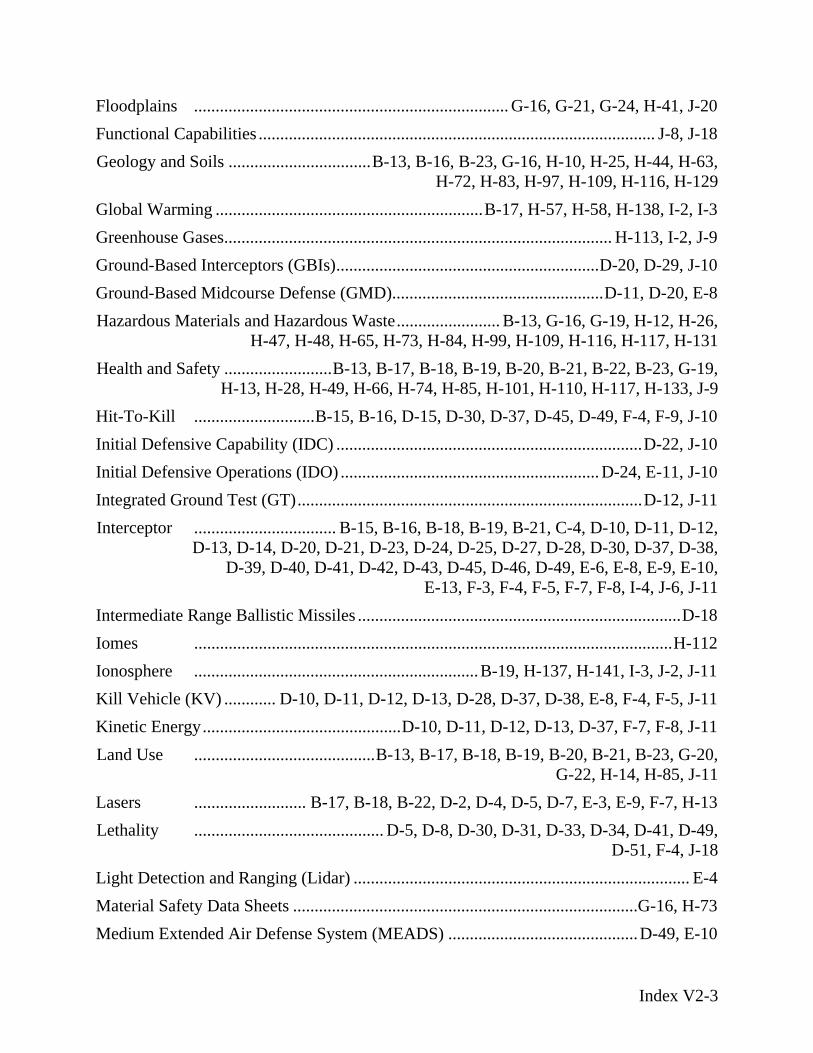
Floodplains ......................................................................... G-16, G-21, G-24, H-41, J-20
Geology and Soils .................................B-13, B-16, B-23, G-16, H-10, H-25, H-44, H-63, H-72, H-83, H-97, H-109, H-116, H-129
Ground-Based Midcourse Defense (GMD).................................................D-11, D-20, E-8
Health and Safety .........................B-13, B-17, B-18, B-19, B-20, B-21, B-22, B-23, G-19, H-13, H-28, H-49, H-66, H-74, H-85, H-101, H-110, H-117, H-133, J-9
Initial Defensive Capability (IDC) .......................................................................D-22, J-10
Integrated Ground Test (GT)................................................................................D-12, J-11
Ionosphere ..................................................................B-19, H-137, H-141, I-3, J-2, J-11
Kinetic Energy..............................................D-10, D-11, D-12, D-13, D-37, F-7, F-8, J-11
Lasers .......................... B-17, B-18, B-22, D-2, D-4, D-5, D-7, E-3, E-9, F-7, H-13
Light Detection and Ranging (Lidar) .............................................................................. E-4
Medium Extended Air Defense System (MEADS) ............................................D-49, E-10
Functional Capabilities ............................................................................................ J-8, J-18
Global Warming ..............................................................B-17, H-57, H-58, H-138, I-2, I-3 Greenhouse Gases.......................................................................................... H-113, I-2, J-9 Ground-Based Interceptors (GBIs).............................................................D-20, D-29, J-10
Hazardous Materials and Hazardous Waste........................ B-13, G-16, G-19, H-12, H-26, H-47, H-48, H-65, H-73, H-84, H-99, H-109, H-116, H-117, H-131
Hit-To-Kill ............................B-15, B-16, D-15, D-30, D-37, D-45, D-49, F-4, F-9, J-10
Initial Defensive Operations (IDO) ............................................................ D-24, E-11, J-10
Interceptor ................................. B-15, B-16, B-18, B-19, B-21, C-4, D-10, D-11, D-12, D-13, D-14, D-20, D-21, D-23, D-24, D-25, D-27, D-28, D-30, D-37, D-38,
D-39, D-40, D-41, D-42, D-43, D-45, D-46, D-49, E-6, E-8, E-9, E-10, E-13, F-3, F-4, F-5, F-7, F-8, I-4, J-6, J-11
Intermediate Range Ballistic Missiles ...........................................................................D-18 Iomes ...............................................................................................................H-112
Kill Vehicle (KV) ............ D-10, D-11, D-12, D-13, D-28, D-37, D-38, E-8, F-4, F-5, J-11
Land Use ..........................................B-13, B-17, B-18, B-19, B-20, B-21, B-23, G-20, G-22, H-14, H-85, J-11
Lethality ............................................ D-5, D-8, D-30, D-31, D-33, D-34, D-41, D-49, D-51, F-4, J-18
Material Safety Data Sheets ................................................................................G-16, H-73
Index V2-3
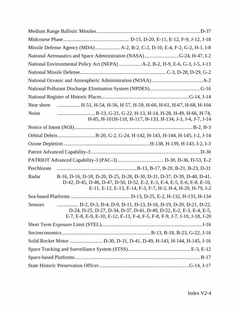
Medium Range Ballistic Missiles..................................................................................D-37 Midcourse Phase.................................................... D-15, D-20, E-11, E-12, F-9, J-12, J-18
National Missile Defense.................................................................... C-3, D-28, D-29, G-2
National Pollutant Discharge Elimination System (NPDES)........................................G-16
Near shore .................. H-51, H-54, H-56, H-57, H-59, H-60, H-61, H-67, H-68, H-104
Notice of Intent (NOI) .............................................................................................B-2, B-3
Missile Defense Agency (MDA)....................A-2, B-2, C-2, D-10, E-4, F-2, G-2, H-1, I-8 National Aeronautics and Space Administration (NASA)...........................G-24, H-47, I-2 National Environmental Policy Act (NEPA) ..................A-2, B-2, D-9, E-6, G-3, J-5, J-13
National Oceanic and Atmospheric Administration (NOAA) ........................................A-2
National Register of Historic Places.....................................................................G-14, J-14
Noise .............................. B-13, G-21, G-22, H-13, H-14, H-28, H-49, H-66, H-74, H-85, H-101H-110, H-117, H-133, H-134, J-3, J-4, J-7, J-14
Orbital Debris .............................B-20, G-2, G-24, H-142, H-143, H-144, H-145, I-2, J-14 Ozone Depletion ....................................................................H-138, H-139, H-143, I-2, I-3 Patriot Advanced Capability-3 ......................................................................................D-30 PATRIOT Advanced Capability-3 (PAC-3) .................................... D-30, D-36, D-53, E-2 Perchlorate ...............................................................B-13, B-17, B-20, B-21, B-23, D-31 Radar B-16, D-16, D-18, D-20, D-25, D-28, D-30, D-31, D-37, D-39, D-40, D-41,
D-42, D-45, D-46, D-47, D-50, D-52, E-2, E-3, E-4, E-5, E-6, E-8, E-10, E-11, E-12, E-13, E-14, F-3, F-7, H-3, H-4, H-20, H-79, J-2
Sea-based Platforms ...............................................D-13, D-25, E-2, H-132, H-133, H-134 Sensors ................. D-2, D-3, D-4, D-9, D-11, D-13, D-16, D-19, D-20, D-21, D-22,
D-24, D-25, D-27, D-34, D-37, D-41, D-49, D-52, E-2, E-3, E-4, E-5, E-7, E-8, E-9, E-10, E-12, E-13, F-4, F-5, F-8, F-9, J-7, J-10, J-18, J-20
Short Term Exposure Limit (STEL)............................................................................... J-16 Socioeconomics ......................................................................B-13, B-18, B-23, G-22, J-16 Solid Rocket Motor .......................... D-30, D-31, D-41, D-49, H-143, H-144, H-145, J-16 Space Tracking and Surveillance System (STSS)................................................. E-3, E-12 Space-based Platforms...................................................................................................B-17 State Historic Preservation Officer.......................................................................G-14, J-17
Index V2-4

Stratosphere ............................... H-56, H-57, H-137, H-139, H-143, I-2, I-3, I-4, I-6, I-8, I-9, I-10, I-11, I-12, I-13, J-2, J-12, J-15
Superfund .................................................................................................................G-16 Support Assets ........................................................................................................D-2, J-17 System Integration Flight Tests (SIFTs) ........................................................................ J-18 Targets ......................B-15, C-3, D-3, D-6, D-7, D-8, D-9, D-11, D-12, D-13, D-16,
D-17, D-18, D-25, D-27, D-29, D-30, D-33, D-34, D-41, D-42, D-45, D-48, D-51, E-3, E-4, E-9, E-10, F-2, F-4, F-5, F-7, F-8, F-9, J-18, J-19
Terminal High Altitude Area Defense (THAAD).......................................B-15, D-30, E-5 Terminal Phase ................................................................. D-37, D-45, D-49, F-3, F-7, J-18 Test Assets .................................................................................................................. J-18 Test Bed ...........D-5, D-8, D-12, D-14, D-17, D-22, D-23, D-27, E-6, E-9, E-12, J-18 Test Sensors .................................................................................................................D-52 Testing ...................B-13, B-15, B-16, B-17, B-18, B-19, B-21, D-4, D-5, D-6, D-7,
D-8, D-10D-11, D-12, D-13, D-17, D-18, D-23, D-24, D-27, D-32, D-33, D-34, D-40, D-41, D-42, D-43, D-46, D-47, D-51, D-52, E-2,
E-5, E-7, E-9, E-10, F-4, F-5, F-6, F-10, G-14, G-17, H-12, H-14, H-27, H-37, H-52, H-67, H-79, H-80, J-6, J-11, J-18
Theater Missile Defense (TMD) .................................................................................... J-19 Threatened and Endangered Species ..................................B-22, H-41, H-43, H-44, H-115 Transportation............................. B-13, D-21, D-36, G-17, G-22, H-14, H-15, H-28, H-29,
H-49, H-50, H-66, H-67, H-74, H-75, H-85, H-86, H-99, H-101, H-102, H-110, H-111, H-117, H-118, H-134, H-138, I-3, I-4, J-19
Troposphere ............ H-56, H-57, H-137, H-138, H-139, I-3, I-4, I-8, I-11, J-2, J-17, J-19 Utilities ....................................................................................B-13, B-22, G-22, J-19 Visible ....................................................E-3, E-5, E-8, H-141, J-10, J-12, J-14, J-20 Water Resources................B-13, B-20, B-21, B-23, G-16, G-19, G-23, H-16, H-29, H-50,
H-51, H-67, H-75, H-76, H-87, H-102, H-111, H-118, H-119, H-135, J-20 Weapons ................................. B-12, B-14, B-15, B-16, B-19, B-20, D-4, D-15, D-16,
D-19, D-22, D-37, D-45, E-2, F-4, F-5, G-20, H-14, H-20, J-7, J-10, J-18 Wetlands . G-10, G-12, G-13, G-21, H-8, H-11, H-22, H-24, H-29, H-30, H-39, H-42,
H-51, H-52, H-53, H-54, H-71, H-75, H-76, H-82, H-88, H-95, H-107, J-20 Sea-Based X-band Radar (SBX) .................................................................B-18, E-2, D-20 X-Band Radar (XBR) ....................................................................................................B-18
Index V2-5