microsoft word - grouse_mtn.doc
DESCRIPTION
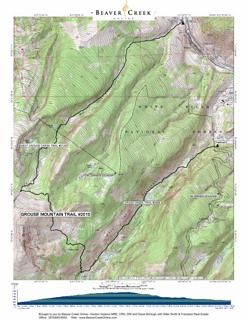
Holy Cross Ranger District 24747 US Hwy 24 P.O. Box 190 Minturn, CO 81645 (970) 827- 5715 - Voice (970) 827-9343 - Fax Access #2: South Trailhead: Begin at the Cross Creek Trailhead on Tigiwon Road #707. Hike the Cross Creek Trail #2006 six miles to the junction with Grouse Mountain Trail. Access #1: North Trailhead: Begin at the Grouse Creek Trailhead 1 mile north of Minturn on U.S. Hwy. 24. Hike the West Grouse Creek Trail 7 miles to the junction with Grouse Mountain Trail.TRANSCRIPT

Length: 15.6 miles Trail Use: Light to Moderate Difficulty: More Difficult Open To: Hiking, Horseback Beginning Elevation: 7,834 ft. (at West Grouse) Ending Elevation: 8,514 ft. (at Cross Creek) Elevation Gain: +4,357 ft.-3,677 ft. = +680 ft. USGS Map(s): Minturn, Grouse Mtn Permit Information: In order to continue to provide quality recreation experiences and to protect the wilderness lands, the Forest Service must gather data regarding visitor use and travel patterns. Each party recreating in the Holy Cross Wilderness is required to self-register at the trailhead and to carry a copy of the registration with them during their visit. There is no fee charged and no limit to the num-ber of permits issued. Access #1: North Trailhead: Begin at the Grouse Creek Trailhead 1 mile north of Minturn on U.S. Hwy. 24. Hike the West Grouse Creek Trail 7 miles to the junction with Grouse Mountain Trail. Access #2: South Trailhead: Begin at the Cross Creek Trailhead on Tigiwon Road #707. Hike the Cross Creek Trail #2006 six miles to the junction with Grouse Mountain Trail. Trail Highlights: This trail links the West Grouse Creek Trail #2129 and the Cross Creek Trail #2006. The mileages and elevation gains given on this sheet assume hiking from West Grouse Creek trailhead to Cross Creek trailhead. Access to Grouse Mountain, Buffalo Lake is provided by this trail. The climb from Cross Creek Valley to the junction of Sisters Cabin Trail #2128 is very steep, but provides good vistas of Mount of the Holy Cross and Cross Creek Valley. Elk and deer are often sighted along this trail. If the trail is hiked north to south, the steep climb out of Cross Creek Valley can be avoided. This trail passes over an eastern shoulder of Grouse Mountain and several panoramas of the Sawatch Range can be seen from openings in the forest and near timberline areas along the trail. Buffalo Lake and the surrounding woods and meadows are good places to spot wildlife. Wildflower displays are continuous during the growing season. A side trip to the top of Grouse Mountain provides 360 degrees views of the Gore Range to the east, the Sawatch Range and the upper Eagle Valley. Important Information: Grouse Mountain Trail is within the Holy Cross Wilderness. Wilderness is for your use and enjoyment, but you have an obligation to leave it unimpaired for future generations. Please understand your responsibilities when visiting these special places. Leave them as you wish to Find them: * Camping - camp at least 100 feet from streams, lakes, and trails * Dogs - must be leashed out of consideration for both other people and wildlife * Fire - campstoves are recommended and fires are prohibited at and above timberline * Group size - limit group sizes to 15 people * Sanitation - bury human waste 100 feet from water and 6 inches in the soil
PACK IT IN - PACK IT OUT!! LEAVE NO TRACE!!
GROUSE MOUNTAIN TRAIL #2010
Holy Cross Ranger District 24747 US Hwy 24 P.O. Box 190 Minturn, CO 81645 (970) 827- 5715 - Voice (970) 827-9343 - Fax
United States Department of Agriculture HIKING
This map is intended for use as a general guide only, not for actual land navigation. The White River National Forest strongly suggests purchasing a topographic map and compass prior to your hiking trip.
Brought to you by Beaver Creek Online - Kenton Hopkins MRE, CRS, GRI and David McHugh with Slifer Smith & Frampton Real Estate Office: (970)845-8053 Web: www.BeaverCreekOnline.com
Brought to you by Beaver Creek Online - Kenton Hopkins MRE, CRS, GRI and David McHugh with Slifer Smith & Frampton Real Estate Office: (970)845-8053 Web: www.BeaverCreekOnline.com