marine mammal monitoring and mitigation plan · marine mammal monitoring and mitigation plan ......
TRANSCRIPT
Marine Mammal Monitoring and Mitigation Plan
Exploration Drilling of Selected Lease Areas in
The Alaskan Chukchi Sea
Shell Gulf of Mexico Inc.
August 2014
Revised December 2014
Revised March 2015
Revised September 2015
Chukchi Sea, Alaska Marine Mammal Monitoring and Mitigation Plan
Shell Gulf of Mexico Inc. i Revised September 2015
Chukchi Sea, Alaska Marine Mammal Monitoring and Mitigation Plan
TABLE OF CONTENTS
INTRODUCTION..........................................................................................................................1
VESSEL BASED MARINE MAMMAL MONITORING PROGRAM ...................................2
MITIGATION MEASURES DURING EXPLORATION DRILLING ACTIVITIES ............................................3 Exclusion and Disturbance Zones ....................................................................................................3 Exploration Drilling Activities ........................................................................................................3 ZVSP Surveys ..................................................................................................................................4 Number of Observers .......................................................................................................................5
Crew Rotation ..................................................................................................................................6 Observer Qualifications and Training ..............................................................................................6 PSO Handbook.................................................................................................................................6
MONITORING METHODOLOGY ..........................................................................................................7 Monitoring At Night and In Poor Visibility ....................................................................................8 Specialized Field Equipment ...........................................................................................................8
Field Data-Recording, Verification, Handling, and Security ..........................................................8 Field Reports ....................................................................................................................................9
REPORTING .......................................................................................................................................9
ACOUSTIC MONITORING PLAN ..........................................................................................10
EXPLORATION DRILLING, ZVSP AND VESSEL SOUND MEASUREMENTS .........................................10
Objectives ......................................................................................................................................10 Exploration Drilling Sound Characterization ................................................................................10
Vessel Sound Characterization ......................................................................................................12
Zero-Offset Vertical Seismic Profiling Sound Monitoring ...........................................................12
Acoustic Data Analyses .................................................................................................................14 Reporting of Results ......................................................................................................................16
ACOUSTIC “NET” ARRAY IN CHUKCHI SEA ....................................................................................16 Background and Objectives ...........................................................................................................16 Technical Approach .......................................................................................................................16
Analysis and Reporting ..................................................................................................................17
CHUKCHI OFFSHORE AERIAL PHOTOGRAPHIC MONITORING PROGRAM .......18
Camera Specifications ...................................................................................................................19 Survey Timing and Frequency .......................................................................................................20
Survey Pattern ................................................................................................................................20 Data Analyses ................................................................................................................................22
Other Imagery and Sensors ............................................................................................................23
CHUKCHI SEA COASTAL AERIAL SURVEY .....................................................................23
Objectives ......................................................................................................................................23 Survey Procedures .........................................................................................................................24 Coordination with Other Aerial Surveys .......................................................................................25
LITERATURE CITED ...............................................................................................................26
Chukchi Sea, Alaska Marine Mammal Monitoring and Mitigation Plan
Shell Gulf of Mexico Inc. ii Revised September 2015
Chukchi Sea, Alaska Marine Mammal Monitoring and Mitigation Plan
ACRONYMS
C degrees Celsius
T degrees True North
µPa microPascals(s)
4MP Marine Mammal Monitoring and Mitigation Plan
AMAR Autonomous Multi-channel Acoustic Recorder(s)
BOEM Bureau of Ocean Energy Management
BSEE Bureau of Safety and Environmental Enforcement
cm centimeter(s)
cm3
cubic centimeter(s)
dB decibel
Discoverer M/V Noble Discoverer
DNV Det Norske Veritas
DP Dynamic Positioning
ft. feet
GPS Global Positioning System
HSWUA Hana Shoal Walrus Use Area
Hz Hertz
in3
cubic inches
JASCO JASCO Applied Sciences
kHz kilohertz
km kilometer(s)
LBCHU Ledyard Bay Critical Habitat Unit
Leq sound energy equivalent level
m meters
mi mile(s)
MLC Mudline Cellar
MMPA Marine Mammal Protection Act
MONM Marine Operations Noise Model
NMFS National Marine Fisheries Service
NSB North Slope Borough
NVD Night-vision Device(s)
OBH Ocean Bottom Hydrophone
Polar Pioneer Transocean Polar Pioneer
psi pounds per square inch
PSO Protected Species Observer(s)
rms root-mean-square
Shell Shell Gulf of Mexico Inc.
UAS Unmanned Aerial System
USFWS United States Fish and Wildlife Service
ZVSP Zero-offset Vertical Seismic Profile
Chukchi Sea, Alaska Marine Mammal Monitoring and Mitigation Plan
Shell Gulf of Mexico Inc. 1 Revised September 2015
Chukchi Sea, Alaska Marine Mammal Monitoring and Mitigation Plan
INTRODUCTION
Shell Gulf of Mexico Inc. (Shell) will conduct a Marine Mammal Monitoring and Mitigation Plan (4MP)
for exploration drilling activities in the Chukchi Sea during the drilling season. The 4MP developed for
Shell’s exploration drilling program supports protection of the marine mammal resources, fulfills
reporting obligations to the Bureau of Ocean Energy Management (BOEM), Bureau of Safety and
Environmental Enforcement (BSEE), the National Marine Fisheries Service (NMFS), the United States
Fish and Wildlife Service (USFWS); and establishes a means for gathering additional data on marine
mammals for future operational planning.
Shell plans to conduct exploration drilling within existing leases in the Chukchi Sea. Drilling will be
conducted from the self-propelled drillship M/V Noble Discoverer (Discoverer) owned and operated by
Noble Corporation and the towed semi-submersible Polar Pioneer owned by Transocean. The Discoverer
is ice-class rated and capable of performing drilling operations in offshore Alaska. Similarly, the Polar
Pioneer is specially designed and classed by Det Norske Veritas (DNV) as a 1A1 column stabilized
drilling unit capable of operating in offshore Alaska. In addition to the drilling units, various support
vessels will be required. The support vessels will include tugs and barges, ice management vessels,
anchor handlers, and oil spill response vessels.
At or near the end of well construction, a Zero-offset Vertical Seismic Profile (ZVSP) survey will be
conducted for each well. During the ZVSP surveys, an airgun array is deployed adjacent to the drilling
units, while receivers are placed in the wellbore. The sound source (airgun array) is fired, then the
reflected sonic waves are recorded by receivers (geophones) located in the wellbore. The surveys may last
10-14 hours each; as the receivers are moved through the length of the wellbore, the airguns may be fired
5-7 times after each movement. The purpose of the ZVSP survey is to gather geophysical information at
various depths, which can then be used to tie in or ground truth geophysical information from the
previous seismic surveys with geological data collected within the wellbore.
Shell’s 4MP is a combination of active monitoring in the area of operations and the implementation of
mitigation measures designed to minimize project impacts to marine resources. Monitoring will provide
information on the numbers of marine mammals potentially affected by exploration activities, in addition
to facilitating real time mitigation to prevent injury of marine mammals by industrial sounds or activities.
These goals will be accomplished by conducting vessel based visual monitoring, aerial photographic
monitoring, and acoustic monitoring programs to document the potential reactions of marine mammals in
the area to the various sounds and activities, in addition to characterizing the sounds produced by drilling
activities, support vessels, and ZVSP surveys.
A minimally-manned aerial photographic survey around the offshore drilling operations, opportunistic
aerial photographic surveys to monitor marine mammals in coastal and nearshore areas of the Chukchi
Sea, and recordings of ambient sound levels and vocalizations of marine mammals from bottom-founded
hydrophones placed in large arrays across the Chukchi Sea will be used to interpret potential reactions of
marine mammals to the offshore exploration drilling operations and in subsistence use areas closer to
shore. Acoustic measurements will be made to establish exclusion zones for real time mitigation around
ZVSP surveys and to verify pre-season estimates of the sound footprints and disturbance zones for
exploration drilling activities. The exploration drilling activities that will be characterized include
movement of the drilling units, drilling sounds, resupply and discharge monitoring support vessels using
dynamic positioning (DP) while in direct support of the moored drilling units, mudline cellar (MLC)
construction, anchor setting and connecting of the drilling units, and ice management activities; as well as
the sound signatures of contracted Shell vessels that have not previously been recorded in the activity
area. A detailed report of the sound source analyses will be issued to the NMFS as part of the 90-day
report following the end of the exploration drilling season. Shell will continue to measure the sound
propagation of exploration drilling activities throughout the exploration drilling season.
Chukchi Sea, Alaska Marine Mammal Monitoring and Mitigation Plan
Shell Gulf of Mexico Inc. 2 Revised September 2015
Chukchi Sea, Alaska Marine Mammal Monitoring and Mitigation Plan
VESSEL BASED MARINE MAMMAL MONITORING PROGRAM
Shell’s vessel based 4MP is designed to meet the requirements of the Marine Mammal Protection Act
(MMPA) non-lethal, incidental take authorizations for marine mammals (MMPA authorizations) which
Shell has requested from the NMFS and the USFWS. The 4MP also addresses other stipulated
agreements between Shell and additional agencies or groups. The objectives of the program are to ensure
that disturbance to marine mammals and subsistence hunts is minimized, that effects on marine mammals
are documented, and that data are collected on the occurrence and distribution of marine mammals in the
project area.
The 4MP will be implemented by a team of experienced protected species observers (PSOs). The PSOs
will be experienced biologists and Alaska Native personnel trained as field observers. PSOs will be
stationed on both drilling units, ice management vessels, anchor handlers and other drilling support
vessels engaged in transit to and between drill sites to monitor for marine mammals. The duties of the
PSOs will include watching for and identifying marine mammals, recording their numbers, recording
distances and reactions of marine mammals to exploration drilling activities, initiating mitigation
measures when appropriate, and reporting results of the vessel based monitoring program, which will
include the estimation of the number of marine mammal “exposures” as defined by the NMFS and
stipulated in its MMPA authorization for Shell.
Exploration activity dates and areas will depend upon ice and weather conditions. The Discoverer, the
Polar Pioneer and support vessels will transit through the Bering Strait into the Chukchi Sea on or about
July 11 and will arrive on location at the Burger Prospect to commence drilling activities as soon as ice,
weather, and other conditions safely allow. Vessel based monitoring for marine mammals will be done
throughout Shell’s exploration drilling activities in compliance with the MMPA authorizations issued by
the NMFS and the USFWS.
The vessel based work will provide:
the basis for real-time mitigation, if necessary, as required by the various permits that Shell
receives;
information needed to estimate the number of “exposures” of marine mammals to sound
levels that may result in harassment, which must be reported to NMFS and USFWS;
data on the occurrence, distribution, and activities of marine mammals in the areas where
drilling activity is conducted;
information to compare the distances, distributions, behavior, and movements of marine
mammals relative to the drilling unit during times with and without drilling activity
occurring;
a communication channel to coastal communities including whalers; and
employment and capacity building for local residents, with one objective being to develop a
larger pool of experienced Alaska Native PSOs.
The 4MP will be operated and administered consistent with monitoring programs conducted during past
exploration drilling activities, seismic and shallow hazards surveys, or alternative requirements stipulated
in permits issued to Shell. Agreements between Shell and other agencies will also be fully incorporated.
PSOs will be provided training through a program approved by the NMFS and Shell.
1 As noted in the EP Revision 2, Shell may request permission to transit through the Bering Strait prior to July 1,
2015.
Chukchi Sea, Alaska Marine Mammal Monitoring and Mitigation Plan
Shell Gulf of Mexico Inc. 3 Revised September 2015
Chukchi Sea, Alaska Marine Mammal Monitoring and Mitigation Plan
MITIGATION MEASURES DURING EXPLORATION DRILLING ACTIVITIES
Shell’s planned exploration drilling activities incorporate design features and operational procedures
aimed at minimizing potential impacts on marine mammals and subsistence hunts. The design and
operational procedures of the mitigation measures have been described in the MMPA authorization
requests, to which this 4MP is appended. Some of the mitigation design features include:
timing and locating drilling support activities to avoid interference with the annual
subsistence hunt by Chukchi villages;
conducting pre-season acoustic modeling to establish the appropriate exclusion and
disturbance zones;
vessel based monitoring to implement appropriate mitigation if necessary, and to determine
the effects of drilling activities on marine mammals;
acoustic monitoring of drilling and vessel sounds and marine mammal vocalizations; and
aerial surveys with photographic equipment over operations and in coastal and nearshore
waters to help determine the effects of project activities on marine mammals; and seismic
activity mitigation measures during acquisition of the ZVSP surveys.
The potential disturbance of marine mammals during drilling activities will be mitigated through the
implementation of several vessel based mitigation measures as necessary.
Exclusion and Disturbance Zones
Under current NMFS guidelines (e.g., NMFS 2000), “safety radii” or “exclusion zones” for marine
mammals around airgun arrays and other impulsive industrial sound sources are customarily defined as
the distances within which received levels are ≥180 decibel (dB) re 1 microPascal (µPa) root-mean-
square (rms) for cetaceans and ≥190 dB re 1 µPa rms for pinnipeds. The ≥180 and ≥190 dB rms
guidelines are also employed by USFWS for Pacific walrus and polar bear. These safety criteria are based
on a cautionary assumption that sound energy at lower received levels will not harm these animals or
impair their hearing abilities, but that higher received levels might have some such effects. Disturbance or
behavioral effects to marine mammals from underwater sound may occur after exposure to sound at
distances greater than the exclusion zone (Richardson et al. 1995). The NMFS assumes that marine
mammals exposed to pulsed airgun sounds with received levels ≥160 dB re 1 µPa rms or continuous
sounds from vessel activities with received levels ≥120 dB re 1 µPa rms have the potential to be
disturbed. As a result, these sound level thresholds are currently used by NMFS to define acoustic
disturbance criteria.
Exploration Drilling Activities
The areas exposed to sounds produced by the drilling units Discoverer and Polar Pioneer were
determined by measurements from drilling in 2012 or were modeled by JASCO Applied Sciences. The
2012 measurement of the distance to the 120 dB rms threshold for normal drilling activity by the
Discoverer was 0.93 miles (mi) (1.5 kilometers [km]) while the distance of the ≥120 dB rms radius during
MLC construction was 5.1 mi (8.2 km).
Measured sound levels for the Polar Pioneer were not available. Its sound footprint was estimated with
JASCOs Marine Operations Noise Model (MONM) using an average source level derived from a number
of reported acoustic measurements of comparable semi-submersible drill units, including the Ocean
Bounty (Gales, 1982), SEDCO 708 (Greene, 1986), and Ocean General (McCauley, 1998). The model
yielded a propagation range of 0.22 mi (0.35 km) for rms sound pressure levels of 120 dB for the Polar
Pioneer while drilling at the Burger Prospect.
Chukchi Sea, Alaska Marine Mammal Monitoring and Mitigation Plan
Shell Gulf of Mexico Inc. 4 Revised September 2015
Chukchi Sea, Alaska Marine Mammal Monitoring and Mitigation Plan
In addition to drilling and MLC construction, numerous activities in support of exploration drilling
produce continuous sounds above 120 dB rms. These activities in direct support of the moored drilling
units include ice management, anchor handling, and supply/discharge sampling vessels using DP
thrusters. Detailed sound characterizations for each of these activities are presented in the 2012
Comprehensive Report (JASCO and Greeneridge 2014)
The source levels for exploration drilling and related support activities are not high enough to cause
temporary reduction in hearing sensitivity or permanent hearing damage to marine mammals.
Consequently, mitigation as described for seismic activities including ramp ups, power downs, and shut
downs should not be necessary for exploration drilling activities. However, Shell plans to use PSOs
onboard the drilling units, ice management, and anchor handling vessels to monitor marine mammals and
their responses to industry activities, in addition to initiating mitigation measures should in-field
measurements of the activities indicate conditions that may present a threat to the health and well-being of
marine mammals.
ZVSP Surveys
Two sound sources have been proposed by Shell for the ZVSP surveys. The first is a small airgun array
that consists of three 150 in3 (2,458 cubic centimeters [cm
3]) airguns for a total volume of 450 in
3 (7,374
cm3). The second ZVSP sound source consists of two 250 in
3 (4,097 cm
3) airguns with a total volume of
500 in3 (8,194 cm
3). Sound footprints for each of the two proposed ZVSP airgun array configurations
were estimated using JASCO Applied Sciences MONM. The model results were maximized over all
water depths between 9.9 and 23 feet (ft.) (3 and 7 meters [m]) to yield sound level isopleths as a function
of range and direction from the source. The 450 in3 airgun array at a source depth of 23 ft. (7 m) yielded
the maximum ranges to the ≥190, ≥180, and ≥160 dB rms isopleths.
There are two reasons that the radii for the 450 in3 airgun array is larger than the 500 in
3 array; first, the
sound energy does not scale linearly with the airgun volume; rather it is proportional to the cube root of
the volume. Thus, the total sound energy from three airguns is larger than the total energy from two
airguns, even though the total volume is smaller. Second, larger volume airguns emit more low-frequency
sound energy than smaller volume airguns, and low-frequency airgun sound energy is strongly attenuated
by interaction with the surface reflection. Thus, the sound energy for the larger-volume array experiences
more reduction and results in shorter sound threshold radii.
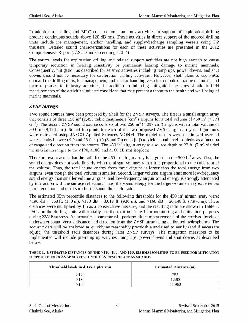
The estimated 95th percentile distances to the following thresholds for the 450 in3 airgun array were:
≥190 dB = 558 ft. (170 m), ≥180 dB = 3,018 ft. (920 m), and ≥160 dB = 26,148 ft. (7,970 m). These
distances were multiplied by 1.5 as a conservative measure, and the resulting radii are shown in Table 1.
PSOs on the drilling units will initially use the radii in Table 1 for monitoring and mitigation purposes
during ZVSP surveys. An acoustics contractor will perform direct measurements of the received levels of
underwater sound versus distance and direction from the ZVSP array using calibrated hydrophones. The
acoustic data will be analyzed as quickly as reasonably practicable and used to verify (and if necessary
adjust) the threshold radii distances during later ZVSP surveys. The mitigation measures to be
implemented will include pre-ramp up watches, ramp ups, power downs and shut downs as described
below.
TABLE 1. ESTIMATED DISTANCES OF THE ≥190, 180, AND 160, DB RMS ISOPLETHS TO BE USED FOR MITIGATION
PURPOSES DURING ZVSP SURVEYS UNTIL SSV RESULTS ARE AVAILABLE.
Threshold levels in dB re 1 µPa rms Estimated Distance (m)
≥190 255
≥180 1,380
≥160 11,960
Chukchi Sea, Alaska Marine Mammal Monitoring and Mitigation Plan
Shell Gulf of Mexico Inc. 5 Revised September 2015
Chukchi Sea, Alaska Marine Mammal Monitoring and Mitigation Plan
Ramp Ups
A ramp up of an airgun array provides a gradual increase in sound levels, and involves a step-wise
increase in the number and total volume of airguns firing until the full volume is achieved. The purpose of
a ramp up (or “soft start”) is to “warn” cetaceans and pinnipeds in the vicinity of the airguns and to
provide time for them to leave the area, thus avoiding any potential injury or impairment of their hearing
abilities.
During the proposed ZVSP surveys, the operator will ramp up the airgun arrays slowly. Full ramp ups
(i.e., from a cold start when no airguns have been firing) will begin by firing a single airgun in the array.
A full ramp up will not begin until there has been observation of the exclusion zone by PSOs for a
minimum of 30 minutes to ensure that no marine mammals are present. The entire exclusion zone must be
visible during the 30 minutes leading into to a full ramp up. If the entire exclusion zone is not visible, a
ramp up from a cold start cannot begin. If a marine mammal is sighted within the exclusion zone during
the 30 minutes prior to ramp up, ramp up will be delayed until the marine mammal is sighted outside of
the exclusion zone or is not sighted for at least 15-30 minutes: 15 minutes for small odontocetes and
pinnipeds, or 30 minutes for baleen whales and large odontocetes.
Power Downs and Shut Downs
A power down is the immediate reduction in the number of operating energy sources from all firing to
some smaller number. A shut down is the immediate cessation of firing of all energy sources. The arrays
will be immediately powered down whenever a marine mammal is sighted approaching close to or within
the applicable exclusion zone of the full arrays, but is outside the applicable exclusion zone of the single
source. If a marine mammal is sighted within the applicable exclusion zone of the single energy source,
the entire array will be shut down (i.e., no sources firing).
Protected Species Observers
Vessel based monitoring for marine mammals will be done by trained PSOs on both drilling units, ice
management and anchor handler vessels throughout the exploration drilling activities to comply with
mitigations contained in Shell’s MMPA authorizations. The observers will monitor the occurrence and
behavior of marine mammals near the drilling units, ice management and anchor handling vessels, during
all daylight periods during the exploration drilling operation, and during most periods when exploration
drilling is not being conducted. PSO duties will include watching for and identifying marine mammals;
recording their numbers, distances, and reactions to the exploration drilling activities; and documenting
exposures to sound levels that may constitute harassment as defined by NMFS.
Number of Observers
A sufficient number of PSOs will be onboard to meet the following criteria
100 percent monitoring coverage during all periods of exploration drilling operations in
daylight;
Maximum of four consecutive hours on watch per PSO; and
Maximum of approximately 12 hours on watch per day per PSO
PSO teams will consist of trained Alaska Natives and field biologist observers. An experienced field crew
leader will be on every PSO team aboard the drilling units, ice management and anchor handling vessels,
and other support vessels during the exploration drilling program. The total number of PSOs aboard may
decrease later in the season as the duration of daylight decreases assuming the NMFS does not require
continuous nighttime monitoring. PSOs will help ensure that the vessel communicates with the
Communications and Call Centers (Com Centers) in Native villages along the Chukchi Sea coast.
Chukchi Sea, Alaska Marine Mammal Monitoring and Mitigation Plan
Shell Gulf of Mexico Inc. 6 Revised September 2015
Chukchi Sea, Alaska Marine Mammal Monitoring and Mitigation Plan
Crew Rotation
Shell anticipates that there will be provisions for crew rotation at least every three to six weeks to avoid
observer fatigue. During crew rotations detailed notes will be provided to the incoming crew leader. Other
communications such as email, fax, and/or phone communication between the current and oncoming crew
leaders during each rotation will also occur when necessary. In the event of an unexpected crew change
Shell will facilitate such communications to ensure monitoring consistency among shifts.
Observer Qualifications and Training
Crew leaders serving as PSOs will have experience from one or more projects with operators in Alaska or
the Canadian Beaufort.
Biologist-observers will have previous PSO experience, and crew leaders will be highly experienced with
previous vessel based marine mammal monitoring projects. Resumes for those individuals will be provided
to the NMFS for approval. All PSOs will be trained and familiar with the marine mammals of the area. A PSO
handbook, adapted for the specifics of the planned Shell drilling program will be prepared and distributed
beforehand to all PSOs.
All observers will also complete a training session on marine mammal monitoring, to be conducted
shortly before the anticipated start of the drilling season. The training sessions will be conducted by
marine mammalogists with extensive crew leader experience from previous vessel based monitoring
programs in the Arctic.
Primary objectives of the training include:
review of the 4MP for this project, including any amendments adopted, or specified by the
NMFS the USFWS, the BOEM, the BSEE, or other agreements in which Shell may elect to
participate;
review of marine mammal sighting, identification, (photographs and videos) and distance
estimation methods, including any amendments specified by the NMFS or the USFWS in the
MMPA authorizations issued to Shell;
review operation of specialized equipment (e.g., reticle binoculars, big eye binoculars, night
vision devices, Global Positioning System (GPS); and
review of data recording and data entry systems, including procedures for recording data on
mammal sightings, exploration drilling and monitoring activities, environmental conditions,
and entry error control. These procedures will be implemented through use of a customized
computer databases and laptop computers.
PSO Handbook
A PSO Handbook will be prepared for Shell’s monitoring program. The Handbook will contain maps,
illustrations, and photographs as well as copies of important documents and descriptive text and are
intended to provide guidance and reference information to trained individuals who will participate as
PSOs. The following topics will be covered in the PSO Handbook:
summary overview descriptions of the project, marine mammals and underwater sound
energy, the 4MP (vessel-based, aerial, acoustic measurements, special studies), the NMFS
and USFWS MMPA authorizations and other regulations/permits/agencies,;
monitoring and mitigation objectives and procedures, including initial exclusion and
disturbance zones;
responsibilities of staff and crew regarding the 4MP;
Chukchi Sea, Alaska Marine Mammal Monitoring and Mitigation Plan
Shell Gulf of Mexico Inc. 7 Revised September 2015
Chukchi Sea, Alaska Marine Mammal Monitoring and Mitigation Plan
instructions for staff and crew regarding the 4MP;
data recording procedures: codes and coding instructions, common coding mistakes,
electronic database; navigational, marine physical, and drilling data recording, field data
sheet;
use of specialized field equipment (e.g., reticle binoculars, Big-eye binoculars, Night Vision
Devices [NVD], laser rangefinders);
reticle binocular distance scale;
table of wind speed, Beaufort wind force, and sea state codes;
data storage and backup procedures;
list of species that might be encountered: identification, natural history;
safety precautions while onboard;
crew and/or personnel discord; conflict resolution among PSOs and crew;
drug and alcohol policy and testing;
scheduling of cruises and watches;
communications;
list of field gear provided;
suggested list of personal items to pack;
suggested literature, or literature cited;
field reporting requirements and procedures;
copies of the MMPA authorizations will be made available; and
areas where vessels cannot operate such as the Ledyard Bay Critical Habitat Unit (LBCHU)
and Hana Shoal Walrus Use Area (HSWUA).
MONITORING METHODOLOGY
Each of the two drilling units and primary ice management vessels will be staffed with five PSOs. Each of
the two anchor handling vessels will be staffed with four PSOs. All of the remaining ocean-going support
vessels will be staffed with at least a single PSO and up to three observers in all cases where
accommodations aboard the vessel are sufficient to support this level of PSO staffing. At least two PSOs
will be on watch aboard the drilling units and ice management vessels during all daylight periods when
active drilling and ice management are occurring. Effort periods with two PSOs on watch aboard anchor
handling vessels will be maximized during all daylight periods while active anchor handling operations
are ongoing. At least one PSO will be on watch during all active drilling, ice management, and anchor
handling activities that occur during darkness. PSO watch effort aboard support vessels will be scheduled
to maximize monitoring during active vessel operations in support of primary vessel activities, including
transit periods.
The observer(s) will watch for marine mammals from the best available vantage point on the drilling units
and support vessels. Ideally this vantage point is an elevated stable platform from which the PSO has an
unobstructed 360o view of the water. The observer(s) will scan systematically with the naked eye and
7 50 reticle binoculars, supplemented with Big-eye binoculars and night-vision equipment when needed
(see below). Personnel on the bridge will assist the PSOs in watching for pinnipeds and cetaceans. New or
inexperienced PSOs will be paired with an experienced PSO or experienced field biologist so that the
quality of marine mammal observations and data recording is kept consistent.
Information to be recorded by PSOs will include the same types of information that were recorded during
previous monitoring projects (e.g., Moulton and Lawson 2002; Reiser et al. 2010, 2011; Bisson et al.
Chukchi Sea, Alaska Marine Mammal Monitoring and Mitigation Plan
Shell Gulf of Mexico Inc. 8 Revised September 2015
Chukchi Sea, Alaska Marine Mammal Monitoring and Mitigation Plan
2013). When a mammal sighting is made, the following information about the sighting will be carefully
and accurately recorded:
species, group size, age/size/sex categories (if determinable), physical description of features
that were observed or determined not to be present in the case of unknown or unidentified
animals;
behavior when first sighted and after initial sighting;
heading (if consistent), bearing and distance from observer;
apparent reaction to activities (e.g., none, avoidance, approach, paralleling, etc.), closest point
of approach, and behavioral pace;
time, location, speed, and activity of the vessel, sea state, ice cover, visibility, and sun glare,
on support vessels the distance and bearing to the drilling unit will also be recorded; and
the position of other vessel(s) in the vicinity of the observer location.
The vessel’s position, speed, water depth, sea state, ice cover, visibility, and sun glare will also be
recorded at the start and end of each observation watch, every 30 minutes during a watch, and whenever
there is a change in any of those variables.
Distances to nearby marine mammals will be estimated with binoculars (Fujinon 750 binoculars)
containing a reticle to measure the vertical angle of the line of sight to the animal relative to the horizon.
An electronic database will be used to record and collate data obtained from visual observations during
the vessel-based study. The PSOs will enter the data into the custom data entry program installed on field
laptops. The data entry program automates the data entry process and reduces data entry errors and
maximizes PSO time spent looking at the water. PSOs also have voice recorders available to them. This is
another tool that will allow PSOs to maximize time spent focused on the water.
PSO’s are instructed to identify animals as unknown when appropriate rather than strive to identify an
animal when there is significant uncertainty. Shell also will ask that they provide any sightings cues they
used and any distinguishable features of the animal even if they are not able to identify the animal and
record it as unidentified. Emphasis is also placed on recording what was not seen, such as dorsal features.
Monitoring At Night and In Poor Visibility
Night-vision equipment “Generation 3” binocular image intensifiers or equivalent units will be available
for use when needed. However, past experience with NVDs in the Beaufort Sea and elsewhere indicates
that NVDs are not nearly as effective as visual observation during daylight hours (e.g., Harris et al. 1997,
1998; Moulton and Lawson 2002; Hartin et al, 2011).
Specialized Field Equipment
Shell will provide or arrange for the following specialized field equipment for use by the onboard PSOs:
reticle binoculars, Big-eye binoculars, GPS unit, laptop computers, night vision binoculars, and possibly
digital still and digital video cameras. Big eye binoculars will be mounted and used on key monitoring
vessels including the drilling units, ice management vessels and the anchor handler.
Field Data-Recording, Verification, Handling, and Security
The observers on the drilling units and support vessels will record their observations directly into
computers using a custom software package. The accuracy of the data entry will be verified in the field by
computerized validity checks as the data are entered, and by subsequent manual checking. These
procedures will allow initial summaries of data to be prepared during and shortly after the field season,
and will facilitate transfer of the data to statistical, graphical or other programs for further processing.
Chukchi Sea, Alaska Marine Mammal Monitoring and Mitigation Plan
Shell Gulf of Mexico Inc. 9 Revised September 2015
Chukchi Sea, Alaska Marine Mammal Monitoring and Mitigation Plan
Quality control of the data will be facilitated by (1) the start-of-season training session, (2) subsequent
supervision by the onboard field crew leader, and (3) ongoing data checks during the field season.
The data will be sent off of the vessel to Anchorage on a daily basis and backed up regularly onto storage
devices on the vessel, and stored at separate locations on the vessel. If practicable, hand-written data
sheets will be photocopied daily during the field season. Data will be secured further by having data
sheets and backup data devices carried back to the Anchorage office during crew rotations.
In addition to routine PSO duties, observers will be encouraged to record comments about their
observations into the “comment” field in the database. Copies of these records will be available to the
observers for reference if they wish to prepare a statement about their observations. If prepared, this
statement would be included in the 90-day and comprehensive reports documenting the monitoring work.
PSOs will be able to plot sightings in near real-time for their vessel. Significant sightings from key
vessels including drilling units, ice management, and anchor handlers will be relayed between platforms
to keep observers aware of animals that may be in or near the area but may not be visible to the observer
at any one time. Emphasis will be placed on relaying sightings with the greatest potential to involve
mitigation or reconsideration of a vessel's course (e.g., large group of bowheads, walruses on ice).
Observer training will emphasize the use of “comments” for sightings that may be considered unique or
not fully captured by standard data codes. In addition to the standard marine mammal sightings forms, a
specialized form was developed for recording traditional knowledge and natural history observations.
PSOs will be encouraged to use this form to capture observations related to any aspect of the arctic
environment and the marine mammals found within it. Examples might include relationships between ice
and marine mammal sightings, marine mammal behaviors, comparisons of observations among different
years/seasons, etc. Voice recorders will also be available for observers to use during periods when large
numbers of animals may be present and it is difficult to capture all of the sightings on written or digital
forms. These recorders can also be used to capture traditional knowledge and natural history observations
should individuals feel more comfortable using the recorders rather than writing down their comments.
Copies of these records will be available to all observers for reference if they wish to prepare a statement
about their observations for reporting purposes. If prepared, this statement would be included in the 90-
day and final reports documenting the monitoring work.
Field Reports
Throughout the exploration drilling program, the biologists will prepare a report each day or at such other
interval as required summarizing the recent results of the monitoring program. The reports will
summarize the species and numbers of marine mammals sighted. These reports will be provided to
agencies as required.
REPORTING
The results of the vessel-based monitoring, including estimates of exposure to key sound levels, will be
presented in the 90-day and final technical report(s). Reporting will address the requirements established
by the NMFS and USFWS MMPA authorizations (if so stipulated).
The technical report(s) will include:
summaries of monitoring effort: total hours, total distances, and distribution of marine mammals
through study period for sea state, and other factors affecting visibility and detectability of marine
mammals;
analyses of the effects of various factors influencing detectability of marine mammals: sea state,
number of observers, and fog/glare;
Chukchi Sea, Alaska Marine Mammal Monitoring and Mitigation Plan
Shell Gulf of Mexico Inc. 10 Revised September 2015
Chukchi Sea, Alaska Marine Mammal Monitoring and Mitigation Plan
species composition, occurrence, and distribution of marine mammal sightings including date,
water depth, numbers, age/size/gender categories (when discernible), group sizes, and ice cover;
and
analyses of the effects of exploration drilling operations:
o sighting rates of marine mammals during periods with and without exploration drilling
activities (and other variables that could affect detectability);
o initial sighting distances versus drilling state;
o closest point of approach versus drilling state;
o observed behaviors and types of movements versus drilling state;
o numbers of sightings/individuals seen versus drilling state;
o distribution around the drilling units and support vessels versus drilling state; and
o estimates of “take by harassment”.
Data will be visualized by plotting sightings relative to the position of the exploratory drilling activities.
Shell will also overlay the sightings data with acoustic data that indicates the sound levels associated with
the exploration drilling activity and with maps of call locations determined by the seafloor recorders.
Additionally, sightings data will be incorporated into animations of the call locations around the
exploration drilling activity. Seafloor recorders used in the Chukchi Sea do not have the ability to localize
calls.
Shell will consider requests for data collected during the marine mammal monitoring only after the data
have been put through a quality control/quality assurance program. Such requests may include
incorporating the data with data from other companies and/or integrating the raw data with data from
other marine mammal studies.
ACOUSTIC MONITORING PLAN
EXPLORATION DRILLING, ZVSP AND VESSEL SOUND MEASUREMENTS
Objectives
Exploration drilling sounds are expected to vary significantly with time due to variations in the level of
operations and the different types of equipment used at different times onboard the drilling units. The
goals of the measurements are:
to quantify the absolute sound levels produced by exploration drilling and to monitor their
variations with time, distance and direction from the drilling unit;
to measure the sound levels produced by vessels while operating in direct support of exploration
drilling operations. These vessels will include crew change vessels, tugs, ice-management
vessels, and spill response vessels not measured in 2012; and
to measure the sound levels produced by an end-of-hole ZVSP survey using a stationary sound
source.
Exploration Drilling Sound Characterization
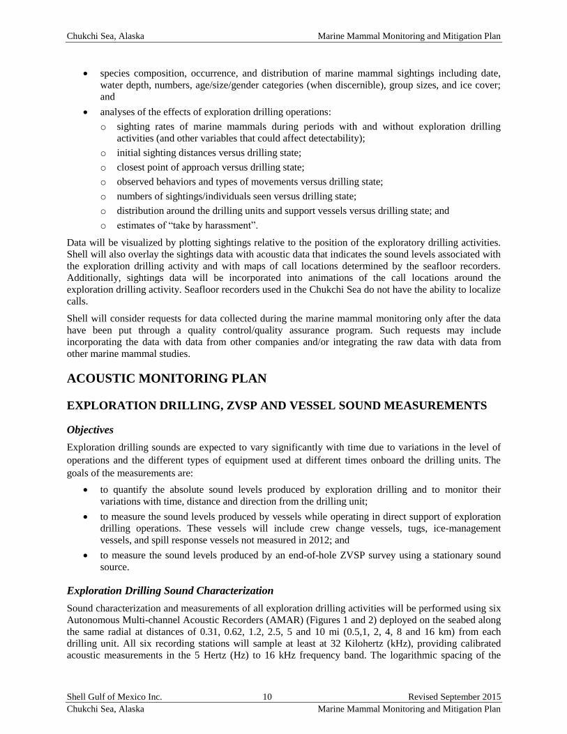
Sound characterization and measurements of all exploration drilling activities will be performed using six
Autonomous Multi-channel Acoustic Recorders (AMAR) (Figures 1 and 2) deployed on the seabed along
the same radial at distances of 0.31, 0.62, 1.2, 2.5, 5 and 10 mi (0.5,1, 2, 4, 8 and 16 km) from each
drilling unit. All six recording stations will sample at least at 32 Kilohertz (kHz), providing calibrated
acoustic measurements in the 5 Hertz (Hz) to 16 kHz frequency band. The logarithmic spacing of the
Chukchi Sea, Alaska Marine Mammal Monitoring and Mitigation Plan
Shell Gulf of Mexico Inc. 11 Revised September 2015
Chukchi Sea, Alaska Marine Mammal Monitoring and Mitigation Plan
recorders is designed to sample the attenuation of drilling unit sounds with distance. The autonomous
recorders will sample through completion of the first well, to provide a detailed record of sounds emitted
from all activities. These recorders will be retrieved and their data analyzed and reported in the project’s
90-day report.
FIGURE 1 GEOMETRY OF THE FIVE AMARS WILL SAMPLE SOUND PRODUCED BY EXPLORATION DRILLING
OPERATIONS FOR THE DRILLING UNITS DISCOVERER AND POLAR PIONEER
FIGURE 2 AMAR FOR ACOUSTIC MONITORING OF EXPLORATORY DRILLING ACTIVITIES
Chukchi Sea, Alaska Marine Mammal Monitoring and Mitigation Plan
Shell Gulf of Mexico Inc. 12 Revised September 2015
Chukchi Sea, Alaska Marine Mammal Monitoring and Mitigation Plan
The deployment of drilling sound monitoring equipment will occur before, or as soon as possible after the
Discoverer and the Polar Pioneer are on site. Activity logs of exploration drilling operations and nearby
vessel activities will be maintained to correlate with these acoustic measurements. All results, including
back-propagated source levels for each operation, will be reported in the 90-day report.
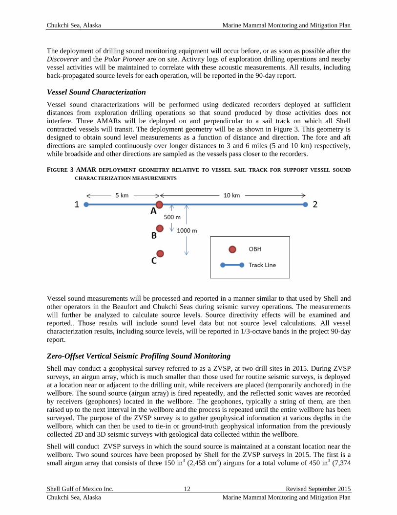
Vessel Sound Characterization
Vessel sound characterizations will be performed using dedicated recorders deployed at sufficient
distances from exploration drilling operations so that sound produced by those activities does not
interfere. Three AMARs will be deployed on and perpendicular to a sail track on which all Shell
contracted vessels will transit. The deployment geometry will be as shown in Figure 3. This geometry is
designed to obtain sound level measurements as a function of distance and direction. The fore and aft
directions are sampled continuously over longer distances to 3 and 6 miles (5 and 10 km) respectively,
while broadside and other directions are sampled as the vessels pass closer to the recorders.
FIGURE 3 AMAR DEPLOYMENT GEOMETRY RELATIVE TO VESSEL SAIL TRACK FOR SUPPORT VESSEL SOUND
CHARACTERIZATION MEASUREMENTS
Vessel sound measurements will be processed and reported in a manner similar to that used by Shell and
other operators in the Beaufort and Chukchi Seas during seismic survey operations. The measurements
will further be analyzed to calculate source levels. Source directivity effects will be examined and
reported.. Those results will include sound level data but not source level calculations. All vessel
characterization results, including source levels, will be reported in 1/3-octave bands in the project 90-day
report.
Zero-Offset Vertical Seismic Profiling Sound Monitoring
Shell may conduct a geophysical survey referred to as a ZVSP, at two drill sites in 2015. During ZVSP
surveys, an airgun array, which is much smaller than those used for routine seismic surveys, is deployed
at a location near or adjacent to the drilling unit, while receivers are placed (temporarily anchored) in the
wellbore. The sound source (airgun array) is fired repeatedly, and the reflected sonic waves are recorded
by receivers (geophones) located in the wellbore. The geophones, typically a string of them, are then
raised up to the next interval in the wellbore and the process is repeated until the entire wellbore has been
surveyed. The purpose of the ZVSP survey is to gather geophysical information at various depths in the
wellbore, which can then be used to tie-in or ground-truth geophysical information from the previously
collected 2D and 3D seismic surveys with geological data collected within the wellbore.
Shell will conduct ZVSP surveys in which the sound source is maintained at a constant location near the
wellbore. Two sound sources have been proposed by Shell for the ZVSP surveys in 2015. The first is a
small airgun array that consists of three 150 in3 (2,458 cm
3) airguns for a total volume of 450 in
3 (7,374
Chukchi Sea, Alaska Marine Mammal Monitoring and Mitigation Plan
Shell Gulf of Mexico Inc. 13 Revised September 2015
Chukchi Sea, Alaska Marine Mammal Monitoring and Mitigation Plan
cm3). The second ZVSP sound source consists of two 250 in
3 (4,097 cm
3) airguns with a total volume of
500 in3 (8,194 cm
3). Specifications of the arrays are provided in Table 2. A representative depiction of the
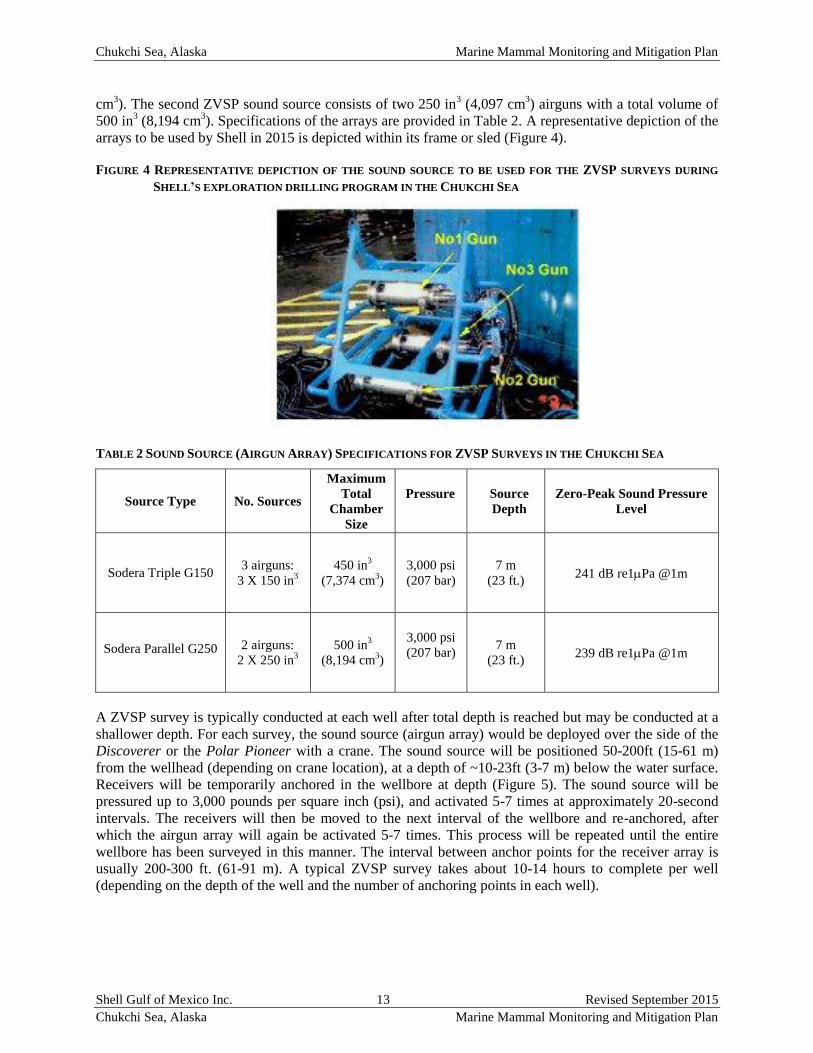
arrays to be used by Shell in 2015 is depicted within its frame or sled (Figure 4).
FIGURE 4 REPRESENTATIVE DEPICTION OF THE SOUND SOURCE TO BE USED FOR THE ZVSP SURVEYS DURING
SHELL’S EXPLORATION DRILLING PROGRAM IN THE CHUKCHI SEA
TABLE 2 SOUND SOURCE (AIRGUN ARRAY) SPECIFICATIONS FOR ZVSP SURVEYS IN THE CHUKCHI SEA
Source Type No. Sources
Maximum
Total
Chamber
Size
Pressure
Source
Depth
Zero-Peak Sound Pressure
Level
Sodera Triple G150 3 airguns:
3 X 150 in3
450 in3
(7,374 cm3)
3,000 psi
(207 bar)
7 m
(23 ft.) 241 dB re1Pa @1m
Sodera Parallel G250 2 airguns:
2 X 250 in3
500 in3
(8,194 cm3)
3,000 psi
(207 bar)
7 m
(23 ft.) 239 dB re1Pa @1m
A ZVSP survey is typically conducted at each well after total depth is reached but may be conducted at a
shallower depth. For each survey, the sound source (airgun array) would be deployed over the side of the
Discoverer or the Polar Pioneer with a crane. The sound source will be positioned 50-200ft (15-61 m)
from the wellhead (depending on crane location), at a depth of ~10-23ft (3-7 m) below the water surface.
Receivers will be temporarily anchored in the wellbore at depth (Figure 5). The sound source will be
pressured up to 3,000 pounds per square inch (psi), and activated 5-7 times at approximately 20-second
intervals. The receivers will then be moved to the next interval of the wellbore and re-anchored, after
which the airgun array will again be activated 5-7 times. This process will be repeated until the entire
wellbore has been surveyed in this manner. The interval between anchor points for the receiver array is
usually 200-300 ft. (61-91 m). A typical ZVSP survey takes about 10-14 hours to complete per well
(depending on the depth of the well and the number of anchoring points in each well).
Chukchi Sea, Alaska Marine Mammal Monitoring and Mitigation Plan
Shell Gulf of Mexico Inc. 14 Revised September 2015
Chukchi Sea, Alaska Marine Mammal Monitoring and Mitigation Plan
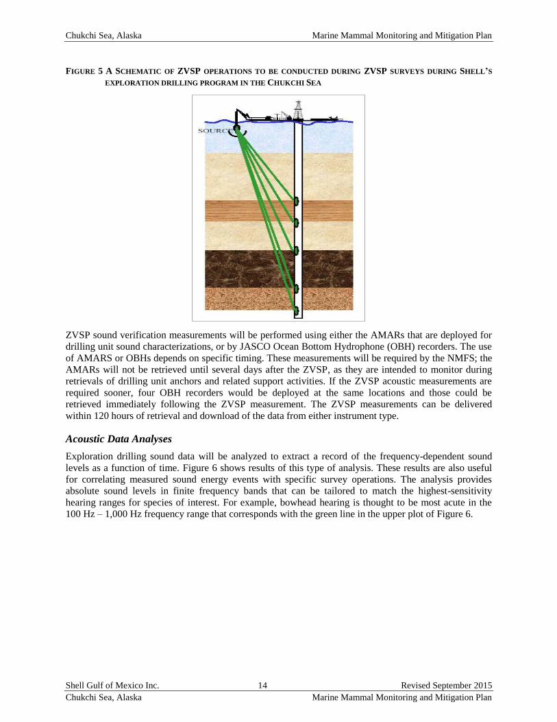
FIGURE 5 A SCHEMATIC OF ZVSP OPERATIONS TO BE CONDUCTED DURING ZVSP SURVEYS DURING SHELL’S
EXPLORATION DRILLING PROGRAM IN THE CHUKCHI SEA
ZVSP sound verification measurements will be performed using either the AMARs that are deployed for
drilling unit sound characterizations, or by JASCO Ocean Bottom Hydrophone (OBH) recorders. The use
of AMARS or OBHs depends on specific timing. These measurements will be required by the NMFS; the
AMARs will not be retrieved until several days after the ZVSP, as they are intended to monitor during
retrievals of drilling unit anchors and related support activities. If the ZVSP acoustic measurements are
required sooner, four OBH recorders would be deployed at the same locations and those could be
retrieved immediately following the ZVSP measurement. The ZVSP measurements can be delivered
within 120 hours of retrieval and download of the data from either instrument type.
Acoustic Data Analyses
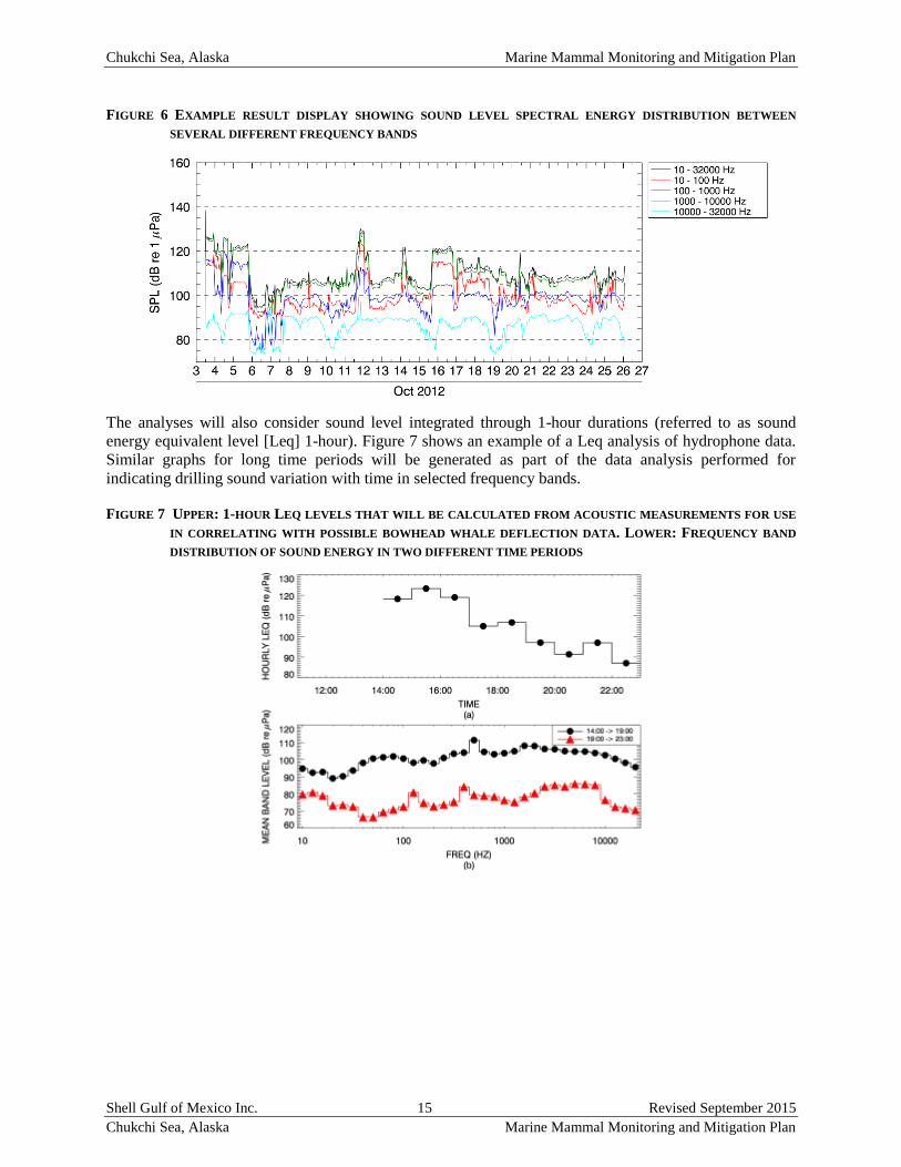
Exploration drilling sound data will be analyzed to extract a record of the frequency-dependent sound
levels as a function of time. Figure 6 shows results of this type of analysis. These results are also useful
for correlating measured sound energy events with specific survey operations. The analysis provides
absolute sound levels in finite frequency bands that can be tailored to match the highest-sensitivity
hearing ranges for species of interest. For example, bowhead hearing is thought to be most acute in the
100 Hz – 1,000 Hz frequency range that corresponds with the green line in the upper plot of Figure 6.
Chukchi Sea, Alaska Marine Mammal Monitoring and Mitigation Plan
Shell Gulf of Mexico Inc. 15 Revised September 2015
Chukchi Sea, Alaska Marine Mammal Monitoring and Mitigation Plan
FIGURE 6 EXAMPLE RESULT DISPLAY SHOWING SOUND LEVEL SPECTRAL ENERGY DISTRIBUTION BETWEEN
SEVERAL DIFFERENT FREQUENCY BANDS
The analyses will also consider sound level integrated through 1-hour durations (referred to as sound
energy equivalent level [Leq] 1-hour). Figure 7 shows an example of a Leq analysis of hydrophone data.
Similar graphs for long time periods will be generated as part of the data analysis performed for
indicating drilling sound variation with time in selected frequency bands.
FIGURE 7 UPPER: 1-HOUR LEQ LEVELS THAT WILL BE CALCULATED FROM ACOUSTIC MEASUREMENTS FOR USE
IN CORRELATING WITH POSSIBLE BOWHEAD WHALE DEFLECTION DATA. LOWER: FREQUENCY BAND
DISTRIBUTION OF SOUND ENERGY IN TWO DIFFERENT TIME PERIODS
Chukchi Sea, Alaska Marine Mammal Monitoring and Mitigation Plan
Shell Gulf of Mexico Inc. 16 Revised September 2015
Chukchi Sea, Alaska Marine Mammal Monitoring and Mitigation Plan
Reporting of Results
Acoustic sound level results will be reported in the 90-day and comprehensive reports for this program.
The reports will include:
sound source levels for the drilling units and all drilling support vessels;
spectrogram and band level versus time plots computed from the continuous recordings obtained
from the hydrophone systems;
hourly Leq levels at the hydrophone locations; and
correlation of exploration drilling source levels with the type of exploration drilling operation
being performed. These results will be obtained by observing differences in drilling sound
associated with differences in drilling unit activities as indicated in detailed drilling unit logs.
ACOUSTIC “NET” ARRAY IN CHUKCHI SEA
Background and Objectives
This section describes acoustic studies that were undertaken from 2006 through 2013 in the Chukchi Sea
as part of the Joint Monitoring Program and that will be continued by Shell during exploration drilling
activities. The acoustic “net” array used during the 2006–2013 field seasons in the Chukchi Sea was
designed to accomplish two main objectives. The first was to collect information on the occurrence and
distribution of marine mammals (including beluga whale, bowhead whale, walrus and other species) that
may be available to subsistence hunters near villages along the Chukchi Sea coast and to document their
relative abundance, habitat use, and migratory patterns. The second objective was to measure the ambient
soundscape throughout the eastern Chukchi Sea and to record received levels of sounds from industry and
other activities further offshore in the Chukchi Sea.
Technical Approach
A net array configuration similar to that deployed in 2007–2013 is again proposed. The basic components
of this effort consist of autonomous acoustic recorders deployed widely across the U.S. Chukchi Sea
during the open water season and then more limited arrays during the winter season. These calibrated
systems sample at 16 kHz with 24-bit resolution, and are capable of recording marine mammal sounds
and making anthropogenic noise measurements. The net array configuration will include a regional array
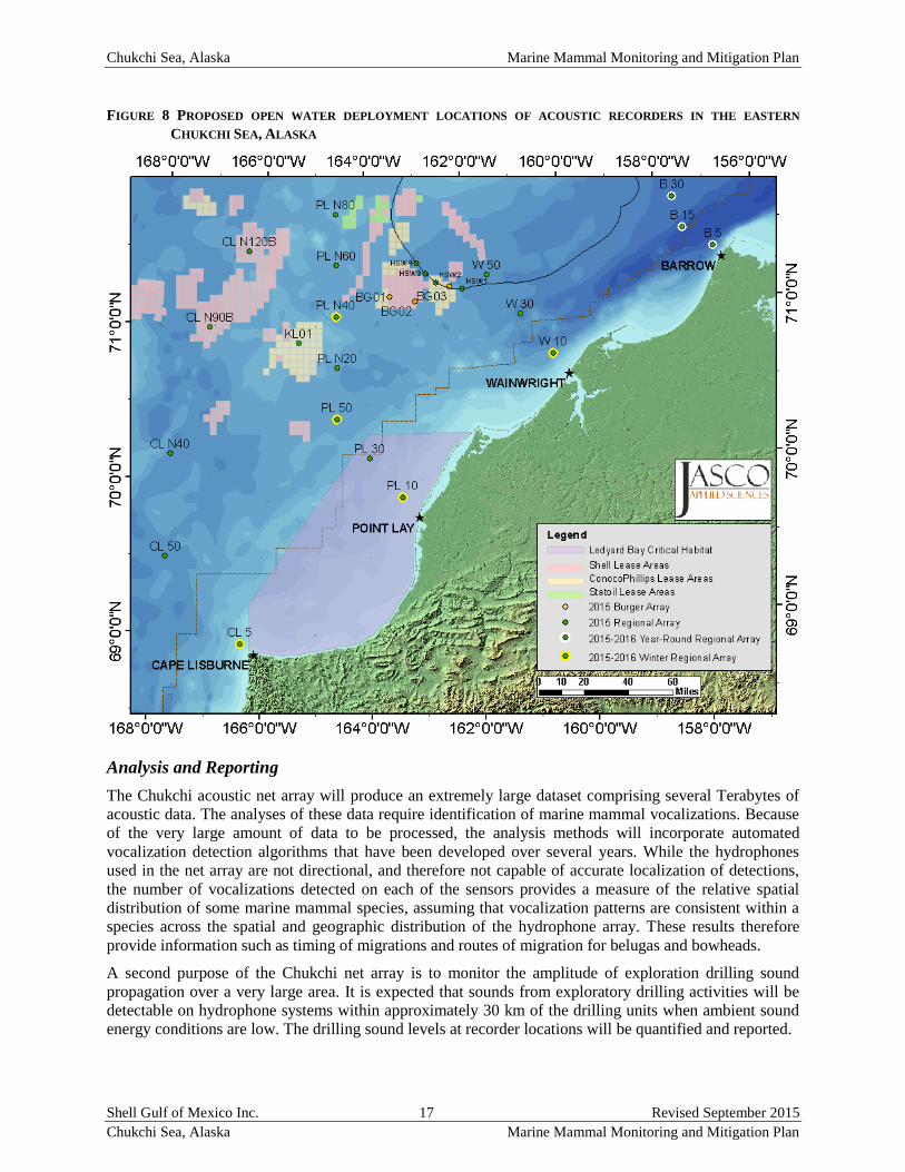
of 23 AMARs deployed July–October off the four main transect locations: Cape Lisburne, Point Lay,
Wainwright and Barrow as shown in Figure 8. The Wainwright line will not include recorder through the
HSWUA as it has over the previous seven years, due to time-area restrictions on entering the HSWUA
imposed by the USFWS. All of these offshore systems will capture sounds associated with exploration
drilling, where present, over large distances to help characterize the sound transmission properties in the
Chukchi Sea. Three additional summer AMARs will be deployed around the Burger drill sites to monitor
directional variations and longer-range propagation of drilling-related sounds. These recorders will also
be used to examine marine mammal vocalization patterns in vicinity of exploration drilling activities. The
regional recorders will be retrieved in early October 2015; acoustic monitoring will continue through the
winter with 5 AMARs deployed October 2015–August 2016 at the yellow-highlighted locations in Figure
8 and 3 year-round (August 2015–August 2016) recorders deployed off Barrow at the white-highlighted
locations in Figure 8. The winter recorders will sample at 16 kHz on a 17% duty cycle (40 minutes every
4 hours). The winter recorders deployed in previous years have provided important information about fall
and spring migrations of bowhead, beluga, walrus and several seal species.
Chukchi Sea, Alaska Marine Mammal Monitoring and Mitigation Plan
Shell Gulf of Mexico Inc. 17 Revised September 2015
Chukchi Sea, Alaska Marine Mammal Monitoring and Mitigation Plan
FIGURE 8 PROPOSED OPEN WATER DEPLOYMENT LOCATIONS OF ACOUSTIC RECORDERS IN THE EASTERN
CHUKCHI SEA, ALASKA
Analysis and Reporting
The Chukchi acoustic net array will produce an extremely large dataset comprising several Terabytes of
acoustic data. The analyses of these data require identification of marine mammal vocalizations. Because
of the very large amount of data to be processed, the analysis methods will incorporate automated
vocalization detection algorithms that have been developed over several years. While the hydrophones
used in the net array are not directional, and therefore not capable of accurate localization of detections,
the number of vocalizations detected on each of the sensors provides a measure of the relative spatial
distribution of some marine mammal species, assuming that vocalization patterns are consistent within a
species across the spatial and geographic distribution of the hydrophone array. These results therefore
provide information such as timing of migrations and routes of migration for belugas and bowheads.
A second purpose of the Chukchi net array is to monitor the amplitude of exploration drilling sound
propagation over a very large area. It is expected that sounds from exploratory drilling activities will be
detectable on hydrophone systems within approximately 30 km of the drilling units when ambient sound
energy conditions are low. The drilling sound levels at recorder locations will be quantified and reported.
Chukchi Sea, Alaska Marine Mammal Monitoring and Mitigation Plan
Shell Gulf of Mexico Inc. 18 Revised September 2015
Chukchi Sea, Alaska Marine Mammal Monitoring and Mitigation Plan
Analysis of all acoustic data will be prioritized to address the primary questions. The primary data
analysis questions are to (a) determine when, where, and what species of animals are acoustically detected
on each recorder (b) analyze data as a whole to determine offshore distributions as a function of time, (c)
quantify spatial and temporal variability in the ambient sound energy, and (d) measure received levels of
exploration drilling survey events and drilling unit activities. The detection data will be used to develop
spatial and temporal animal detection distributions. Statistical analyses will be used to test for changes in
animal detections and distributions as a function of different variables (e.g., time of day, season,
environmental conditions, and ambient sound energy, and drilling or vessel sound levels).
CHUKCHI OFFSHORE AERIAL PHOTOGRAPHIC MONITORING
PROGRAM
Shell has been reticent to conduct manned aerial surveys in the offshore Chukchi Sea because conducting
those surveys puts people at risk. There is a strong desire; however, to obtain data on marine mammal
distribution in the offshore Chukchi Sea and Shell will conduct an offshore aerial wildlife monitoring
photographic survey that would put fewer people at risk as an alternative to the fully-manned aerial
survey. The photographic survey would reduce the number of people on board the aircraft from six
persons to two persons (the pilot and copilot) and would serve as a pilot study for future surveys that
would use an Unmanned Aerial System (UAS) to capture the imagery. Successful aerial surveys with
only pilots and camera systems were conducted over drilling locations in the Chukchi Sea in 2012.
Aerial photographic surveys have been used to monitor distribution and estimate densities of marine
mammals in offshore areas since the mid-1980s, and before that, were used to estimate numbers of
animals in large concentration areas. For example, Koski and Davis (1980), Koski et al. (2002) and
Richard et al. (1990) used aerial photography to provide more precise estimates of numbers of belugas in
concentration areas during aerial surveys of Lancaster Sound and Hudson Bay, respectively. Later
Richard et al. (1994), Witting et al. (2005) and Heide-Jørgensen et al. (2010) used aerial photography to
estimate numbers and densities of narwhals and minke whales in their survey areas.
Digital photographs provide many advantages over observations made by people if the imagery has
sufficient resolution (Koski et al. 2013). With photographs there is constant detectability across the
imagery, whereas observations by people decline with distance from the center line of the survey area.
Observations at the outer limits of the transect can decline to 5-10% of the animals present for real-time
observations by people during an aerial survey. The distance from the trackline of sightings is more
accurately determined from photographs; group size can be more accurately determined; and sizes of
animals can be measured, and hence much more accurately determined, in photographs. As a result of the
latter capability, the presence or absence of a calf can be more accurately determined from a photograph
than by in-the-moment visual observations. Another benefit of photographs over visual observations is
that photographs can be reviewed by more than one independent observer allowing quantification of
detection, identification and group size biases.
During the 2012 field season Shell successfully conducted photographic surveys using two Nikon D800
cameras obliquely mounted in a Twin Otter to record marine mammals around their drill sites in the
Chukchi Sea. In addition, a HD video camera was tested and compared to the still camera for evaluation
as a tool for real-time monitoring during future studies. Shell plans to use an Aero Commander aircraft,
with similar Nikon cameras mounted in the airplane. If there is enough room, we will also mount a third
vertically-mounted DSLR camera with a longer lens. The longer lens will give higher resolution imagery
and will help us understand if we are missing seals and may allow us to identify many of the unidentified
small pinnipeds detected during the 2012 study.
The proposed photographic survey will provide imagery that can be used to evaluate the ability of future
studies to use the same image capturing systems in an UAS where people would not be put at risk.
Although the two platforms are not the same, the slower airspeed and potentially lower flight altitude of
Chukchi Sea, Alaska Marine Mammal Monitoring and Mitigation Plan
Shell Gulf of Mexico Inc. 19 Revised September 2015
Chukchi Sea, Alaska Marine Mammal Monitoring and Mitigation Plan
the UAS would mean that the data quality would be better from the UAS. Initial comparisons have been
made between data collected by human observers on board both the Chukchi and Beaufort aerial survey
aircraft and the digital imagery collected in 2012. Overall, the imagery provided better estimates of the
number of large cetaceans and pinnipeds present but fewer sightings were identified to species in the
imagery than by PSOs, because the PSOs had sightings in view for a longer period of time and could use
behavior to differentiate species. The comparisons indicated that some cetaceans that were not seen by
PSOs were detected in the imagery; errors in identification were made by the PSOs during the survey that
could be resolved from examination of the imagery; cetaceans seen by PSOs were visible in the imagery;
and during periods with large numbers of sightings, the imagery provided much better estimates of
numbers of sightings and group size than the PSO data.
Camera Specifications
The cameras that we will use are Nikon D800s, or similar, which are 36.3 megapixel cameras that store
imagery in 7,360×4,912 pixel arrays. The aircraft will be flown at 1,000 or 1,500 ft. above sea level and
the cameras will be triggered to provide 50% overlap with adjacent photos and 100% overlap among all
imagery. Actual trigger timing will depend on the survey speed and altitude of the aircraft but would be
about every three (when at 1,000 ft.) or five seconds (when at 1,500 ft.). The cameras will have 21 mm
f/2.8mm Zeiss lenses, which will each cover a swath ~720 or ~1000 m on the water surface with one pixel
representing a 6–9 centimeters (cm) square at the water surface on the trackline and about 31 or 46 cm at
the outer edge of the frame. Thus, the lenses are optimized for a 1,000 ft. flight altitude as this will
provide higher resolution images. The cameras will be mounted such that one DSLR points 25° to the
right and one 25° to the left side of the trackline, with the inner edge of both cameras’ field of view
overlapping about 67 or 100 m on either side of the centerline. These pixel sizes on the trackline are one
seventeenth or one eighth of the pixel size (25 cm square) tested by Koski et al. (2009) during their tests
with a video camera for detection of kayaks and is a smaller pixel size (better resolution) on the trackline
than was tested by Amanda Hodgson (16.8 cm) during her surveys of humpback whales off Australia and
which proved adequate for counting humpback whales in their imagery.
This camera configuration was used successfully in 2012 during surveys at both 1,000 and 1,500 ft. and
the resolution permitted detection and identification of all medium and large cetaceans seen by PSOs on
the manned aircraft. Further, it also permitted counting of walrus/bearded seals (Koski et al 2013) and
some unknown fraction of small pinnipeds. The resolution does not always permit differentiation of
bearded seals from walrus, especially when they are in the water. This imagery resolution provides
slightly better ability for determining species and detecting animals than people would have in an aircraft
flying at 1,000 ft. above sea level and more pinnipeds were sighted during the review of the imagery than
PSOs saw in the same swath during the survey.
Route planning and data storage software are off-the-shelf products. The set up includes a harness to
connect the camera and GPS to the Photo Coupler Controller which is connected to a GPS for triggering
capture of images and recording of metadata for each image. The system can be powered by 10–32 volt
DC or a custom power source and has a back-up battery power source to prevent interruption to data
capture. Data will be stored on a memory card in the camera and camera settings will be set before the
survey with shutter speed priority to ensure that motion blur is minimized. The system is “plug-and-play”
and does not require input from persons on board the aircraft during the flight. The system can be pre-
programmed to take photographs starting and stopping at predetermined times.
Chukchi Sea, Alaska Marine Mammal Monitoring and Mitigation Plan
Shell Gulf of Mexico Inc. 20 Revised September 2015
Chukchi Sea, Alaska Marine Mammal Monitoring and Mitigation Plan
Survey Timing and Frequency
Offshore aerial wildlife monitoring photographic surveys would start as soon as the ice management,
anchor handler and drilling units are at or near the first drill site and would continue throughout the
drilling period and until the drilling related vessels have left the exploration drilling area. If in the event
vessels enter the Chukchi Sea on or about 1 July, surveys would be initiated on or about 3 July or possibly
sooner. This start date differs from past practices of beginning five days prior to initiation of an activity
and continuing until five days after cessation of the activity because the presence of vessels with
helidecks in the area where overflights will occur is one of the main mitigations that will allow for safe
operation of the overflight program this far offshore. The surveys will be based out of Barrow and the
same aircraft will conduct the offshore surveys around the drilling units and the coastal saw-tooth pattern.
Photographic surveys will be flown daily, weather permitting, throughout the drilling program. The
offshore survey transects over the drilling area will be the default priority each day, as opposed to the
nearshore/coastal pattern discussed below. The nearshore/coastal survey pattern will be flown only in
instances when conditions offshore are not conducive for flying and coastal conditions would, however,
support an overflight. There also may be isolated instances during the season when the near shore coastal
survey would be identified as the priority due to a unique biological or operational scenario (e.g., walrus
aggregations).
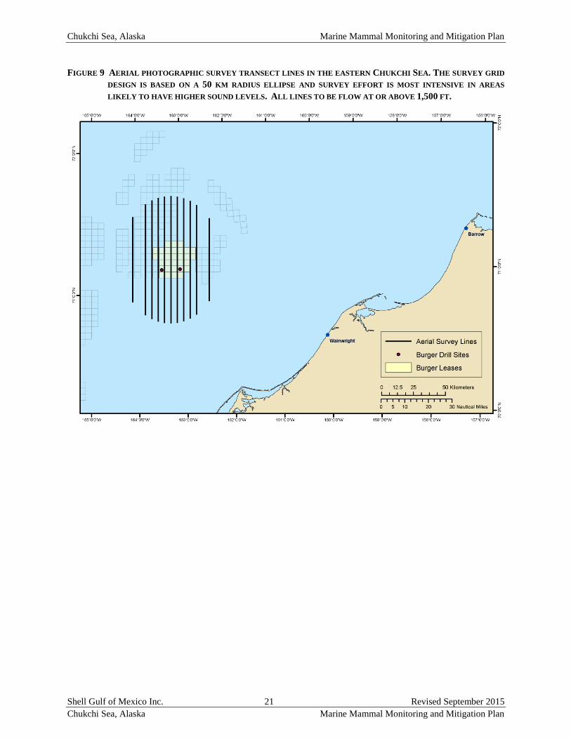
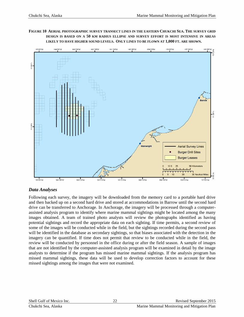
Survey Pattern
The aerial survey grids are designed to maximize coverage of the sound level fields of the drilling units
during the different exploratory drilling activities. The survey grids can be modified as necessary based
on weather and aircraft endurance. The transect lines are spaced 5 km apart in the center of the survey
area to maximizes the effort over the area where sound levels are expected to be highest and animal
densities are likely to be lowest (Figure 9). The perimeter of the survey area is elliptical with a 50 km
radius on the long axis of the ellipse (north-south orientation) and 40 km on the minor axis (east-west
orientation). The two outer survey lines are spaced 10 km apart. Due to regulatory restrictions imposed
by USFWS restricting flying at less than 1,500 feet over the HSWUA through September 30th, the entire
survey pattern can only be flown if the flight altitude is 1,500 ft. or higher. Since the camera lenses are
optimized for detecting wildlife from a 1,000 ft. flight altitude and a greater number of flights will likely
be successful due to flying under low clouds, the survey area may be reduced to cover only the area where
1,000 ft. flight altitudes are permitted without restriction (Figure 10). The transect lines will be
randomized for each survey by shifting all lines 0.1–2.5 km east or west. The total length of survey lines
will be about 1,000 km and the exact length will depend on the location of the randomly selected start
point.
Chukchi Sea, Alaska Marine Mammal Monitoring and Mitigation Plan
Shell Gulf of Mexico Inc. 21 Revised September 2015
Chukchi Sea, Alaska Marine Mammal Monitoring and Mitigation Plan
FIGURE 9 AERIAL PHOTOGRAPHIC SURVEY TRANSECT LINES IN THE EASTERN CHUKCHI SEA. THE SURVEY GRID
DESIGN IS BASED ON A 50 KM RADIUS ELLIPSE AND SURVEY EFFORT IS MOST INTENSIVE IN AREAS
LIKELY TO HAVE HIGHER SOUND LEVELS. ALL LINES TO BE FLOW AT OR ABOVE 1,500 FT.
Chukchi Sea, Alaska Marine Mammal Monitoring and Mitigation Plan
Shell Gulf of Mexico Inc. 22 Revised September 2015
Chukchi Sea, Alaska Marine Mammal Monitoring and Mitigation Plan
FIGURE 10 AERIAL PHOTOGRAPHIC SURVEY TRANSECT LINES IN THE EASTERN CHUKCHI SEA. THE SURVEY GRID
DESIGN IS BASED ON A 50 KM RADIUS ELLIPSE AND SURVEY EFFORT IS MOST INTENSIVE IN AREAS
LIKELY TO HAVE HIGHER SOUND LEVELS. ONLY LINES TO BE FLOWN AT 1,000 FT. ARE SHOWN.
Data Analyses
Following each survey, the imagery will be downloaded from the memory card to a portable hard drive
and then backed up on a second hard drive and stored at accommodations in Barrow until the second hard
drive can be transferred to Anchorage. In Anchorage, the imagery will be processed through a computer-
assisted analysis program to identify where marine mammal sightings might be located among the many
images obtained. A team of trained photo analysts will review the photographs identified as having
potential sightings and record the appropriate data on each sighting. If time permits, a second review of
some of the images will be conducted while in the field, but the sightings recorded during the second pass
will be identified in the database as secondary sightings, so that biases associated with the detection in the
imagery can be quantified. If time does not permit that review to be conducted while in the field, the
review will be conducted by personnel in the office during or after the field season. A sample of images
that are not identified by the computer-assisted analysis program will be examined in detail by the image
analysts to determine if the program has missed marine mammal sightings. If the analysis program has
missed mammal sightings, these data will be used to develop correction factors to account for these
missed sightings among the images that were not examined.
Chukchi Sea, Alaska Marine Mammal Monitoring and Mitigation Plan
Shell Gulf of Mexico Inc. 23 Revised September 2015
Chukchi Sea, Alaska Marine Mammal Monitoring and Mitigation Plan
Other Imagery and Sensors
In addition to the imagery indicated above, Shell is examining systems that are in development that would
allow collection of additional imagery. They include collection of multi-spectral/hyperspectral imagery,
infrared sensors, and a multi-camera system that would allow collection of imagery over a wider area. If
these systems are ready for testing in 2015, Shell will consider incorporating these systems into the
Chukchi Sea program.
CHUKCHI SEA COASTAL AERIAL SURVEY
Nearshore aerial surveys of marine mammals in the Chukchi Sea were conducted over coastal areas to
approximately 23 miles (mi) (37 km) offshore in 2006–2008 and in 2010 in support of Shell’s summer
seismic exploration activities. In 2012, these surveys were flown when it was not possible to fly the
photographic transects out over the Burger well site due to weather or rescue craft availability. These
surveys provided data on the distribution and abundance of marine mammals in nearshore waters of the
Chukchi Sea. Shell plans to conduct these nearshore aerial surveys in the Chukchi Sea as opportunities
unfold and surveys will be similar to those conducted during previous years except that no PSOs will be
onboard the aircraft. As noted above, the first priority will be to conduct photographic surveys around the
offshore exploration drilling activities each day conditions allow, but nearshore surveys will be conducted
whenever weather does not permit flying offshore. As in past years, surveys in the southern part of the
nearshore survey area will depend on the end of the beluga hunt near Point Lay. In past years, Point Lay
has requested that aerial surveys not be conducted until after the beluga hunt has ended and so the start of
surveys has been delayed until mid-July.
Alaskan Natives from villages along the east coast of the Chukchi Sea hunt marine mammals during the
summer and Native communities are concerned that offshore oil and gas exploration activities may
negatively impact their ability to harvest marine mammals. Of particular concern are potential impacts on
the beluga harvest at Point Lay and on future bowhead harvests at Point Hope, Point Lay, Wainwright and
Barrow. Other species of concern in the Chukchi Sea include the gray whale; bearded, ringed, and spotted
seals; and walrus. Gray whale and harbor porpoise are expected to be the most numerous cetacean species
encountered during the proposed aerial survey; although harbor porpoise are abundant they are difficult to
detect from aircraft because of their small size and brief surfacing. Beluga whales may occur in high
numbers early in the season. The ringed seal is likely to be the most abundant of the pinniped species. The
current aerial survey program will be designed to collect distribution data on cetaceans but will be limited
in its ability to collect similar data on pinnipeds and harbor porpoises because they are not reliably
detectable during review of the collected images unless a third camera with a 50 mm or similar lens is
deployed.
Objectives
The aerial survey program objectives will be:
to collect data on the distribution and abundance of marine mammals in coastal areas of the
eastern Chukchi Sea;
to collect and report data on the distribution, numbers, orientation and behavior of marine
mammals, particularly beluga whales, near traditional hunting areas in the eastern Chukchi Sea;
and
to collect marine mammal sighting data using digital media.
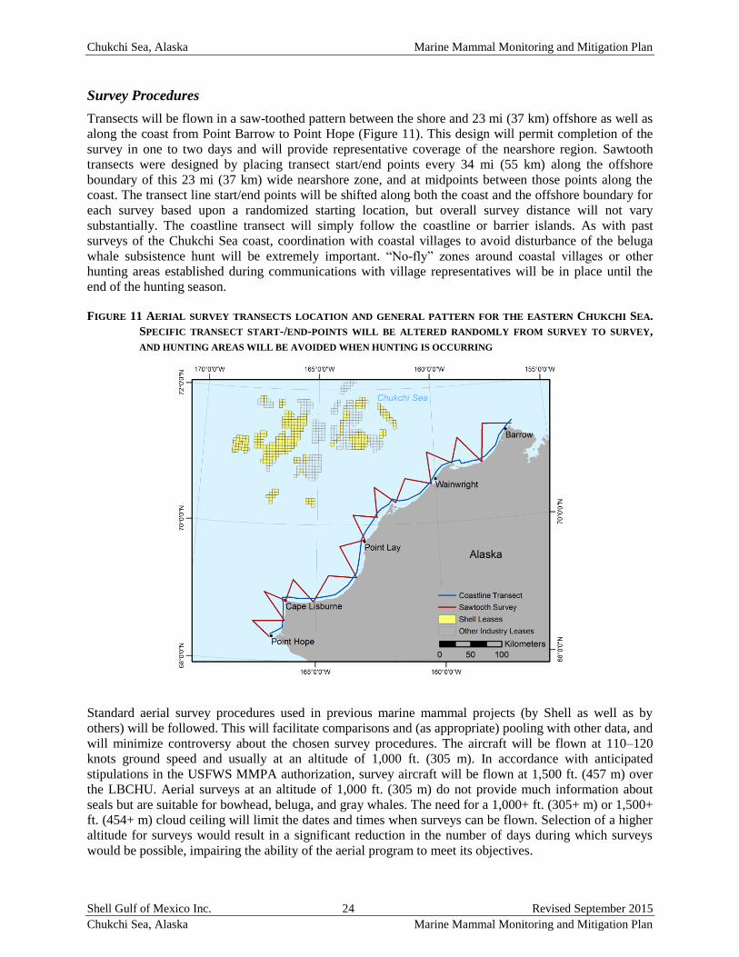
Chukchi Sea, Alaska Marine Mammal Monitoring and Mitigation Plan
Shell Gulf of Mexico Inc. 24 Revised September 2015
Chukchi Sea, Alaska Marine Mammal Monitoring and Mitigation Plan
Survey Procedures
Transects will be flown in a saw-toothed pattern between the shore and 23 mi (37 km) offshore as well as
along the coast from Point Barrow to Point Hope (Figure 11). This design will permit completion of the
survey in one to two days and will provide representative coverage of the nearshore region. Sawtooth
transects were designed by placing transect start/end points every 34 mi (55 km) along the offshore
boundary of this 23 mi (37 km) wide nearshore zone, and at midpoints between those points along the
coast. The transect line start/end points will be shifted along both the coast and the offshore boundary for
each survey based upon a randomized starting location, but overall survey distance will not vary
substantially. The coastline transect will simply follow the coastline or barrier islands. As with past
surveys of the Chukchi Sea coast, coordination with coastal villages to avoid disturbance of the beluga
whale subsistence hunt will be extremely important. “No-fly” zones around coastal villages or other
hunting areas established during communications with village representatives will be in place until the
end of the hunting season.
FIGURE 11 AERIAL SURVEY TRANSECTS LOCATION AND GENERAL PATTERN FOR THE EASTERN CHUKCHI SEA.
SPECIFIC TRANSECT START-/END-POINTS WILL BE ALTERED RANDOMLY FROM SURVEY TO SURVEY,
AND HUNTING AREAS WILL BE AVOIDED WHEN HUNTING IS OCCURRING
Standard aerial survey procedures used in previous marine mammal projects (by Shell as well as by
others) will be followed. This will facilitate comparisons and (as appropriate) pooling with other data, and
will minimize controversy about the chosen survey procedures. The aircraft will be flown at 110–120
knots ground speed and usually at an altitude of 1,000 ft. (305 m). In accordance with anticipated
stipulations in the USFWS MMPA authorization, survey aircraft will be flown at 1,500 ft. (457 m) over
the LBCHU. Aerial surveys at an altitude of 1,000 ft. (305 m) do not provide much information about
seals but are suitable for bowhead, beluga, and gray whales. The need for a 1,000+ ft. (305+ m) or 1,500+
ft. (454+ m) cloud ceiling will limit the dates and times when surveys can be flown. Selection of a higher
altitude for surveys would result in a significant reduction in the number of days during which surveys
would be possible, impairing the ability of the aerial program to meet its objectives.
Chukchi Sea, Alaska Marine Mammal Monitoring and Mitigation Plan
Shell Gulf of Mexico Inc. 25 Revised September 2015
Chukchi Sea, Alaska Marine Mammal Monitoring and Mitigation Plan
The surveyed area will include waters where belugas are usually available to subsistence hunters. If large
concentrations of belugas are encountered during the survey, the aircraft will climb to ~10,000 ft. (3,050
m) altitude to avoid disturbing the cetaceans. If cetaceans are in offshore areas, the aircraft will climb
high enough to include all cetaceans within a single photograph; typically about 3,000 ft. (914 m) altitude.
When in shallow water, belugas and other marine mammals are more sensitive to aircraft over flights and
other forms of disturbance than when they are offshore (see Richardson et al. 1995 for a review). They
frequently leave shallow estuaries when over flown at altitudes of 2,000–3,000 ft. (610-904 m); whereas
they rarely react to aircraft at 1,500 ft. (457 m) when offshore in deeper water. Additionally, if large
groups of other marine mammals are encountered on the surveys, such as the large aggregations of
walruses seen in 2007 and 2010, Shell will attempt to photograph the animals and provide location
information to interested stakeholders.
Coordination with Other Aerial Surveys
The BOEM, the NMFS, the USFWS, the North Slope Borough (NSB), or other organizations may also
conduct aerial surveys in the Chukchi Sea during the exploration drilling season. Shell will consult with
any groups or organizations conducting aerial surveys along the eastern Chukchi Sea coast regarding
coordination during the exploration drilling season. The objectives will be:
to ensure aircraft separation when both crews conduct surveys in the same general region;
to coordinate the aerial survey projects in order to maximize consistency and minimize
duplication; and
to maximize consistency with previous years’ efforts in so far as feasible.
Chukchi Sea, Alaska Marine Mammal Monitoring and Mitigation Plan
Shell Gulf of Mexico Inc. 26 Revised September 2015
Chukchi Sea, Alaska Marine Mammal Monitoring and Mitigation Plan
LITERATURE CITED
Bisson, L.N., H.J. Reider, H.M. Patterson, M. Austin, J.R. Brandon, T. Thomas, and M.L. Bourdon. 2013.
Marine mammal monitoring and mitigation during exploratory drilling by Shell in the Alaskan
Chukchi and Beaufort seas, July–November 2012: Draft 90-Day Report. Editors: D.W. Funk,
C.M. Reiser, and W.R. Koski. LGL Rep. P1272D–1. Rep. from LGL Alaska Research
Associates Inc., Anchorage, AK, USA, and JASCO Applied Sciences, Victoria, BC, Canada,
for Shell Offshore Inc., Houston, TX, USA, Nat. Mar. Fish. Serv., Silver Spring, MD, USA,
and U.S. Fish and Wild. Serv., Anchorage, AK, USA. 266 pp, plus appendices.
Gales, R.S., 1982. Effects of Noise of Offshore Oil and Gas Operations on Marine Mammals-An
Introductory Assessment. Volume 2 (No. NOSC/TR-844-VOL-2). Department of Interior
Bureau of Land Management.
Green, C.R., 1986. Underwater Sounds from the Submersible Drill Rig SEDCO 708 Drilling in the
Aleutian Islands (working paper), American Petroleum Institute. 120p.
Harris, R.E., G.W. Miller, R.E. Elliott and W.J. Richardson. 1997. Seals [1996]. p. 4-1 to 4-42 In: W.J.
Richardson (ed.), Northstar marine mammal monitoring program, 1996: marine mammal and
acoustical monitoring of a seismic program in the Alaskan Beaufort Sea. LGL Rep. 2121-2.
Rep. from LGL Ltd., King City, Ont., and Greeneridge Sciences Inc., Santa Barbara, CA, for
BP Explore. (Alaska) Inc., Anchorage, AK, and Nat. Mar. Fish. Serv., Anchorage, AK, and
Silver Spring, MD. 245 p.
Harris, R.E., A.N. Balla-Holden, S.A. MacLean and W.J. Richardson. 1998. Seals [1997]. p. 4-1 to 4-54
In: W.J. Richardson (ed.), Marine mammal and acoustical monitoring of BP Exploration
(Alaska's) open-water seismic program in the Alaskan Beaufort Sea, 1997. LGL Rep.
TA2150-3. Rep. from LGL Ltd., King City, Ont., and Greeneridge Sciences Inc., Santa
Barbara, CA, for BP Explore. (Alaska) Inc., Anchorage, AK, and U.S. National Marine
Fisheries. Service, Anchorage, AK, and Silver Spring, MD, 318 pp.
Hartin K.G., L.N. Bisson, S.A. Case, D.S. Ireland, and D. Hannay. (eds.) 2011. Marine mammal
monitoring and mitigation during site clearance and geotechnical surveys by Statoil USA E&P
Inc. in the Chukchi Sea, August–October 2011: 90-day report. LGL Rep. P1193. Rep. from
LGL Alaska Research Associates Inc., LGL Ltd., and JASCO Research Ltd. for Statoil USA
E&P Inc., National Marine Fisheries Service, and U.S. Fish and Wildlife Service, 202 pp, plus
appendices.
Heide-Jørgensen, M.P., L. Witting, K.L., Laidre, R.G., Hansen and M. Rasmussen. 2010. Fully corrected
estimates of common minke whale abundance in West Greenland in 2007. J. Cetacean Res.
Manage. 11(2):75-82.
JASCO Applied Sciences, Inc. and Greeneridge Sciences, Inc. 2014. Description of offshore industry
activities and monitoring in 2012. (Chapter 3) In: LGL Alaska Research Associates, Inc.,
JASCO Applied Sciences, Inc., and Greeneridge Sciences, Inc. 2014. Joint Monitoring
Program in the Chukchi and Beaufort Seas, 2012. LGL Alaska Final Report P1272-2 for
Shell Offshore, Inc. ION Geophysical, Inc., and Other Industry Contributors, National Marine
Fisheries Service, and U.S. Fish and Wildlife Service. 320 p. plus Appendices.
Koski, W.R., R.A. Davis. 1980. Studies of the late summer distribution and fall migration of marine
mammals in NW Baffin Bay and E Lancaster Sound, 1979. Rep. from LGL Ltd., Toronto,
Ont., for Petro-Canada Expl., Calgary, Alb. 214 p.
Koski, W.R., R.A. Davis, and K.J Finley. 2002. Distribution and abundance of eastern Canadian Arctic
belugas. Page 87-126. In: Ø. Wigg and M.P., Heidi-Jørgensen, (eds). Belugas and Narwhals.
NAMMCO Sci. Publ. No. 4.
Chukchi Sea, Alaska Marine Mammal Monitoring and Mitigation Plan
Shell Gulf of Mexico Inc. 27 Revised September 2015
Chukchi Sea, Alaska Marine Mammal Monitoring and Mitigation Plan
Koski, W.R., T. Allen, D. Ireland, G. Buck, P.R. Smith, A.M. Macrander, C. Rushing, D.J. Sliwa, and
T.L. McDonald. 2009. Evaluation of an unmanned airborne system for monitoring marine
mammals. Aquat. Mammals 35(3):347-357.
Koski, W. R., T. A. Thomas, D. W. Funk, and A. M. Macrander. 2013. Marine mammal sightings by
analysts of digital imagery vs. aerial surveyors: a preliminary comparison. Journal of
Unmanned Vehicles (in press).
McCauley, R.D. 1998. Radiated Underwater Noise Measured from the Drilling Rig Ocean General, Rig
Tenders Pacific Ariki and Pacific Frontier, Fishing Vessel Reef Venture and Natural Sources
in the Timor Sea, Northern Australia (working paper), and Curtin University of Technology.
Moulton, V.D., J.W. Lawson. 2002. Seals, 2001. p. 3-1 to 3-48 In: W.J. Richardson (ed.), Marine
mammal and acoustical monitoring of WesternGeco’s open water seismic program in the
Alaskan Beaufort Sea, 2001. Rep. from LGL Ltd., King City, Ont., and Greeneridge Sciences
Inc., Santa Barbara, CA, for WesternGeco, Houston, TX, and National Marine Fisheries
Service, Anchorage, AK, and Silver Spring, MD. LGL Rep. TA 2564-4.
NMFS, 2000. Small takes of marine mammals’ incidental to specified activities; marine seismic-
reflection data collection in southern California/Notice of receipt of application. Fed. Regist.
65(60, 28 Mar.):16374-16379.
Reiser, C.M., D.W. Funk, R. Rodrigues, and D. Hannay. (eds). 2011. Marine mammal monitoring and
mitigation during marine geophysical surveys by Shell Offshore, Inc. in the Alaskan Chukchi
and Beaufort seas, July–October 2010: 90-day report. LGL Rep., P1171E–1. Rep. from LGL
Alaska Research Associates Inc., Anchorage, AK, and JASCO Applied Sciences, Victoria, BC
for Shell Offshore Inc., Houston, TX, Nat. Mar. Fish. Serv., Silver Spring, MD, and U.S. Fish
and Wildlife Service, Anchorage, AK, 240 pp, plus appendices.
Reiser, C.M., D.W. Funk, R. Rodrigues, and D. Hannay. (eds). 2010. Marine mammal monitoring and
mitigation during open water seismic exploration by Shell Offshore, Inc. in the Alaskan
Chukchi Sea, July–October 2009: 90-day report. LGL Rep., P1112-1. Rep. from LGL Alaska
Research Associates Inc. and JASCO Research Ltd. for Shell Offshore Inc., National Marine
Fisheries Service, and U.S. Fish and Wildlife Service, 104 pp, plus appendices.
Richard, P.R., J.R. Orr, D.G., Barber. 1990. The distribution and abundance of belugas, Delphinapterus
leucas, in the eastern Canadian subarctic waters: a review and update. Can. Bull. Fish. Aquat.
Sci. 224:23-38.
Richard, P.R., P. Weaver, L. Dueck, D.G., Barber. 1994. Distribution and numbers of Canadian High
Arctic narwhals (Monodon monoceros) in August 1984. Meddr. om Grønland, Biosci. 39:41-
50.
Richardson, W.J., C.R. Greene Jr., C.I., Malme and D.H., Thomson. 1995. Marine Mammals and Noise.
Academic Press, San Diego, 576 p.
Witting, L., D.G. Pike. 2005. Applying aerial digital photo based strip-width surveys to minke whales.
SC/57/AWMP2 presented to the IWC Scientific Committee, Ulsan, Korea, 26 May-10 June
2005. 15 p.