map of clyne valley coutry park orienteering course
DESCRIPTION
Map of Clyne Valley Coutry Park orienteering courseTRANSCRIPT
ORIENTEERING here at Clyne Valley is designed for both novices and experienced orienteers.
Novices should read the next few sections of explanation, then select an easy course to try. Orienteering is an enjoyable recreational activity with its accent on map-reading skills. It can also be taken up as a competitive sport as the section on ‘challenges’ shows. AIM. The aim in orienteering is to get around a course, made up of a series of control points, by selecting a route between them from the map and then map-reading your way along the route and finding the controls.
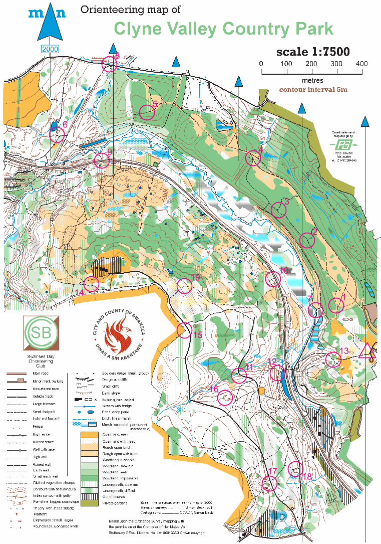
THE MAP. This is a standard orienteering map; the symbols and colours are explained in the legend. The scale is 1:7,500 which means that 1cm on the map represents 75 metres on the ground, as shown by the scale line.
DISTANCES. The distance from one point to another can be worked out using the scale line. When measuring on the ground, a metre is roughly one good adult stride.
DIRECTIONS. Whichever direction you are going or facing, try to keep the map the same way round as the ground. This in turn helps you to check which way to go at tricky path junctions.
THE COMPASS. If you have one you can use it to orientate the map. The needle points to magnetic north. Use this to keep the long arrows on the map pointing north. The compass is especially useful for finding accurate directions across areas without paths, and to sort out which way to go at path junctions, etc.
How to use a baseplate compass:
1 Place the edge of the compass baseplate along the direction you want to go on the map. 2 Turn the capsule so that the parallel lines in it are in line with the north lines on the map. 3 Take the compass off the map and hold it in front of you, pointing forward. TURN
YOURSELF with the compass until the needle is in line with the lines in the capsule. 4 Travel forward the way the front of the compass is now pointing.
CONTROLS and MARKERS. The locations of the controls are shown on the map by numbered circles in red, and a description of each is given on the next page. The controls are marked on the ground by a post on top of which is a plaque with a red and white orienteering symbol. There is a number as on the map, and a letter which you note down in the appropriate square on the control ‘card’. CHALLENGES.
A Select some of the controls to form a course, and find them in order. For a competition, set the competitors off at, say, 1 minute intervals to avoid following, and time them to see who gets around
fastest finding all the control set!
B Find all the controls, or a selection of them, in any order. For a competition, set a time limit, with penalties for being late.
C. Relay races for teams of three running individually or three pairs: I Select a shortish course. Start the first runners of each team together. On their return
they set off their second runners, and they in turn set off the third member. The winning team is that with its third member home first.
ii Select three courses, so that each member of a team has a different course to run. The courses can have some common controls. Start everyone together and the winning team is that with all three members back first, having completed their courses.
SUGGESTED COURSES. The following courses vary in length and difficulty. You can, as indicated above, make up your own courses, but note that the controls have different degrees of difficulty as set out in the descriptions in the next section. Remember, too, that orienteering is about choosing routes between controls, so select these such that the difficulty of the route choices matches your skills.
Starting and finishing at the Ynys Newydd Free Car Park, which is shown on the map with a red triangle.
A B C D
2.2Km. Short Start 7 12 11 16 15 19 10 13 Finish 3.3Km. Medium – Easy Start 1 2 3 4 5 6 9 10 13 Finish 4.3Km. Medium - Harder Start 1 2 4 8 6 9 10 15 16 12 13 Finish 5.2Km. Long. Start 1 2 3 4 5 8 6 9 14 19 15 16 17 18 11 12 7 Finish
CONTROL DESCRIPTIONS
1 2 3 4 5 6 7
Path Junction Path Junction Path Junction Path Junction Vegetation Boundary Path Junction Path Junction
8 9 10 11 12 13
Path Junction Track/Path Junction Track/Path Junction Quarry Path Junction Vegetation Boundary
14 15 16 17 18 19
Path Junction Fence Corner Quarry Earthbank Quarry Path Bend
The permanent orienteering course in Clyne Vallley was set up with the help of a grant from the Sports Council for Wales’ Community Chest scheme.
Volunteers from Clyne Valley Community Project installed the markers.
Your local club is Swansea Bay Orienteering Club who made the map and planned the course.
For further information on local permanent courses and events email [email protected], or visit the club's website at www.sboc.org.uk
FURTHER ACTIVITY. The recreation and sport of orienteering flourishes in every part of the country, organised by local clubs, and there are a number of events every week, mostly on Sundays. For further information on how to keep up your interest and skills, contact:
National Office, BRITISH ORIENTEERING FEDERATION, 8a Stancliffe House,Whitworth Road, Darly Dale, MATLOCK, Derbyshire DE4 2HJ Tel: 01629 734042 Email: [email protected]
Peter Ribbans, Membership Secretary, WELSH ORIENTEERING ASSOCIATION, 22 The Willows, RAGLAN, Gwent NP5 2HB
Orienteering in the Clyne Valley