manhattan east side transit alternatives...
TRANSCRIPT
Manhattan East Side Transit Alternatives
(MESA)/Second Avenue Subway Summary Report
Prepared for:
MTA New York City Transit
Prepared by:
Vollmer Associates, LLP SYSTRA Consulting, Inc.
Allee King Rosen & Fleming, Inc.
October 2001
Second Avenue Subway Summary Report MTA NYCT
TABLE OF CONTENTS 1. INTRODUCTION ................................................................................................................................ 1
2. MAJOR INVESTMENT STUDY AND ALTERNATIVE DEVELOPMENT PROCESS ............ 2 2.1 INTRODUCTION.................................................................................................................. 2 2.2 IDENTIFICATION OF PROBLEMS AND NEEDS.................................................................... 2 2.3 DEVELOPMENT OF GOALS AND OBJECTIVES ................................................................... 5 2.4 DEVELOPMENT AND ANALYSIS OF ALTERNATIVES.......................................................... 5
2.4.1 Long List Of Alternatives........................................................................................... 5 2.4.2 Reduced Long List of Alternatives ........................................................................... 11 2.4.3 Alternatives Evaluated in Detail in MIS/DEIS ........................................................ 14
2.5 PUBLIC OUTREACH DURING DEVELOPMENT AND EVALUATION OF ALTERNATIVES..... 15 2.5.1 Public Meetings ....................................................................................................... 15 2.5.2 Public Hearing on MIS/DEIS .................................................................................. 16
2.6 FURTHER REFINEMENT TO SECOND AVENUE SUBWAY DESIGN .................................... 16 2.7 COMMITMENT TO BEGIN FULL-LENGTH SECOND AVENUE SUBWAY............................ 18 2.8 DECISION TO PROCEED WITH SDEIS .............................................................................. 18 2.9 NEW YORK METROPOLITAN PLANNING ORGANIZATION ............................................... 19
3. DESCRIPTION OF SELECTED ALTERNATIVE........................................................................ 20 3.1 ALIGNMENT .................................................................................................................... 20 3.2 STATIONS ........................................................................................................................ 23 3.3 NEW SERVICE.................................................................................................................. 23 3.4 ROLLING STOCK.............................................................................................................. 23 3.5 CONSTRUCTION TECHNIQUES ......................................................................................... 25 3.6 BENEFITS OF THE FULL-LENGTH SECOND AVENUE SUBWAY ........................................ 26
4. SUPPLEMENTAL DEIS AND PRELIMINARY ENGINEERING.............................................. 27 4.1 SUPPLEMENTAL DEIS ..................................................................................................... 27 4.2 PRELIMINARY ENGINEERING .......................................................................................... 27 4.3 SCHEDULE ....................................................................................................................... 28
LIST OF TABLES TABLE 1: DAILY WORK TRIPS TO STUDY AREA (1990) .................................................................................. 4 TABLE 2: MESA STUDY GOALS AND OBJECTIVES ......................................................................................... 6 TABLE 3: LONG LIST OF ALTERNATIVES......................................................................................................... 7 TABLE 4: REDUCED LONG LIST OF ALTERNATIVES....................................................................................... 12 TABLE 5: RESULTS OF SCREENING ANALYSIS FOR REDUCED LONG LIST OF ALTERNATIVES........................ 14 TABLE 6: ALTERNATIVES ANALYZED IN THE DEIS ...................................................................................... 19 TABLE 7: SECOND AVENUE SUBWAY STATION LOCATIONS.......................................................................... 24
Summary Report 10/11/2001

Second Avenue Subway Summary Report MTA NYCT
LIST OF FIGURES FIGURE 1: STUDY AREA .................................................................................................................................. 3 FIGURE 2: PROPOSED SECOND AVENUE SUBWAY WITH SOUTH FERRY TERMINUS ....................................... 21 FIGURE 3: PROPOSED SECOND AVENUE SUBWAY WITH NASSAU STREET LOOP ........................................... 22
Summary Report 10/11/2001
Second Avenue Subway Summary Report MTA NYCT
1. Introduction
This report describes the alternatives analysis undertaken for the Metropolitan Transportation Authority (MTA) New York City Transit (NYCT)’s Manhattan East Side Transit Alternatives Study, known as MESA. Section 2 summarizes the process used to develop and evaluate alternatives as part of the Major Investment Study (MIS) and Draft Environmental Impact Statement (DEIS) prepared for MESA, as well as other analysis undertaken by MTA that supplemented the MIS/DEIS process. Section 3 describes the alternative that resulted from those processesa full-length Second Avenue Subway with two different engineering options for Lower Manhattan. Section 4 sets forth the processes to be followed to continue the analysis and design work for the full-length Second Avenue Subway alternative.
Summary Report 1 10/11/2001
Second Avenue Subway Summary Report MTA NYCT
2. Major Investment Study and Alternative Development Process
2.1 Introduction
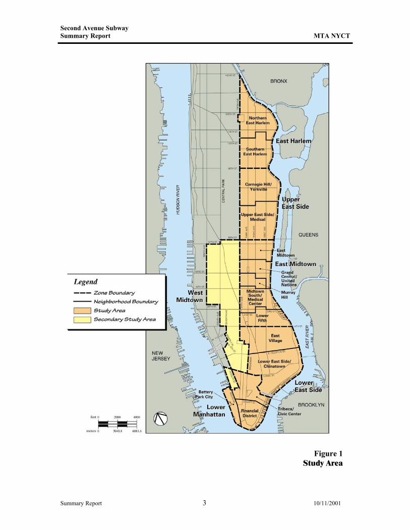
In 1995, MTA NYCT began its Manhattan East Side Transit Alternatives Study, known as MESA. This study was implemented to identify and address transportation problems and needs on Manhattan’s East Side. The study’s primary goal is to develop a long-term strategy that addresses crowding and delays on the Lexington Avenue subway line and improves transit accessibility to residents on the far East Side of Manhattan. The study area for MESA consists of a primary study area, encompassing the entire East Side of the Manhattan (generally the area east of Fifth Avenue, but also including all of Lower Manhattan south of Canal Street), and a secondary study area to the west, extending as far west as Tenth Avenue in Midtown (see Figure 1). MTA NYCT conducted a combined Major Investment Study (MIS) and Draft Environmental Impact Statement (DEIS) for MESA. This process was conducted pursuant to federal procedures, with extensive public outreach and participation, beginning in July 1995, when a Notice of Intent was published in the Federal Register. Public scoping meetings were held under the National Environmental Policy Review Act (NEPA) in July 1995. A final scoping document that included comments received on the project and the scope of studies was issued in December 1995. After extensive analysis of a wide range of alternatives, an MIS/DEIS for the MESA Study was published in August 1999, and a public hearing on the project was held under NEPA in September 1999. The MIS/DEIS process included the following steps, described in more detail below:
• Identification of problems and needs; • Development of goals and objectives; and • Development and analysis of alternatives.
2.2 Identification Of Problems And Needs
At the onset of the study, an extensive inventory of both demographic and socioeconomic characteristics and the physical and operational characteristics of transportation within the study area was completed. Using this information, a problem and needs statement was prepared. The problem and needs statement concluded that the need for transit improvement on Manhattan’s East Side is clear. In the primary area, only the Lexington Avenue subway line (the Nos. 4, 5, and 6 lines) provides full north-south rapid transit service. South of 64th Street (primarily East Midtown), several east-west subway lines (Q, N, R, E, F, 7, 42nd Street Shuttle, and L) cross the area and connect to other north-south services. The N and R trains provide north-south service along Broadway from 57th Street to Lower Manhattan. Several subway lines serve the Lower East Side (F, B, D, Q, J, M and Z), but these do not offer direct north-south service on the East Side, and their stations are at some distance from residents living in the easterly portions of the neighborhood. (Certain subway routes in the NYCT subway system will change in 2001, but the information above reflects conditions when the inventory of problems and needs was prepared.)
Summary Report 2 10/11/2001
Second Avenue Subway Summary Report MTA NYCT
Figure 1 Study Area
Summary Report 3 10/11/2001
Second Avenue Subway Summary Report MTA NYCT
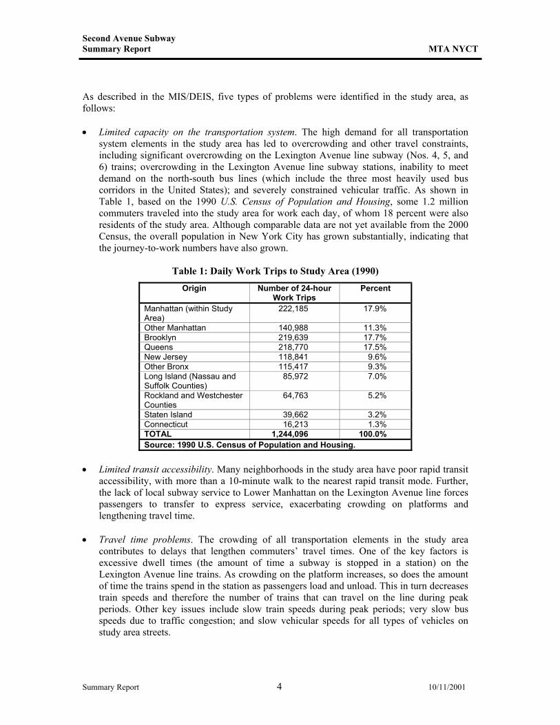
As described in the MIS/DEIS, five types of problems were identified in the study area, as follows: • Limited capacity on the transportation system. The high demand for all transportation
system elements in the study area has led to overcrowding and other travel constraints, including significant overcrowding on the Lexington Avenue line subway (Nos. 4, 5, and 6) trains; overcrowding in the Lexington Avenue line subway stations, inability to meet demand on the north-south bus lines (which include the three most heavily used bus corridors in the United States); and severely constrained vehicular traffic. As shown in Table 1, based on the 1990 U.S. Census of Population and Housing, some 1.2 million commuters traveled into the study area for work each day, of whom 18 percent were also residents of the study area. Although comparable data are not yet available from the 2000 Census, the overall population in New York City has grown substantially, indicating that the journey-to-work numbers have also grown.
Table 1: Daily Work Trips to Study Area (1990)
Origin Number of 24-hour Work Trips
Percent
Manhattan (within Study Area)
222,185 17.9%
Other Manhattan 140,988 11.3% Brooklyn 219,639 17.7% Queens 218,770 17.5% New Jersey 118,841 9.6% Other Bronx 115,417 9.3% Long Island (Nassau and Suffolk Counties)
85,972 7.0%
Rockland and Westchester Counties
64,763 5.2%
Staten Island 39,662 3.2% Connecticut 16,213 1.3% TOTAL 1,244,096 100.0% Source: 1990 U.S. Census of Population and Housing.
• Limited transit accessibility. Many neighborhoods in the study area have poor rapid transit
accessibility, with more than a 10-minute walk to the nearest rapid transit mode. Further, the lack of local subway service to Lower Manhattan on the Lexington Avenue line forces passengers to transfer to express service, exacerbating crowding on platforms and lengthening travel time.
• Travel time problems. The crowding of all transportation elements in the study area
contributes to delays that lengthen commuters’ travel times. One of the key factors is excessive dwell times (the amount of time a subway is stopped in a station) on the Lexington Avenue line trains. As crowding on the platform increases, so does the amount of time the trains spend in the station as passengers load and unload. This in turn decreases train speeds and therefore the number of trains that can travel on the line during peak periods. Other key issues include slow train speeds during peak periods; very slow bus speeds due to traffic congestion; and slow vehicular speeds for all types of vehicles on study area streets.
Summary Report 4 10/11/2001

Second Avenue Subway Summary Report MTA NYCT
• Decreased flexibility of the system. The overcrowding on the transit system in the study
area leads to unpredictable and unreliable subway and bus service during peak periods and the inability to accommodate future growth in the area.
• Environmental and socioeconomic concerns. The lack of capacity and resulting congestion
on the city’s transportation system in turn leads to the deterioration of a range of environmental and socioeconomic conditions, including air quality, neighborhood character, and economic vitality of the city’s regional and local commercial areas.
2.3 Development Of Goals And Objectives
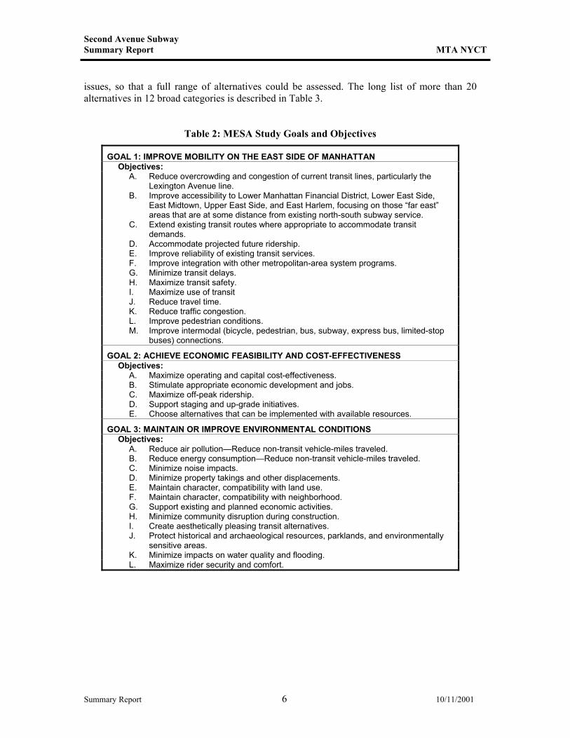
Based on the problems and needs identified, a list of comprehensive goals and objectives was created to set the direction of the study. These were developed with input through a Technical Advisory Committee (TAC) and Public Advisory Committee (PAC) convened for the study, the MTA’s Long-Range Planning Framework working group, and civic and community groups. The study’s goals and objectives are listed in Table 2.
2.4 Development and Analysis of Alternatives
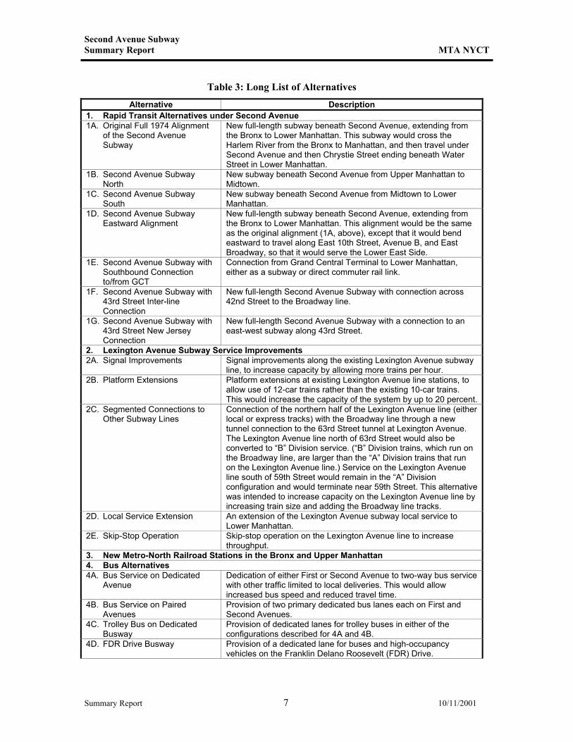
The basic alternatives development and evaluation approach for the MESA study was to consider all options suggested, evaluating each against the project’s goals and objectives. MTA NYCT and the project team accepted recommendations from other agencies, the TAC and PAC, members of civic groups, the general public, as well as those being generated by the study’s planners and engineers. From a large list, these alternatives were grouped and combined into the “long list” of more than 20 project alternatives in 12 broad categories. This long list was subjected to a preliminary screening analysis using relatively broad criteria to eliminate those options that could not reasonably be built and combine others together to form several new “combination” alternatives. The initial long list of alternatives was screened again, with public input, and options were eliminated and combined to create a “reduced long-list” of seven alternatives. Using detailed criteria including engineering and preliminary cost analysis; traffic, environmental, and socioeconomic information; and transportation modeling, the reduced long list was evaluated in three successive screening steps. This process resulted in the selection of the four alternatives that were analyzed in the MIS/DEIS. The different alternatives considered and the reasons for their elimination during the MIS/DEIS process are summarized below.
2.4.1 Long List Of Alternatives
Development of Long List of Alternatives
The first step in the development of alternatives for the MESA Study was to identify as many potential alternative solutions as possible to the existing and future transportation problems and needs in the study area. As described above, the initial long list of alternatives was developed through extensive public outreach. In addition, alternatives recommended in past studies were reconsidered and refined to address current and future problems and needs. These alternatives were developed without regard for cost, feasibility, environmental issues, or neighborhood
Summary Report 5 10/11/2001
Second Avenue Subway Summary Report MTA NYCT
issues, so that a full range of alternatives could be assessed. The long list of more than 20 alternatives in 12 broad categories is described in Table 3.
Table 2: MESA Study Goals and Objectives
GOAL 1: IMPROVE MOBILITY ON THE EAST SIDE OF MANHATTAN Objectives: A. Reduce overcrowding and congestion of current transit lines, particularly the
Lexington Avenue line. B. Improve accessibility to Lower Manhattan Financial District, Lower East Side,
East Midtown, Upper East Side, and East Harlem, focusing on those “far east” areas that are at some distance from existing north-south subway service.
C. Extend existing transit routes where appropriate to accommodate transit demands.
D. Accommodate projected future ridership. E. Improve reliability of existing transit services. F. Improve integration with other metropolitan-area system programs. G. Minimize transit delays. H. Maximize transit safety. I. Maximize use of transit J. Reduce travel time. K. Reduce traffic congestion. L. Improve pedestrian conditions. M. Improve intermodal (bicycle, pedestrian, bus, subway, express bus, limited-stop
buses) connections.
GOAL 2: ACHIEVE ECONOMIC FEASIBILITY AND COST-EFFECTIVENESS Objectives: A. Maximize operating and capital cost-effectiveness. B. Stimulate appropriate economic development and jobs. C. Maximize off-peak ridership. D. Support staging and up-grade initiatives. E. Choose alternatives that can be implemented with available resources.
GOAL 3: MAINTAIN OR IMPROVE ENVIRONMENTAL CONDITIONS Objectives: A. Reduce air pollution—Reduce non-transit vehicle-miles traveled. B. Reduce energy consumption—Reduce non-transit vehicle-miles traveled. C. Minimize noise impacts. D. Minimize property takings and other displacements. E. Maintain character, compatibility with land use. F. Maintain character, compatibility with neighborhood. G. Support existing and planned economic activities. H. Minimize community disruption during construction. I. Create aesthetically pleasing transit alternatives. J. Protect historical and archaeological resources, parklands, and environmentally
sensitive areas. K. Minimize impacts on water quality and flooding. L. Maximize rider security and comfort.
Summary Report 6 10/11/2001
Second Avenue Subway Summary Report MTA NYCT
Table 3: Long List of Alternatives
Alternative Description 1. Rapid Transit Alternatives under Second Avenue 1A. Original Full 1974 Alignment
of the Second Avenue Subway
New full-length subway beneath Second Avenue, extending from the Bronx to Lower Manhattan. This subway would cross the Harlem River from the Bronx to Manhattan, and then travel under Second Avenue and then Chrystie Street ending beneath Water Street in Lower Manhattan.
1B. Second Avenue Subway North
New subway beneath Second Avenue from Upper Manhattan to Midtown.
1C. Second Avenue Subway South
New subway beneath Second Avenue from Midtown to Lower Manhattan.
1D. Second Avenue Subway Eastward Alignment
New full-length subway beneath Second Avenue, extending from the Bronx to Lower Manhattan. This alignment would be the same as the original alignment (1A, above), except that it would bend eastward to travel along East 10th Street, Avenue B, and East Broadway, so that it would serve the Lower East Side.
1E. Second Avenue Subway with Southbound Connection to/from GCT
Connection from Grand Central Terminal to Lower Manhattan, either as a subway or direct commuter rail link.
1F. Second Avenue Subway with 43rd Street Inter-line Connection
New full-length Second Avenue Subway with connection across 42nd Street to the Broadway line.
1G. Second Avenue Subway with 43rd Street New Jersey Connection
New full-length Second Avenue Subway with a connection to an east-west subway along 43rd Street.
2. Lexington Avenue Subway Service Improvements 2A. Signal Improvements Signal improvements along the existing Lexington Avenue subway
line, to increase capacity by allowing more trains per hour. 2B. Platform Extensions Platform extensions at existing Lexington Avenue line stations, to
allow use of 12-car trains rather than the existing 10-car trains. This would increase the capacity of the system by up to 20 percent.
2C. Segmented Connections to Other Subway Lines
Connection of the northern half of the Lexington Avenue line (either local or express tracks) with the Broadway line through a new tunnel connection to the 63rd Street tunnel at Lexington Avenue. The Lexington Avenue line north of 63rd Street would also be converted to “B” Division service. (“B” Division trains, which run on the Broadway line, are larger than the “A” Division trains that run on the Lexington Avenue line.) Service on the Lexington Avenue line south of 59th Street would remain in the “A” Division configuration and would terminate near 59th Street. This alternative was intended to increase capacity on the Lexington Avenue line by increasing train size and adding the Broadway line tracks.
2D. Local Service Extension An extension of the Lexington Avenue subway local service to Lower Manhattan.
2E. Skip-Stop Operation Skip-stop operation on the Lexington Avenue line to increase throughput.
3. New Metro-North Railroad Stations in the Bronx and Upper Manhattan 4. Bus Alternatives 4A. Bus Service on Dedicated
Avenue Dedication of either First or Second Avenue to two-way bus service with other traffic limited to local deliveries. This would allow increased bus speed and reduced travel time.
4B. Bus Service on Paired Avenues
Provision of two primary dedicated bus lanes each on First and Second Avenues.
4C. Trolley Bus on Dedicated Busway
Provision of dedicated lanes for trolley buses in either of the configurations described for 4A and 4B.
4D. FDR Drive Busway Provision of a dedicated lane for buses and high-occupancy vehicles on the Franklin Delano Roosevelt (FDR) Drive.
Summary Report 7 10/11/2001
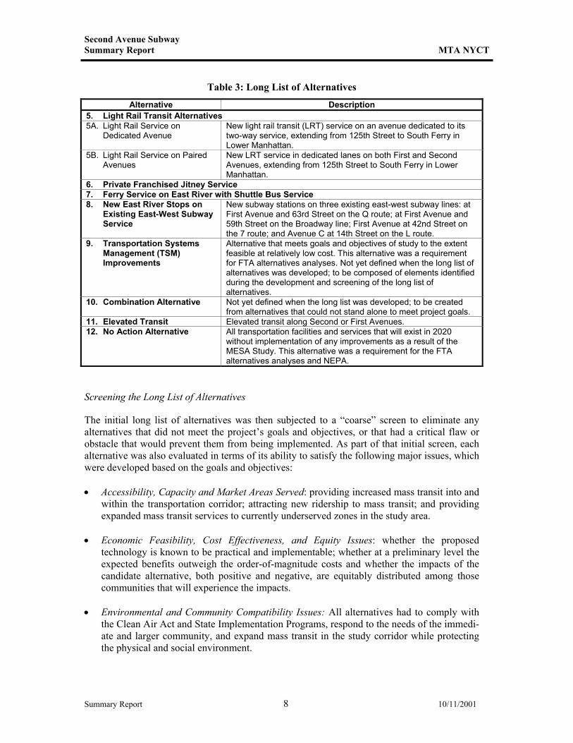
Second Avenue Subway Summary Report MTA NYCT
Table 3: Long List of Alternatives
Alternative Description 5. Light Rail Transit Alternatives 5A. Light Rail Service on
Dedicated Avenue New light rail transit (LRT) service on an avenue dedicated to its two-way service, extending from 125th Street to South Ferry in Lower Manhattan.
5B. Light Rail Service on Paired Avenues
New LRT service in dedicated lanes on both First and Second Avenues, extending from 125th Street to South Ferry in Lower Manhattan.
6. Private Franchised Jitney Service 7. Ferry Service on East River with Shuttle Bus Service 8. New East River Stops on
Existing East-West Subway Service
New subway stations on three existing east-west subway lines: at First Avenue and 63rd Street on the Q route; at First Avenue and 59th Street on the Broadway line; First Avenue at 42nd Street on the 7 route; and Avenue C at 14th Street on the L route.
9. Transportation Systems Management (TSM) Improvements
Alternative that meets goals and objectives of study to the extent feasible at relatively low cost. This alternative was a requirement for FTA alternatives analyses. Not yet defined when the long list of alternatives was developed; to be composed of elements identified during the development and screening of the long list of alternatives.
10. Combination Alternative Not yet defined when the long list was developed; to be created from alternatives that could not stand alone to meet project goals.
11. Elevated Transit Elevated transit along Second or First Avenues. 12. No Action Alternative All transportation facilities and services that will exist in 2020
without implementation of any improvements as a result of the MESA Study. This alternative was a requirement for the FTA alternatives analyses and NEPA.
Screening the Long List of Alternatives
The initial long list of alternatives was then subjected to a “coarse” screen to eliminate any alternatives that did not meet the project’s goals and objectives, or that had a critical flaw or obstacle that would prevent them from being implemented. As part of that initial screen, each alternative was also evaluated in terms of its ability to satisfy the following major issues, which were developed based on the goals and objectives: • Accessibility, Capacity and Market Areas Served: providing increased mass transit into and
within the transportation corridor; attracting new ridership to mass transit; and providing expanded mass transit services to currently underserved zones in the study area.
• Economic Feasibility, Cost Effectiveness, and Equity Issues: whether the proposed
technology is known to be practical and implementable; whether at a preliminary level the expected benefits outweigh the order-of-magnitude costs and whether the impacts of the candidate alternative, both positive and negative, are equitably distributed among those communities that will experience the impacts.
• Environmental and Community Compatibility Issues: All alternatives had to comply with
the Clean Air Act and State Implementation Programs, respond to the needs of the immedi-ate and larger community, and expand mass transit in the study corridor while protecting the physical and social environment.
Summary Report 8 10/11/2001
Second Avenue Subway Summary Report MTA NYCT
• Street and Subsurface Transportation and Transit Congestion Issues: All alternatives were required to alleviate crowding on existing transit lines, highway corridors and, specifically, the East Side transportation corridor; reduce travel times; and maintain or improve adequate parking and loading areas throughout the project corridor.
If the alternative adequately addressed these issues, it was then subject to a series of questions, as follows: • Does this alternative stand alone? If the alternative adequately addressed the study goals
and objectives and was able, by itself, to address the major transportation problems in the study area, it was considered a “stand-alone” alternative.
• If not, would this alternative better address study area issues if it were combined with
another alternative? Each “does not stand alone” alternative was further evaluated to deter-mine whether it could be combined with other alternatives to form one alternative that ad-dressed the study goals and objectives. Potential components of the Transportation Systems Management (TSM) Alternative were also identified in this way. (The TSM Alternative was a requirement for alternatives analyses performed for FTA, and consisted of transportation improvements that met the goals and objectives of the study to the extent possible at a relatively low cost.)
• If the alternative does not stand alone, can it be considered a routing or other type of
option for a stand-alone alternative? • Are there any major flaws in the alternative that would prevent its implementation? Once the coarse screen evaluation was nearly complete, the project team presented the alterna-tives to the Public Advisory Committee and held workshops and focused meetings throughout the study area. These discussions also helped to hone the long list. Long list alternatives that did not stand alone were either eliminated or combined with other alternatives to help create well-rounded solutions to the transit and transportation issues on the East Side of Manhattan. If, during the screening process, the issues related to an alternative appeared too complex for a quick screen, additional analysis was conducted. The intent of the analysis was to provide the team with more information on an alternative so that the benefits or impediments could be assessed and a well-informed decision (i.e., whether the alternative would be screened out or whether it may be combined with another alternative to better satisfy the study area needs) could be made. Results of the Coarse Screen of the Long List of Alternatives
The coarse screen of the long list of alternatives was narrowed as follows: • Rapid Transit Alternatives under Second Avenue (Alternative 1): The full-length Second
Avenue Subway (Alternative 1A in Table 3 above) and two other subway options—the eastward alignment (Alternative 1D) and the New Jersey connection (Alternative 1G) were found to meet the goals and objectives and passed the coarse screen. The other subway alternatives were eliminated as stand-alone alternatives because they would increase accessibility and increase capacity only to certain portions of the study area, would be
Summary Report 9 10/11/2001
Second Avenue Subway Summary Report MTA NYCT
difficult to implement, and/or would not be cost-effective compared to other alternatives that would provide similar improvements. (In developing the long list of alternatives, rapid transit lines were initially considered for any of the avenues east of Second Avenue, but Second Avenue was chosen early on as most appropriate because a route on Third Avenue would too closely duplicate the Lexington Avenue line’s service area; a subway route on First Avenue would be difficult near the Queensboro Bridge, the United Nations, and the Queens-Midtown Tunnel; and it takes advantage of the tunnel sections already built for the original Second Avenue subway.)
• Lexington Avenue Subway Service Improvements (Alternative 2): Both the improvements
to the Lexington Avenue line’s signals (Alternative 2A) and extensions to the platforms (Alternative 2B) were eliminated as stand-alone alternatives, because neither would make rapid transit more accessible to underserved portions of the study area. Further, both alternatives would have costs that far outweighed the benefits, so they were eliminated from consideration as part of the TSM Alternative or a combination alternative. Alternative 2C (segmented connections to other subway lines) was eliminated because it would not address many of the access and service issues of the study area and would be extremely costly and disruptive to rail operations. An extension of Lexington Avenue local service south of City Hall (Alternative 2D) was eliminated as a stand-alone alternative because it would address only a portion of the study area’s transportation issues, but this alternative was retained as a component of a combination alternative. Similarly, Lexington Avenue line skip-stop operation (Alternative 2E) was eliminated as a stand-alone alternative because it would only minimally address study area transportation issues, but this element was also retained as part of a combination alternative.
• New Metro-North Railroad Stations in the Bronx and Upper Manhattan: The alternative to
add Metro-North Railroad stops in the Bronx and Upper Manhattan (Alternative 3) was eliminated as a stand-alone alternative because it would offer limited access improvements to underserved portions of the study area and would not increase capacity materially. Also, because the costs would be very high, particularly compared with the benefits accrued, this option was eliminated from consideration as a component of the TSM Alternative.
• Bus Alternatives (Alternative 4): Bus alternatives 4A and 4B (dedicated bus lanes) would
meet study area goals and objectives, and were retained. • Light Rail Transit Alternatives (Alternative 5): Similarly, LRT service in dedicated lanes
(Alternatives 5A and 5B) were retained. • Private Franchised Jitney Service (Alternative 6): This alternative would not provide
enough capacity to relieve transit or on-street congestion, and so was eliminated as a stand-alone alternative but retained as a candidate for inclusion in the TSM Alternative.
• Ferry Service on the East River (Alternative 7): Similarly, new ferry service on the East
River would not materially reduce crowding on the Lexington Avenue subway and would only partially address accessibility needs, but was retained as a potential candidate for the TSM Alternative.
Summary Report 10 10/11/2001
Second Avenue Subway Summary Report MTA NYCT
• New East River Stops On Existing East-West Ferry Service (Alternative 8): This alternative would improve subway accessibility in underserved areas but would not relieve congestion in the area’s north-south transit corridors. Further, this option would have considerable expense and construction difficulties. Most options of this alternative were eliminated from further study, but the proposed station on the L route at 14th Street and Avenue C was retained for possible inclusion in the TSM Alternative, because of public interest.
• Elevated Transit (Alternative 11): This would meet the study’s transportation goals, but
would not meet several of the other goals. Its visual impact and community compatibility (third goal) issues would be potentially significant, and community reaction to this option was quite negative. This alternative was eliminated from further study (although it was retained until a full range of community input could be obtained).
The TSM Alternative (Alternative 9), combination alternatives (Alternative 10), and No Action Alternative (Alternative 12) were retained. These alternatives were developed as the screening analyses proceeded.
2.4.2 Reduced Long List of Alternatives
Developing the Reduced Long List of Alternatives
The result of the coarse screen of the long list of alternatives was a preliminary reduced long list of 12 alternatives (including several combination alternatives developed from components of alternatives that could not stand alone). The preliminary reduced long list of alternatives list was presented to the PAC and at a series of focused public meetings within the study area. Using this public input, continued evaluation of the alternatives (including development of several white papers analyzing particular alternatives or components of alternatives), this list was refined and several alternatives were eliminated, resulting in a “reduced long list” of nine alternatives. That reduced long list of alternatives is provided in Table 4. Screening the Reduced Long List of Alternatives
The reduced long list of alternatives was narrowed through several successive screens, as described below. As the screening process proceeded, increasing levels of detail were prepared for alternatives that had survived previous screening levels, to allow better evaluation and comparison of alternatives. • Screen 1: Confirmation of Feasibility. The first screen involved final confirmation of
feasibility based on early conceptual engineering drawings prepared as necessary to identify alternatives that were clearly infeasible.
Summary Report 11 10/11/2001
Second Avenue Subway Summary Report MTA NYCT
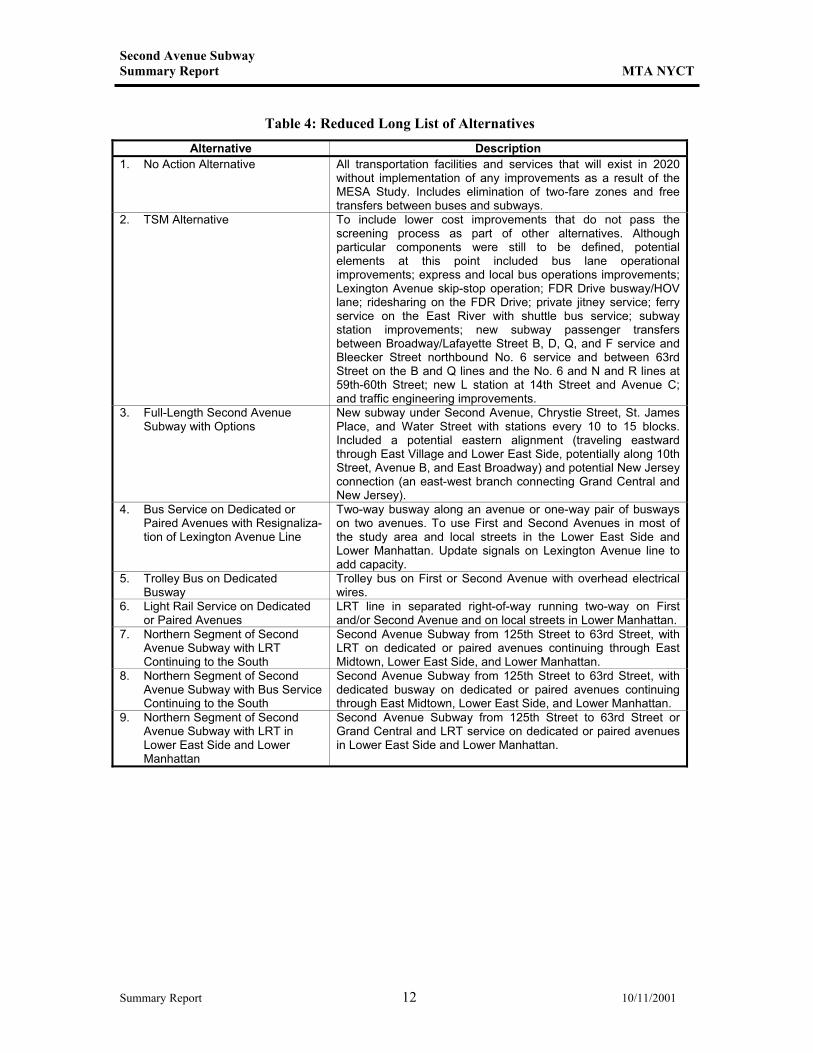
Table 4: Reduced Long List of Alternatives
Alternative Description 1. No Action Alternative All transportation facilities and services that will exist in 2020
without implementation of any improvements as a result of the MESA Study. Includes elimination of two-fare zones and free transfers between buses and subways.
2. TSM Alternative To include lower cost improvements that do not pass the screening process as part of other alternatives. Although particular components were still to be defined, potential elements at this point included bus lane operational improvements; express and local bus operations improvements; Lexington Avenue skip-stop operation; FDR Drive busway/HOV lane; ridesharing on the FDR Drive; private jitney service; ferry service on the East River with shuttle bus service; subway station improvements; new subway passenger transfers between Broadway/Lafayette Street B, D, Q, and F service and Bleecker Street northbound No. 6 service and between 63rd Street on the B and Q lines and the No. 6 and N and R lines at 59th-60th Street; new L station at 14th Street and Avenue C; and traffic engineering improvements.
3. Full-Length Second Avenue Subway with Options
New subway under Second Avenue, Chrystie Street, St. James Place, and Water Street with stations every 10 to 15 blocks. Included a potential eastern alignment (traveling eastward through East Village and Lower East Side, potentially along 10th Street, Avenue B, and East Broadway) and potential New Jersey connection (an east-west branch connecting Grand Central and New Jersey).
4. Bus Service on Dedicated or Paired Avenues with Resignaliza-tion of Lexington Avenue Line
Two-way busway along an avenue or one-way pair of busways on two avenues. To use First and Second Avenues in most of the study area and local streets in the Lower East Side and Lower Manhattan. Update signals on Lexington Avenue line to add capacity.
5. Trolley Bus on Dedicated Busway
Trolley bus on First or Second Avenue with overhead electrical wires.
6. Light Rail Service on Dedicated or Paired Avenues
LRT line in separated right-of-way running two-way on First and/or Second Avenue and on local streets in Lower Manhattan.
7. Northern Segment of Second Avenue Subway with LRT Continuing to the South
Second Avenue Subway from 125th Street to 63rd Street, with LRT on dedicated or paired avenues continuing through East Midtown, Lower East Side, and Lower Manhattan.
8. Northern Segment of Second Avenue Subway with Bus Service Continuing to the South
Second Avenue Subway from 125th Street to 63rd Street, with dedicated busway on dedicated or paired avenues continuing through East Midtown, Lower East Side, and Lower Manhattan.
9. Northern Segment of Second Avenue Subway with LRT in Lower East Side and Lower Manhattan
Second Avenue Subway from 125th Street to 63rd Street or Grand Central and LRT service on dedicated or paired avenues in Lower East Side and Lower Manhattan.
Summary Report 12 10/11/2001
Second Avenue Subway Summary Report MTA NYCT
• Screen 2: Definition and Evaluation of Routing Options. This screening analysis addressed a number of issues related to feasibility and impact. The analysis required refinement in potential routing, alignment, and engineering options for the remaining alternatives. This information was used to evaluate the alternatives against the following criteria:
— Total cost (comparing relative cost of same-mode options); — Average speed; — Potential for free subway-to-subway transfer; — Impacts on existing transit system (such as elimination, rerouting, reduction, or
increase of existing routes); — Other service changes required to existing system; — Use of existing tunnels (this use of existing infrastructure was considered an
advantage); — Engineering complications; — Unresolved issues (these were either resolved through further analysis or identified
as potentially unresolvable); — Potential for community/public support (based on potential for community-related
impacts, such as disruption and traffic congestion); — Expanded rapid transit area (provision of service to a previously underserved area); — Ridership (comparison of ridership levels among same-mode options, based on early
model results); — Street/operations impacts (for alternatives once constructed); — Legal issues (problems in jurisdiction, easements, property takings, etc.); — Construction impacts; — Possibility of phased construction (given the potential limitations to available capital
funds during construction, alternatives that did not allow for reasonable phasing were eliminated); and
— Schedule for implementation.
As a result of this screen, several alternatives were reconfigured and recombined and others were eliminated. Most notably, the full-length Second Avenue Subway with an eastward alignment was reconfigured as a Lower East Side subway shuttle with connections to existing subways and combined with a “North Subway” (new construction along Second Avenue from 125th Street to 63rd Street, where it would connect to the Broadway express tracks) for further analysis.
• Screen 3: Quantitative and Qualitative Evaluation of Alternatives. The final screen
involved an analysis of specific quantitative and qualitative data for each of the remaining alternatives. Preliminary model output (including ridership and travel time information) and capital cost estimates were used to perform a partial cost benefit analysis. This screen also used qualitative screening criteria, including a definition of accessibility; potential for displacement; service to low-income, minority, and transit-dependent populations; community character effects (such as impacts on land use/public policy, visual character, open space, and historic and archaeological resources); hazardous materials issues; traffic impacts; impact on parking and goods delivery; air quality impacts; compatibility with existing transit system; and a general analysis of construction impacts.
Summary Report 13 10/11/2001
Second Avenue Subway Summary Report MTA NYCT
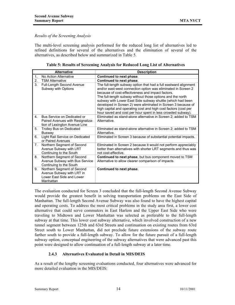
Results of the Screening Analysis
The multi-level screening analysis performed for the reduced long list of alternatives led to refined definitions for several of the alternatives and the elimination of several of the alternatives, as described below and summarized in Table 5.
Table 5: Results of Screening Analysis for Reduced Long List of Alternatives
Alternative Description 1. No Action Alternative Continued to next phase. 2. TSM Alternative Continued to next phase. 3. Full-Length Second Avenue
Subway with Options The full-length subway option that had a full eastward alignment and/or east-west connection option was eliminated in Screen 2 because of cost-effectiveness and impact factors. The full-length subway without those options and the north subway with Lower East Side subway shuttle (which had been developed in Screen 2) were eliminated in Screen 3 because of high capital and operating cost and high cost factors (cost per hour saved and cost per hour spent in less crowded subway).
4. Bus Service on Dedicated or Paired Avenues with Resignaliza-tion of Lexington Avenue Line
Eliminated as stand-alone alternative in Screen 2; added to TSM Alternative.
5. Trolley Bus on Dedicated Busway
Eliminated as stand-alone alternative in Screen 2; added to TSM Alternative.
6. Light Rail Service on Dedicated or Paired Avenues
Eliminated in Screen 3 because of substantial potential impacts.
7. Northern Segment of Second Avenue Subway with LRT Continuing to the South
Eliminated in Screen 2 because it would not perform appreciably better than alternatives with shorter LRT segments and thus was not cost-effective.
8. Northern Segment of Second Avenue Subway with Bus Service Continuing to the South
Continued to next phase, but bus component moved to TSM Alternative to allow clearer comparison of impacts.
9. Northern Segment of Second Avenue Subway with LRT in Lower East Side and Lower Manhattan
Continued to next phase.
The evaluation conducted for Screen 3 concluded that the full-length Second Avenue Subway would provide the greatest benefit in solving transportation problems on the East Side of Manhattan. The full-length Second Avenue Subway was also found to have the highest capital and operating costs. To address the most critical problems in the study area first, a lower cost alternative that could serve commuters in East Harlem and the Upper East Side who were traveling to Midtown and Lower Manhattan was selected as preferable to the full-length subway at that time. This lower cost subway alternative, which involved construction of a new tunnel segment between 125th and 63rd Streets and continuation on existing routes from 63rd Street south to Lower Manhattan, did not preclude future extensions of the subway route farther south to provide a full-length subway. To allow for the future pursuit of a full-length subway option, conceptual engineering of the subway alternatives that were advanced past this point were designed to allow continuation of a full-length subway at a later time.
2.4.3 Alternatives Evaluated in Detail in MIS/DEIS
As a result of the lengthy screening evaluations conducted, four alternatives were advanced for more detailed evaluation in the MIS/DEIS:
Summary Report 14 10/11/2001
Second Avenue Subway Summary Report MTA NYCT
• No Action Alternative: This alternative included those improvements in the city’s
transportation system that would be instituted after 1995 (the base year for the MESA study) and before 2020 (the future analysis year). This included completion of MTA operating agency initiatives to bring the system into a state of good repair (such as the purchase of new subway cars, rehabilitation of certain stations, track improvements, etc.); introduction of MetroCard; free transfers between buses and subways; introduction of unlimited system-wide passes; and the service changes associated with completion of the 63rd Street Tunnel Connector.
• TSM Alternative: This relatively low-cost option was developed by combining elements of
several project alternatives that did not meet project goals and objectives by themselves. The TSM Alternative included improvements to station dwell times on the Lexington Avenue line; introduction of bus priority lanes, called “New York Bus Lanes,” on First and Second Avenues between Houston and 96th Streets; and improvements to bus service on the Lower East Side (including creation of two new routes and modification of two others).
• Build Alternative 1: This alternative would provide a new subway extending from 125th
Street at Lexington Avenue, curving east to Second Avenue at approximately 116th Street and then traveling south beneath Second Avenue and bending westward again to 63rd Street at Lexington Avenue, where it would join the B and Q lines. The new service would then travel down the underused Broadway line express tracks to Lower Manhattan and Brooklyn.
• Build Alternative 2: This alternative would provide the same new subway service as Build
Alternative 1, and would also include new LRT service on the Lower East Side and in Lower Manhattan. The new two-way LRT service would operate at street level from Union Square along 14th Street, then south down Avenue D, then bending west along East Broadway and beneath Canal Street to Centre Street (where it would be underground), and then continuing east to Water Street and south down Water Street to a terminus at Broad Street.
These alternatives were evaluated at length in the MIS/DEIS, based on full ridership modeling and conceptual engineering work.
2.5 Public Outreach During Development and Evaluation of Alternatives
2.5.1 Public Meetings
The MIS/DEIS was conducted with an extensive public outreach process. NYCT and the project team accepted recommendations from other public agencies, a TAC and PAC, members of civic groups, and the general public. At each milestone of the project, meetings were held with the TAC, PAC, Long-Range Planning Framework working group, Community Boards, elected officials, community and civic groups, and other groups to present results and receive input and feedback. Key milestones at which public input was sought included the following:
Summary Report 15 10/11/2001
Second Avenue Subway Summary Report MTA NYCT
• Scoping meeting; • Development of problem and needs statement; • Development of goals and objectives; • Development and evaluation of long list of alternatives; • Review of screening of long list and preliminary reduced long list of alternatives; • Review of reduced long list of alternatives; and • Review of short list of alternatives. More than 100 meetings were held throughout the study to keep the community informed and to seek public input as the study progressed. As a result of public input, suggested studies and design alternatives have included new bus routes throughout the study area that were incorporated into the TSM Alternative and Build Alternative 1. Public participation also helped fashion the specific LRT alignment and cross-section within Build Alternative 2. It also provided valuable local insights in narrowing the initial set of alternatives to those on the short list. In addition, community members suggested that an additional subway stop be included on the new subway line in East Harlem near 116th Street.
2.5.2 Public Hearing on MIS/DEIS
MTA NYCT completed the MESA MIS/DEIS and published a Notice of Availability in the Federal Register in August 1999. A public hearing was conducted in September 1999 to receive comments on the project and the MIS/DEIS. At the hearing, members of the public, community groups, and elected officials voiced their support for a full-length Second Avenue Subway from 125th Street to Lower Manhattan. Of the 45 people who spoke at the public hearing, 40 supported a full-length Second Avenue Subway. During the public comment period, MTA received numerous written comments. Of these, the great majority were in support of a full-length Second Avenue Subway. The MTA also received thousands of postcards expressing support for a full-length Second Avenue Subway.
2.6 Further Refinement to Second Avenue Subway Design
In November 1997, the MTA initiated the Lower Manhattan Access Study (LMA) to examine transportation alternatives that would improve access from the New York City suburbs to Lower Manhattan. Although the goals and objectives of the LMA Study were different than those of the MESA Study, an extension of MESA’s subway build alternative under Second Avenue from 63rd Street to Lower Manhattan was one of the five long-list build alternatives developed by LMA, with the support of its Technical and Public Advisory Committees. In terms of LMA project goals, the full-length Second Avenue Subway would improve access from New York’s suburbs to Lower Manhattan by allowing suburban commuters to make an easier transfer to a less crowded subway line than they have today. Adding a new Second Avenue Subway would reduce crowding on the Lexington Avenue line and improve travel capacity and reliability to Lower Manhattan. As part of LMA, engineering, operations, ridership, and cost analyses were performed for the full-length subway, building on those already completed for the segment north of 63rd Street by the MESA Study. The engineering work laid out the mainline route under Second Avenue, the potential station locations south of 63rd Street, and two engineering options south of
Summary Report 16 10/11/2001
Second Avenue Subway Summary Report MTA NYCT
Houston Street (one via Water Street and the other via the Nassau line subway). During development of the southern portion of the Second Avenue Subway alignment, several alignment options were also analyzed to identify the most effective Second Avenue route, which minimizes construction complexity and costs and maximizes customer benefits and ridership. Two key areas were assessed to determine the basic alignment of the route: • Second Avenue vs. Third Avenue: These alignment shift alternatives were examined to
investigate the impacts of moving the line closer to the heart of Midtown. Shifting the subway line from Second to Third Avenue in Midtown proved to have significant property impacts, increased construction complexity and cost, and increased travel time due to slower operating speeds.
• Grand Central Terminal Spur: This spur option consisted of a subway shuttle service along
44th Street from the Second Avenue Subway to Grand Central Terminal. This option was examined to assess the benefits of providing direct subway service from Grand Central Terminal to Lower Manhattan via the Second Avenue Subway. Ridership modeling analysis revealed that a shuttle service along a Grand Central Terminal spur could only be effective if its frequency and travel time were competitive with the Lexington Avenue express service. The Grand Central Terminal spur service could not achieve competitive frequency due to capacity constraints on the Second Avenue route. It also could not achieve competitive travel time, because the Lexington Avenue subway’s route to Lower Manhattan is shorter than the potential Second Avenue Subway route.
In addition, several other studies were also undertaken of different design options. Key areas of analysis included the following: • Connection between Second Avenue Subway south of 63rd Street and the 63rd Street
Subway east of Second Avenue: Several options were examined to address grade and construction complexities at the 63rd Street connection of the potential new route and the existing subway tunnel. Of the four options examined, the preferred connection to the 63rd Street line reduced the grades of the flexings by shifting the proposed 56th Street station on the Second Avenue line approximately 500 feet to the south. A benefit of shifting the station south is that it would allow passengers to transfer to the 53rd Street subway lines.
• Second Avenue Connection to the Nassau Line: Several options were examined to reduce
property impacts, reduce construction along the existing Nassau line, and coordinate better with NYCT’s planned Nassau line reconfiguration. Of the three options and seven sub-options examined, the routing via Chrystie Street with connections to tracks J1 and J2 was recommended. This option allows for cross platform transfers at both the Canal and Chambers Street stations from the J/M/Z routes to the new Second Avenue Subway line. This option also had the lowest level of operational constraints or construction impacts.
• Water Street Alignment (Grand Street Station Configuration): Several options were
examined to minimize environmental impacts during construction to the existing Sara Delano Roosevelt Park and the surrounding neighborhood. Of the four Grand Street station options examined, the leading option locates the Second Avenue station below the existing Grand Street station. This option would tend to limit impacts on Sara Delano Roosevelt
Summary Report 17 10/11/2001
Second Avenue Subway Summary Report MTA NYCT
Park and would maintain a consistent Second Avenue Subway station design with island platforms.
• Water Street Alignment (Whitehall Terminal Configuration): Several options were
examined to improve terminal operations and facilitate transfer opportunities. Of the three Whitehall Terminal options examined, the location between the intersection of Whitehall/Water Streets and Battery Park was selected. This option allows for potential connections to other transit lines, allows for three new stations in Lower Manhattan, and matched the capacity of the 125th Street northern terminal.
The four alignment refinements described above will undergo further analysis as part of the ongoing MESA/Second Avenue study and preparation of the Supplemental Draft Environmental Impact Statement (SDEIS) analyzing a full-length Second Avenue Subway, described below in Section 4. This will include extensive public outreach
2.7 Commitment To Begin Full-Length Second Avenue Subway
In April 2000, the MTA Board committed to begin construction of a full-length Second Avenue Subway in the 2000-2004 Capital Program. In May 2000, the MTA Capital Program Review Board approved the MTA’s 2000-2004 Capital Program, which allocates $1.05 billion for a full-length Second Avenue Subway. This initial funding level provides for environmental studies, design, and the initiation of construction. (Additional funding will be required for continuation of construction to complete the project.)
2.8 Decision to Proceed with SDEIS
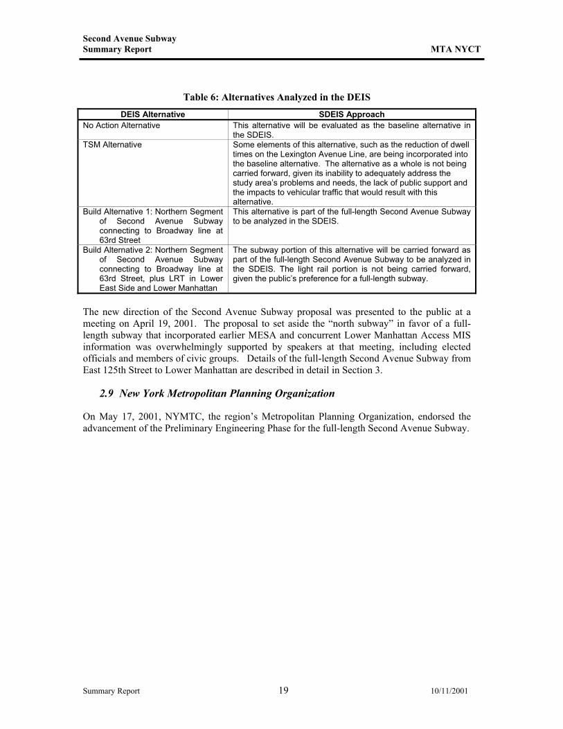
In response to widespread public support for the full-length Second Avenue Subway expressed at the August 1999 public hearing, and pursuant to the decision by the MTA Capital Program Review Board to fund a full-length Second Avenue Subway in the 2000-2004 Capital Program, it was decided to develop an SDEIS analyzing a full-length Second Avenue Subway alternative, setting aside the previous “north subway” concepts. As outlined in the table below, the alternatives evaluated in the DEIS are either being abandoned because they do not adequately address the problems and needs of the study area, or are being carried forward as part of the full-length alternative.
Summary Report 18 10/11/2001
Second Avenue Subway Summary Report MTA NYCT
Table 6: Alternatives Analyzed in the DEIS
DEIS Alternative SDEIS Approach No Action Alternative This alternative will be evaluated as the baseline alternative in
the SDEIS. TSM Alternative Some elements of this alternative, such as the reduction of dwell
times on the Lexington Avenue Line, are being incorporated into the baseline alternative. The alternative as a whole is not being carried forward, given its inability to adequately address the study area’s problems and needs, the lack of public support and the impacts to vehicular traffic that would result with this alternative.
Build Alternative 1: Northern Segment of Second Avenue Subway connecting to Broadway line at 63rd Street
This alternative is part of the full-length Second Avenue Subway to be analyzed in the SDEIS.
Build Alternative 2: Northern Segment of Second Avenue Subway connecting to Broadway line at 63rd Street, plus LRT in Lower East Side and Lower Manhattan
The subway portion of this alternative will be carried forward as part of the full-length Second Avenue Subway to be analyzed in the SDEIS. The light rail portion is not being carried forward, given the public’s preference for a full-length subway.
The new direction of the Second Avenue Subway proposal was presented to the public at a meeting on April 19, 2001. The proposal to set aside the “north subway” in favor of a full-length subway that incorporated earlier MESA and concurrent Lower Manhattan Access MIS information was overwhelmingly supported by speakers at that meeting, including elected officials and members of civic groups. Details of the full-length Second Avenue Subway from East 125th Street to Lower Manhattan are described in detail in Section 3.
2.9 New York Metropolitan Planning Organization
On May 17, 2001, NYMTC, the region’s Metropolitan Planning Organization, endorsed the advancement of the Preliminary Engineering Phase for the full-length Second Avenue Subway.
Summary Report 19 10/11/2001
Second Avenue Subway Summary Report MTA NYCT
3. Description of Selected Alternative
As a result of the conceptual engineering work and evaluation conducted as part of the MESA MIS/DEIS and the substantial public input supporting a full-length Second Avenue Subway, MTA NYCT is now pursuing development of a full-length subway extending from 125th Street to Lower Manhattan. Track connections would be provided to the 63rd Street line and the Broadway express tracks. Two services are proposedon the East Side, from 125th Street to Lower Manhattan via Second Avenue; and on the West Side, from 125th Street to 63rd Street via Second Avenue and then continuing south and to Brooklyn via the Broadway line. The full-length Second Avenue Subway alternative is described below.
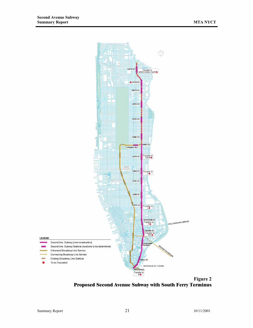
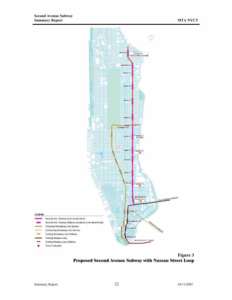
3.1 Alignment
The proposed Second Avenue Subway alignment runs from 125th Street in Harlem to Lower Manhattan via Second Avenue, with two engineering options south of Houston Street (see Figures 2 and 3). From north to south, the new subway route would begin at 125th Street and Lexington Avenue, where transfers would be available between the new service and the existing Lexington Avenue line (Nos. 4, 5, and 6) station. From 125th Street, the subway would curve east toward Second Avenue, and then would continue beneath Second Avenue to approximately Houston Street. From Houston Street southward, two engineering options are possible for the new service. The first option proposes subway service that would run south beneath Chrystie Street, the Bowery, St. James Place, and Water Street, with a terminus near South Ferry. This route is the approximate route once anticipated in the original Second Avenue alignment developed during the 1970’s. The Water Street alignment option would allow the project to use existing tunnel sections that were constructed for the new subway in the 1970’s, and, in addition, would bring passengers farther east in Lower Manhattan, to an area currently without subway service. The second engineering option proposes subway service that would connect to the existing Nassau Street (J/M/Z lines) service. The subway would continue west and then south beneath Delancey Street and Nassau Street into Lower Manhattan before continuing into Brooklyn via the Montague Street Tunnel. The Nassau Street alignment option would bring new subway service to the heart of the Financial District and allow the new service to continue into Brooklyn. The two different engineering options would have different costs, benefits, effects on subway service, and potential impacts on the community and environment. The cost of the Nassau line option would be lower because this option reduces the amount of new tunnel required. However, by utilizing an existing subway line, this engineering option would have impacts on the existing J/M/Z service. The number of new riders attracted to the subway system would be greater for the Nassau line option, simply because of its greater coverage by providing service to Brooklyn. However, the Water Street option would provide better ridership benefits within Manhattan and a slightly greater effect in relieving congestion on the existing Lexington Avenue line. The Water Street option would also have more significant potential environmental impacts to parks and archaeological resources south of Houston Street.
Summary Report 20 10/11/2001
Second Avenue Subway Summary Report MTA NYCT
Figure 2 Proposed Second Avenue Subway with South Ferry Terminus
Summary Report 21 10/11/2001
Second Avenue Subway Summary Report MTA NYCT
Figure 3 Proposed Second Avenue Subway with Nassau Street Loop
Summary Report 22 10/11/2001
Second Avenue Subway Summary Report MTA NYCT
In addition to this new route to Lower Manhattan, the new Second Avenue Subway would also provide a second route via the existing but underutilized Broadway line. The new subway beneath Second Avenue would connect to the Broadway line at 63rd Street, and could continue southward via the Broadway route to Lower Manhattan and onward to Brooklyn, or could use the express tracks on the Broadway line and continue to the Lower East Side of Manhattan and on to Brooklyn.
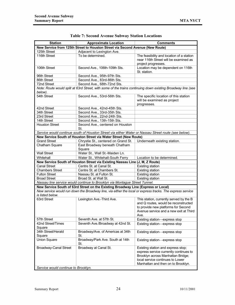
3.2 Stations
New stations would be created approximately every 10 blocks to provide access to as many people as possible while keeping train speeds as high as possible. Approximate station locations are listed in Table 7. Connections would be available to other lines at many of the stations listed in the table. For example, the 125th Street terminus of the new Second Avenue line would connect to the Lexington Avenue (Nos. 4, 5, and 6) lines, the 54th Street station would likely connect to the existing 53rd Street station at Lexington Avenue (currently served by the E, F, and 6 lines), the 42nd Street station could connect to the 7 line and therefore to Grand Central, the 14th Street station might connect to the L line, and the Houston Street station would connect to the Second Avenue station currently served by the F line. Numerous connections would also be available at most of the stations south of Houston Street as well. Prototypical stations for the new route would have a mezzanine above the tracks and platforms, where passengers could pay their fare and access either the uptown or downtown trains. Elevators and stairs and/or escalators would provide access (that would comply with the requirements of the Americans with Disabilities Act) between the street and platforms.
3.3 New Service
At this time, it is anticipated that the new Second Avenue Subway would operate with between two- and three-minute peak-period headways from 125th Street to 63rd Street. The service would split at 63rd Street, with some trains continuing on the Second Avenue line and some branching off to the Broadway express tracks.
3.4 Rolling Stock
The rolling stock for the Second Avenue Subway would be similar to the standard equipment used on New York City Transit’s B Division lines. The new line would be designed to accommodate 75-foot-long cars, with full train sets of 600 feet in length. These trains would have a total capacity of approximately 1,400 passengers. The trains would be powered from a 600-volt third rail. The proposed Second Avenue service plan would require the operation of approximately 31 new B Division trainsets, including spares, depending on the final alignment options selected.
Summary Report 23 10/11/2001
Second Avenue Subway Summary Report MTA NYCT
Table 7: Second Avenue Subway Station Locations
Station Approximate Location Comments New Service from 125th Street to Houston Street via Second Avenue (New Route) 125th Street Adjacent to Lexington Ave. 116th Street To be determined. The feasibility and location of a station
near 116th Street will be examined as project progresses.
106th Street Second Ave., 106th-109th Sts. Location may be dependent on 116th St. station.
96th Street Second Ave., 95th-97th Sts. 86th Street Second Ave., 83rd-86th Sts. 72nd Street Second Ave., 68th-72nd Sts. Note: Route would split at 63rd Street, with some of the trains continuing down existing Broadway line (see below). 54th Street Second Ave., 53rd-56th Sts. The specific location of this station
will be examined as project progresses.
42nd Street Second Ave., 42nd-45th Sts. 34th Street Second Ave., 33rd-35th Sts. 23rd Street Second Ave., 22nd-24th Sts. 14th Street Second Ave., 13th-15th Sts. Houston Street Second Ave., centered on Houston
St.
Service would continue south of Houston Street via either Water or Nassau Street route (see below). New Service South of Houston Street via Water Street (New Route) Grand Street Chrystie St., centered on Grand St. Underneath existing station. Chatham Square East Broadway beneath Chatham
Square
Wall Street Water St., Wall St.-Maiden Ln. Whitehall Water St., Whitehall-South Ferry Location to be determined. New Service South of Houston Street via Existing Nassau Line (J, M, Z Route) Canal Street Centre St. at Canal St. Existing station Chambers Street Centre St. at Chambers St. Existing station Fulton Street Nassau St. at Fulton St. Existing station Broad Street Broad St. at Wall St. Existing station Nassau line service would continue to Brooklyn via Montague Street Tunnel. New Service South of 63rd Street on the Existing Broadway Line (Express or Local) New service would run down the Broadway line, via either the local or express tracks. The express service is listed below. 63rd Street Lexington Ave.-Third Ave. This station, currently served by the B
and Q routes, would be reconstructed to provide new platforms for Second Avenue service and a new exit at Third Ave.
57th Street Seventh Ave. at 57th St. Existing stationexpress stop 42nd Street/Times Square
Seventh Ave./Broadway at 42nd St. Existing stationexpress stop
34th Street/Herald Square
Broadway/Ave. of Americas at 34th St.
Existing stationexpress stop
Union Square Broadway/Park Ave. South at 14th St.
Existing stationexpress stop
Broadway-Canal Street Broadway at Canal St. Existing station and express stop; express service currently continues to Brooklyn across Manhattan Bridge; local service continues to Lower Manhattan and then on to Brooklyn.
Service would continue to Brooklyn.
Summary Report 24 10/11/2001
Second Avenue Subway Summary Report MTA NYCT
3.5 Construction Techniques
Construction techniques to be used for the Second Avenue Subway will be defined in the preliminary engineering phase of the project and reflected in the project’s Environmental Impact Statement (discussed below in section 4). Potential construction methods that may be used are described below. The proposed two-track Second Avenue Subway would be built using tunnel boring machines (TBMs) along the majority of the alignment. Two independent tunnels, approximately 20 feet in diameter, would be bored beneath Second Avenue from approximately 92nd Street south to 4th Street. Cut-and-cover construction would be used along this segment to construct ventilation shafts, station mezzanines, exits and entrances, and other ancillary facilities. North of 92nd Street, two existing tunnel sections that were built during the 1970’s but never put into service would be incorporated into the new system. Where the new tunnel would curve from Second Avenue at approximately 116th Street to Lexington Avenue and 125th Street, hard-rock tunneling techniques would be used to build the tunnels beneath private property. Cut-and-cover construction is also expected to complete stations and ancillary facilities along this portion of the new system. South of 4th Street, where the bedrock profile is considerably deeper, the new tunnels would be located in soft soils, which eliminates the possibility of a hard-rock TBM construction approach. As such, at this time it is anticipated that cut-and-cover construction would be employed between 4th Street and Gouverneur Lane for a Water Street alignment to construct the running tunnels, the stations, and the ancillary facilities. At Gouverneur Lane, the bedrock surface rises back up, which allows for mined tunnel construction of the tunnels to the terminus at Whitehall. South of 4th Street where there are numerous stations, complicated underpinning of the existing Grand Street station, and an existing tunnel section also built during the 1970’s that would be incorporated into the new system, cut-and-cover construction is the most likely technique, although other methods will be investigated in the study to determine which is most appropriate in terms of constructability and avoiding impacts to archaeological resources. For the optional connection to the Nassau line, the soft soils south of 4th Street make use of a TBM impossible. In this area, cut-and-cover construction or a drilling machine appropriate for soft soils (known as an Earth Pressure Balance Machine, or EPBM), may be used. In addition, the connection requires a shallow profile to join with the existing Nassau line, which is just below the surface along Kenmare Street. This shallow profile, combined with the need to construct both the Houston Street station and the Nassau line connection with cut-and-cover methods, make use of a soft-soil tunneling approach, such as an EPBM, more difficult. Along the existing Nassau line, cut-and-cover construction is expected between the connection and the south end of the existing Canal Street station because of the need to reconstruct a significant portion of the existing structure. For the platform extensions at Chambers, Fulton, and Broad Streets, it is expected that the majority of the work could be completed from within the existing tunnel structure. However, some cut-and-cover construction may be required pending more detailed investigations during advanced design.
Summary Report 25 10/11/2001
Second Avenue Subway Summary Report MTA NYCT
3.6 Benefits of the Full-Length Second Avenue Subway
The new Second Avenue Subway (with either the Water Street or Nassau line engineering option) would attract new riders to the subway system and shift riders from the overcrowded Lexington Avenue line. The new service would relieve overcrowding on the Lexington Avenue line and serve approximately 578,000 riders each day, including a projected 25,000 new subway riders.
Summary Report 26 10/11/2001
Second Avenue Subway Summary Report MTA NYCT
4. Supplemental DEIS and Preliminary Engineering
4.1 Supplemental DEIS
Building on the process to date, NYCT is now preparing a Supplemental DEIS (SDEIS) that assesses the full-length subway alternative. This continues the technical work completed in the MIS/DEIS process, supplemented by the technical work performed after the MIS/DEIS was completed. The alternatives analyzed in the MIS/DEIS completed in 1999 are not being carried forward into the SDEIS. The SDEIS is required under NEPA because the full-length subway alternative was not fully analyzed in the MIS/DEIS published for the project. As set forth in the federal regulations implementing NEPA, supplemental environmental impact statements should be prepared when substantial changes in the proposed action are made that may affect the environment. This document will assess the full-length subway’s effects on the environment, and compare those effects to those of the baseline (No Action) alternative. For the SDEIS, that No Action alternative will include implementation of the MTA’s Long Island Rail Road (LIRR) East Side Access Project, which is proposed to bring LIRR service to Grand Central Terminal as well as to its existing terminus at New York Penn Station. The SDEIS will evaluate the effects of a new full-length Second Avenue Subway. As the SDEIS is prepared, engineering work will continue to refine the project design, including the station design, the engineering options in Lower Manhattan (the Water Street and Nassau Street alignments), and construction techniques. The project’s ongoing public outreach program will provide the opportunity for public review and comment on that information. The extensive public outreach program begun for the MESA MIS/DEIS will continue throughout preparation of the SDEIS. This includes regular meetings of the TAC and PAC, as well as outreach to civic and community groups, community boards, elected officials, other interested parties, and the general public. The analyses will also continue to be coordinated with other MTA initiatives and studies through MTA’s Long-Range Planning Framework working group.
4.2 Preliminary Engineering
To support the SDEIS and meet commitments made to the New York State legislature, NYCT intends (pending approval by the Federal Transit Administration) to begin preliminary engineering work on this alternative by fall 2001.
Summary Report 27 10/11/2001
Second Avenue Subway Summary Report MTA NYCT
4.3 Schedule
Key milestones for the Environmental Impact Statement and preliminary engineering phases of the project area as follows: • Issue Notice of Intent to prepare SDEIS: spring 2001; • Begin preliminary engineering: fall 2001; • Publication of SDEIS for public review and comment: fall/winter 2002; • Completion of Final EIS and issuance of Record of Decision: fall/winter 2003; • Begin final design: winter/spring 2004; • Begin construction: fall/winter 2004. ♦
Summary Report 28 10/11/2001