management plan for antarctic specially protected area … · management plan for antarctic...
TRANSCRIPT

Measure 1 (2014) Annex
Management Plan for
Antarctic Specially Protected Area No. 113
LITCHFIELD ISLAND, ARTHUR HARBOR
ANVERS ISLAND, PALMER ARCHIPELAGO
Introduction
Litchfield Island lies within Arthur Harbor, SW Anvers Island, at 64°46' S, 64°06' W. Approximate area:
0.34 km2. Designation on the grounds that Litchfield Island, together with its littoral zone, possesses an
unusually high collection of marine and terrestrial life, is unique amongst the neighboring islands as a
breeding place for six species of native birds and provides an outstanding example of the natural ecological
system of the Antarctic Peninsula area. In addition, Litchfield Island possesses rich growths of vegetation
and has the most varied topography and the greatest diversity of terrestrial habitats of the islands in Arthur
Harbor.
The Area was originally designated as Specially Protected Area (SPA) No. 17 through Recommendation
VIII-1 (1975) after a proposal by the United States of America. The site was renamed and renumbered as
Antarctic Specially Protected Area (ASPA) No. 113 by Decision 1 (2002). The original Management Plan
was adopted through Measure 2 (2004) and revised through Measure 4 (2009).
The Area is situated within Environment E – Antarctic Peninsula, Alexander and other islands based on the
Environmental Domains Analysis for Antarctica and within Region 3 – Northwest Antarctic Peninsula based
on the Antarctic Conservation Biogeographic Regions. Litchfield Island lies within Antarctic Specially
Managed Area No.7 Southwest Anvers Island and Palmer Basin.
1. Description of values to be protected
Litchfield Island (Latitude 64°46' S, Longitude 64°06' W, 0.34 km2), Arthur Harbor, Anvers Island, Antarctic
Peninsula was originally designated on the grounds that “Litchfield Island, together with its littoral,
possesses an unusually high collection of marine and terrestrial life, is unique amongst the neighboring
islands as a breeding place for six species of native birds and provides an outstanding example of the natural
ecological system of the Antarctic Peninsula area”.
The current management plan reaffirms the original reasons for designation associated with the bird
communities. The island supports a diverse assemblage of bird species that is representative of the mid-
western Antarctic Peninsula region. The number of bird species recorded as breeding on Litchfield Island is
currently six, following the recent local extinction of Adélie penguins (Pygoscelis adeliae) on the island.
Population decline has been attributed to the negative impact of increased snow accumulation and reduced
sea ice extent on both food availability and survival of young (McClintock et al. 2008). The species
continuing to breed on Litchfield Island are southern giant petrels (Macronectes giganteus), Wilson’s storm
petrels (Oceanites oceanicus), kelp gulls (Larus dominicanus), south polar skuas (Stercorarius
maccormicki), brown skuas (S. lonnbergi), and Antarctic terns (Sterna vittata). The status of these bird
colonies as being relatively undisturbed by human activities is also an important value of the Area.
In 1964 Litchfield Island supported one of the most extensive moss carpets known in the Antarctic Peninsula
region, dominated by Warnstorfia laculosa which was then considered near its southern limit (Corner
1964a). W. laculosa is now known to occur at a number of sites further south, including Green Island (ASPA
No. 108, in the Berthelot Islands) and Avian Island (ASPA No. 118, in Marguerite Bay). Accordingly, the
value originally cited that this species is near its southern limit at Litchfield Island is no longer valid.
Nevertheless, at the time Litchfield Island represented one of the best examples of maritime Antarctic
vegetation off the western coast of Graham Land. Furthermore, several banks of Chorisodontium aciphyllum
and Polytrichum strictum of up to 1.2 m in depth were described in 1982, which were considered to be some

ATCM XXXVII Final Report
of the best examples of their kind in the Antarctic Peninsula area (Fenton and Lewis Smith 1982). In
February 2001 it was observed that these values have been severely compromised by the impact of Antarctic
fur seals (Arctocephalus gazella), which have damaged and destroyed large areas of vegetation on the lower
accessible slopes of the island by trampling and nutrient enrichment. Southern elephant seals (Mirounga
leonina) have also had a severe, although more localized, impact. Some areas previously richly carpeted by
mosses have been completely destroyed, while others have suffered moderate-to-severe damage. Slopes of
Deschampsia antarctica are more resilient and have persisted even where fur seals have been numerous,
although here signs of damage are also obvious. However, on the steeper and higher parts of the island, and
other areas that are inaccessible to seals, the vegetation remains undamaged. Furthermore, observations
suggest that a recent local decline in Antarctic fur seal numbers has led to the recovery of previously
damaged vegetation on Litchfield Island (Fraser and Patterson-Fraser pers. comms. 2014). While the
vegetation is less extensive and some of the moss carpets have been compromised, the remaining vegetation
continues to be of value and an important reason for special protection of the island. Litchfield Island also
has the most varied topography and the greatest diversity of terrestrial habitats of the islands in Arthur
Harbor.
The Antarctic Peninsula is currently experiencing regional warming at a rate that exceeds any other observed
globally. The marine ecosystem surrounding Litchfield Island is undergoing substantial and rapid change in
response to this climatic warming, which has included a decline in local Adélie penguin and Antarctic fur
seal populations and changes in vegetation patterns. As such, maintenance of the relatively undisturbed state
of Litchfield Island has potential value for long-term studies of this ecosystem.
Litchfield Island has been afforded special protection for most of the modern era of scientific activity in the
region, with entry permits having been issued only for compelling scientific reasons. Litchfield Island has
therefore never been subjected to intensive visitation, research or sampling and has value as a terrestrial area
that has been relatively undisturbed by human activities. The Area is thus valuable as a reference site for
some types of comparative studies with higher use areas, and where longer-term changes in the abundance of
certain species and in the micro-climate can be monitored. The island is easily accessible by small boat from
nearby Palmer Station (US), and Arthur Harbor is visited frequently by tourist ships. Continued special
protection is therefore important to ensure the Area remains relatively undisturbed by human activities.
The designated Area is defined as including all of Litchfield Island above the low tide water level, excluding
all offshore islets and rocks.
2. Aims and objectives
Management of Litchfield Island aims to:
Avoid degradation of, or substantial risk to, the values of the Area by preventing unnecessary human
disturbance and sampling in the Area;
Allow scientific research on the ecosystem and physical environment in the Area provided it is for
compelling reasons which cannot be served elsewhere and that will not compromise the values for which
the Area is protected;
Allow visits for educational and outreach purposes (such as documentary reporting (visual, audio or
written) or the production of educational resources or services) provided such activities are for
compelling reasons that cannot be served elsewhere and will not compromise the values for which the
Area is protected;
Minimize the possibility of introduction of alien plants, animals and microbes to the Area;
Minimise the possibility of the introduction of pathogens that may cause disease in faunal populations
within the Area; and
Allow visits for management purposes in support of the aims of the management plan.
3. Management activities
The following management activities shall be undertaken to protect the values of the Area:

ASPA No 113 – Litchfield Island
Signs showing the location of the Area (stating the special restrictions that apply) shall be displayed
prominently, and copies of this management plan, including maps of the Area, shall be made available at
Palmer Station (US);
Copies of this management plan shall be made available to all vessels and aircraft visiting the Area
and/or operating in the vicinity of Palmer Station, and all personnel (national program staff, field
expeditions, tourist expedition leaders, pilots and ship captains) operating in the vicinity of, accessing or
flying over the Area, shall be informed by their national program, tour operator or appropriate national
authority of the location, boundaries and restrictions applying to entry and overflight within the Area;
National programs shall take steps to ensure the boundaries of the Area and the restrictions that apply
within are marked on relevant maps and nautical / aeronautical charts;
Markers, signs or other structures erected within the Area for scientific or management purposes shall be
secured and maintained in good condition, and removed when no longer required;
Visits shall be made as necessary (at least once every five years) to assess whether the Area continues to
serve the purposes for which it was designated and to ensure management and maintenance measures are
adequate.
4. Period of designation
Designated for an indefinite period.
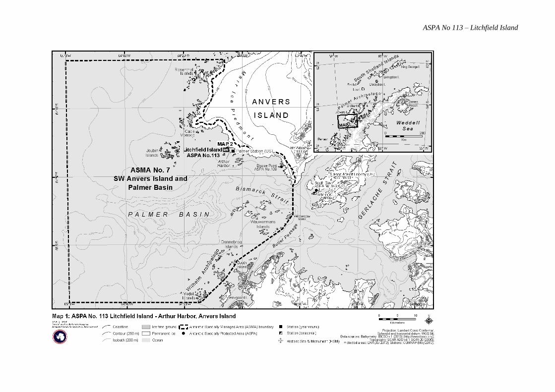
5. Maps and photographs
Map 1: ASPA No. 113 Litchfield Island – Arthur Harbor, Anvers Island, showing the location of nearby
stations (Palmer Station, US; Yelcho Station, Chile; Port Lockroy Historic Site and Monument No.
61, UK), the boundary of Antarctic Specially Managed Area No. 7 Southwest Anvers Island and
Palmer Basin, and the location of nearby protected areas.
Projection: Lambert Conformal Conic; Central Meridian: 64° 00' W; Standard parallels: 64° 40' S,
65° 00' S; Latitude of Origin: 66° 00' S; Spheroid and horizontal datum: WGS84; Contour interval:
Land – 250 m, Marine – 200 m.
Data sources: coastline & topography SCAR Antarctic Digital Database v4.1 (2005); Bathymetry:
IBCSO v.1 (2013); Protected areas: ERA (Jul 2013); Stations: COMNAP (May 2013).
Inset: the location of Anvers Island and the Palmer Archipelago in relation to the Antarctic
Peninsula.
Map 2: ASPA No. 113Litchfield Island: Physical features and selected wildlife.
Projection: Lambert Conformal Conic; Central Meridian: 64°06'W; Standard parallels: 64°46'S,
64°48'S; Latitude of Origin: 65°00'S; Spheroid and horizontal datum: WGS84; Vertical datum: mean
sea level; Contour interval: Land – 5 m; Marine – 20 m; Coastline, topography, vegetation &
southern elephant seal wallow derived from orthophoto (Feb 2009, ERA 2014) with a horizontal
accuracy of ~ 2 m and a vertical accuracy of ~ 3 m; Bathymetry derived from Asper & Gallagher
PRIMO survey (2004); Skuas: W. Fraser (2001-09); Former penguin colony: USGS Orthophoto
(1998); Survey mark: USGS; Camp site, Boat landing site: RPSC; Protected area and zones: ERA
(Jan 2014).
6. Description of the Area
6(i) Geographical coordinates, boundary markers and natural features
General description
Litchfield Island (64°46'15" S, 64°05'40" W, 0.34 km2) is situated in Arthur Harbor approximately 1500 m
west of Palmer Station (US), Gamage Point, Anvers Island, in the region west of the Antarctic Peninsula
known as the Palmer Archipelago (Map 1). Litchfield Island is one of the largest islands in Arthur Harbor,
measuring approximately 1000 m northwest to southeast and 700 m from northeast to southwest. Litchfield
Island has the most varied topography and the greatest diversity of terrestrial habitats of the islands in Arthur
Harbor (Bonner and Lewis Smith 1985). Several hills rise to between 30-40 m, with the maximum elevation

ATCM XXXVII Final Report
of 48 m being in the central western part of the island (Map 2). Rocky outcrops are common both on these
slopes and on the coast. The island is predominantly ice-free in summer, apart from small snow patches
occurring mainly on the southern slopes and in valleys. Cliffs of up to 10 m form the northeastern and
southeastern coasts, with pebble beaches found in bays in the north and south.
The designated Area is defined as all of Litchfield Island above the low tide water level, excluding all
offshore islets and rocks. The coast itself is a clearly defined and visually obvious boundary feature, so
boundary markers have not been installed. Several signs drawing attention to the protected status of the
island are in place and legible, although deteriorating (Fraser pers. comm. 2009).
Climate
Few meteorological data are available for Litchfield Island, although temperature data were collected at two
north- and south-facing sites on Litchfield Island from January – March 1983 (Komárková 1983). The
north-facing site was the warmer of the two, with January temperatures generally ranging between 2 to 9C,
February between -2 to 6C, and March -2 to 4C in 1983. A maximum temperature of 13C and a
minimum of -3C were recorded at this site over this period. The south-facing site was generally about 2C
cooler, with January temperatures generally ranging between 2 to 6C, February between -2 to 4C, and
March -3 to 2C. A maximum temperature of 9C and a minimum of -4.2C were recorded at the south-
facing site.
Longer-term data available for Palmer Station show regional temperatures to be relatively mild because of
local oceanographic conditions and because of the frequent and persistent cloud cover in the Arthur Harbor
region (Lowry 1975). Yearly air temperature averages recorded at Palmer Station during the period 1974 to
2012 show a distinct warming trend but also demonstrate significant inter-annual variability (Figure 1). The
maximum temperature recorded during the period was 11.6º C in March 2010, whilst the minimum was –26º
C in August 1995. Previous studies have identified August as the coldest month and January as the warmest
(Baker 1996). Storms and precipitation at Palmer Station are frequent, with winds being persistent but
generally light to moderate in strength, prevailing from the northeast.
Figure 1. Mean annual surface air temperature at Palmer Station 1974 – 2012. Data source: Palmer LTER ( http://oceaninformatics.ucsd.edu/datazoo/data/pallter/datasets?action=summary&id=189).
Geology, geomorphology and soils
Litchfield Island is one of numerous small islands and rocky peninsulas along the southwestern coast of
Anvers Island which are composed of an unusual assemblage of late Cretaceous to early Tertiary age rock
types called the Altered Assemblage (Hooper 1962). The primary rock types of the Altered Assemblage are
tonalite, a form of quartz diorite, and trondhjemite, a light-colored plutonic rock. Also common are granite
and volcanic rocks rich in minerals such as plagioclase, biotite, quartz and hornblende. Litchfield Island is
characterized by a central band of medium-dark gray, fine-grained diorites which separate the predominantly

ASPA No 113 – Litchfield Island
light gray medium-grained tonalites and trondhjemites of the east and west (Willan 1985). The eastern part is
characterized by paler dykes up to 40 m across and trending north-south and east-west. Minor quartz,
epidote, chlorite, pyrite and chalcopyrite veins of up to 8 cm thick strike SSE, cutting the tonalite. Dark gray
fine-grained plagioclase-phyric dykes with traces of magnetite strike ENE to ESE. Numerous dark gray
feldspar-phyric dykes are present in the west, up to 3 m thick and trending north-south and ESE. Some cut,
or are cut by, sparse quartz, epidote, chlorite, pyrite, chalcopyrite and bornite veins of up to 20 cm thick.
The soils of Litchfield Island have not been described, although peaty soils of up to one meter in depth may
be found in areas where there is, or once was, rich moss growth.
Freshwater habitat
There are a few small ponds on Litchfield Island: one small pond on a hill in the central, northeastern part of
the island has been described as containing the algae Heterohormogonium sp. and Oscillatoria brevis.
Another pond 50 m further south has been described as containing Gonium sp., Prasiola crispa, P. tesselata
and Navicula sp (Parker et al. 1972).
Vegetation
The plant communities at Litchfield Island were surveyed in detail in 1964 (Corner 1964a). At that time,
vegetation on Litchfield Island was well-developed and comprised several distinct communities with a
diverse flora (Lewis Smith and Corner 1973; Lewis Smith 1982). Both species of Antarctic vascular plant,
Antarctic hairgrass (Deschampsia antarctica) and Antarctic pearlwort (Colobanthus quitensis) were present
on Litchfield Island (Corner 1964a; Greene and Holtom 1971; Lewis Smith and Corner 1973). Corner
(1964a) noted that D. antarctica was common along the northern and northwestern coast of the island, with
more localized patches growing further inland on ledges with deposits of mineral material and forms closed
swards (Greene and Holtom 1971; Lewis Smith 1982). C. quitensis was present in two localities: a patch on
the northeastern coast measuring approximately 9x2 m and a series of about six cushions scattered over a
steep, flushed cliff above the northwestern coast. Commonly associated with the two vascular plants was a
moss carpet assemblage comprising Bryum pseudotriquetrum, Sanionia uncinata, Syntrichia princeps and
Warnstorfia laculosa (Corner 1964a). Factors controlling the distribution of C. quitensis and D. antarctica
area include the availability of suitable substrate and air temperature (Komarkova et al. 1985). In conjunction
with recent warming, existing populations of C. quitensis have expanded and new colonies have been
established within the Arthur Harbor area, although this has not been studied specifically at Litchfield Island
(Grobe et al. 1997; Lewis Smith 1994).
On well-drained rocky slopes, several banks of Chorisodontium aciphyllum and Polytrichum strictum were
described in 1982 as up to 1.2 m in depth, and were considered to be some of the best examples of their kind
in the Antarctic Peninsula area (Fenton and Lewis Smith 1982; Lewis Smith 1982). The more exposed areas
of moss turf were covered by crustose lichens, species of Cladonia spp. and Sphaerophorus globosus and
Coelocaulon aculeatum. In deep, sheltered gullies there was often a dense lichen cover comprising Usnea
antarctica, U. aurantiaco-atra and Umbilicaria antarctica. Raised areas of P. strictum turf of approximately
0.5 m high occurred at the bottom of a narrow, east to west trending, valley. The hepatics Barbilophozia
hatcheri and Cephaloziella varians were associated with the turf communities, particularly in frost heave
channels and often occurred as stunted specimens on exposed humus.
There were a number of permanently wet areas on the island, an outstanding feature of which was one of the
most extensive moss carpets known in the Antarctic Peninsula region, dominated by W. laculosa (Fenton and
Lewis Smith 1982). Elsewhere, S. uncinata and Brachythecium austro-salebrosum formed smaller stands.
Pohlia nutans lined the drier areas where the moss carpet communities merged with the moss turf
communities.
Rock surfaces supported a variety of lichen-dominated communities in addition to the numerous epiphytic
species that occurred on the moss banks. An open lichen and bryophyte community covered rocks and cliffs
around the coast and in the center of the island. The southern coast of the island consisted of primarily
crustose species of lichen, predominantly Usnea antarctica along with the mosses Andreaea depressinervis

ATCM XXXVII Final Report
and A. regularis. The foliose alga Prasiola crispa forms small stands associated with the penguin colonies
and other seabird habitats.
Other species recorded as present within the Area are: the hepatic Lophozia excisa; the lichens Buellia spp.,
Caloplaca spp., Cetraria aculeata, Coelopogon epiphorellus, Lecanora spp., Lecidia spp., Lecidella spp.,
Lepraria sp., Mastodia tessellata, Ochrolechia frigida, Parmelia saxatilis, Physcia caesia, Rhizocarpon
geographicum, Rhizocarpon sp., Stereocaulon glabrum, Umbilicaria decussata, Xanthoria candelaria and X.
elegans; and the mosses Andreaea gainii var. gainii, Bartramia patens, Dicranoweisia grimmiacea, Pohlia
cruda, Polytrichastrum alpinum, Sarconeurum glaciale and Schistidium antarctici (BAS Plant Database
2009).
Previously, increasing populations of Antarctic fur seals (Arctocephalus gazella) have caused significant
damage to the moss banks and carpets at lower elevations (Lewis Smith 1996; Harris 2001). However,
observations suggest previously damaged vegetation is recovering at some sites following a recent decline in
fur seal populations on Litchfield Island, although recent increases in southern elephant seals (Mirounga
leonina) hauling out on the island has resulted in severe damage in their wallow locality (Map 2) and on
access routes (Fraser and Patterson-Fraser, pers comms. 2014). South polar skuas (Stercorarius
maccormicki) nest in the moss banks and cause some local damage.
Invertebrates, bacteria and fungi
The invertebrate fauna of Litchfield Island has not been studied in detail. Observations made in 1966
recorded the presence of large populations of invertebrates, particularly in areas colonised by plants,
including Cyrtolaelaps, Protereunetes, Stereotydeus, Rhagidia, Tydeus, Alaskozetes and Opisa, in addition to
Cryptopygus, Parisotoma and Belgica. Larvae of Belgica were numerous under grass and moss, numbering
approximately 10,000 per m2. Large numbers of Nanorchestes and some Cryptopygus were observed on the
green algae Pandorina. The intertidal mite Rhombognathus gressitti was observed, although very scarce, on
a rocky beach and mudflat of the island (Gressitt 1967). The tardigrades Macrobiotus furciger, Hypsibius
alpinus and H. pinguis have been observed in moss patches, predominantly on north-facing slopes (Jennings
1976).
Breeding birds
Six bird species breed on Litchfield Island, making it one of the most diverse avifauna breeding habitats
within the Arthur Harbor region. A small Adélie penguin (Pygoscelis adeliae) colony was previously
situated on the eastern side of the island and has been censused regularly since 1971 (Table 1, Map 2).
Following the substantial decline in the numbers of breeding pairs over a 30-year period, Adélie penguins are
presently extinct on Litchfield Island (Fraser pers. comm. 2014). Population decline has been attributed to
changes in both sea ice distribution and snow accumulation (McClintock et al. 2008). Adélie penguins are
sensitive to changes in sea ice concentration, which has an influence on penguin access to feeding areas and
on the abundance of Antarctic krill, which is their primary prey (Fraser and Hofmann 2003; Ducklow et al.
2007). The recent substantial extension of ice-free conditions within the Palmer LTER study area occurred
concurrently with an 80 percent decrease in krill abundance along the northern half of the western Antarctic
Peninsula and as a result may have significantly reduced the food supply of Adélie penguins inhabiting
Litchfield Island (Fraser and Hofmann 2003; Forcada et al. 2008). In recent years, spring blizzards in the
Arthur Harbor area have become more frequent and more intense, which coupled with widespread
precipitation increases, is thought to have substantially increased mortality rates of Adélie chicks and eggs
(McClintock et al. 2008; Patterson et al. 2003). The Litchfield Island colony receives the most snowfall of
the seven penguin colonies studied in the Palmer area and has shown the most rapid decline, strongly
implicating increased snowfall as a contributing factor in Adélie penguin losses (Fraser, in Stokstad 2007).
Table 1. Numbers of breeding Adélie penguins (Pygoscelis adeliae) on Litchfield Island 1971-2009
Year BP Count
Type1
Source Year BP Count
Type1
Source Year BP Count
Type1
Source
1971-72 890 N3 2 1986-87 577 N1 3 2000-01 274 N1 3

ASPA No 113 – Litchfield Island
1972-73 1987-88 430 N1 3 2001-02 166 N1 3
1973-74 1988-89 2002-03 143 N1 3
1974-75 1000 N4 2 1989-90 606 N1 3 2003-04 52 4
1975-76 884 N1 3 1990-91 448 N1 3 2004-05 33 4
1977-78 650 N1 2 1991-92 497 N1 3 2005-06 15 4
1978-79 519 N1 2 1992-93 496 N1 3 2006-07 4 4
1979-80 564 N1 2 1993-94 485 N1 3 2007-08 0 4
1980-81 650 N1 2 1994-95 425 N1 3 2008-09 0 4
1981-82 1995-96 410 N1 3 2009-10 0 5
1982-83 1996-97 346 N1 3 2010-11 0 5
1983-84 635 N1 2 1997-98 365 N1 3 2011-12 0 5
1984-85 549 N1 2 1998-99 338 N1 3 2012-13 0 5
1985-86 586 N1 2 1999-2000 322 N1 3
1. BP = Breeding pairs, N = Nest, C = Chick, A = Adults; 1 = < 5%, 2 = 5-10%, 3 = 10-15%, 4 = 25-50%
(classification after Woehler, 1993)
2. Parmelee and Parmelee, 1987 (N1 and December counts are shown where several counts were made in one
season).
3. W.R. Fraser data supplied February 2003, based on multiple published and unpublished sources.
4. W.R. Fraser data supplied January 2009.
5. W.R. Fraser data supplied February 2014.
Southern giant petrels (Macronectes giganteus) breed in small numbers on Litchfield Island. Approximately
20 pairs were recorded in 1978-79, including an incubating adult that had been banded in Australia (Bonner
and Lewis Smith 1985). More recent data on numbers of breeding pairs are given in Table 2 and show a
continuing upward trend in breeding pairs, followed by a stabilization in recent seasons. An increasing, and
now stable, breeding population on Litchfield Island and in the vicinity of Palmer Station provide a notable
exception to more widespread decline of southern giant petrels in the Antarctic Peninsula region, and have
been attributed to the close proximity of prey-rich feeding grounds and the relatively low level of
commercial fishing activity within the region (Patterson and Fraser 2003). In austral summer 2004, six
southern giant petrel chicks from four colonies located close to the Palmer Station were found to have
poxviral infection (Bochsler et al. 2008). While the reasons for the emergence of the virus and its potential
impacts on southern giant petrel populations are currently unknown, it has been suggested that Adélie
penguins may be equally vulnerable to infection.
Table 2. Numbers of breeding southern giant petrels (Macronectes giganteus) on Litchfield Island 1993-
2012 (nest counts accurate < 5%)
Year Breeding pairs Year Breeding pairs Year Breeding pairs
1993-94 26 2000-01 39 2007-08 45
1994-95 32 2001-02 46 2008-09 57
1995-96 37 2002-03 42 2009-10 52
1996-97 36 2003-04 47 2010-11 60
1997-98 20 2004-05 48 2011-12 54
1998-99 44 2005-06 43 2012-13 54
1999-2000 41 2006-07 50
Source: Unpublished data supplied by W.R. Fraser, February 2003, January 2009, February 2014.

ATCM XXXVII Final Report
Wilson’s storm petrels (Oceanites oceanicus) breed within the Area, although numbers have not been
determined. Up to 50 pairs of south polar skuas (Stercorarius maccormicki) occur on the island, although
the number of breeding pairs fluctuates widely from year to year. Brown skuas (S. lonnbergi) have in the
past been closely associated with the Adélie penguin colony (Map 2), with the number of breeding pairs
having ranged from two to eight. The low count of two pairs in 1980-81 followed an outbreak of fowl
cholera, which killed many of the brown skuas on Litchfield Island in 1979. Hybrid breeding pairs also
occur. Although 12-20 kelp gulls (Larus dominicanus) are seen regularly on the island, there are only two or
three nests each season. A small number of Antarctic terns (Sterna vittata) regularly breed on Litchfield
Island, usually less than a dozen pairs (approximately eight pairs in 2002-03) (Fraser pers. comm. 2003).
They are most commonly found on the NE coast although their breeding sites change from year to year, and
in 1964 they occupied a site on the NW coast (Corner 1964a). A recent visit to Litchfield Island indicates
that the number of Wilson’s storm petrels, south polar skuas, brown skuas, kelp gulls and Antarctic terns
breeding on the island has undergone minimal change in recent years (Fraser pers. comm. 2009).
Among the non-breeding birds commonly seen around Litchfield Island, the Antarctic shag (Phalacrocorax
[atriceps] bransfieldensis) breeds on Cormorant Island several kilometers to the east; chinstrap penguins
(Pygoscelis antarctica) and gentoo penguins (P. papua) are both regular summer visitors in small numbers.
Snow petrels (Pagodroma nivea), cape petrels (Daption capense), Antarctic petrels (Thalassoica antarctica)
and southern fulmars (Fulmarus glacialoides), are irregular visitors in small numbers, while two gray-headed
albatross (Diomedea chrysotoma) were sighted near the island in 1975 (Parmelee et al. 1977).
Marine mammals
Antarctic fur seals (Arctocephalus gazella) started to appear in Arthur Harbor in the mid-1970s and are now
common on Litchfield Island from around February each year. Regular censuses conducted in February and
March over the period 1988-2003 recorded on average 160 and 340 animals on the island in these months
respectively (Fraser pers. comm. 2003), with a peak of 874 on 19 March 1994 (Fraser pers. comm. 2014). In
recent years, however, Antarctic fur seal numbers have decreased within the Arthur Harbor area (Siniff et al.
2008). Population decline has been tentatively attributed to reduced Antarctic krill availability within the
area, which represents a key component of the diet of Antarctic fur seals, particularly during pupping (Clarke
et al. 2007; Siniff et al. 2008). Diminished Antarctic krill abundance is thought to be a result of reduced sea
ice extent and persistence within the Arthur Harbor area (Fraser and Hoffman 2003; Atkinson et al. 2004).
Southern elephant seals (Mirounga leonina) haul out on accessible beaches from October to June, numbering
on average 43 animals throughout these months since 1988 (Fraser pers. comm. 2003), with numbers
remaining relatively stable or perhaps increasing slightly (Fraser and Patterson-Fraser, pers. comms. 2014).
A group of a dozen or more is found on the northeastern side of the island, having moved in recent years
from the low-lying valley to more elevated ground ~150 m northwest of the former haul-out site (Map 2). A
few Weddell seals (Leptonychotes weddellii) occasionally haul out on beaches. Long term census data
(1974–2005) indicate that elephant seal populations within the Arthur Harbor area have recently expanded,
as larger ice-free areas have become available for breeding. In contrast, data indicate that Weddell seal
numbers have declined as a consequence of reduced fast-ice extent, which is necessary for breeding (Siniff et
al. 2008). Both crabeater seals (Lobodon carcinophagus) and leopard seals (Hydrurga leptonyx) may also
commonly be seen on ice floes near Litchfield Island. Minke whales (Balaenoptera acutorostrata) have been
sighted in the Arthur Harbor area during both the austral summer (Dec-Feb) and autumn (Mar-May)
(Scheidat et al. 2008).
Littoral and benthic communities
Strong tidal currents occur between the islands within Arthur Harbor, although there are numerous sheltered
coves along the coast (Richardson and Hedgpeth 1977). Subtidal rocky cliffs grade into soft substrate at an
average depth of 15 m and numerous rock outcrops are found within the deeper soft substrate. Sediments in
Arthur Harbor are generally poorly sorted and consist primarily of silt sized particles with an organic content
of approximately 6.75 % (Troncoso et al. 2008). Significant areas of the seabed within Arthur Harbor are
covered by macroalgae, including Desmarestia anceps and D. menziesii, and sessile invertebrates such as
sponges and corals are also present (McClintock et al. 2008; Fairhead et al. 2006). The predominantly soft
mud substrate approximately 200 m off the northeastern coast of Litchfield Island has been described as

ASPA No 113 – Litchfield Island
supporting a rich macrobenthic community, characterized by a high diversity and biomass of non-attached,
deposit-feeding polychaetes, arthropods, molluscs and crustaceans (Lowry 1975). Analysis of molluscan
assemblages within Arthur Harbor, conducted as part of an integrated study of the benthic ecosystem in the
austral summers 2003 and 2006, indicates that species richness and abundance are relatively low (Troncoso
et al. 2008). The fish species Notothenia neglecta, N. nudifrons and Trematomus newnesi have been recorded
between 3 and 15 meters depth (De Witt and Hureau 1979; McDonald et al. 1995). The Antarctic limpet
(Nacella concinna) is common in the marine area around Litchfield Island and is widespread within shallow
water areas of the western Antarctic Peninsula (Kennicutt et al. 1992b; Clarke et al. 2004). Monitoring of
zooplankton distribution within the marine area surrounding Litchfield Island indicates that the abundance of
Euphausia superba and Salpa thompsoni decreased significantly between 1993 and 2004 (Ross et al. 2008).
Human activities and impact
In January 1989 the vessel Bahia Paraiso ran aground 750 m south of Litchfield Island, releasing more than
600,000 liters (150,000 gallons) of petroleum into the surrounding environment (Kennicutt 1990; Penhale et
al. 1997). The intertidal communities were most affected, and hydrocarbon contaminants were found in both
sediments and inter- and sub-tidal limpets (Nacella concinna), with an estimated mortality of up to 50%
(Kennicutt et al. 1992a&b; Kennicutt and Sweet 1992; Penhale et al. 1997). However, numbers recovered
soon after the spill (Kennicutt 1992a&b). Levels of petroleum contaminants found in intertidal sample sites
on Litchfield Island were among some of the highest recorded (Kennicutt et al. 1992b; Kennicutt and Sweet
1992). It was estimated that 80% of Adélie penguins nesting in the vicinity of the spill were exposed to
hydrocarbon pollution, and exposed colonies were estimated to have lost an additional 16% of their numbers
in that season as a direct result (Penhale et al. 1997). However, few dead adult birds were observed. Samples
collected in April 2002 detected hydrocarbons within the waters surrounding the Bahia Paraiso wreck,
suggesting some leakage of Antarctic gas oil (Janiot et al. 2003) and fuel occasionally reaches beach areas
on south-western Anvers Island (Fraser pers. comm. 2009). However, hydrocarbons were not found within
sediment or biota samples collected in 2002 and high sea energy within the area is thought to significantly
limit the impact of fuel leaks on local biota and the persistence of contaminants on beaches. In addition,
marine debris, including fishing hooks, lines and floats are occasionally observed on Litchfield Island.
US permit records show that between 1978-92 only about 35 people visited Litchfield Island, with possibly
around three visits being made per season (Fraser and Patterson 1997). This suggests a total of
approximately 40 visits over this 12-year period, although given that a total of 24 landings were made at the
island over two seasons in 1991-93 (Fraser and Patterson 1997), this would seem likely to represent an
underestimate. Nevertheless, visitation at Litchfield Island was undoubtedly low over this period, and has
remained at a minimal level. Visits have been primarily related to bird and seal censuses and work on
terrestrial ecology.
Plant studies carried out on Litchfield Island in 1982 (Komárková 1983) used welding rods inserted into the
soil to mark study sites. At nearby Biscoe Point (ASPA No. 139), where similar studies were conducted,
numerous rods left in situ killed surrounding vegetation (Harris 2001). It is unknown how many of the rods
were used to mark sites on Litchfield Island, or whether most were subsequently removed. However, one
was found and removed from a vegetated site in a small valley approximately 100 m west of the summit of
the island after a brief search in February 2001 (Harris 2001) and welding rods are still occasionally found
(Fraser pers. comm. 2009). A more comprehensive search would be required to determine whether further
welding rods remain within the Area. No other impacts on the terrestrial environment that could be attributed
to human visitation were observed on 28 February 2001, although one of the two protected area signs was in
poor condition and insecurely placed. The impact of human activities upon the terrestrial ecology, birds and
seals on Litchfield Island from direct visits may thus be considered to have been minor (Bonner and Lewis
Smith 1985; Fraser and Patterson 1997; Harris 2001).
6(ii) Access to the Area
The Area may be accessed over sea ice or by sea. Particular routes have not been designated for access to the
Area, although the preferred small boat landing site is located in a small cove on the eastern coast of the
island (Map 2). Overflight and aircraft landing restrictions apply within the Area, the specific conditions for
which are set out in Section 7(ii) below.

ATCM XXXVII Final Report
6(iii) Location of structures within and adjacent to the Area
With the exception of a cairn on the summit of the island, there are no structures present within the Area. A
permanent survey marker, consisting of a 5/8" stainless steel threaded rod, was installed on Litchfield Island
by the USGS on 9 February 1999. The marker is located near the summit of the island at 6446'13.97"S,
6405'38.85"W at an elevation of 48 m, about 8 m west of the cairn (Map 2). The marker is set in bedrock
and marked by a red plastic survey cap. A survival cache is located near the crest of a small hill overlooking
the former Adélie penguin colony, approximately 100 m south of the small boat landing site.
6(iv) Location of other protected areas in the vicinity
Litchfield Island lies within Antarctic Specially Managed Area (ASMA) No.7 Southwest Anvers Island and
Palmer Basin (Map 1). The nearest Antarctic Specially Protected Areas (ASPAs) to Litchfield Island are:
Biscoe Point (ASPA No. 139) which is 16 km east of the Area adjacent to Anvers Island and South Bay
(ASPA No. 146), which is approximately 27 km to the southeast at Doumer Island (Inset, Map 1).
7. Permit conditions
7(i) General Permit conditions
Entry into the Area is prohibited except in accordance with a Permit issued by an appropriate national
authority. Conditions for issuing a Permit to enter the Area are that:
it is issued only for compelling scientific reasons that cannot be served elsewhere, and in particular for
research on the terrestrial ecosystem or fauna in the Area;
it is issued for compelling educational or outreach reasons that cannot be served elsewhere, or for
reasons essential to the management of the Area;
the actions permitted will not jeopardize the ecological or scientific values of the Area or the value of the
Area as a terrestrial reference site;
any management activities are in support of the objectives of the Management Plan;
the actions permitted are in accordance with the Management Plan;
the activities permitted will give due consideration via the environmental impact assessment process to
the continued protection of the environmental and scientific values of the Area;
the Permit shall be issued for a finite period;
the Permit, or a copy, shall be carried when in the Area.
7(ii) Access to, movement within or over, the Area
Access to the Area shall be by small boat, or over sea ice by vehicle or on foot. Vehicles are prohibited and
all movement within the Area shall be on foot. When access over sea ice is viable, there are no special
restrictions on the locations where vehicle or foot access may be made, although vehicles are prohibited from
being taken on land.
Foot access and movement within the Area
Persons on foot should at all times avoid disturbance to birds and seals, and damage to vegetation. Boat
crew, or other people in boats or vehicles, are prohibited from moving on foot beyond the immediate vicinity
of the landing site unless specifically authorised by Permit.
Pedestrians should maintain the following minimum approach distances from wildlife, unless it is necessary
to approach closer for purposes allowed for by the permit:
Southern giant petrels (Macronectes giganteus) – 50 m
Antarctic fur seals (for personal safety) – 15 m
other birds and seals – 5 m.

ASPA No 113 – Litchfield Island
Visitors should move carefully so as to minimize disturbance to flora, fauna, and soils, and should walk on
snow or rocky terrain if practical, but taking care not to damage lichens. Pedestrian traffic should be kept to
the minimum consistent with the objectives of any permitted activities and every reasonable effort should be
made to minimize effects.
Small boat access
The recommended landing site for small boats is on the beach in the small cove mid-way along the eastern
coast of the island (Map 2). Access by small boat at other locations around the coast is allowed, provided this
is consistent with the purposes for which a Permit has been granted.
Aircraft access and overflight
Landing by aircraft within the Area is prohibited and landings within 930 m (~1/2 nautical mile) of the Area
should be avoided wherever possible. Overflight below 610 m (~2000 ft) Above Ground Level is prohibited
except when operationally necessary for scientific purposes.
7(iii) Activities that may be conducted within the Area
Scientific research that will not jeopardize the ecosystem values of the Area or the value of the Area as a
reference site, and which cannot be served elsewhere;
Activities with compelling educational and / or outreach purposes that cannot be served elsewhere;
Essential management activities, including monitoring and inspection.
7(iv) Installation, modification or removal of structures
No structures are to be erected within the Area except as specified in a permit and, with the exception of
permanent survey markers and the existing cairn at the summit of the island, permanent structures or
installations are prohibited;
All structures, scientific equipment or markers installed in the Area must be authorized by permit and
clearly identified by country, name of the principal investigator, year of installation and date of expected
removal. All such items should be free of organisms, propagules (e.g. seeds, eggs) and non-sterile soil,
and be made of materials that can withstand the environmental conditions and pose minimal risk of
contamination or damage to the values of the Area;
Installation (including site selection), maintenance, modification or removal of structures or equipment
shall be undertaken in a manner that minimizes disturbance to flora and fauna.
Removal of specific structures / equipment for which the permit has expired shall be the responsibility of
the authority which granted the original Permit, and shall be a condition of the permit.
7(v) Location of field camps
Camping should be avoided within the Area. However, when necessary for essential purposes specified in
the Permit, temporary camping is allowed at the designated site on the terrace above the former penguin
colony. The campsite is located at the foot of a small hill (~35 m), on its eastern side, approximately 100 m
south-west of the small boat landing beach (Map 2). Camping on surfaces with significant vegetation cover
is prohibited.
7(vi) Restrictions on materials and organisms which may be brought into the Area
In addition to the requirements of the Protocol on Environmental Protection to the Antarctic Treaty,
restrictions on materials and organisms which may be brought into the Area are:
Deliberate introduction of animals, plant material, micro-organisms and non-sterile soil into the Area is
prohibited. Precautions shall be taken to prevent the accidental introduction of animals, plant material,
micro-organisms and non-sterile soil from other biologically distinct regions (within or beyond the
Antarctic Treaty area);

ATCM XXXVII Final Report
Visitors shall ensure that sampling equipment and markers brought into the Area are clean. To the
maximum extent practicable, footwear and other equipment used or brought into the area (including
backpacks, carry-bags and other equipment) shall be thoroughly cleaned at Palmer Station before
entering the Area. Visitors should also consult and follow as appropriate recommendations contained in
the Committee for Environmental Protection Non-native Species Manual (CEP 2011), and in the
Environmental Code of Conduct for terrestrial scientific field research in Antarctica (SCAR 2009);
All poultry brought into and not consumed or used within the Area, including all parts, products and / or
wastes of poultry, shall be removed from the Area or disposed of by incineration or equivalent means
that eliminates risks to native flora and fauna;
No herbicides or pesticides shall be brought into the Area;
Any other chemicals, including radio-nuclides or stable isotopes, which may be introduced for scientific
or management purposes specified in the permit, shall be removed from the Area at or before the
conclusion of the activity for which the permit was granted;
Fuel, food, chemicals and other materials are not to be stored in the Area, unless specifically authorized
by permit or are contained within an emergency cache authorized by an appropriate authority, and shall
be stored and handled in a way that minimises the risk of their accidental introduction into the
environment;
All materials introduced shall be for a stated period only, shall be removed at or before the conclusion of
that stated period, and shall be stored and handled so that risk of their introduction into the environment
is minimized;
If release occurs which is likely to compromise the values of the Area, removal is encouraged only
where the impact of removal is not likely to be greater than that of leaving the material in situ.
7(vii) Taking of, or harmful interference with, native flora or fauna
Taking or harmful interference of native flora and fauna is prohibited, except in accordance with a permit
issued under Article 3 of Annex II of the Protocol on Environmental Protection to the Antarctic Treaty.
Where animal taking or harmful interference is involved, this should, as a minimum standard, be in
accordance with the SCAR Code of Conduct for the Use of Animals for Scientific Purposes in Antarctica.
7(viii) Collection or removal of materials not brought into the Area by the Permit holder
Material may be collected or removed from the Area only in accordance with a permit and should be
limited to the minimum necessary to meet scientific or management needs. This includes biological
samples and rock specimens.
Material of human origin likely to compromise the values of the Area, which was not brought into the
Area by the permit holder or otherwise authorized, may be removed from any part of the Area, unless the
impact of removal is likely to be greater than leaving the material in situ. If this is the case the
appropriate authority should be notified.
7(ix) Disposal of waste
All wastes shall be removed from the Area. Human wastes may be disposed of into the sea.
7(x) Measures that may be necessary to continue to meet the aims of the Management Plan
Permits may be granted to enter the Area to:
1) carry out monitoring and Area inspection activities, which may involve the collection of a small number
of samples or data for analysis or review;
2) install or maintain signposts, markers, structures or scientific or essential logistic equipment;
3) carry out protective measures;
4) carry out research or management in a manner that avoids interference with long-term research and
monitoring activities or possible duplication of effort. Persons planning new projects within the Area

ASPA No 113 – Litchfield Island
should consult with established programs working within the Area, such as those of the US, before
initiating the work.
7(xi) Requirements for reports
The principal permit holder for each visit to the Area shall submit a report to the appropriate national
authority as soon as practicable, and no later than six months after the visit has been completed.
Such reports should include, as appropriate, the information identified in the visit report form contained
in the Guide to the Preparation of Management Plans for Antarctic Specially Protected Areas. If
appropriate, the national authority should also forward a copy of the visit report to the Parties that
proposed the Management Plan, to assist in managing the Area and reviewing the Management Plan.
Parties should, wherever possible, deposit originals or copies of such original visit reports in a publicly
accessible archive to maintain a record of usage, for the purpose of any review of the Management Plan
and in organising the scientific use of the Area.
The appropriate authority should be notified of any activities/measures undertaken, and / or of any
materials released and not removed, that were not included in the authorized permit.
References
Atkinson, A., Siegel, V., Pakhomov, E. & Rothery, P. 2004. Long-term decline in krill stock and increase in
salps within the Southern Ocean. Nature 432: 100–03.
Bonner, W.N. & Lewis Smith, R.I. (eds) 1985. Conservation areas in the Antarctic. SCAR, Cambridge: 73-
84.
Baker, K.S. 1996. Palmer LTER: Palmer Station air temperature 1974 to 1996. Antarctic Journal of the
United States 31 (2): 162-64.
Clarke, A., Murphy, E.J., Meredith, M.P., King, J.C., Peck, L.S., Barnes, D.K.A. & Smith, R.C. 2007.
Climate change and the marine ecosystem of the western Antarctic Peninsula. Philosophical
Transactions of the Royal Society B 362: 149–166 [doi:10.1098/rstb.2006.1958]
Clarke, A., Prothero-Thomas, E. Beaumont, J.C., Chapman, A.L. & Brey, T. 2004. Growth in the limpet
Nacella concinna from contrasting sites in Antarctica. Polar Biology 28: 62–71. [doi 10.1007/s00300-
004-0647-8]
Corner, R.W.M. 1964a. Notes on the vegetation of Litchfield Island, Arthur Harbour, Anvers Island.
Unpublished report, British Antarctic Survey Archives Ref AD6/2F/1964/N3.
Corner, R.W.M. 1964b. Catalogue of bryophytes and lichens collected from Litchfield Island, West Graham
Land, Antarctica. Unpublished report, British Antarctic Survey Archives Ref LS2/4/3/11.
Domack E., Amblàs, D., Gilbert, R., Brachfeld, S., Camerlenghi, A., Rebesco, M., Canals M. & Urgeles, R.
2006. Subglacial morphology and glacial evolution of the Palmer deep outlet system, Antarctic
Peninsula. Geomorphology 75(1-2): 125-42.
Ducklow, H.W., Baker, K., Martinson, D.G., Quentin, L.B., Ross, R.M., Smith, R.C. Stammerjohn, S.E.
Vernet, M. & Fraser, W. 2007. Marine pelagic ecosystems: the West Antarctic Peninsula.
Philosophical Transactions of the Royal Society B 362: 67–94. [doi:10.1098/rstb.2006.1955]
Fairhead, V.A., Amsler, C.D. & McClintock, J.B. 2006. Lack of defense or phlorotannin induction by UV
radiation or mesograzers in Desmarestia anceps and D. menziesii (phaeophyceae). Journal of
Phycology 42: 1174–83.
Fenton, J.H.C & Lewis Smith, R.I. 1982. Distribution, composition and general characteristics of the moss
banks of the maritime Antarctic. British Antarctic Survey Bulletin 51: 215-36.
Forcada, J. Trathan, P.N., Reid, K., Murphy, E.J. & Croxall, J.P. 2006. Contrasting population changes in
sympatric penguin species in association with climate warming. Global Change Biology 12: 411–23.
[doi: 10.1111/j.1365-2486.2006.01108.x]
Fraser, W.R. in: Stokstad, 2007. Boom and bust in a polar hot zone. Science 315: 1522–23.
Fraser, W.R. & Hofmann, E.E. 2003 A predator’s perspective on causal links between climate change,
physical forcing and ecosystem response. Marine Ecological Progress Series 265: 1–15.
Fraser, W.R. & Patterson, D.L. 1997. Human disturbance and long-term changes in Adélie penguin
populations: a natural experiement at Palmer Station, Antarctic Peninsula. In Battaglia, B. Valencia, J.
& Walton, D.W.H. (eds) Antarctic Communities: species, structure and survival. Cambridge
University Press, Cambridge: 445-52.

ATCM XXXVII Final Report
Greene, D.M. & Holtom, A. 1971. Studies in Colobanthus quitensis (Kunth) Bartl. and Deschampsia
antarctica Desv.: III. Distribution, habitats and performance in the Antarctic botanical zone. British
Antarctic Survey Bulletin 26: 1-29.
Gressitt, J.L. 1967. Notes on Arthropod populations in the Antarctic Peninsula - South Shetland Islands -
South Orkney Islands area. In Entomology of Antarctica, J.L. Gressitt (ed) Antarctic Research Series
10. AGU, Washington DC.
Grobe, C.W., Ruhland, C.T. & Day, T.A. 1997. A new population of Colobanthus quitensis near Arthur
Harbor, Antarctica: correlating recruitment with warmer summer temperatures. Arctic and Alpine
Research 29(2): 217-21.
Harris, C.M. 2001. Revision of management plans for Antarctic protected areas originally proposed by the
United States of America and the United Kingdom: Field visit report. Internal report for the National
Science Foundation, US, and the Foreign and Commonwealth Office, UK. Environmental Research &
Assessment, Cambridge.
Holdgate, M.W. 1963. Observations of birds and seals at Anvers Island, Palmer Archipelago, in 1956-57.
British Antarctic Survey Bulletin 2: 45-51.
Hooper, P.R. 1958. Progress report on the geology of Anvers Island. Unpublished report, British Antarctic
Survey Archives Ref AD6/2/1957/G3.
Hooper, P.R. 1962. The petrology of Anvers Island and adjacent islands. FIDS Scientific Reports 34.
Janiot, L.J., Sericano, J.L. & Marcucci, O. 2003. Evidence of oil leakage from the Bahia Paraiso wreck in
Arthur Harbour, Antarctica. Marine Pollution Bulletin 46: 1615–29.
Jennings, P.G. 1976. Tardigrada from the Antarctic Peninsula and Scotia Ridge region. BAS Bulletin 44: 77-
95.
Kennicutt II, M.C. 1990. Oil spillage in Antarctica: initial report of the National Science Foundation-
sponsored quick response team on the grounding of the Bahia Paraiso. Environmental Science and
Technology 24: 620-24.
Kennicutt II, M.C., McDonald, T.J., Denoux, G.J. & McDonald, S.J. 1992a. Hydrocarbon contamination on
the Antarctic Peninsula I. Arthur Harbour – subtidal sediments. Marine Pollution Bulletin 24 (10):
499-506.
Kennicutt II, M.C., McDonald, T.J., Denoux, G.J. & McDonald, S.J. 1992b. Hydrocarbon contamination on
the Antarctic Peninsula I. Arthur Harbour – inter- and subtidal limpets (Nacella concinna). Marine
Pollution Bulletin 24 (10): 506-11.
Kennicutt II, M.C. & Sweet, S.T. 1992. Hydrocarbon contamination on the Antarctic Peninsula III. The
Bahia Paraiso – two years after the spill. Marine Pollution Bulletin 25 (9-12): 303-06.
Komárková, V. 1983. Plant communities of the Antarctic Peninsula near Palmer Station. Antarctic Journal
of the United States 18: 216-18.
Komárková, V. 1984. Studies of plant communities of the Antarctic Peninsula near Palmer Station. Antarctic
Journal of the United States 19: 180-82.
Lewis Smith, R.I. 1982. Plant succession and re-exposed moss banks on a deglaciated headland in Arthur
Harbour, Anvers Island. British Antarctic Survey Bulletin 51: 193–99.
Lewis Smith, R.I. 1994. Vascular plants as bioindicators of regional warming in Antarctica. Oecologia 99:
322-28.
Lewis Smith, R.I. 1996. Terrestrial and freshwater biotic components of the western Antarctic Peninsula. In
Ross, R.M., Hofmann, E.E. and Quetin, L.B. (eds) Foundations for ecological research west of the
Antarctic Peninsula. Antarctic Research Series 70: 15-59.
Lewis Smith, R.I. & Corner, R.W.M. 1973. Vegetation of the Arthur Harbour – Argentine Islands region of
the Antarctic Peninsula. British Antarctic Survey Bulletin 33 & 34: 89-122.
Lowry, J.K. 1975. Soft bottom macrobenthic community of Arthur Harbor, Antarctica. In Pawson, D.L.
(ed.). Biology of the Antarctic Seas V. Antarctic Research Series 23 (1): 1-19.
McClintock, J., Ducklow, H. & Fraser, W. 2008. Ecological responses to climate change on the Antarctic
Peninsula. American Scientist 96: 302.
McDonald, S.J., Kennicutt II, M.C., Liu, H. & Safe S.H. 1995. Assessing aromatic hydrocarbon exposure in
Antarctic fish captured near Palmer and McMurdo Stations, Antarctica. Archives of Environmental
Contamination and Toxicology 29: 232-40.
Parker, B.C, Samsel, G.L. & Prescott, G.W. 1972. Freshwater algae of the Antarctic Peninsula. 1.
Systematics and ecology in the U.S. Palmer Station area. In Llano, G.A. (ed) Antarctic terrestrial
biology. Antarctic Research Series 20: 69-81.
ASPA No 113 – Litchfield Island
Parmelee, D.F, Fraser, W.R. & Neilson, D.R. 1977. Birds of the Palmer Station area. Antarctic Journal of the
United States 12 (1-2): 15-21.
Parmelee, D.F. & Parmelee, J.M. 1987. Revised penguin numbers and distribution for Anvers Island,
Antarctica. British Antarctic Survey Bulletin 76: 65-73.
Patterson, D.L., Easter-Pilcher, A. & Fraser, W.R. 2003. The effects of human activity and environmental
variability on long-termchanges in Adelie penguin populations at Palmer Station, Antarctica. In A. H.
L. Huiskes, W. W. C. Gieskes, J. Rozema, R. M. L. Schorno, S. M. van der Vies & W. J. Wolff (eds)
Antarctic biology in a global context. Backhuys, Leiden, The Netherlands: 301–07.
Patterson, D.L. & Fraser, W. 2003. Satellite tracking southern giant petrels at Palmer Station, Antarctica.
Feature Article 8, Microwave Telemetry Inc.
Penhale, P.A., Coosen, J. & Marschoff, E.R. 1997. The Bahia Paraiso: a case study in environmental impact,
remediation and monitoring. In Battaglia, B. Valencia, J. & Walton, D.W.H. (eds) Antarctic
Communities: species, structure and survival. Cambridge University Press, Cambridge: 437-44.
Richardson, M.D. & Hedgpeth, J.W. 1977. Antarctic soft-bottom, macrobenthic community adaptations to a
cold, stable, highly productive, glacially affected environment. In Llano, G.A. (ed.). Adaptations
within Antarctic ecosystems: proceedings of the third SCAR symposium on Antarctic biology: 181-96.
Ross, R.M., Quetin, L.B., Martinson, D.G., Iannuzzi, R.A., Stammerjohn, S.E. & Smith, R.C. 2008. Palmer
LTER: patterns of distribution of major zooplankton species west of the Antarctic Peninsula over a
twelve year span. Deep-Sea Research II 55: 2086–2105.
Sanchez, R. & Fraser, W. 2001. Litchfield Island Orthobase. Digital orthophotograph of Litchfield Island, 6
cm pixel resolution and horizontal / vertical accuracy of 2 m. Geoid heights, 3 m2 DTM, derived
contour interval: 5 m. Data on CD-ROM and accompanied by USGS Open File Report 99-402 “GPS
and GIS-based data collection and image mapping in the Antarctic Peninsula”. Science and
Applications Center, Mapping Applications Center. USGS, Reston.
Scheidat, M., Bornemann, H., Burkahardt, E., Flores, H., Friedlaender, A. Kock, K.-H, Lehnert, L., van
Franekar, J. & Williams, R. 2008. Antarctic sea ice habitat and minke whales. Annual Science
Conference in Halifax, 2008.
Shearn-Bochsler, V. Green, D.E., Converse, K.A., Docherty, D.E., Thiel, T., Geisz, H. N., Fraser, W.R. &
Patterson-Fraser, D.L. 2008. Cutaneous and diphtheritic avian poxvirus infection in a nestling
Southern giant petrel (Macronectes giganteus) from Antarctica. Polar Biology 31: 569–73. [doi
10.1007/s00300-007-0390-z]
Siniff, D.B., Garrot, R.A. & Rotella, J.J. 2008. Opinion: Projecting the effects of environmental change on
Antarctic seals. Antarctic Science 20: 425-35.
Stammerjohn, S.E., Martinson, D.G., Smith, R.C. & Iannuzzi, R.A. 2008. Sea ice in the Western Antarctic
Peninsula region: spatio-temporal variability from ecological and climate change perspectives. Deep-
Sea Research II 55: 2041–58. [doi:10.1016/j.dsr2.2008.04.026]
Troncoso, J.S. & Aldea, C. 2008. Macrobenthic mollusc assemblages and diversity in the West Antarctica
from the South Shetland Islands to the Bellingshausen Sea. Polar Biology 31(10): 1253–65. [doi
10.1007/s00300-008-0464-6]
Vaughan, D.G., Marshall, G.J., Connolley, W.M., Parkinson, C., Mulvaney, R., Hodgson, D.A., King, J.C.,
Pudsey, C.J., & Turner, J. 2003. Recent rapid regional climate warming on the Antarctic Peninsula.
Climatic Change 60: 243–74.
Willan, R.C.R. 1985. Hydrothermal quartz+magnetite+pyrite+chalcopyrite and quartz+polymetallic veins in
a tonalite-diorite complex, Arthur Harbour, Anvers Island and miscellaneous observations in the
southwesternAnvers Island area. Unpublished report, British Antarctic Survey Archives Ref
AD6/2R/1985/G14.
Woehler, E.J. (ed) 1993. The distribution and abundance of Antarctic and sub-Antarctic penguins. SCAR,
Cambridge.
ASPA No 113 – Litchfield Island

ATCM XXXVII Final Report