making radar altimetry more usable and web … · making radar altimetry more usable and...
TRANSCRIPT
MAKING RADAR ALTIMETRY MORE USABLE AND WEB-INTEROPERABLE IN THE COASTAL OCEAN
Vignudelli S. (1), Cipollini P. (2), Snaith H. M. (2), Venuti F. (2), Lyard F. (3), Bouffard J. (3), Roblou L. (4),
Cretaux J. F. (3), Kostianoy A. (5), Lebedev S. (6), Mamedov R. (7) (1) Consiglio Nazionale delle Ricerche, Istituto di Biofisica, Area Ricerca CNR San Cataldo, 56127 Pisa, Italy (2) National Oceanography Centre Southampton, European Way, SO14 3ZH Southampton, United Kingdom (3) CNRS-LEGOS, 18 Av. Edouard Belin, 31401 Toulouse Cedex 9, France (4) Noveltis, Parc Technologique du Canal 2, Avenue de l'Europe 31520, Ramonville-Saint-Agne, France (5) P.P. Shirshov Institute of Oceanology, Nakhimovsky Pr. 36, 117997 Moscow, Russia (6) Geophysical Center, Molodezhnaya Str. 3, 119991 Moscow, Russia (7) Institute of Geography, Center for Caspian Sea Problems, H. Javid Str. 31, AZ1143 Baku, Azerbaijan ABSTRACT In this paper, we describe the ALTICORE (value added satellite ALTImetry in COastal REgions) initiative, a consortium aiming at providing high quality coastal altimetry over some European seas. Taking the Ligurian Sea in the NW Mediterranean as an example, which acts as a test zone for this work, we show the improvement in availability and quality of ENVISAT data, through our processing, when compared with the official altimetric products delivered by AVISO. We also introduce the building concepts of solutions for data search, extraction, update and delivery based on web-services. This grid-type infrastructure is being designed in the framework of ALTICORE. 1. THE CONTEXT The natural interface between humans and the oceans is at the coast, and many of the key impacts of the sea on human activities are in the coastal zone. Coastal management often requires decisions to be taken at a level close to that of the people directly affected, i.e. at local or regional level. To act efficiently, managers need fast, reliable access to all available environmental data, both when they are confronted with episodic, unpredictable threats (e.g., storms, pollution events, blooms, etc.) and for long-term planning. In this scenario there is clearly ample scope to assess the ability and performance of existing remote sensing technology closer to the coasts, and investigate the knowledge and benefit that this technology can offer. A case in point is that of altimetry. Information on the ocean surface gathered by the altimeters is used to derive a description of the sea state, through measurements of wave height and wind speed. The altimeter is also the only satellite-borne instrument which returns a measurement (sea surface height) directly related to the internal dynamical state of the ocean. The observed sea surface height
variations are related to temperature and salinity changes. They can also provide a measure of currents through the geostrophic relation. These capabilities are provided regardless of weather conditions, especially cloud cover, and in day/night viewing. However, the past and present satellite altimetry missions were not conceived with the coastal ocean in mind, and data in proximity of the coast are normally rejected. This is not only owing to intrinsic limitations of the system but also to the lack of techniques for processing and correction. These data would be extremely important not only for scientific research but also for other socio-economic activities, when assimilated into models of coastal dynamics, sediment transport and pollutant dispersion. While forthcoming altimetric missions such as AltiKa and CryoSat-2 promise much improved capabilities closer to the coast, a current priority is to analyze the existing, under-exploited, 15-year global archive of coastal altimeter data from past and present missions, such as ERS-1 and -2, TOPEX/Posedon, Jason-1, Geosat Follow-On and ENVISAT, both in order to extract all the available information and in order to formulate recommendations and solutions for future missions. This is a key purpose of the ALTICORE (value added satellite ALTImetry in COastal Regions) Project. The present paper describes the structure and organization of the project and illustrates with some examples the methodology for its implementation phase. 2. SATELLITE ALTIMETRY IN THE COASTAL OCEAN The coastal ocean is a complex environment for radar altimetry operation [1]. There are inherent limitations from the technology (e.g.: sampling and coverage) and intrinsic difficulties in processing and interpretation of the data (e.g.: proximity of land, control of seabed, rapid variations due to tides and atmospheric effects); this problem has been common to other remote sensing
_____________________________________________________
Proc. ‘Envisat Symposium 2007’, Montreux, Switzerland 23–27 April 2007 (ESA SP-636, July 2007)
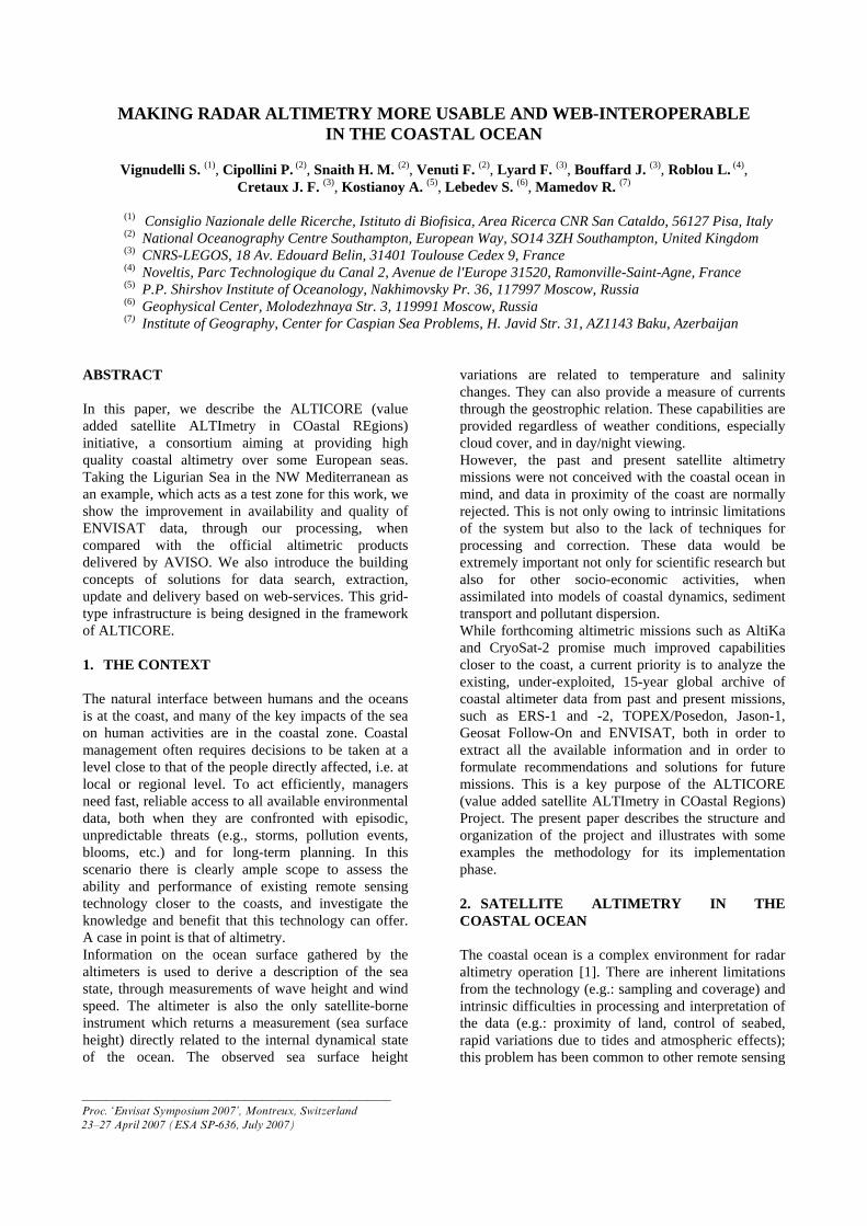
techniques (e.g., ocean colour), but research in coastal altimetry is still at an early stage when compared to those techniques. However there are also unexploited possibilities (e.g.: higher along track data rates, multi-altimetry scenarios). There have been a few isolated attempts by some laboratories to reprocess the altimetric records in a way that improves the quantity and quality of coastal data, but it is still difficult for the non-specialist to get data optimized for coastal targets in a ready to use format. Satellite altimetry in the context of the coastal ocean requires access to, and manipulation of, data from multiple sources, many of which undergo regular revision and enhancement. At the moment this is only within reach of a small number of specialists, while many potential users are not be able to take full advantage of improved coastal altimetry. It is therefore necessary to move from the present collection of unstructured data sets to a fully accessible network of linked data and software. 3. ALTICORE IN A NUTSHELL ALTICORE (www.alticore.eu) is a research programme involving a consortium of six teams from the EU, Russia and Azerbaijan and is a follow-on from the ALBICOCCA (ALtimeter-Based Investigations in COrsica, Capraia and Contiguous Areas) initiative. The ALTICORE Project is funded for a period of two years (12/2006 – 12/2008) - by INTAS, an independent association supported by the European Community and the European Union member states. In addition to its primary focus on the Mediterranean, ALTICORE is also targeted on other European seas, namely Black, Caspian, White and Barents (Fig. 1).
Figure 1. Map showing the European Seas to be investigated within ALTICORE and location of the
study area (Ligurian Sea) chosen as example.
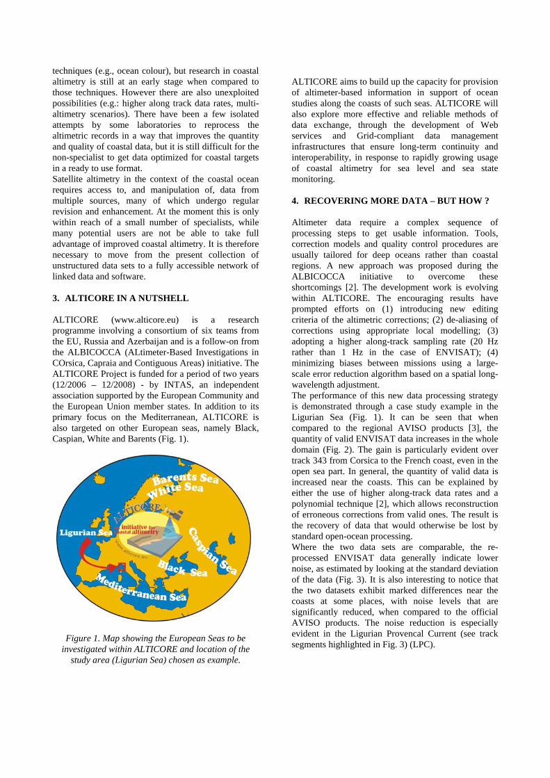
ALTICORE aims to build up the capacity for provision of altimeter-based information in support of ocean studies along the coasts of such seas. ALTICORE will also explore more effective and reliable methods of data exchange, through the development of Web services and Grid-compliant data management infrastructures that ensure long-term continuity and interoperability, in response to rapidly growing usage of coastal altimetry for sea level and sea state monitoring. 4. RECOVERING MORE DATA – BUT HOW ? Altimeter data require a complex sequence of processing steps to get usable information. Tools, correction models and quality control procedures are usually tailored for deep oceans rather than coastal regions. A new approach was proposed during the ALBICOCCA initiative to overcome these shortcomings [2]. The development work is evolving within ALTICORE. The encouraging results have prompted efforts on (1) introducing new editing criteria of the altimetric corrections; (2) de-aliasing of corrections using appropriate local modelling; (3) adopting a higher along-track sampling rate (20 Hz rather than 1 Hz in the case of ENVISAT); (4) minimizing biases between missions using a large-scale error reduction algorithm based on a spatial long-wavelength adjustment. The performance of this new data processing strategy is demonstrated through a case study example in the Ligurian Sea (Fig. 1). It can be seen that when compared to the regional AVISO products [3], the quantity of valid ENVISAT data increases in the whole domain (Fig. 2). The gain is particularly evident over track 343 from Corsica to the French coast, even in the open sea part. In general, the quantity of valid data is increased near the coasts. This can be explained by either the use of higher along-track data rates and a polynomial technique [2], which allows reconstruction of erroneous corrections from valid ones. The result is the recovery of data that would otherwise be lost by standard open-ocean processing. Where the two data sets are comparable, the re-processed ENVISAT data generally indicate lower noise, as estimated by looking at the standard deviation of the data (Fig. 3). It is also interesting to notice that the two datasets exhibit marked differences near the coasts at some places, with noise levels that are significantly reduced, when compared to the official AVISO products. The noise reduction is especially evident in the Ligurian Provencal Current (see track segments highlighted in Fig. 3) (LPC).
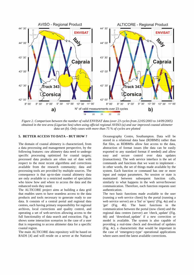
Figure 2. Comparison between the number of valid ENVISAT data (over 23 cycles from 22/05/2003 to 14/09/2005) obtained in the test area (Ligurian Sea) when using official regional AVISO (a) and our improved coastal altimeter
data set (b). Only cases with more than 75 % of cycles are plotted 5. BETTER ACCESS TO DATA – BUT HOW ? The domain of coastal altimetry is characterized, from a data processing and management perspective, by the following features: raw altimetry data need to undergo specific processing optimized for coastal targets; processed data products are often out of date with respect to the most recent algorithms and corrections available from the research community; data and processing tools are provided by multiple sources. The consequence is that up-to-date coastal altimetry data are only available to a restricted number of specialists who know how and where to access the data and the enhanced tools they need. The ALTICORE project aims at building a data grid that enables users to have seamless access to the data products and tools necessary to generate ready to use data. It consists of a central portal and regional data centres, each having primary responsibility for regional archives, local corrections and quality control, and operating a set of web-services allowing access to the full functionality of data search and extraction. Fig. 4 shows some interaction scenarios in the case of a user that is requesting to access altimeter data for a specific coastal region. The main ALTICORE data repository will be based on RADS [4] and will reside on a server at the National
Oceanography Centre, Southampton. Data will be stored in a relational data base (RDBMS) rather than flat files, as RDBMSs allow fast access to the data, abstraction of format issues (the data can be easily exported to any standard format if needed) and allow easy and secure control over data updates (transactions). The web service interface is the set of commands and functions that we want to implement - in other words, the set of things made available by the system. Each function or command has one or more input and output parameters. No session or state is maintained between subsequent function calls, similarly to what happens in the web server/browser communication. Therefore, each function requests user authentication. The two basic functions made available to the user (running a web service client) by the portal (running a web service server) are a 'list' or 'query' (Fig. 4a) and a 'get' (Fig. 4b). The basic functions in the communication between the portal (now client) and the regional data centres (server) are 'check_update' (Fig. 4d) and ‘download_update’ if a new correction or model is available. The system is also capable of providing a real-time check and download of updates (Fig. 4c), a characteristic that would be important in the case of ‘emergency-type’ operational applications where users need the latest available corrections.
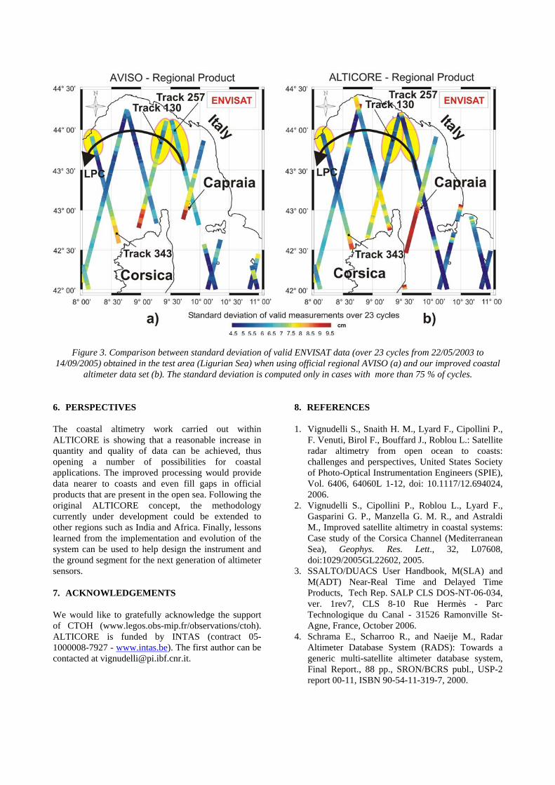
Figure 3. Comparison between standard deviation of valid ENVISAT data (over 23 cycles from 22/05/2003 to 14/09/2005) obtained in the test area (Ligurian Sea) when using official regional AVISO (a) and our improved coastal
altimeter data set (b). The standard deviation is computed only in cases with more than 75 % of cycles. 6. PERSPECTIVES The coastal altimetry work carried out within ALTICORE is showing that a reasonable increase in quantity and quality of data can be achieved, thus opening a number of possibilities for coastal applications. The improved processing would provide data nearer to coasts and even fill gaps in official products that are present in the open sea. Following the original ALTICORE concept, the methodology currently under development could be extended to other regions such as India and Africa. Finally, lessons learned from the implementation and evolution of the system can be used to help design the instrument and the ground segment for the next generation of altimeter sensors. 7. ACKNOWLEDGEMENTS We would like to gratefully acknowledge the support of CTOH (www.legos.obs-mip.fr/observations/ctoh). ALTICORE is funded by INTAS (contract 05-1000008-7927 - www.intas.be). The first author can be contacted at [email protected].
8. REFERENCES 1. Vignudelli S., Snaith H. M., Lyard F., Cipollini P.,
F. Venuti, Birol F., Bouffard J., Roblou L.: Satellite radar altimetry from open ocean to coasts: challenges and perspectives, United States Society of Photo-Optical Instrumentation Engineers (SPIE), Vol. 6406, 64060L 1-12, doi: 10.1117/12.694024, 2006.
2. Vignudelli S., Cipollini P., Roblou L., Lyard F., Gasparini G. P., Manzella G. M. R., and Astraldi M., Improved satellite altimetry in coastal systems: Case study of the Corsica Channel (Mediterranean Sea), Geophys. Res. Lett., 32, L07608, doi:1029/2005GL22602, 2005.
3. SSALTO/DUACS User Handbook, M(SLA) and M(ADT) Near-Real Time and Delayed Time Products, Tech Rep. SALP CLS DOS-NT-06-034, ver. 1rev7, CLS 8-10 Rue Hermès - Parc Technologique du Canal - 31526 Ramonville St-Agne, France, October 2006.
4. Schrama E., Scharroo R., and Naeije M., Radar Altimeter Database System (RADS): Towards a generic multi-satellite altimeter database system, Final Report., 88 pp., SRON/BCRS publ., USP-2 report 00-11, ISBN 90-54-11-319-7, 2000.
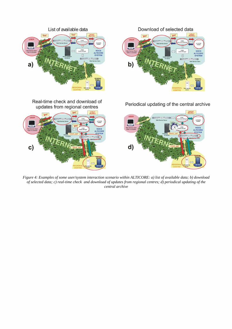
Figure 4: Examples of some user/system interaction scenario within ALTICORE: a) list of available data; b) download
of selected data; c) real-time check and download of updates from regional centres; d) periodical updating of the central archive