lro lyman alpha mapping project (lamp): data users … · lro lyman alpha mapping project (lamp):...
TRANSCRIPT
LRO Lyman Alpha Mapping Project (LAMP): Data Users Guide
Kurt D. RetherfordLAMP PI
and the LAMP Team
LAMP STM 1
Outline
1. LAMP Instrument Intro2. LAMP Nightside and Dayside Mapping Techniques Summary3. PDS Current Sets of Data4. Low-level ENG and SCI file formats5. Low-level IDL tools for using the data6. High-level map product formats7. Upcoming PDS delivery of global brightness maps8. Upcoming revisions to albedo and illumination products9. Future work
LAMP STM 2
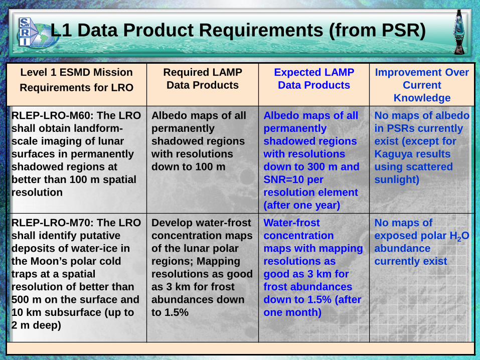
L1 Data Product Requirements (from PSR)
Level 1 ESMD MissionRequirements for LRO
Required LAMP Data Products
Expected LAMP Data Products
Improvement Over Current
KnowledgeRLEP-LRO-M60: The LRO shall obtain landform-scale imaging of lunar surfaces in permanently shadowed regions at better than 100 m spatial resolution
Albedo maps of all permanently shadowed regions with resolutions down to 100 m
Albedo maps of all permanently shadowed regions with resolutions down to 300 m and SNR=10 per resolution element (after one year)
No maps of albedo in PSRs currently exist (except for Kaguya results using scattered sunlight)
RLEP-LRO-M70: The LRO shall identify putative deposits of water-ice in the Moon’s polar cold traps at a spatial resolution of better than 500 m on the surface and 10 km subsurface (up to 2 m deep)
Develop water-frost concentration maps of the lunar polar regions; Mapping resolutions as good as 3 km for frost abundances down to 1.5%
Water-frost concentration maps with mapping resolutions as good as 3 km for frost abundances down to 1.5% (after one month)
No maps of exposed polar H2O abundance currently exist
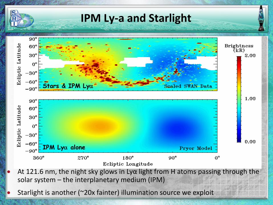
Stars & IPM Lyα
IPM Lyα alone
• At 121.6 nm, the night sky glows in Lyα light from H atoms passing through the solar system – the interplanetary medium (IPM)
• Starlight is another (~20x fainter) illumination source we exploit
IPM Ly-a and Starlight
4
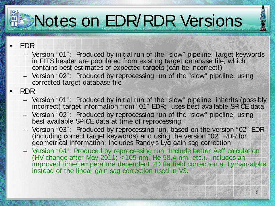
Notes on EDR/RDR Versions• EDR
– Version “01”: Produced by initial run of the “slow” pipeline; target keywords in FITS header are populated from existing target database file, which contains best estimates of expected targets (can be incorrect!)
– Version “02”: Produced by reprocessing run of the “slow” pipeline, using corrected target database file
• RDR– Version “01”: Produced by initial run of the “slow” pipeline; inherits (possibly
incorrect) target information from “01” EDR; uses best available SPICE data– Version “02”: Produced by reprocessing run of the “slow” pipeline, using
best available SPICE data at time of reprocessing– Version “03”: Produced by reprocessing run, based on the version “02” EDR
(including correct target keywords) and using the version “02” RDR for geometrical information; includes Randy’s Lyα gain sag correction
– Version “04”: Produced by reprocessing run. Include better Aeff calculation (HV change after May 2011; <105 nm, He 58.4 nm, etc.). Includes an improved time/temperature dependent 2D flatfield correction at Lyman-alpha instead of the linear gain sag correction used in V3.
5
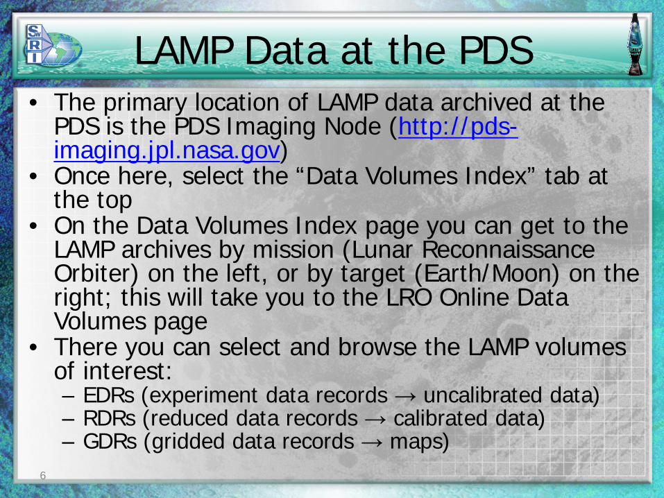
LAMP Data at the PDS• The primary location of LAMP data archived at the
PDS is the PDS Imaging Node (http://pds-imaging.jpl.nasa.gov)
• Once here, select the “Data Volumes Index” tab at the top
• On the Data Volumes Index page you can get to the LAMP archives by mission (Lunar Reconnaissance Orbiter) on the left, or by target (Earth/Moon) on the right; this will take you to the LRO Online Data Volumes page
• There you can select and browse the LAMP volumes of interest:– EDRs (experiment data records → uncalibrated data)– RDRs (reduced data records → calibrated data)– GDRs (gridded data records → maps)
6
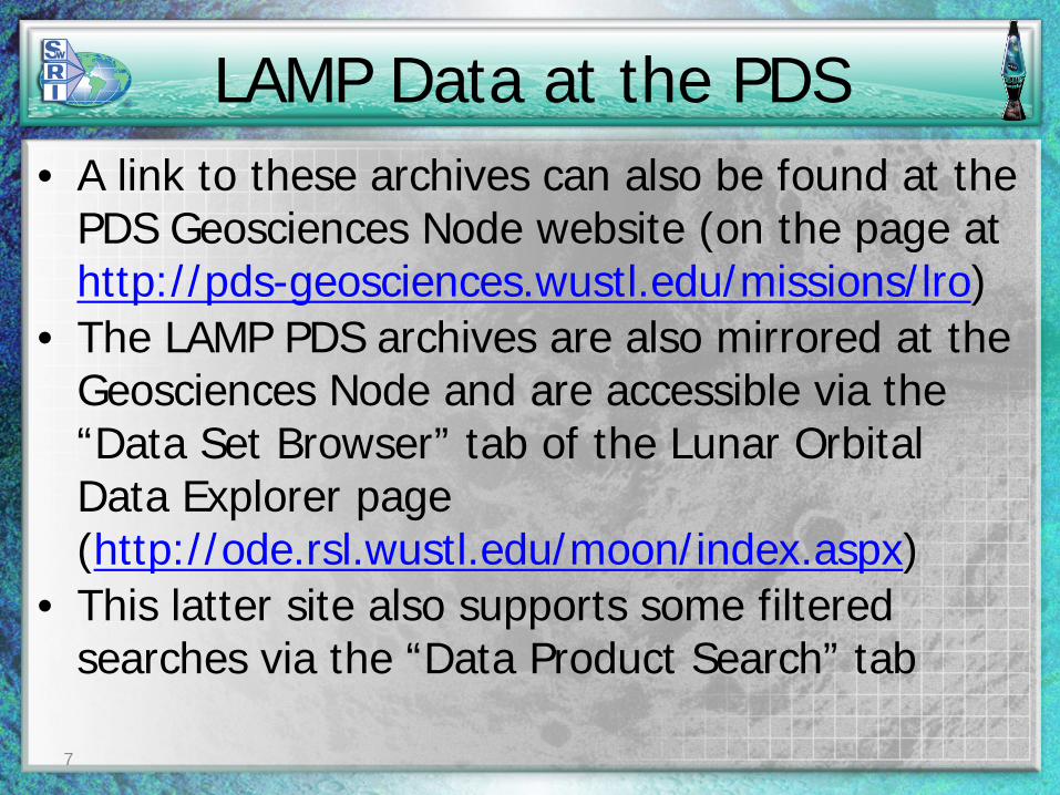
LAMP Data at the PDS• A link to these archives can also be found at the
PDS Geosciences Node website (on the page at http://pds-geosciences.wustl.edu/missions/lro)
• The LAMP PDS archives are also mirrored at the Geosciences Node and are accessible via the “Data Set Browser” tab of the Lunar Orbital Data Explorer page (http://ode.rsl.wustl.edu/moon/index.aspx)
• This latter site also supports some filtered searches via the “Data Product Search” tab
7
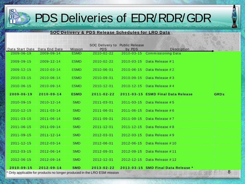
PDS Deliveries of EDR/RDR/GDRSOC Delivery & PDS Release Schedules for LRO Data
Data Start Date Data End Date MissionSOC Delivery to
PDSPublic Release
by PDS Description2009-06-19 2009-09-14 ESMD 2010-02-22 2010-03-15 Commissioning Data
2009-09-15 2009-12-14 ESMD 2010-02-22 2010-03-15 Data Release #1
2009-12-15 2010-03-14 ESMD 2010-06-01 2010-06-15 Data Release #2
2010-03-15 2010-06-14 ESMD 2010-09-01 2010-09-15 Data Release #3
2010-06-15 2010-09-14 ESMD 2010-12-01 2010-12-15 Data Release #4
2009-06-19 2010-09-14 ESMD 2011-02-22 2011-03-15 ESMD Final Data Release GRDs
2010-09-15 2010-12-14 SMD 2011-03-01 2011-03-15 Data Release #5
2010-12-15 2011-03-14 SMD 2011-06-01 2011-06-15 Data Release #6
2011-03-15 2011-06-14 SMD 2011-09-01 2011-09-15 Data Release #7
2011-06-15 2011-09-14 SMD 2011-12-01 2011-12-15 Data Release #8
2011-09-15 2011-12-14 SMD 2012-03-01 2012-03-15 Data Release #9
2011-12-15 2012-03-14 SMD 2012-06-01 2012-06-15 Data Release #10
2012-03-15 2012-06-14 SMD 2012-09-01 2012-09-15 Data Release #11
2012-06-15 2012-09-14 SMD 2012-12-01 2012-12-15 Data Release #12
2010-09-15 2012-09-14 SMD 2013-02-22 2013-03-15 SMD Final Data Release *8* Only applicable for products no longer produced in the LRO ESM mission
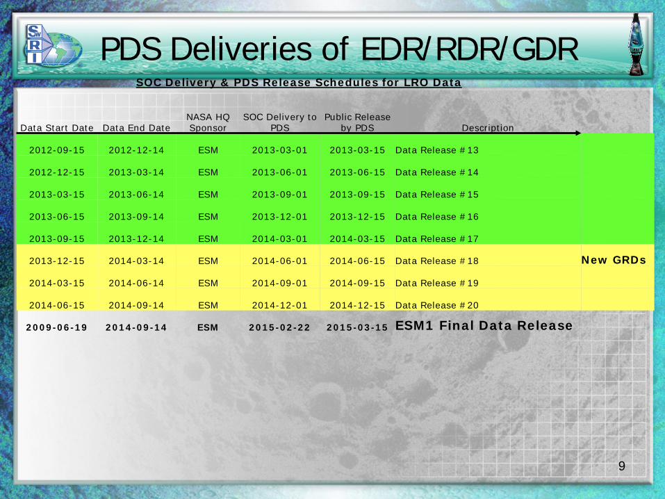
PDS Deliveries of EDR/RDR/GDRSOC Delivery & PDS Release Schedules for LRO Data
Data Start Date Data End DateNASA HQ Sponsor
SOC Delivery to PDS
Public Release by PDS Description
2012-09-15 2012-12-14 ESM 2013-03-01 2013-03-15 Data Release #13
2012-12-15 2013-03-14 ESM 2013-06-01 2013-06-15 Data Release #14
2013-03-15 2013-06-14 ESM 2013-09-01 2013-09-15 Data Release #15
2013-06-15 2013-09-14 ESM 2013-12-01 2013-12-15 Data Release #16
2013-09-15 2013-12-14 ESM 2014-03-01 2014-03-15 Data Release #17
2013-12-15 2014-03-14 ESM 2014-06-01 2014-06-15 Data Release #18 New GRDs
2014-03-15 2014-06-14 ESM 2014-09-01 2014-09-15 Data Release #19
2014-06-15 2014-09-14 ESM 2014-12-01 2014-12-15 Data Release #20
2009-06-19 2014-09-14 ESM 2015-02-22 2015-03-15 ESM1 Final Data Release
9
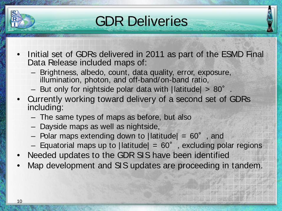
GDR Deliveries
• Initial set of GDRs delivered in 2011 as part of the ESMD Final Data Release included maps of:– Brightness, albedo, count, data quality, error, exposure,
illumination, photon, and off-band/on-band ratio,– But only for nightside polar data with |latitude| > 80°.
• Currently working toward delivery of a second set of GDRs including:– The same types of maps as before, but also– Dayside maps as well as nightside,– Polar maps extending down to |latitude| = 60°, and– Equatorial maps up to |latitude| = 60°, excluding polar regions
• Needed updates to the GDR SIS have been identified• Map development and SIS updates are proceeding in tandem.
10
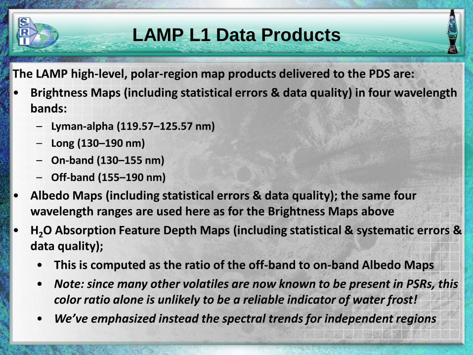
LAMP L1 Data Products
The LAMP high-level, polar-region map products delivered to the PDS are:
• Brightness Maps (including statistical errors & data quality) in four wavelength bands:
– Lyman-alpha (119.57–125.57 nm)
– Long (130–190 nm)
– On-band (130–155 nm)
– Off-band (155–190 nm)
• Albedo Maps (including statistical errors & data quality); the same four wavelength ranges are used here as for the Brightness Maps above
• H2O Absorption Feature Depth Maps (including statistical & systematic errors & data quality);
• This is computed as the ratio of the off-band to on-band Albedo Maps
• Note: since many other volatiles are now known to be present in PSRs, this color ratio alone is unlikely to be a reliable indicator of water frost!
• We’ve emphasized instead the spectral trends for independent regions
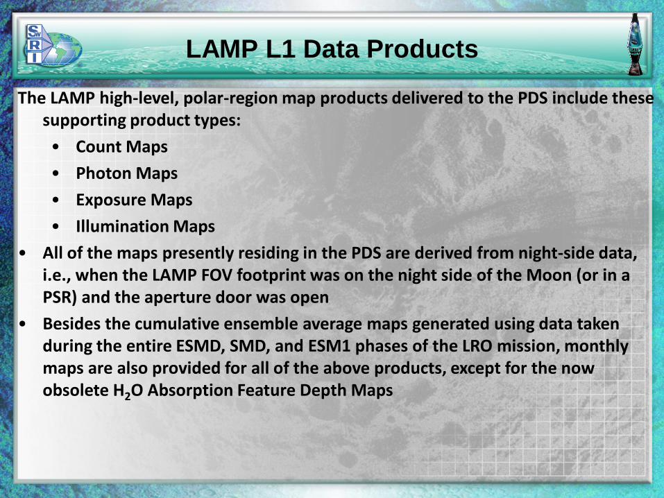
LAMP L1 Data Products
The LAMP high-level, polar-region map products delivered to the PDS include these supporting product types:
• Count Maps
• Photon Maps
• Exposure Maps
• Illumination Maps
• All of the maps presently residing in the PDS are derived from night-side data, i.e., when the LAMP FOV footprint was on the night side of the Moon (or in a PSR) and the aperture door was open
• Besides the cumulative ensemble average maps generated using data taken during the entire ESMD, SMD, and ESM1 phases of the LRO mission, monthly maps are also provided for all of the above products, except for the now obsolete H2O Absorption Feature Depth Maps
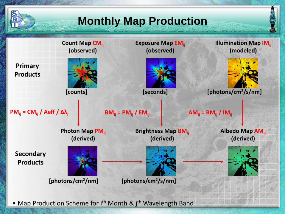
Monthly Map Production
Count Map CMij
(observed)
Primary Products
SecondaryProducts
Exposure Map EMij
(observed)
[counts] [seconds]
Illumination Map IMij
(modeled)
[photons/cm2/s/nm]
Photon Map PMij
(derived)
[photons/cm2/nm]
Brightness Map BMij
(derived)
[photons/cm2/s/nm]
Albedo Map AMij
(derived)
PMij = CMij / Aeff / Δλj BMij = PMij / EMij AMij = BMij / IMij
• Map Production Scheme for ith Month & jth Wavelength Band
Cumulative Map Production
Count Maps CMij
Monthly PrimaryProducts
CumulativeProducts
Exposure Maps EMij
[counts] [seconds]
Illumination Maps IMij
[photons/cm2/s/nm]
Photon Map PMj
[photons/cm2/nm]
Brightness Map AMj
[photons/cm2/s/nm]
AMj = PMj / Σ(EMi*IMi)
PMj = ΣCMij / Aeff / Δλj
• Map Production Scheme for jth Wavelength Band & Ratio Map
Albedo Map AMj
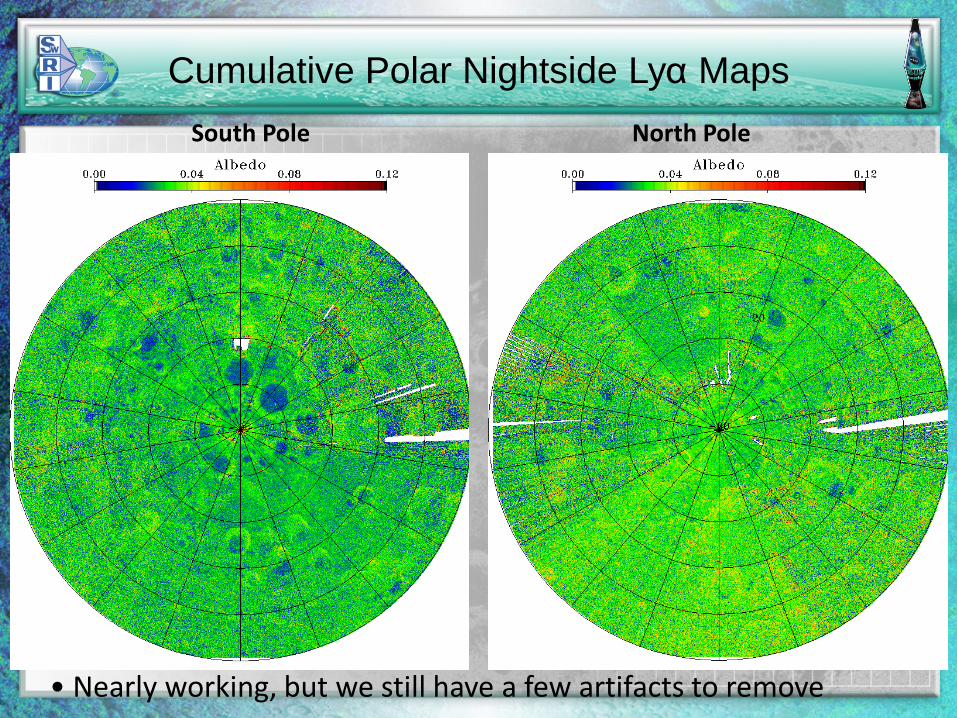
Cumulative Polar Nightside Lyα Maps South Pole North Pole
• Nearly working, but we still have a few artifacts to remove
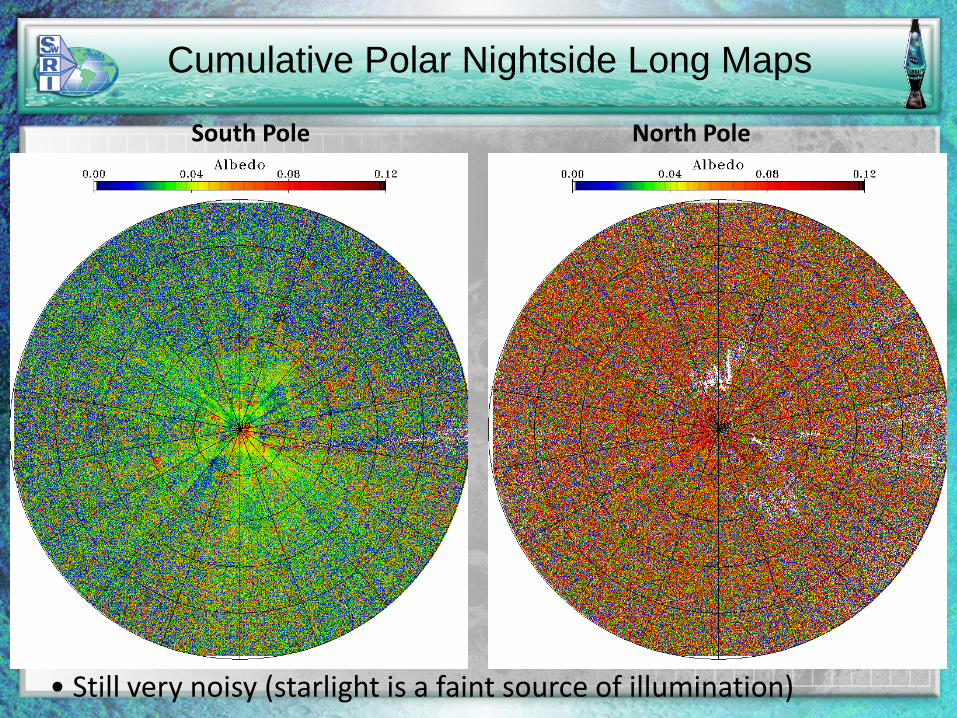
Cumulative Polar Nightside Long Maps
South Pole North Pole
• Still very noisy (starlight is a faint source of illumination)
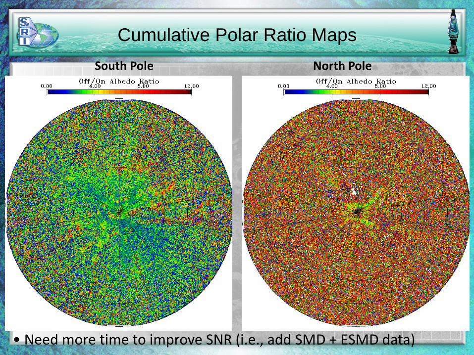
Cumulative Polar Ratio Maps South Pole North Pole
• Need more time to improve SNR (i.e., add SMD + ESMD data)
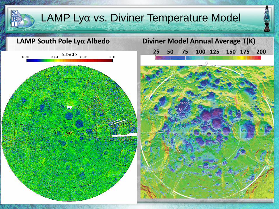
LAMP Lyα vs. Diviner Temperature Model
LAMP South Pole Lyα Albedo Diviner Model Annual Average T(K)25 50 75 100 125 150 175 200
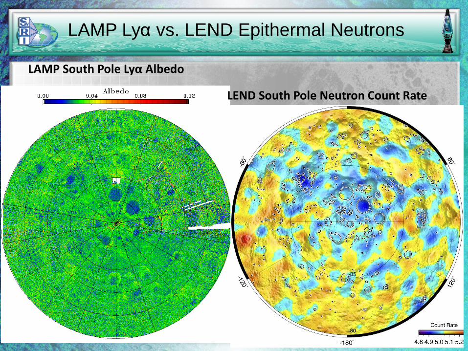
LAMP Lyα vs. LEND Epithermal Neutrons
LAMP South Pole Lyα Albedo
LEND South Pole Neutron Count Rate
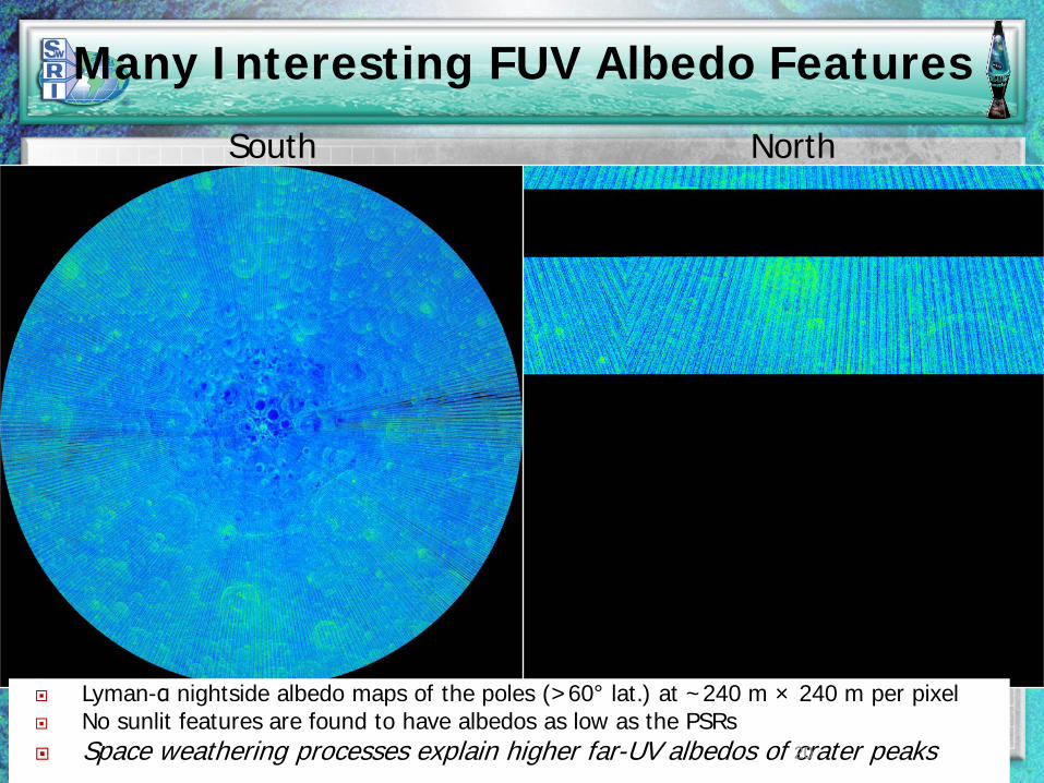
Many Interesting FUV Albedo Features
South North
Lyman-α nightside albedo maps of the poles (>60° lat.) at ~240 m × 240 m per pixel No sunlit features are found to have albedos as low as the PSRs Space weathering processes explain higher far-UV albedos of crater peaks20
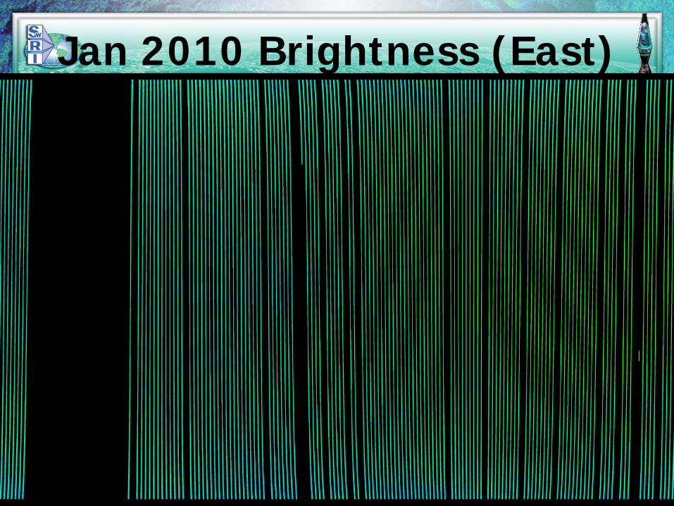
Jan 2010 Brightness (East)
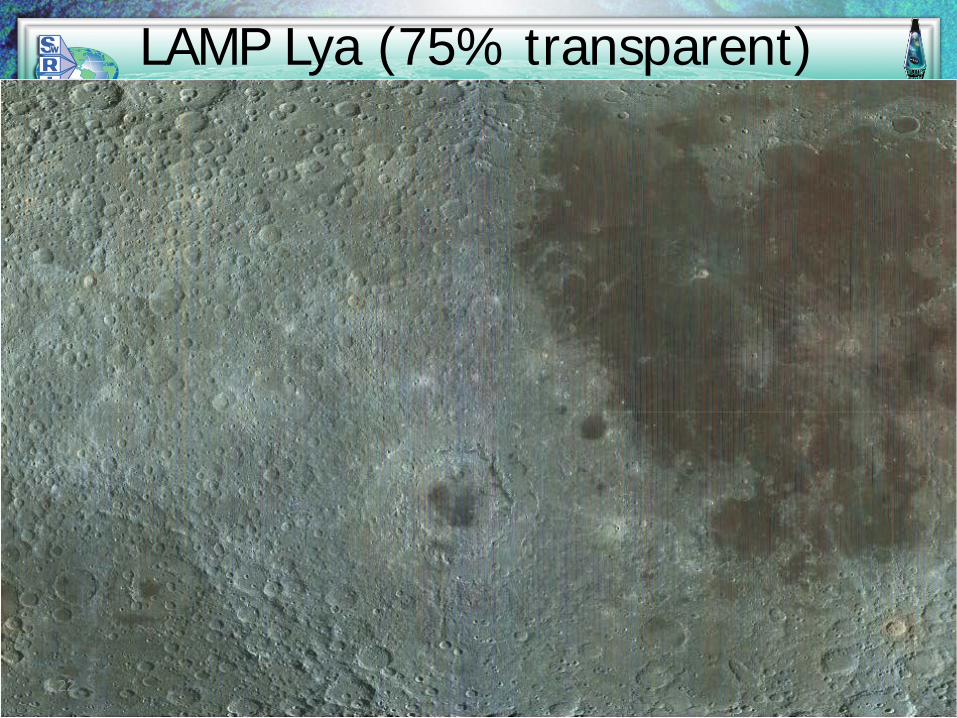
LAMP Lya (75% transparent)
22
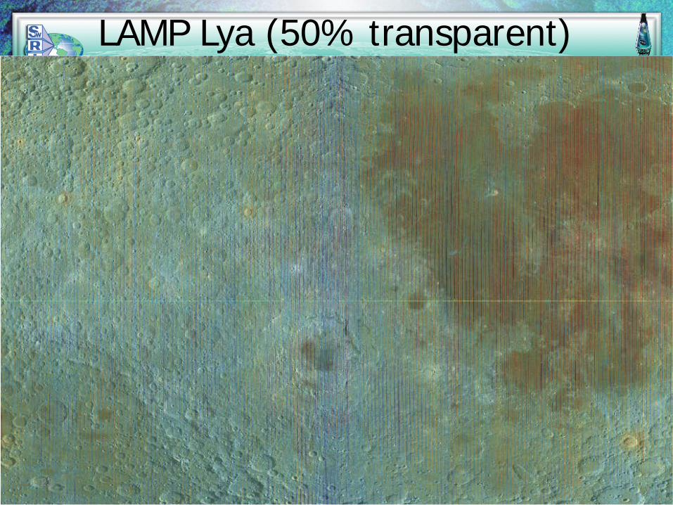
LAMP Lya (50% transparent)
23
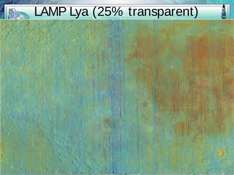
LAMP Lya (25% transparent)
24
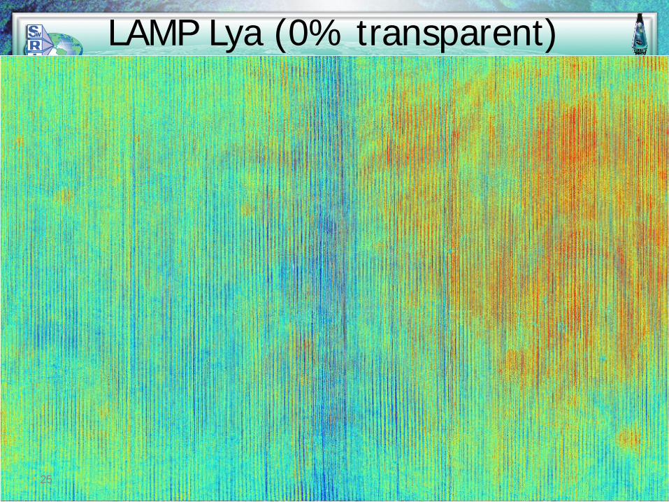
LAMP Lya (0% transparent)
25

Future Work• Version 5 mapping pipeline code is in progress. – next 3 month PDS
delivery– More robust testing with checksums and other tools now in hand– Added a count rate map (rmap) standard output– Commissioning data seems to be ready to go in pipeline– New semantics and illumination definitions– Hit a snag in recent illumination calculations and the albedo maps are under
revision – we might just go ahead and deliver the latest brightness and other maps in the meantime
• Tommy Greathouse has developed a spectral brightness mapping tool that produces image cubes more efficiently
• Additional upgrades/tasks on the horizon (V5 or V6)– Change dayside photometry from μ0 to μ0 /(μ + μ0)– Model Earthshine illumination– Filter out high-noise solar event times, and solar glint and penumbral
eclipse geometries– Improve sunlit peak removal during monthly accumulations (median
filtering); esp. for Shackleton mapping
LAMP STM 26
Backup
LAMP STM 27
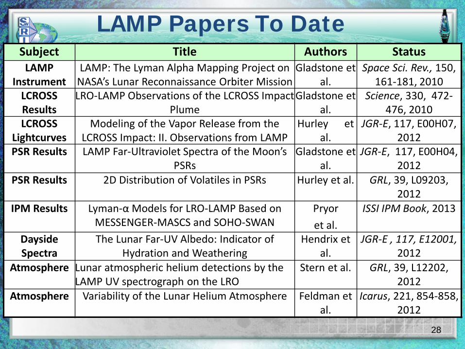
LAMP Papers To Date
28
Subject Title Authors StatusLAMP
InstrumentLAMP: The Lyman Alpha Mapping Project on
NASA’s Lunar Reconnaissance Orbiter MissionGladstone et
al.Space Sci. Rev., 150,
161-181, 2010LCROSS Results
LRO-LAMP Observations of the LCROSS Impact Plume
Gladstone et al.
Science, 330, 472-476, 2010
LCROSS Lightcurves
Modeling of the Vapor Release from the LCROSS Impact: II. Observations from LAMP
Hurley et al.
JGR-E, 117, E00H07, 2012
PSR Results LAMP Far-Ultraviolet Spectra of the Moon’s PSRs
Gladstone et al.
JGR-E, 117, E00H04, 2012
PSR Results 2D Distribution of Volatiles in PSRs Hurley et al. GRL, 39, L09203, 2012
IPM Results Lyman-α Models for LRO-LAMP Based on MESSENGER-MASCS and SOHO-SWAN
Pryor
et al.
ISSI IPM Book, 2013
Dayside Spectra
The Lunar Far-UV Albedo: Indicator of Hydration and Weathering
Hendrix et al.
JGR-E , 117, E12001, 2012
Atmosphere Lunar atmospheric helium detections by the LAMP UV spectrograph on the LRO
Stern et al. GRL, 39, L12202, 2012
Atmosphere Variability of the Lunar Helium Atmosphere Feldman et al.
Icarus, 221, 854-858, 2012
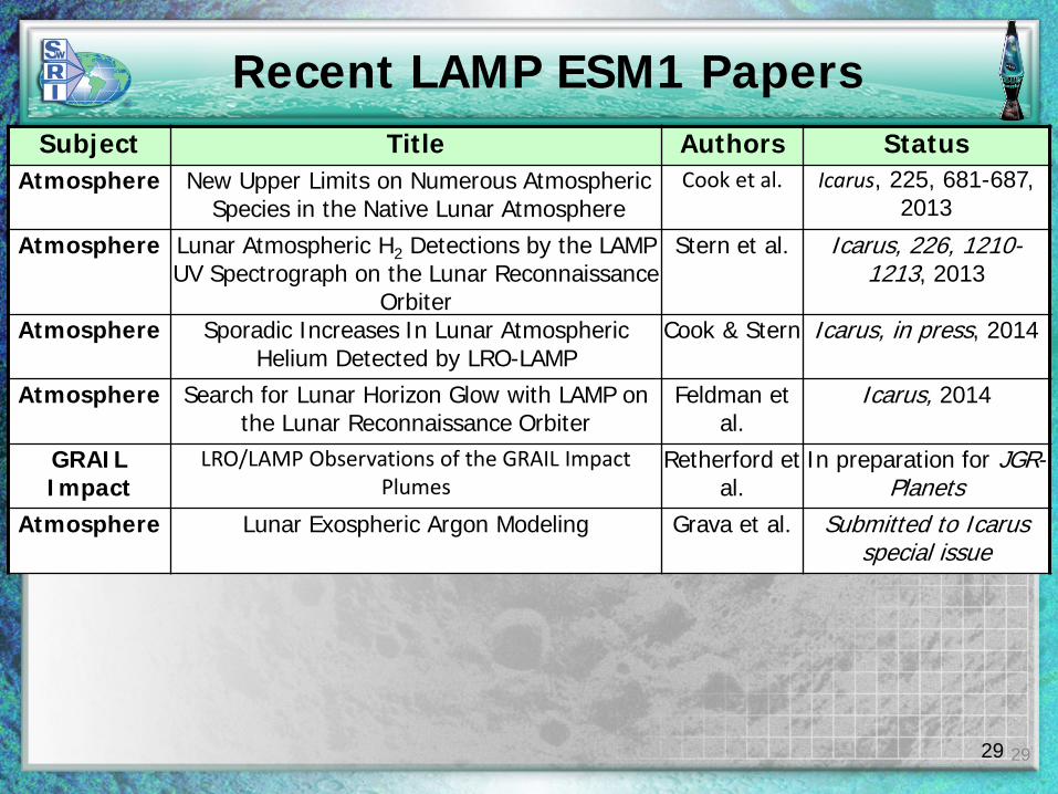
Recent LAMP ESM1 Papers
29
Subject Title Authors StatusAtmosphere New Upper Limits on Numerous Atmospheric
Species in the Native Lunar AtmosphereCook et al. Icarus, 225, 681-687,
2013
Atmosphere Lunar Atmospheric H2 Detections by the LAMP UV Spectrograph on the Lunar Reconnaissance
Orbiter
Stern et al. Icarus, 226, 1210-1213, 2013
Atmosphere Sporadic Increases In Lunar Atmospheric Helium Detected by LRO-LAMP
Cook & Stern Icarus, in press, 2014
Atmosphere Search for Lunar Horizon Glow with LAMP on the Lunar Reconnaissance Orbiter
Feldman et al.
Icarus, 2014
GRAIL Impact
LRO/LAMP Observations of the GRAIL Impact Plumes
Retherford et al.
In preparation for JGR-Planets
Atmosphere Lunar Exospheric Argon Modeling Grava et al. Submitted to Icarusspecial issue
29
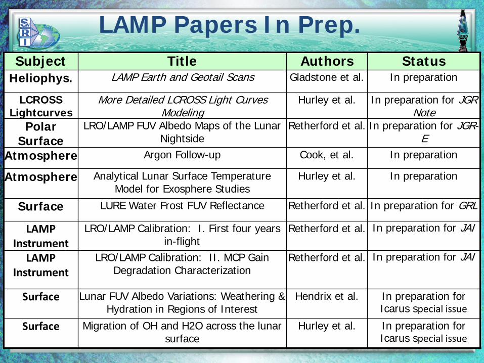
LAMP Papers In Prep.
30
Subject Title Authors StatusHeliophys. LAMP Earth and Geotail Scans Gladstone et al. In preparation
LCROSS Lightcurves
More Detailed LCROSS Light Curves Modeling
Hurley et al. In preparation for JGR Note
Polar Surface
LRO/LAMP FUV Albedo Maps of the Lunar Nightside
Retherford et al. In preparation for JGR-E
Atmosphere Argon Follow-up Cook, et al. In preparation
Atmosphere Analytical Lunar Surface Temperature Model for Exosphere Studies
Hurley et al. In preparation
Surface LURE Water Frost FUV Reflectance Retherford et al. In preparation for GRL
LAMP Instrument
LRO/LAMP Calibration: I. First four years in-flight
Retherford et al. In preparation for JAI
LAMP Instrument
LRO/LAMP Calibration: II. MCP Gain Degradation Characterization
Retherford et al. In preparation for JAI
Surface Lunar FUV Albedo Variations: Weathering & Hydration in Regions of Interest
Hendrix et al. In preparation for Icarus special issue
Surface Migration of OH and H2O across the lunar surface
Hurley et al. In preparation for Icarus special issue
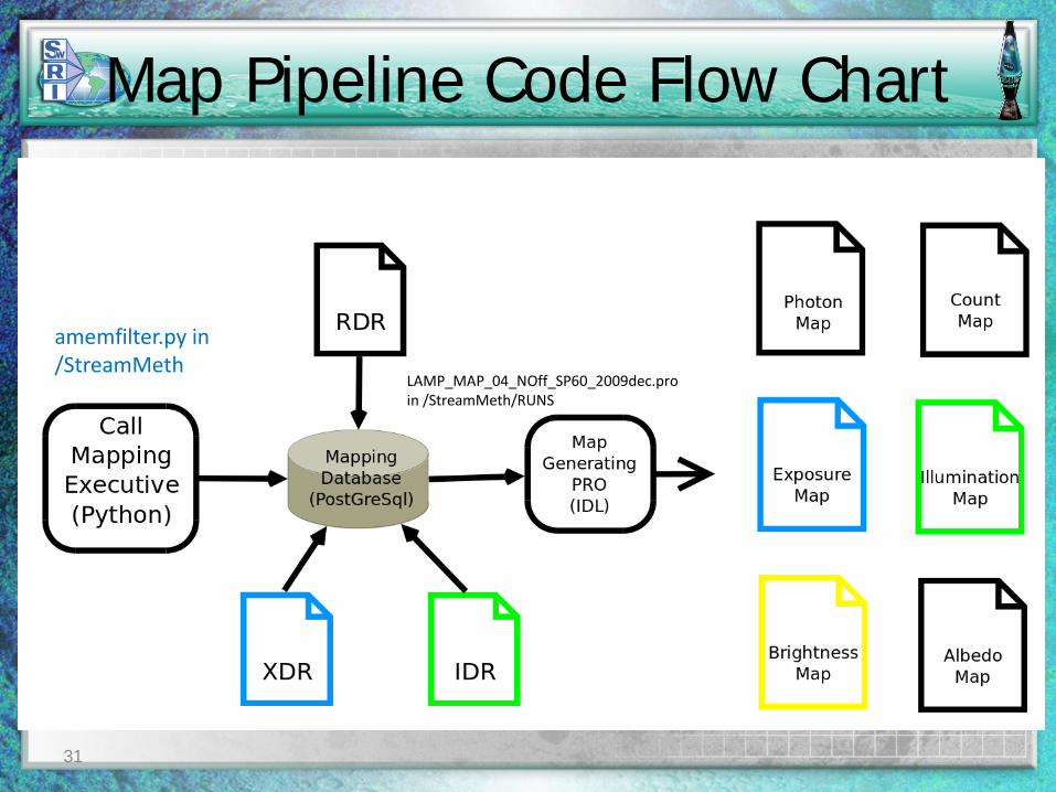
Map Pipeline Code Flow Chart
amemfilter.py in /StreamMeth
LAMP_MAP_04_NOff_SP60_2009dec.proin /StreamMeth/RUNS
31
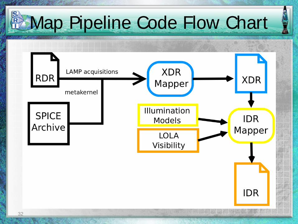
Map Pipeline Code Flow Chart
32
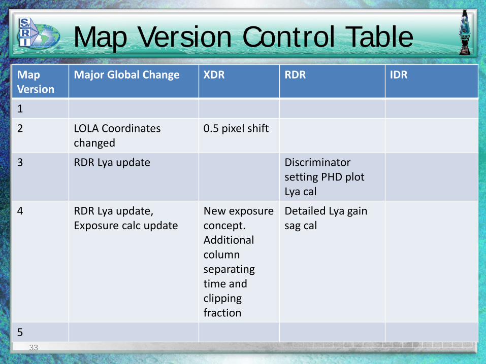
Map Version Control TableMap Version
Major Global Change XDR RDR IDR
1
2 LOLA Coordinates changed
0.5 pixel shift
3 RDR Lya update Discriminator setting PHD plot Lya cal
4 RDR Lya update, Exposure calc update
New exposureconcept. Additional column separating time and clipping fraction
Detailed Lya gain sag cal
533
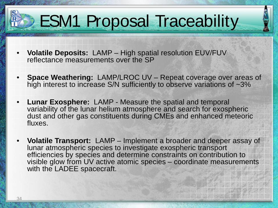
ESM1 Proposal Traceability
• Volatile Deposits: LAMP – High spatial resolution EUV/FUV reflectance measurements over the SP
• Space Weathering: LAMP/LROC UV – Repeat coverage over areas of high interest to increase S/N sufficiently to observe variations of ~3%
• Lunar Exosphere: LAMP - Measure the spatial and temporal variability of the lunar helium atmosphere and search for exospheric dust and other gas constituents during CMEs and enhanced meteoric fluxes.
• Volatile Transport: LAMP – Implement a broader and deeper assay of lunar atmospheric species to investigate exospheric transport efficiencies by species and determine constraints on contribution to visible glow from UV active atomic species – coordinate measurements with the LADEE spacecraft.
34
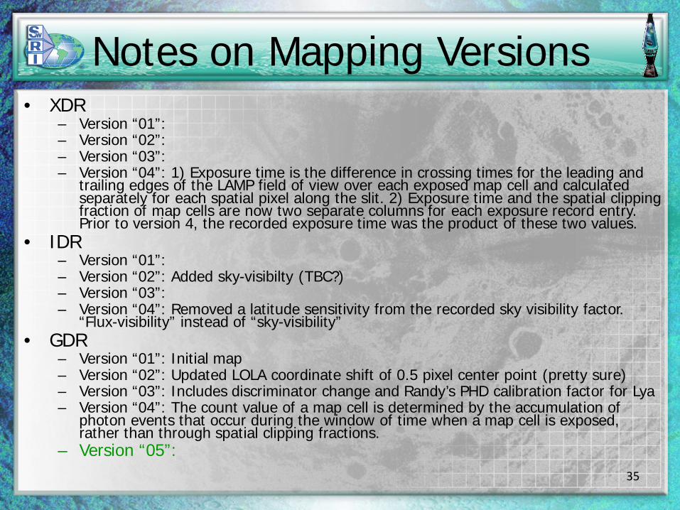
Notes on Mapping Versions• XDR
– Version “01”:– Version “02”:– Version “03”:– Version “04”: 1) Exposure time is the difference in crossing times for the leading and
trailing edges of the LAMP field of view over each exposed map cell and calculated separately for each spatial pixel along the slit. 2) Exposure time and the spatial clipping fraction of map cells are now two separate columns for each exposure record entry. Prior to version 4, the recorded exposure time was the product of these two values.
• IDR– Version “01”:– Version “02”: Added sky-visibilty (TBC?)– Version “03”:– Version “04”: Removed a latitude sensitivity from the recorded sky visibility factor.
“Flux-visibility” instead of “sky-visibility”• GDR
– Version “01”: Initial map– Version “02”: Updated LOLA coordinate shift of 0.5 pixel center point (pretty sure)– Version “03”: Includes discriminator change and Randy’s PHD calibration factor for Lya– Version “04”: The count value of a map cell is determined by the accumulation of
photon events that occur during the window of time when a map cell is exposed, rather than through spatial clipping fractions.
– Version “05”:35