louisiana department of wildlife & … and water conservation district (cbbrwcd) as a...
TRANSCRIPT
1
LOUISIANA DEPARTMENT OF
WILDLIFE & FISHERIES
OFFICE OF FISHERIES
INLAND FISH SECTION
PART VI-A
WATERBODY MANAGEMENT PLAN SERIES
CYPRESS BAYOU RESERVOIR
LAKE HISTORY & MANAGEMENT ISSUES

2
CHRONOLOGY
DOCUMENT SCHEDULED TO BE UPDATED EVERY THREE YEARS
December 2014—Prepared By:
James Seales, Biologist III, District 1
Jeff Sibley, Biologist Manager, District 1
Kevin Houston, Biologist Supervisor, District 1
3
TABLE OF CONTENTS
LAKE HISTORY ......................................................................................................5
GENERAL INFORMATION ............................................................................................................ 5
Parish/ location .............................................................................................................................. 5
Date Lake Formed ......................................................................................................................... 5
Impoundment................................................................................................................................. 5
Size (surface area) ......................................................................................................................... 5
Watershed ...................................................................................................................................... 5
Pool Stage ...................................................................................................................................... 5
Spillway Width .............................................................................................................................. 5
Alternate / Local Names ................................................................................................................ 5
Drawdown description ................................................................................................................... 6
Who Controls ................................................................................................................................ 6
LAKE AUTHORITY ......................................................................................................................... 6
Association .................................................................................................................................... 6
Authorization ................................................................................................................................. 6
Board of Commissioners ............................................................................................................... 6
ACCESS .............................................................................................................................................. 7
Boat Ramps ................................................................................................................................... 7
State / Federal Facilities ................................................................................................................ 8
Artificial Reefs .............................................................................................................................. 8
Piers ............................................................................................................................................... 8
SHORELINE DEVELOPMENT ...................................................................................................... 9
PHYSICAL DESCRIPTION OF LAKE .......................................................................................... 9
Shoreline Length ........................................................................................................................... 9
Timber Type .................................................................................................................................. 9
Average Depth ............................................................................................................................... 9
Maximum Depth ............................................................................................................................ 9
Total Water Storage Volume at Pool Stage ................................................................................. 10
Natural Seasonal Water Fluctuation ............................................................................................ 10
EVENTS/ PROBLEMS .................................................................................................................... 10
Eutrophication ............................................................................................................................. 10
Commission Rules and Regulation Issues ................................................................................... 10
MANAGEMENT ISSUES......................................................................................11
AQUATIC VEGETATION ............................................................................................................. 11
DRAWDOWN HISTORY ............................................................................................................... 11
4
Aquatic Vegetation Surveys and Type Maps .............................................................................. 12
Aquatic Vegetation Treatment History ........................................................................................ 12
Biological .................................................................................................................................... 12
Chemical ...................................................................................................................................... 12
HISTORY OF REGULATIONS ..................................................................................................... 14
Recreational ................................................................................................................................. 14
Commercial ................................................................................................................................. 14
FISH KILLS / DISEASE HISTORY, LMBV ................................................................................ 15
CONTAMINANTS/POLLUTION .................................................................................................. 15
BIOLOGICAL .................................................................................................................................. 15
Fish Sampling History: ................................................................................................................ 15
Lake Records ............................................................................................................................... 17
Stocking History .......................................................................................................................... 18
Largemouth Bass Genetics .......................................................................................................... 18
Species Profile: ............................................................................................................................ 19
Threatened/Endangered/Exotic Species ...................................................................................... 20
CREEL .............................................................................................................................................. 20
HYDROLOGICAL CHANGES ...................................................................................................... 20
WATER USE .................................................................................................................................... 21
APPENDIX I ...........................................................................................................22
APPENDIX II ..........................................................................................................29
APPENDIX III ........................................................................................................35
APPENDIX IV ........................................................................................................36
5
LAKE HISTORY
GENERAL INFORMATION
Parish/ location
Cypress Bayou Reservoir is located in Bossier Parish, approximately 3 miles east of Benton,
LA.
Date Lake Formed
Cypress Bayou Reservoir was impounded in 1975.
Impoundment
Cypress Bayou Reservoir was created by the construction of a 6,100 foot long, earthen dam
and concrete spillway on Cypress Bayou. A second 1,000 foot long embankment is located
to the west of the main structure and separates Cypress Bayou Reservoir from the adjacent,
“sister” reservoir, Black Bayou Reservoir. The main dam has a 15 foot crown with crest
elevation of 199.0 MSL.
Size (surface area)
The surface area of Cypress Bayou Reservoir is approximately 3,100 acres at normal pool
stage. Normal water level fluctuations do not greatly alter surface area due to shoreline
contour.
Watershed
There are 155 square miles of area (99,200 acres) that drain into Cypress Bayou Reservoir.
Three major inlets contribute to Cypress Bayou Reservoir: Cypress Bayou, Little Caney
Bayou and White Oak Bayou. The ratio of watershed to lake surface area is 32:1.
Pool Stage
Surface elevation of Cypress Bayou Reservoir is set at the spillway crest elevation of 180
MSL.
Spillway Width
Cypress Bayou Reservoir has a 300 foot wide concrete sharp-crested weir-type spillway
designed for a maximum discharge rate of 45,400 cubic feet per second. There is a
downstream energy deflecting dissipater embedded in the stilling basin approximately 15 feet
below the spillway crest.
Alternate / Local Names
Cypress Bayou Reservoir is also known locally as “Cypress Lake”, “Cypress Bayou”, or
“Cypress”. On documents dealing with the design, construction, operation and maintenance
of the reservoir the official names generally used are “Cypress Black Bayou Site No. 1”,
“Cypress Black Bayou Reservoir No. 1” or sometimes simply “Reservoir No. 1”. Black
Bayou Reservoir is the “sister” reservoir located adjacent to Cypress Bayou Reservoir. The
two lakes are independent of one another but are connected through a concrete box culvert
with sluice gates on each end.
6
Drawdown description
A 6 foot by 6 foot drawdown gate in the face of the spillway wall allows for a near complete
dewatering of the reservoir. Cypress Bayou Reservoir can also be dewatered approximately
10-12 feet utilizing the 210 foot long interconnect structure provided the lake level of Black
Bayou Reservoir has been reduced below the level of Cypress Bayou Reservoir. The lakes
are connected with a 6-foot square, concrete box culvert with sluice gates on each end. See
Water Use section for more information.
Who Controls
Cypress Bayou Reservoir is owned, operated and maintained by the Cypress Black Bayou
Recreation and Water Conservation District (CBBRWCD) as a multipurpose reservoir. The
lake commission is responsible for the control structures on the lake including operation for
drawdowns. Drawdown plans from the commission are coordinated through Louisiana
Department of Wildlife and Fisheries (LDWF) and Louisiana Department of Transportation
and Development (DOTD) prior to opening the control structure. DOTD performs annual
dam safety inspections.
LAKE AUTHORITY
Association
The CBBRWCD owns, operates and maintains Cypress Bayou Reservoir and the adjacent
Black Bayou Reservoir.
Authorization
Act No. 292 of the 1958 Louisiana Legislature (APPENDIX I) created the CBBRWCD and
granted the commission the authority to enact rules and regulations pertaining to Cypress
Bayou Reservoir and Black Bayou Reservoir.
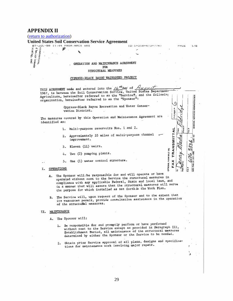
Funds for the construction of the Cypress-Black Bayou Watershed Project were provided by
the United States Soil Conservation Service in an agreement dated August 16, 1967. The
two reservoirs were created as multipurpose reservoirs for the storage of water for irrigation,
municipal purposes, recreation, and sediment storage (APPENDIX II). The dam and control
structures were designed by the Louisiana Department of Public Works.
Board of Commissioners
Members of the board of commissioners of the CBBRWCD are appointed as follows: one by
the Bossier Parish Police Jury, one by the mayor and governing authority of Bossier City,
one by the mayor and governing authority of the village of Benton, one by the Bossier Parish
School Board, and the fifth by the Board of Commissioners of the Bossier Levee
District. Any vacancy in the office of commissioner, due to death, resignation or any other
cause, shall be filled by the remaining commissioners for the unexpired term.
7
Table 1. Cypress – Black Bayou Recreation and Water Conservation District Commissioners
Name Appointed
By: Address
Term
Expires
Walt Bigby
President Bossier City
201 Bridgepoint Circle
Bossier City, LA 71111 7-31-2015
Gary Wyche
Vice President
Town of
Benton
1337 Linton Road
Benton, LA 71006 7-31-2016
Alan Warren
Secretary
Bossier
Levee
District
371 Vance Road
Benton, LA 71006 7-31-2017
Robert Berry
Executive
Director
Bossier
Police Jury
121 Preston Bay
Benton, LA 71006 7-31-2018
Jerry Fowler
Bossier
Parish
School
Board
2008 Chelsey
Benton, LA 71006 7-31-2019
Robert Berry – Executive Director of the Cypress Black Bayou Recreation and Water
Conservation District. 318-965-2289.
Cypress – Black Bayou Recreation and Water Conservation District
135 Cypress Park Dr.
Benton, LA 71106
318-965-0007
http://www.cypressblackbayou.com/
ACCESS
Boat Ramps
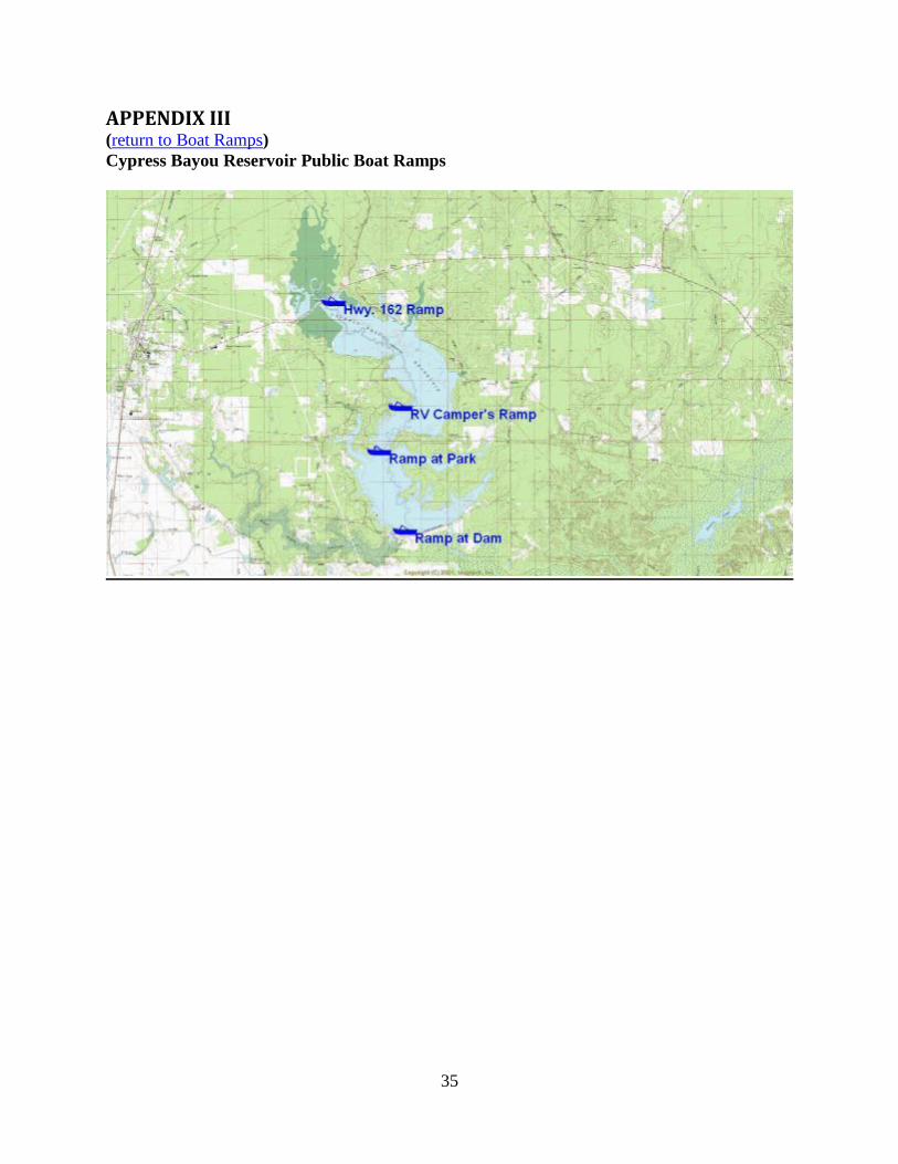
There are four public boat launching facilities available for use at Cypress Bayou Reservoir.
Each ramp is owned by the CBBRWCD and offers bank fishing and a boat mooring pier.
All boats on Cypress Bayou Reservoir are required to have a boat permit issued by the
CBBRWCD. These permits must be obtained annually and additional fees are required for
use of the CBBRWCD facilities for access, parking, or launching. Boat permits and other
annual passes may be obtained at the Cypress-Black Bayou Park. Additional information
regarding such fees can be found at: http://www.cypressblackbayou.com/price.html. Names
of the ramps, physical descriptions and geo-referenced locations are provided in Table 2.
8
Table 2. Locations and descriptions of public boat ramps on Cypress Bayou Reservoir, LA.
Ramp Coordinates
NAD83 Ramp Parking
Cypress Park (Public – Pay to
Launch)
32.671990° N
-93.675031° W
Concrete Blacktop – 60 Trailers
Cypress Dam (Public – Pay to
Launch)
32.651590° N
-93.666311° W
Concrete Blacktop - 70 trailers
Hwy 162 Ramp (Public – Pay to
Launch)
32.707070° N
-93.687689° W Concrete Blacktop – 20 Trailers
Cypress Park – Camping Area
(Registered Campers Only)
32.681357° N
-93.667377° W
Concrete Campers park at their
designated campsite
See APPENDIX III - “Cypress Bayou Reservoir Public Boat Ramps” for mapped locations
of ramps.
State / Federal Facilities
There is no state or federal facilities on the lake.
In addition to the boat launches at the dam and Hwy. 162, the CBBRWCD operates the
Cypress Black Bayou Park and Recreation Area which has cabin rentals, camping areas, RV
hookups, restrooms, boat launches, fishing piers, day use facilities, playgrounds, a small zoo,
a nature center, and a swimming beach. For more information on the Cypress Black Bayou
Park and Recreation Area please visit the following site:
http://www.cypressblackbayou.com/
Artificial Reefs
No artificial reefs have been placed in Cypress Bayou Reservoir by LDWF.
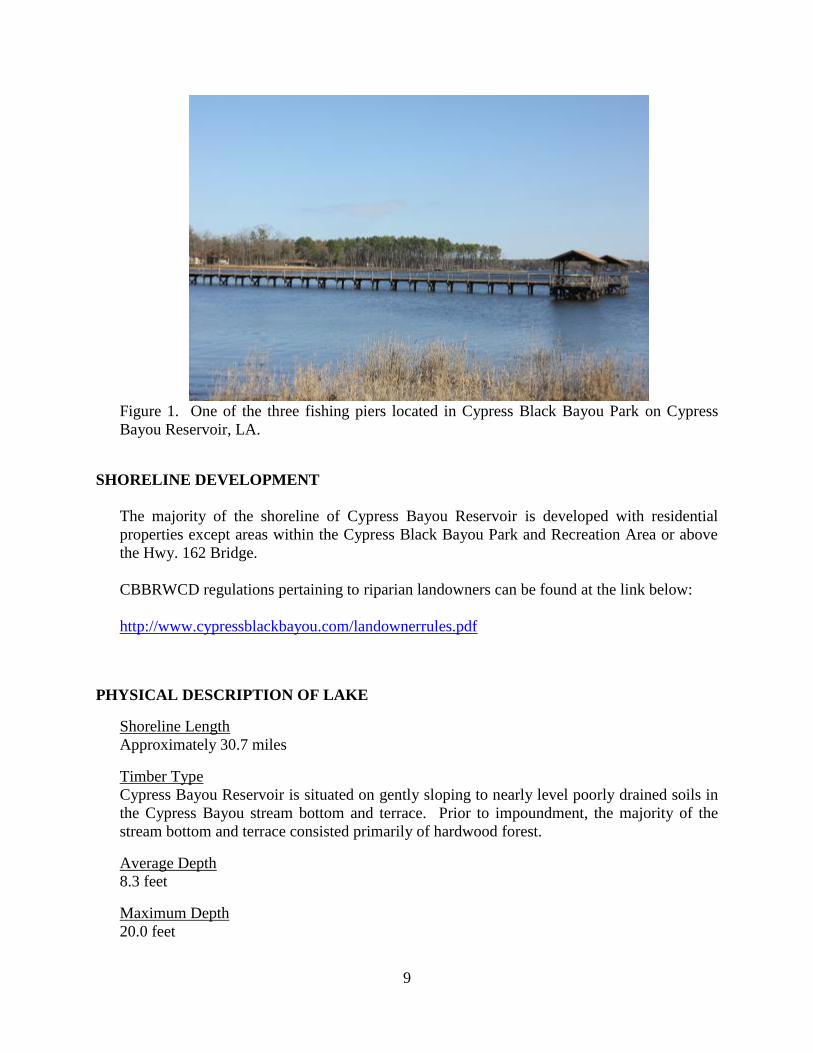
Piers
The CBBRWCD has several piers at the Cypress Black Bayou Park and Recreation Area.
These piers range from small boat mooring piers to large, lighted fishing piers which extend
250 feet out into the lake (Figure 1).
9
Figure 1. One of the three fishing piers located in Cypress Black Bayou Park on Cypress
Bayou Reservoir, LA.
SHORELINE DEVELOPMENT
The majority of the shoreline of Cypress Bayou Reservoir is developed with residential
properties except areas within the Cypress Black Bayou Park and Recreation Area or above
the Hwy. 162 Bridge.
CBBRWCD regulations pertaining to riparian landowners can be found at the link below:
http://www.cypressblackbayou.com/landownerrules.pdf
PHYSICAL DESCRIPTION OF LAKE
Shoreline Length
Approximately 30.7 miles
Timber Type
Cypress Bayou Reservoir is situated on gently sloping to nearly level poorly drained soils in
the Cypress Bayou stream bottom and terrace. Prior to impoundment, the majority of the
stream bottom and terrace consisted primarily of hardwood forest.
Average Depth
8.3 feet
Maximum Depth
20.0 feet
10
Total Water Storage Volume at Pool Stage
25,800 acre feet
Natural Seasonal Water Fluctuation
2-3 feet
EVENTS/ PROBLEMS
Eutrophication
The upper end of Cypress Bayou Reservoir is gradually becoming shallow, which is typical
of ageing impoundments. This is a result of nutrient input from the stream and watershed
and sediment deposition from the stream. These shallow, nutrient rich waters are ideal
habitat for aquatic vegetation. This problem is compounded when aquatic vegetation dies,
sinks to the bottom of the lake, decomposes slowly and begins to form layers of organic
muck on the lake bed. Leaf litter and other organic material also contribute to the buildup of
muck on the lake bed. This soft bottom can make spawning difficult for nest building fish
such as bass, crappie, and bream. Over a long period of time, these species typically decline
in numbers and are replaced by rough fish that spawn in different manners.
Commission Rules and Regulation Issues
Historically, there has been some concern with the CBBRWCD passing rules and regulations
pertaining to Cypress Bayou Reservoir for which the CBBRWCD did not have jurisdiction.
Various resolutions were passed by the CBBRWCD from the mid 1980’s through early
2000’s attempting to ban the use of fishing gears such as nets and yo-yo’s, and implementing
a 12-inch minimum length limit for black bass on the lake. LDWF representatives met with
or sent correspondence to the CBBRWCD regarding these issues and explained that the
CBBRWCD did not have the authority to regulate the fishery resources in the lake. This has
not been an issue within the past 10 years.
11
MANAGEMENT ISSUES
AQUATIC VEGETATION
Nuisance aquatic vegetation has been present in Cypress Bayou Reservoir for many years.
However, it is not a major hindrance for recreational boating and fishing access in the
majority of the lake. The area above and immediately below the Hwy. 162 Bridge on the
upper end of the lake is where the majority of the aquatic vegetation problems persist.
American lotus (Nelumbo lutea) is often a problem in this area of the lake. Access for foliar
herbicide treatments can be difficult due to the shallow water depths and numerous stumps.
The extreme upper end of the coves of the lake can also harbor problematic vegetation. The
remainder of the lake is generally either free of aquatic vegetation or is limited to a fringe
along the shoreline.
In 1998, hydrilla (Hydrilla verticillata) was documented in Cypress Bayou Reservoir.
Hydrilla becomes dense some years in the shallow area of the lake just below the Hwy. 162
boat launch and will limit boating access to the creek channel. It does not severely impact
recreational activities in the main lake. Wave action and turbidity appear to control the plant
in this area.
Giant salvinia (Salvinia molesta) was first documented in Cypress Bayou Reservoir in 2007.
The plant has not become a significant problem on this lake. Foliar herbicide applications
have been utilized on an as needed basis to help control the plant around the boat launches
and other areas that harbor the plants. Very few mats have become established on the lake.
It is apparent that the physical characteristics of the lake are beneficial in helping keep this
plant under control. Much of the shoreline is open, windswept, and exposed to wave action.
DRAWDOWN HISTORY
Drawdowns have been used infrequently on Cypress Bayou Reservoir and have been
primarily used for shoreline maintenance and erosion control. Information from the
CBBRWCD indicates that Cypress Bayou Reservoir has undergone four drawdowns
following initial impoundment. Although not completely documented, the lake was likely
dewatered twice during the 1980’s. A letter from 1985 indicated plans for a future
drawdown and discussed occurrences from the “last drawdown.” Specific details of these
two events are unknown. The drawdown history of Cypress Bayou Reservoir from 1999 to
2014 can be found in Table 3.
The CBBRWCD is responsible for operation and maintenance of the control structure,
spillway and dam. Drawdown plans from the CBBRWCD are coordinated through LDWF
and DOTD prior to opening the control structure.

12
Table 3. Drawdown history of Cypress Bayou Reservoir, LA from 1999 to 2014.
Date
Opened
Date
Closed
Depth
Below Pool Purpose Results
10/1999
(approx.)
1/17/2000
(planned
closure)
5 feet
Shoreline maintenance,
repair and restoration of
beach at park, erosion
control
Good
Notes: Gate closed on 12/1/1999 at target depth and not operated again.
9/8/2009
1/15/2010
(planned
closure)
6 – 8 feet
Shoreline maintenance,
repair and restoration of
beach at park, erosion
control
Unsuccessful
due to heavy
rains and
flooding.
Notes: Drawdown cancelled due to heavy rains and flooding
8/15/2010 1/15/2011 6 – 8 feet
Shoreline maintenance,
erosion control, repair and
restoration of beach, aquatic
vegetation control.
Good
Notes:
Lake did not return to pool until March 10, 2012 due to drought. This
slow refill allowed hydrilla to expand in some shallow areas on the upper
end and extend further into the lake. Small clumps of marginal plants
became established off the shoreline providing beneficial fish cover.
Aquatic Vegetation Surveys and Type Maps
Vegetation type map surveys were conducted on Cypress Bayou Reservoir by personnel from
the Aquatic Vegetation Control Section of LDWF each year from 1990-2001 except 1996.
Surveys were conducted by LDWF Inland Fisheries personnel in 2006 and 2009. The results
of the latest survey in 2009 can be found in APPENDIX IV. The remainder of the aquatic
vegetation type maps and narratives can be found in Cypress Bayou Reservoir MP-C.
Aquatic Vegetation Treatment History
Biological
No biological control agents have been introduced on Cypress Bayou Reservoir.
Chemical
The use of herbicides is an important component of the LDWF integrated pest management
program. The proper selection and use of herbicides is essential to achieve cost effective
benefits and to avoid damage to non-target species. Each product listed has been approved
by the Environmental Protection Agency (EPA) for aquatic use. Aquatic vegetation is
treated according to the standard operating procedures for the application of herbicides as
adopted by the LDWF Inland Fisheries Section.

13
Foliar herbicide applications by LDWF spray crews or contractors for control of giant
salvinia have been ongoing since the plant was discovered in Cypress Bayou Reservoir in
2007. Contractors have been used on one occasion in 2013 when an application was made to
17 acres of giant salvinia. Prior to the discovery of giant salvinia on the lake, the
predominant problem was American lotus on the upper end of the reservoir. Foliar herbicide
applications by LDWF spray crews for floating and emergent aquatic vegetation are listed in
Table 4.
Table 4. Herbicide applications by LDWF Spray Crews in Cypress Bayou Reservoir, LA,
2007 – 2014.
Treatment
Year
Primary Plant
Species
Herbicides Used Acres
Treated
2007
water shield,
giant salvinia,
water hyacinth
Aqua Master – 2 gals.
(1 gal/acre)
Reward – 1 gal.
(1 gal/acre)
3
2008
American lotus,
giant salvinia,
water hyacinth,
giant cut grass,
alligator weed
Aqua Star – 26.6 gals
(0.75 gal/acre)
Aqua Master – 6 gals.
(0.75 gal/acre)
Diquat 0.25 gals.
(1 gal/acre)
43.3
2009
giant salvinia,
American lotus,
water hyacinth,
giant cut grass,
alligator weed,
water lily,
watershield
Aqua Master – 152.5 gals.
(0.75 gal/acre)
Aqua Star – 1.2 gals.
(0.75 gal/acre)
Diquat 11.5 gals.
(1 gal/acre)
217
2010
American lotus,
water lily,
Alligator weed,
giant salvinia,
water hyacinth,
giant cut grass,
watershield
Aqua Master – 6.5 gals
(0.75 gal/acre)
Knockout – 1.25 gals.
(1 gal/acre)
2,4-D – 28.5 gals.
(0.5 gal/acre)
143
2012
Alligator weed,
smartweed,
primrose,
giant cut grass
Aqua Master – 15 gals.
(0.75 gal/acre)
20
2013
giant salvinia,
giant cut grass,
alligator weed,
primrose,
Ecomazapyr – 15.5 gals.
(0.5 gal/acre)
Rodeo – 12.75 gals.
(0.75 gal/acre)
Tribune – 7 gals.
(1 gal/acre)
Clearcast – 6 gals.
72
14
(0.5 gal/acre)
Aqua Master – 5 gals
(1 gal/acre)
2014 Alligator weed,
giant cut grass
Ecomazapyr – 12.5 gals.
(0.5 gal/acre) 25
In addition to herbicide applications by LDWF spray crews, the Cypress Black Bayou
Recreation and Water Conservation District utilizes their personnel for spraying aquatic
vegetation along the shoreline of the park areas. They also employed a contractor in 2006 for
a one-time treatment of American lotus and alligator weed on Cypress Bayou Reservoir
(acres treated unknown).
HISTORY OF REGULATIONS
Recreational
Statewide regulations have been in effect for all game fish species since impoundment.
The recreational fishing regulations may be viewed at the link below:
http://www.wlf.louisiana.gov/fishing/regulations
Commercial
In April of 2002, legislation was passed which gave the Louisiana Wildlife and Fisheries
Commission the authority to regulate recreational and commercial use of hoop nets, gill
nets, trammel nets, strike nets, seines, wire nets, wire traps, and slat traps on Cypress
Bayou Reservoir and Black Bayou Reservoir.
The use of gill nets, trammel nets and fish seines was prohibited in Cypress Bayou
Reservoir and Black Bayou Reservoir in September 2002 by the Louisiana Wildlife and
Fisheries Commission. This regulation was established in an effort to protect the large
bass in the reservoir which are susceptible to capture in these types of entanglement
gears.
Further restrictions were implemented in August of 2004 in response to requests from the
Cypress Black Bayou Recreation and Water Conservation District and shoreline property
owners who were “concerned about the depletion of the catfish population, killing of
game fish and turtles and nets being a safety hazard to swimmers and water craft on the
reservoirs.” At this time, the Louisiana Wildlife and Fisheries Commission added
prohibitions on the use of hoop nets, slat traps, and wire nets except during an established
special season which runs from November 1 through the end of February of the following
year. During this special season, the use of hoop nets, slat traps and wire nets is allowed.
The statewide commercial fishing regulations may be viewed at the link below:
http://www.wlf.louisiana.gov/fishing/regulations
15
FISH KILLS / DISEASE HISTORY, LMBV
No major fish kills on Cypress Bayou Reservoir have been reported to LDWF in recent
years.
LMBV - Largemouth Bass Virus is a naturally occurring waterborne virus that effects fish,
but is not known to infect warm-blooded animals. The virus has been found in other
members of the sunfish family, but has only proved fatal to largemouth bass. The virus
affects the swim bladder in largemouth bass. Largemouth bass which are exhibiting
symptoms of the disease lose their ability to control their buoyancy and experience trouble
swimming and appear bloated. The fish eventually float to the surface where they can be
affected by other environmental stressors. Most bass infected with largemouth bass virus
appear normal. Adult bass weighing two pounds or more appear to be most susceptible to
the disease. Researchers are uncertain as to what triggers an epizootic outbreak, but as most
fish kills occur during the warmer months, high water temperatures and poor water quality
may contribute to development of the disease. It is uncertain as to whether Largemouth Bass
Virus will have any long term impacts to any body of water where it is known to occur. It
appeared that the incidence of disease and infection rate diminished with time after the initial
infection of fish in a given waterbody. Sampling for Largemouth Bass Virus has not been
conducted on Cypress Bayou Reservoir. It is likely that Largemouth Bass Virus is present in
the lake because 6.7% of 60 largemouth bass sampled from the adjacent Black Bayou
Reservoir tested positive in 2002. Additionally, 20 bluegills and 10 redear were tested for
LMBV. No individuals of either of these species tested positive.
CONTAMINANTS/POLLUTION
No Fish Consumption Advisory has been issued for Cypress Bayou Reservoir.
BIOLOGICAL
Fish Sampling History:
The Louisiana Department of Wildlife and Fisheries began conducting fisheries sampling on
Cypress Bayou Reservoir in 1980. The fish sampling history from 1980 to 2014, along with
proposed future sampling, can be found in Table 5.
Table 5. Historical, and scheduled fish sampling on Cypress Bayou Reservoir, LA, from
1980 to 2018.
YEAR GEAR
1980 2 – One Acre Rotenone Sets
1982 2 – One Acre Rotenone Sets
1985 3 – One Acre Rotenone Sets
1986 2 – One Acre Rotenone Sets
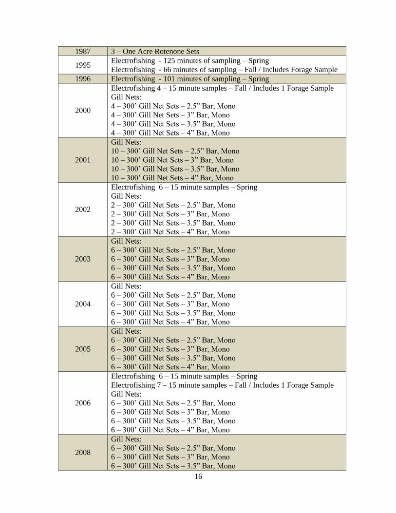
16
1987 3 – One Acre Rotenone Sets
1995 Electrofishing - 125 minutes of sampling – Spring
Electrofishing - 66 minutes of sampling – Fall / Includes Forage Sample
1996 Electrofishing - 101 minutes of sampling – Spring
2000
Electrofishing 4 – 15 minute samples – Fall / Includes 1 Forage Sample
Gill Nets:
4 – 300’ Gill Net Sets – 2.5” Bar, Mono
4 – 300’ Gill Net Sets – 3” Bar, Mono
4 – 300’ Gill Net Sets – 3.5” Bar, Mono
4 – 300’ Gill Net Sets – 4” Bar, Mono
2001
Gill Nets:
10 – 300’ Gill Net Sets – 2.5” Bar, Mono
10 – 300’ Gill Net Sets – 3” Bar, Mono
10 – 300’ Gill Net Sets – 3.5” Bar, Mono
10 – 300’ Gill Net Sets – 4” Bar, Mono
2002
Electrofishing 6 – 15 minute samples – Spring
Gill Nets:
2 – 300’ Gill Net Sets – 2.5” Bar, Mono
2 – 300’ Gill Net Sets – 3” Bar, Mono
2 – 300’ Gill Net Sets – 3.5” Bar, Mono
2 – 300’ Gill Net Sets – 4” Bar, Mono
2003
Gill Nets:
6 – 300’ Gill Net Sets – 2.5” Bar, Mono
6 – 300’ Gill Net Sets – 3” Bar, Mono
6 – 300’ Gill Net Sets – 3.5” Bar, Mono
6 – 300’ Gill Net Sets – 4” Bar, Mono
2004
Gill Nets:
6 – 300’ Gill Net Sets – 2.5” Bar, Mono
6 – 300’ Gill Net Sets – 3” Bar, Mono
6 – 300’ Gill Net Sets – 3.5” Bar, Mono
6 – 300’ Gill Net Sets – 4” Bar, Mono
2005
Gill Nets:
6 – 300’ Gill Net Sets – 2.5” Bar, Mono
6 – 300’ Gill Net Sets – 3” Bar, Mono
6 – 300’ Gill Net Sets – 3.5” Bar, Mono
6 – 300’ Gill Net Sets – 4” Bar, Mono
2006
Electrofishing 6 – 15 minute samples – Spring
Electrofishing 7 – 15 minute samples – Fall / Includes 1 Forage Sample
Gill Nets:
6 – 300’ Gill Net Sets – 2.5” Bar, Mono
6 – 300’ Gill Net Sets – 3” Bar, Mono
6 – 300’ Gill Net Sets – 3.5” Bar, Mono
6 – 300’ Gill Net Sets – 4” Bar, Mono
2008
Gill Nets:
6 – 300’ Gill Net Sets – 2.5” Bar, Mono
6 – 300’ Gill Net Sets – 3” Bar, Mono
6 – 300’ Gill Net Sets – 3.5” Bar, Mono
17
6 – 300’ Gill Net Sets – 4” Bar, Mono
2009 Electrofishing 6 – 15 minute samples – Spring
2013
Electrofishing 6 – 15 minute samples – Spring
Electrofishing 6 – 15 minute samples – Fall
4 – 225 second Forage Samples – Fall
2014
Gill Nets:
6 – 300’ Gill Net Sets – 2.5” Bar, Mono
6 – 300’ Gill Net Sets – 3” Bar, Mono
6 – 300’ Gill Net Sets – 3.5” Bar, Mono
6 – 300’ Gill Net Sets – 4” Bar, Mono
2015 No planned sampling
2016
Begin largemouth bass and crappie mortality studies
Electrofishing 6-15 minute samples (spring and fall)
Electrofishing Forage Sample 4-225 second samples (fall)
Lead Nets-6 stations
Gill Netting – 6 samples each including:
300' 2.5 in. bar.
300' 3.0 in. bar.
300' 3.5 in. bar
300’ 4.0 in. bar
2017
Continue largemouth bass and crappie mortality studies
Electrofishing 6-15 minute samples (spring and fall)
Electrofishing Forage Sample 4-225 second samples (fall)
Lead Nets-6 stations
Gill Netting – 6 samples each including:
300' 2.5 in. bar.
300' 3.0 in. bar.
300' 3.5 in. bar
300’ 4.0 in. bar
Recreational Angler Survey
2018
Complete largemouth bass and crappie mortality studies
Electrofishing 6-15 minute samples (spring and fall)
Electrofishing Forage Sample 4-225 second samples (fall)
Lead Nets-6 stations
Gill Netting – 6 samples each including:
300' 2.5 in. bar.
300' 3.0 in. bar.
300' 3.5 in. bar
300’ 4.0 in. bar
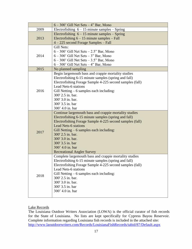
Lake Records
The Louisiana Outdoor Writers Association (LOWA) is the official curator of fish records
for the State of Louisiana. No lists are kept specifically for Cypress Bayou Reservoir.
Complete information regarding Louisiana fish records is included in the attached site:
http://www.laoutdoorwriters.com/Records/LouisianaFishRecords/tabid/87/Default.aspx
18
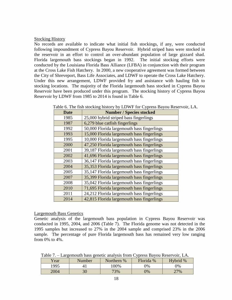
Stocking History
No records are available to indicate what initial fish stockings, if any, were conducted
following impoundment of Cypress Bayou Reservoir. Hybrid striped bass were stocked in
the reservoir in an effort to control an over-abundant population of large gizzard shad.
Florida largemouth bass stockings began in 1992. The initial stocking efforts were
conducted by the Louisiana Florida Bass Alliance (LFBA) in conjunction with their program
at the Cross Lake Fish Hatchery. In 2000, a new cooperative agreement was formed between
the City of Shreveport, Bass Life Associates, and LDWF to operate the Cross Lake Hatchery.
Under this new arrangement, LDWF provided fry and assistance with hauling fish to
stocking locations. The majority of the Florida largemouth bass stocked in Cypress Bayou
Reservoir have been produced under this program. The stocking history of Cypress Bayou
Reservoir by LDWF from 1985 to 2014 is found in Table 6.
Table 6. The fish stocking history by LDWF for Cypress Bayou Reservoir, LA.
Date Number / Species stocked
1985 25,000 hybrid striped bass fingerlings
1987 6,279 blue catfish fingerlings
1992 50,000 Florida largemouth bass fingerlings
1993 15,000 Florida largemouth bass fingerlings
1995 10,000 Florida largemouth bass fingerlings
2000 47,250 Florida largemouth bass fingerlings
2001 39,187 Florida largemouth bass fingerlings
2002 41,696 Florida largemouth bass fingerlings
2003 36,147 Florida largemouth bass fingerlings
2004 35,353 Florida largemouth bass fingerlings
2005 35,147 Florida largemouth bass fingerlings
2007 35,399 Florida largemouth bass fingerlings
2008 35,042 Florida largemouth bass fingerlings
2010 71,695 Florida largemouth bass fingerlings
2011 24,212 Florida largemouth bass fingerlings
2014 42,815 Florida largemouth bass fingerlings
Largemouth Bass Genetics
Genetic analysis of the largemouth bass population in Cypress Bayou Reservoir was
conducted in 1995, 2004, and 2006 (Table 7). The Florida genome was not detected in the
1995 samples but increased to 27% in the 2004 sample and comprised 23% in the 2006
sample. The percentage of pure Florida largemouth bass has remained very low ranging
from 0% to 4%.
Table 7. – Largemouth bass genetic analysis from Cypress Bayou Reservoir, LA.
Year Number Northern % Florida % Hybrid %
1995 41 100% 0% 0%
2004 30 73% 0% 27%
19
2006 57 77% 4% 19%
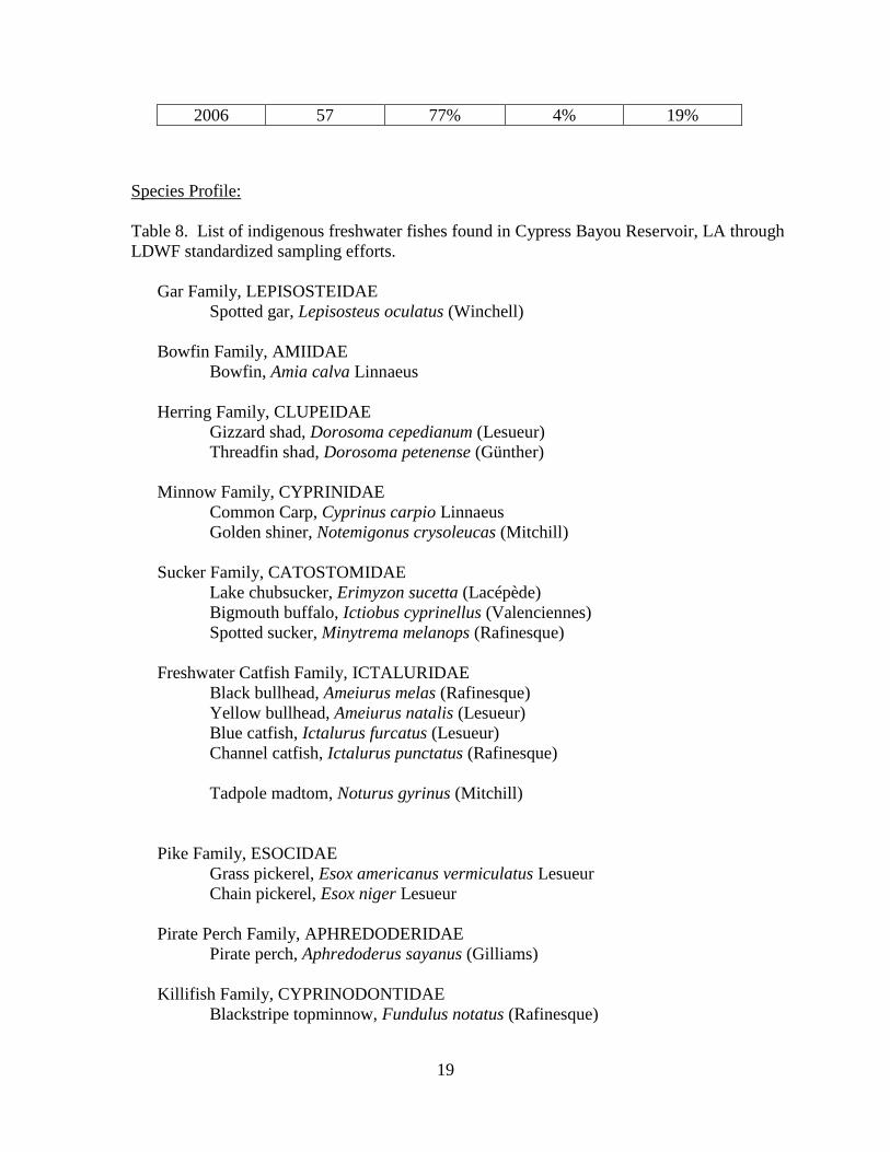
Species Profile:
Table 8. List of indigenous freshwater fishes found in Cypress Bayou Reservoir, LA through
LDWF standardized sampling efforts.
Gar Family, LEPISOSTEIDAE
Spotted gar, Lepisosteus oculatus (Winchell)
Bowfin Family, AMIIDAE
Bowfin, Amia calva Linnaeus
Herring Family, CLUPEIDAE
Gizzard shad, Dorosoma cepedianum (Lesueur)
Threadfin shad, Dorosoma petenense (Günther)
Minnow Family, CYPRINIDAE
Common Carp, Cyprinus carpio Linnaeus
Golden shiner, Notemigonus crysoleucas (Mitchill)
Sucker Family, CATOSTOMIDAE
Lake chubsucker, Erimyzon sucetta (Lacépède)
Bigmouth buffalo, Ictiobus cyprinellus (Valenciennes)
Spotted sucker, Minytrema melanops (Rafinesque)
Freshwater Catfish Family, ICTALURIDAE
Black bullhead, Ameiurus melas (Rafinesque)
Yellow bullhead, Ameiurus natalis (Lesueur)
Blue catfish, Ictalurus furcatus (Lesueur)
Channel catfish, Ictalurus punctatus (Rafinesque)
Tadpole madtom, Noturus gyrinus (Mitchill)
Pike Family, ESOCIDAE
Grass pickerel, Esox americanus vermiculatus Lesueur
Chain pickerel, Esox niger Lesueur
Pirate Perch Family, APHREDODERIDAE
Pirate perch, Aphredoderus sayanus (Gilliams)
Killifish Family, CYPRINODONTIDAE
Blackstripe topminnow, Fundulus notatus (Rafinesque)
20
Silverside Family, ATHERINIDAE
Brook silverside, Labidesthes sicculus (Cope)
Temperate Bass Family, PERCICHTHYIDAE
Yellow bass, Morone mississippiensis Jordan and Eigenmann
Sunfish Family, CENTRARCHIDAE
Warmouth, Lepomis gulosus (Cuvier)
Bluegill, Lepomis macrochirus (Rafinesque)
Dollar sunfish, Lepomis marginatus (Holbrook)
Longear sunfish, Lepomis megalotis (Rafinesque)
Redear sunfish, Lepomis microlophus (Günther)
Redspotted sunfish, Lepomis miniatus Jordan
Bantam sunfish, Lepomis symmetricus Forbes
Northern largemouth bass, Micropterus salmoides salmoides (Lacépède)
White crappie, Pomoxis annularis Rafinesque
Black crappie, Pomoxis nigromaculatus (Lesueur)
Perch Family, PERCIDAE
Logperch, Percina caprodes (Rafinesque)
Drum Family, SCIAENIDAE
Freshwater drum, Aplodinotus grunniens Rafinesque
Species introduced through stocking efforts:
Florida largemouth bass, Micropterus floridanus Kassler et al.
Threatened/Endangered/Exotic Species
No threatened or endangered fish species are known to inhabit Cypress Bayou Reservoir.
Bald Eagles have nested adjacent to the lake for a number of years. An artificial platform has
been created and is utilized by a nesting pair of eagles after the original nesting tree was
destroyed.
CREEL
No creel surveys have been conducted on Cypress Bayou Reservoir.
HYDROLOGICAL CHANGES
There have been no major hydrological changes on Cypress Bayou Reservoir since
impoundment and the subsequent completion of the adjacent Black Bayou Reservoir
complex.
21
WATER USE
Irrigation/Municipal Use
Cypress Bayou Reservoir is a multi-purpose reservoir. The primary purpose for which the
lake was built is storage of water for supplementary irrigation of cropland (15,500 acre feet).
Other purposes of the lake are; a supplementary municipal water supply (2,450 acre feet),
recreation (5,730 acre feet), and for the expected accumulation of 100 years of sediment
(1,270 acre feet).
The lake has a surface area of approximately 3,100 acres at the spillway crest level. The
minimum recreation pool is 1,050 surface acres of water. In order to maintain this minimum
recreation pool area, water stored below the elevation of the recreation pool will not be
withdrawn for other purposes.
The design of the Cypress – Black Bayou Reservoir Complex is unique in that the reservoirs
are interconnected and designed to supply water downstream through Flat River for irrigation
purposes. The two reservoirs are interconnected by a concrete box culvert that is
approximately 6 feet square and 210 feet long with sluice gates on both ends. The primary
purpose of the interconnect structure is to transfer water from the larger Cypress Bayou
Reservoir to the smaller Black Bayou Reservoir for irrigation purposes. The structure which
provides water downstream to Flat River for irrigation is located on Black Bayou Reservoir.
Water can be transferred in either direction between the two reservoirs; however, the transfer
of water is by gravity flow. The normal pool stage for Black Bayou Reservoir is 185.0 MSL
and normal pool stage for Cypress Bayou Reservoir is 180.0 MSL. To utilize the
interconnection for the intended purpose; Black Bayou Reservoir must first be lowered to a
level lower than Cypress Bayou Reservoir. This would likely occur if water had already
been released from Black Bayou Reservoir for irrigation purposes.
The Cypress–Black Bayou Reservoir Complex is occasionally utilized for irrigation
purposes, but has never been utilized to the full design potential for irrigation. Therefore,
releases for irrigation purposes have not resulted in significant dewatering of the reservoirs,
or greatly impacted recreation.
Recreational Use
The lake is popular for recreational activities including fishing, boating, waterskiing,
swimming and waterfowl hunting. Winter-time crappie fishing is very popular with local
anglers. No permanent waterfowl blinds are allowed on the lake by the CBBRWCD.
22
APPENDIX I (return to authorization)
Cypress – Black Bayou Recreation and Water Conservation District - Enabling Legislation
RS 38:2601 – 38:2612
PART III. CYPRESS-BLACK BAYOU RECREATION AND
WATER CONSERVATION DISTRICT
§2601. Creation
The Cypress-Black Bayou Recreation and Water Conservation District is hereby created.
Added by Acts 1958, No. 292, §1.
§2602. Location
The area comprising the said District shall be all of Ward 2, Sections 19, 30 and 31, Township
20 North, Range 12 West; and Sections 6, 7, 8, 17 and 18 Township 19 North, Range 12 West of
Ward 5, all in Bossier Parish, Louisiana, and the following described property, to-wit:
Beginning at a point where the North line of Section 3, Township 17 North, Range 13 West,
Bossier Parish, Louisiana, intersects the East Right-of-Way line of Kansas City Southern-
Louisiana & Arkansas Railway Company; thence Southeasterly along the East Right-of-Way of
the Louisiana and Arkansas Railroad Right-of-Way, to a corner of Barksdale Air Force Base,
being also United States Monument No. 163, run thence along the Boundary of Barksdale Air
Force Base as follows: North 89°57' East, a distance of 1,552.96 feet, South 14°15' East a
distance of 1,714.94 feet, South 46°15' East a distance of 1,203.08 feet to a point being the most
Southerly Boundary corner of Barksdale Air Force Base; North 72°35'50" East, a distance of
1,043.65 feet; South 17°24'10" East, a distance of 130 feet; run thence North 72°35'50" East, a
distance of 20.43 feet; run thence South 17°24'10" East, a distance of 150 feet; run thence South
62°24'10" East, a distance of 42.42 feet; run thence South 17°24'10" East, a distance of 35.7 feet;
run thence South 25°22'45" East, a distance of 68.96 feet; run thence South 33°21'30" East, a
distance of 211.17 feet, run thence South 20°42'30" East, a distance of 121.26 feet; run thence
South 8°03'30" East, a distance of 157.16 feet; run thence South 81°56'30" West, a distance of
310 feet; run thence North 8°03'30" West, a distance of 92.15 feet; run thence North 20°42'30"
West, a distance of 136.60 feet; run thence North 33°21'30" West, a distance of 137.34 feet; run
thence North 25°22'45" West, a distance of 155.06 feet; run thence North 7°24'10" West, a
distance of 35.7 feet; run thence North 62°24'10" West, a distance of 42.42 feet; run thence
South 72°35'50" West, a distance of 250 feet; run thence South 35°02'50" West, a distance of
50.45 feet; run thence South 72°35'50" West, a distance of 30 feet; run thence North 70°12'10"
West, a distance of 50.86 feet; run thence South 72°35'50" West, a distance of 254.27 feet; run
23
thence South 30°23'10" West, a distance of 55.35 feet to a point being the common rear corner of
Lots 84 & 85 of said Bellaire Subdivision Unit No.1; run thence South 23°53'50" East, a distance
of 101.20 feet; run thence South 33°21'30" East, a distance of 351.05 feet; run thence South
71°51'40" West, a distance of 32.7 feet; run thence South 8°03'30" East, a distance of 203.2 feet
to a point being the most Southeasterly corner of Bellaire Subdivision Unit No. 1, said point also
being on the South Right-of-Way line of Bellaire Boulevard; run thence South 81°56'30" West
along said South Right-of-Way line of Bellaire Boulevard, a distance of 90 feet to the point of a
curvature of a curve to the left having the following data: Delta = 90°00', Tangent = 20 feet and
Radius of 20 feet; run thence Southeasterly along said curve, a distance of 31.42 feet; run thence
South 81°56'30" West, a distance of 50 feet to the point of tangency of a curve having the
following data: Delta = 90°00', Tangent = 20 and Radius = 20 feet; run thence along said curve
in a Southwesterly direction, a distance of 31.42 feet; run thence South 81°56'30" West, a
distance of 540.59 feet to the point of curvature of a curve to the left having the following data:
Delta = 25°18', and Radius = 408.70 feet; run thence Southwesterly along said curve, a distance
of 180.47 feet to a point on the Northeasterly line of the Louisiana and Arkansas Railroad Right-
of-Way; run thence South 33°23' East, along the East right-of-way line of the KCS-L&A
Railway to the Southwest corner of Lot No. 12 of the Clay Plantation Pecan Orchard Subdivision
Unit No. 1 as recorded in Book 141, Page 163, Records of Bossier Parish, Louisiana; run thence
South 89°05' East a distance of 601.54 feet; run thence North a distance of 363.60 feet; run
thence South 89°00' East a distance of 1,461.05 feet; run thence North 0°05' East a distance of 10
feet; run thence South 89°00' East a distance of 109.74 feet; run thence North 0°11' East a
distance of 495.13 feet; run thence North 89°22' East a distance of 405.46 feet; run thence North
27°38' East, a distance of 447.90 feet, to a point being on the South boundary line of Barksdale
Air Force Base, said point also being on a line common to Sections 2 and 11; run thence North
89°59' East, along said line common to Sections 2 and 11; a distance of 1,214.24 feet to a point
being the common corner of Sections 1, 2, 11 and 12, Township 17 North, Range 13 West, run
thence North 89°59' East, along a line common to Sections 1 and 12, a distance of 1,214.10 feet;
run thence South 0°02' West, a distance of 173.50 feet; run thence South 89°58' East, a distance
of 1.00 foot; run thence South 0°02' West, a distance of 150 feet; run thence South 43°52' West,
a distance of 41.51 feet; run thence South 0°30' East, a distance of 673.38 feet; run thence South
49°16' East, a distance of 35.44 feet; run thence South 3°40' East, a distance of 155 feet; run
thence South 86°20' West, a distance of 2.77 feet; run thence South 3°40' East, a distance of 100
feet; run thence South 49°24' West, a distance of 49.63 feet; run thence South 0°30' East, a
distance of 340.17 feet; run thence South 43°21' East, a distance of 58.47 feet; run thence South
7°35' West, a distance of 146.79 feet; run thence North 82°25' West, a distance of 43.67 feet; run
thence South 7°35' West, a distance of 190.88 feet to a point being on the Northerly high bank of
Macks' Bayou; run thence South 0°07' East, a distance of 83.86 feet to a point on the Southerly
high bank of Macks' Bayou, said point also being the Northeast corner of Lot 20 of Shady Grove
Subdivision Unit No. 3 as recorded in Book 275, Pages 306 and 307 records of Bossier Parish,
Louisiana; run thence South 80°11' East, a distance of 381.77 feet; run thence South 71°11' East,
a distance of 621.77 feet; run thence South 69°14' East, a distance of 195.90 feet; run thence
North 80°04' East, a distance of 62.90 feet; run thence East, a distance of 228.81 feet; run thence
South, a distance of 925.27 feet; run thence South 89°22' West, a distance of 4,987.20 feet to a
point on the West Right-of-Way line of Parkway Drive, said point being the Southeast corner of
Lot 7, Replat Shady Grove Subdivision Unit No. 1; run thence South 33°13' East along said
West Right-of-Way line, a distance of 150 feet; run thence South 56°47' West, a distance of 148
feet to a point on the East right-of-way line of the KCS-L&A Railroad; run thence North 33°13'
24
West, along said East right-of-way line, a distance of 2,108.20 feet; run thence South 89°22'
West a distance of 1,254.45 feet to the East line of the Red River levee; run thence along said
East levee line, as follows: North 11°36' West a distance of 1,780.5 feet, North 50°05' West a
distance of 917.93 feet, North 14°35'05" West a distance of 1,439.59 feet, North 74°19'30" West
a distance of 1,008.28 feet, North 14°45' West a distance of 653.58 feet, North 55°22'20" West a
distance of 1,545.24 feet, North 20°39'20" West a distance of 288.78 feet, North 36°04'20" West
a distance of 766.57 feet, North 14°13'20" West a distance of 444.64 feet to a point being the
intersection of the Northeasterly line of the existing Red River Levee with the Northeasterly line
of the original Red River Levee as shown with the Re-subdivision of Fertile Gardens Unit No. 3
as recorded in Book 60, Page 487 of Records of Bossier Parish, Louisiana; run thence
Northwesterly along said Northeasterly line of said original Red River Levee (being also the
Northeasterly line of the existing levee) to the intersection with the Township line between
Township 17 North, Range 13 West and Township 18 North, Range 13 West; run East along the
North line of Section 3, Township 17 North, Range 13 West, to point of beginning, which point
is the intersection of the East right-of-way line of the Kansas City Southern Arkansas &
Louisiana Railway Company with the North line of Section 3, Township 17 North, Range 13
West, Bossier Parish, Louisiana, point of beginning and being all that part of Ward One, Bossier
Parish, Louisiana within the City Limits of Bossier City, Bossier Parish, Louisiana, as per
Ordinance No. 800 recorded in Vol. 364, Page 290, Bossier Parish Records. In addition to all of
the above described territory, there shall be included within said District all of the territory lying
within the municipal limits of Bossier City, Parish of Bossier, as said limits are now or may be
hereafter constituted.
Added by Acts 1958, No. 292, §2. Amended by Acts 1964, No. 305, §1; Acts 1968, No. 502, §1.
§2603. District as political subdivision and body corporate; purpose and powers; issuing bonds
and levying taxes
The Cypress-Black Bayou Recreation and Water Conservation District so created shall be a
political subdivision of the State of Louisiana, shall constitute a waterworks district under the
provisions of Article XIV, Section 14 of the Constitution of the State of Louisiana for the year
1921, as amended, and shall have all the rights, powers, privileges and immunities hereinafter set
forth. Additionally, the district shall be a budgetary unit of the State of Louisiana and shall have
for its purpose the development of the wealth and natural resources of the district by the
conservation of water for agricultural, municipal, recreational, commercial, industrial and
sanitary purposes. It shall constitute a body corporate in law with all the powers, rights,
privileges and immunities of a public corporation, and all powers necessary for it to carry out the
objects for which it was created. It shall have the power to sue and be sued and to buy and sell all
types of property, both real and personal, and to expropriate in accordance with law any
properties which may be necessary for the accomplishment of its purposes as herein
contemplated. It shall have the authority to negotiate and execute contracts, to acquire by
purchase, gift, and expropriation or otherwise every type and specie of property and servitudes,
rights of way and flowage rights necessary to its purpose, and to construct, build, purchase, lease,
operate and maintain any facilities, works or machinery designed to accomplish the purposes of
the district. It shall have complete control over the supply of fresh water made available by its
facilities which shall be administered for the benefit of the persons residing or owning property
within the District and if it should be for the benefit of the district it shall have the authority to

25
sell such water for irrigation, municipal and industrial uses both within and outside the district.
The district shall constitute an agency of the State of Louisiana designed to carry out an essential
governmental function of the State, and all of the property of the district shall be exempt from
taxation. It shall have the authority to cooperate and contract with the government of the United
States or any department or agency thereof and to accept gifts, grants and donations of property
and money therefrom. It shall have the authority to cooperate with the State of Louisiana or any
political subdivision, department, agency or corporation of said state for the construction,
operation and maintenance of such facilities designed to accomplish the purpose for which the
district is created on any basis including the matching of funds and by participating in projects
authorized by any federal or state law as it shall see fit.
The district shall have authority to incur debt, issue negotiable bonds and levy taxes for the
purpose of constructing, acquiring, extending or improving any lands, reservoirs, levees,
channels, canals, pipe lines, pumping stations, waterworks plants and any other facilities,
including buildings, machinery and equipment, for the development of the wealth and natural
resources of the district by the conservation and use of water for agricultural, municipal,
recreational, commercial, industrial and sanitary purposes, including the acquisition of all lands
incidental or necessary for the construction, use and enjoyment thereof, such purpose being
hereby found and declared to be a public purpose. Any such bonds payable from ad valorem
taxation shall be issued under the terms and provisions of Sub-Part A, Part III, Chapter 4, Title
39 of the Louisiana Revised Statutes of 1950, and any revenue bonds shall be issued under the
terms and provisions of Sub-Part B or Sub-Part C of Part I, Chapter 10, Title 33 of the Louisiana
Revised Statutes of 1950, provided, however, that any bonds so issued shall first be approved at
a taxpayers election held in the manner prescribed by Part II, Chapter 4, Title 39 of the Louisiana
Revised Statutes of 1950. In each instance the board of commissioners of the district shall be the
governing authority of the district and shall have all of the rights, powers and privileges
conferred upon the respective governing authorities by said statutes. Additionally, the district
shall have authority to levy taxes under the provisions of Article X, Section 10 of the
Constitution for the purpose of improving, operating and maintaining its facilities, provided any
such tax shall first be approved at a taxpayer’s election as therein required. In the event any of
the aforesaid parts of the Revised Statutes are in conflict with the provisions of this Part, then the
provisions of this Part shall control, but in all other respects the cited portions of the Revised
Statutes shall apply to the district for the purposes herein indicated.
Added by Acts 1958, No. 292, §3. Amended by Acts 1966, No. 198, §1.
§2604. Governing board; membership; tenure, vacancies, domicile
The district shall be governed and controlled by a board of five commissioners, each of whom
shall be a qualified elector of Bossier Parish residing within and owning property within the
district. The successors to the present members of the board of commissioners shall be appointed
as follows: one by the police jury of Bossier Parish; one by the mayor and governing authority of
the city of Bossier City; one by the mayor and governing authority of the village of Benton; one
by the Bossier Parish school board and the fifth, by the Board of Commissioners of the Bossier
Levee District. Any vacancy in the office of commissioner, due to death, resignation or any other
cause, shall be filled by the remaining commissioners for the unexpired term.
26
Each member of the board of commissioners shall serve a term of five years from the date of his
appointment to the board.
The board shall be domiciled at Benton, Louisiana.
Added by Acts 1958, No. 292, §4. Amended by Acts 1966, No. 448, §2.
§2605. Oaths; per diem allowance
Before entering upon his official duties, each member of the board of commissioners shall take
the oath or affirmation required by Article XIX, Section 1, of the Constitution of Louisiana.
Each member of said board shall be entitled to receive, out of available funds of the district, a per
diem allowance of forty dollars for each meeting of the board which he attends, but no such
allowance shall be paid for more than thirty-six meetings in any calendar year.
Added by Acts 1958, No. 292, §5. Amended by Acts 1967, No. 101, §2; Acts 1974, No. 422, §1
§2606. Election of officers; record book; public inspection
Immediately after the members of the board of commissioners have been appointed by the
governor, or as soon as thereafter is practicable, they shall meet and organize by electing from
their number a president, vice-president and secretary who shall perform the duties normally
required of such officers. The said board shall also cause the name by which the district is to be
known to be recorded in a bound book which shall also be the depository of the minutes and
proceedings of the board, certificates, oaths of commissioners and any and all corporate acts of
the board. This book shall be in the custody of the secretary of the board and shall be open for
public inspection at all reasonable times.
Added by Acts 1958, No. 292, §6.
§2607. Fishing activities; prohibition of certain gear
The Wildlife and Fisheries Commission may prohibit the recreational and commercial use of
hoop nets, gill nets, trammel nets, strike nets, seines, wire nets, wire traps, and slat traps on
Cypress Bayou Reservoir and Black Bayou Reservoir. In addition, the board of commissioners
of the Cypress-Black Bayou Recreation and Water Conservation District shall maintain public
access to Cypress Bayou Reservoir and to Black Bayou Reservoir.
Acts 2002, 1st Ex. Sess., No. 55, §1, eff. April 18, 2002.
§2608. Enumerated powers
In order to accomplish the purposes of the district and to secure the best results from the
construction, operation and maintenance of the works and improvements of the district and to
prevent damage to the property of the district, the board of commissioners may make such rules
and regulations as it shall deem advisable to:

27
(1) Protect and preserve the works, machinery, improvements and property owned or controlled
by the district and to prescribe the manner of their use;
(2) Prescribe the manner of buildings, bridges, roads, fences or other works in, along or across
any channel, reservoir or other construction of the district;
(3) Prescribe the manner in which ditches, sewers, pipelines or other works shall be adjusted to
or connected with the facilities of the district or any water course within the district and the
manner in which the water courses of the district may be used for the disposal of waste;
(4) Prescribe the permissible uses of the waters of the district made available by its facilities and
to prevent the pollution or the unnecessary waste of such water;
(5) Prohibit or regulate the discharge of sewers into the district of any liquid or solid waste
deemed detrimental to the waters or facilities of the district.
Added by Acts 1958, No. 292, §8.
§2609. Parks, playgrounds and picnic areas for use of district facilities
The district shall have the authority to create, construct and administer such recreational parks,
playgrounds and picnic areas as the board shall consider necessary for the use and enjoyment of
any water facility owned or controlled by the district and shall provide adequate access to any
lake or reservoir created by the district for the use of the public.
Added by Acts 1958, No. 292, §9. Amended by Acts 1966, No. 198, §2.
§2610. Engineering services by Department of Public Works
The Department of Public Works, State of Louisiana, shall furnish to the district such
engineering services as it shall require and may cooperate with the district in the construction of
any work or facility considered necessary by the district and said department to the purposes of
the district. Any moneys appropriated by the state or said department shall be expended under
the supervisory control of said department and the board of commissioners of the district may by
appropriate contract subject any project to the supervisory control of said department.
Added by Acts 1958, No. 292, §10. Amended by Acts 1966, No. 198, §3.
§2611. Retention of mineral rights
Whenever it shall become necessary for the district or the department of public works, state of
Louisiana to acquire the fee simple title to any land for the purpose of constructing any work or
facility within the district, the owner thereof in his own behalf or in behalf of his assigns in the
event of a prior assignment may retain the mineral rights to such property together with the right
to grant mineral leases and servitudes thereon. No form of prescription shall divest such owner or
his assigns of these rights so long as the district, the department of public works or some other
department or agency of the state retains the ownership of the property, but should ownership
28
pass into private hands, the prescription of non-user provided by R.C.C. Arts. 789 and 3546 shall
apply as in the usual case.
Added by Acts 1958, No. 292, §11.
§2612. Tax exemption; lease of lands for production of minerals
Should the district or the department of public works acquire servitude, right of way or flowage
right over any property as distinguished from the fee simple title thereto such property shall not
be subject to any ad valorem tax or tax of any nature by the state of Louisiana or any political
subdivision thereof so long as such property is used for the purpose of the district. The
provisions of this Part shall in no wise abridge the right of any individual, person, firm or
corporation from whom a servitude, right of way, or flowage right may have been acquired to
lease the land subject thereto for the production of oil, gas or other minerals and to produce or
cause to be produced oil, gas or other minerals from such property.
Added by Acts 1958, No. 292, §12.
29
APPENDIX II (return to authorization)
United States Soil Conservation Service Agreement
30
31
32
33
34
35
APPENDIX III (return to Boat Ramps)
Cypress Bayou Reservoir Public Boat Ramps
36
APPENDIX IV (return to Type Maps)
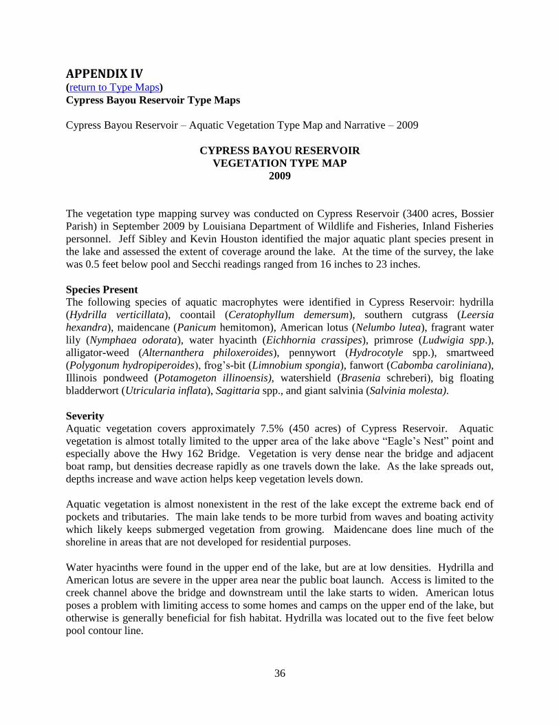
Cypress Bayou Reservoir Type Maps
Cypress Bayou Reservoir – Aquatic Vegetation Type Map and Narrative – 2009
CYPRESS BAYOU RESERVOIR
VEGETATION TYPE MAP
2009
The vegetation type mapping survey was conducted on Cypress Reservoir (3400 acres, Bossier
Parish) in September 2009 by Louisiana Department of Wildlife and Fisheries, Inland Fisheries
personnel. Jeff Sibley and Kevin Houston identified the major aquatic plant species present in
the lake and assessed the extent of coverage around the lake. At the time of the survey, the lake
was 0.5 feet below pool and Secchi readings ranged from 16 inches to 23 inches.
Species Present
The following species of aquatic macrophytes were identified in Cypress Reservoir: hydrilla
(Hydrilla verticillata), coontail (Ceratophyllum demersum), southern cutgrass (Leersia
hexandra), maidencane (Panicum hemitomon), American lotus (Nelumbo lutea), fragrant water
lily (Nymphaea odorata), water hyacinth (Eichhornia crassipes), primrose (Ludwigia spp.),
alligator-weed (Alternanthera philoxeroides), pennywort (Hydrocotyle spp.), smartweed
(Polygonum hydropiperoides), frog’s-bit (Limnobium spongia), fanwort (Cabomba caroliniana),
Illinois pondweed (Potamogeton illinoensis), watershield (Brasenia schreberi), big floating
bladderwort (Utricularia inflata), Sagittaria spp., and giant salvinia (Salvinia molesta).
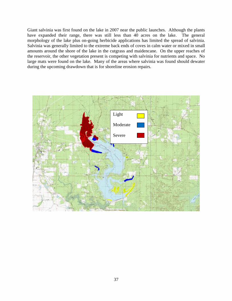
Severity Aquatic vegetation covers approximately 7.5% (450 acres) of Cypress Reservoir. Aquatic
vegetation is almost totally limited to the upper area of the lake above “Eagle’s Nest” point and
especially above the Hwy 162 Bridge. Vegetation is very dense near the bridge and adjacent
boat ramp, but densities decrease rapidly as one travels down the lake. As the lake spreads out,
depths increase and wave action helps keep vegetation levels down.
Aquatic vegetation is almost nonexistent in the rest of the lake except the extreme back end of
pockets and tributaries. The main lake tends to be more turbid from waves and boating activity
which likely keeps submerged vegetation from growing. Maidencane does line much of the
shoreline in areas that are not developed for residential purposes.
Water hyacinths were found in the upper end of the lake, but are at low densities. Hydrilla and
American lotus are severe in the upper area near the public boat launch. Access is limited to the
creek channel above the bridge and downstream until the lake starts to widen. American lotus
poses a problem with limiting access to some homes and camps on the upper end of the lake, but
otherwise is generally beneficial for fish habitat. Hydrilla was located out to the five feet below
pool contour line.
37
Giant salvinia was first found on the lake in 2007 near the public launches. Although the plants
have expanded their range, there was still less than 40 acres on the lake. The general
morphology of the lake plus on-going herbicide applications has limited the spread of salvinia.
Salvinia was generally limited to the extreme back ends of coves in calm water or mixed in small
amounts around the shore of the lake in the cutgrass and maidencane. On the upper reaches of
the reservoir, the other vegetation present is competing with salvinia for nutrients and space. No
large mats were found on the lake. Many of the areas where salvinia was found should dewater
during the upcoming drawdown that is for shoreline erosion repairs.
Light
Moderate
Severe