lithofacies and depositional environments of the coal ... · lithofacies and depositional...
TRANSCRIPT
Lithofacies and Depositional Environments of the Coal-Bearing Paleocene Patala Formation, Salt Range Coal Field, Northern Pakistan
By Peter D. Warwick, U.S. Geological Survey Tariq Shakoor, Geological Survey of Pakistan
Chapter I ofRegional Studies of the Potwar Plateau Area, Northern PakistanEdited by Peter D. Warwick and Bruce R. Wardlaw
Prepared in cooperation with the Geological Survey of Pakistan, under the auspices of the U.S. Agency for International Development, U.S. Department of State, and the Government of Pakistan
Bulletin 2078–I
U.S. Department of the InteriorU.S. Geological Survey

iii
Contents
Abstract ......................................................................................................................................................... I1Introduction.....................................................................................................................................................1
Acknowledgments ................................................................................................................................2Regional Geology of the Salt Range ...........................................................................................................2
Structural Setting ..................................................................................................................................2Stratigraphy ...........................................................................................................................................3Biostratigraphic and Paleoenvironmental Studies .........................................................................4Coal Field Studies..................................................................................................................................5
Methods...........................................................................................................................................................5Lithofacies of the Patala Formation ............................................................................................................7
Claystone, Siltstone, Mudstone, Marl, and Limestone ...................................................................7Sandstone ..............................................................................................................................................9Carbonaceous Shale and Coal ...........................................................................................................9Paleosol ................................................................................................................................................10
Lateral and Vertical Distribution of Lithofacies of the Patala Formation ............................................11Eastern Area of the Salt Range Coal Field ......................................................................................11Central Area of the Salt Range Coal Field ......................................................................................14Western Area of the Salt Range Coal Field ....................................................................................15
Summary and Discussion ...........................................................................................................................17Selected References ...................................................................................................................................19
Plate[Plate is in pocket]
I1. Isopach and isolith maps of the Patala Formation in the Salt Range coal field, northern Pakistan.
Figures I1, I2. Index maps showing— I1. Location of the Salt Range study area ........................................................................... I2 I2. Location and generalized geology of the Salt Range study area ................................3 I3. Generalized east-west longitudinal section of Tertiary formations in the Salt Range
study area .....................................................................................................................................4 I4–I7. Photographs of— I4. Representative exposures of the Hangu Formation and Lockhart Limestone ..........5 I5. Representative exposures of sandstone types and structures in the Patala
Formation ..............................................................................................................................8 I6. Exposure of burrowed carbonaceous shale in the Patala Formation ......................10 I7. Basal Paleocene paleosol in the Salt Range ................................................................11
iv
I8. Detailed east-west longitudinal section of the coal-bearing and associated rocks in the eastern part of the Salt Range coal field ..........................................................12
I9. Detailed stratigraphic section of the coal-bearing and associated rocks in the eastern part of the Salt Range coal field .........................................................................13
I10, I11. Detailed east-west longitudinal sections of the— I10. Coal-bearing and associated rocks in the central part of the Salt Range
coal field ..............................................................................................................................15 I11. Coal-bearing and associated rocks in the western part of the Salt Range
coal field ..............................................................................................................................16 I12. Detailed stratigraphic section S–29 of the coal-bearing and associated rocks in
the western part of the Salt Range coal field ........................................................................17 I13. Block diagrams showing depositional environments of the Paleocene coal-
bearing sediments in the Salt Range coal field .....................................................................18 I14. Sketch map showing late Paleocene plate configuration and depositional
trough ............................................................................................................................................19
Table I1. Averaged selected analytical results of tests on coal samples from the Patala
Formation listed by area within the Salt Range coal field, northern Pakistan ................. I6
Lithofacies and Depositional Environments of the Coal-Bearing Paleocene Patala Formation, Salt Range Coal Field, Northern Pakistan
By Peter D. Warwick and Tariq Shakoor
Abstract
Analyses of measured stratigraphic sections, drill-hole logs, and paleontologic and coal-quality data indicate that the coal-bearing Paleocene Patala Formation in the Salt Range of northern Pakistan originated within barrier-island and back-barrier depositional environments. Facies analysis indicates that the coal beds in the Patala Formation in the eastern part of the Salt Range coal field were deposited in mires in back-barrier environments that were landward of foreshore and nearshore marine sediments deposited unconformably on Cambrian and Permian sedimentary rocks. A north-trending, sandstone-dominated deposit in the western part of the coal field is more than 15 kilometers (km) wide and 20 meters (m) thick; it marks a low-stand shoreline of the Tethys Sea during the latter part of deposition of the Patala. Contemporaneous peat mires developed east of this paleophysiographic feature. Paleobotanic data indicate that the peat mires formed in sub-tropical to tropical, brackish-water environments.
Individual sandstone bodies throughout the coal field range from a few centimeters to more than 5 m in thickness and are dominated by fine to pebble-sized quartz grains. Sedimentary structures, vertical-facies profiles, and lateral lithofacies relations of rock types in the Patala Formation indicate that the sandstone bodies were deposited as foreshore, tidal-channel, and washover-fan units. Deposition of some sandstone bodies may have been influenced by local contem-poraneous basement faulting.
Coal-bed thickness for the Salt Range coal field aver-ages 0.5 m, and a preliminary estimate indicates a resource of 235 million metric tons of coal of bituminous rank. Coal-bed thickness is generally greater where the beds overlie sandstone bodies. This relation suggests that the sandstone bodies served as platforms for thick peat development. Averaged analyti-cal results on an as-received basis indicate that coal beds yield 24.2 percent ash and contain the following (expressed as percent): 9.0 moisture, 5.3 sulfur, 33.5 fixed carbon, 33.3 volatile matter, and 16.1 oxygen. Calculated heating potential expressed as average calorific value is 4,970 kilocalories per
kilogram (kcal/kg). Ash yields and sulfur contents are related to the environments of peat accumulation.
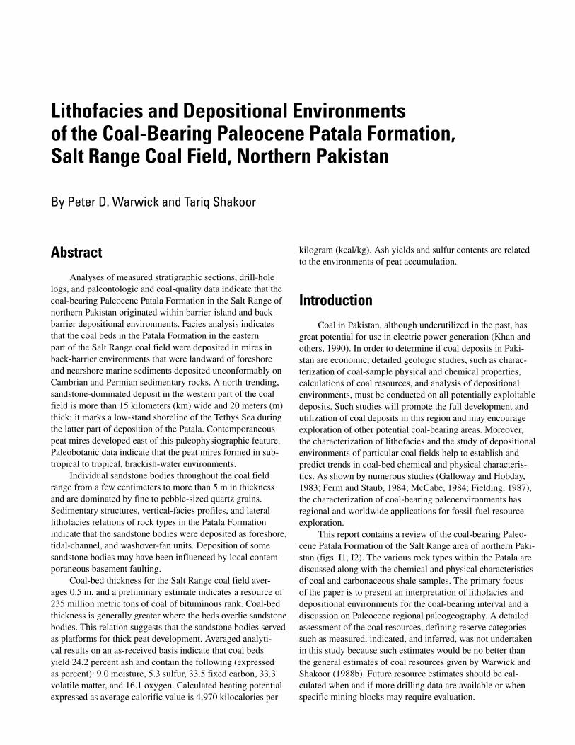
IntroductionCoal in Pakistan, although underutilized in the past, has
great potential for use in electric power generation (Khan and others, 1990). In order to determine if coal deposits in Paki-stan are economic, detailed geologic studies, such as charac-terization of coal-sample physical and chemical properties, calculations of coal resources, and analysis of depositional environments, must be conducted on all potentially exploitable deposits. Such studies will promote the full development and utilization of coal deposits in this region and may encourage exploration of other potential coal-bearing areas. Moreover, the characterization of lithofacies and the study of depositional environments of particular coal fields help to establish and predict trends in coal-bed chemical and physical characteris-tics. As shown by numerous studies (Galloway and Hobday, 1983; Ferm and Staub, 1984; McCabe, 1984; Fielding, 1987), the characterization of coal-bearing paleoenvironments has regional and worldwide applications for fossil-fuel resource exploration.
This report contains a review of the coal-bearing Paleo-cene Patala Formation of the Salt Range area of northern Paki-stan (figs. I1, I2). The various rock types within the Patala are discussed along with the chemical and physical characteristics of coal and carbonaceous shale samples. The primary focus of the paper is to present an interpretation of lithofacies and depositional environments for the coal-bearing interval and a discussion on Paleocene regional paleogeography. A detailed assessment of the coal resources, defining reserve categories such as measured, indicated, and inferred, was not undertaken in this study because such estimates would be no better than the general estimates of coal resources given by Warwick and Shakoor (1988b). Future resource estimates should be cal-culated when and if more drilling data are available or when specific mining blocks may require evaluation.

I2 Regional Studies of the Potwar Plateau Area, Northern Pakistan
TajikistanTurkmenistan
CASPIAN L ines ofSEA contro l
Uzbekistan Himalaya C h i n a
A f g h a n i s t a n MouI r a n re
nt
vRi Study ainarea s
Quetta
s LahoreudnI Nepal
P a k i s t a n
KarachiI n d i a
Oman
ARABIAN SEAINDIAN OCEAN
Islamabad
Jammu andKashmir
60° 80°
Makarwalcoal field
30°
20°
1000 Km625 Mi
Figure I1. Index map showing the Salt Range study area (shown in more detail in fig. I2), Makarwal coal field, and selected regional features.
Acknowledgments
This chapter is a product of a cooperative program between the Geological Survey of Pakistan (GSP) and the U.S. Geological Survey (USGS), which was sponsored by the Government of Pakistan and the U.S. Agency for International Development (USAID). Funding was provided by USAID through project 391–0478; Energy Planning and Develop-ment Project, Coal Resource Assessment Component 2a; and Participating Agency Service Agreement (PASA) 1PK–0478–P–IC–5068–00.
We are thankful to the Punjab Directorate of Industries and Mineral Development, Punjab Mineral Development Corporation, Pakistan Mine Owners Association, and Paki-stan Mineral Development Corporation for providing some of the data that were used in this study. Many individual mining companies throughout the Salt Range provided coal-thickness data and access to their mines for sampling. Robert W. Hook contributed many helpful suggestions and comments to the manuscript.
Regional Geology of the Salt Range
Structural Setting
The Salt Range and Potwar Plateau (fig. I2) are part of the active foreland fold-and-thrust belt of the Himalayas of northern Pakistan (Jaumé and Lillie, 1988; Gee, 1989; Pen-nock and others, 1989). The Salt Range is an east-northeast-
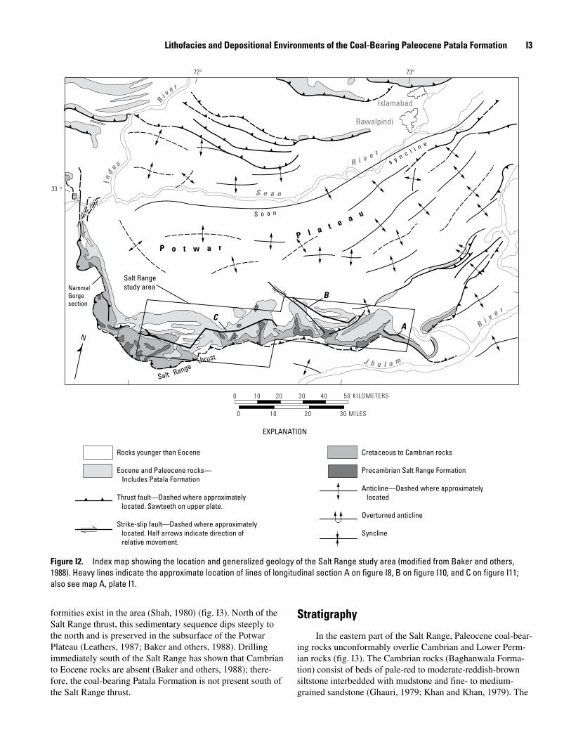
trending thrust front approximately 175 kilometers (km) long that rises abruptly from the Jhelum River plain. Most of the thrusting in the Potwar occurred during the Miocene and Plio-cene (Raynolds and Johnson, 1985; Burbank and Raynolds, 1988). To the west, the Salt Range bends northward (fig. I2), where it is bound by a major north-trending, strike-slip fault (Baker and others, 1988; McDougall, 1988; McDougall and Khan, 1990; McDougall and Hussain, 1991). At the eastern end of the range, complex thrusts pass into northeast-trending anticlines (Pennock and others, 1989). To the north, the Salt Range merges with the Potwar Plateau, which is a low-relief upland except where dissected by the Soan River and its tribu-taries (Yeats and others, 1984).
Within the Salt Range, the structure consists of a narrow zone of intensely folded, faulted, and uplifted rocks, which contrasts with the open folds of low-structural relief of the Potwar Plateau; the sedimentary rocks south of the Salt Range thrust lack structural deformation (Yeats and others, 1984). The upthrown block of the thrust brings to the surface the Salt Range Formation along the southward-facing edge of the over-thrust block, which contains evaporites of late Precambrian or Early Cambrian age (fig. I3). These evaporites underlie the Potwar Plateau and form a zone of décollement for regional thrusting (Butler and others, 1987; Jaumé and Lillie, 1988; Pennock and others, 1989).
Overlying the evaporites of the Salt Range Formation is an unusually well exposed sedimentary record of Cambrian, Permian, and younger strata (Gee, 1980, 1989; Yeats and oth-ers, 1984). Rocks of Ordovician through Carboniferous, Late Cretaceous, and Oligocene ages are absent, and major uncon-
Lithofacies and Depositional Environments of the Coal-Bearing Paleocene Patala Formation I�
Islamabad
Rawalpindi
reviR
ei n
r le c
v ns R i ys
udnI
S o a n
S o a n
Salt Rangestudy area
reviR
J h u me l
NammalGorgesection
B
CA
72° 73°
33 °
0 50 KILOMETERS10 20 30 40
0 10 20 30 MILES
Rocks younger than Eocene Cretaceous to Cambrian rocks
Eocene and Paleocene rocks— Precambrian Salt Range Formation Includes Patala Formation
Anticline—Dashed where approximatelyThrust fault—Dashed where approximately located located. Sawteeth on upper plate.
Overturned anticlineStrike-slip fault—Dashed where approximately located. Half arrows indicate direction of Syncline relative movement.
uaetaP l
P o t w a r
N
thrust
Salt Range
EXPLANATION
Figure I2. Index map showing the location and generalized geology of the Salt Range study area (modified from Baker and others, 1988). Heavy lines indicate the approximate location of lines of longitudinal section A on figure I8, B on figure I10, and C on figure I11; also see map A, plate I1.
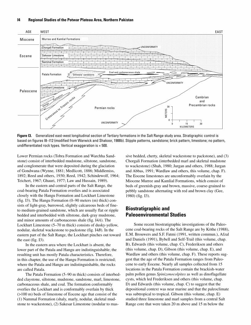
formities exist in the area (Shah, 1980) (fig. I3). North of the Salt Range thrust, this sedimentary sequence dips steeply to the north and is preserved in the subsurface of the Potwar Plateau (Leathers, 1987; Baker and others, 1988). Drilling immediately south of the Salt Range has shown that Cambrian to Eocene rocks are absent (Baker and others, 1988); there-fore, the coal-bearing Patala Formation is not present south of the Salt Range thrust.
Stratigraphy
In the eastern part of the Salt Range, Paleocene coal-bear-ing rocks unconformably overlie Cambrian and Lower Perm-ian rocks (fig. I3). The Cambrian rocks (Baghanwala Forma-tion) consist of beds of pale-red to moderate-reddish-brown siltstone interbedded with mudstone and fine- to medium-grained sandstone (Ghauri, 1979; Khan and Khan, 1979). The
I� Regional Studies of the Potwar Plateau Area, Northern Pakistan
Miocene
Eocene
Paleocene
WEST EASTAGE
Patala Formation
briancks Cam
roc andPrecambr a ocks
Triassi
i n r30to Permian rocks
s S
uo
R
e
E
cta
TE
Cre M
00 15 30
KILOMETERS
Lockhart Limestone
Nammal Formation
Sakesar Limestone
Chorgali Formation
Coal and carbonaceous shale"Dilliwala" sandstone
Murree and Kamlial Formations
UNCONFORMITY
UNCONFORMITY
UNCONFORMITY
ntrma io
ngu F
o
Ha
Figure I�. Generalized east-west longitudinal section of Tertiary formations in the Salt Range study area. Stratigraphic control is based on figures I8–I12 (modified from Warwick and Shakoor, 1988b). Stipple patterns, sandstone; brick pattern, limestone; no pattern, undifferentiated rock types. Vertical exaggeration is × 500.
Lower Permian rocks (Tobra Formation and Warchha Sand-stone) consist of interbedded mudstone, siltstone, sandstone, and conglomerate that were deposited during the glaciation of Gondwana (Wynne, 1881; Medlicott, 1886; Middlemiss, 1892; Reed and others, 1930; Reed, 1942; Schindewolf, 1964; Teichert, 1967; Ghauri, 1977; Law and Hussain, 1989).
In the eastern and central parts of the Salt Range, the coal-bearing Patala Formation overlies and is associated closely with the Hangu Formation and Lockhart Limestone (fig. I3). The Hangu Formation (0–90 meters (m) thick) con-sists of light-gray, burrowed, slightly calcareous beds of fine- to medium-grained sandstone, which are usually flat or ripple bedded and interbedded with siltstone, dark-gray mudstone, and minor amounts of carbonaceous shale (fig. I4A). The Lockhart Limestone (5–70 m thick) consists of dusky-yellow, nodular, skeletal wackestone to packstone (fig. I4B). In the eastern part of the Salt Range, the Lockhart pinches out toward the east (fig. I3).
In the eastern area where the Lockhart is absent, the lower part of the Patala and Hangu are indistinguishable; the resulting unit has mostly Patala characteristics. Therefore, in this chapter, the use of the Hangu Formation is restricted; where the Patala and Hangu are indistinguishable, the rocks are called Patala.
The Patala Formation (5–90 m thick) consists of interbed-ded claystone, siltstone, mudstone, sandstone, marl, limestone, carbonaceous shale, and coal. The formation conformably overlies the Lockhart and is conformably overlain by thick (>100 m) beds of limestone of Eocene age that consist of the (1) Nammal Formation (shaly, marly, nodular, skeletal mud-stone to wackestone), (2) Sakesar Limestone (nodular to mas-
sive bedded, cherty, skeletal wackestone to packstone), and (3) Chorgali Formation (interbedded marl and skeletal mudstone to wackestone) (Shah, 1980; Jurgan and others, 1988; Jurgan and Abbas, 1991; Wardlaw and others, this volume, chap. F). The Eocene limestones are unconformably overlain by the Miocene Murree and Kamlial Formations, which consist of beds of greenish-gray and brown, massive, coarse-grained to pebbly sandstone alternating with red and brown clay (Gee, 1980) (fig. I3).
Biostratigraphic and Paleoenvironmental Studies
Some recent biostratigraphic investigations of the Paleo-cene coal-bearing rocks of the Salt Range are by Köthe (1988), E.M. Brouwers and S.F. Fatmi (1991, written commun.), Afzal and Daniels (1991), Bybell and Self-Trail (this volume, chap. B), Edwards (this volume, chap. C), Frederiksen and others (this volume, chap. D), Gibson (this volume, chap. E), and Wardlaw and others (this volume, chap. F). These reports sug-gest that the age of the Patala Formation ranges from Paleo-cene to early Eocene. Nearly all samples collected from 15 locations in the Patala Formation contain the brackish-water palm pollen genus Spinizonocolpites as well as dinoflagellate cysts, which led Frederiksen and others (this volume, chap. D) and Edwards (this volume, chap. C) to suggest that the depositional context was near marine and that the paleoclimate was subtropical to tropical. Gibson (this volume, chap. E) studied three limestone and marl samples from a central Salt Range core that were taken 20 m above and 15 m below the
Lithofacies and Depositional Environments of the Coal-Bearing Paleocene Patala Formation I�
coal-bearing zone and suggested that the depositional environ-ment for the samples was in shallow to very shallow inner neritic areas at less than 30 m water depth. Afzal and Daniels (1991) studied planktonic and benthic foraminifers from the Patala and Nammal Formations of the western Salt Range and suggested that the rocks were deposited in open-marine, outer-shelf depositional conditions. Shah (1980) was the first to describe Patala barrier deposits in the central part of the Salt Range and informally named them the “Dilliwala” sandstone. Wells (1984), Alam and others (1987), Warwick and Shakoor (1988b), Mashhadi and others (1990), and Warwick and oth-ers (1990b) briefly described the depositional environments for the Patala coal-bearing deposits as having been deposited landward (toward the east) of a large barrier-island system near the western end of what is now the Salt Range.
Coal Field Studies
Most coal and carbonaceous shale deposits in the Salt Range are contained within the Paleocene Patala Formation; limited occurrences are in the Lower Permian Tobra Formation (Gee, 1938; Bhatti, 1967; Shah, 1980; Alam and others, 1987). Although the Paleocene Hangu Formation in the Salt Range contains a few carbonaceous beds, minable coal beds (gener-ally >0.5 m thick) in the Hangu are present in the Makarwal area of the Surghar Range (Danilchik and Shah, 1987; War-wick and others, 1995), about 40 km west of the western end of the Salt Range (fig. I1).
Warwick and Shakoor (1988b) presented a review of the stratigraphy of the Patala Formation in the Salt Range coal field and a collection of measured sections and borehole data. They made a preliminary estimate of 235 million metric tons of original coal resources for the Paleocene coal deposits of the Salt Range coal field. Warwick and Hussain (1990)
reviewed the stratigraphy, coal characteristics, and resources of northern Pakistan coal fields. They reported that the Salt Range coal field produces about 0.45 million metric tons of coal per year. Chemical and physical characteristics for 60 samples of Salt Range coal and carbonaceous shale were reported by Warwick and others (1990a, b). The apparent rank of the coal was found to be high-volatile C bituminous, and averaged selected analytical results of tests on coal samples are shown in table I1. Warwick and Javed (1990) compared Salt Range coal-quality data with data from other Pakistan coal fields and found that Salt Range coals are similar to other Pakistan bituminous coals.
Methods
This study is based on field work conducted from 1987 through 1989. Stratigraphic sections in Paleocene and associ-ated rocks were measured (maps A–C, pl. I1) along the main Salt Range escarpment and into canyons cut into the escarp-ment. These sections, along with previously unpublished drill-hole data, were compiled by Warwick and Shakoor (1988b). Additional data were available from Alam and others (1987) and Mashhadi and others (1990) that present the results of a recent GSP coal-exploratory drilling program in the Salt Range. Selected stratigraphic sections and drill-hole logs from these sources and from unpublished GSP data were used to construct longitudinal sections (lines of section A, B, and C, on fig. I2 and on map A, pl. I1) to show the lateral and vertical variation of lithofacies in the lower Tertiary units along the east-northeast-trending Salt Range front. A “best fit” method was employed on each longitudinal section, using the coal-bearing zone as datum.
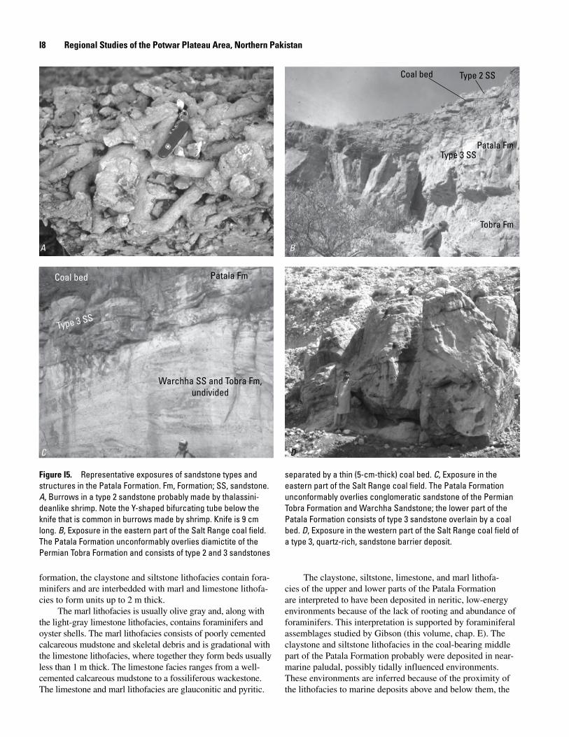
Figure I�. Representative exposures in the western part of the study area of the Hangu Formation (A) and the Lockhart Limestone (B). The Hangu Formation generally consists of flat-bedded clastic rocks, and the Lockhart Limestone is made up of nodular carbonate rocks.
A B
I� Regional Studies of the Potwar Plateau Area, Northern Pakistan
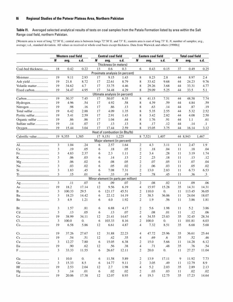
Table I1. Averaged selected analytical results of tests on coal samples from the Patala Formation listed by area within the Salt Range coal field, northern Pakistan.
[Western area is west of long 72°30′ E.; central area is between longs 72°30′ E. and 73° E.; eastern area is east of long 73° E. N, number of samples; avg., average; s.d., standard deviation. All values as received or whole-coal basis except thickness. Data from Warwick and others (1990b)]
Western coal field Central coal field Eastern coal field Total coal fieldN avg. s.d. N avg. s.d. N avg. s.d. N avg. s.d.
Thickness (in meters)Coal-bed thickness ...... 18 0.42 0.22 13 0.6 0.3 6 0.43 0.15 37 0.49 0.25
Proximate analysis (in percent)Moisture ...................... 19 9.11 2.93 17 9.15 1.43 8 8.23 2.8 44 8.97 2.4Ash yield ..................... 19 21.8 8.72 17 22.61 8.79 8 33.42 9.68 44 24.23 9.76Volatile matter ............. 19 34.62 4.7 17 33.75 4.46 8 29.26 3.68 44 33.31 4.77Fixed carbon ................ 19 34.47 4.95 17 34.48 4.29 8 29.09 5.25 44 33.5 5.1
Ultimate analysis (in percent)Carbon ......................... 19 50.37 7.45 17 50.07 6.35 8 41.15 7.51 44 48.58 7.74Hydrogen ..................... 19 4.96 .54 17 4.92 .58 8 4.39 .59 44 4.84 .59Nitrogen ...................... 19 .98 .16 17 .86 .13 8 .63 .14 44 .87 .19Total sulfur .................. 19 6.42 2.88 17 4.09 1.35 8 5.35 2.55 44 5.32 2.52Pyritic sulfur ................ 19 5.41 2.59 17 2.91 1.43 8 3.42 2.82 44 4.08 2.50Organic sulfur ............. 19 .86 .86 17 1.04 .44 8 1.76 .91 44 1.1 .61Sulfate sulfur ............... 19 .14 .07 17 .13 .13 8 .17 .12 44 .14 .1Oxygen ........................ 19 15.44 3.04 17 17.44 2.59 8 15.05 3.75 44 16.14 3.12
Heat of combustion (in Btu/lb)Calorific value ............. 19 9,355 1,385 17 9,151 1,225 8 7,521 1,407 44 8,943 1,467
Major element (in percent)Al .................................. 3 1.04 .24 6 2.57 1.64 2 4.3 3.11 11 2.47 1.9Ca ................................. 3 .19 .05 6 .18 .05 2 .18 .04 11 .18 .04Fe .................................. 3 4.83 2.37 6 2.3 1.11 2 3.4 .28 11 3.19 1.74K ................................... 3 .06 .03 6 .14 .13 2 .23 .18 11 .13 .12Mg ................................ 3 .06 .02 6 .08 .05 2 .07 .05 11 .07 .04Na ................................. 3 .03 .02 6 .05 .02 2 .06 .03 11 .05 .02Si .................................. 3 1.83 .45 6 7.08 7.31 2 13.0 2.83 11 6.73 6.53Ti .................................. 3 .15 .01 6 .33 .19 2 .78 .45 11 .36 .3
Minor element (in parts per million)Ag ................................. 3 .11 .07 6 .09 .07 2 .08 .02 11 .09 .06As ................................. 19 18.2 17.14 12 9.56 6.19 4 15.97 15.28 35 14.31 14.31B ................................... 3 100.33 29.5 6 121.17 45.51 2 110.0 0. 11 113.45 36.05Ba ................................. 3 18.23 14.42 6 22.12 14.19 2 38.5 36.06 11 24.04 18.07Be ................................. 3 4.9 1.21 6 4.0 1.92 2 1.9 .56 11 3.86 1.81
Br .................................. 3 1.57 .81 6 6.88 4.17 2 5.6 1.98 11 5.2 3.86Cd ................................. 3 .13 .05 6 .13 .07 2 .08 .01 11 .12 .06Ce ................................. 19 38.99 34.11 12 21.41 14.67 4 34.55 23.83 35 32.45 28.34Cl .................................. 3 100.0 0. 6 103.33 8.16 2 100.0 0. 11 101.81 6.03Co ................................. 19 6.58 5.86 12 6.61 4.87 4 7.32 8.51 35 6.68 5.68
Cr .................................. 19 37.26 27.67 12 31.88 22.23 4 47.72 25.96 35 36.61 25.44Cs ................................. 19 .54 .51 12 .42 .35 4 .69 .6 35 .52 .46Cu ................................. 3 12.27 7.80 6 15.05 6.38 2 15.0 5.66 11 14.28 6.12Eu ................................. 19 .90 .62 12 .56 .38 4 .71 .48 35 .76 .54F ................................... 3 33.33 11.55 6 26.67 12.11 2 20.0 0. 11 27.27 11.04
Ga ................................. 1 10.0 0. 6 11.58 5.89 2 13.9 17.11 9 11.92 7.73Ge ................................. 3 15.33 8.5 6 14.77 9.11 2 3.05 .49 11 12.79 8.9Hf ................................. 19 2.53 2.04 12 2.7 1.98 4 5.2 2.03 35 2.89 2.13Hg ................................. 3 .14 .01 6 .02 .02 2 .03 .03 11 .02 .02La ................................. 19 20.06 17.38 12 12.07 8.93 4 19.3 12.75 35 17.23 14.64
Lithofacies and Depositional Environments of the Coal-Bearing Paleocene Patala Formation I7
Table I1. Averaged selected analytical results of tests on coal samples from the Patala Formation listed by area within the Salt Range coal field, northern Pakistan.—Continued
Western coal field Central coal field Eastern coal field Total coal fieldN avg. s.d. N avg. s.d. N avg. s.d. N avg. s.d.
Minor element (in parts per million)—ContinuedLi .................................. 3 11.53 6.71 6 47.17 31.02 2 66.0 62.22 11 40.87 35.85Lu ................................. 19 .31 .16 12 .24 .15 4 .28 .16 35 .28 .15Mn ................................ 3 23.0 9.54 6 33.0 19.22 2 31.5 6.36 11 30.00 15.09Mo ................................ 1 2.4 0. 6 8.05 2.4 2 13.7 10.32 9 8.68 5.33Nb ................................. 3 5.0 1.9 6 11.47 9.64 2 29.5 6.36 11 12.98 11.24
Nd ................................. 3 16.0 4.36 6 16.03 5.27 2 26.0 18.38 11 17.83 8.23Ni .................................. 3 13.57 6.83 6 22.47 13.83 2 26.0 7.07 11 20.68 11.52P ................................... 3 131.03 215.62 6 177.62 140.04 2 103.0 9.9 11 151.34 141.84Pb ................................. 3 11.5 6.95 6 14.67 7.17 2 13.8 5.94 11 13.64 6.4Pr .................................. 3 11.53 7.99 6 4.18 5.35 2 2.9 .28 11 5.95 6.34
Rb ................................. 19 41.82 15.18 12 31.21 21.03 4 22.7 14.83 35 35.99 18.23Sb ................................. 19 .35 .18 12 .31 .09 4 .65 .3 35 .37 .2Sc .................................. 19 7.42 5.87 12 5.87 4.08 4 7.15 4.43 35 6.85 5.09Se .................................. 19 9.28 2.78 12 11.77 3.48 4 21.0 6.73 35 11.48 5.04Sm ................................ 19 4.52 3.35 12 2.76 1.87 4 3.77 2.56 35 3.83 2.89
Sn ................................. 1 3.5 0. 6 4.6 2.03 2 6.05 4.88 9 4.8 2.48Sr .................................. 3 186.67 60.28 6 142.17 103.85 2 131.0 55.15 11 152.27 83.24Ta .................................. 3 .4 .08 6 .93 .52 2 1.95 .92 11 .71 .71Tb ................................. 19 .64 .37 12 .44 .30 4 .51 .33 35 .55 .34Th ................................. 19 5.89 3.93 12 7.12 3.13 4 12.85 6.58 35 7.11 4.46
U ................................... 3 1.89 1.07 6 2.6 1.4 2 9.4 6.5 11 3.64 3.69V ................................... 3 33.0 16.09 6 46.5 24.94 2 76.0 33.94 11 48.18 26.53W .................................. 3 .53 .06 6 1.36 .5 2 2.0 .99 11 1.25 .71Y ................................... 3 16.33 6.11 6 15.62 4.13 2 19.0 4.24 11 16.43 4.42Yb ................................. 19 2.31 1.21 12 1.57 .99 4 2.06 1.12 35 2.02 1.15
Zn ................................. 3 67.33 37.81 6 70.83 85.92 2 61.0 43.84 11 68.09 64.68Zr .................................. 3 33.0 2.0 6 579.0 1,235.46 2 315.0 106.07 11 382.0 908.31
Lithofacies of the Patala Formation
The Patala Formation can be divided into several lithofa-cies, which in decreasing order of abundance are claystone, siltstone, mudstone, sandstone, marl, limestone, carbonaceous shale, and coal. A mudstonelike lithofacies, described by Whitney and others (1990) as a paleosol, is common near the base of the Paleocene sequence in the Salt Range. Outcrop and subsurface information provides local lithofacies charac-terization of the rocks that are described below. The physical characteristics and distribution of these lithofacies are depicted in figures I5–I12.
Claystone, Siltstone, Mudstone, Marl, and Limestone
The claystone, siltstone, mudstone, marl, and limestone lithofacies make up most of the Patala Formation. The clay-
stone lithofacies is usually dark gray to greenish black and is generally less than 3 m thick. The claystone contains pyrite, either as small disseminated crystals or clusters up to several centimeters in diameter, and burrows, which are commonly filled by pyrite. The claystone lithofacies may be interbedded with light- to dark-gray siltstone or with sandstone streaks and layers that range from a few centimeters to 1 m in thickness. Claystone lithofacies is gradational, and siltstone and sand-stone deposits have thin (a few centimeters thick) claystone interbeds that drape over bedforms preserved on bedding surfaces. The claystone lithofacies associated with coal and carbonaceous beds in the middle part of the formation is usually carbonaceous and rooted. The siltstone lithofacies is flat or ripple bedded, calcareous in places, and may be rooted and burrowed. Individual siltstone beds are usually less than 3 m thick. Sandstone and siltstone interbeds are common and grade laterally into larger sandstone bodies (discussed below). Intervals that are usually less than 10 m thick, where the claystone and siltstone lithofacies are intermixed, are referred to as mudstone lithofacies. In the upper and lower parts of the
I� Regional Studies of the Potwar Plateau Area, Northern Pakistan
formation, the claystone and siltstone lithofacies contain fora-minifers and are interbedded with marl and limestone lithofa-cies to form units up to 2 m thick.
The marl lithofacies is usually olive gray and, along with the light-gray limestone lithofacies, contains foraminifers and oyster shells. The marl lithofacies consists of poorly cemented calcareous mudstone and skeletal debris and is gradational with the limestone lithofacies, where together they form beds usually less than 1 m thick. The limestone facies ranges from a well-cemented calcareous mudstone to a fossiliferous wackestone. The limestone and marl lithofacies are glauconitic and pyritic.
The claystone, siltstone, limestone, and marl lithofa-cies of the upper and lower parts of the Patala Formation are interpreted to have been deposited in neritic, low-energy environments because of the lack of rooting and abundance of foraminifers. This interpretation is supported by foraminiferal assemblages studied by Gibson (this volume, chap. E). The claystone and siltstone lithofacies in the coal-bearing middle part of the Patala Formation probably were deposited in near-marine paludal, possibly tidally influenced environments. These environments are inferred because of the proximity of the lithofacies to marine deposits above and below them, the
A
Coal bed
Type 3 SS
Type 2 SS
Patala Fm
Tobra Fm
B
Coal bed
Type 3 SS
Patala Fm
Warchha SS and Tobra Fm,undivided
C D
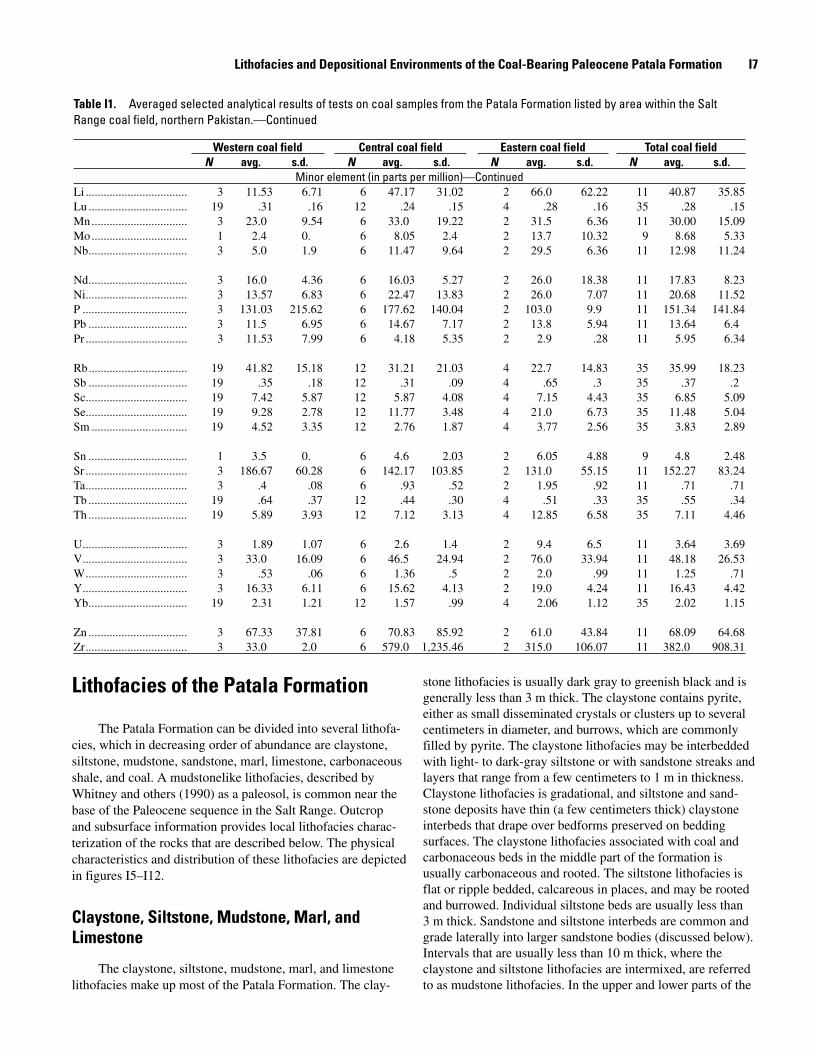
Figure I�. Representative exposures of sandstone types and structures in the Patala Formation. Fm, Formation; SS, sandstone. A, Burrows in a type 2 sandstone probably made by thalassini-deanlike shrimp. Note the Y-shaped bifurcating tube below the knife that is common in burrows made by shrimp. Knife is 9 cm long. B, Exposure in the eastern part of the Salt Range coal field. The Patala Formation unconformably overlies diamictite of the Permian Tobra Formation and consists of type 2 and 3 sandstones
separated by a thin (5-cm-thick) coal bed. C, Exposure in the eastern part of the Salt Range coal field. The Patala Formation unconformably overlies conglomeratic sandstone of the Permian Tobra Formation and Warchha Sandstone; the lower part of the Patala Formation consists of type 3 sandstone overlain by a coal bed. D, Exposure in the western part of the Salt Range coal field of a type 3, quartz-rich, sandstone barrier deposit.
Lithofacies and Depositional Environments of the Coal-Bearing Paleocene Patala Formation I�
presence of brackish-water pollen taxa, common clay drapes overlying bedding bedforms, rooting, and the close association of the lithofacies with coal and carbonaceous shale lithofacies.
Sandstone
The sandstone lithofacies within the Patala Formation generally occurs in three forms:
Type 1 consists of flat- to ripple-bedded, fine-grained sandstone beds a few centimeters thick that occur in intervals dominated by claystone and siltstone lithofacies; these sandstones can be interlayered with carbonaceous shale or impure coal and can be rooted. Individual beds can be traced laterally for as much as 20 m.
Type 2 sandstone lithofacies consists of continuous tabu-lar bodies as much as 2 m thick that are traceable laterally for up to 100 m. These sandstones are fine to medium grained, wavy bedded, ripple laminated, or cross strati-fied, and have small (<0.25 m thick) tabular- and trough-crossbed sets. The basal contact is usually sharp, and the upper contact is gradational with the overlying sediments. Burrows are common and generally are filled with mud or pyrite. Most burrows (fig. I5A) are similar to those made by thalassinidean shrimp (compare with those described by Bromley and Frey (1974)). Type 1 and type 2 sand-stone lithofacies usually occur together in mudstone-dom-inated intervals. Type 1 grades laterally into type 2.
Type 3 sandstone lithofacies forms continuous bodies that are laterally traceable for several kilometers and may exceed 5 m in thickness (figs. I5B–D). Grain sizes in type 3 sandstones range from medium to pebbles, and all type 3 sandstones are quartzose. These sandstone bodies usu-ally display a fining-upward grain size. The upper contact of type 3 sandstone bodies is gradational. Sedimentary structures consist of planar beds, ripple lamination, and trough to broad low-angle, and tabular cross stratification. Trough and tabular cross-stratified bed sets as much as 0.5 m thick and 2 m wide occur within internal scour features that are laterally continuous across outcrops. The upper parts of type 3 sandstone bodies commonly have thin claystone interbeds or claystone drapes that overlie ripple lamination at reactivation surfaces. Individual type 3 sandstone bodies are stacked locally and form composite bodies dominated by type 3 sandstone up to 20 m in thick-ness. These thick bodies contain several fining-upward sequences that are usually separated by burrowed siltstone and type 2 sandstone lithofacies.
The vertical change in lithofacies and sedimentary struc-tures of the sandstones in the Patala Formation indicate that the sandstones were shoreface sandstones, probably deposited in a barrier-island system. These interpretations are supported by the presence of brackish-to-marine fossils and the abun-
1.
2.
3.
dance of quartzose sandstones; these characteristics are typical of most barrier deposits (Moslow, 1984).
The bodies dominated by type 3 sandstone are charac-terized by (1) a scoured base and multiple internal channel scours, (2) a vertical decrease in scale of bimodal trough, tabular, and ripple cross stratification at reactivation surfaces, and (3) a general fining upward in grain size, all of which are typical of barrier deposits (Barwis and Hayes, 1979; Galloway and Hobday, 1983; Moslow, 1984). The low-angle cross-strati-fication sets commonly preserved in the bodies dominated by type 3 sandstone probably represent beach-foreshore deposits. The abundant trough-and-tabular crossbedding found in these bodies was probably produced within the intertidal zone. Such scour features could have been produced by tidal chan-nels. The upper- and lower-shoreface deposits were probably removed by the scour associated with the movement of the shoreface. The upper parts of these bodies are commonly rooted, indicating shallow-water or subaerial environments of deposition; however, no dune deposits have been observed. Similar barrier-type sandstone bodies have been described by Hobday and Horne (1977) and Horne and others (1979) in the Appalachian coal fields of the eastern United States, and by Roehler (1988) in the Rock Springs coal field of the western United States.
Type 1 and type 2 sandstones probably were deposited in a variety of intertidal environments that were generally away from the high-energy shoreface environments in which the type 3 sandstones were deposited. Type 2 sandstone lithofacies containing small sets of tabular cross stratifica-tion, found between and above type 3 sandstone bodies, and within mudstone-dominated intervals, probably repre-sents tidal-delta or small tidal-creek deposits. These type 2 sandstones commonly contain burrows like those made by thalassinidean shrimp such as are found in Pleistocene shallow-marine and estuarine-salt marsh sediments in east-ern North Carolina (Curran and Frey, 1977). Type 1 and 2 sandstone lithofacies not associated with type 3 sandstone lithofacies probably represent distal washover deposits that were deposited in protected back-barrier environments such as back-barrier mires. Back-barrier and washover deposits directly overlie the barrier deposits in both the eastern and western parts of the Salt Range coal field. This vertical pro-file of lithofacies is typical of regressive-shoreline sequences (Galloway and Hobday, 1983; Moslow, 1984).
Carbonaceous Shale and Coal
In the eastern and central parts of the Salt Range, coal and carbonaceous shale lithofacies generally occur within a 5-m-thick zone in the middle part of the Patala Formation, usually within a single bed less than 1 m thick that can be split by dark-gray claystone or thin (<0.25 m thick) bands of quartzose type 1 sandstone. These lithofacies are discontinu-ous, commonly overlie quartzose type 3 sandstone bodies, and merge laterally with sandstone, claystone, and siltstone
I10 Regional Studies of the Potwar Plateau Area, Northern Pakistan
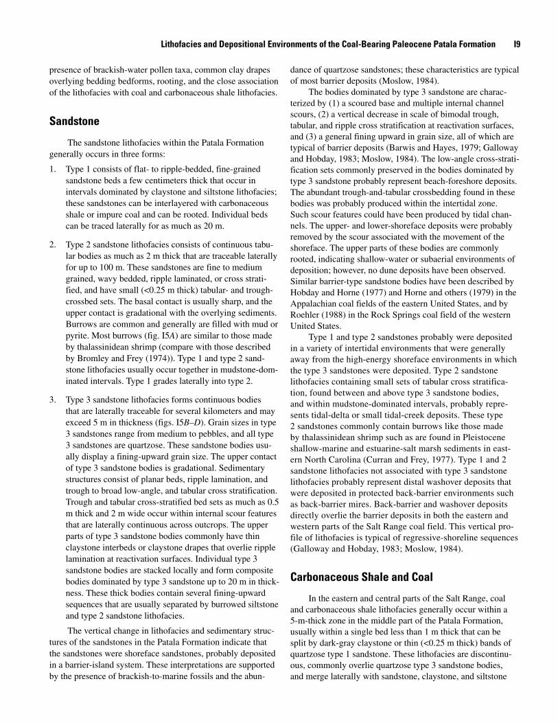
Figure I�. Exposure of the upper part of a carbonaceous shale bed showing numerous flattened burrows filled with mudstone. Such features are common in Salt Range coal and carbonaceous shale beds of the Patala Formation. Hammer head is 19 cm long.
lithofacies. Such organic-matter-rich intervals are restricted to the middle part of the Patala Formation.
Coal beds in the Patala Formation are gradational later-ally and vertically with carbonaceous shale. Megascopically, the coal beds are generally thinly banded (bands <3 centime-ters (cm) thick) and characterized by bright bands isolated in a matrix dominated by dull, resinous organic material. The number of bright bands decreases as the coal grades into carbo-naceous shale. Thin (<1 cm thick) fusain bands are present but not common. Nodules of pyrite as much as 5 cm in diameter are commonly dispersed throughout the coal; these usually occur as replacements of burrow infillings and are more common in the upper parts of the coal beds (fig. I6). Thin (<0.5 cm thick) gyp-sum veins are common and tend to occur along the cleat of the coal bed. Ghaznavi (1988) has described the petrology of three Salt Range coal samples as consisting of 79.1 percent vitrinite, 11.2 percent inertinite, and 9.7 percent liptinite.
Warwick and others (1990b) reported that thicknesses of coal and carbonaceous shale beds from 37 sample locations averaged 0.49 m (table I1). Results of proximate and ultimate analyses, reported on an as-received basis, indicate that coal beds have the following average characteristics: 24.23 percent ash yield, 5.32 percent total sulfur content, 4.08 percent pyritic sulfur content, and 8,943 British thermal units per pound (Btu/lb) (4,972 kilocalories per kilogram (kcal/kg)) calorific value. Concentrations of Ti, at 0.36 percent; Zr, at 382 parts per million (ppm); and Se, at 11.48 ppm (table I1) are high in comparison with averages for these elements in coals of similar rank (Stach and others, 1982; Ward, 1984; R.B. Finkelman, written commun., 1989). In general, the thickest coal beds have the lowest total sulfur content and are in the central area of the coal field (table I1). These variations in coal-bed character are probably related to the depositional environments of the peats.
The close association of the coal and carbonaceous shale lithofacies with the sandstone and finer grained lithofacies indicates that the coal and carbonaceous shale of the Patala Formation were probably deposited in back-barrier environ-ments. This interpretation has been suggested by various authors (Wells, 1984; Alam and others, 1987; Mashhadi and others, 1990; Warwick and others, 1990b) and is supported by the presence of brackish-water pollen taxa and gener-ally high sulfur contents in the coal beds. The Salt Range coal and carbonaceous lithofacies probably formed in mires of back-barrier/lagoonal areas that were protected from coastline-related sediment influx by barriers composed of bodies dominated by type 3 sandstone.
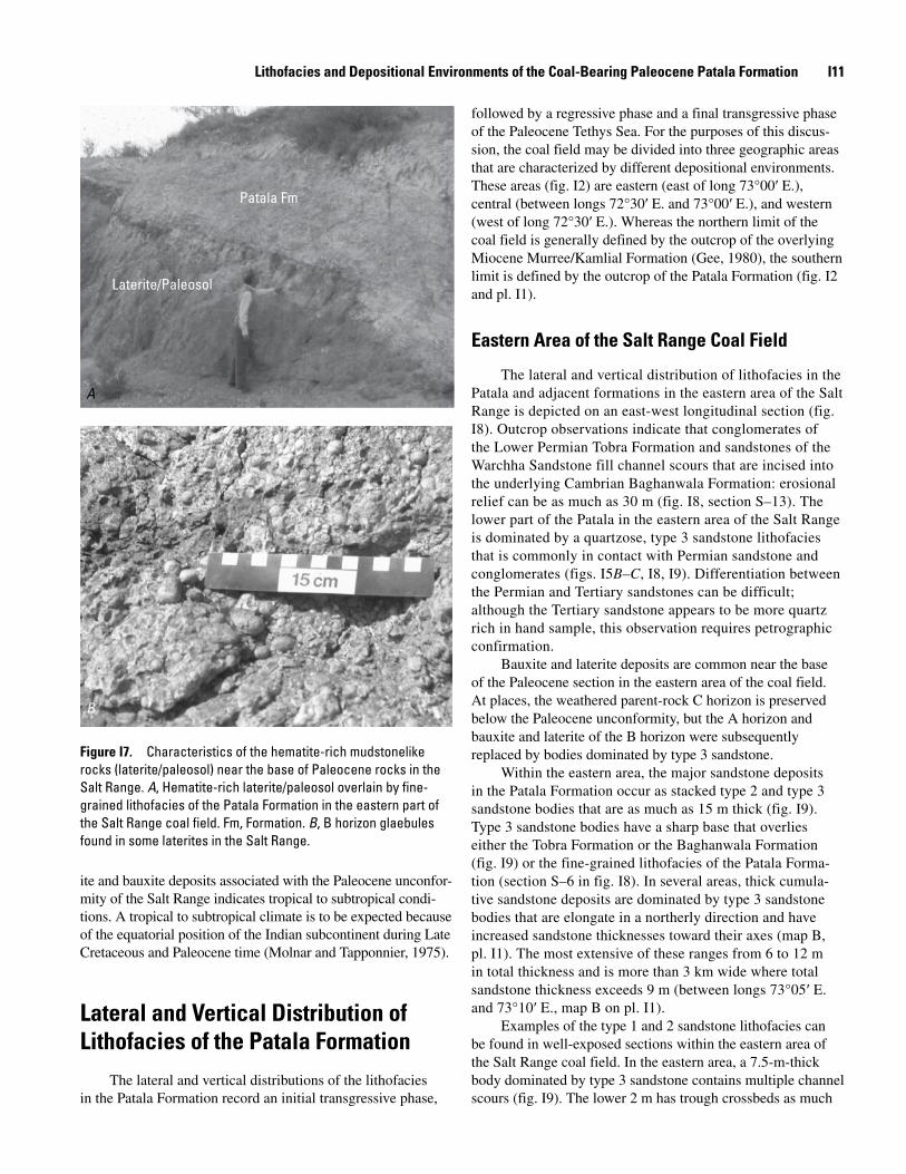
Paleosol
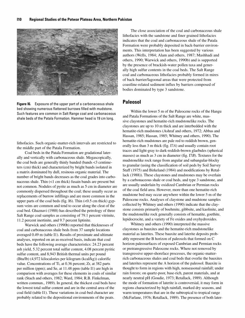
Within the lower 5 m of the Paleocene rocks of the Hangu and Patala Formations of the Salt Range are white, mas-sive claystones and hematite-rich mudstonelike rocks. The claystones are up to 10 m thick and are interbedded with the hematite-rich mudstones (Ashraf and others, 1972; Abbas and Hassan, 1985; Hassan, 1985; Whitney and others, 1990). The hematite-rich mudstones are pale red to reddish brown, gen-erally less than 3 m thick (fig. I7A) and usually contain root traces and light-gray to dark-reddish-brown glaebules (spherical masses) as much as 3 cm in diameter (fig. I7B). Textures for the mudstonelike rock range from angular and subangular-blocky to granular (using the classification of soil peds by Soil Survey Staff (1975) and Birkeland (1984) and modifications by Retal-lack (1988)). These claystones and mudstones may be overlain by a carbonaceous shale or coal beds, and type 3 sandstone, and are usually underlain by oxidized Cambrian or Permian rocks of the coal field area. However, more than one hematite-rich mudstone bed may occur anywhere within the lower 5 m of the Paleocene rocks. Analyses of claystone and mudstone samples collected by Whitney and others (1990) indicate that the clay-stone consists primarily of boehmite, gibbsite, and kaolinite, and the mudstonelike rock generally consists of hematite, goethite, lepidocrocite, and a variety of Fe oxides and oxyhydroxides.
Whitney and others (1990) interpreted the massive claystones as bauxites and the hematite-rich mudstonelike material as laterites. These bauxite and laterite deposits prob-ably represent the B horizon of paleosols that formed on C horizon paleosurfaces of exposed Cambrian and Permian rocks or pretransgressive Paleocene rocks. Where not removed by transgressive upper-shoreface processes, the organic-matter-rich carbonaceous shales and coal beds that overlie the bauxites and laterites represent the A horizon of the paleosol. Bauxite is thought to form in regions with high, nonseasonal rainfall; under rain forests; on quartz-poor, base-rich, parent materials, and at nearly neutral pH (Goudie, 1973; Retallack, 1989). Although the mode of formation of laterite is controversial, it may form in regions characterized by high rainfall, marked dry seasons, and warm temperatures that are in the subtropical to tropical range (McFarlane, 1976; Retallack, 1989). The presence of both later-
Lithofacies and Depositional Environments of the Coal-Bearing Paleocene Patala Formation I11
ite and bauxite deposits associated with the Paleocene unconfor-mity of the Salt Range indicates tropical to subtropical condi-tions. A tropical to subtropical climate is to be expected because of the equatorial position of the Indian subcontinent during Late Cretaceous and Paleocene time (Molnar and Tapponnier, 1975).
Lateral and Vertical Distribution of Lithofacies of the Patala Formation
The lateral and vertical distributions of the lithofacies in the Patala Formation record an initial transgressive phase,
followed by a regressive phase and a final transgressive phase of the Paleocene Tethys Sea. For the purposes of this discus-sion, the coal field may be divided into three geographic areas that are characterized by different depositional environments. These areas (fig. I2) are eastern (east of long 73°00′ E.), central (between longs 72°30′ E. and 73°00′ E.), and western (west of long 72°30′ E.). Whereas the northern limit of the coal field is generally defined by the outcrop of the overlying Miocene Murree/Kamlial Formation (Gee, 1980), the southern limit is defined by the outcrop of the Patala Formation (fig. I2 and pl. I1).
Eastern Area of the Salt Range Coal Field
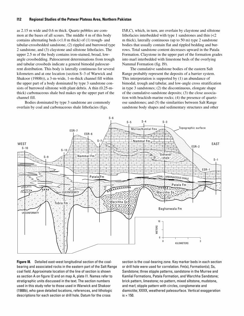
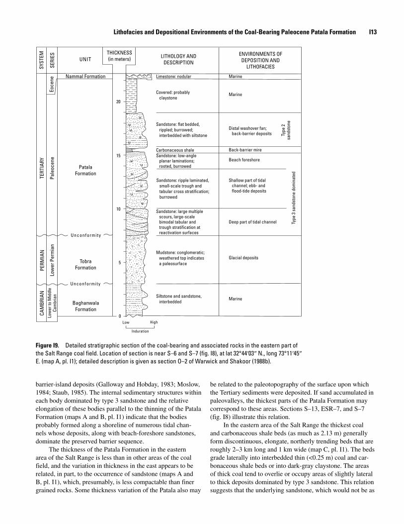
The lateral and vertical distribution of lithofacies in the Patala and adjacent formations in the eastern area of the Salt Range is depicted on an east-west longitudinal section (fig. I8). Outcrop observations indicate that conglomerates of the Lower Permian Tobra Formation and sandstones of the Warchha Sandstone fill channel scours that are incised into the underlying Cambrian Baghanwala Formation: erosional relief can be as much as 30 m (fig. I8, section S–13). The lower part of the Patala in the eastern area of the Salt Range is dominated by a quartzose, type 3 sandstone lithofacies that is commonly in contact with Permian sandstone and conglomerates (figs. I5B–C, I8, I9). Differentiation between the Permian and Tertiary sandstones can be difficult; although the Tertiary sandstone appears to be more quartz rich in hand sample, this observation requires petrographic confirmation.
Bauxite and laterite deposits are common near the base of the Paleocene section in the eastern area of the coal field. At places, the weathered parent-rock C horizon is preserved below the Paleocene unconformity, but the A horizon and bauxite and laterite of the B horizon were subsequently replaced by bodies dominated by type 3 sandstone.
Within the eastern area, the major sandstone deposits in the Patala Formation occur as stacked type 2 and type 3 sandstone bodies that are as much as 15 m thick (fig. I9). Type 3 sandstone bodies have a sharp base that overlies either the Tobra Formation or the Baghanwala Formation (fig. I9) or the fine-grained lithofacies of the Patala Forma-tion (section S–6 in fig. I8). In several areas, thick cumula-tive sandstone deposits are dominated by type 3 sandstone bodies that are elongate in a northerly direction and have increased sandstone thicknesses toward their axes (map B, pl. I1). The most extensive of these ranges from 6 to 12 m in total thickness and is more than 3 km wide where total sandstone thickness exceeds 9 m (between longs 73°05′ E. and 73°10′ E., map B on pl. I1).
Examples of the type 1 and 2 sandstone lithofacies can be found in well-exposed sections within the eastern area of the Salt Range coal field. In the eastern area, a 7.5-m-thick body dominated by type 3 sandstone contains multiple channel scours (fig. I9). The lower 2 m has trough crossbeds as much
Figure I7. Characteristics of the hematite-rich mudstonelike rocks (laterite/paleosol) near the base of Paleocene rocks in the Salt Range. A, Hematite-rich laterite/paleosol overlain by fine-grained lithofacies of the Patala Formation in the eastern part of the Salt Range coal field. Fm, Formation. B, B horizon glaebules found in some laterites in the Salt Range.
Patala Fm
Laterite/Paleosol
A
B
I12 Regional Studies of the Potwar Plateau Area, Northern Pakistan
as 2.15 m wide and 0.6 m thick. Quartz pebbles are com-mon at the bases of all scours. The middle 4 m of this body contains alternating beds (<1.0 m thick) of (1) trough- and tabular-crossbedded sandstone, (2) rippled and burrowed type 2 sandstone, and (3) claystone and siltstone lithofacies. The upper 2.5 m of the body contains iron-stained, broad, low-angle crossbedding. Paleocurrent determinations from trough and tabular crossbeds indicate a general bimodal paleocur-rent distribution. This body is laterally continuous for several kilometers and at one location (section S–3 of Warwick and Shakoor (1988b)), a 3-m-wide, 1-m-thick channel fill within the upper part of a body dominated by type 3 sandstone con-sists of burrowed siltstone with plant debris. A thin (0.25-m-thick) carbonaceous shale bed makes up the upper part of the channel fill.
Bodies dominated by type 3 sandstone are commonly overlain by coal and carbonaceous shale lithofacies (figs.
I5B,C), which, in turn, are overlain by claystone and siltstone lithofacies interbedded with type 1 sandstones and thin (<2 m thick), laterally continuous (up to 50 m) type 2 sandstone bodies that usually contain flat and rippled bedding and bur-rows. Total sandstone content decreases upward in the Patala Formation. Claystone in the upper part of the formation grades into marl interbedded with limestone beds of the overlying Nammal Formation (fig. I9).
The cumulative sandstone bodies of the eastern Salt Range probably represent the deposits of a barrier system. This interpretation is supported by (1) an abundance of bimodal, trough and tabular, and low-angle cross stratification in type 3 sandstones; (2) the discontinuous, elongate shape of the cumulative-sandstone deposits; (3) the close associa-tion with brackish-marine rocks; (4) the presence of quartz-ose sandstones; and (5) the similarities between Salt Range sandstone body shapes and sedimentary structures and other
x x x x x x x x x x x x x x x x xxxxx
Baghanwala Fm
Warchha Ss
Warchha Ss
Tobra Fm
Patala Fm
Patala Fm
Nammal Fm
Nammal Fm
"Sidhandi" shale
Murree/Kamlial Fms Topographic surface
EASTWEST
S–1
S–3S–4S–5S–6
S–7
S–13
S–9
S–10 ESR–2
ESR–6ESR–7
ESR–1
UNCONFORMITY
UNCONFORMITY
COAL-CARBONACEOUS SHALE
00
10
3KILOMETERS
MET
ERS
Figure I�. Detailed east-west longitudinal section of the coal-bearing and associated rocks in the eastern part of the Salt Range coal field. Approximate location of the line of section is shown as section A on figure I2 and on map A, plate I1. Names refer to stratigraphic units discussed in the text. The section numbers used in this study refer to those used in Warwick and Shakoor (1988b), who gave detailed locations, references, and lithologic descriptions for each section or drill hole. Datum for the cross
section is the coal-bearing zone. Key marker beds in each section or drill hole were used for correlation. Fm(s), Formation(s); Ss, Sandstone; three stipple patterns, sandstone in the Murree and Kamlial Formations, Patala Formation, and Warchha Sandstone; brick pattern, limestone; no pattern, mixed siltstone, mudstone, and marl; stipple pattern with circles, conglomerate and diamictite; XXXX, weathered paleosurface. Vertical exaggeration is × 150.
Lithofacies and Depositional Environments of the Coal-Bearing Paleocene Patala Formation I1�
Eoce
ne
Nammal Formation
20
TERT
IARY
Pale
ocen
e 15
PatalaFormation
10
Unconformity
PERM
IAN
Low
er P
erm
ian
Tobra 5Formation
Unconformity
CAM
BRIA
NLo
wer
to M
iddl
eCa
mbr
ian
BaghanwalaFormation
0
SYST
EM
SERI
ES
Limestone: nodular
Covered: probably Marine claystone
Sandstone: flat bedded,Distal washover fan; rippled; burrowed; back-barrier deposits yp
e 2
interbedded with siltstone Tsa
ndst
one
Carbonaceous shale Back-barrier mireSandstone: low-angle planar laminations; Beach foreshore rooted, burrowed
Sandstone: ripple laminated, Shallow part of tidal small-scale trough and channel; ebb- and tabular cross stratification; flood-tide deposits burrowed
Sandstone: large multiple scours, large-scale bimodal tabular and Deep part of tidal channel yp
e 3
sand
ston
e do
min
ated
T
trough stratification at reactivation surfaces
Mudstone: conglomeratic; weathered top indicates Glacial deposits a paleosurface
Siltstone and sandstone, Marine interbedded
Low High
Induration
THICKNESSUNIT (in meters) LITHOLOGY AND
DESCRIPTION
ENVIRONMENTS OFDEPOSITION AND
LITHOFACIES
Marine
Figure I�. Detailed stratigraphic section of the coal-bearing and associated rocks in the eastern part of the Salt Range coal field. Location of section is near S–6 and S–7 (fig. I8), at lat 32°44′03″ N., long 73°11′45″ E. (map A, pl. I1); detailed description is given as section O–2 of Warwick and Shakoor (1988b).
barrier-island deposits (Galloway and Hobday, 1983; Moslow, 1984; Staub, 1985). The internal sedimentary structures within each body dominated by type 3 sandstone and the relative elongation of these bodies parallel to the thinning of the Patala Formation (maps A and B, pl. I1) indicate that the bodies probably formed along a shoreline of numerous tidal chan-nels whose deposits, along with beach-foreshore sandstones, dominate the preserved barrier sequence.
The thickness of the Patala Formation in the eastern area of the Salt Range is less than in other areas of the coal field, and the variation in thickness in the east appears to be related, in part, to the occurrence of sandstone (maps A and B, pl. I1), which, presumably, is less compactable than finer grained rocks. Some thickness variation of the Patala also may
be related to the paleotopography of the surface upon which the Tertiary sediments were deposited. If sand accumulated in paleovalleys, the thickest parts of the Patala Formation may correspond to these areas. Sections S–13, ESR–7, and S–7 (fig. I8) illustrate this relation.
In the eastern area of the Salt Range the thickest coal and carbonaceous shale beds (as much as 2.13 m) generally form discontinuous, elongate, northerly trending beds that are roughly 2–3 km long and 1 km wide (map C, pl. I1). The beds grade laterally into interbedded thin (<0.25 m) coal and car-bonaceous shale beds or into dark-gray claystone. The areas of thick coal tend to overlie or occupy areas of slightly lateral to thick deposits dominated by type 3 sandstone. This relation suggests that the underlying sandstone, which would not be as
I1� Regional Studies of the Potwar Plateau Area, Northern Pakistan
compactable as adjacent finer grained sediments, served as a platform for plant growth and peat accumulation on a subsid-ing coastal plain. In the easternmost area of the coal field (map C, pl. I1), anomalously thick coal beds (as much as 2.13 m) were described by LaTouche (1894). Areas of thick coal such as these occur as narrow (<250 m wide), elongate bodies (map C, pl. I1) and, generally, have been completely mined out. Such thick coal may represent peat accumulation within abandoned channels. This interpretation is supported by the elongate shape of the coal bodies and outcrop observations of the upper parts of channel fill sequences that consist of organic material (section S–3, Warwick and Shakoor (1988b)).
Coal samples collected from the eastern area of the coal field produced greater ash yields than samples collected from other areas of the field (table I1). These increased ash yields in an easterly or landward direction probably indicate that eastern areas of peat accumulation were more prone to an influx of sediment, which may have been derived from exposed uplands toward the east. Frequent type 1 sandstone partings in the coal beds in this area suggest periodic wash-over sedimentation. Landward increases in organic sulfur and selenium content (table I1) indicate that organic sulfur and selenium were enriched in these more landward, pos-sibly fresher water environments. The increase of average organic sulfur content eastward (table I1) may indicate that freshwater environments of peat accumulation were inun-dated subsequently by sulfide-rich marine waters. Similar depositional environments have been proposed for increases in organic sulfur content in Appalachian coal beds (Davies and Raymond, 1983).
The upper part of the Patala Formation in the eastern Salt Range contains a foraminifer-rich claystone lithofacies and is gradational to a generally nodular to shaly limestone of the Nammal Formation, which suggests that the upper part of the Patala was probably deposited in neritic environments.
Central Area of the Salt Range Coal Field
Within the central area of the Salt Range coal field, quartzose type 2 and 3 sandstone bodies become less com-mon in a westerly direction (fig. I10). Type 1 sandstones are commonly observed in the coal-bearing interval in the eastern part of the central area. As in the eastern area of the field, areas of thick bodies dominated by type 3 sandstone are discontinuous and elongate in a northerly direction in the eastern part of the central coal field (map B, pl. I1). The thickest (>21 m) cumulative sandstone in the central area of the coal field is about 20 km west of the thick cumulative sandstones of the eastern area of the field. This distance may represent the spacing between the position of the earlier east-ernmost shoreline and the regressive shoreline that followed in the central area of the field.
A general lack of major sandstone bodies in the western part of the central coal field indicates a later westward shift of the shoreline. The areas with little sandstone content (between
longs 72°30′ E. and 72°55′ E., map B on pl. I1) probably rep-resent back-barrier environments. These areas were protected from coarse clastic influx associated with shoreline processes that apparently deposited the large complex dominated by type 3 sandstone (map B, pl. I1) west of long 72°30′ E. (described below).
Coal and carbonaceous shale deposits in the western part of the central coal field were probably deposited in back-barrier mires. Areas lateral to coal and carbonaceous shale deposits probably received clastic sediments that inhibited peat accumulation. The sediments may have been tidally transported. Environments of deposition in the more eastern part of the central area were similar to those in the eastern area of the field, where peat accumulated on platforms dominated by type 3 sandstone (maps B and C, pl. I1). The thicker coal beds occur proximal to areas of the thickest cumulative type 1, 2, and 3 sandstone deposits. Similarly shaped coal bodies and associated rocks have been described by Horne and others (1979) from Appalachian back-barrier environments.
Coal samples collected from the central area of the Salt Range coal field have a lower average total-sulfur yield than samples collected from other areas of the field (table I1). Lower organic- and pyritic-sulfur yields account for the major decrease in total sulfur in the central area of the field. Decreases in organic-sulfur yield (as a percentage of total sulfur) westward may indicate more marine-dominated environments of peat deposition in the western part of the study area. Casagrande and others (1977), likewise, found that as a percentage of total sul-fur, organic-sulfur yields from Florida Everglades marine-peat samples were less than those from Okefenokee freshwater-peat samples. Pyritic sulfur, however, is greater in the western and eastern areas of the Salt Range coal field (table I1). Although the causes for the reduction of pyritic-sulfur content in the coals of the central area of the field are not clear, the differences may be related to the depositional origin of the overlying rocks. Because marine roof rocks are known to have contributed to the pyritic-sulfur content of coals in central and eastern North America (Williams and Keith, 1963; Gluskoter and Simon, 1968), pyritic-sulfur yields in the western area of the Salt Range coal field similarly may be related to an increased marine influ-ence. Marine conditions for roof-rock deposition and increased pyritic-sulfur content also may be reflected by an abundance of pyrite-filled burrows observed commonly in the upper part of coal beds in the western area of the field.
The underlying Lockhart Limestone may have influ-enced the thickness of the Patala Formation in the central area of the coal field. The Lockhart Limestone, which is represented by a thin (<1 m thick) carbonate-rich zone in the eastern part of the central coal field, increases to more than 10 m in thickness in the western part of the same region (fig. I10). The thickness of the Patala Formation (map A, pl. I1) becomes more uniform toward the west in association with decreased net sandstone content and because the forma-tion was not deposited on pre-Paleocene topography. An anomalous, westerly trending, thin area of the Patala between longs 72°45′ E. and 73°00′ E. (map A, pl. I1), however, may
Lithofacies and Depositional Environments of the Coal-Bearing Paleocene Patala Formation I1�
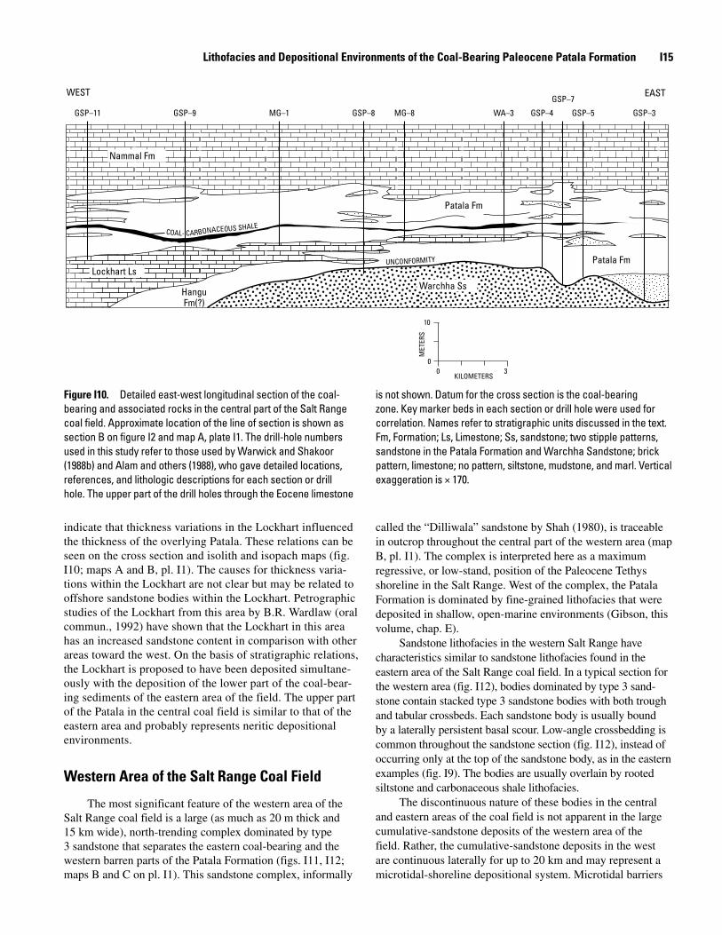
indicate that thickness variations in the Lockhart influenced the thickness of the overlying Patala. These relations can be seen on the cross section and isolith and isopach maps (fig. I10; maps A and B, pl. I1). The causes for thickness varia-tions within the Lockhart are not clear but may be related to offshore sandstone bodies within the Lockhart. Petrographic studies of the Lockhart from this area by B.R. Wardlaw (oral commun., 1992) have shown that the Lockhart in this area has an increased sandstone content in comparison with other areas toward the west. On the basis of stratigraphic relations, the Lockhart is proposed to have been deposited simultane-ously with the deposition of the lower part of the coal-bear-ing sediments of the eastern area of the field. The upper part of the Patala in the central coal field is similar to that of the eastern area and probably represents neritic depositional environments.
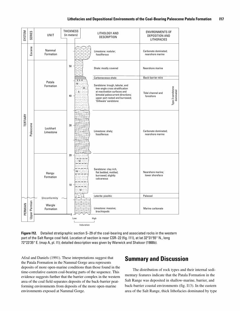
Western Area of the Salt Range Coal Field
The most significant feature of the western area of the Salt Range coal field is a large (as much as 20 m thick and 15 km wide), north-trending complex dominated by type 3 sandstone that separates the eastern coal-bearing and the western barren parts of the Patala Formation (figs. I11, I12; maps B and C on pl. I1). This sandstone complex, informally
called the “Dilliwala” sandstone by Shah (1980), is traceable in outcrop throughout the central part of the western area (map B, pl. I1). The complex is interpreted here as a maximum regressive, or low-stand, position of the Paleocene Tethys shoreline in the Salt Range. West of the complex, the Patala Formation is dominated by fine-grained lithofacies that were deposited in shallow, open-marine environments (Gibson, this volume, chap. E).
Sandstone lithofacies in the western Salt Range have characteristics similar to sandstone lithofacies found in the eastern area of the Salt Range coal field. In a typical section for the western area (fig. I12), bodies dominated by type 3 sand-stone contain stacked type 3 sandstone bodies with both trough and tabular crossbeds. Each sandstone body is usually bound by a laterally persistent basal scour. Low-angle crossbedding is common throughout the sandstone section (fig. I12), instead of occurring only at the top of the sandstone body, as in the eastern examples (fig. I9). The bodies are usually overlain by rooted siltstone and carbonaceous shale lithofacies.
The discontinuous nature of these bodies in the central and eastern areas of the coal field is not apparent in the large cumulative-sandstone deposits of the western area of the field. Rather, the cumulative-sandstone deposits in the west are continuous laterally for up to 20 km and may represent a microtidal-shoreline depositional system. Microtidal barriers
GSP–11 GSP–9 MG–1 GSP–8 MG–8 WA–3 GSP–4 GSP–5
GSP–7
GSP–3
EASTWEST
00
10
3KILOMETERS
MET
ERS
Patala Fm
Patala FmLockhart Ls
Warchha Ss
Nammal Fm
HanguFm(?)
COAL- CARBONACEOUS SHALE
UNCONFORMITY
Figure I10. Detailed east-west longitudinal section of the coal-bearing and associated rocks in the central part of the Salt Range coal field. Approximate location of the line of section is shown as section B on figure I2 and map A, plate I1. The drill-hole numbers used in this study refer to those used by Warwick and Shakoor (1988b) and Alam and others (1988), who gave detailed locations, references, and lithologic descriptions for each section or drill hole. The upper part of the drill holes through the Eocene limestone
is not shown. Datum for the cross section is the coal-bearing zone. Key marker beds in each section or drill hole were used for correlation. Names refer to stratigraphic units discussed in the text. Fm, Formation; Ls, Limestone; Ss, sandstone; two stipple patterns, sandstone in the Patala Formation and Warchha Sandstone; brick pattern, limestone; no pattern, siltstone, mudstone, and marl. Vertical exaggeration is × 170.
I1� Regional Studies of the Potwar Plateau Area, Northern Pakistan
typically are more continuous laterally than mesotidal bar-riers (Hayes, 1975; Barwis and Hayes, 1979). Additionally, the bodies dominated by type 3 sandstone of the western area contain low-angle cross stratification throughout, which may indicate that foreshore processes were more dominant in the west than tidal-channel processes were in the central and east-ern areas of the field.
Coal and carbonaceous shale lithofacies proximal to the “Dilliwala” sandstone complex dominated by type 3 sandstone are commonly split by type 1 and 2 sandstones. In the eastern part of the western area, coal and carbonaceous shale beds contain fewer rock partings and are more laterally continuous (fig. I11). These trends indicate that barrier-washover sedi-mentation may have been more common in the back-barrier mires proximal to the “Dilliwala” complex.
The development of the thick, widespread “Dilliwala” sandstone complex in the western area of the coal field may have been structurally influenced. Baker (1988) discussed the influences of basement offsets (as much as 1 km) on ramping and thrusting in the Salt Range area. Studies of airborne-mag-netic and gravity data from the Potwar area led H.D. Drewes (written commun., 1991) and H.R. Blank (oral commun., 1992) to suggest that a northwest-trending basement fault occurs under the western part of the Potwar Plateau. This fault is in close proximity to the present position of the “Dilliwala” sandstone complex and areas where Gee (1980, 1989) and
Fatmi and Haydri (1986) observed that several Paleozoic for-mations vary in thickness, pinch out, and reappear. If the pre-regional thrust position of the western Salt Range was proxi-mal to this or other basement faults, the facies and thickness variations observed in the western Salt Range could have been related to deposition that was contemporaneous with move-ment along the basement fault. One of the mechanisms of bar-rier-island formation is that of offshore sandstone buildup in areas of shoaling (Reinson, 1979). A shoaling area may have developed over an uplifted part of the basement during the Paleocene, which may have been responsible for the buildup of the “Dilliwala” sandstone complex and the variation of thicknesses of the Hangu Formation, Lockhart Limestone, and Patala Formation observed in the western area (fig. I11). Similar structural controls on sedimentation and barrier-island formation have been demonstrated in the Appalachian region of the eastern United States (Staub, 1985).
The Nammal Gorge section of the western Salt Range is depicted at the western end of the cross section shown on figure I11. Gibson (this volume, chap. E) reported that forami-niferal assemblages from five samples of claystone, marl, and limestone collected from the Patala Formation at this location represent a shallow, inner neritic depositional environment in the lower part of the Patala, and a middle to outer neritic marine depositional environment in the upper part of the Patala. These depositional environments are similar to those proposed by
0 6 120
20
KILOMETERS
MET
ERS
Patala Fm
EASTWEST
S–31 WS–218 CDH–6 CSR–22CDH–5
CDH–17CSR–8
MW–1PJ–5
CDH–10CDH–11
JR–2 JR–1Nammal Gorge
Lockhart Ls
Nammal Fm
Hangu Fm
"Dilliwala" sandstone
UNCONFORMITY
COAL-CARBONACEOUS SHALE
Laterite
Permian rocksJurassic rocks
Triassicrocks
Cretaceousrocks
Figure I11. Detailed east-west longitudinal section of the coal-bearing and associated rocks in the western part of the Salt Range coal field. Approximate location of the line of section is shown as section C on figure I2 and on map A, plate I1. Nammal Gorge section is from unpublished GSP data (location not shown on map A, pl. I1). The section numbers used in this study refer to those used by Warwick and Shakoor (1988b), who gave detailed locations, references, and lithologic descriptions for each
section or drill hole. The upper part of the drill holes through the Eocene limestone is not shown. Datum for the cross section is the coal-bearing zone. Key marker beds in each section or drill hole were used for correlation. Names refer to stratigraphic units discussed in the text. Fm, Formation; Ls, Limestone; stipple pattern, sandstone; brick pattern, limestone; shaded areas, laterite; no pattern, siltstone, shale, marl, and limestone. Vertical exaggeration is × 165.
Lithofacies and Depositional Environments of the Coal-Bearing Paleocene Patala Formation I17
Afzal and Daniels (1991). These interpretations suggest that the Patala Formation in the Nammal Gorge area represents deposits of more open-marine conditions than those found in the time-correlative eastern coal-bearing parts of the sequence. This evidence suggests further that the barrier complex in the western area of the coal field separates deposits of the back-barrier peat-forming environments from deposits of the more open-marine environments exposed at Nammal Gorge.
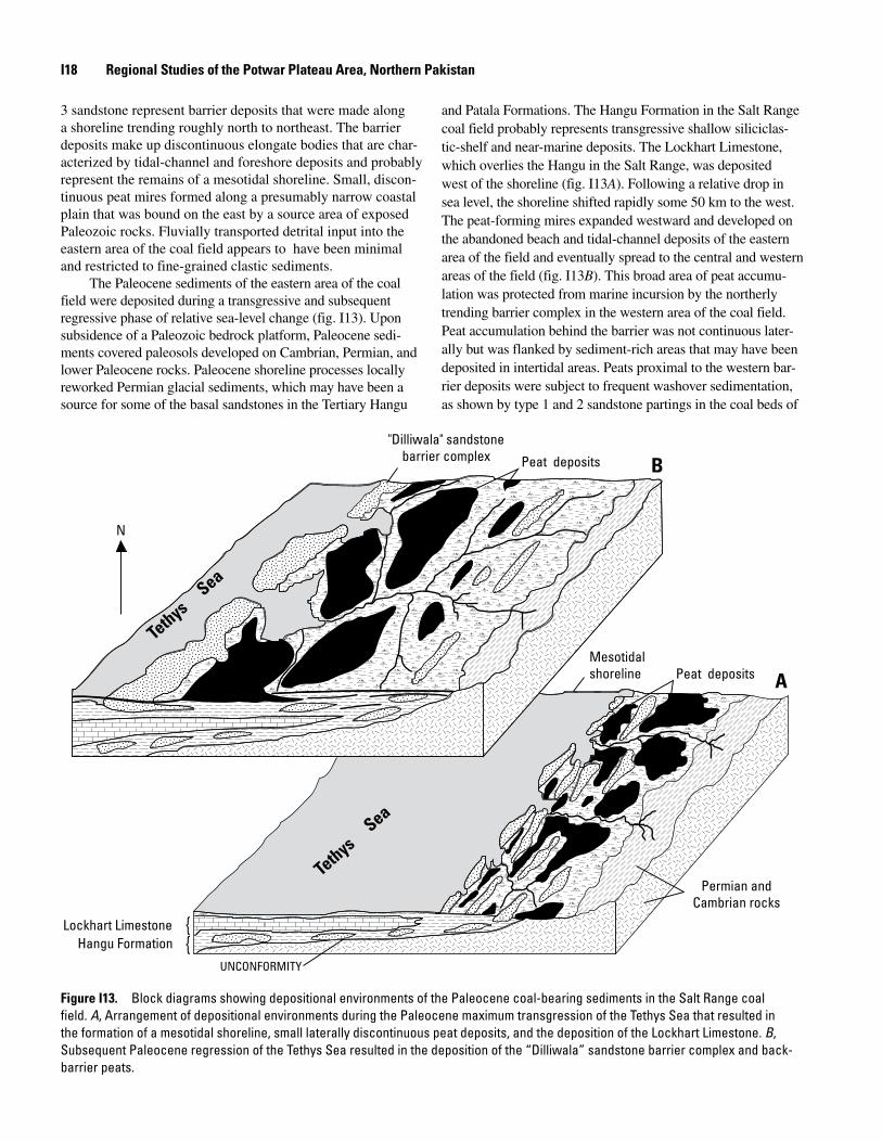
Summary and Discussion
The distribution of rock types and their internal sedi-mentary features indicate that the Patala Formation in the Salt Range was deposited in shallow-marine, barrier, and back-barrier coastal environments (fig. I13). In the eastern area of the Salt Range, thick lithofacies dominated by type
SYST
EM
SERI
ESEo
cene
TERT
IARY
Pale
ocen
e
PERM
IAN
Uppe
r Per
mia
nUNIT
NammalFormation
50
PatalaFormation
40
30LockhartLimestone
20
HanguFormation
10
Unconformity
Wargle Formation
0Low High
Induration
THICKNESS(in meters)
Limestone: nodular; Carbonate dominated; fossilferous nearshore marine
Shale: mostly covered Nearshore marine
Carbonaceous shale Back-barrier mire
Sandstone: trough, tabular, and low-angle cross stratification at reactivation surfaces and Tidal channel and bimodal paleocurrent directions; foreshore upper part rooted and burrowed; "Dilliwala" sandstone
Type
3 s
ands
tone
do
min
ated
Limestone: shaly; Carbonate dominated; fossilferous nearshore marine
Sandstone: clay rich, flat bedded, mottled; Nearshore marine; burrowed; slightly lower shoreface calcareous
Laterite: pisolitic Paleosol
Limestone: massive; Marine carbonate brachiopods
LITHOLOGY ANDDESCRIPTION
ENVIRONMENTS OFDEPOSITION AND
LITHOFACIES
Figure I12. Detailed stratigraphic section S–29 of the coal-bearing and associated rocks in the western part of the Salt Range coal field. Location of section is near CSR–22 (fig. I11), at lat 32°31′55″ N., long 72°23′35″ E. (map A, pl. I1); detailed description was given by Warwick and Shakoor (1988b).
I1� Regional Studies of the Potwar Plateau Area, Northern Pakistan
3 sandstone represent barrier deposits that were made along a shoreline trending roughly north to northeast. The barrier deposits make up discontinuous elongate bodies that are char-acterized by tidal-channel and foreshore deposits and probably represent the remains of a mesotidal shoreline. Small, discon-tinuous peat mires formed along a presumably narrow coastal plain that was bound on the east by a source area of exposed Paleozoic rocks. Fluvially transported detrital input into the eastern area of the coal field appears to have been minimal and restricted to fine-grained clastic sediments.
The Paleocene sediments of the eastern area of the coal field were deposited during a transgressive and subsequent regressive phase of relative sea-level change (fig. I13). Upon subsidence of a Paleozoic bedrock platform, Paleocene sedi-ments covered paleosols developed on Cambrian, Permian, and lower Paleocene rocks. Paleocene shoreline processes locally reworked Permian glacial sediments, which may have been a source for some of the basal sandstones in the Tertiary Hangu
and Patala Formations. The Hangu Formation in the Salt Range coal field probably represents transgressive shallow siliciclas-tic-shelf and near-marine deposits. The Lockhart Limestone, which overlies the Hangu in the Salt Range, was deposited west of the shoreline (fig. I13A). Following a relative drop in sea level, the shoreline shifted rapidly some 50 km to the west. The peat-forming mires expanded westward and developed on the abandoned beach and tidal-channel deposits of the eastern area of the field and eventually spread to the central and western areas of the field (fig. I13B). This broad area of peat accumu-lation was protected from marine incursion by the northerly trending barrier complex in the western area of the coal field. Peat accumulation behind the barrier was not continuous later-ally but was flanked by sediment-rich areas that may have been deposited in intertidal areas. Peats proximal to the western bar-rier deposits were subject to frequent washover sedimentation, as shown by type 1 and 2 sandstone partings in the coal beds of
Peat deposits B
aeS
Tethys
Peat deposits A
aeS
Tethys
UNCONFORMITY
Permian andCambrian rocks
Mesotidalshoreline
"Dilliwala" sandstonebarrier complex
Lockhart LimestoneHangu Formation
N
{{
Figure I1�. Block diagrams showing depositional environments of the Paleocene coal-bearing sediments in the Salt Range coal field. A, Arrangement of depositional environments during the Paleocene maximum transgression of the Tethys Sea that resulted in the formation of a mesotidal shoreline, small laterally discontinuous peat deposits, and the deposition of the Lockhart Limestone. B, Subsequent Paleocene regression of the Tethys Sea resulted in the deposition of the “Dilliwala” sandstone barrier complex and back-barrier peats.
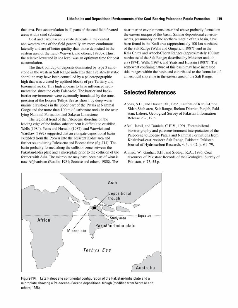
Lithofacies and Depositional Environments of the Coal-Bearing Paleocene Patala Formation I1�
that area. Peat accumulation in all parts of the coal field favored areas with a sand substrate.
Coal and carbonaceous shale deposits in the central and western area of the field generally are more continuous laterally and are of better quality than those deposited in the eastern area of the field (Warwick and others, 1990b). Thus, the relative lowstand in sea level was an optimum time for peat accumulation.
The thick buildup of deposits dominated by type 3 sand-stone in the western Salt Range indicates that a relatively static shoreline may have been controlled by a paleotopographic high that was created by uplifted blocks of pre-Tertiary and basement rocks. This high appears to have influenced sedi-mentation since the early Paleozoic. The barrier and back-barrier environments were eventually inundated by the trans-gression of the Eocene Tethys Sea as shown by deep-water marine claystones in the upper part of the Patala at Nammal Gorge and the more than 100 m of carbonate rocks in the over-lying Nammal Formation and Sakesar Limestone.
The regional trend of the Paleocene shoreline on the leading edge of the Indian subcontinent is difficult to establish. Wells (1984), Yeats and Hussain (1987), and Warwick and Wardlaw (1992) suggested that an elongate depositional basin extended from the Potwar into the adjacent Kohat area and further south during Paleocene and Eocene time (fig. I14). The basin probably formed along the collision zone between the Pakistan-India plate and a microplate prior to the collision of the former with Asia. The microplate may have been part of what is now Afghanistan (Boulin, 1981; Scotese and others, 1988). The
near-marine environments described above probably formed on the eastern margin of this basin. Similar depositional environ-ments, presumably on the northern margin of this basin, have been found in the Kotli area (approximately 100 km northeast of the Salt Range (Wells and Gingerich, 1987)) and in the Kala Chitta and Attock-Cherat Ranges (approximately 100 km northwest of the Salt Range; described by Meissner and oth-ers (1974), Wells (1984), and Yeats and Hussain (1987)). The somewhat confining nature of this basin may have increased tidal ranges within the basin and contributed to the formation of a mesotidal shoreline in the eastern area of the Salt Range.
Selected References
Abbas, S.H., and Hassan, M., 1985, Laterite of Karuli-Choa Sidan Shah area, Salt Range, Jhelum District, Punjab, Paki-stan: Lahore, Geological Survey of Pakistan Information Release 237, 12 p.
Afzal, Jamil, and Daniels, C.H.V., 1991, Foraminiferal biostratigraphy and paleoenvironment interpretation of the Paleocene to Eocene Patala and Nammal Formations from Khairabad-east, western Salt Range, Pakistan: Pakistan Journal of Hydrocarbon Research, v. 3, no. 2, p. 61–79.
Ahmad, W., Gauhar, S.H., and Siddiqi, R.A., 1986, Coal resources of Pakistan: Records of the Geological Survey of Pakistan, v. 73, 55 p.
Asia
Depositional trough
EquatorStudy areaAfrica
Pakistan-India plateMicroplate
T e t h y s S e a
Australia
Figure I1�. Late Paleocene continental configuration of the Pakistan-India plate and a microplate showing a Paleocene–Eocene depositional trough (modified from Scotese and others, 1988).
I20 Regional Studies of the Potwar Plateau Area, Northern Pakistan
Akhtar, M., 1985, Stratigraphy of Precambrian to lower Ter-tiary rocks of Salt Range, Punjab, Pakistan: Lahore, Geo-logical Survey of Pakistan Information Release 241, 99 p.
Alam, G.S., Bhatti, N.A., Mashhadi, S.T.A., Shakoor, T., Javed, S., and Anwar, M., 1988, Coal deposits of the Dalwal Plateau, District Chakwal, eastern Salt Range, Punjab, Paki-stan: Lahore, Geological Survey of Pakistan Information Release 325, 33 p.
Alam, G.S., Mashhadi, S.T.A., and Khan, M.A., 1987, Interim report on Permian coal exploration in Punjab Plains (drilling at Ashaba, District Jhang): Lahore, Geological Survey of Pakistan Information Release 286, 19 p.
American Society for Testing and Materials, 1986, Gaseous fuels, coals and coke, v. 05.05 in Annual book of ASTM standards: Philadelphia, Pa.: ASTM, 565 p.
Ashraf, M., Qureshi, W.M., and Faruqi, F.A., 1972, Prelimi-nary studies on the economic geology of bauxite/laterite deposits, Katha area, Salt Range, Punjab, Pakistan: Punjab University Geological Bulletin 9, p. 43–53.
Baker, D.M., 1988, Balanced structural cross section of the central Salt Range and Potwar Plateau of Pakistan; Short-ening and overthrust deformation; Corvallis, Oregon State University, M.S. thesis, 120 p.
Baker, D.M., Lillie, R.J., Yeats, R.S., Johnson, G.D., Yousuf, M., and Zamin, A.S.H., 1988, Development of the Hima-layan frontal thrust zone—Salt Range, Pakistan: Geology, v. 16, no. 1, p. 3–7.
Barwis, J.H., and Hayes, M.O., 1979, Regional patterns of modern barrier island and tidal inlet deposits as applied to paleoenvironmental studies, in Ferm, J.C., and Horne, J.C., eds., Carboniferous depositional environments in the Appa-lachian region: Columbia, University of South Carolina, Carolina Coal Group, p. 472–498.
Bhatti, N.A., 1967, Occurrence of Permian coal near Buri Khel, western Salt Range: Lahore, Geological Survey of Pakistan, 21 p.
Birkeland, P.W., 1984, Soils and geomorphology: New York, Oxford University Press, 372 p.
Boulin, Jean, 1981, Afghanistan structure, greater India con-cept and eastern Tethys evolution: Tectonophysics, v. 72, p. 261–287.
Bromley, R.G., and Frey, R.W., 1974, Redescription of the trace fossil Gyrolithes and taxonomic evaluation of Thalassinoides, Ophiomorpha and Spongeliomorpha: Bulletin of the Geological Society of Denmark, v. 23, p. 311–335.
Burbank, D.W., and Raynolds, R.G.H., 1988, Stratigraphic keys to the timing of thrusting in terrestrial foreland basins; Applications to the northwestern Himalaya, in Kleinspehn, K.L., and Paola, Chris, eds., New perspectives in basin analysis: New York, Springer-Verlag, p. 331–351.
Butler, W.H., Harwood, G.M., and Knipe, R.J., 1987, Salt control on thrust geometry, structural style and gravitational collapse along the Himalayan Mountain front in the Salt Range of northern Pakistan, in Leche, I., and O’Brien, J.J., eds., Dynamic geology of salt and related structures: New York, Academic, p. 339–418.
Casagrande, D.J., Siefert, Kristine, Berschinski, Charles, and Sutton, Nell, 1977, Sulfur in peat-forming systems of the Okefenokee Swamp and Florida Everglades—Origins of sulfur in coal: Geochimica et Cosmochimica Acta, v. 41, p. 161–167.
Curran, H.A., and Frey, R.W., 1977, Pleistocene trace fossils from North Carolina (USA), and their Holocene analogues, in Crimes, T.P., and Harper, J.C., eds., Trace fossils 2: Liv-erpool, Seel House Press, p. 139–162.
Danilchik, W., and Shah, S.M.I., 1987, Stratigraphy and coal resources of the Makarwal area, Trans-Indus Mountains, Mianwali District, Pakistan: U.S. Geological Survey Profes-sional Paper 1341, 38 p.
Davies, T.D., and Raymond, R., Jr., 1983, Sulfur as a reflec-tion of depositional environments in peats and coals, in Raymond, R., Jr., and Andrejko, M.J., eds., Mineral matter in peat, its occurrence, form, and distribution: Los Alamos, N.M., Los Alamos National Laboratory, p. 123–139.
Fatmi, A.N., and Haydri, I.H., 1986, Disappearance and reap-pearance of some Mesozoic units in Lalumi section, western Salt Range—A stratigraphic riddle: Acta Mineralogica Pakistanica, v. 2, p. 53–59.
Ferm, J.C., and Staub, J.R., 1984, Depositional controls of minable coal bodies, in Rahmani, R.A., and Flores, R.M., eds., Sedimentology of coal and coal-bearing sequences, International Association of Sedimentologists Special Pub-lication 7: Boston, Mass., Blackwell Scientific Publications, p. 275–289.
Fielding, C.R., 1987, Coal depositional models for deltaic and alluvial plain sequences: Geology, v. 15, p. 661–664.
Galloway, W.E., and Hobday, D.K., 1983, Terrigenous clastic depositional systems: New York, Springer-Verlag, 423 p.
Gee, E.R., 1938, The economic geology of the northern Punjab, with notes on adjoining portions of the North-West Frontier Province: India Mining, Geological and Metallurgi-cal Institute Transactions, v. 33, pt. 3, p. 263–350.
Lithofacies and Depositional Environments of the Coal-Bearing Paleocene Patala Formation I21
Gee, E.R., 1980, Pakistan geological Salt Range series: Direc-torate of Overseas Surveys, United Kingdom, for the Gov-ernment of Pakistan, and Geological Survey of Pakistan, 6 sheets, scale 1:50,000.
Gee, E.R., 1989, Overview of the geology and structure of the Salt Range, with observations on related areas of northern Pakistan, in Malinconico, L.L., Jr., and Lillie, R.J., eds., Tectonics of the western Himalayas: Geological Society of America Special Paper 232, p. 95–112.
Ghauri, A.A.K., 1977, The study of structures having direc-tional properties and delineation of provenance with help of heavy mineral analysis in the Khewra Sandstone: Bul-letin of the Centre of Excellence in Geology, University of Peshawar, v. 9–10, no. 1, p. 79–84.
Ghauri, A.A.K., 1979, Sedimentary structures of the Jutana Dolomite and the Baghanwala Formation: Bulletin of the Centre of Excellence in Geology, University of Peshawar, v. 12, no. 1, p. 1–10.
Ghaznavi, M.I., 1988, The petrographic properties of the coals of Pakistan: Carbondale, Southern Illinois University, M.S. thesis, 175 p.
Gluskoter, H.J., and Simon, J.A., 1968, Sulfur in Illinois coals: Illinois State Geological Survey Circular 432, 28 p.
Goudie, A., 1973, Duricrust in tropical and subtropical land-scapes: Oxford, Clarendon Press, 174 p.
Hassan, M., 1985, Investigations for coal in Sammewala mine area, central Salt Range, Punjab, Pakistan: Lahore, Geologi-cal Survey of Pakistan Information Release 232, 8 p.
Hayes, M.O., 1975, Morphology of sand accumulation in estu-aries, in Cronin, L.E., ed., Estuarine research: New York, Academic, v. 2, p. 3–22.
Hobday, D.K., and Horne, J.C., 1977, Tidally influenced bar-rier island and estuarine sedimentation in the Upper Carbon-iferous of southern West Virginia: Sedimentary Geology, v. 18, p. 97–122.
Horne, J.C., Ferm, J.C., and Swinchatt, J.P., 1979, Deposi-tional model for the Mississippian-Pennsylvanian boundary in northeastern Kentucky, in Ferm, J.C., and Horne, J.C., eds., Carboniferous depositional environments in the Appa-lachian region: Columbia, University of South Carolina, Carolina Coal Group, p. 386–403.
Jaumé, S.C., and Lillie, R.J., 1988, Mechanics of the Salt Range-Potwar Plateau, Pakistan—A fold-and-thrust belt underlain by evaporites: Tectonics, v. 7, p. 57–71.
Johnson, G.D., Raynolds, R.G.H., and Burbank, D.W., 1986, Late Cenozoic tectonics and sedimentation in the northwest-ern Himalayan foredeep, I, thrust ramping and associated deformation in the Potwar region: International Association of Sedimentologists Special Publication 8, p. 273–291.
Jurgan, H., and Abbas, G., 1991, On the Chorgali Forma-tion at the type locality: Pakistan Journal of Hydrocarbon Research, v. 3, no. 1, p. 35–45.
Jurgan, H., Abbas, G., and Mujtaba, M., 1988, Depositional environments and porosity development in lower Eocene limestone formations of the Surghar Range, Salt Range, and Potwar Basin, Pakistan: Hannover, Germany, Bundesanstalt für Geowissenschaften und Rohstoffe Technical Coopera-tion Project Report, Project 83.2068.1, 80 p.
Khan, A.S., Mumtaz, A., and Athar, G.R., 1990, Signifi-cance of indigenous coal in Pakistan’s energy scenario, in Kazmi, A.H., and Siddiqi, R.A., eds., Significance of the coal resources of Pakistan: Quetta, Geological Survey of Pakistan, p. 173–188.
Khan, M.A., and Khan, N.J., 1979, Petrology of the Baghan-wala Formation, Khewra Gorge, Khewra, Jhelum District, Punjab, Pakistan: Bulletin of the Centre of Excellence in Geology, University of Peshawar, v. 12, no. 1, p. 11–20.
Khan, N.M., 1949, A survey of coal resources of Pakistan: Geological Survey of Pakistan Records, v. 2, pt. 2, p. 1–11.
Köthe, Angelika, 1988, Biostratigraphy of the Surghar Range, Salt Range, Sulaiman Range and the Kohat area Pakistan, according to Jurassic through Paleogene calcareous nan-nofossils and Paleogene dinoflagellates: Geologisches Jahrbuch, pt. B, v. 71, p. 3–87.
Landis, E.R., Reinemund, J.A., Cone, G.C., Schlick, D.P., and Kebblish, W., 1973, Analyses of Pakistan coals (Project Report (IR) PK–58): Washington, D.C., U.S. Geological Survey Open-File Report [not numbered], 71 p.
LaTouche, B.A., 1894, Report on the Baghanwala coal field, Salt Range, Punjab: Geological Survey of India Records, v. 27, p. 16–33.
Law, B.E., and Hussain, T., 1989, Measured stratigraphic sec-tions of the Lower Permian Nilawahan Group, Salt Range, Punjab Province, Pakistan: U.S. Geological Survey Open-File Report 89–464, 11 p.
Leathers, M., 1987, Balanced structural cross section of the Salt Range and western Potwar Plateau, Pakistan—Defor-mation near the strike-slip terminus of an overthrust sheet: Corvallis, Oregon State University, M.S. thesis, 228 p.
Mashhadi, S.T.A., Javed, S., Anwar, M., Hussain, H., and Alam, G.S., 1990, Coal deposits of Ara-Basharat Plateau, District Chakwal, eastern Salt Range, Punjab, Pakistan: Lahore, Geo-logical Survey of Pakistan Information Release 456, 32 p.
I22 Regional Studies of the Potwar Plateau Area, Northern Pakistan
McCabe, P.J., 1984, Depositional environments of coal and coal-bearing strata, in Rahmani, R.A., and Flores, R.M., eds., Sedimentology of coal and coal-bearing sequences, Interna-tional Association of Sedimentologists Special Publication 7: Boston, Mass., Blackwell Scientific Publications, p. 13–42.
McDougall, J.W., 1988, Geology and geophysics of the fore-land fold-thrust belt of northwestern Pakistan: Corvallis, Oregon State University, Ph.D. dissertation, 140 p.
McDougall, J.W., and Hussain, Ahmad, 1991, Fold and thrust propagation in the western Himalaya based on a balanced cross section of the Surghar Range and Kohat Plateau, Pakistan: American Association of Petroleum Geologists Bulletin, v. 75, no. 3, p. 463–478.
McDougall, J.W., and Khan, S.H., 1990, Strike-slip faulting in a foreland fold-thrust belt: the Kalabagh Fault and western Salt Range, Pakistan: Tectonics, v. 9, no. 5, p. 1061–1075.
McFarlane, M.J., 1976, Laterite and landscape: New York, Academic, 151 p.
Medlicott, H.B., 1886, Memorandum on the discussion regarding the boulder-beds of the Salt-range: Records of the Geological Survey of India, v. 19, pt. 2, p. 131–133.
Meissner, C.R., Master, J.M., Rashid, M.A., and Hussain, M., 1974, Stratigraphy of the Kohat quadrangle, Pakistan: U.S. Geological Survey Professional Paper 716–D, 30 p.
Middlemiss, C.S., 1892, Petrological notes on the boulder-bed of the Salt Range, Punjab: Records of the Geological Survey of India, v. 25, p. 29–35.
Molnar, P., and Tapponnier, P., 1975, Cenozoic tectonics of Asia—Effects of a continental collision: Science, v. 189, no. 4201, p. 419–426.
Moslow, T.F., 1984, Depositional models of shelf and shore-line sandstones: Tulsa, Okla., American Association of Petroleum Geologists Continuing Education Course Note Series 27, 102 p.
Pennock, E.S., 1988, Structural interpretation of seismic reflection data from the eastern Salt Range and Potwar Plateau, Pakistan: Corvallis, Oregon State University, M.S. thesis, 55 p.
Pennock, E.S., Lillie, R.J., Zaman, A.S.H., and Yousaf, M., 1989, Structural interpretation of seismic reflection data from eastern Salt Range and Potwar Plateau, Pakistan: American Association of Petroleum Geologists Bulletin, v. 73, no. 7, p. 841–857.
Raynolds, R.G.H., and Johnson, G.D., 1985, Rates of Neogene depositional processes, northwestern Himalayan foredeep margin, Pakistan, in Snelling, N.J., ed., The chronology of the geological record: Geological Society of London Mem-oir, v. 10, p. 297–311.
Reed, F.R.C., 1942, Non-marine lamellibranchs, etc., from the Speckled Sandstone Formation (Punjabian) of the Salt Range: Records of the Geological Survey of India, v. 74, pt. 4, p. 474–492.
Reed, F.R.C., Cotter, G. de P., and Lahiri, H.M., 1930, The Permo-Carboniferous secession in the Warchha valley, west-ern Salt Range, Punjab: Records of the Geological Survey of India, v. 62, pt. 4, p. 412–443.
Reinson, G.E., 1979, Facies model 6—Barrier island systems: Geoscience Canada, v. 6, p. 57–74.
Retallack, G.J., 1988, Field recognition of paleosols, in Rein-hardt, J., and Sigleo, W.R., eds., Paleosols and weathering through geologic time—Principles and applications: Geo-logical Society of America Special Paper 216, p. 1–20.
Retallack, G.J., 1989, Laboratory exercises in paleopedology: Eugene, University of Oregon, 74 p.
Roehler, H.W., 1988, The Pintail coal bed and Barrier Bar G—A model for coal of barrier bar-lagoon origin, Rock Springs coal field, Wyoming: U.S. Geological Survey Professional Paper 1398, 60 p.
Schindewolf, O.H., 1964, Über die jungpaläozoische versisung der Salt Range (W. Pakistan): Neues Jahrbuch für Miner-alogie, Geologie, und Paleontologie, ser. B, v. 121, no. 1, p. 55–66.
Scotese, C.R., Gahagan, L.M., and Larson, R.L., 1988, Plate tectonic reconstructions of the Cretaceous and Cenozoic ocean basins: Tectonophysics, v. 155, p. 27–48.
Shah, S.M.I., 1980, Stratigraphy and economic geology of central Salt Range: Records of the Geological Survey of Pakistan, v. 52, 104 p.
Sigleo, W.R., and Reinhardt, J., 1988, Paleosols from some Cretaceous environments in the southern United States, in Reinhardt, J., and Sigleo, W.R., eds., Paleosols and weather-ing through geologic time—Principles and applications: Geo-logical Society of America Special Paper 216, p. 123–142.
Simpson, R.R., 1904, Report on the coal deposits of Isa Khel, Mianwali, Punjab: Records of the Geological Survey of India, v. 31, pt. 1, p. 9–34.
Soil Survey Staff, 1975, Soil taxonomy: U.S. Department of Agriculture Handbook, v. 436, 754 p.
Stach, E., Mackowsky, M.-Th., Teichmüller, M., Taylor, G.H., Chandra, D., and Teichmüller, R., 1982, Stach’s textbook of coal petrology: Stuttgart, Gebrüder Borntraeger, 535 p.
Staub, J.R., 1985, Tectonically controlled distribution of the thick minable bodies of the Beckley seam coal in southern West Virginia: Columbia, University of South Carolina, Ph.D. dissertation, 121 p.
Lithofacies and Depositional Environments of the Coal-Bearing Paleocene Patala Formation I2�
Teichert, C., 1967, Nature of Permian glacial record, Salt Range and Khisor Range, West Pakistan: Neues Jahrbuch für Mineralogie, Geologie, und Paläentologie, ser. B, v. 129, no. 2, p. 167–184.
Ward, C.R., 1984, Coal geology and coal technology: Mel-bourne, Blackwell Scientific Publications, 345 p.
Warwick, P.D., and Hussain, Farhat, 1990, Coal fields of Pun-jab and Northwest Frontier Provinces, and Azad Kashmir, Pakistan, in Kazmi, A.H., and Siddiqi, R.A., eds., Signifi-cance of the coal resources of Pakistan: Quetta, Geological Survey of Pakistan, p. 15–26.
Warwick, P.D., and Javed, S., 1990, Quality and character of Pakistan coal, in Kazmi, A.H., and Siddiqi, R.A., eds., Sig-nificance of the coal resources of Pakistan: Quetta, Geologi-cal Survey of Pakistan, p. 127–135.
Warwick, P.D., Javed, Shahid, Mashhadi, S.T.A., Shakoor, Tariq, Khan, A.M., and Khan, A.L., 1995, Lithofacies and palynostratigraphy of some Cretaceous and Paleo-cene rocks, Surghar and Salt Range coal fields, northern Pakistan: U.S. Geological Survey Bulletin 2096, 35 p. (Also available online at http://pubs.usgs.gov/bul/b2096/index.htm.)
Warwick, P.D., and Shakoor, T., 1988a, Controls on the distri-bution and lithofacies of marginal-marine Paleocene forma-tions of the Salt Range, Pakistan [abs.]: Geological Society of America Abstracts with Programs, v. 20, no. 7, p. A90.
Warwick, P.D., and Shakoor, T., 1988b, Preliminary report on the coal characteristics in the Salt Range area of north-central Pakistan: U.S. Geological Survey Open-File Report 88–637, 333 p.
Warwick, P.D., Shakoor, T., Javed, S., Mashhadi, S.T.A., and Ghaznavi, M.I., 1990a, Chemical and physical character-istics of coal beds from the Salt Range coal field, Punjab Province, Pakistan, in Carter, L.M.H., ed., USGS research on energy resources—1990 program and abstracts, Sixth V.E. McKelvey Forum on Mineral and Energy Resources: U.S. Geological Survey Circular 1060, p. 86.
Warwick, P.D., Shakoor, T., Javed, S., Mashhadi, S.T.A., and Ghaznavi, M.I., 1990b, Chemical and physical characteris-tics of coal and carbonaceous shale samples from the Salt Range coal field, Punjab Province, Pakistan: U.S. Geologi-cal Survey Open-File Report 90–524, 44 p.
Warwick, P.D., and Wardlaw, B.R., 1992, Paleocene-Eocene stratigraphy in northern Pakistan—Depositional and struc-tural implications [abs.], in 7th Himalaya-Karakoram-Tibet Workshop Programme and Abstracts: Oxford, U.K., Depart-ment of Earth Sciences, Oxford University, p. 97.
Wells, N.A., 1984, Marine and continental sedimentation in the early Cenozoic Kohat Basin and adjacent northwestern Indo-Pakistan: Ann Arbor, University of Michigan, Ph.D. dissertation, 465 p.
Wells, N.A., and Gingerich, P.D., 1987, Paleoenvironmental interpretation of Paleogene strata near Kotli, Azad Kashmir, northeastern Pakistan: Kashmir Journal of Geology, v. 5, p. 23–41.
Whitney, Gene, Abbas, S.Q., and Esposito, Kenneth, 1990, Mineralogy and thermal properties of clay deposits in the Salt Range and Kala Chitta Range, Punjab Province, Pakistan: U.S. Geological Survey Open-File Report 90–657, 114 p.
Williams, E.G., and Keith, M.L., 1963, Relationship between sulfur in coals and the occurrence of marine roof beds: Eco-nomic Geology, v. 58, p. 720–729.
Wynne, A.B., 1878, Geology of the Salt Range in the Punjab: Memoirs of the Geological Survey of India, v. 14, 313 p.
Wynne, A.B., 1881, Travelled blocks of the Punjab: Records of the Geological Survey of India, v. 14, pt. 1, p. 153–154.
Yeats, R.S., and Hussain, A., 1987, Timing of structural events in the Himalayan foothills of northwestern Paki-stan: Geological Society of America Bulletin, v. 99, no. 2, p. 161–176.
Yeats, R.S., Khan, S.H., and Akhtar, M., 1984, Late Quater-nary deformation of the Salt Range of Pakistan: Geological Society of America Bulletin, v. 95, p. 958–966.
